IGOS Geohazards: toward an improved use of Earth Observations for Geohazards mitigation Scientific and Technical Subcommittee session Vienna, 15th February 2007 Gonéri Le Cozannet IGOS Geohazards Bureau

Welcome message from author
This document is posted to help you gain knowledge. Please leave a comment to let me know what you think about it! Share it to your friends and learn new things together.
Transcript

IGOS Geohazards: toward an improved use of Earth
Observations for Geohazards mitigation
Scientific and Technical Subcommittee sessionVienna, 15th February 2007
Gonéri Le CozannetIGOS Geohazards Bureau

SummarySummary
• Some geological disaster management related issues
• Earth Observations and geological disaster management
• From user needs to multi-risk/hazards approaches
• IGOS Geohazards GeoHazData demonstrator• International cooperation

Hazards and riskHazards and riskA short example: in December 2003, 3 earthquakes of magnitude 6,5 occurred:
� Taiwan, 0 damage, 0 victims
� California, 0 damage, 1 victim
� Bam, Iran, city destroyed to 80%, 38 000 victims
Lessons learnt:
� Same probability of occurrence and of intensity of hazards does not mean “identical risk”
� Need to assess vulnerability of exposed elements, in order to take appropriate mitigation measures

Mitigation and Mitigation and responseresponse policiespolicies
Policies focusing on Policies focusing on crisiscrisis finally save lives, but finally save lives, but recovery costs continue to increaserecovery costs continue to increase
Preparadness
Mitigation
Prevention Development
Recovery
Response
Disaster
Mitigation policies: Mitigation policies: •• reduce vulnerability of exposed elements, saving reduce vulnerability of exposed elements, saving lives and costslives and costs•• contribute to sustainable use of natural resourcescontribute to sustainable use of natural resources

Reducing vulnerabilityReducing hazard Reducing exposure
Mitigation policies can focus on
e.g. landslides
Need of input information forLAND USE PLANING
Need of information to identify hazards and level of threat
Need to collect all available information and data and to use it for multi-risk assessment
Need of information for the assesment of
systemic and physicalvulnerabilities

SummarySummary
• Some issues related to geological disaster management
• Earth Observations and geological disaster management
• From user needs to multi-risk/hazards approaches
• IGOS Geohazards GeoHazData demonstrator• International cooperation

Access to data Access to data atat differentdifferent phases of the phases of the disasterdisaster cycle cycle
Preparadness
Mitigation
Prevention Development
Recovery
Response
Disaster
Disaster Charter
Activation
���� Need to facilitate access to Earth Observation datafor Mitigation and Prevention of Geohazards
• Uponrequests
• Subject to satellite taskingpriorities
• Conflictwith the need of regularacquisitions

GPS makes InSAR accurate.
� ��
� ��
� �
�
�
� �� � �� � � � �Leveling (cm)
Up
by In
SA
R(c
m) y=1.211x+2.685
r=0.8675
� ��
� ��
� �
�
�
� �� � �� � � � �Leveling (cm)
Up
InS
AR
+ G
PS
(c
m)
y=0.8735x+0.30r=0.9183
�������������������������������������������� � ��� ��� ��� �� ��������������������������������������������������������
After Tobita, et al., 2004
The The needneed for multiple data sources: for multiple data sources: usingusing RemoteRemotesensingsensing togethertogether withwith inin--situ datasitu data

Leveling vs. InSAR+GPSAfter Tobita, et al., 2004
Bench m
ark Bench m
ark
GP
S station
No leveling Small ScaleSubsidence
Interpolationof Leveling
Bench Mark(Leveling)
GPS station
Cross section
Down
Up
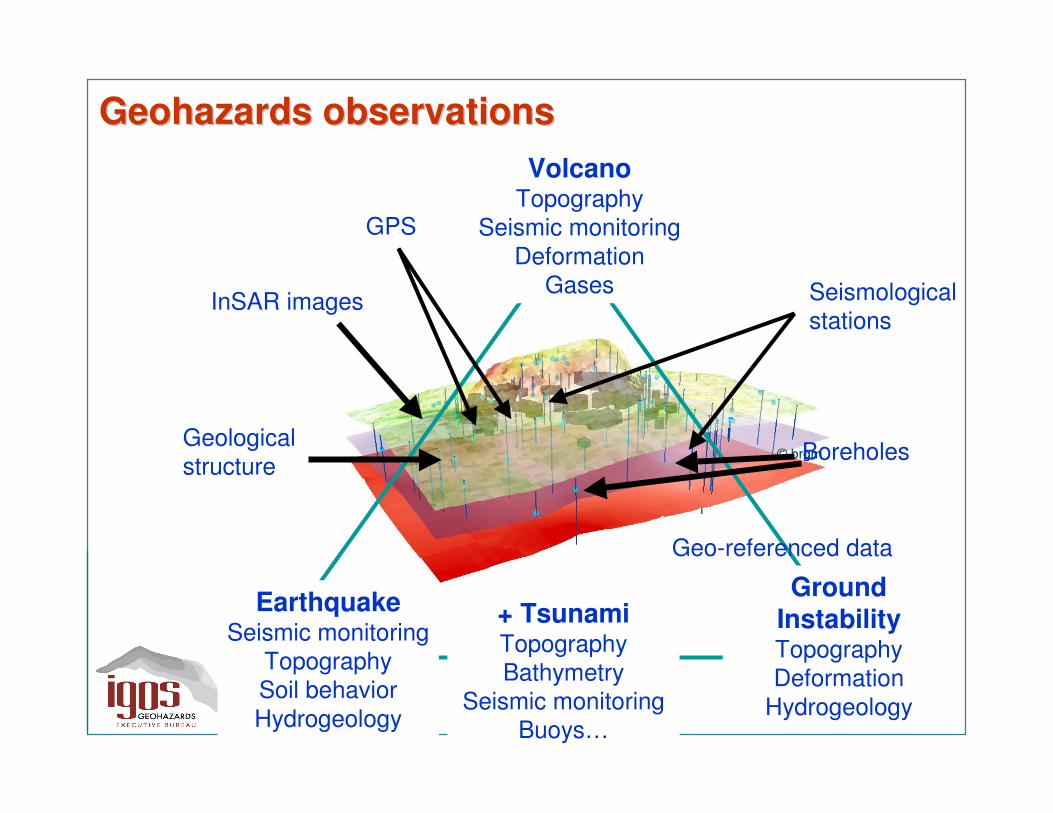
EarthquakeSeismic monitoring
TopographySoil behaviorHydrogeology
VolcanoTopography
Seismic monitoringDeformation
Gases
Ground InstabilityTopographyDeformation
Hydrogeology
BoreholesGeological structure
InSAR images Seismologicalstations
Geo-referenced data
GPS
GeohazardsGeohazards observationsobservations
+ TsunamiTopographyBathymetry
Seismic monitoringBuoys…
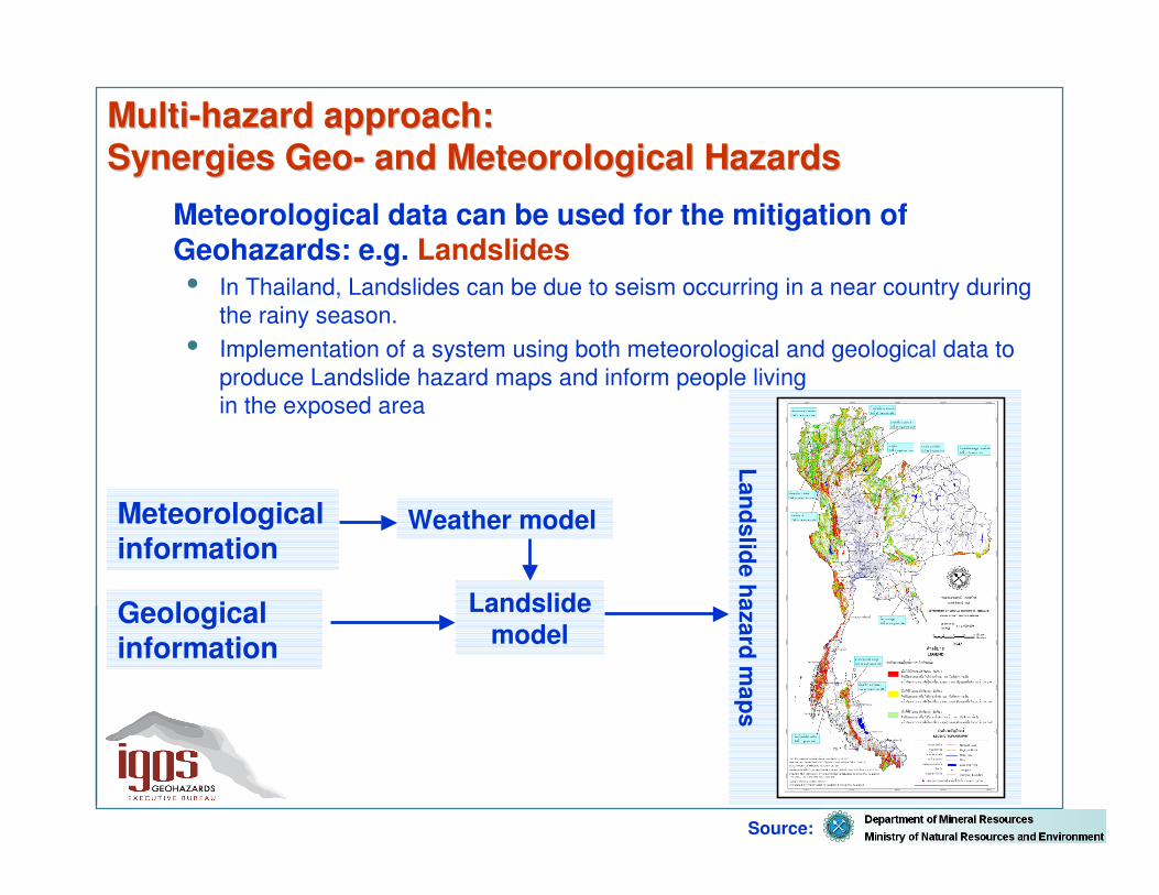
MultiMulti--hazardhazard approachapproach: : Synergies Synergies GeoGeo-- and and MeteorologicalMeteorological HazardsHazards
Meteorological data can be used for the mitigation of Geohazards: e.g. Landslides• In Thailand, Landslides can be due to seism occurring in a near country during
the rainy season. • Implementation of a system using both meteorological and geological data to
produce Landslide hazard maps and inform people living in the exposed area
Meteorologicalinformation
Geologicalinformation
Weather model
Landslidemodel
Landslidehazard
maps
Source:

SummarySummary
• Some issues related to geological disaster management
• Earth Observations and geological disaster management
• From user needs to multi-risk/hazards approaches
• IGOS Geohazards GeoHazData demonstrator• International cooperation

Data flows across communities concerned with Geohazards
Data ProvidersData Acquisition
End Users Groups
In-sector ProvidersData Process and
InterpretationDecision Support
Derived
information
products
High Level
Requirem
entsRemote Sensing Agencies, In Situ Monitoring Networks
Research scientists andgeological surveys
Public authoritiesInternational, national,
local level
Operational state organisations
Civil securityDisaster Reduction
OrganisationsEarthquakes Reduction
OrganisationsGeological surveys
Exposed populations
Media, E
ducation, Capacity building, A
lert
Engineering Level R
equirements
Raw
data
RequirementsRequirements
Data flowData flow
Benefits of multihazards/risk approach for Geohazards mitigation� Geohazards remains a highly diverse community with little interaction
between thematic areas� This is DESPITE significant overlap in earth observations for different
Geohazards
� homogenize hazard/risk assessments for all hazards
In addition, multi-hazard/risk strategies are expected to:
� facilitate mitigation actions
� facilitate the setting of priorities among the threats at international to local level
� facilitate the anticipation of cascade effects
Need of a trans-disciplinary and Globalcoordination mechanism for geohazards
Tsunami example: regional disaster, global response
The need for coordination in The need for coordination in GeohazardsGeohazards
� Multi-risk/hazards approach: many national initiatives, EC… At the international level: GEO, IGOS
Cooperations possibilities with UNOOSA SPIDER Programme
IGOS Geohazards limitation: only earthquake, volcanoes, landslides and tsunamis are considered, while geologists (and geological surveys) need to address the full range of geology related hazards, including floods, land heave and subsidence, gaseous emanations and more…

Annecy (France) microzonation map
Hazard and risk maps (local to regional scale)
Damage and response scenarii
GeohazardsGeohazards productsproductsUsers are:
• Public authorities: disaster management and land use planning authorities
• Private: building and insurance companies • Citizens• Scientific community
Inventories of geohazards data,
sensors and events

SummarySummary
• Some issues related to geological disaster management
• Earth Observations and geological disaster management
• From user needs to multi-risk/hazards approaches
• IGOS Geohazards demonstrator• International cooperation

The IGOS The IGOS GeohazardsGeohazards vision:vision:Toward a geohazards Earth Observation data clearing house
GeoHazData
10 years plan
Instruments
Databases
Application layerOpen data access and visualization services
Databases interoperability
Access to all data
Various databasesData collected by Geological surveys, mapping agencies,
space agencies, universities…
Inventories of data and observing means= Catalogue of Metadata
Seismometers
GPS networks
Other in-situ instruments
Satellite images
OGC, INSPIRE

Task DI-06-07

Task DI-06-07

GEO members such as Italy, Germany or Portugal, participate in task DI-06-07, and collected information on new and already existing hazards maps.
The Hazard maps inventory requires coordination of many organisations working on different thematics in different countries.
Other steps to increase the amount of metadata available through the system are detailed in working documents (promote voluntary basis, seek funding to perform regional inventories and increase cooperation with other initiatives and projects)
Task DI-06-07

SummarySummary
• Some issues related to geological disaster management
• Earth Observations and geological disaster management
• From user needs to multi-risk/hazards approaches
• IGOS Geohazards GeoHazData demonstrator• International cooperation

Spatial distribution of hazards
Principal earthquake zones and explosivevolcanoes
‘Ring of Fire’
S. E. Asia
CaribbeanMountSt. Helens1980
Montserrat1995-present
Toba 73ka
Pinatubo 1991
Tambora 1815
Aitapei1998
Alaska 1964
Northridge 1994Loma Prieta 1989
Chile 1960
Izmit 1999Lisbon1755
Tangshen1976
Tokyo 1923Kobe 1995
Tropical cyclone zones
Bhuj 2001
Taiwan 1999
Columbia 1999
Venezuela 2000Hurricane Mitch1999
after UCL
MultiMulti--hazardshazards approachapproach: : needneed of global and of global and regionalregionalapproachesapproaches

Report on the GEO GeohazardsWorkshop in South East Asia
The Malaysian remote sensing Center (MACRES), the Group on Earth Observation (GEO), NASA, UNESCO and IGOS Geohazardsorganised this workshop in order to enhance regional and international cooperation on geological disasters in South East Asia.
More than 90 participants
Participants stressed the need of a Regional Multi-Hazards approach.

Workshop recommendations• Data timeliness and coverage:
need to move toward an open near real time data dissemination. This requires coordination of Southeast Asia countries and work with the space agencies and donor countries to focus on monitoring high-risk areas for disaster mitigation.
• System interoperability:need to move toward an open geospatial data portal to overcome interoperability issues and facilitate access to data in a timely manner.
• Historical and archive data:need to improve historical event databases, archives of observation data and to get easier access to these data sets
• Regional cooperation:need to establish a community of practice on geohazards at the regional level in South East Asia.
Workshop outcome:IGOS Geohazards advocates spaceagencies for providing an easier access to spaceborne data in specific high risksareas for disaster mitigation.
GEO TASK DI-06-07
Partnership with CCOP
Toward a community of practice on Geohazards in South East Asia ?...

- This workshop will address data user/ providers issues, try to make a step forward in databases interoperability, mutual exchange of knowledge with developing countries.- You are cordially invited to this workshop; Please contact the Bureau

ConclusionsConclusions
• Need to focus on an easier data provision disaster mitigation
• IGOS Geohazards aims at–supporting a multi-disaster approach–increase the exchange of data from various sources–moving toward an open access to data
• Involvement within the GEO framework to progress
• Cooperation with other organization programmes (UNESCO, WMO, UNOOSA, UNISDR) is expected to help coordinating the initiative

Vielen Dank für IhreAufmerksamkeit
Contact: [email protected]
Tungurahua volcano threatening the city of Banos in Ecuador
Arnaud Joëlle and Scholl Pierre-Grégoire
Related Documents