Landform Geography Fluvial Systems and Landforms

Welcome message from author
This document is posted to help you gain knowledge. Please leave a comment to let me know what you think about it! Share it to your friends and learn new things together.
Transcript

Landform Geography
Fluvial Systems and Landforms
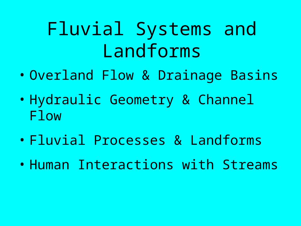
Fluvial Systems and Landforms
• Overland Flow & Drainage Basins
• Hydraulic Geometry & Channel Flow
• Fluvial Processes & Landforms
• Human Interactions with Streams

Overland Flow
• Perennial Streams – water runs all year
• Ephemeral Streams – water runs only part of year
• Sources of stream water:
– Groundwater
– Melting Ice
– Surface Runoff

Drainage Basins• Drainage Basin – area contributing
groundwater and runoff to a stream
• Drainage basins are divided from each other by topographic barriers called watersheds
• Drainage Divide – elevated terrain forming rim around a drainage basin
• Drainage basins vary tremendously in size
• Basins are nested, smaller within larger
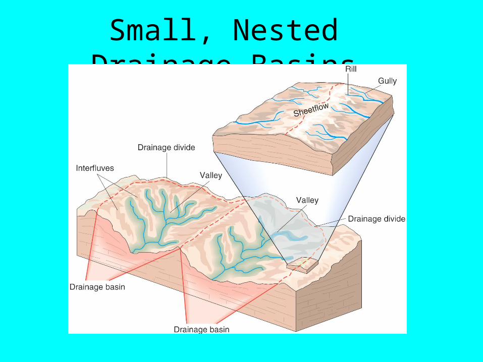
Small, Nested Drainage Basins

Common Drainage Pattern Types
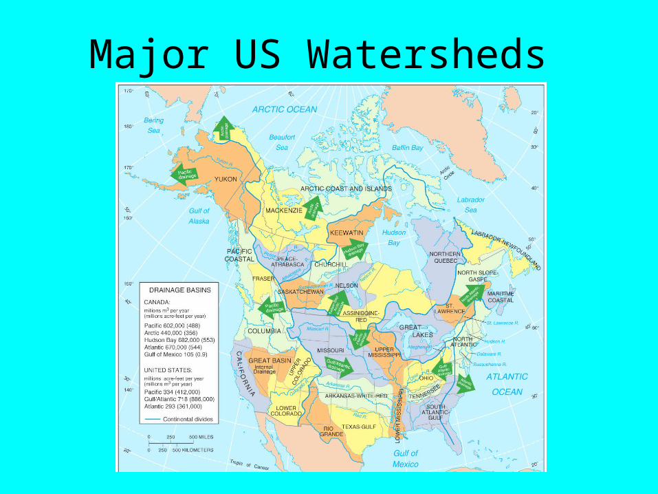
Major US Watersheds

Drainage DensityTotal length of all streamsDrainage Density = Area of drainage basin
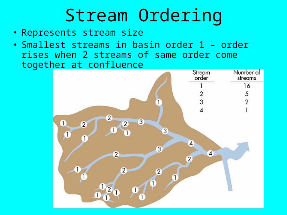
Stream Ordering• Represents stream size• Smallest streams in basin order 1 – order rises when 2
streams of same order come together at confluence

Hydraulic Geometry
• Geometric attributes of river channels
• Variables:– w = channel width– d = channel depth– v = velocity of water– s = slope (steepness) also called gradient– Q = discharge (amt of water flowing)– Q = w x d x v (units m3/s or ft3/s)

Hydraulic Variables

Stream Hydrograph
• Graph showing fluctuation in stream discharge over time• Lag between storm event and highest discharge
• Base flow – flow rate sustained by groundwater influx

Flooding
• Flood Stage – stream discharge increases so that water spills out of channel onto adjoining ground
• Return Period – time between events of a given magnitude, e.g. annual flood, 50-year flood, 100-year flood
• Larger floods occur less frequently

Mississippi River Floods - 1993
• At least 100-year flood, perhaps a 500-year flood
• Heavy winter rains saturated ground
• Stationary high pressure in Southeast in summer, blocking mid-latitude jet stream over Midwest
• Cool, dry air collided with warm, moist air along jet stream, creating constant precipitation
• Precipitation ran off into stream channels & rivers

Mississippi River Floods - 1993

2009 Carrollton Floods

Fluvial Processes and Landforms
• Running water is most important geomorphic (landform shaping) process on Earth’s surface
• All landforms due to either erosion or deposition
• Erosional landforms occur when sediment, soil, or rock is stripped away from land
• Depositional landforms occur where sediment accumulates after being dropped

Depositional vs. Erosional Landforms

Hillslopes• Most active zones of fluvial erosion due to high
relief creating fast-moving, powerful waterRills Gully

Ravine
Canyon

Landforms Geography
Glaciers

Glacial Geomorphology
• Development of a glacier
• Types of glaciers
• Glacial landforms
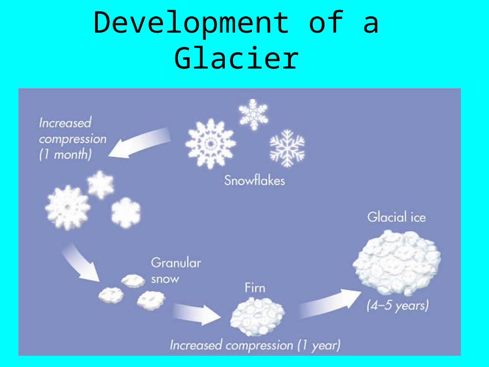
Development of a Glacier

Glacial Mass Budget

Glacial Mass Budget

Glacial Movement

Glacial Movement
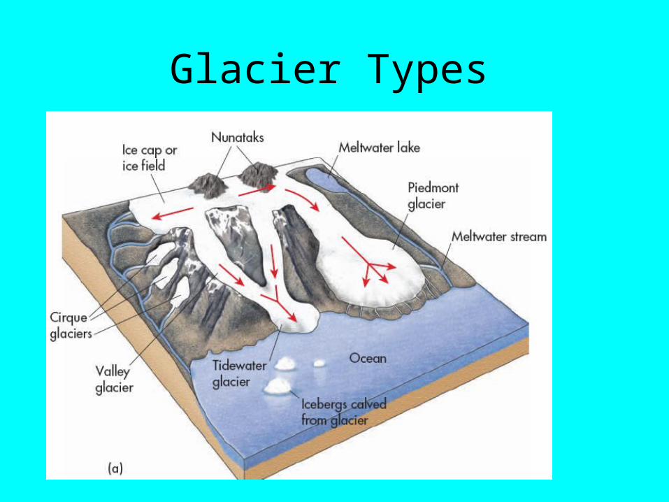
Glacier Types

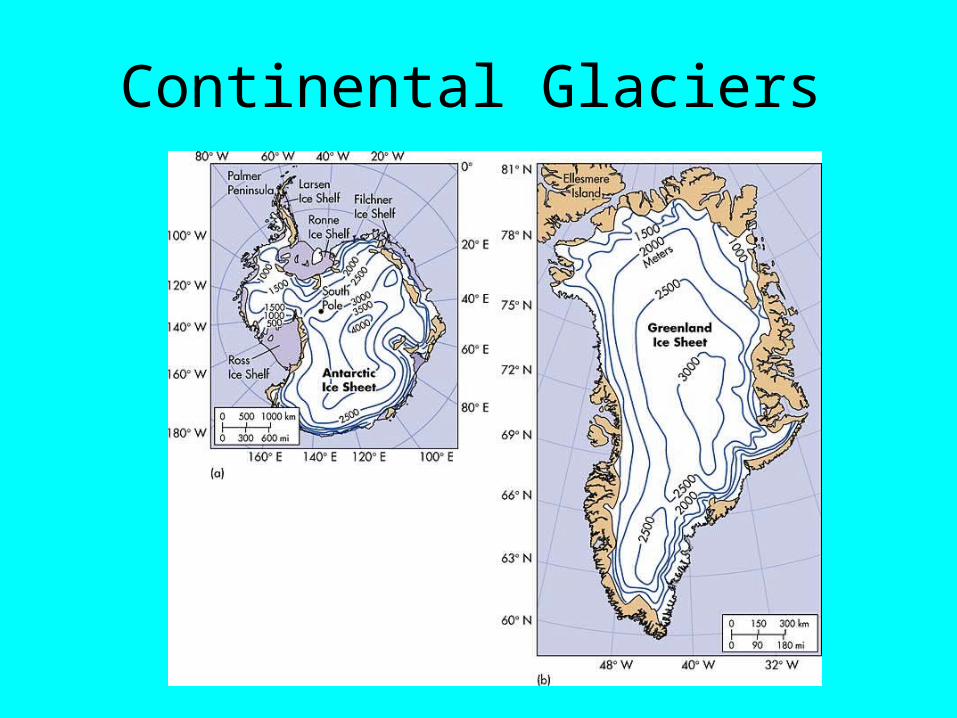
Continental Glaciers

Glacial Landforms
• Rock & debris picked up by glaciers, transported in direction of movement & deposited
• Glacial erosion:– Glacial Abrasion – scratch and gouge bedrock– Glacial Striations – caused by glacial abrasion– Glacial Grooves – deep striations– Glacial Plucking – boulders ripped from ground
by glacier – deposited by retreating glacier, called Glacial Erratics
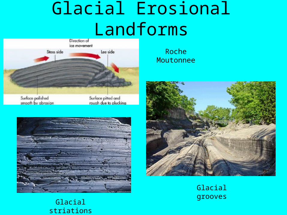
Glacial Erosional Landforms
Glacial grooves
Roche Moutonnee
Glacial striations

Alpine Erosional Landforms
• Glacial Erosion:– Cirque – bowl-like feature on mountain flanks– Tarn – small lake in bottom of cirque– Arête – narrow, steep ridges between cirques– Horn – mountain with 3 or more arêtes at summit– Glacial Trough – u-shape valley eroded by glacier

Alpine Erosional Landforms

Glacial Depositional Landforms – Glacial Drift
• Glacial Till – sediment directly deposited by glacier – many particle sizes
• Moraine – winding ridge formed by till at the front or side of glacier – Moraine types:– Lateral – along former edges of glacier– Terminal – along front of former glacier– Recessional – formed as glacier recedes– Medial – between 2 glaciers– Ground – irregular deposition as glacier recedes

Glacial Depositional Landforms (Till)

Glacial Depositional Landforms (outwash)
• Glacial Outwash – sediments deposited by water out & under a glacier as it melts – forms Outwash Plain, flat feature in front of former glacier
• Kame – large mound deposited near glacier front
• Esker – winding ridge from water flowing in tunnel through ice under glacier
• Kettle Lake – big ice block fallen off glacier front is buried by outwash, melts later forming lake

Glacial Depositional Landforms
Related Documents