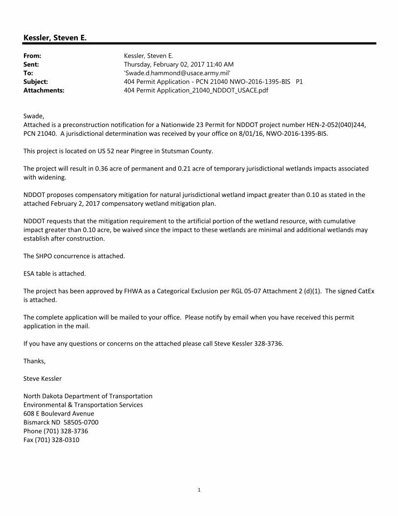
1 Kessler, Steven E. From: Kessler, Steven E. Sent: Thursday, February 02, 2017 11:40 AM To: '[email protected]' Subject: 404 Permit Application - PCN 21040 NWO-2016-1395-BIS P1 Attachments: 404 Permit Application_21040_NDDOT_USACE.pdf Swade, Attached is a preconstruction notification for a Nationwide 23 Permit for NDDOT project number HEN‐2‐052(040)244, PCN 21040. A jurisdictional determination was received by your office on 8/01/16, NWO‐2016‐1395‐BIS. This project is located on US 52 near Pingree in Stutsman County. The project will result in 0.36 acre of permanent and 0.21 acre of temporary jurisdictional wetlands impacts associated with widening. NDDOT proposes compensatory mitigation for natural jurisdictional wetland impact greater than 0.10 as stated in the attached February 2, 2017 compensatory wetland mitigation plan. NDDOT requests that the mitigation requirement to the artificial portion of the wetland resource, with cumulative impact greater than 0.10 acre, be waived since the impact to these wetlands are minimal and additional wetlands may establish after construction. The SHPO concurrence is attached. ESA table is attached. The project has been approved by FHWA as a Categorical Exclusion per RGL 05‐07 Attachment 2 (d)(1). The signed CatEx is attached. The complete application will be mailed to your office. Please notify by email when you have received this permit application in the mail. If you have any questions or concerns on the attached please call Steve Kessler 328‐3736. Thanks, Steve Kessler North Dakota Department of Transportation Environmental & Transportation Services 608 E Boulevard Avenue Bismarck ND 58505‐0700 Phone (701) 328‐3736 Fax (701) 328‐0310

Kessler, Steven E. · 1 Kessler, Steven E. From: Kessler, Steven E. Sent: Thursday, February 02, 2017 11:40 AM To: '[email protected]' Subject: 404 Permit Application
Jun 01, 2020
Welcome message from author
This document is posted to help you gain knowledge. Please leave a comment to let me know what you think about it! Share it to your friends and learn new things together.
Transcript
1
Kessler, Steven E.
From: Kessler, Steven E.Sent: Thursday, February 02, 2017 11:40 AMTo: '[email protected]'Subject: 404 Permit Application - PCN 21040 NWO-2016-1395-BIS P1Attachments: 404 Permit Application_21040_NDDOT_USACE.pdf
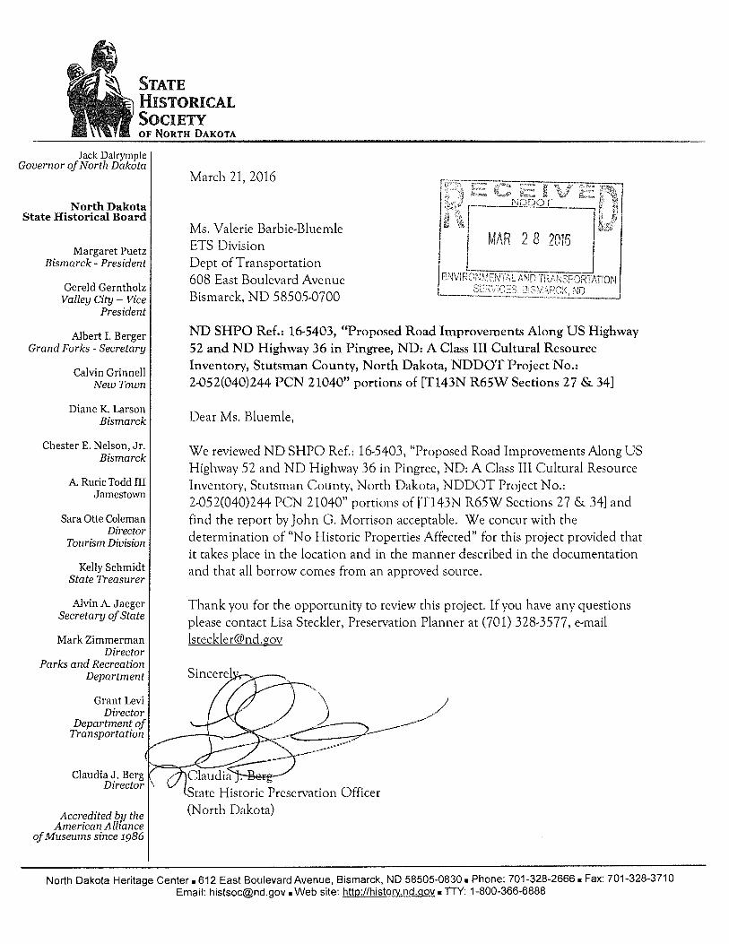
Swade, Attached is a preconstruction notification for a Nationwide 23 Permit for NDDOT project number HEN‐2‐052(040)244, PCN 21040. A jurisdictional determination was received by your office on 8/01/16, NWO‐2016‐1395‐BIS. This project is located on US 52 near Pingree in Stutsman County. The project will result in 0.36 acre of permanent and 0.21 acre of temporary jurisdictional wetlands impacts associated with widening. NDDOT proposes compensatory mitigation for natural jurisdictional wetland impact greater than 0.10 as stated in the attached February 2, 2017 compensatory wetland mitigation plan. NDDOT requests that the mitigation requirement to the artificial portion of the wetland resource, with cumulative impact greater than 0.10 acre, be waived since the impact to these wetlands are minimal and additional wetlands may establish after construction. The SHPO concurrence is attached. ESA table is attached. The project has been approved by FHWA as a Categorical Exclusion per RGL 05‐07 Attachment 2 (d)(1). The signed CatEx is attached. The complete application will be mailed to your office. Please notify by email when you have received this permit application in the mail. If you have any questions or concerns on the attached please call Steve Kessler 328‐3736. Thanks, Steve Kessler North Dakota Department of Transportation Environmental & Transportation Services 608 E Boulevard Avenue Bismarck ND 58505‐0700 Phone (701) 328‐3736 Fax (701) 328‐0310

Page | 1
Corps of Engineers Nationwide Permit (NWP) Verification NORTH DAKOTA DEPARTMENT OF TRANSPORTATION (ND DOT) PROJECTS
REQUEST FOR NWP DETERMINATION(S) IMPACTED
WATER RESOURCE
NUMBER
PCN (DOT
generated) HWY/Road
Number
TYPE AND DIMENSIONS
OF EXISTING
STRUCTURE
ACTIVITY STREAM IMPACTS BELOW OHWM
(linear feet)
WETLAND IMPACTS
(acres)
LOCATION LAT/LONG (NAD 83)
SEC-TWP-RGE, COUNTY
COE ID NUMBER
(to be filled by COE)
N W P
# TEMP (LF)
PERM (LF)
PERM (acre)
TEMP (acre)
PERM (acre)
LAT (Decimal Degrees)
LONG (Decimal Degrees)
1a(b), 1d(b), 1d(c), 1d(d) 21040 Widening 0.21 0.36 47.1661250 -98.905740 NW 34-143-65,
Stutsman
The U.S. Army Corps of Engineers verifies that the requested activity(s) meet the criteria of the listed NWPs.
Signed: ______________________________________________ North Dakota Regulatory Office
Verification Date: ______ __________ Expiration Date: ___ ____________
*This NWP verification is subject to the activity meeting all General and Regional Conditions applicable to the 2012 NWPs reissuance. For this authorization to remain valid, you must meet all Regional and General Conditions and Section 401 Water Quality Certification Requirements, identified in the applicable Nationwide Permit Fact Sheet. All Fact Sheets and Section 401 Water Quality Certification Requirements are provided on the North Dakota Regulatory Office's website at http://www.nwo.usace.army.mil/Missions/RegulatoryProgram/NorthDakota.aspx. **Project Compliance Certification. In compliance with General Condition 26, you are required to submit the following project compliance certification within thirty (30) days of project completion. [Please check all applicable statements]
[ ] I certify that I have completed the project as permitted. [ ] I certify that I have completed a modified version of the project. [ ] I certify that I have completed all required mitigation.
Permittee’s Signature: Date: *** Special Conditions.

U.S. Department of Transportation North Dakota Department of TransportationFederal Highway Administration ND Division SFN 18878 - REV 07/07
PROJECT PCN
LOCATION REQUESTED DATE / BID DATE
LENGTH SUBMITTED BY / DATE
NATURE CONTACT / PHONE
OF WORKFor FHWA Use Only
DATE IN COMMENTS DUE
PROJECT STATUS
ENVIRONMENTAL DOCUMENT
Signature Date
Name Title
07/13
HEN-2-052(040)244 21040 DOCUMENT DATE
09.13.2016
US 52 & ND 36 at Pingree
Intersection
Adding turn lanes at intersection
01.10.2017 / 03.10.2017
MARK GAYDOS / 01.10.2017
AMY BEISE 701-328-
DOCUMENT TYPE
ENVIRONMENTAL APPROVAL REQUEST
Documented CATEX
CatEx Categorical ExclusionApproved
01/10/2017
Pete Christensen Environmental Scientist II
Pete Christensen Digitally signed by Pete Christensen DN: cn=Pete Christensen, o=NDDOT, ou, [email protected], c=US Date: 2017.01.10 09:10:18 -06'00'
01/12/2017
Mark Schrader Transportation Engineer
MARK R SCHRADER Digitally signed by MARK R SCHRADER DN: c=US, o=U.S. Government, ou=DOT FHWABismarkND, ou=FHWA FHWABismarkND, cn=MARK R SCHRADER Date: 2017.01.12 15:40:05 -06'00'
CATEGORICAL EXCLUSION / CONCEPT CONCURRENCE
NORTH DAKOTA DEPARTMENT OF TRANSPORTATION
The supporting documentation has been reviewed for compliance with the National Environmental Policy Act.
Signature
Name Title
Date
FHND1 Rev 07/13

Listing Key: E – Endangered T – Threatened P – Proposed C – Candidate D – Designated Date of last updates to table: 12/2015
NDDOT Threatened, Endangered, Proposed, Candidate Species and Critical Habitat Affect Determination Table
Project: HEN‐2‐052(040)244 PCN: 21040 Location: Intersection ND 36 and US 52 at Pingree County: Stutsman
Species Listing Guidance
FHWA Review
Required? Determination Additional
Documentation Included
Yes No Not Present
No Effect
Interior Least Tern E FHWA Review required for work in or along the shoreline of the Missouri River System including
reservoirs from April 15 through August 1. X
Whooping Crane E
FHWA Review required for the adjustment (raising, relocating) of existing above‐ground utility lines; or for newly placed poles/towers that require overhead lines/guy wires; unless the adjustments or new installations are located in a highly developed or urban area.
X X
Black‐footed Ferret E FHWA Review required for ground disturbing activities within 100 feet of prairie dog towns of at least
80 acres in size. Projects within the existing right‐of‐way will not require FHWA review. X
Pallid Sturgeon E FHWA Review required for work in or along the shoreline of the Missouri River (including reservoirs) and Yellowstone River Systems. X
Gray Wolf E FHWA Review required for roadway projects of 2 or more lanes on a new location (i.e. construction of a new roadway). X X
Poweshiek Skipperling E FHWA Review required for work occurring outside of the right of way in undisturbed native tall grass
prairie and wet swales. X
Piping Plover T
FHWA Review required for ground disturbing activities within ½ mile of designated piping plover critical habitat or known nesting sites. See link for piping plover designated critical habitat maps: http://www.fws.gov/mountain‐prairie/species/birds/pipingplover/
X X
Western Prairie Fringed Orchid
T FHWA Review required for all ground disturbing activities on non‐flooded, undisturbed ground, known habitat, and native prairie. High probability of species in or near the Sheyenne National Grassland. X
Dakota Skipper T FHWA Review required for work occurring outside of the right of way in high quality native prairie containing a high diversity of wildflowers and grasses. X X
Rufa Red Knot T
FHWA Review required for work activities impacting Piping Plover Critical Habitat or sewage lagoons. See link for piping plover designated critical habitat maps: http://www.fws.gov/mountain‐prairie/species/birds/pipingplover/
X X
Northern Long‐Eared Bat T
FHWA Review required for work involving the removal of trees or buildings, ground disturbance in areas with caves, mines, and rock crevices, or work on structures. FHWA and USFWS have prepared a Programmatic Biological Assessment (PBA) for No Effect and May Affect Not Likely to Adversely Affect Determinations for this species. See following link for information on how to use PBA for NDDOT projects. http://www.dot.nd.gov/manuals/design/designmanual/reference‐forms.htm
X X
Sprague’s Pipit C
FHWA Review Required for work activities occurring outside the right of way in large native short‐to‐mixed grass prairie patches of approximately 72 acres or greater.
X X
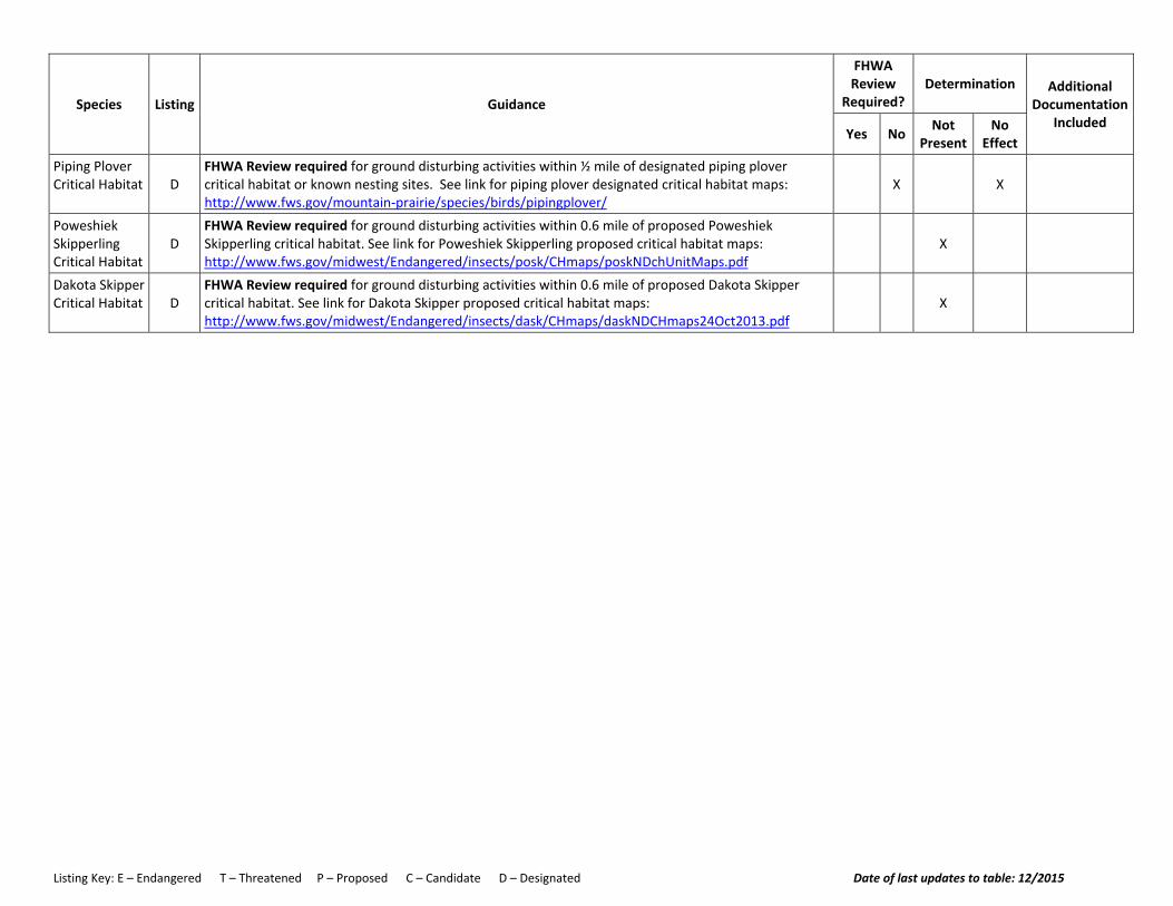
Listing Key: E – Endangered T – Threatened P – Proposed C – Candidate D – Designated Date of last updates to table: 12/2015
Species Listing Guidance
FHWA Review
Required? Determination Additional
Documentation Included
Yes No Not Present
No Effect
Piping Plover Critical Habitat D
FHWA Review required for ground disturbing activities within ½ mile of designated piping plover critical habitat or known nesting sites. See link for piping plover designated critical habitat maps: http://www.fws.gov/mountain‐prairie/species/birds/pipingplover/
X X
Poweshiek Skipperling Critical Habitat
D FHWA Review required for ground disturbing activities within 0.6 mile of proposed Poweshiek Skipperling critical habitat. See link for Poweshiek Skipperling proposed critical habitat maps: http://www.fws.gov/midwest/Endangered/insects/posk/CHmaps/poskNDchUnitMaps.pdf
X
Dakota Skipper Critical Habitat D
FHWA Review required for ground disturbing activities within 0.6 mile of proposed Dakota Skipper critical habitat. See link for Dakota Skipper proposed critical habitat maps: http://www.fws.gov/midwest/Endangered/insects/dask/CHmaps/daskNDCHmaps24Oct2013.pdf
X
NDDOT Approval Date
OFFICE OF PROJECT DEVELOPMENT
NDDOT Approval Name
Designer Line 5
Steve Thompson
Damon DeVillers, PE
Jeff Nording
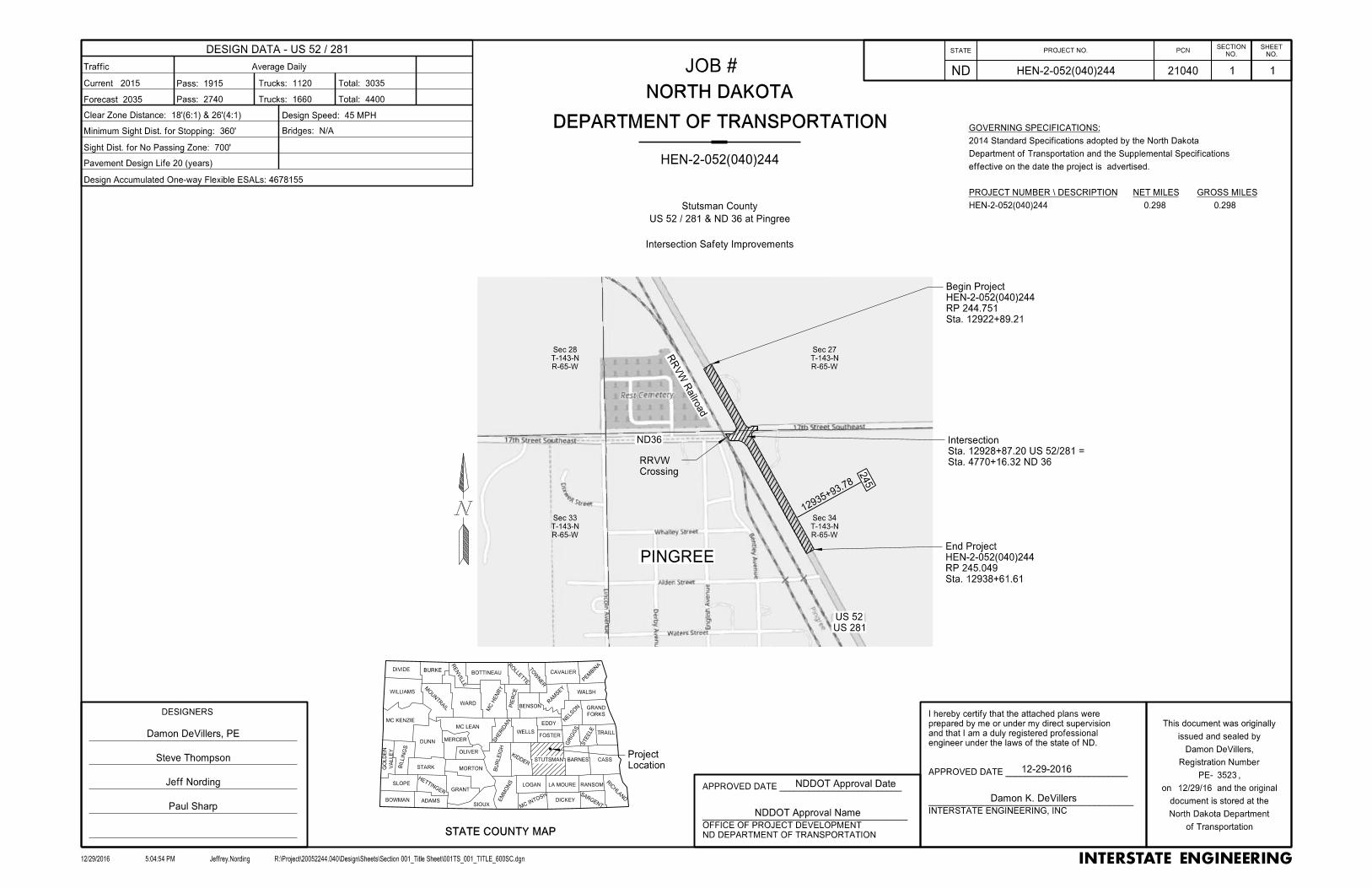
R-65-W
T-143-N
Sec 28
R-65-W
T-143-N
Sec 27
R-65-W
T-143-N
Sec 34
R-65-W
T-143-N
Sec 33
PINGREE
ND36
US 281
US 52
Paul Sharp
1293
5+93.78
245
Crossing
RRVW
Sta. 12922+89.21
RP 244.751
HEN-2-052(040)244
Begin Project
Sta. 4770+16.32 ND 36
Sta. 12928+87.20 US 52/281 =
Intersection
RR
VW R
ailro
ad
Location
Project
Sta. 12938+61.61
RP 245.049
HEN-2-052(040)244
End Project
DESIGNERS
ND DEPARTMENT OF TRANSPORTATION
__________________________________________
APPROVED DATE _________________________
GRAND
FORKS
GO
LD
EN
VA
LLE
Y
CASS
RIC
HLA
ND
RANSOM
SARGENTDICKEY
LA MOURE
BARNES
KIDDER
LOGAN
MC IN
TOSH
BU
RLEIG
H
MORTON
GRANT
SIOUXADAMS
HETTINGER
SLOPE
BOWMAN EM
MO
NS
OLIVER
MERCER
STARKBIL
LIN
GS
DUNN
MC KENZIE
MC LEAN
SHERID
AN
WELLS
EDDY
FOSTER
GRIG
GS
STEELE
TRAILL
DIVIDE
WILLIAMS
BURKE
MO
UNTR
AIL
RE
NVIL
LE
WARD
MC H
EN
RY
BOTTINEAU
ROLLE
TTE
TO
WNER
CAVALIER
RA
MSEY
WALSH
PE
MBIN
A
NELS
ONBENSONP
IER
CE
STUTSMAN
STATE COUNTY MAP
11
12/29/16
INTERSTATE ENGINEERING, INC
21040HEN-2-052(040)244
HEN-2-052(040)244
Stutsman County
US 52 / 281 & ND 36 at Pingree
STATE PROJECT NO.
ND
PCNNO.
SHEET
NO.
SECTION
DEPARTMENT OF TRANSPORTATION
NORTH DAKOTA
__________________________________________
APPROVED DATE _________________________
engineer under the laws of the state of ND.
and that I am a duly registered professional
prepared by me or under my direct supervision
I hereby certify that the attached plans were
12/29/2016 Jeffrey.Nording R:\Project\20052244.040\Design\Sheets\Section 001_Title Sheet\001TS_001_TITLE_600SC.dgn5:04:54 PM
of Transportation
North Dakota Department
document is stored at the
on and the original
PE- ,
Registration Number
issued and sealed by
This document was originally
JOB #
HEN-2-052(040)244 0.298 0.298
GROSS MILES NET MILES PROJECT NUMBER \ DESCRIPTION
effective on the date the project is advertised.
Department of Transportation and the Supplemental Specifications
2014 Standard Specifications adopted by the North Dakota
GOVERNING SPECIFICATIONS:
Intersection Safety Improvements
3523
Damon DeVillers,
DESIGN DATA - US 52 / 281
Traffic Average Daily
Current 2015
Forecast 2035
Pass: 1915
Pass: 2740
Trucks: 1120
Trucks: 1660
Total: 3035
Total: 4400
Design Speed: 45 MPH
Bridges: N/A
Pavement Design Life 20 (years)
Minimum Sight Dist. for Stopping: 360'
Clear Zone Distance: 18'(6:1) & 26'(4:1)
Sight Dist. for No Passing Zone: 700'
Design Accumulated One-way Flexible ESALs: 4678155
Damon K. DeVillers
12-29-2016

Bldg
Bldg
12922 12923 12924 12925 12926 12927 12928 12929 12930 12931 12932 12933 12934 12935 12936 12937 12938 12939 12940
4764
4765
4766
4767
4768
4769
4770
100
101
102
103
104
105
106
17T
H St SE
17T
H St SE / N
D 3
6
US 52/281 US 52/281
Sta. 12922+89.21
RP 244.751
HEN-2-052(040)244
Begin Project
Sta. 12938+61.61
RP 245.049
HEN-2-052(040)244
End Project
Turn Lane
Southbound Right
Turn Lane
Northbound Left
Destination Lighting
Install Intersection
Pingree
4768+69.71
RRVW
Paving Area
NTHN PLNS ELEC
Aggregate Areas
Remove Approaches and
Aggregate Area
Remove Approach and
STATE PROJECT NO.
ND
NO.
SHEET
NO.
SECTION
1/3/2017 Jeffrey.Nording R:\Project\20052244.040\Design\Sheets\Section 004_Scope\004SW_001_Scope of Work_120SC.dgn5:08:56 PM
of Transportation
North Dakota Department
document is stored at the
on and the original
PE- ,
Registration Number
issued and sealed by
This document was originally
Damon DeVillers,
3523
HEN-2-052(040)244 4 1
SCOPE OF WORK
US 52 / 281 & ND 36 at Pingree
Stutsman County
01/04/17

6:1
2.10%
6:1
6:1
6' Mill
Correct
Slope
Ground
Existing
17' to 30'
21' to 34'
31.5' to 44.5'
10.5' 4' 5' 0' to 13' 12'
Varies
6:1
6:1
6:1
Ground
Existing
30' to 17'
34' to 21'
44.5' to 31.5'
10.5' 4' 5' 13' to 0' 12'
Varies
= 31.88 SF
Area(@ max. width)
18" Aggregate Base CL 5
= 31.88 SF
Area(@ max. width)
18" Aggregate Base CL 5
East Side
East Side
6' Mill
Correct
Slope
Sta. 12922+89.21 Lt. to Sta. 12928+87.20 Lt.
RP 244.751 to RP 244.865
Proposed Typical Section
Sta. 12928+87.20 Lt. to Sta. 12938+61.61 Lt.
RP 244.865 to RP 245.049
Proposed Typical Section
12' Driving Lane
12' Driving Lane
Var.12'
Ditch
24:1 4:1
(See cross sections for locations)
Cut Section Detail
Varies
To Road
6:1
18'
18'
Embankment
Embankment
Area = 3.10 SF
2" Commercial Grade Hot Mix Asphalt
Area = 3.10 SF
2" Commercial Grade Hot Mix Asphalt
Area(@ max. width) = 8.17 SF
5" Commercial Grade Hot Mix Asphalt
Topsoil
Topsoil
TopsoilArea(@ max. width) = 6.07 SF
5" Commercial Grade Hot Mix Asphalt
Varies Varies Varies
2.10%Varies Varies Varies
ROW 120'± to 125' ±`
ROW 55' ± to 75'±
ROW 45' ± to 50'±`
ROW 120'± to 125' ±
(Width varies to cover existing subgrade)
Geosynthetic Material Type R1
(Width varies to cover existing subgrade)
Geosynthetic Material Type R1
STATE PROJECT NO.
ND
NO.
SHEET
NO.
SECTION
1/3/2017 Jeffrey.Nording R:\Project\20052244.040\Design\Sheets\Section 030_Typicals\030TP_005_Typicals_Prop_10SC.dgn5:10:09 PM
of Transportation
North Dakota Department
document is stored at the
on and the original
PE- ,
Registration Number
issued and sealed by
This document was originally
30
HEN-2-052(040)244
US 52 / 281 & ND 36 at Pingree
Stutsman County
5
TYPICAL SECTIONS - PROPOSED
Damon DeVillers,
3523
US 52 / 281
01/04/17
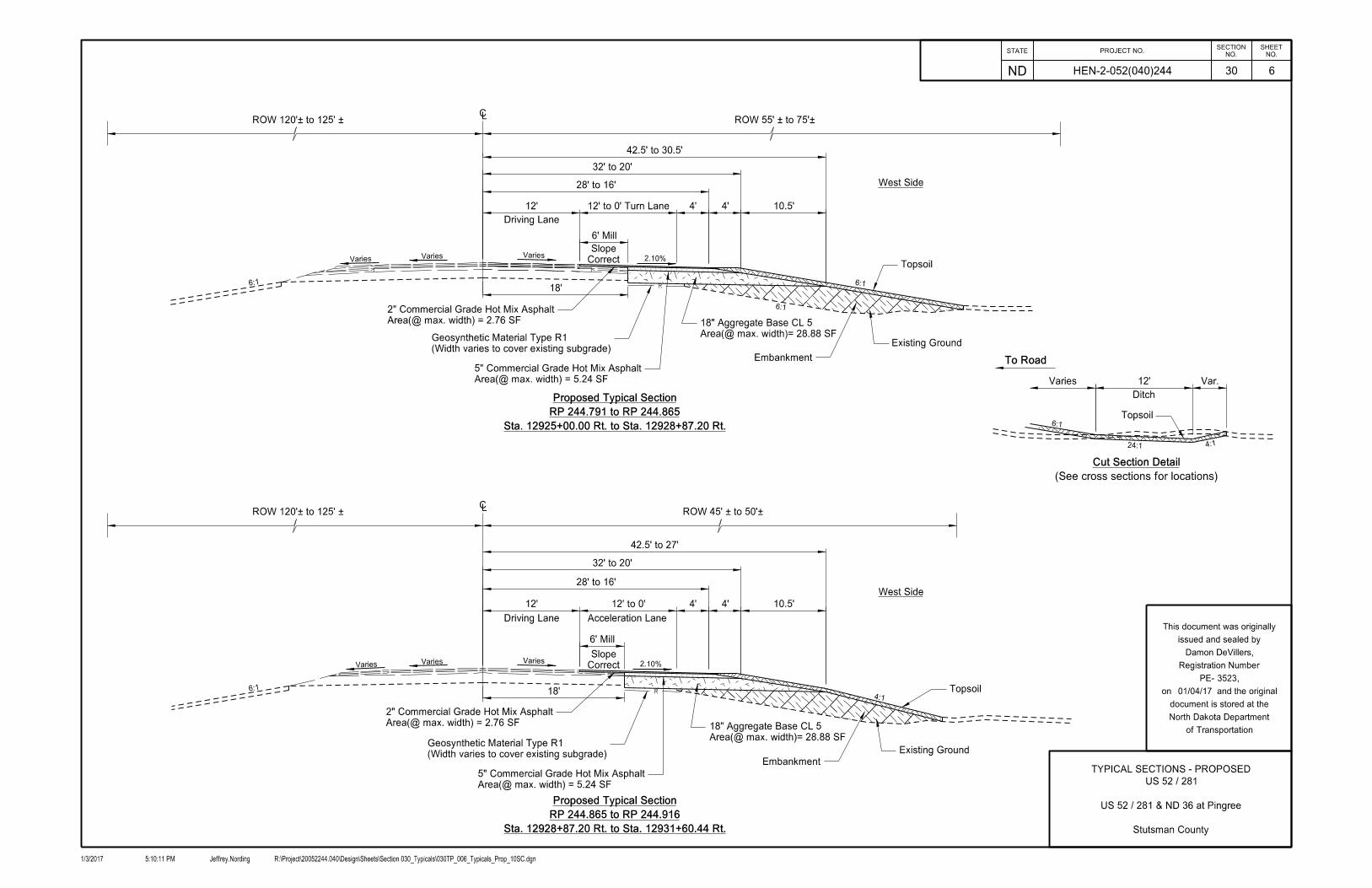
6:1
2.10%
28' to 16'
32' to 20'
42.5' to 30.5'
Existing Ground
28' to 16'
32' to 20'
42.5' to 27'
10.5'4'4'12' to 0'12'
Existing Ground
Driving Lane
Driving Lane
6' Mill
Correct
Slope
6' Mill
Correct
Slope
6:1
Sta. 12925+00.00 Rt. to Sta. 12928+87.20 Rt.
RP 244.791 to RP 244.865
Proposed Typical Section
Sta. 12928+87.20 Rt. to Sta. 12931+60.44 Rt.
RP 244.865 to RP 244.916
Proposed Typical Section
6:1
10.5'4'4'12' to 0' Turn Lane12'
6:1
4:1
West Side
West Side
Acceleration Lane
Var.12'
Ditch
24:1 4:1
(See cross sections for locations)
Cut Section Detail
Varies
To Road
6:1
18'
18'
Embankment
Embankment
Area(@ max. width) = 2.76 SF
2" Commercial Grade Hot Mix Asphalt
Area(@ max. width) = 5.24 SF
5" Commercial Grade Hot Mix Asphalt
Area(@ max. width) = 5.24 SF
5" Commercial Grade Hot Mix Asphalt
Area(@ max. width) = 2.76 SF
2" Commercial Grade Hot Mix Asphalt
Topsoil
Topsoil
Topsoil
VariesVaries
Varies
VariesVaries Varies 2.10%
`ROW 45' ± to 50'±ROW 120'± to 125' ±
`ROW 55' ± to 75'±ROW 120'± to 125' ±
Area(@ max. width)= 28.88 SF
18" Aggregate Base CL 5
Area(@ max. width)= 28.88 SF
18" Aggregate Base CL 5
(Width varies to cover existing subgrade)
Geosynthetic Material Type R1
(Width varies to cover existing subgrade)
Geosynthetic Material Type R1
STATE PROJECT NO.
ND
NO.
SHEET
NO.
SECTION
1/3/2017 Jeffrey.Nording R:\Project\20052244.040\Design\Sheets\Section 030_Typicals\030TP_006_Typicals_Prop_10SC.dgn5:10:11 PM
of Transportation
North Dakota Department
document is stored at the
on and the original
PE- ,
Registration Number
issued and sealed by
This document was originally
30
HEN-2-052(040)244 6
TYPICAL SECTIONS - PROPOSED
US 52 / 281 & ND 36 at Pingree
Stutsman County
Damon DeVillers,
3523
US 52 / 281
01/04/17
STATE PROJECT NO.
ND
NO.
SHEET
NO.
SECTION
1/3/2017 Jeffrey.Nording R:\Project\20052244.040\Design\Sheets\Section 051_Allowable Pipe List\051AP_001_PipeList_1SC.dgn5:10:15 PM
of Transportation
North Dakota Department
document is stored at the
on and the original
PE- ,
Registration Number
issued and sealed by
This document was originally
51
HEN-2-052(040)244 1
ALLOWABLE PIPE LIST
US 52 / 281 & ND 36 at Pingree
Stutsman County
Damon DeVillers,
3523
01/04/17

STATE PROJECT NO.
ND
NO.
SHEET
NO.
SECTION
1/17/2017 jeffrey.nording R:\Project\20052244.040\Design\Sheets\Section 075_Wetlands\075WL_001_Wetlands Mitigation and Environmental_1SC.dgn1:28:00 PM
of Transportation
North Dakota Department
document is stored at the
on and the original
PE- ,
Registration Number
issued and sealed by
This document was originally
75
WETLANDS MITIGATION AND ENVIRONMENTAL
1
Damon DeVillers,
3523
US 52 / 281 & ND 36 at Pingree
Stutsman County
HEN-2-052(040)244
01/17/17
Permanent Impacts
Temporary Impacts
Wetland Delineation
17th St SE
17th St SE / N
D 3
6
US 52/281
R-65-W
T-143-N
Sec 27
R-65-W
T-143-N
Sec 34
R-65-W
T-143-N
Sec 27
R-65-W
T-143-N
Sec 34
Wetland Mitigation
STATE PROJECT NO.
ND
NO.
SHEET
NO.
SECTION
1/9/2017 jeffrey.nording R:\Project\20052244.040\Design\Sheets\Section 075_Wetlands\075WL_002_Wetland_Impacts_150SC.dgn11:20:50 AM
purposes.
implementation
construction or
and not for
is preliminary
This document
PRELIMINARY
75
HEN-2-052(040)244
WETLAND IMPACTS
US 52 / 281 & ND 36 at Pingree
Stutsman County
2
1548.6
9
1549.0
3
1549.7
9
1550.1
2
1550.3
5
1550.7
9
1550.9
8
1551.1
2
1551.22
1551.3
7
1551.38
1551.4
4
1551.65
1551.69
1551.82
1551.83
1551.93
1551.9
4
1552.08
1552.3
6
12920+00
12925+00
12930+00
12935+00
12940+00
Wetland 2
Impact = 0.01 Acres
Permanent Wetland
Wetland 5
Wetland 3
Wetland 7
b
Wetland 7a
Wetland 6
Impact = 0.03 Acres
Permanent Wetland
Impact = 0.01 Acres
Temporary Wetland
Impact = 0.03 Acres
Permanent Wetland
Grading Tie Line
Grading Tie Line
Grading Tie Line
Wetland 1a(d) Wetland 1a(c)
Wetland 1a(b)
Wetland 1a(a)
1c(b)
Wetland
1b(b)
Wetland
Wetland 1d(a)Wetland 1d(b)
Wetland 1d(d)
Wetland 1d(c)
Impact = 0.09 Acres
Permanent Wetland
Impact = 0.10 Acres
Permanent Wetland
Impact = 0.14 Acres
Permanent Wetland
Impact = 0.13 Acres
Temporary Wetland
Acreage = 0.14 Ac.
Bottom Elev. 1449.70
Site 1
Wetland Mitigation
Impact = 0.03 Acres
Temporary Wetland
Impact = 0.04 Acres
Temporary Wetland
Grading Tie Line

00
00
1010
1010
2020
2020
3030
3030
4040
4040
5050
5050
6060
6060
7070
7070
8080
8080
9090
9090
100100
100100
110110
110110
120120
120120
130130
130130
140140
140140
150
150
1540 1540
1550 1550
1560 1560
1570 1570
1530 1530
12931+00.00
1540 1540
1550 1550
1560 1560
1570 1570
1580 1580
1530 1530
12931+70.00
1540 1540
1550 1550
1560 1560
1570 1570
1530 153012932+00.00
STATE PROJECT NO.
ND
NO.
SHEET
NO.
SECTION
1/9/2017 jeffrey.nording R:\Project\20052244.040\Design\Sheets\Section 200_XSections\200XS_001_US52_20SC.dgn11:20:58 AM
200
HEN-2-052(040)244
Cross-Sections
US 52 / 281 7
Existing
R/W
RR
RO
W
Wetland
Delineate
d
Wetland
Delineate
d
2.10%
6:1
24:14:1
2.10%
4:1
Existing
R/W
RR
RO
W
Wetland
Delineate
d
Wetland
Delineate
d
Wetland
Delineate
d
Wetland
Delineate
d
2.10%
Existing
R/W
RR
RO
W
Wetland
Delineate
d
Wetland
Delineate
d
Wetland
Delineate
d
Wetland
Delineate
d
Wetland
Delineate
d
Wetland
Delineate
d
6:1
4:1
2.10%
approximate
water line
location
approximate
Exst Line Fiber Optic
location
approximate Exst Line Fiber Optic crossing
DG 50.55
approximate
water line
location
approximate
Exst Line Fiber Optic
location
DG 50.16
Remove
Existing 2 CSFES
Existing 18" x 54' CSP (good)
Sta. 12931+76 - 68' LT
18IN - Approach
Install 62 LF of Pipe Conduit
Install Private Drive
Sta 12931+70 Lt
approximate
water line
location
approximate
Exst Line Fiber Optic
location
Elevation 1549.70
Bottom Elevation 1449.70
Station 12934+80 Lt
Station 12932+00 Lt to
Wetland Mitigation Site 1
00
00
1010
1010
2020
2020
3030
3030
4040
4040
5050
5050
6060
6060
7070
7070
8080
8080
9090
9090
100100
100100
110110
110110
120120
120120
130130
130130
140140
140140
150
150
1540 1540
1550 1550
1560 1560
1570 1570
1530 1530
12933+00.00
1540 1540
1550 1550
1560 1560
1570 1570
1530 1530
12933+21.81
1540 1540
1550 1550
1560 1560
1570 1570
1530 1530
12934+00.00
STATE PROJECT NO.
ND
NO.
SHEET
NO.
SECTION
1/9/2017 jeffrey.nording R:\Project\20052244.040\Design\Sheets\Section 200_XSections\200XS_001_US52_20SC.dgn11:20:59 AM
200
HEN-2-052(040)244
Cross-Sections
US 52 / 281 8
Existing
R/W
RR
RO
W
Wetland
Delineate
d
Wetland
Delineate
d
Wetland
Delineate
d
Wetland
Delineate
d
Wetland
Delineate
d
Wetland
Delineate
d
6:1
2.10%
4:1
Existing
R/W
RR
RO
W
Wetland
Delineate
d
Wetland
Delineate
d
Wetland
Delineate
d
Wetland
Delineate
d
Wetland
Delineate
d
Wetland
Delineate
d
6:1
2.10%
Existing
R/W
RR
RO
W
Wetland
Delineate
d
Wetland
Delineate
d
Wetland
Delineate
d
Wetland
Delineate
d
Wetland
Delineate
d
Wetland
Delineate
d
6:1
2.10%
approximate
water line
location
approximate
Exst Line Fiber Optic
location
Elevation 1549.70
approximate
water line
location
approximate
Exst Line Fiber Optic
location
Elevation 1549.70
approximate
Exst Line Fiber Optic
location
Elevation 1549.70

00
00
1010
1010
2020
2020
3030
3030
4040
4040
5050
5050
6060
6060
7070
7070
8080
8080
9090
9090
100100
100100
110110
110110
120120
120120
130130
130130
140140
140140
150
150
1540 1540
1550 1550
1560 1560
1570 1570
1530 1530
12935+00.00
1540 1540
1550 1550
1560 1560
1570 1570
1530 1530
12936+00.00
1540 1540
1550 1550
1560 1560
1570 1570
1530 1530
12937+00.00
STATE PROJECT NO.
ND
NO.
SHEET
NO.
SECTION
1/9/2017 jeffrey.nording R:\Project\20052244.040\Design\Sheets\Section 200_XSections\200XS_001_US52_20SC.dgn11:21:01 AM
200
HEN-2-052(040)244
Cross-Sections
US 52 / 281 9
Existing
R/W
RR
RO
W
Wetland
Delineate
d
Wetland
Delineate
d
Wetland
Delineate
d
Wetland
Delineate
d
Wetland
Delineate
d
6:1
2.10%
Existing
R/W
RR
RO
W
Wetland
Delineate
d
Wetland
Delineate
d
Wetland
Delineate
d
Wetland
Delineate
d
Wetland
Delineate
d
6:1
2.10%
Existing
R/W
RR
RO
W
Wetland
Delineate
d
Wetland
Delineate
d
Wetland
Delineate
d
6:1
2.10%
approximate
Exst Line Fiber Optic
location
approximate
Exst Line Fiber Optic
location
approximate
Exst Line Fiber Optic
location
Project Number: HEN-2-052(040)244, PCN 21040 USACE Number: NWO-2016-1395-BIS Page 1
Compensatory Wetland Mitigation Plan; Hwy 52 near Pingree; February 2, 2017
1. OBJECTIVE: The objective is to create a shallow, seasonal palustrine emergent (PEMx) wetland consisting of a prevalence of herbaceous hydrophytic vegetation. The mitigation area of Site 1 is 0.14 acre which expands wetland 1d(d) to mitigate for losses to wetland 1d(c) of which 0.10 acre is required to function for the USACE. The created wetland will be constructed within the NDDOT right of way along US 52 / 281 near Pingree. Ditch bottoms will be widened and deepened in one area to pond water in the ditch to an appropriate elevation. The mitigation area is proposed to be adjacent to the impacted wetlands. The created wetlands will offset the unavoidable loss of aquatic resource functions and values.
2. SITE SELECTION: The site was selected due to the location adjacent to existing wetlands, the contributing watershed, suitable soils, the proximity to the project, the ease of construction, and because it is within existing DOT right of way. Excavated material from the created wetland will may be utilized in the roadway embankment. The created wetland area will be sustained through storm water runoff and spring snow melt. All impacts and mitigation are within the Missouri River Basin Southern Zone Regional Service Area.
Hydrology Site 1 is adjacent to wetland 1d(d) which receive hydrology from stormwater and snow melt from the 42.8 acres of contributing watershed. Soils The existing NRCS Web Soil Survey generally indicates soil characteristics at the site near wetland 1d(d) and 1d(c) consist of soils having a high infiltration rate with a 0-3 percent slope with fine sandy loam soils with a 36 - 60” water table.
3. SITE PROTECTION: The mitigation site is located within the NDDOT's permanent ROW. The mitigation site will be protected in perpetuity. In the event of highway abandonment, the terms of the permit and mitigation will be transferred to the receiving property owner.
4. BASELINE INFORMATION: A field delineation was conducted on November 24, 2015 and June 16, 2016. The mitigation site vegetation is above the existing adjacent wetland and dominated by upland vegetation typical on NDDOT ROW. The area does not have a cropping history. The upland area will be converted to wetland with hydrology driven by spring snowmelt and storm water runoff. The proposal is to expand wetland 1d(d) to compensate for the permanent impacts to wetland 1d(c).
a) Hydrology
This drainage area of the James Headwaters hydrologic unit HUC10160001 should support the proposed mitigation plan stormwater runoff and from spring snowmelt. Average annual precipitation at Jamestown, 20 miles to the south, is 18.8 inches.
b) Soils
From the NRCS Web Soil Survey, the area primarily consists of G732A – Swnoda-Barnes fine sandy loams with 0 – 3 percent slopes. The depth to restrictive feature is more than 80 inches, and the hydric rating is 2, which is 1 – 32 percent hydric components.
c) Vegetation

Project Number: HEN-2-052(040)244, PCN 21040 USACE Number: NWO-2016-1395-BIS Page 2
From the closest sampling point Pit # 1 of the Wetland delineation report, the existing Herb Stratum is 80 % smooth brome (Bromus inermis) and 20% Kentucky bluegrass (Poa pratensis).
5. DETERMINATION OF CREDITS: Credit ratios were determined using the Wetland Mitigation Banking in North Dakota – Interagency Guidance for Mitigation Bank document, utilizing guidance that creation adjacent to the wetland impacted receives a 1:1 and mitigation nonadjacent to the wetland impacted receives a 2:1. The breakdown of impacts, ratios, and resulting mitigation required is below. NDODT proposed no mitigation for the artificial portion of the resource with permanent impacts greater than 0.10 acre. Table 1: Wetland Credit Ratios and Credit Calculation
Mitigation Site #
Wetland Number
Wetland Feature
Mitigation Type
Perm. Wetland Impact (acre)
Acre-Credit Ratio
(location)
Mitigation after ratios for USACE
Impacts (acres)
Total Constructed
Onsite Mitigation
(acres)
Site 1 1d(c) Natural Creation Adjacent
0.10 1:1 0.101 0.14
Totals 0.10 0.10 0.14
1 Mitigation for the natural portion where cumulative permanent impact to the resource was greater than 0.10 acre.
6. MITIGATION WORK PLAN: Site 1 will be constructed by excavating and grading upland to a variable depth up to 2 feet maximum depth depressional area adjacent to the existing wetlands 6 and totaling 1.61 acres (1.59 acre required for the USACE). The site will be over excavated by 6 inches to a final elevation of 1449.70 feet and will be graded with a 4:1 transition, not included in the mitigation acreage, from the final 2 foot depth to the existing grade and contours of the adjacent uplands surrounding the mitigation site. The work will be started in the summer of 2017 and anticipated to be completed by the end of November. Hydrology will be obtained from the adjacent wetlands, road ditches, and water table. The wetland mitigation site will be seeded with the following wetland seed mix.

Project Number: HEN-2-052(040)244, PCN 21040 USACE Number: NWO-2016-1395-BIS Page 3
BMPs will be installed to prevent erosion and sedimentation within the site. All BMPs will be removed from the mitigation site upon the establishment of vegetative cover. After completion of the mitigation site designated photo points will be developed. Monitoring reports will be provided yearly until success criteria are met. As-built plans will be submitted to the USACE only if changes in the design plan occur.
7. MAINTENANCE PLAN: The site will be maintained along with the adjacent road right of way. This section of highway is mowed periodically from the edge of pavement to the toe slope of the road grade by NDDOT maintenance staff. The balance of the right of way may be hayed by the adjacent landowner. No haying restrictions will be placed on this site. Noxious weeds will be controlled by NDDOT staff or a certified applicator. The site will be maintained to meet the success criteria outlined in the performance standards.
8. PERFORMANCE STANDARDS: Wetland – Success criteria will be met when hydrology exists at the site for sufficient time periods to support a prevalence of vegetation typically adapted for life in saturated soil conditions. Performance standards are met when the mitigation meets wetland criteria for hydrology and hydrophytic vegetation as defined in the 1987 Corps of Engineers Wetland Delineation Manual and Great Plains Regional Supplement (Version 2.0). Once hydrology and hydrophytic vegetation performance standards are met, this serves to confirm that the soil is forming under conditions of saturation, flooding, or ponding long enough during the growing season to develop anaerobic conditions in the upper part. Buffer – No buffer credits are proposed due to ROW restrictions at this location; however, all disturbed terrestrial areas will be reestablished with permanent native grass cover, as described in the mitigation work plan above. No buffer performance standards are necessary.
9. MONITORING REQUIREMENTS:
I. Performance standard: The 0.10 acre mitigation area must successfully meet performance standards, as defined in component 8. Performance Standards
II. Monitoring Requirements:
The NDDOT shall submit mitigation monitoring reports as stated below:
1. First growing season: A mitigation monitoring report will be submitted to the North Dakota Regulatory Office. The report will discuss and document that the site was constructed as detailed in the mitigation plan, identify any problem areas, and a map will be included with established photo points. The photographic narrative will be included. The NDDOT onsite mitigation certification form will be included. The map will include:
a. Most current aerial background b. Previously delineated existing wetlands (if present, supplied by NDDOT) c. Design mitigation boundary d. Photo points e. Remedial action areas
2. Second growing season: A mitigation monitoring report will be submitted to the North Dakota
Regulatory Office. The report will discuss and document how the site is progressing toward meeting performance standards up to the design boundary, identify any problem areas, and a map
Project Number: HEN-2-052(040)244, PCN 21040 USACE Number: NWO-2016-1395-BIS Page 4
will be included with previously established photo points. The photographic narrative will be included. The map will include:
a. Most current aerial background b. Previously delineated existing wetlands (if present, supplied by NDDOT) c. Design mitigation boundary d. Photo points e. Remedial action areas
3. Third growing season and/or until performance criteria are met: A monitoring report shall be
submitted to the North Dakota Regulatory Office. The report will include the identification of existing vegetation and documentation of hydrology indicators within the mitigation site. A mitigation site boundary where performance standards are being met will be collected and shown on a map. The photographic narrative will be included. The map will include:
a. Most current aerial background b. Previously delineated existing wetlands (if present, supplied by NDDOT) c. Design mitigation boundary d. Mitigation boundary where performance standards are met (can go beyond mitigation
design boundary but not within previously delineated wetlands) e. Photo points f. Remedial action areas
4. If remedial actions are needed, the reporting may start over as the first growing season
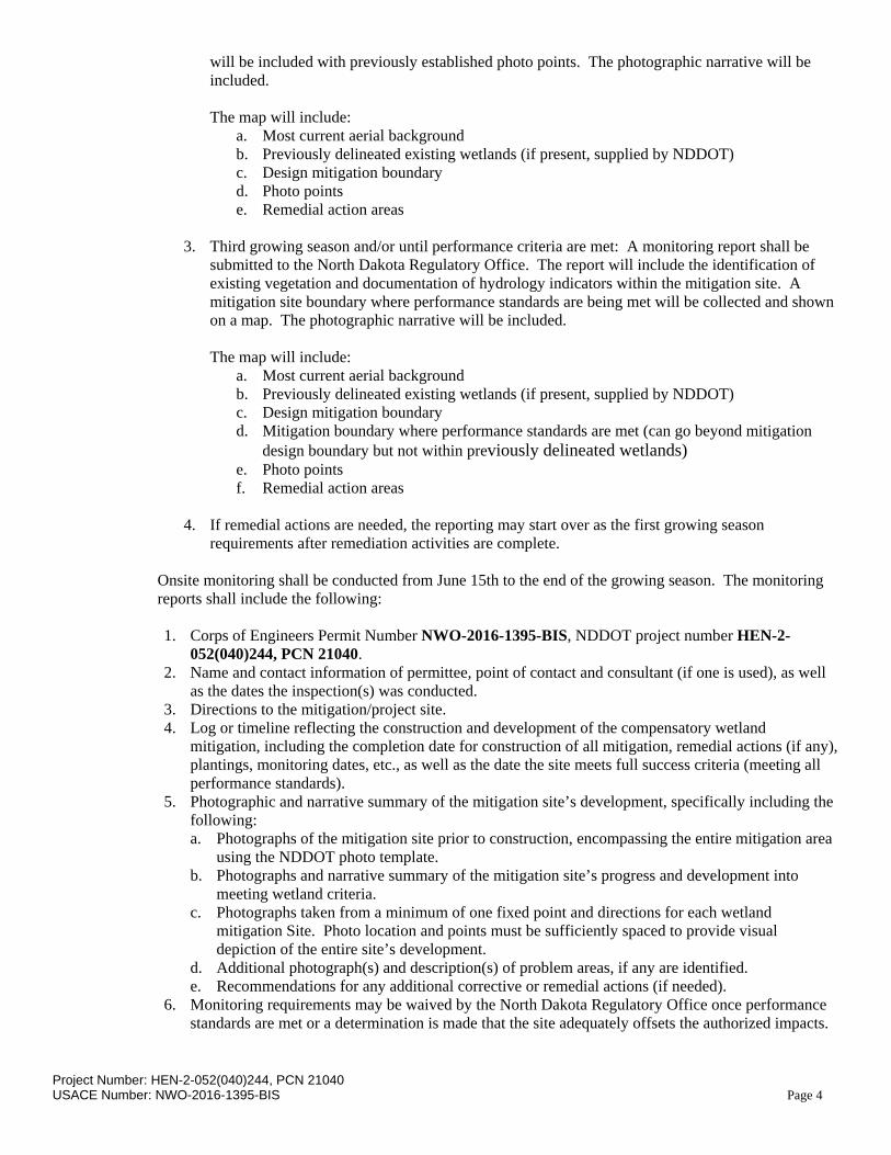
requirements after remediation activities are complete. Onsite monitoring shall be conducted from June 15th to the end of the growing season. The monitoring reports shall include the following: 1. Corps of Engineers Permit Number NWO-2016-1395-BIS, NDDOT project number HEN-2-
052(040)244, PCN 21040. 2. Name and contact information of permittee, point of contact and consultant (if one is used), as well
as the dates the inspection(s) was conducted. 3. Directions to the mitigation/project site. 4. Log or timeline reflecting the construction and development of the compensatory wetland
mitigation, including the completion date for construction of all mitigation, remedial actions (if any), plantings, monitoring dates, etc., as well as the date the site meets full success criteria (meeting all performance standards).
5. Photographic and narrative summary of the mitigation site’s development, specifically including the following: a. Photographs of the mitigation site prior to construction, encompassing the entire mitigation area
using the NDDOT photo template. b. Photographs and narrative summary of the mitigation site’s progress and development into
meeting wetland criteria. c. Photographs taken from a minimum of one fixed point and directions for each wetland
mitigation Site. Photo location and points must be sufficiently spaced to provide visual depiction of the entire site’s development.
d. Additional photograph(s) and description(s) of problem areas, if any are identified. e. Recommendations for any additional corrective or remedial actions (if needed).
6. Monitoring requirements may be waived by the North Dakota Regulatory Office once performance standards are met or a determination is made that the site adequately offsets the authorized impacts.
Project Number: HEN-2-052(040)244, PCN 21040 USACE Number: NWO-2016-1395-BIS Page 5
III. Reports shall be sent to: North Dakota Regulatory Office, 1513 South 12th Street, Bismarck, North Dakota, 58504
10. LONG-TERM MANAGEMENT PLAN: The NDDOT will continue to manage the site with noxious weed control, periodic mowing, and litter removal along with the adjacent road right of way. Repairs will be to the original construction specification. The NDDOT will inform the USACE if any corrective measures are needed.
11. ADAPTIVE MANAGEMENT PLAN:
The NDDOT will continue to manage the site with noxious weed control, periodic mowing to reduce litter accumulation, and repair of any structures to original construction specification. The NDDOT will inform the USACE of any adaptive management needs.
12. FINANCIAL ASSURANCES: Sufficient funds will be available to pay for monitoring and maintenance in the future. The Department receives an allocation from the North Dakota Legislature on biennium basis for road development and maintenance. Historically the NDDOT has allocated $0.5 million annually for wetland mitigation development, management and monitoring.

'Pingree; ND'; Scale: 1" = 0.275Mi 443Mt 1,455Ft, 1 Mi = 3.630" , 1 cm = 175Mt
steve.thompson
Callout
Contributing Watershed 42.8 Acres
steve.thompson
Callout
Wetland Number 1d(c) mitigation area. Section 34, T 143N, R 65W, 0.14 Acres, 47.1661250 -98.905740
steve.thompson
Oval
steve.thompson
Line
steve.thompson
Line
steve.thompson
Callout
Project Location
steve.thompson
Line
steve.thompson
Text Box
N
steve.thompson
Text Box
HEN-2-052(040)244 PCN 21040
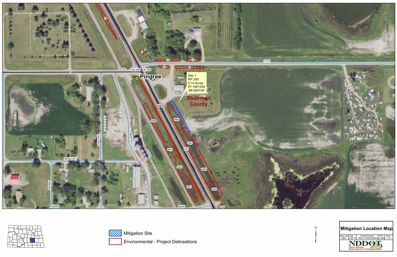
Site 1RP 2450.14 Acres47.1661250-98.905740
52
3690.344244.865
245
StutsmanCounty
DERB
Y
MAIN
WHALLEY
MAIN
ENGL
ISH
BENTLEY
17TH2
3
7b7a
6
5
1d(a)
1d(b)
1d(c)
1d(d)
1a(b)
1a(d)
1a(c)
1a(a)
1c(b)
Pingree
Mitigation SiteEnvironmental - Project Delineations
Drawn By:SEK
Project Number: PCN:Date: Sheet:1 of 1
Mitigation Location Map1/26/17 HEN-2-052(040)244 21040
Soil Map—Stutsman County, North Dakota(HEN-2-052(040)244 PCN 21040)
Natural ResourcesConservation Service
Web Soil SurveyNational Cooperative Soil Survey
12/30/2016Page 1 of 3
5223
610
5223
660
5223
710
5223
760
5223
810
5223
860
5223
910
5223
610
5223
660
5223
710
5223
760
5223
810
5223
860
5223
910
506790 506840 506890 506940 506990 507040 507090 507140 507190 507240 507290
506790 506840 506890 506940 506990 507040 507090 507140 507190 507240 507290
47° 10' 7'' N98
° 5
4' 3
8'' W
47° 10' 7'' N
98° 5
4' 1
3'' W
47° 9' 56'' N
98° 5
4' 3
8'' W
47° 9' 56'' N
98° 5
4' 1
3'' W
N
Map projection: Web Mercator Corner coordinates: WGS84 Edge tics: UTM Zone 14N WGS840 100 200 400 600
Feet0 35 70 140 210
MetersMap Scale: 1:2,400 if printed on A landscape (11" x 8.5") sheet.
Soil Map may not be valid at this scale.
Map Unit Description
The map units delineated on the detailed soil maps in a soil survey represent thesoils or miscellaneous areas in the survey area. The map unit descriptions in thisreport, along with the maps, can be used to determine the composition andproperties of a unit.
A map unit delineation on a soil map represents an area dominated by one ormore major kinds of soil or miscellaneous areas. A map unit is identified andnamed according to the taxonomic classification of the dominant soils. Within ataxonomic class there are precisely defined limits for the properties of the soils.On the landscape, however, the soils are natural phenomena, and they have thecharacteristic variability of all natural phenomena. Thus, the range of someobserved properties may extend beyond the limits defined for a taxonomic class.Areas of soils of a single taxonomic class rarely, if ever, can be mapped withoutincluding areas of other taxonomic classes. Consequently, every map unit ismade up of the soils or miscellaneous areas for which it is named and someminor components that belong to taxonomic classes other than those of themajor soils.
Most minor soils have properties similar to those of the dominant soil or soils inthe map unit, and thus they do not affect use and management. These are callednoncontrasting, or similar, components. They may or may not be mentioned in aparticular map unit description. Other minor components, however, haveproperties and behavioral characteristics divergent enough to affect use or torequire different management. These are called contrasting, or dissimilar,components. They generally are in small areas and could not be mappedseparately because of the scale used. Some small areas of strongly contrastingsoils or miscellaneous areas are identified by a special symbol on the maps. Ifincluded in the database for a given area, the contrasting minor components areidentified in the map unit descriptions along with some characteristics of each. Afew areas of minor components may not have been observed, and consequentlythey are not mentioned in the descriptions, especially where the pattern was socomplex that it was impractical to make enough observations to identify all thesoils and miscellaneous areas on the landscape.
The presence of minor components in a map unit in no way diminishes theusefulness or accuracy of the data. The objective of mapping is not to delineatepure taxonomic classes but rather to separate the landscape into landforms orlandform segments that have similar use and management requirements. Thedelineation of such segments on the map provides sufficient information for thedevelopment of resource plans. If intensive use of small areas is planned,however, onsite investigation is needed to define and locate the soils andmiscellaneous areas.
An identifying symbol precedes the map unit name in the map unit descriptions.Each description includes general facts about the unit and gives important soilproperties and qualities.
Map Unit Description: Swenoda-Barnes fine sandy loams, 0 to 3 percent slopes---StutsmanCounty, North Dakota
HEN-2-052(040)244 PCN 21040
Natural ResourcesConservation Service
Web Soil SurveyNational Cooperative Soil Survey
12/30/2016Page 1 of 5
Soils that have profiles that are almost alike make up a soil series. All the soils ofa series have major horizons that are similar in composition, thickness, andarrangement. Soils of a given series can differ in texture of the surface layer,slope, stoniness, salinity, degree of erosion, and other characteristics that affecttheir use. On the basis of such differences, a soil series is divided into soilphases. Most of the areas shown on the detailed soil maps are phases of soilseries. The name of a soil phase commonly indicates a feature that affects use ormanagement. For example, Alpha silt loam, 0 to 2 percent slopes, is a phase ofthe Alpha series.
Some map units are made up of two or more major soils or miscellaneous areas.These map units are complexes, associations, or undifferentiated groups.
A complex consists of two or more soils or miscellaneous areas in such anintricate pattern or in such small areas that they cannot be shown separately onthe maps. The pattern and proportion of the soils or miscellaneous areas aresomewhat similar in all areas. Alpha-Beta complex, 0 to 6 percent slopes, is anexample.
An association is made up of two or more geographically associated soils ormiscellaneous areas that are shown as one unit on the maps. Because ofpresent or anticipated uses of the map units in the survey area, it was notconsidered practical or necessary to map the soils or miscellaneous areasseparately. The pattern and relative proportion of the soils or miscellaneousareas are somewhat similar. Alpha-Beta association, 0 to 2 percent slopes, is anexample.
An undifferentiated group is made up of two or more soils or miscellaneous areasthat could be mapped individually but are mapped as one unit because similarinterpretations can be made for use and management. The pattern andproportion of the soils or miscellaneous areas in a mapped area are not uniform.An area can be made up of only one of the major soils or miscellaneous areas, orit can be made up of all of them. Alpha and Beta soils, 0 to 2 percent slopes, isan example.
Some surveys include miscellaneous areas. Such areas have little or no soilmaterial and support little or no vegetation. Rock outcrop is an example.
Additional information about the map units described in this report is available inother soil reports, which give properties of the soils and the limitations,capabilities, and potentials for many uses. Also, the narratives that accompanythe soil reports define some of the properties included in the map unitdescriptions.
Stutsman County, North Dakota
G732A—Swenoda-Barnes fine sandy loams, 0 to 3 percentslopes
Map Unit SettingNational map unit symbol: 2q5wqElevation: 1,000 to 2,050 feetMean annual precipitation: 16 to 20 inchesMean annual air temperature: 39 to 45 degrees F
Map Unit Description: Swenoda-Barnes fine sandy loams, 0 to 3 percent slopes---StutsmanCounty, North Dakota
HEN-2-052(040)244 PCN 21040
Natural ResourcesConservation Service
Web Soil SurveyNational Cooperative Soil Survey
12/30/2016Page 2 of 5
Frost-free period: 120 to 140 daysFarmland classification: All areas are prime farmland
Map Unit CompositionSwenoda and similar soils: 49 percentBarnes and similar soils: 20 percentMinor components: 31 percentEstimates are based on observations, descriptions, and transects of
the mapunit.
Description of Swenoda
SettingLandform: RisesDown-slope shape: ConcaveAcross-slope shape: LinearParent material: Coarse-loamy eolian deposits over fine-loamy till
Typical profileAp - 0 to 9 inches: fine sandy loamA - 9 to 13 inches: fine sandy loamBw - 13 to 33 inches: fine sandy loam2Bk - 33 to 39 inches: loam2C - 39 to 60 inches: loam
Properties and qualitiesSlope: 0 to 3 percentDepth to restrictive feature: More than 80 inchesNatural drainage class: Moderately well drainedRunoff class: LowCapacity of the most limiting layer to transmit water (Ksat):
Moderately low to moderately high (0.14 to 1.42 in/hr)Depth to water table: About 36 to 60 inchesFrequency of flooding: NoneFrequency of ponding: NoneCalcium carbonate, maximum in profile: 30 percentGypsum, maximum in profile: 1 percentSalinity, maximum in profile: Nonsaline to slightly saline (0.0 to 4.0
mmhos/cm)Available water storage in profile: High (about 9.5 inches)
Interpretive groupsLand capability classification (irrigated): None specifiedLand capability classification (nonirrigated): 3eHydrologic Soil Group: BEcological site: Loamy Overflow (R055BY059ND)Other vegetative classification: Overflow (G055BY500ND)Hydric soil rating: No
Description of Barnes
SettingLandform: RisesDown-slope shape: Convex
Map Unit Description: Swenoda-Barnes fine sandy loams, 0 to 3 percent slopes---StutsmanCounty, North Dakota
HEN-2-052(040)244 PCN 21040
Natural ResourcesConservation Service
Web Soil SurveyNational Cooperative Soil Survey
12/30/2016Page 3 of 5

Across-slope shape: LinearParent material: Fine-loamy till
Typical profileAp - 0 to 7 inches: fine sandy loamBw - 7 to 19 inches: loamBk - 19 to 37 inches: loamC - 37 to 60 inches: loam
Properties and qualitiesSlope: 0 to 3 percentDepth to restrictive feature: More than 80 inchesNatural drainage class: Well drainedRunoff class: LowCapacity of the most limiting layer to transmit water (Ksat):
Moderately low to moderately high (0.14 to 1.42 in/hr)Depth to water table: About 48 to 72 inchesFrequency of flooding: NoneFrequency of ponding: NoneCalcium carbonate, maximum in profile: 30 percentGypsum, maximum in profile: 1 percentSalinity, maximum in profile: Nonsaline to slightly saline (0.0 to 4.0
mmhos/cm)Available water storage in profile: High (about 10.2 inches)
Interpretive groupsLand capability classification (irrigated): None specifiedLand capability classification (nonirrigated): 2eHydrologic Soil Group: BEcological site: Loamy (R055BY064ND)Other vegetative classification: Loam (G055BY100ND)Hydric soil rating: No
Minor Components
TownerPercent of map unit: 10 percentLandform: RisesDown-slope shape: ConcaveAcross-slope shape: LinearEcological site: Subirrigated Sands (R055BY074ND)Other vegetative classification: Droughty Loam (G055BY120ND)Hydric soil rating: No
HamerlyPercent of map unit: 7 percentLandform: FlatsDown-slope shape: LinearAcross-slope shape: LinearEcological site: Limy Subirrigated (R055BY058ND)Other vegetative classification: Subirrigated (G055BY700ND)Hydric soil rating: No
Map Unit Description: Swenoda-Barnes fine sandy loams, 0 to 3 percent slopes---StutsmanCounty, North Dakota
HEN-2-052(040)244 PCN 21040
Natural ResourcesConservation Service
Web Soil SurveyNational Cooperative Soil Survey
12/30/2016Page 4 of 5
Wyndmere, loamy substratumPercent of map unit: 5 percentLandform: FlatsDown-slope shape: LinearAcross-slope shape: LinearEcological site: Limy Subirrigated (R055BY058ND)Other vegetative classification: Subirrigated (G055BY700ND)Hydric soil rating: No
BalatonPercent of map unit: 4 percentLandform: RisesLandform position (two-dimensional): Summit, shoulderDown-slope shape: ConvexAcross-slope shape: ConvexEcological site: Thin Loamy (R055BY068ND)Other vegetative classification: Limy Upland (G055BY400ND)Hydric soil rating: No
LanonaPercent of map unit: 3 percentLandform: RisesDown-slope shape: ConvexAcross-slope shape: LinearEcological site: Sandy (R055BY062ND)Other vegetative classification: Loam (G055BY100ND)Hydric soil rating: No
ArvesonPercent of map unit: 2 percentLandform: Depressions, flatsDown-slope shape: Concave, linearAcross-slope shape: Concave, linearEcological site: Wet Meadow (R055BY071ND)Other vegetative classification: Wet (G055BY900ND)Hydric soil rating: Yes
Data Source Information
Soil Survey Area: Stutsman County, North DakotaSurvey Area Data: Version 19, Sep 21, 2016
Map Unit Description: Swenoda-Barnes fine sandy loams, 0 to 3 percent slopes---StutsmanCounty, North Dakota
HEN-2-052(040)244 PCN 21040
Natural ResourcesConservation Service
Web Soil SurveyNational Cooperative Soil Survey
12/30/2016Page 5 of 5
Related Documents