JOURNAL OF ENVIRONMENTAL HYDROLOGY The Electronic Journal of the International Association for Environmental Hydrology On the World Wide Web at http://www.hydroweb.com VOLUME 11 2003 Journal of Environmental Hydrology Volume 11 Paper 12 October 2003 1 PROBLEMS IN ASSESSING GROUNDWATER RESOURCES IN BEDROCK AQUIFERS, ERITREA Filmon Tesfaslasie Alexander Mebrahtu Water Resources Department, Government of Eritrea Asmara, Eritrea The problems associated with bedrock aquifers are discussed in reference to an unusual groundwater condition observed in the study area. To understand and explain the problem, a geologic and hydrogeologic investigation was carried out. First, the results of previous geologic and hydrogeologic investigations conducted by JICA and Euroconsult were obtained and analyzed. Secondly, a structural map and a drainage map of the area were prepared using information extracted from topographic maps, aerial photographs and SPOT images. In addition, fieldwork was conducted during which static water levels were measured in available wells. The field data were used to develop a water table contour map from which the general direction of groundwater flow was determined. Finally, the processed data and field observa- tion were analyzed and interpreted to develop theories that explain the problem.

Welcome message from author
This document is posted to help you gain knowledge. Please leave a comment to let me know what you think about it! Share it to your friends and learn new things together.
Transcript
JOURNAL OFENVIRONMENTAL HYDROLOGY
The Electronic Journal of the International Association for Environmental HydrologyOn the World Wide Web at http://www.hydroweb.com
VOLUME 11 2003
Journal of Environmental Hydrology Volume 11 Paper 12 October 20031
PROBLEMS IN ASSESSING GROUNDWATER RESOURCESIN BEDROCK AQUIFERS, ERITREA
Filmon TesfaslasieAlexander Mebrahtu
Water Resources Department, Government of EritreaAsmara, Eritrea
The problems associated with bedrock aquifers are discussed in reference to an unusualgroundwater condition observed in the study area. To understand and explain the problem, ageologic and hydrogeologic investigation was carried out. First, the results of previousgeologic and hydrogeologic investigations conducted by JICA and Euroconsult were obtainedand analyzed. Secondly, a structural map and a drainage map of the area were prepared usinginformation extracted from topographic maps, aerial photographs and SPOT images. Inaddition, fieldwork was conducted during which static water levels were measured in availablewells. The field data were used to develop a water table contour map from which the generaldirection of groundwater flow was determined. Finally, the processed data and field observa-tion were analyzed and interpreted to develop theories that explain the problem.

Journal of Environmental Hydrology Volume 11 Paper 12 October 20032
Groundwater in Bedrock Aquifers, Eritrea Tesfaslasie and Mebrahtu
INTRODUCTION
In many regions of the world, groundwater is an essential commodity for life. Althoughgroundwater makes up only 0.61% of the total volume of water available on Earth, it constitutes themain and most reliable source of water in arid regions. In United States, for example, 58% of allavailable water supplies are derived from groundwater sources (Fetter, 1994). This percentage isbelieved to be much higher for Eritrea, given the aridity of the country.
In Eritrea nearly all of the annual rainfall is received during the summer months, and streamsystems in the country are seasonal in character. Most of the rain is delivered as high intensity, shortduration storms which generate short-lived flash floods. In addition, there is a great variability inrainfall from year to year that can greatly reduce the volume and duration of flows in streams. For thesereasons, surface water provides most of the water used during part of the year in Eritrea, but it is notconsidered a reliable source of water supply on a continuous basis.
A more reliable source of water supply that is put to different uses in Eritrea is groundwater. Thisis particularly true in the rural parts of country where communities use groundwater for domestic,livestock and agricultural purposes.
Both unconsolidated (alluvial) and bedrock aquifer systems are known to exist in Eritrea. Alluvialaquifers are found over extensive areas in the eastern lowlands and coastal areas, but are limited tovalleys and flood plains of major stream systems in the rest of the country. Bedrock aquifers consistingof weathered and fractured basement rock have wide distribution throughout much of the centralhighlands and western lowland.
In such aquifers, the occurrence and movement of groundwater is largely controlled by geologicstructures such as faults, joints, fractures, etc. As such, a good understanding of the type, orientation,density, and interrelationship of such structures is essential for assessing the storage and movementof groundwater and the potential yield of aquifers. Specifically, such an understanding is crucial tosuccessful siting of high yield wells.
Unfortunately, detailed geologic structure maps at sufficiently large scale have not yet beendeveloped for the country. In addition bedrock aquifers in Eritrea tend to be deep controllingstructures often masked by thick layers of weathered material or alluvial deposits. Exploration andsuccessful development of groundwater resources is made difficult by all these conditions. However,it is possible to partially overcome these problems through a combined use of topographic maps,aerial photographs, satellite images and carefully planned geophysical surveys. Proper analysis andinterpretation of data collected from these sources can assist in siting wells with yields that areadequate for most purposes.
STATEMENT OF THE PROBLEM
This study began when the authors learned of the existence of uncommon groundwater conditionsin the Dekemhare area based on their reading of reports of two separate investigations that wereconducted in the area by the Japan International Cooperation Agency (JICA) and Euroconsult, aninternational consulting group contracted by the Government of Eritrea. As part of the sector studyon National Water Resource and Irrigation potential, Euroconsult drilled an exploratory borehole ata site in the Adi-golgol plain. The borehole, which is located a few kilometers south of the town ofDekemhare, was dry and abandoned. The same, year JICA drilled test wells a few hundred meterson each side of the failed borehole and determined that both wells have reasonably good yields.
Journal of Environmental Hydrology Volume 11 Paper 12 October 20033
Groundwater in Bedrock Aquifers, Eritrea Tesfaslasie and Mebrahtu
The main objective of this study is therefore to collect and analyze available geologic andhydrogeologic data for the area to supplement existing observation with limited field information inorder to develop a realistic explanation for the discontinuity of groundwater occurrence as observedduring borehole drilling in the area.
BACKGROUND
The present study was conducted in a 16 km section of the Adi-Golgol plain with extendssouthward from the town of Dekemhare in the Debub administrative region of Eritrea. The regionis located in the southern end of the central highlands, which consists of extensive plateaus whoseedges are marked by escarpments and deep valleys.
The area is drained by small ephemeral streams, which flow for short periods during the year. Theflows of these streams, and storage of minor reservoirs along them, provide sources of water supplyfor part of the year. But the main source of drinking water in the area is groundwater, which alsoprovides a reliable water supply for other uses when streams dry up during the dry season. The townof Dekemhare and the village of Adi-Golgol to the south obtain their drinking water from a few hand-dug wells and boreholes constructed in the area. One of these boreholes (BH14) is the main sourceof water supply for Dekemhare. Analysis of water samples collected from these sources by the WaterResources Department shows that groundwater in the area is generally of good quality.
The general climatic and geologic conditions of the study area are outlined in the followingparagraphs.
Climate
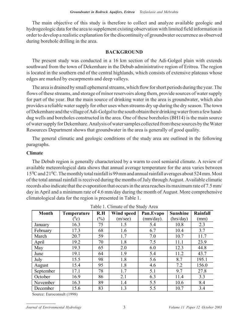
The Debub region is generally characterized by a warm to cool semiarid climate. A review ofavailable meteorological data shows that annual average temperature for the area varies between15 0C and 21 0C. The monthly total rainfall is 99 mm and annual rainfall averages about 524 mm. Mostof the total annual rainfall is received during the months of July through August. Available climaticrecords also indicate that the evaporation that occurs in the area reaches its maximum rate of 7.5 mm/day in April and a minimum rate of 4.6 mm/day during the month of August. More comprehensiveclimatological data for the region is presented in Table 1.
Month Temperature (0c)
R.H (%)
Wind speed (m/see)
Pan.Evapo (mm/day).
Sunshine (hrs/day)
Rainfall (mm)
January 16.3 75 1.5 5.4 10.8 2.3 February 17.3 68 1.6 6.7 10.4 3.7 March 20.7 59 1.7 7.0 10.7 11.7 April 19.2 70 1.8 7.5 11.1 23.9 May 19.3 65 2.0 6.0 12.3 44.8 June 19.1 64 1.9 5.4 11.2 43.7 July 15.5 98 1.8 5.6 8.7 195.1 August 15.4 95 1.8 4.6 7.2 156.0 September 17.1 78 1.7 5.1 9.7 27.8 October 16.9 86 2.1 6.3 11.4 3.3 November 16.3 89 1.4 5.5 10.6 8.4 December 15.6 83 1.3 5.5 10.7 3.4
Source: Euroconsult (1998)
Table 1. Climate of the Study Area
Journal of Environmental Hydrology Volume 11 Paper 12 October 20034
Groundwater in Bedrock Aquifers, Eritrea Tesfaslasie and Mebrahtu
Drainage
The region in which the study area is located includes parts of two regional catchments. The northand northwest part of the region is drained by a number of streams, which flow eastward into the Redsea. A much larger portion drains into the westward flowing Mereb river system. Locally, the studyarea and its surroundings are drained by three small streams, namely the Mai-edaga, Ruba Koraro andMai Elab. These streams, like the major rivers in the region, are seasonal and flow only during andshortly after the rainy season.
Local drainage in the study area is southward as controlled by the gentle slope of the Adi-Golgolplain.
Rainstorms that occur during the summer months generate flash floods in these streams, most ofwhich normally leave the area or are lost to evaporation. However, a few micro-dams have recentlybeen built on these streams retaining some of the stream flows. Water stored in these micro-dams ispresently used for irrigation and watering livestock.
Vegetation
Vegetation in the study area and its surrounding is generally sparse and consists of eucalyptus(mostly planted by communities), acacia, and shrubs. The poor vegetation cover is largely a reflectionof the aridity of the area (i.e. low rainfall and high evaporation losses). However, deforestationresulting from cutting of trees for firewood and over grazing may have reduced the area’s vegetationcover over time.
Relatively dense vegetation is observed along stream courses, possibly because of the existenceof thicker soils and better soil moisture conditions. The nearly flat topography of the Adi-Golgol plainand the reasonably thick soil cover observed over large parts of the area are conditions that promotebetter soil moisture retention capacity. Therefore it is likely that the ongoing national reforestationeffort will succeed here in reviving the vegetation cover in the area.
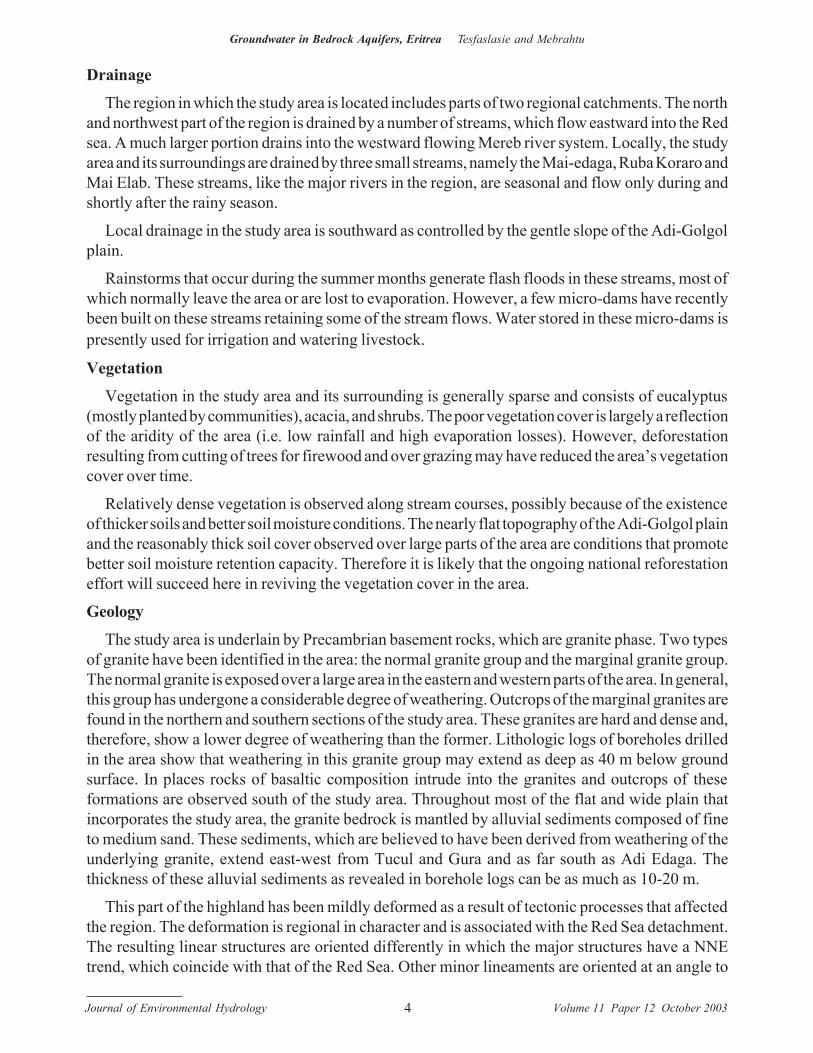
Geology
The study area is underlain by Precambrian basement rocks, which are granite phase. Two typesof granite have been identified in the area: the normal granite group and the marginal granite group.The normal granite is exposed over a large area in the eastern and western parts of the area. In general,this group has undergone a considerable degree of weathering. Outcrops of the marginal granites arefound in the northern and southern sections of the study area. These granites are hard and dense and,therefore, show a lower degree of weathering than the former. Lithologic logs of boreholes drilledin the area show that weathering in this granite group may extend as deep as 40 m below groundsurface. In places rocks of basaltic composition intrude into the granites and outcrops of theseformations are observed south of the study area. Throughout most of the flat and wide plain thatincorporates the study area, the granite bedrock is mantled by alluvial sediments composed of fineto medium sand. These sediments, which are believed to have been derived from weathering of theunderlying granite, extend east-west from Tucul and Gura and as far south as Adi Edaga. Thethickness of these alluvial sediments as revealed in borehole logs can be as much as 10-20 m.
This part of the highland has been mildly deformed as a result of tectonic processes that affectedthe region. The deformation is regional in character and is associated with the Red Sea detachment.The resulting linear structures are oriented differently in which the major structures have a NNEtrend, which coincide with that of the Red Sea. Other minor lineaments are oriented at an angle to
Journal of Environmental Hydrology Volume 11 Paper 12 October 20035
Groundwater in Bedrock Aquifers, Eritrea Tesfaslasie and Mebrahtu
the major structures. The general geology of the study area is shown in Figure 1, which was adoptedfrom the JICA report (1998).
Figure 1. Geology of study area.
Journal of Environmental Hydrology Volume 11 Paper 12 October 20036
Groundwater in Bedrock Aquifers, Eritrea Tesfaslasie and Mebrahtu
PREVIOUS HYDROGEOLOGIC WORK
Two important hydrogeological surveys were conducted recently in this area. These studies wereconducted by the Japan International Cooperation Agency (JICA) and Euroconsult (an internationalconsulting company) which implemented the sector study on National Water Resources andIrrigation potential.
JICA carried out their exploratory work during August 1997 to November 1998. The objective oftheir study was to evaluate the potential of the water resource, focusing on groundwater, to formulatea development plan for a water supply project for the town of Dekemhare. In this study first handgeologic information was obtained, a hydrogeologic map of the area was produced, and twosuccessful test wells (DEK-1 and DEK-2) were drilled.
The JICA primarily carried out a regional geological study to delineate structure of the area andto select geophysical prospecting sites. They conducted surface investigations in which three kindsof geophysical surveys were used: very low frequency electromagnetic wave sounding (VLF-EM),horizontal electric sounding (HS) and vertical electric sounding (VES). The overall analysis of thegeophysical data led them to the identification and drilling of the bore holes DEK-1 and DEK-2. Wellyields, transmissivity and water quality were determined after performing lithologic logging,pumping tests and chemical analyses (JICA, 1998).
A reconnaissance geological and hydrogeological study of the same area was carried out earlierby Euroconsult. Assessment of the groundwater resource, in terms of their distribution, quality,quantity and their potential was the main objective of the study. Also geological characterization wasone of the specific aspects in the study.
Euroconsult conducted successive investigations at the study area. After applying the full rangeof geophysical techniques including TDEM and VES sounding (Euroconsult, 1998), they drilled asingle borehole (BH-16) as an exploratory well. Although they report that they encountered highconductivity, the borehole was found to be dry. In their report, there are some missing data, and theirdescription of the location of the borehole is ambiguous. Besides, they did not give a description ofwhat was performed at the site, and an adequate explanation for the failure of the drilling effort.
PRESENT STUDY
Data Collection
The topographic, geologic, hydrologic and hydrogeologic data of the study area, which arerelevant to the objectives of the present study, were obtained from different sources. The basic sourcesof information include topographic maps, aerial photographs, SPOT images and existing reports ofgeologic and hydrogeologic investigations and studies that were conducted in the study area by otherinvestigators. These resource materials were obtained mostly from the Department of Mines(Ministry of Mines and Energy) and the Water Resources Department (Ministry of Land, Water andEnvironment)
In addition, the authors spent time discussing various aspects of the project with geologists andhydrogeologists at that same institution. Most of these professionals had either worked in the area orwere familiar with its geology and hydrogeology. Therefore they were in the position to provideadditional useful information, and to discuss problems and ideas that are of relevance to the present
Journal of Environmental Hydrology Volume 11 Paper 12 October 20037
Groundwater in Bedrock Aquifers, Eritrea Tesfaslasie and Mebrahtu
study. Finally, the authors conducted a reconnaissance field visit to the area to verify aspects ofinformation obtained from the above sources. The field visit also allowed static water level to bemeasured in all accessible boreholes in the study area.
The desk study, library research, and the field visit conducted by the authors allowed the followingproducts to be developed for the study:
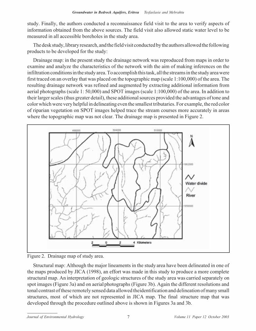
Drainage map: in the present study the drainage network was reproduced from maps in order toexamine and analyze the characteristics of the network with the aim of making inferences on theinfiltration conditions in the study area. To accomplish this task, all the streams in the study area werefirst traced on an overlay that was placed on the topographic map (scale 1:100,000) of the area. Theresulting drainage network was refined and augmented by extracting additional information fromaerial photographs (scale 1: 50,000) and SPOT images (scale 1:100,000) of the area. In addition totheir larger scales (thus greater detail), these additional sources provided the advantages of tone andcolor which were very helpful in delineating even the smallest tributaries. For example, the red colorof riparian vegetation on SPOT images helped trace the stream courses more accurately in areaswhere the topographic map was not clear. The drainage map is presented in Figure 2.
Figure 2. Drainage map of study area.
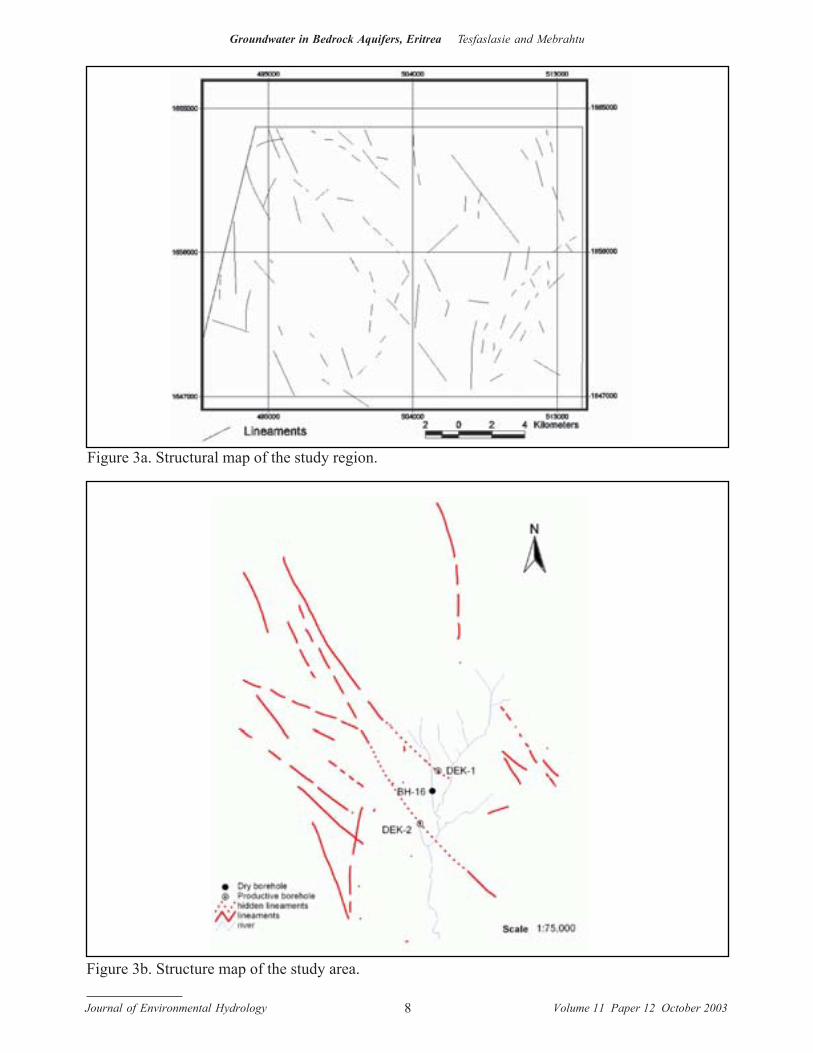
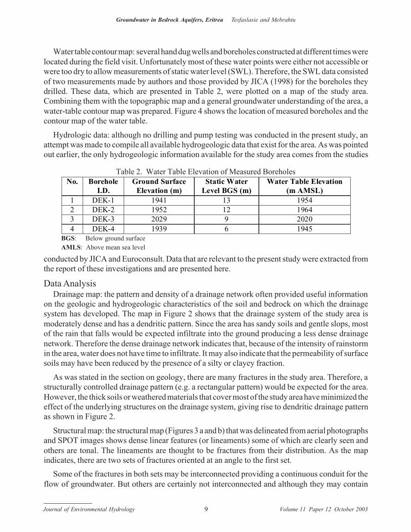
Structural map: Although the major lineaments in the study area have been delineated in one ofthe maps produced by JICA (1998), an effort was made in this study to produce a more completestructural map. An interpretation of geologic structures of the study area was carried separately onspot images (Figure 3a) and on aerial photographs (Figure 3b). Again the different resolutions andtonal contrast of these remotely sensed data allowed the identification and delineation of many smallstructures, most of which are not represented in JICA map. The final structure map that wasdeveloped through the procedure outlined above is shown in Figures 3a and 3b.
Journal of Environmental Hydrology Volume 11 Paper 12 October 20038
Groundwater in Bedrock Aquifers, Eritrea Tesfaslasie and Mebrahtu
Figure 3a. Structural map of the study region.
Figure 3b. Structure map of the study area.
Journal of Environmental Hydrology Volume 11 Paper 12 October 20039
Groundwater in Bedrock Aquifers, Eritrea Tesfaslasie and Mebrahtu
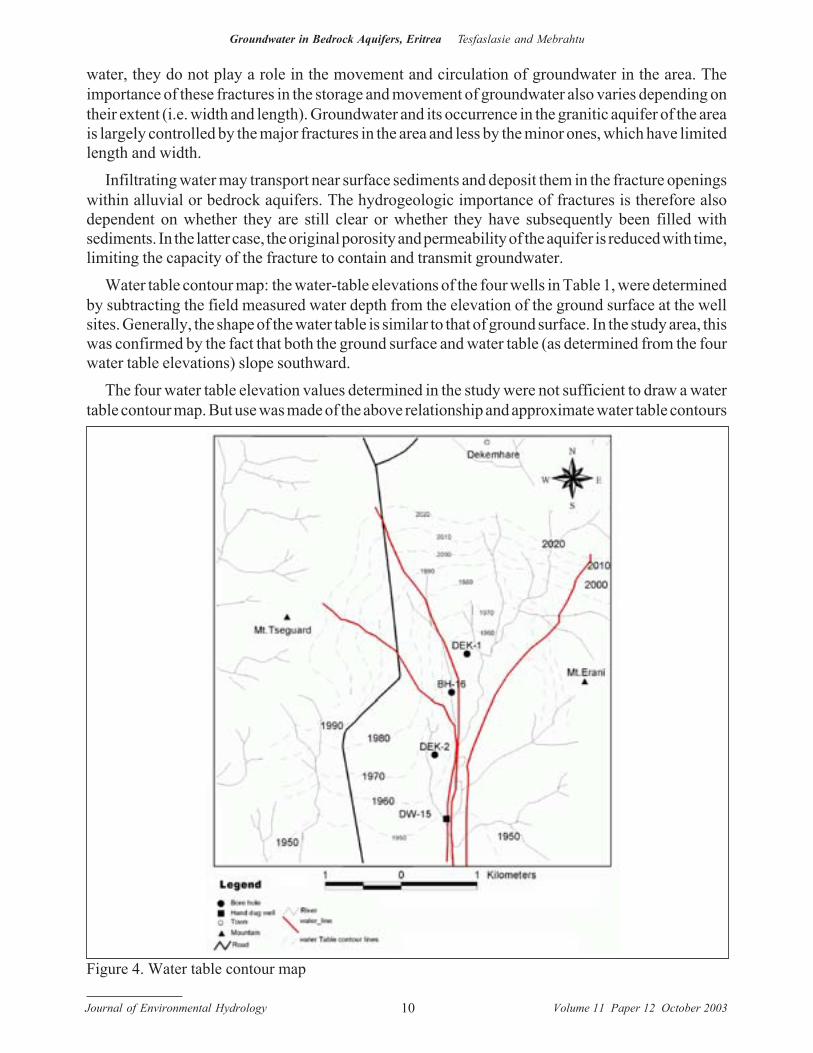
Water table contour map: several hand dug wells and boreholes constructed at different times werelocated during the field visit. Unfortunately most of these water points were either not accessible orwere too dry to allow measurements of static water level (SWL). Therefore, the SWL data consistedof two measurements made by authors and those provided by JICA (1998) for the boreholes theydrilled. These data, which are presented in Table 2, were plotted on a map of the study area.Combining them with the topographic map and a general groundwater understanding of the area, awater-table contour map was prepared. Figure 4 shows the location of measured boreholes and thecontour map of the water table.
Hydrologic data: although no drilling and pump testing was conducted in the present study, anattempt was made to compile all available hydrogeologic data that exist for the area. As was pointedout earlier, the only hydrogeologic information available for the study area comes from the studies
No. Borehole I.D.
Ground Surface Elevation (m)
Static Water Level BGS (m)
Water Table Elevation (m AMSL)
1 DEK-1 1941 13 1954 2 DEK-2 1952 12 1964 3 DEK-3 2029 9 2020 4 DEK-4 1939 6 1945
Table 2. Water Table Elevation of Measured Boreholes
BGS: Below ground surfaceAMLS: Above mean sea level
conducted by JICA and Euroconsult. Data that are relevant to the present study were extracted fromthe report of these investigations and are presented here.
Data AnalysisDrainage map: the pattern and density of a drainage network often provided useful information
on the geologic and hydrogeologic characteristics of the soil and bedrock on which the drainagesystem has developed. The map in Figure 2 shows that the drainage system of the study area ismoderately dense and has a dendritic pattern. Since the area has sandy soils and gentle slops, mostof the rain that falls would be expected infiltrate into the ground producing a less dense drainagenetwork. Therefore the dense drainage network indicates that, because of the intensity of rainstormin the area, water does not have time to infiltrate. It may also indicate that the permeability of surfacesoils may have been reduced by the presence of a silty or clayey fraction.
As was stated in the section on geology, there are many fractures in the study area. Therefore, astructurally controlled drainage pattern (e.g. a rectangular pattern) would be expected for the area.However, the thick soils or weathered materials that cover most of the study area have minimized theeffect of the underlying structures on the drainage system, giving rise to dendritic drainage patternas shown in Figure 2.
Structural map: the structural map (Figures 3 a and b) that was delineated from aerial photographsand SPOT images shows dense linear features (or lineaments) some of which are clearly seen andothers are tonal. The lineaments are thought to be fractures from their distribution. As the mapindicates, there are two sets of fractures oriented at an angle to the first set.
Some of the fractures in both sets may be interconnected providing a continuous conduit for theflow of groundwater. But others are certainly not interconnected and although they may contain
Journal of Environmental Hydrology Volume 11 Paper 12 October 200310
Groundwater in Bedrock Aquifers, Eritrea Tesfaslasie and Mebrahtu
Figure 4. Water table contour map
water, they do not play a role in the movement and circulation of groundwater in the area. Theimportance of these fractures in the storage and movement of groundwater also varies depending ontheir extent (i.e. width and length). Groundwater and its occurrence in the granitic aquifer of the areais largely controlled by the major fractures in the area and less by the minor ones, which have limitedlength and width.
Infiltrating water may transport near surface sediments and deposit them in the fracture openingswithin alluvial or bedrock aquifers. The hydrogeologic importance of fractures is therefore alsodependent on whether they are still clear or whether they have subsequently been filled withsediments. In the latter case, the original porosity and permeability of the aquifer is reduced with time,limiting the capacity of the fracture to contain and transmit groundwater.
Water table contour map: the water-table elevations of the four wells in Table 1, were determinedby subtracting the field measured water depth from the elevation of the ground surface at the wellsites. Generally, the shape of the water table is similar to that of ground surface. In the study area, thiswas confirmed by the fact that both the ground surface and water table (as determined from the fourwater table elevations) slope southward.
The four water table elevation values determined in the study were not sufficient to draw a watertable contour map. But use was made of the above relationship and approximate water table contours
Journal of Environmental Hydrology Volume 11 Paper 12 October 200311
Groundwater in Bedrock Aquifers, Eritrea Tesfaslasie and Mebrahtu
were drawn by using the topographic contours of the area as a guide. This produces a water tablecontour map for part of the study area (see Figure 4). The approximate nature of the contour map isindicated in the figure by drawing the individual contours as dashed lines.
Groundwater flows in the direction of steepest hydraulic gradient or water table slope. Thus, oncethe contour lines were drawn, it was possible to include in the map representative but approximategroundwater flow paths (i.e. lines showing the direction of groundwater flow) by drawing lines thatintersect the contour lines at right angles. These lines have been drawn in red in Figure 4.
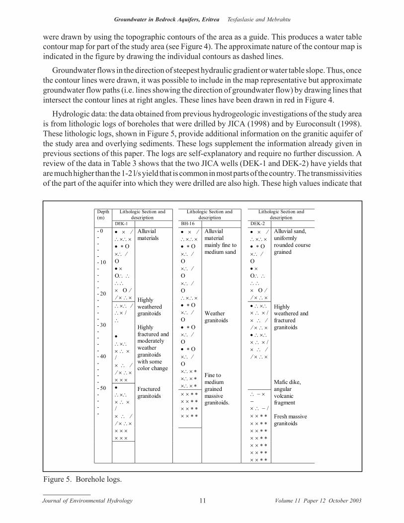
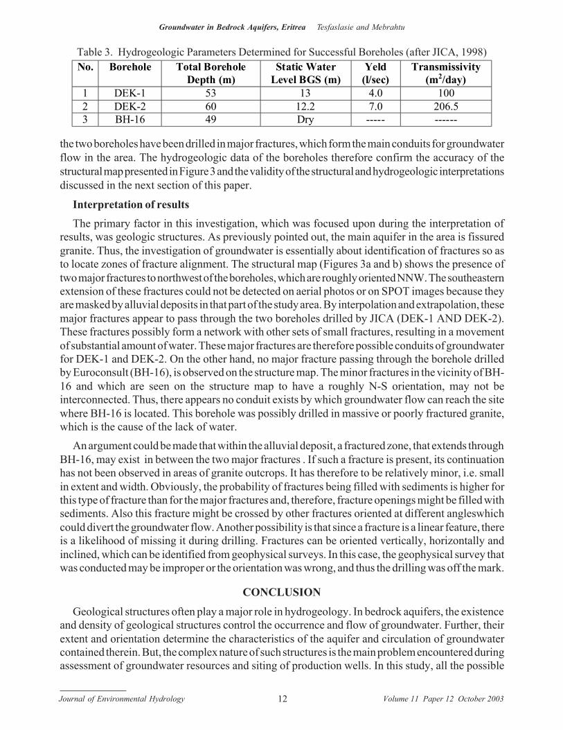
Hydrologic data: the data obtained from previous hydrogeologic investigations of the study areais from lithologic logs of boreholes that were drilled by JICA (1998) and by Euroconsult (1998).These lithologic logs, shown in Figure 5, provide additional information on the granitic aquifer ofthe study area and overlying sediments. These logs supplement the information already given inprevious sections of this paper. The logs are self-explanatory and require no further discussion. Areview of the data in Table 3 shows that the two JICA wells (DEK-1 and DEK-2) have yields thatare much higher than the 1-2 l/s yield that is common in most parts of the country. The transmissivitiesof the part of the aquifer into which they were drilled are also high. These high values indicate that
Lithologic Section and description
Lithologic Section and description
Lithologic Section and description
Depth (m)
DEK-1 BH-16
DEK-2
• × ⁄ ∴×∴× • ∗ Ο ×∴ ⁄ Ο ×∴ ⁄ Ο
• × ⁄ ∴×∴× • ∗ Ο ×∴ ⁄ Ο • × Ο∴ ∴ ∴∴ × Ο ⁄ ⁄ × ∴×
• × ⁄ ∴×∴× • ∗ Ο ×∴ ⁄ Ο • × Ο∴ ∴ ∴∴ × Ο ⁄ ⁄ × ∴×
×∴ ⁄ Ο ∴×∴× • ∗ Ο ×∴ ⁄ Ο
∴×∴ ⁄ ∴× / ∴
• ∴×∴ × ∴ × / × ∴ ⁄ ⁄ × ∴× × × ×
• ∗ Ο ×∴ ⁄ Ο • ∗ Ο ×∴ ⁄ Ο ×∴× ∗ ×∴× ∗ ×∴× ∗
• ∴×∴ × ∴ × / × ∴ ⁄ ⁄ × ∴× • ∴×∴ × ∴ × / × ∴ ⁄ ⁄ × ∴×
∴ − × − × ∴ − /
× × ∗ ∗ × × ∗ ∗ × × ∗ ∗ × × ∗ ∗
• ∴×∴ × ∴ × / × ∴ ⁄ ⁄ × ∴× × × × × × ×
- 0 - - - - - 10 - - - - - 20 - - - - - 30 - - - - - 40 - - - - - 50 - - - -
Alluvial materials Highly weathered granitoids Highly fractured and moderately weather granitoids with some color change Fractured granitoids
Alluvial material mainly fine to medium sand Weather granitoids Fine to medium grained massive granitoids.
× × ∗ ∗ × × ∗ ∗ × × ∗ ∗ × × ∗ ∗ × × ∗ ∗ × × ∗ ∗ × × ∗ ∗
Alluvial sand, uniformly rounded course grained Highly weathered and fractured granitoids Mafic dike, angular volcanic fragment Fresh massive granitoids
Figure 5. Borehole logs.
Journal of Environmental Hydrology Volume 11 Paper 12 October 200312
Groundwater in Bedrock Aquifers, Eritrea Tesfaslasie and Mebrahtu
the two boreholes have been drilled in major fractures, which form the main conduits for groundwaterflow in the area. The hydrogeologic data of the boreholes therefore confirm the accuracy of thestructural map presented in Figure 3 and the validity of the structural and hydrogeologic interpretationsdiscussed in the next section of this paper.
Interpretation of resultsThe primary factor in this investigation, which was focused upon during the interpretation of
results, was geologic structures. As previously pointed out, the main aquifer in the area is fissuredgranite. Thus, the investigation of groundwater is essentially about identification of fractures so asto locate zones of fracture alignment. The structural map (Figures 3a and b) shows the presence oftwo major fractures to northwest of the boreholes, which are roughly oriented NNW. The southeasternextension of these fractures could not be detected on aerial photos or on SPOT images because theyare masked by alluvial deposits in that part of the study area. By interpolation and extrapolation, thesemajor fractures appear to pass through the two boreholes drilled by JICA (DEK-1 AND DEK-2).These fractures possibly form a network with other sets of small fractures, resulting in a movementof substantial amount of water. These major fractures are therefore possible conduits of groundwaterfor DEK-1 and DEK-2. On the other hand, no major fracture passing through the borehole drilledby Euroconsult (BH-16), is observed on the structure map. The minor fractures in the vicinity of BH-16 and which are seen on the structure map to have a roughly N-S orientation, may not beinterconnected. Thus, there appears no conduit exists by which groundwater flow can reach the sitewhere BH-16 is located. This borehole was possibly drilled in massive or poorly fractured granite,which is the cause of the lack of water.
An argument could be made that within the alluvial deposit, a fractured zone, that extends throughBH-16, may exist in between the two major fractures . If such a fracture is present, its continuationhas not been observed in areas of granite outcrops. It has therefore to be relatively minor, i.e. smallin extent and width. Obviously, the probability of fractures being filled with sediments is higher forthis type of fracture than for the major fractures and, therefore, fracture openings might be filled withsediments. Also this fracture might be crossed by other fractures oriented at different angleswhichcould divert the groundwater flow. Another possibility is that since a fracture is a linear feature, thereis a likelihood of missing it during drilling. Fractures can be oriented vertically, horizontally andinclined, which can be identified from geophysical surveys. In this case, the geophysical survey thatwas conducted may be improper or the orientation was wrong, and thus the drilling was off the mark.
CONCLUSION
Geological structures often play a major role in hydrogeology. In bedrock aquifers, the existenceand density of geological structures control the occurrence and flow of groundwater. Further, theirextent and orientation determine the characteristics of the aquifer and circulation of groundwatercontained therein. But, the complex nature of such structures is the main problem encountered duringassessment of groundwater resources and siting of production wells. In this study, all the possible
No. Borehole Total Borehole Depth (m)
Static Water Level BGS (m)
Yeld (l/sec)
Transmissivity (m2/day)
1 DEK-1 53 13 4.0 100 2 DEK-2 60 12.2 7.0 206.5 3 BH-16 49 Dry ----- ------
Table 3. Hydrogeologic Parameters Determined for Successful Boreholes (after JICA, 1998)
Journal of Environmental Hydrology Volume 11 Paper 12 October 200313
Groundwater in Bedrock Aquifers, Eritrea Tesfaslasie and Mebrahtu
explanations that the authors have presented for the stated hydrogeologic problem is directly orindirectly related to geological structures. Thus, in siting wells in bedrock aquifers, all existingstructures must be identified and delineated from all sources, including aerial photographs andsatellite images. Analyzing and interpreting information obtained from these sources together withthe results of properly conducted geophysical surveys, are vital in the investigation of such aquifers.
ACKNOWLEDGMENT
The preparation of this paper would have been impossible with out the continuous guidance andencouragement of Dr. Yemane Zecharias, Department of Water Resources, who has supervised ourwork from the beginning. We also gratefully acknowledge the assistance of Dr. Seife Berh whohelped with interpreting SPOT images and provided us with aerial photographs. Last but not least,we thank members of the Department of Water Resources in general for the assistance they gave us.
REFERENCES
JICA; (1998). Study on groundwater development and water supply for Dekemhare, Vol. 1 and 2.Euroconsult; (1998). Sector study on National Water Resources and Irrigation Potential in Eritrea, Groundwater
Components Volume 1 and 2.Fetter, C.W.; (1994). Applied Hydrogeology, 3rd edition, Prentice-Hall, London, pp.681
ADDRESS FOR CORRESPONDENCEFilmon TesfaslasieWRDPO Box 1488AsmaraEritrea (North East Africa)
E-mail: [email protected]
Related Documents