• Jean-Paul Lavoie Jean-Paul Lavoie Geodesy, San Francisco Geodesy, San Francisco • Dave Matson Dave Matson City of Palo Alto City of Palo Alto Delivering Documents Delivering Documents GIS for Low Cost Document GIS for Low Cost Document Management Management GIS-Centric Document GIS-Centric Document Management Management CalGIS, April CalGIS, April 2007 2007

Jean-Paul LavoieJean-Paul Lavoie Geodesy, San Francisco Dave MatsonDave Matson City of Palo Alto Delivering Documents GIS for Low Cost Document Management.
Dec 24, 2015
Welcome message from author
This document is posted to help you gain knowledge. Please leave a comment to let me know what you think about it! Share it to your friends and learn new things together.
Transcript

• Jean-Paul LavoieJean-Paul LavoieGeodesy, San FranciscoGeodesy, San Francisco
• Dave MatsonDave MatsonCity of Palo AltoCity of Palo Alto
Delivering DocumentsDelivering DocumentsGIS for Low Cost Document ManagementGIS for Low Cost Document Management
GIS-Centric Document GIS-Centric Document ManagementManagement
CalGIS, April CalGIS, April 20072007

• At its essence, Dox is just files in folders on a At its essence, Dox is just files in folders on a network, organized for viewing from a GIS.network, organized for viewing from a GIS.
• Got a GIS? You can use it to spatially index just Got a GIS? You can use it to spatially index just about any document at your agency.about any document at your agency.
• Using your GIS as an entrée to document Using your GIS as an entrée to document management can extend the value of GIS. management can extend the value of GIS.
Dox: (Nearly) Free Document Dox: (Nearly) Free Document ManagementManagement
GIS-Centric Document GIS-Centric Document ManagementManagement
CalGIS, April CalGIS, April 20072007

• We started viewing individual feature-related documents We started viewing individual feature-related documents from the GIS about five years ago.from the GIS about five years ago.
• Dox was conceived of three years ago with a comment Dox was conceived of three years ago with a comment from Palo Alto’s Planning Department.from Palo Alto’s Planning Department.
• Palo Alto was using an aging optical disk-based Informix Palo Alto was using an aging optical disk-based Informix database called BODS to store their documents.database called BODS to store their documents.
• Geodesy reverse-engineered the Informix database Geodesy reverse-engineered the Informix database design and extracted the contents.design and extracted the contents.
• The result is an “interim” system to contain the The result is an “interim” system to contain the documents until a larger, ERP-based document documents until a larger, ERP-based document management solution is in place.management solution is in place.
A Brief History of DoxA Brief History of Dox
GIS-Centric Document GIS-Centric Document ManagementManagement
CalGIS, April CalGIS, April 20072007

• Dox is based on files in folders.Dox is based on files in folders.
• It is useful for just about any file format.It is useful for just about any file format.
• PDF has become the most ubiquitous format.PDF has become the most ubiquitous format.
• A number of Palo Alto departments are now using Dox.A number of Palo Alto departments are now using Dox.
• There are over a million files in Dox so far at Palo Alto.There are over a million files in Dox so far at Palo Alto.
• Other agencies have implemented Dox to various Other agencies have implemented Dox to various degrees.degrees.
Current Scope of DoxCurrent Scope of Dox
GIS-Centric Document GIS-Centric Document ManagementManagement
CalGIS, April CalGIS, April 20072007

Folder HierarchyFolder Hierarchy
DepartmentDepartment “ “Streets”Streets” Street NameStreet Name Block NumberBlock Number Address NumberAddress Number Unit NumberUnit Number Permit NumberPermit Number
Organizing Documents by Street Organizing Documents by Street AddressAddress
GIS-Centric Document GIS-Centric Document ManagementManagement
CalGIS, April CalGIS, April 20072007

Linking the GIS to Address-Based Linking the GIS to Address-Based DocumentsDocuments
GIS-Centric Document GIS-Centric Document ManagementManagement
CalGIS, April CalGIS, April 20072007
LogicLogic LogicLogic
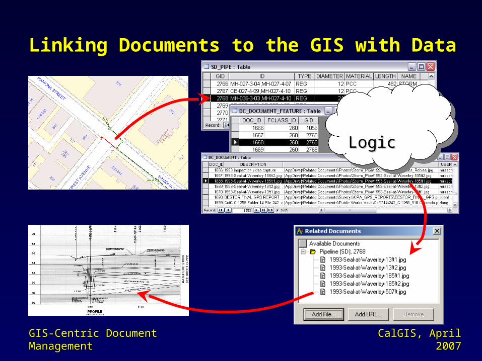
Linking Documents to the GIS with DataLinking Documents to the GIS with Data
GIS-Centric Document GIS-Centric Document ManagementManagement
CalGIS, April CalGIS, April 20072007
LogicLogic LogicLogic
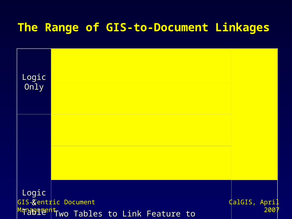
The Range of GIS-to-Document LinkagesThe Range of GIS-to-Document Linkages
GIS-Centric Document GIS-Centric Document ManagementManagement
CalGIS, April CalGIS, April 20072007
Logic Logic OnlyOnly
User-Readable Folder Names (like street User-Readable Folder Names (like street addresses or project or permit numbers)addresses or project or permit numbers)
Implicit Implicit (low cost)(low cost)
Explicit Explicit (laborious)(laborious)
Folder Names with GIS IDs (like feature or Folder Names with GIS IDs (like feature or project IDs)project IDs)
Logic & Logic & TablesTables
Single Additional Table to Link Feature to Folder Single Additional Table to Link Feature to Folder (e.g. FeatureId and FolderName columns)(e.g. FeatureId and FolderName columns)
Two Tables to Link Feature to Specific Doc. (i.e. Two Tables to Link Feature to Specific Doc. (i.e. a Feature-Doc join table plus a Doc-File table)a Feature-Doc join table plus a Doc-File table)
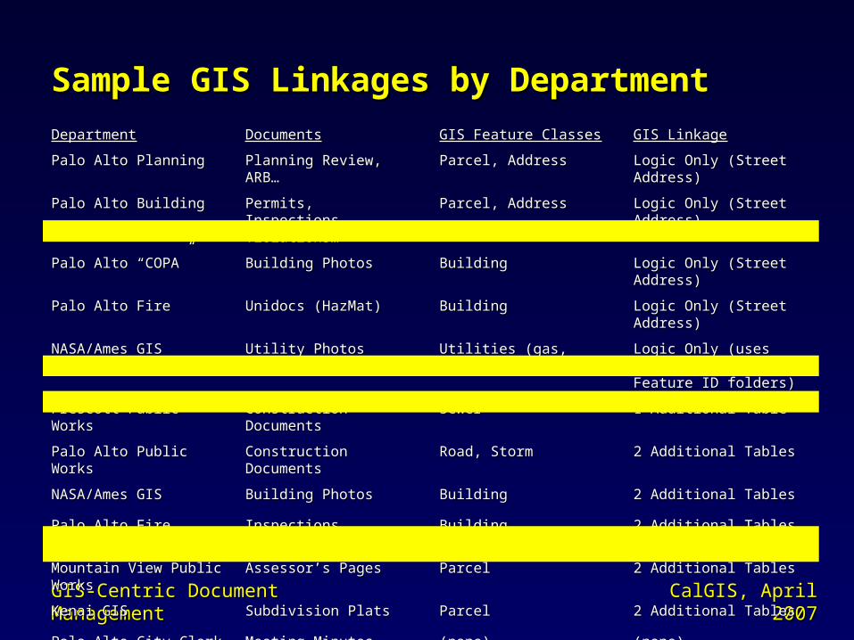
Sample GIS Linkages by DepartmentSample GIS Linkages by Department
GIS-Centric Document GIS-Centric Document ManagementManagement
CalGIS, April CalGIS, April 20072007
DepartmentDepartment DocumentsDocuments GIS Feature ClassesGIS Feature Classes GIS LinkageGIS Linkage
Palo Alto PlanningPalo Alto Planning Planning Review, ARB…Planning Review, ARB… Parcel, AddressParcel, Address Logic Only (Street Address)Logic Only (Street Address)
Palo Alto BuildingPalo Alto Building Permits, Inspections, Permits, Inspections, Violations…Violations…
Parcel, AddressParcel, Address Logic Only (Street Address)Logic Only (Street Address)
Palo Alto “COPA”Palo Alto “COPA” Building PhotosBuilding Photos BuildingBuilding Logic Only (Street Address)Logic Only (Street Address)
Palo Alto FirePalo Alto Fire Unidocs (HazMat)Unidocs (HazMat) BuildingBuilding Logic Only (Street Address)Logic Only (Street Address)
NASA/Ames GISNASA/Ames GIS Utility PhotosUtility Photos Utilities (gas, water, waste Utilities (gas, water, waste water…)water…)
Logic Only (uses FClass Logic Only (uses FClass Name & Feature ID folders)Name & Feature ID folders)
Prescott Public WorksPrescott Public Works Construction DocumentsConstruction Documents SewerSewer 1 Additional Table1 Additional Table
Palo Alto Public WorksPalo Alto Public Works Construction DocumentsConstruction Documents Road, StormRoad, Storm 2 Additional Tables2 Additional Tables
NASA/Ames GISNASA/Ames GIS Building PhotosBuilding Photos BuildingBuilding 2 Additional Tables2 Additional Tables
Palo Alto FirePalo Alto Fire Inspections, Violations…Inspections, Violations… BuildingBuilding 2 Additional Tables2 Additional Tables
Mountain View Public Mountain View Public WorksWorks
Assessor’s PagesAssessor’s Pages ParcelParcel 2 Additional Tables2 Additional Tables
Kenai GISKenai GIS Subdivision PlatsSubdivision Plats ParcelParcel 2 Additional Tables2 Additional Tables
Palo Alto City ClerkPalo Alto City Clerk Meeting Minutes, Meeting Minutes, ResolutionsResolutions
(none)(none) (none)(none)

• Program to extract images and data from BODS.Program to extract images and data from BODS.
• Program to create address folder trees from GIS data.Program to create address folder trees from GIS data.
• Program for merging files from parallel folder trees.Program for merging files from parallel folder trees.
• ““InDox” document scanning and indexing application.InDox” document scanning and indexing application.
• ““DoxView” stand-alone application DoxView” stand-alone application for listing documents and plug-in for listing documents and plug-in for GIS.for GIS.
• ““DoxKey” for keywording.DoxKey” for keywording.
Dox Automation to DateDox Automation to Date
GIS-Centric Document GIS-Centric Document ManagementManagement
CalGIS, April CalGIS, April 20072007
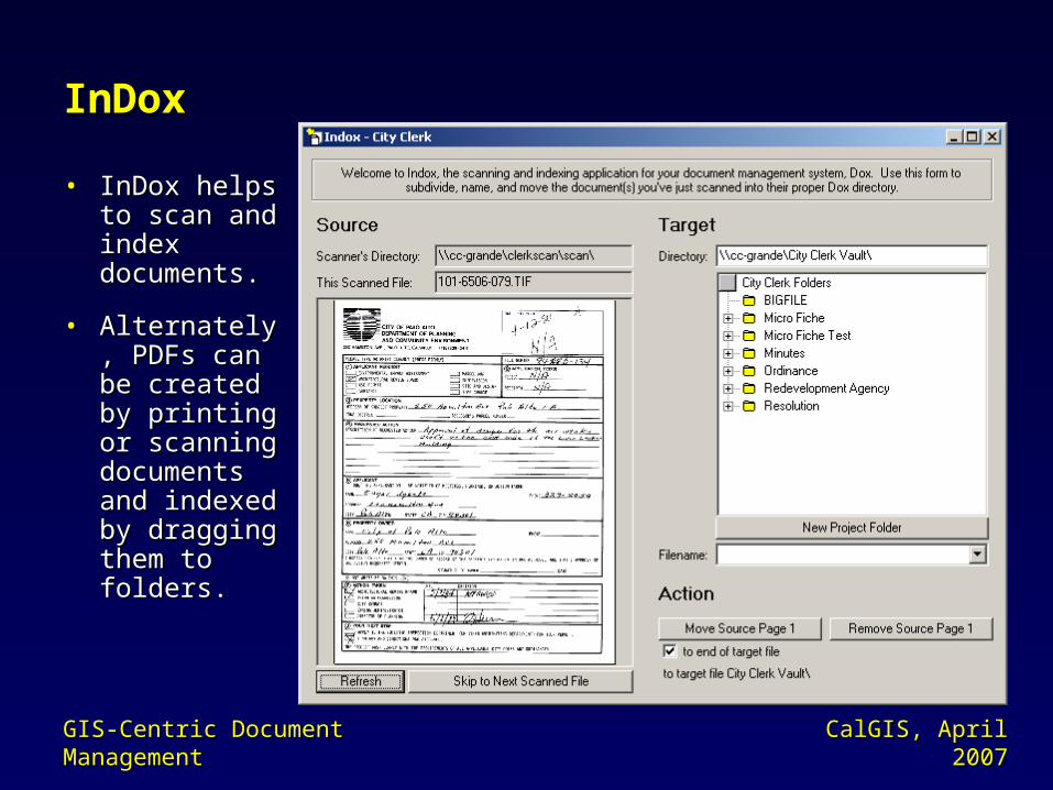
• InDox helps InDox helps to scan and to scan and index index documents.documents.
• Alternately, Alternately, PDFs can be PDFs can be created by created by printing or printing or scanning scanning documents documents and indexed and indexed by dragging by dragging them to them to folders.folders.
InDoxInDox
GIS-Centric Document GIS-Centric Document ManagementManagement
CalGIS, April CalGIS, April 20072007

• DoxKey makes use of PDF keywords and infers DoxKey makes use of PDF keywords and infers keywords from folder and file names.keywords from folder and file names.
• DoxKey is…DoxKey is…– A Windows service that waits for changes to PDF files A Windows service that waits for changes to PDF files
and then extracts keywords to a database.and then extracts keywords to a database.– A plug-in for searching documents by keyword using a A plug-in for searching documents by keyword using a
Google-like search string.Google-like search string.
• Keywords are all stored at the document level, so Keywords are all stored at the document level, so they should be easy to move to any future DMS.they should be easy to move to any future DMS.
DoxKeyDoxKey
GIS-Centric Document GIS-Centric Document ManagementManagement
CalGIS, April CalGIS, April 20072007

• Only one folder tree per document set. (This limitation Only one folder tree per document set. (This limitation may be turning out to be a convenient simplicity.)may be turning out to be a convenient simplicity.)
Summary of LimitationsSummary of Limitations
GIS-Centric Document GIS-Centric Document ManagementManagement
CalGIS, April CalGIS, April 20072007
• No explicit system for document versioning. (File naming No explicit system for document versioning. (File naming conventions may suffice.)conventions may suffice.)
• No explicit approach for active document management. No explicit approach for active document management. (No check-out / check-in system.)(No check-out / check-in system.)
• Not really intended for un-shared documents like Not really intended for un-shared documents like employee reviews. (Folder-level security could be employee reviews. (Folder-level security could be applied.)applied.)

• The use of known concepts (folders, files, addresses, etc) inspires user The use of known concepts (folders, files, addresses, etc) inspires user understanding and confidence.understanding and confidence.
Summary of BenefitsSummary of Benefits
GIS-Centric Document GIS-Centric Document ManagementManagement
CalGIS, April CalGIS, April 20072007
• Your file explorer alone is required to index, browse, and view documents. Your file explorer alone is required to index, browse, and view documents.
• It’s straight forward to connect to your GIS.It’s straight forward to connect to your GIS.
• There are no proprietary barriers and automation is easy to add.There are no proprietary barriers and automation is easy to add.
• The approach is highly scalable and portable into the future.The approach is highly scalable and portable into the future.
• Outside vendors can readily deliver to your selected file formats and index Outside vendors can readily deliver to your selected file formats and index structures.structures.
• It’s easy to replicate the data for field use or backups.It’s easy to replicate the data for field use or backups.
• It’s readily extendable to the web for public document viewing.It’s readily extendable to the web for public document viewing.

• This “interim” solution is growing in popularity This “interim” solution is growing in popularity and scope.and scope.
• GIS and spatial indexing is the key. It provides GIS and spatial indexing is the key. It provides quick access and display of on-line documents quick access and display of on-line documents via map clicks.via map clicks.
• Dox further proves and extends the value of GIS.Dox further proves and extends the value of GIS.
• Information and this presentation is available at Information and this presentation is available at www.geodesy.net/doxwww.geodesy.net/dox..
ConclusionsConclusions
GIS-Centric Document GIS-Centric Document ManagementManagement
CalGIS, April CalGIS, April 20072007

Questions?Questions?
Delivering DocumentsDelivering DocumentsGIS for Low Cost Document ManagementGIS for Low Cost Document Management
GIS-Centric Document GIS-Centric Document ManagementManagement
CalGIS, April CalGIS, April 20072007
Related Documents