\¡&J INTERNATIONAL ATOMIC ENERGY AGENCY, VIENNA, 1985

Welcome message from author
This document is posted to help you gain knowledge. Please leave a comment to let me know what you think about it! Share it to your friends and learn new things together.
Transcript

\¡&J INTERNATIONAL ATOMIC ENERGY AGENCY, VIENNA, 1985

The cover picture shows a view of the Mount St. Helens volcano in Washington, United States of America.(Provided by courtesy of P.W. Lipman of the United States Geological Survey.)


URANIUM DEPOSITS IN VOLCANIC ROCKS

The following States are Members of the International Atomic Energy Agency:
AFGHANISTANALBANIAALGERIAARGENTINAAUSTRALIAAUSTRIABANGLADESHBELGIUMBOLIVIABRAZILBULGARIABURMABYELORUSSIAN SOVIET
SOCIALIST REPUBLIC CAMEROON CANADA CHILE CHINA COLOMBIA COSTA RICA CUBA CYPRUSCZECHOSLOVAKIA DEM OCRATIC KAMPUCHEA DEMOCRATIC PEOPLE’S
REPUBLIC O F KOREA DENMARKDOMINICAN REPUBLICECUADOREGYPTEL SALVADORETHIOPIAFINLANDFRANCEGABONGERMAN DEMOCRATIC REPUBLICGERM ANY, FED ER A L REPUBLIC O FGHANAGREECEGUATEM ALA
HAITIHOLY SEEHUNGARYICELANDINDIAINDONESIAIRAN, ISLAMIC REPUBLIC OFIRAQIRELANDISRAELITALYIVORY COASTJAMAICAJAPANJORDANKENYAKOREA, REPUBLIC O F KUWAIT LEBANON LIBERIALIBYAN ARAB JAM AHIRIYALIECHTENSTEINLUXEMBOURGM ADAGASCARMALAYSIAMALIMAURITIUSMEXICOMONACOMONGOLIAMOROCCONAMIBIANETHERLANDSNEW ZEALANDNICARAGUANIGERNIGERIANORWAYPAKISTANPANAMA
PARAGUAYPERUPHILIPPINESPOLANDPORTUGALQATARROMANIASAUDI ARABIASENEGALSIERRA LEONESINGAPORESOUTH AFRICASPAINSRI LANKASUDANSWEDENSWITZERLANDSYRIAN ARAB REPUBLICTHAILANDTUNISIATURKEYUGANDAUKRAINIAN SOVIET SOCIALIST
REPUBLIC UNION OF SOVIET SOCIALIST
REPUBLICS UNITED ARAB EM IRATES UNITED KINGDOM O F G REAT
BRITAIN AND NORTHERN IRELAND
UNITED REPUBLIC OF TANZANIA
UNITED STATES O F AMERICA URUGUAY VENEZUELA V IET NAM YUGOSLAVIA ZAIRE ZAMBIA
The Agency’s S ta tu te was approved on 23 O ctober 1956 by the Conference on the S ta tu te o f the IAEA held a t U nited N ations H eadquarters, New Y ork; it en tered in to force on 29 July 1957. The H eadquarters o f the Agency are situated in V ienna. Its principal objective is “ to accelerate and enlarge the con tribu tion o f a tom ic energy to peace, health and prosperity th roughou t the w orld” .
© IAEA, 1985
Permission to reproduce or translate the inform ation contained in this publication m ay be obtained by writing to the In ternational A tom ic Energy Agency, W agramerstrasse 5, P.O. Box 100, A -1400 Vienna, Austria.
Printed by the IAEA in Austria O ctober 1985

PANEL PROCEEDINGS SERIES
URANIUM DEPOSITS IN VOLCANIC ROCKS
PROCEEDINGS OF A TECHNICAL COMMITTEE MEETING ON URANIUM DEPOSITS IN VOLCANIC ROCKS
ORGANIZED BY THE INTERNATIONAL ATOMIC ENERGY AGENCY
AND HELD IN EL PASO, TEXAS, 2 - 5 APRIL 1984
INTERNATIONAL ATOMIC ENERGY AGENCY VIENNA, 1985

URANIUM DEPOSITS IN VOLCANIC ROCKS IAEA, VIENNA, 1985
STI/PUB/690 ISBN 92—0 —041085—5

FOREWORD
The occurrence of uranium mineralization in rocks o f volcanic origin has been known for many years. During the last several years there has been increased exploration activity in these host rocks and a num ber o f supporting and related research projects have been carried out. This work has led to the increased recognition that these host rocks warranted more attention. In view of the exploration success that has been attained on specific projects and the widespread areas o f the E arth’s crust tha t may contain similar rocks and geological settings, the possibility of identifying additional new uranium deposits, districts and provinces is now considered to be very good.
As work on these types o f deposits has been carried out in only a few countries and as the literature is not well developed, particularly as regards recent efforts, the advantages o f developing additional inform ation and coordination of efforts were clear. The International Atomic Energy Agency therefore convened a meeting to provide presentation of technical papers on this topic, to allow exploration and research geologists to m eet, discuss and coordinate their work, and to identify the general areas o f common ground in the findings of the work and those topics and problems on which additional work is needed, including possible contributions by the Agency.
The meeting formed part o f an ongoing activity o f the Agency to further the gathering, exchange and dissemination o f inform ation on the geology of uranium and related exploration and evaluation techniques. Over the years a num ber of meetings have been held and publications produced on specific types of deposits and specific geographical areas.
The meeting on Uranium Deposits in Volcanic Rocks was held at El Paso, Texas, from 2 to 5 April 1984 and was hosted by the Departm ent o f Geological Sciences, University o f Texas at El Paso. This location was selected as it provided easier access to workers in N orth and South America, where much of the recent work has been done and where it is judged that the possibility for additional discoveries is very good. It also provided easier access for visits to deposits in Mexico and the United States of America. The meeting attracted 46 participants from 15 countries. Twenty-eight papers were presented at the meeting and two additional papers were provided. Three panels were organized to consider the specific aspects of: (1) the genesis o f uranium deposits in volcanic rock;(2) recognition criteria for the characterization o f such deposits; and (3) approaches to exploration. The papers presented and the findings o f the panels are included in the Proceedings.
Particular thanks are extended to P.C. Goodell o f the University o f Texas at El Paso who hosted the meeting and served as general chairman and to the university for the generous use o f their facilities and the support services provided.

E D IT O R IA L N O T E
The papers and discussions have been edited by the editorial s ta ff o f the InternationaI A tom ic Energy Agency to the exten t considered necessary fo r the reader’s assistance. The views expressed and the general style adopted remain, however, the responsibility o f the'nam ed authors or participants. In addition, the views are no t necessarily those o f the governments o f the nominating M ember States or o f the nominating organizations.
Where papers have been incorporated into these Proceedings w ithout resetting by the Agency, this has been done with the knowledge o f the authors and their government authorities, and their cooperation is gratefully acknowledged. The Proceedings have been printed b y composition typing and photo-offset, lithography. Within the lim itations imposed by this method, every e ffort has been made to maintain a high editorial standard, in particular to achieve, wherever practicable, consistency o f units and sym bols and conform ity to the standards recom m ended by com petent international bodies.
The use in these Proceedings o f particular designations o f countries or territories does no t im ply any judgem ent by the publisher, the IA EA , as to the legal status o f such countries or territories, o f their authorities and institutions or o f the delimitation o f their boundaries.
The mention o f specific companies or o f their products or brand names does no t im ply any endorsement or recommendation on the part o f the IAEA.
A uthors are themselves responsible fo r obtaining the necessary permission to reproduce copyright material from other sources.

CONTENTS
Classification and model o f uranium deposits in volcanic environments(IAEA-TC-490/8) .................................................................................................. 1P.C. Goodell
Uranium in acidic volcanic environments (IAEA-TC-490/4) ........................... 17E. LocardiDiscussion ................................................................................................................. 28
Geochemical characteristics o f uranium-enriched volcanic rocks(IAEA-TC-490/1) ................................................................................................... 29
\
K.J. WenrichA global geochemical model o f uranium distribution and concentration
in volcanic rock series (IAEA-TC-490/6) .................... .................................. 53M .Treuil •
Main characteristics and genesis o f Phanerozoic vein-type uraniumdeposits (IAEA-TC-490/12) ............................................................................... 69Zhaobo Chen, Xiheng Fang
Volcanic rocks as sources o f uranium: Current perspective and futuredirections (IAEA-TC-490/26) ...... .................................................................... 83R.A . Zielinski
Chihuahua City uranium province, Chihuahua, Mexico (IAEA-TC-490/19 )... 97 P.C. Goodell
Volcanic stratigraphy and U-Mo mineralization of the Sierra de PeñaBlanca district, Chihiiahua, Mexico (IAEA-TC-490/31) ............ ■.................. 125D. Cárdenas-Flores
Características petrográficas y geoquímicas de las unidades ignimbríticas portadoras de mineralización de uranio de la Sierra Peña Blanca,México (IAEA-TC-490/7) .................................................................................... 137M.C. Magonthier
Em anom etría de radón en el distrito uranífero de Sierra Peña Blanca y enotras áreas volcánicas de.Chihuahua, México (IAEA-TC-490/21) ............ 151M.A. Miranda, J. M artínez, L. Olvera
Depósito de m olibdeno asociado con uranio en Peña Blanca, México(1АЕА-ТС-490/16) .................................................................................................. 161M. Reyes-Cortés
Uranium deposits of the Sierra Peña Blanca: Three examples of mechanisms o f ore deposit form ation in a volcanic environment(IAEA-TC-490/8) ................................................................................................... 175B. George-Aniel, J. Leroy, B. Poty

Geología y potencial uranífero de la Sierra los Arados, México(IAEА-TC-490/22) ...................................................... ................................................187M.A. Miranda
Uranium mineralization in the San Marcos volcanic centre, Chihuahua,Mexico ( I AE A-TC-490/3 ) ..................................................................................... 197H. FérrizDiscussion ....................................................................................................................216
Ignimbritas uraníferas en la Sierra de Coneto, México (IAEA-TC-490/23) ... 217I.A. Reyes-Cortés
Exploración de uranio utilizando geoquímica de sedimentos de arroyo y levantamientos de radiaciones gamma en el área Majalca, México(IAEA-TC-490/20) ........... ............. ........................................................................... 225M.A. Miranda, E.P. Núñez
Geología y metalogenia de las mineralizaciones uraníferas de Macusani,Puno (Perú) (IАЕА-ТС-490/14) ............................................................................ 237A. Arribas, E. Figueroa
Uranio en rocas ígneas: Intrusivas sub-efusivas y piroclásticas delOrogeno Andino boliviano (IAEA-TC-490/33) ............................................... 255E. Pardo-Ley ton
Consideraciones geoquímicas de los indicios uraníferos de Macusani,Puno (Perú) (IAEA-TC-490/32) ...............................!.......................................... 275 '/ . Valencia, G. Arroyo
Deposits and radioactive anomalies in the Sevaruyo region (Bolivia)(IAEA-TC-490/9) .................................................................................................... 289J. Leroy, B. George-Aniel, E. Pardo-LeytonDiscussion ....................................................................................................................300
Uranium occurrences in the volcanic rocks of northw estern Argentina(1АЕА-ТС-490/13) ......................................................................................... 301P. Stipanicic, A. Belluco, H. Nicolli, S. Gorustovich, J. Salflty,A. Vullien, J. Suriano, M. Koukharski, E. Abril
Episodic uranium mineralization in the western San Juan Calderacomplex, Colorado (IAEA-TC-490/24) ................................................................ 315R.I. Grauch, A .R . Kirk, K. Hon, K.R. Ludwig, H.H. Mehnert,J.A. Zamudio, L.M. Bithell
Origin o f hydrotherm al uranium vein deposits in the Marysvale volcanicfield, Utah (IAEA-TC-490/27) ............................................................................ 317J.D. Rasmussen, C.G. Cunningham, T.A. Steven, R.O. Rye,S.B. Romberger
Overview o f uranium in volcanic rocks o f the Canadian Cordillera(1АЕА-ТС-490/11 ) ........................................................................................ 319R.T. Bell

Relation of topaz rhyolite volcanism to uranium mineralization in thewestern United States o f America (IAEA-TC-490/17) ................................ 337D.M. Burt, M.F. SheridanDiscussion ................................................................................................................... 345
Permo-Carboniferous volcanism in France and western Europe:Métallogénie significance (IAEA-TC-490/10) .............................................. 347D. Badia, P. Begassat, Y. FuchsDiscussion ................................................................................................................... 361
Precambrian submarine volcanogenic uranium deposits: An example from southeastern New York, United States o f America(IAEA-TC-490/25) ............................................................................................... 363R.I. GrauchDiscussion ...................................................................................................................363
Uranium mobility in late magmatic and hydrotherm al processes: Evidencefrom fluorite deposits, Texas and Mexico (IAEA-TC-490/34) .................. 365T.W. Duex, C.D. HenryDiscussion ...................................................................................................................376
Uranium associated with volcanic rocks of the McDermitt Caldera,Nevada and Oregon (IAEA-TC-490/30) ............................................................... 379R.D. Dayvault, S.B. Castor, M.R. Berry
Geology o f the Lakeview uranium area, Lake County, Oregon(IAEA-TC-490/29) ............................................................................................... 411G.W. Walker
PANELS
Panel 1 : Genesis of volcanogenic uranium deposits ............................................451Panel 2: Recognition criteria and deposit characterization ............................. 455Panel 3: Exploration for uranium ore deposits in volcanic environments .... 459
List of Participants ......................................................................................................... 465


IAEA-TC-490/8
CLASSIFICATION AND MODEL OF URANIUM DEPOSITS IN VOLCANIC ENVIRONMENTS
P.C. GOODELLDepartm ent o f Geological Sciences,University of Texas at El Paso,El Paso, Texas,United States o f America
Abstract
CLASSIFICATION AND MODEL OF URANIUM DEPOSITS IN VOLCANIC ENVIRONMENTS.Uranium is concentrated in felsic igneous rocks, in and around which uranium deposits
are found. Volcanic calderas and their associated rocks are the geological environm ents which host these deposits. The igneous, sedim entological and tecton ic evolution o f calderas is discussed. The behaviour o f uranium throughout this evolutionary sequence is considered from the po in t o f view of source rocks, transport mechanisms and depositional controls. On the conceptual level a generalized caldera m odel can be constructed!; a logical classification of uranium deposits in volcanic environm ents is the result. Deposits in various subtypes have characteristic geological, geochemical and geophysical properties. N um erous know n uranium deposits in volcanic environm ents are classified by placing them in the caldera model.
1. URANIUM DEPOSITS IN VOLCANIC ENVIRONMENTS
The specialty in uranium geology that is the common bond throughout these Proceedings is a uranium deposit type which is not at or near the top of the list o f largest contained reserves. As a proved environment for uranium resources, however, this deposit type probably has the greatest potential for advancement of conceptual models and for additions to the resource package. Volcanic regions have been active exploration frontiers in several countries and have been a significant producer in a few select countries. Proterozoic unconform ity and sandstone deposit types would be more preferable targets; however, thé geological endowm ent of certain countries is such that their optimal target type o f uranium resource developm ent is in volcanic environments. They m ust pursue exploration in this environm ent if they are to achieve energy diversity and independence.
It has long been recognized that volcanic rocks contain radiom etric anomalies, and certain areas were known to have abundant uranium occurrences in these environments. Scientific understanding had to wait for the elucidation o f the genesis o f their host rock which is, in general, caldera-related rock in the sense described by Smith and Bailey [1]. The framework o f the conceptual model and the evolution
1

2 GOODELL
of the geological events it describes is fundam ental, and becomes the framework for the geochemical problem o f considering uranium distribution within this environment.
The discussion tha t follows and the resulting model o f uranium in caldera environments have been several years in development. Preliminary aspects were first presented at a National Uranium Resource Evaluation Symposium on Uranium Geology held in 1977 [2]. The complete model was presented at the national meeting of the American Association o f Petroleum Geologists held in 1981 [3] and has been applied and tested in several additional studies [4 -8 ] . I t is presented here in an updated and elaborated form. By its nature, the model is a generalization. Details o f the various genetic influences are not known in m ost deposits, and in terpretation often verges on speculation in many specific instances.
Several other models are available for mineralization within caldera environm ents [9—11] although they do no t deal with uranium exclusively. The models are generally compendiums of deposit occurrences within the geological framework and interpretations of genetic processes. As conceptual aids they can be very helpful. The models do not differ in fundam ental ways, and a comparative discussion is not intended here.
2. CALDERA CYCLE
Uranium deposits in igneous rocks are m ost frequently associated with felsic rocks and with clastics related to caldera activity. They are relatively high in silica content and have been found to conform to a regular pattern or cycle of geological events, i.e. the caldera cycle. Therefore, to provide a necessary background for examining the behaviour o f uranium in volcanogenic environments, this section will briefly summarize the geological evolution o f calderas. I t is adapted from Smith and Bailey [1] and includes certain more recent developments. The m ultiple events associated w ith felsic calderas are outlined in Fig. 1. Although these events overlap, they are listed in relative time, called stages, on the left side o f the figure. The volcanic edifice itself is seen in the cross-section in Fig.2, where the location of major rock bodies o f igneous or sedimentological origin are indicated.This figure shows rock bodies after two cycles o f caldera evolution; thus, several units are duplicates except for their being from AFT I or AFT II, i.e. ash-flow tuffs from each o f the two consecutive caldera cycles.
The volcanic basement and intrusive host, the oldest rock unit in the region, is unit N, and unit В is the equivalent after down-dropping by caldera activity. Stage 0 has been added and constitutes widespread calcalkaline volcanism. This stage is often a precursor to felsic caldera volcanism and its inclusion is based on the widespread observation that esitic rocks frequently underlie near-source caldera volcanics. Unit D in Fig.2 would be reproduced during this stage, and at least a part o f unit С is its down-dropped equivalent.

IAEA-TC-490/8 3
F IG .l. Time sequence o f the stages o f caldera evolution.

4 GOODELL
A M agm a cham ber G Volcaniclastic product o f A F T 1
В D ow n-d ropped central caldera block H Volcaniclastic product o f A F T II
С Intercaldera volcanic facies, and dow n-dropped unit 0 1 Lacustrine facies of A F T 1
D Pre-caldera andesitic volcanic pite J Lacustrine facies o f A F T И
E O utflow facies of ash-flow tuff 1 M Playa or calcrete
F O utflow facies o f ash-flow tuff II N Vo lcan ic basement and intrusive host
FIG.2. R o c k units and cross-section o f caldera and environs.
Stage 1 involves regional tumescence or uplift resulting from the forceful intrusion o f large volume magmas into the upper portions o f the crust. It may be associated with significant structural activity and m inor volcanic eruptions. I t is not specifically indicated in the figure, but the magma chamber is produced from the emplacement o f unit A.
Stage 2 is the major caldera-forming eruption of large volume ash-flow tuffs. Venting is generally thought to take place along the ring and radial fracture zones. Ash-flow tuffs may travel 50 to 70 km away from their vents at the time of eruption. Units E and F represent these facies for two successive caldera cycles. These outflow facies form broad, continuous, uniform sheets which can be used as stratigraphie markers. Large volumes of magma may also pond in the central caldera depression and large thicknesses o f such rocks undergo relatively slow cooling; these produce tfie distinctive granopheric texture o f inner caldera facies. Unit С in Fig.2 in part represents these rocks. These central facies are generally much thicker and less uniform than the outflow facies.
A thick and hot ash-flow tu ff may undergo welding o f a portion o f the glass shards immediately after deposition. The degree of welding is affected by the following variables: emplacement tem perature, am ount and com position of volatiles, composition of the magma, lithostatic load, rate o f cooling and rate of crystallization. Tem peratures of emplacement range from greater than 900°C to as low as 600°C. Once emplaced, ash-flow tuffs, particularly the outflow facies, show a distinctive primary zoning pattern. It is during the depositional and immediately after the depositional phases that certain models for the genesis of

IAEA-TC-490/8 5
uranium deposits are called upon to be very active in the process o f uranium m obilization. Degassing o f the rhyolitic ash-flow tuffs is particularly active at this time. These depositional processes produce rocks tha t are (chemically and texturally) zoned vertically and sometimes laterally. V itrophyric or glassy zones, often preserved by quick cooling, at the base o f a welded tu ff are o f particular interest in geochemical studies. V itrophyre contains the closest composition to the original magma, while the rest o f the rock has undergone chemical changes from the processes m entioned above. V itrophyre can provide im portant genetic and exploration inform ation.
Stage 3 involves caldera collapse and takes place concurrently with stage 2, as the caldera roof collapses into the space provided by the expulsion of the large volumes o f magma. This is indicated in the figure by the downward displacement of units В and C. The distance of this subsidence has been measured as up to 3 km. Stage 4 consists o f post-collapse sedim entation and pre-resurgence volcanism. Such sedim entation is suggested by the stratified region immediately above unit С in Fig.2. Caldera collapse o f the previous stage produces a tectonic depression, while mass wasting and other erosional processes begin filling the depression. Megabreccias can form from landslides off the sides o f the caldera. M inor.pyroclastic eruptions or lavas may also occur at this time. Sedimentary materials may grade im perceptibly into similar rocks formed during subsequent stages.
Stage 5 is resurgent doming. A renewal o f magmatic activity characterizes this stage and is indicated in Fig.2 by the central magmatic conduit and now- buried flow dome. The primary result is form ation o f a structural dome superimposed upon the collapsed caldera floor due to renewed intrusion from an underlying magma chamber. The structural nature o f the resurgent dome is quite characteristic. It generally has longitudinal, radial or apical grabens and other tensional features. The collapsed caldera forms a closed basin w ithin which water and sediments accumulate. The enlarging central resurgent structural dome may eventually form an island within the central lake. Sedimentary materials then have an annular or ring-like geometry and are called m oat deposits, as indicated on either side of the resurgent dome in the figure. They generally rest unconform ably above similar pre-resurgence material.
The reasons for caldera resurgence are not firmly established. It can be speculated that the magma chamber is repressurized by a new influx of fluids from the host environment. Differentiation in some caldera systems may take place by thermal gravimetric diffusion and crystal settling, w ith the relative im portance of each mechanism being hotly debated.
Stage 6 consists o f m ajor ring fracture volcanism, often incorporating or involving m oat environments; this is the last major igneous activity o f a caldera cycle. Late-stage ring fracture volcanism is indicated on the right-hand caldera boundary in Fig.2. Ring fracture volcanism is generally more porphyritic than resurgent dome extrusives. The filling o f the volcano-tectonic depression continues w ith both sedimentary and igneous m aterial, as indicated in the figure. Intervals

6 GOODELL
•A
FIG.3. Convection cells o f geotherm al system s around a cooling caldera.
of constructive volcanism are followed by long periods of erosion and redeposition. In addition to indicating these sedimentary events for the inner caldera facies,Fig.2 shows clastics (units G and H) and lacustrine facies (units I and J) for two caldera cycles. A playa environment might substitute for the lacustrine.
Stage 7 consists o f fumerolic and ho t spring activity. Once igneous activity has ceased, final cooling o f the caldera region takes place by means o f circulating waters. Heat exchange takes place from rock to water, and groundwaters in the caldera move up and out. Large convective cells form around and within the caldera environment, as suggested in Fig.3. It should be noted that these geothermal systems are present throughout the life o f the caldera, as seen in F ig .l, but are all tha t remains of the form er volcanic activity that took place at stage 7. These geothermal systems may contain a magmatic com ponent o f the fluid, but this is usually small and decreases in quantity over time.These ho t waters leach large volumes o f rock and reprecipitate various materials as they cool, boil or react with o ther rocks. Numerous commodities such as gold, silver, mercury and antim ony, in addition to uranium , are associated with this activity.

IAEA-TC-490/8 7
3. URANIUM IN CALDERA REGIONS
Considerations o f the genesis o f mineral deposits within a particular geological environment are divided into three fundam ental questions. The first relates to the presence, nature and distribution of effective source rocks. Source rocks usually contain higher than average am ounts o f liranium. The rock m ust be voluminous enough to be able to contribute significant am ounts o f the element, and the element must be present in tha t rock in such a mineral that it is more or less available for release.
The second fundam ental question is that of transport. How does the uranium get from the source rock to the depositional site? The transportation process is assumed to be a fluid movement o f some sort, whether magmatic or aqueous. In addition to chemical parameters and tem perature, which are im portant, the physical aspects o f permeability and porosity are also critical considerations. Uranium deposits may require several different stages o f transport and remobilization in order to form deposits o f significant grades.
The third question concerns the depositional site and precipitation mechanism. Deposition o f uranium generally takes place by the fluid flow-through o f the transport medium with a chemical barrier superimposed upon it.
4. SOURCE ROCKS
Physical and chemical parameters determine good uranium source rocks.With respect to the chemical characteristics, high uranium content is not the sole criterion for good source rocks; effective uranium leachability m ust also be taken into consideration. The mineralogy o f uranium is quite variable in source rocks and uranium contained in resístate minerals is generally no t available for later chemical transport and reprecipitation. The question o f availability of uranium from a rock is further complicated by the dependence on potential transport processes — the am ount o f leachable uranium is higher for higher tem perature processes, i.e. a geothermal system can leach more uranium than a meteoric water system. In general, there is a close correlation between uranium content and high thorium content, as illustrated in Fig.4 [12]. This diagram provides data taken from various igneous rock types and shows a strong correlation between increasing thorium and uranium and progressive igneous differentiation. This same pattern of behaviour is shown in Fig.5, relating the silica content o f igneous rocks on the X-axis w ith uranium contents on the Y-axis. The correlation between high silica content and uranium from this data set; (in southwestern New Mexico [ 12]) is conclusive. The uranium-thorium diagram proves useful in comparisons w ith data from any new area under investigation. Deviations from this pattern o f behaviour are interpreted as secondary processes; tha t is, deviations to the right o f this line suggest uranium enrichment,

8 GOODELL
2.0
1.5LOG Th
ppm1.0
0 .5--
H--------- h -+■---- — -i0.0 0.5 1.0 15 2.0
LOG U ppm
FIG .4. Thorium and uranium variations w ith igneous rock types.
6 -
5-
Ё o. a3 -
2 -
----NON-CAULDHON--- CAULDRON
I>-HiIiJ.
50
51
-I-
i 155 60 65
n i 170 75
wt % SiO„
F IG .5. Uranium and S i0 2 variations o f igneous rocks fro m the M ogollon-Datil volcanic fields, southw estern N ew M exico (from R ef. [12]).
whereas deviations to the left reflect uranium leaching. These statem ents are based on the relative immobility o f thorium in m ost low tem perature geothermal systems.
Caldera environments do have one particularly favourable uranium source rock in the form o f glass. Glass shards are one of the distinctive characteristics of ignimbrites or ash-flow tuffs, so their abundance in caldera regions is extraordinary.

IAEA-TC-490/8 9
1 U ranium -enriched granite — by crystal fractionation
2 Uranium -enriched cupola — convection-driven therm ogravitational d iffusion
3 Rhyo lite flow dom es
4 Inner caldera volcaniclastics
5 V itrophyre, pum ice and less welded zones of ash-flow tuff
6 Rem nant glass in volcaniclastic facies
6 Surface water
FIG. 6. (a) Schem atic cross-section o f caldera showing po ten tia l uranium source rock regions; (b) schematic cross-section o f caldera showing areas o f influence o f po ten tia l uranium transport mechanisms.
It has been proved tha t glass is a highly chemically reactive substance in the geological environment and that trace elements contained in the "glass can reasonably be expected to be released upon alteration o f the glass. Experim ental work has been devoted to this question and Zielinsky discusses and summarizes the results o f such studies in another paper in these Proceedings [13].
Uranium found as a trace element in glass is thus brought to the surface during caldera eruptions and the glass is contained in outflow facies or inner caldera facies. Glass from the upper unwelded zones o f outflow facies can also be reworked sedimentologically to produce shard-bearing clastic material which has started to undergo alteration or which can readily be altered later.
Potential source rocks found within the caldera are defined and indicated by different stippled areas in Fig.6(a). Potential source rocks can be widely distributed and it is rare that a specific rock can be identified as being responsible for a particular

10 GOODELL
uranium concentration. Source rocks 1 and 2 are uranium-enriched intrusive rock granitoids, enriched by fractional crystallization and convection-driven thermogravitational diffusion; source rocks 3 and 4 consist of inner caldera volcanics and volcaniclastics. Unit 4 would consist of the more coarsely crystalline ignimbrite (granophyre) which serves as a source rock when the slow recrystallization process that forms-this rock effectively expels uranium from the crystallizing mineral lattices. This rock forms the largest potential uranium source within the caldera.
Source rock 5 is the vitrophyre, pumice and less welded zone o f ash-flow tuffs. These constituents are all glass (and during subsequent weathering, zeolite) releasing the contained uranium. These m ore porous zones may well have received uranium which was expelled during the recrystallization or devitrification o f the densely welded zones. The area labelled 6 in Fig.6(a) represents rem nant volcanic glass present in the clastic facies of each caldera cycle. The top zone o f 5 can readily be eroded and quickly redeposited before alteration o f the glass. Finally, source rocks may constitute the host rock o f the caldera itself, N.
5. TRANSPORT MECHANISMS
Within the confines o f this model uranium can be transported in the magmatic or aqueous phase. The aqueous phase can vary from the magmatic- hydrotherm al to the rainfall run-off environment. With such a great variety of transport mechanisms, which is a reflection of the geochemical diversity and
m obility o f uranium, it can be predicted that interpretations o f origin o f specific deposits might be diverse.
The transport mechanisms are listed in Fig.6(b); the regions o f influence o f the different mechanisms are also shown schematically. Transport mechanism 1 would be the movement o f uranium-bearing magma fluid. Transport mechanisms 2 and 3 are related; 2 would generally evolve into 3. The pneum atolitic and magmatic-hydrothermal stages are the higher tem perature, magmatic emanations exsolved from magma crystallization and the lower tem perature aqueous stage o f cooling of tha t vapour. Regions o f influence o f these processes are shown in Fig.6(b) within the caldera prisms. Details of the transport mechanisms are not known, although uranium is often surmised to be moved in the hexafluoride complexes at the high tem perature end.
Figure 6(b) fails to give due im portance to another region influenced by gas-phase and fumerolic-alteration processes. Reference is made to the outflow facies o f the ignimbrites with respect to this statem ent. The im portant aspect of gas and ho t water processes in ash-flow tuffs tha t have just been vented is that they mobilize uranium out o f the devitrifying tu ff and make it more available for later lower tem perature remobilization. This gas-phase alteration stage is common in many ash-flow tuffs and would be effective in the regions where E and F are located.

IAEA-TC-490/8 11
The last three transport mechanisms are interrelated and represent the more surficial aspects. Surface water, 6, can become groundwater, 5, which, when deeply circulated, can become the m ajority o f the aqueous feedstock for the circulating geothermal system, 4. Geotherm al systems may interface and mix w ith magmatic hydrotherm al solutions, 3.
With respect to low tem perature and surface waters, knowledge o f the details o f uranium transport broadens. Direct measurements o f surface and groundwater uranium contents and the concentrations o f associated species and specialized complexing agents have placed this knowledge on a quantitative basis. I t has been shown that many different anions can complex the basic uranyl ion and transport it. However, phosphate and carbonate are the m ost likely candidates for average groundwater compositions. Solution chemistry is im portant, but details are not given here.
The paths o f uranium transport within the caldera edifice and related rocks can be complex. Initial zones o f high porosity and permeability have been superimposed upon by later ones, as is suggested by subsequent tectonism . Early pathways can later even be plugged-up and closed-off by massive silicate precipitation, causing the evolution o f vent systems. Details o f potential solution pathways m ust be planned in each individual instance; they are often the result o f a complex interplay o f facies and stratigraphie and structural features.
6. DEPOSITIONAL INFLUENCES
With respect to the precipitation o f uranium from transporting aqueous fluids, it is generally recognized tha t by reducing the conditions provided by either organic carbon or sulphide extremely favourable depositional environments would result. Precipitation, however, can also take place because o f a high am ount o f silicates. Precipitation can also take place by boiling, tem perature decrease or o ther as yet unproposed reactions with the host rock.
Depositional influences are varied and multiple. F urther discussion o f the details will not be undertaken here and they will no t be dealt w ith diagrammatically, as was done with o ther genetic considerations in Fig.6. Instead, the m ultitudinous known depositional sites in calderas are synthesized.
7. EXAMPLES FROM SEVERAL CALDERAS
Data from some actual studies on uranium in calderas are presented. The Long Valley caldera in eastern California has been closely studied, particularly with respect to detailed chemical variations in the Bishop T uff [14, 15], which is an outflow facies o f a m ajor recent eruption. Using vitrophyre compositions as an initial magma com position in the num erator, a ratio can be calculated between

12 GOODELL
. ENRICHMENTEARLY / LATE
.5
.1
Be
H2°l
à, «NaI 11 s.
Mg
Sc
IMn
i Ni Z n l
T I Cli
Sb0
Sn
° v Vb TBaLu
Zr Nd
Ce
Au
FIG. 7. Chemical enrichm ent diagram fo r B ishop Tu ff, California; atom ic num ber, Z, on the X-axis (from R e fs [14, 15]).
740
720
i 140 с
f <20
TOLEDO CALDERA. STAGE 2 ERUPTION ф
— •A
o lava Hows and domes x ash-flow pumice + air-fall pumice
-V A L L E S C A L D E R A . STAGE 2
a 9/iS
/ °N / 0\
/ о\ ?
О 0„
V ¿ ¿ W
1.2 \0
«610 y e a r s B .R
F IG .8. N iobium variations w ith tim e in rocks associated, w ith the Valles and Toledo Calderas, N ew M exico (from R ef. [16\).

IAEA-TC-490/8 13
trace element contents elsewhere w ithin the ignimbrite and the vitrophyre trace elem ent com position; it is plo tted against the atomic num ber on the X-axis (see Fig.7) and is known as an enrichm ent diagram. It can be immediately seen from this diagram whether a specific magma was relatively enriched. O ther geochemical associates can also be distinguished. The mineralogy o f the uranium at this stage is especially im portant, as has already been discussed.
A second example illustrates the variation o f a single trace element during the entire eruptive cycle (or double cycle) o f one caldera system. The Valles caldera in New Mexico is the classic caldera example; the niobium content variations with age o f the erupted rock are shown in Fig.8 [16]. The dramatic variations in niobium content are evident, and it has been proved that uranium often follows niobium in caldera environments. Niobium can be used as a good proxy for uran ium .. Documentations of this type, together w ith the mapped and projected prior distribution o f a niobium-rich rock unit, can help in source rock studies.
These two brief examples o f chemical behaviour at the caldera form ation stage illustrate the variations and com plexity o f the problem.
8. POTENTIAL URANIUM HOST ENVIRONMENTS IN VOLCANICAND VOLCANICLASTIC REGIONS
Consideration is now given to the various regions within the caldera model which are known to contain uranium deposits or significant concentrations. In some instances num erous examples o f each environment are known; several are listed in the legend o f Fig.9. These environments are m entioned in sequence,' from the intrusive to extrusive to outflow to volcaniclastic stages. They are summarized schematically in the figure, which shows the proposed model of potential uranium environments in volcanic and volcaniclastic terrains. This discussion is more a description o f the depositional sites available and does not necessarily imply genetic considerations. Such genetic influences are probably varied and multiple, as implied in Fig.6(b).
The pegmatitic stage, 1, is associated w ith the caldera magma chamber. Urani- ferous pegmatites and pegmatite dykes are com m on in these regions. Magmatic hydrotherm al vein deposits are often associated w ith ring dyke intrusions, 2, or resurgent intrusions, 3; both environments give way upwards to the rhyolite flow domes, 4, which the ring dykes were feeding. An example o f deposit type 2 is the Moonlight mine at the M cDermitt caldera, Nevada [17]. Environment, 5, consists o f pyroclastic flows, flow breccias or lag deposits w ithin the caldera depression. Such phenom ena are common and form porous, permeable and reactive facies. Site 6 is a mafic flow breccia and vesicular zone which is known to contain a deposit in the M cDermitt caldera complex [18, 19]. Num ber 7 consists of caldera boundary breccias which are frequently zones o f megabreccia- tion, and an environment within which large am ounts o f depositional space are

16, к(17, M )
1 Pegmatite2 Magmatic-hydrothermal veins associated with ring
dyke intrusivos - ex: Moonlight mine, McDerm itt caldera, Nevada
3 Magmatic-hydrothermal veins associated with resurgent dome intrusives - may be indistinguishable from stage 2
4 Rhyolite flow dom e - ex: Pinto Canyon, West Texas5 Pyroclastic flows or flow-breccias - ex: Pinto Canyon,
West Texas6 Mafic flow breccia and vesicular zone - ex: Aurora
deposits, McDermitt caldera, Nevada7 Caldera boundary breccias8 Intercaldera voicaniclastic and lake facies,
pre-resurgence associated with stage 49 Intercaldera volcaniclastic and lake or 'm oat' facies,
post-resurgence associated with stages 5 and 6 - may be difficult to distinguish from stage 8
10 'Step faults' and other sturctural sites in welded tu ff s -e x : Nopal 1 and Margaritas. Peña Blanca, Mexico, Mammoth mine area, West Texas
11 Altered basal vitrophyre of welded tuffs, stratigraphie control * ex: Margaritas, in part
12 Lapilli tuffs, lithophysal zones, stratigraphically determined zones, in pyroclastic outflow facies - ex: surface of Margaritas
13 Unwelded basal lithic, carbonate-rich zone of ash-flow tuff, permeable and reactive - ex: Spo r Mt., Utah
14 Conglomerate, arkose and sandstone-filled channels cut into volcanic basement, sometimes w ith accompanying organic debris - ex: Talahassee Creek, Colorado, Sonora Pass, California
15 G, H - volcaniclastic facies16 I, J or К - ex: Andersen Ranch, Brewster County,
Texas
17 M - playa, calcrete facies18 Structural features in the volcanic basement, faults,
karsts, Peña Blanca - ex: thrust faults and karsts at Sierra Gomez, fractures and karsts at Domatilla, karsts in W yom ing
19 Stratigraphie features in volcanic basement, permeable clastic units act as solution paths
20 Chemical features in volcanic basement, reductants provided by iron sulphonides and organic material - ex: Sierra Gomez
F IG .9. Schem atic m odel o f potentia l uranium environm ents in volcanic and volcaniclastic terrones.
GO
OD
EL
L

IAEA-TC-490/8 15
available. The next environments are the inner caldera volcaniclastic facies, indicated by numbers 8 for pre-resurgent facies and 9 for post-resurgent facies. These zones may contain large bodies o f low-grade disseminated uranium o f either the hexavalent or reduced state.
Favourable uranium environments are also abundant outside the volcano- tectonic depression o f the caldera itself. One such environment, for example, is characterized by the step faults, 10, small step-wise displacements o f welded ash-flow tuffs. Step faults play an im portant part in localizing mineralization in the Pefia Blanca deposits; the Nopal 1 deposit occurs at the intersection of several o f these step faults. Small-scale faulting provides ground preparation and plumbing for solution flow. A nother im portant environment consists o f the altered basal vitrophyre o f ash-flow tuffs, 11. V itrophyre is unusually reactive and permeable. A t Pefia Blanca vitrophyres are altered over a wide region around the mineralized zones. Similarly, o ther stratigraphically controlled sites, 12, consist o f lapilli tuff, lithosphyssal zones, pumice or lithic-rich zones and other deposits. Additional stratigraphically controlled sites in volcanics or associated rocks consist o f clastic-filled channels cut into the volcanic basement, 14; these are im portant at the Talahasee Creek, Colorado. Uranium can also be concentrated in coarse clastic accumulations, organic-rich environments in the clastic, 15, or lacustrine, 16, facies, and finally, in the far reaches o f the volcaniclastic system in playa or calcrete deposits, 17.
Structural sites, 18, in the volcanic basement can consist o f faults or karst zones, whereas stratigraphie sites, 19, can be generally clastic units. These can be further subdivided by their chemical influences, 20, on precipitation, which would include organic- and pyrite-rich sediments or o ther précipitants influencing the deposition.
The model in Fig.9 consists o f an integrated geological facies model of uranium in volcanic and volcaniclastic environments. The actual genesis o f any particular deposit may be quite complicated and can only be deciphered by sophisticated studies. Metamorphosed equivalents o f several o f these facies have been identified in uranium deposits in Precambrian felsic and clastic environments.
ACKNOWLEDGEMENT
The Electric Power Research Institute, Palo A lto, California, United States of America, provided the support for this work. Appreciation should also be expressed for their foresight in supporting studies o f this vital but neglected uranium environment.
REFERENCES
[ 1] SMITH, R.L., BAILEY, R.A., “Resurgent cauldrons”, Studies in Volcanology (COATS, R .R ., HAY, R.L., ANDERSON, C.A., Eds), Geol. Soc. Am ., Mem. 1 1 6 (1 9 8 3 ) 613.

[2] GOODELL, P.C., “Uranium and the diagenesis o f volcanic sedim ents” , 1977 NURE Uranium Geology Sym posium , Energy Research and Developm ent Adm inistration, Grand Junction , Rep. GJBX-12 (1978) 151.
[3] GOODELL, P.C., A m odel for form ation o f uranium deposits in volcanic rocks, Am. Assoc. Pet. Geol., Annu. Con. (1981) (abstract only).
[4] AIKEN, M.J., Mineralogy and Geochem istry o f a Lacustrine Uranium Occurrence, A nderson Ranch, Brewster C ounty , Texas, MSc Thesis, University of Texas a t El Paso, 1981, 162 p.
[5] TRENTHAM, R.C., Leaching o f Uranium from Felsic Volcanics and Volcaniclastics; Model, Experim ental Studies and Analysis o f Sites, DGSc D issertation, University o f Texas atEl Paso, 1981, 204 p.
[6] ORAJAKA, I.P., Mineralogy and Uranium Geochem istry o f Selected Volcaniclastic Sedim ents in the W estern U nited States — An E xploration Model, DGSc Dissertation, University o f Texas at El Paso, 1981, 365p.
[7] H O FFER , R.L., Uranium Geochem istry o f Selected Rock Units from the Marysvale Volcanic Field, Piute C ounty , U tah, DGSc D issertation, University o f Texas at El Paso,1982, 268p.
[8] MITCHELL, S.М., Geology of the Sierra Gom ez, Chihuahua, Mexico, MSc Thesis, University o f Texas at El Paso, 1980, 142p.
[9] RYTUBA, J.J ., “R elation o f calderas to ore deposits in the western U nited S tates” ,Relations o f Tectonics to Ore Deposits in the Southern Cordillera, Ariz. Geol. Soc. Dig. 14(1981) 227.
[10] SHERIDAN, M.F., BURT, D.M., A m odel for the genesis o f uranium /lithophile elem ent deposits related to rhyolitic volcanism, Geol. Soc. Am., Abstr. Programs I I (1979) 515.
[11] ELSTON, W., personal com m unication, 1984.[ 12] BORNHORST, T .J., ELSTON, W.E., “U ranium and thorium in mid-Cenozoic rocks of
th e M ogollon-Datil volcanic field”, U ranium in Volcanic and Volcaniclastic Rocks, Am. Assoc. Pet. G eo l,S tu d . Geol. 13 (1981) 145.
[13] ZIELINSKI, R .A., these Proceedings.[14] HILDRETH, E.W., The Magma Cham ber o f Bishop Tuff: G radients in Tem perature,
Pressure, and Com position, PhD Dissertation, U niversityof California, Berkeley, 1977.[15] HILDRETH, E.W., The Bishop Tuff: Evidence for the origin o f com positional zonation
in silica magma cham bers, Geol. Soc. Am.,Spec. Pap. 180 (1979) 43.[16] SMITH, R.L., Ash-flow magmatism, Geol. Soc. Am.,Spec. Pap. 180 (1979) 5.[17] DAYVAULT, R.D., CASTOR, S.B., BERRY, M.R., these Proceedings.[18] WALLACE, A.B., ROPER, M.W., “ Geology and uranium deposits along the northw estern
margin, M cDermitt Caldera com plex, Oregon”, Uranium in Volcanic and Volcaniclastic Rocks, Am. Assoc. Pet. Geol., Stud. Geol., 13 (1981) 73.
[19] ROPER, M.W., WALLACE, A.B., “Geology of the A urora uranium prospect, Malheur C ounty, Oregon” , U ranium in Volcanic and Volcaniclastic Rocks, Am. Assoc. Pet.Geol., Stud. Geol. 13 (1981) 81.
16 GOODELL

IAEA-TC-490/4
URANIUM IN ACIDIC VOLCANIC ENVIRONMENTS
E. LOCARDICom itato Nazionale per la Ricerca
e per lo Sviluppo dell’Energia Nucleare e delle Energie Alternative (ENEA),
CRE Casaccia,Rome, Italy
Abstract
URANIUM IN ACIDIC VOLCANIC ENVIRONMENTS.The acidic volcanic environm ent is developing as a m ajor target fo r uraniferous research
because it is associated w ith uranium deposits in m any parts o f the world. Some of these deposits are o f u tm ost econom ic interest bu t, in m ost cases, they are no t included in the classic type o f uranium occurrences and do no t have a suitable definition. Deposits o f this kind are know n from the Precam brian age (Sweden) to the Q uaternary age (Peru) and are well represented in the Devonian age (USSR), the Perm ian age (Italy , China), the Lias age (China) and the Neogene age (Mexico). Thus, they correspond to an event which repeats itself from Precam brian tim es, in different parts o f the E arth and in different tectonic environm ents. This event would appear to be a particular one, because it is able to trigger o ff the association betw een volcanism and uranium deposits, which is uncom m on in volcanic processes. A comparative analysis o f the m ajor features which characterize the uranium occurrences in acidic volcanic environm ents, taken from Asia, E urope, Africa and South America, gives some indication of the kind o f processes controlling these deposits. The data converge in recognizing in particular m antle anomalies the origin o f tec ton ic features, the kind o f magmatism, regional alteration and the U, F , Mo, etc. supply.
1. INTRODUCTION
Uranium deposits in volcanic environments have been considered as a somewhat surprising occurrence by geologists in Africa, Europe and N orth and South America. Only some examples are known and described, but none show the characters o f im portant economic deposits. Quite different is the situation in China and the USSR, where about one-half of the uranium reserves are related to the volcanic environment.
To understand what occurs in the form ation o f economic uranium deposits in volcanic environments, we are very dependent on Russian and Chinese literature on the subject [1—9].
The main results o f these contributions are summarized in the paper, but first it is advisable to com m ent on one basic aspect o f the problem , namely the long debated and much studied problem o f uranium in granitic environments.
17

18 LOCARDI
Granites have been extensively surveyed; some are associated w ith uranium deposits but most are not. Favourable situations have been searched for in uraniferous granites, but the relatively high uranium content in the rock has not been recognized as a necessary condition for producing uranium deposits.
Granites have been classified as ‘barren’, ‘metalliferous’ or ‘mineralized’, and their genesis and evolution have been carefully studied. From the example o f the Scottish Caledonian we know tha t uranium deposits are associated w ith granites which have deep roots in the lithosphere, and which were emplaced up to 85 million years after the m etam orphic climax that gave origin to anatectic granites. Furtherm ore, considering that some granite-related uranium deposits are o f an age that is tens of millions o f years younger than that of granite emplacement, the conviction takes form tha t many deposits are independent of granite petrology. Apparently both granite and uranium deposits are partial aspects o f a broader geodynamic process.
It is advisable to consider the experience gained in the ‘granite lesson’ when facing the problem of deciding which characters o f volcanism are associated with uranium deposits. The fact that mineralization does not seem to be necessarily related to the uranium content o f the rock is confirmed by the observation that the uranium-rich volcanic suites (alkaline ones) are not associated w ith the most im portant uranium mineralizations. Economic deposits have mostly been found in orogenic, acidic volcanic rocks o f crustal, anatectic origin. On the o ther hand, this kind o f magmatism has been considered ‘barren’ in granitic intrusives.
2. URANIUM DEPOSIT CHARACTERS IN ACIDIC VOLCANIC ENVIRONMENTS IN CHINA AND THE USSR
2.1. Tectonic setting
Mineralizing occurs:
(1) In the final stage of the orogenic evolution of a myogeosyncline, corresponding to rigid vertical movements o f a num ber of tectonic blocks
(2) On ancient orogenic belts reactivated by a magma-to-tectonic phase characterized by a series o f uplifted and down-thrown blocks
(3) In cratonic areas where a taphrogenic tectonic phase occurs.
In all three cases elongated graben-like structures form, which are filled up with volcano-sedimentary series. The fractures limiting the graben can develop in mantle depths.
It seems, therefore, tha t the necessary condition which permits mineralization to occur is rigid, deeply rooted , block tectonics. The time relationship between the taphrogenic and orogenic phases does n o t seem to play an im portant role. In fact, considering uranium deposits o f the same order o f magnitude, in the USSR

IAEA-TC-490/4 19
the taphrogenic metallizing event is Mesozoic on a Devonian orogenic belt, while in China it is only 50 million years later than the orogenic phase.
The situation is most favourable when the taphrogenic phase occurs in orogenic belts characterized by strong crustal thickness and the low-dip angle o f the subducted plate.
Taphrogenic tectonics affect an elongated bu t narrow part of the orogenic belt, corresponding to narrow mantle uplift zones.
It can be concluded tha t uranium deposits are controlled by taphrogenic features connecting the mantle with the surface, and that the largest deposits also depend on the crustal characters achieved after orogenesis of a particular dynamic pattern.
2.2. Type of volcanism
The most frequent type is where acidic, subalkaline volcanism predominates. The beginning of volcanism is marked by poorly developed basaltic-andesitic lavas. An im portant role is played by acidic ignimbrites and tuffs which accumulated in subsiding grabens as volcano-sedimentary series, attaining thicknesses of more than 1000 m. In o ther cases basic and interm ediate volcanic suites prevail.
I t can therefore be inferred th a t the type o f volcanism is no t the necessary condition for ore form ation, even if the acidic, subalkalic suites seem to offer the more favourable condition.
The intrusive bodies which cross the volcano-sedimentary series are im portant. These are subvolcanic bodies, such as stocks, necks, dykes and kim berlitic diatremes, representing different pétrographie suites, with lamprophyres and alkali-basalts well represented among more acidic rocks.
2.3. Distribution o f uranium deposits
Ore distribution is controlled by deep fissure systems tha t govern the vertical tectonics and the structures related to volcanism, such as calderas, larger circular subsidence zones, linear effusions and subvolcanic bodies.
Major control is given by a master fault, extending over hundreds of kilometres, crossing all the crust and limiting the volcano-sedimentary basins that develop along it. Most of the mineralizations are no t directly connected with the master fault but w ith o ther fissure systems which border and cross the volcano- sedimentary basins. The same fissures guided the emplacement o f the last subvolcanic intrusives and the last volcanic apparata.
On a more local scale, control is given by low-dip angle fissures, due to intraform ational gliding, or by joints.
Mineralization generally takes the form of a series o f columns that start about 600 to 800 m from the original surface and attain a vertical extension o f 1200 m.

20 LOCARDI
In the case o f laccolithic intrusion, mineralization is concentrated in the upper contacts. Dykes o f the last volcanic phase are also mineralized.
In volcano-sedimentary series mineralization takes the form of a flattened stockwork which develops below some low-angle fissure zone or in some tu ff layer. In this type o f series, the vertical extension o f mineralization is about 200 to 250 m.
In southeast China three main mineralizing events have been recognized and dated:
(1) A lbite-type uranium deposits (alkaline solutions) associated w ith apatite, chlorite, carbonate; age, 120 million years
(2) Hydro mica-type uranium deposits (acidic solutions) associated with fluorite, sulphide, carbonate; age, 100 million years
(3) D ickite-type uranium deposits (strongly acidic solutions) associated with fluorite, alunite, sulphide; age, 80 to 90 million years.
Uranium is normally present as pitchblende and is associated w ith considerable am ounts o f Th, Mo, Cu, Ag, Pb, Zn, Be, As and Sb.
A large num ber of volatile com ponents such as F, P, S, C 0 2 and H 20 are also contained in ore and altered wall rock.
The tem perature o f mineralization in the early stage varies from 350 to 300° (albite, garnet, topaz), whereas the form ation tem perature o f pitchblende varies from 150 to 250° and late generations of gangue minerals such as fluorite and carbonate have a tem perature o f 100° to 80°C.
2.4. Alteration zones
Very widespread alterations are distributed along the same large faults that, formerly, controlled the emplacement o f volcanism and late subvolcanic intrusions. After the alteration phase, the same faults will control the distribution of mineralization.
Dykes and volcanic pipes, with their wall rocks, are the favourite sites for alteration to occur. In the case o f volcano-sedimentary cover, alteration zones develop along fissure systems. The intensity o f the alteration is in direct proportion to the importance o f the mineralization.
2.5. Timing of events
The main economic deposits among occurrences in China and the USSR show a striking analogy in the type and timing o f events:
( 1 ) Emplacement o f huge masses o f anatectic magmas as volcano-plutonic complexes in orogenic areas
(2) Cooling and cratonization o f the orogenic belt (about 50 million years)

IAEA-TC-490/4 21
(3) Extensional tectonic events w ith uplifting, rifting, block faulting(4) Intrusion o f dyke swarms, volcanic pipes and effusions o f magmas o f in ter
mediate and mafic (mantle-derived) compositions, corresponding to a new tectono-magmatic cycle
(5) Wall-rock alterations (albitizations, kaolinizations, cárbonatizations) along the dykes and the main crustal fissures; older features such as calderas are also utilized by mineralizing fluids
(6) Introduction of U, Th, Mo, Be, Zr, Nb, Hg, Sb, etc. and base metals by a C 0 2, F, P, Cl, H 2S-rich, watery fluid phase through several pulses at intervals of about 20 million years.
2.6. Interpretation
The main general observations of USSR authors are that:
( 1 ) There is no direct genetic relationship between the magmatic bodies and the uranium deposits, but both depend on a deeper source area
(2) Wall-rock alterations are similar in all uraniferous provinces o f this kind, and are therefore no t determ ined by local lithological conditions but by much deeper ones
(3) Mineralizations are not o f the classic hydrotherm al type because, instead of having a telescopic deposition in function' of the local pT conditions, they maintain constant characters of over 2000 m thickness, and on each spot the overlapping o f different mineralizing events is evident.
Chinese authors go further in proposing the ‘double mixing’ genetic model. The conclusions are that the water o f the mineralizing solutions mostly originates from meteoric water which circulates in the enormous underground therm al water system activated by magmatism, and that the major mineralizing agents (F, Cl, C 0 2, S, P, and alkaline metal) are derived from the primary fluids which yield from the anatectic zone in the central and lower part o f the crust and from the upper mantle. Concentrated primary fluids enter the hydrotherm al system and mix with meteoric water. Concerning the uranium contained in the mineralizing solutions, it is also a product o f a uranium mixture from different sources, hence the name ‘double mixing’ genetic model. Im portance is given to the presence of huge masses of acidic, anatectic magmas representing a preconcentration o f the lithophile elements. Mineralization occurs when orogenic conditions are inverted into taphrogenic conditions which allow mantle material to ascend along deep open fissures.
3. THE COLLIO BASIN (ITALY) AND THE MACUSANI BASIN (PERU)
In the Permian volcanics of the Italian Alps many uranium occurrences have been found and the economic interest o f some has been tested. Their main

22 LOCARDI
tectonic, volcanologie and minerogenetic features show interesting analogies with those controlling the uranium depositions in the volcanic environments o f the USSR and China.
The master fault could be represented by the ‘Insubric Line’ dividing the southern Alps (African continent) from the northern Alps (European continent) in the Hercynian period. Along this line a series o f volcano-sedimentary basins developed during Permian times. The volcanism is acidic and mostly represented by rhyolitic ignimbrites. The deepest of these basins is the Collio where the most im portant uranium occurrences have been found (Novazza and Val Vedello).
These occurrences are concentrated on the southern and northern borders of the basins, near the faults which limit the subsidence area, i.e. in accordance with features which are typical o f uranium deposits in volcanic environments elsewhere in the world. Apparently the uranium deposits o f Novazza and Val Vedello are different from each other; because the form er is a flattened stockwork inside an ignimbritic sheets, whereas the la tter extends vertically for about 1000 m against a mylonitic surface o f a crystalline tectonic un it that roofs the edge o f the volcanic basin. Both settings are reported in Russian and Chinese literature as being typical o f the uranium deposits in volcanic environments. The alteration halo of the two deposits is, however, similar (albitization, carbonitization), as is the characteristic abundance of some elements such as F, Zr, Nb, Zn, Pb, Sb and As.
Most striking is the analogy in the timing of events.Some tens o f millions o f years after the deposition o f acidic, orogenetic volcanism
a thermal event was recorded, accompanied by the intrusion o f mafic dyke swarms. Then widespread alteration and mineralization occurred. Sometimes the dykes are mineralized and, in general, the mineralization is distributed along the same tectonic features tha t controlled the dyke’s emplacement.
In conclusion, after the Hercynian orogenesis and the emplacement o f acidic magmatism, a taphrogenic tectonic phase set in, with block faulting, collapse and intrusion o f mafic dykes. The same tensional lines spilled out the metalliferous solutions and deposited the ore on the convenient traps.
Analogies can also be recognized with the uranium deposits in the Macusani Basin (Puno district) in Peru. On the eastern Cordillera, along a master fault (‘Faja de Depressiones’), a series of volcanic basins developed, starting in Peru and continuing through Bolivia into Argentina. In many of these basins uranium occurrences have been detected.
In the Puno district, the gentle Tertiary folds are abruptly cut by sharp block tectonics which correspond to acidic volcanic occurrences. These rhyolitic, anatectic products are dated at about 4 million years. More recently, in a Q uaternary post-glacial period, an andesitic volcanism set in along some rejuvenated fissure systems, and it is with this tectono-magmatic phase that uranium and other mineralizations are associated. Andesitic breccia pipes contain uranium ores, but most are concentrated in a basin which form ed during the first magmatic phase.

IAEA-TC-490/4 23
The ignimbritic and tuffaceous basin fill contains primary uranium ores in its upper levels.
The distribution and control o f uranium ores are very similar to those of the USSR and China. They are linked to wide (100 to 300 m), extended (10 to 20 km) fracture zones corresponding to the regional block tectonics fault system. The fracture zones are diffusely altered (kaolinizations, carbonatizations) and the uranium ores concentrate into low-angle joints in the ignimbrites, or impregnate the tuffitic horizons in lens-shaped deposits. Faulted basement rocks also contain m inor uranium occurrences associated with kaolinic and carbonatic alterations.
O ther basic points stated by Chinese authors are: the particularly thick crust and particularly low-dip angle of the subducted plate. A more detailed comparative analysis could be misleading because the Macusani (Peru) deposits are so young and poorly eroded compared with those to which we are referring. For the same reason the Quaternary uranium deposits of Latium (Italy) will no t be discussed here. However, it is w orth mentioning that in the Macusani Basin (an area of about 500 km 2 ) the uranium ores correspond to a very regular monomineralic horizon, some tens o f metres from the top of the volcanic pile, whose attitude appears to have been controlled by the intersection of the fracture zone with a water-table. This is a feature tha t is more similar to the Latium ore distribution than to the other examples m entioned. It might be that in the older occurrences this upper part o f the mineralized series has been eroded or leached out.
4. CONCLUSIONS
It can be said tha t acidic volcanism connected with uranium deposits only acts as host rock to the mineralizations. The volcanism that is more directly associated with the mineralizing event is post-orogenetic, corresponding to a taphrogenic phase which can be active only after cratonization of the orogen. This volcanism (represented mostly by subvolcanic dykes and volcanic pipes) can, however, only indicate the possible presence o f mineralization. The very origin o f the mineralization is the tensional tectonic phase tha t produces fissures connecting mantle material with the upper crust. These fissures first drain the magmatic material from the mantle (dykes and diatremes) and then drain the solutions that provoke alterations and mineralization in the upper crust. This event is associated w ith mantle uplifts and with contributions o f mantle-derived magmas and mantle-derived fluids.
The activity of these deep mantle-derived fluids (H 20 , C 0 2 , F , Cl, S, etc.) is well known and docum ented by petrologists. They ascend from the deep mantle as hypercritical solutions tha t are able to leach out o f the rocks they pass through those elements that are less strictly bound in the crystal lattices (‘incompatible elem ents’). This mechanism explains the genesis of alkaline magmatism. Redeposition of the incompatible elements in some shallower parts of the mantle and

24 LOCARDI
(a)
UNBROKEN LITHOSPHERE LID
STEADY-STATE D ISTR IBUTION OF VO LAT ILES BELOW 250km
RELEASE ZONE
F IG .l. (a) Before rifting, an essentially unbroken plate perm its only pervasive release o f volatiles; (bj Perforation or fissuring o f the lithosphere, setting up an open system through which volatiles fro m the deep mantle drain to the surface ( ‘p ie-funnel’ effect). Fissuring o f the plate o ffers channels o f easy escape through which mobile elem ents are exhausted fro m a large mantle reservoir (stippled). The escape channel acts as a focus o f heat and volatiles in the lithosphere, resulting in metasom atism and expansion, which may culm inate in partial melting (from R e f .[12]).
addition o f volatiles and heat produce the metasomatism in mantle regions (whose partial melts have the characteristic alkalic composition) which are greatly enriched in incom patible elements such as U, Th, light REE, Zr, Sr, Rb, etc.
The concept of Bailey [10—12], regarding ‘crustal lesions’ and their cone of influence on deeper mantle m aterial, can be applied to the case we are considering.
Lithospheric fissures provoke a strong depression on the underlying asthenosphere tha t enhances partial melting and the production of basalts o f tholeiitic composition.
Lithospheric ‘lesions’ provoke a depression on the mantle tha t is not strong enough to produce partial melts directly, bu t is very efficient in draining to the surface deep mantle volatiles (‘pie-funnel’ effect). The mantle reservoirs from which mobile elements escape are large and involve mostly the asthenosphere, to a lesser extent the lithospheric mantle and to a limited extent the crust (Fig.l [12]). Mantle metasomatism and later partial melting is considered to occur in the upper asthenosphere.
This model, supported by experim ental petrological data, explains the origin of intraplate alkalic rift volcanism, but this situation is only partly reflected in the

IAEA-TC-490/4 25
situation we are dealing with. Typical rifts are wide (about 40 km) and associated with a large quantity o f volcanic products o f well-defined pétrographie characters. Abundances o f U, Th, REE, Zr, etc. are very high in volcanic rocks, but the ores are relatively modest and represented mostly by carbonatites. The rifts hosting uranium deposits in taphrogenic volcanic belts superimposed on orogenic belts are narrower (about 20 km in width) and are associated with a small quantity of volcanism o f very variable pétrographie character. Kimberlites, i.e. extremely potassic magmas o f deep (more than 100 km) origin, and lamprophyres can be found, as well as basalts, andesites and more silicic products. Mineralizations associated with this situation have some o f the characteristics o f former ones (high U, Th, REE, Zr, etc. contents), bu t much more Mo, F, Pb, Zn, etc., which suggests crustal contributions. A pparently, magmas and mineralizing solutions have been drained off, no t only from the asthenosphere but also from the crust.
A better understanding o f the whole process can be achieved by taking into account two other im portant features tha t are present in taphrogenic volcanic belts richest in uranium: the high crustal thickness and low-dip angle o f the subducted plate.
High crustal thickness facilitates partial melting and the generation o f acidic anatectic magmatism that preconcentrates the lithophile elements contained in the crust. High crustal thickness also constitutes a larger reservoir o f mobile elements which are at the disposal o f the leaching action o f the uprising mantle volatiles.
The dip o f the subducted plate plays a large role in taphrogenic and mineralizing processes, probably because it controls the drainage o f mantle volatiles. Indirect evidence o f this is shown by the fact that in the orogenic belts in which subduction occurs with high-dip angle, which is the most common case, no uranium deposits have been found in association with volcanism. Fluids are given o ff by dehydration o f the subducted slab and taken up from the upper mantle wedge in the generation o f andesitic magmatism [13]. According to Bailey, the mantle fluids are steadily distributed into the asthenosphere, and a fissure or lesion in the lithosphere triggers o ff their direct ascent to the surface.
Apparently, low-dip angle conditions of the subsided lithosphere represent a favourable situation for fissuring to occur after the convergence is concluded.From these fissures the asthenospheric fluids, whose exhalation has long been inhibited by compressional forces in the upper lithosphere, can escape. In a deeply rooted, ho t orogenic area the ascent of fluids cannot be as quick and direct as in cold, cratonized continents. Their complex interaction w ith the orogenic crust can account for the particular composition o f the mineralizing solutions observed in the taphrogenic zones.
This analysis o f the main processes governing the form ation o f uranium deposits in acidic volcanic environments contributes to the concepts tha t have already been expressed by Gabelman [14] and Darnley [15] on a more general basis. Gabelman, discussing the distribution patterns and structural associations of

26 LOCARDI
FIG .2. N orth Am erican uranium lineaments and uranium deposits (from R ef.[15 \).
the western United States o f America uranium belts, states that the basic in troduction into the crust o f economically significant quantities of uranium was controlled by taphrogeny. Darnley, in his comparative analysis o f uranium distribution and structural associations in Canada, concludes that mineralization develops along lineaments, corresponding to old fissures (‘lesions’? ) in the crust (Fig.2).
The influence o f mantle-derived uranium in the form ation of many kinds of deposits cannot be denied. In the case o f uranium-related volcanism we are probably discussing only one example of w hat occurs when taphrogenesis allows volatile degassing of the mantle. If this is the main mechanism of transfer to the crust for uranium not carried directly in magmas, it is hard to believe tha t it does no t affect granite metallogenesis as well.
The type and timing o f events outlined in the volcanic belts is similar to those recognized in Hercynian granites, for instance, the Saint Sylvestre plutons near Limoges (France), that host the uranium deposits of La Crouzille, emplaced 350 million years ago. After 65 million years a taphrogenic phase set in, with
\

IAEA-TC-490/4 27
brittle tectonics and intrusion o f lamprophyres. This corresponds to the phase of ‘episyenitization’ o f the granites due to fluids circulating in faults and fractures. Pitchblende and pyrite mineralization immediately followed emplacement of the lamprophyres and ‘episyenitization’ o f the granite. Mineralization was precipitated from a C 0 2-rich fluid by the unmixing o f complex C 0 2-H20 mixtures following a drop in pressure, at a tem perature of 345°C. Form ation ó f the deposit ended with the deposition o f fluorites, barites and calcites, beginning at 135°C and continuing to a lower tem perature.
A similar sequence o f magmatic and tectonic styles is found elsewhere in the Hercynian chain.
REFERENCES
[1] WOLFSON, F .I., et al., C onditions de la mise en place de la m inéralisation uranifère hydrotherm ale dans les form ations stratifiées de l’étage structural, Izv. Akad. Nauk SSSR, Ser. Geol. II.
[2] LAVEROV, N.P., et al., Quelques particularités de la géologie des gisements urano- m olybdénifères associés à des intrusions subvolcaniques acides, Geol. R udn. M estorozhd.1 (1965).
[3] MODNIKOV, I.S., LEBEDEV-ZINOVIEV, A.A., Relations entre dykes e t m inéralisation urano-m olybdénifère dans certains gisements encaissés dans des appareils volcaniques, Geol. Rudn. M estorozhd. 5 (1969).
[4] LEBEDEV-ZINOVIEV, A.A., MOKNIKOV, I.S., Influence de la m orphologie et de la structure interne des appareils volcaniques sur la localisation de la m inéralisation urano- m olybdénifère, Izv. Vyssh. Uchebn. Zaved., Geol. Razved. 5 (1971) 58.
[5] SHCHUROV, V.P., TIM OFEEV, E.V., Quelques types de contrôle structural de la m inéralisation dans les gisements uranifères hydrotherm aux, Geol. R udn. M estorozhd. 5 (1969) 34.
[6] ZLOBIN, V.A., Occurrences uranifères en présence d’une zéolitisation de porphyres trachyliparitiques, Izv. Akad. Nauk SSSR (Siberia), Geol. Geofiz. 5 (1967) 44.
[7] KOLOTOV, B.A., MALOGLAVETS, V.G., KISELEVA, E.A., Types structuraux des ■ champs minéralisés et des gisements m olybdéno-uranifères, Sov. Geol. 12 10 (1969) 124.
[8] CHEN, Zhaobo, “ Double mixing genetic m odel o f uranium deposits in volcanic rocks and the relationship betw een China’s Mesozoic vein-type uranium deposits and Pacific Plate tectonics” , Metallogenesis o f Uranium (Proc. 26 Int. Geol. Congr. Paris, 1980), Geoinstitu te , Belgrade (1981) 65 (abstract only).
[9] WANG, Chuanwen, CHEN, Zhaobo, XIE, Y ouxin, Metallogenesis o f Uranium (Proc.26 Int. Geol. Congr. Paris, 1980), G eoinstitu te, Belgrade (1981) 33 (abstract only).
[ 10] BAILEY, D.K., V olatile flux, heat focussing and the generation of magma, Geol. J., Special Issue, 2 (1 9 7 0 ) 177.
[11] BAILEY, D.K., U plift, rifting and m agm atism in continental plates, J. E arth Sci. (Leeds) 8 (1 9 7 2 ) 225.
[12] BAILEY, D.K., Mantle m etasom atism — continuing chemical change w ithin the earth, Nature (L ondon) 296 525.
[13] RINGWOOD, A.E., Phase transform ations and differentiation in subducted lithosphere: Im plications for m antle dynamics, basalt petrogenesis and crustal evolution, J. Geol. 90(1982) 611.

28 LOCARDI
[14] GABELMAN, J.W., “ Orogenic and taphrogenic uranium concen tra tion” , Recognition and Evaluation o f Uraniferous Areas (Proc. Panel Vienna, 1975), IAEA, Vienna (1977) 1 0 9 -1 2 1 .
[15] DARNLEY, A.G., “ The relationship betw een uranium distribution in some m ajor crustal features in Canada” , Uranium 81 (Proc. Mtg. 1981) (SIMPSON, P.R ., PLANT, J. A., BROWN, G.C., Eds), Vol.44, The Mineralogical Society, London (1981) 53.
DISCUSSION
F.J. DAHLKAMP: Do you know of any economic deposits o f this type?E. LOCARDI: The deposits discovered in Africa, Europe and N orth and
South America may no t be currently economic, but those found in China and the USSR would be economic.

IAEA-TC-490/1
GEOCHEMICAL CHARACTERISTICS OF URANIUM-ENRICHED VOLCANIC ROCKS
K.J. WENRICHUnited States Geological Survey,Denver, Colorado,United States o f America
Abstract
’ GEOCHEMICAL CHARACTERISTICS OF URANIUM-ENRICHED VOLCANIC ROCKS.The average uranium concentra tion for rhyolites and dacites in the western U nited States
of America is 6.5 ppm. Uranium m ineralization ( > 2 5 ppm ) in these volcanic rocks is most com m only no t in peralkaline volcanic rocks; most o f the volcanic terranes containing uranium m ineralization appear to be part of the calc-alkaline suite. Correlation coefficients betw een uranium and o ther elem ents from a study of 1352 unm ineralized silicic volcanic rocks from the western United States of America showed significant correlations at the 99% confidence lim it (positive or negative, as indicated), in decreasing order o f strength, w ith Th, Be, Rb, Cs,Ta, -V, Nb, -Ba, -Eu, Si, -Sr, -Ca, Yb, -Sc, -Fe, -Co, Pb, Lu, К and -Mg. Those élém ents showing positive correlations w ith uranium are essentially the incom patible elem ents th a t are norm ally concentrated in late-stage silicic rocks by magmatic processes. Similarly, the incom patible elem ents correlate w ith the unusually high uranium concentrations (unusual for ultrabasic rocks) in the m onchiquitic lavas o f the Hopi B uttes in Arizona. These lavas also have high C 0 2 and H20 which, in general, are believed to be genetically responsible fo r the high uranium and o ther incom patible elem ents in silica-undersaturated melts. In contrast, those elem ents which com m only are strongly enriched with uranium in m ineralized volcanic rocks are: Ag, As, B, Ce, Cr, Cu, Mo, Ni, Sr and V; this enrichm ent appears to occur in rocks containing more than 25 ppm U. The sim ilarity betw een this elem ent assemblage and that for epitherm al ore deposits, as well as that for m odem ho t springs, suggests th a t the secondary processes concentrating the uranium above 25 ppm may be hydrotherm al in nature. Data from uranium m ineralized rocks show that secondary enrichm ent, in addition to that produced by magm atic processes, appears necessary to create m ost uranium concentrations above approxim ately 25 ppm . Thus, there seem to be two geochemical processes controlling the uranium concentra tion in silicic volcanic rocks: (1) magmatic processes such as partial m elting or fractional crystalUzation which com m only produce whole-rock uranium concentrations up. to approxim ately 25 ppm , and(2) post-magma tic processes which can produce whole-rock uranium concentrations in excess of 25 ppm.
1. INTRODUCTION
It has long been recognized that silicic igneous rocks contain higher uranium concentrations than o ther rock types. This observation and the common spatial association of granite and rhyolite with sedimentary uranium deposits suggest that such rocks are potential sources o f uranium. However, the im portance of silicic igneous rocks as hosts for uranium deposits has probably been underestim ated in
29

30 WENRICH
the United States of America. Major uranium deposits in the USSR, China and Mexico are hosted by silicic volcanic rocks, whereas in the USA > 90% of known resources are in sedimentary rocks [ 1 ]. Interest in silicic volcanic rocks as a host for uranium mineralization has recently been enhanced by the discovery of significant resources of uranium at M cDermitt, Nevada [2], Marysvale, U tah [3] and Sierra Peña Blanca, Mexico [4]. These deposits are located within the Basin and Range Province, and subsequent exploration has focused on this area of extensive Tertiary silicic volcanism. Geochemical characteristics can identify volcanic rocks favourable for uranium mineralization and thereby augment US uranium resources.
This paper attem pts to define the geochemical characteristics of (1) unmineralized volcanic rocks, i.e. rocks with less than 25 ppm uranium (exceptions to this are sparse vitrophyres with uranium up to 40 ppm ), and (2) mineralized volcanic rocks, and to relate these characteristics to magmatic and post-magmatic processes. Post-magmatic processes refer to those events which occurred after solidification of the volcanic rock. Although silicic volcanic rocks generally contain greater uranium concentrations than more mafic rock types, anomalous enrichments of uranium do occur in mafic rocks such as the monchiquites of the Hopi Buttes and the m inettes of the Navajo volcanic provinces in Arizona. Because some ultrabasic rocks are enriched in uranium (enriched meaning above the average crustal abundance for this rock type), these anomalous rocks also require explanation if the primary and post-magmatic processes controlling uranium distribution are to be understood.
2. URANIUM AND ASSOCIATED ELEMENTS IN UNMINERALIZEDVOLCANIC ROCKS OF THE WESTERN UNITED STATES OF AMERICA
Enrichm ent of uranium in later magmatic stages is due to the incompatible behaviour of uranium in normal rock-forming minerals because of its large ionic radius and high charge. Consequently, its concentration generally increases with S i0 2 within an igneous differentiation suite and tends to concentrate in the glass or m atrix of most volcanic rocks. The average uranium content in silicic extrusive rocks (rhyolites and dacites) is reported to be 5 ppm [5], in contrast to basaltic rocks with 1 ppm and ultrabasic rocks with 0.001 ppm [6].
2.1. Geochemical trends in Cenozoic silicic volcanic rocks — western UnitedStates of America
An understanding of the geochemical associations of uranium and other elements in unmineralized silicic rocks due to primary magmatic processes is essential in order to recognize anomalous element associations which may characterize uranium-enriched volcanic rocks. A statistical study was made of

IAEA-TC-490/1 31
4 0 0 - - 4 0 0
s з о ° -"5.E
с »
& 0 41 ».i- «I U.
Es
200 —
100 —
.8 1
- 3 0 0
— 200
-100
i5 10
Ura ni um (ppm) ( l o g a r i t h m i c s c a l e )
2 5 50
4 0 0 — — 4 0 0
3 0 0 -a
> E
S ô 20°-eru. x>
E100—
I10
- 3 0 0
— 200
100
2 0 5 0T h o r i u m (ppm)
( l o g a r i t h m i c s c a l e )
100 200
F IG .l. Histogram o f uranium concentrations in 1352 silicic volcanic rocks fro m the western USA. The mean uranium concentration is 6.5 ppm and the mean thorium concentration is 21 .6 ppm . Two standard deviations above the mean uranium concentration is 22 ppm , i.e. 95% o f the rock samples contain less than 22 ppm uranium. For thorium , tw o standard deviations above the mean is 67 ppm.

32 WENRICH
i— ¡ S i g n i f i c a n t + c o r r e l a t i o n I . I wi t h ur ani um
j S i g n i f i c a n t — c o r r e l a t i o n wi t h u r a n i u m
]S t u d i e d but no j c o r r e l a t i o n
(Mg A l
О
He
Ne
Ar
It Ca S c Ti C r Fe Co Ni Cu a» Ge Se Br Kr
Sr Tc Ru Rh Pd Cd I n i№ Te Xe
Ba La Re Os Ir Pt TI Bi Po At R n
Fr Ra AcCe Pr 1 1 Pm S e Bu Gd Tb Ho Er T m TW
n Pa U Np Pu Am Cm Bk Cf Es Fm Md No Lw
FIG .2. Periodic table showing the elem ents which correlate with uranium in a population o f 1352 silicic volcanic rocks fro m the western USA.
1352 silicic volcanic rock samples compiled from geological literature and the United States Geological Survey Rock Analysis Storage System (USGS RASS).All samples had S i0 2 contents greater than 65 w t% and care was taken to avoid obviously mineralized samples, as indicated by the sample description in the RASS file. In a data set of 1352 samples the impact of any misnamed samples, if present at all, on the statistical analysis is insignificant, as can be seen by the normality of the uranium and thorium distributions (Fig. 1). The figure shows log normal uranium (a) and thorium (b) frequency distributions; m ost other determined elements have similar distributions but are based on fewer data points. The mean uranium concentration is 6.5 ppm for 1352 samples; based on the standard deviation of this mean, the 5 ppm mean in silicic rocks of Coats [5] is significantly different at the 99% confidence limit from the mean (6.5 ppm) for rhyolites and dacites of this study. This difference could be due to a num ber of factors: (1) Coats may have had more dacites in his population than present in this study, thus reducing the mean uranium concentrations. (2) The 116 rocks from Coats’ study were restricted almost exclusively to California, Nevada and Oregon, whereas this study also included significant numbers of samples from Arizona, New Mexico, U tah and Texas. Coats, in fact, shows significant geographical variation in uranium concentrations, with eastern Nevada (and three samples in eastern Idaho) having the greatest uranium concentrations. (3) The delayed neutron analysis used in this study yielded higher and probably better analytical data than that produced by fluorim etry used before 1956 on Coats’ samples.

IAE А-ТС-490/1 33
20- Be
32t
Th1̂1
16 —Rb
12 —
3с _о U
IQ 1Л*üi ~ 4k. IQ© (Й
8 —
0 —
Si
GaZn
Cs
Nb
Sn
Ta
Ybn L u
Tb
Sm
Pb
Hf
"8 —
-1 2 —
Mg Al
Cr
Ti
Ni
Cu
CaSc Fe СоSr
La Nd
Ce
Ba Eu
I nc re as i ng a tomi c n um be r яф
FIG.3. Degree o f correlation (z-sîatistic) betw een uranium and various other elements. The elem ents are arranged in order o f increasing a tom ic num ber . Data are fro m 1352 silicic volcanic rocks fro m the western USA. E lem ents above a z-statistic o f 0 have a positive correlation with uranium and those below have a negative correlation.
Correlation coefficients were calculated for uranium and each element.Figure 2 shows those elements which correlate significantly w ith uranium, both positively and negatively, at the 99% confidence level. An additional 15 elements which were studied but show less significant correlations are: Li, B, Na, Cl, Mn,As, Y, Zr, Mo, Ag, Sb, W, Au, Hg and Dy. Data for Hg, Au and Ag are a problem; they may not have correlated primarily because of a high analytical detection limit which truncated a large percentage of the distribution and caused a skewing of the data. Most o f the correlations are based on fewer than 1352 sample pairs as not all samples were analysed for all the elements. Many of the elements that correlate

34 WENRICH
with uranium can be grouped into families. All the 3-d transition elements (except for Mn and Zn) have significant negative correlations with uranium. The heavier alkali elements (K, Rb and Cs) have positive correlations with uranium, whereas the heavier alkaline earths (Mg, Ca, Sr and Ba) all have negative correlations. In general, the light rare earth elements do not correlate with uranium, whereas the heavy earth elements do. H ildreth [7] observed similar rare earth elem ent behaviour as well as a decoupling of Mn and Sc from the other 3-d transition elements. In this study Mn and Zn show this decoupling. There is a remarkable similarity in element behaviour between Fig.3 in this paper and Fig. 14 of Ref.[7]. Because uranium is one o f the m ost incompatible elements and also one of the m ost strongly enriched in the volatile-rich roof zone [7], those elements which correlate with uranium should result in similar trends to that observed by H ildreth, if the same differentiation processes are operating on them as on the Pleistocene Bishop Tuff. The similar behaviour of these 1352 silicic volcanic rocks to the Bishop Tuff suggests that thermogravitative diffusion may be the m ost im portant geochemical process controlling trace elements in silicic ( > 65% S i0 2) volcanic rocks throughout the western USA. The relative strength o f the correlation with uranium is shown for each element by use of the z-statistic (Fig.3), which is a measure of the strength of the correlation coefficient calculated from the number of samples and the correlation coefficient [8]. Those elements which correlate m ost strongly with uranium (both positively and negatively, as indicated), in decreasing order, are:Th, Be, Rb, Cs, Ta and -V. A continuation of this list shows that Nb, -Ba, -Eu, Si, -Sr, -Ca, Yb, -Sc, -Fe, -Co, Pb, Lu, К and -Mg correlate with U. Those elements showing positive correlations with uranium are essentially the incompatible elements that are normally concentrated in late-stage silicic rocks by magmatic processes.
2.2. Geochemical trends in spatially and temporally related rhyolites -San Francisco volcanic field
Many of the correlations listed in the study of 1352 silicic volcanic rocks can be observed in chemical data from rhyolites within individual volcanic fields. Thirty-three rhyolites were studied from the San Francisco volcanic field, Arizona, located on the southern margin o f the Colorado Plateau. This volcanic field was used as a controlled study to compare data from one spatially and chronologically unaltered volcanic field with the 1352 silicic volcanic rocks which have more data but less sample control. Although m ost exploration for uranium deposits in volcanic rocks has been in the Basin and Range, these rhyolites have uranium concentrations as high as Basin and Range rhyolites. The U concentrations range from 2.5 to 24 ppm (with a mean value of 7.5 ppm ) in rhyolites that are spatially and temporally distributed throughout the volcanic field. The Th : U ratio for these rhyolites varies from 1.4 to 4, with a mean of 2.8. It is interesting to note that the spatially and temporally associated rhyolites, andesites and basalts have

IAEA-TC-490/1
U r a n i u m (ppm)
FIG.4. Uranium versus (a) strontium and (bj barium fo r rhyolites fro m the San Francisco volcanic field. The correlation coeffic ien t (r) is shown and the num ber o f samples fn j (* indicates a significant correlation a t the 99% confidence lim it; * indicates a significant correlation a t the 95% confidence lim it).

36 WENRICH
FIG.5. Uranium versus (a) lith ium and (b) beryllium fo r rhyolites fro m the San Francisco volcanic field. The correlation coeffic ien t (rj is show n and the num ber o f samples (n)(* indicates a significant correlation a t the 99% confidence lim it j. Samples which were below the detection lim it are also p lo tted (L i a t 50 and 75 ppm and Be at 1 ppm ). The correlation coefficients were calculated using all samples and the regression line using on ly those above the detection limit.

IAEA-TC-490/1 37
Uranium (ppm)
FIG. 6. Uranium versus (a) Yb, fb j Y and (c) Pb fo r 33 rhyolites fro m the San Francisco volcanic field. The correlation coeffic ien t (r) is show n and the num ber o f samples (n)(* indicates a significant correlation at the 99% confidence limit).

38 WENRICH
essentially an identical mean T h :U ratio of 2.9. These ratios suggest very little, if any, remobilization of uranium . These moderately high U values could in part be due to less leaching of U because of their young age, 0.2 to 2.8 million years.Three o f these samples are peralkaline riebeckite rhyolites, and although peralkaline rhyolites are often purported to be of m ost interest as sources of U, all three samples have U concentrations no greater than the mean for the entire volcanic field.
The seven scatter plots (Figs 4 - 6 ) all illustrate continuous linear trends, which suggest the operation o f a single process and are consistent with the elemental trends produced by partitioning between silicic melt and a crystalline residuum.As with the study of 1352 rhyolites, both Sr and Ba show significant negative correlations w ith uranium (Fig.4). This and the negative correlation with Eu (Fig.3) are a result o f preferential incorporation in feldspars which are fractionated from the silicic m elt before eruption. Zirconium does not show any correlation with U, suggesting that the uranium which is in zircons is a very insignificant proportion of the whole-rock total. Most o ther elements which show strong positive correlations with U, such as Li and Be (Fig.5), Yb, Y and Pb (Fig.6), and Th, Rb, Nb, Ga and Sn are similarly excluded from the structures o f major rock-forming minerals because of their small size (Be, Li) or high charge (Pb, Yb, Y, Th), and tend to concentrate in late-stage magmatic products. The 3-d transition metals have a negative correlation with uranium, hence a depletion in silicic magmas, due to their incorporation in iron oxides and ferromagnesian silicates which may be fractionated from the silicic magma before eruption. As expected, a positive correlation also exists between U and S i0 2 and a negative one between U and CaO and A120 3.
2.3. Geochemical trends in unusually uraniferous lamprophyres — Hopi Buttesvolcanic field
Rhyolites are not the only volcanic rocks that contain greater than 5 ppm U, although others are uncommon. One such peculiar group of rocks are the monchiquites o f the Hopi Buttes on the Colorado Plateau in Arizona. These silica-undersaturated alkali basalts, with an average silica content of 40%, have uranium concentrations ranging from 2.5 to 9 ppm, over 1000 times the average crustal abundance [6] of U for ultrabasic rocks. In addition, the lavas are associated with nearby travertine lake beds which are apparently genetically related to the monchiquites; they have a similar suite of anomalous trace elements and are spatially and temporally related, presumably deposited by hydrotherm al fluids associated with the m onchiquitic magmatic event [9]. The travertine lake beds within the diatremes contain uranium resources estimated at over 100 short tons1 of U 30 8 with a minimum grade o f 100 ppm [ 10]. Study o f the associated trace elements in these unusual rocks may help to isolate the uranium source and perhaps the processes o f unusual uranium enrichment in mafic volcanic rocks.
1 1 short ton = 9.072 X 10² kg.

IAEA-TC-490/1 39
TABLE I. CHEMICAL ANALYSES OF MONCHIQUITES OF THEHOPI BUTTES(average values (15 samples))
(%) (%)
SiOj = 40.2 K20 = 1.36
CaO = 1 2 .1 Na20 = 3.09
Fe20 3 = 12.7 T i0 2 = 4 .01a
A l j0 3 = 11.4 P2Os = 1.51a
H20 + = 2.1a MnO = 0.17
H20 ' = 0 .79a MgO = 7.5
C 0 2 = 0 .87a Total = 97.8
(ppm ) (ppm ) (ppm ) (ppm )
Ua = 4 Agb = < 0 .4 9 Asa = 5 Baa = 1000
Bea = 2 С = 3 7 0 0 Cea = 190 Co = 45
Cr = 157 Cs = 1.8 Cu = 54 Dya = 8
;Eua = 4.7 F a = 1 4 0 0 Ga = 21 Gda = 13
Hfa = 9 L aa = 92 Li = 21 Lu = 0.27
Mo = 5 N b a = 55 Nda = 92 Ni = 91
Pba = 11 Rb = 20 S = 300 Sb = 0.15
Sc = 18 Sea = 0.62 Sma = 17 Sna = 3
Sra = 1700 T aa = 6.5 Tba = 1.5 T ha = 11
V = 138 Y = 19 Yb = 1.9 Zna = 157
Zra = 420
a At least twice the average crustal abundance fo r basaltic rocks and generally over a m agnitude m ore abundant than for ultrabasic rocks. (Average crustal abundances taken from Ref.[6].)
b Only two samples were above the detection lim it of 0.1 ppm but they were 3 ppm.
Average chemical compositions o f monchiquites from 15 diatremes within the Hopi Buttes area are shown in Table I. The CaO content o f the Hopi Buttes monchiquites is high compared with m ost volcanic rocks; volcanic rocks with high CaO do not normally have high U. Many elements within these rocks are present in concentrations exceeding at least twice the average crustal abundance for ultrabasic rocks; these elements are As, Ba, Ce, C 0 2, Cs, Dy, Eu, F, Gd, Hf, H20 , La, Mo, Nb, Nd, P, Pb, Se, Sm, Sn, Sr, Ta, Tb, Th, Ti, U, Yb and Zr.

Aо
WE
NR
ICH

Thick deposits in s truc tu ra lly negative areas
Main te rre str ia l volcanic rocks Mainly of various Tertiary ages, but includes Cretaceous in places.Of differing compositions, origins,
and degrees of deformation.Younger than Mesozoic orogenies
Younger in tru sive and plutonic rocks Mainly early to middle Tertiary, partly synorogenic to Laramide orogeny
Younger eugeosynclinal deposits Mainly Triassic and Jurassic. Deformed mainly by middle Mesozoic (Nevadan) orogeny. 07a, Strongly metamorphosed
<» rati.' Miogeosynclinal deposits—*— i—4-w3 Cambrian to Jurassic. Deformed mainly
by end of Mesozoic (Laramide) orogeny. 09a, Strongly metamorphosed in parts of British Columbia
Old eugeosynclinal depositsEarly to Late Paleozoic. In part deformed by one or more Paleozoic orogenies, and reworkded by later
orogenies. 06a, Strongly metamorphosed
Lower Proterozoic sedimentary and volcanic rocks
Lower Proterozoic g ra n it ic and gn e iss ic rocks
FIG. 7. M ap o f the w estern USA showing the distribution o f uranium occurrences w ith respect to geological provinces in volcanic rocks fo r Nevada, Utah, A rizona , N e w M exico , Colorado and Texas. The m ajor uranium occurrences in volcanic rocks are labelled. (Base m ap fro m the U nited S ta tes Geological Survey tec ton ic map o f N o rth America.)

42 WENRICH
With the exception of Ti and C 0 2, all the elements which are abnormally high in these monchiquites are elements which are more typically concentrated within silicic igneous rocks than in mafic igneous rocks. I t is possible that the uranium and other incompatible element enrichm ent in these rocks is due to contam ination by the underlying Precambrian granite. Although granitic xenoliths are sparse in most diatremes o f the Hopi Buttes, they are abundant in some, most notably diatreme 205 [9]. Nevertheless, a mixing model required that the original magma contained significantly less than 40 wt% S i0 2, which is considered improbable. The incompatible element association and the peculiarly high uranium concentration may indicate a magmatic process associated with a unique mantle inhomógeneity. Wyllie [11] has shown that C 0 2 and H20 cause incipient melting of the mantle, and the presence of a small proportion of C 0 2 is sufficient to generate dolomite and buffer the magma composition to subsilic, alkalic compositions. These C 0 2-rich magmas would also be enriched in incompatible elements [11]. Wyllie also states tha t C 0 2 and H 20 are locally concentrated from time to time beneath continental shields. The anomalous C 0 2 and H 20 contents, as well as the incompatible elements, o f these monchiquites certainly suggest such an origin; this also suggests that, in general, magmas with higher C 0 2 and H 20 may contain greater concentrations o f uranium.
3. URANIUM AND ASSOCIATED ELEMENTS IN MINERALIZED VOLCANIC ROCKS OF AND NEAR THE SOUTHWESTERN UNITED STATES OF AMERICA
Uranium occurrences in volcanic rocks within the states of Nevada, Utah, Arizona, New Mexico, Texas and Colorado are shown in Fig.7. These locations were compiled from USGS and United States Atomic Energy Commission preliminary reconnaissance reports, as well as from other literature. Only about one-fourth o f the localities (primarily in New Mexico and Arizona) were field- checked during this study. A ‘uranium occurrence’ as used here is restricted to outcrops that showed gamma radioactivity o f at least three times background, which would not necessarily qualify as mineralized ( > 25 ppm), as used in this report, in part because gamma radioactivity and chemical uranium determ inations do not necessarily correspond. These occurrences, if < 25 ppm, are referred to as enriched, i.e. greater than the average crustal abundance for that rock type.
Although some uranium occurrences are hosted by alkali rhyolites, this does not necessarily place them genetically with the alkalic suite of rocks. In fact, most uranium occurrences within and near the Basin and Range Province are located within subalkaline rocks (Fig.8 [12]). Typical subalkaline host rocks fall in the subalkaline field of an S i0 2 versus Na20 + K20 variation diagram, and are calc-alkaline rather than tholeiitic because they do not show iron enrichment.The lamprophyres of the Hopi and Navajo volcanic fields are also p lotted in Fig.8

IAEA-TC-490/1 43
16п ■ McDermi t t • Mar ys va l e♦ Pe na Bl a nc a • Na v a j o - Ho p i • B u c k s h o t * D a t e Creek* L a k e v i e w
50 S i 0 2 W
FIG .8. S i0 2 versus N a 20 + K 20 fo r rocks fro m areas o f major uranium occurrences in volcanic rocks. The line separating the alkaline fie ld fro m the subalkaline fie ld is fro m Irvine and Bar agar [12].
F IG .9. Molecular N a20 + K 20 versus molecular A l20 3 fo r areas o f major uranium occurrences in volcanic rocks. R o cks w ith greater molecular N a20 + K 20 than A l20 3 (area above the dashed line) are p'eralkaline.

Si0
2<*
>
44 WENRICH
F I G. 10.
U r a n i u m (ppm)( lo g a r i t hm ic s ca l e )
S i0 2 versus U fo r 39 rhyolites from uranium occurrences in N ew M exico and Arizona.
JO —
’L (a)
* , h * .» «• * •3
2
10
L
I S a m p l e s < 2 5 p p m U
r o O . 6 2 *
I 1.-31
t -\ *I I !
j _____ iJ O 2 5 1 0 0 2 0 0
U r a n i u m ( p p m )
( b ) • j S a m p l e s < 2 5 p p m U
I I » 0 . 4 2

IAEA-TC-490/1 45
F IG .l l . Uranium versus (a) K 20 , (b) Cs, (c) R b , (d) As, (e) L i fo r volcanic samples fro m uranium occurrences in N ew M exico and Arizona. The correlation coeffic ien t (rj is shown and the num ber o f samples (n). The correlation was only calculated fo r samples with U concentrations < 25 ppm . (* indicates a significant correlation at the 99% confidence limit,Cs is significant a t the 95% confidence lim it.) U, As, R b and L i are p lo tted on a logarithmic scale.

46 WENRICH
FIG. 12. Thorium versus uranium fo r volcanic samples fro m uranium occurrences in N ew M exico, A rizona and Nevada. The lines designate the boundaries fo r samples having Th : U ratios betw een 1 and 6.5; ratios typical fo r unmineralized, unaltered silicic volcanic rocks in the western USA [13].
and dem onstrate their distinctly alkalic nature in contrast to the uranium-enriched silicic volcanic rocks. Some o f the uranium-enriched rhyolites from uranium districts have greater molecular Na20 + K 20 than molecular A120 3, making them peralkaline (Fig.9); however, m ost are not peralkaline.
The geochemistry o f 41 rhyolites from 31 uranium occurrences in New Mexico and Arizona was studied. All the analysed samples em itted to tal gamma counts of at least three times background. Figure 10 shows the U concentration versus S i0 2. In general, the S i0 2 content reflects the rhyolitic composition of the samples, but is commonly augmented by additional silicification. In contrast to the rhyolites m entioned in Section 2, correlation coefficients calculated between U and other elements produced no significant correlations. Yet, on each o f the scatter plots (Fig. 1 l(a ) - (e ) ) for K20 , As, Cs, Rb and Li, if the samples are separated by a line at 25 ppm U, samples o f < 25 ppm U exhibit significant positive correlations (95 to 99% confidence limits) between these elements and U. For rhyolites with U concentrations above 25 ppm, the concentrations of these elements drop significantly, suggesting that they were (1) removed by mineralizing fluids, or(2) secondary silica-rich fluids transporting the U were not as enriched in these elements as the uranium. This discontinuity is most readily observed for elements which display positive correlations with uranium during magmatic processes.These trends for < 2 5 ppm uranium are similar to those calculated for the previous group of 1352 rhyolites o f the western USA (Figs 2 and 3). Because Th, a relatively immobile element, also shows a similar discontinuity at 25 ppm U (Fig. 12),

IAEA-TC-490/1 47
it is unlikely that the elements were removed. The figure shows a field of samples with Th: U ratios between 1 and 6.5; these are normal for unmineralized, unaltered silicic volcanic rocks in the western USA [13]. Because of the high Th values accompanying the U in this field, uranium concentrations above 25 ppm could not have been formed by groundwater or any other low tem perature fluid. In many cases the Th : U ratio o f mineralized samples is less than 1 (Fig. 12), suggesting that uranium and not thorium was enriched. In these cases the mineralizing fluids may have been low tem perature. In o ther cases, most notably the Sn rhyolites of Majuba Hill, Nevada, the Th: U ratio is around 4 and the Th concentrations are as high as 1200 ppm. These uranium occurrences, therefore, were form ed by higher tem perature fluids. Enrichm ent of uranium by uraniferous secondary silica-rich fluids is more attractive, bu t if enrichm ent is produced by secondary fluids they are no t necessarily always silica-rich. Figure 10 shows that some o f the uranium mineralized samples have high silica, but it is not significantly greater than that for samples with only uranium enrichment. Nevertheless, one characteristic that can be observed in the field at most o f the uranium occurrences is sufficient silicification to prevent the rocks from being as readily broken as unmineralized rhyolites. Below approxim ately 25 ppm U the dom inant geochemical control appears to be a magmatic one, which does no t generally appear capable of producing uranium concentrations significantly in excess o f 25 ppm (Fig. 1 shows that <3% of the 1352 rhyolites exceed 25 ppm, which is greater than two standard deviations in excess of the mean o f 6.5 ppm). Although vitrophyres with a uranium concentration of up to 50 ppm do exist, they are sparse. These exceptions ( < 1% of the samples have uranium concentrations exceeding 40 ppm) are probably examples of extreme magmatic differentiation of the incompatible elements. If, indeed, simple magmatic differentiation were the cause o f uranium mineralization in these rocks, the o ther incompatible elements should show similar enrichment with uranium above 25 ppm (Fig. 11(a)—(e)), which they do not. Thus, it appears that most uranium concentrations in excess of 25 ppm are not due to magmatic differentiation processes bu t to secondary mineralizing processes. The scatter diagrams (Fig. 11(a)—(e)) indicate that there are two geochemical processes affecting the geochemistry o f these samples: (1) magmatic processes such as described in subsection 2.1, and (2) post-magmatic processes.
3.1. Geochemical trends of mineralized rhyolites from uranium districts
Rhyolites of the Peña Blanca, Mexico, uranium district (located approxim ately 200 km southwest o f Presidio, Texas) have anomalously high concentrations of several elements compared with the average crustal abundance for rhyolites. In addition to uranium, Cs, V, Mo, As, Sr and Ag are exceptionally high, and in fact Mo is considered a by-product to uranium at the Margaritas deposit; caesium could likewise be recovered as a by-product at the same deposit. In addition,

48 WENRICH
В, Bi, Ce, Сг, Cu, Ег, Ni, Pb, S and Dy are also anomalous, but less so (Table I [14]). The Cs and V concentrations are sufficiently high at the Margaritas deposit to form a new mineral, a Cs-analogue o f carnotite named margaritasite, discovered and described by Wenrich et al. [14]. The discovery of Cs-rich carnotite in the Peña Blanca uranium district provides strong evidence for local hydrotherm al or pneum atolytic activity during or after uranium mineralization. Data from geological literature indicate that the high Cs/total alkali element ratios required to produce Cs-rich minerals can be generated and sustained only in higher tem perature environments (higher than average groundwater); Synthesis experiments [14] show that margaritasite can form by the reaction o f Cs-rich solutions with natural carnotite at 200°C, but the reaction does not occur or is too slow to be observed in 61 days at 80°C.
Although background Cs levels are lower (less than 20 ppm) in the Marysvale, Utah, area than in the Pefia Blanca district, the Cs content is elevated (19 ppm compared with 4 ppm in unmineralized samples) in silicic igneous rocks which are mineralized by uranium, such as the uranium ore at the Prospector IV mine [15 ]. The uranium ore contains anomalous values o f the same elements that are anomalous in the Pefia Blanca U district: V, Sr, Ag, As, B, Ce, Cr, Cs, Cu, Ni and Pb; in addition, Co and Sc are high.
Samples collected from the Mammoth mine in Trans Pecos, Texas, are unusual. Despite U concentrations o f the ore samples which average 3000 ppm, the only associated anomalous element is Se. This suggests that U mineralization at the M ammoth mine has a very different genesis from that o f Marysvale and Peña Blanca.
Data for U mineralized rhyolites from the Moonlight mine in the McDermitt, Nevada, U district [16] are sketchy, but o f those elements for which data are available the following are anomalous: Ag, As, B, Cs, Cu, Pb, Mo, Hg, Sb, Y and Zr; Ni and Cr were high in one sample but not in others. R ytuba and Conrad [2] have reported that Cs values in excess o f 100 ppm occur within rhyolites from the M cDermitt district, and that rhyolites hosting uranium deposits show an excellent positive correlation between U and Cs.
Walker [17] and the results reported here for 1352 rhyolites dem onstrate a significant positive correlation between uranium and caesium in Tertiary rhyolites of the northern Basin and Range. This finding is expected because uranium and caesium are bo th incompatible elements and during magmatic crystallization processes tend to be enriched in the more silicic magmas. The additional correlation between these two elements within many uranium deposits hosted by silicic volcanic rocks suggests that these deposits may well have formed during processes accompanying silicic magmatism, perhaps as a result of rock- vapour phase interactions.
In summary, those elements which appear to be most commonly enriched in uranium deposits in volcanic rocks are Ag, As, B, Ce, Cr, Cs, Cu, Mo, N i, Sr and V. Some of the above-mentioned deposits also have anomalous concentrations of Bi,

IAEA-TC-490/1 49
Co, Hg, Pb, Sb and Sc, but lack of consistent enrichm ent of these elements in all uranium deposits may in part be due to high detection limits for the analytical m ethods used. Good analytical data were not available from most deposits for elements such as Au, Hg and Sb, which are often associated with Ag or As. This suite of elements is extremely different from that associated with uranium in unmineralized volcanic rocks. The difference in element assemblage suggests that processes o ther than magmatic ones produced the uranium enrichm ent in these mineralized rocks. Based on the data of Fig. 11, silicic volcanic rocks exceeding approximately 25 ppm U have been enriched in uranium by secondary mineralizing fluids.
4. DISCUSSION
A study of 1352 silicic unmineralized volcanic rocks shows that uranium correlates most strongly with the following elements, listed in decreasing order of degree of correlation (positive or negative, as indicated): Th, Be, Rb, Cs, Ta, -V, Nb, -Ba, -Eu, Si, -Sr, Ca, Yb, -Sc, -Fe, -Co, Pb, Lu, К and -Mg. These element associations are what would be expected as a result o f magmatic processes. Yet, in uranium mineralized rock a different suite o f elements correlates positively with uranium: Ag, As, B, Ce, Cr, Cs, Cu, Mo, Ni, Sr and V. This difference in element assemblage suggests that processes other than magmatic ones, which concentrate the incompatible elements in silicic volcanic rocks, produced the uranium mineralized rock. Based on the data o f Fig. 11, silicic volcanic rocks exceeding approximately 25 ppm uranium may have been enriched in uranium by secondary mineralizing fluids. Although vitrophyres with uranium concentrations exceeding 25 ppm are produced by magmatic processes, they are sparse; less than 3% of the 1352 rhyolites have uranium concentrations exceeding 25 ppm (Fig. 1).
The presence o f such elements as Ag, Cr, Cs, Ni and В in the suite associated with many uranium deposits in volcanic rocks distinguishes this assemblage from that commonly associated with uranium in sandstone-type deposits formed by groundwater. Dilute geothermal waters may transport and deposit base metal sulphides (Au, Ag, Hg, As and Sb) in amounts adequate to account for many so-called ‘epitherm al’ ore deposits in spite of the very low concentrations o f these metals in the waters, provided sufficiently high flow rates persist for long enough [18]. With the exception o f elements such as Au, Hg and Sb, which have high detection limits with standard spectrographic analysis and are not normally determined by most geologists by other more sensitive analytical m ethods, this suite of epithermally deposited elements (the base metals, Ag and As) is very similar to those associated with uranium deposits in volcanic rocks. Warm springs (30 to 40°C) in the Ojo Caliente area o f New Mexico (near the Jemez Caldera) show elevated concentrations o f As, B, Co, Cr, Cu, Mo, Ni, S 0 4 and Sr compared with

50 WENRICH
lower tem perature groundw ater [ 19]. All these elements are again essentially ones that are associated with uranium deposits in volcanic rocks.
Rhyolites with uranium concentrations up to 25 ppm are not restricted to the Basin and Range, but also occur on the Colorado Plateau. The absence of uranium deposits in Colorado Plateau silicic volcanic rocks might be due to their young age and incomplete development o f a late-stage therm al system. Weissberg et al. [18] believe that the form ation o f hydrotherm al ore deposits may require favourable conditions persisting over millions of years instead of tens of thousands. The similar element assemblage found in docum ented ‘epitherm al’ ore deposits, m odem hot springs, and that associated with many uranium deposits in volcanic rocks suggest that hydrotherm al fluids may provide the post-magmatic processes necessary for the development of uranium deposits in volcanic rocks. The general sparsity of uranium deposits in volcanic rocks, in contrast to o ther metals, may in part be due to the extreme m obility of uranium in oxidizing environments, and hence its subsequent transport to a separate, more reducing environment such as associated lacustrine and volcanogenic sediments by a third process, most notably groundwater transport and deposition.
ACKNOWLEDGEMENTS
Special thanks go to R.A. Zielinski, R.V. Mendes and R.J. Melvin who did m uch o f the work in compiling a com puter file o f chemical data on silicic volcanic rocks in the western USA. Data on uranium occurrences in Nevada and Utah were compiled by C. Bromfield and his permission to use these data is appreciated. This report is based on results from an ongoing United States Geological Survey project on exploration guides for uranium in silicic volcanic rocks, and a census survey of uranium in volcanic rocks funded by the United States Departm ent o f Energy.The many useful suggestions provided by R.A. Zielinski, D. Frishman, G.W. Walker and J.T. Nash are especially appreciated.
REFERENCES
[ 1 ] UNITED STATES DEPARTM ENT OF ENERGY, An Assessment R eport on Uranium in the U nited States of America, U nited States D epartm ent of Energy Rep. G J0-111(80)(1980) 150 p.
[2] RYTUBA, J.J., CONRAD, W.K., “ Petrochem ical characteristics o f volcanic rocksassociated with uranium deposits in the M cDermitt caldera com plex” , Uranium in Volcanic and Volcaniclastic Rocks (GOODELL, P.O., WATERS, A.C., Eds), Am. Assoc. Pet. Geol., Stud. Geol. 13 (1981).
[ 3] STEVEN, T.A., CUNNINGHAM, C.G., MACHETTE, M.N., Integrated Uranium Systems in the Marysvale Volcanic Field, W est-Central U tah, U nited States Geological Survey Open-File Rep. 80-524 (1981) 39 p.

IAEA-TC-490/1 51
[ 4] GALVEZ, L., VELEZ, C., Uranium and its projected use in nuclear generation of electricity in Mexico — Summary, Am. Assoc. Pet. Geol., Mem. 25 (1974) 522—524.
[ 5] COATS, R .R ., Uranium and certain o ther trace elem ents in felsic volcanic rocks o fCenozoic age in western U nited States, U nited States Geological Survey, Prof. Páp. 300 (1956) 7 5 -7 8 .
[ 6] TUREKIAN, K.K., WEDEPOHL, K.H., D istribution o f the elem ents in some m ajor units o f the E arth ’s crust, Geol. Soc. Am., Bull. 72 2 (1961) 175—191.
[7 ] HILDRETH, E.W., “ The Bishop Tuff: Evidence for the origin o f com positional zonation in silicic magma cham bers” , Ash-Flow Tuffs (CHAPIN, C.E., ELSTON, W.E., Eds) (1979) 4 3 -7 5 .
[8 ] FISHER, R.A., Statistical M ethods for Research W orkers, Oliver and Boyd, Edinburgh and London (1948) 354 p.
[9 ] WENRICH, K .J., MASCARENAS, J .F ., Uranium-bearing diatrem es o f the Hopi Buttes, Arizona, U nited States Geological Survey Miscellaneous Field Studies Series Map MF-1310 (1982).
[10] WENRICH-VERBEEK, K.J., et al., Uranium Resource Evaluation, Flagstaff Quadrangle, Arizona, U nited States Geological Survey NURE Folio, U nited States D epartm ent of Energy Open-File Rep. PG J-014(80) (1980) 483 p.
[1 1 ] WYLLIE, P .I., Magma and volatile com ponents, Am. Mineralog. 64 (1979) 4 6 9 —500.[12] IRVINE, T.N., BARAGAR, W.R.A., A guide to the chemical classification o f the com m on
volcanic rocks, Can. J. Earth Sci. 8 (1971) 523—548.[1 3 ] ZIELINSKI, R.A., personal com m unication, 1984.[14] WENRICH, K .J., MODRESKI, P.J., ZIELINSKI, R.A., SEELEY, J.L ., Margaritasite:
A new mineral o f hydrotherm al origin from the Peña Blanca uranium district, Mexico,Am. Mineralog. 67 (1982) 1 2 7 3 -1 2 8 9 .
[15] WENRICH, K.J., unpublished data, 1980.[16] RYTUBA, J.J., w ritten com m unication, 1981.[17 ] WALKER, G.W., Uranium , Thorium , and O ther M etal Associations in Silicic Volcanic
Complexes o f the N orthern Basin and Range: A Prelim inary R eport, U nited States Geological Survey Open-File Rep. 81-1290 (1981) 45 p.
[18] WEISSBERG, B.G., BROWNE, P.R.L., SEWARD, T.M., “ Ore m etals in active geotherm al system s” , Geochem istry o f H ydrotherm al Ore Deposits (BARNES, H.L., Ed.) (1979) 7 3 8 -7 8 0 .
[19] WENRICH-VERBEEK, K.J., SUITS, V .J., Chemical data and statistical analyses froma uranium hydrogeochem ical survey of the Rio Ojo Caliente drainage basin, New Mexico. Part I. W ater, U nited States Geological Survey Open-File Rep. 79-996 (1979) 143 p.


IAEA-TC-490/6
A GLOBAL GEOCHEMICAL MODEL OF URANIUM DISTRIBUTION AND CONCENTRATION IN VOLCANIC ROCK SERIES*
M. TREUILLaboratoire de géochimie comparée
et systématique,Université Pierre et Marie Curie,Paris, France
Abstract
A GLOBAL GEOCHEMICAL MODEL OF URANIUM DISTRIBUTION AND CONCENTRATION IN VOLCANIC ROCK SERIES.
Uranium ore deposits related to volcanic rocks are the result o f successive and superim posed processes which operate in well-located geodynam ical features. U ranium is extracted from m antle sources and concentrated in low, partially m elted and strongly d ifferentiated magmas as a result o f its strong hygrom agm aphile character w hich is due to the high stability o f its com plexed species in silicate melts. This p reconcentration of uranium in magmas is more or less strongly fixed in volcanic rocks because of extrusive and eruptive conditions. The stability and m ineralogical expressions o f uranium are largely controlled by com position and oxide- reduction properties o f silicate m elts and also by the relative rate o f tem perature and pressure decrease during volcanic processes. Uranium m obility is increased in rapidly quenched and degassed pyroclastic products. In such volcanic products, uranium fixed in an unstable glassy m atrix or m ineral phase can easily be rem obilized and concentrated by successive pneum atolic and hydrotherm al processes which can operate in long-term , perm anent volcanic activity. The following characteristic tec ton ic features are required to enable these successive processes to lead to econom ic uranium deposits: (1) a large am ount o f andesitic magmas related to plate subduction; (2) injection and differentiation on a long-term basis o f an im portan t part o f these magmas at different levels o f a compressed upper lithosphere; (3) extrusions and successive eruptions of these strongly d ifferentiated magmas which accom pany later distensive tectonic phases and eventually lead to new magma em placem ent in shallow reservoirs. This perm anent, long-term volcanic activity induces the developm ent o f im portan t hydrotherm al systems which can be active enough to locally reconcentrate im portan t uranium quantities.
1. INTRODUCTION
Uranium ore deposits related to volcanic rocks are considered on the basis o f the trace element geochemistry applied to typical volcanic rock series belonging to different tectonic styles.
* This work was carried ou t in co-operation w ith the G roupe des sciences de la terre, Laboratoire Pierre Süe, Centre d ’études nucléaires de Saclay, Gif-sur-Yvette, France.
53
54 TREUIL
The behaviour of uranium in volcanic processes is principally governed by its hygromagmaphile character [1 ,2 ]. However, in highly differentiated magmas the liquid structural properties and the spéciation of certain trace elements are also o f fundam ental importance. We have repeatedly stressed the likelihood of complexing highly charged large cations in silicate melts. The behaviour of cations that have a single possible valence under magmatic conditions (e.g. Th, Zr, Hf, Nb, Ta, all the REEs except Eu) is generally good in differentiated volcanic suites, whereas heterovalent hygromagmaphile m inor and trace cations (e.g. Fe,U, Eu) behave in a less predictable manner. The well-known fact tha t uranium ore deposits related to volcanic rock series are clearly associated with silicic alkalic magmas generated, differentiated and erupted according to well-specified geodynamical conditions should be emphasized. In this paper, we discuss the geochemical studies that were carried out on the Sierra Madre Occidental (Mexico) and the Roman andN eapolitan volcanic series (Italy) [3 -7 ].
2. HYGROMAGMAPHILE CHARACTER AND MINERALOGICAL DISTRIBUTION OF URANIUM AND ASSOCIATED ELEMENTS DURING EXTRUSIVE AND ERUPTIVE PROCESSES OF MAGMAS
During these processes, uranium distribution is strongly governed by the speed o f quenching and crystallization o f silicate melt, and by silicate m elt compositions, gaseous nucléation and exsolution (F ig .l):
(1) Rapidly projected and quenched magmas into the atmosphere are characterized by homogeneous uranium distribution in glassy or finely crystallized ground- mass.
(2) Heterogeneous uranium distribution and removal increase with the degree of groundmass crystallinity.
(3) Crystallization rates and magma com position dictate the mineralogical distribution and possibility o f uranium spéciation into accessory and refractory minerals. High magma contents in P, Ca, Ti, Zr, Nb, Ta, La, Ce and Y, in correlation with high uranium contents and low solidification speeds, favour uranium stabilization in to accessory and refractory minerals. Low magma contents in these elements, in correlation w ith high uranium contents and high solidification speeds, favour uranium incorporation into different highly alterable ferromagnesian oxides and glass phases in the groundmass.
(4) Regarding magma extrusions and eruptions, magmatic gas and primary hydrotherm al fluids produce m ore or less efficient rem obilization o f uranium. Efficiency is increased by late but rapid gaseous nucléation and transfer, which preserves the to tal uranium stock and m obility in silicate m elt until eruptive processes occur.

« ' ' J *
* A eYtf*
I** /
tfw Ч^Я Ж Ш 1
П̂Им»**4 î

56 TREUIL
...»... «С .. j .«..« ............ *...( о ) ( p )

IAEA-TC-490/6 57
3. HYGROMAGMAPHILE CHARACTER AND RELATIVE URANIUM AND ASSOCIATED ELEMENT ENRICHMENTS DURING MAGMATIC FRACTIONAL CRYSTALLIZATION
Uranium deposits found in silicic alkalic volcanic magmas can be traced to enrichm ent processes operating on basaltic or andesitic melts by different fractional crystallization processes.
The operation o f fractional crystallization processes and their efficiency are established by different mineralogical and geochemical evidence:
( 1 ) Strong enrichm ent and positive linear correlations between the hygromagmaphile elements associated w ith strong depletions o f 3-d transition elements in well-identified volcanic suites (Fig.2).
(2) Strong europium depletions in strongly differentiated magmas related to strong positive anomalies in alkalic feldspars (Fig.3).
(3) A good relation between the groundmass or total rock distributions o f these elements and their mineral phenocryst/liquid partition coefficients. U, Th,La and Ce have a systematically low mineral/liquid partition coefficient, except for specific accessory minerals such as sphenes or zircons. Nb, Ta, Zr,Hf and heavy REEs have low olivine, feldspar and pyroxene partition coefficients, but significantly higher titanom agnetite and hydroxylated mineral partition coefficients (Table I, Fig.4).
F IG .l. (a-b). M assif Central, M o n t Dore (France): trachy-phonolite w ith feldspars and sphene in fin e ly crystallized groundmass; uranium is hom ogeneously distributed in groundm ass and relatively enriched in sphene. (c-d) Vulsini volcano, La tium (Italy): latite w ith fin e ly crystallized groundmass; uranium is hom ogeneously distributed, (e-f) Cimino volcano, La tium (Italy): ignimbritic texture; uranium is hom ogeneously distributed in quenched groundmass. (g-h) Vulsini volcano, Latium (Italy): tephro-phonolite w ith coarsely crystallized groundmass, leucite, pyroxenes and opaque minerals; uranium is heterogeneously distributed and concentrated into late
crystallizing minerals, (i-j) Cimino volcano, Latium (Italy): trachy-phonolite w ith pyroxene, magnetite and sphene in coarsely crystallized groundmass; uranium is absent in pyroxene and magnetite, slightly concentrated in sphene, and heterogeneously d istributed in the groundmass.(k-l) Cimino volcano, Latium (Italy): latite w ith bubble cavity in fin e ly crystallized groundmass which is slightly altered a t the cavity surface; uranium concentration is observed along altered surfaces, (m-n) Cimino volcano, La tium (Italy): trachy-andesite w ith groundm ass partly altered around a biotite phenocryst; uranium is hom ogeneously distributed in the fresh groundmass; alteration is m arked by uranium rem obilization fro m the groundmass. (о-p) Cimino volcano, La tium (Italy): latite-andesite w ith strongly altered groundm ass and small residual zircons; uranium in the groundm ass is remobilized; uranium in zircons is fixed .

PPm U Velay (France)
5Th
ppmI Sc
30|„
2o\‘\ •*
10 '5.Th
ppm
30 Hf "
20
10 . A
/ ' Th
% \ T ¡0 2
3 V i .
2 Í' Y -
ppm Vulsini (Italy)3 Ta
2.• >'• •
1 - V * ’
0. Th
.ppm • Sc
-30 ; .i
, г л■20 ‘ ’
ioTh
ppmLa
160ч ' ’
120 . i ••**
80
4 0 / 'Th
•ppm 800 Cr
600
400 . •
"200*•. ’ Th
----------— -.H \-v . , ■ . . . . .„— '---- -----.---- .------- _J__________________0 30 60 90 120 ppm 0 30 60 90 120 ppm
10 20 30 40 ppm 10 20 30 40 ppm
ppm Phlegrean Fields 8 (Italy) x
6
• X
Th
ppm
I &20*.
V,0 \
V . . . Th
ppm I 20 '
¿ s '10 y '
Th
ppm(Co
30L
” V10 . 4
^ Th
20 40 60 80 ppm 20 40 60 80 ppm
FIG.2. Positive linear correlations o f hygromagmaphile and transitional e lem ents w hich decrease concentrations in volcanic series evolved by the fractional crystallization process: (a) Velay, M assif Central (France); (b) Phlegrean fields, Neapolitan province (Italy); (c) Vulsini volcano, L atium (Italy).

IAEA-TC-490/6 59
Sam ple value : chondrite value
FIG.3. Positive europium anom aly in alkalic feldspars in correlation w ith strong europium depletion in residual silicate m elts o f a volcanic series evolved by the fractional crystallization process: Sierra Madre Occidental (Mexico).

OnО
TA B LEI(a). CONCENTRATIONS OF SELECTED MAJOR AND TRACE ELEMENTS IN THE VOLCANIC SERIES STUDIED (SÍO2 and K 20 are in wt%; traces are in ppm)
Elem entsVulsiniLatium
(Italy)
VicoLatium
(Italy)
Phlegreanfields
(Italy)
MassifCentral,Velay(France)
Strom boli
(Italy)
Antilles,Grenada(WestIndies)
Azores,JerceiraIsland(A tlantic)
Massif Central, M ont Dore (France)
PantelleriaIsland
(Italy)
Marques:Islands
(Pacific)
SiOj 4 6 -5 6 4 8 - 6 0 4 9 -6 2 4 4 -6 3 4 6 -6 8 4 4 -7 4 4 6 -6 6
k 2o 1 -1 0 3 - 1 0 3 .5 -9 1 .6 -6 0 .5 -5 1 .5 -6 1 -6 .5
Na20 3 -1 1 6 - 1 4 6 -1 4 5 -1 3 2 .5 -1 1 3 .5 -1 4 4 -1 3 .5
K20
U 4 -2 4 6 - 7 0 4 -3 0 1 -1 0 2 - 6 0 .6 -4 0 .5 -7 0 .9 -2 6 12 1 .4 -5
Th 1 6 -8 4 3 0 -2 8 0 1 3 -9 0 5 -4 0 6 - 2 4 1 .3 -1 2 1 .7 -2 0 3 - 8 0 41 6 -2 8
Hf 4 -1 1 7 -2 5 5 -2 0 6 -3 5 3 - 6 1 .7 -4 3 - 3 0 6 - 1 9 50 7 -1 8
Zr 8 0 -8 0 0 2 8 0 -1 4 0 0 190-1020 2 7 0 -1 5 0 0 1 4 0 -3 0 0 3 6 -1 7 0 1 3 0 -1 2 0 0 2 4 0 -4 4 0 1660 3 0 0 -7 6 0
Ta 0 .3 -1 .9 0 .6 -5 1 .8 -8 6 .0 -2 9 0 .5 -1 .8 0 .6 -1 .6 1 .9 -1 4 3 -2 3 24 4 -1 3
La 3 8 -1 4 0 7 0 -3 0 0 5 0 -1 7 0 4 8 -2 0 0 2 4 -6 0 6 -3 0 1 6 -1 2 5 5 5 -8 8 310 3 8 -1 1 0
Co 4 0 -6 4 7 - 3 2 0 -1 3 5 -0 .5 3 0 -1 5 7 5 -6 0 5 0 -1 3 4 -0 0.2 4 6 -2
Se 3 5 -1 2 3 -1 2 0 -1 t-J
0 1 О 1/1 3 0 -1 3 3 8 -3 0 3 5 -3 2 0 -0 .5 1.5 2 6 -2
TR
EU
IL

IAEA-TC-490/6 61
TABLE 1(b). RATIOS OF SELECTED TRACE ELEMENTS IN THE SAME SERIES
Elem entsPhlegreanfields
(Italy)
VulsiniLatium
(Italy)
VicoLatium
(Italy)
C ontinental alkaline series, Massif Central. Velay (France)
Th/U 3.75 4.4 4.6 3.8
Th/H f 2.94 4.3 4.3 1.0
T h/Z r 0.08 0.13 0.14 0.02
Th/La 0.26 0.42 0.42 0.12
Th/Ta 9 47 4 1.2
La/Ta 36 112 112 10
(4) Uraniferous volcanic suites corresponding to different fractional crystallization modalities included between two main typical evolutions. The first is a fractional crystallization process that evolved under a low water pressure and is governed by olivine, pyroxene and feldspar crystallization. Under these conditions a large num ber of elements maintain their hygromagmaphile character and are enriched in residual liquids. The second evolved under a high water pressure and is governed w ith amphibole and/or biotite crystallization. Under these conditions, U and Th are selectively enriched in residual liquids. The hygromagmaphile character o f Ti, Ta, Nb, Zr, H f and heavy REEs strongly decreases with differentiation. This second modality is more favourable for selective uranium enrichm ent and decreasing possibilities o f uranium incorporation in refractory accessory minerals [8].
4. HYGROMAGMAPHILE CHARACTER OF URANIUM AND ASSOCIATED ELEMENT ENRICHMENTS DURING MAGMA GENERATION PROCESSES AND MANTLE SOLID-SOURCE PROPERTIES
The trace element geochemistry o f these uranium-rich volcanic suites pointsout the mantle origin of their primary magmas:
(1) Highly differentiated terms are related to basaltic or andesitic magmas, as discussed in Section 3
(2) High 3-d transition element contents, e.g. Ni, Co, Cr, Sc, in more basic and less differentiated magmas are arguments for crystal fractionation operating as a main process (Table II [8])

62 TREUIL
FIG .4. R E E distributions in volcanic rocks fro m the Sierra Madre Occidental (M exico):(1) rare earth pattern in dacitic d ifferen tia ted products fro m andesitic magma, w ith dom inant plagioclase-pyroxene fractional crystallization; (2) rare earth pattern in peralkaline rhyolitic differentia ted products fro m dacitic magma, w ith dom inant alkali feldspar fractional crystallization; (3) rare earth pattern in calco-alkaline rhyolitic d ifferentia ted products fro m dacitic magma, w ith dom inant hydroxyla ted minerals (biotites) together w ith alkali feldspars.

IAEA-TC-490/6 63
TABLE II. DISTRIBUTION COEFFICIENTS OF TRACE ELEMENTS BETWEEN PHENOCRYST AND GROUNDMASS IN THE CONTINENTAL ALKALIC VOLCANIC SERIES (after Ref. [8] ) (01: olivine;CPx: clinopyroxene; PI: plagioclase; Fp alk: alkali-feldspar; Ox: opaque oxides; Amph: amphibole; Bi: biotite)
U Th Ta Hf Zr La Tb Rb Ba
01. 0.04 0.04 0.03 0.05 0.11 0.03 0.04 0.03 0.04
CPx. 0.05 0.04 0.06 0.45 0.27 0.12 0.7 0.04 0.03
PI. 0.06 0.03 0.03 0.05 0.14 0.3 0.1 0.1 0.86
Fp alk. 0.10 0.09 0.08 0.13 0.27 0.24 0.1 0.3 3.6
Ox. 0.44 0.55 0.5 0.38 0.25 0.3 0.3 0.2 0.3
Amph. 0.15 0.08 0.76 0.66 0.62 0.68 3.0 0.1 0.4
Bi. 0.13 0.12 0.56 1.8 2.5 0.7 1.1 1.9 10
(3) Most im portant, hygromagmaphile element ratios are in total agreement with the mantle source origin [2, 9, 10].
We have emphasized that the ratios o f strongly hygromagmaphile elements are closely related to the chemical and mineralogical properties o f the solid mantle sources. For example, silicate m elt Th:Ta ratios provide evidence o f the differences that exist between both mineralogical and chemical m antle properties and the melting conditions in the mantle, in rifting continental or oceanic areas on the one hand and subduction or orogenic oceanic or continental zones on the other.
This fact can be attributed to the hygromagmaphile character differences of these elements when crust/m antle interactions occur in the mantle. Under conditions of partial melting at low w ater pressure, Th and Ta have the same behaviour and are both enriched in silicate melts at the same rate, provided the degree o f partial melting is low. On the contrary, under high water pressure partial melting conditions, thorium (and uranium) is more strongly enriched in low degree partial melts than tantalum (and Nb, Zr, Ti, etc.), which has a lower hygromagmaphile character and is more strongly fixed in hydroxylated and other minerals of a previously m etasom atized mantle (Fig.5, Table 1(b)).
There, the main geochemical differences between rifting zone magmas and subduction or orogenic zone magmas do not seem to be due to the continental or oceanic upper lithospheric properties, the m ore or less hygromagmaphile character of uranium and thorium at their silicate m elt enrichments, but rather to the lesser hygromagmaphile character o f Nb, Ta, Zr, Hf, heavy REEs, Y and Ti and therefore their relative depletion w ith regard to U and Th in magmas generated in regional compressive tectonic settings.

64 TREUIL
10
0.1
( a )
Phlegrean Fields (Italy) /
100-Th
FIG .5. Th-Ta correlations in d ifferen t volcanic series: fa j Phlegrean fields series and Vulsini volcano (Italy); (b) Boina (D jibouti), Marquesas Islands (Pacific Ocean); (c) continental alkaline series, M assif Central, Velay and the P uys chain (France); (d) (e) Sierra Madre Occidental (Mexico).

IAEA-TC-490/6 65
5. HYGROMAGMAPHILE CHARACTER OF URANIUM AND ASSOCIATED ELEMENTS IN CONVERGING AND CONCURRENT, TECTONIC, MAGMATIC, VOLCANIC AND HYDROTHERMAL PROCESSES IN OROGENIC COMPRESSIVE TECTONIC SETTING
( 1 ) Crustal interaction w ith the m antle mainly induces high w ater and fluid pressure melting conditions which generate less enriched magmas in most hygromagmaphile elements, except uranium, thorium and a few other elements.
(2) Only part o f these magmas is rapidly extracted and erupted; m ost is intruded at different levels o f the thick and compressed upper lithosphere.
(3) Provided regional compressive tectonics operate, long-term differentiation mainly governed by fractional crystallization processes gives strongly uranium- enriched silicic alkalic magmas.
(4) Regarding the usual hygromagmaphile character o f U and Th and thus their selective enrichm ent in the melt, high water pressure fractional crystallization conditions favour more strongly a relative depletion o f Ti, Zr and other hygromagmaphile elements.
(5) Water- and fluid-rich residual silicate melts can only be significantly extruded and erupted when a new regional distensive tectonic phase occurs, allowing fast upward percolation and migration o f large quantities o f differentiated magmas. In the field, this situation gives spatial and tem poral separation between prim ary basic magmas and strongly acid-differentiatëd products* as observed in the Sierra Madre Occidental.
(6) Rapid extrusions and eruptions o f small quantities of magmas favour quenching and late degassing processes more suitable for early gaseous and hydro- thermal uranium remobilizations from thin glassy tuffaceous or ignimbritic deposits. This situation can more easily be imagined at the beginning o f a hesitating distensive tectonic phase superimposed on a previous compressive one. The oldest and thinnest volcanic deposits interbedded w ith detritic deposits in the eastern margins o f the Sierra Madre Occidental are much more favourable from this point o f view than the very thick ignimbritic flows o f the central part o f the Sierra Madre, which is associated w ith a westward migration and an enhanced distensive tectonic rate.
(7) Operating hydrotherm al systems and processes are strongly dependent on the specific tectonic setting and the com m encem ent (in the orogenic zone) o f a distensive tectonic phase following a long-term compressive one and m antle/crust interactions in the mantle.

66 TREUIL
The hygromagmaphile character o f uranium can be summed up by the following simplified equilibrium equations o f complex species in silicate melts [3 ,5 ]:
U+ Iv + 2 0 " " ^ U 0 2
t r IV + n X " Í U (X )n
With the simplification assimilating concentrations and activities, the total solubility of uranium can be
[U]L = [IT IV]L { J81 [ 0 - ] 2l + 02 [X- ]£}
The solubility and the hygromagmaphile character of uranium are strongly increased by O- "activity, which is related to the structural properties o f silicate melts, and by ligand X~activity, which depends on the m elt composition.
If we take into account the following equilibrium in the melt
2 0 " I 0 ""+ 0°
0 ° Í 1/2 O?
and
X" 1/2 X 2 + le"
u™ I 1 Uv + le" I 2 UIV + le"
it can easily be shown tha t uranium solubility in silicate m elt is strongly dependent on the fugacities of fluid com ponents and, in particular, on oxygen and X 2 partial pressures. It can be expected tha t the solubility and the hygromagmaphile character o f uranium increase w ith decreasing p 0 2 and increasing pX 2, whereas the hygromagmaphile character will be strongly decreased with increasing oxygen fugacity and decreasing ligand vapour pressure, pX 2 . Thus, uranium can be more easily extracted from magma as a volatile phase (or fixedin accessory minerals) when strong degassing processes occur under supergeneconditions.
These simple equations are certainly no t directly applicable to complex natural situations; however, they do emphasize tha t equilibriums in silicate melts are not only affected by but also reflect the tectonic, magmatic, volcanic and hydrotherm al processes operating on uranium geochemistry and the form ation o f its ore deposits in the volcanic environment.
6. CONCLUSIONS

IAEA-TC-490/6 67
REFERENCES
[1] TREU IL, М., VARET, J., Critères volcanologiques et géochim iques de la genèse et de la différenciation des magmas basaltiques: Exem ple de l’Afar, Bull. Soc. Geol. Fr. XV 5 -6 (1 9 7 3 ) .
[2] TREUIL, М., JO RON, J.L ., U tilisation des élém ents hygrom agm aphiles pour la simplification de la m odélisation quantitative des processus magmatiques: Exem ple de l’Afar e t de la dorsale m édio-atlantique, Soc. Ital. Min. Pet. XXXI (1975) 125.
[3] TREUIL, М., et al., Géochim ie de l’uranium et de ses m inéralisations associées au volcanisme, CEA, Paris, In ternai reports ( 1 9 7 9 -1 9 8 0 -1 9 8 1 -1 9 8 2 ) .
[4] CALAS, G., E tude expérim entale du com portem ent de l ’uranium dans les magmas:E tats d’oxydation et coordinence, Geochim. Cosmochim. A cta 43 (1979) 1 5 2 1 -1 5 3 1 .
[5] ANIEL, В., Les gisements d ’uranium associés au volcanisme acide tertiaire de la Sierrade Peña Blanca (Chihuahua, Mexique), Thèse 3e cycle, Université P. e t M. Curie, Paris, 1982.
[6] CHAULOT-TALMON, J.F ., E tude structurale de la Sierra Madre O ccidentale, Thèse de 3e cycle, Université Orsay, 1984.
[7] MAGONTHIER, M.C., C ontribu tion à la pétrographie e t à la géochimie des ignimbrites. Sierra Madre Occidentale et Province uranifère de la Sierra Peña Blanca, Mexique, Thèse de docto ra t d ’E tat, Université P. et M. Curie, Paris, 1983.
[8] VILLEM ANT, B„ JA FFR EZ IC , H., JO RON, J.L ., TREU IL, M „ D istribution coefficients of major and trace elements: F ractional crystallisation in the alkali basalt series o f Chaine des Puys (Massif Central, France), Geochim . Cosmochim. Acta, 45 (1981) 1 9 9 7 -2 0 1 6 .
[9] JORON, J.L ., JA FFR EZIC , H., TREU IL, М., Géochimie du m anteau: D istribution des élém ents en traces dans les magmas basaltiques. 1. C orrélations entre élém ents fortem ent hygromagmaphiles: Exem ple de l’A tlantique N ord, J. Radioanal. Chem. 71 1—2 (1982) 3 3 3 -3 4 6 .
[10] TREUIL, M., JO RON, J.L ., JA FFR EZIC , H., Géochim ie du m anteau: D istribution des élém ents en traces dans les magmas basaltiques. 2. Proposition d ’une m éthode d’identification des effets de sources e t de leur d istinction de ceux de la fusion partielle et de la différenciation des magmas: Exem ple des dom aines d ’expansion océanique, J. Radioanal. Chem. 71 (1982) 3 4 7 -3 6 3 .


IAEA-TC-490/12
MAIN CHARACTERISTICS AND GENESIS OF PHANEROZOIC VEIN-TYPE URANIUM DEPOSITS
Zhaobo CHEN, Xiheng FANG Beijing Research Institute of
Uranium Geology,Beijing, China
Abstract
MAIN CHARACTERISTICS AND GENESIS OF PHANEROZOIC VEIN-TYPE URANIUM DEPOSITS.
Vein-type uranium deposits are one of the m ost im portan t types o f uranium deposits o f the Phanerozoic age. They occur in active continental margins underlain by ancient sial basement and m edian masses in geosyncline-folded belts. The host rocks are m ainly granites and acid volcanics. The geological and geochemical characteristics o f Phanerozoic vein-type uranium deposits are sum m arized. It is believed th a t anatexis and acid magm atism play an im portan t role in ore-form ing processes. The tim e coincidence of the consolidation o f anatexis zones w ith tensional tectonics is very im portan t for the vast form ation of vein-type uranium deposits. Finally, the ‘double m ixing’ genetic m odel is discussed.
1. INTRODUCTION
The majority o f Phanerozoic vein-type or hydrotherm al uranium deposits occur in Europe, the USSR and China. Some m inor deposits o f this type have also been found in the United States o f America, Mexico and Australia. French uranium geologists have carried out substantial research work on hydrotherm al uranium deposits in Hercynian granites [1—3]. Some research results in relation to the hydrotherm al uranium deposits have been published by Soviet uranium geologists [4 -6 ].
Phanerozoic vein-type uranium deposits occur in a variety o f geological environments; their mineralization processes are very complex. The genesis o f uranium mineralization continues to be a subject of contention. The paper attem pts to approach some of the theoretical problems o f the genesis of Phanerozoic vein-type uranium deposits on the basis o f the results on research carried out in China, Europe, the USSR and the USA.
69

70 CHEN and FANG
2. MAIN CHARACTERISTICS OF PHANEROZOIC VEIN-TYPE URANIUMDEPOSITS
According to available data, the main characteristics of Phanerozoic vein-typeuranium deposits may be summarized as follows:
(1 ) They are located mainly along two vast tectonic zones. One is the latitudinal Palaeozoic folded zone beginning at the Iberian Meseta and continuing through the Central Massif o f France, the northern Alps and Carpathian M ountains, to Central Asia, northern China and the southeast USSR. The other zone is the Circum-Pacific tectonic zone, including the eastern parts of China, the USSR and the western part of the USA.
(2) Uranium mineralization is closely related, both in time and space, to products of the taphrogenic structures of regional tension such as dyke swarms (especially lamprophyres) and various tension-type, down-faulted basins. The main mineralization stage generally took place at the last stage of the strongest orogeny in the region, i.e. Hercynian for Eurasia and Yenshanian-Himalayan or Laramide for the Circum-Pacific tectonic zone.
(3) Distribution of ore bodies is predom inantly controlled by structurally weakened zones, including regional faults, fracture systems, shearing zones and gently dipping, interstratified shearing zones. The ore bodies occur in the form of veins, vein swarms, nests, stockworks, lenses and stratiform bodies.
(4) Both Phanerozoic and Precambrian rocks are host rocks, bu t uranium mineralization bears a close time and spatial relationship to Phanerozoic magmatism, especially acidic magmatism. The close relationship between uranium mineralization and Hercynian granitic intrusion and acidic volcanism can be found in Europe, the USSR and northern China, while the uranium deposits are related to Yenshanian, Alpine and Laramide acidic magmatism foundin eastern China, eastern USSR, western USA and Mexico. The favourable host rocks are granite, rhyolite, dacite, trachyte, ignimbrite, acid tuff, etc.
(5) Uranium mineralization was formed under low to middle tem perature and pressure conditions. The ore-forming tem perature is about 100 to 250°C and the pressure is about 300 to 1300 bar. Therefore, Phanerozoic vein-type uranium deposits are of the epi-mesothermal type.
(6) Strong hydrotherm al alterations are widely developed in ore districts. Acidic alteration include sericitization, hydromicalization, dickitization, kaolinization, silicification and fluoritization. Alkaline alteration covers albitization, adulari- zation, microclinization and carbonatization; dickitization has only been found in acid volcanics.
(7) Regarding the ore com position, mineralization can be divided in to two categories: ( 1 ) a simple mineral and element association — uranium minerals are dom inant, w ith m inor sulphides; (2) a complex com position — uranium minerals are associated w ith considerable am ounts of sulphide and arsenide. Deposits o f the first category are greater than those of the second.

IAEA-TC-490/12 71
(8) Ore and gangue minerals are poorly crystallized especially in volcanics.Colloidal pyrite, jordisite, chalcedony, m icroquartz, sooty purple-black fluorite and collophane often appear in ores. Jordisite and collophane only existed in ore hosted by volcanics. The im portant uranium minerals are colloidal pitchblende, coffinite and brannerite.
(9) The size o f the deposits is generally small to medium. The reserve of individual deposits rarely exceeds 10 000 t U, but the deposits frequently occur in groups, forming uranium fields of districts o f considerable size. The vertical extension of mineralization varies from less than 200 to 1500 m; it is usually less than 800 m.
(10) Uranium mineralization took place at the last stage of the endogenic ore deposit sequence, later than REE, Nb, Ta, W, Sn, Cu, Pb, Mo, Au and Ag and close to the Hg, Sb ore-forming stage in a large tectono-magmatic cycle. Usually, the form ation of uranium deposits has a special sequence. For instance, in the volcanics of southeast China, the first form ation was of the albite type (120 million years), followed by the hydrom ica type (100 million years) and then the dickite type (90 million years).
3. INDISPENSABLE METALLOGENETIC CONDITIONS: ANCIENT SIAL BASEMENT AND ANATEXIS
Major Phanerozoic vein-type uranium deposits are located along tw o vast tectonic zones. However, w ithin these zones the distribution o f deposits is extremely uneven.
In Palaeozoic geosyncline-folded belts, vein-type uranium ore deposits are concentrated in the interiors and margins of the median masses, anticlinoria and other uplifts underlain by ancient sial, while there are almost no uranium deposits in eugeosynclines and deeply depressed miogeosynclines. Representative of this are the Hercynian hydrotherm al uranium deposits concentrated in the Iberian Meseta, Armoricain and Central Massifs o f France and the Bohemia Massif of Czechoslovakia (F ig .l) [1—5]. When Hercynian orogeny took place these median masses were also greatly influenced, resulting in strong tectonic and magmatic activities which formed uraniferous granitic intrusions. Most o f the vein-type uranium deposits occur in these uraniferous granites or their exocontact zones. Geologists in the USSR have reported tha t Hercynian hydrotherm al uranium deposits are mainly distributed in the median masses of the Ural-Mongolian folded belt [6].i In the Circum-Pacific tectonic zones, Meso-Cenozoic hydrotherm al uranium deposits occur in the interior (foreland) of the mass. Few hydrotherm al uranium deposits are found in Meso-Cenozoic eugeosynclines at the exterior and island arcs o f transition-type crust. Regarding the Cordillera tectonic zone, hydrotherm al uranium deposits are found in the western USA, especially in the regions adjacent

72 CHEN and FANG
' ^ '•li 4 5
F IG .l. Map o f Europe showing the structure and location o f the main uranium deposits. (1) Caledonian; ( 2 - 4 ) Hercynian; (2) Hercynian fo ld belt w ith older core (median mass),(3) Hercynian fo ld belt exposed. (4) Hercynian fo ld belt covered by younger sediments;(5) A lp ine; (6) eastern European p latform ; (7) uranium deposit.N um bers in map: (1 ) Armoricain Massif; (2) Central Massif; (3) Vosges and Schwarzwald;(4) Bohem ia Massif; (5) Central zone o f Iberian Meseta.
to the Colorado Plateau (Schwartzwalder deposit and deposits in the Central City area), as well as in Basin and Range areas (Marysvale deposit, U tah, and McDermitt deposit, Oregon). Owing to high speed and low angle (20°) subduction of the Pacific Plate (east and south margin of China at 195 to 120 million years), the eastern part of China became an active continental margin of the Andes type. All Pre-Mesozoic terrains were involved in this tectonic movement and underwent strong activation and remobilization. Strong magmatic activity led to the form ation o f a vast intermediate-acid magmatic belt, w ith a w idth exceeding 800 km. A large am ount o f hydrotherm al uranium deposits occurred in the active part o f the miogeo- syncline underlain by Precambrian basement. They are located in the interior and exocontact zone of the Yenshanian granitic batholiths and Mesozoic continental intermediate-acid volcanic series in southeast China [7—9].
Uranium is a lithophile element. It gradually derived from m antle and sima to sial crust by granitization and sediment differentiation during the long process o f crust evolution. The pervasive granitization o f Archaean cratons, especially the development o f potassic granites, led to the pre-concentration o f uranium in sial crust. The uranium content of Archaean potassic granites is m ore than ten

IAEA-TC-490/12 73
times higher than tha t o f greenstone belts. The further endogenetic and exo- genetic reworking of ancient cratons during the Proterozoic age resulted in the ¡formation of giant uranium deposits o f conglomerate and uncom form able vein types. The Phanerozoic age is considered to be rather short in the contex t o f the history 'of the E arth’s crust. Eugeosyncline belts, which were transform ed from oceanic ¡into continental crusts during this age, contain less uranium because o f their ’relatively short history, and no im portant discovery has as yet been made. In the Phanerozoic geosyncline-folded zones, the relict ancient continental block (median masses) or the ancient sial basement overlain by miogeosyncline sediments is ¡relatively rich in uranium ; it was these old terrains that probably constituted the major source of uranium for Phanerozoic hydrotherm al uranium mineralization. More and more uranium geologists have observed that uranium deposits of ¡different ages and types are (directly or indirectly) spatially related to Precambrian terrains [10, 11]. The authors believe tha t this relationship implies that ¡ancient sial may be the regional source o f uranium and may offer the m aterial prerequisite for the form ation o f uranium provinces. By analysing the ¡geology o f the main Phanerozoic hydrotherm al uranium districts in the world, fit can be concluded th a t acid magmatic rocks hosting uranium mineralization were mainly formed as a result o f anatexis or selective remelting of Middle-Lower Proterozoic, or even the Archaean complex which constitutes the lower part o f the median masses and the basement o f miogeosynclines during Phanerozoic ¡tectonic cycles. During this process, uranium in sial basement was remobilized and migrated upwards, forming uraniferous granites, acid volcanics and uranium deposits.
In 1980, the authors considered tha t the necessary conditions for the form ation of Phanerozoic hydrotherm al uranium deposits were the existence of Precambrian ¡sial basement and strong tectono-magmatic activities during the Phanerozoic [12]. It is well known that miogeosyncline is developed on the basis o f ancient continental crust; thus, it has a two-level structure. In southeast China, the basement of the miogeosyncline is thought to be older than Sinian (Upper Proterozoic), i.e. equivalent to Middle-Lower Proterozoic. It was this old basement tha t underwent strong anatexis during Mesozoic, resulting in a large am ount o f acid magmatic rocks.
Owing to low angle and high speed subduction of the Pacific Plate in Jurassic and Early Cretaceous times (Fig.2), two magmatic series were form ed in the miogeosyncline o f southeast China. One is the intermediate-basic calc-alkaline magma predom inated by andesite composition. It was derived from the remelting o f subducted oceanic crust and the fractional distillation of upper m antle near ¡the Benioff zone. Its products are intermediate-basic volcanics and diorite- monzonite-granodiorite intrusions. Many ore deposits o f sulphophile elements (porphyrite iron, porphyry copper and m olybdenum , skarn iron, copper and molybdenum and some Pb, Zn and Ag deposits) are related to this magmatic series. The other series is acid magma represented by granite-rhyolite, which are

74 CHEN and FANG
M esozo ic basic— intermediate M e sozo ic acidic volcanics volcanics {Fe, Cu, M o ) (U, Th, Sn, Be)
M iogeosyncline deposits (S in ian — Cam brian)
Fe, Cu, M o Pb, Zn , A g
U , T h , R E E , Nb, I m onzon ite l I granito id ITo IAI C« I : Da "■ Ш 1 1 ■“ 1 1
Presinian basement (M idd le — Low er Proterozoic?)
/ 7 7 /7 ' / i ' ' i > ' i • i / / ' / / / / // /и I I I / / I I Z on e of M esozo ic anatexcs / ’ / ,■ / / / {orig ination o f acidic m agm a during M esozo ic ) ' /
\ l ./ ( / I 1, , , u n m i t , -f U i u - U -• . I I I / / / . / , / í / / í . Í / / / / Í / /~xr/J_L J-V j -l L ^ l ± U - ±
Subducted
Pacific Plate during M e sozo ic
Z on e o f orig ination o f basic— intermediate m agm a
FIG.2. M esozoic magmatism in the Caledonian fo ld ed belt, south China. Unbroken arrows show ascending magma; broken arrows indicate heat flow .
the products of strong anatexis o f the basement o f the miogeosyncline. Anatexis took place under the influence of high heat flow and fluids ascending from the mantle near the subduction zone. Anatexis led to the occurrence of a wide acid magma generation zone in the middle-low parts o f the sial. The acid magma thus derived moved upwards. Part o f the acid magma intruded into Sinian-Cambrian miogeosyncline strata, forming the Yenshanian granites; the rem ainder erupted to the Earth’s surface, resulting in the form ation of Mesozoic continental acid volcanics in the coastal areas o f southeast China (Fig.2). Apart from uranium, a num ber of mineral resources of lithophile elements, such as the Chinese tungsten deposits as well as Nb, Ta, REE, Li, Be and Sb, are related to this magmatic series. There are also some Pb, Zn, Hg, Sb and fluorite deposits.
Of importance is the inheritance and similarity o f the com position of the acid magma and the ancient continental crust which underwent anatexis. This implies that the chemical com position o f the acid magma produced by anatexis, especially the abundance of some lithophile elements, depends on their original concentration in the terrains which underw ent anatexis. The acid magma is uraniferous if the anatexis zone contains uranium-rich terrains, such as uraniferous

IAEA-TC-490/12 75
carbonaceous siliceous slate, phosphorite, potash granite, pegm atite and old uranium deposits. Generally, uranium and other lithophile elements preferentially enter into the acid magma, together w ith Si, A1 and K, in the process of anatexis. Besides, the volatile com ponents contained in m antle fluids which caused the anatexis are in favour of the dissolution and extraction o f uranium and other lithophile elements from terrains which have undergone anatexis. It is obvious that anatexis is an im portant factor in the rem obilization and transport of uranium in the middle and lower parts o f the Earth’s crust. With anatexis, uranium turned from old terrains into acid magma and migrated to the upper part o f the crust; it then concentrated, along w ith the evolution o f the magmatism and post-magmatic processes.
It seems likely that the source o f uranium and the form ation of the uranium province for the median masses in Hercynian folded zones o f Europe and the USSR were due to the same mechanism, i.e. uranium in terrains equivalent to Proterozoic or even older groups underneath median masses was remobilized by anatexis and migrated to the upper and marginal parts o f median masses during Hercynian orogeny. The hydrotherm al uranium deposits in the western USA are similar. Even for the numerous sandstone-type deposits in Colorado and Wyoming, the regional source of uranium is probably directly or indirectly related to Pre- cambrian basem ent [13].
4. GENESIS OF VEIN-TYPE URANIUM DEPOSITS
Uranium geologists o f various countries have discussed the genesis of vein- type uranium deposits and suggested some hypotheses and genetic models.
The traditional hypothesis o f magmatic differentiation is supported by most uranium geologists in the USSR [ 14]. Because isotopic dating shows that the age of most Phanerozoic vein-type uranium deposits is some tens of millions of years later than tha t o f acid magmatic hosts, Geffroy and Sarcia [15] suggested the hypothesis o f the ‘epithermal uranium deposit’, which considers that the uranium deposits in French granites are unrelated to the evolution o f granitic magma itself, and th a t uraniferous hydrotherm al solutions were formed as a result o f the geothermal heating of groundwater which moves along fractured zones and extracts uranium from granites during ascending.
The ‘descending’ model was first proposed by Moreau et al. [16] in 1966.He stated that during the Middle Permian period Hercynian uraniferous granites were exposed at the E arth’s surface by erosion and underw ent weathering under arid conditions. In the process of weathering, uranium turned in to groundwater and descended along fractured zones, forming uranium deposits at shallow depths. Barbier [17] and others further developed the hypothesis o f continental weathering and the ‘descending’ model. Derry [18], Knipping [19] and Langford [20] applied the model to Canadian and Australian old vein-type and uncom form ity-related

76 CHEN and FANG
uranium deposits. Rich et al. [21] suggested that the classical ore-forming mechanism o f sandstone-type deposits can be used to explain the genesis o f hydro- thermal uranium deposits; they also discussed the possible conditions for supergenic, deep meteoric and non-meteoric models. Some geologists in the USSR suggested that surface water descended along the porous beds of volcanic series and was so heated, thus forming uranium-bearing hydrothermals.
The fluid inclusion study o f Poty et al. [2] and Leroy and Poty [22] shows that the tem perature of ore-forming fluids is 340 to 350°C, the pressure is 700 to 800 bar, and the fluids are rich in C 0 2 . This study has upset the basic theory o f the ‘descending model’, because the supergenic origin of a hydrotherm al solution abundant in C 0 2 is impossible. Moreau [3] has changed his original point o f view and now relates the ore-forming solution to magmatism and granitization. Recently, Leroy [23] suggested another genetic model. He believes that the form ation of ore-forming solutions is related to the intrusion of lamprophyre magma, the groundwater being heated by the lamprophyre and the carbon dioxide being o f deep origin and derived from lam prophyre magma or mantle.
Chinese uranium geologists have suggested various genetic hypotheses. In the early 1960s it was believed tha t post-magmatic hydrotherm al solutions leached out uranium from the granite in the process of ascending. This viewpoint was further developed into the dual genetic model o f descending and ascending [8]. Du [8] and Zhou [24] suggested the genetic model o f ‘deep circulation and return ascending o f descending meteoric water’ which extracts uranium from granites and other uraniferous terrains at surface and shallow depths. Wang [25] believes that the ore- forming solutions for alkali-metasomatic uranium deposits are the products of magmatic differentiation, tha t uranium deposits o f clay type are o f supergenic and descending origin and that uranium deposits o f the microcrystalline quartz- fluorite type are formed as a result o f uranium leaching by the ascending o f the hydrotherm al solution.
In 1980, one of the authors o f this paper suggested a new genetic model, namely the ‘double mixing’ hypothesis [12], which is a model interm ediate between the ‘descending’ and ‘ascending’ hypotheses and comprehensively takes into account endogenic and exogenic processes. This model considers that bo th are o f a ‘mixing’ nature. The w ater in ore-forming solution originates mainly from m eteoric water. The main mineralizing agents (F, Cl, C 0 2 , Na and partly S and P) determining the geochemical characteristics o f the ore-forming solution were principally derived from prim ary fluids emanating mainly from anatexis zones (i.e. zones originating in the acid magma) in the lower part o f the sial in active continental margins or median masses.
4.1. Mixing o f primary fluids w ith m eteoric water
Acid magmatism caused by strong orogeny in active continental margins and median masses can be continued for tens o f millions of years to 100 million

IAEA-TC-490/12 77
years. The anatectic zones in the middle and lower parts o f the sial continuously generated acid magma which invaded the upper crust or erupted to the Earth’s surface. With the slow ending of orogeny, acid magmatism weakened and ceased gradually. However, thorough consolidation of the anatexis zone required a longer period, tens o f millions o f years later than the consolidation o f batholiths. For instance, in southeast China the main phases of acid magmatism occurred at 190 to 130 million years under conditions o f strong compression exerted from the Pacific Plate. The batholiths crystallized and solidified under relatively closed conditions. The residual fluids were enveloped in batholiths and dispersed in interstices o f silicate minerals, causing autom etam orphism m arked by muscoviti- zation and resulting in the dissemination of m inor uraninite. Therefore, uranium abundance in some batholiths is high, up to 15 to 25 ppm. A fter 120 million years the stress pattern in southeast China turned from compression to tension and pervasive acid magmatism term inated. However, the anatexis zone did not solidify and consolidate thoroughly. According to the dating o f Late Yenshanian granitic stocks (microgranitic, aplitic and quartz-porphyritic dykes, as well as contam inated lamprophyres), the anatectic zone did no t thoroughly solidify in 100 to 90 million years. The residual volatile com ponents produced in the process of slow crystallization o f the anatectic zone moved towards the pressure-reduced fracture zones, forming primary fluids and ascending along fractures. Linder conditions of large-scale tension tectonics, part o f the fluids derived directly from the upper mantle might have mixed w ith the fluids o f anatecnic zones.
Owing to the lack o f water in deep parts o f the crust and upper mantle, the primary fluids were probably highly concentrated fluids rich in mineralizer and minero-genetic materials in a supercritical situation. When the fluid moved upwards, it inevitably met and mixed with m eteoric water circulating at different depths. Primary fluids not only raised the tem perature o f the m eteoric water but also changed its chemical composition, forming acidic or alkaline hydrotherm al solutions w ith specific geochemical features.
In natural environments, some evidence o f the mixing o f endogenic fluids with groundwater or lake and sea water has been shown. During eruption, high tem perature volcanic gas rich in C 0 2, H 2S, etc. ascended along volcanic pipes and reacted with aquifers, forming acidic thermal water. A further example is ho t brine near the m odern oceanic ridge, which represents a m ixture o f hot prim ary fluids with sea water. In studying porphyry copper in N orth America, it has been revealed that the oxygen-hydrogen isotopic com position varies w ith latitude, which is similar to meteoric water. However, sulphur and the main ore constituents are thought to be of deep origin.
4.2. Mixing of uranium o f different origins in therm al water
After the uranium was remobilized it preferentially entered the acid magma in the process o f anatexis. In the course of consolidation o f the anatectic zone, the

78 CHEN and FANG
volatile com ponents were able to extract the disseminated uranium unfixed in the crystal lattice o f silicates and accessory minerals when they moved towards the pressure-reduced zones, thus forming primary uraniferous fluids. This is the first uranium source of ore-forming solutions. During the ascending and further circulation of these primary fluids and mixed hydrotherm al solutions, they can draw part of the uranium from the uraniferous terrains and old uranium deposits through which they have passed. This constitutes another uranium source. It is also possible that the m eteoric water dissolved some uranium during descending and therefore made some contribution to the uranium concentration in thermal solutions.
In general, the ‘double mixing’ genetic model takes comprehensive account of tectonics, anatexis, magmatism, descending m eteoric water and various sources of uranium. It considers the form ation of hydrotherm al uranium deposits as a consequence of a series of geological events but not that ore-forming solutions are directly derived from the crystallization and differentiation of magmatic rocks surrounding the uranium deposits. The model emphasizes the im portance o f the anatectic zone in which the acid magma originated and which provided the primary fluids rich in mineralizers and uranium. Because thorough consolidation of the anatectic zone occurred tens of millions of years to more than 100 million years later than that o f batholiths and volcanics, it is easy to understand the relatively long time gap between the form ation o f batholith and vein-type uranium deposits. As the primary fluids preferentially ascended along the original path of the acid magma, the preferential locations for ore occurrence are the interiors of batholiths, the exocontact zone and the areas around the centre o f volcanic activity such as calderas. Derivation of primary fluids from the anatectic zone is related to tensional tectonics which is not continuous but which occurs in stages; thus, the deviation and ascending of primary fluids is multi-staged, resulting in multi-staged mineralizations.
5. ROLE OF TENSIONAL TECTONICS AND TAPHROGENY INCONTROLLING VEIN-TYPE URANIUM DEPOSITS
There is a common feature for Phanerozoic hydrotherm al uranium deposits in Europe, the USSR and China, namely that the time o f ore form ation was neither the period of strong compression of the orogeny nor the period of main phases o f the acid magma, bu t rather the tensional period and end stages of acid magmatism (Fig.3). Regionally, the deposits are closely associated w ith the products o f taphrogeny in space.
A t 195 to 120 million years the eastern and southern margins of China underw ent high-speed subduction o f the Pacific Plate, becoming active continental margins of the Andes type. It was a period of strong compression and high tidal acid magmatism. A fter 120 million years, because of the changing o f mantle

IAEA-TC-490/12 79
FIG.3. Main period o f mineralization fo r vein-type uranium deposits in southeast China.
convection mechanism, the subduction speed o f the Pacific Plate slowed down and the subduction zone migrated towards the ocean. The nature o f stress changed from strong compression to strong tension. Some micro-ridges o f spreading and marginal seas, such as the Sea o f Japan and the South China Sea, as well as the East Asia Island Arc were formed. Strong taphrogeny occurred in continental margins. Uranium ore form ation was concentrated in the interval o f 120 to 60 million years, which represents the transition period from compression to tension. The tensional structures associated w ith uranium mineralization are of two main types: the first consists o f elongated, down-faulted basins and graben-like basins filled with red beds o f Cretaceous to Lower Tertiary age [26]; the second represents swarms of lam prophyre, diabase, dolerite and some aplite, granite- porphyry and quartz-porphyry. In southeast China, num erous vein-type uranium deposits of both types have occurred.
In the French Central Massif the close time and spatial relationship between uranium deposits and lam prophyre dykes is very prom inent. Recently, Moreau [3] and Carrat [27] suggested a possible relationship between uranium mineralization and some continental rifts. Russian and Czechoslovak literature has also pointed out the same relationship between uranium mineralization and lam prophyre or diabase dykes. It is well known tha t m ost petrographers believe that lamprophyre is a product o f the basic magma derived from the upper m antle and contam inated by sial. Ascending o f lam prophyre magma usually indicates tensional tectonic conditions.

80 CHEN and FANG
The reason for the form ation o f vein-type uranium mineralization in the .tensional period is that derivation of primary fluids from the anatectic zone requires tensional and loose tectonic conditions. Tensional tectonic conditions led to the opening of regional faults that reached the anatectic zone, forming a pressure-reduced zone. The primary fluids ascended and circulated along the pressure-reduced zones. Crystallization and consolidation of the anatectic zone located in the depth were tens of millions of years to more than 100 million years later than those o f magmatic rocks in the upper part o f the Earth’s crust.The time coincidence o f crystallization and consolidation o f an anatectic zone with the appearance o f tensional tectonics is very im portant for the form ation o f vein-type uranium deposits, this being the reason why there was a big time difference between the form ation o f vein-type uranium deposits and the emplacem ent o f batholiths.
6. CONCLUSIONS
(1) Vein-type (hydrotherm al) uranium deposits are one o f the m ost im portant types of uranium deposits in the Phanerozoic age.
(2) The vast appearance o f Phanerozoic vein-type uranium deposits is related to the full development o f sial and the patterns of tectonics since the Palaeozoic era. Vein-type uranium deposits are distributed in active continental margins w ith ancient sial basement and median masses in geosyncline- folded belts.
(3) The ascending of high heat flow and fluids from the m antle near the subduction zone impelled anatexis o f the middle and lower parts o f sial to take place, forming strong acid magmatism. Uraniferous terrains and old uranium deposits in the sial crust are the main source of uranium. Anatexis and acid magmatism facilitated the rem obilization and migration of uranium. The form ation of the uranium province depends mainly on the am ount of uraniferous terrains in the middle and lower parts of the sial which underwent anatexis.
(4) Water, mineralizers, uranium and other minero-genetic materials were not derived from the same source. Both ore-forming solutions and uranium are characterized by their ‘mixing’ nature. As a result, the ‘double mixing’ genetic model was adopted.
(5) Phanerozoic vein-type uranium deposits were formed under tension-tectonic conditions and closely related to the products of taphrogeny (down-faulted, graben-like basins and intermediate-basic dyke swarms, etc.), bo th in time and space. The time coincidence of consolidation of the anatectic zone w ith tensional tectonics is very im portant for the vast form ation of vein-type uranium deposits and is also an essential reason for the remarkable time difference between uranium mineralization and batholith emplacement.

IAEA-TC-490/12 81
REFERENCES
GA NGLOFF, A., “Notes som m aires sur la géologie des principaux districts uranifères étudiés par le CEA”, Uranium E xploration Geology (Proc. Panel Vienna, 1970), IAEA, Vienna (1970) 7 7 -1 0 5 .POTY, В., LEROY, J., CUNEY, M., “Les inclusions fluides dans les minerais des gisem ents d ’uranium intragranitiques du Lim ousin et Forez (Massif Central, F rance)” , Form ation of U ranium Ore Deposits (Proc. Symp. A thens, 1974), IAEA, Vienna (1974) 5 6 9 -5 8 2 .MOREAU, М., “L’uranium et les granitoïdes: essai d’in te rp réta tio n ”, Geology, Mining and Extractive Processing o f Uranium (Proc. Symp. London, 1977), Institu tion o f Mining and Metallurgy, L ondon (1977) 83.KAZANSKIJ, V .I., LAVEROV, N.P., “U ranium ”, Ore Deposits in the USSR, Nedra, Moscow (1974) (in Russian).SMORCHKOV, I.R ., et al., Geology of H ydrotherm al Uranium D eposits, Nedra, Moscow (1966) (in Russian).KAZANSKIJ, V.I., LAVEROV, N.P., TUGARINOV, A.I., Evolution o f Uranium Ore Form ations, A tom izdat, Moscow (1978) (in Russian).WANG, Chuanwen, CHEN, Zhaobo, XIE, Y ouxin, “U ranium deposits in the Shengyuan volcanic basin, South China”, Metallogenesis of Uranium (Proc. 2 6 th IGC, Belgrade), G eoinstitute, Belgrade ( 1981).DU, Letian, et al., Com pilation o f Granite-Type Uranium Deposits, A tom ic Energy Press, Beijing (1982).CHEN, Z haobo, e t al., Uranium deposits in Mesozoic volcanics in south-east China, Acta Geol. Sinica 3 (1982) 235.BOWIE, S.H.U., “World uranium deposits”, Uranium E xploration Geology (Proc. Panel Vienna, 1970), IAEA, V ienna ( 1970) 2 2 -3 3 .ZIEGLER, V., “Essai de classification m étallotectonique de gisements d’uranium ”, Form ation o f Uranium Ore Deposits (Proc. Symp. A thens, 1974), IAEA, Vienna (1974) 6 6 1 -6 7 7 .CHEN, Zhaobo, “ ‘Double m ixing’ genetic m odel o f uranium deposits in volcanic rocks and the relationship betw een China’s Mesozoic vein-type uranium deposits and Pacific plate tectonics”, Metallogenesis o f Uranium (Proc. 26 th IGC, Belgrade), G eoinstitute, Belgrade (1981).MALAN, R.C., Sum m ary R eport: D istribution o f Uranium and Thorium in the Pre- cambrian o f the W estern U nited States, U nited States A tom ic Energy Commission, W ashington, DC, Rep. AEC-RD-12 (1972).BARSUKOV, V .L., e t al., C onditions for the Form ation of Uranium Deposits in Volcanic Depressions, A tom izdat, Moscow (1972) (in Russian).GEFFROY, J., SARCIA, J.A ., La no tion de “g îte épitherm al uranifère” e t les problèm es qu ’elle pose, Bull. Soc. Geol. Fr. 6 (1958) 173.MOREAU, M., POUGHON, A., PUIBARAUD, Y., SANSELME, H., L ’uranium et les granites, Chron. Mines Rech. Min. 350 (1966) 47.BARBIER, J., C ontinental weathering as a possible origin o f vein-type uranium deposits, Miner. D eposita 9 (1974).DERRY, D.R., Ore deposition and contem poraneous surfaces, Econ. Geol. 68 (1973) 1374. KNIPPING, H.D., “The con cep tso f supergene versus hypogene em placem ent o f uranium at Rabbit Lake, Saskatchewan, C anada”, Form ation o f Uranium Ore Deposits (Proc.Symp. A thens, 1974), IAEA, Vienna (1974) 5 3 1 -5 4 9 .

[20] LANGFORD, F .F ., A supergene origin for vein-type uranium ores in the light of western Australian calcrete-carnotite deposits, Econ. Geol. 69 (1974) 516.
[21] RICH, R., HOLLAND, H.D., PETERSEN, U., H ydrotherm al U ranium Deposits, Elsevier, A m sterdam and New Y ork (1977).
[22] LEROY, J.,PO TY , B., Recherches prélim inaires sur les fluides associés à la genèse de m inéralisations en uranium du Lim ousin (France), Miner. Deposita 4 (1969) 395.
[23] LEROY, J., Métallogenèse des gisements d ’uranium de la division de la Crouzille, Sci. Terre, Mem. 3 6 (1 9 7 8 ) 198.
[24] ZHOU, Weixun, “Two types o f uranium deposits and m ineralization in the granite area in South C hina”, Proc. Symp. Geological Society on 60 th Anniversary of Establishm ent, Geological Press, Beijing (1982).
[25] WANG, Yanting, et al., “ The relationship betw een granite and uranium m ineralization in South China”, Sci. Pap. Geol. Int. Exch. 3 (1980) 91.
[26] MA, Xingyuan, et al., Meso-Cenozoic taphrogeny and extensional tectonics in eastern China, Acta Geol.Sinica 1 (1983) 22.
[27] CARRAT, H.G., Le rôle de la géochim ie de l’uranium et du thorium dans la recherche des gisements uranifères intragranitiques, Sci. Terre 20 (1976).
8 2 CHEN and FANG

IAEA-TC-490/26
VOLCANIC ROCKS AS SOURCES OF URANIUMCurrent perspective and future directionsR.A. ZIELINSKIUnited States Geological Survey,Denver, Colorado,United States o f America
Abstract
VOLCANIC ROCKS AS SOURCES OF URANIUM: CURRENT PERSPECTIVE AND FUTURE DIRECTIONS.
R ecent studies 'of volcanic rocks carried ou t by U nited States Geological Survey scientists indicate the efficiency of uranium liberation during eruption , cooling, hydration and alteration. Field studies where relatively unaltered glassy rock can be confidently com pared with nearby altered equivalents are particularly inform ative. R eported com parisons include:(1) obsidian versus perlite, o r obsidian versus felsite from ash and lava flows; (2) glassy air-fall ash versus m ontm orillonite , kaolinite or clinoptilolite alteration products in tuffaceous sedim ents; and (3) dry, freshly erupted ash versus water-rinsed ash from active volcanoes. Laboratory m ethods include leaching studies, uranium -lead dating o f uraniferous secondary silica, uranium decay-series m easurem ents and radiography. Results suggest th a t absorbed, water-soluble uranium on freshly erupted ash and uranium removed during glass hydration are insignificant. Felsites are com m only depleted of uranium relative to coexisting obsidian, suggesting some uranium removal during high tem perature devitrification, bu t additional young suites o f obsidian-felsite are needed to evaluate the possible overprint o f long-term differential leaching. A lteration of air-fall ash to clay and zeolite liberates m uch of the uranium from glassy hosts, bu t the ultim ate m igrational range o f uranium is highly dependent on hydrology, rock perm eability, solution chem istry and abundance of adsorbants. In favourable settings, as m uch as 90% of original uranium can be removed. Leaching experim ents indicate th a t tem perature has the greatest influence on the rate of uranium liberation from glass. More field studies are needed, and laboratory studies should include experim ental devitrification and alteration of uranium -enriched glasses at high tem peratures.
1. INTRODUCTION
The close spatial association o f silicic igneous rocks (granite, rhyolite) with uranium deposits is too common to be considered a m atter o f chance. This observation and the relatively high uranium contents o f silicic igneous rocks compared with more mafic rocks strongly suggest that the form er are the more reasonable choice for uranium source rocks. Because successful exploration programmes are dependent in part on the proper selection o f source rocks, the
83

84 ZIELINSKI
United States Geological Survey (USGS) initiated a research programme in 1974 to further refine and quantify the process of source rock selection. This paper summarizes the results o f the research that deals w ith volcanic source rocks.
As initially outlined, the research programme sought to address the following questions: (a) What geological process or processes are most im portant for liberating uranium from igneous rocks? (b) How much uranium can be liberated? (c) What is the timing o f uranium liberation? and (d) What com bination o f field observations and laboratory measurements is most crucial for answering these questions?
In volcanic source rocks, investigated processes included adsorption- condensation in the volcanic plume, high tem perature devitrification, glass hydration and glass alteration.
2. PROCESSES
2.1. Adsorption-condensation in the volcanic plume
Some researchers [1,2] believe that significant amounts of uranium may be released upon the first exposure o f freshly deposited ash to meteoric water. To test this hypothesis, freshly erupted ash unaffected by rain was obtained from three active volcanoes in Central America and from the 18 May 1980 eruption of Mount St. Helens [3, 4]. These 49 ash samples, ranging in composition from andesite to dacite, were subjected to an initial water rinse and a series of successive leaches with acidic and alkaline solutions. Leachates were analysed for dissolved uranium as well as many other elements. The fraction of water-soluble uranium in the initial leach did not exceed 0.6% of the am ount originally present in any sample and most values were below the detection limit o f 0.1 to 0.2% of the am ount present. In contrast, significant percentages of Na and Ca (0.5 to 2.0) as well as S 0 4 and Cl (40 to 80) were present in water-soluble form, which is in agreement with the results o f other studies. Although no fresh rhyolitic ash was available for study, it seems unlikely that the fraction o f leachable uranium will . increase dramatically for rhyolitic compositions, and this process is tentatively assigned a m inor role.
A successive leach with mildly alkaline solutions at 80°C produced incipient dissolution o f glassy com ponents of ash and elevated concentrations o f dissolved silica, uranium, lithium and vanadium. This result suggests that diagenetic alteration o f glass is more im portant for uranium liberation than is dissolution of adsorbed condensates from glass surfaces.
2.2. High tem perature devitrification of glass
As defined in this research, devitrification o f glass involves a nearly isochemical, in situ atomic rearrangement that proceeds by the breaking and reforming

IAEA-TC-490/26 85
F IG .l. Temperature dependence o f rate constants (k) fo r hydration and devitrification o f silicic volcanic glass w ith pure w ater (reproduced fro m R e fs [ 5 ,6 , 8]J. R a te constants (cm 2/s) are related to observed thicknesses o f hydration or devitrification rinds according to the equation X 2 = k t, where X = rind thickness in centim etres and t = seconds.
of cation-oxygen bonds. Natural glasses devitrify to a m ixture o f therm odynamically more stable crystalline phases such as silica polym orphs and feldspars. Previous experimental studies and observations of natural assemblages o f known age indicate that the rate o f devitrification is strongly dependent on the tem perature and salinity of coexisting fluids and is 3 to 4 orders o f magnitude slower than the rate of glass hydration under similar conditions [5^—9]. Devitrification is here contrasted with ‘alteration’, which occurs in relatively open systems of higher water:rock ratios to produce major compositional changes and a wide variety of alteration products (clays, zeolites, etc.). Although devitrification can theoretically occur at any tem perature, glass that escapes high tem perature devitrification is more likely to undergo subsequent hydration and alteration

86 ZIELINSKI
A G E. IN MILLIONS OF YEARS
FIG.2. Relative abundances o f U in crystallized rhyolites, norm alized to coexisting obsidian, p lo tted versus sample age and coded according to com positional type. Data fo r peralkaline samples and fo r one transitional com position (14 m illion years) are reproduced from R o sh o lt e t al. [11] /reproduced fro m Zielinski [ 10]j.
during prolonged exposure at near-surface conditions. Extrapolation o f experimental data for rates o f devitrification (k) at various tem peratures (Fig. 1,[5, 6, 8]), indicates that a t2 0 °C a rind of devitrification will only grow about2 to 3 jitm in 100 million years.
To test the effect of high tem perature devitrification on the liberation of uranium from silicic volcanic rocks, closely coexisting obsidian and devitrified equivalents (felsite) from lavas and ash flows o f the western United States of America were analysed for uranium [10]. Sixteen pairs of samples were chosen to represent rhyolites o f a variety o f ages (< 0 .1 to 29 million years) and compositional types (peralkaline to calc-alkaline). Emphasis was placed on localities where rocks showed little evidence o f the complicating effects o f alteration. Results confirm the findings of an earlier study [11] that indicated significant depletion of uranium in felsite relative to coexisting glass. However, when the uranium depletion in felsites is plo tted versus sample age, consistently greater uranium depletions (relative to coexisting obsidian) are found in the older felsites o f each compositional type (Fig.2). This suggests that selective loss of

IAEA-TC-490/26 87
uranium from felsites occurs slowly and is not an immediate consequence of cooling. Fission-track radiography indicated distinct differences between the distribution o f uranium in the glassy samples and the devitrified samples.Extremely homogeneous distribution o f uranium in glass suggests ready solubility in the silicate melt. In contrast, the uranium in felsites is localized in many minute point sources that are probably early-formed nucleating sites for uraniferous accessory phases or Fe-Ti-Mn oxides. Preferential leaching o f uranium from felsite apparently occurs when local access to water is so severely restricted that coexisting glass can survive in a partially hydrated, but otherwise unaltered, state. Although the am ount o f uranium removed from a body of rock by this process may be great, the slow rate o f removal that is indicated limits the source rock potential at any point in time. Similar studies of additional young suites o f obsidian-felsite are needed to substantiate this conclusion, especially suites in which a uranium complexing agent such as fluoride is unusually abundant.
2.3. Hydration of glass
Freshly erupted volcanic glass contains <1 wt% water, but interaction with ground and surface water can introduce additional water o f hydration o f as much as 6 wt% . Physical and chemical changes that accompany hydration include increase of density, change in refractive index, oxidation of iron and ion exchange of alkalis and alkaline-earth elements. Stresses produced during cooling and hydration are relieved by the form ation of fractures that allow even greater access of water. Measured thicknesses o f hydration rinds in samples of known age and results of experimental studies indicate tha t water penetration is diffusion controlled and strongly tem perature dependent. For example, in rhyolitic glass water will diffuse 100 щп in 3 million years at 20°C, or the same distance in 300 years at 120°C (F ig .l).
The question o f uranium loss during glass hydration was addressed by comparing the uranium content of closely-coexisting obsidian and hydrated equivalents (perlite) from lavas and ash flows. Ten pairs o f analysed samples are made from some o f the same sites tha t were sampled for coexisting obsidian- felsite. Uranium is no t lost during hydration, as its content in perlite is analytically indistinguishable from that in coexisting obsidian. Furtherm ore, the uranium distribution in perlite is as homogeneous as in obsidian. A pparently, the process o f glass hydration does little to redistribute or mobilize uranium. Thorium abundances in coexisting obsidian, perlite and felsite are all analytically indistinguishable, indicating a relatively low solubility o f thorium compounds in most surface and groundwater.
2.4. Alteration of glass
Alteration o f volcanic glass occurs subsequent to hydration and is a consequence of increased interaction o f glass with surface and groundwater. Partial,

88 ZIELINSKI
incongruent dissolution o f glass com ponents produces major compositional changes. New phases such as clays and zeolites precipitate, depending on the physical and chemical conditions in the evolving rock/w ater system. These new phases may adsorb uranium that is released during glass dissolution and adsorption must be considered in any unified model of source rock evaluation. Crystalline phases of volcanic rocks will also undergo alteration but are usually uranium poor (quartz, feldspars) and/or much less reactive than volcanic glass. Fission-track radiography of volcanic rocks confirms that volcanic glass is the major uranium host in vitric samples, whereas uraniferous accessory minerals such as zircon, sphene, apatite and rutile are the major hosts in devitrified rocks.
Volcanic glass may dissolve by mechanisms of diffusion-ion exchange and m atrix destruction. The former mechanism involves exchange o f hydrogen ions in the water (probably as H 30 +) for cations that diffuse to the glass surface and is relatively im portant in solutions o f acid-to-neutral pH. Cations of alkali and alkaline-earth elements diffuse more rapidly in glass than o ther cations and are preferentially affected by this mechanism. Destruction of the alumino-silicate m atrix becomes an im portant mechanism in alkaline solutions because at pH > 9 the solubility o f S i0 2 increases rapidly with increasing pH. Limited experimental data for natural glasses indicate that the rate o f glass dissolution is an exponential function o f tem perature [12].
The am ount, rate and mechanism of uranium removal during glass alteration were investigated by a com bination o f field and laboratory studies. Field studies were conducted where volcanic glass and a particular monomineralic alteration product could be sampled in close proxim ity. Studies included chemical comparisons o f coexisting glass and m ontm orillonite from a partially altered air-fall ash layer [13] and a partially altered tuffaceous siltstone [14]. The latter study required tedious separation o f glass shards and clay rinds. An alternative m ethod was employed in a study o f zeolitic alteration in water-laid tu ff [15], where the abundance of clinoptilolite in 76 samples was estim ated by X-ray methods. Mineralogical and chemical abundances were then treated by multivariate statistical m ethods to determine the variability o f uranium as a function of zeolitization. In still another approach, the chemical effects o f alteration o f rhyolitic ash to kaolinite were studied by comparing the chemistry o f a tonstein layer with that o f contem poraneous ashes from the vicinity [16].
The results o f these field studies indicate major (up to 90%) removal o f original uranium during alteration o f volcanic glass to clay minerals. In the case o f the tonstein study, the intim ate association o f a uranium source (original ash) and a uranium sink (enclosing organic m atter) produced dramatic enrichments o f uranium at tonstein-coal contacts. This result emphasizes tha t liberated uranium cannot be transported for any great distance if the source rocks contain abundant reductants and/or adsorbants. A lteration o f water-laid tu ff to clinoptilolite did no t produce losses o f uranium in excess o f about 10%. This result was unexpected given the rapid rate o f glass dissolution in alkaline, saline

IA EATC-490/26 89
ON-OFF valve
— Leachate reservoir
PumpPressurized
reservoir
Filter
To other sample lines
-Check valve
S
-Furnace
-Sample holder
_l L,
ON-OFF valve
Regulating valve
• Sample collection
FIG.3. Schem atic diagram o f experim ental leaching apparatus (reproduced fro m Zielinski [20]).
pore fluids tha t prom ote zeolitic alteration. The possible explanation, also advanced by Henry and Duex [17], is that relatively stagnant flow regimes and the abundance of uranium adsorbants, such as iron and manganese oxyhydroxides and silica gel, limit uranium migration to very local redistribution within the altered unit.
Laboratory studies o f uranium m obility involve open-system leaching of well described natural samples under carefully controlled conditions (Fig.3). All variables except the one under investigation are held constant and both leachates and residues are m onitored through time. Oxidizing conditions sufficient to convert uranium to the relatively soluble uranyl (VI) form are maintained in all experiments and are required in any natural system where the m ajority o f liberated uranium is to be transported in solution. Leaching o f compositionally similar obsidian, perlite and felsite by alkaline solutions at 120°C indicated distinct differences in the leachability of uranium [18]. Felsite released a small fraction (2.5%) o f contained uranium during initial stages o f leaching, which probably

90 ZIELINSKI
represents a loosely bound intergranular com ponent o f uranium. Thereafter, the release o f uranium was much slower than tha t from obsidian or perlite. Relatively constant release rates from the well flushed vitric samples probably represent progressive dissolution and alteration o f host glass. The fractions o f uranium removed during a 30-day experim ent ranged from 3.5% (felsite) to 27% (perlite). This result contrasts w ith the observations o f natural obsidian-felsite pairs and emphasizes the effect o f increased w ater/rock interactions on the rate o f uranium removal from glass. O ther investigated variables included tem perature, pressure, grain size, glass composition and solution composition (pH, carbonate content) [19, 20]. Changes in tem perature had by far the greatest influence on the rate of uranium removal. Solution pH (if greater than 9) and grain size were of next ranked importance. In all experiments with volcanic glass the rate o f uranium removal was most strongly coupled to the rate of silica removal, which suggests that a mechanism of glass m atrix destruction is required to liberate uranium.
3. TIMING OF URANIUM LOSS
The results o f process-oriented studies indicate that extensive interaction of volcanic rocks with surface and groundwater can produce significant mobilization of uranium. Uranium losses from devitrified volcanic rocks apparently occur over very long periods and major contributions to nearby uranium deposits seem likely only if the deposits form over similarly lengthy periods. In contrast, evidence from the geological record and experimental studies indicates that m ajor alteration of glassy volcanic rocks can occur very rapidly, especially at elevated temperatures. For example, rhyolitic ash deposited in saline, alkaline lakes can alter to zeolites in a few thousand years [21, 22]. A similar time-scale is estimated for conversion of volcanic ash to clay in well flushed tropical soils [23]. Both zeolite and clay alteration o f rhyolitic glass can be experimentally produced in a m atter of days at hydrotherm al conditions [24, 25]. In spite of the potential for periods o f rapid alteration, the combined assemblage of zeolite and clay alteration products in most rocks is a time-integrated accumulation that is subject to continual m odification. As a result, the timing o f discrete episodes o f uranium m obilization is most directly estimated by uranium-based isotopic measurements o f relatively unaltered whole rocks or relatively insoluble uraniferous minerals (zircon). Disequilibrium excesses o f radiogenic lead relative to uranium are used to docum ent the am ount and timing of uranium loss from granitic rocks [26], but because of the time required to generate sufficient radiogenic lead from the am ount of uranium in granites, this m ethod is generally limited to rocks o f Precambrian age. A nother type o f disequilibrium between uranium and its long-lived daughters can docum ent open-system behaviour in whole rocks within approxim ately the last 800 000 years. Comparison o f chemical uranium and radium-equivalent uranium, the latter by gamma spectrom etry, can be used to screen samples for

IAEA-TC-490/26 91
possible decay-series disequilibria o f this type. More sensitive and detailed inform ation on the relative abundance o f 238U, 234U and 230Th is obtained by chemical separation o f uranium and thorium followed by alpha spectrom etry. Both recent uranium loss and enrichm ent can be docum ented by this m ethod [27,28]. Uranium-lead m ethods are widely used to date massive uraninite or well cemented disseminated uraninite-coffinite in a variety o f ore deposits, but the host for such deposits need not be the source. A somewhat more direct link between a datable uranium mineral and its source is provided by study of uraniferous secondary silica (opal, chalcedony). Reported occurrences o f uraniferous silica are as vesicle fillings or fracture coatings in silicic igneous rocks or as more massive replacements o f air-fall ash, diatom ite, limestone or wood in tuffaceous sediments.Glassy and/or silica-rich host rocks are the obvious source of silica, and probably of uranium, particularly in view o f the experim ental results for glass dissolution (above). Fission-track radiography confirms that the uranium incorporated in secondary silica is homogeneously dispersed, suggesting coprecipitation with the original silica gel. Fluorescence o f uraniferous silica under ultraviolet light indicates that at least some uranium is fixed in its most oxidized form (VI). Experimental studies confirm a high efficiency of uptake o f dissolved uranium by freshly precipitated silica gel [29], probably by a mechanism of adsorption.An im portant outgrow th of the USGS research was the verification that some uraniferous silica could be dated by uranium-lead m ethods. Suitable samples of massive opal or chalcedony w ith sufficiently high ratios o f uranium :com m on lead have produced nearly concordant, reproducible and geologically reasonable ages for samples as young as 2.5 million years [14, 2 9 -3 1 ].
4. SUMMARY AND FUTURE DIRECTIONS
The tools available to the exploration geologists for evaluation of silicic igneous rocks as uranium sources range in sophistication from qualitative field observations through quantitative pétrographie, chemical and isotopic measurements. Clearly, the reliability o f any source rock evaluation is in direct proportion to the thoroughness and scope o f the observations-measurements. The results o f the USGS research programme suggest that critical field observations include the degree, type and distribution of alteration, the abundance o f uranyl-rich secondary minerals, and any indications o f prolonged contact o f source rock with thermal waters. Volcanic environments in which this la tter condition is m ost probable include intracaldera or subvolcanic settings. At a thin section scale, fission-track radiography can provide additional qualitative evidence for uranium redistribution via association w ith secondary silica or w ith secondary oxides of Fe, Mn or Ti, which also adsorb dissolved uranium. Samples collected for chemical analysis should include representatives o f all types and degrees o f alteration as well as a large population of relatively unaltered samples to establish baseline (i.e. primary

Юto
TABLE I. URANIUM AND THORIUM CONTENTS AND Th:U RATIOS OF SELECTED POPULATIONS OF RHYOLITIC GLASS
Number of samples
U (ppm) Th (ppm) Th:USample description Mini
mumMaximum
Average SD Minimum
Maximum
Average SD Minimum
Maximum
Average SD
Glass separates and glassy air-fall ash from the White River Formation [14]
27 4.0 18.6 8.0 3.3 12.2 43.3 22.4 8.2 1.9 4.2 2.9 0.58
Glass separates, Arikaree, Ogallala, Browns Park and Gering Formations of Wyoming, Colorado, Nebraska and Kansas [32]
57 2.4 28.8 8.3 3.8 7.4 48.0 27.4 8.4 2.2 5.4 3.5 0.77
Glass separates and glassy air-fall ash of Pleistocene age from the western United States of America [33]
217 ■ 2.1 28.7 8.5 3.4 3.7 47.1 26.0 8.2 0.90 5.9 3.3 0.90
Lavas and ash flows. Obsidian, perlite, pumice fragments, and vitrophyres of Cenozoic lavas and ash flows of the western United States of Americaa
231 (U) 190 (Th)
2.0 4S.9 8.9 6.6 6.9 63.5 22.4 8.2 1.0 6.6 3.1 1.1
a R.A. Zielinski and numerous contributors, as obtained from the USGS analytical data file and geological literature. Most data are post-1970 and were obtained by delayed-neutron or fluorometric methods.
ZIE
LIN
SKI

IAEA-TC-490/26 93
magmatic) values for U, Th and Th:U (Table I) [14, 32, 33]. In volcanic terrains the best examples of baseline values are provided by non-hydrated obsidian and
.hydrated, but otherwise unaltered, glasses (perlite, glassy air-fall ash, pumice separates). Particularly informative comparisons are of such samples w ith nearby altered or devitrified equivalents. Uranium mobility is also suggested if the population of all altered samples is m uch more variable in U and Th:U than the population o f unaltered samples. Isotopic measurements o f whole rocks or uraniferous silica can provide quantitative estimates o f the timing o f uranium mobilization from a particular source, but are more costly and/or labour intensive. Of course, isotopic ages of potential source rocks can always be compared with the estimated ages o f nearby deposits to eliminate candidates that are too young:
It is hoped that worldwide exploration will generate additional field studies of the type outlined in this paper. In particular, comparisons o f glassy and devitrified or altered equivalents are needed from a wider variety o f geological environments to corroborate these preliminary results. The effects o f zeolitic alteration on uranium m obility need to be studied in tuffaceous lake sediments as well as in more open hydrological systems. Likewise, the effects o f kaolinitic alteration in such diverse environments as tropical soils and hydrotherm al cells need more study.
The adsorption o f dissolved uranium by clays and zeolites under geologically reasonable conditions needs further experimental study, especially with regard to the presence or absence o f organic coatings. Experimental leaching o f glass and its alteration products at hydrotherm al tem peratures is a logical extension of the existing data, most o f which are at 120°C and below. Finally, the solubility of uranium in a vapour phase coexisting with a silicate melt needs to be measured as a function o f tem perature, melt composition and vapour com position, with particular emphasis on alkalis, fluoride and chloride contents. A recent study of molybdenum in this system indicated a surprisingly m inor complexing effect of fluoride and chloride [34]. As indicated from this list, the goal o f future source rock studies should be to further understand the mechanisms, rates and amounts of uranium liberation in environments o f high w ater:rock ratio and/or high tem perature.
REFERENCES
[1] HENRY, C.D., TYNER, G.N., “Geology and uranium potential, Virgin Valley, Nevada”, Formation of Uranium Ores by Diagenesis of Volcanic Sediments (HENRY, C.D., WALTON, A.W., principal investigators), Bureau of Economic Geology, University of Texas at Austin VIII (1978) 1.
[2] BOBERG, W.W., Some speculations on the development of central Wyoming as a uranium province, Wyoming Geol. Assoc. Guidebook, 32nd Field Conf. (1981) 161.
[3] SMITH, D.B., ZIELINSKI, R.A., ROSE, W.I., Leachability of uranium and other elements from freshly erupted volcanic ash, J. Volcanolog. Geotherm. Res. 13 (1982) 1.

[4] SMITH, D.B., ZIELINSKI, R.A., TAYLOR, H.E., SAWYER, M.B., Leaching characteristics of ash from the May 18, 1980 eruption of Mount St. Helens volcano, Washington, Bull. Volcanolog. 46 2 (1984).
[5] MARSHALL, R.R., Devitrification of natural glass, Geol. Soc. Am., Bull. 72 (1961) 1493.[6] LOFGREN, G., Experimental devitrification of glass, PhD Thesis, Stanford University,
1969, 99 p.[7] FRIEDMAN, I., SMITH, R.L., A new dating method using obsidian. Part I. The develop
ment of the method, Am. Antiq. 25 (1960) 476.[8] FRIEDMAN, I., SMITH, R.L., LONG, W.D., Hydration of natural glass and formation of
perlite, Geol. Soc. Am., Bull. 77 (1966) 323.[9] ZIELINSKI, R.A., Stability of glass in the geologic environment: Some evidence from
studies of natural silicate glasses, Nucl. Tech. 51 (1980) 197.[10] ZIELINSKI, R.A., Uranium abundances and distribution in associated glassy and
crystalline rhyolites of the western United States, Geol. Soc. Am., Bull. 89 (1978) 409.[11] ROSHOLT, J.N., et al., Mobility of uranium and thorium in glassy and crystallized
silicic volcanic rocks, Econ. Geol. 66 (1971) 1061.[12] WHITE, A.F., CLASSEN, H.C., “Dissolution kinetics of silicate rocks — applications to
solute modelling”, Chemical Modelling in Aqueous Systems (JENNE, E.A., Ed.), Am.Chem. Soc., Symp. Ser. 93 (1979) 447.
[13] ZIELINSKI, R.A., The mobility of uranium and other elements during alteration of rhyolitic ash to montmorillonite: A case study in the Troublesome Formation, Colorado, USA, Chem. Geol. 35 (1982) 185.
[14] ZIELINSKI, R.A., Tuffaceous sediments as source rocks for uranium: A case study of the White River Formation, Wyoming, J. Geochem. Expl. 18 (1983) 285.
[15] ZIELINSKI, R.A., LINDSEY, D.A., ROSHOLT, J.N., The distribution and mobility of uranium in glassy and zeolitized tuff, Keg Mountain area, Utah, USA, Chem. Geol.29 (1980) 139.
[16] ZIELINSKI, R.A., Element mobility during alteration of silicic ash to kaolinite - a study of tonstein, (submitted to Sedimentology).
[17] HENRY, C.D., DUEX, T.W., “Uranium in diagenesis of the Pruett, Duff and Tascotal Formations, Trans Pecos Texas”, Uranium in Volcanic and Volcaniclastic Rocks (GOODELL, P.C., WATERS, A.C., Eds), Am. Assoc. Pet. Geol., Stud. Geol. 13 (1981) 167.
[18] ZIELINSKI, R.A., Uranium mobility during interaction of rhyolitic obsidian, perlite and felsite with alkaline carbonate solution: T = 120°C, P = 210 kg/cm2, Chem. Geol. 27 (1979) 47.
[19] ZIELINSKI, R.A., Uranium Mobility During Interaction of Rhyolitic Glass with Alkaline Solution: Dissolution of Glass, United States Geological Survey Open-File Rep. 77-744 (1977).
[20] ZIELINSKI, R.A., “Experimental leaching of volcanic glass: Implications for evaluation of glassy volcanic rocks as sources of uranium”, Uranium in Volcanic and Volcaniclastic Rocks (GOODELL, P.C., WATERS, A.C., Eds), Am. Assoc. Pet. Geol., Stud. Geol. 13(1981) 1.
[21] HAY, R.L., Zeolite and zeolitic reactions in sedimentary rocks, Geol. Soc. Am., Spec.Pap. 85 (1966).
[22] SURDAM, R.C., MARINER, R.H., The genesis of phillipsite in recent tuffs at Teels Marsh, Nevada, Geol. Soc. Am., Abstr. Progr. 3 (1971) 725.
[23] HAY, R.L., Rate of clay formation and mineral alteration in a 4000-year-old volcanic ash soil on St. Vincent, BWI, Am. J. Sci. 258 (1960) 354.
[24] HAWKINS, D.B., ROY, R., Experimental hydrothermal studies on rock alteration and clay mineral formation, Geochim. Cosmochim. Acta 27 (1963) 1047.
9 4 ZIELINSKI

IAEA-TC-490/26 95
[25] GRAZ, V.W., Experim ents on hydrotherm al alteration processes o f rhyolitic glass in closed and open system , Neues Jahrb. Mineral. M onatsh. 5 (1976) 203.
[26] STUCKLESS, J.S., NKOMO, I.T., Uranium-lead isotopic system atics in uraniferous alkali-rich granites from the Granite M ountains, Wyoming: Im plications for uranium source rocks, Econ. Geol. 73 (1978) 427.
[27] STUCKLESS, J.S ., FER R EIR A , C:P., “Labile uranium in granitic rocks”, Exploration for Uranium Ore Deposits (Proc. Sym p. Vienna, 1976), IAEA, V ienna (1976) 7 1 7 -7 3 0 .
[28] ROSHOLT, J.N ., “M obilization and w eathering”, Uranium Series Disequilibrium: Applications to Environm ental Problems (IVANOVICH, М., HARMON, R.S., Eds), Clarendon Press, O xford (1982) 167.
[29] ZIELINSKI, R.A., Uranium in secondary silica: A possible exploration guide, Econ.Geol. 75 (1980) 592.
[30] ZIELINSKI, R .A., Uraniferous opal, Virgin Valley, Nevada: C onditions o f form ation and im plications for uranium exploration, J. Geochem . Expl. 16 (1982) 197.
[31] LUDWIG, K .R., LINDSEY, D.A., ZIELINSKI, R.A., SIMMONS, K .R ., U-Pb ages of uraniferous opals and im plications for the history of beryllium, fluorine and uranium m ineralization at Spor M ountain, U tah, E arth Planet. Sci. L ett. 46 (1980) 221.
[32] IZETT, G.A., WILCOX, R.E., ZIELINSKI, R.A., w ritten com m unication, 1980.[33] IZETT, G.A., WILCOX, R.E., w ritten com m unication, 1980.[34] CANDELA, P.A., HOLLAND, H.D., The partitioning o f copper and m olybdenum betw een
magmas and hydro therm al fluids, Geol. Soc. Am., Abstr. Progr. 14 7 (1983) 458.


IAEA-TC-490/19
CHIHUAHUA CITY URANIUM PROVINCE, CHIHUAHUA, MEXICO
P.C. GOODELLDepartm ent o f Geological Sciences,University of Texas at El Paso,El Paso, Texas,United States o f America
Abstract
CHIHUAHUA CITY URANIUM PROVINCE, CHIHUAHUA, MEXICO.Three uranium districts and m any uranium occurrences and anomalies constitu te the
Chihuahua City uranium province. The districts are: ( 1 ) Peña Blanca, in ignim brites and volcaniclastics, some initial geological studies have been undertaken ; (2 ) Sierra Gomez, in carbonates, prelim inary geological studies accomplished; (3) San Marcos, in caldera margin ignimbrites, prelim inary geological studies accomplished. The C hihuahua C ity region lies on a hinge line betw een a stable cratonic block on the west and a more m obile zone to the east. This characteristic has been present repeatedly through the Phanerozoic. W ithin the last 100 m illion years, subduction occurred from the west, w ith the form ation o f the lower volcanic series o f the Sierra Madre, follow ed by tensional environm ents and upper volcanic series caldera flare-up. Basin and Range-Rio Grande R ift tectonism is a post-29 m illion years phenom enon. Chemical analyses fo r 152 lithogeochem ical samples from 12 d ifferent geological families and for 171 stream sedim ent samples (36 and 32 chemical species, respectively) are summarized.The Peña Blanca uranium deposits are believed to have been form ed from source rock of30 million years, w ith approxim ately 18 to 20 ppm U; the uranium was transported eastwest from the Sierra del Nido block via clastic and solution processes. These m aterials within the Ojo Laguna Graben, w ith its high heat flow, were pressure cooked. Epitherm al-geotherm al systems using these heated w aters as their source solutions moved hydro logically southeastward through Peña Blanca range faults to favourable precip itation sites in the Peña Blanca deposits o f Margaritas and N opal 1.
1. INTRODUCTION
The purpose of this paper is to describe (from a regional perspective) the characteristics o f the Chihuahua City uranium province. Several uranium occurrences and deposits have been reported in the area, and considerable geological mapping has been done, either together w ith uranium studies or independently. The general outlines o f the uranium province are beginning to emerge, although the region has never previously been identified as such. Various aspects o f the geochemical character and exploration are also discussed. A model of the genesis of these deposits is proposed which is consistent w ith geological constraints.
97

98 GOODELL
Numerous other studies in these Proceedings constitute detailed studies on various specialized topics w ithin the Chihuahua City uranium province. This work will be referred to bu t not repeated, and an attem pt will be made to provide the basis for the weaving together of these contributions. It should be emphasized tha t the area is still in an early stage of study and understanding.Much o f the basic geological, geochemical and geophysical data still have to be gathered, integrated and synthesized.
2. REGIONAL GEOLOGICAL STUDIES
Geological studies in the Chihuahua City region have been diverse, but those relevant to the topic at hand are regional geology or mineral deposit studies. Numerous academic projects have engaged in field mapping in the region, and these have generally been affiliated w ith the East Carolina University (ECU), the University of Texas at Austin (UTA), the University of Texas at El Paso (UTEP), and the A utonom ous University o f Chihuahua (UACH). Although the region has not been completely mapped, enough has been done to make available the general outlines o f the geological history. Field mapping is supplemented by volcanic stratigraphy, rock chemistry, and to varying degrees with age dates, rare earth chemistry and strontium isotopic results. Field and geochemical work is progressing at a rapid rate.
The second type o f investigation which has been carried out, i.e. mineral deposit studies, have been undertaken by various government agencies in Mexico, government agencies in France and the United States of America and investigators at Mexican, US and French universities; these are generally directed towards the understanding of the geology and genesis of the deposits or developing exploration expertise. Actual projects o f an exploration and development nature have been carried out on uranium exploration targets at perhaps 50 sites throughout the region by various agencies of the Mexican Government. Such projects have included airborne, carborne and footborne radiom etric surveys, surface mapping and sampling, trenching, drilling and exploration mining. Open-pit and underground exploitations have taken place, and the results o f all these studies are proprietary to the Mexican Government.
Selected studies o f the region are now discussed, and reference is made to the location o f additional details. This regional geological overview will, in part, set the stage for subsequent discussions. The Peña Blanca district ((1) in Fig. 1 ) will be discussed in greater detail in Section 4. The present discussion proceeds from the Peña Blanca range to the east, and then in a clock-wise direction around Peña Blanca.
The Sierra Peña Blanca is a 60-km long, north-south trending range which constitutes the surface expression of the Peña Blanca block, a small coherent tectonic fragment which ranges from Mid-Tertiary volcanics (45 to 35 million

IAEA-TC-490/19 99
F IG .l. Location map, Chihuahua C ity uranium province, Chihuahua, M exico, 2 8 0 miles south o f El Paso, Texas. (1). Peña Blanca uranium district: 1(a). Margaritas deposit,1(b). N opal 1 deposit, 1(c). E l Cuervo prospects, 1(d). E l Calvario prospects, 1(e). L os Filtros area; (2). Sierra G om ez uranium district; (3). Sierra de la Gloria occurrences; (4). Santa Eulalia Ag-Pb-Zn district; (5). Sierra Pastorías Caldera; (6). N uevo Caldera and uranium occurrences;(7). San Marcos Caldera and uranium district; (8). Majalca Canyon; (9). Bella Vista Canyon;(10). Santa Clara Canyon; (11). Campana Peak; (12). Ojo Laguna Lake; (13). Sierra Gallego; (14). Artesian well; (15). Palaeo h o t springs (uraniferous). (See te x t fo r description o f num bered localities.)

100 GOODELL
years) [ 1 ] at the northern end to progressively older units to the south. Cretaceous transitional facies underlie the Peña Blanca district [2, 3]; this western boundary o f the Chihuahua Trough overlies Permian flysch [4, 5] and includes Precambrian blocks [6—8] (1(e) in Fig. 1 ). The Sierra Sacramento trend towards Chihuahua City contains mid-Tertiary volcanics overlying Cretaceous carbonates [9].
The Sierra Gomez uranium district lies 25 km southeast o f the Peña Blanca uranium deposits((2) in F ig .l), and 50 km northeast o f Chihuahua City [10—12]. Pyritic- and organic-rich limestones o f Middle Albian age have been folded and faulted. Karst and low angle detachm ent zones have been extensively mineralized w ith hexavalent uranium. Trace element data indicate an association with nickel, zinc, vanadium and m olybdenum , and mineralization is thought to have occurred by epithermal processes. Fifty kilom etres to the east of Sierra Gomez lies Placer de Guadalupe, where uraninite and gold are found in quartz veins in hypabyssal intrusives and rhyolitic flow domes (32 million years [13]), in a geochemical association which is becoming increasingly interesting.
The Sierra de la Gloria ((3) in F ig .l) is immediately east o f Chihuahua City and south of the Peña Blanca block, and contains several uranium anomalies and occurrences of the Nopal 1 type. Uraninite has been reported. To the south, or 20 km southeast o f Chihuahua City, lies the Santa Eulalia mining district ((4) in F ig .l), a silver-lead-zinc carbonate-hosted m anto replacement deposit w ith a total production of 100 million short tons1 during the past 300 years. Numerous studies have been carried out on this exceptional mineral deposit [14—16] and several others are currently in progress. Minor am ounts of hexavalent uranium are present in the upper levels of the workings, bu t its presence remains unexplained.To the south of Chihuahua City is the Sierra Pastorías, where a Mid-Tertiary caldera has been described [17, 18]. This area contains an excellent exposure and a classic array of volcano-tectonic relationships; however, the area is sterile in uranium. Post-dating the Pastorías Caldera and lying several kilometres to the southwest ((6) in F ig .l), is the Nuevo Caldera, a relatively small structure. This area has been found to contain interesting uranium anomalies, and has been subjected to exploration drilling.
To the west and northw est of Chihuahua City lies an area of volcanic rocks largely unstudied until recently, although it is now being worked on by the UACH and UTA. Further to the northw est are the San Marcos and Majalca areas. The San Marcos Caldera has been described [19, 20] as the site of numerous uranium occurrences, mainly in faults related to the caldera boundary and in rhyolite flow domes. The geology of this area and characterization of several uranium occurrences are discussed in another paper in these Proceedings [21]. The area has been tested by drilling, and will undoubtedly receive more attention by exploration. The age o f the caldera and mineralization are still in contention.
1 1 short ton = 9.072 X 10² kg.

IAEA-TC-490/19 101
FIG.2. Regional gravity map, northern Chihuahua (1 mGal = 10 s m /s2).

102 GOODELL
The area to the north of the San Marcos volcanic centre has been mapped and studied by Mauger and his students from the ECU [22—26] as a continuing effort over a period of ten years. A large volume o f Early- to Mid-Tertiary volcanics has been identified in the Majalca [22, 23], Bella Vista [24] and Santa Clara Canyons [25, 26], which constitute the eastern-facing escarpment of the Sierra del Nido tectonic block and the eastern margin o f the Sierra Madre volcanic plateau.The volcanics are, in general, younger to the north, as in the Sierra Pefia Blanca, culminating in the 29 million years La Campana tu ff centred in the Santa Clara Canyon. There are no identified uranium occurrences on the eastern Sierra del Nido escarpment; however, the high uranium content [25, 27] of several of the volcanic units makes them likely source rocks for mineral deposits.
The Sierra del Nido tectonic block is evident in regional gravity studies, as shown in Fig.2, and has properties similar to those of the Sierra Madre Occidental. The block is topographically higher, and bounded on the northeast by the Ojo Laguna Graben. This latter feature trends roughly north-south for at least 60 km, beginning approximately 25 km north o f Chihuahua City. The Graben separates the Sierra del Nido block from the Sierra Peña Blanca to the east. Ash-flow tuff, w ith an age of 29 million years [26], has been faulted down in to the basin, suggesting tha t most of this tensional activity has occurred since then. The Sierra Peña Blanca appears to be a tectonic fragment which separated from the Sierra del Nido block along this tensional feature. These activities may be influential in the genesis of some of the uranium deposits, as will be discussed in Section 5.
Further to the north, east of Sueco in the Sierra del Gallego region ((13) in Fig. 1 ), large volcanic edifices, later ignimbrite eruptions, and terminal bimodal volcanism at 30 million years have been identified [28]. Uranium anomalies and uraniferous chalcedony are know n in the area. To the northw est of El Sueco, the Sierra Los Arados area contains several uranium occurrences and possibly two caldera structures. This region is reported in another paper in these Proceedings [29].
3. REGIONAL GEOLOGICAL HISTORY
The geological sequence of events o f the Chihuahua City region is synthesized. The area is generally considered to be part o f the North American Craton, and the presence of Precambrian rock in the Sierra Peña Blanca has been reported [6—8]. Fragments o f Precambrian rhyolite have been found in conglomerates near the Sierra Mojina, which is evidence o f nearby Precambrian basement. There are, however, no direct studies o f crustal thickness within the Chihuahua area. The North American Craton is present in West Texas, as indicated by the Diablo Platform in Fig.2, where it has a thickness o f approximately 40 km. Crustal thinning appears to be present between the Diablo Platform and the Sierra del Nido tectonic block, and it is this feature which m ust be discussed in greater detail.

IAEA-TC-490/19 103
The generalized geological events of the region are indicated in Fig.3, with the location of the Chihuahua City area. In general, the Chihuahua City region has been at or near the transition zone between stable and m ore mobile zones of distension at least three times in the Phanerozoic, w ith substantial basinal developm en t during the Pennsylvanian-Permian [30], during the Cretaceous w ith the ¡development of the Chihuahua Trough, and during the past 30 million years with ¡the development of the Basin: and Range-Rio Grande Rift, a process which is U ndoubtedly continuing today. The repeated distension and basinal environment ¡situated between the Sierra del Nido block and the N orth American Craton is ¡shown in 3(a). Evidence suggests that this is tectonic, sedimentological and geophysical, and constitutes the widespread acceptance of the Pedrogosa Basin, Chihuahua Trough, and Basin, and Range-Rio Grande Rift. Exactly whether each o f these episodes constitutes à rift, aulocogen or back-arc spreading regime is open to question. Significant thickening of isopachs is present during the Missis- isippian, Pennsylvanian and Permian. The Chihuahua Trough commenced in Late Jurrassic (?) to Early Cretaceous, and in places consists o f thousands of metres of evaporites which were overlain by thick basinal deposits. Adjacent platform s were the Diablo Platform o f the N orth American Craton (1(a) in F ig .l) and the Aldama Platform to 'th e southwest. The la tter appears to be superimposed upon the probable ancestral Sierra del Nido tectonic block. Reef facies partially bound the Margaritas uranium deposit [2, 3], and their massive character served to limit mineralizing solution flow. Furtherm ore, sites where uranium mineralizing solutions might have encountëred organic-rich basinal facies could be good exploration targets. This la tter environm ent is one of three which is mineralized at Sierra Gomez, 20 km to the southeást of Peña Blanca. There, mineralization occurs in finely laminated, lagoonal, organic-and sulphide-rich Albian limestones; in karsts generally with clay, limonite and haem atite; and in low angle detachm ents with haematite.
The third period o f extensional processes is during the Mid-Tertiary to present, beginning approxim ately at 30 million years when Basin and Range and/or southern Rio Grande Rift processes commenced in the area. A high heat flow started somewhat earlier, and distensional tectonics were active shortly after 30 million years. The Chihuahua Trough, o f earlier time, was engulfed by Basin and Range tectonics. In summary, distensional activities have been present in the Chihuahua City region during the three successive episodes, and the area lies, in general, along the hinge line between the distensional and stable zones.\n! Between the second and third distensional periods is a Mesozoic compressional tectonic and igneous phase, comprising the Laramide or Hidalgoan orogeny, as indicated in Fig.3(b). The lower volcanic series of the Sierra Madre, including the Majalca Canyon, San Marcos, etc., were produced during this time, which terminated at approxim ately 45 million years. This orogeny, as seen Fig.3(b), is interpreted to have occurred because o f plate subduction off the west coast o f Mexico. The Farallón Plate was being subducted over a long interval, producing the lower

platform
C retoceoust ro u g h
B A S IN A L EN V IRO N M EN T - D IST EN S IO N A L, AUCOLOGEN ? RIFT
1. Penn- Perm
2. Cretaceous ± 1 0 0 Mo Aldamo Platform - Chihuahua Trough
3. Tertiary З О М о -present D EL N IDO BLO CK - Bo sin 8 Rongeor southern Rio Grande R ift
p c r iio J m e lt in g rising isotherm of widespread SM O volcanism starting ot 34 Mo
MESOZOIC compression^ tectonic and volcanic phase (Laramide)
LOW ER VO LCAN IC S E R IE S OF S IE R R A MAORE to 4 4 Mo
(e)
peroihoiine uraniferous rocks
D E L n i d o \ ,/ - " лB L O C K “ 4 P E N A B L A N C A \ \
\ B L O C K
__P ERALK AL IN E EVENT, 3 1 -29 Ma 20 ppm URANIUM
FIG.3. Schem atic interpretation o f the Phanerozoic history o f the Chihuahua C ity region, w ith emphasis on uranium.
104 G
OO
DELL

IAEA-TC-490/19 105
volcanic series either directly; or with contributions by crustal contam ination. This same process is hypothesized1 to have produced the West Texas volcanic belt, as indicated on the right side ofF ig .3 (b ), and the details of these relationships are the subject of active debate.
Figure 3(c) indicates thë Sierra del Nido block and the Cretaceous carbonate facies from the Aldama Platform on the west to the Chihuahua Trough on the east. The lower volcanic series are shown schematically overlying the Cretaceous rocks, and the volcanics do diminish abruptly to the east of the hinge line. The lower part o f the figure suggests the crust-mantle boundary becoming more shallow towards the distensional region. The horizontal dashed line is a newly superimposed rising isotherm at a time immediately preceding 30 million years. The evidence supporting this rising isotherm is the renewal o f widespread volcanism in the Sierra Madre, starting a t about 34 million years, with strontium isotopes [26] suggesting partial melting o f the lower parts o f the continental crust to produce the upper volcanic series. In^Fig^íd), the partial melting of the crustal blocknear the hinge line of the dis'tensional region causes a renewal of volcanism in
|tl
the Chihuahua area. This is seen by the lower volcanic series being overlain unconform ably by subsequent units and by volcanism evolving to the north and towards increasing peralkalinity. Volcanism culminated in the eruption of two peralkaline units o f m ajor proportions (Fig.3(d)); these have anomalously high uranium contents. Finàlly, Fig.3(e) shows a schematic cross-section of the Sierra del Nido to Peña Blanca to Sierra Gomez west to east, as it is today. This generalized section shows the peralkaline rocks underlying Campana Peak and the lower volcanic series beneath it. The Peña Blanca block is separated from the del Nido block by the Ojo Laguna Graben, and the Sierra Gomez block is separated from the Peña Blanca by 15 km o f basinal graben fill. This present-day section has formed (Fig.3(d)) by fragm entation of the margin of the Sierra del Nido block to form the Sierra Peña Blanca tectonic fragment. Distension and its associated high heat flow [have been moving and heating rock masses along this hinge line. Figure 3(e) is further discussed in Section 5.
4. PEÑA BLANCA URANIUM DEPOSITS
Selected aspects of the Peña Blanca deposits have been presented elsewhere [31—33] and several o ther contributions to these Proceedings are directed towards the area [34—36]. Repetition o f material is no t intended. Suffice to say that the deposits are hosted in volcanic and volcaniclastic rocks ranging in age from 44 to 38 million years, w ith m inorjam ounts also occurring in underlying Cretaceous carbonates. The Nopal 1 and!Margaritas deposits are the best known (sites (lb ) and ( l a ) in Fig. 1). Nopal 1 contains high-grade tetra- and hexavalent uranium in a breccia zone at the intersection o f several faults, whereas Margaritas consists of a larger, lower-grade deposit-With bo th structural and stratigraphie control. The

106 GOODELL
TABLE I. SUMMARY OF MEANS AND STANDARD DEVIATIONS BY SAMPLE FAMILIES, PEÑA BLANCA, CHIHUAHUA, MEXICO
Chemicalelement3
Limestone (11)
Mean ± SD
Nopal (33)
Mean ± SD
Vitrophyre(5)
Mean ± SD
Escuadra (20)
Mean ± SD
S i02 (wt%) 13.00 11.05 67.46 15.82 78.93 15.81 71.44 6.30A120 3 0.S9 0.59 11.38 3.76 12.39 1.25 1 1.69 2.41Fe20 3 0.18 0.20 1.34 0.52 2.29 0.91 2.46 4.68FeO 0.09 0.15 0.14 0.12 0.78 0.586 0.08 0.09MgO 0.28 0.30 0.246 0.22 0.37 0.27 0.25 0.12CaO 45.09 5.99 1.40 2.03 0.85 0.67 1.86 2.92Na20 0.02 0.00 1.89 0.82 3.61 0.54 2.10 0.88K20 0.13 0.25 5.74 1.23 4.00 1.10 4.78 1.38ТЮ2 0.02 0.03 0.25 0.06 0.30 0.09 0.23 0.11P2Os 0.02 0.01 0.04 0.04 0.02 0.02 0.03 0.03MnO 0.00 0.00 0.00 0.00 0.00 0.00co2 38.30 5.02 1.39 2.27 0.27 0.12 1.09 1.99H20 0.20 0.18 3.67 2.08
U (ppm) 3.46 3.73 3.87 6.15 11.25 5.31 11.15 32.95Li 10.91 10.68 70.33 21.57 32.50 8.86 62.50 29.36Be 1.73 0.47 4.90 4.92 8.38 4.72 7.30 12.50С (org.) (wt%) 0.10 0.16 0.02 0.00 0.02 0.00 0.02 0.00F 129.09 115.45 338.00 149.56 452.50 361.297 473.50 212.98
S 490.91 242.71 362.50 226.39V 6.36 2.34 12.00 6.10 10.00 0.00 17.00 11.29Cr 8.64 2.34 21.00 4.02 11.25 3.54 23.00 5.71Co 19.09 3.02 5.00 0.00 5.00 0.00 6.00 3.08Ni 21.82 5.60 5.00 0.00 5.00 0.00 5.50 1.54Cu 4.64 1.21 4.37 5.11 2.00 0.93 4.50 6.39
Zn 12.46 7.49 35.80 14.03 37.38 34.62 52.30 92.77As 3.05 3.33 9.53 11.57 1.00 0.00 278.50 1112.71Se 0.25 0.00 1.00 0.00 0.94 0.18 1.00 0.00Zr 7.00 6.63 325.33 82.49 652.50 307.75 270.00 78.07Mo 1.00 0.00 2.03 0.18 2.00 0.00 19.30 53.21
Sn 0.01 0.00 10.00 0.00 25.00 13.09 10.00 0.00Sb 0.50 0.00 1.03 0.18 1.00 0.00 4.15 13.85Cs 46.36 5.05 16.33 7.18 141.25 146.33 27.50 33.70Ba 29.55 10.11 105.33 67.91 0.00 0.00 360.50 378.91W 0.50 0.00 2.63 5.49 1.00 0.00 2.10 3.18Hg (ppb)b 30.46 19.93 33.33 33.67 35.00 34.33 38.75 27.09Pb 29.09 3.75 11.67 6.48 10.63 10.16 21.00 29.23
a wt% for first 13 elem ents; all o thers in ppm unless otherw ise designated.b 1 US billion is one thousand millions.

IAEA-TC-490/19 107
TABLE I. (cont.)
Chemicalelement3
Chontes(6)
Mean ± SD
Peña Blanca (11)
Mean ± SD
La Mesa (3)
Mean ± SD
Si02 (wt%) 64.38 4.70 66.76 7.22 73.13 0.31A120 3 13.57 2.01 11.24 1.07 12.57 0.59
Fe20 3 4.78 1.20 1.87 1.48 2.83 0.32
FeO 0.14 0.08 0.10 0.08 0.15 0.09
MgO 0.81 0.42 0.53 0.34 0.12 0.06CaO 2.80 0.62 3.35 4.04 0.21 0.12Na20 2.70 0.79 1.92 1.20 3.50 0.20K20 3.35 1.19 4.05 1.48 5.23 0.32T i0 2 0.71 0.21 0.26 0.17 0.26 0.01
P2Os 0.08 0.07 0.04 0.36 0.03 0.02MnOC 0 2 0.37 0.24 2.16 3.25 0.12 0.03H20
U (ppm) 2.00 0.00 4.55 1.92 3.00 1.00Li 43.33 20.66 50.00 39.75 46.67 15.28Be 3.00 1.26 5.82 3.22 4.67 1.53С (org.) (wt%) 0.02 0.00F 668.33 247.18 829.09 747.55 273.33 128.58
SV 46.67 35.02 20.91 15.14 10.00 0.00Cr 40.00 12.65 26.36 8.09 20.00 0.00Co 8.33 2.58 6.82 4.62 5.00 0.00Ni 8.33 2.58 6.36 4.52 5.00 0.00Cu 5.50 2.59 4.91 3.15 2.00 0.00
Zn 45.50 13.31 48.18 20.52 70.67 16.80As 38.67 60.80 5.46 6.28 44.00 74.48Se 1.00 0.00Zr 480.00 126.02 245.46 82.63 636.667 20.82Mo 2.00 0.00 2.00 0.00 2.00 0.00
Sn 10.00 0.00 16.67 11.55
Sb 1.00 0.00 1.82 2.71
Cs 31.67 24.01 27.27 27.24 13.33 5.77
Ba 796.67 448.00 260.00 218.54 36.67 11.55
W 1.00 0.00 1.91 2.7
Hg (ppb)b 25.00 18.44 59.09 97.77 11.67 2.89
Pb 12.50 5.24 19.09 8.31 10.00 0.00
a wt% for first 13 elem ents; all o thers in ppm unless otherw ise designated.b 1 US billion is one thousand millions.

108 GOODELL
TABLE I. (cont.)
Stream sediment Mineralized Drill hole 46C“ (8) (10) (31)element
Mean ± SD Mean ± SD Mean ± SD
Si02(wt%) 57.76 8.79 54.02 27.49 71.15 4.16
A120 3 12.40 12.10 10.12 8.63 11.81 1.91Fe20 3 3.34 0.45 1.71 1.53 3.09 2.59FeO 1.34 1.15 0.05 0.06 0.28 0.10MgO 0.84 0.27 0.06 0.02 0.06 0.15CaO 5.93 6.83 3.72 8.42 0.61 1.29
Na20 1.27 0.33 0.27 0.37 0.25 0.14K20 2.84 0.69 3.49 3.17 4.37 1.60T i0 2 0.68 0.12 0.18 0.09 0.17 0.04
p 2o 5 0.07 0.02 0.04 0.03 0.33 1.61
MnO 0.004 0.001 0.00 0.00 5.91 13.57
C 0 2 9.58 7.33 0.96 2.10 0.68 1.00H20 6.15 0.87 6.56 5.56 2.03 1.08
U (ppm) 3.71 1.11 463.36 870.84 1979.36 1746.18Li 48.57 9.00 29.09 20.72 27.10 9.73Be 4.57 1.27 3.73 2.33 1.77 0.87С (org.) (wt%) 1.73 1.51 0.02 0.00 0.06 0.05F 517.14 49.57 890.00 1610.03 614.80 699.40
S 71.47 188.96 13409.09 10271.41 2500.00 1700.00V 35.71 5.35 485.46 1178.05 339.68 175.91Cr 32.86 4.88 10.00 0.00 32.26 11.46Co 11.43 3.78 8.64 10.51 31.45 45.87Ni 12.86 4.88 9.09 9.17 34.65 71.04Cu 61.43 41.71 8.82 7.55 357.81 1246.89
Zn 81.29 18.41 286.73 574.74 710.45 1243.88As 20.86 13.96 570.73 629.83 780.00 573.64
Se 0.71 0.27 1.73 1.60 7.76 10.58Zr 495.71 107.84 423.82 762.81 280.32 59.92Mo 354.727 706.42 938.81 1077.16
Sn 10.00 11.18 14.55 5.22 9.13 17.54Sb 1.79 0.81 12.82 18.40 65.10 97.20Cs 60.00 14.14 83.64 169.60 22.58 29.21Ba 407.14 67.26 0.09 0.30 23.71 34.47W 2.71 1.58 16.09 41.15 5.87 4.03Hg (ppb)b 365.71 324.49 1044.55 2728.69 302.90 150.54Pb 34.29 6.73 1050.00 2118.18 97.26 64.22
a wt% for first 13 elem ents; all o thers in ppm unless otherw ise designated.b 1 US billion is one thousand millions.

IAEA-TC-490/19 109
TABLE I. (cont.)
Fresh-altered Chalcedony All data
element3(16)
Mean »± SD(6)
Mean ± SD Mean ± SD
Si02(wt%) 70.38 ' 10.95 96.22 0.45 64.06 23.21
AlîCb 12.35 2.11 0.14 0.01 9.85 5.43Fe20 3 1.10 0.78 0.21 0.12 1.79 2.40
FeO 0.18 0.36 0.01 0.00 0.15 0.25
MgO 0.28 ' 0.64 0.03 0.01 0.29 0.29
CaO 2.35 5.69 0.15 0.17 6.46 13.85
Na20 1.42 0.50 0.03 0.00 1.69 1.29
K20 6.07 1.85 0.03 0.00 3.95 2.37ТЮ2 0.26 0.05 0.01 0.00 0.23 0.18P2Os 0.02 1 0.02 0.01 0.00 0.04 0.04
MnO o.oo ; 0.00 0.00 0.00
Ci О M 1.31 4.62 0.16 0.14 5.00 11.72н 2о 2.34 : 3.07 0.71 0.14
и (ppm) 324.35 . 1205.93 5.83 4.26 54.11 304.85Li 67.06 28.67 5.00 0.00 47.91 31.06Be 4.29 1.57 4.67 1.97 5.12 6.49С (org.) (wt%) 0.08 0.24 0.03 0.01 0.02 0.00F 2020.59 ¿557.05 18.33 12.91 460.76 627.97
S 1823.94 050.79 383.33 183.49V 142.35 455.42 5.83 2.04 64.95 393.09Cr 7.35 2.57 5.00 0.00 19.33 9.33Со 8.97 19.88 2.50 0.00 7.43 5.76Ni 5.44 5.25 2.50 0.00 7.71 6.39Cu 5.00 4.73 0.67 0.26 4.51 5.11
Zn 203.88 645.02 3.67 1.21 64.29 198.98As 66.21 102.16 0.50 0.00 11.97 547.43Se 0.22 0.24 0.29 0.10 1.07 0.55Zr 296.77 89.11 9.17 10.21 308.18 311.73Mo 160.706 628.75 1.00 0.00 42.26 245.12
Sn 7.95 12.75 5.00 ■ 0.00 11.81 5.85Sb 4.06 .14.42 0.50 0.00 2.93 9.02Cs 34.71 12.31 10.00 0.00 39.71 76.20Ba 214.71 175.68 50.00 0.00 171.25 289.76W 1.12 1.01 0.50 0.00 3.35 13.91Hg (ppb)b 48.82 38.35 10.00 7.75 140.81 902.25Pb 35.59 52.32 4.17 1.29 124.29 729.99
a wt% for first 13 elem ents; all o thers in ppm unless otherw ise designated.ь 1 US billion is one thousand millions,

110 GOODELL
deposit lies in a small graben along a major northw est trending range fault. One hundred and five radiom etric anomalies are reported in the northern half o f the range, and dozens of areas have been tested by drilling or exploration mining. The El Cuervo area in the north (1(c) in F ig .l) has significant uranium at the base of the Lower Nopal and in the underlying carbonates. The El Calvario area lies 35 km to the south, where m inor uranium was produced from carbonates during the early 1970s, and where the overlying cuesta of Pefia Blanca group volcanics gives remarkably high lithogeochemical anomalies.
Subsequent discussion of the Pefia Blanca deposits consists of a more detailed presentation of tw o efforts directed towards exploration geochemistry for this deposit type. A lithogeochemical study o f 152 samples analysed for 36 chemical species provides direct exploration guides, and rock alteration and mineralization chemistry give evidence of the genetic regime. A second study consists o f 171 stream sediment samples analysed for 32 chemical constituents.The first study is discussed in terms of the several different sample families which make up the complete sample population.
The 152 lithogeochemical samples represent twelve different geological families. The mean values and standard deviations for the families are given in Table I. The samples have been taken from mapped areas and are o f tw o general categories. The first consists o f seven families representing the stratigraphie or lithogeochemical character or background o f the area. The second category consists of five families which relate to mineralization or alteration. These sample groups are briefly described as well as some o f the chemical variations.Family one consists of eleven limestone samples from the region [37]. Although collected as apparently fresh limestone, the data suggest that some samples have been slightly mineralized and that a significant halo may be present in the limestones. Families tw o to seven comprise 78 samples representing the volcanic stratigraphy. They were collected from several different stratigraphie sections [33]. Chemical variations within a family result from vertical and lateral changes in the ash-flow tuff, and occur from devitrification, degassing, fumerolic and other deuteric actions. Superimposed upon these changes may be further effects o f dia- genetic and/or hydrotherm al alteration. The results o f all these varying chemical influences are the high values o f the standard deviations found in Table I. Pétrographie study is in progress to separate fresh from altered samples, and will undoubtedly reduce the standard deviations and further subdivide the families.
Stream sediment samples constitute family eight, and the data are of interest when compared w ith the second geochemical study, which is only stream sediments. Family nine is mineralized samples collected from numerous surface occurrences or prospect openings throughout the area. Only samples with visible hexavalent uranium present were selected. Family ten is a series of samples from drill hole 46 in the Margaritas deposit.
A distinctive rock alteration is found surrounding fractures in the Nopal ignimbrite and in close spatial association w ith the Nopal 1 and similar deposits

IAEA-TC-490/19 111
P E N A BLAN C A . CH IHUAHUA, Log U - S iO -
S iO j
wt %
-H--------H--------- 1--------- 1-------—t------------------- 1--------- 10 .5 t.O 13 2 0 2 .5 3 .0 3 .5
Log U ppm
P EN A B LA N C A , L o g U ’ K
wt % x IO3 0
• 0 1 5 2 0 2 5 3 0 3 5Log U ppm
PEN A BLAN C A , Log U - Log F
Log F ppm
PEN A BLAN C A , Log U - Log Zn
3.0 t
Log Zn ppm
0 .5 1 0 1.5 2 0 ' 2 5 3 0 3 5Log U ppm „ц
0 5 Ю 15 2 .0 2 .5 3 0 3 5
L o g U ppm
A Mean of all samples 46 Drill Hole 46 M Mineralized samples F A Fresh-altered pairs SS Stream sediment С Chalcedony
LM La Mesa
RB Peña Blanca Ch Chontes ,E Escuadra V Vitrophyre
N Nopal !|_ Limestone
P EN A B LA N C A , Loq U -N o
FIG .4. Mean values o f selected elem ents fo r 12 sample, fam ilies p lo tted against uranium, Peña Blanca district.

112 GOÓDELL
2 5
2.0L og V
ppm
I S
10
0 5
3 .0
2 5
2.0
Log Mo ppm
1.5
1.0
0 .5
20
1.5
Log Ni ppm
1.0
P EN A B L A N C A , Log U -L o g V P EN A B L A N C A , Log U -L o g A t
H---------- 1---------- 1---------- H0 .5 1.0 1 5 2 0 2 5 3 0 3 .5
Log U ppm
P E N A B LA N C A , L og U - Log Mo
P EN A B L A N C A , Log U - Log Ni
1.5 Log A *
ppm
0 .5 Ю 1.5 2 0 2 .5 3 0 3 5
Log U ppm
P EN A B L A N C A , L og U - L o g Se
Log Se ppm
0 .5 1.0 1.5 2 .0 2 5 3 0 3 5
L og U ppm
P E N A BLAN C A , Log U - Log Hg
Log Hg PPb
0 5 1 0 1 5 2 0 2 5 3 0 3 5
L og U ppm
A Mean of all samples 46 Driil Hole 46 M Mineralized samples F A Fresh-altered pairs S S Stream sediment С Chalcedony LM La Mesa
PB Peña Blanca Ch Chontes E Escuadra V Vitrophyre
N Nopal L Limestone
0 5 1 0 15 2 0 2 5 3 0 3 5
Log U ppm
FIG .5. Mean values o f additional trace elem ents fo r 12 sample fam ilies p lo tted against uranium, Peña Blanca district.

IAEA-TC-490/19 113
on the cuestas to the north. These reactions take place over a distance o f several inches. Eight pairs o f fresh ànd altered zones comprise sample family eleven and have been averaged together1 here. Finally, in an attem pt to investigate uraniferous chalcedony around uranium, deposits, several chalcedony samples have been analysed. These are from the altered, basal vitrophyre of the lower Nopal member, and this sample constitutes family twelve.
Descriptions of analytic techniques are given in Ref. [33]. Trace element analyses are estim ated to have an accuracy o f ± 10%, whereas whole rock values are considerably better. The mean values o f selected elements from sample families in Table I are p lo tted against uranium for those families w ith the results shown in Figs 4 and 5. Data representing the volcano-stratigraphic sample families are usually enclosed in a solid line and represent the lithogeochemical background of the area. Host rock chemistry varies between 65 and 78% S i0 2 . Silica leaching occurred and is commonly associated w ith mineralization; however, Margaritas mineralization was associated w ith subsequent silicification. Nopal 1 deposit also has mineralization correlated w ith intense silicification. K20 appears to be mobilized in the alteration zone, and then succumbs to complete leaching in intensely mineralized areas such as Nopal 1. Margaritas DH46 shows a wide range from 2 to 8% K 20 , with no correlation with uranium contents. Na20 varies from 1 to 3.5% in the fresh rocks, but undergoes strong teaching in alteration and mineralization environments. F does no t undergo a strong enrichm ent in Fig.4, although F enrichm ent in the alteration halo is suggested. Likewise, Nopal 1 shows no F variation; however, Margaritas DH46 does indicate a correlation w ith and doubling o f F values at U highs. F was mobilized or introduced during mineralization, bu t was only selectively associated w ith mineralization. Zn is seen to increase an order o f magnitude, while uranium increases tw o or three orders of magnitude.
Figure 5 indicates the variation o f additional trace elements w ith uranium.V, As and Mo are strongly enriched with U. A t Margaritas DH46, As and Mo correlate strongly with U, arid V has a lesser response. Se and Ni throughout Peña Blanca are only slightly or variably enhanced in regions of intense uranium mineralization. Hg is noticeably enriched w ith uranium, although there is only slight enrichm ent in the altered samples.
Considering the lithogeochemical study o f the two various volcano-; stratographic sections (families two to seven), they can be viewed in a reconstructed section depicting their geochemical variations. This reconstruction has been made in Fig.6, with the trace element variation from samples in the stratigraphie columns shown on the horizontal axis. The coarse and permeable zones o f the Nopal and Esquadra Form ations frequently show highly anomalous values, particularly in uranium and caesium. It appears that broad anomalies can result w ithin favourable units, even though these samples may occur some distance from a know n deposit.
One additional stratigraphie section was studied in this manner; it lies 15 km south o f the Margaritas area,; near the El Calvario Mine. This stratigraphie section

U)
50 150 р р Ю 9 -
50 150 р р Ю 950 150 250 350рр109
Mesa Fm.
Peña Blanca Fm.
Chontes Fm.
Esquadra Fm.
Nopal Fm.5 0 p p 1 0 9 50 150pp 109
50 1 50 p p io » 50 100 p p 109
( Hg )
FIG.6. L ithogeochem ical trace elem ent stratigraphy, east escarpm ent o f M id-Tertiary volcanic sequence, northern Sierra Peña Blanca.
GO
OD
EL
L

IAEA-TC-490/19 1
TABLE II. STATISTICAL SUMMARY OF 32 CONSTITUENTS FOR 171 STREAM SEDIMENT SAMPLES, SIERRA PEÑA BLANCA, CHIHUAHUA, MEXICO (units in ppm unless otherwise stated)
Element Mean SD Maximum Minimum Averagegranite
Averagelimestone
Averageshale
A1 (wt%) 4.67 0.71 7.11 2.72 - - -
В 6.20 2.84 18.00 5.00 15 10 100
Ba 390.97 146.97 832.00 79.00 600 100 700
Be 2.23 0.81 6.0 1.00 5 1 3
Ca (wt%) 4.06 3.43 16.74 3.00 - - -
Ce 53.98 13.60 150.00 25.00 46 10 50
Co 9.50 6.07 46.00 4.00 1 4 20
Cr 19.68 14.14 98.00 2.00 4 10 100
Cu 65.52 78.13 444.00 5.00 10 15 50
Fe (wt%) 2.01 1.10 7.39 0.61 - - -
К (wt%) 2.16 0.59 3.41 0.65 - - -
Li 44.28 9.78 80.00 23.00 30 20 60
Mg(wt%) 0.45 0.25 1.80 0.09 - - -
Mn 544.87 275.03 2040.00 240.00 500 1100 850
Mo 2.61 1.69 12.00 2.00 2 1 3
Na (wt%) 0.84 0.34 1.70 0.13 - - -
Nb 24.03 6.05 59.00 10.00 20 - 20
Ni 7.08 3.24 22.00 2.00 0.5 12 70
P 257.51 125.62 : 852.00 46.00 - - -
Sc 4.77 1 .39 9 .0 0 2 .0 0 5 5 15
Sr 209.43 131.61 741.00 60.00 285 500 300
Th 16.21 4.11 * 32.00 8.00 17 2 12
Ti (wt%) 0.29 0.17 ■fi 1.04 0.08 0.23 0.04 -
V 53.12 47.67 338.00 10.00 20 15 130
Y 18.90 4.56 40.00 9.00 40 15 25
Zn 71.58 38.66 267.00 2.00 40 25 100
Zr 100.57 26.38 306.00 45.00 180 20 160
Ufa 4.27 2.13 25.81 1.40 4.8 2.0 4.0
U ntb 4.51 2.06 24.00 1.50 - - -
eU 5.62 5.95 79.48 0.37
eTh 21.11 7.78 46.25 0.82
eK (wt%) 2.75 0.76 4.55 0.17
Uranium determined by: a Uf, fluorimetry; b Unt, neutron activation.

116 GOODELL
% ORGANIC CARBON
FIG. 7. Linear regression through uranium-organic carbon contents, stream sedim ent samples, Peña Blanca district.
lies in an isolated cuesta o f Peña Blanca group volcanics. Results there suggest high favourability for mineralization in the Nopal and Esquadra zones, with caesium giving particularly high geochemical anomalies.
A nother type of geochemical exploration study has been undertaken, and constitutes 171 stream sediment samples from the Peña Blanca area. These samples have been analysed for 32 chemical constituents, with the results given in Table II. Most o f these constituents were analysed according to standardized National Uranium Resource Evaluation (NURE) procedures; details o f this study have been reported elsewhere [33]. The purpose o f this effort was to test the sensitivity o f NURE activities to Peña Blanca type deposits. Uranium was determined by neutron activation, fluorimetry and laboratory-sited gamma-ray spectography. Data were processed in numerous statistical ways. Correlation coefficients w ith uranium are notably low, w ith niobium having a high value o f 0.44. Eliminating this and other elements present in resistate minerals, the conclusion, although frustrating, is that among the 27 elements studied m olybdenum is the only stream sediment geochemical pathfinder, and a poor one at that. Luckily, however, several selected samples were also analysed for organic carbon content and Fig.7 shows a regressional relationship between the uranium and organic carbon contents of several stream sediment samples. Fig.8 shows the areal distribution of variation of uranium contents of the stream sediment samples in the Peña Blanca area, as well as the locations o f the major mineralized areas.

IAEA-TC-490/19 117
The geochemical distribution o f uranium suggests tha t it alone is a reliable guide to mineralization in this environment. Uranium exploration on limited budgets might be more effective if it is devoted to sampling only the tops of alluvial fans and analyses are made for organic carbon and uranium only.
5. GENETIC MODEL FOR THE FORMATION OF THE PEÑA BLANCADEPOSITS
It will be of great interest to know the genesis o f the Peña Blanca uranium deposits, and those o f the entire Chihuahua City uranium province, as this will enable more successful exploration o f these deposits in Chihuahua and in other regions of the world. The deposits have obviously attracted great interest from scientific and exploration communities, as evidenced by the large num ber of studies devoted to the Peña Blanca deposits and the Chihuahua region.
The previously suggested genetic process initially pu t forth by Bazan [38] are m entioned briefly. This magmatic-hydrothermal process has been favoured by many subsequent workers and may be suggested in o ther presentations at this meeting. W ithout elaborating further, these ideas, in general, call upon an alkalic magma at depth beneath the Peña Blanca block, as indicated in Fig.9. Magmatic- tiydrothermal fluids are envisioned as being given off by this magma, and these magmatic emanations are essentially the source o f mineralization in the Pefia Blanca region. Hexavalent uranium is the oxidized portion o f the ore zone.
A nother theory of the origin of these deposits has to do w ith degassing and recrystallization processes during and after deposition o f the ignimbrite units. Several stages of m obilization1 and concentration are generally envisioned as necessary for the production of a deposit of high enough grade to be an economic target. This theory generally! adheres to deuteric and lower tem perature processes, and to a relatively near-source origin for the uranium. The opinion o f the authors is that this mechanism probably was present, bu t it is difficult to evaluate how important it might be.
The intention here is not to explain these alternative models into detail, bu t to note their presence and to leave their details to their proponents.
The proposed genetic system is best envisioned by Fig. 10, which illustrates schematic cross-sections through the Sierra del Nido block-Ojo Laguna Graben north of Chihuahua City. Cross-section (a) lies approxim ately 30 km north of ;ross-section (b); these sections comprise approximately 100 km west to east.The highway is shown (H 45)'on the western margins of the Ojo Laguna Graben.The surface geology of these sections is mapped, except on the eastern portion of the Peña Blanca block for'cross-section (a). The presence and character of the Sierra del Nido tectonic block have already been discussed and have been mapped extensively and dated. In cross-section (a), in the Campana Peak and Santa Clara Canyon regions, there are enormous volumes of peralkaline tuffaceous rocks which

P L A Y A L A K E
F IG .8. Geochem ical d istribution o f to ta l uranium contents, stream sed im ent samples, Peña Blanca district.

IAEA-TC-490/19 119
w
Sierra del Nido Block
AldamaPlatform
Uranium
I Pena Blanca Chihuahua- , Block
Laguna /Graben
ChihuahuaTrough
Bolson del Cuerva
Cuerva Graben
I Magmalic hydrothermal fluids
+
Magma
FIG. 9. Schem atic cross-section o f the Sierra del N ido and Sierra Peña Blanca blocks, illustrating the magm atic-hydrotherm al genetic model.
are anomalously rich in uranium. This is the peralkaline event from 31 to 29 million years, which was discussed in Section 3. This peralkaline event diminishes to the south and is no t present in the Majalca area. The Cryptic tu ff alone is estimated to have a volume o f 400 km 3 , and limited analysis suggests 20 ppm uranium [25]. The overlying Campana tu ff also had approxim ately 20 ppm uranium.
Progressing eastward in Fig. 10, the Ojo Laguna Graben consists o f basinal sediments, tectonic slivers and water under high heat flow conditions. This graben currently has ho t springs, as evidenced by the village w ith the name Agua Palíente. The dimensions of the graben are poorly known, bu t it has an abundant hydrological regime such that its lakes constitute one of the few year-round lakes of the state o f Chihuahua. Advantage is being taken of these abundant water resources, particularly beneath Campana Peak, by the development of extensive irrigation. Surface and underground hydrological transport in this region is from west to east, away from! the Sierra del Nido block.
To the east o f the Ojo Laguna Graben lies the Pefia Blanca block. This block contains Tertiary volcanics in the north , and progressively older sedimentary rocks to the south, younging from the south to the north in a fashion similar to that of the Sierra del Nido block. This block is separated from the Sierra del Nido by the Ojo Laguna Graben.- The graben is a post-29 million years feature, and it appears tha t the Pefia Blanca block was rafted from the Sierra del Nido block by tensional processes. Whether these tensional processes are called the Rio Grande R ift or the Basin and Range regime is open to question.

(a)2 9 М.о.
3 0 М.о.
го М.а.
( Ь ) 35 М а.
WEST EAST N>О
Pre se n t doy a rte s ia n well
Sierra del Nido tectonic block
Ojo Laguna Graben basina/ sediments, tectonic blocks, and wo ter, under high heat flow conditions ¡ r if t boundary geothermo! system
Peña Blanca block possibiy ra fte d from Sierra del Nido block by post 29 M.o. (Rio Gronde r) r i f t processes; hydrologie transport contro lled by soufheosf trending structures
Laguna E l Cuervo Graben
Aldama _ Platform “
ChihuahuaTrough
Margarita*deposit
Nopal I deposit
FIG. 10. Schem atic east-w est cross-sections o f the Sierra del N id o and Sierra Peña Blanca blocks, illustrating the proposed genetic model.
GO
OD
EL
L

IAEA-TC-490/19 121
Source
perolkaline tuffaceous uranium rich rocks, 20 - 60 ppm U, ±30 M.a.
Transport mechanismг !meteoric water feeding a geothermal system supplied by high heat flow ot the rift boundary
Depositional controls
reducing environment siliceous environment cooling
F IG .11. Sum m ary o f g e n e tic ]aspects proposed in the Peña Blanca uranium district model.
In any case, hydrological transport across the Peña Blanca block is controlled by major southeast trending structures. Present-day artesian wells (location 14,Fig. 1 ) illustrate the hydrological regime present in the eastern portion of cross- section (a) (Fig. 10). The hydrological transport from the Ojo Laguna Graben eastward through the lower lying Peña Blanca block is indicated. Furtherm ore, active ho t spring systems are believed to have been present in the past. Uraniferous chalcedony and agate occur in several o f these deposits (location 15, Fig. 1 ) in enough abundance for it to have been considered an interesting exploration target.
Finally, on the eastern end o f cross-section (b) in Fig. 10 lies the major uraniferous zone o f the Peña Blanca block, the Margaritas deposit and the Nopal group. The Margaritas, in particular, lies in a down-dropped feature along a major range structure trending directly northw est back to Campana Peak. Further to the right in Fig.lO(b) lies the Sierra Gomez (see location 2, F ig .l); uranium occurrences in this area were described in Section 3. It is proposed that a t post-29 million years the movement of uranium-bearing clastic material from the Campana Peak area added to the dissolution and leaching o f uranium from the uraniferous tu ff transported uranium by clast and aqueous means from the west to the east into the progressively forming Ojo Laguna Graben. These clastic and aqueous phases rich in uranium were then subjected to high heat flow conditions, a kind o f pressure cooker, present here at the margin o f the Basin and Range/ rift environment. These palaeo-geothermal systemsiproduced circulating waters and leached rocks and created ho t springs w ithin the region. This added to the regional hydrological gradient o f west to east and the southeast-trending structures in the Peña Blanca block served to move ho t w ater at depth through the Peña Blanca block from westto east. The Margaritas and Nopal deposits appear to be the result o f such epither-'Í1!mal, geothermal systems, and the presence o f alunite w ith m ultiple clays at Margaritas is strong evidence for such a ho t spring regime. The tem perature measured from fluid inclusion studies [33, 36] are no t in conflict w ith such a ho t spring regime.

122 GOODELL
Furtherm ore, hydrological transport was not just in the direction from Campana Peak to the southeast, and the Campana Peak volcanics might not be the only source rock of uranium in this region. Multiple o ther variations o f hydrological transport could have produced numerous o ther occurrences, and other potential Peña Blanca districts could be present. Are the San Marcos uranium occurrences locally derived from that region, or are they part o f a larger hydrological, geothermal system? This question has yet to be answered. It is probable, however, that there are m ultiple uraniferous source rocks within the Chihuahua City uranium province.
In summary, Fig.l 1 illustrates several conclusions arrived at in this paper. With respect to the Pefia Blanca uranium district, the source rock of the region is believed to be peralkaline tuffaceous uranium-enriched rocks w ith up to 20 ppm uranium and having an age of approxim ately 30 million years. The transpo rt mechanism is believed to be meteoric water feeding a geothermal system supplied by high heat flow at a rift boundary. Depositional controls, no t discussed in any great length here, possibly involved the reducing environment provided by the limestones and/or the siliceous environment provided by the volcanic rocks. Cooling and/or boiling may also have played a part in the deposition o f these deposits.
. The Pefia Blanca district consists o f only one o f numerous uranium deposits within the Chihuahua City region. The m ultitudinous occurrences and probable com m unality of origin justify the recognition of the Chihuahua City uranium province.
REFERENCES
[1] ALBA, L.A., CHAVEZ, R., К -Ar ages o f volcanic rocks from the central Sierra Peña Blanca, Chihuahua, Mexico, Isochron West 10 (1974) 21.
[2] STEGE, B.M., PINGITORE, N .E., GOODELL, P.C., LeMONE, D.V., “L im estone bedrock as a barrier to uranium m igration, Sierra Peña Blanca, Chihuahua, M exico”, Uranium in Volcanic and Volcaniclastic Rocks, Am. Assoc. Pet. Geol., Stud. Geol. 13 (1981) 265.
[3] PINGITORE, N.E., STEGE, B.M., GOODELL, P.C., LeMONE, D.V., “L im estone stratigraphy, central Sierra Peña Blanca, Chihuahua, M exico”, Geology and Mineral Resources o f North-Central Chihuahua, El Paso Geol. Soc. G uidebook (1983) 239.
[4] TOVAR, J.C ., VALENCIA, J., “First-day road log Ojinaga to Chihuahua C ity”, Geological Field Trip G uidebook through the States o f Chihuahua and Sinaloa, Mexico, West Texas Geol. Soc. Publ. 74-63 (1974) 7.
[5] MELLOR, E.L., A Structural and Pétrographie S tudy o f Permian R ocks near Villa Aldama, Chihuahua, Mexico,MSc Thesis, Texas Christian University, 1978.
[6] BLOUNT, J.G ., The Geology o f the Rancho Los F iltros Area, C hihuahua, M exico, MSc Thesis, East Carolina University, 1982 ,78 p.
[7] BLOUNT, J.G ., “The geology of the R ancho Los F iltros area, C hihuahua, M exico”, Geology and Mineral Resources o f N orth-C entral C hihuahua, El Paso Geol. Soc. G uidebook (1983) 157.

IAEA-TC-490/19 123
MAUGER, R.L., McDOWELL, F.W., BLOUNT, J.G ., “Grenville-age Precam brian rocks of the Los F iltros area near Aldama, C hihuahua, M exico”, Geology and Mineral Resources o f N orth-Central C hihuahua, ibid., 165.MAUGER, R .L., “The geology and volcanic stratigraphy o f the Sierra Sacram ento block near C hihuahua city, Chihuahua, M exico”, ibid., 137.MITCHELL, S.М., Geology o f the Sierra Gom ez, C hihuahua, Mexico, MSc Thesis,University o f Texas at El Paso, 1980.MITCHELL, S.M., GOODELL, P.C., LeMONE, D.V., PINGITORE, N .E., “Uranium m ineralization of Sierra Gom ez, Chihuahua, M exico”, Uranium in Volcanic and Volcaniclastic Rocks, Am. Assoc. Pet. Geol., Stud. Geol. 13 (1981) 293.LeMONE, D.V., MITCHELL, S.M., PINGITORE, N.E., GOODELL, P.C., “Econom ic potential o f the carbonate facies o f the central Sierra Gom ez, Chihuahua, Mexico”,Geology and Mineral Resources o f N orth-C entral Chihuahua, El Paso Geol. Soc. Guidebook (1983) 363.KRIEGER, P., An association of gold and uraninite from C hihuahua, Mexico, Econ.Geol. 2 7 (1 9 3 2 )6 5 1 .HEWITT, W.P., Occurrences o f lead-zinc ores in dolom itic lim estones in no rthern Mexico, Geol. Soc. Am., Bull. 64 (1943) 173.HEWITT, W.P., Geology and m ineralization of the m ain m ineral zone o f the Santa Eulalia d istrict, Chihuahua, Mexico, Am. Inst. Min. Eng. Trans. 240 (1968) 229.ESPINOSA, D.M., MEGAW, P.K., “Geology of the Santa Eulalia m ining district, C hihuahua, Mexico”, Geology and Mineral Resources o f North-Central Chihuahua, El Paso Geol. Soc. G uidebook (1983) 367.MEGAW, P.K., “Volcanic rocks o f the Sierra Pastorías caldera area, Chihuahua, M exico”, Uranium in Volcanic and Volcaniclastic Rocks, Am. Assoc. Pet. Geol., S tud. Geol. 13 (1981) 189.MEGAW, P.K., McDOWELL, F.W., “Geology and geochronology of volcanic rocks o f the Sierra Pastorías area, C hihuahua, M exico”, Geology and Mineral R esources o f North- Central Mexico, El Paso Geol. Soc. G uidebook (1983) 195.CHÁVEZ, J.M., CHAVEZ; R., FÉ R R IZ , J., “Geología y M etalogenia de la Caldera de San Marcos, Chihuahua, Memoria Técnica de la XIV Convención R acional de la Asociación de Minas, M etalurgistas y Geólogos de Mexico, Acapulco, México (1981) 105.FÉR R IZ , H., Geología de là Caldera de San Marcos, Chihuahua, México, Revista del Institu to de Geología, Universidad Nacional A utónom a de México, Revista 5 1 (1981) 65. FÉR R IZ , H., these Proceedings.MAUGER, R.L., “Geology, and petro logy o f the central part o f the Sierra del Nido block, Chihuahua, M exico”, Uranium in Volcanic and Volcaniclastic Rocks, Am. Assoc. Pet. Geol., Stud. Geol. 1 3 (1 9 8 1 ) 205.MAUGER, R.L., “Geologic map o f the M ajalca-Punta de Agua area, central Chihuahua, Mexico”, Geology and Mineral Resources in N orth-C entral Mexico, El Paso Geol. Soc. G uidebook (1983) 169.
[24] MAUGER, R.L., Progress report, Chihuahua volcanic project, subm itted to Consejo de Recursos Minerales, Mexico City, Mexico, 1976, 43p.DAYVAULT, R.D., The Geology o f Lower Santa Clara C anyon, C hihuahua, Mexico,MSc Thesis, East Carolina University, 1979, 105 p.
[26] MAUGER, R .L., DAYVAULT, R.D ., “The T ertiary volcanic rocks in th e lower Santa Clara canyon, central Chihuahua, M exico”, Geology and Mineral Resources in North-Central Mexico, El Paso Geol. Soc. G uidebook (1983)175.
[27] WENRICH, K .J., MODRESKI, P.J., ZIELINSKI, R .A., SEELEY, V .L., Margaritasite:A new m ineral o f hydrotherm ál origin from the Peña Blanca uranium district, Mexico,Am. Mineral. 67 (1982) 1273.

[28] KELLER, P.C., BOCKOVEN, N.T., McDOWELL, F.W., T ertiary volcanic history of the Sierra del Gallego area, Chihuahua, Mexico, Geol. Soc. Am., Bull. 93 (1982) 303.
[29] MIRANDA, M.A., these Proceedings.[30] LeMONE, D.V., et al.,“Paleozoic and Early Cretaceous isopach studies o f the southw est
border region”, Geology and Mineral Resources o f N orth-C entral Mexico, El Paso Geol. Soc. G uidebook (1983) 275.
[31] GOODELL, P.C., “Chemical characteristics o f the Peña Blanca uranium district, Chihuahua, Mexico”, Geology and Mineral Resources o f N orth-C entral Mexico, El Paso Geol. Soc. Guidebook (1983) 345.
[32] CARDENAS, F.D ., “Volcanic stratigraphy and uranium deposits of central Sierra Peña Blanca, Chihuahua, M exico”, Geology and Mineral Resources o f N orth-C entral Mexico,El Paso Geol. Soc. G uidebook (1983) 325.
[33] GOODELL, P.C., “Geology of the Peña Blanca uranium deposits, C hihuahua, M exico”, Uranium in Volcanic and Volcaniclastic Rocks, Am. Assoc. Pet. Geol., S tud. Geol. 13 (1981) 275.
[34] MAGONTHIER, M.C., these Proceedings.[35] REYES-CORTES, М., these Proceedings.[36] GEORGE-ANIEL, B., LEROY, J.L ., these Proceedings.[37] STEGE, B.R., Stratigraphy and Significance o f the C arbonates o f the Sierra Peña Blanca,
Chihuahua, Mexico, MSc Thesis, University o f Texas at El Paso, 1979, 81 p.[38] BAZAN, B.S., “D epósitos de uranio en faja de tipo cordillerano”, Proc. Symp. Uranium
E xploration, Uram ex, Chihuahua ( 1980).
1 2 4 GOODELL

IAEA-TC-490/31
VOLCANIC STRATIGRAPHY AND U-Mo MINERALIZATION OF THE SIERRA DE PEl^A BLANCA DISTRICT, CHIHUAHUA, MEXICO
D. CÁRDENAS-FLOkES Mexico City,Mexico
Abstract
VOLCANIC STRATIGRAPHY AND U-Mo M INERALIZATION O F THE SIERRA DE PEÑA BLANCA DISTRICT, CHIHUAHUA, MEXICO.
The Sierra de Peña Blanca district encloses three econom ic deposits: El Nopal 1, Margaritas and Puerto 3; U-Mo m ineralization is confined in the Tertiary volcanic sequence. Locally, this volcanic sequence rests on the Pozos conglom erate, which has predom inant calcareous pebbles. Where the Pozos conglom erate was n o t deposited, the volcanic sequence rests on Albian-Cenom anian lim estones. The recently updated Tertiary volcanic stratigraphy consists of a sequence o f rhyolitic ash-flow tuffs divided in to six simple cooling units in terbedded with epiclastic conglom erates as follows. The Corrales Form ation , a crystalline rhyolitic ignim brite, is the first evidence o f Tertiary volcanism in the central Peña Blanca; it crops ou t extensively in the area and overlies (unconform ably) the Pozos conglom erate. The Coloradas Form ation overlies the Corrales and shows intense argillitic alteration which masks its upper and lower contacts; this unit consists o f reddish lithic-crystal rhyolitic ignim brite, w ith dark basal vitrophyre. The Nopal Form ation, a crystalline rhyolitic ignim brites overlies the Coloradas Form ation. I t has upper contact w ith the Escuadra Form ation , is locally separated by the Piloncillos fanglom erate, crops ou t locally in the area betw een the N opal and Escuadra Form ations, and consists o f conglom erates w ith volcanic clasts. The Escuadra Form ation consists of pinkish crystalline rhjiolitic ignim brite w ith densely to slightly welded zones. It overlies (unconform ably) the Piloncillos fanglom erate and is observed in con tact w ith the Nopal Form ation where the Pilocillos un it is absent. The Chontes conglom erate overlies the Escuadra Form ation and consists o f a sequence of conglom erates with red sandstone lenses and a laharic deposit at its base. The Peña Blanca Form ation consists (lithologically) o f white rhyolitic vitroclastic tu ff, the upper con tact being the Mesa Form ation . It consists o f rhyolitic crystalline ignim brite, w ith a strong eutaxitic tex ture observed at the top of the sequence. Finally, a dark doleritic body crops ou t ini the northw est area o f the district, form ing sills and dykes through the Pozos conglom erate and the Corrales Form ation. Econom ic m ineralization of El Nopal 1, Margaritas and Puerto, 3 is confined to the Tertiary volcanic sequence, m ainly i n . ash-flow tu ff sheets o f the Escuadra and Nopal Form ations, and shows predom inant stratigraphie control. The updated stratigraphie and structural characteristics o f the deposits, the epitherm al essence o f m ineralization and the lack of any identified intrusive rocks related to the ore fluid generation suggest th a t the source of this m ineralization was no t m agm atic-hydrotherm ál. It is m ore likely to be derived from the diagenetic alteration and leaching of the volcanic glass by a geotherm al convective groundw ater system .
125

126 CÁRDENAS-FLORES
1. INTRODUCTION AND LOCATION
The Sierra de Pefia Blanca uranium deposits are located 45 km to the north of Chihuahua City (F ig.l). Three deposits are in an active stage of development:El Nopal 1, Margaritas and Puerto 3. The Nopal 1 breccia pipe has been partially exploited by open-pit m ethods and some underground work; the Margaritas stockwork ore body is currently being prepared for exploitation by open-pit m ethods; and tw o inclines are being driven into the Puerto 3 stratabound deposit. Economic mineralization is confined to the volcanic sequence, mainly in the Nopal and Escuadra Form ations (Fig.2).
2. GEOLOGICAL SETTING
The Sierra de Pefia Blanca, formerly known as the Sierra del Cuervo, consists of igneous, sedimentary and m etam orphic rocks o f Precambrian, Palaeozoic, Mesozoic and Cenozoic age.
2.1. Precambrian
Updated studies by Blount [1 ] (see also o ther papers in these Proceedings) report the presence of Precambrian crystalline rocks (Grenvillian) at Los Filtros in the southeastern portion of the Sierra, approxim ately 10 km to the NNW of Villa Aldama.
These rocks were dated by К-Ar m ethods on hornblende (1030 and 1060 million years) from amphibolites, and consist o f sheared and recrystallized granites which are cut by dykes of amphibolite and gneissic granite. These are the first Precambrian rocks exposed at the surface to be described at Chihuahua.
2.2. Palaeozoic
Surrounding the crystalline rocks are 1000 to 2000 m of highly deformed Late Palaeozoic flysch-like sandstones and shales which crop out in an area of approxim ately 70 km 2 beneath flat-lying Albian limestones. Two small lenses of limestone at the northeastern edge of the Palaeozoic contain late Wolfcampian fusulinids [2]. In 1957 the sequence was named the Rara Form ation and was correlated with the Palaeozoic rocks of the Placer de Guadalupe.
2.3. Mesozoic
Mesozoic rocks in the Sierra de Pefia Blanca are represented by Lower to Upper Cretaceous limestones and Upper Cretaceous volcaniclastic deposits. In 1979 Stege [3] mapped the limestones present in the central Sierra de Pefia Blanca

IAEA-TC-490/31 127
F1G.1. Location map o f the Sierra de Peña Blanca region.

CR
ET
AC
EO
US
—V
----
----
----
----
----
----
----
----
----
----
----
----
----
----
----
----
----
---
TE
RT
IAR
Y
CÁRDENAS-FLORES
Mesa Fm .
Tamaulipas Fm.
El Abra Fm.
FIG.2. Diagrammatic stratigraphie colum n o f the central Sierra de Peña Blanca area.

IAEA-TC-490/31 129
area and correlated them with the Albian-Cenomanian Form ations of the Sierra Madre Oriental (Tamaulipas, El Abra and Cuesta del Cura Formations).
The sedimentary Cenomanian rocks which crop out in the northeastern flank of the sierra correspond to the Buda and del Rio Formations. They consist o f thinly bedded shaly limestones and greyish shales overlain by the El Cuervo Form ation, which is exposed¡in a relatively small outcrop (outside the mine area) and consists of a sequence of waterlain tuffs, ignimbrites, volcaniclastic deposits and conglomerates. This Late Cretaceous sequence (volcanics and limestones) is deformed into northw est trending (overturned to the southwest) folds.
2.4. Cenozoic
The Tertiary volcanic rocks in the Sierra de Peña Blanca belong to one of the largest continuous rhyolitic provinces in the world (125 000 km 2), known as the Sierra Madre Occidental.
The Tertiary volcanic stratigraphy has recently been updated. It consists of a sequence o f rhyolitic ash-flow sheets which were divided into six simple cooling units interbedded with epiclastic conglomerates and sandstones.
2.4.1. Pozos conglomerate
The base of the Tertiary sequence in the Sierra de Peña Blanca is represented by the Pozos conglomerate. This is largely an epiclastic conglomerate with some interbedded lenses o f sandstone and a few interbedded haematized tuffaceous deposits. Its contact with underlying Cretaceous limestones is m arked by erosional unconform ity. This un it is, in turn, overlain by the Corrales Form ation. It has a variable thickness throughout the district, ranging from 0 to 50 m. In the Nopal 1 area, this unit has a characteristic dark-brown to reddish colour due to thermal alteration induced by the overlying Corrales Form ation and intense silicification is pervasive, making it a scarp former. It has been suggested that this silicification may have resulted from degàssing and vapour-phase alteration during deposition of the Corrales Form ation. This unit is thought to represent a lull in the volcanic activity and erosion o f pre-existing units.
2.4.2. Corrales Forma tion
Rhyolitic ignimbrite is the first evidence o f Tertiary volcanism in the central Peña Blanca area, originally described as rhyolitic ignimbrites and tuffs with a restricted outcrop in the west-central area o f the Peña Blanca district.
It is found extensively in the area, although m inor erosional gaps have been observed in Margaritas-Puerto 3. The Corrales Form ation overlies (unconformably) the Pozos conglomerate, upper contact being with the Coloradas Form ation. The Corrales Form ation consists* o f crystalline rhyolitic ignimbrite, w ith quartz,

130 CÁRDENAS-FLORES
feldspars and biotite phenocrysts and lithic angular fragments. The groundmass consists of partially devitrified glass to spherulitic orthoclase; glass structures are evident. In the base, vitrophyre o f a few m etres’ thickness has been observed.In the eastern area the unit is strongly kaolinized, especially near the uranium deposits; in the western part alteration consists of feldspar kaolinization.
2.4.3. Coloradas Formation
The Coloradas Form ation, formerly known as the Nopal Tuff Member, overlies the Corrales Form ation in an apparent transitional contact at the east-central flank of the sierra. At this location intense argillitic alteration has been observed, masking its upper and lower contacts.
The Coloradas is a simple cooling unit, best exposed at the west-central side of the mapped area; its discordant contacts with the Corrales and Nopal Formations are m arked by its separate cooling and pétrographie characteristics. This unit is extensively distributed in the central portion o f the sierra (Fig.2), and consists of reddish lithic-crystal rhyolitic ignimbrite, with a dark basal vitrophyre observed unaltered in the west-central area. Where argillitic alteration is present, especially in the Nopal 1 area, vitrophyre and partially welded to welded zones have been observed, with a tuffaceous appearance and a light purple to brown colour.Lithic fragments consist of volcanics (andesites?), sometimes observed as dense clusters or trains o f angular to subangular fragments (up to 10 m long and 2 m wide) exposed in welded zones. Eutaxitic texture is well developed.
2.4.4. Nopal Formation
The Nopal Form ation is a simple cooling unit, formerly known as the Nopal Rhyolite Member. It overlies (discordantly) the Coloradas Form ation and its upper contact with the Escuadra Form ation is marked by erosional unconform ity. These tw o units are separated locally by the Piloncillos fanglomerate.
Lithologically, it consists o f crystalline rhyolitic ignimbrite with a dark basal vitrophyre which shows different alteration grades and contains well developed geodes in its southwestern exposure.
Petrographically, it shows a groundmass o f glass devitrified to cryptocrystalline aggregates of cristobalite and feldspar with some axiolitic texture; some partially to totally altered euhedral to subhedral quartz and sanidine phenocrysts have been observed. It also contains some altered biotite phenocrysts. Alba and Chávez [4] have dated the unit at 43.8 million years (Fig.2).
The need to understand the stratigraphie mineralization guides led to subdivision in to the last three units. This was primarily based on their different cooling histories.

IAEA-TC-490/31 131
2.4.5. Piloncillos fanglomerate
The Piloncillos fanglomerate is an epiclastic unit which crops out in the east- central and north-west portions of the mapped area (Fig.3). It is a relatively thin unit located between the Nopal and Escuadra Formations. A 25-m thick section was measured in the central Sierra de Peña Blanca area. Lithologically, it consists of a sequence of interbedded conglomerates and crossbed sandstones composed predom inantly o f volcanic clasts. This unit represents a fanglomerate deposited during a relatively long erosional period before deposition o f the Escuadra Ignimbrite.
2.4.6. Escuadra Formation
This unit has been datéd at 38 million years [4], and consists of pinkish crystalline rhyolitic ignimbrite formed as a simple cooling unit with densely to slightly welded zones. Petrographically, it consists o f quartz and altered sanidine phenocrysts in a devitrified groundmass of cryptocrystalline cristobalite and feldspar. A vapour-phase zone is pervasive in the upper portion.
The Escuadra Form ation overlies (unconform ably) the Piloncillos fanglomerate and is observed in direct contact with the Nopal Form ation where the Piloncillos unit is absent. This unit is observed outcropping extensively in the central Sierra de Peña Blanca area.
2.4.7. Chontes conglomerate
This sedimentary unit overlies (unconform ably) the Escuadra Form ation. Itis extensively distributed in th e central-western portion of the sierra, and representsifan erosional gap between deposition of the Escuadra and Peña Blanca Formations. Lithologically, it consists oflia thick sequence o f polymictic conglomerates with crossbedded red sandstone lbnses and contains 2 to 3 m o f laharic deposit at its base; this is better exposed at the top o f Escuadra Form ation in the Margaritas deposit. This laharic mem ber contains economic uranium mineralization and a recently identified mineral species, ‘Margaritasite’.
2.4.8. Peña Blanca FormationV
This unit was originally! described by Alba and Chávez [4] as a white non- resistant tuff. It has been observed locally in the southwestern portion of the sierra, and crops ou t at numerous localities between Margaritas and the north- central portion o f the mapped area. Throughout the sierra the thickness o f this unit varies from 45 to 100 m. Lithologically, it consists o f white rhyolitic vitro- clastic tuff, with quartz and'feldspar phenocrysts in an aphanitic vitric matrix showing the glass structures partially devitrified in a eutaxitic texture. At the top o f this unit a com pact whitej horizon is observed which thickens to the north.

29°
06
' 29
° 0
8'
29"
10
'
1 0 6 ' 0 7 ' 1 06 ° 05 ' 1 0 6 ° 0 3 ’ 1 0 6 ° 0 Г
NT m M esa ¡gn ím brite
T p b Peña B lanca tuff
T ch C h on te s con g lom era te
Te E scuadra ¡gn ím brite
T fp P ilo n c illo s fanglom erate
Е Й Do le rite intrusive
T n N op a l ign im brite
Tel C o lo rad a s ¡gn ím brite
f c v V j T c o Corra les ign im b rite
K v . V j T cp P o z o s con g lom era te
K i C retaceou s ind ifferentia ted
* * D ip a n d strike
,/Ь Fau lt
V M in e
V Prospect
•£* Settlem ent
y>**% im p r o v e d r o a d
U n im p ro v e d road
G eo log ica l contact
FIG.3. Geological map o f the Sierra de Peña Blanca district.
CA
RD
EN
AS-FL
OR
ES

IAEA-TC-490/31 133
2.4.9. Mesa Formation
This is the m ost widespread unit of the district and has been dated at 37.3 million years. It has been observed at the top o f the sequence and rests (unconformably) on the Peña Blanca Form ation. Given the dense welding o f this unit one can assume that is was quite thick, although no more than 75 m can actually be observed. A dark red, almost unaltered vitrophyre constitutes the base of this form ation which attains a thickness of 5 m and has a densely welded dark brown zone; above the vitrophyre it contains abundant flattened pumice fragments. A eutaxitic texture is predom inant and flow foliation is strongly developed in places. It is rhyolitic ignimbrite with cliff-forming characteristics. Petrographically, it contains subhedral to euhedral quartz and sanidine phenocrysts in a completely devitrified groundmass of crptocrystalline crystobalite and feldspars. The devitrification pattern is pátchy, with paches (2.5 mm) welded in optical continuity.
2.4.10. Do le rite
A dark doloritic body has been mapped which crops out in the north-west, area of the district, forming-sills and dykes through Pozos conglomerate and the Corrales Form ation. Outside of this area it has been observed as a thick dyke intruding the Nopal Form ation. Emplacement of this mafic hypabyssal rock is probably related to the last extensional volcanism period of northern Chihuahua.
3. MINERALIZATION
Economic uranium-molybdenum mineralization of the Peña Blanca district is found at the Nopal 1, Margaritas and Puerto 3 deposits.
During the late 1950s some economic mineralization was also exploited from the reef limestones of the Domitilla deposit which is located beside the Margaritas Mine. Of interest is that the limestones near the veins are only slightly recrystallized.
3.1. Nopal 1
A small high-grade deposit, formed in a breccia pipe-like ore body with some observed collapse, is structurally controlled between the intersection of two step- faults and is confined to the Nopal and Coloradas Formations.
Stratigraphie control is also observed, since high-grade uranium is only found in the Nopal Form ation and the overlying Coloradas which is strongly altered; however, uranium values decrease notably. The uranium minerals in the deposit are uraninite, uranophane, betauranophane, weeksite, carnotite and m etatyuyam unite

134 CÁRDENAS-FLORES
[5], and some chemical analyses indicate enrichm ent of molybdenum and lead in the breccia pipe [6].
3.2. Margaritas
This large ore body has a mean grade of 0.1% U3Og and 0.09% Mo. It seems to be a stockwork ore body, with mineralization confined to the Escuarda Form ation and the laharic m ember of the Chontes conglomerate. Only hexa- valent uranium minerals are found (uranophane, betauranophane, carnotite, weeksite and m etatyuyam unite). Recently, a new mineral species, Margaritasite (a caesium carnotite), was identified; it was found in a sample o f the laharic member of the Chontes Form ation. The molybdenum mineral identified was powellite [5].
Structurally, this deposit is controlled by a series of almost vertical step- faults with a predom inantly north-south orientation. Mineralization has been observed which fills the fractures, joints and faults, although dissemination is present in zones with hexavalent minerals which fill the altered feldspar pheno- cryst voids. Stratigraphically, the ore body is confined to the Escuadra Form ation and the laharic basal member o f the Chontes. It seems to be entrapped in a small basin formed in the pre-existing reef limestones which probably help to concentrate the mineralized solutions.
Vertical zoning has been observed, with molybdenum enriched upwards and uranium downwards, although some stratiform-enriched uranium ore bodies are present at the top in the laharic m ember of the Chontes.
Preparations have been made to exploit the deposit by open-pit methods, and some initial production has been stored in mill site patios. The databank of all the drilling development has been treated geostatistically in order to obtain the regionalized variable, influence rank and kriggage parameters. These studies have shown that the ore body has anisotropic characteristics. Inform ation in the databank will be updated periodically.
3.3. Puerto 3
This is a stratabound m anto ore body controlled by the top of the Nopal Form ation, with some m inor occurrences in the Escuadra. Only hexavalent uranium mineralization is found and m olybdenum is present as powellite.
Two inclines have been driven from the 1495 level near the Margaritas campsite and from the 1550 level located close to the western Margaritas open-pit slope. Both have actually reached the mineralized manto and some initial production is being stored. Mining will be done by the room and pillar m ethod.
Several o ther occurrences o f radiom etric anomalies are found in the district, the most im portant of which are the so-called Nopal 3, Puerto 4, Puerto 5, Tecolotes, Puerto 1, Puerto 2, Puerto 8, Peña Blanca 17, Tascates 2, Laguna del Diablo and Cueva Amarilla.

IAEA-TC-490/31 135
The Tertiary volcanic sequence of the Peña Blanca uranium district (updated in the present study) shows tha t newly defined cooling units in the area are suitable for detailed mapping in order to gain a better understanding o f the stratigraphie mineralization controls. The basal volcanic sequence has been subdivided into three simple cooling units, defined here as the Corrales, Coloradas and Nopal Formations. The ignimbrite sheets are interbedded with mappable conglomeratic units which are related to relatively long erosional periods. The Piloncillos fanglomerate and the Chontes conglomerate are now classed as formal units in the stratigraphie column. In addition, it is im portant to note that the basal laharic members o f the Chontes conglomerate host uranium mineralization in the Margaritas area.
An im portant mineralization stratigraphie control has been observed in the Escuadra Form ation at the Puerto 3, Puerto 4, Puerto 5, Margaritas, Tecolotes and Cueva Amarilla areas. In the Nopal Form ation this control has been observed at Nopal 1 ; m ineralization decreases notably in the underlying Coloradas Form ation and in the Nopal 3, Peña Blanca 17, Tascates 2 and Laguna del Diablo areas where mineralization is restricted to the Nopal Formation. In the Corrales Formation fissure vein mineralization has been observed at the Puerto 1, Puerto 2 and Puerto 8 prospects.
Structural control of the mineralization seems to be im portant, with certain favourable conditions such as secondary porosity, brecciated zones and fissures for vein-filling structures.
The stratigraphie and structural characteristics of the deposits, the epithermal essence of the mineralization and the lack of any identifiable intrusive rocks related to the ore fluid generation suggest that the source of this mineralization was not magmatic-hydrothermal, it being more likely to have derived from dia- genetic alteration and leaching o f the volcanic glass by a geothermal convective groundwater system.
Recently, uranium exploration techniques in Chihuahua have followed all these guides, with some good results in areas such as Pastorias-El Nuevo and west of the Sierra de Carneros.
4. CONCLUSIONS
REFERENCES
[1] BLOUNT, J.G., The Geology of the Los Filtros Areas, Southeastern Sierra del Cuervo, Chihuahua, Mexico, Central Section, Annu. Mtg Geol. Soc. Am. (1982) 106 (abstract only).
[2] BRIDGES, L.W., Stratigraphy of the Mina Plomosas-Placer de Guadalupe Area, West Texas Geological Society Field Trip Guidebook, No. 64-50, (1964) 20-29.

CÁRDENAS-FLORES
STEGE, B.R., Stratigraphy and Significances of the Carbonates of the Peña Blanca Uranium District, Chihuahua, Mexico, MS Thesis, University of Texas at El Paso, 1979, 81 p.ALBA, L.A., CHÁVEZ, R., К-Ar ages of volcanic rocks from the Central Sierra Peña Blanca, Chihuahua, Mexico, Isochron West 10 (1974) 2.URAMEX, Caracterización de una muestra representativa de Margaritas, Informe interno 3/81, 1980, 18 p.BELL, R., Geology at Central Sierra Peña Blanca, MS Thesis, University of Texas at El Paso, 1981.

IAEA-TC-490/7
CARACTERÍSTICAS PETROGRAFICAS Y GEOQUIMICAS DE LAS UNIDADES IGNIMBRITICAS PORTADORAS DE MINERALIZACION DE URANIO DE LA SIERRA PEÑA BLANCA, MEXICO
M.C. MAGONTHIER Université Paris VI,París, Francia
Abstract-ResumenPETROGRAPHIC AND GEOCHEMICAL CHARACTERISTICS OF THE IGNIMBRITIC UNITS CONTAINING URANIUM MINERALIZATION OF THE SIERRA PEÑA BLANCA, MEXICO.
The Sierra Peña Blanca, which is characterized by Miocene-Plioquatemary Basin and Range tectonics, is a mountain range 70 km long oriented NNW—SSE and located 50 km to the north of the city of Chihuahua. This range is divided into two parts: a southern one with outcrops of old Palaeozoic and Mesozoic series and a northern one in which the Eocene ignimbritic sequence lies in unconformity over the folded Mesozoic series. The Eocene volcanic sequence consists of five cooling units locally separated by levels of calcareous breccias, conglomerates or arenites; the first two units were deposited at 43.5 ± 1 MA and the other three at 37.8 ± 0.5 MA. The uranium mineralization is found in the oldest ignimbritic units with the exception of the El Nopal I deposit which is of the breccia pipe type and is situated in the second cooling unit (Nopal “ rhyolite” — Escuadra “rhyolite” ); the El Nopal deposit is either on the border between the lava flows (El Nopal III) or is well disseminated (El Puerto III and Las Margaritas). The Nopal “rhyolite” and the Escuadra “ rhyolite” are locally separated by a level of fine ash. With medium to low porphyricity (Nopal 16% phenocrysts and Escuadra 7.5%), the two lava flows are characterized by the association of sanidine + quartz ± amphibole ± sphene ± oxides. The quartz phenocrysts always have secondary growth phenomena; micropegmatitic crystallizations with graphic intergrowth are frequently found at the tops of the lava flows and are evidence of granophyric crystallization. The Nopal and Escuadra “ rhyolites” , which are rich in silicon (75 ± 0.5%) and in alkalines (> 8 % ) are noted for their K20 contents o f above 6%; this is a primary characteristic confirmed by the composition of the vitreous inclusions of quartz phenocrysts (Na20 + K20 > 10% ~K20 = 6.3 ±0 .1% ) predating post-depositional processes which, on the other hand, have influenced the percentage of Na20 , causing the chemical compositions to move in the direction of hyperaluminosity. Developed rhyolites are enriched in Th (35 ppm) and U (10 ppm); this continuous background is sufficient to permit in situ remobilization as a result of the circulation of fluids linked with the escape of gases.
CARACTERISTICAS PETROGRAFICAS Y GEOQUIMICAS DE LAS UNIDADES IGNIMBRITICAS PORTADORAS DE MINERALIZACION DE URANIO DE LA SIERRA PEÑA BLANCA, MEXICO.
La Sierra Peña Blanca, individualizada por la tectónica de distensión mioceno-püo- cuaternaria, es una cadena montañosa de 70 km de longitud, orientada NNO—SSE y localizada a 50 km en dirección norte de la ciudad de Chihuahua. Está dividida en dos partes: una meridional, donde afloran las series antiguas paleozoicas y mesozoicas, y otra septentrional, donde la secuencia ignimbrítica del Eoceno reposa en discordancia sobre las series mesozoicas plegadas. La secuencia volcánica del Eoceno está formada de cinco unidades de enfriamiento,
137

138 MAGONTHIER
localm ente separadas por niveles de brechas calcáreas, conglom erados o arenitas; las dos primeras unidades fueron depositadas a 43,5 ± 1 M.A. y las tres últim as a 37,8 ± 0,5 M.A. La mineraliza- ción de uranio está localizada en las unidades ignim bríticas más antiguas, a excepción del yacim iento de El Nopal I que es de tipo “ breccia pipe” , más exactam ente situada en la segunda unidad de enfriam iento (riolita Nopal - riolita Escuadra), ya sea en el lím ite entre las dos unidades de derram e (El Nopal III) o bien diseminada (El Puerto III y Las Margaritas). Las riolita Nopal y riolita Escuadra están localm ente separadas po r un nivel de cenizas finas. M ediadamente a poco porfírica (Nopal: 16% y Escuadra: 7,5% en fenocristales), los dos derram es están caracterizados por la asociación sanidino+cuarzo±anfibol±esfena±óxidos. Los fenocristales de cuarzo presentan siempre lagunas de crecim iento, fenóm enos de crecim iento secundario, así com o cristalizaciones m icropegm atíticas con in tercrecim iento gráfico, son frecuentes en la cima de los derram es y son evidencias de una cristalización de tipo granofírico. Las “ riolitas” Nopal y Escuadra, ricas en silicio (75 ± 0,5%) y en alcalinos (> 8 % ), están caracterizadas por sus tenores en K20 superiores al 6%; es un caracter prim ario confirm ado por la com posición de las inclusiones vitrosas de los fenocristales de cuarzo (Na20 + K20 > 10%— K jO = 6,3 ± 0,1%), anterior a los procesos post-depositacionales que, por el contrario , han influido sobre el porcentaje en Na20 desplazando las com posiciones quím icas hacia el dom inio hiper-alum inoso. Las riolitas evolucionadas están enriquecidas en Th (35 ppm ) y U (10 ppm ); este fondo continuo es suficiente y perm ite la removilización in situ debida a la circulación de fluidos ligados al escape de gases.
INTRODUCCION
La Sierra Peña Blanca se ubica a unos 50 km al norte de la ciudad de Chihuahua (Estado de Chihuahua, México). Se individualizó durante la tectónica de “ Basin and Range” formando una sierra de unos 70 km de largo con orientación NNO—SSE (Fig. 1). La Sierra Peña Blanca está cercada al este y al oeste por dos sierras con la misma orientación: al este la Sierra de Gómez, formada por más de 500 m de calizas de edad albiano, y al oeste la Sierra del Nido, esencialmente formada por vulcanitas; las calizas afloran en escasos lugares (Fig. 1).
La Sierra Peña Blanca se ubica al lím ite de dos dominios paleográficos diferentes: durante el Mesozoico se individualizaron dos dominios: el dominio cordillerano occidental, prolongación de la cordillera Oeste-americana e individualizado en el Triásico Superior, y el dominio geosinclinal tetisiano oriental, nacido durante el Jurásico con su prolongación en Chihuahua y Texas [1 ,2 ]. Así, la Sierra Madre Occidental está marcada por una historia esencialmente volcánica, mientras que el sistema de Chihuahua, ligado a la provincia de plataformas de la Sierra Madre Oriental, lo está por una historia mesozoica sedimentaria con sus dos conjuntos: el primero de calizas (Cretácico Inferior), el segundo terrígeno (Cretácico Superior). El cambio de ambiente se debe a la emersión del continente cordillerano occidental, fuente de un im portante m aterial detrítico.
La actividad volcánica empezó después de la emersión de la Sierra Madre Oriental, al final del Plioceno: 44,5 M.A. en la Sierra Peña Blanca, 4 6 -4 4 M.A. en la provincia del Trans-Pecos Texas.

IAEA-TC-490/7
F IG .l. Localización de la Sierra Peña Blanca.

Т с « F o rm a c ió n Corra les; T n 1 » T o b a N op a l;
T n 2 = R io l ita N o p a l; T e 1 y T e 2 e R io l it a Escuadra
FIG.2. Comparaciones entre la colum na estratigráfica de la Sierra Peña Blanca (izquierda) y la de la secuencia cenozoica de dicha Sierra (derecha).
140 M
AG
ON
THIER

IAEA-TC-490/7 141
Por lo tanto , las diferentes sierras de Chihuahua pertenecen al sistema Sierra Madre Oriental con una excepción: la Sierra del Nido, en la que el basamento mesozoico es de naturaleza volcánica y se liga al conjunto volcánico inferior [3] definido por McDowell y Keiser [4].
La Sierra Pefia Blanca se ubica al extrem o oeste de la Sierra Madre Oriental, jun to a las Sierras de los Carneros y del Gallego (Fig. 1). Esta franja ha sido el lugar de una actividad volcánica im portante durante el Eoceno, cuando en áreas más orientales siguió funcionando un régimen sedimentario con depósitos de molasas hasta el Mioceno Superior [2].
ESTRATIGRAFIA DE LAS FORMACIONES EOCENO DE LA SIERRA PEÑA BLANCA
En la parte meridional de la Sierra Peña Blanca afloran las sequencias del Paleozoico y del Mesozoico [5 ,6 ]. En la parte norte, las rocas volcánicas de edad Eoceno descansan en discordancia sobre las series plegadas del Mesozoico [5—7].
La Formación volcánica Cuervo queda poco conocida y no pertenece a alguna columna estratigráfica descrita o publicada. Es una form ación cuya edad es desconocida, supuestam ente ante-laramide [5], en la cual alternan niveles conglomerados y piroclastitas con extensión m uy local. Esta formada por dos unidades riolíticas piroclásticas [8] y solo la unidad inferior, porfídica y rica en cuarzo, contiene la mineralización de uranio.
Todas las demás formaciones volcánicas son de edad Eoceno [7] y enciman una formación sedimentaria, Formación Pozos, equivalente a las molasas rojas continentales de tipo Ahuichila que afloran en toda la Sierra Madre Oriental.
La columna estratigráfica establecida y fechada por Alba y Chávez [7] se presenta en la primera columna de la Fig. 2. Las Formaciones Nopal y Escuadra, portadoras de las mineralizaciones de uranio, se dividen en tobas y riólitas.Goodell [9], en un artículo más reciente, modifica la descripción de las Formaciones Nopal y Escuadra.
La Formación Nopal está constituida de una parte tobacea y de dos unidades de tobas soldadas, cada una de ellas con vitrófido en la base y una zona menos soldada.
La Formación Escuadra contiene depósitos aéreos, tobas retrabajadas, un grueso lahar y una unidad de enfriam iento con un vitrófido en la base, una parte m uy o m oderadam ente soldada y cenizas soldadas.
Así, ese autor subdividió la Form ación Pefia Blanca en Form ación Chontes a la base (conglomerados) y una Form ación Peña Blanca ^ s., correspondiente a la parte superior de la Form ación Escuadra, retrabajada.

CUADRO I. ANALISIS MODALES DE LAS DIFERENTES FORMACIONES DE LA SECUENCIA EOCENAaN>
1 2 3 4 5 6 7 8 9 10
Cuarzo 1,10 0,75 1,75 2,33 0,92
Plagioclasa 3 ,60 0,30
F. alcalino 0,95 5,40 3,70 14,70 10,65 10,40 4,70 5,30 2,57 1,78
F. arcilloso 2,75 0,25 1,67
Pegm atita 0,65
Biotita 0,80 0,20 0,20 0,05 0,05 0,09
A nfíbola 0,40 0,15 0,16 0,21
Esfena 0,20 0,08 0,05
Opacos 0,20 0,20 0,20 0,30 0,35 0,37 0,05 0,05 0,13 0,30
Zirconio 0,05 0,05 0,10 0,05 0,05 0,07 - 0,05 0,03 0,07
T Cristales 5,75 6,10 4,10 16,50 15,90 16,20 7,58 8,23 2,73 2,15
Matriz 94,25 74,30 78,50 80,70 ,8 0 ,9 0 83,80 92,42 91,74 85,73 95,56
Pómez 19,00 16,70 1,60 3,10 7,03 1,45
Xenolitos 0,60 0,70 1,20 0,10 4,50 0,85
12 У 3 4 - 5 - 6
.7 y 8 9 y 10
Form ación Corrales.Toba Nopal; 2 — Laguna del Diablo, 3— Rancho El Cuervo.R iolita Nopal; 4 — Laguna del Diablo, 5— Rancho El Cuervo, 6 — N opal I.R iolita Escuadra — R ancho El Cuervo; 7 - Unidad Inferior, 8— U nidad Superior. Form ación Mesa.
MA
GO
NT
fflER

IAEA-TC-490/7 143
DESCRIPCION PETROGRAFICA DE LAS FORMACIONES DEL EOCENO
El m uestreo de las diferentes formaciones del Eoceno se hizo al nivel de los yacimientos de uranio, así como en los lugares más alejados, representados por dos triángulos negros en la Fig. 1 : al nivel de la Laguna del Diablo al Oeste (Formaciones Corrales y Nopal), y del Rancho el Cuervo al NE (Form ación Nopal y Escuadra).
Los análisis modales de las diferentes formaciones se presentan en el Cuadro I. Muy localmente aflora la Form ación Corrales. Las relaciones entre Formación Corrales y tobas Nopal se hace en continuidad y no es posible, en el campo, hacer la distinción entre esas dos unidades. En base al estudio petrográfico, las dos puden ser distinguidas: tienen pocos cristales (menos del 6%) y con paragénesis similares; la Formación Corrales es más rica en plagioclasa y bio tita que la toba Nopal (análisis 1, 2 y 3 del Cuadro I).
Por el contrario, en el campo es fácil dinstinguir entre toba y riolita Nopal: la toba Nopal es más rica en lápilis de pómez y tiene pocos cristales, mientras que la riolita Nopal es pobre en lápilis de pómez y m edianamente porfídica (16% en fenocristales). Se trata de dos unidades de derramamientos entre las cuales, al nivel del Rancho El Cuervo, existe una intercalación de conglomerados como testigo de una interrupción de la actividad volcánica.
La existencia de este conglomerado ha sido señalado por los geólogos de URAMEX en la explicación de un plano geológico a escala 1/15 000 de la Sierra Peña Blanca (docum ento con fecha de octubre de 1979), lo que prueba que la toba y la riolita Nopal pertenecen a dos unidades de enfriamientos diferentes.
Por lo general se utiliza el color rojizo de la toba Nopal com o criterio de reconocim iento en el campo pero, relacionado con el grado de oxidación de la matriz, no es posible generalizar al conjunto. Solo tiene como característica la riqueza en lápilis de pómez. La deformación de los lápilis es plana, con un prom edio largo/ancho/espesor de 30/30/3 a l . La riolita Nopal es una toba vitroclástica con un 14,5% de cristales de sanidino (Or 45 — Or 38), cuarzo, anfíbolas transformadas, óxidos y zirconio. Los feldespatos están frecuentemente transformados en arcillas; la muestra de la Laguna del Diablo es la menos transformada. El cuárzo es lím pido, caracterizado por figuras de crecimiento incom pleto y ocurrencia de inclusiones vitreas; los huecos de crecimiento son espectaculares y semejantes a los de los cuarzos de las tobas del Valle de los Diez-Mil-Humos [10]. También se encuentran cristales simplécticos de cuarzo, feldespatos alcalinos, con más frecuencia en las muestras de la parte superior de los derrames. Esas mismas características se encuentran en la unidad TV.4 del Rancho El Papalote [11], así como en la toba Quintas de la Sierra del Nido [12]. Localmente apatita y esfeno completan la paragénesis.
La toba Escuadra tiene muy poca extensión cuando el cambio riolita Nopal — riolita Escuadra se hace con un nivel fino en el área de los yacimientos; por el contrario, está en continuidad en la zona del Rancho El Cuervo. Las riolitas

144 MAGONTHIER
Nopal y Escuadra presentan paragénesis similares (sanidino y cuarzo) y los cambios del porcentaje de fenocristales (15,6 - 7,6%) y de la población feldespato alcalino/ cuarzo (1 9 ,5 -2 ,1 ) atestiguan en ese lugar la existencia de dos unidades de derramamiento asociadas en una misma unidad de enfriamiento.
Existe una segunda riolita Escuadra que no ha sido encontrada en la zona de los yacimientos y queda separada de la primera por conglomerados de calizas.Estas dos riolitas son muy similares; se trata de tobas vitroclásticas con alrededor del 8% de fenocristales: sanidino (Or 53 - Or 48)—cuarzo—anfíbolas pseudom orfozadas-biotita oxidada-esfena—óxidos y zirconio. Las diferencias quedan únicamente en el porcentaje de cuarzo y en el grado de transformación (arcillas) del sanidino (análisis 7 y 8 del Cuadro I).
Igual que en la riolita Nopal, los cristales de cuarzo quedan lím pidos y caracterizados por figuras incompletas de crecimientos, así como por la ocurrencia de inclusiones vitreas; la cristalización en fase vapor está muy desarrollada (micropegmatitas).
La presencia y la extensión del conglomerado de calizas dentro de la riolita Escuadra deben ser verificadas con un trabajo de mapeo preciso; sin embargo nos permite explicar la diferencia de 6 M.A. existente entre las dos fechas referentes a la riolita Escuadra {7]: 44,5 M.A. a la base, y 38,3 M.A. en la parte superior.El mismo ejemplo de formaciones ignimbríticas semejantes, pero de edades diferentes, se encuentra en la región del R ío Sacramento del Bloque Calera —Del Nido, donde se asocian la riolita Magote María (mineralógicamente cercana a la riolita Escuadra), fechada a 45 — 44 M.A., y una riolita, mineralógicamente muy cercana, fechada a 36 M.A. [13].
Entonces, en base a las observaciones en el campo (conglomerados), y del estudio petrográfico, hemos dividido la columna estratigráfica de la siguiente manera (segunda columna de la Fig. 2):— Unidad 1 : Formación Corrales (Тс) y toba Nopal (Tn 1).— Unidad 2: riolita Nopal (Tn 2) y riolita Escuadra 44,5 M.A. (Te 1).— Unidad 3: riolita Escuadra, 38,3 M.A. (Te 2), las dos últimas unidades siendo
poco modificadas con respecto a las definiciones anteriores.— La Formación Peña Blanca (s. s.), formada por tobas blancas con estratificaciones
cruzadas, ricas en elementos líticos (19%) y en cristales (desde el 36 hasta el 56% yendo hacia la parte superior) : feldespato alcalino—plagioclasa—cuarzo—biotita— esfena y óxidos. En base a la mineralogía y la naturaleza vitroclástica de la matriz, este nivel no puede corresponder a un nivel retrabajado de las unidades inferiores [8].
— La Formación Mesa. Se trata de una toba vitroclástica pobre en fenocristales, muy soldada con textura eu taxítica (generalmente pómez aplastados y estirados) en una matriz con cristalización de cuarzo micropoikilítico. Con menos del3% de fenocristales —esencialmente sanidino Or 42 (análisis 9 y 10 del Cuadro I) esa unidad posee características texturales de ignimbritas peralcalinas: pómez estirados, pseudolineas de flujo, deformación y plegamento del vidrio [14].

IAEA-TC-490/7 145
El emplazamiento de las mineralizaciones de uranio ocurre en las unidades volcánicas más antiguas: unidades 1 y 2. Unicamente la unidad 2 (riolitas Nopal y Escuadra) es portadora de yacimientos estratiformes que se localizan a un nivel entre Tn 2 y Te 1 (Nopal III), o son difusas (Puerto III y Las Margaritas), es decir en zonas con fuerte influencia de fase vapor.
La unidad 2 es m uy extensa y se caracteriza por la asociación sanidina— cuarzo. Los cristales de cuarzo siempre presentan lagunas de crecimiento y fenómenos de crecimiento secundario, así como frecuentes cristalizaciones m icropegmatíticas en la parte superior del derrame. Sus características, incluyendo la ocurrencia de micropegmatitas, corresponden a las de unas facies del conjunto potásico de la Sierra Madre Occidental [9], tom ado como referencia para la caracterización geoquímica de la unidad portadora de las concentraciones uraníferas.
GEOQUIMICA DE LA FORMACION PORTADORA
Elementos mayores
Los análisis de las muestras de las zonas más alejadas de las mineralizaciones se encuentran en el Cuadro II (análisis 1 a 3). La naturaleza de la unidad 2 es riolítica, caracterizada por altos porcentajes en alcalinos (Na20 + K20 > 8%) y proporciones Na20 /K 20.com prendidas entre 0,4 y 0,2; la disminución de esta proporción, hasta unos valores inferiores de 0,1, es la característica común a las muestras situadas en las cercanías de las mineralizaciones [9, 15], sistemáticamente empobrecidas en Na20 . El conjunto de las muestras tienen valores de la proporción Na20 /K 20 inferiores a las de los vidrios incluidos en los fenocristales de cuarzo cercanos de 0,6 (análisis 4 y 5 del Cuadro II). El análisis quím ico de la muestra cuya proporción Na20 /K 20 es la más elevada (análisis 1, Laguna del Diablo) queda cerca de las inclusiones vitreas y solo los alcalinos son diferentes; si los valores en K20 se parecen, el porcentaje de Na20 y el índice de hiperal- calinidad quedan más altos en las inclusiones vitreas. En esa unidad llegaría un fenómeno secundario a una partida de Na20 , luego acentuado en los yacimientos.
La característica potásica de la unidad es entonces primaria, como lo atestigua la composición quím ica de las inclusiones vitreas y la naturaleza de los feldespatos, y no adquirida de una manera secundaria con fenómenos tardíos.Con un porcentaje de anortita normativa inferior a 2,5, la unidad se encuentra en el campo de la ortoclasa en el sistema An—Ab—Or, y con más del 35% de cuarzo normativo se encuentra en la cercanía de los m ínimos isobáricos de débiles presiones de agua (PH20 < 1 Kb), y del lado Qz—Or en el sistema Qz—Ab—Or—H20 [16] en medio de los puntos representativos del conjunto potásico de la Sierra Madre Occidental.
Las inclusiones vitreas han sido representadas en ese diagrama Qz—Ab—Or, y los puntos se encuentran desplazados hacia la línea Ab—Or. En el caso de que

146 MAGONTHIER
CUADRO II. ANALISIS QUIMICOS DE LA UNIDAD 2, DE LAS INCLUSIONES VITREAS Y DE LAS FORMACIONES EQUIVALENTES DEL RANCHO EL PAPALOTE Y DE LA SIERRA DEL NIDO
1 2 3 4 5 6 7 8
SÍ02 74,48 69,95 75,54 73,59 74,43 72,27 74,26 72,81
A120 3 13,57 13,52 11,78 14,14 13,96 13,20 12,56 12,32
Fe20 3 1,29 1,67 0,87 0,97° 1,23 1,22
FeO 0,07 0,07 0,07 0,61* 0,57* - 0,12
MgO 0,42 0,72 0,59 0,03 0,14 0,42 0,28
CaO 0,52 0,55 0,43 0,34 0,14 0,51 0,98 0,84
Na2 0 2,43 1,72 1,30 3,58 3,82 3,10 2,53 4,43
K20 6,12 7,55 6,11 6,42 6,22 5,40 5,16 3,26
MnO n.d. n.d. n.d. 0 ,10 0,01 n.d. 0,05 0,07
T i0 2 0,22 0,26 0,16 0,19 0,22 0,26 0,22 0,25
P2Os 0,07 0,04 0,05 - - n.d. 0,03 0,03
P.F. 1,38 3,95 3,34 - - 1,72 3,25 4,92
T otal 100,57 100,00 100,24 99,02 99,39 97,57 100,69 100,55
I.A. 0,78 0,81 0,74 0,91 0,93 0,82 0,78 0,88
U 9,70 5,90 3,20 9,27 15,50
Th 34,40 43,50 35,90 36,70 37,80
Zr 209,00 263,00 112,00 220,00 270,00
Hf 6,60 8,10 6,20 7,69 7,93
Ta 2,74 3,32 2,85 2,92 2,93
Ba 142,00 192,00 - 99,00 226,00
Sr 55,00 - - - 99,00
Cs 10,58 7,45 7,45 5,52 60,00
Rb 318,00 386,00 329,00 265,00 278,00
Sb 1,13 0,82 0,41 0,68 0,89
Cr 13,00 - - - -
Со 0,59 1,59 0,82 0,38 0,91
Ni - - - - -
Se 2,66 3,21 2,19 3,08 3,61
La 46,00 48,00 29,00 53,60 49,00
IAEA-TC-490/7 147
CUADRO II. (cont.)
1 2 3 4 5 6 7 8
Ce 91,00 68,00 57,00 86,00 92,00
Eu 0,57 0,58 0,36 0,60 0,82
Tb 1,11 0,84 0,73 0,91 0,87
Yb 4,40 4,00 4,00 3,70 2,60
Th/U 3,55 7,37 11,22 3,96 2,44
* = Fe total.
1 y 2 : R iolita Nopal: sanidino-cuarzo-(anfibolas)-M . opacos-zirconio-(esfena).3 Riolita Escuadra: sanidino-cuarzo-biotita-anfíbolas-М. opacos-(esfena).4 y 5 : Inclusiones vitreas.6 Unidad Tv 4 (1 l)-R ancho El Papalote: sanidino-cuarzo-(clinopiroxeno-anfíbolas-
biotita)-M . opacos.7 y 8:: Toba Quintas (12)-Sierra del Nido: sanidino-cuarzo-(clinopiroxeno-anfíbolas-biotita)-M .
opacos-zirconio-(esfena).
las inclusiones correspondan en efecto al líquido encarcelado durante la cristalización del cuarzo, esta cristalización se hizo con una PH20 elevada, alrededor de 4 Kb, con el líquido llegando o no a la superficie cotéctica cuarzo- ortoclasa. Sin querer generalizar esta fuente de PH20 al conjunto de las riolitas potásicas de la Sierra Madre Occidental, ésta podria caracterizar aquellas, en las cuales se encuentran con frecuencia los fenocristales de cuarzo con lagunas de crecimiento y los microsistemas pegm atíticos tal como la unidad Tv 4 del Rancho El Papalote [ 11 ] y la toba Quintas [12] de la Sierra del Nido.
Geoquímica de los elem entos trazas
Con respecto a las riolitas del conjunto potásico de la Sierra Madre Occidental [9], las riolitas de la unidad 2 de la Sierra Peña Blanca se caracterizan por valores más altos de U, Th, Ta, Cs y Rb. Al mismo nivel del sílice, son más ricos en uranio, y la proporción Th/U: 3,55 es la de las riolitas potásicas de la Sierra Madre Occidental (x = 3,57, a = 0,26) y atestan así de una característica primaria del magma y no de un proceso posterior de enriquecimiento. Al igual, el enriquecimiento en K20 , con respecto a las riolitas potásicas de la Sierra Madre Occidental, se acompaña de Rb y Cs, enriquecimiento global en alcalinos, no siendo de manera alguna el resultado de efectos secundarios. Las concentraciones

148 MAGONTHIER
FIG.3. Correlación U-Th.
en U, Th, Та y alcalinos, jun to con débiles valores alcalino-térreos y los elementos de transición, representan los de los magmas diferenciados; las concentraciones de uranio de la unidad 2, son suficientem ente elevados para que sean el origen de nuevas concentraciones in situ y de depósitos uraníferos estratiformes dentro de la unidad, Se ilustran las concentraciones de uranio in situ en el diagrama U—Th (Fig. 3), siendo unas muestras desplazadas hacia más débiles concentraciones de uranio con respecto al punto de referencia de la Laguna del Diablo (concentraciones globalmente comprendidas entre 3 y 18,5 ppm). Puede aplicarse este razonam iento al cesio, cuyos valores varían de sencillos a doble (7,5 a 16,5 ppm). Estas reconcentraciones en Cs son necesarias a la formación de margaritasita, mineral vecino de la carnotita y muy rico en Cs [ 15].
El estudio petrográfico y geoquímico de los elementos mayores permite comparar las riolitas de la unidad 2 de la Sierra Blanca con la unidad Tv 4 del Rancho El Papalote [ 11 ] y de la toba Quintas de la Sierra del Nido [12]. El estudio de los elementos trazas de la toba Quintas [12] confirma esas similitudes y tam bién permite, con el análisis de un vitrófido poco hidratado (análisis 8,Cuadro II), el conocim iento de las concentraciones de uranio pero sobre todo de Cs, elemento siempre afectado por devitrificación, conservado en ese caso.Estos valores, respectivamente 15,5 y 60 ppm son bastante elevados como para perm itir que exista removilización in situ con desvitrificación (caso del Cs) o migración de los volátiles y cristalización en fase vapor (caso del uranio).
Las concentraciones en uranio y torio de la unidad 2 de la Sierra Peña Blanca avecinan las de las riolitas del M ount Belknap, situadas en el campo volcánico mineralizado de Marysvale, U tah [16]: 7,5 < U < 15 ppm y 2 6 < T h < 4 4 ,5 ppm.

IAEA-TC-490/7 149
Si las concentraciones en U y Th se relacionan a los alcalinos y directam ente en proporcionalidad con el grado de evolución de los magmas, eso ya no se verifica cuando aparecen fenómenos secundarios; no existe ninguna correlación T h—U, Rb—U o K20 —U más allá de 35 ppm de Th, 350 ppm de Rb o 6% de K20 en las muestras de la unidad 2 de la Sierra Peña Blanca [9]. Los fenómenos secundarios se sobreponen a la línea de evolución utilizada como referencia para reconocer el papel del uranio; si un grado de evolución adelantado se necesita para que sea bastante elevado el fundo continuo de uranio favorable a una movilización in situ, no es una condición suficiente par que haya una movilización y una concentración. La ocurrencia de fenómenos secundarios, como la cristalización a fase vapor o la cristalización granofírica, es indispensable.
REFERENCIAS
[ 1 ] TARDY, М., Essai sur la reconstitu tion de l’évolution paléogéographique e t structurale de la partie septentrionale du Mexique au cours du M ésozoïque et du C énozoïque, Bull. Soc. Géol. 19 7 (1977) 1297.
[2] TARDY, М., C ontribution à l’étude géologique de la Sierra Madre orientale du Mexique, Mém thèse d’E ta t, Paris VI, 1980.
[3] SPRUILL, R.K., Geochem istry and Petrology o f the Calera del Nido Block, Chihuahua, Mexico, Phd Disseration, University o f N orth Carolina, Chapel Hill, 1981.
[4] McDOWELL, F.W., KEISER, R.P., Timing and m id-Tertiary volcanism in the Sierra Madre Occidental betw een Durango City and Mazatlan, Mexico, Geol. Soc. Am., Bull. 88 10 (1977) 1479.
[5] CALAS, G., Les phénom ènes d’altération hydrotherm ale e t leur relation avec les m inéralisations uranifères en m ilieu volcanique: le cas des ignim brites tertiaires de la Sierra de Peña Blanca, Chihuahua (M exique), Sci. Géol. Bull. 30 1 (1977) 3.
[6] STEGE, B., PINGITORE, N.E., GOODELL, P.C., LEMONE, D.V., “ Lim estone bedrock as a barrier to uranium m igration, Sierra Peña Blanca, Chihuahua, Mexico” , Uranium in Volcanic and yolcaniclastic Rocks (GOODELL, P.C., WATERS, A., Eds), Am. Assoc.Pet. Geol., Stud. Geol. 13 (1981) 265.
[7] ALBA, L.A., CHAVEZ, R., К —Ar ages o f volcanic rocks from the central Sierra Peña Blanca, Chihuahua, Mexico, Isochron West 10 (1974) 21.
[8] MAGONTHIER, M.C., Les ignim brites de la Sierra Madre occidentale et de la province uranifère de la Sierra Peña Blanca, Mexique. Mém. thèse d’E tat, Paris VI, 1984.
[9] GOODELL, P.C., “ Geology of the Peña Blanca uranium deposits, C hihuahua, M exico” , Uranium in Volcanic and Volcaniclastic Rocks, 275.
[10] CLOCCHIATTI, R ., Les inclusions vitreuses des cristaux de quartz. E tude optique, therm o-optique e t chim ique. A pplications géologiques, Mém. Soc. Géol. France 122 LIV (1975).
[11] CAPPS, R.C., “ Geology o f the R ancho El Papalote area, Chihuahua, M exico” , Uranium in Volcanic and Volcaniclastic Rocks (GOODELL, P.C., WATERS, A., Eds), Am. Assoc. Pet. Geol., Stud. Geol. 13 (1981).
[12] ZARATE-CRUZ, C., E tude pétrologique e t géochimique des roches volcaniques de la Sierra del Nido, Chihuahua, Mexique, Mém. thèse 3 ° Cycle, Paris VI, 1983.

[13] MAUGER, R.L., “ Geology and Petrology of the central part o f the Calera del Nido block, C hihuahua, Mexico” , Uranium in Volcanic and Volaniclastic Rocks (GOODELL, P.C., WATERS, A., Eds), Am. Assoc. Pet. Geol., Stud. Geol. 13 (1981) 205.
[14] SCHMINCKE, H.U., Volcanological aspects of peralkaline silicic welded ash flow tuffs,Bull. Volcanol. 38 3 (1974) 594.
[15] WENRICH, K.J., MODRESKI, P.J., ZIELINSKI, R .A., SEELEY, J.L ., Margaritasite:A new m ineral o f hydrotherm al origin from the Peña Blanca uranium district, Mexico,Am. Mineral. 67 1 1 -1 2 (1982) 1273.
[16] STEVEN, T.A., CUNNINGHAM, C.G., MACHETTE, M.N., “ Integrated uranium systemsin the Marysvale volcanic field, W est-Central U tah” , Uranium in Volcanic and Volcaniclastic Rocks (GOODELL, P.C., WATERS, A., Eds), Am. Assoc. Pet. Geol., Stud. Geol. 13 (1981) 111.
150 MAGONTHIER

IAEA-TC-490/21
EMANOMETRIA DE RADON EN EL DISTRITO URANIFERO DE SIERRA PEÑA BLANCA Y EN OTRAS AREAS VOLCANICAS DE CHIHUAHUA, MEXICO
M.A. MIRANDA, J. MARTINEZ, L. OLVERA Uranio Mexicano,Chihuahua, México
Abstract-Resum en
RADON EMANOMETRY IN ХНЕ URANIFEROUS DISTRICT OF SIERRA PEÑA BLANCA AND IN OTHER VOLCANIC AREAS OF CHIHUAHUA, MEXICO.
There are difficulties associated w ith the repeatability o f radon m easurem ents using portable em anom eters owing to the effects o f m eteorological phenom ena on soil gases. The paper describes a correction m ethod based on fluctuation curves. O rientation surveys were carried o u t on different days a t the Las Margaritas and N opal I deposits o f the Sierra Peña Blanca and the radon concentrations m easured a t the same stations were found to be very different. In the surveys, fluctuation curves at stations were determ ined, and the readings from the surveys were subsequently corrected. The surveys perform ed on the first day showed no conspicuous anomalies directly above the deposits, bu t after correction of the measurements the anomalies increased to a facto r o f 3—4 above the norm al concentration . The second surveys showed considerable anomalies above the deposits and also increased after correction of the m easurem ents. The fluctuation curves obtained at the Sierra de la Gloria and o ther prospects o f the n o rth central part o f Chihuahua showed highs in the m ornings and evenings. The m ost com m on variations in the fluctuation curves are betw een 100% and 200%, although they can be higher. The corrections to the measured concentrations were calculated by means of straight-line graphs and also by the CORRAD program , which calculates a curve by the least squares m ethod. System atic surveys w ithout any correction show strong line effects which render their use im practical. C orrections calculated with straight-line graphs reduce the line effect, while surveys corrected w ith the CORRAD program show a b e tte r d istribution of anomalies, making them more useful.
EMANOMETRIA DE RADON EN EL DISTRITO URA NIFERO DE SIERRA PEÑA BLANCA Y EN OTRAS AREAS VOLCANICAS DE CHIHUAHUA, MEXICO.
La repetibilidad de las m ediciones de radón utilizando em anóm etros portátiles es difícil debido al efecto de los fenóm enos m eteorológicos en los gases del suelo. En este trabajo se presenta un m étodo de corrección basado en curvas de deriva. Se llevaron a cabo, los levantam ientos de orientación en días diferentes en cada uno de los yacim ientos Las Margaritas y El N opal I de la Sierra Peña Blanca. Las concentraciones de radón m edidas en las mismas estaciones fueron m uy diferentes. D urante los levantam ientos se determ inaron curvas de deriva en estaciones y posteriorm ente las lecturas de los levantam ientos fueron corregidas.Los levantam ientos realizados durante el prim er d ía no m uestran anom alías conspicuas d irectam ente sobre los depósitos, pero después de corregir las m ediciones, las anom alías aum entan de 3 a 4 veces sobre la concentración norm al. Los segundos levantam ientos m uestran grandes anom alías sobre los depósitos y tam bién aum entan después de corregidas
151

152 MIRANDA et al.
las m ediciones. Las curvas de deriva determ inadas en la Sierra de la Gloria y en otros prospectos de la porción norte central de C hihuahua m uestran altos m atutinos y vespertinos. Las variaciones más com unes en las curvas de deriva son del 100 al 200%, pero las hay más altas.Las correcciones de las concentraciones m edidas fueron calculadas utilizando gráficas de líneas rectas y tam bién por m edio del program a CORRAD, el cual calcula una curva por el m étodo de m ínim os cuadrados. Los levantam ientos sistem áticos sin ninguna corrección m uestran fuertes efectos de línea, haciendo su uso im práctico. Las correcciones calculadas a partir de gráficas de líneas rectas dism inuyen el efecto de línea, m ientras que los levantam ientos corregidos con el program a CORRAD m uestran una m ejor distribución de las anom alías, haciéndolas más útiles.
1. INTRODUCCION
En la exploración de depósitos de uranio comunm ente se emplean m étodos convencionales de cintilom etría o expectrom etría de radiaciones gamma. Desafortunadam ente, cuando los minerales radiactivos se encuentran cubiertos por depósitos de talud o suelos transportados, las radiaciones gamma no pueden ser detectadas en la superficie. La gran movilidad del radón y en general la de todos los gases hace que puedan emplearse como trazadores geoquímicos para depósitos cubiertos o ciegos. Sin embargo, la repetibilidad del m uestreo de gases utilizando emanómetros portátiles es difícil debido a que los agentes externos, principalmente meteorológicos, afectan a la concentración y a la movilidad de los gases del suelo cercanos a la superficie. En este trabajo se presenta un m étodo para corregir las lecturas obtenidas en levantamientos sistemáticos acumulativos y los resultados de ellos.
1.1. Migración del radón
El radón es generado por la decadencia radiactiva del uranio y del torio.El radón 222 es el isótopo producido por el uranio 238; su vida media es de 3,8 días. El torón o radón 220, de vida media de 54,8 s, se produce por la decadencia del torio 232. El uranio 235 produce el isótopo radón 219, llamado actinón, cuya vida media es de 3,9 s. El radón 222 es el isótopo empleado en la exploración por uranio.
En un levantamiento realizado durante nueve meses en el domo Salino Storks, Lousiana, EE UU [ 1 ] se encontró que las emanaciones de radón variaban cíclicamente, con intervalos de 2 1 /2 ,6 y 24 horas, de semanas y de meses, y se determinó la existencia de altos repentinos de gran magnitud. Se ha observado que durante las variaciones de presión y tem peratura del mediodía, cuando la tem peratura y el viento hacen que el radón fluya a la superficie, las lecturas son más altas y erráticas; y durante la noche el flujo es relativamente constante. La concentración de otros gases en el suelo, como el mercurio, también presenta variaciones diurnas.

IAEA-TC-490/21 153
La presión atmosférica y la tem peratura son los dos factores más im portantes que controlan las variaciones de la concentración de los gases en el suelo [ 1—3].La disminución de la presión atmosférica tiende a sacar los gases del suelo y a dejar que escapen a la superficie, mientras que cuando la presión aum enta tiende a empujarlos dentro del suelo [ 1, 4, 5]. Si una capa de suelo roca de 100 m de profundidad con un porcentaje de espacios porosos llenos de aire uniform e sufre un incremento del 1% en la presión atmosférica, el aire que se encuentra a un m etro de profundidad será sacado a la superficie.
El aum ento de tem peratura hace que el aire del suelo se expanda y escape.Las diferencias de tem peratura producen corrientes de convección en los espacios porosos del suelo [6, 7]. La cantidad de radón atrapada debajo de la zona saturada de agua aumenta [3, 4, 8]. Esta concentración llega a producir anomalías de radiaciones gamma [3]. Si el viento es muy fuerte, puede ocurrir que disminuya el contenido de radón en el suelo [3].
La profundidad a la que se considera que puede emigrar el radón es variable, según diferentes autores. Se ha propuesto que la máxima profundidad a la que se puede detectar un cuerpo mineralizado cubierto es de 7 m. Observaciones de campo muestran que las anom alías se pueden detectar hasta 100 m sobre un depósito de uranio. En estos casos, la migración del radio a partir de los depósitos de uranio puede jugar un papel im portante [1, 5, 9].
2. ORIENTACION GEOQUIMICA EN LOS YACIMIENTOS LAS MARGARITAS,EL NOPAL I Y PUERTO VIII, SIERRA PEÑA BLANCA, CHIHUAHUA
Con el objeto de aplicar los levantamientos emanométricos de radón sistemáticamente en la exploración de uranio, se llevaron a cabo levantamientos de orientación en zonas mineralizadas conocidas, como lo son los yacimientos de la Sierra Peña Blanca, Chihuahua (F ig .l). Con ellos se pudieron conocer los efectos por contaminación, el efecto de la profundidad de los agujeros de muestreo y las variaciones diurnas de las emanaciones de radón producidas por cambios climatológicos.
En el yacimiento Las Margaritas se levantó una sección emanométrica durante dos días diferentes (21-1-1981 y 30-1-1981) sobre los mismos agujeros de muestreo (Fig.2). En las dos secciones las concentraciones más altas de radón se detectaron directam ente sobre el depósito, pero la intensidad de las respuestas es muy diferente.
La sección medida el día 21-1-1981 se empezó a las 9.38 y se term inó a las11.38 (Fig.2). Los valores son generalmente bajos, posiblemente porque el levantamiento coincide con uno de los bajos cíclicos de las emanaciones controlado por los efectos climatológicos. La lectura más alta sin corregir se encuentra sobre un cuerpo mineralizado superficial. Las lecturas corregidas aum entan considerablem ente sobre toda la zona mineralizada y, como en las lecturas sin corregir, el valor se encuentra sobre el yacimiento Las Margaritas.

pC
i/L
154 MIRANDA et al.
++4- + -H -t-+ ± if iE L P A SO ,T E X A S C IU DADTU AkEZ
ESTADOS UNIDOS DE
NORTEAMERICA
F IG .l. Mapa de localización.
3000-
2000
1000 ■
2000
1900 ■
OIA 3 0 - I- I9 8 I
DIA 21- I- I9 8 I
LECTU RAS CORREGIDAS _ SIN CORREGIR LECTURAS CORREGIDAS _ SIN CORREGIR
T v IGNIMBRITAS TERCIARIAS K ia C A LIZA S CRETACICAS * • YACIMIENTO
100 m
FIG.2. Orientación geoquím ica de radón. Yacim iento Las Margaritas, Sierra Peña Blanca, Chihuahua.

IAEA-TC-490/21 155
Tv IGNIMBRITAS TERCIARIAS Y YACIMIENTO
100 m i i
FIG.3. Orientación geoquím ica de radón. Yacim iento E l N opal 1. Sierra Peña Blanca, Chihuahua.
Con el segundo levantam iento (30-1-1981) (Fig.2) los levantamientos se increm entan sustancialmente. La lectura m ayor se encuentra directam ente sobre una zona de fracturam iento que pasa por el cuerpo mineralizado principal. Tanto los valores corregidos como no corregidos m uestran un increm ento de 3 a 6 veces la concentración normal directam ente sobre el mayor cuerpo mineralizado de Las Margaritas.
En el yacimiento El Nopal I se levantó otra sección de orientación medida en dos días diferentes sobre los mismos agujeros de m uestreo de 90 cm de profundidad (Fig.3). Durante el primer levantamiento se obtuvieron valores más bajos que en el segundo. Este efecto pudo ser ocasionado por el mismo bajo cíclico de las emanaciones radón, lo que afectó a la sección de orientación medida sobre el yacimiento Las Margaritas. Las lecturas más altas del primer levantamiento se encuentran a un lado de la chimenea mineralizada y hacia el noroeste de ella. El segundo levantam iento muestra un alto muy bien definido sobre la chimenea del Nopal I, del orden de 4 a 5 veces la concentración normal. Otro alto se encuentra sobre la zona localizada al noroeste de la chimenea, donde anteriorm ente fue reportada mineralización. Los valores corregidos varían casi paralelamente con los valores sin corregir y se increm entan en la zona descrita con anterioridad del noroeste de la chimenea.
Con la finalidad de conocer la respuesta de posibles cuerpos mineralizados tom ando muestras de gas a diferentes profundidades, se realizaron los levantamientos de 143 muestras en el depósito Puerto VIII, en agujeros de m uestreo de 40 y 90 cm de profundidad. - Los dos levantamientos coinciden más o menos. Las zonas de m ayor concentración presentan una respuesta semejante, m ientras que en las zonas de m enor concentración la respuesta es diferente. El contraste de las

156 MIRANDA et al.
anomalías y la configuración de los cuerpos mineralizados es mejor utilizando el m uestreo de 90 cm de profundidad.
En las áreas Puerto VIII, El Nopal y Las Margaritas, los depósitos de talud y los suelos fueron removidos en algunas partes y los polvos producidos por las máquinas de perforación hacen que los levantamientos geoquímicos tradicionales de suelos sean inaplicables. Estas contaminaciones tienen poco o ningún efecto en los levantamientos emanométricos de radón y mercurio.
3. CORRECCION DIURNA
Con el objeto de disminuir en lo posible los efectos de las variaciones de las emanaciones de radón, se ideó un m étodo para corregir las lecturas, partiendo de la premisa de que el radón producido por un depósito de uranio es constante y de que las variaciones registradas se deban a otras causas, principalmente meteorológicas.
Durante los levantamientos de campo se establecieron dos estaciones de control para determ inar las variaciones de radón en el lapso durante el que se obtuvieron las mediciones sistemáticas.
Las dos estaciones de control se hicieron coincidir con las dos primeras estaciones del levantamiento sistemático, generalmente a las 8.00 y a cada hora se suspendió éste, para volver a medir las concentraciones de radón en las dos primeras estaciones leídas durante el día. Con los datos obtenidos se construyeron dos gráficas de deriva que sé promediaron para obtener una intermedia que representara una mejor aproximación de las variaciones de las emanaciones.
Se han obtenido 53 gráficas de variaciones diurnas en las áreas Puerto I - Puerto VIII; cerros Colorados, Sierra de la Gloria y Boquilla Colorada del Estado de Chihuahua. En ellos se observa que existen incrementos y decrementos de hasta el 1000%, siendo los más comunes del 100% al 200%. Esta operación coincide con los incrementos más comunes reportados [1]. También se encontró que las emanaciones prestaban un alto m atutino alrededor de las 8.40, un bajo entre la 13.30 y las 15.30 y a veces hasta las 17.00. Posteriormente, la concentración vuelve a ascender, dando lugar a un alto vespertino de aproxim adam ente la misma intensidad que la del alto m atutino. Otros investigadores también reportan esta clase de altos [1 ,7 ] .
Se consideró que las variaciones medidas en las estaciones de control son las mismas variaciones que se presentan en la zona donde se lleva a cabo el levantam iento sistemático; sin embargo, bajo ciertas condiciones pueden producirse variaciones diferentes de las emanaciones en una zona relativamente pequeña, debido a que el calor transm itido por el sol a las laderas de las colinas no es uniforme, ocasionando flujos convectivos de los gases del suelo [7]:
Considerando lo anteriorm ente expuesto, se tom ó un nivel de referencia para corregir los valores obtenidos en el campo. La primera lectura del día fue la más adecuada debido a que generalmente es la más alta, por coincidir con el alto

IAEA-TC-490/21 157
ESTACION IL 2 - I DIA I 0 - IX - I9 8 0
ALTO MATUTINO
. „ f l 'V E L J J E REFEREN CIA , i 140) (140)
BAJO(901х-------- - (90>
(80)
ALTO VESPERTINO
130)
8 .4 0 I0!40 12140 14140 16:40
FACTOR DE CORRECCION$ 52 5?
s«Ю Oсо C J
CVJN0 — c \ i 1 Л
| 5 0 + _ + _ _ + ___ ± _ + _ _ + NIVEL_qE REFERENCIA
140
8 :40 9!40
FIG.4. Corrección de las emanaciones de radón.
1m atutino. Si hubiéramos considerado como nivel de referencia una lectura intermedia, los resultados habrían sido promediados de tal forma que los contrastes deseados habrían sido disminuidos notablem ente. Un nivel de referencia más bajo habría disminuido todos los valores (Fig.4). Posteriorm ente se calculó un factor de corrección en porcentaje (F.C.%) para cada grupo de valores obtenidos durante una hora. El cálculo de las correcciones puede hacerse por m étodos manuales y computadorizados. El m étodo manual (Fig.4) considera los factores de corrección a partir de una gráfica formada por rectas. El programa CORRAD, elaborado por la com putadora PDP-1145, determina los factores de corrección a partir de una curva calculada por el m étodo de máximos y mínimos.
4. LEVANTAMIENTOS SISTEMATICOS
En el área La Gloria IA se llevó a cabo un levantamiento sistemático para conocer la continuación de una veta de minerales secundarios de uranio (uranófano principalmente), que fue desplazado por una falla normal con una posible componente a rumbo. En esta zona se realizaron 319 mediciones de las concentraciones de radón durante cinco días de levantamiento.

158 MIRANDA et al.
F A L L A NORMAL * ;
FIG .5. La Gloria IA . Isoemanaciones de radón. Sin corrección.
Tv : 5 0 m
o AGUJERO DE MUESTREO
Ql OEROSITOS DE TALUD Ту IGNIMBRITA RIOLITtCA
^ VETA DE M INERALES SECUNDARIOS DE URANIO ^ F A L L A NORMAL
FIG.6. La Gloria IA . Isoemanaciones de radón. Corrección manual por horas y días.
La configuración de las isoemanaciones de radón sin corrección (Fig.5) muestran un gran efecto de línea que hacen totalm ente impráctica su aplicación. La Fig.6 muestra la configuración de los valores corregidos manualmente por horas y días. Todas las lecturas tuvieron lugar principalmente a las 8.00 durante los cinco días del levantamiento. Las correcciones por días fueron referidas a una estación de control que fue leída a las 8.00 al principio de cada día de muestreo, y fueron

IAEA-TC-490/21 159
0 X < N < X + S1 X + S < N < 5 < + 2 Sг X + 2 S < N < X + 3S3 N > X + 3 SN CONCENTRACION DE Rn EN pCI/L
X MEDIAs DESVIACION ESTANDAR
FIG. 7. La Gloria IA . A nom alías para cada día de muestreo. Valores corregidos. Programa CORRAD .
calculadas de igual forma que las correcciones por hora. La configuración de los resultados corregidos de esta manera disminuyen el efecto de línea. Por último, se corrigieron los valores únicam ente por días y se calcularon los valores anómalos para cada día de m uestreo tom ando en cuenta la media y la desviación estándar por medio del programa CORRAD (Fig.7). Las anomalías obtenidas de esta manera presentan una mejor distribución, aproxim adam ente paralela a la veta y casi no presentan efecto de línea.
5. CONCLUSIONES
Los levantamientos geoquímicos de gases tienen la lim itante que los fenómenos meteorológicos afectan a su concentración en los espacios porosos del suelo, haciendo que la repetibilidad de las mediciones sea muy difi'cil. Sin embargo, según los resultados aquí presentados, es posible corregir las variaciones de las emanaciones considerando que las variaciones medidas en las estaciones de control son extrapolables a todo el área de muestreo. De esta manera, los resultados obtenidos pueden ser aplicados en la exploración de yacimientos minerales.
Quedan factores que es necesario conocer mejor para realizar las correcciones más adecuadamente. Estos factores son las corrientes de convección en zonas relativamente pequeñas producidas por diferencias en el calentam iento del suelo y el mejoramiento del m étodo de campo para obtener un control más riguroso de las variaciones de las emanaciones durante los muestreos sistemáticos.

160 MIRANDA et al.
REFERENCIAS
[1] GABELMAN, J.W., Migration of uranium and thorium exploration significance, Am. Assoc. Pet. Geol., Stud. Geol. 3 (1977).
[2] McCARTHY, J.H ., et al., Mercury in the atm osphere, US Geol. Soc. Prof. Pap. 713 (1970) 37.
[3] M ILLER, J.M., OSTLE, D., “ R adon m easurem ent in uranium prospecting” , Uranium E xploration M ethods (Proc. Panel Vienna, 1972), IAEA, V ienna (1973) 237.
[4] KOVACH, E.M., Meteorological influence upon the radon content of soil gas, Trans. Am. Geophys. Union 26 (1945) 241.
[5] TANNER, A.B., “ R adon m igration in the ground” , N atural Radiation Environm ent Inst. Symp. H ouston, Univ. o f Chicago Press (1964) 161.
[6] ROSE, W .A., HAUKES, H .E., WEBB, S., G eochem istry in Mineral Exploration , 2nd edn, Academ ic Press, New Y ork(1979) 490.
[7] TERRADEX CORP., W eather and seasonal effects in radon m easurements, Tracketch Newslett. 3 8/81 (1981) 1.
[8] DYCK, W., The use o f helium in m ineral exploration , J. Geochem . Explor. 5 (1976) 3.[9] GINGRICH, J.E ., FISHER, J.C ., “ U ranium exploration using the track-etch m ethod” ,
Exploration fo r Uranium Ore Deposits (Proc. Symp. Vienna, 1976), IAEA, Vienna (1976) 213.

IAEA-TC-490/16
DEPOSITO DE MOLIBDENO ASOCIADO CON URANIO EN PEÑA BLANCA, MEXICO
M. REYES-CORTES Departam ento de Geología,Universidad Autónom a de Chihuahua,Chihuahua, México
Abstract-Resum en
DEPOSIT OF MOLYBDENUM ASSOCIATED WITH URANIUM IN PEÑA BLANCA, MEXICO: The uranium -m olybdenum deposits are in the Sierra Peña Blanca, 45 km n orth o f the city
o f Chihuahua. The largest am ounts o f uranium -m olybdenum ore are found in the area of Las M argaritas-Puerto III. The ratio o f m olybdenum m ineralization to uranium is 2:1 in this area and the deposits are distributed at depths o f 55 —100 m in ignim britic rocks o f the so called Escuadra Form ation. This volcanic unit consists o f an altered crystalline-lithic ash-flow tu ff of Oligocene age. The m olybdenum m ineral occurs as powellite (C aM o04) and is found predom inantly in two size ranges: phenocrysts 0 .1 —20 mm in diam eter are abundant in the upper part of the deposit, while a m aterial which varies betw een cryptocrystalline and am orphous predom inates in the lower part. This la tter m aterial can easily be identified inside the mine by its strong orange fluorescence; it is also easy to recover by leaching. In contrast, the metallurgical process o f recovery by leaching of the phenocrystalline po rtion o f the powellite has so far presented problem s. Powellite is generally found in association w ith carnotite , m argaritasite and uranophane, and its m ineralization consists o f dissem inated lumps, druses, crustifications and veins; frequently , it partially replaces the phenocrysts o f argillized feldspars o f the Escuadra Form ation . Fractured and brecciated zones w ith intense oxidation o f jarosite, haem atite, lim onite and goethite som etim es show high U-Mo concentrations; on o ther occasions the concentration is found w ith alunite at the contact betw een the ignim brite and the layers of argillized vitrophyre. The m ineralizations o f fluorite, pyrite, jarosite, alunite and opal are indicative o f hydrotherm al deposition, possibly at low tem perature w ith supergene or geotherm al alterations.
DEPOSITO DE MOLIBDENO ASOCIADO CON URANIO EN PEÑA BLANCA, MEXICO.Los depósitos de uranio-m olibdeno están situados en la Sierra Peña Blanca, a 45 km al
norte de la ciudad de Chihuahua. Los más altos valores de m ineral de uranio-m olibdeno se localizan en el área de Las M argaritas-Puerto III. La m ineralization de m olibdeno presenta una relación de 2:1 con respecto a la de uranio en la m encionada área y los depósitos están distribuidos entre una profundidad de 55 a 100 m , en rocas ignim bríticas de la llamada Form ación Escuadra. Esta unidad volcánica consiste en una “ash-flow tu ff” cristalina-lítica alterada del período Oligoceno. El m ineral de m olibdeno se presenta como powellita (C aM o04) y se distribuye predom inantem ente en dos tam años: los fenocristales de 0,1 a 20 mm de diám etro, abundantes en la parte superior del depósito, y un m aterial que va de criptocristalino a am orfo, que predom ina en la parte inferior. Este ú ltim o se identifica fácilm ente en el interior de la m ina por su fuerte fluorescencia anaranjada; además es fácilm ente recuperable por procesos de lixiviación. Por o tra parte , la porción de pow ellita fenocristalina ha presentado
161

162 REYES-CORTES
hasta el m om ento problem as de recuperación en el proceso m etalúrgico por lixiviación. La powellita generalm ente se presenta asociada con carnotita , m argaritasita y uranofano, y su mineralización consiste de grumos diseminados, drusas, crustificaciones y vetillas; en muchas ocasiones está reem plazando parcialm ente a los fenocristales de feldespatos argilitizados de la Form ación Escuadra. Las zonas fracturadas y brechadas con intensa oxidación de jarosita, hem atita, lim onita y goethita presentan algunas veces buena concentración de U-Mo, otras veces la concentración se presenta con alunita en el contacto de la ignim brita con las capas de v itrófido argilitizado. La m ineralización de fluorita, pirita, jarosita, alunita y ópalo indican un carácter h idroterm al del yacim iento, el cual es posiblem ente de baja tem peratura con alteraciones supergénicas o geotermales.
1. LOCALIZACION
Los depósitos de uranio-molibdeno se localizan en la Sierra Peña Blanca, Municipio de Aldama, Estado de Chihuahua, a 29°07 '30" de latitud norte y 106°05' de longitud oeste del Meridiano de Greenwich, aproximadamente a 45 km al norte de la ciudad de Chihuahua (Fig. 1).
2. GEOLOGIA
La Sierra de Peña Blanca forma parte de la provincia fisiográfica de sierras y cuencas; esta sierra esta considerada como el lím ite entre la plataform a de Aldma y la cuenca de Chihuahua. Tectónicam ente pertenece a la Sierra del Nido, la cual es un bloque tectónico m ayor que ha sido fragmentado (Goodell, 1981).
Las rocas más antiguas de la Sierra Peña Blanca añoran en la parte sur con sedimentos paleozoicos, mientras que en la parte norte afloran calizas arrecifales del Albiano pertenecientes a la Formación El Abra. Suprayaciéndola en discordancia angular y litológica, añora una secuencia ignimbrítica compuesta por tres unidades de enfriamiento; es en esta secuencia (principalmente en la Form ación Escuadra) donde se encuentra alojada la mineralización económica de uranio-molibdeno (Fig.2).
3. DESCRIPCION DE LAS FORMACIONES MINERALIZADAS
Se pueden distinguir dos Formaciones:
1 ) Formación Escuadraa) Miembro superior
— Brecha conglomerática riolítica (m uy local)- Ignimbrita cristalina

IAEA-TC-490/16 163
F IG .l. Plano de localización.

164 REYES-CORTES
F. M E SA
Tm Ignimbritas traquíticas — rioliticas
F. PEÑ A B L A N C A
Tpb Ignimbritas riolíticas
F. E SC U A D R A
Miembro superior Tes Ignimbrita cristalina riolítica con un Tesb Miembro muy local de brecha
Mineralización de Las Margaritas Teí/Tsl/TeivTei Miembro inferior
Ignimbrita tipo Sillar •I _____I Teiv Vitrófido Alterado"
F. N O PAL
Miembro superior Ignimbrita cristalina riolítica Mineralización en el contacto Tns/Teiv Puerto III
Tnvs Vitrófido Miembro superior_______________
Miembro inferior Tni Ignimbrita lítica riolítica
Я Mineralización de Nopal I Tnvi/Tni/Tnvs/Tns
, i nyj. Tnb
vuronao Miemoro rnienor Ignimbritas basales
F. C O R R A L E STe Iqnimbritas riolíticas
F. POZOSTp Conglomerados calcáreos
(Molíase Continental)
F. C U E ST A D E L C U R A (CU EN CA)Kcc Calizas estratificación delgada/lutitas
F. T A M A U L IP A S (CU EN CA)Kit Calizas estratificación media
F. E L A B R A (P LA T A F O R M A )Kia Calizas arrecifales
FIG.2. Columna estratigráfica de la porción centro-oriental de la Sierra Peña Blanca.
IAEA-TC-490/1 б 165
b) Miembro inferior— Ignimbrita cristalina tipo sillar— V itrófido argilitizado
2) Form ación Nopala) Miembro superior
. - Ignimbrita cristalina— V itrófido1
b) Miembro inferior1— Ignimbrita lítica1— V itrófido1— Ignimbrita cristalina1
3.1. Form ación Escuadra
3.1.1. Miembro superior — Brecha conglomerática riolítica
Este horizonte fue cortado por solo 3 barrenos y aflora en una superficie muy reducida. Presenta un espesor máximo de 3 m. Está formado por una brecha cinerítica y material conglomerático con estratificación graduada, y fragmentos de roca riolítica que varían de 1 a 15 cm de diámetro. Contiene cuarzo y sanidino anedral en matriz micro a criptocristalina de cuarzo y feldespatos con intensa argilitización y carbonatation. La mineralización de uranio-molibdeno es en carnotita, margaritasita, uranofano y powellita. En este horizone se observaron los mayores fenocristales de powellita.
3.1.2. Miembro superior — Ignimbrita cristalina riolítica
Es una roca de color rosado claro, estructura muy com pacta con algunos espacios vacíos de feldespatos lixiviados y textura ligeramente eutaxítica. Al microscopio se observa holocristalina con matriz micro a criptocristalina y con algunos fragmentos alargados de roca. Los feldespatos están to tal o parcialmente argilitizados a caolinita y alunita. Presenta trazas de esfena con alteración a leucoxeno. La matriz da la impresión de que originalmente fue vitrea con posterior cristalización; se observan escasas vetillas de cuarzo y calcita. Contiene mineral de uranio en cantidades insignificantes y prácticam ente nada de molibdeno.
3.1.3. Miembro inferior — Ignimbrítica cristalina tipo sillar
Roca de color rosado claro, homogénea y muy compacta. La diferencia textural entre este horizonte y el Miembro superior cristalino es su aspecto casi
1 Incipiente mineralización de Mo.

166 REYES-CORTES
afanítico con escasos fenocristales, sin huecos de lixiviación. Al microscopio presenta textura vitroclástica relicta, ligeramente eutaxítica y casi equigranular. Está formada por finos cristales de cuarzo y sanidino anedrales y corroídos, así como abundantes esquirlas de vidrio ácido con parcial recristalización.
La alteración de esta roca se reduce a una ligera oxidación y argilitización de los feldespatos y el vidrio. En este horizonte los cristales de powellita no son mayores de 1 cm.
3.1.4. Miembro inferior — Vitrófldo argilitizado
Corresponde a un vitrófido desvitrificado que en general forma un horizonte arcilloso, pero en algunos tram os de menor alteración se pudo clasificar como una ignimbrita vitrocristalina de composición riolítica o vitrófido riolítico. Los minerales arcillosos fueron analizados por difracción de rayos X, obteniendo los siguientes resultados por orden de abundancia:
Grupo de la M ontmorillonita
Grupo del Caolín
M ontmorillonitaN ontronitaSaponita
Caolinita (escasa) Dikita (escasa)
En fragmentos menos alterados, al microscopio se observa una textura vitrofídica, relicta y eutaxítica, formada por escasos cristales anedrales y corroídos de cuarzo, fragmentos de roca riolítica y de sanidino argilitizados, en una abundante matriz originalmente vitrea pero con intensa argilitización posterior.El espesor de este horizonte es de 1 a 2,5 m, pero puede alcanzar hasta 4 m y descansa en concordancia sobre el Miembro superior de la Formación Nopal. La im portancia de este horizonte reside en que de alguna manera controla la mineralización de uranio, ya que en los contactos tanto superior como inferior se han localizado las mayores concentraciones; además, también controla la mineralización del molibdeno, ya que en esta zona la powellita se hace de criptocristalina a amorfa y de aquí hacia abajo disminuye la ley de Mo.
En la Formación Escuadra, con sus miembros inferior y superior, se encuentra alojado más del 90% del mineral de molibdeno del yacim iento Las Margaritas; de ella se obtuvo una muestra representativa con rocas de las zonas mineralizadas con mayores valores de Mo para tener una idea general de la mineralogía. La reconstrucción mineralógica de esta m uestra representativa se presenta en el Cuadro I.

IAEA-TC-490/16 167
CUADRO I. RECONSTRUCCION MINERALOGICA - FORMACION ESCUADRA - AREA LAS MARGARITAS
Sím bolo % Especie m ineral Com posición quím ica %
SÍO2 78,500 cuarzo S i0 2 46,15
AI2O3 11,120 feld. к KAlSi3Og 35,90
K20 6,235 caolinita Al20 3.S i0 2.2H20 10,23
F e20 3 1,030 m ontm oril. M g0.Al20 35 S i0 25H20 1,60
C aC 03 0,780 plag. Na NaAlSi3Oe 2,02
CaO 0,600 alunita ' K 2A16(S04)4 (0 H )12 0,86
S 0 4 0,542 jarosita K2Fe6(S 0 4)4 ( 0 H ) 12 0,80
Na20 0,310 hem atita F e20 3 0,83
Mo 0,182 calcita C aC 03 0,78
u3o8 0,106 powellita CaM 04 0,38
V 0,020 silicatos de U a 0,15
As 0,020 vanadatos de U*3 0,05
Zn 0,010 fosfatos de U c 0,02
Pb 0,006 non tron ita T
Mn 0,005 saponita T
Mg 0,005 dikita T
Sb 0,005 lim onita T
Cu 0,004 goethita T
Bi 0,003 esfena T
Cd 0,002 biotita T
W T yeso T
Ti T zircón T
Zr T m agnetita T
Ce T pirita T
P T fluorita T
Se T w ulfenita, galena, calcopirita m olibdenita, esfalerita
TT
a U ranofano, betauranofano, weeksita, soddyita. ^ C arnotita, m argaritacita, tyuyam unita.0 M etautunita.T = Trazas.

168 REYES-CORTES
3.2. Form ación Nopal
3.2.1. Miembro superior — Ignimbrita cristalina riolítica
Es una roca de color pardo a rosado obscuro; megascópicamente presenta una textura porfídica con matriz afanítica y a veces eutaxítica; es muy dura pero contiene numerosos espacios vacíos debidos a la lixiviación de los feldespatos.Al microscopio se observa una textura eutaxítica con matriz micro a cripto- cristalina a veces parcialmente vitrea y a veces porfídica. Contiene fragmentos alargados de roca riolítica, cristales deformados de cuarzo y sanidino y algunas plagioclasas corroídas. Contiene además fragmentos de roca pertítica caolinizada en pequeña proporción, pero suficiente para distinguir este horizonte. También en pequeñas proporciones se observa hem atita, calcita en vetillas, biotita ligeramente cloritizada y esfena con alteración a leucoxeno, así como pirita diseminada y oxidada a hem atita. El espesor aproximado de este horizonte es de 60,0 m, pero varía considerablemente ya que a profundidad se transform a paulatinam ente en una zona de transición que varía desde pocos centím etros hasta 5 ó 6 m de vitrófiro riolítico que se considera como el Miembro superior- vitrófido de la Formación Nopal.
En el área El Nopal, este horizonte contiene la mayor concentración de uranio, pero en cambio solo presenta trazas de Mo. Los minerales de uranio determinados por petrografía y com probados por difracción de rayos X son los siguientes: uranofano, m etatyuyam unita, tyuyam unita y carnotita de colores amarillo canario y amarillo verdoso, translúcido y semiopaco, con lustre vitreo; se presentan en cristales aciculares, fibrosos, tabulares y masivos como manchones difusos en los minerales arcillosos. También se encontraron betauranofano, weeksita, soddyita y masuyita englobados en una matriz de ópalo; la uraninita no se observó en el área Las Margaritas-Puerto III.
4. ALTERACIONES
Para la determinación de los minerales de alteración, se separaron por diferentes m étodos las fracciones requeridas y se sometieron a su análisis por difracción y fluorescencia de rayos X.
4.1. Argilitización
Es la alteración más fuerte que se presenta en el yacimiento; se divide en dos tipos: caolinización con sus productos caolinita, dikita y alunita derivados de la alteración supergénica con soluciones ácidas de los feldespatos, y fragmentos de roca que constituyen las ignimbritas. La capa más caolinizada es la correspondiente al Miembro superior de la Fom iación Escuadra, y es precisamente

IAEA-TC-490/16 169
ahí donde se concentra la mineralización de uranio y donde se divide hacia abajo la baja mineralización de molibdeno y hacia arriba los mayores valores.
Al segundo tipo pertenecen los minerales arcillosos del grupo de la m ontmorillonita. De los resultados de los estudios por difracción de rayos X se observó que los minerales arcillosos pertenecientes a los horizontes vitrofídicos correspondían a este tipo y que el caolín fue derivado de la alteración de los feldespatos contenidos en el mismo vidrio.
4.2. Silicificación
El cuarzo forma vetillas con inclusiones de silicatos de uranio principalmente uranofano, forma drusas rellenadas en su parte central por la powellita y además se presenta como ópalo en vetillas y rellenando vacíos que dejaron los feldespatos y fragmentos de roca lixiviados; forma también pequeños conjuntos botroidales recubriendo a los silicatos de uranio (weeksita) que, con su estructura radial- acicular, quedan incluidos de esta manera en una capa protectora.
4.3. Oxidación
Es este un tipo de alteración generalizado en todo el paquete de rocas, aunque puede estar ausente en algunas áreas caolinizadas. La hem atita, limonita, goethita y jarosita se concentran en las paredes de los planos de falla rellenando fracturas, sustituyendo a los feldespatos; diseminada en la mesostasis desvitrificada de la ignimbrita y, como cem entante parcial en las rocas brechadas, eventualmente va acompañada por leucoxeno.
Los más altos valores y el m ayor tonelaje de molibdeno están concentrados en zonas con hematita-jarosita y brechadas.
4.4. Carbonatación
La calcita se presenta formando parte del cem entante de las escasas localidades donde se presenta la brecha conglomerática del Miembro superior de la Formación Escuadra; la carbonatación está presente prácticam ente en todo el paquete de rocas ígneas, a medida que se profundiza, y se está a punto de llegar al contacto con las calizas inferiores; se presenta en vetillas, sustituyendo a los feldespatos, al cuarzo y también al vidrio de la matriz.
La calcita negra y la fluorita están presentes en las concentraciones de tyuyam unita y en el contacto de la Form ación Nopal con la Form ación Escuadra, ahí donde es abundante la mineralización del molibdeno.
4.5. Piritización
La pirita como tal no se observa com unm ente en este yacim iento; sin embargo, la presencia de los moldes cúbicos hematizados y la abundancia de jarosita indican que debió existir una considerable piritización.

170 REYES-CORTES
4.6. Lixiviación
Los “feldomoldes” son vacíos ocasionados por la argilitización de los feldespatos y su posterior lixiviación; estos son comunes en la Formación Escuadra Superior, pero son más abundantes en el horizonte cristalino del Miembro superior de la Formación Nopal y son significativos para suponer que las soluciones super- génicas o geotermales tuvieron diferente grado de eficiencia en la disolución de la roca y en el volumen de mineral percolado.
5. MINERALIZACIÓN DE MOLIBDENO
La powellita (Ca(Mo, W)4) es prácticam ente el único mineral de molibdeno presente en este yacimiento, aunque no podemos dejar de citar que se logró identificar una pequeña mancha de m olibdenita en uno solo de más de 60 barrenos estudiados.
La presencia de la powellita está delimitando tres zonas en el yacimiento:La zona superior, que alcanza una profundidad de 0 a 21 m aproxim adam ente
(Cuadro II), en la que la powellita se encuentra en fenocristales, con una estructura bipiramidal de base cuadrada con hábito octaedral y a veces tabular; pertenece al sistema tetragonal. Es de color amarillo pardusco, semejante al de la miel o del ámbar; los cristales son translúcidos a lechosos y se presentan ya sea como cristales individuales reemplazando a los feldespatos o formando texturas de relleno de cavidades (en drusas y crustificación) así como texturas de reemplazamiento. La powellita criptocristalina solo se observó en tres o cuatro grumos con la ayuda de la fluorescencia de luz ultravioleta.
La zona intermedia, cuya profundidad es de 21 a 63 m, aunque realmente los altos valores de Mo solo se presentan en el tramo de 56 a 63 m. En este tramo, la presencia de powellita cristalina es evidente, sin embargo viene acompañada de material criptocristalino de carácter masivo, el cual fue analizado por difracción de rayos X y dió como resultado también powellita. En la forma de emplazamiento del mineral no existe mucha, diferencia con respecto al intervalo superior; está diseminado, pero principalmente rellenando cavidades en drusas y crustificación; también se presenta en pequeños cuerpos irregulares masivos de material cripto-cristalino con el núcleo de fenocristales.
Una apreciación, sujeta a corrección, del porcentaje de mineral cristalino respecto al “masivo” es de uno a dos, es decir que hay dos veces más mineral “masivo” que cristalino en este intervalo.
La zona inferior, que para los efectos de este estudio fue definida desde los 63 m hasta el contacto con la Form ación Nopal a 100 m aproximadamente, es la zona que contiene el m ayor tonelaje de Mo. Es en esta zona donde mejor se pudo analizar la powellita. Por m étodos megascópicos y microscópicos se determ inaron con mayor precisión las relaciones mineralógicas entre la powellita

IAEA-TC-490/16 171
CUADRO II. RELACION ENTRE LOS VALORES OBTENIDOS DE Mo Y U 30 8 . BARRENO BD-27. AREA LAS MARGARITAS
Profundidad en m
%de U30 8
%de Mo
Profundidad en m
%de U 3O8
%de Mo
9 - 1 0 0,0166 0,0653 6 2 -6 3 0,1501 0,0609
10-11 0,0100 0,0229 6 3 -7 7 < 0 ,0 0 5 0 < 0,0100
11-12 0,0183 0,0621 7 7 -7 8 0,1418 3,2351
1 2 -1 3 0,0208 0,1528 7 8 -7 9 0,0738 0,1632
1 3 -1 4 0,0140 0,0752 7 9 - 8 0 0,0448 0,0366
1 4 -1 5 0,0134 0,0952 8 0 -8 1 0,0820 0,0459
1 5 -1 6 0,0134 0,1966 8 1 -8 2 0,0971 0,2715
1 6 -1 7 0,0134 0,1504 8 2 -8 3 0,1506 1,7557
1 7 -1 8 0,0085 0,1190 8 3 -8 4 0,0864 1,1579
1 8 -1 9 0,0134 0,0716 8 4 -8 5 0,0835 0,2715
1 9 -2 0 0,0134 0,1813 8 5 -8 6 0,2556 1,4863
20-21 0,0123 0,0538 8 6 -8 7 0,2367 1,8883
21-22 0,0860 0,0100 8 7 -8 8 0,2713 2,5983
2 2 -2 3 0,0071 0,0196 8 8 -8 9 0,2205 1,4016
2 3 -2 4 0,0072 0,0144 8 9 - 9 0 0,1378 0,0730
2 4 -2 5 0,0084 0,0178 9 0 -9 1 0,0675 0,0164
2 5 -2 6 0,0090 0,0148 9 1 -9 2 0,0350 0,0179
2 6 -2 7 0,0045 0,0346 9 2 -9 3 0,1225 0,0356
2 7 -2 8 0,0097 0,0150 9 3 - 9 4 0,1.239 0,6433
2 8 -5 6 < 0 ,0 0 5 0 < 0,0100 9 4 -9 5 0,3258 1,6318
5 6 -5 7 0,0178 0,0558 9 5 -9 6 0,1285 0,5548
5 7 -5 8 0,0886 1,2943 9 6 -9 7 0,4181 1,1377
5 8 -5 9 0,0642 0,1292 9 7 -9 8 0,1232 0,5951
5 9 -6 0 0,0142 0,0150 9 8 -9 9 0,1117 0,4491
6 0 -6 1 0,1101 0,1591 . 9 9 -1 0 0 0,0039 0,0010
6 1 -6 2 0,1407 0,0684
fenocristalina y la criptocristalina. Originalmente se pensó que toda la que se observaba “masiva” era prácticam ente amorfa y que procedía de la alteración de la powellita cristalina. Posteriorm ente, por análisis quím icos por vía húmeda y por fluorescencia de rayos X, se determ inó que el m encionado material supuestamente amorfo era en parte powellita criptocristalina; de esta manera se

172 REYES-CORTES
kg/t de M o P ro fu n d id ad en m
F0 R M A С1О
> N
ESСUADRA
NОPAL
SUP?
D e sc r ip c ió n y alteraciones
Brecha con hem atita
F rac tu ram ien to
Brecha c o n hem atita Pow ellita cristalina
Brecha con hem atita Pow ellita crista lina
F rac tu ram ien toF rac tu ram ien to y brecham iento con hem atizac ión
F ractu ram ien to
B recha ox id ad a
Brecha
F rac tu ram ien to
C ao lin iza c ión
F rac tu ram ien to^ con hem atita
C ao lin iza c ión
V it ró f id oa rg ilitízado
Pow ellita crista lina y crip to * crista lina. Fractu ram iento. H em atizac ión intensa, a lun ita
C a o lin iza c ió n carnotita
F ra c tu ram ien to ligero
C a o lin iza c ió n
F rac tu ram ien to
C a o lin iza c ió n
H em atizac ión y fracturam iento. Pow ellita crista lina y cripto * crista lina, a lunita Pow ellita crista lina y crip to - cristalina. Fractu ram iento, hum atizac ión y lim on it iza c ión F rac tu ram iento , hem atizac ión y lim on itizac ión . Pow ellita crista lina y -crip to-crista lina, a lun ita
H em atizac ión
Brecha con hem atita y alunita. Pow ellita crista lina y crip to - cristalina. F rac tu ram ien to con hem atita y calcita
F rac tu ram iento . Ca lcita
S ilic if ica c ión . Calcita
FIG.3. Columna del barreño BD-27, C ontenido de m olibdeno y breve descripción de la alteración de la roca. Las Margaritas.

IAEA-TC-490/1 6 173
encontró que la powellita amorfa existe en pequeñas cantidades y que además existe la powellita en forma criptocristalina y fenocristalina.
Para los cálculos de proporciones entre una y otra powellita se tom a la amorfa y la criptocristalina como una sola y diferente de la fenocristalina; en esta zona la proporción aproximada es de uno a tres, es decir que hay tres veces más mineral criptocristalino “masivo” que fenocristalina.
La powellita en la zona superior se encuentra más asociada con la carnotita y la margaritasita (Wenrich, 1983) que con el uranofano, y en la parte inferior su asociación es con tyuyam unita principalmente; es común observar zonas blancas de alunita, las cuales dan la impresión de actuar como esponjas para absorver microcristales de powellita, carnotita, uranofano y soddyita. Otra forma de ocurrencia de la powellita es en zonas con intenso fracturam iento y fuerte- m enta oxidadas en presencia de limonita y jarosita.
Si tomamos en cuenta la fórmula de la alunita K2 Al6(OH)12 (S 0 4)4 y de la jarosita K2F e6(0 H )12(S0 4 )4 , vemos que son dos compuestos muy semejantes, que además tienen un origen tam bién semejante, y coincidentem ente las zonas con alunita y jarosita son las que presentan las mayores concentraciones de Mo.En la Fig.3 se presenta la columna de uno de los barrenos estudiados, en la que se observa a la izquierda el contenido de m olibdeno y a la derecha una breve descripción de la alteración de la roca. En el Cuadro II se presenta la relación que existe entre los valores obtenidos de Mo y U 3Og en el mismo barreno a diamante; en él se puede observar claramente la relación 2:1 entre Mo y U 3Og.
En conclusión, la mineralización de powellita acompañada de minerales tales, como alunita, jarosita, cuarzo, ópalo, productos de la argilitización, silicificación, zeolitización y oxidación en primer lugar, y la incipiente presencia de pirita, yeso, fluorita y calcita en segundo lugar, indican un posible carácter epitermal con alteraciones supergénicas o geotermales.
La jarosita y la alunita presentan un formidable receptáculo para el mineral de molibdeno (powellita) y de uranio (vanadatos). La alunita retiene a la powellita en forma criptocristalina, mientras que la matriz de calcita en la roca encajonante contribuye a form ar fenocristales de powellita. El emplazamiento de los cuerpos de molibdeno es totalm ente irregular y solo obedece a las mayores concentraciones de jarosita, alunita, hem atita, zeolita y calcita por orden de abundancia.
BIBLIOGRAFIA
ALBA, L.A., CHAVEZ, R., К -Ar ages of volcanics rocks from the Central Sierra Peña Blanca, Chihuahua, Mexico, Isochrom West 10 (1974) 2 1 -2 8 .
BADILLA, R., REYES, М., SANCHEZ, S., TREVINO, P., ARCE, U., Caracterización Mineralógica y Q uím ica de los Y acim ientos de Uranio de Las Margaritas, Puerto III y Nopal I, Inf. Nos 2, 3, 5, 8, Cent. Estud. M etal., U ram ex, Deleg. C hihuahua (1980).

174 REYES-CORTES
COOK, E .F ., Stratigraphy of Tertiary Volcanic R ocks in Eastern Nevada, Nevada Bureau of Mines Rep. 11 (1965) 61 p.
GOODELL, P.C., TRENTHOM, R.C., CARAWAY, K.E., “Geological setting of the Peña Blanca uranium deposits, Chihuahua, M exico”, Form ation of Uranium Ores by Diageneses o f Volcanic Sedim ents, U nited States Geological Society Open-File Rep. GJEX PIX 1 -3 8 (1979).
IPARREA, V., CHAVEZ, R., “Descubrim ientos recientes de localidades uraníferas en rocas ígneas extrusivas en la porción central del Estado de C hihuahua” (Actas VIII Convene. Nac. A.I.M.M.G.M., México) México (1969) 2 5 7 -2 6 0 .
MIRANDA, M.A., ZARATE, C.G., GAMBOA, G .J., Geología del Area Las M argaritas-Puerto III- Domitila-Escalera, Sierra de Peña Blanca, Mpio. de Aldama, Chihuahua, Inf. 1, Uram ex, Deleg. Chihuahua, Depto. de Explor. Superf. (1980).
REYES, C.M., BADILLA, C.R., Descripción Petrográfia de Barrenos a D iamante y Muestras Colectadas en las Areas de Las Margaritas, Puerto III y El Nopal I, Sierra Peña Blanca, Mpio. de Aldama, Chihuahua, Infs. 4, 6, 10, Cent. Estud. M etal., Uram ex, Deleg. C hihuahua (1980).
SMITH, R .L., “Zones and zonal variations in welded ash flow s”, General Geology, US Geol.Surv. Prof. Pap. 354-F (1960).
WENRICH, K .J., MODRESKI, P.J.Y ., ZIELINSKI, R.A., “Anom alous cesium and uranium in volcanic rocks from central C hihuahua, Mexico”, Geology and Mineral Resources o f N orth- Central Chihuahua, El Paso Geol. Soc. Publ. 15 (1983).
IAEA-TC-490/8
URANIUM DEPOSITS OF THE SIERRA PEÑA BLANCAThree examples of mechanisms of ore deposit formation in a volcanic environment*B. GEORGE-ANIEL*,J. LEROY*, **, B. POTY*
* CREGU, Vandoeuvre-lès-Nancy
** Ecole nationale supérieure de géologie appliquée et de prospection minière,
Nancy
France
Abstract
URANIUM DEPOSITS O F THE SIERRA PEÑA BLANCA: THREE EXAMPLES OF MECHANISMS OF ORE DEPOSIT FORM ATION IN A VOLCANIC ENVIRONMENT.
The Nopal and Escuadra Form ations (welded vitroclastic tuffs) contain the uranium deposits o f Sierra Peña Blanca (Chihuahua, Mexico). These Tertiary form ations (betw een 44 and 38 million years) overlie Cretaceous lim estones. With m ineralogical, petrographical, geochemical and fluid inclusion studies o f the non-altered rocks o f the úraniferous m ineralization and the associated alteration three genetic types o f ore deposits have been identified. Hydro- thermal ore deposits (Nopal I). These ore deposits are linked to faults or a breccia pipe. They are m ainly located in the Nopal Form ation. Their history is com plex and begins soon after the deposition of tuff. They are considered hydrotherm al, even if some supergene alteration occurs during late stages. Oxidized m ineralization (uranophane) succeeds reduced ore (uranium oxides-ilm enite and p itchblende-pyrite associations). The associated kaolinite has a high tem perature habitus. The m ontm orillonite-zeolite association is local and occurs after kaolinization. Supergene ore deposit (Puerto III). Puerto III is a stratiform -shaped deposit.The only oxidized m ineralization lies in the upper part o f the Nopal Form ation and is located under a silicified bed in te rp reted as a palaeosoil. M ixed ore deposit (Las Margaritas). This uranium -m olybdenum deposit is located in the Escuadra Form ation . The alteration products are kaolinite with a m iddle tem perature habitus and alunite. The intensity o f this alteration is low er than in the first hydro therm al type, bu t the volume of altered rock is greater. Uranium m ineralizations (silicates, phosphates, vanadates) are associated with m olybdenum minerals (sulphides and m olybdates). This deposit is considered to be the result o f an in teraction , in a tectonic valley, betw een hydrotherm al volcanic fluids and underground waters.
* This w ork was carried ou t w ith the co-operation of URAMEX, C hihuahua, Mexico.
175

176 GEORGE-ANIEL et al.
The Sierra Peña Blanca is a narrow volcanic range located in the north of Chihuahua State (Mexico). With some other sierras (Sierra del Nido, de Gomez, de la Gloria, del Gallego, etc.), it belongs to a north-south Basin and Range system, limited by two main volcanic ranges, the Sierra Madre Occidental (Mexico) to the west and the Trans-Pecos (Texas, United States o f America) to the east (Fig. 1 [ 1 ]). The mining district is located on the eastern border o f the central part of the Sierra Peña Blanca, 50 km to the northeast of Chihuahua City.
1. INTRODUCTION
"I\----------
Basin and I Range System!
T ra n s -P e c o eT e x a s
K I L O M E T R E S
¡T E R T IA R Y V O L C A N IC R O C K S
F IG .l. D istribution o f Tertiary volcanic form ations.

IAEA-TC-490/8 177
2. GEOLOGICAL SETTING
The Sierra Peña Blanca roughly consists o f a Tertiary volcanic pile (vitro- clastic tuffs) overlying a calcareous basement o f Cretaceous age. This basement outcrops in the south of the sierra because of a general tilting towards the north.The regional geology has been reviewed by Goodell et al. [2]. In the mining area the stratigraphie column, from bottom to top, is:
(1) A calcareous basement (Cretaceous) studied by Stege [3](2) A base conglomerate (Pozos Form ation)(3) Four volcanic form ations (Nopal, Escuadra, Peña Blanca and Mesa)(4) Quaternary sediments.
The Nopal Form ation, which is the first volcanic unit, is divided into two parts (lower and upper Nopal) and has vitrophyre on both sides. Both terms are more or less welded vitroclastic tuffs. Its age is 43.8 million years [4].
Uraniferous deposits are mainly mined in the Nopal and Escuadra Form ations (Fig.2). Mineralogical, petrographical, geochemical and fluid inclusion studies have been carried ou t by Aniel [5]. They have led to the definition of three genetic types:
(a) Type I: These deposits are related to a fault system and are considered tobe mainly hydrotherm al. To date they are all located in the Nopal Form ation (Puerto I, VIII, Nopal III, etc.); the best example is the Nopal I deposit.
(b) Type II: This is a stratiform-shaped deposit in the upper part of the NopalForm ation (Puerto III).
(c) Type III: This type, exemplified by the Las Margaritas deposit, is due tothe interaction of hydrotherm al volcanic fluids w ith supergene water.
3. NOPAL I DEPOSIT
In the Nopal I deposit uraniferous mineralizations are disseminated inside an irregular, north-south to N 130° striking breccia pipe (20 X 40 m) (Fig.3). This 100 m high pipe is limited to the west by a N 145° main fault dipping 50 to 80°W. Inside the pipe blocks of bo th the lower and upper Nopal Form ation are completely altered; outside the pipe alteration decreases w ith the distance to the pipe and with the decrease o f the density o f fractures (Fig.3(c)). The mineralization is strictly limited to the pipe and appears as an association o f UVI minerals (urano- phane, weeksite, boltw oodite, etc.), iron oxides and yellow to green opal.
Similar features are found in Puerto I, V and VIII, all located in upper Nopal tuffs.

-J00
ЕТ^л) Q uaternary Form ation
[ДЛИЛ Mesa Fo rm ation -
ГТТП Peña Blanca Form ation
Escuadra Form ation
Nopal F o rm ation
Corrales Form ation
Pozos Form ation
Cretaceous limestones
Deposits and indices
5 0 0 1000 m
FIG.2. S im plified geological map o f uraniferous districts (d o cum en t fro m URAM EX),
GE
OR
GE
-ANIEL et
al.

IAEA-TC-490/8 179
GEOLOGICAL SECTION NE 52°SW KlcS W NE N O P A L F O R M A T IO N
upper tuff
I I altered v it ro p h y re
l l i j lower tuff
p | B recc ia pipe
Ш Strong altered zone
□ W eakaltered zone
□ Light or not altered zone
—7 0 — altitude
©
FIG.3. (a) Geological section o f the breccia pipe o f the N opal I deposit (docum ent from U RAM EX); (b) Tectonic map around the N opal I deposit (docum ent fro m U RAM EX); (c) Map o f the d iffe ren t intensities o f the alteration around the N opal I deposit.

180 GEORGE-ANIEL et al.
3.1. Alteration
The main alteration corresponds to a kaolinization of upper Nopal tuffs.These tuffs are vitroclastic tuffs o f rhyolitic composition (S i0 2 = 74.48%;A120 3 = 13.57%; K20 = 6.12 and Na20 = 2.43%). During kaolinization feldspar phenocrysts (Or 40 to 50 - Ab 58 to 48) are progressively replaced by kaolinite, Inside the pipe both phenocrysts and feldspars of the matrix Or 85 — Ab 15 are completely kaolinized. Chemically, this alteration corresponds to K, Na and Rb leaching.
With electron microscope scanning, kaolinite occurs as well formed hexagonal plates and tight packets. This habit is considered by Keller [6] to be typically hydrotherm al.
East o f the pipe lower Nopal tuffs, uplifted to the О-level by faults, are also altered. In this case, Ca-montmorillonite, with some zeolites (heulandite), occurs instead of kaolinite. Mineralogical studies indicate that this m ontm orillonitization occurs after kaolinization.
3.2. Mineralizations
Nopal I is known to be an oxidized deposit bu t to have microscopic patches of pitchblende, as described in Refs [7 -9 ] .
New mineralogical observations [5, 10] have led to the consideration o f two UIV stages before UVI mineralizations:
Stage 1 : A t this stage tetravalent uranium precipitates as oxide in microcracks inside volcanic ilmenites. This precipitation seems to be controlled by the haematite exsolution lattice of ilmenites.
Stage 2: The ilmenite-uranium oxide association is no longer stable. I t is replacedby the previously known pitchblende-pyrite association which precipitates around ilmenites as a pseudom orph of magnetite or as a dissemination of kaolinized tu ff (Fig.4). Structural features indicate that pitchblende precipitation and kaolinization are closely associated in time.
Several remobilization stages, either hydrotherm al or supergene, occur after the pitchblende-pyrite stage and lead to current oxidized mineralizations.
Chemically altered and mineralized tuffs are enriched in Sr (288 ppm),Pb (2000 ppm) and Mo (500 ppm). There is no change of Th content and REE patterns.
3.3. Fluid inclusion studies
Rhyolitic quartz in fresh tu ff only contains glassy inclusions. Fluid inclusions appear in such quartz in association w ith alteration or mineralizations. Fluid

IAEA-TC-490/8 181
FIG .4. D istribution o f pitchblende-pyrite associations in kaolinized upper N opal tu ff.
inclusion studies have also been carried out in the vapour phase o f quartz and in late yellow to green opals associated w ith uranophane.
Fluid inclusions in the vapour phase o f quartz are not purely aqueous.C 0 2 and N 2 are present and m icrotherm om etric studies indicate a rather high tem perature (400°C). Similar fluids are found inside the breccia pipe. The first stage o f reduced mineralization (uranium oxides-ilmenite association) is considered to be related to such fluids.
All o ther inclusions are purely aqueous, with a low salt content (0 to 4.94 wt% equivalent NaCl). Kaolinization and pitchblende deposition also occur from 250 to 150°C. This tem perature range is in good agreement w ith Ref. [11]; these authors consider that the quartz-kaolinite association is stable up to 300°C.
Fluid inclusions from opals associated with uranophane needles give a tem perature o f 150°C. This opal-uranophane association precipitates in the western side of the pipe, in connection with an iron oxide- and hydroxide-enriched fault.
3.4. Genetic model
As a result o f these studies, the Nopal I deposit is considered to be the consequence of the succession and superposition of several events, mainly hydro- thermal, which occurred soon after the emission of the tuffs:

Doe 0
5
PUERTO 111
■ MINERALIZATIONS
FIG.5, Geological section o f the Las Margaritas and Puerto H I deposits (docum ents fro m U RAM EX).

IAEA-TC-490/8 183
FIG. 6. Tectonic map around the Las Margaritas and Puerto I I I deposits (docum ents from URAM EX).
(1) Precipitation o f uranium oxides inside volcanic ilmenites. This first hydro- thermal event is considered to be early according to C 0 2- and N2-rich fluids, similar to vapour phase fluids.
(2) Hydrothermal remobilization of this uranium and precipitation of pitchblende with pyrite. During this stage, the tuffs are kaolinized (aqueous fluids:250 to 150°C).
(3) Hydrothermal transform ation o f this reduced mineralization alternating with supergene processes in oxidized conditions. Lower tu ff is m ontm orillonitized and hydrotherm al kaolinites are damaged. Uranium minerals are mainly silicates: uranophane, weeksite, boltwoodite, soddyite, haweite, etc.).
(4) Opal precipitation w ith uranophane (150°C) due to late thermal activity.
4. PUERTO III DEPOSIT
The Puerto III deposit has a stratiform shape. Uraniferous mineralizations (hexavalent uranium silicates) are mined in the upper part o f the Nopal Form ation, on the west side of a north-south tectonic valley filled by the Escuadra Form ation (Figs 5 and 6).

184 GEORGE-ANIEL et al.
The upper part of the Nopal Form ation is altered. A t the top o f the altered zone, clay minerals are m ontm orillonite with rare quartz and feldspars. This clay level is compacted and stretched, which may be due to deposition o f the overlying Escuadra Form ation. I t overlies iron oxide concretions with low tem perature kaolinite and non-altered but silicified Nopal tuff. This zoning is interpreted by Aniel [5] to be the result o f the weathering of Nopal tu ff (palaeosoil) before deposition of the Escuadra Form ation. According to Ref. [12], there is a U and S i0 2 release during m ontm orillonitization. The clay level and silicified tuffs are impermeable. Mineralizations (hexavalent uranium silicates w ithout Mo) are located below this level, w ith low tem perature kaolinite [6] resulting from the alteration of feldspars.
The Puerto III deposit is interpreted as a purely supergene deposit because of uranium remobilization during the weathering of Nopal tu ff or is related to movem ents o f underground water.
5. LAS MARGARITAS DEPOSIT
Las Margaritas is the only known deposit mined in the Escuadra Form ation, east o f Puerto III (Figs 5 and 6). It is located in the middle o f a roughly north- south tectonic valley. This valley is filled by the Escuadra Form ation, which directly overlies the calcareous basement according to drill cores. Both sides of this valley are highly faulted (Fig.6).
5.1. Alteration
Escuadra tu ff is a vitroclastic alkaline rhyolitic tuff, welded by crystallization o f the matrix. Its composition [13] is: S i0 2 = 75.53%; A120 3 = 11.63%;K20 = 5.91%; Na20 = 2.26% and CaO = 0.33%. It has a uranium background of 3.93 ppm; Nopal tu ff is 6 to 10 ppm.
The tu ff is altered in the mineralized area. Only feldspar phenocrysts are transformed to kaolinite, which must be considered a low to medium tem perature alteration according to Keller [6]. In comparison w ith kaolinization in the Nopal I deposit, alteration in the Escuadra deposit is low-grade but affects a m uch greater volume o f tuffs. Kaolinite is sometimes associated with alunite, which means a more acid- and SO^-enriched environment.
5.2. Mineralization
The main mineralization (U-Mo) is located in the axis o f the valley. According to URAMEX [14], the Mo grade is higher than that of U (respectively, 0.182% and0.106%).

IAEA-TC-490/8 185
U minerals are always UVI, silicates, phosphates (phosphuranylite) and vanadates (carnotite and tyuyam unite). A Cs-rich carnotite (margaritasite) is described. Wenrich et al. [15] believe that the form ation of such a mineral indicates local hydrotherm al or pneum atolytic activities before or after primary mineralization. To date, pitchblende is not known in the deposit. M olybdenite (MoS2) and powelite (CaM o04) are the main Mo minerals.
5.3. Genetic model
According to Aniel [5], the Las Margaritas deposit is considered to be the result o f interference of hydrothermal, volcanic fluids (U-Mo association, H2S in relation w ith the fault system) with underground water. This m ixture of low tem perature m eteoric waters and high tem perature volcanic fluids leads to low- grade and high-volume alteration and kaolinite-alunite association. Late fumarolic activity with alunite-opal-jarosite is known in the west-faulted side o f the deposit.
Such a mechanism is described by Locardi and M ittempergher [16] in volcanic rocks from Latium (Italy). Uranium concentrations w ith thorium and marcasite are related to the association in space and time o f the exhalative process and water- table modifications. Kaolinite-alunite and opal are associated w ith uranium precipitation.
6. CONCLUSIONS
In the Pefia Blanca district, three genetic types of. ore deposits have been . identified: hydrotherm al deposits, the most numerous, all located in Nopal tuffs; supergene deposit (Puerto III) in the upper part o f the Nopal Form ation, below an impermeable level; and interm ediate deposit (Las Margaritas).
In this district hydrotherm al events are numerous. The earliest hydrotherm al activity, in the Nopal I deposit, is considered to follow immediately after the deposition of tuff. The role of Basin and Range tectonism (= 20 million years) in the formation or the remobilization of uranium is not clearly understood.
REFERENCES
[1] Uranium in Volcanic and Volcaniclastic R ocks (GOODELL, P.C., WATERS, A.C., Eds), Am. Assoc. Pet. Geol., Stud. Geol. 13 (1981).
[2] GOODELL, P.C., TRENTHAM, R., CARRAWAY, K., “ Geologic setting of the Peña Blanca uranium deposits, C hihuahua, M exico” , Form ation o f Uranium Ores by Diagenesis of Volcanic Sedim ents (HENRY, C.D., WALTON, A. W., Eds), U nited S tates D epartm ent o f Energy Open-File Rep. GJBX-22 (79) (1979).

186 GEORGE-ANIEL et al.
[3] STEGE, B., “ Lim estone bedrock as a barrier to uranium m igration, Sierra de Peña Blanca, Chihuahua, Mexico” , Uranium in Volcanic and Volcaniclastic Rocks, Am.Assoc. P e t.Geol., S tud. Geol. 13 (1981).
[4] ALBA, L.A., CHÁVEZ, R., К -Ar ages o f volcanic rocks from the central Sierra de Peña Blanca, Chihuahua, Mexico, Isochron West 10 (1974) 21.
[5] ANIEL, В., Les gisements d’uranium associés au volcanisme acide tertiaire de la Sierra de Peña'Blanca (Chihuahua, M exique), Géol. G éochim .U ran., Mém., Nancy 2 (1983).
[6] KELLER, W.D., Scan electron micrographs of kaolins collected from diverse environm ents or origin. I and II, Clays Clay Miner. 24 (1976).
[7] CALAS, G., Les phénom ènes d’altération hydrotherm ale e t leur relation avec les m inéralisations uranifères en m ilieu volcanique: le cas des ignim brites tertiaires de la Sierra de Peña Blanca, Chihuahua, Soc. Géol. Bull., 30 p.
[8] RODRIGUEZ-TORREZ, R., et al., “ Rocas volcánicas ácidas y su potencial como objectivos para prospectar u ran io” , E xploration for Uranium Ore Deposits (Proc. Symp. Vienna, 1976), IAEA, Vienna (1976) 601—623.
[9] URAMEX, R apports internes, 1979, 1980, 1981.[10] ANIEL, В., LEROY, J., The reduced uraniferous m ineralizations associated w ith the
volcanic rocks of the Sierra de Peña Blanca (in preparation).[11] ROSE, A.W., BURT, D.M., “H ydrotherm al altera tion” , Geochem istry o f H ydrotherm al
Ore Deposits (1979).[12] ZIELINSKI, R .A., The m obility o f uranium and o ther elem ents during alteration of
rhyolitic ash to m ontm orillonite: A case study in the Troublesom e Form ation , Colorado, USA, Chem. Geol. 35 (1982).
[13] MAGONTHIER, M.C., Géochim ie de l’uranium e t de ses m inéralisations associées au volcanisme, R apport scientifique, 1979.
[14] URAMEX, Las Margaritas deposit, Internal report, 1980.[15] WENRICH, K .J., MODRESKI, P.J., ZIELINSKI, R.A., SEELEY, J.L ., Margaritasite:
A new m ineral of hydrotherm al origin from the Sierra de Peña Blanca uranium district, Mexico, Am. Mineral. 67 (1982).
[16] LOCARDI, E., MITTEM PERGHER, М., Exhalative supergenic uranium thorium and m arcas occurrences in quaternary volcanites of central Italy , Bull. Volcanol. XXXV I (1971).

IAEA-TC-490/22
GEOLOGIA Y POTENCIAL URANIFERO DE LA SIERRA LOS ARADOS, MEXICO
M.A. MIRANDA Uranio Mexicano,Chihuahua, México
Abstract-Resu men
GEOLOGY AND URA NIFEROU S POTENTIAL OF THE SIERRA LOS ARADOS, MEXICO.The Sierra Los Arados is in the no rth central part o f Chihuahua. It is a volcanic area
w ith various occurrences o f uranium and base m etals associated w ith plu tonic and volcanic rocks and also large circular structures. In the area there is an ou tcrop of a sequence of lava flows and ignim brites m ore than 1000 m th ick , w ith intrusions o f syenites and m onzonites.The magmatism is associated w ith the subduction o f the Farallón Plate beneath the American Plate during the Tertiary. The uraniferous m ineralization of the north-eastern part o f the Sierra Los Arados is in a fault betw een a rhyolitic dom e and the La C ontención trachyandesite. The uranium m inerals present are uraninite, kasolite and uranophane. The gangue m inerals are purple fluorite, calcite and clays. This vein is enriched in V, Ce, Rb, Hg, Ba, La and Pb. The U 30 8 concentra tion is 0.038%. In the eastern part there is the Las Lagartijas IA anomaly.Here, uraninite is associated w ith sm oky quartz and pyrite in a silicified and haem atized rhyolite. The zone is enriched in Si, Se, Rb, Sr and Zr. The M octezuma IIA and Las Lagartijas IIA anomalies show enrichm ent in Mo, V and Se.
GEOLOGIA Y POTENCIAL URA N IFERO DE LA SIERRA LOS ARADOS, MEXICO.La Sierra Los Arados se encuentra en la porción norte central de Chihuahua. Es una
región volcánica en la que se localizan varias localidades de uranio y m etales base asociados con rocas plutónicas y volcánicas, y tam bién grandes estructuras circulares. En el área aflora un paquete de flujos lávicos e ignim bríticos de más de 1000 m de espesor, intrusionados por sienitas y m onzonitas. Dicho m agmatismo está asociado con la subducción de la Placa Farallón debajo de la Placa Am ericana durante el Terciario. La m ineralización uran ífera de la porción noroeste de la Sierra Los Arados se encuentra en una falla entre un dom o rio lítico y la tranquiandesita La C ontención. Los m inerales de uranio presentes son uraninita, kasolita y uranofano. Los minerales de gangas son fluorita m orada, calcita y arcillas. Esta veta se encuentra enriquecida en V, Ce, Rb, Hg, Ba, La y Pb. La concentración de U30 8 es de 0,038%. En la porción oriental se encuentra la anom alía Las Lagartijas IA. En este lugar, la uranin ita está asociada a cuarzo ahum ado y pirita en una riolita silicificada y hem atizada. La zona está enriquecida en Si, Se, Rb, Sr y Zr. Las anom alías M octezuma НА y Las Lagartijas IIA presentan enriquecim iento en Mo, V y Se.
1. INTRODUCCION
La Sierra Los Arados se encuentra en la porción norte central del Estado de Chihuahua, entre la carretera federal 45 y la carretera estatal 10. El Sueco se localiza en la esquina suroriental de la sierra (Fig. 1).
187

188 MIRANDA
F IG .l. Mapa de localización de la Sierra L o s Arados.
Las rocas volcánicas félsicas han sido reconocidas en muchas localidades como fuentes y rocas encajonantes de mineralización uranífera de importancia. Algunas de estas localidades son Spor M ountain y Marysvale, Utah, EE UU, y la Sierra Peña Blanca, Chihuahua. Las características más im portantes de estas áreas volcánicas son gruesos paquetes ignimbríticos y estructuras circulares interpretadas como calderas. La Sierra Los Arados es una región volcánica en la que se encuentran varias localidades de uranio y metales base asociados con rocas plutónicas y volcánicas, así como estructuras circulares détectables en imágenes de satélite.
2. AMBIENTE GEOLOGICO
La Sierra Los Arados está localizada dentro de la provincia fisiográfica de cuencas y sierras, al oriente de la Sierra Madre Occidental.
La mayor parte del Estado de Chihuahua está cubierta por rocas volcánicas probablem ente relacionadas con la subducciónde la Placa Farallón durante el Terciario. Aproximadamente en el 30% de la superficie del estado afloran rocas sedimentarias cretácicas. El basamento Paleozoico y Precámbrico está pobrem ente expuesto.

IAEA-TC-490/22 189
Durante el Jurásico y Cretácico se desarrolló la cuenca conocida corno el Canal de Chihuahua, y en él se depositó una secuencia sedimentaria de más de 2500 m de espesor. En la Sierra de La Mojina existe una elevación del basamento [1]. Sobre él se depositaron rocas calcareas arrecifales. Posteriorm ente, el tectonism o asociado con la Orogenia Laramide provocó que los sedimentos fueran plegados y cabalgados.
Las rocas ígneas en el norte de México presentan un zoneam iento químico. Las rocas calcoalcalinas de la Sierra Madre Occidental, las rocas intermedias en alcalinidad provenientes de Chihuahua oriental y las rocas alcalinas de la región Trans-Pecos, Texas, pueden ser diferenciadas en base a su alcalinidad [2]. La Sierra Los Arados se encuentra en la zona intermedia en alcalinidad.
El “rift” del R ío Grande se extiende por más de 950 km, desde Colorado,EE UU, hasta el norte de Chihuahua. Form a una serie de cuencas producidas por fallamiento normal que siguen aproxim adam ente el curso del R ío Grande. La extensión del “rift” dentro de México es especulativa. La Sierra Los Arados se encuentra directam ente en la proyección sur del “rift”.
En la Sierra del Nido se han identificado ignimbritas com endíticas de 30 m.a. de antigüedad [3]. Estas unidades son las ignimbritas Críptica y La Campana, las cuales contienen fuertes cantidades de elementos traza que comunm ente son excluidos de los minerales formadores de roca que indican que esas unidades corresponden a magmas extrem adam ente fraccionados. Estas rocas hiper- alcalinas pueden representar la actividad volcánica de una zona de rift [4].
En la Sierra de Gallego, localizada al suroeste de La Sierra Los Arados, afloran ignimbritas y flujos andesíticos y riolíticos extrabasados hace 45 a 36 m.a. Después de un hiatus de 6 m.a., se produjo el vulcanisno toleitico bimodal del basalto Milagro [5].
3. PORCION NORESTE
Las rocas más antiguas de la Sierra Los Arados afloran en la porción noroeste. Son calizas probablem ente del Albiano, están formadas por lodo calcáreo y contienen menos del 10% de algas y rudistas; en la porción norte se encuentran interestratificadas con conglomerados. La abundancia de rudistas y su posición paleogeográfica con respecto a la línea de costa Cretácica sugieren un origen arrecifal. En algunos lugares, conglomerados calcáreos continentales terciarios suprayacen a las calizas (Fig.2).
La traquiandesita La Contención aflora en el flanco noroeste de la sierra (Fig.2), y es la unidad volcánica más antigua. Suprayace discordantem ente a las rocas calcáreas. Es de textura porfídica con fenocristales de antipertita y plagioclasa sódica con marcados bordes de reabsorción y coronas de feldespato potásico. Los fenocristales presentan inclusiones de apatita, piroxeno, esfena y

190 MIRANDA
□ ALUVION 1ШТТГП TOBAS CRINOLINO [ГТТ71 IGNIMBRITA ENCINO E U TOBAS PETROLERO ЕШИ RIOLITA PILARES ГГ-1 CONGLOMERADO CHUPADERO ШШ DOMOS RIOLITICOS ¡23 IGNIMBRITA EL SALTO E 3 TOBAS LA VIBORA ШШ TRAQUIANDESITA LA CONTENCION
CONGLOMERADOS CALCAREOS Y И З CALIZAS CRETACICAS
O MONZONITA LA VINATA 1^1 SIENITA MENDOZA
FIG.2. Mapa geológico de la porción noroeste de la Sierra L o s Arados.

IAEA-TC-490/22 191
magnetita. Su matriz es un mosaico cuarzo-feldespático con magnetita, clinopiroxeno y zircón. El cuarzo dentro de la m atriz es de tipo m irm equítico.
Las tobas La V íbora únicamente afloran en la porción noroeste. El espesor de la toba inferior varía de 0 a 50 m. Es una toba (“air-fall tu f f ’) formada por fragmentos líticos (10%), cristales (37%) y vidrio (53%) y contiene biotita, zircón y magnetita. La toba superior es una ignimbrita riolítica de 120 m de espesor, casi com pletam ente desvitrificada. La parte inferior está fuertem ente soldada y los fragmentos de pumicita y las esquirlas de vidrio están completamente distorsionados. Contiene menos del 20% de cristales de sanidino, magnetita y zircón, y menos del 1% de líticos. La parte superior está recristalizada por fases gaseosas.
La ignimbrita El Salto aflora en la porción norte del área. Su espesor varía de 40 a 100 m. Presenta un vitrófiro basai bien desarrollado. La parte inferior está soldada y los fragmentos de pómez y las esquirlas de vidrio no se encuentran tan distorsionados como los de la ignimbrita La Víbora. Contiene más líticos (2%) y cristales (4%) que La Víbora. Presenta biotita, sanidino, augita y magnetita. La porción superior no se encuentra deformada y preserva su estructura original.
La riolita Pilares suprayace a la ignimbrita El Salto en la porción norte y al conglomerado Chupadero en el cerro El Encino. Su principal volumen se encuentra en el cerro El Encino, donde se presenta con estructura dómica. Este domo puede ver la zona de emisión de las ignimbritas La V íbora y El Salto, como lo sugieren sus espesores y la presencia de tobas verticalmente foliadas en la. porción central del domo. Contiene menos del 4% de fenocristales, como sanidino, magnetita, zircón y biotita.
Las tobas El Petróleo afloran en las partes altas de la sierra. La unidad inferior se compone de depósitos epiclásticos constituidos por fragmentos riolíticos aparentem ente derivados de la riolita Pilares. El miembro superior es una serie de ignimbritas riolíticas delgadas pobrem ente soldadas. Contienen aproxim adam ente el 1% de sanidino y magnetita y el 99% de vidrio.
La ignimbrita El Encino cubre la m ayor parte de la sierra. Su apariencia es la de flujos riolíticos lávicos, pero su distribución corresponde a la de una ignimbrita. Presenta un vitrófiro basal tan fuertem ente soldado que casi se ha homogeneizado. Contiene glomerocristales de sanidino y pequeños cristales de biotita y magnetita.
Las tobas El Crinolino son los piroclásticos más jóvenes del noroeste de la sierra. Suprayacen a las tobas El Encino en el cerro El Crinolino, donde son ignimbritas delgadas riolíticas. También presentan litarenitas interestratificadas con las ignimbritas.
La m onzonita La Vinata y la sienita Mendoza afloran en la porción noroeste de la sierra. La m onzonita La Vinata intrusiona a las rocas calcáreas, a la traquiandesita La Contención y a las ignimbritas El Salto y Crinolino (Figs. 3 y 4). En las rocas calcáreas se desarrolló una amplia zona de “skarn”, mientras que las rocas volcánicas fueron intensam ente silicificadas. Algunos depósitos de Fe y Cu

192 MIRANDA
T e t - IG N IM B R IT A E N C IN O
T p t - T O B A S E L P E T R O L E O
T p r — R IO L I T A P I L A R E S
Т с с - C O N G L O M E R A D O C H U P A O E R O S
T r d - D O M O R IO U T IC O
FIG.3. Sección A A 'd e la Fig.2.
Qol - ALUVIONTvt - IGNIMBRITA LA VIBORAT ltc- TRAQUIANDESITA LA CONTENCIONT r d - D O M O R I O L I T I C O
Tvm- MONZONITA LA VINATA
FIG.4. Sección В в ' de la Fig.2.
se encuentran en esta zona de “skarn”. Contiene fenocristales de antipertita y plagioclasa sódica con marcados bordes de reabsorción e inclusiones de apatita, magnetita y piroxenos. Están rodeados por una corona de feldespato potásico. Presenta además exoluciones mirmequíticas, cuarzo intersticial, clinopiroxeno, esfena, biotita y zircón.
La sienita Mendoza es una estructura dómica que intrusiona a las rocas calcáreas (Fig.3). Contiene cristales elongados de feldespato potásico (88%) que indican un enfriamiento súbito, con exoluciones de plagioclasa. Además contiene cuarzo intersticial (5%), biotita, arfvedsonita, que está relacionado a partir de la biotita, y magnetita.
La mineralización uranífera se encuentra en una falla entre un domo riolítico y la traquiandesita La Contención, en el prospecto La Soledad. Tiene un espesor de 1,2 m. La roca encajonante está fuertem ente argilitizada, calcificada

IAEA-TC-490/22 193
y hematizada. Aparentem ente, la calcita fue la primera en depositarse, y posteriorm ente la fluorita m orada reemplazó a la calcita y a la roca encajonante, seguida por los minerales opacos. Los minerales de uranio presentes son uraninita, kasolita y uranofano. La veta de La Soledad se encuentra enriquecida en Pb, V,Ce, Rb, Hg, Ba y La. La ley de la mineralización es del 0,038% de U 3Og.
La distribución de los domos riolíticos, de la sienita Mendoza y de los contactos de los intrusivos con las rocas ígneas sugiere una estructura circular alrededor de la m onzonita La Vinata. Probablemente esta porción de la sierra representa un conjunto tipo caldera profundam ente erosionado. La m onzonita La Vinata puede ser la cámara magmática resurgente. Los intensos bordes de reabsorción de las antipertitas y de las plagioclasas rodeadas con feldespato potásico pudieron haber sido producidas por el ascenso de la cámara magmática durante la resurgencia. El interpretar de este m odo las estructuras de la porción norte nos permite situar la mineralización uranífera en la zona de fracturam iento anular de dicha caldera.
El domo del cerro del Encino se encuentra en otra estructura circular. El único afloramiento del conglomerado Chupadero se encuentra justo en la zona de emisión de la lava riolítica. Las tobas La V íbora y El Salto parecen haber sido extrabasadas de esta zona. Esta-estructura también es interpretada como otra posible caldera en la que el conglomerado Chupadero puede pertenecer a los depósitos del foso (Figs.3 y 5).
4. LAS LAGARTIJAS
En la porción oriental de la Sierra Los Arados aflora la andesita El Agate (F ig .5 ) . L a r io l i ta G a lle g o e s tá fo r m a d a p o r d o s u n id a d e s r ic a s e n c r is ta le s q u e
forman escarpes pronunciados. Se encuentran separadas por un lahar cuyos fragmentos provienen de la misma unidad. Dos unidades ignimbríticas suprayacen a la riolita Gallego. El basalto Milagro cubre toda la secuencia. La riolita Las Lagartijas se encuentra en el centro del área asociada al fallamiento semicircular.
Los rum bos y echados alrededor del fallamiento semicircular y la presencia de los domos riolíticos sugieren una estructura tipo caldera. Dos grandes fallas del tectonism o de cuencas y sierras m utilan la estructura al norte y oriente. Aparentemente las fallas semicirculares fueron reactivadas durante este últim o tectonismo.
Las Lagartijas IA es un prospecto que se encuentra sobre la riolita Las Lagartijas (Fig.5). La mineralización se encuentra en fracturas y está asociada con cuarzo ahumado y pirita. La roca encajonante está fuertem ente silicificada y hematizada. El mineral uranífero es uraninita. En toda la zona, especialmente en la andesita Rancho El Agate, se depositó calcedonia en los espacios porosos.La zona mineralizada se encuentra enriquecida en Si, Se, Rb, Sr y Zr.

194 MIRANDA
U Я* PROSPECTO
□ ALUVIONК З GRAVAШ BASALTO MILAGRO111 RIOLITA LAS LAGARTIJASШМ TOBAS LAS GÜERASЕ Э RIOLITA GALLEGOЕ5Э ANDESITA RANCHO EL AGATE
km
FIG.5. Mapa geológico del área Las Lagartijas.

IAEA-TC-490/22 195
Moctezuma IIA у Las Lagartijas IIA son anomalías radiométricas localizadas sobre La riolita Gallego, que m uestran concentraciones relativamente altas de
’ Mo, V y Se.
5. POTENCIAL URANIFERO
La mineralización uranífera en la Sierra Los Arados se localiza en dos estructuras interpretadas como posibles calderas. En la porción noroccidental, el prospecto La Soledad se encuentra en una posible zona de fracturam iento anular. Obviamente, en esta zona es donde pueden localizarse depósitos semejantes.
En la porción oriental, la mineralización uranífera podría estar asociada a fenómenos de liberación de uranio debidos a la destrucción de rocas vitreas, como lo puede sugerir la asociación de las anomalías con las zonas fuertem ente silicificadas. Es posible que estos ambientes geológicos dentro de la Sierra Los Arados puedan albergar depósitos uraníferos de m ayor importancia económica que los actualm ente conocidos.
REFERENCIAS
[1] LEMONE, D.V., et al., “Paleozoic isopach studies o f the southw est border region”, Geology and Mineral Resources o f North-Central Chihuahua, G uidebook for the 1983 Field Conference, El Paso Geological Society (1983) 275.
[2] McDOWELL, F.W., CLABAUGH, S.E., “Ignimbrites o f the Sierra Madre Occidental and their relation to the tecton ic history of w estern M exico”, Geol. Soc. Am., Spec. Pap.180 (1979). 113.
[3] SPRUILL, R.K., “Strontium isotope geochem istry and К -Ar ages o f Cretaceous to Oligocene rocks from the Calera del Nido Range, Chihuahua, M exico”, 77 A nnu. Mtg., Geol. Soc. Am., Abstr. Progr. (1981).
[4] MAUGER, R.L., “Geology and petrology of the central part o f the Calera-del Nido block, Chihuahua, M exico”, Uranium in Volcanic and Volcaniclastic Rocks, Am. Assoc. Pet. Geol., Stud. Geol. 13 (1982) 243.
[5] KELLER, P.C., BOCKOVEN, N.T., McDOWELL, F.W., Tertiary volcanic history of the Sierra del Gallego area, Chihuahua, Mexico, Geol. Soc. Am., Bull. 9 3 (1 9 8 2 ) 303.


IAEA-TC-490/3
URANIUM MINERALIZATION IN THE SAN MARCOS VOLCANIC CENTRE, CHIHUAHUA, MEXICO
H. FÉRRIZDepartm ent o f Applied Earth Sciences,Stanford University,Stanford, California,United States of America
Abstract
URANIUM M INERALIZATION IN THE SAN MARCOS VOLCANIC CENTRE,CHIHUAHUA, MEXICO.
The Eocene San Marcos silicic volcanic centre contains about 30 radiom etric anomalies, the m ost im portan t o f which are the San Marcos and V ictorino uranium prospects. The volcanic centre is located in the eastern foothills o f the Sierra Madre O ccidental, 30 km northw est o f the Chihuahua City. Volcanic activity began w ith eruption o f the rhyodacitic V ictorino Ignimbrite leading to collapse o f the 20-km diam eter San Marcos Caldera. A second stage o f plinian eruptions a t 46 m illion years led to collapse o f the 5 X 1 5 km Tinaja Graben within the larger San Marcos Caldera. More than 200 m of rhyolitic Quintas Ignimbrite accum ulated within this graben. A still smaller nested graben developed inside the Tinaja Graben, in which volcaniclastic deposits and a small volume o f ignim brite accum ulated. L ater volcanism led to the accum ulation o f extensive air falls. Ryolite dom es erupted in d ifferent portions o f the San Marcos volcanic centre th roughout its history. Finally, the eastern half of the centre was down-faulted by a north-south striking range-front fault and was covered by alluvium. The San Marcos prospect is hosted by the Quintas Ignim brite, and is in terpreted to be the upper level o f a vein system comprising tw o alteration events. Early quartz-K feldspar-haem atite veinlets, accom panied by feldspathization of the ignim brite, was followed by fracture- controlled haem atitic and argillic alteration . The occurrence of uranophane w ithin partially argillized rock suggests th a t i t precipitated as acidic ore solutions reacted w ith previously feldspathized wall rocks. The V ictorino prospect is a stockw ork developed in locally pyritized V ictorino Ignim brite. Wall rocks are haem atitically altered. Pitchblende, now partially rimm ed by uranophane, was precip ita ted probably by reduction of the ore fluids during reaction with magnetite-bearing, densely welded portions o f the ignim brite and /or w ith the pyrite-bearing portions. At o ther prospects in the volcanic centre, dissem inated uranophane occurs in fault breccias, along intrusive dom e contacts, and as small m antos in air falls and ignimbrites.
1. INTRODUCTION
In 1979, an im portant uranium anomaly was discovered near the San Marcos Dam, Chihuahua, Mexico, by the Comisión Federal de Electricidad. Further prospecting located several o ther anomalies in the same vicinity, all o f them in intra-caldera rocks of the San Marcos volcanic centre (F ig .l). The objectives o f
197
198 FÉRRIZ
this paper are to summarize the geological history of this centre, to describe the major uranium prospects, to present some preliminary genetic hypotheses of mineralization, and to further define exploration targets. A preliminary account o f the m ost im portant prospects has been presented by Chávez et al. [ 1 ].
2. GEOLOGICAL HISTORY
A detailed account o f the geological evolution o f the San Marcos volcanic centre has been presented elsewhere [2], so only a short summary is given here.The key geological features described in the tex t are shown in Figs 1 and 2.
The San Marcos centre is a silicic volcanic system, probably o f Eocene age. Volcanic activity began w ith eruption o f the rhyodacitic Victorino Ignimbrite over a substratum o f Cretaceous interm ediate volcanic rocks, the Peñas Azules volcanics [3 ,4 ]. This eruption led to collapse o f the San Marcos Caldera, which had an estimated diam eter o f 20 km and a minimum vertical displacement of 250 m. The structural boundary o f the caldera is inferred to be fault zone F I (F ig .l). Eruption continued after the onset o f collapse, filling the caldera with Victorino Ignimbrite. This ignimbrite has no t been radiometrically dated.
The ignimbrite is m oderately to strongly welded. Phenocrysts typically constitute ^20% by volume of the rock and include sanidine (50%), quartz (25%), and plagioclase (25%), as well as m inor am ounts of amphibole, Fe-Ti oxides and zircon. The ignimbrite is extensively devitrified and vapour-phase altered. Locally, hydrotherm al alteration produced disseminated chlorite and pyrite, in many places overprinted by pervasive haematization.
Doming (see Ref. [5]) o f the caldera floor took place, probably shortly after the emplacement o f the ignimbrite. A topographic m oat developed between the structural dome and the caldera walls, in which conglomerates, sandstones and thin ash-flow tuffs o f the Cumbres Form ation [3] accumulated. The epiclastic material probably was derived from the erosion o f both the structural dome and the caldera walls.
The collapse o f the Tinaja Graben, a small 15 X 5 km volcano-tectonic depression nested within the San Marcos Caldera, was coeval w ith the eruption of the rhyolitic Quintas Ignimbrite. This ignimbrite has a К-Ar date o f 46 million years [3]. The western structural boundary o f the graben is fault F3 (Fig. 1), the northern portion o f which was reactivated at a later time. The eastern boundary is inferred to underlie alluvial cover. A t least 200 m of Quintas Ignimbrite accumulated inside the Tinaja Graben. Three major flow units can be recognized. The vents for the upper two flow units were arcuate dykes (e.g. D1 and D4 in Figs 1 and 2) that cut the lower flow unit or the Victorino Ignimbrite.
Within the Tinaja Graben, the Quintas Ignimbrite is locally rheomorphic. Phenocrysts (10 to 20% o f the rock) o f embayed quartz (40%), sanidine (40%), pagioclase (20%), and m inor hornblende, biotite and Fe-Ti oxides are set in a

IAEA-TC-490/3 199
I a l I A L LU V IU M
I m I M IO C E N E T U F F S
I ô 1 O L IG O C E N E T U F F S
I д I P ICO S G E M E L O S A N D E S IT E
m ¡ R H Y O L I T I C D Y K E S , D O M E S AN D S T O C K S
И ;Й 1 M E S A L A T R A M P A FM.
M E S A C O L O R A D A FM .
P R E S A S A N M A R C O S FM .
Q U IN T A S A N D N U E V O M A J A L C A IG N IM B R IT E S
C U M B R E S FM.
; ‘J V IC T O R IN O IG N IM B R IT E
P R E - C A L O E R A L A V A S
F IG .l. S im plified geological map o f the exposed northwestern quadrant o f the San Marcos volcanic centre [2]. B lack stars indicate the location o f uranium prospects and radiometric anomalies m entioned in the text.
characteristically devitrified and vapour-phase altered m atrix. Extensive portions o f the ignimbrite are fumarolically altered.
The 70-m thick rhyolitic Nuevo Majalca Ignimbrite covers the Quintas Ignimbrite. I t is similarly devitrified and vapour-phase altered, and typically contains a total o f 10% phenocrysts o f chatoyant sanidine (70%) and quartz (30%).
A smaller nested graben, bounded to the west by fault F7 (F ig .l), developed inside the Tinaja Graben, cutting the Quintas and Nuevo Majalca Ignimbrites. In this depression accumulated the Presa San Marcos Form ation, a sequence o f volcaniclastic and maar deposits, volumetrically small ignimbrites, rhyolite domes and andesite flows. Some o f these late ignimbrites resulted from eruptions linked to the intrusion o f magma beneath the floor o f the Tinaja Graben, which caused

200 FÉRRIZ
I I a l l u v i u m m e s a c o l o r a d a f m .
jD A C IT E S I L L 1° »!l P R E S A S A N M A R C O S F M .
I R H Y O L IT IC D Y K E S , D O M E S \> j N U EVO M A J A L C A IG N IM B R IT E
A N D S T O C K S Q U IN TA S IG N IM B R IT E
M E S A L A T R A M P A T U F F S L -1 л*| V IC T O R IN O IG N IM B R IT E
......J M E S A L A T R A M P A B A S A L T S
FIG.2. Sim plified geological map o f the surroundings o f the San Marcos prospect [2]. Intra- form ational boundaries have been o m itted fo r clarity.
doming o f the Quintas and Nuevo Majalca Ignimbrites and tilting o f the Presa San Marcos Form ation.
The Mesa Colorada Form ation was deposited in a structural depression developed along the northern boundary o f the Tinaja Graben, contem poraneously with the deposition o f the Presa San Marcos Form ation. The Mesa Colorada Form ation consists o f a sequence o f interbedded pyroclastic flows and falls that accumulated in subaerial and lacustrine environments. A portion o f these deposits was then uplifted, probably due to magma intrusion, to form the present- day Mesa Colorada (F ig .l).
Later volcanism led to accumulation o f the extensive pyroclastic fall deposits o f the Mesa La Trampa Form ation, К-Ar dated at 43 million years [4]. Some o f

IAEA-ТС-490/3 201
these deposits accumulated in shallow lacustrine environments, whereas others mantled topographic highs such as the Mesa Colorada structural dome. The thickness o f this form ation ranges from 70 to 200 m. Contem poraneously, a small volume o f basalt was erupted in one o f the depositional basins o f the Mesa La Trampa Form ation (Fig.2). Cutting the Mesa La Trampa tuffs are several rhyolitic domes tha t were emplaced along one o f the northern ring-fracture zones that delineate the San Marcos Caldera. Volcanic activity along this ring-fracture zone was closed by development o f an andesitic volcanic dome and intrusion o f a dacitic sill in the tuffs o f the Mesa La Trampa Form ation.
A large range-front fault dropped down the eastern half o f the San Marcos volcanic centre, which is now covered by alluvium. Later, Oligocene tuffs covered half o f the western fault block of the San Marcos volcanic centre, so only its north western quadrant is currently exposed.
3. URANIUM MINERALIZATION
3.1. San Marcos prospect
The San Marcos prospect consists o f radiom etric anomalies aligned along a set o f parallel fractures that cut the Quintas Ignimbrite. The m ost im portant o f these fractures is X2 (Fig.2; San Marcos 1 in Fig.3). Radiometric anomalies extend eastward for 450 m along X2 from its intersection with fault zone F 12.
The main geological features o f the prospect are shown in Fig.3. The Quintas Ignimbrite is transected by the north-south fault F 12. The vertical fracture zone X2 (San Marcos 1 in Fig.3) comprises an east-west alignment o f small faults and fractures which averages 5 m in to tal width. The trace o f the fracture zone is perpendicular to fault zone F 12 and nearly perpendicular to dyke D l. There are other fracture zones subparallel to X2 and striking into F I 2 (e.g. XI in Fig.2).Some term inate against fault zone F 12, whereas others cut it. Fracture zones XI and X2 cut the upper flow unit o f the Quintas Ignimbrite, but fracture zone XI seems to be covered by the Nuevo Majalca Ignimbrite. This suggests that both fracture zones developed shortly after the emplacement o f the upper flow unit o f the Quintas Ignimbrite, perhaps due to late magma intrusion along dyke D l , portions o f which are inferred to have been the feeders o f the upper flow unit.
Two major types o f alteration are present in the San Marcos prospect: early quartz-K feldspar-haematic veining, and later haematization and argillization. So far, the first type o f alteration has been recognized only in the neighbourhood of the San Marcos prospect, where it is well developed within an area several hundred metres in diameter. It is characterized by thin (< 1 cm) quartz veinlets, which display microcomb structures, are subparallel with the com paction planes o f the ignimbrite, and form 2 to 15% o f the rock. The veinlets also contain minor amounts o f orthoclase and specular haem atite. In some veinlets, quartz is subordinate to feldspar and haematite.

202 FÉRRIZ
FIG.3. S im plified geological map o f the San Marcos prospect. The locations o f radiometric anomalies and talus deposits have been o m itted fo r clarity.
The quartz-feldspar-haematite veinlets have alteration envelopes, commonly less than 1 cm wide, o f a cryptocrystalline aggregate of orthoclase quartz and small am ounts of haematite. The envelopes appear to have formed at the expense o f the devitrified m atrix o f the ignimbrite and o f plagioclase and mafic mineral phenocrysts. Primary phenocrysts o f sanidine and quartz are not destroyed by the alteration envelopes.
The quartz-feldspar-haematite alteration stage was accompanied by the development o f recrystallization structures in the ignimbrite. There are small lenses (1 to 5 cm) of granophyric aggregates of potassium feldspar, haem atite and minor quartz in areas where the density o f quartz-feldspar-haematite veinlets is high. Also, m icrostylolitic sutures cut the devitrified m atrix o f the ignimbrite and sanidine phenocrysts.
Later haematization and argillization overprint the early quartz-feldspar- haem atite veining. Haematization is controlled by fracture zones at San Marcos. Haematite and goethite stain the m atrix and feldspars of the ignimbrite. The strong reddening o f the envelopes o f the quartz-feldspar-haematite veinlets is particularly conspicuous. Where haem atization occurs, sanidine phenocrysts, the devitrified matrix o f the ignimbrite, and the microcrystalline envelopes o f the quartz-feldspar-haematite veinlets are partially altered to kaolinite.

IAEA-TC-490/3 203
Late argillization at the San Marcos area is represented mainly by the replacem ent .of the host rock by a microcrystalline aggregate o f kaolinite and silica (quartz (?) and chalcedony). In general, the alteration destroys original volcanic textures, except for relicts o f feldspar phenocrysts, and quartz phenocrysts with secondary overgrowths. Clay and silica alteration is always present within the zone affected by haem atization and is commonly surrounded by a halo o f particularly strong haematization. This pattern suggests that iron originally present in rock that is now argillized was remobilized during the alteration process.
A t San Marcos 1 argillization is controlled, in general, by fracture zone X2, and in detail by three sets o f steep fractures, each of which is a few metres in length. Where the density o f fractures is high, the rock has been altered pervasively to kaolinite and silica. On some o f the fractures an inner envelope o f haem atite or haematite-pyrolusite (?) occurs, suggesting late-stage introduction of ferric iron.
Almost all the radiom etric anomalies found in San Marcos 1 are within the haematized and partially argillized zone around fracture zone X2, particularly on its upper levels. Anomalies do not occur in completely argillized rock. A t several o f the anomalies, m inor am ounts o f uranophane are found. Uranophane forms impregnations along small discontinuous fractures, replaces feldspars in the wall rock, fills small spaces inside the quartz-feldspar-haematite veinlets, or forms thin veinlets that widen where they cut the envelopes on quartz-feldspar-haematite veinlets. Some uranophane is an alteration product o f pitchblende; in scarce 4-cm long silicified pods within haematized rock, uranophane rims prim ary colloform pitchblende. More commonly, however, uranophane replaces partially argillized feldspars, indicating that at least some o f it precipitated directly from solution. Surface channel samples taken across fracture X2 over a w idth o f 7 m have average grades o f 0.2% eU30 8 and maximum grades o f 1.2% eU30 8 [ 1 ].
I estimate the minimum depth at the time o f alteration and mineralization at ^ 150 m, because mineralization is present in the Quintas lower flow unit and is controlled by fracture X2, which cuts the three flow units o f the Quintas Ignimbrite. This figure corresponds to the combined thickness o f the middle and upper flow units of the Quintas Ignimbrite. The maximum depth o f form ation of the exposed mineralization is «*220 m, the combined thickness of the Quintas and Nuevo Majalca Ignimbrites.
3.2. Victorino prospect
The V ictorino prospect is hosted by the Victorino Ignimbrite, which is characterized by intense sheeted fracturing. The prospect is in strongly welded ignimbrite near the arcuate fault zone F6 (F ig .l), along which a rhyolitic dyke (D4) was intruded.
As described by Chávez et al. [1], the prospect consists o f a 240 X 50 m arcuate area (Fig.4) in which fractures are filled by pitchblende and uranophane veinlets, each commonly less than 1 mm thick. Pitchblende in the veinlets

204 FÉRRIZ
VICTORINO ig n im b r it e :I-. л1 STRONGLY FRACTURED. LOCALLY PYRITIZED
I I HAEMATIZATION. MINOR PYROLUSITE
f.V.1 PITCHBLENDE AND URANOPHANE VEINLETS
M i RHYOLITIC DYKE
FIG.4. Sim plified geological map o f the Victorino prospect. The locations o f radiometric anomalies, talus and alluvial deposits have been o m itted fo r clarity.
commonly is rimmed by uranophane. No alteration envelopes are observed around the veinlets, but the surrounding rock is pervasively haematized. A poorly defined pyrolusite halo surrounds the stockwork. Outside the haematized area, disseminated pyrite is common. Radiom etric anomalies and m inor uranophane occurrences extend southwest o f the Victorino prospect for over 400 m, parallel to dyke D4 and to fault F6.
3.3. O ther prospects
Several other radiometric anomalies have been located in the Quintas and Victorino Ignimbrites, in the tuffs o f the Presa San Marcos, Mesa Colorada and Mesa La Trampa Form ations, arid in rhyolitic domes and stocks [1]. Where urano-

IAEA-ТС-490/3 205
phane is present in these anomalies it occurs as manto-like disseminations a few metres long in m oderately welded ignimbrite (e.g. 4 in Figs 1 and 2), disseminated in fault breccias tha t cut rhyolitic stocks (e.g. 3 in Figs 1 and 2), and disseminated along the intrusive contacts o f rhyolitic domes (e.g. 5 in Fig.2). Where the rhyolitic domes cut volcaniclastic units o f the Presa San Marcos (5 in Fig.2) or Mesa Colorada (7 in F ig .l) Form ations, the rock is indurated either by baking or by introduction o f silica. At locality 5, uranophane is disseminated throughout the indurated halo and out into argillized tuff. Radiometric anomalies in the Mesa La Trampa Form ation (e.g. 6 in Fig. 1 ) are also located in indurated tuffaceous sandstones and siltstones, although no rhyolite domes crop ou t in the surrounding area.
4. GEOCHEMISTRY
The fluids responsible for the two alteration events observed at the San Marcos prospect probably had different geochemical characteristics. The fact that the alteration envelopes o f the quartz-feldspar-haematite veinlets are orthoclase- bearing, and tha t the alteration is no t sanidine-destructive suggests that the fluid responsible for the early alteration had a relatively high K/H activity ratio, within the stability field o f potassium feldspar. In addition, the presence o f recrystallization and dissolution structures in the ignimbrite suggests that alteration took place at relatively high tem peratures. Fluid inclusion studies of similar types o f veins (deposit 1 of Table I [6 -1 0 ]) yield vein-forming tem peratures of ~340°C.
Fluids responsible for late argillization at San Marcos had a K/H activity ratio below the stability range o f potassium feldspar. The strong haematization observed at both the San Marcos and Victorino prospects indicates that the fluids had a relatively high oxygen fugacity.
The quartz-feldspar-haematite stage of alteration at San Marcos does not seem to be associated directly with the uranophane mineralization, bu t it did increase the am ount of potassium feldspar and quartz present in the rock. The spatial coincidence between haematization and partial argillization o f the rock and uranophane mineralization suggests that this late stage o f alteration is genetically associated with hexavalent uranium deposition.
It is possible that low tem perature fluids, perhaps even groundwater under supergene conditions, were responsible for the argillization and/or the present uranium distribution and mineralogy. If this is true, then Fig.5 [1 1 -1 3 ], an Eh-pH diagram at 25°C, may help to provide an understanding o f geochemical parameters o f ore deposition. Owing to a lack o f therm odynam ic data, similar diagrams cannot be constructed for higher tem peratures. If groundwaters were the mineralizing fluid, then m odern groundwater in rhyolitic terranes (Table II [14—17]) can be used as analogues to constrain ore fluid compositions (see caption of Fig.5).

TABLE I. EXAMPLES OF URANIUM DEPOSITS HOSTED BY FELSIC PYROCLASTIC SEQUENCES
D eposit T ype o f o re bodies S tru c tu ra l env ironm ent M ineral associations A lte ra tion p a tte rn s
(1 ) U niden tified , USSR[6] p .3 7 5 -3 8 1
F rom top to b o tto m :Vein ore bodies p redom inate in upper p o rtio n o f in tra- caldera pyroclastic sequence. Elongated s tockw orks d om inan t in th e m iddle p o rtio n s o f the py roc lastic sequence. M anto-like o re bodies fou n d in tu ffs a t the base o f the p y ro d as tic sequence, w here they rest above andesite flows. A ndesites are com pact and have low perm eab ility .
D eposit located in the resurgent (? ) dom e o f a caldera system . Spatia lly re la ted to apical norm al faults. M ajor planar rhyolite dykes em placed along faults.The deposit itse lf is lo ca ted in th e in traca ldera sequence o f tuffs and ignim brites. S tructu re o f th e ore bod ies con tro lled by frac tu re p a tte rn s re la ted to m ajor dykes o r to th in concealed felsite dykes.All ore bodies co n cen tra te tow ard these concealed dykes. The deposits are th o u g h t to have form ed a t dep th s from 300 to 1200 m , over a tem pera tu re in te rva l o f 3 1 0 -3 4 0 °C (first a lte ra tio n stage), 1 9 0 -2 5 0 °C (a lb itiz a tio n ), 9 0 -1 8 0 °C (ore d ep o sitio n ), and shortly a fte r th e m ain period o f volcanic activity .
In u p p e r ho rizons in the vein ore bodies; p itc h blende and co ffin ite (90% ), calcite , go e th ite , p y rite . In low er ho rizo n s in th e vein ore bod ies and in stock- w ork and m anto-like ore bodies: p itch b le n d e , m o ly b d e n ite , galena, sphalerite , calcite , sericite.
F rom earliest to youngest;(1 ) Q uartz -haem atite- fe ldspar veins and veinlets accom panied by aureole o f recrystalliza; tion o f felsic eruptives.(2 ) A lbite-calcite veinlets accom panied by albitiza- tion o f felsic eruptives.(3 ) A lte ra tio n envelopes a round ore bod ies, m ostly w ith in a lb itized rocks:In the u p p e r h o rizons th e sam e general sequence as described below fo r low er horizons, b u t m uch th in n er a lte ra tio n zones; som etim es on ly reddening.
In zones o f extensive a lb itiza tion in low er horizons, from o re body ou tw ard :- ore body- seric itiza tion— ch io ritiza tio n and carb o n atiza tio n— redden ing . W idespread finely d ispersed iron oxides (g o e th ite , hydro- g oeth ite and less freq u en tly h aem atite ).

(2 ) N opal 1, S ierra de Peña Blanca, M exico
[ 7 ,8 ]
Breccia pipe w ith te trava len t u ranium m inerals dissem inated in th e siliceous cem en t o f th e breccia, o r in m icro- fractu res. O nly secondary U (IV ) m inerals are fo u n d in the low er p a rt o f the o re body . V ertical ex tension o f ore body is *5 100 m.
(3 ) N opal 3, S ierra de Peña Blanca, M exico[ 7 ,9 ]
L ayered dissem inations o f U (V I) m inerals.
(4) LasM argaritas — P u erto III, S ierra de Peña Blanca, M exico [7 , 9, 10]
F ro m to p to b o tto m ; L ayered dissem ination in a lapilli tu f f 4 m th ick . S tockw orks m erging dow nw ard in to veins in th e w elded upper p o rtion o f a cooling un it.
E x tracaldera sequence o f ignim brites.T he breccia pipe is developed at the in te rsection o f tw o no rm al faults.The bulk o f the m inera liza tion is found w here the breccia pipe cu ts the low er unw elded p o rtio n o f an ash-flow cooling un it, n ear its co n tac t w ith the densely w elded po rtion .
E xtraca ldera ignim brite . M ineralization co n cen tra ted in a m ild ly argillized h o rizo n , a few m etres th ick , a t the c o n tac t betw een the low er unw elded p o rtio n o f an ash- flow cooling un it. D eposit loca ted near in te rsection o f tw o norm al faults.
E x traca ldera sequence o f ignim brites resting over c re taceous lim estones. D eposit located at the in te rsec tio n o f two m ineralization trends.
P yrite and la ter p itchb lende are dissem inated in the cryp tocrysta lline cem ent o f the breccia p ipe. F luo rite , m o ly b d en ite and m agnetite also p resent.S econdary U (V I) m inerals are u ranophane, soddyite , and w eeksite .3 5 0 t U3Os as o f 1976. G rades as high as 15% l^ O s in th e upper portions o f the breccia pipe.
U ranophane coating feldspars and a u to m o rp h crystals o f au tu n ite are found dissem inated in the argillized horizon .21 0 t U 30 8 as o f 1976.
The low er p a rt o f the w elded p o rtio n o f the ign im brite is silicified (q u a rtz vein lets and c ry p to c ry sta llin e silica). The u p p e r p a rt o f the unw elded p o rtio n o f the ign im brite is s trongly argillized(m o n tm o rillo n ite ) .
In the argillized horizon the glassy m atrix o f the u nw elded ignim brite has been rep laced by m o n tm orillon ite and kao lin ite . P rim ary pherrocrysts have n o t been destroyed .
C a rn o tite and ty u y am u n ite H aem atiza tion o f thecoating o r replacing feldspars. lapilli tu ff .U ranophane, carn o tite , S ilicification o f thepow ellite , quartz . C arn o tite , ign im brite in th e formty u y am u n ite , pow ellite , o f q u a rtz veinlets.p itch b len d e (? ), co ffin ite (? ), S ilicification o f thep y rite . C am o tite , ign im brite .

TABLE I. (cont.)
D eposit T ype of ore bod ies S tructu ra l env ironm ent M ineral associations A lte ra tion p a tte rn s
M anto-like o re bodies ty u y a m u n ite , a u tu n ite .a t and below the c o n tac t Q u artz , f lu o rite , gypsum ,betw een th e u p p e r w elded 235 0 t U îO g a s o f 1976.p o rtio n and the low er unw elded p o rtio n o f the ash-flow coo ling un it.Veins and fillings o f d isso lu tion cavities in underly ing cre taceous lim estones.

IAEA-TC-490/3 209
The high oxygen fugacity, uranium-bearing fluid responsible for argillization and haem atization at San Marcos would be restricted to the upper portion o f the Eh-pH diagram o f Fig.5, for example at location A. A fluid such as A would be buffered at a pH o f 8.8 during argillization of potassium feldspar (location В at the kaolinite-microcline reaction boundary), thus leading to the precipitation o f uranophane. The am ount of uranophane deposited would depend on the degree o f supersaturation of the uranyl ion with respect to uranophane. The absence o f uranium minerals where argillization is complete may be due to the fact tha t once all the feldspar is argillized, the pH is no longer buffered and can remain low. Therefore, if any uranophane were precipitated during the early, buffered stages of alteration at any one location, it would be redissolved when kaolinization of the rock is complete and the buffer destroyed. The kaolinite-feldspar pH buffer will be most efficient when there is a large am ount o f feldspar in the rock. In this regard, the feldspathization related to the first stage o f alteration at San Marcos may have been an im portant ground preparation event.
The apparently oxidizing nature of the altering fluids may have been a natural consequence o f the oxidation state of iron in the host rocks. Ignimbrites are largely composed o f glass shards that contain iron, which is oxidized during eruption by high tem perature air-glass interaction. This produces haematite, which is responsible for the red and pink colours characteristic o f Holocene unwelded ignimbrites. A fter emplacement, portions o f the ignimbrite may become welded. Strong welding leads to reduction o f the iron contained in the glass — a common phenom enon observed in industrial glass welding processes. The reduced iron forms abundant microscopic magnetic granules in ignimbrite vitrophyres [18]. In summary, m ost o f the iron in an ignimbrite would be expected to be in its oxidized state, except in strongly welded portions o f the rock. Thus, a fluid that had percolated extensively through an ignimbrite and had reached equilibrium with it would be expected to have a high oxygen fugacity, regardless of its origin. As discussed below, the strongly welded portions o f the ignimbrite, in which iron is largely in the ferrous state, may constitute a favourable environm ent for the reduction o f the ore fluids and the precipitation o f tet-ravalent uranium minerals.
The simple model for the mineralization at San Marcos presented above may also explain some o f the features observed in o ther uranium deposits hosted by ignimbrites. For example, Calas [7] points ou t that uranophane mineralization at Nopal 3 (deposit 3 of Table I) is present only where the feldspars o f the rock are partially argillized but is absent where argillization is complete.
An increase in the pH o f the ore fluid is considered to be the m ost im portant consequence o f the wall rock-ore fluid interaction at the San Marcos prospect, where hydrolytic alteration of the wall rocks is extensive. In the Victorino prospect, on the other hand, hydrolytic alteration is not widely developed. The precipitation of pitchblende there may instead have been related to oxidation- reduction reactions between the ore fluid and the wall rocks. If a fluid such as A

2 1 0 FÉRRIZ
FIG.5. Eh-pH stability diagram at 25°C fo r uranium aqueous species and minerals, w ith superim posed stability diagram fo r iron minerals, and location o f the kaolinite-microcline reaction boundary (heavy dashed line). B lack stars indicate flu id com positions m entioned in the text.The diagram fo r uranium minerals was calculated w ith the com puter program M INEQL [ i i ] , using free energy data from Langm uir [12]. L ines were drawn at the first appearance o f a solid or where the am oun t o f uranium bound to the two m ost predom inant aqueous species or minerals is equal. The diagram fo r iron minerals was calculated using the m ethods described by Garrels and Christ [13]. F luid com positions were selected from Table I I as follow s:(a) log[U O z(H )]= —4 (m o l/L ); this value is high fo r groundwaters, bu t is the low est reported in groundwaters o f uranium mines. I t was chosen on the premise that a mineralizing flu id has an abnormally high uranium content, (b) log[H^SiOn] = ~ 3; this value is slightly larger than quartz saturation, and was chosen because quartz phenocrysts in the argillized zones o f the San Marcos prospect show thin quartz overgrowths, (c) log[Ca(II)] = —3.3, average value given in T a b le ll. (d) lo g [K (I)]= ~ 4 .5 ,average value. (e)log[Fe(II)] = - 6 , average value, (f) log[C 03(II)] = —4.5; this value is close to the low est value o f Table I and was chosen because no carbonate minerals are present in the prospects, (g) log[POn (III)] = ~ 9 , this low value was chosen because no autunites have been identified at any o f the prospects, (h) log[SOn(II)] = -3 .6 8 , average value, (i) log[F(I)] = -4 .4 5 , average value, (j) Ionic strength values shown in Table I I are so low that they were neglected. A - D are locations (see text).

IAEA-TC-490/3 211
TABLE II. SUMMARY OF CHEMICAL ANALYSES OF GROUNDWATERS IN RHYOLITIC TERRANES
Minimum Maximum Average
SÍO2 log (m ol/L ) -4 .4 6 -2 .9 8 -3 .4 7
P 0 4 (m ol/L ) 0 -5 .68 -5 .98
s o 4 (m ol/L ) -5 .31 -2 .42 -3 .68
Ca (m ol/L ) -4 .4 9 -2 .8 0 -3 .30
К (m ol/L ) -5 .9 9 -3 .87 -4 .55
Na (m ol/L ) -4 .4 0 -2 .61 -3 .45
Fe (m ol/L ) -8 .0 5 -4 .88 -6 .16
F (m ol/L ) -5 .6 8 -2 .85 -4 .45
и (m ol/L ) -9 .3 8 -5 .69 -7,.55
U (in mines) (m bl/L ) -4 .2 0 -2 .77
Ct (m ol/L ) -4 .73 -2 .7 2
pH 4.40 8.55 7.58
I 0.0001 0.014
All data taken from McHugh et al. ([14], p .18), except U (in mines) groundw ater taken from Fix [15], and P 0 4 taken from White et al. [16]. С to ta l (C t) values calculated from alkalinity m easurem ents using the m ethod described by Stum m and Morgan ([17], P - 13).I = ionic strength.
in Fig.5 were to equilibrate with portions o f the tu ff that have been pyritized during an earlier alteration event or with magnetite-bearing densely welded ignimbrite, it would be reduced and forced into the stability field o f uraninite (locations С or D in Fig.5). A lthough pH and Eh changes are described here as two different processes, both are consequences of an ore fluid interacting with its host rocks, and both could have operated simultaneously.
5. EXPLORATION TARGETS
5.1. Ignimbrites
Additional exploration targets within the ignimbrites at San Marcos are suggested by examination o f the literature on several o ther uranium deposits hosted by ignimbrites (e.g. Table I). The best published analogue o f the San Marcos and

212 FÉRRIZ
Victorino prospects is an unidentified deposit in the USSR (deposit 1 in Table I) described by Kazanskij and Laverov [6].
Deposit 1 resembles the San Marcos prospect in its general geological setting, as well as in some of its associated alteration patterns. The quartz-haematite- feldspar veins in deposit 1 may be equivalent to the quartz-feldspar-haematite veinlets o f San Marcos. A second pre-ore alteration event at deposit 1, albitization, does no t seem to be present at San Marcos, though it conceivably could be present at unexplored depths. Only the two outerm ost o f the ore-related alteration zones at deposit 1, haem atization and argillization, are represented at San Marcos.However, deeper, chloritic and sericitic alteration zones containing uranium m ineralization are also widely developed at deposit 1. The lack o f the deeper zones at San Marcos might again be an artifact o f the level o f exposure.
At deposit 1, vein ore bodies are more common towards the upper portion of the pyroclastic sequence, where the thickness o f the cover was presumably about 300 m. Ore-related alteration around these veins is lim ited to reddening, cutting weak albitic alteration, which in tu rn cuts the quartz-haematite-feldspar halo. The Quintas Ignimbrite, which hosts the San Marcos prospect, is no t very brittle; fracture zones are narrow, and would favour the development o f vein ore as opposed to stockwork ore. Thus, by analogy, San Marcos could represent the upperm ost portion o f a vein system. A t deposit 1, vein ore bodies grade downward into elongate stockworks. The stockworks are best developed in the thickest ignimbrite of the pyroclastic sequence. A t San Marcos, the stratigraphie sequence suggests that, at depth, the Quintas Ignimbrite is underlain by the Victorino Ignimbrite.The la tter contains stockwork mineralization at the Victorino prospect and is a potential host for o ther stockwork ore bodies as it is very brittle, strongly fractured zones being frequently more than 100 m wide. Finally, at deposit 1, ‘layered’ segregations are found at the contact between brittle tuffs and compact andesites.A t San Marcos, an analogous contact between the very brittle Victorino Ignimbrite and the compact andesites o f the Peñas Azules volcanics can be expected at a minimum depth o f 250 m beneath the exposed mineralization. In summary, I th ink that (1) the lower member o f the Quintas Ignimbrite is a potential host for vein orebodies; (2) the main body o f the Victorino Ignimbrite is a potential host for stockwork orebodies; and (3) the lowermost portion o f the Victorino Ignimbrite is a potential host for manto-like orebodies.
5.2. Rhyolitic domes and subvolcanic intrusions
The domes and intrusions at the San Marcos volcanic centre tha t are potential uranium mineralization targets are R1 and R9 (Fig.2), the rhyolitic domes found along the Arroyo El Oso arcuate fault zone (F2 in F ig .l), and the stock S (Figs 1 and 2). All these bodies are relatively large in size, show evidence o f alteration in the form of reddening and mild argillization o f the groundmass, and have radio- metric anomalies.

IAEA-ТС-490/3 213
The rhyolitic domes found along the Arroyo El Oso fault zone and R9 are probably related to.the latest stages of volcanism of the San Marcos Caldera system. Domes related to ring-fracture volcanism are known to be mineralized in the M cDermitt Caldera complex [19] and in the USSR [20]. This empirical relationship between late rhyolites emplaced along ring-fracture zones and mineralization could be a consequence o f the fact th a t such rhyolites commonly erupt through m oat deposits where uranium may have accumulated through the lifetime o f the caldera system. Hydrothermal cells developed around the rhyolite domes could then lead to uranium rem obilization and concentration (see Ref. [21 ]). If.this hypothesis is valid, then the domes intruded along the Arroyo El O so:fault zone and dome R9 have the highest exploration potential. The proto-ore lithology would be the sediments o f the Cumbres Form ation, which are spatially related to the ring-fracture zone.
5.3. Basaltic and andesitic flows
The Aurora and Bretz uranium prospects [22, 23] in the M cDermitt Caldera complex dem onstrate tha t interm ediate and mafic flows can be a suitable site for uranium deposition. A t San Marcos, the basaltic flows of the Mesa La Trampa Form ation have similar structural relations to those o f the Aurora prospect. The flows are located close to the Arroyo El Oso ring-fault zone (F2 in F ig .l) and are covered by at least 70 m o f the Mesa La Trampa tuffs. The basalts are oxidized, and their scoriaceous tops have ubiquitous quartz veinlets and quartz-filled vesicles. The andesite flows o f the Presa San Marcos Form ation are also potential targets for this type o f deposits. These andesitic flows are located near the bounding fault o f the basin, and are covered by rhyolitic tuffs and ignimbrites. Although they are no t scoriaceous, the andesites are either pervasively haem atized.or show prom inent fracture-controlled haematization.
6. DISCUSSION AND CONCLUSIONS
The uranium prospects described'in this paper are in an early stage o f exploration. A more comprehensive description o f the mineralized bodies must await better exposure by drilling or mining. Further discussion o f uranium sources, fluid types, timing o f mineralization, and large-scale ore-forming models is unwarranted at this time.
I currently attach the most im portance, from the standpoint o f uranium exploration, to: (1) the presence o f a thick ignimbrite sequence, different portions o f which exhibit different mechanical properties, as evidenced by variable styles o f fracturing; (2) the presence o f ground preparation events, such as the quartz-feldspar-haematite veinlets observed at the San Marcos prospect or the dense welding and local pyritization o f the Victorino Ignimbrite; (3) the clustering of dykes, domes and stocks that could lead to the development o f hydrotherm al

214 FÉRRIZ
cells; (4) the intrusion o f domes or stocks through potential proto*ore lithologies such as tuffs and volcaniclastic deposits; and (5) the occurrence o f mafic and interm ediate flows at the base o f thick pyroclastic sequences.
Many o f these conditions could be met in a caldera system, but are not necessarily restricted to it. F o r example, in terms o f petrophysical characteristics, the intracaldera ignimbrite sequence o f San Marcos resembles the extracaldera sequence o f the Sierra de Peña Blanca, located about 50 km northeast o f San Marcos. At Peña Blanca, breccia-pipe uranium deposits are found in the upper portion of the eruptive sequence, stockworks are developed in the lower portion, and m antos are developed at the boundaries o f welding zones or at the lower contact o f the sequence (see Table I).
A caldera system represents a large structural anomaly in the crust that can serve to focus volcanism for long periods o f tim e after its form ation. Post-caldera volcanism could include magmas genetically related to the discrete caldera cycle and unrelated magmas exploiting zones o f crustal weakness. It is less im portant to an explorationist to know w hether the age o f the domes that were emplaced along a ring-fracture zone is 0.1 or 10 million years younger than the caldera forming event, and thus may or may not be related to the caldera cycle, than to know whether associated, relatively small hydrotherm al cells are developed in a favourable lithology.
ACKNOWLEDGEMENTS
Discussions with my colleagues o f Comisión Federal de ElectricidadС. García, R. Chávez, M. Morales, R. Yza, M. Royo, J. Alcántara and J.M. Chávez are gratefully appreciated. R. Lyon, G. Mahood, C.E. Seedorff and V. Tripathy, of Stanford University, provided many helpful suggestions. I am also grateful for revisions to the manuscript made by M. Sander, C.E. Seedorff and K. Weissenburger. This research was supported by Mexico’s Comisión Federal de Electricidad, Consejo Nacional de Cienciá y Tecnología, and Facultad de Ingeniería (UNAM).
REFERENCES
[1] CHAVEZ, J.M ., CHAVEZ, R., FE R R IZ , H., “ Geología y m etalogenia de la caldera.de San Marcos, C hihuahua” , Memoria Técnica de la XIV Convención Nacional de la Asociación de Ingenieros de Minas, M etalurgistas y Geólogos de México, Acapulco, Mexico, 2 5 - 2 9 O ctober (1981) 105.
[2] FE R R IZ , H., Geología de la caldera de San Marcos, Chihuahua, México, Revista del In stitu to de Geología, Universidad Nacional A utónom a de México (in press).

IAEA-ТС-490/3 215
SPRUILL, R.C., The volcanic geology of the Rancho Peñas Azules area, C hihuahua,Mexico, MSc Thesis, East Carolina University, 1975.MAUGER, R.L., “ Geology and petrology of the central part o f the Caldera-del Nido block, Chihuahua, M exico” , Uranium in Volcanic and Volcaniclastic Rocks, Am. Assoc.Pet. Geol., Stud. Geol. 13 (1 9 8 1 )2 0 5 .SMITH, R .L., BAILEY, R.A., “ Resurgent cauldrons” , Studies in Volcanology, Geol.Soc. Am., Mem. 116 (1968) 613.KAZANSKIJ, V .I., LAVEROV, N.P., “ Deposits o f uranium ” , Ore Deposits o f the USSR (SM IRNOV, V .I., E d.), P itm an Publishing Co., New York (1977) 424p.CALAS, G., Les phénom ènes d’altération hydrotherm ale e t leur relation avec les m inéralisations uranifères en milieu volcanique: Le cas des ignim brites tertiaires de la Sierra de Peña Blanca, C hihuahua (M exique), Bull. Soc. Geol. Fr. 30 (1977) 3.GOODELL, P.C., “ Geology of the Peña Blanca uranium deposits, C hihuahua, M exico” , Uranium in Volcanic and Volcaniclastic Rocks, Am. Assoc. Pet. Geol., Stud. Geol. 13 (1981) 275.RODRIGUEZ, R „ YZA, R., CHAVEZ, R., CONSTANTINO, S.E., “ Rocas volcánicas ácidas y su potencial com o objetivos para prospectar uranio” , E xploration for Uranium Ore Deposits (Proc. Sym p. Vienna, 1976), IAEA, Vienna (1976) 601.MICHEL, H., SCHNEIDER, H .J.,.U ranvorkom m en im Zusamm enhang m it den tertiàren V ulkaniten des lateinam erikanischen Kordillerenzuges, Erzm etall 31 (1978) 1. WESTALL, J.C., ZACHARY, J.L ., M OREL, F.M.M., MINEQL, a com puter program for calculation of chemical equilibrium com position o f aqueous systems, W ater Quality Laboratory , D epartm ent o f Civil Engineering, Massachusetts Institu te o f Technology, Technical Note No. 18 (1976).LANGMUIR, D., Uranium solution-m ineral equilibria at low tem peratures with applications to sedim entary ore deposits, Geochim . Cosmochim. A cta 42 (1978) 547.GARRELS, R.M., CHRIST, C.L., Solutions, Minerals and Equilibria, Freem an, Cooper & Co., San Francisco (1965) 450p.McHUGH, J.B ., MOTOOKA, J.M ., TUCKER, R.E., Analytical results for 122 water samples from M ount Belknap caldera, U tah, U nited States Geological Survey Open- File R eport 80-820 (1980).F I X , P .G ., H y d ro c h e m ic a l e x p lo r a t io n f o r u ra n iu m , U n ite d S ta te s G e o lo g ic a l S u rv e y ,
Prof. Pap. 300 (1956) 667.WHITE, D.E., HEM, J.D ., WARING, G.A., “ Chemical com position o f sub-surface w aters” , D ata o f G eochem istry, U nited States Geological Survey, Prof. Pap. 440-F (1963).STUMM, W., MORGAN, J.J., Aquatic Chem istry, W iley-lnterscience, New York (1977)583p.SMITH, R .L., Ash-flow tuffs: Their origin, geologic relations and identification , U nited States Geological Survey, Prof. P ap .366 (1961) 87p.RYTUBA, J.J ., GLANZMAN, R.K., R elation of Hg, U and Li deposits to the M cDermitt caldera com plex, Nevada-Oregon, U nited States Geological Survey Open-File R eport 78- 926 (1978).MODNIKOV, I.S., CHESNOKOV, L.V., LEBEDEV-Z., A.A., KHALDEJ, A .J.,FRO LO V, G.I., D istribution patterns o f uranium -m olybdenum m ineralization in volcano- tecton ic com plexes o f regions o f continental volcanism, In t. Geol. Rev. 21 (1979) 11.BURT, D.M., SHERIDAN, M.F., “ Model for the form ation o f uranium /lithophile elem ent deposits in fluorine-rich volcanic rocks” , Uranium in Volcanic and Volcaniclastic Rocks, Am. Assoc. Pet. Geol. Stud. Geol. 13 (1981) 99.

216 FÉRRIZ
[22] POPER, M.W., WALLACE, A .В., “Geology o f the A urora uranium prospect, Malheur C ounty, Oregon” , Uranium in Volcanic and Volcaniclastic Rocks, Am. Assoc. Pet. Geol., S tud. Geol. 13 (1981) 81.
[23] WALLACE, A.B., DREXLER, J.W., GRANT, N .K., NOBLE, D.C., Icelandite and aenigm atite-bearing pantellerite from the M cDerm itt caldera complex, Nevada-Oregon, Geology 8 (1 9 8 0 )3 8 0 .
DISCUSSION
J. LEROY : What do you mean by low tem perature?H. FÉRRIZ: The model was carried out at 25°C as this is the only
tem perature for which therm odynam ic data were available. The calculations were done for some 25 minerals; inform ation would be needed on all minerals to do it at o ther temperatures. I would not be surprised if the tem perature is very im portant from an exploration viewpoint.
J. LEROY : Could you expand on the phenom enon o f reduction during the welding process, as we have heard that uranium is mainly in the welded zones o f ' the formations?
H. FERRIZ: We do not have any data on the thermochemistry of the phenom enon. We do know that in the industrial production of perlite if the air injection or tem perature is off, a mass of welded material with reduced iron accumulates on the side of the reactor vessel. We also have evidence from the form ation of magnetite granites in the glass shards as the welding increases, and from the measurement of F e 0 /F e 0 3 ratios in variously welded ignimbrites of the western USA.

IAEA-TC-490/23
IGNIMBRITAS URANIFERAS EN LA SIERRA DE CONETO, MEXICO
I.A. REYES-CORTES Departam ento de Geología,Universidad A utónom a de Chihuahua,Chihuahua, México
Abstract-Resu men
URANIFEROUS IGNIMBRITES IN THE SIERRA DE CONETO, MEXICO.The Sierra de Coneto, in the central part o f the State o f Durango, consists o f six ignim brites
of the upper volcanic series. The m ineralization is dissem inated in alm ost the whole o f the stratigraphie colum n, bu t radiom etric anomalies are concentra ted in the upper part o f the Alum bre Form ation and in the Salto, Y erbabuena and Lajas Form ations. The uranium mineralization in the ignim brites is in terpreted as resulting from one of tw o processes o r from a com bination thereof: the first is geotherm al-epitherm al activity associated w ith sericitization and silicification of fracture and fault zones, and the second is leaching of the altered m atrix of the Lajas and Y erbabuena ignim brites. Lateral and /o r vertical leaching may have been assisted by geotherm al activity, as observed in the coal-bearing sandstones of the Salto Form ation and in the fill o f fractures in the upper part o f the Alum bre-Dom o m em ber o f the Y erbabuena Form ation. The average uranium conten t th roughout the colum n is less than 10 ppm , b u t the upper m em ber o f the Salto Form ation and the Lajas Form ation have 20 and 19 ppm on average. Statistical studies following physico-chemical analysis identify two factors w hich are interpreted as being m ineralization processes: geotherm al-epitherm al activity and leaching, bo th of which are post-depositional processes. However, dissem inated uranium would need to have pre-existed in the ignim brites in order for it to have been leached and redeposited.
IG N IM B R IT A S U R A N IF E R A S EN LA S IE R R A DE CONETO, M E X IC O .
La Sierra de C oneto, localizada en la parte central del Estado de Durango, consiste de seis ignim britas de la serie volcánica superior que sobreyacen a la serie volcánica inferior de carácter andesítico. La m ineralización esta diseminada en casi toda la colum na estratigráfica, pero las anom alías radiom étricas se concentran en la parte superior de la Form ación Alum bre y en las Form aciones Salto, Y erbabuena y Lajas. La fuente de la m ineralización de uranio en las ignim britas se in terpreta como consecuencia de dos procesos o com binación de ellos: el prim ero, la actividad geoterm al-epiterm al asociada a sericitización y silicificación de zonas de fracturam iento y fallas, y el segundo, la lixiviación de la m atriz alterada de las ignim britas Lajas y Yerbabuena. La lixiviación lateral y /o vertical pudo ser increm entada por la presencia de actividad geoterm al, com o se observa en las areniscas con carbón de la Form ación Salto y en el relleno de fracturas de la parte superior del m iem bro Alum bre-Dom o y la Form ación Yerbabuena. El prom edio de contenido de uranio en toda la colum na es m enor a 10 ppm pero el m iem bro superior de la Form ación Salto y la Form ación Lajas tiene 20 y 19 ppm en prom edio. Los estudios estadísticos de los resultados de los análisis físico-quím icos definen dos factores que son in terpretados com o procesos de mineralización: la actividad geoterm al-epiterm al y la lixiviación, ambos procesos post-deposicionales. Sin embargo, se requiere de la pre-existencia del uranio diseminado en las ignim britas para poder ser lixiviado y redepositado.
217

218 REYES-CORTES
1. LOCALIZACION
La Sierra de Coneto está situada a 100 km en línea recta al norte de la ciudad de Durango, en el Estado del mismo nombre y a 130 km al sureste de la ciudad de Torréon, Coahuila. Las coordenadas son 24°56' de latitud norte y 104°47' de longitud oeste de Greenwich. El área donde afloran las ignimbritas uraníferas se encuentra en el borde oriental de la provincia fisiográfica de la Sierra Madre Occidental, casi en el lím ite de la transición con la provincia fisiográfica de la Mesa Central (Fig. 1) [1—3]. La parte oriental de la Sierra Madre Occidental es la subprovincia fisiográfica de las Llanuras Altas y Cuencas, donde la vegetación es escasa y el clima varía de árido hasta templado.
La Sierra de Coneto esta definida al oeste por un escarpe acantilado hacia la Cuenca de Santiaguillo y al este por una pendiente relativamente m enor hacia el Graben Lajas. En el flanco oriental de la Sierra se ha formado una. franja de abanicos aluviales que la bordean.
2. ESTRATIGRAFIA
Las rocas aflorantes son em inentem ente volcánicas, sobre un basamento de carácter terrigeno-calcáreo de posible edad cretácica, el cual tiene afloramientos muy restringidos dentro del área. Las rocas volcánicas se dividen en dos grupos: la Serie Volcánica Inferior (SVI) y la Serie Volcánica Superior (SVS)[4, 5]. La SVI tiene su equivalente dentro del área en el Grupo Gotera, mientras que la SVS la constituyen las Formaciones Ocampo, Alumbre, Salto, Yerbabuena, Lajas y Grullas (Fig. 2) [6 ]. El Grupo Gotera se caracteriza por su composición intermedia, fuerte alteración y color verde negruzco. La SVS tiene composición félsica y forma los escarpados cantiles de las sierras. Este grupo tiene varios miembros tobáceos y derrames lávicos, pero ninguno es mapeable por sus cambios litológicos y fuertes acuñamientos.
La SVS tiene hacia la base la Formación Ocampo, constituida por tobas intercaladas con epiclásticos. Esta formación no presenta mineralización alguna pero tiene potencialidad por su constitución areno-brechosa. Además, presenta estratificación cruzada y discordancias dentro de la misma formación.
La Formación Alumbre sobreyace a la Formación Ocampo y consiste de tres facies: de intracaldera o miembro Alumbre-inferior, de extracaldera o miembro Alumbre-mesa y de resurgencia o miembro vitreo Alumbre-domo. Este últim o miembro es receptor del mineral de uranio dentro del fracturam iento de la parte más exterior, con minerales como autunita, uranofano y beta-uranofano [7].
La Formación Salto sobreyace al miembro Alumbre-domo y también se divide en dos miembros: Salto 1 o ignimbrita inferior y Salto 2 que consiste de interestratificación de capas de toba y epiclásticos con estratificación laminar, delgada y cruzada, asociada a material carbonoso (troncos). La mineralización

IAEA-TC-490/23 219
F IG .l. Localización de la Sierra de Coneto y las subprovincias fisiográficas de la Sierra Madre Occidental y la provincia fisiográfica de la Mesa Central en el Estado de Durango, M éxico [i].
de uranio presenta minerales como uranofano, autunita y m eta-autunita [8 ].Este miembro esta íntim am ente ligado a la m ateria orgánica. La Form ación Salto tiene un espesor total máximo de 100 m, pero está acuñada al norte y sur de la Sierra de Coneto.
La Form ación Yerbabuena sobreyace a la anterior y consiste de una ignimbrita de más de 200 m de espesor, la que forma cantiles de más de 100 m en la Sierra de Coneto. El vitrófido basai de la ignimbrita Yerbabuena de más de 20 m presenta horizontes fuertem ente desvitrificados, sericitizados y argilitizados con textura arenosa. Esta alteración provoca que la formación parezca tener más de un vitrófido. La mineralización de uranio está íntim am ente asociada a estas zonas

220 REYES-CORTES
SERIE VOLCANICA SUPERIORFormación Grullas.- Ignimbrita con más de 80m de espesor sin vitrófido basal.Formación Lajas.- Unidad ignim- brítica de enfriamiento compuejs to con ¡i miembros y más de 3 0 0m. Formación Yerbabuena.- Ignimbri ta con más de 200m y un Ty-| . Vitrófido de Ту con más de 20m. Formación Salto miembro volcani^ clástico-epiclástico con más de 20m y material carbonoso.Miembro ignimbrítico inferior de Ts con más de 100m y un inci. piente vitrófido basal.Formación Alumbre.- miembro d o mo con más de 1O O m ,estructura fluidal y textura vitrea.Miembro ignimbrítico de intra - caldera de Та, con más de 100m y vitrófido basal.Miembro Mesa, ignimbrita de ex- tracaldera con más de 80m. Formación O c a m p o .-Tobas interca ladas con epiclásticos y 100m.
' SERIE VOLCANICA INFERIOR(Grupo Gotera) Formación Gotera, miembro ande- sltico formado por derrames y tobas de 60m.Miembro calctfreo de Tg, calizas micriticas con 4m e intercalada con epiclásticos.Miembro Trincheras de Tg, ignim brita que subyace a andesitas.
INTRUSIVOSTp Miembro Perla de TI, intrusivos
pequeños, diques y mantos que afectan a Tg y parcialmente TI.
FIG.2. Columna estratigráfica de la Sierra de Coneto en el Estado de Durango, M éxico.
desvitrificadas y alteradas, pudiéndose hacer una comparación con el mecanismo de mineralización que ocurre en Pefia Blanca [9]. Los minerales de uranio son uranofano y weeksita [7, 8].
La Formación Lajas es una unidad ignimbrítica de enfriam iento compuesto que no alcanza a desarrollar una zona de vitrófido basai a pesar de que su espesor es mayor a los 300 m. La Formación Lajas se divide localmente en cuatro miembros separados por horizontes de toba en capas delgadas y laminares. Algunas veces las tobas presentan graduación inversa. La matriz de la formación está intensam ente desvitrificada y argilitizada, además de presentar zonas sericitizadas y fuertem ente silicificadas. Los minerales de uranio son uranofano, weeksita y autunita [7 ,8 ].
La Formación Grullas sobreyace a la Formación Lajas en zonas restringidas dentro del área de estudio. La Form ación Grullas es una ignimbrita sin vitrófido

IAEA-TC-490/23 221
UjOg en ppm
FIG.3. Rangos de contenido de uranio dentro de cada unidad. (El contenido prom edio se indica con un asterisco y el valor m áxim o con núm eros de lado derecho.)
basal pero con una tex tura eutaxítica bien definida y muy alterada; sin embargo, presenta algunos altos radiométricos hacia el sur de la Sierra de Coneto.
3. MINERALIZACION
Se colectaron 250 muestras de roca, de las cuales 240 fueron objeto de estudios petrográficos. Se analizaron 140 muestras por los elementos traza U,Mo, Pb, V, As y Th, por los m étodos de fluorescencia de rayos X, fluorim etría y colorim etría en los laboratorios de URAMEX [8], y 120 muestras fueron analizadas por los óxidos mayores de Na, Mg, Al, Si, P, K, Ca, Ti, Mn y Fe total, por el m étodo de fluorescencia de rayos X en los laboratorios de la Universidad de Texas, en El Paso. Las muestras corresponden a lugares donde no hay altos radiométricos, sin embargo las cantidades de uranio en ppm son relativamente altas (Fig. 3).
Los datos de los elementos traza y óxidos mayores de las muestras fueron tratados por m étodos estadísticos de “ Factor Analysis” y “ Discriminant Functions” . Los primeros dan como resultado seis factores independientes (Fig. 4), los cuales son interpretados como sigue: el factor 1 asocia a los elementos Mn, Mo, Pb y Th, que representan la actividad geotermal-epitermal de mineralización; el factor 2 reúne al Ca, U, V y As, que representan los elementos lixiviados de la matriz y áreas mineralizadas; los factores З у б abarcan los elementos Ti,Fe y P y posiblemente correspondan a los minerales accesorios de las ignimbritas; m ientras que los factores 4 y 5, que reúnen al Na, Al y K, representan a los feldespatos y plagioclasas de la roca.
El análisis de funciones discriminantes define solo tres funciones independientes, las cuales se interpretan como los tres procesos diferentes que

222 REYES-CORTES
1 . 0 .9 .8 .7 . 6 .5
.3-
0 .0 .
С ОSS 0.6- п)О £=> > <
•н С cJ:
-.3 - - * 4 -
- .5 -
etоe-*о<fe
et:ое-чосfe
ОЙоЕнО<fe
<fe «Jîfe
FIG .4. La matriz de “varimax rota ted fa c to r” da seis factores independientes, cuyos valores de corrección están representadas por barras.
.5.
. I
.3.)
.2-
0 . 0 - .Г - . 2--.3 '
ч cd дэ kj < us a cl,
o
&fe
W Æ Д bo o ■O « < > fe h s : s
Л И ]
fe
Ф- НW febcd w ¡z <
í=>fe
FIG.5. Correlaciones rotadas entre las “canonical discrim inant fu n c tio n s” y las variables discriminantes.
originaron dichas asociaciones de elementos (Fig. 5). La primera función, que relaciona los elementos Ca, Al, U, Na y Pb, corresponde al proceso de lixiviación; la función 2 asocia a los elementos Si, V, Th, As, Pb, Mg y Mo, que representan el proceso de mineralización geotermal-epitermal; mientras que la tercera función asocia positivamente los elementos Al, K, Fe y Ti y negativamente al Na, As y V, que representan el proceso de formación de los fenocristalés y su posterior alteración.
Los coeficientes de correlación (Fig. 6) m uestran ciertos agrupamientos de elementos definidos por su afinidad y que se pueden interpretar relacionándolos a procesos de formación de la roca y a posteriores actividades de mineralización. Así, el uranio tiene altos coeficientes de correlación con el V, Ca y As, mientras

Na Mn Al Si P K Ca Ti Mn Fe U Mo Pb V As Th
IAEA-TC-490/23 223
Ш15 -. 50 - . 7 5. 2 5 - . 5 0. 0 0 - . 2 5
- . 2 5 - . 0 0- . 5 0 - - . 2 5
F IG .6. Coeficientes de correlación.
que los coeficientes de correlación con el Na, Al у К son negativos; ésto se interpreta como un evento de mineralización posterior al emplazamiento de la ignimbrita, que lixivió unos elementos mientras concentró otros.
4. INTERPRETACION
De acuerdo con lo anteriorm ente expuesto, la mineralización en las ignimbritas uraníferas de la Sierra de Coneto se define por dos procesos. El primer proceso, de tipo geotermal-epitermal asociado a fracturas y fallas con intensa silicificación, posiblemente no solo trajo al silice y a la mineralización en aguas epitermales [10], sino que inclusive pudo removilizar el uranio de las mismas ignimbritas, como lo indican los factores 1 y 2 (Fig. 4) y la función discriminante 2 (Fig. 5). El segundo proceso se interpreta como la lixiviación tanto del uranio diseminado en la matriz de las ignimbritas Lajas y Yerbabuena como de zonas mineralizadas por epitermalismo posterior al emplazamiento de las ignimbritas. El uranio lixiviado [11 — 16] se transportó hacia partes topográficamente más bajas con condiciones favorables para su acumulación. La lixiviación vertical y /o lateral pudo haberse reforzado por la actividad geotermal ([17] y Goodell, comunicación verbal,1981), como lo indica la concentración de uranio en las areniscas con carbón del miembro Salto 2 y el relleno con mineral de las fracturas superficiales del miembro Alumbre-domo.
También se puede in terpretar como una combinación de ambos procesos, los cuales dieron origen a las 54 anomalías radiométricas encontradas en los alrededores de la Sierra de Coneto y que están concentradas entre la parte superior del miembro Alumbre-domo y la parte inferior de la Formación Lajas (Fig. 2) [18].

REYES-CORTES
REFERENCIAS
RAISZ, E., Landform s of Mexico, 2nd edn, Geography Branch, Office o f Naval Research, Cambridge, MA, map scale 1 :300 000 (1964).ORDOÑEZ, E., Principal physiographic provinces o f Mexico, Am. Assoc. Pet. Geol.,Bull. 20 10 (1936) 1 2 7 7 -1 3 0 7 .CARRASCO, M.C., Carta y Provincias M etalogenéticas del Estado de Durango, C.R.M., Public. 22-Е (1980).CLARK, К .F., Geologic section accross the Sierra Madre Occidental, Chihuahua to T opolobam po, Mexico, New Mexico Geol. Soc. Spec. Publ. 6 (1976) 26 —38.CLARK, K.F., et al., “ Magmatism in northern Mexico in relation to mineral deposits” , (Mem. Téc. XIII Conv. Nal. Acapulco, 1979), AIMMGM, Acapulco (1979) 8 -5 7 .REYES, C.I., GOMEZ, S.J., GOODELL, P.C., REYES, C.M., “ Geología y posibilidades uraníferas de la Sierra de Coneto, Municipio de C om onfort, Durango, México” (VI Conv. Nal. México, 1982), Sociedad Geológica Mexicana (1982).INEN, Inform e In terno de Avance de Trabajo, con Análisis Quím icos por Uranio y D eterm inación de Minerales de Uranio, Inst. Nal. Energ. Nucí., Deleg. Coahuila-Durango en Torreón (1978).URANIO MEXICANO (URAMEX), Inform es Internos de Avance de Trabajo, Cent.Estud. Metalúrg. de Uranio M exicano, Deleg. Chihuahua, México (1982).GOODELL, P.C., Geology of the Peña Blanca uranium deposits, Chihuahua, Mexico,Am. Assoc. Pet. Geol., Stud'. Geol. 13 (1981) 2 7 5 -2 9 2 .RICH, R.A., HOLLAND, H.D., PETERSON, U., H ydrotherm al Uranium Deposits,Elsevier, Am sterdam (1977) 264.THRENTHAM , R.C., Leaching of Uranium from Felsic Volcanics and Volcaniclastics: Model, Experim ental Studies and Analysis of Sites, PhD Dissertation, University o f Texas at El Paso, 1981.ROSHOLT, J.N ., NOBLE, D.C., Loss o f uranium from crystallized silicic volcanic rocks, E arth Planet. Sci. L ett. 6 (1969) 2 6 8 -2 7 0 .ROSHOLT, J.N ., et al., M obility o f uranium and thorium in glassy and crystallized silicic volcanic rocks, Econ. Geol. 66 (1971) 1061 — 1069.GABELMAN, J.W., Migration of uranium and thorium exploration significance, Am. Assoc. Pet. Geol., Stud. Geol. 3 (1977).ZIELINSKI, R.A., Uranium M obility During In teraction of R hyolitic Glass w ith Alkaline Solutions: Dissolution of Glass, U nited States Geological Survey, Open-File Rep. 77-144 (1977) 36.ZIELINSKI, R.A., Uranium m obility during in teraction of rhyolitic obsidian, perlite and felsite with alkaline carbonate solution: T = 120°C, P = 210 kg/cm 2, Chem. Geol. 27 (1979) 4 7 -6 3 .SHERIDAN, M.F., BURT, D.M., A m odel for the genesis o f uranium /lithophile elem ent deposits related to rhyolitic volcanism, Geol. Soc. Am., Abs. Progr. II 7 (1979) 515. URANIO MEXICANO (URAMEX), Inform es In ternos de Avance de Trabajo en las Areas de Monedas, San A ntonio, Ojo de Agua, El Pinito y La Perla de la Sierra de C oneto, Dgo., Uranio Mexicano, Superint. Esdos. Coahuila y Durango en Torreón (1979).

IAEA-TC-490/20
EXPLORACION DE URANIO UTILIZANDO GEOQUIMICA DE SEDIMENTOS DE ARROYO Y LEVANTAMIENTOS DE RADIACIONES GAMMA EN EL AREA MAJALCA, MEXICO
M.A. MIRANDA, E.P. NUÑEZ Uranio Mexicano,Chihuahua, México
Abstract-Resumen
URANIUM EXPLORATION USING RIVER SEDIMENT GEOCHEMISTRY AND GAMMA RADIATION SURVEYS IN THE AREA OF MAJALCA, MEXICO.
The area of Majalca is situated 60 km to the southw est of the Sierra Peña Blanca uraniferous district in the no rthern central part o f Chihuahua. A to ta l o f 238 river sedim ent samples were analysed by atom ic absorption for six elem ents and the uranium was analysed by fluorim etry. R hyolites and andesites, possibly o f the Upper Cretaceous, are overlaid unconform ably by rhyolites, andesites and basalts less than 43 m illion years old. The uraniferous m ineralization is found in rhyolitic ignim brites, possibly o f the Upper Cretaceous, which are strongly fractured , silicified and haem atized. The m ost com m on uranium m ineral is uranophane, but uraninite, to rbern ite and au tun ite are also present. The uranium anom alies coincide with the radiom etric anomalies and w ith the uraniferous sites. Arsenic is the elem ent which best detects these sites. A pparently , the presence o f m anganese bears no relation to the anomalous concentrations o f uranium and o th er elem ents. Zn, Cu, Mo and V anomalies coincide with uraniferous sites and w ith radiom etric anomalies to different degrees. Two factors were determ ined by factor analysis. F ac to r 2 (Zn-Mo-U-V) was in terpreted as being an indicator of uraniferous m ineralization. F ac to r 1 can be used to represent uraniferous m ineralization with a different geochemical association or another type of m ineralization. If, in addition to m apping the anomalies o f each of the elem ents analysed, the values o f factors and ground-level radio- m etric anomalies are also included, it is possible to identify zones w ith possible uranium deposits.
EXPLORACION DE URANIO UTILIZANDO GEOQUIMICA DE SEDIMENTOS DE ARROYO Y LEVANTAMIENTOS DE RADIACIONES GAMMA EN EL AREA MAJALCA, MEXICO.
El área Majalca se localiza a 60 km al suroeste del distrito uran ífero Sierra Peña Blanca, en la porción n o rte central de C hihuahua. 238 m uestras de sedim entos de arroyo fueron analizadas por seis elem entos, por absorción atóm ica, y el uranio fue analizado po r fluorim etría. R iolitas y andesitas, posiblem ente del Cretácico Superior son suprayacidas discordantem ente por riolitas, andesitas y basaltos de m enos de 43 m illones años. La m ineralización uran ífera se encuentra en ignim britas riolíticas, posiblem ente del Cretácico Superior, fuertem ente fracturadas, silicificadas y hem atizadas. El m ineral de uranio m ás com ún es uranofano, pero tam bién están presentes uraninita, to rbern ita y autunita. Las anom alías de uranio coinciden con las radio- m étricas y con las localidades uraníferas. El arsénico es el elem ento que m ejor detecta esas localidades. A parentem ente el manganeso no está relacionado con las concentraciones anómalas de uranio y de otros elem entos. Las anom alías de Zn, Cu, Mo y V coinciden con las localidades uraníferas y con las anom alías radiom étricas en diferentes grados. Se determ inaron dos factores po r m edio del análisis factorial. El factor 2 (Zn-Mo-U-V) fue in te rpretado com o indicador de
225

226 MIRANDA y NUÑEZ
m ineralización uranífera. El facto r 1 puede representar m ineralización uranífera con una asociación geoquím ica diferente u o tra clase de m ineralización. Si, además de m apear las anom alías de cada uno de los elem entos analizados, tam bién se incluyen los valores factoriales y las anom alías radiom étricas terrestres, es posible discrim inar zonas con posibles depósitos u raníferos con un grado de confiabilidad m ayor.
1. INTRODUCCION
El área Majalca está localizada a 60 km al suroeste del distrito uranífero Sierra Peña Blanca y a 30 km al noroeste de la ciudad de Chihuahua (F ig .l).
La presencia de mineralización uranífera en esta región, su cercanía con los yacimientos de la Sierra Peña Blanca y la casi nula contaminación por actividades mineras, industriales y urbanas motivaron la utilización de sedimentos de arroyo, con el doble objetivo de explorar la región y de conocer la respuesta geoquímica de las localidades uraníferas conocidas.
Fueron colectadas 239 muestras de sedimentos. En el laboratorio fueron tamizadas a la malla — 150 y -1 0 0 . La porción de la malla — 150 fue analizada por uranio por el m étodo fluorimétrico en el analizador UA-3 Scintrex. La porción de la malla —100 se analizó por Zn, Cu, V, As, Mo y Mn por absorción atómica.
IF IG .l. Mapa de localización.

CO
NC
EN
TR
AC
ION
(l
og)
IAEA-TC-490/20 227
100
75
50
25
n *2 3 7 X = 11,399
Varianza*3l,296 Rango '37 ,000
Sumo=27l3,000 E rro r estandard-0.363
Cur losis-2 ,804 Minimo=0,000
S=5,594 Asimetría >0,569
Máxim o-37,000
10 20 30 40Concentración (ppm)
50 60
FIG.2. Histogram a de U3Os. Sedim entos de arroyo. Area Cumbre de Majalca.
F R E C U E N C IA A C U M U L A D A 1%)
FIG.3. Gráfica de probabilidad de í /30 8. Sedim entos de arroyo. Area Cumbre de Majalca.

228 MIRANDA y NUÑEZ
FIG.4. U30g. Sedim entos de arroyo.. Area Majalca, Chihuahua, M éxico.
2. BOSQUEJO GEOLOGICO
Aflora en el área una gruesa sequencia de rocas riolíticas y andesíticas, posiblemente del Cretácico Superior, pertenecientes ala riolita Majalca-Sacramento, y a las unidades Los Almireces y Peñas Azules. Son suprayacidas discordante- m ente por la unidad La Trampa y por flujos andesíticos de la Formación Cumbres [1 -3 ].
La zona donde se encuentran las localidades uraníferas ha sido descrita como una caldera [4], pero existe controversia al respecto [1 ]. La mineralización de uranio se encuentra principalmente en fracturas y zonas brechadas asociadas con

CO
NC
ENT
RA
CIO
N
(log
)
IAEA-TC-490/20 229
100-
50
n»2 38 X -0 , 542
Varianzo= 2 , 747 Rongo = 2 0 ,0 0 0 Suma = l2 9 ,0 0 0
Error eslondard-O, I 07 Curtosis = 8 6 ,3 0 7
Mínimo= 0 ,0 0 0
S - 1,6 57 Asimetría *8 ,1 2 9 Máximo- 2 0 ,0 0 0
O 5Concentración (ppm)
FIG .5. Histograma de m olibdeno. Sed im entos de arroyo. Area Cumbres de Majalca.
FRECUENCIA ACU M U LAD A (%)
FIG. 6. Gráfica de probabilidad de m olibdeno. Sed im entos de arroyo. Area Cumbres de Majalca.

230 MIRANDA y NUÑEZ
□ M IN E R A L IZ A C IO N U R A N IF E R A
o A N O M A L IA R A D IO M E T R IC A ( "C A R - B O R N E " )
P O B L A C IO N В < 4 pp m ( 9 0 % )
A > 4 ( 1 0 % )
FIG.7. M olibdeno. Sed im entos de,arroyo. Area Majalca. Chihuahua, M éxico.
fuerte silicificación, argilitización y hematización. Los minerales de uranio más comunes son uranofano y, en m enor grado, úraninita; también han sido reportadas autunita y torbernita [4].
3. RADIOMETRIA
Se llevó a cabo un levantamiento radiom étrico au to trasportado, utilizando un espectróm etro Geometrix 2001 m ontado en un vehículo y provisto de cristal de Nal activado con talio de 4 X 4 X 6 pulgadas.
La zona mineralizada localizada cerca de la Presa San Marcos pudo ser detectada por anomalías radiom étricas en los arroyos que drenan esa zona.

IAEA-TC-490/20 231
d D POBLACION
n MINERALIZACION URANIFERA 1
o ANOMALIA RADIOMETRICA ("CAR-BORNE")POBLACION D - 0 -4 ppm (64%)
Cr 4 ,1 -6 (29,27.) fB - 6 ,1 -8 (5,2%) I
<£8 Ar 8,1-13 (1,6%)
FIG .8. Vanadio. Sedim entos de arroyo. Area Majalca, Chihuahua, M éxico.
4. SEDIMENTOS DE ARROYO
La interpretación de los análisis quím icos se llevó a cabo siguiendo el criterio de disección de poblaciones estadísticas [2]. Las poblaciones de más baja concentración son las que contienen el m ayor porcentaje de muestras y se consideraron como concentración normal. Las poblaciones de concentraciones más altas contienen m uy pocas muestras claramente anómalas, m ientras que las poblaciones intermedias pueden considerarse como anomalías de m enor grado de confiabilidad. En los mapas se marcaron las cuencas de drenáje que cada m uestra representaba, por lo que su tam año y forma obedecen a las características de esas cuencas.

232 MIRANDA y NUÑEZ
¿3 POBLACION
a MINERALIZACION URANIFERA
o ANOMALIA RAOIOMETRICA ("CAR-BORNE")POBLACION D.- O- I5ppm (68,27o) 1
C r 15,1-30 (25,5%) i
^ Br 30,1 — 40 (5,5%) I
A - 40,1-50 ( 0 ,8 % )
FIG .9. Arsénico. Sed im entos de arroyo. Area Majalca, Chihuahua, M éxico.
Las concentraciones de U30 8 en las muestras de sedimentos de arroyo tienen uña distribución polimodal. En la Fig.2 se m uestran los parám etros estadísticos. Al graficar el conjunto de datos en papel de probabilidad (Fig.3) fue posible diseçtar los datos en tres poblaciones estadísticas. La población C, de concentración más baja, incluye la gran m ayoría de las muestras y puede representar la concentración normal de uranio en los sedimentos. La población A, de concentraciones más altas, es claramente anómala. La población B, de concentraciones intermedias, puede ser interpretada como una población anómala de m enor grado de confiabilidad.

IAE A-TC-490/20 233
"о 5 km
¿ 3 POBLACION□ MINERALIZACION URANIFERA
ANOMALIA RADIOMETRICA ("CAR-BORNE")
POBLACION С 0-100ppm (58,5%) |
В 101-200 (27,5%) PA 201-500 (14%) I
FIG.10. Zinc. Sed im entos de arroyo. Area Majalca, Chihuahua, M éxico.
CUADRO I. MATRIZ DE CORRELACION
Elem ento Coeficientes
u3o8
V
Mo
As
Cu
Zn
Mn
-0,58-0,22 0,31-0,52 0,68 0,23
-0,57 0,79 0,32 0,79
0,42 -0,21 0,23 -0,29-0,37 -0,34 -0,23 -0,43
-0,23- 0,51 0,26

234 MIRANDA y NUÑEZ
CUADRO II. ANALISIS FACTORIAL (“VARIMAX ROTATED”)
Elem ento F actor 1 F actor 2
u3o8 -0,76 0,18V 0,85 0,12Mo 0,38 0,76As 0,85 • -0,004Cu ‘ 0,90 0,10Zn -0,40 0,79Mn -0,63 0,03
□ D
28<50
28"4C(
c D POBLACION
□ MINERALIZACION URANIFERA
o ANOMALIA RADIOMETRICA ("CAR-BORNE")
• FACTOR I Cu - A»—V — Mo > 1,99(VALORES FACTORIALES)|
• 1-1,99
X FACTOR 2 Zn-Mo-U-V >1,99
X 1-1,99
F I G .l l . Análisis factorial. Sed im entos de arroyo. Area Majalca, Chihuahua, M éxico.

IÁE A-TC-490/20 235
Las muestras definitivamente anómalas en uranio (Fig.4) están asociadas a altos radiométricos. Una área anómala de la población В se encuentra al suroeste de la Presa San Marcos, donde están localizados los afloramientos uraníferos.
El 90% de las muestras analizadas por molibdeno contienen menos de 4 ppm. Las características estadísticas de los valores de molibdeno se m uestran en la Fig.5. Presenta dos poblaciones estadísticas (Fig.6). El principal grupo de anomalías •está sobre la zona mineralizada, al oeste de .là Presa San Marcos (Fig. 7).
El vanadio se encuentra estadisticamente distribuido en cuatro poblaciones (Fig.8). Las poblaciones А у В se encuentran preferentem ente en la zona mineralizada y están asociadas con anomalías radiométricas entre Cumbres de Majalca y Punta de Agua.
Las concentraciones más altas de arsénico se encuentran en el extrem o sureste del área y están asociadas con una anomalía de manganeso, en una región donde se conoce mineralización de Pb-Zn (Fig.9). La población В se presenta en la zona uranífera de la Presa San Marcos y en otros lugares donde también se detectaron anomalías de uranio, V y Zn. La población С define claramente la zona uranífera. Aparentem ente el arsénico es el elemento que mejor define esta zona.
Las anomalías de zinc están ampliamante distribuidas (Fig. 10). Aparentem ente no hay una relación clara entre las zonas uraníferas y las anomalías de zinc.
El manganeso presenta dos poblaciones. La población anómala В coincide con las anomalías de Zn y As en una región donde se reconoció mineralización de Pb-Zn. La distribución del cobre es errática.
El análisis factorial ( “varimax ro ta ted” ) reveló dos factores; el factor 1 está definido por Cu-As-V-Mo y el factor 2 es Zn-Mo-U-V (Cuadros I, II). Se obtuvieron los valores factoriales para cada sitio de muestreo y se marcaron los que mayor peso estadístico tenían.
El factor 2 puede interpretarse como representante de la mineralización al sur de la Presa San Marcos (Fig.l 1). El extrem o suroeste del área está claramente delimitado por este factor.
El factor 1 está claramente restringido a la zona noroeste de la Presa San Marcos y al norte de Cumbres de Majalca. Este factor puede representar mineralización diferente a la conocida de uranio, pero su asociación espacial con anomalías radiométricas sugiere que podría reflejar diferentes movilidades geoquímicas a partir de fuentes similares a las del factor 2 o mineralización de uranio con una asociación geoquímica diferente.
El coeficiente de correlación entre el manganeso y el uranio es bajo (0,37) y las anomalías de estos elementos no coinciden espacialmente. Lo anterior sugiere que las concentraciones de uranio no están controladas por la adsorción de hidróxido de Fe-Mn. Desafortunadam ente, en este trabajo no se obtuvieron datos acerca de la m ateria orgánica en las muestras. La absorción de uranio por m ateria orgánica es ampliamente conocida y se ha sugerido en la literatura que la concentración de uranio en sedimentos de arroyo está controlada por ella.

236 MIRANDA y NUÑEZ
Las anomalías que mejor definen las zonas mineralizadas son las de arsénico, uranio y molibdeno, miestras que las anomalías de los demás elementos coinciden en m ayor o menor grado con las zonas mineralizadas y con las anomalías radio- métricas. Si se mapean los valores factoriales y las anomalías radiométricas terrestres en conjunto con las anomalías geoquímicas es posible discriminar con un grado de certidumbre m ayor las zonas mineralizadas potenciales.
REFERENCIAS
[1] MAUGER, R .L., “ Geologic map o f the M ajalca-Punta de Agua area, C entral C hihuahua, M exico” , Geology and Mineral Resources o f N orth- Central C hihuahua, G uidebook for the 1983 Field Conference, El Paso Geol. Soc. (1983) 169.
[2] SINCLAIR, J.A ., A pplications o f probability graphs for m ineral exploration , Assoc. Exp. Geochem ., Special Publication 4 (1976).
[3] SPRUILL, R .K., The Volcanic Geology of the R ancho Peñas Azules Area, Chihuahua, Mexico, MS Thesis, East Carolina University, 1976.
[4] CHAVEZ, J.M ., CHAVEZ, R ., FE R R IZ , H., “ Geología y m etalogénia de la caldera San Marcos, C hihuahua” (Mem. Tec. XIV Conv. Nal. 1981), AIMMGM, México (1981) 105.
5. CONCLUSIONES

IAEA-TC-490/14
GEOLOGIA Y METALOGENIA DE LAS MINERALIZACIONES URANIFERAS DE MACUSANI, PUNO (PERU)
A. ARRIBASDepartam ento de Geología,Universidad de Salamanca,Salamanca, España
E. FIGUEROAInstituto Peruano de Energía Nuclear,Lima, Perú
Abstract-Resumen
GEOLOGY AND METALLOGENY OF THE URANIFEROUS M INERALIZATIONS OF MACUSANI, PUNO (PERU).
The pétrographie, m ineralogical and tec ton ic characteristics o f the uranium occurrences of Macusani, 150 km to the NNW of Lake T iticaca in Peru, are such th a t these m ineralizations are unique among U deposits associated w ith pyroclastic rocks. The studies perform ed show that: (1) the U ores are found principally a t higher levels o f the volcanic sequence; (2) the enclosing rocks are Plio-Q uatem ary rhyolitic and rhyodacitic ignim brites form ed by quartz, sanidine, oligoclase, b io tite, and occasionally m uscovite and andalusite, in a partially devitrified vitreous m atrix containing num erous lu tite clasts; (3) bio tite, sm oky quartz and andalusite are very abundant in the m ineralized levels; (4) the m etallic ores consist alm ost exclusively o f massive pitchblende m ore or less transform ed in to gummites, phosphates and silicates o f U, and very sparse Fe sulphides; and (5) the pitchblende fills fractures betw een a few centim etres and several m etres long and betw een 1 and 100 m m wide. Some of these fractures are subvertical and are due to the con traction which gave rise to the colum nar disjunction. Others are subhorizontal and parallel to a system of conjugate ductile shear form ations produced by com paction and settling o f the pyroclastic m aterials containing the m ineralization. In the light of these factors, the paper proposes a tentative m étallogénie m odel for elucidating the origin o f this unique type of uranium deposit.
GEOLOGIA Y METALOGENIA DE LAS M INERALIZACIONES URANIFERAS DE MACUSANI, PUNO (PERU).
Los caracteres petrográficos, m ineralógicos y tectónicos de los indicios u raníferos de Macusani, situados 150 km al NNW del lago T iticaca, en Perú, hacen de estas mineralizaciones un caso único entre los yacim ientos de U asociados con rocas piroclásticas. Así, los estudios llevados a cabo dem uestran que: 1 ) los m inerales de U se hallan principalm ente en los niveles superiores de la pila volcánica; 2) las rocas encajantes corresponden a ignim britas riolíticas y riodacíticas, plio-cuatem arias, form adas po r cuarzo, sanidina, oligoclasa y b io tita , y ocasionalm ente m oscovita y andalucita, en una m atriz vitrea, parcialm ente desvitrificada, que contiene num erosos clastos de lutitas; 3) la b io tita , cuarzo ahum ado y andalucita son m uy abundantes en los niveles m ineralizados; 4 ) los m inerales m etálicos se com ponen casi exclusivam ente de pechblenda masiva, más o m enos transform ada en gum mitas y fosfatos y silicatos de U, y muy escasos sulfuras de Fe; 5) la pechblenda rellena fracturas que m iden entre unos cen tím etros y
237

238 ARRIBAS y FIGUEROA
varios m etros de longitud, y de 1 a 100 m m de anchura. Algunas de estas fracturas son subverticales y debidas a la contracción que dió lugar a la disyunción colum nar. O tras son subhorizontales y paralelas a un sistema de cizallas dúctiles conjugadas que se desarrolló por com pactación y asentam iento de los materiales piroclásticos que contienen la m ineralización.De acuerdo con estos factores, se propone en este trabajo un m odelo m etalogénico prelim inar para explicar el origen.de este singular tipo de yacim ientos de uranio.
1. INTRODUCCION
Los indicios uraníferos de Macusani, los más im portantes de los encontrados hasta ahora en el Departam ento de Puno (Perú), constituyen un ejemplo muy característico de las mineralizaciones de uranio asociadas con rocas piroclásticas. Sin embargo, dado el precio del uranio, este tipo de yacimientos, que no está todavía bien definido ni desde el punto de vista mineralógico ni metalogénico, tenía hasta hace poco un interés limitado.
Ultimamente, los trabajos de exploración realizados por el Instituto Peruano de Energía Nuclear (IPEN) en las ignimbritas de la meseta de Quenamari han perm itido encontrar pechblenda en casi todos los indicios situados en los niveles superiores de la pila volcánica, lo que demuestra que estas mineralizaciones no se deben únicamente a la lixiviación y redeposición del uranio de las rocas piroclásticas por aguas meteóricas, sino a la oxidación in situ de pechblenda filoniana.
Este hecho, y las especiales características petrológicas, mineralógicas y geoquímicas que presentan los indicios de Macusani perm iten afirmar dos cosas: primero, que éstos constituyen un caso singular entre las mineralizaciones de uranio asociadas con rocas volcánicas; y segundo, que por su ley y caracteres metalogénicos, estos indicios podrían conducir al descubrimiento de yacimientos de importancia fuera de lo común, incluso a escala mundial.
2. GEOLOGIA REGIONAL
El distrito uranífero de Macusani está situado al NO de la provincia de Carabaya, en el flanco occidental de la Cordillera Oriental, constituida aquí por materiales fundam entalm ente paleozoicos. Estos materiales fueron plegados por la orogenia hercínica y afectados posteriorm ente por los mismos procesos tectónicos, andinos, que dieron lugar a la formación de la Cordillera Occidental durante el Mesozoico y Cenozoico [1, 2].
A finales del Mioceno, la superficie Puna, una penillanura desarrollada entre 2000 y 2500 m, se levantó a altitudes que pasan de los 4000 m por el juego de grandes fallas longitudinales. Los relieves originados por estos procesos fueron cubiertos por los sedimentos lacustres y las rocas piroclásticas, entre ellas las ignimbritas de las mesetas Quenamari y Picotani, que se extienden por el Altiplano y el borde occidental de la Cordillera Oriental (Fig. 1(A)).

IAEA-TC-490/14 239
-^.FAJA.SUBANDINA
^ t ^ F S v T COR D I L L E R A X '
H W “ , B T,L\ 4
_______2 5 \
Km \
CORDILLERÀV\ oJ U L IA C A
OCCIDENTAL ^\____
C U E N С A
A M A Z O N I C A
F IG .L Las mineralizaciones uraníferas de Macusani, Puno (Perú). La numeración de los indicios se refiere al Cuadro II.

240 ARRIBAS y FIGUEROA
Los indicios uraníferos de la meseta de Quenamari corresponden a filonciílos de pechblenda masiva, casi totalm ente oxidados en superficie, localizados en los niveles superiores de las rocas piroclásticas que rellenaron la gran depresión tectónica situada entre los ríos Macusani y San Gabán, al E, y Corani, al N, en una zona delimitada por las localidades de Macusani, Tantamaco, Chaconiza y Chullopampa (Fig. 1(B)). La estructura en la que se encuentra esta depresión se extiende, de forma discontinua y a lo largo de más de 200 km, desde Macusani a Cojata, siguiendo una línea más o menos paralela al Lago Titicaca y la costa del Pacífico, y en la que se encuentran situadas también las ignimbritas de Picotani, Morococala y Los Frailes, éstas últimas en Bolivia (Fig. 1(C)).
2.1. Estratigrafía
Las formaciones sedimentarias del distrito de Macusani están constituidas por los materiales paleozoicos, concretam ente Carbonífero y Permotrías, que forman el basamento, y los depósitos cuaternarios —lacustres, glaciares y fluviales— que cubren tanto a aquéllos como a las rocas piroclásticas.
2.1.1. Paleozoico
Formación Ananea: Situada al sur de Macusani, está constituida por una potente serie de lutitas que tiene areniscas y cuarcitas intercaladas, y aspecto flyschoide.En esta formación se incluyen los sedimentos indiferenciados del Devónico y Silúrico que afloran al norte del Lago Titicaca, entre el Abra de la Raya, en la carretera de Juliaca a Ayaviri, al 0 de Macusani, y la frontera boliviana.
Formación Am bo: Aflora en numerosos puntos de la Cordillera Oriental, entre Macusani y Cojata. En las proximidades de Macusani, está constituida por cuarcitas y dolomías, lutitas y cuarcitas, y lutitas y microconglomerados.
Grupo Copacabana: Comprende la parte alta del Pensylvaniense y la inferior del Pérmico, y da lugar a pequeños afloramientos en las proximidades de Macusani y el cauce del río San Gabán. Esta zona está constituida por areniscas y lutitas, alternantes con calizas que contienen niveles de silexitas, calizas y margas. Algunos esquistos, concretam ente los que se encuentran entre Chaconiza y Occacaja, corresponden a tobas andesíticas muy alteradas.
Grupo Mitu: Las rocas permo-triásicas del Mitu, principales com ponentes del basamento, consisten en una alternancia de materiales volcánico-sedimentarios y detríticos. Estos últimos, fuertem ente rojizos y a veces con algas marinas, están formados por arenas, lutitas, brechas y conglomerados. Los depósitos volcánicos corresponden a espilitas y andesitas que llevan intercalados niveles de ignimbritas, riolitas y dacitas.

IAEA-TC-490/14 241
FIG.2. Huyquiza. Las ignimbritas del borde oriental de la cuenca del río Macusani.
2.1.2. Cuaternario
Está representado por los depósitos morrénicos y fluvio-glaciares que rellenaron los amplios valles excavados en las rocas piroclásticas, y por las formaciones lacustres y aluviales de las depresiones interandinas que han dado lugar a las extensas pampas del Altiplano.
2.2. Rocas volcánicas
Las vulcanitas de la Cuenca de Macusani (Fig. 2) tienen un carácter eminentem ente ácido, peraluminoso, y están formadas por rocas de tipo sillar, es decir, por ignimbritas riolíticas y riodacíticas no soldadas pero más o menos compactadas. Las rocas piroclásticas cubren una superficie superior a los 2000 km 2, son subhorizontales, o bien presentan buzamientos comprendidos entre 5o y 20° al NE, aunque en ocasiones lo hacen en sentido contrario, especialmente en el borde oriental de la cuenca. Ocasionalmente contienen niveles de lahars y otros sedimentos volcanoclásticos.
En general, las ignimbritas son masivas, de color blanco o ligeramente grisáceo (Fig. 3), y tienen diferente compacidad, lo que depende del grado de recristalización de la matriz. Las que se encuentran sobre la formación Ambo, entre

242 ARRIBAS y FIGUEROA
F IG .4, Chapi. A specto al microscopio de las tobas lapíllicas. Cristales de biotita y oligoclasa (izquierda) y andalucita zonada (derecha) en una m atriz cineritica con abundante cuarzo y parcialmente desvitrificada, nicoles Xs, 25x.

IAEA-TC-490/14 243
FIG .5. Chilcuno VI. La b iotita y el cuarzo ahumado son m uy abundantes en las ignimbritas mineralizadas.
Chacaconiza y Occacaja, están más soldadas y tienen las vesículas aplastadas y dispuestas en una matriz microcristalina con textura fluidal. Algunas veces la matriz está constituida por partículas de vidrio sueltas, por lo que la roca tiene textura terrosa y, ocasionamente, fractura concoidea. Además, intercalados en estos niveles hay otros minerales de composición semejante, pero de carácter algo- merático, que contienen abundantes litoclastos. Estos pueden variar de unos milímetros a varios centím etros, e incluso llegar a ser bloques y bombas volcánicas.
Por lo que se refiere a las rocas lapíllicas, en las que norm alm ente se encuentran las mineralizaciones, son las que tienen una disyunción columnar mejor definida. Macroscópicamente se tra ta de tobas cristalovítreas, seudo- estratificadas y con estructura generalmente brechoidea; especialmente cuando aumenta la proporción de fragmentos líticos. Al microscopio (Fig. 4) tienen textura porfiroclástica, lo que se debe a la forma angulosa de la m ayor parte de sus componentes.
2.2.1. Composición mineralógica
Cuarzo: En cristales angulosos a subredondeados, generalmente fracturados, agrietados y corroídos por la matriz, con frecuentes inclusiones de apatito, silimanita y moscovita. Es de destacar que, en las rocas encajantes de los indicios

244 ARRIBAS y FIGUEROA
uraníferos, la m ayor parte de los cristales de cuarzo son ahumados, bipiramidales y con escasas inclusiones fluidas (Fig. 5). Ocasionalmente ocupan fisuras y cavidades de matriz.
Feldespato potásico: Se trata generalmente de sanidina, la cual forma cristales idiomorfos a subidiomorfos, generalmente fracturados, que pueden contener hasta el 25% de albita.
Plagioclasas: Corresponden norm alm ente a oligoclasa (25an) idiomorfa a sub- idiomorfa y frecuentem ente zonada, en cuyo caso la parte externa puede llegar a ser albita, que contiene inclusiones de micas, circón y apatito. Ocasionalmente forma cristales mixtos con los feldespatos potásicos.
Biotita: Muy abundante, aparece como cristales de color pardo a pardo oscuro1 que pueden medir hasta 1 cm de sección. En ocasiones, la biotita está cloritizada o desferrificada, pasando a moscovita, y solo presenta inclusiones de apatito o minerales opacos, siendo de destacar que es mucho más frecuente en las rocas encajantes de los indicios uraníferos (Fig. 5). La relación Fe/Fe + Mg es 0,75.
Moscovita: Rara como mineral primario, es a veces de tipo lepidolítico y, por tanto, la portadora del Li de las tobas. Frecuentem ente es secundaria, bien sea por transform ación de las plagioclasas o la biotita.
Andalucita: De color rosado, claramente pleocroica, de rojizo a verde claro (Fig. 4), forma cristales aciculares, idiomorfos, más o menos fragmentados, que excepcionalmente pueden llegar a medir 2 cm de longitud. En algunos casos, la andalucita está asociada con silimanita, b io tita y plagioclasas en lo que parecen ser coronas de reacción sobre xenolitos pelíticos.
Minerales accesorios: Los más frecuentes son apatito, topacio, turmalina, silimanita, circón, rutilo e ilmeno-rutilo, así como magnetita y pirita, todos los cuales forman inclusiones o están diseminados en la matriz. Ninguno de ellos presenta características especiales, si bien hay que destacar la presencia de espinelas entre los minerales que reemplazan a los xenolitos.
Litoclastos: Aunque los fragmentos líticos más abundantes son los de las propias rocas volcánicas, las tobas contienen también pequeños fragmentos de lutitas y cuarcitas arrancados del basamento. La frecuencia de estos xenolitos puede explicar, en parte, el alto contenido en aluminio de las rocas piroclásticas y, en consecuencia, la presencia de andalucita, silimanita y espinelas.
Matriz: En general, está constituida por partículas de vidrio cuarzo-feldespático, a veces vesicular, que se ha desvitrificado parcialmente y dado lugar a la aparición

CUADRO I. ANALISIS QUIMICO DE ROCAS DE MACUSANI, PUNO (PERU)
IAEA-TC-490/14 245
Mayores Muestra 1 (en %)
Muestra 2 (en %)
Trazas Muestra 1 (en ppm)
Muestra 2 (en ppm)
Si02 71,50 73,00 Ba 200 30
A120 3 14,35 15,60 Cs 70 340
Fe20 3 1,47 0,65 Sn 50 280
MnO 0,04 0,06 Rb 750 2000
MgO 0,37 0,04 Sr 100 10
CaO 1,53 0,30 Pb 50 80
Na20 3,40 4,10 As 30 200
K 20 4,75 3,90 Zn 120 120
T i02 0,28 0,20 Cu 40 30
P2O s 0,31 0,53 Ni 50 30
M.V. 1,99 1,33 Li 200 1500
В 300 3000
Total 99,99 • 99,71 u 10,2 6,8
Th 3,7 3
Muestra 1 (AA-11). Ignimbrita, Pinocho.Muestra 2 (AA-11C). Obsidiana (m acusanita), Chilcuno Chico.
de halloysita, m ontm orillonita y otros minerales de la arcilla. Este proceso de desvitrificación es más intenso en la superficie de las partículas de vidrio, donde aquellos minerales crecen paralela o perpendicularmente a los bordes (Fig. 4). La matriz contiene además abundantes microlitos de feldespato y fragmentos de sílice micro y criptocristalina y, en general, corresponde a una ceniza volcánica poco compactada, por lo que las tobas suelen tener gran porosidad. Debido a éllo, las rocas encajantes de los filoncillos de pechblenda, generalmente muy oxidados, están impregnadas por minerales secundarios que crecen sobre los feldespatos alterados o forman agrupaciones fibroso-radiadas alrededor de los litoclastos y fragmentos de cuarzo.
En la serie volcánica existen también niveles de cenizas, formados únicamente por esquirlas de vidrio que constituían las paredes de las vesículas de gas, lo que demuestra la gran riqueza en volátiles del magma, y fragmentos de macusanita [3], un tipo de obsidiana que hasta ahora solo se ha encontrado en el cauce de algunos ríos, principalmente el Chilcuno Chico.
La macusanita, que presenta exteriorm ente señales debidas al desprendimiento de volátiles, contiene casi siempre, y orientados por el ñujo, cristales de

246 ARRIBAS y FIGUEROA
andalucita semejantes a los que se encuentran en las tobas. Por otra parte, las analogías existentes entre la composición quím ica de las ignimbritas y la macusanita (Cuadro I) indican que esta últim a podría ser el resultado de la fusión de las ignimbritas a una tem peratura que no llegó a alcanzar la de la andalucita.
2.2.2. Caracteres geoquímicos
La composición quím ica mineralógica de las rocas encajantes de las minera- lizaciones uraníferas (Cuadro I) indica que las ignimbritas de Macusani tienen un origen claramente cortical. El magma peraluminoso se originó probablem ente por fusión anatéctica de materiales del zócalo, especialmente pelíticos, a baja presión de agua y a tem peraturas comprendidas entre 700° y 750°C, acordes con el campo de estabilidad de la silimanita. Posteriormente, los productos de la fusión habrían ascendido hasta niveles relativamente superficiales -probablem ente inferiores a 3 km, dada la presencia simultánea de moscovita y andalucita en el magma rio lítico— en los que se habría producido una fuerte diferenciación. Esto habría dado lugar a un enriquecimiento en Na, P, Rb, Cs y Sn, y empobrecimiento en Fe, Mg, Ca y Sr como consecuencia de la abundancia de volátiles, tal y como parece indicar el alto contenido en В y Li de la macusanita, representante muy evolucionado del magma que dió origen a las rocas piroclásticas.
2.3. Tectónica
En el SE del Perú, el basamento paleozoico ha sufrido los efectos de dos fases de deformación hercínicas [4]. La más antigua, la eohercínica, se produjo durante el paso del Devónico al Carbonífero, y dió lugar a pliegues acompañados por una esquistosidad de fractura que, en los niveles pelíticos, puede llegar a ser de flujo.La segunda fase, la tardihercínica, se desarrolló a mediados del Pérmico, y dió origen a la discordancia existente entre las formaciones perm ocarboníferas y permotriásicas del Grupo Mitu. Más tarde, los materiales mesozoicos y cenozoicos de la Cordillera Oriental fueron afectados por la orogenia andina, la cual produjo sobre el basamento hercínico grandes fracturas longitudinales que alcanzaron su máximo desarrollo durante el Cenozoico y dieron lugar a la tectónica de bloques que domina en la zona. Esta fracturación perm itió la salida de los materiales piroclásticos en los que se encuentran los minerales de uranio. Por últim o, en el Cuaternario, los procesos tectónicos están representados por una fracturación que afectó incluso a las mineralizaciones, y facilitó la acción erosiva de los ríos que, en dirección más o menos paralela al Corani y Macusani, disecan la meseta de Quenamari.
Por lo que se refiere a la tectónica propia de las rocas volcánicas, hay que señalar la presencia en éllas de dos sistemas principales de fractura, uno subvertical y otro subhorizontal, que han tenido gran im portancia en el control de la mineralización (Figs. 6, 7). El primero, paralelo a las diaclasas de enfriamiento,
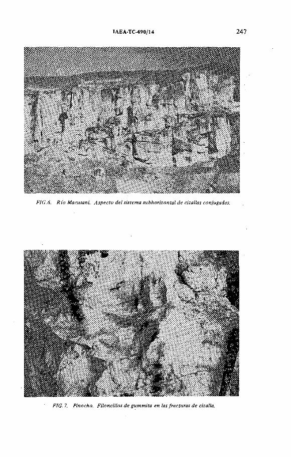
IAEA-TC-490/14 247
FIG. 7. Pinocho. F iloncillos de gu m m ita en las fracturas de cizalla.

248 ARRIBAS y FIGUEROA
dió lugar a la disyunción columnar que domina en los niveles más compactados de las ignimbritas, entre éllos el superior, que es donde se encuentra la mayor parte de los indicios uraníferos. El segundo, constituido por fracturas conjugadas, es paralelo al sistema de cizalla dúctil que, buzam iento variable de 5° a 15o, se desarrolló por la sucesiva com pactación y distensión, y posterior asentamiento de los materiales volcánicos.
3. LA MINERALIZACION
Las mineralizaciones de Macusani, aunque semejantes por la naturaleza de sus rocas encajantes a algunas de las que existen en otras partes del m undo [5], m uestran ciertas características petrológicas y estructurales que les hacen ser, por el m om ento, únicas en su genero.
3.1. Minerales hipogénicos
La pechblenda es el mineral primario de uranio en los principales indicios descubiertos hasta ahora —Pinocho, Chilcuno, Kiguitian, Calvario y Chapi—, y si bien la presencia de este mineral era predecible porque en todos éllos se habían encontrado gummitas, el descubrimiento de la pechblenda, generalmente muy oxidada, no se realizó hasta 1982, en Pinocho (Fig. 8). En cualquier caso, la existencia de minerales hipogénicos es im portante no solo por el hecho en sí, sino por la extraordinaria espectacularidad de los indicios, ya que las vetas de pechblenda pueden llegar a medir hasta 10 cm de potencia y varias decenas de metros de longitud (Fig. 2).
Salvo que está muy oxidada, la pechblenda tiene un aspecto normal, tan to a simple vista como al microscopio; siendo de destacar que, en Calvario, existen agregados botroidales seudomorfizados por gummita amarilla y autunita, y cu y o s. esferulitos pueden medir más de 2 cm de diám etro (Fig. 9). Al microscopio, la pechblenda aparece fuertem ente alterada, por lo que tiene dureza y poder reflector bajos. En realidad, se trata casi siempre de gummita negra, en la que quedan restos de parapechblenda y de los muy escasos sulfuros de hierro que acompañaban a los minerales primarios. Aquéllos son pirita y melnicovita, y se presentan bajo dos aspectos: diseminados en la pechblenda, form ando pequeñísimas inclusiones puntuales o agregados framboideos, y tapizando o rellenando los huecos que dejan entre sí los esferulitos.
Aparte de los sulfuros no se han encontrado hasta ahora otros minerales acompañando a la pechblenda. Sin embargo, teniendo en cuenta el Ca que debieron dejar libre las plagioclasas como consecuencia de la alteración hidroterm al sufrida por las rocas volcánicas, se puede prever que la calcita será también un com ponente de la ganga en las zonas no oxidadas de estos yacimientos. Por ahora, sin embargo, dada la fuerte alteración sufrida por los minerales primarios, sólo se puede decir

IAEA-TC-490/14 249
F IG .9. Calvario. E sferu litos d e pech blen da seudom o rfiza d o s p o r gu m m ita y au tunita , l ,5 x

250 ARRIBAS y FIGUEROA
que la pechblenda y los sulfuras de hierro, que se formaron por la deposición rítm ica de un gel complejo urano-sulfurado, son de hecho los únicos componentes de la mineralización.
3.2. Minerales supergénicos
Como, hasta ahora, todas las labores de reconocimiento, aún las más profundas, se han llevado a cabo en la zona de oxidación, los minerales secundarios de uranio -parapechblenda, gummitas y minerales hexavalentes- son los principales constituyentes de la mineralización.
Las gummitas naranjas, muy raras, consisten en agregados criptocristalinos de becquerelita y, probablem ente, billietita, la cual, puesto que no se ha encontrado por ahora baritina en la ganga, se habría formado con el Ba (200 ppm ) de las rocas piroclásticas. Por el contrario, las gummitas amarillas son muy abundantes, y están formadas por una asociación micro a criptocristalina de silicatos y fosfatos de uranio, especialmente uranotilo y fosfuranilita, que unas veces tiene textura com pacta y brillo vitreo, y otras, las más, textura terrosa y brillo apagado. En cuanto a los minerales supergénicos, los silicatos y fosfatos de uranio son los más importantes, especialmente la autunita, pues no solo rellenan los poros y tapizan las fracturas de las rocas encajantes, sino que seudomorfizan también a las propias gummitas.
Aparte de la autunita, que es el mineral secundario más frecuente y el único que se encuentra en los indicios inferiores de las tobas, p.e en Chapi Bajo y Kiguitian Bajo, los otros minerales hexavalentes son el uranotilo y la fosfuranilita.
4. LOS INDICIOS URANIFEROS
Salvo las anomalías de Chapi Bajo y Medio, Espéranza y Kiguitian Bajo (Fig. 1(B)), todas las mineralizaciones están formadas por gummitas amarillas, que séudomórfizan parcial o totalm ente a la pechblenda, y por fosfatos y silicatos de uranio. En todos los indicios, estos minerales se encuentran siempre en las ignimbritas de los niveles superiores, en los cuales son muy abundantes el cuarzo ahumado, la biotita y andalucita, distribuidas en los dos tipos de fracturas, verticales y subhorizontales, que se han descrito en el apartado 2.3. En el Cuadro II se resumen la situación y composición mineralógica de las principales anomalías.
Por lo que se refiere a los indicios citados más arriba, su im portancia es muy limitada, tanto desde el punto de vista económico como metalogénico. Todos éllos están formados por minerales secundarios, principalmente autunita, que tapiza las fisuras de las rocas volcánicas situadas por debajo del nivel donde se encuentran los minerales primarios. .
La formación de estos indicios, especialmente los de Chapi y Kiguitian Bajo, se debe probablem ente a la lixiviación por las aguas vadosas del uranio contenido

IAEA-TC-490/14 251
CUADRO II. PRINCIPALES ANOMALIAS DE LA MESETA DE QUENAMARIa
№ Indicio Altitud (en m)
Composición mineralógica
1 Pinocho 4300 pe, gu, au, fo, ur.
2 Esperanza I y II 4375 au, fo.
3 Esperanza III 4350 au, fo.
4 Chilcuno VI 4340 gu, au, fo.
5 Kiguitian II y III 4355 gu, au, ps.
6 Kiguitian I 4150 au.
7 Calvario 4430 gu, au, fo.
8 Chapi Alto 4600 gu, be, au, fo.
9 Chapi Bajo 4400 au.
a El número del indicio indica su situación en el mapa de la Fig. 1 (pe: pechblenda; gu: gummitas; au: autunita; fo: fosfuranilita; ur: uranotilo; ps: psilomelana; be: becquerelita).
en los niveles altos, el cual habría sido redepositado en aquellos niveles donde, por cambiar la textura y naturaleza de las rocas piroclásticas, se produce la sur- gencia de los acuíferos.
5. ORIGEN DE LA MINERALIZACION
El estudio petrográfico y mineralógico de los indicios uraníferos de Macusani indica que las rocas piroclásticas son al mismo tiem po las portadoras y receptoras del uranio. Esta conclusión deriva de las siguientes observaciones:
/.— Hasta ahora, los minerales primarios de uranio solo se han encontrado en la
parte superior de la serie volcánica, en un nivel constituido por ignimbritas de grano medio a grueso y que contiene abundante biotita y cuarzo ahumado.
— Este nivel es análogo a otros que aparecen intercalados en la serie volcánica, que poseen también una clara disyunción columnar y un comienzo de desvitrificación de la matriz. Esta contiene, además de los com ponentes normales -cu arzo , feldespatos, biotita y algo de m oscovita-, abundantes litoclastos de lutitas paleozoicas y permotriásicas, así como frecuentes cristales idiomorfos de andalucita, mineral que se formó probablem ente por la abundancia de alúmina en el magma riolítico como consecuencia de la incorporación de las rocas pelíticas o a causa de los procesos de diferenciación.

252 ARRIBAS y FIGUEROA
— La paragénesis es la misma en todos los indicios y se caracteriza por una asociación pechblenda-sulfuros de hierro análoga a la que se encuentra en muchos granitos hercínicos europeos. La pechblenda es masiva y, hasta ahora, salvo por lo que se refiere a los óxidos de Mn, no parece ir acompañada por otros minerales.
— Aparte del control litológico y mineralógico, existe otro estructural, ya que los minerales primarios se han depositado en las fracturas verticales y subhorizontales originadas por los procesos de enfriamiento, consolidación y asentamiento dela pila volcánica.
— La edad relativamente reciente de las rocas piroclásticas de la meseta de Quenamari, 4,2 m.a. [3], es del mismo orden que la obtenida para las ignimbritas de la meseta de Los Frailes, en Bolivia, de análoga composición, y que contiene también mineralizaciones de uranio, p.e. las de Cotaje [6].
— Es de destacar que estas dos formaciones volcánicas, jun to con las que constituyen las mesetas de Picotani, en Perú, y Morococala, en Bolivia, de edad y composición semejantes, están alineadas sobre un gran arco tectónico que, a lo largo de las Cordilleras Oriental y Real, sigue una dirección paralela a la Depresión Central del Altiplano.
— En la proximidad de la superficie, los indicios uraníferos han sufrido una fuerte meteorización. Esta ha dado lugar a la formación de gummitas amarillas que seudomorfizan parcial o totalm ente a la pechblenda, y al desarrollo de minerales secundarios de uranio que tapizan las fisuras o rellenan los huecos de las rocas encajantes.
Todos estos factores indican la existencia de una estrecha relación entre, por un lado, los indicios uraníferos con minerales primarios y, por otro, la naturaleza de las rocas volcánicas y la presencia en éllas de fracturas abiertas durante los procesos de consolidación.
Desde el punto de vista metalogénico, estos factores parecen dem ostrar que el uranio se depositó en determ inados niveles de la serie ignim brítica al tiem po que lo hacían los minerales que forman los rocas encajantes; lo que, por otra parte, y de acuerdo con las observaciones efectuadas en otros yacimientos [5], viene a confirmar que las rocas piroclásticas de tipo riolítico y riodacítico, soldadas o no, constituyen un im portante m etalotecto del uranio. En este caso, sólo haría falta explicar cómo este elemento ha podido ser movilizado, transportado y redeposi- tado en las fracturas de las tobas para dar lugar a concentraciones de interés económico.
Una posibilidad sería adm itir que el uranio estaba contenido en las cenizas y esquirlas de la matriz, las cuales, al desvitrificarse, habrían expulsado aquel elemento y perm itido su transporte por el agua liberada durante la recristalización hasta depositarlo en fracturas o en cualquier otra tram pa —paleosuelos, paleo- cauces, o niveles alterados y porosos— capaz de retener el uranio. El contenido en este elemento de las rocas encajantes, alrededor de 10 ppm, y la fuerte

IAEA-TC-490/14 253
alteración hidroterm al que localmente presentan las rocas de caja podrían servir de apoyo a esta hipótesis.
Sin embargo, las extraordinarias vetas de pechblenda masiva que caracterizan a estos yacimientos no se pueden explicar fácilmente por un simple proceso de desvitrificación. Por un lado, porque éste parece ser sólo incipiente en muchas de las rocas de Macusani, y por otro, porque de haber sido este proceso la causa principal de la liberación del uranio, el fenómeno habría sido más general y serían más numerosos los indicios de esta clase.
En este caso, es decir, si los componentes de las ignimbritas no han sido los portadores del uranio, sería más fácil admitir que las rocas piroclásticas donde se encuentran las mineralizaciones se originaron a partir de un magma rico en fluidos uraníferos que fueron atrapados por la matriz. Más tarde, avanzada la consolidación y una vez abiertas las fracturas de contracción y cizalla, los fluidos residuales pudieron circular y depositar en éllas la pechblenda y los sulfures de hierro que constituyen la mineralización. Es decir, que el proceso habría sido semejante al que dió lugar a algunas de las mineralizaciones filonianas que se encuentran en las calderas del Terciario y Cuaternario de Lakeview (Oregon), M cDermitt (Nevada) y Marysvale (Utah), en los EE UU, y en los volcanes Vulsini (Lazio), en Italia, así como en otras formaciones volcánicas más antiguas, tales como las proterozoicas y paleozoicas de Makkovik (Labrador), Rexpar (Columbia Británica) y Mount Pleasant (New Brunswick), en Canadá; Maureen (Queensland), en Australia; y Novazza (Bergamo), en Italia [5].
En Macusani, al igual que en muchos de los casos citados, las mineralizaciones de uranio se pueden considerar como exhalativas y sinvolcánicas, es decir, debidas a soluciones hidrotermales de tipo deutérico, cargadas de volátiles, que circularon por las rocas piroclásticas durante las últimas etapas de consolidación; en cuyo caso, si este fuera el origen, el uranio habría sido transportado como complejo clorurado o bicarbonatado, en estado hexavalente, y reducido y precipitado, en forma de pechblenda, en presencia de C 0 2 y/o SH2.
La precipitación de los minerales filonianos habría estado regulada además por las variaciones del pH, Eh y la tem peratura en la zona de mezcla de los fluidos hidrotermales con las aguas subterráneas, los cuales eran probablem ente muy abundantes en una zona que podía estar sometida ya, en esos m omentos, a la acción de procesos glaciares.
En cualquier caso, dadas las analogías existentes entre las rocas volcánicas de Macusani y las anteriorm ente citadas, así como con algunas otras más próximas y que pertenecen también al modelo de caldera resurgente [7], tales como las de la meseta de Los Frailes (kari-kari), en Bolivia, y la de Cerro Galán, en Argentina [8], situadas prácticam ente sobre el mismo arco volcánico en la Cordillera Oriental de Los Andes, cabe preguntarse si no será también Macusani una estructura de esta clase.
En principio y sin que se pueda llegar a ninguna conclusión en tanto no se conozca bien la geología de la zona, hay datos que así parecen confirmarlo; entre

254 ARRIBAS y FIGUEROA
otros, y aparte los rasgos estructurales que se observan en las imágenes Landsat, la naturaleza y disposición de las ignimbritas y los pórfidos graníticos que les intruyen, ya que algunos de éstos, con texturas de flujo y mineralizaciones de antim onio, p.e. las de Kolpa, tienen un carácter claramente subvolcánico.
6. CONCLUSIONES
Como resultado de lo anteriorm ente expuesto se puede afirmar que lasmineralizaciones uraníferas de Macusani están controladas por tres factores:
1) Litológicos: las anomalías uraníferas se encuentran siempre en las ignimbritas compactadas y diaclasadas que forman los niveles superiores de la serie volcánica.
2) Mineralógicos: los indicios con minerales primarios de uranio se hallan siempre en tobas caracterizadas por su abundancia en biotita, cuarzo ahumado y, en m enor proporción, andalucita.
3) Tectónicos: los minerales de uranio se depositaron en fracturas producidas •como consequencia de los procesos de compactación, contracción y asentamiento de los materiales volcánicos encajantes.
REFERENCIAS
[1] B ELL ID O , E., M O N T R EU IL , L., Aspectos generales de la m etalogenia del Perú, Geol.Ecori., 1, Min. Energ. Min., Perú (1972).
[2] BELLIDO, E., Sinopsis de la Geología del Perú, INGEMMET, Bol. 22 (1982).[3] BARNES, V.E., EDWARDS, G., McLAUGHLIN, V.A., FRIEDMAN, I., JOENSUU, О.,
Macusanita occurrence, age, and composition, Macusani (Perú), Bull. Geol. Soc. Am.81 (1969) 1541.
[4] AUDEBAUD, E„ LAUBACHER, G„ BARD, J.P., CAPDEVILA, R„ DALMAYRAC, B., MEGARD, F., PAREDES, J., La Cadena Hercínica en el Perú y Bolivia, Est. Esp., 3,Min. Eng. Min., Perú (1973).
[5] GOODELL, P.C., WATERS, A.C. (Eds), Uranium in volcanic and volcaniclastic rocks,Am. Assoc. Pet. Geol., Stud. Geol. 13 (1981).
[6] APARICIO, A., “Mineralización de uranio en rocas volcánicas terciarias de la Formación Los Frailes, Bolivia” , Yacimientos de Uranio en América Latina: Geología y Exploración (Actas Reun. Grup. Ases. Reg. Lima, 1978), OIEA, Viena (1981) 485.
[7] CURRY, D.L., “Two concepts of uranium geology in the USA that may be useful in Latin American uranium exploration” , Uranium Deposits in Latin America: Geology and Exploration (Proc. Panel Lima, 1978), IAEA, Vienna (1981) 89.
[8] FRANCIS, P., Giant volcanic calderas, Sci. Am. 248 6 (1983 46.

IAEA-TC-490/33
URANIO EN ROCAS IGNEAS: INTRUSIVAS SUB-EFUSIVAS Y PIROCLASTICAS DEL OROGENO ANDINO BOLIVIANO
E. PARDO-LEYTON Dpto. de Prospección Minera,Servicio Geológico de Bolivia,La Paz, Bolivia
Abstract-Resumen
URANIUM IN IGNEOUS ROCKS: SUB-EFFUSIVE AND PYROCLASTIC INTRUSIVE ROCKS OF THE BOLIVIAN ANDEAN OROGENY.
The uranium m ineralization enriched in residual magmas an d /o r hydro therm al fluids is the result o f magm atic differentiation and is found in igneous rocks o f different types (plutonic, sub-effusive, pyroclastic), depending on the degree o f evolution o f the magma cham ber in a given area. The studies perform ed in the South Am erican and Bolivian A ndean orogenies show that, in one way or another, the uranium is associated w ith plu tonium and /o r volcanism, so it is reasonable to consider this m orpho-structural un it as a favourable m edium for uranium prospection, since m odels o f this very specific type o f uraniferous m ineralization are already known. For these reasons, a brief description is given o f the uranium prospecting w ork done on igneous rocks o f the Bolivian Andean orogeny, w ith particular emphasis on the work perform ed in the volcanic environm ent o f the Sevaruyo uranium district (Los Frailes Plateau), as it is the one which is best know n and has been m ost intensively studied. In this paper, stress is laid on identifying the regional characteristics o f the Los Frailes area, its possible magmatic evolution and the geographic and stratigraphical situations of the m ain uraniferous prospects discovered.
URANIO EN ROCAS IGNEAS: INTRUSIVAS SUB-EFUSIVAS Y PIROCLASTICAS DEL OROGENO ANDINO BOLIVIANO.
El contenido de uranio enriquecido en magmas residuales y /o fluidos hidroterm ales, resultado de una diferenciación m agm ática, hace que la m ineralización se ubique en rocas ígneas de diferente categoría (plutónicas, sub-efusivas, piroclásticas), dependiendo del grado de evolución de la cám ara m agm ática en una determ inada región. Por los estudios realizados en el Orogeno Andino sudam ericano y en el de Bolivia, se conoce que de uno u o tro m odo el uranio está asociado al plu tonism o y /o volcanism o, por lo que es lógico pensar en esta unidad m orfoestructural com o am biente favorable para la prospección del uranio, conociéndose ya m odelos uraníferos bien determ inados. Por estas consideraciones, se presentan en form a bien resum ida los trabajos de prospección uran ífera realizados en rocas ígneas del Orogeno Andino boliviano, poniendo particular énfasis en los trabajos desarrollados en am biente volcánico del D istrito u ran ífero de Sevaruyo (Meseta de Los Frailes), el más conocido y más trabajado hasta el m om ento. En este trabajo se m uestran preferentem ente las características regionales del área de Los Frailes, su posible evolución m agm ática y la situación geográfica y estratigráfica de los principales prospectos u raníferos detectados.
255

256 PARDO-LEYTON
Los trabajos de prospección y exploración uranífera, realizados por la ex COBOEN (Comisión Boliviana de Energía Nuclear) a través del D epartam ento de Materias Primas Radiactivas, comenzaron preferentem ente en la unidad morfo- estructural del Orogeno Andino, por ser la más conocida, más trabajada y con m ayor potencial mineralógico del país a la fecha.
Así, en el Orogeno Andino se recolectaron y/o realizaron, entre otros, estudios petrográficos, mineralógicos, litoestratigráficos, tectónicos, metalogenéticos y de datación de edades, a fin de reunir la información necesaria para efectuar estudios de determinación de áreas favorables de aporte, así como de depositación. Se observó que el plutonism o y/o el vulcanismo son responsables en gran parte de la mineralización uranífera determinada en los prospectos de: Lunlaya-Cohuila (área Charazani), mina La Incognita (batolito de Sorata), Bolsa Negra-La Urania (batolitos de Taquesi-Mururata e Illimani), distrito uranífero de Los Frailes (piroclásticas de la Meseta de Los Frailes) y, por últim o, los prospectos del Distrito uranífero de Tupiza (vulcanitas de la Formación Choroma).
Tanto al norte como al sur del Orogeno Andino, los prospectos uraníferos citados fueron detectados en su gran m ayoría por trabajos de control radiométrico realizados en los lugares de recolección de mineral, de donde muchas de las muestras analizadas en los laboratorios de la ex COBOEN arrojaron contenidos im portantes de uranio, verificados y confirmados con trabajos de campo.
Para ubicarse dentro del área del Orogeno Andino (Andes bolivianos), es conveniente utilizar la delimitación preliminar de las unidades geológico-uraníferas de América Latina (Fig. l) , donde es factible delimitar seis unidades que coinciden en general con los principales ambientes m orfoestruçturales de América Latina y de Bolivia; sólo las unidades Extra-Andino Austral y Centro Americana se encuentran fuera de los lím ites territoriales de Bolivia.
Así, en Bolivia se tienen las siguientes unidades m orfoestruçturales de Oriente a Occidente: Precámbrico (I), Chaco-Beni (II), Subandino (III), Cordillera Oriental u Orogeno Andino (IV), Altiplano Boliviano (V) y Cordillera Occidental (VI) (Fig. 2).
1. INTRODUCCION
2. EVOLUCION TECTONICA DE LA CORTEZA CONTINENTAL DE SUD AMERICA Y SU IMPORTANCIA EN LA CARACTERIZACION DE PROVINCIAS URANIFERAS
Una vez ubicados dentro de la unidad m orfoestructural del Orogeno Andino y con la finalidad de referir algunas características de la evolución tectónica de la corteza continental de Sudamérica y del Orogeno en particular, se transcriben parcialmente los estudios realizados por Cordani [ 1 ].

IAEA-TC-490/33 257
F IG .l. D elim itación de unidades geológico-uraníferas en Sudamérica.

258 PARDO-LEYTON
M O R F O E S T ñ U C T U R A L E S
(I) Precámbrico(II) Chaco-Beni(III) Sub-Andino(IV) Orógeno Andino(V) Altiplano(V I) Cordillera Occidental
a) Coasab) Aricomac) Limbani
B O L IV IA
1 Batolito de Huato (Charazani)2 Illampu y Vani (Sorata)3 Zongo4 Huayna Potosí o Chucura5 Chacal taya6 Taquesi (Bolsa Negra)7 Illimani (Urania)8 Tres Cruces
10 San Cristóbal11 "S tock” Cerro Sapo12 "S tock” Japo13 Meseta de Morococala14 “Stock” de ia Salvadora15 Meseta de los Frailes16 "S tock” Cotaje17 "S to c k " Carguaicoiio18 Tollojchi19 Choroma (Tupiza)20 Chorolque21 Tatasi
Zona de mayor disturbación
Orógeno Andino
FIG.2. Mapa de Bolivia. Unidades y am bientes de prospección.

IAEA-TC-490/33 259
Si se examina la evolución tectónica del continente Sudamericano y sus relaciones con la mineralización del uranio, durante el fanerozoico, se identifican como m ínim o tres fases orogénicas, relacionadas con la Cordillera Andina, a saber: 1) en el Paleozoico Inferior; 2) en el Paleozoico Superior; 3) en el Meso- cenozoico.
Por la existencia de grandes fallas tensionales y /o direccionales producidas durante la estabilización tectónica de hace 1700 a 1800 m.a., el uranio pudo haber emigrado hacia las márgenes de las fajas orogénicas (sedimentos pericratónicos del antepaís), o concentrarse en estructuras tensionales (grandes zonas cataclásticas).
Por otro lado, el régimen tectónico m oderno se caracteriza por movimientos horizontales de grandes placas en la parte superior de la corteza terrestre; se explican así los cinturones de montañas, debido a colisiones de placas litosféricas.
¿Hasta qué punto podemos regresar en el tiempo, con el régimen de tectónica de placas? No lo sabemos ya que en el Paleozoico, e inclusive en el Precámbrico, se formaron muchos cinturones análogos a los modernos. Por esta razón habrá que considerar dos tipos de regímenes tectónicos diferentes, uno m uy antiguo y relacionado con la corteza primitiva de la tierra y otro moderno, asociado a los movimientos geodinámicos actuales. Aplicando los conceptos arriba mencionados, se puede explicar la evolución tectónica del continente sudamericano desde el Proterozoico Inferior, y en parte desde el Arqueano, hasta el presente, por el sucesivo desarrollo de cinturones móviles.
La situación actual del continente sudamericano se ubica en la infraestructura del Orogeno Andino, una gran faja móvil moderna; en esta región, las condiciones ambientales son de metamorfismo de medio a alto grado.
Resumiendo, podemos decir que la unidad m orfoestructural del Orogeno Andino sudamericano integra la cadena de Los Andes en una superficie de unos 3 millones de km 2, con una máxima afectación orogénica que condiciona y limita la posible yacencia de algunos modelos metalogenéticos del uranio.
Sus perspectivas de favorabilidad cubren una amplia gama de modelos uraníferos, desde hábitos filoneanos y de dispersión secundaria en plutonitas y vulcanitas, a los peneconcordantes en sedimentos continentales de las secuencias paleomesozoicas (cubetas interm ontanas y ambientes peribatolíticos).
3. CARACTERISTICAS LITOESTRATIGRAFICAS Y TECTONICASGENERALES DEL OROGENO ANDINO BOLIVIANO
El Orogeno Andino correspondiente a la parte boliviana cumple también el rol orogénico de cinturón móvil, está constituido por una cadena m ontañosa de aproximadamente 800 km lineales de extensión, con una superficie aproximada de 184 870 km 2, representando la quinta parte del territorio nacional.
Representa la unidad m orfoestructural más sobresaliente en la fisiografía del país; comienza en la frontera peruana (Cordillera Blanca del Perú), para

260 PARDO-LEYTON
prolongarse hacia el sur en territorio argentino, formando una dorsal cuya máxima expresión topográfica se manifiesta en la parte Norte del D epartam ento de La Paz (bloque metalogenético del norte).
Esta unidad m orfoestructural se diferencia de la faja subandina y de la del Altiplano en que presenta una marcada inversión en su relieve, puesto que los sinclinales constituyen los altos topográficos y los anticlinales las depresiones y los valles topográficos [2].
Revisando el mapa tectónico de Bolivia [3] se observa que la cadena hercínica está ampliamente desarrollada en el Orogeno Andino, distinguiéndose en esta unidad terrenos del Paleozoico Inferior (V4) afectados por la tectónica eo-hercínica (post-Devónico a pre-Carbonífero y terrenos del Paleozoico Superior afectados por la tectónica tardi-hercínica (Carbonífero a Pérmico Medio).
Durante la era paleozoica, el actual bloque paleozoico fué plegado, disturbado y ligeramente metamorfizado. En algunos sectores de su tram o constituyó una elongada cuenca marina de carácter “ Miogeosinclinal” , que se rellenó con una potente secuencia nerítica y batial del tipo “ Flishoide” del Ordovícico a Pérmico, caracterizada por depósitos de lutitas negras, grauvacas, ortocuarcitas y delgados bancos de calcáreos (Pérmico-nerítico transgresivo), favorables para la depositación de minerales uraníferos en cuencas intram ontanas y /o ambientes peribatolíticos.
Durante el Devónico y el Pérmico, la cuenca colatada en gran parte en el Silúrico Superior fué afectada por plegamientos del tipo Germánico y levemente m etam orfizada durante la orogénesis hercínica [3].
El revestimiento mesocenozoico de la plataform a hercínica está constituido por sedimentos típicos de cuencas intramontanas.
La actividad magmática del ciclo andino está representada por la Cadena de plutonitas de la Cordillera Oriental, agrupadas bajo el títu lo de granitos andinos sin diferenciación, por lo que las rocas de origen magmático en Bolivia han sido determinadas como pertenecientes a diferentes períodos geológicos y que en forma aislada se consolidaron form ando ya sean cuerpos plutónicos, sub-volcánicos y /o extensas cubiertas de material piroclástico, constituyendo en muchos casos rocas fértiles para la prospección del uranio, como se demostrará en el curso del presente trabajo.
La era paleozoica tiene pocas manifestaciones de magmatismo, pareciendo existir más bien una removilización magmática de carácter profundo, avalada por la presencia de numerosos diques, los mismos que intruyen rocas ordovícicas y devónicas de naturaleza diabásica y cálciea, sobre todo en los Departamentos de La Paz y Chuquisaca.
Las rocas ígneas de edad mesocenozoica se encuentran distribuidas dentro del Orogeno Andino, Altiplano y Cordillera Occidental. Durante el Terciario Medio a Superior se emplazan numerosos cuerpos de naturaleza hipoabisal, compuestos principalmente por rocas de carácter riodacítico y que en muchos casos se constituyen en rocas fértiles responsables de la mineralización Sn-W-U.
La principal actividad volcánica corresponde a este período y en general es de tipo semi-ácido, no encontrándose rocas de carácter básico.

IAEA-TC-490/33 261
CUADRO I. DAT ACIONES DE EDADES К/A r DE LA PARTE SEPTENTRIONAL DEL OROGENO ANDINO
Localizaciónaproxim ada
Tipo de roca Material datado Edad y error en m.a.
Ancom a Granito BiotitaMuscovita
- 2 2 5 ,0 ± 6 ,9 220,9 ± 6,5
Illam pu G ranodiorita B iotitaMuscovita
- 2 1 9 ,2 ± 6 ,7 201,6 ± 6,2
Chucura G ranodioritaGranito
B iotitaMuscovita
- 2 1 7 ,9 ± 6,6 214,9 ± 6,6
Unduavi G ranodiorita Biotita - 2 0 2 ,7 ± 6,1
Chacaltaya Zona de alteración Muscovita - 2 0 9 ,7 ± 6,4 212,8 ± 5,2
Mina Chojlla Alpita, veta Greissen
Muscovita - 2 0 3 ,2 ± 6,2 202,7 ± 6 ,2 195,4 ± 5,7
Taquesi Zona alterada G ranito
MuscovitaB iotita
- 2 1 4 ,2 ± 6,5 211,0 ± 6,8
Bolsa Negra Veta Salvan da
Muscovita - 2 1 2 ,3 ± 6,8
Illimani G ranodioritaA lteración
BiotitaMuscovita
- 28,4 ± 1,1 26,5 ± 0,8
Quinsa Cruz G ranodioritaGranito
BiotitaMuscovita
- 25,9 ± 0 ,8 23,9 ± 0 ,8
Sta. Vera Cruz G ranodioritaRiolita
B iotita - 23,3 + 0,8 20,7 ± 0,7
Oruro Riodacita Biotita - 16,3 ± 0 ,5
Potosí BrechaG ranodiorita
Biotita - 21,0 ± 0 ,5 21,2 ± 0,7
Las nuevas determinaciones radiométricas de potasio/argón (Cuadros I y II), realizadas sobre rocas graníticas y minerales provenientes de la faja septentrional de la Cordillera Oriental (15° a 18° S) entre las latitudes de Ulla Ulla y la ciudad de Oruro, confirman que esta región fué afectada por una actividad magmática repetida, a la cual se asocia una actividad m etalífera rica en metales litófilos.
Las intrusiones de monzogranitos, en parte peraluminosa y de granodioritas, se ponen en evidencia desde el Triásico Medio a Superior (225 a 202 m.a.) y durante el Oligo-mioceno (entre los 24,4 a 19,2 m.a.). El episodio magmático del Triásico ha afectado simultáneamente a 200 km lineales de la faja, desde el batolito

262 PARDO-LEYTON
CUADRO II. DAT ACIONES DE EDADES К/Аг DEL SECTOR LOS FRAILES PARTE MERIDIONAL DEL OROGENO ANDINO
Localización Tipo de roca Edad en m.a. Observacionesaproxim ada
F-21 Sta. Bárbara Vulcanita - 2,12 + 0,18 2,28 ± 0 ,1 7
F-9 Frailes LavasCuarzo
- 2,3 ± 0 ,4 9 2,2 ± 0,4
F-13 Tollojchi Latita - 10,24 + 0 , 3 8 - 10,03 + 0,34
F-l Azanaques BatolitoGranito
- 19,96 ± 0 ,9 2 - 2 0 ,4 1 ±0 ,71
F-2 Challapata Cuarzo, latita - 2 3 ,2 7 ± 1,5
F-3 Torcko Cuarzo, latita - 9,97 ± 0 ,4 8
F-4 Tihua Riodacita - 10,45 ± 0,7Carguaycollo Intrusivo
F-6 Chico Paya Cuarzo, latita Alterada
- 2 8 ,6 ± 0 ,5 28,9 ± 0 ,1
Es posible 2,8
F-8 Cebadillas Lavas, cuarzo, latita - 1 5 ,3 9 ± 0 ,4 7
F-10 Cuarzo, latita - 15,63 ± 1,22 - 1 4 ,6 4 ±0 ,71 - 1 5 ,6 ± 0 ,7 9
F-l 1 Cuarzo, latita - 12,07 ± 0 ,5 5- 12,43 ± 0 ,7 7
F - l4 Frailes Tollojchi
Cuarzo, latita- 1 0 ,9 ± 0 ,5 - 11,25 ± 0 ,5
F-l 5 Cebadillas Cuarzo, latita - 16,61 ± 0 ,8 2 - 15,52 ± 0 ,7 9
F - l6 Frailes Cuarzo, latita - 11,68 ± 0 ,5 7- 11,92 ± 0 ,4 7
Cerca a F - l4
F -l 8 Cruce Ventilla Cuarzo, latita - 18,81 ± 1,2
F - l9 Pum puri Cuarzo, latita - 1 3 ,4 7 ± 0 ,6 9 - 13,61 ± 0 ,7
F-20 Pum puri Cuarzo, latita - 1 5 ,0 ± 3 ,0
III P. Miraflores Lavas 6,89Potosí

IAEA-TC-490/33 263
de Huato por el norte (Charazani) hasta los batolitos del Taquesi-Mururata por el sur. En cambio, el dominio magmático del Terciario (Oligo-mioceno) ha seguido una migración longitudinal SE, donde las etapas tardías coinciden con el comienzo de un largo período de vulcanismo y de intrusiones, desde el Batolito del Illimani hasta el de Kari-Kari, en las cercanías de la ciudad de Potosí.
Una débil mineralización del tipo filoneano de Pb-Zn-Ag está probablemente asociada con el magmatismo de carácter básico a interm edio del Cretácico Superior.
4. CARACTERIZACION DE LOS PROSPECTOS URANIFEROS DENTRO DELOS AMBIENTES DE PROSPECCION DEL OROGENO ANDINO
Para dar una m ejor información de la geología del uranio en el Orogeno Andino y del emplazamiento de los prospectos, se respetará la clasificación de ambientes de prospección, en base a los cuales se describirán sintéticam ente las características específicas de los prospectos principales, a fin de motivar entre los especialistas del área investigaciones compartidas sobre aspectos tales como fertilidad, lixiviación, transporte, depositación, paragénesis y tipo de emplazamiento mineral, para pretender hacer correlaciones latinoamericanas dentro del Orogeno Andino y, a su vez, afinar los criterios para formular programas de prospección y exploración [4, 5].
4.1. Cordillera Oriental Norte (IV-1)
Los cuerpos ígneos situados al norte del Batolito del Illimani coinciden con el eje fisiográfico del macizo de Los Andes. En este sector aparece una franja aproximada de 7 km de ancho con sedimentos metamorfizados, donde encajan afloramientos ígneos muy favorables para una prospección aérea de geofísica integrada y /o prospección regional terrestre (prospección geoquímica). Los bordes oriental y occidental generalmente están delimitados por fracturas longitudinales de desarrollo regional, donde la mineralización está emplazada con preferencia en las zonas disturbadas por estas fallas y en rocas metamórficas. La composición petrográfica de estos plutones es de granitos a granodioritas, que en la m ayoría de los casos según se va investigando están constituidos por granitos a dos micas (biotita y muscovita), que en otras partes son fértiles en uranio (Macizo Central de Francia), por lo que será necesario investigar este bloque metalogenético en base a los prospectos ya detectados desde el batolito de Huato por el norte (Charazani), hasta el Taquesi (Bolsa Negra) por el sur.
Los prospectos de Lunlaya-Çohuila se hallan emplazados en el batolito de Huato (Charazani); se encuentran en piroclastitas del Terciario que recubren el paleorelieve, constituido de metasedimentos del Paleozoico (esquistos y pizarras de la Cordillera Real).

264 PARDO-LEYTON
La mineralización está constituida por minerales negros (pechblenda, uranita y coffínita), y coloreados (autunita, uranofano) asociados a pirita, calcopirita, baritina, esfalerita y calcita. El probable modelo uranífero para el prospecto de Cohuila es hidrotermal, enriquecido por soluciones de carácter supergénico en superficie. Para el de Lunlaya es de carácter supergénico, enriquecido por minerales uraníferos, lixiviados de las vulcanitas Charazani, depositados favorablemente en fracturas y diaclasas.
Este sector de Charazani, con los prospectos de Lunlaya-Cohuila, es corre- lacionable con el prospecto de Macusani (Puno, Perú) emplazado en plutonitas y vulcanitas ácidas de la Cordillera Blanca del Perú (batolitos de Limbani- Quillabamba y Coaza), con edades que fluctúan entre los 257 a 238 m.a., en dirección NW-SE, y cuya estructura penetra en territorio boliviano en las inmediaciones de área de Charazani.
Los prospectos de la mina La Incognita, Bolsa Negra y la Urania se encuentran emplazados en los batolitos de Sorata, M ururata e Illimani, respectivamente. Los batolitos intruyen metasedimentos del Paleozoico (esquistos negros y pizarras) y están constituidos por granodioritas con diques de granitos a dos micas (Yani- Zongo e Illimani).
El prospecto uranífero de mina La Incognita está emplazado en el batolito de Sorata; éste intruye metasedimentos del Paleozoico (lutitas y pizarras) de la Cordillera Real. Rocas fértiles portadoras de mineralización están constituidas por granodioritas y granitos a dos micas. La mineralización es de carácter polimetálico y está relacionada con vetas de cuarzo controladas por fallas y fracturas; no se observan magoscópicamente minerales de uranio, citándose entre los asociados pirita, bismutina, niquel y oro.
En la mina Bolsa Negra, situada en la falda occidental del batolito de Taquesi- Mururata, la mineralización de uraninita está presente en bancos y lentes discontinuos de cuarzo, asociados a vetas de wolfram y estaño, paralelas a la estratificación de las pizarras y esquistos de la Cordillera Real. Se sugiere que el depósito está relacionado con estratos sedimentarios (tipo m anto) pertenecientes a metasedimentos del Paleozoico.
En la mina denominada La Urania, situada en el flanco sur del batolito del Illimani, la mineralización de pechblenda está asociada paragenéticamente con minerales de Sn-W, en vetas polimetálicas en zona de contacto m etam órfico, entre la granodiorítica y los metasedimentos del Paleozoico. Asociados al uranio se encuentran: pirrotina, pirita, arsenopirita, esfalerita, calcopirita, wolframita, schelita, casiterita, marcasita, cuarzo y turmalina. Este prospecto está dentro del modelo de mineralización hidrotermal.
4.2. Cordillera Centro Oriental (IV-2)
Tanto la Cordillera Centro Oriental (IV-2) como la Centro Occidental (IV-3) comienzan al sur del lineamiento de Tapacarí. En éstas asoman a la superficie

IAEA-TC-490/33 265
solamente pequeños intrusivos, stocks sub-volcánicos y /o cuellos volcánicos, form ando cumbres aisladas que, regionalmente, presentan un ordenam iento lineal controlado por fracturas de carácter regional, orientadas paralelamente a los plegamientos.
Este sector situado al este de la Meseta de Los Frailes está constituido por los prospectos uraníferos de Yarhuicoya-Esperanza y Chullchucani emplazados en sedimentos paleomesozoicos.
La mineralización uranífera en el prospecto de Yarhuicoya está constituida por pechblenda, shoepita asociada a bom ita, calcopirita, chalcolita, esmaltita, cobaltina y calcopirita. La presencia de “ Mouse-eye-like” (ojos de ratón de pechblenda) nos indica que se formó a partir de soluciones coloidales hidrotermales de tem peraturas bajas a moderadas.
La mineralización en el prospecto La Esperanza está formada por torbernita, m etatorbenita y autunita, asociadas a hidróxidos de hierro y manganeso, m onacita y circón. Bajo el microscopio, la gohetita rodea a la m etatorbem ita. La temperatura y la mineralización del depósito sugieren un origen supergénico epigenético.
La mineralización uranífera en el área de Chullchucani contiene torbernita, autunita y uranofano, asociados a cuarzo, calcita, melanita, azurita, crisocola, heterogenita, con menores cantidades de alófana, cobalto y manganeso, de posible origen supergénico epigenético, formado por la removilización de depósitos sedimentarios singenéticos; se remarca el carácter de estrato-ligados (estrato-Boun). La mineralización de Cu-Co es de origen singenético con las areniscas cretácicas; la relación Cu-U-Co muy variable, notándose que a m ayor contenido de cobalto disminuye el de uranio.
En el prospecto de Padcoyo, relacionado con metasedimentos del Paleozoico (pizarras y esquistos del Ordovícico), se hallan presentes diques de alasquita, conteniendo pirocloro y autunita de probable origen de segregación magmática hidrotermal, enriquecidos por soluciones supergénicas.
4.3. Cordillera Oriental Sur (IV-4)
Este sector está representado en la parte sur del Orogeno Andino, en Bolivia, por núcleos precámbricos constituidos por gneis-esquistos y granitoides (PXV), los cuales fueron retom ados en los plegamientos hercínicos y andinos.
Ex COBOEN trabajó en los sectores Rejara y Mecoya, en base a rodados del Cámbrico, los mismos que en la Argentina contienen mineralización uranífera.
Se observan también terrenos del Paleozoico Inferior y algunos afloramientos del Paleozoico Superior (Suerio) (V-2). Hacia el SW se observan dacitas y andecitas ácidas a intermedias, correspondientes a las vulcanitas de la Formación Choroma-Tupiza.
En el distrito uranífero de Tupiza, algunos prospectos están relacionados con rocas volcánicas terciarias de carácter ácido, de la Form ación Choroma, cuya composición petrográfica porcentual de una de sus muestras es la siguiente: un
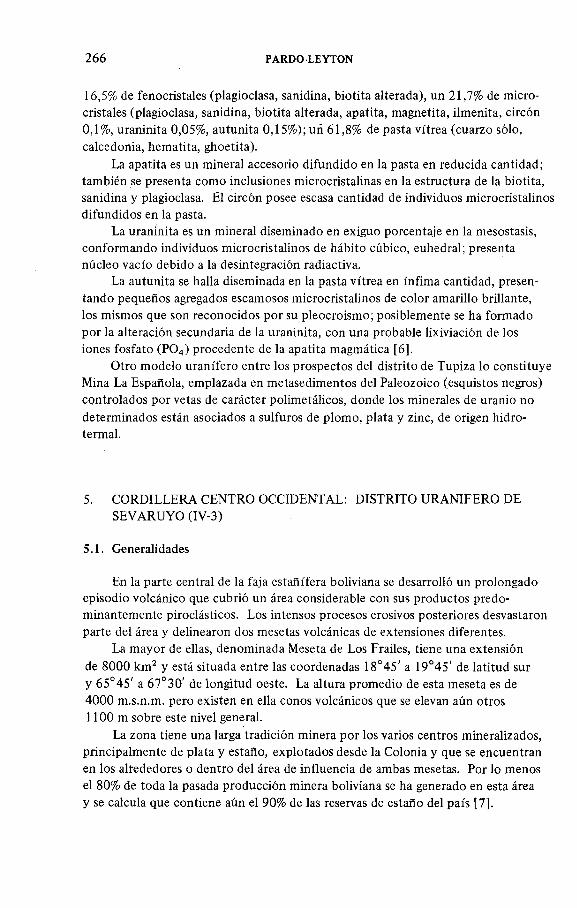
266 PARDO LEYTON
16,5% de fenocristales (plagioclasa, sanidina, biotita alterada), un 21,7% de micro- cristales (plagioclasa, sanidina, biotita alterada, apatita, magnetita, ilmenita, circón0,1%, uraninita 0,05%, autunita 0,15%); uñ 61,8% de pasta vitrea (cuarzo sólo, calcedonia, hem atita, ghoetita).
La apatita es un mineral accesorio difundido en la pasta en reducida cantidad; también se presenta como inclusiones microcristalinas en la estructura de la biotita, sanidina y plagioclasa. El circón posee escasa cantidad de individuos microcristalinos difundidos en la pasta.
La uraninita es un mineral diseminado en exiguo porcentaje en la mesostasis, conform ando individuos microcristalinos de hábito cúbico, euhedral; presenta núcleo vacío debido a la desintegración radiactiva.
La autunita se halla diseminada en la pasta vitrea en ínfima cantidad, presentando pequeños agregados escamosos microcristalinos de color amarillo brillante, los mismos que son reconocidos por su pleocroismo; posiblemente se ha formado por la alteración secundaria de la uraninita, con una probable lixiviación de los iones fosfato (P 0 4) procedente de la apatita magmática [6].
Otro modelo uranífero entre los prospectos del distrito de Tupiza lo constituye Mina La Española, emplazada en metasedimentos del Paleozoico (esquistos negros) controlados por vetas de carácter polimetálicos, donde los minerales de uranio no determinados están asociados a sulfuros de plomo, plata y zinc, de origen hidrotermal.
5. CORDILLERA CENTRO OCCIDENTAL: DISTRITO URANIFERO DESEVARUYO (IV-3)
5.1. Generalidades
En la parte central de la faja estañífera boliviana se desarrolló un prolongado episodio volcánico que cubrió un área considerable con sus productos predom inantem ente piroclásticos. Los intensos procesos erosivos posteriores desvastaron parte del área y delinearon dos mesetas volcánicas de extensiones diferentes.
La m ayor de ellas, denominada Meseta de Los Frailes, tiene una extensión de 8000 km 2 y está situada entre las coordenadas 18°45' a 19°45' de latitud sur y 65°45' a 67°30' de longitud oeste. La altura promedio de esta meseta es de 4000 m.s.n.m. pero existen en ella conos volcánicos que se elevan aún otros 1100 m sobre este nivel general.
La zona tiene una larga tradición minera por los varios centros mineralizados, principalmente de plata y estaño, explotados desde la Colonia y que se encuentran en los alrededores o dentro del área de influencia de ambas mesetas. Por lo menos el 80% de toda la pasada producción minera boliviana se ha generado en esta área y se calcula que contiene aún el 90% de las reservas de estaño del país [7].

IAEA-TC-490/33 267
5.2. Geología regional de la Meseta de Los Frailes
Un breve bosquejo de la geología regional debe considerar dos ciclos deposi- cionales mayores y un vulcanismo post-orogénico de carácter ácido a intermedio.
El prim er ciclo, predom inantem ente marino profundo, está com puesto de un espesor de más de 10 000 m de sedimentos mio-geosinclinales constituidos de lutitas areniscas y grauvacas que localmente pasan a pizarras y cuarcitas por metamorfismo. Al parecer, la serie permaneció relativamente indisturbada hasta su turbación por solevantamiento.
El tope del Devónico Medio marca el fin de la deposición. Aquellos sedimentos paleozoicos del prim er ciclo en el área están infrayaciendo discordan- tem ente a 600 m del Cretácico Continental, constituido m ayoritariam ente por areniscas rojas con calizas y margas multicolores subordinadas. Se conocen además diversos niveles de lavas basálticas de gran difusión de los Andes Orientales y el Subandino, pero ausentes en el Altiplano. La datación de uno de estos niveles dió una edad de 83 m.a. [8].
No existe continuidad en la sedimentación entre el Cretácico y el Terciario dado que el “uplift” del Bloque Andino comenzó solo durante el Oligoceno. Las formaciones clásticas del Terciario tem prano se intercalan con tufitas y rocas volcánicas calcoalcalinas a partir del Mioceno Inferior, haciéndose plenamente volcánicas en el Mioceno Superior y Plioceno; este vulcanismo es el responsable de la formación de las Mesetas de Morococala y Los Frailes.
Esta últim a es la de geología más compleja, debido a que m antos ignimbríticos de diversa edad y provenientes de varias fuentes se han apilado y traslapado hasta un espesor de más de 600 m. Modernas dataciones К /A r demuestran que la actividad comenzó hace 23 m.a. aproxim adam ente y se extendió hasta el Cuaternario antiguo, con interrupciones relativamente cortas. Inicialmente el vulcanismo fué de carácter piroclástico predom inantem ente, y solo en tiempos cuaternarios las efusiones de lavas andesíticas formadoras de conos volcánicos son mayoritarias. Globalmente, los m antos ignimbríticos terciarios pueden ser correlacionados con ía formación “ Riolita” y las lavas cuaternarias con la Form ación “ Andesita” , definida para los Andes Centrales en Perú, Bolivia y Chile [9].
Actualmente existe aún un vulcanismo remanente localizado en zonas de actividad termal caliente o fría. En el primer caso, las tem peraturas fluctúan entre los 60 a 80°C en los alrededores de las fuentes; precipitan sulfatos, travertinos y en algunos casos óxidos de hierro (Wichajlupe, La Calera).
5.3. Trabajos realizados en el área
Por tratarse de un área de enorme potencial mineralógico, durante la gestión de 1966 entre el Servicio Geológico de Bolivia (GEOBOL) y las NU se programó el levantamiento geofísico aéreo integrado en la Cordillera por los m étodos de electromagnetismo, magnetismo y radiométrico, com prendiendo las mesetas indicadas.

268 PARDO-LEYTON
Se determinaron 655 anomalías cualitativas, de las cuales 270 fueron rechazadas por ser de carácter dudoso; la m ayoría de las anomalías coincidían con zonas de alteración hidrotermal, remanentes andesíticos de la parte superior de la Formación de Los Frailes y con la presencia de stocks intrusivos y altos topográficos.
COBOEN procesó la información correspondiente a los registros radiométricos, observando que la m ayoría de las anomalías radiactivas coincidían con los altos topográficos y /o que muchas de ellas estaban desplazadas por carecer de corrección de altura, debido a que los instrum entos de medición no funcionaron. Sin embargo, toda esta información se ploteó en mapas topográficos a escala 1:50 000 y se procedió a la verificación de campo, tom ando en cuenta criterios geológicos tales como alteraciones, decoloraciones, silicificación, presencia de cuarzo ahumado y otros conceptos útiles en la prospección, determinándose así la m ayoría de los prospectos del distrito uranífero de Sevaruyo (Fig. 3).
Posteriormente, en 1979, COBOEN realizó una prospección heliportada sobre 5200 km 2 en las márgenes oriental y occidental de los Frailes, comprendiendo algunas ventanas estratigráficas y tom ando en cuenta el paleorrelieve de las vulcanitas; se detectaron algunos prospectos sobre la margen oriental de Los Frailes (Yarhuicoya - Tollojchi).
5.4. Evolución del vulcanismo en la Meseta de Los Frailes
Con la finalidad de aclarar la evolución tectónica, se procede a determ inar los niveles preferenciales de piroclastitas conteniendo uranio, en el ám bito de la Meseta de Los Frailes y preferentem ente en la parte occidental (Distrito uranífero de Sevaruyo). Para tal fin, se procedió a realizar una fotogeología orientada a observar en grande el com portam iento de las vulcanitas, tom ando en cuenta controles litoestratigráficos, tectónicos ya conocidos en modelos uraníferos determinados.
Por otro lado, se empezó a estudiar la evolución del vulcanismo terciario de Los Frailes mediante reconocim iento de carácter regional, procediéndose a la tom a de muestras para análisis de laboratorio tanto en el país como en el exterior, a fin de conocer el emplazamiento de los principales prospectos.
Algunos trabajos de investigación efectuados durante los últimos años han aclarado la evolución geológica del área. Morfológicamente, la zona ha sido definida como una meseta de ignimbritas [10], actualmente muy disectada por el drenaje radial centrífugo y disturbada por tectonism o de subsidencia. El clima es predom inantem ente seco y ventoso, favoreciendo la formación de depósitos eólicos en la parte norte del área.
La estratigrafía ha merecido la m ayor atención de los investigadores en los últimos años. Los trabajos minuciosos de Taylor [11], Barrón [ 12] y Jiménez [ 10] han perm itido conocer con bastante detalle el aspecto estratigráfico de las vulcanitas del área.

IAEA-TC-490/33 269
FIG.3. Mapa geológico del D istrito uranífero de Sevaruyo con localización de mineralización de uranio.

270 PARDO-LEYTON
/CICLO DE ACTIVIDAD
MAGMATICAE V E N T O M AG M ATlCO
E D A D
m .aF A S E TE C T O N IC A
A N O M A LIA DE
URANIO
oT r a v e r t in o s
W ichaj Lupi L o C o le ra
V)
D o m o s d e lova y c u e rp o s h ip o b iso le s
oL o v a s d e n s a s
o
oI g n im b r i ta V K 2 3 6
<
z
ЭI g n i m b r i t a V K 1
<r
o
ШI g n im b r ita D
tnI g n im b r i ta С 9 . 9 A su n c ió n
T o rk o
o
- I
A lteración y m inerolizoción A g,Sn ,Z n 1 0 . 5
tnи
In tr u s iv o C argu o ico llo
Oи
L a v a a l t e r a d o
_j<E
liiIg n im b r ita В 11
— Q u e c h u a 1
L o s D iques T h o to p a lc o
z I g n im b r i ta A 1 6 C o te jeH uoncaran i
«<r<E<t
CE
CL T u fita s e ignim brita de p o c o e s p e s o r
<XO
I n c a i c a 2
CO
CA
¡
С R E T A С 1 С 0
F IG .4. Evolución del vulcanismo terciario de la Meseta de Los Frailes (Distrito de Sevaruyo).
Los dos primeros se ocuparon de la estratigrafía terciaria pre-volcánica y, con ligeras discrepancias, arribaron a las siguientes conclusiones: existen sedimentos terciarios, predom inantem ente psamíticos, en todo el borde oeste del área y, aunque el contacto con las rocas cretácicas no es observable en forma directa, se infiere la existencia de una falla entre ambos sistemas (Fig. 4).
Estudios anteriores del Servicio Geológico de Bolivia dividieron el Terciario de esta región en tres unidades formacionales: formaciones Coca, Chamarra y Frailes. Taylor y Barran determ inaron que la Form ación Coca es la base de la

IAEA-TC-490/33 271
columna y esta compuesta por una serie de arcillas violáceas algo yesíferas, con interestratificación de delgados bancos de areniscas marrón obscuras. Por encima se encuentra la Formación Chamarra, constituida por un conglomerado basal seguido de areniscas de grano medio a grueso con bancos y lentes de guijarros de color café rojizo; en la parte media de la Formación se describen areniscas m ulticolores de grano fino, friables, con lentes de fragmentos de caliza y de limolitas y, hacia el tope, areniscas quijarrosas con clastos de tobas, horizontes tufíticos y un nivel ignimbrítico de 6 m de espesor, interestratificado en las areniscas; las dos formaciones están separadas por una discordancia angular.
Existe un paso interrum pido de las capas superiores de la Form ación Chamarra a las tobas soldadas de la Formación Los Frailes. Los detallados perfiles geológicos de Barrón [12] demuestran que esta formación se inicia con un nivel tu fítico de poco espesor que gradualmente pasa a tobas poco soldadas, para finalmente concluir en un grueso paquete de tobas densamente soldadas.
La base de la Formación de Los Frailes está por lo tanto en plena concordancia con la formación infrayacente, plegada hasta 58° de inclinación. Santiváñez [13] dató la toba soldada cerca de la base en 16 m.a.
La parte media y superior de esta formación se encuentra en posición horizontal y su estudio es llevado a cabo por Jiménez [ 10]. Los primeros resultados señalan la posibilidad de la ocurrencia de dos ciclos de actividad magmática. El primer ciclo se habría iniciado en el paquete ignim brítico plegado, descrito en la columna anterior y continuado con otros dos m antos de ignimbritas —el superior de 11 m.a., de edad prom edio— finalizando con la efusión de una corta colada de lava y la intrusión de un cuerpo dacítico hipabisal que posteriorm ente fué intensamente alterado y mineralizado con minerales de estaño, plata y zinc (Carguaycollo). La alteración, última fase de este primer ciclo, ocurrió hace 10,5 m.a.
El segundo ciclo se inició hace 9,9 m.a. con algún grado de cambio en la composición quím ica de las ignimbritas. Se pueden reconocer cuatro mantos compuestos de ignimbritas de diverso espesor. La última ignimbrita fué datada por Santivañez [13] en 3,6 m.a. La fase final de este ciclo construyó el volcán Vila Khollu y generó varias coladas de lavas y cuerpos intrusivos de pequeño tamaño, dispersos por toda el área.
De acuerdo con el trabajo de Jiménez [10], en la zona actuaron las fases La Incaica 2 y Quechua, del tectonism o andino, causando las dos discordancias angulares mencionadas antes. En la parte superior de la Form ación Frailes no existen moviemientos compresivos, sino más bien tensionales que originaron fallas normales y zonas de subsidencia. Los rumbos de fracturam iento más frecuentes son NE-SW, E-W y secundariamente N-S.
Las ignimbritas en general exhiben un elevado contenido de uranio, por lo que deben considerarse como una buena roca fuente. Todas las anomalías de uranio conocidas en este sector están relacionadas con los primeros niveles de ignimbritas presentes en el área. Sin embargo, se conocen anomalías determinadas

272 PARDO-LEYTON
por prospección aérea en niveles superiores. En todo caso, los valores radiactivos anómalos están siempre relacionados con las fases piroclásticas y no con las fases lávicas ni intrusivas. Se conocen dos anomalías en relación con la formación de travertinos que también han sido descritas en el área (Wichajlupe y la Calera).
6. CONCLUSIONES Y RECOMENDACIONES
Por los estudios realizados en los prospectos más im portantes del país se evidencia que el uranio está asociado a las plutónicas y /o vulcanitas del Orogeno Andino.
Así, los prospectos situados en la Cordillera Oriental norte están emplazados preferentem ente en granodioritas, las que intruyen metasedimentos del Paleozoico (lutitas, pizarras y esquistos negros de la Cordillera Real). La mineralización de uranio está asociada a polimetálicos, en zonas de contacto metamórfico (grano- diorita-pelosedimentos).
Por tratarse de plutonitas y vulcanitas, alineadas en dirección NW-SE, con un ancho medio de 20 km e in fruyendo metasedimentos del Paleozoico, se recomienda:
— Realizar, para la áreas de Charazani, Sorata, Bolsa Negra y La Urania, prospección geoquímica con determ inación de uranio fijo y uranio móvil en los granitos y zonas de contacto metamórfico, en base a determinaciones de uranio en ilmenita.
— Una vez prioritadas las áreas seleccionadas por la prospección geoquímica, se recomienda una prospección heliportada en las áreas marginales de contacto metamórfico, preferentem ente en el área de granitos a dos micas.
— Continuar con los estudios de investigación de muestras en laboratorio, con el fin de conocer el tipo de emplazamiento mineral.
— Establecer eventuales correlaciones litoestratigráficas, tectónicas, entre los prospectos de Macusani (Puno-Perú) y los de Lunlaya, Cohuila (Charazani- Bolivia).
Con respecto a los prospectos situados en el Distrito uranífero de Sevaruyo, emplazado en vulcanitas terciarias, se concluye que:
— La evolución magmática del área está caracterizada por la presencia de dos ciclos magmáticos (16 a 11 m.a. y 10,5 a 3,6 m.a.), formados por la efusión de tufitas, tobas, m antos ignimbríticos, coladas de lavas y de intrusiones de carácter dacítico.
— Los minerales primarios de uranio están situados en las fases piroclásticas correspondientes al primer ciclo magmático y a no así en las fases de carácter lávico y/o intrusivo. Los mismos están sometidos a procesos de'intensa erosión y lixiviación.
— La mineralización uranífera, encontrada hasta ahora en la parte occidental de Los Frailes (Distrito uranífero de Sevaruyo), es con toda probabilidad de

IAEA-TC-490/33 273
carácter supergénico y está formada por la alteración de mineralizaciones primitivas pre-existentes. La coffinita encontrada en niveles inferiores a Mina . Cotaje probablem ente se formó por procesos locales de reducción, en la parte inferior de la zona de oxidación.
— La mineralización de uranio determinada en las vulcanitas terciarias de la Formación Choroma, Tupiza, está constituida por uraninita, presente como un mineral diseminado conform ando individuos microcristalinos; la autunita presente se ha form ado probablem ente por la alteración secundaria de la primera, con una probable lixiviación de los iones fosfato (P 0 4=) procedentes de la apatita magmática.
Se recomienda para ambos sectores realizar investigaciones más intensivas en base a muestras de laboratorio, a fin de conocer el tipo de emplazamiento mineral.
Por otro lado, se debe continuar con los estudios de la evolución del vulca- nismo terciario, a fin de conocer los niveles y épocas preferenciales de mineralización y depositación mineral.
Se debe tom ar conocimiento teórico de la evolución de las calderas colapsadas y/o resurgentes, ampliamente favorables para la prospección mineralógica y así buscar este tipo de modelos de emplazamiento en las áreas indicadas y otras del país.
AGRADECIMIENTOS
El autor del presente trabajo desea testim oniar su agradecimiento al Ing. Nestor Jiménez, por su cooperación eficaz en la elaboración del capítulo de la Meseta de Los Frailes; al OIEA en la persona del Dr. John A. Patterson,' Secretario Científico de la Reunión El Paso-Texas, por haber motivado y auspiciado la referida reunión técnica; a las autoridades ejecutivas del Servicio Geológico de Bolivia (GEOBOL), por haber facilitado la presentación del trabajo y auspiciado la visita técnica y, a los profesionales técnicos, prospectores, personal de cartografía y planta de secretarías del Depto. de Prospección Minera (GEOBOL), por su colaboración directa e indirecta en la elaboración del presente trabajo.
REFERENCIAS
[1] CORDANI, U.G., “ Evolución tectónica de la corteza continental de Sudam érica y su im portancia en la caracterización de provincias uraníferas” , Y acim ientos de Uranio en América Latina: Geología y Exploración (Actas Reun. Grup. Ases. Reg. Lima, 1978), OIEA, Viena (1 9 8 1 )3 .
[2] CLAURE, H., MINAYA, E., Mineralización de los Andes Bolivianos, en Relación con la Placa de Nazca, GEOBOL/COMIBOL, La Paz, Bolivia (1979).
[3] MARTINEZ, C., TOMASSI, P., BOTELL, R., Mapa tectónico de Bolivia, UMSA, Geo- ciencias, GEOBOL, La Paz, Bolivia (1973).

274 PARDO-LEYTON
[4] PARDO-LEYTON, E., “ Determ inación de áreas favorables para la prospección de uranio. en territorio boliviano” , Y acim ientos de Uranio en América Latina: Geología y Explora
ción (Actas Reun. Grup. Ases. Reg. Lima, 1978), OIEA, Viena (1981) 155.[5] PARDO-LEYTON, E., BARRON, E., “ Estudio prelim inar sobre la geología y m etalo-
génesis del uranio en Bolivia” , Geología y Metalogénesis de los Depósitos y Manifestaciones U raníferos de Sudam érica (Actas Reun. Grup. Trab. San Luis), OIEA, Viena (1984).
[6] AGIP URANIUM LTDA., Inform e Final Técnico-Económ ico 1974—1978, C ontrato de operaciones uraníferas COBOEN-AGIP, Bolivia.
[7] GEOBOL-PNUD, Deep E xploration Potential for Major Tin and Tin-Silver Deposits Beneath the Frailes and Morococala Volcanic Mesetas, Central Andean Bolivia, Project Cordillera, GEOBOL, La Paz, 1982 (internal report).
[8] EVERNDEN, J.F ., KRIZ, S.J., Cherroni, C., Potassium-argon ages o f some Bolivia rocks, Ec. Cacol. 7 2 (1 9 7 7 ) 1 0 4 2 -1 0 6 1 .
[9] PICHLER, H., ZEIL, W., The Cenozoic rhyolite-andesite association o f the Chilean Andes, Bull. Volcanol. 35 (1972) 4 2 4 -4 5 2 .
[10] JIMENEZ, N., Evolución del Vulcanism o Terciario en la Meseta de Los Frailes, Tesis de grado en preparación, La Paz, Bolivia, 1984.
[11] TAYLOR, J., Uranium Prospection, R eport to the Governm ent o f Bolivia, IAEA, Vienna, 1980 (internal report).
[12] BARRON, E., Perfiles Geológicos, Zona Mina Am istad-Santiado del Larco, Inf. Int. COBOEN, La Paz, Bolivia (1981).
[13] SANTIVAÑEZ, R., Estudio Petrográfico de la Región de Sevaruyo (W ichajlupe), Tesis de grado UMSA, La Paz, Bolivia 1977.

IAEA-TC-490/32
CONSIDERACIONES GEOQUIMICAS DE LOS INDICIOS URANIFEROS DE MACUSANI, PUNO (PERU)
J. VALENCIA, G. ARROYO Dirección de Materias Primas,Instituto Peruano de Energía Nuclear,Lima, Perú
Abstraer-Resumen
GEOCHEMICAL ASPECTS OF THE URANIUM OCCURRENCES OF MACUSANI, PUNO (PERU).
The ignim brites o f the Q uenam ari form ation, of Mio-Pliocene age, are found in graben- type tectonic depressions in the south-east o f Peru, and their uraniferous po ten tial is promising. They are peralum inous, occur in an unusual mineralogical association w ith andalusite, sillimanite and m uscovite; and are enriched in volatile, trace and m etallic elelments. The uraniferous m ineralization is m ainly uranium w ith sulphides (pitchblende); phosphuranylite-renardite, au tunite, m eta-autunite and gum m ite have also been identified, and the presence o f phosphorus in the uranium oxide (p itchblende) has been detected w ith the m icroprobe. These rocks are the result of partial fusion of the crust m aterial in back-arch position in the A ndean geotectonic structure.
CONSIDERACIONES GEOQUIMICAS DE LOS INDICIOS URA NIFEROS DE MACUSANI, PUNO (PERU).
Las ignim britas de la form ación Quenam ari, de edad m iopliocénica, se em plazan en depresiones tectónicas de tipo “graben” , en el SE del Perú y tienen un potencial uranífero especiante. Presentan un carácter per-aluminoso y una asociación m ineralógica excepcional con andalucita — sillimanita — m uscovita; así como un enriquecim iento en elem entos volátiles, elem entos trazas y m etálicos. La m ineralización uran ífera es principalm ente urano- sulfurada (pechblenda); se ha reconocido además fosfuranilita-renardita, au tun ita , m eta-autunita y gum m ita; y se ha identificado por m icrosonda la presencia de fósforo en el óxido uranoso (pechblenda). Estas rocas resultan de la fusión parcial de m aterial crustal en posición “ back-arch” en el edificio geotectónico andino.
1. INTRODUCCION
En el sur-este del Perú aflora una potente secuencia de rocas volcánicas, pertenecientes a la formación Quenamari, a las cuales están asociados numerosos indicios uraníferos en curso de estudio.
Las ignimbritas de la formación Quenamari están situadas en el Departam ento de Puno, provincia de Carabaya, próximas a la localidad de Macusani. Están distribuidas en un conjunto de depresiones de origen tectónico, orientadas SE-NW,
275

276 VALENCIA y ARROYO
en diferentes cuencas: Macusani, Crucero, Picotani, Cojata, etc; morfológicam ente están en el borde accidental de la Cordillera Oriental por el este y la cordillera de Carabaya por el oeste.
La altitud promedio es de 4300 m.s.n.m y tiene un clima frío con lluvias en el período de diciembre a marzo.
2. GEOLOGIA
Las ignimbritas de Quenamari forman parte del episodio volcánico mio- pliocénico del SE del Perú, datado en 4,2 m.a [1]; a causa de la erosión, su potencia real es desconocida (en Macusani las ignimbritas tienen una potencia aproximada de 350 m).
El substratum está constituido, por rocas paleozoicas de diversa litología: esquistos, pizarras, cuarcitas, calizas, dolomitas y rocas volcano-detríticas.
Desde el punto de vista estratigráfico, en la formación Quenamari se distingue regionalmente la siguiente secuencia:
— Serie volcánica básica. Aflora en las inmediaciones de Crucero en forma de coladas basálticas vesiculares.— Serie ignimbrítica. Sobreyace a las coladas basálticas formando grandes mesetas disectadas por la erosión fluvial. La serie tiene una estratificación horizontal integrada por varias unidades de emplazamiento y enfriamiento [2], agrupadas en varios episodios eruptivos que alternan entre tobas e ignimbritas; las primeras forman un relieve suave mientras que las segundas forman escarpas con diaclasa- m iento columnar y su diferencia granulométrica contrasta con la homogeneidad mineralógica y química; la falta de estratificación (fina) y la presencia de contactos erosivos en la base de cada secuencia indican que estas vulcanitas se han emplazado bajo la forma de coladas piroclásticas y las erupciones se han debido suceder dentro de un lapso de tiem po relativamente corto.— Nivel de tufo epiclástico. Observado dentro de la parte superior de la secuencia ignimbrítica, se trata de un producto de desmantelamiento in situ de las ignimbritas; presenta un carácter discontinuo con un espesor máximo de 10 m; es un nivel guía local.— Serie lacustre. Yace sobre las ignimbritas de Quenamari, en los alrededores de Crucero y Macusani, y está compuesta de decenas de metros de argilitas, diatomitas, calizas silicificadas y tufos redepositados de color blanquecino.
3. PETROGRAFIA Y MINERALOGIA
La formación Quenamari corresponde a un im portante emplazamiento de tufos piroclásticos de composición riolítica color blanco a grisáceo, relativamente

IAEA-ТС-490/32 277
friables y con textura vitroclástica a pseudo fluidal [3], donde los fenocristales y líticos están groseramente alineados, presentando del 30 al 40% de fenocristales milimétricos a m enudo rotos o deformados; los elementos líticos están representados por pelitas, andesitas, granitos y cuarcitas o fragmentos de ignimbritas y de macusanitas (vidrio volcánico). Están constituidas por cuarzo bipiramidal hialino y ahumado, obsidiana, feldespatos (sanidina, plagioclasa, albita), b iotita, muscovita, andalucita, sillimanita, turmalina, etc., todo esto dentro de una matriz de cuarzo feldespática, biotita que a m enudo está alterada.
La ausencia de flamas y figuras características de “colada” en régimen laminar, así como el débil grado de soldadura de las astillas vitrosas ( “echards” ) implican un grado de fragmentación im portante, un régimen de emplazamiento turbulento y una tem peratura de emisión baja [2].
El estudio al microscopio permite distinguir una mesostasa fuertemente alterada (argilización im portante: kaolinita y m ontm orillonita).
La paragénesis magmática está caracterizada por el crecimiento de apatita, biotita, plagioclasas albíticas y sanidinas y la precipitación precoz de la andalucita seguida por cuarzo y muscovita. La confirmación del origen magmático precoz de la andalucita está evidenciada- por la observación de la mineralogía de la macusanita (vidrio volcánico no alterado) y preserva un estado de cristalización menos avanzado, la andalucita autom orfa y orientada (¿según la dirección de flujo?), que es el sólo mineral constantem ente representado (=« 1%); las otras fases presentes de forma esporádica son idénticas a las de la ignimbrita; se observa, sin ëmbargo, la presencia de virgitita (solución sólida S i0 2-LiAlSi20 s) descubierta por Barnes [ 1 ]. Se nota una gran abundancia de fragmentos de vidrio desvitrificado a manera de pequeños esferulitos calcedónicos, rodeados de una corona de esferolitos filitosos (¿illita?) : este mineral es muy frecuente como constituyente tardío de lavas riodacíticas, tufos, etc. de cordilleras muy recientes; el topacio xenomorfo se presenta con un clivaje bien m arcado, a veces de color rosado [4].
La paragénesis de los fenocristales está caracterizada por la presencia de andalucita de plecroismo rosado, de muscovita sub-automorfa (celadonitá 10%, paragonita ^10% ), de cuarzo, de sanidina (Or 70, Ab 30), de plagioclasa zonada (al centro Or 2, Ab 69, An 29; borde Or 5, Ab 90, An 5), de biotita (Fe/(Fe + Mg)= 0,7; Al/(m+2 + Al) = 0,3), de apatito, de turmalina (Fe/(Fe + Mg) = 0,7), de sillimanita prismática muy abundante, de ilmeno rutilo- ilmenita (Ru 30, Ilm 70 a Hem 3 Ilm 97), de zircón y de espinel verde (He 60, Ga 40); todos estos son las inclusiones más frecuentes de los fenocristales.
El estudio de las relaciones espaciales y texturales entre los diversos minerales muestra que la sillimanita, la espinela, el zircón, y la ilmenita son minerales relictos. De igual forma lo son la turm alina (parcialmente reabsorbida), así como una parte de los apatitos, plagioclasas, sanidinas (con inclusiones de zircón y sillimanita dispuestos según las fases de crecimiento del mineral); las biotitas (con inclusiones de espinela, ilmenita, apatito) han sido heredadas del material original de la zona de anatexis.

F IG .l. Variaciones verticales de composición de la secuencia ignim britica de Macusani.
278 V
ALEN
CIA
y
AR
RO
YO

IAEA-TC-490/32 279
El vidrio volcánico (macusanita) se presenta en forma de guijarros de diferentes tamaños, generalmente redondeados a causa del transporte. Su composición química similar a las ignimbritas, así como la edad (m étodo K/Ar [4]) indican el mismo origen volcánico; la m acusanita data de 4,2 ± 1,5 m.a. y la ignimbrita (biotita) de 4,1 ± 1,0 m.a.
En las ignimbritas de Quenamari no se observa ninguna variación significativa de su composición mineralógica, y su composición quím ica es de riolita; están notablem ente enriquecidas de gas y fluidos (presencia en abundancia de topacio y turmalina) [3].
4. GEOQUIMICA
En los datos concernientes a la geoquímica de las ignimbritas de Quenamari, la “Macusanita” (vidrio no desvitrificado) es tomada como roca de referencia y los elementos que la constituyen son considerados como representativos de la composición original del magma riolítico, lo que aporta una inform ación directa sobre la composición del mismo en un punto dado de su evolución.
4.1. Elementos mayores
Los tenores de los elementos mayores están representados en la F ig .l , en la que se evidencia una composición tanto química como mineralógica constante en la vertical; se trata de una composición medianamente rica en sílice (S i0 2 = 72% en prom edio); per-aluminosa (14,3 — 15,3%), m uy pobre en Fe, Ca, Mg, Ti (Q + Ab + Or + Со > 95%) (Cuadro I); los cambios más notables conciernen a los alcalinos con una relación K 20 /N a 20 > 1 para la roca desvitrificada y < 1 para la macusanita; esta modificación puede ser el resultado de la desvitrificación y alteración, siendo este fenómeno el que transforma la mesostasa cuarzofeldespática en arcillas. En cuanto al P2Os, se observa un enriquecimiento en las riolitas de Quenamari (0,34%) en relación con otras riolitas del sur del Perú (0,10%) [5].
Estos fenómenos son comparables a los observados en rocas volcánicas de los yacimientos de la Sierra de Peña Blanca (México) [6].
Los análisis quím icos de una sección muestreada [7] se reportan sobre el diagrama Q 3 - B3 - F 3 (Fig.2); su posición en el triángulo muestra que hay una contribución im portante de los feldespatos y una proporción m enor de la biotita en relación con la muscovita; hacia la parte superior de la secuencia se observa una tendencia hacia el polo de los feldespatos (F3) que probablem ente esté relacionada con los fenómenos de desvitrificación de las ignimbritas.
4.2. Elementos menores
Los elementos menores analizados (m étodo de espectrom etría de emisión) han sido de preferencia aquellos que guardan relación con el uranio (Cuadro II).

CUADRO I. ANALISIS QUIMICOS DE LAS IGNIMBRITAS DE QUENAMARI DE MACUSANI Y DE LA MACUSANITA - ELEMENTOS MAYORES EN %
MH-3 MH-4 MH-5 MH-6 MH-7 MH-8 MAC-9 MH-A MH-10 MAC-10 MH-1 MAC-1 MH-2
SÍ02 73,43 72,39 70,25 72,10 71,43 73,01 73,22 68,35 71,50 73,00 71,1 72,8 72,65
a i2o 3 14,35 14,81 15,57 14,38 15,39 14,91 16,13 16,59 14,35 15,6 15,8 16,3 14,68
Fe20 3 1,26 1,36 1,46 1,24 1,38 1,14 0,76 2,37 1,47 0,65 1,03 0,59 1,29
MnO 0,04 0,03 0,03 0,04 0,04 0,03 0,06 0,05 0,04 0,06 0,04 0,06 0,04
MgO 0,2 0,2 0,19 0,2 0,21 0,2 TR 0,43 0,37 0,04 0,05 TR 0,24
CaO 0,5 0,59 0 ,69 0,6 0,66 0,81 0,05 0,58 1,53 0,3 0,81 0,16 0,65
Na20 3,37 3,2 3,17 3,16 3,69 3,45 4,26 2,68 3,4 4,10 3,20 4,1 . 3,25
k 2o 4,54 4,87 4,75 4,78 5,5 4,89 3,73 4,26 4,75 3,9 5,0 3,7 4,84
TiO 0,13 0,14 0,16 0,10 0,22 0,14 0,06 0,35 0,28 0,2 0,15 0,02 0,12
P2O5 0,36 0,42 0,3 TR 0,27 TR 0,39 0,26 0,31 0,53 0,37 0,55 0,35
PF 1,51 1,6 2,96 2,17 0,79 0,99 1,05 4,02 1,53
T otal 99,19 99,61 99,53 99,22 ' 99,58 99,57 99,71 99,94 98,00 98,38 98,15 98,28 99,64
MH = Ignim brita MAC = M acusanita MH-A = Tufo epiclástico
280 V
ALEN
CIA
y
AR
RO
YO

IAEA-TC-490/32 281
Q3
FIG.2. Diagrama Q3-B3-F3.
Las variaciones verticales de estos elementos están representados en la Fig.3. El enriquecimiento en elementos volátiles es excepcional: F (ignimbrita = 0,18%—0,29%, macusanita = 1,31%) Li20 (Ig = 560—1780 ppm , mac = 0,74%), B20 3 (Ig = 960 ppm, mac = 0,62%). De igual forma se observa un enriquecimiento de los siguientes elementos; Rb (Ig = 310—560 ppm, mac = 990 ppm ),Sn (Ig = 32—60 ppm , mac = 120 ppm ), As, Cs, TI y Be; en tanto que se observa un empobrecimiento en Sr (Ig = 90—190 ppm , mac = 1 ppm ); Mo, W y tierras raras.
En cuanto a U y Th, se observa el siguiente com portam iento:U (Ig = 5 ,6 -1 8 ppm, mac = 18,44 ppm) y T h(Ig = 8,6—13,3 ppm , mac = 2,27 ppm). La m ayoría de los tenores en torio de las ignimbritas es superior a 10 ppm, mientras que para la macusanita es de 2,27 ppm; el com portam iento del uranio es inverso con relación al torio; en la macusanita el tenor de uranio es de 18,44 ppm, mientras que para las ignimbritas es de 10 ppm (promedio). Esto sugiere que hubo un enriquecimiento en uranio con relación al torio [8], lo que a su vez sugiere la participación de rocas pelíticas en el magma [1 ,9 , 10].

CUADRO II. ANALISIS QUIMICOS DE LAS IGNIMBRITAS DE MACUSANI Y DE LA MACUSANITA - ELEMENTOS MENORES EN PPM
MH-3 MH-4 MH-5 MH-6 MH-7 MH-8 MAC-9 MH-A MH-10 MAC-10 MH-1 MAC-1
Br 246 280 279 332 351 475 13 394
СО 26 28 21 38 62 . 17 19 29
Cr < 1 0 < 1 0 20 < 1 0 < 10 < 1 0 < 1 0 < 1 0 10
Cu < 1 0 < 1 0 < 1 0 < 1 0 < 1 0 < 1 0 < 1 0 < 1 0 40 30 8
Ni < 1 0 < 1 0 < 1 0 < 1 0 < 1 0 < 1 0 < 1 0 < 1 0 50 30
Sr 88 96 103 108 140 188 13 168 100 10 70
V ' 13 15 22 33 38 36 17 29
Rb 549 477 466 538 515 312 600 420 750 2000 490 900
Li 832 472 347 523 606 262 3220 429 200 1500 1100 2700
Th 8,62 10,36 10,30 9,87 13,33 12,01 2,27 17,33 3,7 3,0
U 5,96 18,06 12,16 12,40 11,30 5,60 18,44 466,67 10,2 6,8
MH = Ignim brita MAC = M acusanita MH-A = Tufo epiclástico
282 V
ALEN
CIA
y
AR
RO
YO

FIG.3. Variaciones verticales de com posición quím ica de la secuencia ignim britica de Macusani.

VALENCIA y ARROYO
5 0 ■
4 0
3 0
20
10 ■
987
6
5
4
10,9 0,8 0,7
0.6
0,5 ■
0 ,4 ■
0,3
0,2
0,10 ,090,080,07
0,06
0 ,05
0 ,04
0 ,03
0,02
M H -3
M H -4
M H -5
M H -6
M H -7
M H -8
M A C
La/ V b
2 0 ,6 4 2
2 1 ,0 1 5
19,162
1 8 ,414
2 3 ,5 9 0
2 6 ,1 8 5
2 ,1 38
La Ce N d Sm Eu G d D y E r Y b Lu
FIG.4. Repartición de las tierras raras de las ignimbritas de Macusani.

IAEA-TC-490/32 285
4.3. Tierras raras
La actividad efusiva de una misma cámara magmática posee características geoquímicas propias y, por consiguiente, las concentraciones en tierras raras permanecen constantes aun cuando se produzcan variaciones en su composición quím ica a petrográfica [5].
Se pueden distinguir dos grupos (Fig.4): las riolitas caracterizadas por su tenor algo elevado en tierras raras ligeras y una relación La/Yb elevada (1 8 ,4 -2 6 ,1 ), y la macusanita, con tenores más bajos en tierras raras y una relación La/Yb baja (2,1).
Asimismo, éstas presentan una anom alía negativa en europio, que es más pronunciada en la macusanita. Por o tro lado, la macusanita presenta una anomalía positiva en cerio; esto indica que el ambiente magmático habría tenido carácter reductor [11].
5. MINERALIZACION
El carácter de la mineralización es polimineral en general, y asociada de una manera estrecha con la mineralización de sulfuros. Desde el punto de vista de la mineralización uranífera, existe la de tipo tetravalente, aunque en vías de transformación en productos amarillos.
El estudio microscópico [3] señala la presencia de una textura brechoide que se traduce en fragmentos de óxidos uranosos (pechblenda) dentro de una matriz, donde están asociados, cofinita y productos amarillos. La paragénesis m etalífera es urano-sulfurada: la fase uranífera se presenta mineralógicamente en dos formas: pechblenda, en la que predomina la fase botrioidal, y cofinita, de un poder reflector más bajo. La prechblenda posee poder reflector variable debido probablem ente a la inicial transform ación en productos secundarios.
El estudio al microscopio electrónico de barrido [3, 8] ha perm itido evidenciar la presencia de fósforo en el óxido uranoso; esto ha sido confirmado por los análisis químicos efectuados por microsonda electrónica en Nancy (Francia), de la pechblenda de Macusani (véase el Cuadro III).
Esta anomalía nos lleva a pensar en'^clos posibilidades: se debe a la presencia de productos secundarios tales como los fosfatos a uranio hexavalente, o se trata de un fosfato uranoso.
La mineralización m etalífera no-uranífera es esencialmente sulfurada (pirita, chalcopirita y melnicovita diseminada en la mineralización uranífera primaria); también han sido identificadas algunas playas de galena.
La mineralización hexavalente, que es la más abundante, está representada por autunita, m eta-autunita, fosfuranilita-renardita y gummita, presentándose todas estas especies siempre dentro del contexto ign-imbrítico de Macusani. Sin embargo, la sobreimposición de los fenómenos de oxidación supergénica ha producido una removilización de la mineralización.

286 VALENCIA y ARROYO
CUADRO III. ANALISIS QUIMICOS DE LA PECHBLENDA DE MACUSANI
Centro Centro Bordura
с o w 78,38 19 ,S I 39,40
T h 0 2 - - -
CaO 3,55 3,21 8,54
S i0 2 - - -
FeO - 0,02 3,01
PbO 0,04 - -
p 2o 5 0,29 5,38 23,43
T otal 32,26 88,18 74,38
Las leyes promedio de uranio en los diferentes indicios (Pinocho, Chilcuno, Chapi) fluctúan entre un 0,09% y un 0,4%.
En cuanto al equilibrio radiogénico, las determinaciones efectuadas (F. Rulmann, no publicado) sobre muestras mineralizadas dan unos valores (Cuadro IV) de los que se puede deducir que la mineralización está prácticam ente en equilibrio.
6. CONSIDERACIONES GENETICAS
La composición química y mineralógica similar en todos los ciclos ignimbríticos así como la edad indican que las ignimbritas y la macusanita tienen el mismo origen.
La información mineralógica (minerales aluminosos) y geoquímica (carácter per-aluminoso) sugiere un origen de naturaleza pelítica [10].
La información isotópica ia0 / 160 y 82Sr/86Sr [6] confirma este origen, lim itando toda participación del manto en la génesis de este magma. La asociación mineralógica biotita desestabilizada, sillimanita prismática y espinela indican tem peraturas superiores a los 700°C; en estas condiciones la composición de opacos (Ilm 97 H em 3) sugiere valores de Ю 2 y PH20 muy bajos, compatibles con la naturaleza del origen (pelitas carbonosas). La fusión parcial se produciría en equilibrio con la sillimanita; el líquido producido es fuertem ente per-aluminoso y forma minerales aluminosos durante el enfriamiento (andalucita y luego muscovita); estas condiciones sólo serían compatibles en una cámara magmática superficial (P < 1 kbar) [4] y a baja tem peratura (aprox. 650°C),.por la coexistencia de andalucita-muscovita-magma.

IAEA-TC-490/32
CUADRO IV. EQUILIBRIO RADIOGENICO
287
Uranio(ppm )
Uranio(equilibrio radiogénico)
433 800,0 0,80
479 700,0 1,01
516 400,0 1.06
497 000,0 1,26
144,0 1,48
57,0 1,06
El efecto conjugado de volátiles (F, Li, B) en las tem peraturas del solidus y la composición m ínim a ternaria (Q2-Ab-Or) conducen a la individualización de magmas residuales m uy ricos en albita (Ab) normativa.
En cuanto al 18¿>0, los valores obtenidos son de + 12,2%o (S.M. Sheppard, no publicado); éstos no se parecen a los reportados por Matsuhisa (1979) en el arco de islas del Japón (+ 5,5%ca + 7,8%<); en cambio se aproximan a los valores de 15,5%o a \1,5%o reportados por Savin y Epstein (1970) para los sedimentos oceánicos de la parte NW del Océano Pacífico, lo que confirm aría la participación de rocas pelíticas marinas (Paleozoico Inferior) en este magma y, de allí, su valor elevado en 1860 .
También se nota un enriquecimiento en la relación de los isótopos 87Sr/86Sr, que da los siguientes valores: ignimbrita: 0,7216, macusanita: 0 ,7310, los cuales se aproximan al valor promedio para rocas siálicas (0,725) (Faure y Hurley (1953 y [12]), lo que confirma la participación de la corteza en este magma.
Finalmente, se señala el origen crustal de este episodio magmático provocado por anatexis en posición de “back-arch” dentro del dispositivo geotectónico andino.
AGRADECIMIENTOS
Los autores desean expresar su reconocim iento de gratitud al CRPG, en la persona de M. Pichavant, a COGEMA, en la persona de F. Rulmann, y al CREGU, en las personas de J. Leroy y B. Aniel, por las valiosas observaciones e información recibida. De igual forma testimonian su agradecimiento al D irector del CESEV, J.C. Samama, en Francia, y a los colegas del IPEN por su colaboración en el presente trabajo.

288 VALENCIA y ARROYO
REFERENCIAS
[1] BARNES, V.E., M acusanita occurrence age and C om position, Geol. Soc. Am. Bull.81 (1970).
[2] GIROD, FISCHER, R.V., Les roches volcaniques, Doin E diteur, Paris (1978).[3] RULHMANN, F ., Sur la m étallogénie de ignim brites de Macusani, R apport in terne
COGEMA, 1983.[4] PICHAVANT, M., Pétrologie des ignim brites plio-quaternaires de la Région de Macusani,
Pérou (1983).[5] LEFEV RE, C., Un exem ple de volcanisme de marge active dans les Andes du Pérou
(Sud), du Miocène à aujourd’hui, Thèse de doctora t, 1979.[6] ANIEL, G.B., Les gisements d’uranium associés au volcanisme acide tertiaire de la Sierra
de Peña Blanca (Chihuahua, M éxico), Géol. Géoch. Uran. (1983)[7] VALENCIA, J., L ’uranium dans les ignim brites de Macusani, Pérou, CESEV, France, 1983.[8] VALENCIA, J., Les indices et gisements d’uranium de la région de Macusani, R apport
CREGU, 1983.[9] GABELMAN, J.W., Migration o f uranium and thorium exploration significance, Am.
Assoc. Pet. Geol. (1977).[10] VALENCIA, J., PICHAVANT, ESTEYRIES, С., Le volcanisme ignim britique per-alumineux
p lioquatem aire de la région de Macusani, Péru, C.R.A.S.P. France 1983.[11] ALLEGRE, С., MICHARD, G., In troduction à la géochimie, Presses Universitaires de
France, Paris, (1983).[12] PILOT, J., Les isotopes en géologie, Doin E diteur, Paris (1974).

IAEA-TC-490/9
DEPOSITS AND RADIOACTIVE ANOMALIES IN THE SEVARUYO REGION (BOLIVIA)
J. LEROY*, **, B. GEORGE-ANIEL*,E. PARDO-LEYTON***
*CREGU, Vandoeuvre-lès-Nancy, France
**Ecole nationale supérieure de géologie appliquée et de prospection minière,
Nancy, France
***Servicio Geológico de Bolivia,Casilla, La Paz, Bolivia
Abstract
DEPOSITS AND RADIOACTIVE ANOMALIES IN THE SEVARUYO REGION (BOLIVIA).Dacitic Tertiary tuffs o f the Los Frailes Form ation! (Sevaruyo district, central Bolivia)
overlie a complex basem ent o f Silurian, Cretaceous and Tertiary ages. They are intruded by dacitic rocks o f similar age. Field work has led to the identification o f several outflow stages. Radioactive occurrences are located in the first tw o units: the Cotaje deposit and the Huancarani anomaly in the first; Los Diques in the lower part o f the second; Torko and Asunción in its upper part. Some ho t or cold springs are anomalous. Mineralogical, geochemical and fission track studies were perform ed on fresh and altered tuffs. An evolution of some trace elem ents (Li, Ba, Sr,Rb, REE) is observed from the bo ttom to the top o f the volcanic series. D ata on altered tuffs confirm the field classification o f radiogenic occurrences. Four types have been distinguished:(1) Magmatic anom aly (Asunción). It corresponds to a 5 to 10-cm thick, horizontal,U-enriched level in the tu ff, w ithou t alteration; (2) H ydrotherm al anomalies (Cotaje, Huancarani, Torko, Los Diques). They are related to fault system s in a highly altered tuff. The alteration is m ainly kaolinization, som etim es associated w ith silicification. Illite, vermiculite and illite-vermiculite interlayered m inerals are subordinate; (3) Anom alies related to springs (Mina Am istad, Wichajlupi, La Calera). Tuffs are altered, bu t in this case clay m inerals are illite-vermiculite interlayered m inerals and halloysite; (4) Sedim entary anomalies (Tholapalca). They are lens-shaped anomalies in detritic and non-consolidated materials. Clay minerals are m ontm orillonite, chlorite and illite-vermiculite interlayered minerals.
1. INTRODUCTION
The Sevaruyo district (Potosí'departm ent, central Bolivia) has been investigated since 1970 and has been found to contain num erous radioactive anomalies. They are mainly located within Tertiary Los Frailes tuffs and ignimbrites and occasionally within sedimentary rocks. Figure 1 shows that these tuffs pour out in the faulted contact zone between the eastern Andean range, the Cordillera Oriental and the
289

290 LEROY et al.
F IG .l. S im plified geological map o f Bolivia and Peru: (a) coastal range; (b) coastal plain; (cj Occidental range; (dj Inter-Andean Valley; (e) A ltip lano; (f) Oriental range;(gj Sub-Andean zone; (h) Am azonian plains (Peru), Beni and Pando (Bolivia); (i) Brazilian Shield. Location o f mineralized zones: (1) Sevaruyo (Bolivia); (2) Charazani (Bolivia);(3) M acuzani (Peru).
Altiplano. Similar tectonic environment is known for other anomalies or deposits within volcanic formations, for example Charazani anomalies in Bolivia and the Macusani deposit in Peru.
2. GEOLOGICAL SETTING
Los Frailes tuffs overlie (unconform ably) a complex basem ent o f Silurian, Cretaceous and Tertiary age. This basement is composed of quartzites and sandstones w ith interbedded shales (Llallaque Form ation, Silurian), sandstones, shales, marls and red to brown limestones (Orinoca, Mulasi, Coroma, Pahua, Candelaria and Tusque Form ations), conglomerates and sandstones (Chamarra Form ation), and sandstones and shales (Quechua Form ation) of Tertiary age [1]. The Campana Form ation consists mainly o f gypsum-bearing shales w ith discontinuous

IAEA-TC-490/9 291
intercalations o f fine-grained sandstones and appears as diapir in Cretaceous formations. This form ation is considered to be Permo-Triassic.
The Los Frailes Form ation (9000 km 2) consists o f tuffs, ignimbrites and lavas o f various compositions. Geochronological data obtained using the K-Ar m ethod [2] give an age o f 16 million years for the bottom of the form ation and 3.6 million years for the upper part. Field work carried out by COBOEN geologists (Comisión Boliviana de Energía Nuclear) [3 -5 ] has led to the identification of several units o f tuffs and intrusions in this more than 500-m thick pile.
Except for the Amistad Mine anomaly, all the radioactive occurrences and deposits (Fig.2) are located in Los Frailes tuffs, especially in the two first units. Cotaje and Huancarani are considered to belong to the first unit, Los Diques and Tholapalca to the bottom of the second unit, Torko and Asunción to its upper part.
Violet tuffs are observed in Asunción, Los Diques and Wichajlupi. They are considered to belong either to the upperm ost part of the second unit or to the bottom o f the following flow. In all the occurrences studied, except Asunción, the tuffs are altered in association with the anomalous zone. Fresh and altered rocks were sampled. The preliminary mineralogical and geochemical results are presented here.
3. PETROLOGY AND GEOCHEMISTRY OF FRESH ROCKS
Petrological and geochemical studies have only been perform ed on the two first units, which contain m ost of the radioactive occurrences.
3.1. Petrology
These two units consist o f tuffs w ith numerous phenocrysts (around 30%).The first unit (P I) is characterized by quartz, oligoclase-andesine and biotite
phenocrysts. K-feldspars (0 r8 0 ) are present, but are less abundant than plagio- clases. All these minerals are disseminated, with ilmenites in a crystallized matrix. Fragments of purely glassy pumices have also been observed (1 to 4 mm long;0.4 to 1 mm wide).
The second unit (P2) contains more calcic plagioclase (andesine-labrador, less frequent K-feldspar (0 r8 0 ), quartz, biotite and ilmenite. The m atrix is usually microcrystalline, but sometimes contains non-compacted shards with a well developed axiolitic texture. Iron oxides are disseminated in the matrix.The only difference between the lower (P2a) and upper (P2b) parts o f this unit is the occurrence o f muscovite in the lower term (P2a).
The upperm ost level o f this second unit (P2c), or the bo ttom o f the third flow (P3), contains less phenocrysts than the underlying units. They are oligo- clase, K-feldspar (0 r8 0 ), biotite and quartz. Ilmenite is also present bu t is

292 LEROY et al.
F IG .2. G eological m ap o f the uraniferous d is tr ic t o f S evaruyo show ing the loca tion o f uranium m ineralizations.
19°
42

Q
IAEA-TC-490/9 293
Ab O r
50 50
20 ■20
FIG.3. Q -Ab-O r diagram o f the evo lu tion o f tu ffs fro m the Sevaruyo region.
Mn-enriched, up to 21 wt%. The m atrix is microcrystalline and consists o f a quartz-feldspar-cristobalite-iron oxides association.
3.2. Geochemistry
Geochemical data show a rather regular evolution of some elem ent contents or some parameters, from the bottom to the top o f the studied levels.
In the normative Q-Ab-Or diagram, for example (Fig.3), orthoclase enrichment corresponds to evolution o f the K 20 :N a 20 ratio, which ranges from 1.4 to 3.16 (PI = 1.4; P 2 a a n d b = 1 .9 ; P2c or P3 = 3.16). S i0 2 :Al20 3 ratios are 5.14, 4.45 and 4.97, respectively. O ther major elements do not show significant variations. From the PI to P2b level, there is a regular increase of Li, Sr and Ba contents and a decrease o f the Rb content (Table I). Except for Li, this regular evolution is modified in the P2c or P3 levels (higher Rb content, lower Sr and Ba contents).A similar evolution is observed for REE (Fig.4), with an increase o f REE content and a decrease o f the negative Eu anomaly from PI to P2b.
Only the P2a and P2b levels are analysed for U and Th. Their U and Th contents (9 and 23 ppm, respectively) are similar to those o f the Peña Blanca tuffs (Mexico) [6].
4. RADIOACTIVE OCCURRENCES
According to field observations, four types of radioactive occurrences have been distinguished. Current laboratory studies confirm this classification. All the occurrences are located in PI to P2c or P3 tuffs.

294 LEROY et al.
TABLE I. TRACE ELEMENT VARIATIONS IN DIFFERENT FRESH TUFFS OF THE VOLCANIC PILE IN THE SEVARUYO REGION
Li(ppm )
Rb(ppm )
Sr(ppm )
Ba(ppm )
P3 or P2c 71 393 277 850
P2b 65 270 382 950
a 51 294 331 800
PI 38 308 265 565
F IG .4. C hondrite-norm alized R E E pa ttern s fo r fresh tu ffs from the Sevaruyo region.
4 .1. Magmatic anomaly
The Asunción anomaly is the only known example. In the field, it is related to a discontinuous horizontal anomalous level in a freshituff (P2b). Its thickness ranges from 5 to 20 cm. It seems to be a U-rich level in a normal tu ff (2600 counts/s

IAEA-TC-490/9 295
using a SPP2 scintillom eter instead o f 200 counts/s). No traces o f alteration were observed, except for smoky quartz.
In the thin section, feldspar and biotite phenocrysts are fresh. Ilmenites are not oxidized. The only difference to normal P2b tu ff is its U content, i.e.95 ppm instead of 10 ppm. With fission track studies, U appears to be well disseminated in the tuff.
4.2. H ydrotherm al anomalies
These correspond to anomalies related to altered zones developed in more or less complex tectonic systems. This type is the most frequent in the area and can be found in all the volcanic units: PI (Cotaje, Huancarani), P2a (Los Diques and Tholapalca II) and P2b (Torko and San Agustin).
In all these occurrences the alteration consists o f kaolinization o f the alkaline feldspars, plagioclases and biotites. Traces o f illite, vermiculite, illite- vermiculite interlayed minerals, m ontm orillonite and halloysite were detected by X-ray diffraction o f the clay minerals fraction (< 2 /лп). Only kaolinite and halloysite can be studied by SEM. According to Ref. [7] kaolinite has a typical hydrotherm al habitus (= 1 0 fim thick). In the Los Diques anomaly, silicification occurs. It corresponds to small bipyramidal quartz (6 цт long) associated with kaolinite.
During kaolinization Na, K, Ca, Mg, Li and Rb are leached; V and Mo are enriched (Table II). These variations increase w ith the intensity o f kaolinization. Changes in S i0 2 content correspond to a random distribution o f the silica released by kaolinization. The variation of major element contents during this alteration is summarized in a chemico-mineralogical Q3-B3-F3 diagram (Fig.5 [8]). In such a diagram, trend (a) corresponds to the transform ation of the quartz (Q3), feldspars (F3) and biotite (B3) association to kaolinite. With silicification (Los Diques occurrence) trend (a) changes to trend (b), quartz-kaolinite association instead of kaolinite. The REE patterns and parameters are no t modified.
4.3. Anomalies related to springs
In the Sevaruyo area, hot (Wichajlupi) and cold (La Calera) springs are still active. The Amistad Mine is considered an inactive spring. In all these areas, altered tuffs, travertines, gypsum and iron oxides were observed. The thick Michin travertines result in thermal springs bubbling in Minchin Lake Quaternary. Some of the active springs are radioactive, up to 4400 counts/s in La Calera and 2500 counts/s in Wichajlupi.
No kaolinite is observed in the altered tuffs, only illite, vermiculite and illite- vermiculite interlayered minerals. Changes in major element contents depend on the spring. Ba, V and Li are enriched (Table III).

296 LEROY et al.
TABLE II. VARIATIONS OF CHEMICAL COMPOSITION WITH THE INTENSITY OF ALTERATION AND THE DISTANCE TO FRACTURE. THE EXAMPLE IS THAT OF TORKO, WHICH IS LOCATED IN THE UPPER PART OF THE SECOND UNIT (P2b)
JL 82-1 JL 82-2 JL 82-4 JL 82-3
Distance 0 m 0.2 m 1 m 9 m
S i0 2 63.96 70.16 68.70 69.16
A120 3 20.12 14.93 15.73 15.59
F e20 3 0.79 1.64 2.75 2.74
MnO 0.02 0.02 0.03 0.02
MgO 0.03 0.68 0.86 1.01
CaO traces 0.57 1.67 1.93
Na20 0.87 1.52 2.43 2.42
K20 3.49 4.62 4.63 4.61
T i0 2 0.81 0.85 0.86 0.81
P2O s 0.12 0.10 0.06 0.27
P.F. 8.60 ■ 4.57 2.38 1.85
Total 98.81 99.66 100.10 ' 100.42
FeO 0.08 0.71 1.60 1.58
C 0 2 0.26 0.12 0.09 0.06
F 0.091 (%) 0.10 0.14 0.13
Li 51 55 65 70
6a 773 958 896 825
Sr 380 355 394 356
Rb 172 255 248 273
V 239. 161 109 89
Co 101 (ppm ) 78 44 68
Mo 8 16 1.5 1
As 5.5 (%) 5.5 4 5

IAEA-TC-490/9
K A O L I N I T E
□\® \
\ © T V, A V fre sh rocks
a lte re d rocks
F IG .5. C hem ical m ineralogical evo lu tion o f a ltera tion in a Q 3-B3-F3 diagram [5]. (a) kaolin ization (T o rk o ); (b ) kao lin iza tion + silicification (L o s D iques).
TABLE III. TRACE ELEMENT VARIATIONS IN TUFFS ALTERED BY HOT SPRINGS (WICHAJLUPI) AND COLD SPRINGS (LA CALERA)
CaO(%)
Li(ppm )
Ba(ppm )
V(ppm )
Fresh tuffs 1.40 51 800 49
Wichajlupi 4.28 62 1723 116
La Calera 1.29 189 2055 102

298 LEROY et al.
FIG. 6. C hondrite-norm alized R E E pa ttern s fo r tu ffs a ltered b y active springs com pared w ith fresh ro c k (co ld springs. La Calera; hot.springs, W ichajlupi).
The REE patterns and param eters are modified (Fig.6). Heavy REEs are enriched. This may be due to a leaching by carbonate solutions and precipitation in altered tuffs when complexes are destroyed on the surface.
4.4. Sedimentary anomalies
In Tholapalca III the radioactive occurrences are located in fine- to medium- grained and non-consolidated detritic material at the foot o f fresh tuffs. They are lens-shaped and contain concentrations of smoky quartz and accessory minerals, mainly apatite. Chemically, this apatite enrichm ent corresponds to high Ca and P contents, 8.2 and 1.5 wt%, respectively. Except for traces of oxidized U minerals (autunite) the anomaly may be related to radioactive inclusions detected by fission track studies in these apatites.
The main clay minerals are Ca-montmorillonite. Chlorites and traces of kaolinite are present, bu t kaolinite is considered to be detritic. Underlying kaolinized tuffs outcrop in some places within the detritic material.

IAEA-TC-490/9 299
Known radioactive occurrences in the Sevaruyo district (Bolivia) are mainly located in the lower part o f the volcanic pile. A vertical chemical evolution of these tuffs occurs. Four types of radioactive anomalies are distinguished by their alteration products: type 2 (hydrotherm al): kaolinite + quartz; type 3 (springs): interlayered minerals; type 4 (detritic): Ca-montmorillonite; no alteration is observed in type 1 (magmatic).
Similar differences are observed for trace elements: Li is leached in type 2 and enriched in type 3 ; REEs do no t move during hydrotherm al kaolinization and heavy REEs are enriched in tuffs altered by springs in association w ith aqueous fluids that are no t quite pure; the Sr content increases in the detritic anomaly in association w ith m ontm orillonite and does not change in type 2.
The only known concentration in this district is the small Cotaje deposit.As a result o f these preliminary studies, it is believed tha t uraniferous concentrations may be associated with type 2 only. The deposits o f Sierra Peña Blanca (Chihuahua, Mexico) [6] are known to be related to similar kaolinization. However, the location o f uranium in volcanic products, the role o f post-magmatic history and the behaviour o f uranium during these events, the role o f the U-enriched level and dacitic intrusions m ust be studied in order to explain the differences between this district and that in Mexico.
5. CONCLUSIONS
REFERENCES
[1] APARICIO, A., “M ineralización de uranium en rocas volcánicas terciarias de la Form ación Los Frailes, Bolivia” , V acim ientos de Uranio én América Latina: Geología y Exploración (Actas Reun. Grup. Ases. Reg. Lima, 1978), OIEA, Viena (1981) 485-520.
[2] SANTIVANEZ, R., Estudio petrográfico de la región de Sevaruyo (W ichajlupi), Tesis inédita, Universidad Mayor de San Andres, La Paz, 1977.
[3] POSTIGO, I., Integración de datos geológicos en el área “Los Frailes”, Inform e interno, Comisión Boliviana de Energía Nuclear, La Paz, 1974.
[4] CORNEJO, R ., Levantam iento geológico detallado de un sector de la anom alía Huancarani y prospección em anom étrica, Comisión Boliviana de Energía Nuclear, La Paz, 1978.
[5] JIM ENEZ, Ch.N., Thesis (in preparation).[6] ANIEL, В., Les gisements d’uranium associés au volcanisme acide tertiaire de la Sierra
de Peña Blanca (Chihuahua, M exique), Géol. Géochim . Uran. Mem., N ancy, 2 (1983).[7] KELLER, W.D., Scan electron m icrographs of kaolins collected from diverse environm ents
or origin. I and II. Clays Clay Miner. 24 (1976).[8] LA ROCHE, H. de, STUSSI, J.M., CHAURIS, L., Les granites à deux micas hercyniens
français, Essais de cartographie et de corrélations géochim iques sur une banque de données, Im plications pétrographiques et m étallogéniques, 26ème CGI, Paris, Livret guide excursion et Sci. de la Terre XXIV I (1980).

300 LEROY et al.
DISCUSSION
F.J. DAHLKAMP: Do you have a high uranium content in the ignimbrite over the whole area?
J. LEROY: Around 9 ppm uranium.F.J. DAHLKAMP: Are there a num ber o f spots with more than 9 ppm?J. LEROY : We think we have the same phenom ena as in the Mexican
Peña Blanca area, the same kaolinization and the same chemical changes, but to date there are no known economic concentrations of uranium.

IAEA-TC-490/13
URANIUM OCCURRENCES IN THE VOLCANIC ROCKS OF NORTHWESTERN ARGENTINA
P. STIPANICIC*, A. BELLUCO*, H. NICOLLI**,S. GORUSTOVICH*, J. SALFITY***, A. VULLIEN*,J. SURIANO**, M. KOUKHARSKI**, E. ABRIL**
* Comisión Nacional de Energía Atómica,Buenos Aires
** Comisión Nacional de Investigaciones Espaciales,
San Miguel *** Universidad Nacional de Salta,
Salta
Argentina
Abstract
URANIUM OCCURRENCES IN THE VOLCANIC ROCKS OF NORTHW ESTERN ARGENTINA.
Rich uranium ore bodies were located at Macusani (14°S, Peru) and several occurrences in Bolivia (19°S, Sevaruyo district) and the Argentinian Puna (23°S) along 1800 km of the Cenozoic Volcanic Belt o f the Central Andes o f Peru, Bolivia and no rthern A rgentina and Chile. The presence in the Argentinian Puna of several favourable factors for uranium accum ulations in volcanic environm ents led to the developm ent o f a m ultidisciplinary project devoted to identifying the m ost favourable areas for fu rth er exploration. The project will comprise geological research on a 1:250 000 scale covering the m ost interesting areas o f the Argentinian Puna, using interactive digital analysis o f LANDSAT imagery and com puter processing techniques. G round-truth studies and laboratory support will com plete the project, in which som e 15 geoscientists will participate for about 1 year.
1. INTRODUCTION
Rich uranium bodies are located at Macusani (14°S, Peru) and several occurrences in Bolivia (19°S, Sevaruyo district) and in the Argentinian Puna (23°S, Cerro Galán o f Jujuy, Aguiliri, etc.) along 1800 km o f the Cenozoic Volcanic Belt o f the Central Andes o f Peru, Bolivia and northern Argentina and Chile.
Exploration work carried out in the Volcanic Belt has been limited, but the uranium potential could be considered very promising because several favourable uraniferous factors have been found throughout the entire belt environment.
301

302 STIPANICIC et al.
For the purpose of defining the uranium potential of the Argentinian sector of the Volcanic Belt, a project will be carried out by the Comisión Nacional de Energía Atómica, in co-operation with the Comisión Nacional de Investigaciones Espaciales and the Universidad Nacional de Salta. Some 15 geoscientists will participate in the project, which will comprise geological research on a 1:250 000 scale, covering the most interesting sectors in an area of 35 000 km 2 of the total o f 120 000 km 2 o f the entire Argentinian Puna. The project will be perform ed using interactive digital analysis of LANDSAT imagery and com puter processing techniques. Ground-truth studies and laboratory support (analytical, mineralogical, petrological and geochronological dating) will complete the project.
For comparison purposes, the satellite imagery interpretation will be extended in the Volcanic Belt to include the uraniferous districts o f Sevaruyo (Bolivia) and Macusani (Peru).
2. GEOLOGY AND STRUCTURE OF THE ANDEAN CENOZOIC VOLCANICBELT BETWEEN 14°S AND 28°S
The continental-internal'Cenozoic Volcanic Belt develops almost continuously between 14°S and 28°S o f the Central Andes o f Peru, Bolivia, and northern Argentina and Chile (F ig .l) and is mainly located within the geo- structural units o f the Cordillera Occidental (Western Cordillera), the Altiplano and the Puna [1].
Eastwards, the Volcanic Belt is separated from the Cordilleras Orientales (Eastern Cordilleras) of Peru, Bolivia and northern Argentina, as well as from the northern sector o f the Sierras Pampeanas (Pampean hills), by an im portant fault front. However, the volcanism also penetrates slightly eastwards of the fault zone, as in Macusani (Peru), Sevaruyo, Cerro Rico de Potosí and Chorolque (Bolivia), Acay and Farallón Negro (Argentina).
The western borders of the Volcanic Belt are the Depresiones Costeras (coastal depressions) o f southern Peru and the Valle Central (Central Valley) of northern Chile, although the Domeyko Cordillera appears to the south [2, 3].
The Volcanic Belt disappears south o f 28°; new isolated occurrences are known at 34°S, but it again takes im portance south of 35°S [1 ,4 ].
Superimposed magmatic arc systems developed during Mesozoic-Cenozoic times in the Central Andes; they were controlled by oceanic (Pacific) crust subducting under the South American continent. Every subsequent magmatic arc is related to a diastrophic phase [5 ,6 ].
Five diastrophic phases, identified from Middle Eocene to Lower Pleistocene, make it possible to set the limits o f and approxim ately correlate the effusive and sedimentary events produced w ithin the Volcanic Belt, but not throughout the entire volcanic chain. This chain developed mainly after the Fase Incaica (Middle Eocene-Early Oligocene), but o ther volcanic events had already taken place. Other diastrophic phases are indicated in Fig.2 [7—11].

IAEA-TC-490/13 303
F1G.1. The Cenozoic Volcanic B elt o f the Sou th Am erican Central A ndes.

304 STIPANICIC et al.
SEDIMENTARY ROCKS VOLCANIC ROCKS INTRUSIVE AND SUBVOLC. ROCKS
URANIUMOCCURRENC.
HOLOCENE— 0.1 —
Detritus, alluvium, dunes, evaporites
оО
S U P
-0.7.IN F
2.0
OJоо
-6.0-
ыоо
- 1 0 -
-1 5 -
----22----
O L IG O CENE
-----3 6 -----EO CENE
P A LA EO GENE
CRETA CEOUS
Terraced deposits (congl. c o n g lc .-sa n d s., sands., tu ffs 8 ignm. interc.)
TrovertinesFe no-b os., and.,ondt-bos., shoshom tic bas. ( ± 0 .2 )And! - flows, an d t- ba s.(0.7-0.2) Rhyot. 8 andt. ignm. (1 .2 -0 .7 ) Pyrocl. depts. ( ± 1.2 )
Socompa
Conglc.-sonds., sands., ca lc .- limst., limst., travc. limst., tuffs., tuffites.
Rhyodac. 8 ondt - lotit, ignm.(± 2.5)R h y o - dact. ignm .(4 )And. & b a s t -a n d . ( 5 - 2 )Tuffs â rhyot. В lotiandt. oggl. a tuffs
АЛЛrtAWWW\AA»WW\A/WWVV\/
LA TE QUECHUA PHASE
Aguiliri Torrejo Paicone Coranzuli Peña Blanca Qda. del Torrejo
Congl., sands., tuffites, ca lc .-sa n d s, limst., tuffs a ignm.
Oact., rhyodat. a andt. ignm. (9.0)Fenoandt. flows, andt. brec., latit. â dact. and. (9 )L a t it -a n d t flows a tuffs interc., doct - rhyodact. ignm. andt. tu ffs , bre. 8 vole, oggl (± 10 )
Ч л л л л л л л л л л л л л л л л л л л л л л л л л /
EARLY QUECHUA PHASE
Reddish congl. a sands, red shales d siltst.t with andt. volcaniclastic rocks in upper levels Violet sands. 8 congl. а interc. of red siltst. а brown sholes
INCAICA PHASE
Red a green claystones, yellow congl. limst., red argil. - sands., sonds, siltst, a congl.
Rhyodt., dact., ondt. - dact. porphyres (10-15)
Andt. porphyre , monzonitic stock ( 2 2 - 2 6 )
Granites Tusoquiita
FIG.2. The Puna Post-Cretaceous stratigraphie sequence. Aggl. = agglomerate; and. = andesite; andt. = andesitic; argil. = argillaceous; bas. = basalt; bast. = basaltic; brec. = breccia; calc. = calcareous; congl. = conglomerate; conglc. = conglomeratic; dact. = dacitic; depts. = deposits; feno-bas. = fenobasa.lt; feno-andt. = fenoandesitic; ignm. = ignimbrite; interc. = intercalations; latit. = latitic; latiand. = latitic-andesite; limest. = lim estone; pyrocl. = pyroclastic; rhyodac. = rhyodacite; rhyodact. = rhyodacitic; rhyot. — rhyolitic; sands. = sandstone; siltst. = siltstone; travc. = travertinic; vole. = volcanic.

IAEA-TC-490/13 305
For practical reasons, Prediaguitic volcanism shall be known as ‘Tertiary volcanism’ (the Rhyolitic Form ation o f Pichler and Zeil [12]) and the Post- diaguitic as ‘Q uaternary volcanism’ (Andesitic Form ation of the same authors).
Rhyolitic, rhyodacitic and dacitic subvolcanic: bodies, lava flow and ash- flow sheets characterize Tertiary volcanism. Acidic tuffs and ignimbrites o f the Macusani uraniferous district (Peru) include abundant andalusite crystals. Postdiaguitic volcanism is mainly o f andesitic character, as in the stratovolcanoes or the Western Cordillera and western parts o f the Altiplano and Puna, but also acidic tuffs and ignimbrites are well developed from Peru to northern Argentina and Chile [13]. These volcanic rocks show a high 87Sr:86Sr ratio [4, 12, 14 -16 ], which suggests crust contam ination of a magma originally derived from the mantle [4, 16] or an anatectic nature o f the magma [17]. Two different associations are sometimes recognized in Postdiaguitic volcanic rocks: the occidental, calc-alkalic, and the oriental, shoshonitic [16, 18].
3. GEOLOGY AND STRUCTURE OF THE ARGENTINIAN PUNA
Considering the objectives of this study, ‘basement’ shall include all geological form ations older than the Fase Incaica; therefore, the following main units can be identified: ‘basement’: Tertiary sediments (continental, Post-Fase Incaica); ‘Tertiary volcanic rocks’ (effusive); ‘Q uaternary volcanic rocks’ (effusive); and Quaternary deposits (valley sediments, evaporites).
The Postincaic stratigraphie sequence o f the Puna is summarized In Fig.2 [ 5 ,7 ,9 , 10, 16, 19]. .
The ‘basement’ is mainly composed o f marine Ordovician sediments with thick contem poraneous intercalations o f rhyolitic-rhyodacitic tuffs and ignimbrites, rhyodacitic and dacitic lava flows, andesites, etc. in the eastern sector [20, 21].Most o f the sediments were related to a ‘Silurian eruptive belt’, which also includes plutonic rocks [22]. Subordinated ‘basement’ terrains belong to Devonian, Carboniferous, Permian, Cretaceous-Eotertiary sediments and to a Precambrian pluton [21, 23, 24]. Lower Cretaceous granites are o f special interest because some show uranium occurrences (Tusaquillas) or thorium deposits (Rangel) in the Argentinian Puna.
The Puna structure was considered relatively simple [22, 24] but new interpretations indicate a more complex pattern. A first in to to depression o f the entire Puna block took place between Eocene and Oligocene, along the main N-S fault system o f its western and eastern borders. From that time, the internal block structure of the Puna developed, and its final uplift began in Late Pliocene and was completed during Pleistocene [22].
The internal block structure shows a main system o f long and narrow horsts and grabens produced by a compressional Tertiary tectonism throughout N-S and NNE-SSW inverse faults o f high to m oderate angles [25]. New satellite imagery

306 STIPANICIC et al.
FIG.3. Geology and main structural lineam ents o f the Argentinian Puna.

IAEA-TC-490/13 307
interpretation pointed out that two other structural lineaments have also affected the ‘basement’ (Fig.3). One has a NW direction but the m ost im portant one, with a WNW trend, created structural sills in this direction, which enabled the form ation of independent basins within the main original depressed N-S grabens [20, 26].
After this compressional tectonism , subordinated distensional compensatory fracturing took place [27—29], causing huge Tertiary volcanism which is mainly located in the intersections o f the WNW-ESE and N-S fault systems. During the Quaternary age new distensional fracturing caused the great volcanism along the N-S Western Cordillera.
Within the block structure of the Puna, the horsts are composed o f folded Ordovician sediments intruded by Lower Palaeozoic plutons [22], and grabens and partial basins were filled during Tertiary times with detrital materials from the Eastern Cordillera and the Sierras Pampeanas. Some of the materials produced by Tertiary volcanism have invaded the adjoining basins, alternating or interfingering with the sedimentary deposits, or covering them . However, the deposits o f each o f the partial basins are quite different in composition and did not allow for their respective strict correlation.
Tertiary deposits are faulted and folded but the Quaternary ones are only faulted.
No Postincaic volcanism is recorded in the Eastern Cordillera at the Domeyko Cordillera, where tectonism only had a clear compressional character.
In the few cases where Tertiary volcanic rocks intruded Tertiary sediments, small subvolcanic bodies resulted (dacitic-andesitic porphyres), located along N-S lineaments (Pan de Azúcar, Cerro Galán o f Jujuy, Aguiliri, etc.); some bear Pb, Ag, Zn, Sn and U mineralization of Intramiocene age, defined by isotopic dating [5, 30] as similar to that o f the Bolivian stanniferous belt. On the other hand, a similar mineralizing process recorded at the Macusani and Cotage districts is related to Pliocene-Pleistocene subvolcanic bodies.
A fter the Diaguitic phase, a Quaternary volcanic arc was installed along the western border of the Puna and Western Cordillera, as well as in some o f the structural lineaments which controlled the former Tertiary volcanic rocks.However, the Quaternary arc, essentially related to N-S structures, shows a different spatial distribution to that o f the Tertiary arc. Interpretation o f seismological data, geostructural analysis and magnetic-teluric sampling suggests that the aforesaid spatial disconform ity between the two volcanic arcs was produced by fragmentation o f the subducted Nazca plate in two transduction blocks, known as the Calchaqui and Incaico Triangles. The above-mentioned events point out the im portant role of the Diaguitic phase [6, 3 1 -3 3 ].
The Quaternary volcanic chain shows mainly stratovolcanoes composed of andesitic and basaltic lava flows and subordinated acidic and interm ediate ignimbrites; small and isolated basalt occurrences are also present.
Late Pliocene diastrophism has mainly controlled the Puna geomorphological pattern, but its present general altitude was completed by Q uaternary uplifts.

308 STIPANICIC et al.
Pleistocene sedimentation took place within the partially depressed blocks, including valley products, evaporitic bodies in large, close basins and ignimbrites and tuffs, which have reached the maximum thickness.
At present the Puna has a closed drainage system because in spite o f the Quaternary uplifts it still corresponds to a depressed block between the higher Eastern and Western Cordilleras.
4. FAVOURABLE FACTORS FOR URANIUM ACCUMULATIONS RECOGNIZED IN THE PUNA VOLCANIC BELT
The following favourable factors for uranium accumulations have been recognized in the Cenozoic Volcanic Belt o f the Argentinian Puna.
4.1. Geotectonic spatial position of the Volcanic Belt
Because of its distal position with respect to the front of subduction of the Nazca plate, the Volcanic Belt offers good conditions for uranium accumulations on its eastern border. In such a direction the increase of alkali, silica, uranium, thorium , etc. contents in the corresponding magma favoured the form ation of:
(1 ) High syngenetic disseminated uranium contents in volcanic rocks, especially in tuffs and ignimbrites (as source rocks)
(2) Hydrotherm al or pneum atolitic uranium accumulations produced by late phases o f magmatic differentiation.
A fter their form ation, these abnormal uranium contents were preserved or eroded and, in the latter case, new secondary accumulations may have been formed under favourable circumstances.
The Macusani, Sevaruyo and Aguiliri uraniferous districts are located in the above-mentioned distal position in relation to the front of subduction.
4.2. Uranium sources
(1) The Volcanic Belt includes abundant rhyolitic, rhyodacitic and dacitic ignimbrites and tuffs (see Fig.2), which have been recognized as the m ost favourable uranium source rocks [34]. Commonly, these volcanic rocks are vitro- crystallines, with 50 to 60% glass, reproducing the favourable conditions mentioned by Zielinsky [34].
In this regard, in several places tuffs and ignimbrites have high uranium contents, as in the Cerro Galán o f Jujuy and Corral Grande (15 ppm U), Turi Lari (10 ppm U), Ramallo (35 ppm U), Cusi Cusi (31 ppm U) and Pairiqui Chico (21 ppm U).

IAEA-TC-490/13 309
(2) Polymetallic mineralizations (Pb, Sn, Hg, Sb, etc.) produced by late volcanic hydrotherm alism are frequent and, in some, uranium minerals are present, as in the dacitic neck o f the Cerro Torrejo [35].
Joints and amygdales o f the Socompa travertines (Quaternary) are filled with Uranium minerals (autunite?) carried by late volcanic aqueous phases [35].
Small hydrotherm al veins, located near Paicone in the tectonic contact between Ordovician and Tertiary sediments, include limonite, chalcopyrite and pyrite, and also show high radioactivity, up to 4000 counts/s [35]i
At Peña Blanca (near the Pirquitas Mine), small hydrotherm al veins, contained in Quaternary altered tuffs, show silicification and are filled with radioactive haematite, with values up to 1000 counts/s.1 This case is very similar to the Los Diques uranium occurrences o f the Sevaruyo district (Bolivia).
At Aguiliri (5 km east o f the Jamma volcano), a Pliocene-Pleistocene dacitic neck intrudes Tertiary red beds and an interesting uranium mineralization (autunite) was found on its northeastern border (recognized along 200 m, with a thickness of 10 m and a grade o f 0.1% U). It is believed that this mineralization was produced by exhalative late volcanic phases, using the altered and crushed borders of the dacitic neck as host rocks.
4.3. Alteration of source rocks — uranium leaching and m obilization
(1) Alteration o f rocks has been produced in the Puna either by weathering (strong oxidation and daily changes of tem perature; alternating dry and wet seasons) or by surficial and underground waters, commonly alkaline, with a pH of 7.4 to 8.2.(2) The alteration, favoured by the high glass content, consists o f advanced devitrification of tuffs and ignimbrites, with argillization and the form ation o f cristobalite, alkaline-phosphates, zeolites, chalcedony, etc.
The degree of devitrification (alteration) is clearly defined in satellite imagery because of the difference in reflectance between altered and fresh ignimbrites (white for altered rocks, and grey for fresh ones; analysis o f band 7 complemented with band 5 in LANDSAT IV imagery).(3) A nother type o f alteration is produced by hydrotherm al and exhalative (C 0 2 and H2S) volcanic processes, with silicification, argillization, deferrization (alteration of biotites), colouring by iron oxides (yellow, pink) and form ation of pumpellite.
A good example o f hydrotherm al alteration is found at the Jama strato- volcano (4 km west o f the Aguiliri uranium deposit), where a typical iron cap was produced; M n-hydrothermal mineralization appears in the nearby volcanic plateau, with a high radioactive background (400 counts/s).
1 Measured w ith a SPP2 scintillom eter.

310 STIPANICIC et al.
F IG .4. The fault-b lock structural system in the Argentinian Puna (preliminary interpretation on L A N D S A T IV imagery). (1) Salar Olaroz; (2) Salar de Cauchan; (3) Salar del R incón;(4) SalarPocitos; (5) Salinas Grandes; (6) San A n to n io de los Cobres; (7) Estación Olacapato; (8) Cerro Tuzgle; (9) Cerro Tul-Tul; (10) Cerro del M edio; (11 ) Cerro Pocitos.

IAEA-TC-490/13 311
(4) A third type of alteration was recognized but the process concerned, which produced the alteration of apatite, has not been identified.(5) Because o f the alteration of the rock, strong leaching and the subsequent mobilization of several elements (including uranium) took place in the Argentinian Puna during Cenozoic times, especially favoured by the coalescence o f neotectonic movements and the abundance o f water during the interglacial Pleistocene stage.
4.4. Deposition of mobilized uranium
The above-mentioned leached elements (including uranium ) might have concentrated when the respective loaded solutions found favourable physical-chemical conditions in the course o f their mobilization. Some o f these conditions have been identified in the Puna environment.(1) Large caldera structures, such as those of the Cerro Galán in Catamarca (40 km 0), Coranzuli and Farallón Negro (filled with tuffs and ignimbrites) have been recognized using satellite imagery. Intracaldera structures are considered one o f the best environments for uranium source [34]; they also offer good conditions for uranium leaching and precipitation.(2) Large fault-block structures are present in the Puna; they resulted in a horst- graben system (Fig.4) which gave place to a structural pattern similar to that of Macusani, where such a pattern has participated in the distribution and concentration of the mobilized uranium [36].
In several cases, the N-S grabens have resulted in closed basins filled with thick tuffs, ignimbrites and sediments, reproducing the physico-chemical conditions o f the caldera environments.
Strong evaporation o f the loaded solutions in the basins resulted in the form ation o f im portant boron deposits and alkali-metal-rich- brines, as in the salars Olaroz, de Cauchari, Incahuasi, del Hombre M uerto, etc. [37, 38]. In the . same way, in the Salar de R ío Grande, the uranium concentration reaches 50 ppm U.
Horizons of haem atite and uranium minerals, produced by oscillation of the water-table, are included in altered subhorizontal tuffs on the western border of the Olaroz graben. A similar condition is recorded 10 km north of Coranzuli, where kaolinic alterations o f subhorizontal tuffs include iron oxides with high radioactivity (up to 1500 counts/s).(3) Hydrosulphuric volcanic exhalations, normally moving through fissures,have produced uranium precipitation from loaded solutions, as in some occurrences o f the Sevaruyo district (Bolivia). H ydrotherm al exhalations are frequent in the Argentinian Puna, but no examples o f related uranium precipitation have yet been identified.

312 STIPANICIC et al.
The uranium possibilities o f the Cenozoic Volcanic Belt of the Argentinian Puna should be considered in relation to the uranium potential o f the whole Volcanic Belt o f the South American Central Andes (covering approximately 300 000 km 2) but especially of other similar geological environments in the world, such as those in China, Mexico, the USSR and the United States of America, where im portant uranium deposits have already been found.
In this regard, the identification in the Argentinian Puna of several factors favourable to uranium accumulations, which have been recognized in the above- m entioned areas, justify detailed analysis o f the Argentinian Volcanic Belt through a multidisciplinary project.
5. CONCLUSIONS
REFERENCES
[1] DEPARTAMENTO NACIONAL DE PRODUCAO MINERAL, Tectonic Map of South America, Commission for the Geological Map of the World, DNPM, Brasilia (1978).
[2] D’ANGELO, E.P., AGUIRRE, L., “Relación entre estructura y volcanismo cuaternario andino en Chile”, Pan Am. Symp. Upper Mantle, Mexico, Vol.2 (1968).
[3] BELLIDO, B.E., Sinopsis de la geología del Perú, Bol. Inst. Geol. Min. Metal., Lima 22 (1969).
[4] KLERKX, J., DEUTSCH, S., PICHLER, H., ZEIL, W., S trontium isotopic com position and trace elem ent data bearing on the origin of Cenozoic volcanic rocks o f the Central and Southern Andes, J. Volcanol. G eotherm . Res. 2 (1977).
[5] COIRA, B., DAVIDSON, J., MPODIZOS, C., RAMOS, V.A., T ectonic and magm atic evolution of the Andes o f northern A rgentina and Chile: Magmatic evolution o f the Andes, Earth Sci. Rev. 18 (1982).
[6] FEBRER, J.M., BALDIS, B.A., GASCO, J.C ., MAMANI, М., POMPOSIELLO, C., “La anom alía geotérm ica Calchaquí en el noroeste argentino: un nuevo proceso geodinámico asociado a la subducción de la placa de Nazca”, Actas 5 Congr. Latinoam ericano Geología, Buenos Aires, Vol.3 (1982).
[7] KUSSMAUL, S., JORDAN, T „ PLOSKONKA, E., Isotopic ages o f Tertiary volcanic rocks o f SW Bolivia, Geol. Jahrb. 14 (1975).
[8] AVILA, S.W., Consideraciones sobre el vulcanismo cenozoico en la Cordillera Occidental de Bolivia, Serv. Geol. Bolivia, Bol. Ser. A 2 (1978).
[9] RAMOS, E., RAMOS, V.A., “Los ciclos m agm áticos de la República Argentina”, Actas 7 Congr. Geol. Argentino, Buenos Aires, Vol. 1 (1979).
[10] LAHSEN, A., U pper Cenozoic volcanism and tectonism in the Andes of northern Chile, Earth Sci. Rev. 18 (1982).
[11] McKEE, E.H., NOBLE, D.C., Miocene volcanism and deform ation in the western Cordillera and high plateaus o f south-central Peru, Geol. Soc. Am., Bull. 93 (1982).
[12] PICHLER, H., ZEIL, W., The Cenozoic rhyolite-andesite association of the Chilean Andes, Bull. Volcanol. 35 (1972).
[13] KUSSMAUL, S., HORMANN, P.K., PLOSKONKA, E., SUBIETA, T., Volcanism and structure o f southw estern Bolivia, J. Volcanol. Geotherm . Res. 2 (1977).

IAEA-TC'490/13 313
McNUTT, R.H., e t al., Initial 87S r/86Sr ratios o f p lu tonic and volcanic rocks of the Central Andes betw een latitudes 26° and 29° south, E árth Planet. Sci. L ett. 27 (1975).FRANCIS, P.W., THORPE, R.S., MOORBATH, S., DRETZCHMAR, G.A., HAMMILL, М., Strontium isotope evidence for crustal contam ination of calc-alkaline volcanic rocks from Cerro Galán, northw est Argentina, E arth Planet. Sci. L ett. 48 (1980).AQUATER, E xploración geotérmica: área del Cerro Tuzgle, provincia de Jujuy,República Argentina, Secretaría de Energía, Buenos Aires, Inform e técnico interno.JAMES, D.E., Origin o f high 87Sr/86Sr in Central Andean calc-alkaline lavas, U nited States Geological Survey Open-File Rep. 701 (1978).DERUELLE, B., Calc-alkaline and shoshonitic lavas from five Andes volcanoes (between latitudes 21°45i arid 24°30’S) and the d istribution o f the Plio-Quaternary volcanism of the south-central Southern Andes, J. Volcanol. Geotherm . Res. 3 (1978).COIRA, B., Levantam iento Geológico de la Hoja 9a-b, Salar de A ntofalla, Provincia de: Catam arca, Servicio Geológico N acional, Buenos Aires, Inform e técnico in terno, 1974. SALFITY, J.A ., GORUSTOVICH, S.A., NOYA, M.C., AMENGUAL, R., “Marco tectónico de la sedim entación y efusividad cenozoica en la Puna Argentina”, Actas 9 Congr. Geol. Argentino (in press).KOUKHARSKI, М., personal com m unication.TURNER, J.M.C., MENDEZ, V., “Puna”, Geología Regional Argentina (TURNER J.C.M., Ed.), A cadem ia N acional de Ciencias C órdoba (1979).AMENGUAL, R., MENDEZ, V., NAVARINI, A., VIERA, O., ZANETTINI, J.C ., Geología de la Región N oroeste, Provincias de Salta y Jujuy, República Argentina, Mapa Geológico Escala 1:400 000, Dirección General Fabricaciones Militares, Buenos Aires, Inform e técnico interno, 1976.ALLMENDINGER, R.W., RAMOS, V .A., JORDAN, T.E., PALMA, М., ISACKS, B.L., Paleogeography and Andean structural geom etry N orthw est Argentina, Tectonics 2 (1983). MENDEZ, V „ TURNER, J.C.M ., NAVARINI, A., AMENGUAL, R., VIERA, V.,Geología de la Región Noroeste, Provincias de Salta y Jujuy, República Argentina,Dirección General Fabricaciones Militares, Buenos Aires (1979).SURIANO, J., ABRIL, E., personal com m unication.PICARD, L., La structure du nord-ouest de l’Argentine avec quelques réflexions sur la structure des Andes, Bull. Soc. Géol. Fr. 5e. Sér., Paris 18 (1948).D’ANGELO, P.E., LE BERT, A.L., “Relación entre estructura y volcanismo cuaternario andino en Chile”, Pan Am. Symp. U pper Mantle, Mexico, V ol.2 (1968).GORUSTOVICH, S.A., GUIDI, F., A nteproyecto de Exploración M ediante Sondeos de la M anifestación Aguiliri, Com isión N acional de Energía A tóm ica, Buenos Aires, 2° Inform e técnico in terno , 1983.GRANT, J.N ., HALLS, С., AVIAL, W., SNELLING, N .J., Edades potasio-argón de las rocas ígneas y la m ineralización de parte de la Cordillera Oriental, Bolivia, Serv. Geol. Bolivia, Bol. Ser. A 1 (1977).ALLMENDINGER, R.W., JORDAN, T.E., PALMA, М., RAMOS, V .A., “Perfil estructural de la Puna catam urquena (2 5 —29°), Argentina” , Actas 5 Congr. Latinoam ericano Geología, Buenos Aires, V o l.l (1982).BALDIS, B.A., FEBRER, J.M., VACA, A., “Transducción: un nuevo fenóm eno asociado a los procesos de la tectónica global” , Actas 5 Congr. Latinoam ericano Geología,Buenos Aires, Vol.3 (1982).ISACKS, B.L., JORDAN, T.E., ALLMENDINGER, R.W., RAMOS, V.A., “La segmentación tectónica de los Andes Centrales y su relación con la geom etría de la placa de Nazca subductada”, ibid.

314 STIPANICIC et al.
[34] ZIELINSKY, R.A., “Experim ental leaching of volcanic glass: Im plications for evaluation o f glassy volcanic rocks as sources o f uranium ”, Uranium in Volcanic and Volcaniclastic Rocks, Am. Assoc. Pet. Geol., Stud. Geol. 13 (1981).
[3.5] BELLUCO, A., personal com m unication.[36] LOCARDI, E., R eport on a mission to Peru (Lim a and Macusani), D epartm ent o f
Technical Co-operation, Project Per/76/002-11-24, IAEA, Vienna, 1983.[37] NICOLLI, H.B., SURIANO, J.M., KIMSA, J .F ., BRODTKORB, A., “Geochemical
characteristics o f brines in evaporitic basins, Argentinian Puna”, Section 10: Geochem istry (Proc. 26 Int. Geol. Congr. Paris, 1980), Academ ia N acional de Ciencias, Córdoba (1982).
[38] NICOLLI, H.B., SURIANO, J.M., MENDEZ, V., GOMEZ PERAL, M.A., “Salmueras ricas en m etales alcalinos del Salar del Hom bre-M uerto, provincia de Catam arca, República Argentina”, Actas 5 Congr. Latinoam ericano Geología, Buenos Aires, Vol.3 (1982).

IAEA-TC-490/24
EPISODIC URANIUM MINERALIZATION IN THE WESTERN SAN JUAN CALDERA COMPLEX, COLORADO*
R.I. GRAUCH, A.R. KIRK, K. HON,K.R. LUDWIG, H.H. MEHNERT,J.A. ZAMUDIO, L.M. BITHELLUnited States Geological Survey,Denver, Colorado,United States o f America
Abstract
EPISODIC URANIUM M INERALIZATION IN THE WESTERN SAN JUAN CALDERA COMPLEX, COLORADO.
Uranium concentrations occur in volcanic host rocks that are spatially and tem porally related to the form ation and evolution of the Lake City and Uncom pahgre Calderas o f the western San Juan volcanic field, Colorado. The Uncom pahgre Caldera constitu tes the eastern half o f the Uncom pahgre-San Juan-Silverton Caldera com plex that collapsed and jo in tly resurged betw een 27 and 29 m illion years ago to form the northeast-oriented Eureka graben along the crest o f the resurgent dom e. Nested w ithin the Uncom pahgre Caldera is the younger Lake City Caldera th a t collapsed following the erup tion o f the com positionally zoned Sunshine Peak Tuff, 23.1 m illion years ago. The com position o f rocks associated w ith these calderas changed from an older, interm ediate-com position calc-alkaline volcanic suite to a younger, bim odal sequence of high-silica alkali rhyolites and alkalic basalts. During the evolution of this m ultiple-caldera system , uranium was concentrated by several different processes th a t resulted in distinct m etal associations. Paragenetically late uraninite, dated at 27.5 ± 0.5 m illion years (U-Pb isochron), occurs as spherical grains th a t are intergrow n w ith alternating zones o f Au and /o r Ag tellurides at the Golden Fleece vein, an epitherm al deposit on the east side o f the Lake City Caldera.Initial lead-isotope ratios and secondary isochron data indicate that significant am ounts of lead and possibly o ther m etals were derived from Precam brian upper crustal m aterial by a deeply circulating hydro therm al system. Uranium also occurs in a similar epitherm al vein on the west side of the Lake City Caldera w ithin Eureka graben structures at Gravel Ridge and is associated with high gold and tellurium values. Magmatic enrichm ent o f uranium in high-silica rhyolites o f the bimodal assemblage is evidenced by the uranium conten ts o f v itrophyres from the 23.1 million year old Sunshine Peak T uff (16 ppm U) and 19 m illion year old rhyolite intrusions n o rth o f the Lake City Caldera (24 to 46 ppm U), which are m uch higher than uranium values from the older calc-alkaline rocks (< 6 ppm U). U ranophane, associated w ith anomalous concentrations o f Be, Mo and F, occurs in fractures w ithin the 19 m illion year old intrusions and in im m ediately adjacent wall rocks. U ranophane probably form ed during crystallization and cooling of the 19 m illion year old intrusions. C om positionally similar 17.5 million year old dikes southw est o f the Lake City Caldera, in the Cuba Gulch area, also contain anomalous am ounts o f U, Mo and F. These occurrences docum ent episodic uranium concentra tion and m ineralization over a period o f abou t 10 m illion years by bo th magm atic differentiation and hydrotherm al processes.
* Only the abstract appears here as the full tex t o f the paper was n o t available.
315


IAEA-TC-490/27
ORIGIN OF HYDROTHERMAL URANIUM VEIN DEPOSITS IN THE MARYSVALE VOLCANIC FIELD, UTAH*
J.D. RASMUSSEN Energy Fuels Nuclear, Inc.,Kanab, Utah
C.G. CUNNINGHAMUnited States Geological Survey,Reston, Virginia
T.A. STEVEN, R.O. RYE United States Geological Survey,Denver, Colorado
S.B. ROMBERGER Departm ent o f Geology,Colorado School o f Mines,Golden, Colorado
United States of America
Abstract
ORIGIN OF HYDROTHERM AL URANIUM VEIN DEPOSITS IN THE MARYSVALE VOLCANIC FIELD, UTAH.
H ydrotherm al uranium veins are exposed over a 300 m vertical range in mines o f the central mining area (1 km across), near Marysvale, U tah. They cut 23 m illion year old quartz m onzonite, 21 m illion year old granite and 19 m illion year old rhyolite ash-flow tuff. The veins form ed 18 to 19 m illion years above the centre o f a com posite magma cham ber at least 1 2 X 6 km across th a t fed a sequence of 21 to 14 million year old rhyolitic (granitic) stocks, lava flows, ash-flow tu ffs and volcanic domes. Intrusive pressure here uplifted and fractured the roof, and m olybdenite-bearing, uranium -rich, glassy dykes were in truded , and a breccia pipe and uranium -bearing veins were form ed. We believe th a t the veins were deposited near the surface above a concealed rhyolite stock, where they filled high-angle fault zones and flat-lying to concave-downward ‘pull ap art’ fractures. Low pH and oxygen fugacity hydrotherm al fluids (tem peratures near 200°C) perm eated the fractured rocks; these fluids were rich in fluorine and potassium , and contained uranium as uranous-fluoride complexes. Fluid/w all rock interaction increased fluid pH, causing precip itation o f uranium minerals. At the deepest exposed levels, wall rocks were altered to kaolinite and sericite, and uraninite, coffinite, jordisite, fluorite, m olybdenite, quartz and pyrite (w ith S34S near 0%o) were deposited. The fluids were progressively oxidized higher in the system ; iron in the wall rocks was oxidized to haem atite, and sooty uraninite and um ohoite were deposited.
* Only the abstract appears here as the full tex t o f the paper was no t available.
317


IAEA-TC-490/11
OVERVIEW OF URANIUM IN VOLCANIC ROCKS OF THE CANADIAN CORDILLERA
R.T. BELLGeological Survey of Canada,Ottawa, Ontario, Canada
Abstract
OVERVIEW OF URANIUM IN VOLCANIC ROCKS OF THE CANADIAN CORDILLERA.Uranium occurs in volcanic rocks in tw o distinct settings in the Canadian Cordillera. The
first is in Late Palaeozoic m arine, syenitic and trachytic flows, volcaniclastics and associated hypabyssal intrusions in the Pelly M ountains, Y ukon, and the Clearwater area, British Columbia. Usually thorium , niobium and REE are m ore abundant than uranium . A single deposit is defined at Clearwater, where fluorite m ay also be econom ic. The second setting is associated with continental, Early Tertiary , felsic volcanics in widespread successor basins in the Interm ontane Belt. D ocum ented occurrences are sparse, m ainly due to lack o f intensive exploration. Volcanic rocks may be a partial con tribu to r to epiclastic basal channels beneath Pliocene Plateau basalts. Much of the In term ontane Belt is favourable for uranium genetically related to Late Cretaceous and Tertiary volcanic rocks, m ainly through supergene and epigenetic processes.The m ore restricted , Late Palaeozoic, marine volcanics are attractive for U-Th-REE deposits through hydrotherm al and m etasom atic events during or closely following em placem ent of the igneous sequences.
1. INTRODUCTION
South o f latitude 65°N, the Cordillera in Canada is divisible into five main geological provinces. From east to west they are the Rocky M ountain Belt (including the Mackenzie Mountains and the Selwyn Basin), the Omineca Belt (including the Yukon cataclastic and crystalline terranes), the Interm ontane Belt, the Coast Plutonic Belt (including the Cascade Belt) and the Insular Belt (including the St. Elias Mountains). The area north of 65°N is often included in the Rock'y Mountain Belt but is significantly more complex. The Rocky M ountain Trench and the Tintina Trench form the natural western boundary for the Rocky M ountain Belt. Much of the Cordillera west of the Rocky M ountain Belt comprises complex accreted and suspect terranes that were emplaced during the Mesozoic, the history of which has been and continues to be unravelled [1]. The main features and boundaries, along with a suspect terrane boundary in northern Yukon are shown in Fig.l [2].
Uranium industry in the Canadian Cordillera has been slow to develop, and as a consequence docum entation and understanding o f the uranium metallogeny there has lagged behind other Canadian areas. Uranium exploration and development
319

320 BELL
F IG .l. Principal elem ents o f the Canadian Cordillera (locations o f U and Th occurrences are discussed in tex t): О - ‘Young’ uranium deposits near Osoyoos; M - Penticton, Gp-uranium- rich volcanics; В — basal channel type; С - Crowsnest volcanics; R - Rexspar; S - Sustu t; H - M o u n t Helveker; G - Pelly M ountains; V -V u lca n (after R e fs [1, 2]).

IAEA-TC-490/11 321
activity in the Cordillera occurred mainly between 1975 and 1980, although two areas where economic deposits are present were identified earlier. In British Columbia exploration and development ceased in 1980 when that province imposed a seven-year m oratorium . For the main part, remoteness affected exploration in the Yukon and adjacent regions. However, ‘distraction’ of the industry by major exploration successes in areas around the Athabasca and Baker Lakes is probably the major factor for reduced attention to the Cordillera and this is expected to remain the case for the next decade at least.
During this brief five-year period the num ber of uranium occurrences more than doubled in British Columbia (to about 140) and in the Yukon Territory it increased from three to over a hundred. Since 1975, regional geochemical reconnaissance programmes conducted by provincial and federal governments have surveyed more than 380 000 km 2 in the Cordillera. These and more detailed them atic studies indicate significant uranium potential, especially in the Inter- m ontane Belt and immediately adjacent regions. Some of these responses are directly attributed to volcanic rocks [3—5].
2. GEOLOGY AND OCCURRENCES
The following summary is divided into two main topics: uranium in Middle to Late Palaeozoic volcanic rocks and. uranium in Cretaceous-Tertiary successor basins.
2.1. Uranium in Middle to Late Palaeozoic volcanic rocks
Figure 2 illustrates the distribution of belts of rocks containing largely Late Palaeozoic extrusive and intrusive igneous rocks. Much of these are made up of mafic oceanic rocks entrained during accretion of the western Cordillera. However, two sequences contain felsic volcanic rocks that host several uranium- thorium occurrences, including one deposit o f economic interest, namely the Rexspar deposit.
2.1.1. Rexspar area
Figure 3 [3, 6—10] summarizes the geological relationships in this region and the local situation at the Rexspar deposit. The region is a complex o f accreted and suspect terranes with attendant structural and metam orphic problems. A group of rocks (Eagle Bay Form ation, unit 6) comprising Palaeozoic volcanic and derived sedimentary rocks is in fault contact on the west with mainly mafic Palaeozoic rocks (including Fennel Form ation, unit 9) of the Slide M ountain Terrane. Recently, a group of Mississippian sedimentary rocks (unit 8) has been identified and the current practice is to distinguish these rocks from the original Eagle Bay

322 BELL
:-< fe > £ !hyve• - f i t O r im.
[ y .-4 M a in ly M i d d l e a n d L a t e P a l a e o z o i c v o l c a n i c a n d a s s o c i a t e d s e d i m e n t a r y r o c k s
 s a b o v e , c o n t a i n i n g f e í s i c v o i c a n i c s
G n e i s s t e r r a n e s c o n t a i n i n g p o s s i b l e M id d le a n d L a t e P a l a e o z o i c v o l c a n i c a n d i n t r u s i v e r o c k s
E a s t e r n b o r d e r s o f s u s p e c t t e r r a n e s a n d o f c o a s t p l u t o n i c c o m p l e x s h o w n
SCALE
100 200 km
_ Canada U.S.A.
FIG.2. D istribution o f selected M iddle to L a te Palaeozoic volcanic rocks (locations as in Fig. 1 j.

IAEA-TC-490/11 323
1 ° 3 0 ' 9 ó
| ~ I 3 ~ ] C E N O Z O i C C O V E R
[~Гг [ M E S O Z O I C GRANITIC R O C K S
f~< 1 I l a t e t r i a s s i c . n i c c o l a g r o u p
I t o I LATE P A L A E O Z O I C H A R P E R R A N C H G R O U P
| ^ 9 b ~ ] LA TE P A L A E O Z O I C FE N N E L FM ( W E S T E R N )
5 J ° 3 0 * p Q" ¡~ | p r ê -M IO O LE D E V O N I A N FE N N E L FM ( E A S T E R N )
I В j M I S S IS S I P P I A N S E 0 1 M E N T S
m M ID -D E V O N IA N GR A N IT IC R O C K S
] L AT E P A L A E O Z O I C . IN PA R T 1 — -1 P R E - M I D - DE VONIAN. А С Ю -IN TERMEOlA TE
V O LC A NI C SUITE ( E A G L E BAY)
1 ~ б Т ] L AT E P A L A E O Z O I C M E T A S E D IM E T a RY AND1--------- 1 M E T A V O L C A N I C S U I T E S UNDIVIDED
(E A G L E S A Y )
f 5 [ P A L A E O Z O I C P ) : S l C A M O U S G R O U P
I 4 I P A L A E O Z O I C I * ) T S A L K O M G R E E N S T O N E S
I 3 I P R E - O R O O V I C I A N : S I L V E R C R E E K
]~ 2 ~ 1 EAR LV P A L A E O Z O I C - P R O T E R O Z O I C
S H U S W A P G N E I S S
\ i { PR E C A M B R IA N : M O N A S H E E G N E I S S E S
D O M I N A N T L Y F E L O S P a T H i C
C H L O R I T E - S E R I C I T E S C H I S T
D O M I N A N T L Y O U A R T Z - S E R l C l T E A N D C H L O R I T E S C H I S T W I T H D A R K G R E Y
P H Y L L I T E A N O M I N O R L I M E S T O N E
D O M I N A N T L Y T R A C H Y T E
M I N E R A L I Z E O Z O N E
FIG.3. Geology near Rexspar, Clearwater, British Columbia (after R e fs [3, 6 -1 0 ]).

324 BELL
assemblage. The remaining Eagle Bay assemblage can be further refined by identifying those areas dominated by acidic to intermediate volcanic units and associated sedimentary rocks (unit 6b) representing spatially two or more volcanic centres. The southernm ost suite is cut by mid-Devonian granites; accordingly, at least part o f this suite must be pre-Middle Devonian.
At Rexspar the Eagle Bay assemblage contains a 200-m thick sequence of feldspar-porphyritic, trachytic flows, pyroclastics and pyritic schist (unit 6 b J enclosed in quartz-sericite-chlorite schist and dark grey phyllite with m inor chert and limestone beds. West of this are feldspathic chlorite-sericite schists (unit 6b3). Some of the trachytes may be hypabyssal intrusions; some of the schists are tuffaceous. Primary layering (i.e. bedding) is reasonably evident and dips less than 30° northwesterly, subparallel with foliation; however, no top determ inations are known. The sequence is probably marine but high potassium and low sodium contents [11] in the trachytes suggest that spilitization, normally associated with marine environments, did not occur.
To the northwest o f Rexspar, Mississippian sediments (Fig.3, unit 8), until recently included in the Eagle Bay, are overturned, separated from the Fennel Form ation to the west by a thrust fault and probably separated from the Eagle Bay Form ation also by a thrust fault. In any case, it is likely that the sequence containing the Rexspar is older than these Mississippian rocks, either because they are overturned, or thrust over the Mississippian rocks, or both. Perhaps the Eagle Bay volcanics are related to mid-Devonian granitic intrusion. Drilling and mapping around the deposit did not indicate w hether or not the sequence is overturned. There does not appear to be any evidence o f hydrotherm al replacement in the schists beneath the trachyte.
The following descriptions follow those o f Preto [6] and Morton et al. [7].The trachyte everywhere displays at least twice background radioactivity. The Rexspar includes three main zones. These are lenses o f sheared, dark grey, tuffaceous schists and coarse pyroclastics at roughly the same stratigraphie level at the west end of the trachyte unit. Similar smaller and lower grade zones occur elsewhere in the unit.
Uraninite, uranian thorite and uranothorianite occur as finely disseminated grains in a m atrix o f sericite, albite and quartz. It is usually accompanied by coarse pyrite and fluorphlogopite, purple fluorite, celestite and calcite. Minor bastnaesite, zircon, rutile, monazite, and secondary torbernite and m etatorbernite are also present. The zones are cut by a later series o f fluorite veins.
At approximately the same stratigraphie level there is also a Fluorite Zone o f massive and disseminated fluorite and celestite in a 15-m thick tabular zone parallel with the schistocity. It contains pyrite, molybdenite and traces of galena, but little uranium or thorium. It probably formed at a different time than two stages of fluorite o f the uraniferous zones. The Fluorite Zone was the object o f sporadic exploration after its discovery in 1918; however, the presence of significant uranium content was not discovered until 1949. Work on the deposit was interm ittent until 1979.

IAEA-TC-490/11 325
Joubin and James [12] speculated that sulphide-fluorite mineralization was the result of a synvolcanic exhalative process, followed by cataclasis. In turn, this was followed by the introduction o f uraniferous minerals and finally recem entation by fluorite.
Preto [6] suggested a syngenetic model wherein the deposition o f the sulphides, fluorite and uranium was brought about by late stage, deuteric, volatile-rich fluids generated during trachytic vulcanism. He casts doubt on late hydrotherm al events because hydrotherm al replacements and alterations do not appear to occur in the schists beneath the trachyte unit. His assumption is that the section is upright and not overturned.
M orton et al. [7] postulated, on the basis o f fluid inclusion studies, that the uranium, thorium and rare earth elements were transported as carbonate complexes in a saline hydrotherm al system strongly charged with C 0 2 in the cooling volcanic suite. On venting to the surface, the lowering o f P c o 2 would result in precipitation o f the uranium minerals. They postulated that the Fluorite Zone was produced under different conditions and later than the uraniferous zones. They published a К-Ar date of 236 ± 8 million years (Permian), obtained from fluor- phlogopite. Argon extraction from the sample was poor, so it can be considered a minimum for mineralization.
Preto [6] reports ore reserves from the three zones at Rexspar to be slightly more than 1 million tonnes, grading 0.66 kg uranium per tonne. Additional resources could be defined for small deposits immediately to the east, but data are insufficient to provide reserves. Thorium resources are about equal to uranium; certainly fluorite and celestite in a separate zone, as well as probably rare earth elements associated with the uranium and thorium , could be exploited.
In summary, the Rexspar deposit:
(1) Has reserves of 1 million tonnes of ore, grading 0.66 kg uranium per tonne, with economic fluorite and celestite
(2) Was formed syngenetically With the host trachytes, no later than in the Permian but probably during Devonian to earliest Mississippian time
(3) Is in a sequence o f rocks that may be overturned, and belongs to a suspect terrane that was likely accreted to the Cordillera during Triassic time.
2.1.2. Northern Pelly Mountains
In the Pelly Mountains o f the Cassiar Platform (Fig.4 [13 — 15]) several prospects were located in the mid- to late-1970s which are primarily rich in thorium , niobium and rare earth elements. These are in Mississippian alkaline volcanic flows (trachytes and phonolites), volcaniclastic rocks, and associated hypabyssal syenite dykes and stocks (Nokluit property) and in skarns (Guano-Guayes properties) formed by intrusions in Siluro-Devonian shaly carbonates. Mississippian volcaniclastic rocks in adjacent areas (MM property) are strongly radioactive.

SCHEMATIC DIAGRAM
REGIONAL GEOLOGY
ED CRETACEOUS INTRUSIONS
Ш POST-MISSISSIPPIAN SEDIMENTSMISSISSIPPIAN :
ШШ SYENITEG 3 APHANITIC SYENITEГСТ1 BRECCIA PIPEЕШЗ VOLCANICS (DOMINANT)USD SEDIMENTS (DOMINANT)
PRE-MISSISSIPPIAN :CZ1 SEDIMENTS UNDIVIDED
CARBONATES AND SANDSTONE (C-D)m®
©
SHALE AND PHYLLITE (C-D)
NOKLUIT - Th, Nb. U.BRECCIA PIPE IN SYENITE GUANO-GUAYES - Th, Nb, REE, U SKARN AND SYENITE DYKESMM-ANOM., U, Th
______ , FAULTTHRUST FAULT
FIG .4. Geology o f the northern Pelly M ountains, Y ukon (after R e fs [1 3 -1 5 ]).

IAEA-TC-490/11 327
Rare earth elements, niobium , thorium and uranium report to the order of10 000, 5000, 3000 and 70 ppm, respectively, and are contained mainly in zircon and allanite [13, 16, 17]. These occurrences are not economic for uranium, nor for the other metals.
The base o f the sequence in the northern Pelly Mountains comprises Cambro- Devonian Platform rocks similar to those to the east in the Rocky Mountain Belt. Reconstruction of a 300 to 400 km displacement on the Tintina Fault brings the platform back to continuity with the Rocky M ountain Belt and to continuity with the N orth American Craton. It is therefore no t an accreted terrane.
The Cambro-Devonian sequence is cut by hypabyssal syenite dykes and stocks and overlain by syenitic breccias and pyroclastics that grade laterally into a Devono-Mississippian, fine-grained, clastic, marine sequence. Morin [14] (see schematic diagrams in Fig.4) interprets the volcanic environment as part o f a cauldron complex where these and other (Mo, Ag, Pb, Zn) occurrences were formed by processes related to vulcanism.
The platform was deformed during the Mesozoic in the course of being overridden by a complex o f sheets of ophiolite and cataclastite from the southwest, intruded by granodiorites and moved northwesterly by right lateral movements on the Tintina Fault. Some right lateral movements of the platform may have preceded Mesozoic overthrusting.
These deposits are interesting economically in that further exploration could disclose significant uranium resources, and scientifically in tha t these Late Palaeozoic volcanics and intrusions occur on a wedge of the North American Craton rather than as part o f an accreted assemblage.
2.1.3. Other Late Palaeozoic assemblages
Strongly metam orphosed sequences in Yukon and British Columbia contain felsic vulcanites that may in part be Late Palaeozoic. Certainly there is evidence of an intrusive event during the Devono-Mississippian in the Canadian Cordillera (e.g. mid-Palaeozoic granitic intrusions o f northern Yukon; the presence of orthogneisses south of Dawson; the previously m entioned intrusions in the Pelly M ountains; and those intrusions south of Rexspar) that should encourage closer scrutiny for uranium hosted by volcanics or related hypabyssal granites or their metamórphic successors. Recently, Medford et al. [18] indicated that part o f the metam orphic terrane in the Okanagan area contains evidence of Palaeozoic magmatic activity. Perhaps the uranium province in this area, discussed in Subsection 2.2.4, draws some o f its inheritance from this event.
2.2. Uranium in Late Cretaceous-Tertiary successor basins
Figure 5 illustrates the distribution o f Late Cretaceous-Tertiary sequences containing significant volcanic rocks. These are mainly in continental successor

328 BELL
FIG.5. D istribution o f Late Cretaceous-Tertiary volcanics and associated sedim ents in the Canadian Cordillera (locations as in F ig .l).

IAEA-TC-490/11 329
basins in or adjacent to the Interm ontane Belt. Documented occurrences within the volcanic rocks are sparse, mainly due to lack o f intensive exploration. However, the deposits in surficial sands and clays and in sandstones may have uranium derived from fertile volcanics.
2.2.1. M ount Helveker and S ustu t areas
In north-central British Columbia, immediately before the seven-year m oratorium , Aquitaine Company (Canada) Ltd (now Kidd Creek Mines Ltd) found an interesting occurrence on M ount Helveker [4, 19, 20]. Here, uranium minerals occur as saléeite and torbernite, along with uranium associated with clays, limonite, organic trash and opal in small lenses in a fluvial sandstone-conglomerate sequence containing a few thin beds o f felsic ash. This unit is overlain conform ably by felsic porphyritic flows and agglomerates, and ash o f the Sloko Group. The lowermost porphyritic flows are m oderately radioactive.
The uranium-bearing clastic sequence, correlative with the upper Sustut Group, contains mainly granitoid and mafic volcanic clasts derived from Mesozoic basem ent rocks and sparse felsic fragments and ash similar to the immediately overlying Sloko volcanics. The inference is clear that at M ount Helveker this basal clastic sequence was penecontem poraneous with vulcanism. The clastic unit ranges from 400 to 600 m in thickness over a 2 km distance; this is partly due to faulting penecontem poraneous with this interval o f sedimentation. A dense swarm of trachytic dykes, along with the penecontem poraneous faulting, suggests close proxim ity to a volcanic centre.
Two hundred kilometres east o f Mount Helveker, in the dom inantly clastic sequence of the Sustut Group in the Spatsizi Plateau, the author found units o f fine tuffaceous siltstone up to 5 m thick in the upper half o f the Sustut Group. Most of these tuffaceous units are m oderately radioactive and locally contain as much as 335 ppm uranium [20].
These rocks are roughly contem poraneous with Sloko volcanics (to the northwest) and Ootsa Lake felsic volcanics (250 km to the south). Cursory inspection of the Sloko volcanics did not disclose any significant anomalies o ther than at M ount Helveker. A sizeable part o f the Sloko volcanic rocks distribution is in an provincial park and was not inspected.
The Ootsa Lake volcanic rocks [21 ] are deeply weathered and no t well exposed. The main region was extensively staked in the late 1970s. Sabugalite and torbernite [22] have been reported from a porphyritic rhyolite dyke in this area (Nithi M ountain). This dyke is probably coeval with Ootsa volcanics. Although the Ootsa Lake volcanic unit is an attractive environm ent, it m ust await lifting of the uranium exploration m oratorium for really intensive study.

S K A H A L A K E — F A H C O N G L O M E R A T E . B R E C C I A
t ? £ ] W H I T E L A K E — S H A L E , T R A C H Y T E
Щ\Ш M A R A M A — R H Y O L I T E
líY T Í l M A R R O N — P H O N O L I T E , T R A C H Y T E ,“ --------1 A N D E S I T E
|lv 'v ^ y ] S P R I N G S R O O K — C O N G L O M E R A T E
I V ~ 1 F E E D E R S — P O R P H Y R Y
P L I O C E N E
P L A T E A U a V A L L E Y B A S A L T S
E O C E N E
C O R Y E L L . MAINLY S Y E N I T E ANO
M O N Z O N I T E
f C v v v j P E N T I C T O N G R O U P : MAINLY A N D E S IT E S .
T R A C H Y T E S . T U F F S & A S S O C I A T E D
P A L A E O G E N E ?
Щ Щ K E T T L E R IV E R. S P R I N G B R O O K : C O N G L O M E R A T E
T O M U O S T O N Ç . R K Y O H T c . Q A CI TE .
T U F F & B R E C C I A
I---------- 1 P R E - T E R T I A R Y G R A N I T E S . D IO R IT E S . G N E I S S E S .
---------- S C H I S T S AND G R E E N S T O N E
V V O L C A N I C S W IT H H I G H URANIUM & T H OR IU M C O N T E N T
ф ‘ Y O U N G * U RA N IU M O C C U R R E N C E S
9 U R A N IU M IN B A S A L C H A N N E L S
ф U R A N IU M IN C O R Y E L L
FIG. 6. Uranium occurrences and deposits and Tertiary volcanics in southern British Columbia w ith exam ple o f local stratigraphy (a fter R e fs [J , 2 3 -2 8 ] / .
330 B
EL
L

IAEA-TC-490/11 331
2.2.2. Kelowna-Osoyoos area (Marron volcanics)
Figure 6 [5, 23—28] illustrates the Tertiary geology of this area just north of the border o f the United States of America. The eastern border of the Interm ontane Belt is m arked by the line through the chain o f lakes from Osoyoos Lake to Okanagan Lake. The Eocene Penticton Group [23, 24, 29, 30] is a sequence of continental phonolites, trachytes, andesites and rhyolites and associated sediments.
The section at the top o f Fig.6 is representative of the stratigraphy, but there is considerable local variation. The main radioactive units are in the lower part (Yellow Lake Member) o f the Marron Form ation, comprised o f undersaturated alkaline lavas. Church and Johnson [23] estimate that this unit originally covered much o f the area indicated in Fig.6 and locally attained a thickness o f 500 m. However, Boyle [25] believes the volcanics are more restricted. Analyses [23, 30] o f more than 200 samples o f the volcanics showed a mean content o f about11 ppm U and 43 ppm Th (average 27 ppm U and 94 ppm Th). Limited drilling in the area did no t find significant uranium concentrations but did, however, prove good porosity in lower beds, a feature favourable for a target. Perhaps more significantly, this area has waters in springs and alkaline ponds containing mobilized uranium in the 1 to 20 ppm range. The author shares Church’s view [3, 23] that a large am ount o f this mobilized uranium is from leaching of the volcanic rocks.
2.2.3. Kelowna-Osoyoos area (basal channel deposits)
In the eastern part o f the area, as shown in Fig.6, there are occurrences and deposits(e.g. Blizzard deposit containing4000 tU ) [22, 25] in fluvial gravels, sands and silts sandwiched between Pliocene Plateau basalts and various pre-Miocene basement rocks, largely Cretaceous granites and gneisses. The original discovery of exposed mineralized gravel by the PNC Exploration (Canada) Co. L td, called the Fuki prospect, lies on Marron volcanics. These deposits are analogous to those in Miocene basal channels (Tono, Ningyotoge) in Japan [31].
The deposits at and near Blizzard are not in volcanic sediments, although minor siltstone beds containing possible tuffaceous com ponents are present. The deposits are protected from erosion by an impermeable cap o f thick, olivine basalts that perhaps served as well to constrain the plumbing o f the ore-forming solutions within the underlying sands, gravels and shattered basement rocks.
Boyle [25] discounted a significant volcanic source for m ost o f the uranium, pointing out that in general Eocene volcanic rocks contain lower (i.e. 23 pplO9) amounts o f labile uranium than Cretaceous basement granitoid rocks (59 to 192 pplO 9 for various units) o f the region. However, he indicated that the Eocene Coryell intrusions, which are feeders for the Penticton Group volcanics, contain 43 pplO 9 labile uranium. It is worth investigating w hether the enhanced labile uranium in Cretaceous granitoid rocks is solely due to the granitic rocks themselves

332 BELL
or partly due to infiltration of uranium-bearing waters from weathering of a previously more widespread blanket o f volcanic rocks. A study o f the radioelement isotope systematics may well be worthwhile.
2.2.4. Kelowna-Ôsoyoos area — ‘Young’ deposits
West o f the Osoyoos-Okanagan trend is an interesting group o f anomalously uraniferous occurrences in surficial materials [28]. These are ‘Young’ insofar as they have not yet developed enough daughter elements to give even a m odest conventional radiometric response. They were discovered through refined geochemical techniques in the course of exploration of the Penticton Group volcanics and investigation o f uranium-bearing springs and alkaline lakes. They occur as concentrations (to the order o f 3000 ppm U) over a few m etres’ thickness in fine-grained sediments near the top o f present and former alkaline ponds, bogs and marshes.
These particular deposits cannot be construed as being volcanic hosted, but their propinquity with older fertile volcanics suggests a genetic connection, as inferred in Subsection 2.2.3.
2.3. Miscellaneous — Crowsnest volcanic rocks
The author inspected the Lower Cretaceous Crowsnest Form ation of phono- litic and trachytic agglomerate, tu ff and volcanic sandstones in the Rocky Mountains. The upper 40 m show about four times background radioactivity, but much o f this is due to high potassium and thorium . This unit is o f limited extent and is unlikely to be economically significant.
2.4. Miscellaneous — Lower Palaeozoic black shales
In Yukon Territory and the adjacent District of Mackenzie several black, phosphatic shales were found to contain the order o f 30 to 200 ppm U [32].One o f these has a Pb-Zn deposit (Vulcan) and is spatially associated with m inor volcanic flows and contains as m uch as 500 ppm U. Economically, these are of little significance, except for safety during mining and for mine waste disposal.
3. CONCLUSIONS
Restricted, Middle to Late Palaeozoic, marine, felsic volcanics in the Omineca Belt o f the Canadian Cordillera contain a U-Th deposit (Rexspar) and a few Th-REE-U occurrences deposited through hydrotherm al and metasomatic events during or closely following emplacement o f the igneous sequences. In addition, strongly m etam orphosed terranes bear witness to a Middle Devonian to Carboni-

IA EA-TC-490/11 333
ferous magmatic event and could be favourable for m etam orphic successor deposits from initially volcanic- and granitic-hosted uranium. More speculatively, these terranes may have contributed to fertile basement rocks.
Much o f the Interm ontane Belt is favourable for uranium deposits, either within continental Late Cretaceous-Tertiary, felsic volcanic complexes or their derived sediments. To date, only a few supergene occurrences have been docum ented within these volcanic rocks. Uranium deposits hosted by Miocene or later sandstones and Recent surficial materials are spatially close to Early Tertiary felsic volcanics. A hypothesis that the uranium was derived from the volcanic rocks is not commonly accepted, but there may be an indirect association between the two. This connection might be two-stage, in which the labile uranium of the crystalline basement rocks was enhanced during Miocene weathering and erosion to be later released in Pliocene and Recent times.
ACKNOWLEDGEMENTS
The author would like to thank his colleagues B. Ballantyne, D. Boyle,K.M. Dawson, H. Gabrielse, S. Gandhi, L. Jones, H. Little, A. Okulich and V. Ruzicka for many stimulating discussions. R. Culbert introduced him to surficial deposits, A. Okulich helped up-grade his knowledge o f the stratigraphy and tectonics in the region near Rexspar, but the conclusions remain his responsibility.G. Young and M. St-Martin assisted with the drafting.
REFERENCES
[1] MONGER, J.W .H., PRICE, R .A., TEMPELMAN-KLUIT, D .J., Tectonic accretion and the origin of the tw o m ajor m etam orphic and plu tonic welts in the Canadian Cordillera, Geology 10 2 (1982) 7 0 -7 5 .
[2] TIPPER, H.W., WOODSWORTH, G .J., GABRIELSE, H. (C o-ordinators), Tectonic Assemblage Map of the Canadian Cordillera and A djacent Parts o f the USA, Geological Survey of Canada, Map 1505A (1981).
[3] CHURCH, B.N., “ Tertiary stratigraphy and resource po tential in south-central British C olum bia” , Geological Fieldw ork 1978, Geological Division, British Colum bia Ministry of Energy, Mines and Petroleum Resources, Paper 1979-1 (1979) 7 — 15.
[4] BELL, R .T., “ Prelim inary evaluation o f uranium in Sustut and Bowser successor basins, British C olum bia” , C urrent Research, Part A, Geological Survey o f Canada, Paper 81-1A(1981) 2 4 1 -2 4 6 .
[5] CHURCH, B.N., “ Anom alous uranium in the Sum m erland cauldera” , Geological Fieldw ork 1979, Geological Division, British'Colum bia Ministry o f Energy, Mines and Petroleum Resources, Paper 1980-1 (1980) 11 — 15.
[6] PRETO, V.A., Setting and genesis o f uranium m ineralization at Rexspar, Canadian Min. Metal. Bull. 71 800 (1978) 8 2 -8 8 .

BELL
MORTON, R.D., AUBUT, A., GANDHI, S.S., “ Fluid inclusion studies and genesis of the Rexspar uranium -fluorite deposit, Birch Island, British C olum bia” , C urrent Research,Part B, Geological Survey of Canada, Paper 78-1B (1978) 1 3 7 -1 4 0 .SCHIARIZZA, P.A., “ Clearwater area” , Geological Fieldw ork 1981, Geological Division, British Columbia Ministry o f Energy, Mines and Petroleum Resources, Paper 1982-1(1982) 5 9 -6 7 .PRETO, V.A., “ Barriere Lakes - Adams Plateau area” , Geological Fieldwork 1980, Geological Division, British Columbia Ministry o f Energy, Mines and Petroleum Resources, Paper 1981-1 (1981) 1 5 -2 3 .OKULICH, A., personal com m unication.GANDHI, S.S., unpublished analyses, personal com m unication.JOUBIN, F.R ., JAMES, D.D., “ Rexspar uranium deposits” , Structural Geology of Canadian Ore Deposits, Vol.2, Canadian Institu te o f Mining and Metallurgy (1957) 8 5 -8 8 . CHRONIC, F .J., GODWIN, C.I., “ Rare earth elem ents in the Guano-Guayes skarn property , Pelly M ountains, Y .T.” , Y ukon Geology and E xploration 1979—80, Geology Section, D epartm ent of Indian and N orthern Affairs, Canada (1981) 55 — 59.MORIN, J.A ., “ Model o f m ineralization related to cauldron facies syenites in the Pellet M ountains” , Yukon Geology and E xploration 1979—80, Geology Section, D epartm ent of Indian and N orthern Affairs, Canada (1981) 8 8 -9 0 .TEMPELMAN-KLUIT, D .J., Quiet Lake (105F) and Finlayson Lake (105G ) Map Areas, Geological Survey of Canada, Open File 486 (1977).DEBICKI, R .L., “ Nokluit and G uano” , Y ukon Geology and E xploration 1979—80, Geology Section, D epartm ent o f Indian and N orthern Affairs, Canada (1981) 175.MORIN, J.A ., MARCHAND, D.M., CRAIG, D.B., DEBICKI, R .L., “ N oklu it” , Mineral Industry R eport 1977, Y ukon T erritory , Geology Section, D epartm ent of Indian and N orthern Affairs, Canada (1979) 80.M EDFORD, G.A., ARMSTRONG, R .L., OSATENKO, M.J., Rb-Sr dating of Palaeozoic(? ), Mesozoic and Cenozoic intrusive rocks, Okanagan Lake region, southern British Columbia, Canada, Can. J. Earth Sci. 20 10 (1983) 1579—1585.SOUTHER, J.G ., Telegraph Creek map-area, British Columbia, Geological Survey of Canada, Paper 7 1 -4 4 (1972) 38 p.BELL, R .T., “ Notes on uranium investigations in the Canadian Cordillera, 1981” , Current Research, Part A, Geological Survey of Canada, Paper 82-1A (1982) 4 3 8 —440.CHURCH, B.N., Geology of the Buck Creek area” , Geology, Exploration , and Mining in British Columbia - 1972, British Columbia D epartm ent of Mines and Petroleum Resources (1973) 3 5 3 -3 6 3 .SUTHERLAND BROWN, A., CARTER, N.C., JOHNSON, W.M., PRETO, V.A., CHRISTOPHER, P.A., A brief subm itted to the Royal Commission of Inquiry on Health and Environm ental P ro tection — Uranium Mining, Geological Division, British Columbia Ministry of Energy, Mines and Petroleum Resources, Paper 1979-6 (1979) 109 p.CHURCH, B.N., JOHNSON, W.M., Uranium and thorium in Tertiary alkaline volcanic rocks in south-central British Colum bia, West. Miner 51 5 (1978) 3 3 -3 4 .CHURCH, B.N., Geology of the White Lake Basin, British Columbia D epartm ent o f Mines and Petroleum Resources, Bull. 61 (1973) 120 p.BOYLE, D .R., The form ation of basal-type uranium deposits in south-central British Columbia, Econ. Geol. 77 (1982) 1176—1209.LITTLE, H.W., Kettle River (East Half), BC, Geological Survey o f Canada,Map. 6-1957 (1957).LITTLE, H.W., K ettle River (West Half), BC, Geological Survey of Canada,Map 15-1961 (1961).

IAEA-TC-490/11 335
[28] CULBERT, R ., personal com m unication, 1980.[29] CHURCH, B.N., “Notes on the Pentic ton G roup, a progress report on a new stratigraphie
subdivision o f the Tertiary, south-central British Colum bia” , Geological Fieldw ork 1981, Geological Division, British Columbia Ministry o f Energy, Mines and Petroleum Resources, Paper 1982-1 (1982) 1 2 -1 6 .
[30] CHURCH, B.N., “ The Riddle Creek uranium -thorium p rospect” , Geological Fieldw ork 1981, Geological Division, British Columbia Ministry o f Energy, Mines and Petroleum Resources, Paper 1982-1 (1982) 17—22.
[31] KATAYAMA, N., KUBO, K., HIRONO, S., “ Genesis of uranium deposits of the Tono Mine, Jap an ” , Form ation of Uranium Ore Deposits (Proc. Sym p. A thens, 1974), IAEA, Vienna (1974) 4 3 7 -4 5 2 .
[32] BELL, R .T., JONES, L .J., “ Geology of some uranium occurrences in western Canada” , Current Research, Part A, Geological Survey of Canada, Paper 79-1A (1979) 3 9 7 -3 9 9 .


IAEA-TC-490/17
RELATION OF TOPAZ RHYOLITE VOLCANISM TO URANIUM MINERALIZATION IN THE WESTERN UNITED STATES OF AMERICA
D.M. BURT, M.F. SHERIDAN D epartm ent o f Geology,Arizona State University,Tempe, Arizona,United States of America
Abstract
RELATION OF TOPAZ RHYOLITE VOLCANISM TO URANIUM M INERALIZATION IN THE WESTERN UNITED STATES OF AMERICA.
Tertiary rhyolites containing topaz, AI2SÍO4F2 , are widespread in the eastern Basin and Range Province and Rio Grande R ift areas in the western U nited States o f Am erica as well as in the central plateau region o f northern Mexico. In the USA, their ages range from less than 0.1 to 50 m illion years. The topaz, occurring m ainly in lithophysal and m iarolitic cavities in small lava flows and dom es, indicates a relatively high fluorine con ten t in the original magma. Associated vitrophyres contain from about 0.1% to m ore than 1.0% fluorine and are also enriched in lithium , rubidium , caesium, beryllium, tin , tungsten, niobium and associated lithophile elements. The lava flows and related underlying tuffs are notably radioactive, w ith background counts measured in ou tcrop up to tw o or three tim es those of older calc-alkaline rhyolites; measured uranium contents range from 5 to 50 ppm . The m ore fluorine-rich rhyolites tend to be m ore radioactive than those w ith less fluorine. In several topaz rhyolite occurrences, including those o f the best know n Spor M ountain-Thom as Range area, western U tah, devitrification and weathering (leaching) of fluorine-rich tu ffs appear to have been responsible for econom ic uranium m ineralization in underlying clastic sediments. Similar leaching may have been responsible fo r the large, low-grade uranium deposits in tuffa- ceous, F-, L i-and Mn-enriched lake sedim ents at the A nderson uranium mine, west-central Arizona. Topaz rhyolites, including the associated tuffs, may therefore be regarded as promising source rocks fo r sedim ent-hosted uranium ores in regional prospecting.
1. INTRODUCTION
Topaz rhyolites are a group o f high-silica, fluorine-rich, mildly alkaline volcanic rocks that are characterized by the presence of topaz, Al2S i04F 2, generally in gas cavities in the lava [ 1 ]. They occur both as lava flows and as shallow extrusive and intrusive domes. Except for a Precambrian example in Arizona, all dated occurrences in the western United States of America are of Cenozoic age (50 million years and younger, w ith the youngest being less than 0.1 million years [2] ), and all occur in areas o f extensional faulting in the Basin and Range Province and Rio Grande R ift (F ig .l) [1, 3—5]. Rhyolites containing topaz
337

338 BURT and SHERIDAN
F IG .l. Id en tified occurrences o f topaz rhyolite lavas, western USA [i] . P oints identified by num ber refer to the fo llow ing list; o ther poin ts are from Shawe [5]. Lines show the presum ed lim its o f the ancient Precambrian continental crust. The solid line is from K ing ( \ 4 \ know n outcrop lim it); the dashed line is fro m Sears and Price ([5], inferred). 1 = Specim en M ountain, Colorado; 2 = Chalk M ountain, Colorado; 3 = N athrop, Colorado; 4 = Tom ichi Dom e, Colorado; 5 = R osita Hills and Silver Cliff, Colorado; 6 = Lake City area, Colorado; 7 = Grants Ridge, N ew M exico; 8 = Black Range, N ew M exico; 9 = Saddle M ountain area, Arizona;10 = Negro Ed, Burro Creek area, A rizona; 11 = Wah Wah M ountains, Utah; 12 = Mineral M ountains, Utah; 13 = Sm elter Knolls, Utah; 14 = K ed M ountain, Utah; 15 = Thom as Range (Topaz M ountain), Utah; 16 = H oneycom b Hills, Utah; 17 = Spor M ountain, Utah;18 = B uckhorn area, Cortez M ountains, Nevada; 19 = Izenhood Ranch, Sheep Creek Range, Nevada; 20 = Jarbridge, Nevada; 21 = E lkhorn M ountains, Nevada; 22= Granite M ountain, L ittle B elt M ountains, M ontana; 23 = China Cap (China Hat), Idaho [2].

IAEA-TC-490/17 339
are also widespread in north-central Mexico [6, 7 ], but little detailed inform ation is available on their mode of occurrence, tectonic setting, age, geochemistry, or
. relation to m etallization, except that many contain fumarolic or wood tin [8—10].Field identification o f topaz rhyolites is generally facilitated by the recogni
tion of topaz in gas cavities in lava or residual surficial sands. The brownish or yellowish colour in freshly exposed topaz fades in sunlight; its prismatic ortho- rhombic crystal form and perfect basal cleavage remain distinctive. High fluorine contents (greater than 0.1 to 0.2%) in associated vitrophyres are also distinctive, as is high radioactivity. Background counts measured in outcrop are typically two to three times those o f older calc-alkaline rhyolites; measured uranium contents range from 5 to 50 ppm [11]. The more fluorine-rich rhyolites, such as those at Spor Mountain, Utah, tend to be more radioactive than those w ith less fluorine.
A similar group of aphanitic, topaz-bearing rocks, first found as porphyry dykes in Mongolia and later in Siberia, has been called ‘ongonite’ by geologists in the USSR, after the type o f locality [12—14]. Occurrences found to date are Mesozoic or older. We prefer the older and more descriptive term ‘topaz rhyolite’; topaz-bearing rhyolites from Utah and Colorado were described nearly 100 years ago [15].
2. GEOCHEMISTRY AND PETROLOGY
In addition to their enrichm ent in fluorine, topaz rhyolites from the western USA are characteristically enriched in a suite of lithophile (or ‘fluorophile’) elements (Li, Rb, Cs, U, Th, Nb, Ta, Sn, W, Be, etc.) which is generally the same suite that is enriched in rare metal pegmatites, granites and greisens [16, 17]. Characteristically, they are also depleted in Ca, Ba and Sr, possess nearly flat chondrite-normalized REE patterns, and have deep Eu anomalies [18]. The reasons for these enrichm ents and depletions remain poorly understood, bu t they are believed to be mainly due to crystal fractionation, perhaps modified by the characteristics of the source rock involved in partial melting, liquid-state processes involving tem perature, density and viscosity gradients, or vapour-phase transport to the tops o f evolving magma chambers [18—20].
Incidentally, the source rocks probably consisted mainly o f granulitic Precambrian crust, because topaz rhyolites are restricted to areas o f such crust (i.e. to the eastern Basin and Range Province), although Cenozoic high-silica rhyolites that are less rich in fluorine occur to the west. Topaz rhyolites thus appear to represent a special class o f the bimodal or ‘high-silica’ rhyolites o f the western USA [21], Such rhyolites (except peralkaline types) are believed to have formed dom inantly by partial crustal anatexis in a high heat flow, extensional environment, the high heat flow having been supplied in large part by the intrusion o f mantle- derived mafic magmas [21 ]. These features might make them the volcanic equivalents o f subalkaline A-type or anorganic granites (Refs [1, 22] and references therein).

340 BURT and SHERIDAN
3. MINERALIZATION
Part o f our interest in topaz rhyolites relates to their spatial and genetic association with volcanogenic deposits o f U, Be, F, Sn and potentially Li [23].Spor Mountain, Utah, provides the best general example of this type o f mineralization [24—29]. Here, at the Yellow Chief Mine [30] devitrification and weathering (leaching) o f fluorine-rich tuffs appear to have been responsible for economic uranium mineralization in underlying clastic sediments. In contrast, beryllium occurs at the top o f the tu ff sequence, just beneath the lava flow, which may have contributed to its mineralization [29]. Fum arolic or wood tin deposits occur within a topaz rhyolite lava rather than in the subadjacent tuffs and those from the Black Range, New Mexico, have been well described [31, 32].
We have developed a detailed model for prospecting such deposits [ 1, 23], based mainly on comparative observations at mineralized and unmineralized volcanic vent areas. Im portant factors appear to be the geochemical and textural features of the lava, the nature of the country rocks around the vent area (whether reactive carbonate rocks or some other lithology), the nature of the eruption itself, and the presence or absence of observable hydrotherm al alteration of the associated tuffs (perhaps due to the contribution of groundwater, which may also have played a role in prom oting hydrovolcanic explosions before eruption o f the lava (see Ref. [33])).
More speculatively, topaz rhyolite volcanism could be related to a great variety o f deposit types, including brines and lake bed deposits containing Li and U, respectively (e.g. the mineralized volcaniclastic lake sediments o f the Anderson uranium mine, Arizona [34], ho t springs and disseminated deposits o f Mn, W and precious metals, precious metal epithermal veins, fluorite-rich volcanic breccias, subvolcanic or deeper fluorite-rich skams mineralized in Be, W and other elements, and subvolcanic Mo-W porphyries as at Climax, Colorado, and Pine Grove, Utah (and presumably also at Henderson, Colorado, where the volcanic edifice has largely been removed by erosion). A t greater depths, comagmatic fluorine-rich plutons could be surrounded by vein and stockwork deposits o f Sn, W and Be (greisen-type mineralization) or even by rare metal pegmatites mineralized in Li, Ta, Be and other elements. These possibilities are summarized in Fig.2 [ 1 ].
Regarding the present meeting, topaz rhyolites may be considered mainly as promising source rocks for sediment-hosted uranium deposits.
4. MEXICAN STUDIES
The Tertiary volcanic suites o f northern Mexico have recently received considerable attention [3 5 -4 0 ], bu t few of these studies have m entioned occurrences of small rhyolitic domes or flows containing topaz. Instead, they have tended to focus on the slightly earlier [41 ] much more voluminous, caldera-related volcanic

IAEA-TC-490/17 341
FIG.2. Surface and subsurface types o f ore deposits possibly associated w ith individual batches o f fluorine-rich magma o f varying water contents, and consequent dep ths o f em placem ent (m odified from R ef. [1 ]). 1 = brines (Li, W, etc.); 2 = tuffaceous lake sedim ents (U, Li, M n, etc.); 3 = h o t springs deposits (W, M n, Ag, disseminated Au, etc.); 4 = clastic rocks beneath tu ffs (leached U); 5 = altered and mineralized pyroclastic deposits (Spor M ountain type, w ith Be, F,Li, Cs, etc.); 6 = fractured lavas and ven t breccias (M exican-type fum arolic Sn); 7 = vent and contact breccias (F , U, etc.); 8 = fluorite-rich skarn (Sn, Be, W, F, etc.) and/or sulphide-rich replacem ent bodies (Sn, Cu, Zn, etc.): 9 = base and precious m etal veins (Ag, Pb, Zn, A u, Sn,W, etc.); 10 = m ineralized breccia pipes (Mn, F, Ag, Au, etc.); 11 = stockw ork/porphyry deposits (Mo, W, Sn, etc.); 12 = greisen-bordered veins (Sn, W, Be, etc.) and /or albitized granite (disseminated Ta, N b, W, Sn, rare earth elem ents); 13 = dissem inated heavy minerals in granite (weathered to placers o f N b, Ta, Sn, W, U, Th, rare earth elem ents, Zr, H f, etc.); 14 = rare m etal pegm atites (Li, Be, Ta, R b , Cs, Sn, etc.).
suites. What petrographical and geochemical data are available for the fluorine-rich volcanics are summarized by Ruiz [41] and Huspeni et al. [10]. Only a review article by Sillitoe [42] has specifically considered the role of volcanic processes in ore genesis.
Uranium ores associated w ith Tertiary volcanism in Mexico are well known (e.g. Goodell [43] and Mitchell et al. [44]), but we are no t aware o f any deposits specifically associated w ith topaz rhyolites.
Regarding other mineral commodities, topaz gemstones have been considered by Sinkankas [6, 7], fluorite by Kesler [45] and Ruiz [41], beryllium w ith fluorite by Levinson [46] and McAnulty et al. [47] and tin by Foshag and Fries [8], Huspeni et al. [10], Lee-Moreno [9], Pan [48], Smith et al. [49] and Ypma and Simons [50]. This list is intended merely to be representative o f recent studies.

342 BURT and SHERIDAN
FIG.3. Iden tified occurrences o f topaz rhyolite lavas in M exico (com piled fro m R e fs [6 -S ]). Smaller do ts are tin rhyolites. 1 = America, Durango; 2 = Cerro de los R em idios, Durango; 3 = Fresnillo, Zacatecas; 4 = Pinos, Zacatecas; 5 = Tepetates, San Luis Potosí; 6 = Guadal- cazar (granite), San Luis Potosí; 7 = Cerritos, San Luis Potosí; 8 = Lourdes, San Lu is Potosí; 9 = Hacienda Sauceda, Guanajuato; 10 = San Felipe, Guanajuato; 11 = Tlachequera, Guanajuato; 12 = Leon, Guanajuato; 13 = Tepuxtepec, Guanajuato; 14 = A pulco , Hidalgo.
Only one of the two fluorite belts noted by Ruiz [41 ] appears to be related to such volcanism; the other, to the east, is related to peralkaline magmatism.
The reported occurrences o f topaz rhyolites in Mexico that we have been able to locate on a map are shown in Fig.3. This map was compiled from inform ation given by Sinkankas [6, 7] and Foshag and Fries [8]. We suspect tha t there are many more localities than those shown.
Ruiz [41] and Huspeni et al. [10] have tentatively concluded tha t all the Tertiary fluorine-rich magmatism in the Sierra Madre Occidental o f north-central Mexico took place over a very narrow time interval of 26 to 32 million years ago, coincident with a change in the angle o f dip o f the subduction zone to the west. If.valid, this 6 million year interval contrasts greatly w ith the 50 million year interval noted in the western USA [ 1 ]. This conclusion is apparently based on data from only five districts. We are currently engaged in co-operative research in Mexico to see if this narrow age span applies to o ther Mexican topaz rhyolites.

IAEA-TC-490/17 343
REFERENCES
[1] BURT, D.M., SHERIDAN, M.F., BIKUN, J.V ., CHRISTIANSEN, E.H ., Topaz rhyolites - , distribution, origin and significance for exploration, Econ. Geol. 77 (1982) 1 8 1 8 -1 8 3 6 .
[2] DAYVAULT, R .D., RUSH, S.M., LUDLAM, J.R ., Evaluation o f uranium potential in a topaz-bearing rhyolite , China Hat Dome, southeastern Idaho, U nited States D epartm ent of Energy Open-File R eport GJBX-1 (84) (1.984), IM -II -2 6 .
[3] SHAWE, D.R., Ed., Geology and resources o f fluorine in the U nited States, U nited States Geological Survey, Prof. Pap. 933 (1976) 99p.
[4] KING, P.B., The Evolution o f N orth America, rev. edn, Princeton University Press, Princeton (1977) 197 p.
[5] SEARS, J.W., PRICE, R .A., The Siberian connection: A case for Precam brian separation of the N orth Am erican and Siberian cratons, Geology 6 (1978) 267—270.
[6] SINKANKAS, J., Gem stones o f N orth America, Vol. 1, Van N ostrand Reinhold, New York (1959) 675p.
[7] SINKANKAS, J., Gem stones o f N orth America, V ol.2, Van N ostrand Reinhold, New York (1976) 494p.
[8] FOSHAG, W .F., FR IES, C., Jr., Tin deposits of the R epublic o f Mexico, U nited States Geological Survey, Bull. 935-C (1942) 99—176.
[9] LEE-MORENO, J.L ., “The m étallogénie tin province in M exico”, Metalogenesis en Latinoam érica (Proc. Symp. Mexico City, 1980), In ternational U nion o f Geological Sciences, Publ. No. 5 (1980) 37 —54.
10] HUSPENI, J.R ., KESLER, S.E., RUIZ, J., TUTA, Z.H., SUTTER, J .F . , JONES, L.M., Petrology and geochem istry o f rhyolites associated w ith tin m ineralization in northern Mexico, Econ. Geol. 79 (1984) 87-105.
11] BURT, D.M., SHERIDAN, M.F., Eds, Uranium m ineralization in fluorine-enriched volcanic rocks, U nited States D epartm ent o f Energy Open-File R eport GJBX-225 (80)(1980) 494p.
12] KOVALENKO, V.I., KUZ’MIN, M.I., ANTIPIN, V.S., PETROV, L.L., Topaz-bearing quartz keratophyre (ongonite): A new variety o f subvolcanic igneous vein rock,Dokl. Acad. Nauk S S S R , Ser. E arth Sci. 199 (1971) 1 3 2 -1 3 4 .
13] KOVALENKO, V .I., KOVALENKO, N .I., “Ongonites (topaz-bearing quartz keratophyre) — subvolcanic analogue o f rare m etal Li-F granites”, Jo in t Soviet M ongolian Science Research Geological E xpedition, Transactions, Vol. 15, Nauka Press, Moscow (1976) 128p.
14] ANTIPIN, V.S., GAIVRONSKIJ, B.A., SAPOZHNIKOV, V.P., PISARSKAYA, V.A., Ongonites o f the Sherlovogarsk region (eastern Transbaikalia), Dokl. Akad. Nauk SSSR 253 (1980) 2 2 8 -2 3 2 (in Russian).
15] CROSS, C.W., On the occurrence of topaz and garnet in lithophyses o f rhyolite , Am. J.Sci., 3rd Ser. 31 (1886) 4 3 2 -4 3 8 .
16] CERNY, P., Ed., Granitic Pegm atites in Science and Industry, Vol.8, Short Course Handbook, Mineralogical Association o f Canada (1982) 555 p.
17] EVANS, A.M., Ed., M etallization Associated w ith Acid Magmatism, Wiley, Chichester(1982) 385p.
18] CHRISTIANSEN, E.H., BURT, D.M., SHERIDAN, M.F., WILSON, R .T., The petro- genesis o f topaz rhyolites from the w estern U nited States, C ontrib. Mineral. Pet. 83(1983) 1 6 -3 0 .
19] HILDRETH, W., G radients in silicic magma chambers: Im plications for lithospheric magmatism, J. Geophys. Res. 86 (1979) 10153—10192.
20] MAHOOD, G., Chemical evolution of a Pleistocene rhyolitic center: Sierra La Primavera, Jalisco, Mexico, C ontrib. Mineral. Pet. 77 (1981) 1 2 9 -1 4 9 .

344 BURT and SHERIDAN
[21] CHRISTIANSEN, R.L., LIPMAN, P.W., Cenozoic volcanism and p late tectonic evolution of the western U nited States. II. Late Cenozoic, R. Soc. (London) Philos. Trans. 271 (1972) 2 4 9 -2 8 4 .
[22] COLLINS, W.J., BEAMS, S.D., WHITE, A .R ., CHAPPELL, B.W., N ature and origin of A-type granites w ith particular reference to south-eastern Australia, Contrib. Mineral.Pet. 8 0 (1 9 8 2 ) 1 8 9 -2 0 0 .
[23] BURT, D.M., SHERIDAN, M.F., A m odel for the form ation o f uranium /lithophile elem ent deposits in fluorine-rich volcanic rocks, Am. Assoc. Pet. Geol., Stud. Geol. 13 (1981)9 9 -1 0 9 .
[2 4 ] ' STAATZ, M.H., CARR, W.J., Geology and m ineral deposits o f the Thom as and Dugway Ranges, Juab and Tooele C ounties, U tah, U nited States Geological Survey, Prof. Pap. 415 (1964) 188p.
[25] LINDSEY, D.A., Epitherm al beryllium deposits in water-laid tuff, western U tah, Econ.Geol. 7 2 (1 9 7 7 ) 2 1 9 -2 3 2 .
[26] LINDSEY, D.A., Volcanism and uranium m ineralization at Spor M ountain, U tah, Am.Assoc. Pet. Geol., Stud. Geol. 13(1981) 8 9 -9 8 .
[27] LINDSEY, D.A., T ertiary volcanic rocks and uranium in the Thom as Range and no ithern Drum M ountains, Juab C ounty, U tah, U nited States Geological Survey, Prof. Pap. 1221(1982) 71 p.
[28] TURLEY, C.H., NASH, W.P., Volcanism in w estern Juab and Millard Counties, U tah,U tah Geological Mineral Survey, Spec. Stud. 52, Part 1 (1980) 1—38.
[29] BIKUN, J.V ., Fluorine and L ithophile E lem ent M ineralization at Spor M ountain, U tah,U nited States D epartm ent of Energy Open-File R eport G JB X -225(80) (1980) 167—377.
[30] LINDSEY, D.A., “Geology of the Yellow Chief mine, Thomas Range, Juab C ounty, U tah”, G uidebook to the Mineral Deposits o f the Central G reat Basin (SHAWE, D.R., Ed.),Nevada Bureau of Mines and Geology, R eno, R eport 32 (1978) 65 —68.
[31] FRIES, C., Jr., Tin deposits o f the Black Range, C atron and Sierra C ounties, New Mexico, U nited States Geological Survey, Bull. 922-M (1940) 355—370.
[32] LUFKIN, J.L ., Chem istry and mineralogy of wood tin , Black Range,,New Mexico, Am. Mineral. 6 2 (1 9 7 2 ) 1 0 0 -1 0 6 .
[33] SHERIDAN, M.F., WOHLETZ, K.H., Hydrovolcanism : Basic considerations and review,J. Volcanol. Geotherm . Res. 17 (1983) 1—29.
[34] SHERBORNE, J.E ., BUCKOVIC, W.A., DEWITT, D.B., HELLINGER, T.S., PAVLAK, S.J., Major uranium discovery in volcaniclastic sediments, Basin and Range province, Yavapai C ounty, Arizona, Am. Assoc. Pet. Geol., Bull. 63 (1979) 621—646.
[35] CAMERON, K.L.,, CAMERON, М., BAGBY, W.C., MOLL, E .J., DRAKE, R .E., Petrologic characteristics o f m id-Tertiary volcanic suites, Chihuahua, Mexico, Geology 8 (1980)8 7 -9 1 .
[36] CAMERON, K .L., HANSON, G.N., Rare earth elem ent evidence concerning the origin o f volum inous m id-Tertiary rhyolitic ignim brites and related volcanic rocks, SierraMadre Occidental, Chihuahua, Mexico, Geochim . Cosmochim. Acta 46 (1982) 1 4 8 9 -1 5 0 3 .
[371 LABARTHE, H.G., TRISTAN, G.M., ARANDA, G .J., Revisión estratigráfica delCenozoico de la parte central del Edo. de San Luis Potosí, In stitu to de Geología y Metalurgia, Universidad A utónom a de San Luis Po tosí, Folleto Técnico No. 85 (1982) 208 p.
[38] McDOWELL, F.W., KEIZER, R.P., Timing of m id-Tertiary volcanism in the Sierra Madre O ccidental betw een Durango City and Mazatlan, Mexico, Geol. Soc. Am., Bull. 88 (1977) 1 4 7 9 -1 4 8 7 .
[39] McDOWELL, F.W., CLABAUGH, S.E., “Ignim brites o f the Sierra Madre Occidental andtheir relation to the tectonic history of w estern M exico”, Ash-Flow Tuffs (CHAPIN, C.E., ELSTON, W.E., Eds), Geol. Soc. Am., Spec. Pap. 180 (1979) 1 1 3 -1 2 4 . ^

IAEA-TC-490/17 345
[40] PAL, S., LOPEZ, M.M., PEREZ, R .J., TER R ELL, D .J., Magma characterization o f the Mexican Volcanic Belt, Bull. Volcanol. 41 (1978) 3 7 9 —389.
[41] RUIZ, J., Geology and geochem istry o f fluorite ore deposits and associated rocks in northern Mexico, PhD Thesis, University of Michigan, Ann Arbor, 1983, 202p.
[42] SILLITOE, R.H., “Metallic m ineralization affiliated to subaerial volcanism: A review”, Volcanic Processes in Ore Genesis, Institu tion o f Mining and M etallurgy, L ondon (1977) 9 9 -1 1 6 .
[43] GOODELL, P.C., Geology of the PeñaB lanca uranium deposits, C hihuahua, Mexico, Am. Assoc. Pet. Geol., Stud. Geol. 13 (1981) 2 7 5 -2 9 1 .
[44] MITCHELL, S.M., GOODELL, P.C., LeMONE, D.V., PINGITORE, N.E., Uranium m ineralization o f Sierra Gom ez, C hihuahua, Mexico, Am. Assoc. Pet. Geol., Stud. Geol. 13(1981) 2 9 3 -3 1 0 .
[45] KESLER, S.E., G eochem istry o f m anto fluorite deposits, northern Coahuila, Mexico, Econ. Geol. 7 2 (1 9 7 7 ) 2 0 4 -2 1 8 .
[46] LEVINSON, A.A., Beryllium-fluorine m ineralization of Aguachile m ountain , Coahuila, Mexico, Am. Mineral. 4 7 (1962) 67—74.
[47] McANULTY, W.N., SEWELL, C.R., ATKINSON, D.R., RASBERRY, J.M., Aguachile beryllium-bearing fluorospar district, Coahuila, M exico,Geol. Soc. A m ., Bull. 74 (1963) 7 3 5 -7 4 4 .
[48] PAN, Y.S., The genesis o f the Mexican type deposits in acidic volcanics, PhD Thesis, Columbia University, New Y ork, 1974, 286p.
[49] SMITH, W.C., SEGERSTROM , K., GUIZA, R „ Jr., Tin deposits o f Durango, Mexico, U nited States Geological Survey, Bull. 962-D (1950) 155—204.
[50] YPMA, P.J.M., SIMONS, J.H ., “G enetical aspects of the tin m ineralization in Durango, M exico”, 2nd Technical Conference on Tin, Bangkok, Vol. 1, In ternational Tin Council and D epartm ent o f Mining Research, Bangkok (1969) 179—191.
DISCUSSION
H. FÉRRIZ: I have a question w ith regard to the scale o f these models, although I realize that the inform ation may be incomplete. You m entioned Henderson where, as I recall, the stock is some 800 metres in diameter, which indicates tha t it is a very small body. Is there enough beryllium in such a small body to form an ore deposit of the type you m entioned, or is this really something on top of a very large chamber?
D.M. BURT : Even in the m ost extrem e example there is a great deal of beryllium in the first 50 metres and perhaps even the first 50 feet o f lava that overlies the ore deposit if you devitrify it and allow the uranium to go down by some mechanism. There is enough berryllium to account for all the beryllium in the ore zone, which is only about 2 metres thick. In some cases more than 50% of the beryllium is freed by devitrifying the magma.


IAEA-TC-490/10
PERMO-CARBONIFEROUS VOLCANISM IN FRANCE AND WESTERN EUROPEMétallogénie significanceD. BADIA, P. BEGASSAT, Y. FUCHS Laboratoire de géochimie et métallogénie,Université Pierre et Marie Curie,Paris, France
Abstract
PERMO-CARBONIFEROUS VOLCANISM IN FRANCE AND WESTERN EUROPE: METALLOGENIC SIGNIFICANCE.
The western E uropean part of the Hercynian basement is affected by an im portan t tectonic faulting during Stephanian and Lower Permian. During Middle and U pper Stephanian, these striking structures acted as shearing zones during a general compressive phase. Where these shearing zones were intersected by o ther accidents, local distensive areas can be located. A t these places in term ontane Carboniferous basins w ith im portan t volcanic activity developed. The magma is mainly acidic with high contents of F and K^O. During Lower Permian, the continental plate underw ent distensive tectonic faulting. Volcanic systems are located at the border or w ithin a distensive graben structure with a dom inant east-west orientation . The ore occurrences, containing uranium and also m olybdenum (Bergamasc Alps) and m ercury (Saar-Nahe), are located w ithin the volcanic system or in the boundary fault system of the subsident graben area. M ineralization is related to hydrotherm al alteration, resulting in kaolinization, sericitization and silicification. A notable characteristic is the rem obilization o f N aîO and, in some cases, the leaching of fluorine.
1. INTRODUCTION
Permo-Carboniferous volcanism of Europe is a geological event o f major im portance involving some vents and shallow depth intrusions. I t occurs in Austria, the Federal Republic of Germany (FRG ), France, the German Democratic Republic (GDR), Italy, the N orth Sea area, Norway, Poland, Spain, Yugoslavia and the United Kingdom. The am ount of vented volcanics is im portant during post-orogenic evolution o f the variscian lithospheric plate-.
The volcanics are particularly significant in determining the nature o f both sedimentary and hydrotherm al deposits within Stephanian and Permian interm ontane basins. Mineral deposits genetically related to hydrotherm alism are directly connected with volcanism: U, F , Ba, Mo and Hg (Ellweiler: Saar-Nahe Basin - FRG; Novazza and Val Vedello: Bergamasc Alps - Italy; Compolibat and Pomayrols: south of the Great Sillon Houiller — France).
347

348 BADIA et al.
The study of Permo-Carboniferous volcanism is an interesting target for the exploration of uranium. Stephanian and Lower Permian (A utunian and Saxonian) magmatic events are present elsewhere in Europe and show many kinds of variation. Upper Permian phenomena belong to a different magmatic evolution and will not be described here.
2. VOLCANIC EVENTS IN NORTHERN AND NORTHEASTERN EUROPE
2.1. Poland
Volcanism, with ages from Upper Carboniferous to Lower Permian, is located in two adjacent grabens: the N orth and Internal Sudet. Two types of rocks are present:
(1) Mafic rocks with potassic feldspars (basalts w ith augite-bronzite and latite with augite-anorthite)
(2) Acid rocks with a rhyolitic composition: vitreous tuffs, ignimbrites and lavas with low tem perature orthose and sanidine [1] are particularly well represented.
Boreholes enabled a significantly better knowledge to be obtained o f these rocks. All the volcanic rocks underwent, on a regional scale, an im portant hydro- therm al alkaline metasomatism characterized by albitization o f the basic plagioclases. This event seems very widely spread over the entire central European platform ; albitized diabases were intersected by boreholes between the Ems and Weser Rivers [2].
2.2. German Democratic Republic (F ig .l)
Many volcanic and hypovolcanic quartzitic porphyries of the same period are known in the Harz Mountains:
( 1 ) Rhyolitic effusives — Auerberg(2) Rhyolitic (M ittelharz) or interm ediate (Bodegang) dykes.
These rocks show a high content o f K20 (3 to 4% for interm ediate rocks and 3 to 7.5% for acid rocks) as well as incompatible elements (2000 ppm of fluorine in the porphyries of Illfeld) [3].
In the north, Permo-Carboniferous volcanism is known in some boreholes and cores under Rügen Island (GDR); they could be o f Upper Carboniferous age (Stephanian). Under Berlin (drillhole No. 1), 500 m of Lower Permian andesites and basalts were intersected at a depth o f 4000 m [4].

IAEA-TC-490/10 349
F IG .l. D istribution o f volcanic events during Low er Permian in western Europe: (1 ) N orth Sea area; (2j Oslo Basin; (3) Saar-Nahe Basin; (4) M ittelharz; (5) Berlin; (6) R ügen Island;(7) Compolibat, Pomayrols; (8) Novazza, Val Vedello.

350 BADIA et al.
2.3. Federal Republic of Germany
(1) N orthw est FRG: Volcanic rocks are essentially andesitic and are partly associated with basalts, dacites, rhyodacites and only rarely rhyolites. Spilitization processes play a m ajor role.
(2) Saar-Nahe Basin: Volcanic rocks are known in the Lower and Middle Permian o f this basin; they belong mainly to a calc-alkaline suite. Volcano-sedimentary tuffs and shallow depth intrusives play an im portant role.
The Saar-Nahe Basin is a large graben filled with continental sediments. The age ranges from Upper Carboniferous to Lower Permian. Intrusive and extrusive volcanic formations are o f basic, interm ediate and acid composition. Numerous uranium and mercury occurrences are associated with these volcanic rocks. Uraniferous mineralizations are located at the border of subeffusive acid rocks.Basic rocks can be observed as sills and veins in the Lower Rotliegende and as lava flows between the Lower Rotliegende and the Upper Rotliegende (Grenalager). Domes o f acid rocks intruded at shallow depth in the Lower and Upper Rotliegende. The volcanic phenom enon seems to begin with mafic activity and to continue with the up-rising of acid material.
Occurrences and small deposits not only show some uranium minerals but also mercury, copper, arsenic, lead, nickel, zinc and molybdenum ores. The most im portant concentrations are uranium, mercury and copper. Hydrothermal kaolinization and silicification (cristobalite) processes are frequent in the immediate vicinity o f the mineralized areas. U, Cu and Hg contents are frequently higher than several hundred parts per million.
Near mineralized areas, and in connection with hydrotherm al activity, a dim inution o f the alkali content can be observed: The average ratio for Na20 :K 20 is 7.8% in non-altered zones but is reduced to 3.65% in altered zones. A small dim inution of the K20 content can be observed (from 5.65 to 3.6%) bu t Na20 seems to be rapidly and completely leached out o f the parent rocks. The ratio K20 :N a 20 changes from 2.6 in non-altered rocks to 28 in rocks that have undergone hydrotherm al activity. This phenom enon can also be observed near the uranium deposit o f Novazza (Bergamasc Alps — Italy).
3. VOLCANIC EVENTS IN SOUTHERN EUROPE
3.1. N orth Italy
Permian volcanism is particularly well developed on the Atesine Platform (South Tyrol) and in the Collio and Novazza Basins (Bergamasc Alps), the main structural direction being north-northeast to south-southwest. These basins are separated by a ridge near Val Camonica. Some Italian authors believe tha t they

IAEA-TC-490/10 351
belong to the ‘pull apart’ type. Nevertheless, they are characterized by a classic tectonic graben and are actively subsident during sedimentation. These structures were partly reactivated during Tertiary orogeny.
Sedimentary, volcano-sedimentary and volcanic deposits fill up these basins. Some strong changes occur from conoids, which are related to the areas of boundary fault activity at the border of the basins, to lacustrine and pre-evaporitic sedim entation in the central part o f the basins.
Mafic rocks are not common and are present only at the lowest part of the stratigraphie column. Volcanic rocks are essentially represented by ignimbrites, lava flows and volcanic vent systems within the basin (M ontecabianca region). Rb-Sr dating of biotites gave ages between 263 and 274 million years [5]. To the east, on the Atesine Platform, Permian volcanism is particularly abundant. Above a thin base level, one finds polyphasic ignimbritic emissions intersected by dykes and plugs. The whole succession can be as much as 1500 m thick. Geochemical studies have shown this succession is calc-alkaline, bu t high contents o f K20 are observed (4 to 8%) [6].
3.2. Uraniferous mineralizations
Basin deposits located to the south o f Sondrio and belonging to the Permian era (Bergamasc Alps) include two im portant uraniferous ore deposits: Novazza and Val Vedello. To the north and the south two major structural faults run along the belt: the Orobic Line (north) and the Val Canale Line (south).
In the Bergamasc Alps, the Permian is composed o f a continental succession interbedded with volcanic rocks, mainly lava flows and ignimbrites, intersected by dykes and plugs. There are tw o basins: Collio to the east and Novazza-Val Seriana to the west, bu t only the western basin shows uraniferous occurrences and deposits. I t is filled w ith volcano-sedimentary deposits which begin during Lower Permian and lie unconform ably on the m etam orphic basement. The basin is bordered to the south by a normal fault system and to the north by a complex system o f reverse faults. Stratigraphie sequences o f the Novazza-Val Seriana Basin pinch out to the west on the ridge o f Val Vassina. The distribution o f sediments in the basin consist o f conoid deposits on the north and south borders; pre- evaporitic deposits in the centre of the basin could reflect the well differentiated palaeogeography of the Collio Basin. This could be related to the perm anent activity of boundary faults during sedimentation. On this volcano-sedimentary sequence (Collio Form ation), conglomerates and red sandstones (Verrucano of Lombardy) lie slightly unconform ably (Saalian tectonic phase).
3.3. Volcanic form ations interbedded in the Collio Form ation
Research has been carried out on a variety of units, namely mafic and intermediate lava-flow emissions, which are not abundant and are essentially located

352 BADIA et al.
in the north-northeast part o f the basin. Felsitic volcanic rocks, on the other hand, are well represented in the south and southeast part of the basin. Volcanic succession is represented by several lava flows, but mainly by ignimbrites and welded tuffs [7]. Emission vents were located in the basin itself. T uff deposits are partly aerial and partly subaquatic: Mont Cabianca and Lago Negro pellets [8].
3.4. Novazza
The volcanic succession is quite characteristic in this area, which is located on a crystalline basement structure that was active during sedimentation. The pre-Carboniferous metam orphic basement is represented by gneisses and micaschists. The Collio Form ation lies unconform ably on the basement and has a thickness ranging from 400 to 800 m. The following can be observed, from the bottom to the top:
(1) Basal conglomerate as lenses (0—20 m)(2) Cineritic tuffs (55 m)(3) First ignimbritic unit (Banco dell l’Abete), w ith a thickness ranging from 0 to
20 m; this unit has a characteristic rhyolitic composition(4) Volcano-sedimentary sequence with coarse-grained facies alternating with
siltstones (0—35 m)(5) Second ignimbritic unit (Banco di Novazza) in which the ore deposit is
located, the texture being porphyritic and the composition rhyolitic;‘fiam m es’ and coo ling s tru c tu re s a re p a rtic u la r ly n u m e ro u s (2 5 —50 m )
(6) Second volcano-detritic sequence (0—70 m)(7) Third ignimbritic form ation, which is quite similar to the Novazza Form ation
(0—70 m)(8) Fourth ignimbritic form ation (80—90 m)(9) Fifth ignimbritic form ation (135 m).
The profile shows a succession o f ignimbritic units interbedded with volcano- detritic sediments. This form ation is intruded up to the level o f the third ignimbritic unit by a shallow plug óf dacitic composition.
The second ignimbritic unit (Banco di Novazza) is the surrounding rock of the main ore deposit. The uranium mineral is pitchblende, while o ther metallic minerals are sphalerite, pyrite, arsenopyrite, galen, marcasite, chalcopyrite and tetrahedrite; a new mineral also occurs, lead-molybdenum sulphide.
The ore deposit occurs as elongated lenses located in the Novazza level, above an area of maximal thickness that is a palaeo-trough of the basement [8]. Sphalerite ore is more widely distributed than uraniferous ore. The latter is mainly disseminated, but can also be observed as veinlets with pitchblende and Mo+Pb sulphides. There are also some uranium impregnations on biotite and feldspar phenocrysts.

FeO+O, 9 F^203
IAEA-TC-490/10 353
FIG.2. N a20 + K 20 - FeO-MgO diagram o f mineralized and non-mineralized areas in N ovazza (Italy): ( • ) Ignim brites o f m ineralized area; (A) Val Seriana volcanic rocks; (□) R h yo litic tu ffs o f Val Vedello.
The process o f mineralization is no t clear. Recrystallization processes related to the alpine phase prevent characterization o f the neo-formed minerals related to the hydrotherm al alteration. However, in the mineralized area we can observe a depletion o f Na20 and K20 (Fig.2). This depletion mainly affects the Na20 content and shows remarkable similarities w ith hydrotherm al events observed in mineralized volcanic rocks of the Saar-Nahe Basin. In the mineralized zone, a depletion in fluorine can be observed: 360 ppm in mineralized areas and 720 ppm in non-mineralized areas. Similar hydrotherm al alteration with depletion of fluorine has been observed in Permian rhyolites o f the Maures Mountains (France). Concentrations o f fluorine may be as small as 30 ppm or even less. On the o ther hand, the first and second ignimbritic units are characterized by high boron contents, 200 to 500 ppm. This may be related to the presence of tourmaline observed in these formations. An identical phenomenom has been described [9] in the dacite o f the Pomayrols (France), where boron was as high as 200 to 500 ppm.

354 BADIA et al.
The source of uranium could be the ignimbrites themselves. These rocks have a high concentration o f U, which is able to remobilize if devitrification processes occur. However, the nature of hydrotherm al activity is not clear. The im portance o f the shallow dacitic intrusive plug and the relation between this event, hydrotherm al activity and the structural trends of the basement, which influence the palaeo-topography o f the Novazza area, need further research.
The existence of a uranium ore deposit [10], located in N 60° and north- south boundary faults (on the northern edge of the Val Vedello Basin), would corroborate the existence o f im portant hydrotherm al activity, possibly related to late orogenic magmatism.
4. VOLCANIC EVENTS IN FRANCE
4.1. Interbedded lava flows, breccias and tuffs
In the Central Massif these formations are widely distributed throughout Carboniferous (coal-bearing) basins that begin in Middle Stephanian, particularly along the Sillon Houiller structure (Fig.3). Volcanic rocks are mainly located in north-south to N 20° basins. Pyroclastic formations are located in the lowest levels and lava flows are predom inant in o ther parts; the composition is mainly acidic. These are essentially volcanic rocks found in the basins o f Ahun, Saint Eloy, Pontaum ur, Decazeville, Figeac and Rodez. This volcanism is im portant and it is not possible to consider it as epiphenomenal and w ithout geodynamic significance.
In the southwestern part o f the Central Massif interm ediate and acid lava flows of Middle Stephanian age are present in the M outhoum et Mountains. Im portant pyroclastic form ations precede and are interbedded w ith the lava flows [11].
In the Briançonnais [12, 13], at the top o f the Lower Stephanian, a large volcanic complex o f trachyte and rhyolite associated w ith pyroclastic formations has been described. Fluorine and uranium are associated with this volcanism.
In the Maures Mountains [14] in the southeast o f France, two basins, Plan de la Tour and Reyran, w ith a dom inant north-northeast to south-southwest orientation show rhyolitic lava flows and cineritic levels, respectively.
In the Pyrenees Mountains [15] im portant volcanic events o f Stephano- Permian age crop out in the Pic du Midi d ’Ossau. The deepest part o f the caldera, w ith a dacitic boundary dyke, is staked by dacitic and rhyolitic domes. Surrounding it is a depression 4 km in diam eter which is filled by effusive andesitic material interbedded with Stephanian pelitic sediments. The distribution of outcrops, which are m ost often preserved in tectonic or volcano-tectonic collapsed structures, shows that Stephanian volcanism seems to be controlled by large crustal orogenic events and is independent of Variscian tectonogenesis per se bu t related to Late Hercynian strike-slip faults.

IAEA-TC-490/10 355
н
FIG.3. Stephano-Permian volcanic events in France: ( 1 j A h u n Basin; (2) A um ance Basin;(3) Sa in t E loy Basin; (4) P ontaum ur Basin; (5) Champagnac Basin; (6) Miécaze-Pers Basin;(7) Figeac-Planioles; (8) Decazeville Basin; (9) rhyolitic dom e, Compolibat; (10) rhyolitic dome, Sincey; (11) rhyolitic dom e, M ontreuillon; (12) A u tu n Basin; (13) Le Creusot Basin;(14) Sain t E tienne Basin; (15) M o u th o u m et M ountains; (16) Pic du M idi d ’Ossau;(17) Stephanian and Permian rhyolites in Maures; (18) Briançonnais (Alps); (19) northern Vosges M ountains; (20) southern Vosges M ountains; (21 ) Permian volcanics o f Corsica;(22) Permian Basin o f Carenta.

356 BADIA et al.
4.2. Stephanian hypovolcanic events
These are closely related to the borders of the basins whose geodynamic localization and evolution were guided by deep-seated lineaments. The volcanic rocks are often trachytic dykes which sometimes intercept coal-bearing series and also rhyolitic domes such as the Compolibat (south of the Sillon Houiller) and Montreuillon (Morvan) [16]. The volcanics show some geochemical similarities with lava flows o f coal-bearing basins, which could indicate a comagmatic origin of intrabasin effusives and volcanic systems on the borders.
4.3. Permian volcanic events
This volcanism is essentially composed of acid rocks, particularly rhyolites, tuffs, cinerites and ignimbrites. The volcanics of this age are widely distributed throughout the Vosges Mountains (northeastern France) and the Maures Mountains (southeastern France), and are found in m inor quantities in the Central Massif.
In the Central Massif, and more especially in the D étroit de Rodez, volcanic rocks are represented by the andesite flows of Vieilles Cases, tuffs o f La Roubayre (Sermels Basin) and the Cantabel [17]. The age of these volcanic rocks ranges from Lower to Middle Autunian.
In the northern part o f the Vosges M ountain region [18] volcanics of Permian age crop out. On the northw est limb of the Hercynian basement, they are found as part of the basins of Saint Dié and Villé, which were separated as a consequence o f the Tertiary tectonic. During the Permian age there was only a single area of sedimentation. The first volcanic event, composed of cinerites, appears in the Upper Autunian. The second and more im portant volcanic event is found at the border o f the Saxonian and Thuringian epochs. It is only composed of acid rocks, specifically ignimbrites and rhyolitic domes.
4.4. Geochemical trends
Some data have been found in the literature and new analyses have been made on the Stephanian lava flows in the southern part of the Sillon Houiller structure (Figeac) and on the rhyolitic dome of the Compolibat. It is notew orthy that, in most samples, the K20 content is very high (7% or even greater). The Na20 content shows im portant variations and can range from 0.1 to 4%. The Stephano- Permian volcanics of France are similar to those o f the Saar-Nahe [19] and Novazza in that they have an irregular variation in the K20 :N a20 ratio.
In the Compolibat the volcanic tuffs and breccias which precede the extrusion of the rhyolite dome have a particularly low Na20 content (0.1%) (Fig.4). There is a relationship between the Na20 content and the Na:Al ratio (Fig.5). It is evident that there is a strong correlation between the decreasing Na20 content and a low Na:Al ratio. A similar diagram was used by Monnier [16] for the

Na20 (%)
IAEA-TC-490/10 357
EZH23
A R h y o l it ic tu ffs
* R h yo lite
B e (ppm )
20
15
10 9 8 7 6 5 4 3 2
1.5F (ppm )
150
Be (ppm )
500 1000 2000 3000
FIG.4. Geochemical evolution o f the rhyolitic dom e o f the Com polibat (Aveyron):(1) leucocratic granite o f Lacapelle Bleys; (2j rhyolite; (3),rhyolitic tuffs, (a) rhyolitic dom e alteration: sericitization-silicification, haem atitization; pyrite, arsenopyrite, topaz, fluorite; (b) rhyolitic t u f f alteration: kaolinization-silicification; high F, Be, U and Th contents.

358 BADIA et al.
Na20 (%)
0 0 .05 0.1 0 .15 0 .2 0 .2 5 0 .3 0 .3 5 0 .4 0 .4 5
■ D o m e rh yo lite s o f the C o m p o lib a t (A ve y ro n )
о T u ffs u n d e rly in g rh yo lite s o f the C o m p o lib a t
FIG .5. R elationship between N a^O con ten t and N a:A l ratio in rhyolite and tu ffs o f the Compolibat.
Stephanian volcanics o f M ontreuillon (Morvan) and shows the same relationship. This type o f relation is caused by the petrological nature of samples. Tuffs, which have a higher porosity, are more altered than rhyolites. Rhyolites and ignimbrites o f the southern part of the Vosges m ountain region show a similar distribution o f Na20 [20]. There, the decrease in Na20 content could be related to an alteration o f the volcanics by m eteoric waters or hydrotherm al fluids. It is an im portant event which occurred after the form ation of the volcanics. Na20 depletion is not the only concentration anomaly evident in these tuffs. Kaolinization and major silicification processes have also been observed in these zones.Some high fluorine values (as much as 3000 ppm ), beryllium (as much as 25 ppm) and thorium can be noted. Uranium also shows im portant concentrations occurring at levels as high as 2640 ppm in brecciated tectonic zones. In the rhyolitic dome itself, alteration occurs as zones on a scale o f metres. Sericitization and silicification processes occur and some minerals are associated w ith these zones (arsenopyrite, pyrite, iron oxides and hydroxides, topaz and fluorite).
5. CONCLUSIONS
During the Upper Carboniferous and Lower Permian periods in Europe, volcanic activity was a major event o f the late evolution of the continental

IAEA-TC-490/10 359
Variscian plate. In the northern region o f the FRG, under the N orth Sea and in the Saar-Nahe Basin volcanism shows a calc-alkaline trend. On the o ther hand, in the southern part o f Europe (southern GDR, Czechoslovakia, the FRG, the Bergamasc Alps in Italy, the Central Massif and Maures Mountains in France) the m ost im portant fact seems to be the abnormally high K20 content. These values are always higher than 4% and can range up to 11%. The Th:U ratio ranges from 0.4 to 4 in the Harz m ountains, w ith most values lying between 2.5 and 3.2 [3]. In the Saar-Nahe Basin, it ranges from 1.7 to 2.0; in the Maures from 1.6 t o 4 and in the Novazza Basin from 0.4 to 4.0 (in the ignimbrite level N o .l) . The Rb:Sr ratio ranges from 0.7 to 1.85 in the Harz Mountains and from 0.8 to 4.0 in Novazza. The K:Ba ratio values are not very different from 100 in m ost o f the volcanics that were analysed. These geochemical characteristics allow hypothesization o f the existence o f a thick continental crust in the southern part o f Variscian Europe.
Volcanic activity is caused by a deep-seated lineament of main tectonic importance. During the Middle Stephanian period (in the French Central Massif) the N 10° to N 20° striking structures acted as a shearing zone during a general compressive phase. The most im portant structure is the Grand Sillon Houiller, but parallel-striking structures such as Lassouts-Bertholène to the east and the Le Plan de la Tour-Reyran structures in the Maures Mountains played a similar role.Where these shearing zones are intersected by other accidents, mainly w ith a N 110° to N 140° direction, local distensive areas can be located (‘pull apart’ or kipping edge basins). A t these places, Carboniferous interm ontane basins with coal-bearing sequences developed in association w ith im portant volcanic activity. These basins show mainly acidic, fluorine- and potassium-rich magmas similar to the ‘topaz rhyolites’ o f the western part o f the United States o f America. The fluorine content can reach 5000 ppm. It may be possible that such magmatic activity is related to local anatexitic phenom ena w ithin a thick continental crust. Possibly similar are the Illfeld porphyries in the Harz Mountains (GDR), whose fluorine content is as high as 2000 ppm, and the porphyries o f the Altenberg district (GDR) and Zinoviec (Zinnwald — Czechoslovakia).
These volcanic systems are commonly intruded by leucocratic granitic plugs with tin and tungsten occurrences: Altenberg, Zinoviec and Compolibat. Uranium and beryllium deposits or geochemical anomalies are the main occurrences associated with the volcanic tuffs which were deposited before the main effusive vent. Fluorite is present as veins in and near the effusive domes themselves. Tungsten and tin can be present in the apical part o f the1 late intrusive leucogranitic plugs.
During the Lower Permian period, the continental plate underw ent distensive tectonicfaulting. The volcanics show a calc-alkaline trend, even if the K20 content remains very high, particularly in the Saar-Nahe Basin, Vosges Mountains, Bergamasc Alps and even in the southern part o f the French Central Massif where the K20 content is no longer as high. The volcanic systems are located at the border of (Pomayrols) or within (Novazza, Ellweiler) distensive graben structures w ith a

360 BADIA et al.
dom inant east-west orientation. Abnormally high concentrations of Cr (up to 1400 ppm at Pomayrols, 600 ppm at Illfeld) and Ni (450 ppm and 175 ppm, respectively) could be a sign o f some contam ination by mantle material in a predom inantly crustal material.
The ore occurrences contain uranium bu t also molybdenum (Novazza) and mercury (Ellweiler). They are located in the volcanic systems (Novazza, Ellweiler, Pomayrols) o rin a boundary fault system o f the subsident graben area (Val Vedello). Within the volcanics themselves, mineralization is related to hydrotherm al alterations, resulting in kaolinization, sericitization and silicification. A notable and characteristic factor is the rem obilization of Na20 and, in some cases (Novazza, Maures Mountains), the leaching o f fluorine.
The age o f the mineralization processes is not yet precisely known. It seems posterior to the volcanic activity in Val Vedello, Novazza or Ellweiler. An initial attem pt to estimate this âge, made in the Pomayrols, shows that it is 35 million years younger than the volcanism itself. Considering tha t some barite veins in the Central Massif are linked to these hydrotherm al alterations, activity persisted during some tens of millions o f years after the magmatic activity ceased. Such a hypothesis
-is compatible with data obtained in other parts of the world. In M ount Belknap (Utah), the age of mineralization is only 2 or 3 million years younger than that of the volcanism [21], bu t data obtained in the volcanics of southern China [22] show that the mineralization is 40 to 50 million years younger than the volcanic parent rocks.
REFERENCES
[1] NOVAKOVSKI, A., Postvolcanic alb itization of lower Permian lavas, BAPS Sci. Geol. Geogr. 15 3 (1967) 113.
[2] ECKHART, F .G .,V orkom m en und Petrogenese spilisierter Diabase des R otliegenden im Weser-Ems Gebiet, Geol. Jahrb. 85 (1979) 227.
[3] W ERNER, C.D., Subsequenter Vulkanismus im U nterharz, Geol. Petr. Z., Berlin 6 9(1978) 1161.
[4] ECKHARDT, F.G., Der Permische Vulkanismus M itteleuropas, Geol. Jahrb ., Hannover 35(1979) 3.
[5] D’AMICO, C., Studio radiom etrico dell ignim briti riolitiche atesine, G rappo Superiore, SIMPAL 2 36 (1980) 703.
[6] GIOBBI, E.O., Petrologic and m étallogénie investigations o f the Collio Form ation , Rend. Soc. It. Min. Petr. 1 38 (1981) 293.
[7] RAVAGNANI, D., Petrologic and m étallogénie investigations of the Novazza mine, Rend. Soc. It. Min. Petr. 1 38 (1981) 293.
[8] RAVAGNANI, D., Le gisement d’uranium de Novazza, Rap. SIMUR SPA.[9] PRAX, J.Y ., Géologie du district m inier de Saint-Geniez d’O lt, Thèse 3e cycle, Univ. de
Paris-Orsay (1979).[10] PESSINA, C.M., Le m ineralizzazioni uranifere di Val Vedello, Rap. AGIP Nucleare SPA
(1982) 11 p.

IAEA-TC-490/10 361
[11] BARRABE, L., Sur un nouveau bassin de la bordure orientale du massif du M outhoum et, C.R., Som m . Seances Soc. Geol. Fr. (1943) 184.
[12] LAMEYRE, J., Le complexe volcanique de la partie N ord du massif français des Grandes Rousses, C.R., Somm. Seances Soc. Geol. Fr. 9 (1957) 157.
[13] PIANTONE, P., Magmatisme e t m étam orphism e des roches intrusives du Carbonifère briançonnais, Thèse 3e cycle, Univ. de G renoble (1980) 214 p.
[14] BOUCARUT, M., E tude pétrographique et volcanologique du Massif de l’Estérel, Thèse d’é ta t Univ. de Nice (1971) 487 p.
[15] BIXEL, F ., Magmatisme, tectonique e t sédim entation dans les fosses du Stéphano-Perm ien des Pyrénées occidentales, Rev. Geogr. Phys. Geol. Dyn. 24 4 (1983) 329.
[16] MONNIER, M., Le complexe paléovolcanique acide de M ontreuillon (M orvan, France),Rap. In t. Cogéma (1983).
[17] FUCHS, Y., M inéralisations liées au volcanisme Permien (Sud du Massif Central français), C.R. DGRST 476 (1980).
[18] MIHARA, S., E tude géologique e t pétrographique de la région de Nideck, Mém. Serv.Carte Geol. Als. Lorr. 4 14 (1935) 134 p.
[ 19] HANEKE, J., Zur stratigraphischen Stellung der R hyolitischen Tuffe im Oberrotliegenden des Saar-Nahe Gebiets und, der Urangehalt des Kohlen-Tuff-Horizonts und der Kornkiste bei Schallodenbach, Z. Dtsch. Geol. 130 (1979) 535.
[20] GREUSOT, G., E tude des roches volcaniques du massif de Chagey (Vosges septentrionales), BRGM 415, Unité Franche Com té (1983).
[21] CUNNINGHAM, C.G., G eochronology of hydrotherm al uranium deposits and associated igneous rocks, Marysvale, U tah, Econ. Geol. 77 (1982) 453.
[22] ZHAO, BOCHEN, “ U ranium deposits in the Shengyuun volcanic basin (south China)” , Metallogenesis o f Uranium (Proc. In t. Conf. Paris, 1981), G eoinstitu te, Belgrade (1981) 33.
DISCUSSION
R.I. GRAUCH: Regarding the new mineral that was found, lead-molybdenum sulphide, is there any uranium with this mineral?
D. BADIA: The uranium is found near the lead-molybdenum sulphide.R.I. GRAUCH: The same relationship was found in the Schwartzwalder Mine
in Colorado; it is a relatively low tem perature, near-surface phenom enon. The lead-molybdenum sulphide seems to be an alteration product.


IAEA-TC-490/25
PRECAMBRIAN SUBMARINE VOLCANOGENIC URANIUM DEPOSITSAn example from southeastern New York, United States of America*R.I. GRAUCHUnited States Geological Survey,Denver, Colorado,United States o f America
Abstract
PRECAMBRIAN SUBMARINE VOLCANOGENIC URANIUM DEPOSITS: AN EXAMPLE FROM SOUTHEASTERN NEW YORK, UNITED STATES O F AMERICA.
One of the m ost extensively studied of the num erous uranium occurrences in the granulite-facies terrain o f southeastern New Y ork is the Camp Sm ith prospect. There, uraninite occurs in a sequence of Precam brian m etam orphosed subm arine sedim entary and volcanic rocks. The sequence, from b o tto m to top , is com posed o f spilites (now am phibolite gneisses and amphi- bolites); a zone containing calcareous iron form ation (now m agnetite-rich am phibolite gneisses), a'massive iron-sulphide body w ith m inor am ounts o f copper and nickel, and a lim estone unit (now m arble); keratophyres (now leucogneisses); and carbonaceous pelites (now graphitic schists). This sequence is cut by m elanocratic pegm atites o f m etam orphic origin and younger leucocratic pegmatites. R adiom etric, very low frequency (V LF) resistivity-phase angle, and magnetic surveys and field observations indicate that uranium and associated m agnetite and sulphides are in the con tact zone betw een the spilite (am phibolite gneiss) and keratophyre (leucogneiss) units. This zone also contains a th in scapolite-pyroxene-am phibole gneiss unit, several m agnetite-rich units, the massive sulphide body, and m ost o f the m elanocratic pegmatites. Uraninite occurs as discrete grains w ithin all the units o f th is zone and as coatings on fractures cutting the leucogneisses. C oncordant 207P b /206Pb whole-rock ages o f uranium ores suggest that uranium concentration an d /o r recrystallization o f the entire rock sequence took place from 950 to 975 m illion years ago. The geological setting, m etal associations and S34S values (country rocks, + 6.71 to — 2.22%° ; sulphide veins, massive sulphide ores and m agnetite ores,+ 1.28 to — 4.46% °) indicate a subm arine volcanogenic origin for these uranium concentrations.
DISCUSSION
R. BELL: How do you fit the evaporite facies into this model?R.I. GRAUCH: The scapolite unit is apparently, if you accept my structural
arguments, stratigraphically above the uranium deposits and it is laterally slightly recovered. How the uranium got into it I cannot explain, but it seems to have arrived there at the same time it arrived everywhere else. If I understand the
* Only the abstract appears here as the full tex t o f the paper was no t available.
363

364 GRAUCH
Japanese paper correctly on the Kuroko deposit, they have major uranium concentrations, 2500 ppm, associated with haloes around the gypsum in the black ores.
R. BELL: We do get a scapolite-uranium association in the Grenville areas northeast o f the Bancroft area, and there has been some attem pt to interpret this area with regard to an evaporite environment. Also, there are scapolite associations in the Wollaston belt. F. Chandler pointed out a number of years ago, after the discovery o f the uranium deposits in the Athabasca Basin, that this was a possible source area for uranium for the Athabasca.
R.I. GRAUCH: The reason I wanted to present this paper here is that we tend to look at relatively young terrains for volcanogenic uranium deposits. I think we could dem onstrate, as R. Bell indicated today, that volcanogenic uranium deposits occurred throughout geological time. We have to work on rocks o f Precambrian through Quaternary age, and also we must look for and investigate the m etam orphic equivalents o f the rock types we have been discussing.

IAEA-TC-490/34
URANIUM MOBILITY IN LATE MAGMATIC AND HYDROTHERMAL PROCESSESEvidence from fluorite deposits, Texas and MexicoT.W. DUEX*, C.D. HENRY Bureau o f Economic Geology,The University o f Texas at Austin,Austin, Texas,United States o f America
Abstract
URANIUM MOBILITY IN LATE MAGMATIC AND HYDROTHERMAL PROCESSES: EVIDENCE FROM FLU O RITE DEPOSITS, TEXAS AND MEXICO.
Differing degrees o f uranium m obility in late m agm atic and hydrotherm al processes are illustrated by irregular enrichm ent o f uranium and related trace elem ents in fluorite from Trans-Pecos, Texas, and Coahuila, Mexico. The fluorite form ed as massive, fine-grained m etasom atic replacem ent o f Cretaceous lim estone along contacts w ith T ertiary hypabyssal rhyolitic intrusions. F luorite deposits associated w ith peralkaline rhyolites are irregularly enriched in U, Th, Mo, Be, Zn, V, As, Pb (up to 1000 ppm each) and Zr (up to 13 000 ppm ); fluorite deposits associated w ith non-peralkaline rhyolites are no t enriched. H ydrotherm al solutions derived from the rhyolites are probably the source o f F for b o th peralkaline- and non-peralkaline-related fluorite. However, peralkaline-related fluorite is as m uch as three orders o f m agnitude enriched in trace elem ents relative to non-peralkaline-related fluorite, whereas peralkaline rhyolite is only tw o to five tim es enriched over non-peralkaline rhyolite. Enrichm ent is no t caused solely by higher initial concentrations in the p aren t magma or by the fluoritization process alone. Relative enrichm ent in peralkaline-related fluorite could be due to the increased magm atic solubility o f the trace elem ents in highly alkaline magmas. Trace elem ents would rem ain in solution in the magma un til a hydrotherm al fluid separates. Fission- track mapping of peralkaline rhyolites shows th a t uranium is concentrated in sodic amphiboles, which are either late magm atic or deuteric in origin; this observation confirm s the continued m agmatic solubility o f uranium , at least. In contrast, trace elem ents may be incorporated in resístate m inerals in non-peralkaline rhyolitic magma and no t be available to a hydrotherm al fluid. No prim ary uranium m inerals were identified in ou tcrop, hand specimen or thin section or by X-ray diffraction in e ither rhyolite o r fluorite. Fission-track maps show th a t U is generally evenly distributed th roughout fluorite, suggesting either actual incorporation in the fluorite lattice or form ation o f dissem inated, subm icroscopic uranium minerals.
* Present address: Geology D epartm ent, T rin ity University, San A nton io , Texas, United States o f America.
365

366 DUEX and HENRY
1. INTRODUCTION
The association of uranium and related trace elements w ith some fluorite deposits has long been recognized [1^4]. Previous studies have shown that some fluorite in Trans-Pecos, Texas, is enriched in uranium, molybdenum , thorium and beryllium [5, 6] and in Coahuila in beryllium [7]. Our work shows that these and some other elements are irregularly enriched in fluorite deposits associated with highly alkaline, and mostly peralkaline, rhyolite intrusions. Deposits related to less alkaline rhyolites are not enriched in the trace elements. This contrast in uranium and other trace element enrichment, along with data on the mode of occurrence of the trace elements and the composition of rhyolites from which the fluorite was derived, can provide inform ation on the magmatic and hydrotherm al behaviour of uranium. In turn, this inform ation may be able to help identify settings in which uranium may be concentrated in economically exploitable fluorite or o ther hydrotherm al deposits.
2. REGIONAL GEOLOGICAL SETTING
The fluorite deposits discussed in this paper lie within the Eocene to Oligocene volcanic field o f Trans-Pecos, Texas, ánd northern Coahuila, Mexico (F ig .l). The volcanic field trends south-southeast from southern New Mexico into northern Mexico. It is dominated by about 14 calderas [8], which were the sources for widespread ash-flow tuffs, lava flows and intrusions, and by numerous, mostly volumetrically minor, shallow intrusions. Barker [9] divided the Trans- Pecos igneous rocks into a western metaluminous belt and an eastern alkalic belt; the latter contains feldspathoidal rocks in addition to silica-oversaturated rocks. Peralkaline rocks occur in both belts, but are more common in the alkalic belt. In general, rocks of the province are relatively alkalic, being either alkalic or alkali-calcic in the alkali-lime index. Barker also pointed out the similarities o f the province to the East African rift system, but Price and Henry [10] showed that the igneous activity occurred during a time o f mild compression remaining from Laramide deformation.
3. GEOLOGICAL SETTING OF FLUORITE DEPOSITS
Most fluorite deposits occur at the contacts o f rhyolitic intrusions, with Cretaceous limestones in bo th caldera and non-caldera settings. The deposits are hydrotherm al replacements o f limestone, commonly w ith some open-space filling [5, 11]. The major areas of fluorite mineralization are in northern Coahuila, which is a major fluorspar producer, the Christmas Mountains, which have a currently inactive mine, the Eagle M ountains, which produced significant

IAEA-TC-490/34 367
F IG .l. Location o f fluorite districts in Texas and M exico.
fluorspar in the 1940s and the Sierra Pena Blanca, which contains numerous unexploited deposits (F ig .l).
In northern Coahuila, numerous small, hypabyssal intrusions cut Lower Cretaceous limestones as stocks and laccoliths. F luorite occurs as m antos in limestone adjacent to rhyolitic contacts, bu t also as replacement deposits distant from any known igneous bodies [11, 12]. Gangue minerals are calcite and quartz with m inor celestite and rare pyrite. The beryllium mineral, bertrandite, occurs with fluorite at the Aguachile Mine [7, 13]. Kesler et al. [14] showed that almost all the fluorine was derived from rhyolites, but that m ost o f the calcium was derived from limestones. Homogenization tem peratures and salinities o f fluid inclusions in fluorite are o f two types [11]. Fluorite from a contact deposit has tem peratures around 400°C and salinities over 40 equivalent wt% NaCl. Homogenization tem peratures o f fluorite from deposits away from intrusions are dom inantly around 150°C, and salinities range from 8 to 18%. The relative abundance o f peralkaline and other rhyolites is no t known, but the area is in the alkalic belt o f Barker [9].
The geology and fluorite deposits o f the Christmas M ountains are similar to those in Coahuila, except tha t deposits away from intrusions are rare. Deposits occur as very fine-grained replacements in limestone adjacent to rhyolite contacts

368 DUEX and HENRY
and as m inor fracture fillings in both limestone and rhyolite. Brecciation along the contacts was im portant in localizing the hydrotherm al fluids and fluorite [5]. Gangue minerals are calcite and quartz, w ith m inor pyrite and siderite. Fluorite from contact deposits at Paisano Peak in the Christmas Mountains has tem peratures in the range 150 to 230°C, and salinities are almost all less than 1% [15]. Most rhyolites associated with fluorite are clearly peralkaline, but some other rhyolites are too altered for precise categorization. Nevertheless, three o f the four rhyolites for which we provide data are peralkaline, and Daugherty [5] reported that the rhyolite o f Paisano Peak, which is associated w ith the largest deposits o f the area, is also peralkaline.
Eagle Mountains is an approximately 10 km diameter caldera filled with a thick sequence of rhyolitic to trachytic lava flows and rhyolitic ash-flow tuffs.The caldera fill is intruded by a syenitic stock. Fluorite occurs widely as bedding replacem ent and fissure deposits in Cretaceous limestones and as fissure deposits in rhyolitic ash-flow tuffs [16]. Most deposits are centred around the syenitic stock, but as m uch as 3 km from it. O ther deposits occur near several rhyolitic intrusions. Because volcanism and intrusion occurred throughout the area, it is no t possible to relate mineralization to a single intrusion, bu t none o f the rocks we have examined are peralkaline. Eagle Mountains is in the western, metalum inous belt o f Barker [9].
The Sierra Peña Blanca area consists o f about seven stocklike or laccolithic rhyolitic intrusions tha t cut Cretaceous limestones [6]. Fluorite deposits occur commonly along the contacts o f several intrusions. All our samples are from deposits along the contact o f one intrusion, L ittle Blanca Peak; deposits there have been found to contain up to 10 000 ppm beryllium and 150 ppm tin [6].The rhyolite, although highly alkalic, is not peralkaline; it contains biotite rather than sodic amphibole. The Sierra Peña Blanca area is in the metaluminous belt.
4. ANALYTICAL RESULTS
We have analysed fluorite from each o f the four districts discussed in Section 3, including fluorite deposits associated w ith four different rhyolitic intrusions in the Christmas Mountains, two in the Coahuila area, and one at Sierra Peña Blanca, for seven trace elements (Table I). Samples from the Eagle Mountains represent all the m ajor deposits, bu t they cannot be specifically related to individual igneous rocks. We have also analysed the associated igneous rocks, except for the Coahuila area, for the same trace elements plus major oxides.
4.1. Major and trace elem ent concentrations o f igneous rocks
As previously noted, all the igneous rocks of Trans-Pecos and Coahuila are relatively alkalic, shown by high to tal alkalies or high molar Na+K/Al. Although

IAEA-TC-490/34 369
TABLE 1(a). SELECTED MAJOR AND TRACE ELEMENT CONCENTRATIONS AND DERIVED PARAMETERS FOR PERALKALINE AND NON-PERALKALINE IGNEOUS ROCKS FROM TRANS-PECOS, TEXAS
C hristm as M ountains (peralkaline)
T rachy teSodic
trach y tePaisano
A dobeWalls
N o rth o f . . . M ount
A bobeWilliams
Walls
S i0 2 64 .62 6 6 .37 6 9 .20 70 .02 70 .88 74 .24
A120 3 15.51 15.77 11.10 12.82 12.58 13.67
Na20 5.02 6.76 6 .3 0 5.06 4 .73 4 .46
K20 5.30 4 .8 0 2 .60 4.31 4.33 4 .89
N a20 + K 20 10.32 11.56 8 .90 9.37 9.06 9.35
(N a+K )/A l 0 .90 1.04 1.19 1.01 0 .99 0 .92
Na20
N a20 + K 200.59 0.68 0.79 0.64 0.62 0.58
Be (ppm) 5 11 9 10 10
Z n (ppm ) 120 160 240 4 20 310
Z r (p p m ) 1000 1390 1640 1530 1030
Mo (ppm) < 2 .5 5 9 3 < 2 .5
Th (ppm ) 30 50 39 52 40
U30 8 (ppm ) < 5 13 7 8 7
Eagle M ountains (non-peralka line)
R hyo lite R hyolite Уеп1*е dom e ash-flow tu ff
Sierra Peña Blanca rh y o lite dom e
S i0 2 64 .17 74.38 75.31 74.35
a i2o 3 15.14 14.05 12.30 13.77
Na20 4.35 3.66 3 .70 4 .99
k 2o 5.72 4.67 5 .00 4 .06
N a20 + K 20 10.07 8.33 8 .70 9.05
(N a+K )/A l 0 .88 0 .79 0 .94 0 .92
N a20
N a ,0 + K 200 .54 0 .54 0.53 0.65
Be (p p m ) 3 7 4 17
Zn (ppm ) 115 39 135 530
Z r (ppm ) 980 80 460 840
Mo (ppm ) 6 1 8 4
T h (ppm ) 16 16 21 150
Ч зО в (p p m ) 5 6 5 < 5

370 DUEX and HENRY
TABLE 1(b). RANGE OF TRACE ELEMENT CONCENTRATIONS IN PERALKALINE- AND NON-PERALKALINE-RELATED FLUORITE
PaisanoA dobeWalls
Peralkaline
N orth o f A dobe M ount Walls Williams
Aguachile La Facile
Non-peralkaline
Sierra EaSle Peña
M ountains Blanca
Be 1 0 -1 1 0 0 1 0 -5 0 10 1 0 -3 0 1 5 -7 0 0 < 1 0 < 5 1 0 -3 2 0 0
Zn < 1 0 - 4 0 1 5 0 -2 5 0 80 200 2 0 -9 0 1 0 0 -1 2 0 1 0 -1 0 0 1 0 -8 0 0
Zr 1 5 -3 0 0 9 0 0 -1 2 000 13 000 5 0 -1 0 0 < 1 0 - 2 0 0 < 2 0 1 0 -1 0 0 2 0 -2 0 0
Mo < 1 0 - 1 0 0 0 1 0 0 -3 0 0 120 5 0 -1 0 0 < 1 0 - 3 0 7 0 0 -2 0 0 0 < 2 0 < 5
Th < 5 - 9 5 0 < 5 - 2 5 360 1 0 -4 0 < 1 0 < 1 0 < 5 < 5 - 6 0
u 3o 8 5 -6 0 0 2 0 0 -8 5 0 1 400 5 0 -1 0 0 < 1 0 1 0 -2 0 0 < 5 < 5 - 6 0
chemical data are not available for Coahuila rocks, the presence of sodic amphiboles and pyroxenes in the rhyolites there and their location within the alkalic belt of Barker [9] indicate that they are equally alkalic. Differentiation indices show that the rhyolitic rocks are all highly differentiated.
Although broadly similar, the rocks differ in significant ways. Most o f the Christmas Mountains rocks are peralkaline; the last two samples are probably also peralkaline, because they contain sodic amphiboles, but have lost some alkalies due to alteration. The Eagle Mountains and Sierra Peña Blanca samples are not per- akaline; their to tal alkali concentrations are comparable to , bu t slightly less than, those o f the Christmas Mountains samples. This is particularly true at the more differentiated, rhyolitic end; apparently total alkalies decrease m ore w ith extreme differentiation in the Eagle Mountains rocks. The Eagle Mountains samples are especially distinguished by having the lowest Na/Na+K, i.e. they are relatively potassic. The Sierra Peña Blanca samples are more like peralkaline Christmas Mountains rocks in having a high Na/Na+K, i.e. they are relatively sodic. The differences in Na/Na+K may be significant for trace element behaviour, because it is the rocks w ith high ratios that show enrichm ent in fluorite.
In general, trace element concentrations overlap, bu t are higher in peralkaline rocks by about a factor of two. The pattern is element specific, however. For example, U, Be, Zn, Zr and Th are enriched in peralkaline rocks relative to the Eagle Mountains rocks. In contrast, Mo is similar in all samples. Also, the non- peralkaline Sierra Peña Blanca sample contains the highest concentrations of Be,Zn and Th, which in this and five other samples average 160 ppm.

IAEA-TC-490/34 371
4.2. Trace elem ent concentrations in fluorite
Fluorite samples from the Christmas M ountains, Coahuila, and the Sierra Peña Blanca show considerable bu t variable enrichment in U, Be, Zn, Zr, Mo and Th. In addition, Pb, V and As are also enriched in some samples, bu t we have much less complete data. In contrast, fluorite from the Eagle M ountains shows little or no enrichm ent in these elements. Zn and Zr may be slightly enriched, bu t more likely the few high values, up to 100 ppm, represent m ixtures o f fluorite and igneous rocks. Most o f the Eagle Mountains samples are from breccia veins in rhyolite; obtaining pure fluorite was not possible.
Trace element enrichm ent is no t uniform , but there are some distinct patterns. First, enrichm ent in one element does no t ensure enrichm ent in any other elements. F or example, the Paisano sample that contains 600 ppm U contains only 20 ppm Th; the sample that contains 950 ppm Th has 12 ppm U. Nevertheless, fluorite associated with each intrusion is relatively distinctive. All Adobe Walls fluorite is enriched in U, Mo and noticeably Zr, but not Be or Th. Fluorite from Paisano rhyolite is irregularly enriched in all the elements except Zn and is the only Christmas Mountains fluorite enriched in Be. Sierra Peña Blanca fluorite is especially enriched in Be, but contains only m inor concentrations o f the o ther elements, even though the associated igneous rock is highly enriched in Th. Fluorite samples from Aguachile are also enriched in Be, but have little or no enrichment in other elements. La Facile fluorite is enriched in Mo but not in the o ther elements. Samples from a third Coahuila fluorite deposit (not listed in Table I), a m anto deposit distant from any known intrusion, are not enriched in any o f the trace elements. We conclude from these data that, although the enrichment process was erratic, fluorite deposits associated w ith particúlar intrusions have characteristic trace elem ent assemblages. These assemblages somehow reflect the hydrotherm al solutions from which the fluorite was derived and ultimately the magmatic chemistry o f the intrusions.
The major point o f the trace element data is tha t fluorite associated with peralkaline rhyolites is enriched, whereas fluorite associated w ith m ost non- peralkaline rhyolites is not. The Sierra Peña Blanca samples where non-peralkaline- related fluorite is also enriched are an exception, although dom inantly in just one element, Be. Some observations on this enrichm ent and speculation about its origin are pursued in subsection 4.3.
4.3. Mineralogical site o f U and the trace elements
We have partial inform ation on the location o f the trace elements. Determining the location is difficult and will ultim ately require analysing pure mineral separates by some means. We have used a variety o f standard techniques along with fission-track mapping, mineralogical data and petrological reasoning to identify sites. In general, no primary minerals have been identified in fluorite

372 DUEX and HENRY
for U, Zn, Zr, Mo or Th in outcrop, hand specimen or thin section, or by X-ray diffraction. A t least some Be occurs as bertrandite at Aguachile [7] and as beryl [6] and bertrandite at Sierra Pefia Blanca. To some extent, Zn, Mo, Pb and As could occur as sulphides; however, sulphides are very rare or not reported from m ost of the deposits. Yellow UVI minerals commonly occur along fractures at Adobe Walls, but nowhere else, and are clearly no t primary.
Fission-track maps o f fluorite from several deposits in the Christmas Mountains show that uranium is mostly uniform ly disseminated throughout fine-grained fluorite. This suggests tha t the uranium is actually incorporated in the fluorite crustal lattice or forms disseminated, submicroscopic uranium minerals. The la tter possibility is obviously unlikely. The suggestion that uranium could substitute for Ca in the fluorite lattice [ 1 ] is consistent w ith our observations. Some coarser-grained fluorite has much lower fission-track density, which suggests that it crystallized under significantly different conditions, i.e. where uranium was not available or could no t be incorporated. Incorporation o f uranium in fluorite suggests that at least some of the other elements which behave geochemically similarly may also be in fluorite. In contrast, the fluorite from Aguachile, Coahuila, contains distinct fine-grained masses of the Be mineral bertrandite which precipitated between different generations o f fluorite mineralization [7 ]. Because no Be minerals are seen outside of Aguachile, it is probably safe to conclude that Be is evenly distributed throughout fluorite and perhaps ionically combined in the fluorite [13]. By analogy, o ther trace elements m ust also be disseminated throughout or combined with the fluorite, since they form no detectable minerals. The im portant point is that the intim ate association of uranium and other elements clearly ties their enrichm ent in fluorite to the fluoritization process.
Fission-track maps o f peralkaline rhyolites from the Christmas Mountains show that uranium is associated w ith sodic amphiboles. The mineralogical site is a little less certain, bu t is probably the amphiboles because tracks are uniformly disseminated through them . Also, these rocks are composed almost entirely of quartz, alkali feldspar and sodic amphiboles. Uranium, fluorine and probably all the o ther trace elements would be excluded from felsic minerals and m ust be in the amphibole or in minor, and currently unidentified, accessory minerals. The amphibole occurs as poikilitic grains filling cavities and surrounding the quartz and feldspar; this occurrence shows that they were the last m ajor mineral to crystallize. Clearly, uranium and other elements were progressively enriched in the remaining liquid as the felsic minerals crystallized. This would keep them available for any late-forming hydrotherm al fluid.
We do not yet have fission-track maps for the Eagle Mountains or the Sierra Peña Blanca rocks and thus have much less inform ation on the site of uranium. However, zircon is a common accessory in both syenites and rhyolites from the Eagle Mountains. Plots o f Zr against S i0 2 show that Zr decreases w ith increasing Z i0 2 , reflecting its incorporation in zircon. Certainly some o f the U and Th m ust also be incorporated in zircon. Such incorporation would reduce their concen-

IAEA-TC-490/34 373
trations in late magmatic differentiates and make them relatively less available to hydrotherm al solutions.
5. DISCUSSION
Enrichm ent of U and the trace elements in fluorite m ust reflect either processes occurring in the magma before form ation of a hydrotherm al fluid, or processes involved in form ation of the fluid, or a com bination o f the two. We will first consider the influence of magmatic processes.
5.1. Uranium and trace elements in magmatic processes
U, Th, Mo, Be, Zr and to some extent Zn are incompatible elements in most magmatic systems and so are enriched in differentiates. For example, in pegmatites U is commonly associated w ith a variety o f elements including Li, Be, Nb, Ta, Sn, REE, Th, W and Zr, whereas in minerals formed at moderate (‘pneum atolitic’) temperatures U is found with Mo, Se and V [17]. Alkaline and peralkaline rocks in particular are enriched in these elements relative to common igneous rocks. In peralkaline rocks U is concentrated in late-forming silicates and in the volatile phase with Th, REE, Ti, Nb and Zr [17]. In fact, extreme enrichm ent of Zr, REE and Ta is possible in peralkaline felsic magmas because of the form ation of an alkalizirconosilicate complex [18]. Uranium and other trace elem ents could form similar complexes and thus be continually enriched in differentiation products of peralkaline magmas. In contrast, some o f the elements would be only partly incompatible in non-peralkaline systems. For example, precipitation of zircon would progressively remove zirconium and, to some degree, U and Th from differentiates. This pattern is dem onstrated in rocks of the Eagle Mountains, which show a decrease in Zr with increasing silica. Zircon solubility in magmatic systems is strongly dependent on alkalinity [18]; increased alkalinity allows a greater am ount of Zr to be dissolved in the magma.
The difference in mineralogical sites of U and other trace elements is potentially significant for ore-forming processes. In peralkaline rocks, which do not precipitate zircon, U, Zr and, we believe, other trace elements are incorporated in late sodic amphiboles, which are relatively susceptible to alteration. In contrast, in non-peralkaline systems zircon precipitation could tie up Zr and at least some of the U and Th. Zircon is extremely resistant to alteration and any trace elements incorporated in it would not be available to later ore-forming solutions. Thus, a hydrotherm al solution of any origin that reacted w ith the host rhyolite could leach significantly greater quantities of U and trace elements from a peralkaline rock than from a non-peralkaline rock, even if the rocks had similar trace element concentrations.

374 DUEX and HENRY
Beryllium is similarly enriched in alkaline rocks and in the fluorite associated with them because it forms complex beryllates or carbonate-beryllates which tend to remain in solution (in the magma) instead o f being incorporated into ordinary silicate minerals [19]. Thus, Be will tend to be found abundantly in the late-stage crystallization products of alkaline magmas. Uranium, similar to Be in being an electropositive element with comparable ionic size, is a ‘typical’ transition element between the electropositive metal atoms, which give up their electrons readily and hence tend to form ionic com pounds, and the typical complex-forming elements which have a tendency to form covalent bonds. The ability of a particular element to form complexes is determ ined by the degree of covalency of its oxygen bonds, which in turn determines the strength o f the com pound. The relative electronegativities of specific elements can be used to estimate the qualitative tendency towards the form ation of a particular type of bonding. However, the type of bond that could be formed is also influenced by other external conditions, among which the m ost im portant w ith regard to U is the concentration of alkali elements. Higher alkali concentrations cause a stronger and greater degree of covalent bonding between oxygen and interm ediate or transition elements such as U, Th and Zr. Thus, in the presence o f abundant alkalies, U (or any other similar elem ent) forms a complex whose stability is determ ined by the concentration of alkalies. Evidently the alkalies partly neutralize the electronegative energy o f such atoms as oxygen and fluorine, and thus ensure a high degree o f covalency for the bond between these elements and transition elements such as uranium, and also increase the possibility of forming complexes. An element that forms a complex will not enter into the lattice of normal silicate minerals and therefore will be concentrated in the final products o f a magmatic system, including (potentially) the hydrotherm al solutions thought to be responsible for the form ation of fluorite.
In summary, uranium will tend to form complexes in an alkaline magma and consequently will be progressively enriched in the magma during differentiation. In contrast, in weakly alkaline magmas, uranium may behave more as an ordinary cation and could be incorporated in zircon or other minerals. Thus, magmatic processes alone would tend to enrich the trace elements to a greater degree in peralkaline than non-peralkaline systems and would place them in mineralogical sites that could be more susceptible to later leaching.
5.2. Uranium and other trace element concentrations in fluorite
Uraniferous fluorite from Trans-Pecos, Texas, and Coahuila, Mexico, has anomalously high concentrations of many other trace elements. The fluorite is spatially and probably genetically related to peralkaline felsic igneous rocks and is thought to be formed by hydrotherm al solutions given off from the crystallizing magmas tha t formed the igneous rocks. The very association of U w ith F implies tha t at high tem peratures U is easily transported in volatile gases, probably as

IAEA-TC-490/34 375
fluoride or chloride complexes [3, 20], although other trace elements such as Mo are not complexed as fluorides in aqueous solutions [21]. O ther complexes could be responsible for trace element mobility, such as C 0 3 in the case o f Be [19], or as alkalisilicates in the case of Zr [18]. The degree of complex form ation is apparently related to the alkalinity. As pointed out in subsection 5.1 the form ation o f Zr and Be complexes is strongly dependent on alkalinity. The exact geochemical boundary between complex form ation or ionic bonding for trace elements must be a rather sharp transition, since the difference in total alkalies (Na+K)/Al and Na/(Na+K) is very slight (Table I). Evidently a threshold is crossed when the rocks become peralkaline, and the behaviour o f trace elements is profoundly changed. However, the fact that enrichm ent is no t only associated with peralkaline rocks (e.g. Sierra Peña Blanca and Spor M ountain, Utah) suggests that it is not just peralkalinity that leads to enrichment. Possibly it is some other featüre o f highly alkaline rocks that is no t indicated solely by the agpaitic index.
6. CONCLUSIONS
Uranium deposits are commonly found in association w ith highly alkaline magmas, and particularly with peralkaline systems. Uraniferous fluorite from Trans-Pecos, Texas, and Coahuila, Mexico (and other localities), is associated with peralkaline igneous rocks and is irregularly enriched in o ther trace elements. The association o f U and other trace elements in fluorite appears to be related to the alkalinity o f the source rocks. The concentration o f alkali metals affects the type of bond that U and other similar trace elements can form and thereby regulates w hether they form complexes and remain in solution in the magma or form ionic bonds and tend to fit in to the lattice of common silicate minerals. The change in bonding characteristics m ust take place over a narrow threshold, since there is only a slight difference in (Na+K)/Al, Na/(Na+K), etc., between peralkaline and non-peralkaline rocks. Alternatively, the key to trace elem ent enrichm ent may be the ratio of Na to K, since the concentration of Na is usually equal to or greater than that of К in peralkaline rocks but less than that o f К in non-peralkaline rocks. On the other hand, the correlation o f trace element enrichm ent and peralkalinity may be fortuitous and the cause of enrichm ent may be due to some other factor, such as the content or composition of the volatile phase, tha t merely correlates with peralkalinity. A t any rate, the concentration o f U and other trace elements in fluorite related to peralkaline rocks provides clues regarding the movement of these elements in magmatic and hydrotherm al systems. This, in turn, may help locate environments tha t are economically exploitable for uraniferous fluorite or other hydrotherm al deposits. Understanding the controls of U distribution in fluorite would better allow evaluation of the possible existence o f significant uraniferous deposits and could provide an effective exploration technique.

376 DUEX and HENRY
ACKNOWLEDGEMENTS
Much o f the work summarized in this paper was supported by the United States Departm ent o f Energy Contract No. DE-AC13-76-GJ0-1664, via Bendix Field Engineering Corporation Subcontract No. 78-215-E. Discussions with D.M. Burt, D. Lindsey, R.A. Zielinski and many others have greatly aided our research.
REFERENCES
[ 1] WILMARTH, V.R., BAUER, H.L., STAATZ, M.H., WYANT, D.G., Uranium in Fluorite Deposits, U nited States Geological Survey Circ. 220 (1952) 13.
[2] STAATZ, M.H., OSTERWALD, F.W., Geology of the Thom as Range F luorspar District,Juab C ounty, U tah, U nited States Geological Survey Bull. 1069 (1959) 97.
[3] GABELMAN, J.W., Dtsch. Geol. Ges. 130 (1979) 459.[4] BURT, D.M., SHERIDAN, M.F., Model for the form ation of uranium /lithophile elem ent
deposits in fluorine-rich volcanic rocks, Am. Assoc. Pet. Geol., Stud. Geol. 13 (1981) 99.[5] DAUGHERTY, F.W., F luorspar Deposits o f the Christmas M ountains D istrict, Brewster
C ounty, Texas, New Mexico Bureau of Mines and Mining Resources Circ. 182 (1982) 85.[6] McANULTY, W.N., F luorspar in Texas, The Univ. of Texas at Austin, Bureau of Econom ic
Geology, Handbook N o.3 (1974) 31.[7] LEVINSON, A.A., Am. Mineral. 47 (1962) 67.[8] HENRY, C.D., PRICE, J.G ., Geophys. Res. L ett, (in press).[9] BARKER, D.S., Geol. Soc. Am ., Bull. 88 (1977) 1421.10] P R IC E , J .G ., H E N R Y , C .D ., G e o lo g y 1 2 (1 9 8 4 ) .11] KESLER, S.E., Econ. Geol. 7 2 (1 9 7 7 ) 204.12] TEMPLE, A.K., GROGAN, R.M., Econ. Geol. 58 (1963) 1037.13] McANULTY, W.N., et al., Geol. Soc. Am ., Bull. 74 (1963) 735.14] KESLER, S.E., et al., Isot. Geosci. 1 (1983) 65.15] ASH, J.T ., KYLE, J.R ., personal com m unication, 1984.16] GILLERM AN, E., U nited States Geological Survey Bull. 987 (1953) 98.17] GABELMAN, J.W., Migration of U and T h - E xploration significance, Am. Assoc. Pet.
Geol., Stud. Geol. 3 (1977) 168.18] WATSON, E.B., Contrib. Mineral. Pet. 70 (1979) 407.19] BEUS, A.A., Geochem istry o f Beryllium, Freem an, Cooper & Co., San Francisco (1966) 401.20] PETERS, W.C., Econ. Geol. 5 3 (1 9 5 8 ) 663.21] CANDELA, P.A., HOLLAND, H.D., Geochim . Cosmochim. A cta 48 (1984) 373.
DISCUSSION
K. WENRICH: In our discussion regarding recognition criteria for uranium deposits in volcanic rocks it was generally agreed, based on work in Italy, Peru, Spor M ountain and other sites, that uranium deposits occur in calc-alkaline and not in peralkaline rocks. Is the Trans-Pecos an exception?

IAEA-TC-490/34 377
T.W. DUEX: Perhaps the Trans-Pecos of Texas is different. However, regarding the association of uranium deposits for the areas you pointed out, it is debatable whether they are alkaline or calc-alkaline. With regard to the Sierra Peña Blanca area, it seems to be in a transition zone from the Trans-Pecos to the main mass of the Sierra Madre Occidental. If you plot all the chemical characteristics, including whole rock, travel element and age data, it is transitional, somewhere between the extrem e peralkaline belt that I discussed and the main mass of calc-alkaline material in the Sierra Madre Occidental, although there certainly is a great deal of overlapping. In addition, it has been pointed out that there are, in fact, calc-alkaline rocks in that belt.
K. WENRICH: Most o f the chemical analysis data that I have are from the area of calc-alkaline rocks’ especially if you eliminate the altered zones.
M. TREUIL: You answer regarding the relationship between uranium deposits and calc-alkaline or peralkaline rocks raises the question of terminology. The usual petro-chemical classification is not precise enough to establish a unique relationship. For example, there are peralkaline silicic rocks which are differentiated products from alkaline basaltic magmas and others which are related to calc-alkaline andesitic series. So, from a broader geochemical po in t o f view, a more complex classification is needed. On the point about chlorine, I agree with you. It is also possible to investigate fluid compositions and origins by looking, for example, at rare earth distributions in accessory minerals such as the fluorites, apatites, scheelites, etc. We have done studies in this way, for example, on apatite related to tin and tungsten deposits. The geochemical comparison between apatites in granites and apatites in related hydrotherm al veins has allowed us to clearly identify the relationship between the hydrotherm al fluid and the silicate melt.
F.J. DAHLKAMP: We can solve the problem or peralkaline, calc-alkaline and alkaline by contem plating the removal of potassium and/or sodium as a late- stage alteration of the calc-alkaline rocks. Do you seee any potassium or sodium removal? I note tha t rocks discussed earlier as calc-alkaline have some good grade uranium mineralization. The rocks you have been discussing have practically no mineralization. Can we consider them as possible source rocks for uranium?
T.W. DUEX: The rocks that I was discussing (with no uranium mineralization) were still alkalic rocks, and were still part o f the Trans-Pecos alkalic province. So even greater problems arise in separating alkalic rocks from calc-alkaline rocks.
D.M. BURT: I m aintain that there are more than two different types of rhyolites, so you are wasting your time to differentiate between calc-alkaline and peralkaline rhyolites. The rocks I discussed earlier fit into neither category.
T.W. DUEX: I agree. However, in the context of the Trans-Pecos of Texas we are able to divide the rocks into these two basic types. Obviously there are many other types.
P.C. GOODELL: I would also note that there are no major uranium deposits in West Texas.


IAEA-TC-490/30
URANIUM ASSOCIATED WITH VOLCANIC ROCKS OF THE McDERMITT CALDERA, NEVADA AND OREGON
R.D. DAYVAULTBendix Field Engineering Corporation, Grand Junction, Colorado
S.B. CASTOR Molycorp, Inc.,Spokane, Washington
M.R. BERRY Consulting Geologist,Spokane, Washington
United States of America
Abstract
URANIUM ASSOCIATED WITH VOLCANIC ROCKS OF THE McDERMITT CALDERA, NEVADA AND OREGON.
The M cDermitt Caldera, located at the ju n c tio n o f Adel, Jordan Valley, M cDermitt and Vya 1° X 2 NTMS Quadrangles in Nevada and Oregon, U nited States o f America, contains the m ost significant volcanogenic uranium deposits in the northern Basin and Range Province.The caldera may possess po ten tial resources o f U30 8 in low -to-interm ediate grade volcanic and volcaniclastic rocks th a t exceed 50 000 short tons, according to US D epartm ent o f Energy estimates. A series o f ash-flow tuffs and dom es, m any peralkaline, were erupted from 18.5 to 13.5 m illion years ago in the M cDermitt Caldera. This was part o f the bim odal volcanism that characterized the extensional tectonics found in the Basin and Range Province. Two distinct tensional tectonic features, the Oregon-Nevada Lineam ent and the Orevada R ift, in tersect near the M cDermitt Caldera. The peralkaline chem istry o f volcanic rocks found in the caldera was probably influenced by this tectonic regime. Two types o f uranium m ineralization, hydrotherm al and stratabound, occur in the ring-fracture zone o f the caldera; central resurgent areas and outflow facies contain few anomalies. H ydrotherm ally m ineralized areas are categorized as follows. (1) The Aurora deposit contains reduced uranium associated w ith pyrite and titanium phases and occurs in vesicular flow tops o f icelanditic lavas. (2) Vein-type deposits, represented by the M oonlight Mine, G ranite Point occurrence and Horse Creek occurrence, contain uranium associated w ith pyrite , fluorite and a clayey zirconium phase; thêy occur along norm al faults th a t dip steeply in to the caldera. (3) Uranium associated w ith m ercury deposits is observed at the Bretz, Opalite and M cDermitt m ercury mines. These are shallow to surficial hydrotherm al and /or syngenetic m ercury deposits located near ring-fracture faults; uranium conten ts are usually low. (4) Thacker Pass occurrences are different from o th er hydro therm al deposits. U ranium is situated in silicified and argillized porous rhyolitic and volcaniclastic rocks. S tratabound m ineralization represents an im portan t low-grade resource o f m oat sedim ents located in the northern part o f the caldera. Uranium is located in a partially opalized bed
379

380 DAYVAULT et al.
about 1 m thick th a t extends laterally for 4 km . S tra tabound m ineralization m ay be related to nearby hydrotherm al cells o r may result from precipitation of uranium due to pH changes in lake-sediment groundw ater.
1. INTRODUCTION
The United States Departm ent of Energy recently completed the National Uranium Resource Evaluation (NURE) programme conducted by the Bendix Field Engineering Corporation (BFEC). The programme was designed to evaluate all uranium environments that have the potential o f containing at least 100 short tons1 o f U30 8 at a minimum cu to ff grade o f 0.01%. The uranium potential o f favourable environments in NTMS 1° X 2° Quadrangles was compared with established uranium recognition criteria [1 ]. The McDermitt Caldera, an area containing the most significant volcanogenic uranium resources in the northern Basin and Range Province, is located near the boundaries o f McDermitt, Vya, Jordan Valley and Adel 1° X 2° Quadrangles (Fig.l [2—5]).
2. TECTONIC SETTING
The McDermitt Caldera is located in the northern Basin and Range Province. This region is characterizèd by narrow m ountain ranges of m oderate to high relief, which trend generally north, separated by broad, flat, alluvial-filled, inter- m ontane basins. Most o f the movement is high-angle normal faulting that began about 17 million years ago [6].
Two structural trends proposed by different authors, along with Basin and Range style faulting, are the controlling tectonic factors in this area. The Oregon- Nevada Lineament [2] is a 750-km long northwest-trending zone of closely spaced, partly en echelon, high-angle faults extending from central Oregon to central Nevada (F ig .l). The Orevada Rift [3] trends west-northwest across southeastern Oregon and northern Nevada (F ig .l).
In Oregon, the Oregon-Nevada Lineament consists of high-angle faults that trend from the Cascade Range in a well-defined belt approxim ately 10 km wide through the High Lava Plains [7]. The fault zone loses its identity as it intercepts the Steens and Pueblo Mountains and may bifurcate into easterly and southeasterly shear zones. The southern extension regains its identity further south in Nevada; the easterly zone becomes obscure in the Owyhee Upland block. The southern extension of the lineament bounds a portion o f the western Owyhee Upland. Throughout Oregon, Miocene or younger volcanic and volcaniclastic rocks crop out in or around the lineament. Eruptive centres for mafic and felsic rocks are also observed along the fault zone. К-Ar age determ inations suggest a
1 1 short ton = 9.072 X 10² kg.

IAEA-TC-490/30 381
decrease in age o f erupted rocks from about 10 to 1 million years (both basaltic and rhyolitic) towards the northwest part o f the lineament [8, 9]. Aeromagnetic data for Oregon do not lend support for the lineament.
In Nevadà the.Oregon-Nevada Lineament trends slightly more northerly and tends to be segmented by Basin and Range style faulting. The lava flows and flow domes spatially related to the lineament are 13.8 to 16.3 million years old [10].The northern portion o f the lineament in Nevada contains dom inantly silicic rocks, rhyolite, rhyodacite and m inor dacite, but the southern portion contains large volumes o f basaltic aiidesite flows. South-southeast-trending mafic dykes up to 1.6 km long and 250 m wide occur in the m ost southern extension o f the lineament and may have been feeders for basaltic andesite [11]. These dykes and the mafic extrusives are probably the source for a major positive aeromagnetic anomaly that coincides with the lineament [5, 12].
Stewart and Carlson [5] interpret the Oregon-Nevada Lineament to be the surface expression of a much deeper-seated fracture zone that may have both strike-slip and extensional movements. The lineament may be related to a single fracture system or to a system o f related tensional and strike-slip faults. The part of the lineament in Oregon may have a strike-slip com ponent based on its narrowness and the partly en echelon pattern o f the fault zone. The portion o f the lineament in Nevada is tensional w ith associated large-volume extrusion o f deep- seated magmas. The oldest lava associated w ith the lineament is 16.3 million years; this correlates with the onset o f Basin and Range faulting in this area [ 13].
The Orevada Rift (Fig. 1 ) extends for about 300 km in a west-northwest direction in southeastern Oregon and northern Nevada [3]. The rift is defined in Nevada and southernm ost Oregon by the northernm ost outcrops of Palaeozoic and Mesozoic rocks; examples are found in the Santa Rosa Range, the Trout'Creek Mountains and the Pueblo Mountains. Similar rocks have apparently been faulted down north o f this line and covered by Tertiary volcanics. A thick sequence of basalts and iron-rich andesite flows occurs in the rift. These were named the Orevada View Series by Greene [14], who recorded at least 700 m o f flows near Orevada View in the northern Trout Creek Mountains. The oldest flows have К-Ar age dates o f 24.6 million years; the younger flows are 20.1 million years old [3]. These rocks are porphyritic alkali-olivine basalts and have been tentatively correlated with the Steens M ountain Andesite Series o f Fuller [15], located 50 km northwest of the McDermitt Caldera.
Large-scale silicic volcanism commenced in the McDermitt area 18.5 million years ago and ended 15.8 million years ago; smaller-scale silicic eruptions continued until 13.5 million years ago. Eruption of the Steens Basalts in the Steens M ountains began about 15.1 million years ago [16]. Iron-rich andesite flows and icelandite flows, similar to the most iron-rich rocks from the Steens Basalt Series and Orevada View Series, filled part o f the northern McDermitt Caldera after the last large-scale silicic volcanism 15.8 million years ago. This is part of the bimodal volcanism that characterizes many parts o f the Basin and Range Province during

120» 116'- 14,-
J 0 R 0 A N V A L L E Y
O re g o n ¡Id o h o
Nevodo
4n. M C D ERM ITT
4\C'*<* ю л
Sonta Rosa Rong« '^<\ LilitlЮ 20 Miles
Ю О Ю 20Ki)ometersliuii I 1
120 И в*
Favourable environments for uranium depositsMesozoic rocks, mostly granitic
Complex, exogenous. Tertiary domes, mostly rhyodaciticSuggested structural lineaments
42е \------- V
u p l a n d
LOCATION MAP
F IG .L Location o f M cD erm itt Caldera and im portan t tectonic features (m odified , fro m R e fs [2 —5]}.
382 D
AY
VA
UL
T
et ai.

IAEA-TC-490/30 383
the Miocene [13]. The trend of the rift was later defined by a series o f exogenous domes and flows of rhyodacitic composition [17]. These features apparently become younger to the northwest [9].
3. McDERMITT CALDERA
Two partly со-extensive favourable environments are delineated in the Vya [18] and Jordan Valley Quadrangle reports [19] and in the Adel Quadrangle data release [20]. These environments were extended into the McDermitt Quadrangle. Both favourable environments are combined and shown in Fig. 1. Hydrothermal uranium deposits associated with fault zones might occur over 270 km 2, and stratabound deposits may occur over 140 km 2. Approximately 36 000 short tons of potential U30 8 resources are estimated to occur in hydrotherm al deposits and14 600 short tons o f potential resources occur in stratabound deposits [21]. This discussion will involve the general geological setting o f the caldera and the descriptions o f occurrences and deposits. The deposits are divided into:(1) hydrotherm al deposits, including the Aurora deposit, vein-type deposits, deposits associated with mercury mineralization and others; and (2) stratabound deposits.
3.1. Geological setting
The McDermitt Caldera is an elliptical, subsidence feature about 40 km in a north-south direction and 30 km wide (Fig.2 [14, 18—20, 22, 23]). According to Rytuba and Glanzman [22], it is a complex system consisting of five overlapping smaller calderas; however, the authors o f this paper recognize a single central resurgent area surrounded nearly continuously by volcaniclastic rocks which presumably fill a m oat. For our purposes, the caldera may be subdivided into four structural and depositional environments. From the centre outwards these are the resurgent area, the m oat, the ring-fracture zone and the outflow area. Many o f the volcanic rocks associated with the caldera are peralkaline or have peralkaline affinities. They have silica contents between 55 and 78% and are enriched in sodium, potassium and iron (Table I [14, 18—20, 22, 23]). Rocks that predate the caldera are mainly calc-alkaline mafic to interm ediate rocks. Potassium-argon age dates for these pre-caldera rocks range between 40 and 18 million years [14, 24]. In the southwest part of the caldera, biotite-rich calc-alkaline interm ediate to rhyolitic rocks are found at or near the base o f the caldera-related volcanic sequence.
The surface o f the resurgent highlands, which occupies a 10 X 30 km area in the centre o f the caldera, is composed mostly of silica-rich peralkaline rhyolite ash-flow tuff(s) (Fig.2), originally named the Jordan Meadow rhyolite by Greene [14]. The rocks are commonly aphyric, texturally dense to highly vesicular,

Rhyolitic rocks, mostly w ith peralkaline affinities
Silicic rocks, dacitic to rhyolitic, m ostly with peralkaline affinities
Ш Ш Late intracaldera rhyolitic flows and ash flows
i— ч Late rhyolite o f H opp in s Peak, flows andprobable ash flows
Late icelanditic flows and associated rhyolitic rocks 13— 14 m illion years old
Older rocks of mafic to intermediate (calc-alkaline) p g a rocks and some silicic rocks w ith peralkaline
affinities. Most rocks 18— 25 m illion years old but may be older
Moat facies sedimentary and volcaniclastic rocks. Ages range from 6 — 16 million years.
f.'A 'I Cretaceous intrusives, mostly granodiorite
Fault
- inferred fault
^ Mines
• Major occurrences
FIG.2. G eological m ap o f th e M cD erm itt Caldera. (Map is a co m p ila tio n fro m R e fs [14 , 1 8 —20, 22 , 2 3 ] an d person al com m u n ica tio n s fro m in d u stry p e r so n n e l)
384 DA
YV AULT
et al.

IAEA-TC-490/30 385
and locally have abundant lithic fragments and a coarse micropoikilitic (granophyric) groundmass (Fig.3). Similar rocks along the eastern margin o f the caldera are the Hoppins Peak rhyolites (Fig.2) o f Greene [14], who mapped a small area o f thick flows and probable vitrophyres that show good flowage features, granophyric devitrification, and low abundances o f plagioclase, quartz, alkali feldspar and ferromagnesian mineral phenocrysts. The rocks are probably peralkaline.
Along the western edge of the caldera, where Basin and Range faulting has exposed a 600-m thick volcanic section, the Jordan Meadow rhyolite is underlain by approxim ately 400 m of rhyolitic ash flows and flows that have peralkaline affinities. These rocks probably underlie the Jordan Meadow rhyolite in the resurgent dome.
The Aurora Series described by Wallace et al. [23] occurs in the moat above the peralkaline rhyolite and beneath at least some moat sedimentary rocks. Several composite cones o f similar rock occur atop the peralkaline rhyolite in the resurgent highlands. The Aurora Series contains icelandite flows (potassium- and iron-rich andesite or dacite) and rhyolite ash flows. In the southwest part of the caldera mafic rock o f probable icelandite com position occurs within the moat sedimentary sequence about 30 m from its base. Older icelandite flows occur beneath peralkaline outflow units in the northern part o f the caldera [23].
Volcaniclastic sediments consist o f fine-grained, variegated to white, buff, grey, brown and green mudstones, shales, tuffaceous sandstones, air-fall tuffs, organic-rich m udstones and coarse layers representing lahars or avalanches. Silicification, zeolitization and argillic alteration are common. D iatom ite is found in some lacustrine sequences. R ytuba [24] reports a 6 million years date for a calc-alkaline basalt found in the southern portion of the caldera near the upper part of the moat facies. McKee [25] reports a 26.4 ± 1.2 million years age for an andesite interbedded with moat sediments from the western part o f the caldera. These dates suggest that moat sedim entation was perpetuated for 10 million years, far longer than the eruption of silicic magmas.
The ring fracture, which bounds the m oat, consists o f one or more normal faults that dip steeply to m oderately into the caldera. Bedded sedimentary breccias, lahars and possible talus breccias occur in the moat adjacent to the ring-fracture zone.
Outflow from the caldera consists o f several peralkaline rhyolite ash-flów sheets that range in age between 18 and 15 million years. In the vicinity o f the Bretz Mine, on the northern edge o f the caldera, several outflow units dip into the caldera [26]. The youngest outflow unit in this area, ash flow 5 o f Rytuba and Glanzman [22], is aphyric and resembles the Jordan Meadow rhyolite.
Uranium occurrences in the caldera are restricted to the ou ter part o f the resurgent highlands, the m oat and the ring-fracture zone. Areas containing hydrothermal and stratabound environments considered favourable for uranium deposits are also restricted to this group of features (Fig. 1 ). The outflow areas, and most of the resurgent highlands, are not considered favourable.

TABLE I. MAJOR ELEMENT ANALYSES FOR SELECTED SAMPLES FROM CALDERA
Sample No. D escription SÍO2
(%)
AI2 O 3
(%)
Fe 2 C>3 FeO
(%) (%)
MgO
(%)
MnO
(%)CaO
(%)
Na20 K 20
(%) (%)
T i0 2
(%)
P2O s
(%)
F(ppm )
M l!
(%)
Agpiatic
coefficientTotal
MLE 5 3 1 a
MLE 569
V itrophyre, M ahogany B u tte
Ash-flow tu ff, A urora
76.40 10.78 1.26 0.95 0.24 0.03 1.32 3.88 6.94 0.32 0.05 1394 - 1.29 102.31
Deposit 77.97 10.93 1.76 0.50 0.08 0 . 0 1 0.14 3.21 4.40 0.30 0 . 0 2 206 0.83 8.92 100.17
MLE 718 Basalt o r andesite ,
Bretz Mine area
59.24 13.41 3.34 7.18 2.16 1.50 5.39 3.01 2.51 2:49 0.06 709 0.75 NA 1 0 1 . 1 1
MLE 719 N on-hydrated glass,
Bretz Mine area
74.88 12.28 1.23 1.76 0 . 0 2 0.06 0.37 4.51 4.46 0.30 < 0 . 0 1 691 0.24 1.00 100.19
M LE 758 N on-hydrated glass,
B retz Mine area
70.90 13.08 0.52 0 . 6 8 0 . 0 1 0.04 0.53 6.96 5.48 0.04 < 0 . 0 1 1156 1 . 0 2 1.33 99.38
MES 183b Glass near Horse Creek 69.51 13.13 1.72 1.96 0.11 0 . 1 0 1.06 3.14 5.82 0.46 0.03 519 3.68 0.87 100.77
MES 353 V itrophyre , M ontana Mts 72.76 11.37 2.44 0.72 0.25 0.06 1.19 3.13 2.65 0.36 0 . 0 2 578 7.18 0.71 102.19
MES 369 Icelandite glass, R ound Mt. 61.71 14.04 5.80 2.98 1.92 0.18 4.69 2.29 3.70 1.76 0.62 949 3.66 NA 103.45
MES 402 Glassy w elded tuff,
M oonlight Mine
70.91 13.24 1.19 3.17 0 . 1 0 0.14 1.28 4.06 4.93 0.58 0.06 < 2 0 0 1.67 0.91 101.34
MES 403 V itrophyre, M oonlight Mine 70.64 11.50 1.71 1.32 0.07 0.06 0.64 3.99 4.38 0.30 < 0 . 0 1 1132 5.44 0.98 100.16
MC 4 8 4 e T rachyandesite , M cConnell
C anyon
55.1 14.6 8 . 2 3.9 2.3 0.19 5.9 3.5 1 . 8 2.3 0.62 1.80 NA 1 0 0 . 2 1
MC 34 3 e Q uartz la tite , M cConnell
C anyon
64.7 13.8 4.3 3.0 1 . 0 0 . 1 2 2.9 3.5 3.7 1 . 1 0.35 1.60 0.71 100.07
R&G JR 7 5 d
50
Ash flow #1
Basal v itrophyre
74.8 11.0 2 . 0 0.72 0.06 0.03 0.17 4.3 4.7 0.11 0.05 0.60 1 . 1 1 98.5
386 D
AY
VA
ULT
et al.

R&G JR 7 5 d
44
Ash flow # 2
Basal vitrophyre
74.7 11.0 1.1 1.7 0.01 0.05 0.23 4.3 4.7 0.23 0.05 - 0.40 1.11 98.4
R&G J R 7 5 d
60
Ash flow # 3
Basal v itrophyre
67.9 12.7 1.7 2.4 0.6 0.09 1.1 3.5 5.5 0.41 0.12 - 2.86 0.92 98.4
R&G J R 7 6 d
48
Intrusive dom e
V itrophyre
68.9 11.9 3.6 1.1 0.2 0.07 0.40 3.6 5.2 0.37 0 .02 — 4.0 0 .97 99.4
Wallace # l e Average icelandite 61.0 13.6 — 9.3
(T .F e)
1.6 _ 4.4 3.6 3.6 1.4 0.6 ~~ 1.1 NA 100.2
Wallace # 5 e
(RM V)
R ound Mt.
Icelandite
62.7 13.2 — 9.40
(T .F e)
1.74 4 .52 3.28 3.12 1.40 0 .64 2.40 NA 102.4
W allace # 6 e
(BMV)
Black Mt.
Icelandite
60.0 14.0 — 9.3
(T .Fe)
1.73 “ 4.43 3.57 3.60 1.89 0.70 — 0.9 NA 100.1
MNB 0 1 7 f V itrophyre, n o rth o f O palite 69.56 13.55 1.36 2.43 0.10 0.12 0:88 4 .76 5.81 0.45 0.07 550 1.70 1.04 100.85
MNB 018 f V itrophyre, n o rth o f O palite 70.48 13.04 1.71 1.97 0.13 0 .12 0.83 3.80 5.37 0.50 0.06 543 3.00 0.93 101.06
M CD-XL-T8 Pantelleritic ash-flow tu ff 75.4 10.55 — 4.25
(T .F e)
0.17 0.07 0.31 4 .20 4 .30 0.24 — — 0.6
(H20 + )
1.10 100.2
M CD-48 Pantelleritic ash-flow tu ff,
v itrophyre
73.9 10.7 — 4.06
(T .Fe)
0.17 0.07 0.30 4 .02 4 .26 0.28 — 2.0
(H 20 ± )
1.05 99.8
All analyses by a tom ic absorp tion , except FeO and P20 5 by gravim etric m ethods; LO I is 1000° for 1 h. a M LE analyses and sam ple locations are from Berry e t al. [19]. b MES analyses and sample locations are from Castor e t al. [18]. c MC analyses are from G reene [14]. d R + G analyses are from R ytuba and G lanzm an [22]. e Wallace analyses a re from Wallace e t al. [23 ]. f Analyses and sam ple locations are from Dayvault [20].8 MCD analyses are from W allace e t al. [23].
IAE
A-T
C-490/30
387

388 DAYVAULT et al.
FIG.3. Sample M ES 363, R o c k Creek area o f Vya Quadrangle. The photograph shows a coarsely m icropoikiolitic groundm ass consisting o f quartz, K-feldspar and dark sodium amphibole, probably riebeckite. Spherulites w ith coarse fibre diameters are apparent. This mineralogy and texture are typical o f high tem perature devitrification com m on in sodium-rich peralkaline volcanic rocks. Crossed polarizers, magnification 40X.
3.2. Geochemical aspects o f M cDermitt Caldera lithologies
Table I shows a number o f major-element analyses for rocks from the McDermitt Caldera; most are glassy samples. These rocks show a range in composition from (1) potassium-rich icelandites with a S i0 2 content o f about 61%, approximately 13% A120 3, 4% Na20 and over 9% iron (as FeO); to(2) comendites with approximately 74% S i0 2, 11% A120 3, over 4% Na20 and approximately 2% iron (as FeO); and finally (3) to an aenigmatite-bearing pantelleritic ash-flow tu ff found in the northern wall tha t contains approximately 74% S i0 2, 10.5% A120 3, 4% Na20 and over 4% iron (as FeO). This sequence is considered to be highly differentiated [3, 23, 27], and represents a magmatic suite typically developed in tensional tectonic environments [2 8 -3 1 ]. This correlates with the tectonic regime already dem onstrated at McDermitt.
The McDermitt Caldera erupted over 1000 km 3 o f silicic magma [3]. If it is assumed tha t a silicic magma is derived from the differentiation o f a mafic parent magma, then huge quantities o f mafic rocks should be associated tem porally and spatially with the silicic ones. Sufficient quantities of mafic rocks are not observed at the McDermitt Caldera. Noble and Parker [31 ] suggest a mechanism whereby sialic magmas that differentiate from a mafic parent at depth rise diapirically

IAEA-TC-490/30 389
because o f their lower specific gravity. This less dense, more silicic magma continues to differentiate by crystal fractionation and crystal settling during its residence time and produces highly silicic, peralkaline magmas rich in lithophile elements. Wallace et al. [23] suggest a similar mechanism for rocks at the McDermitt Caldera. A mantle origin for McDermitt Caldera rocks is suggested by initial Sr87/S r86 ratios o f 0.7023 to 0.7057 for ten silicic volcanic rocks o f northw estern Nevada [27].
The presence of potassium-rich icelandite is considered to be an example of an interm ediate composition rock, between the mafic parent and the peralkaline differentiate [23]. MacDonald [28] discusses the frequent absence o f rocks containing interm ediate silica com positions (the Daly Gap) in peralkaline terrains, especially in areas where pantellerites are dom inant or interm ixed with comendites. Examples include the islands o f Pantelleria [32] and Gran Canaria [33], the Afar Triangle o f Ethiopia [30] and the US Basin and Range [31]. Icelandite samples studied in thin section (this study) contain resorbed feldspar phenocrysts indicating the feldspars were out o f equilibrium w ith the final liquid (for example, see Fig.4). This type o f texture has been used as evidence for magma mixing in subaluminous and peralkaline terrains o f Chihuahua, Mexico [34, 35]. Perhaps the icelandites are examples o f interm ediate compositions and/or some o f the icelandites resulted from the mixing o f silicic melts w ith more mafic magmas.
FIG.4. Sample M ES 551, Bretz M ine area. Icelandite containing a pilo taxitic groundmass and feldspar phenocrysts exhibiting sponge-like resorption textures. A lso present in the thin section are olivine phenocrysts altered to iddingsite and/or chlorite, magnetite, ilm enite, pyrite and a veinlet filled w ith calcite and pyrite. Crossed polarizers, m agnification 16X.

390 DAYVAULT et al.
Highly differentiated peralkaline rhyolites contain higher concentrations of uranium and other lithophile elements than most non-peralkaline rhyolites. Laboratory and field studies of volcanic rocks show that almost all uranium is lost upon crystallization of glassy rocks and that older rocks display a greater loss o f uranium than younger rocks [36—38]. O ther evidence suggests that more coarsely or granophyrically devitrified volcanic rocks, a characteristic commonly found in peralkaline rocks (Fig.3), tend to lose more uranium than comagmatic rocks having a finer-grained groundmass [39]. Therefore, the granophyrically devitrified peralkaline rhyolites, which are common in the M cDermitt Caldera, are an excellent source rock for uranium. O ther areas where uranium is associated w ith peralkaline rocks are the M ammoth Mine in the Buckshot Ignimbrite o f Trans- Pecos, Texas [40] and possibly the Cryptic and Campana tuffs associated w ith the Pefia Blanca deposits of Chihuahua, Mexico [41].
3.3. Hydrotherm al deposits
Hydrothermal uranium deposits contain the majority o f potential resources in the McDermitt Caldera. They are contained in a favourable environment covering 270 km 2 and are estimated to contain approximately 36 000 short tons of U30 8 at an average grade o f approximately 0.03% [21]. The Aurora deposit, vein-type deposits, uranium associated with mercury deposits and other types o f uranium mineralization are discussed in the following subsections.
3.3.1. Aurora deposit
Approximately 17 million pounds of 0.05% grade U 30 8 have been outlined by drilling at the Aurora deposit, which is jo in tly owned by Placer-Amex and Locke-Jacobs [42].2 According to Roper and Wallace [42] shallow uranium mineralization occurs along flow tops and breccia layers of the Aurora Series in a zone 1500 m long by nearly 500 m wide and up to 100 m thick. The long axis o f the deposit is subparallel to the northwest-trending caldera rim fault, which passes through the Bretz Mine pits less than 1 km to the northeast. Higher grade mineralization occurs along steeply dipping fractures that cut the northern part o f the shallow mineralized zone. An additional 6 million pounds o f 0.05 to 0.075% grade U30 8 have been identified by drilling a northwest-trending zone 1800 m long and up to 600 m wide near the old Bretz Mine [43]. This property is owned by the Cordes Exploration Company.
Most uranium at the Aurora deposit is in Aurora lava flows, but some mineralization occurs in underlying rhyolitic rocks and in the lower part o f a section o f tuffaceous m oat sediments overlying the lava flows. Chemically, the
2 1 lb = 0.4536 kg.

IAEA-TC-490/30 391
Aurora lava flows contain high am ounts of iron and alkali elements and intermediate am ounts o f silica [23]. However, whole-rock chemical analyses o f drill- core samples from the deposit indicate that flows and ash flows o f andesitic to rhyolitic com position are also present in the Aurora Series (Table II, MLE 563 and 569). The Aurora flows commonly consist o f massive central zones having vesicular to scoriaceous flow tops and locally brecciated flow layers. The brecciated flow layers probably include flow breccia, laharic breccia and pyroclastic breccia. Individual flows range from 6 to 15m thick and have a cumulative thickness of about 100 m [42].
A lteration o f Aurora lavas is commonly coincident with uranium concentration and is mostly restricted to porous and permeable zones along flow tops and breccia layers. Pétrographie analyses indicate that the groundm ais of the altered rock consists mostly of variable am ounts o f potash feldspar, quartz, clay and, less often, cristobalite. Feldspar phenocrysts are commonly resorbed and altered to clay (Fig.4), and vesicles are often filled with jarosite, spherulitic siderite and clay. According to Roper and Wallace [42], mineralized rock is almost completely altered to m ontm orillonite, chlorite, clinoptilolite, leucoxene and opal. Pyrite is common in mineralized rock and occurs as fine-grained disseminations of framboidal aggregates (Fig.5). O ther minerals associated w ith Aurora lava alteration products include iron oxides, rutile, ilmenite, marcasite, arsenopyrite, sphalerite, galena, calcite, gypsum, fluorite, apatite and barite [42].
Uranium occurs as very fine-grained uraninite and coffinite in fine-grained coatings around and between framboidal pyrite and as sparsely distributed minute grains in leucoxene; tentatively identified uranium phases are phosphuranylite, um ohoite and autunite [42]. The BFEC Petrology Group identified uraniferous titanium oxides, uranophane (?) associated with leucoxene and pyrite, and a uranyl phosphate mineral replacing rutile and forming pseudom orphs after uraninite (?) in mineralized Aurora lava drill core [19]. The association of titanium with uranium at the Aurora deposit is common. Neither uraninite nor coffinite were identified in high-grade unoxidized ore by the BFEC Petrology Group [19].
The uranium content of select drill-core samples in altered Aurora lava from the Aurora deposit ranges from 0.07 to 0.28% (Table II, MLE 561, 564, 566,568). Less altered Aurora lava drill-core samples from massive central zones in the flow contain between 2 and 86 ppm uranium (Table II, MLE 563, 567,MES 551). The discovery outcrop in the Bretz Gulch contains a section of altered and mineralized Aurora lava overlain by about 9 m of uranium-enriched tuffaceous sediments. The altered Aurora lava in the Bretz Gulch area contains up to 338 ppm uranium (Table II, MLE 501). Altered tuffaceous sediments in the Bretz Gulch area contain up to 171 ppm uranium (Table II, MLE 7 0 4 -7 0 6 ). Mineralized Aurora lava a t the deposit has a trace-element suite consisting o f anomalously high am ounts of antim ony, arsenic, fluorine, mercury, molybdenum, titanium, tungsten and zinc when compared with unmineralized Aurora lava.

TABLE II. TRACE ELEMENT ANALYSES FOR SELECTED SAMPLES FROM THE McDERMITT CALDERA (in ppm)
Sample No. Rock name Ag As Au Ba Be Co Cu F Hg Li Mo Pb Sb U W Zn Zr
Aurora depositMLE 501 Aurora lava, altered <0.5 1080 160 2 <1 7 3770 3 25 94 <5 46 338 441 16 198MLE 520 Aurora lava, altered 27 - - -MLE 536 Aurora lava, altered <0.5 127 - 3427 4 6 9 3210 <1 94 20 10 10 59 - 76 247
MLE 551 Altered breccia <0.5 455 - 320 2 <1 8 538 90 29 6 5 34 23 - 144 395
MLE 561 Aurora lava, drill hole <0.5 1730 <10 50 2 6 10 3360 4 35 488 10 14 1306 - 164 230
MLE 562 Aurora lava, drill hole <0.5 88 - 806 2 6 11 2420 5 35 14 5 7 18 - 140 155
MLE 563 Aurora lava, drill hole <0.5 753 - 101 2 3 8 608 21 10 36 5 56 86 - 164 218
MLE 564 Aurora lava, drill hole <0.5 2070 10 50 2 1 8 1040 56 12 162 5 - 738 - 138 165
MLE 566 Altered rock, drill hole <0.5 148 - 328 6 6 12 2590 <1 29 76 20 5 1697 246 118 252
MLE 567 Icelandite, drill hole <0.5 18 - 3326 2 4 8 1449 <1 6 8 5 1 17 118 129
MLE 568 Aurora lava, drill hole <0.5 1064 <10 50 2 5 9 4850 7 16 206 10 106 2791 188 112 281MLE 569 Rhyolitic ash-flow tuff <0.5 95 - 277 2 3 7 206 5 14 10 25 23 77 - 128 227
MLE 704 Diatomaceous shale/travertine <0.5 143 - 134 2 1 8 1080 1 19 14 5 <5 41 - 20 276
MLE 705 Limy diatomaceous shale 84 - - 276
MLE 706 Petrified wood, sandstone 1 1335 16 347 1 2 14 4280 120 32 448 15 164 171 - 21 226
MLE 707 Aurora lava, altered 30 - - -MES 551 Aurora lava, drill hole 2 - - -Moonlight Mine MES 226 Rhyolite 1 530 587 2 2 12 276 3 7 22 15 47 30 _ 12 2343
MES 318 Ore, unoxidized 1 2125 101 534 4 10 72 6175 2 10 18 25 96 1440 24 14 1279
MES 407 Rhyolite 11 - - -MES 408 Ore, oxidized 387 -■ - -MES 409 Breccia, vein 272 - - -
392 D
AY
VA
ULT
et al.

MES 410 Breccia, vein - - - - - - - - - - - ' - - 352 - - -MES 411 Ore, oxidized 2 6025 1890 1255 2 22 134 1753 <1 4 36 35 260 1680 4 187 27062MES 412 Breccia, ore - - - - - - - - - - - - - 352 - - -MES 423 Breccia, ore, oxidized 2 4855 - 961 5 2 22 1079 1 8 14 10 351 1700 - 52 10401MES 446 Welded tuff 2 610 - 1288 2 9 150 633 <1 5 16 10 29 35 41 90 1395MES 447 Fracture zone rock 2 588 - 427 2 2 31 1676 1 24 10 15 73 23 27 14 206MES 448 Rhyolite - - - - - - - - - - - - - 14 - - -MES 449 Tuff - - - - - - - - - - - - - 37 - - -AA1485 Siliciñed breccia - 7113 - 915 <3 - 232 31212 <1 - 40 - 158 2640eU - - 20907AA1485 Volcanic breccia
Granite Point— 3130 - 725 <3 - 118 11649 <1 - 60 - 94 560eU - - 7531
MES 227 A ndesite (?) - - - - - - - - - - - - - 3 - - -MES 414 Vein breccia - - 227 - - - - - - - - - - 165 - - -MES 424
Horse Creek
Andesite 1 470 - 614 4 36 255 2138 <1 45 20 5 45 160 - 523 92
MES 419 Rhyolite - - - - - - - - - - ■ - - - 40 - - -MES 420 Andesite 6 1445 702 1655 2 14 20 1094 1 6 154 10 300 132 - 32 2177MES 421 Bretz Mine
Rhyolite, brecciated 1 426 - 134 3 1 5 982 <1 8 62 25 32 103 16 20 1757
MLE 504 Ash-flow tuff, silicified <0.5 273 - 328 2 1 55 <200 43 68 66 15 149 59 - 21 375MLE 513 Silicified rhyolite <0.5 270 - 101 6 <1 22 <200 32 39 48 15 35 30 - 28 106MLE 515 Volcanic conglomerate, shale <0.5 162 - 277 3 4 22 1840 12 57 86 15 29 94 - 134 1285MLE 550 Altered volcanic breccia 1 991 - 481 1 8 14 1350 160 37 14 40 36 70 35 142 682MLE 554 Silicified sediment breccia <0.5 419 - 641 2 <1 5 704 13 40 16 5 185 17 - 8 288MLE 555 Silicified sediment breccia <0.5 1344 - 961 2 <1 12 2100 376 36 60 15 475 65 - 42 294
IAE
A-T
C-490/30
393

TABLE II. (cont.)
Sample No. Rock name Ag As Au Ba Be Co
Bretz Mine (c o n t)
MLE 560 Altered sedim ent
MLE 570 Altered sedim ent <0.5 742 - 214 <1 4
MLE 572 Altered sedim ent <0.5 937 10 881 4 10
MLE 575 Altered vesicular rock <0.5 1316 10 587 3 7
MLE 577 Altered lim y m o a t rock 0.5 1940 <10 320 4 12
MLE 581 Ash-flow tu ff, breccia 4 419 169 400 2 <1
MLE 582 Altered perlitic vitrophyre <0.5 25 - 721 2 <1
MLE 703 Silicified sedim ent, sulphides <0.5 100 - 214 2 5
MLE 708 Altered breccia - - - - - -
MLE 709 R/A volcanic rock , drill h o le 3 - - - - - -
MLE 710 Limy altered m o a t rock 0.5 311 12 267 2 4
MLE 763 Siliceous breccia, sulphides 0.5 661 <10 80 722 29
Opalite Mine
MNB 001 Silicified sedim ents <0.5 8 14 160 2 <1
MNB 002 Silicified sedim ents <0.5 11 11 187 1 <1
MNB 003 Silicified sedim ents <0.5 10 12 267 2 <1
MNB 004 Silicified sedim ents - - - - - —
MNB 005 Silicified sedim ents <0.5 4 < 10 160 <1 <1
MNB 006 Silicified sedim ents <0.5 14 27 134 <1 <1
MNB 007 Silicified sedim ents - - - - - -
MNB 008 Silicified sedim ents - - - - - -
MNB 009 Silicified sedim ents - - - - - -
MNB 010 Silicified sedim ents <0.5 18 12 107 3 <1
Cu F Hg u Mo Pb
12 5530 53 66 26 554 3240 1090 24 200 115
49 1450 710 26 76 115
55 1467 550 26 52 160
88 258 39 20 62 20
10 28 28 8 12 2514 212 8 36 6 20
10 692 150 15 40 55
38 <200 1.6% 6 232 50
4 <200 730 7 2 55 <200 460 23 12 54 <200 480 56 6 15
4 <200 530 33 6 108 <200 1910 54 6 15
10 <200 540 42 8 5
Sb U W Zn Zr
- 53 - - -84 35 - 39 547
360 106 - 230 2550
85 98 - 323 417
46 132 113 417 828
411 59 23 8 1042
<5 227 - 62 252
50 20 - 18 301
121 - - -
- 232 - - -184 797 - 145 2789
2000 143 - 12 2104
5 41 _ 2 1863
43 16 - 4 243
16 10 - 2 383
- 29 - - -<5 20 - 3 677
16 10 - 2 288
- 152
— — —
38
35
-3 367
394 D
AY
VA
ULT
et al.

MNB O il Silicified sedim ents - - - - - - - - - - - - - 3 - - -
MNB 012 Altered sedim ents <0.5 4700 12 80 3 3 192 < 200 1560 21 6066 705 400 101 - 8 118
MNB 024 Silicified sedim ents <0.5 24 24 134 <1 <2 4 <50 5650 30 8 35 59 13 2 337
MNB 025 Silicified sedim ents <0.5 144 20 80 1 2 5 <50 2200 19 2 15 600 5 - 3 199
C ottonw ood Creek
MLE 713 Opalized (?) shale <0.5 178 10 587 4 1 13 4870 2 473 52 5 9 195 2 47 365
MLE 714 Chalcedony, bed, black <0.5 11 - 80 8 <1 3 243 <1 23 6 20 6 35 <2 4 149
MLE 716 Marker bed, opalized shale - - - - - - - - - - - - - 146 - - -
MLE 751 Marker bed, opalized shale - - - - - - - - - - - - - 120 - - -
MLE 752 Marker bed, opalized shale - - - - - - - - - - - - - 120 - - -
Thacker Pass
MES 179 Welded tuff 3MES 180 Welded tuff 0.5 1595 12 427 9 <1 16 482 2 27 42 70 198 145 15 214 2300
MES 182 Silicified claystone 0.5 1964 31 1015 3 6 30 1530 2 31 18 40 94 34 35 140 490
MES 361 Welded tuff - - - - - - - - - - - - - 163 - - -
MES 362 Breccia <0.5 275 - 214 5 <1 7 <200 1 50 4 30 192 14 - 61 2870
MES 364 Welded tuff - - - - - - - - - - - - - 3 - - -
MES 365 Welded tuff <0.5 98 - 320 4 <1 6 < 200 < 0.5 25 6 20 23 9 - 125 373
All analyses by a tom ic absorption, except F by the potentiom etric m ethod, Zr by X-ray fluorescence, U by fluorom etry , and W by colorim etry.
a R /A = radioactive.

396 DAYVAULT et al.
FIG.5. Sample M LE 566, Aurora deposit high grade ore. Back-scattered electron image o f a calcium uranyl silicate mineral (possibly uranophane). In term ixed with the uranyl silicate mineral is pyrite and an altered titanium-rich mineral, leucoxene (?). A ltered titanium grains contain uranium. Ellipsoidal aggregates are fram boidal pyrite. Darker areas in the uranyl silicate are apatite. M agnification 500X .
Uraniferous sediments overlying the Aurora lavas at the deposit contain similar anomalous trace elements (Table II, MLE 704 and 706).
Uranium mineralization at the deposit appears to be controlled, in part, by four major structures identified by Roper and Wallace [42]. These include the outer rim fault, the inner rim structure, the boundary fault and the Aurora structure (Fig.6).
The outer rim fault, a steeply southwest-dipping normal fault with less than 15 m o f displacement, marks the contact between m oat sediments and caldera rim rocks in most places. It is the innermost exposed ring-fracture fault along the caldera rim. The fault strikes northw est through the pits at the Bretz Mine and appears to have acted as an ore control in this area.
The inner rim structure marks the northern boundary o f the Aurora Series. Locally, the inner rim structure resembles a relatively steep normal fault; however, in most places it is a gently dipping feature suggesting sedimentary or volcanic overlap on an erosion surface.

IAEA-TC-490/30 397
5000
4000L O O K IN G N O R T H W E ST S c a le
1000 ?
6000
5000
4000
Feel
3000 I I
FIG. 6. Generalized geological map (top) w ith generalized structural and stratigraphie cross- section (bo ttom ) through the m ineralized area o f the Aurora and B retz uranium prospects (after Ref. [42]).

398 DAYVAULT et al.
The boundary fault, an arcuate zone of normal faults, term inates the northern limit of relatively shallow mineralized Aurora lavas. The fault strikes northw est and marks the boundary between the Aurora structure and the caldera- rim fault. A basin between these two structures is filled with more than 200 m o f tuffaceous sediments and is partly underlain by Aurora lava. The boundary fault probably consists o f a series of en echelon faults with a total offset o f 60 to 90 m; however, the structure may be the steep outer wall o f an elongate flow dome or series of ash-flow tuffs in the caldera.
The Aurora structure is an elongate, asymmetric, northwesterly trending anticlinal feature containing the series o f Aurora lavas and other rhyolitic and volcaniclastic rocks tha t strike northwest and generally dip southwest. The structure is bounded on the northeast by the steeply dipping boundary fault.The axis or crest of the structure passes through the centre of the shallow mineralized Aurora lavas, and the margin of the structure commonly coincides with the extent o f shallow uranium ore. It is unclear whether the contact between the rhyolitic rocks and the overlying Aurora lavas represents an uncom form ity or was the result o f resurgent doming. The concentration of uranium ore does appear, however, to be related to the form ation o f the Aurora structure. O ther faults at the deposit include a variety o f smaller normal faults with scissor-like offsets and a northeast-trending normal fault, located approximately one-half mile southeast o f the mineralized zone, which appears to limit the eastern extent o f Aurora lavas [42].
The trace-element chemistry, alteration products and structural ore controls at the deposit support a hydrotherm al origin for uranium mineralization. Roper and Wallace [42] suggest th a t uranium mineralization is associated with a final period o f hydrotherm al activity in the caldera, perhaps related to the events that formed the boundary fault and Aurora structure. Hydrotherm al solutions probably introduced uranium into the lava flows and groundwater movement spread uranium along more permeable layers o f the lava sequence. This type of m ineralization is represented by anomaloùsly high am ounts o f uranium, mercury, titanium , antimony, arsenic, m olybdenum, fluorine, tungsten and zinc associated with pyrite along steeply dipping fractures. Roper and Wallace [42] suggest that uranium was transported in slightly acidic hydrotherm al solutions as uranyl carbonate or sulphate complexes and precipitated by a com bination o f fixing agents, conductive chemical environments including supergene enrichment, and/or physical traps. Fixing agents include clay minerals and various oxides, such as leucoxene, which prohibit the migration o f hexavalent uranium ions, as well as H2S gas, which was detected in some drill holes. Wallace et al. [23] suggest that the high concentration o f F e+2 in icelanditic glasses may have produced local reducing conditions and contributed to the fixation of uranium.

IAEA-TC-490/30 399
3.3.2. Vein-type deposits
3.3.2.1. Moonlight Mine
The Moonlight Mine (Fig.2) is the only property in the M cDermitt Caldera that has recorded uranium production - about 1500 lbs of U30 8 from ore at an average grade o f 0.13% U30 8 [44]. It is located on the western edge o f the McDermitt Caldera along a m ajor fault which dips 50 to 60° east and is considered part o f the caldera ring-fracture system.
Oxidized ore at an average grade o f about 0.05% U30 8 occurs in a breccia vein 1 to 5 m thick, which is exposed continuously for over 100 m. Select samples o f breccia contain up to 0.1% uranium (Table II). Equivalent uranium contents o f all bu t one sample are higher than those o f chemical uranium , indicating the active leaching o f uranium (the average eUtcU ratio is 4 :1). Isolated exposures of uraniferous breccia occur along the ring fracture to the north; one such occurrence is about 400 m north o f the mine. An inclined adit 80 m deep has been driven in the breccia zone at the Moonlight Mine. The adit is currently flooded at a depth of about 50 m, but according to Sharp [45], ore extends continuously along its length. Most o f the hanging-wall rock is bio tite rhyolite breccia consisting of ash-flow tu ff fragments in little or no matrix. About 30 m above the mine in the hanging wall, peraluminous biotite rhyolite ash-flow tu ff is overlain by a sequence o f peralkaline rhyolite ash-flow tuffs. Rocks in the hanging wall are probably of middle Miocene age, but the biotite-bearing rocks may be older. Footwall volcanic rocks consist mainly of Miocene (?) rhyolite ash-flow tu ff and dacite flow rock. Mesozoic granodiorite, which is restricted to the footwall, is exposed in the floor of the adit about 50 m from the portal [46].
Uranium ore at the Moonlight Mine consists mainly of iron-stained fault breccia w ith siliceous cement. Iron oxides, fluorite, smoky quartz, m eta-autunite and m eta-torbernite may be identified macroscopically in surface samples. Unoxidized samples from the mine dump contain abundant pyrite and fluorite. Although uraninite has been reported [47], the BFEC Petrology Group was unable to identify prim ary uranium minerals in samples collected for this study. However, a clayey uraniferous, zirconium mineral was found to compose several modal per cent of highly uraniferous samples and to contain most o f the uranium [18]. This phase, which has a cloudy, amorphous appearance, is late stage. It occurs primarily as patches in the m atrix and forms coronas around clasts (Fig.7); it also occurs in late-stage veinlets. Analyses using the energy dispersive spectrom eter (EDS) indicate that this mineral consists dom inantly o f zirconium, variable silicon and uranium and traces o f calcium, potassium and iron. X-ray diffraction (XRD) analyses of samples heated to 1000°C produce a zircon pattern. W ithout heating, no diffraction pattern is obtained.
The association of uranium with zirconium may be related to peralkaline host rocks in the McDermitt Caldera. Experimental results o f zircon saturation .

400 DAYVAULT et al.
FIG. 7. Sample M ES 411, M oonlight Mine. Back-scattered electron image o f uranium-bearing zirconium silicate (?) phase (lightest shade). SEM /ED S analysis shows tha t the uranium- bearing material consists o f dom inant zirconium , variable silicon and uranium, and traces o f calcium, potassium and iron. Under transm itted light, it has a cloudy and isotropic appearance. The material is present in the m atrix and fo rm s concentrations around breccia fragments. Fluorite is com m on, b locky grains o f rutile are m oderately com m on, and galena occurs in traces. M agnification 300X.
in felsic liquids indicate that at molecular concentrations o f Na20 + K 20 /A l20 3> l , zircon solubility increases substantially [48]. Essentially, zircon is soluble in peralkaline melts and alkali-zirconosilicate complexes are probably formed. This is observed in comendites and especially pantellerites that have high zirconium contents and low modal zircon. Some examples are found in Nigeria [49],Namibia [50], Ethiopia [30], and Chihuahua, Mexico [51]. In the McDermitt Caldera, zirconium and uranium complexes may have been mobilized from peralkaline source rocks by late-stage hydrotherm al solutions and concentrated along faults.
Clay minerals, quartz and K-feldspar are the most abundant alteration products in the ore and country rock at the mine. Jarosite, calcite, apatite, barite and titanium oxide minerals were identified in some samples. Although pyrite is thé most abundant sulphide, pyrrhotite, marcasite, galena, sphalerite, arsenopyrite and a mercury sulphide have also been identified [18].

IAEA-TC-490/30 401
Ore from the Moonlight Mine has an extensive suite o f anomalous trace elements. All the uraniferous samples contain high concentrations of antim ony, arsenic, molybdenum and zirconium, and most contain high concentrations of barium, copper, fluorine, mercury, tungsten and silver (Table II) compared with unmineralized rocks. Two select samples contain anomalously high gold contents (Table II, MES 318 and 411).
The geometry, alteration, mineralogy and trace-element suite o f the Moonlight Mine uranium deposit support a shallow hydrotherm al genesis. Fluid inclusions in quartz indicate a deposition tem perature of 330°C [22]. This hydrotherm al system might be a deeper-seated analogue of the very shallow to surficial mercury-rich, siliceous cells. The Anaconda Minerals Company currently controls this ground.
3.3.2.2. Granite Point occurrence
The Granite Point occurrence (Fig.2) is located about 2 km north-northwest of the M oonlight Mine. It consists o f uranium concentrations along a caldera ring fracture. Mineralization at the Granite Point occurrence may be continuous at depth with that at the Moonlight Mine. Footwall rock at the Granite Point occurrence consists o f locally vesicular dacitic flow rock. A thick unit o f devitrified peralkaline ash-flow tu ff comprises the hanging wall.
Uraniferous zircon, fluorite and pyrite, a secondary uranyl-silicate mineral (possibly boltw oodite o r weeksite), were identified by the BFEC Petrology Group [18]. The trace¡ element contents o f uraniferous samples from Granite Point are similar to those from the Moonlight Mine. Samples containing up to0.016% uranium contain high concentrations o f antim ony, arsenic, copper, fluorine, gold and silver (Table II, MES 414, 424).
3.3.2.3. Horse Creek occurrence
The Horse Creek occurrence (Fig.2) is located 3 km north-northeast o f the Granite Point occurrence along the same ring fracture. Host rocks are peralkaline rhyolite ash-flow tu ff in the hanging wall and rhyolite ash flows and dacite flows in the footwall. Some uraniferous rock occurs along a northeast-trending shear which cuts the ring fracture. Uranium contents up to 0.013% cU and 0.024% eU are present (Table II). The mineralogy and trace-element contents o f uraniferous samples are similar to those at the Granite Point occurrence, except that sphalerite and arsenopyrite were identified in one sample from the Horse Creek occurrence. It is possible th a t uranium enrichment is continuous at depth between the Horse Creek occurrence and Moonlight Mine - a distance of about 6 km. The Horse Creek area is owned and has been evaluated by Chevron Resources for uranium potential.

402 DAYVAULT et al.
3.3.3. Uranium associated with mercury deposits
Mercury has been mined for many years along the northern ring-fracture zone of the McDermitt Caldera. The mercury deposits were formed in shallow-to- surficial hydrotherm al cells or springs which produced well developed zones o f siliceous, argillic and zeolitic alteration. Uranium is associated with these mercury deposits, and, in at least one case, ore-grade concentrations o f uranium are present. The Bretz, Opalite and M cDermitt mercury mines are examples of this type of mineralization.
3.3.3.1. Bretz (mercury) Mine
Over 14 000 flasks of mercury were produced at the Bretz Mine from 161 326 short tons o f ore between the years 1930 and 1961. Recovery was from relatively shallow (30 m) orebodies; cinnabar is the dom inant mercury mineral [52]. Uranium mineralization at the Bretz Mine (Fig.2) occurs as silicified and argillized volcanic and volcaniclastic rocks along the outer rim fault o f the ring- fracture zone. Silicification generally occurs along southwest-dipping faults of the ring-fracture zone, but exposures of individual silicified masses are irregular. Surface uranium mineralization occurs interm ittently for approximately 3800 m along the ring-fracture zone for a w idth between 200 and 500 m. Uranium mineralization is со-extensive with mercury mineralization in pits at the mine.Host lithologies for uranium in the Bretz Mine area are: (1) tuffaceous sediments, ranging in texture from tuffaceous shale to sedimentary breccia; (2) peralkaline ash-flow tuffs, which form the caldera wall rocks; and (3) vesicular flow rocks o f interm ediate composition (possibly Aurora lava).
A lteration in the Bretz Mine area consists mostly of microcrystalline and macrocrystalline silicification and argillization. Quartz veins, although not abundant, occur locally, and rusty quartz commonly lines cavities in rocks. Silicification and argillization affects all lithologies, especially the tuffaceous sediments and ash-flow tuff, and locally masks original textures.
Uranium in the Bretz Mine area probably occurs as extremely fine-grained uranium minerals disseminated in silica, absorbed on iron-oxide phases, or associated with sulphides and mercury ore. The BFEC Petrology Group could not identify any discrete uranium minerals; however, they were able to identify trace am ounts o f primary zircon and xenotime in samples o f siliceous breccia. Minerals associated with uraniferous rock include iron-oxide phases, jarosite, leucoxene, rutile and fine-grained aggregates o f barite. Sulphides, mostly pyrite and trace am ounts of chalcopyrite, galena, marcasite and mercury sulphide, and an antimony-iron-copper sulphide were also identified [19].
Surface exposures o f radioactive rock contain uranium concentrations from less than 0.01% to over 0.02% uranium. However, a sample o f altered, iron-stained rock from a drill hole that probably intersects a ring-fracture fault contains

IAEA-TC-490/30 403
nearly 0.1% uranium. Uraniferous samples contain up to 1.6% mercury. O ther anomalous concentrations of trace elements associated with uraniferous rock include antim ony, arsenic fluorine, molybdenum and zircon (Table II). Moderately anomalous am ounts o f barium, lead, tungsten and zinc are also present. Sample MLE 581 contains anomalous gold (Table II).
The mineralogy and trace element chemistry, and the association o f uranium with silicification, argillization and mercury, indicate a shallow hydrotherm al origin for the deposit. Both the mercury and the uranium mineralization appear to have been associated with hot-spring systems along the ring-fracture zone. Tectonic breccia along the ring fracture and sedimentary breccia adjacent to it provided permeable hosts for the metal-bearing solutions. Higher grade mineralization (up to 0.1% uranium), at depth along the ring-fracture faults, may be similar to mineralization along steeply dipping fractures at the nearby Aurora deposit. The Cordex Exploration Company controls the Bretz Mine.
3.3.3.2. Opalite Mine
The Opalite Mine (Fig.2) is a mushroom-shaped, siliceous, sinter mound in moat sediments from which 12 367 flasks of mercury were mined between 1926 and 1961 [52]. Yates [53] reported cinnabar, native mercury, terlinguaite, eglestonite, realgar and pyrite from the mine. ' In addition, pinchite and m ontroydite were identified by the BFEC Petrology Group [20]. Drusy quartz and gypsum are also common in cavities o f silicified lake sediments. Table II contains chemical analyses of silicified volcaniclastic sediment (opalite) samples found at the Opalite Mine.
A survey of the Opalite pit using scintillometers and a comparison o f the mercury content in chip and grab samples collected along these traverses reveals an overall direct relationship between mercury and uranium. MNB 012 (Table II) is a highly argillized sample o f lake sediments collected below the siliceous umbrella. It contains anomalously high concentrations o f antim ony, arsenic, copper, gold, lead, mercury, molybdenum and uranium when compared with silicified samples (e.g. MNB 001 and 011, Table II). The average eU:cU ratio for silicified lake sediments in the Opalite Mine is 3:1, indicating considerable recent loss o f uranium.
The northern caldera ring-fracture zone is located about 3.3 km north of the Opalite Mine; however, R ytuba and Conrad [3] placed a subordinate caldera ring fracture at less than 0.6 km southeast of the mine. A major east-trending lineament has been mapped from the Aurora-Bretz deposits westward to within 2 km of the Opalite Mine, where it is truncated against a north-northeast-trending fault. The east-trending lineament may be a part o f the fault system, antithetic to the caldera rim, which is associated with the Aurora-Bretz deposits. The lineament has similar orientation and displacement to faults that bound the resurgent dome. Several east-northeast-trending, south side up, roughly parallel faults cut

404 DAYVAULT et al.
quartz' latitic resurgent rocks east o f the Opalite Mine. A western extension of the northernm ost fault into lake sediments nearly intersects the mine. Other faults have siliceous zones associated with them or w ith fault extensions projected into the lake sediments. Locke-Jacobs controls the Opalite Mine.
3.3.3.3. M cDermitt Mine
The M cDermitt Mine ore body (Fig.2), delineated in the early 1970s, is a gently dipping, siliceous, hot-spring deposit in m oat sediments that contained approxim ately 3 million short tons o f mercury ore at a grade o f 0.5% [54]. The ore is dom inantly cinnabar and corderoite. In addition, other mercury minerals found in the mine include metacinnabar, eglestonite, native mercury, mosesite and kleinite [25]. Accessory minerals found in m oat sediments and opalite breccia include m ontm orillonite, silfca minerals, oxides o f iron and manganese, calcite, gypsum, alunite, apatite, stibnite and tripuhyite [54]. Glanzman and Rytuba [16] report tha t volcaniclastic sediments around the M cDermitt Mine are altered to clinoptilolite, clinoptilolite-erionite, clinoptilolite-mordenite, K-feldspar, lithium- rich dioctohedral smectite, dioctohedral smectite, calcite and dolomite.
The deposit occurs near a ring-fracture fault. Beds of friable cinnabar and corderoite in highly argillized, silicified and zeolitized volcaniclastic sediments, resting on massive opalite breccia, dip to the north and northwest. Roper [54] considers the deposit to represent a mercury-rich ho t spring; the mercury ore was deposited directly on a lake bottom or on an apron(s) o f breccia along a nearshore environment. He cites the occurrence of numerous hot-spring vents in the ore body, the appearance of finely bedded, fine-grained cinnabar interbedded with fine-grained siliceous tuffs, cross-bedded cinnabar and silica sand layers, and cinnabar replacem ent or coating o f possible biological features such as tubules resembling plant roots and gastropod-like forms.
К-Ar age dates o f alunite associated w ith mineralization yield approxim ately 12 million years [25], 1.5 million years younger than silicic volcanic rocks dated thus far in the caldera. Uranium minerals are not reported from the M cDermitt Mine; however, Garside [55] reports possible autunite from the Cordero Mine approxim ately 1 km to the south. Background scintillometer counts are higher in the M cDermitt open pit where the orebody is being mined. This type of hydro- thermal system has certainly concentrated uranium along with the suite of lithophile elements common to M cDermitt Caldera mercury deposits. Placer-Amex owns the property.
3.3.4. Other types o f uranium mineralization
3.3.4.1. Occurrences at Thacker Pass
At least three uranium occurrences crop ou t in the Thacker Pass area, 10 to15 km southeast o f the M oonlight Mine (Fig.2). The mineralogy and trace element

IAEA-TC-490/30 405
content o f these occurrences suggest that they are genetically related to the mineralization at the Moonlight Mine. Silicified and argillized ash-flow tuff, frothy rhyolite and m inor volcaniclastic sediments contain up to 198 ppm uranium (Table II). Large volumes o f rock at one occurrence contain 60 to 100 ppm uranium. Rocks containing the highest radioactivity display abundant hydrated iron oxides and haem atite and commonly contain large pumice and lithic fragments. Select samples from one occurrence were found to contain a uraniferous zirconium silicate identical to th a t at the Moonlight Mine. In addition to secondary quartz and clay, some carbonate, barite and ilmenite were identified; the sulphides identified include pyrite, galena and chalcopyrite. Anomalously high concentrations of trace elements associated with uranium at Thacker Pass include antimony, arsenic, mercury, molybdenum , tungsten and zirconium (Table II). Mechanisms for this type o f mineralization may be analogous to those tha t produced the mineralization in vesicular flow tops of lavas at the Aurora deposit. The differences between trace element assemblages from the tw o areas suggest tha t the Thacker Pass occurrences were derived from a different chemical system, possibly resulting from the release o f lithophile elements during devitrification of siliceous rocks.
3.3.5. Stratabound deposits
Stratabound uranium deposits constitute an im portant potential resource in the moat sediments o f McDermitt Caldera. They are contained in a favourable environment encompassing over 140 km 2 and are estimated to contain about 14 600 short tons of U 30 8 at an average grade of about 0.016% [21]. The best example occurs at C ottonw ood Creek in the northern part of the caldera (Fig.2).
3.3.5.1. C ottonw ood Creek occurrence
Stratabound uranium at Cottonw ood Creek occurs in a single horizon o f tuffaceous m oat sediments. The uraniferous horizon ‘marker bed’ o f Wallace and Roper [26] is probably the same horizon. It ranges from 0.3 to 1.0 m thick and occurs 15 to 25 m above the contact with the underlying Aurora Series. It occurs in an area about 4000 m long and 500 to 1500 m wide. The area, elongate to the northwest, is bounded on the north by the outer ring-fracture fault. The uraniferous horizon overlies and is со-extensive with the Aurora deposit, but is more widespread, extending well in to the C ottonw ood Creek drainage to the west.
According to Wallace [56], the grade and thickness of the m arker bed increase towards the Bretz Mine, but the bed is unmineralized or pinches out at the caldera rim fault. In exposures along C ottonw ood Creek, the thickness and radioactivity of the m arker bed appear to decrease southward. The marker bed consists o f two brown, opalized, thinly bedded shale units separated by a greenish-grey, altered air-fall tuff. A distinctive black chalcedony bed, 10 to 20 cm thick, occurs beneath the m arker bed. It contains abundant sulphide but has a

406 DAYVAULT et al.
low uranium content. Carbonaceous material has been tentatively identified from a sample o f the black chalcedony bed by the BFEC Petrology Group [19]. Freshly exposed surfaces of this rock west o f the Cottonwood Creek area commonly have a distinct petroliferous odour.
Although no uranium minerals have been identified, it appears that uranium is intim ately associated with opal and clay minerals. Uranium contents of the marker bed range from less than 0.01% to over 0.02% uranium (Table II). One analysis o f uraniferous rock, MLE 713, suggests that it has a trace element suite similar to those at the Aurora and Bretz deposits. It contains high concentrations of arsenic, barium, fluorine, lithium, molybdenum and zirconium when compared with other volcaniclastic m oat sediments. Most o f this area is controlled by Placer-Amex.
3.3.5.2. Origin of stratabound occurrences
The spatial relationship between the m arker bed and the Aurora and Bretz deposits, along with the similarity between trace element suites o f the respective deposits, suggest a genetic connection between hydrotherm al activity and stratabound occurrences. Wallace and Roper [26] and Castor et al. [18] suggest that the uraniferous hot springs along the ring-fracture zone or within the moat o f the caldera introduced uraniferous solutions during lacustrine sedimentation. Therefore, the marker bed may be considered o f hydrothermal-syngenetic origin.A similar mechanism for bedded cinnabar and corderoite at the McDermitt (mercury) Mine has been proposed by Roper [54]. In a detailed study of the stratabound environments, Cupp and Karp [57] considered the uranium enrichment to be associated with the fluctuating boundary of an alkaline groundwater system. The pH changes at the interface of basinal and fresh meteoric waters may have caused the precipitation o f uranium and silica. Whatever the case, uranium is concentrated at discrete horizons, often associated with silica, and does not seem to be influenced by concentrations o f carbonaceous material.
REFERENCES
[1] MICKLE, D.G., MATHEWS, G.W., Eds, Geologic Characteristics o f E nvironm ents Favorable for Uranium Deposits, U nited States D epartm ent o f Energy Open-File Rep. GJBX-67(78) (1978) 250 p.
[2] STEWART, J.H ., WALKER, G.W., KLEINHAMPL, F .J., Oregon-Nevada lineam ent, Geology 3 (1 9 7 5 )2 8 5 -2 6 8 .
[3] RYTUBA, J.J., CONRAD, W.K., “ Petrochem ical characteristics o f volcanic rocks associated w ith uranium deposits in the M cDerm itt caldera com plex” , Uranium in Volcanic and Volcaniclastic Rocks, Am. Assoc. Pet. Geol., Stud. Geol. (1981) 63-72.
[4] WALKER, G.W., Prelim inary Geologic and T ectonic Maps o f Oregon East o f the 121st Meridian, U nited States Geological Survey, Misc. Field Studies Map MF-495 (1973).

IAEA-TC-490/30 407
STEWART, J.H ., CARLSON, J.E ., Prelim inary Geologic Map o f Nevada, U nited States Geological Survey, Misc. Field Studies Map MF-609 (scale 1:500 0 0 0 )(1 9 7 4 ).McKEE, E.H., SILBERMAN, M.L., Geochronology of Tertiary igneous rocks in central Nevada, Geol. Soc. Am., Bull. 81 (1970) 2317-2328.W ALKER, G.W., PETERSON, N.V., GREENE, R.C., Reconnaissance Geologic Map o f the East Half o f the Crescent Quadrangle, Lake, Deschutes and Crook Counties, Oregon,United States Geological Survey, Misc. Geol. Inv. Map 1-493 (scale 1:250 000) (1967). WALKER, G.W., DALRYMPLE, G.B., LANPHERE, M.A., Index to Potassium-Argon Ages o f Cenozoic Volcanic Rocks o f Oregon, United States Geological Survey, Misc. Field Studies Map MF-569 (scale 1:1 000 000) (1974).WALKER, G.W., MacLEOD, N.S., McKEE, E.H., Transgressive age o f late Cenozoic silicic volcanic rocks, across southeastern Oregon: Im plications for geotherm al po tential, Geol. Soc. Am., Abs. Progr. 6 3 (1974) 272.McKEE, E.H., SILBERMAN, M.L., MARVIN, R .E., OBRADOVICH, J.D ., A sum m ary of radiom etric ages o f Tertiary volcanic rocks in Nevada and eastern California. Part 1.Central Nevada, Isochron West 2 (1971) 21-42.MABEY, D .R., Regional gravity and m agnetic anomalies in part o f Eureka C ounty, Nevada, Soc. Explor. Geophys. Min. Geophys. Case Hist. 1 (1966) 77-83.ROBINSON, E.S., Relations betw een geological structure and aerom agnetic anomalies in central Nevada, Geol. Soc. Am., Bull. 81 (1970) 2045-2060 .CHRISTIANSEN, R.L., LIPMAN, P.W., Cenozoic volcanism and p late tec ton ic evolution o f the W estern U nited States. II. Late Cenozoic, Philos. Trans. R. Soc. London, Ser. A 271 (1972) 249-284.GREENE, R.C., Volcanic Rocks o f the M cDermitt Caldera, Nevada-Oregon, U nited States Geological Survey Open-File Rep. 76-753 (1976) 80 p.FULLER, R.R., The geom orphology and volcanic sequence of Steens M ountain in southeastern Oregon, Wash. Univ. Pub. Geol. 3 (1931) 1-130.GLANZMAN, R.K., RYTUBA, J.H ., Zeolite-Clay Mineral Z onation o f Volcaniclastic Sediments w ithin the M cDermitt Caldera Com plex o f Nevada and Oregon, United States Geological Survey Open-File Rep. 79-1668 (1979) 25 p.WALKER, G.W., REPENNING, C.A., Reconnaissance Geologic Map o f th e Adel Quadrangle, Lake Harney, and Malheur Counties, Oregon, United States Geological Survey, Misc. Geol. Inv. Map 1-446 (scale 1:250 000) (1965).CASTOR, S.B., MITCHELL, T.P., QUADE, J.G ., N ational Uranium Resource Evaluation, Vya Quadrangle, Nevada, Oregon, and California: U nited States D epartm ent o f Energy Open-File Rep. PG J/F-135(82) (1982) 25 p.BERRY, M.R., CASTOR, S.B., ROBINS, J.W., N ational Uranium Resource Evaluation, Jo rd o n Valley Quadrangle, Oregon and Idaho, U nited States D epartm ent o f Energy Open-File Rep. PG J/F-132(82) (1982) 33 p.DAYVAULT, R.D., D ata Release on a Portion o f Eastern Adel Quadrangle, Oregon,U nited States D epartm ent o f Energy Open-File Rep. GJBX-38(83) (1983) 21 p.U nited States U ranium Assessment R eport, Prelim inary Data, U nited States D epartm ent o f Energy, Grand Junction Area Office (1982).RYTUBA, J. J., GLANZMAN, R .K., R elation of Mercury, Uranium , and L ithium Deposits to the M cDermitt Caldera Com plex, Nevada-Oregon, U nited States Geological Survey Open-File Rep. 78-926 (1978) 19 p.WALLACE, A.B., DREXLER, J.W., GRANT, N.K., NOBLE, D.C., Icelandite and aenigm atite-bearing pantellerite from th e M cDermitt Caldera com plex, Nevada-Oregon, Geology 8 1 (1980) 380-384 .RYTUBA, I. J., personal com m unication, 1981.

[25] McKEE, E.H., Origin o f the M cDermitt Caldera in Nevada and Oregon and related m ercury deposits, Trans. Soc. Min. Eng. 260 (1976) 196-199.
[26] WALLACE, A.B., ROPER, M.W., “ Geology and uranium deposits along the northeastern margin of the M cDermitt caldera complex, Oregon” , Úranium in Volcanic and Volcaniclastic Rocks, Am. Assoc. Pet. Geol., Stud. Geol. 13 (1981) 73-79.
[27] NOBLE, D.C., HEDGE, C.E., McKEE, E.H., KORRINGA, M.J., Reconnaissance study of the strontium isotopic com position o f Cenozoic volcanic rocks in the northw estern Great Basin, Geol. Soc. Am., Bull. 8 4 (1 9 7 3 ) 1393-1406.
[28] MacDONALD, R., N om enclature and petrochem istry of the peralkaline oversaturated extrusive rocks, Bull. Volcanol. 38 (1975) 498-516 .
[29] SMITH, I.E .М., “ Peralkaline rhyolites from the D ’Entrecasteau Islands, Papua, New G uinea” , Volcanism in Australasia (JOHNSON, R.W., Ed.), Elsvier, Am sterdam (1976) 275-285 .
[30] BARBERI, F., SANTACROCE, R., VARET, J., Silicic peralkaline volcanic rocks o f the Afar depression (E thiopia), Bull. Volcanol. 38 (197 5) 7 55-790.
[31] NOBLE, D.C., PARKER, D .L., Peralkaline silicic volcanic rocks o f the W estern United States, Bull. Volcanol. 38 (1975) 803-827 .
[32] VILLARI, L., The island of Pantelleria, Bull. Volcanol. 39 3 (1975) 680-724.[33] SCHIMCKE, H.U., SWANSON, D.A., Lam inar viscous flowage structures in ash-flow tuffs
from Gran Canaria, Canary Islands, J. Geol. 75 (1967) 641-664.[34] SPRUILL, R .K., The Volcanic Geology of the Rancho Peñas Azules Area, Chihuahua,
Mexico, MS Thesis, East Carolina University, Greenville, 1976, 99 p.[35] DAYVAULT, R.D., The Geology of the Lower Santa Clara Canyon Area, Chihuahua,
Mexico, MS Thesis, East Carolina University, Greenville, 1979, 118 p.[36] ROSHOLT, J.N ., et al., M obility o f uranium and thorium in glassy and crystallized
silicic volcanic rocks, Econ. Geol. 66 (1971) 1061-1069.[37] ZIELINSKI, R.A., Uranium abundances and d istribution in associated glassy and crystalline
rhyolites of the western U nited States, Geol. Soc. Am., Bull. 89 (1978) 409-414 .[38] ZIELINSKI, R.A., “ Experim ental leaching of volcanic glass: Im plications for evaluation
o f glassy volcanic rocks as sources o f uran ium ” , Uranium in Volcanic and Volcaniclastic Rocks, Am. Assoc. Pet. Geol., Stud. Geol. 13 (1981) 1-11.
[39] DAYVAULT, R.D., unpublished data.[40] ANDERSON, W.B., Cooling H istory and Uranium M ineralization o f the Buckshot
Ignim brite, Presidio and Jeff Davis Counties, Texas, MS Thesis, The University o f Texas at Austin, 1975, 135 p.
[41] GOODELL, P.C., “ The Chihuahua City uranium region, Chihuahua, M exico” , these Proceedings.
[42] ROPER, M.W., WALLACE, A.B., “Geology of the Aurora uranium prospect, Malheur C ounty, Oregon” , Uranium in Volcanic and Volcaniclastic Rocks, Am. Assoc. Pet. Geol., Stud. Geol. 13 (1981) 81-89.
[43] Rayrock oil, gas, and gold augm ent, N orita holding, N orth. Min. 65 12 (1979) 24.[44] LEVITCH, R., personal com m unication, 1980.[45] SHARP, B.J., Uranium Occurrences a t the M oonlight Mine, H um boldt C ounty, Nevada,
USAEC Division of Production and Materials M anagement, W ashington, DC, Rep.RME-2032 (1955) 15 p.
[46] TAYLOR, A.O., POWERS, J .F ., Uranium Occurrences at the Moonlight Mine and Granite Point Claims, H um boldt C ounty, Nevada: U nited States Geological Survey, Trace Elem ent M emorandum Open-File Rep. TEM-874-A (1955) 16 p.
[47] RYTUBA, J.J . CONRAD, W.K., Uranium , Thorium , and Mercury D istribution Through the Evolution o f the M cDermitt Caldera Com plex, U nited States Geological Survey Open-File Rep. 79-541 (1979) 12 p.
408 DAYVAULT et al.

IAEA-TC-490/30 409
[48] WATSON, B.E., Z ircon saturation in felsic liquids: Experim ental results and applications to trace elem ent geochem istry, Contrib. Mineral. Petrol. 70 (1979) 407-419.
[49] BUTLER, J.R ., SMITH, A.Z., Z irconium , niobium , and certain o th er trace elem ents in some alkaline igneous rocks, Geochim. Cosm ochim . A cta 26 (1962) 945-953 .
[50] SIEDNER, G., Geochem ical features o f a strongly fractionated alkali igneous suite, Geochim. Cosmochim. Acta. 29 (1965) 113-137.
[51] SPRUILL, R.K., G eochem istry and Petrology o f the Caldera-del Nido Block, Chihuahua, Mexico, PhD Dissertation, University o f N orth Carolina, Chapel Hill, 1981, 106 p.
[52] BROOKS, H.C., Quicksilver in Oregon, Oregon S tate Dept. Geol. Min. Ind. Bull. 55 (1963) 89 p.
[53] YATES, R.G., Quicksilver Deposits o f the Opalite District, M alheur C ounty, Oregon, and H um boldt C ounty, Nevada, U nited States Geological Survey Bull. 931-N (1942) 319-348.
[54] ROPER, M.W., H ot springs m ercury deposition a t M cDermitt Mine, H um boldt C ounty, Nevada, Trans. Soc. Min. Eng. 260 (1976) 192-195.
[55] GARSIDE, L .J., N ational Uranium Resource Evaluation, M cDermitt Quadrangle, Nevada, U nited States D epartm ent of Energy Open-File Rep. PG J/F-045(82) (1982) 29 p.
[56] WALLACE, A.B., personal com m unication, 1981.[57] CUPP, G.M., KARP, K.E., Assessment o f Interm ediate-G rade Potential Uranium Resources
in Part o f the M cDerm itt Caldera: Prelim inary R eport, U nited States D epartm ent o f Energy, Grand Ju n c tio n Office (1982) 43 p.


IAEA-TC-490/29
GEOLOGY OF THE LAKEVIEW URANIUM AREA, LAKE COUNTY, OREGON*
G.W. WALKERUnited States Geological Survey,Menlo Park, California,United States o f America
Abstract
GEOLOGY OF THE LAKEVIEW URANIUM AREA, LAKE COUNTY, OREGON.The Lakeview uranium area has yielded about 220 t o f uranium oxide from the White
King and Lucky Lass Mines. A lthough no active m ining has been carried ou t since 1965, interest in the area has continued, principally by individuals and companies a ttem pting to ascertain w hether it contains additional buried relatively high-grade deposits o f uranium ore, o r very large tonnages o f lower-grade rock associated w ith rhyolitic domes and small intrusions or with the o ther Cenozoic volcanic rocks th a t characterize the region. Geological relations and radio- m etric ages suggest th a t rhyolite was in truded in to Early Miocene and older volcanic and volcaniclastic rocks during three separate episodes in Middle and Late Miocene times, most recently about 8 to 7 m illion years BP. U, Th and several o ther elem ents are concentrated in highly differentiated peralum inous rhyolite; although feldspar fractionation appears to affect the U con ten t o f some of the rhyolite , th a t m ost closely related to the m ajor uranium deposits shows no correlation w ith Ba and Sr contents and thus with feldspar fractionation . Near- surface hydrotherm al system s related to in trusion of the rhyolite have created argillic zones at dep th th a t are overlain by silicic caprocks and have locally form ed concentrations o f U, As, Mo, Hg and Sb.
1. INTRODUCTION
The Lakeview uranium area, which up to 1979 had yielded nearly 500 000 pounds (~ 2 2 0 t) o f uranium oxide (U3Og) from the White King and Lucky Lass Mines, is in southern Lake County, Oregon (Fig. 1), in m ountainous terrane just north of the large valley tha t contains Goose Lake. Initial discoveries of uranium were on the White King and Lucky Lass claims in 1955, followed by discoveries
* This paper, in a different form at, was released in 1980 as U nited States Geological Survey Open-File R eport 80-532. The Open-File R eport contains ancillàry inform ation including: (1) a geological map (scale 1 :48 000) o f the Lakeview uranium area; (2) an index map showing the geographical localities m entioned in the tex t, sample localities for which isotopic dates are available, and the d istribution o f rhyolite intrusives and dom es; (3) a table o f potassium -argon ages o f volcanic units; (4 ) tables o f analytical data; and (5) photographic illustrations o f geological features and mines. Because of space lim itations p ertinen t ancillary data are referenced bu t n o t repeated here.
411

412 WALKER
1 2 4 °
46° --- »- 1—___________
Jihiit
Ï 1 v ___
22° 120°___,115°
-------- \Л
/'itj
4
t
ii 0 R E G О N
/'(» ̂
iil
сi1i
LAKECOUNTY
ni1
//
i11
/\\
\42® V-- (-
Lak£ 1 ^ u,
1
+-
i ew 1 anium 1 area j
111
-J
F IG .l. Index map showing location o f Lakeview uranium area.
of anomalous radioactivity and small occurrences of six-valent uranium minerals in several adjoining areas. These early discoveries ultim ately led to the mining of more than 145 000 t o f ore averaging about 0.17% uranium. Although no active mining has taken place since 1965, interest in the area has continued, principally by companies and individuals attem pting to ascertain w hether the area contains additional buried deposits o f relatively high-grade ore, or very large tonnages of lower-grade rock associated with the rhyolite domes and intrusives or with other Cenozoic volcanic rocks that characterize the region.
1.1. Purpose and scope
This study was directed partly towards the same goals of determining uranium resources but, more specifically, towards establishing the geochemical relations of uranium and other metals w ith rhyolite bodies in the Lakeview uranium area and to compare these bodies with similar rhyolitic bodies outside the area. The ultim ate goal o f this work was to determine, if possible, the uranium resource potential o f these kinds o f rocks over an area of several thousand square kilometres and to apply the knowledge gained from this resource assessment to similar terranes within the northern Basin and Range Province. The regional evaluation

IAEA-TC-490/29 413
is still in progress, and its results will be reported at some appropriate time in the future.
To these ends a review was made of previous geological studies of the area and o f the uranium deposits themselves, and some regional geological mapping was done at a scale o f 1:24 000. A geological map was prepared at 1:48 000 o f an area covering about 450 km 2 (— 170 square miles), more or less centred on the White King and Lucky Lass Mines and on the major cluster o f uranium-bearing rhyolites, and some geological reconnaissance and attendant sampling of rhyolite intrusives and extrusives well outside the Lakeview uranium area were completed. Isotopic dates were obtained on some units and magnetic polarity characteristics were determined on many units in order to more firmly establish the age and stratigraphie relations of the diverse volcanic and volcaniclastic units o f the region.Major oxide chemistry and selected trace-element chemistry were obtained on those rhyolitic units suitable for analysis in order to establish distribution patterns for uranium, as well as several other metals, in the rhyolitic rocks o f the Lakeview uranium area and to make regional correlations with other analysed rhyolitic rocks.
Very little effort was directed towards an investigation of the detailed geology and ores at either the White King or Lucky Lass Mines. This was mandated by lack of access due to flooding of both the open pits and underground workings at the time of the study and to thé availability o f published reports that covered at least parts o f these topics. In 1977 and 1978, when this study was made, the only ore specimens available were those collected either from dumps or, at the White King mine, from small outcrops on the margin o f the lake that filled the open pit.
1.2. Previous work
Knowledge of the geology o f southern Lake County, Oregon, and particularly of the area containing uranium deposits and uranium-bearing rhyolites, was of extremely limited scope before the 1950s and was based almost entirely on broad reconnaissance investigations designed to provide inform ation on geography, broad regional geology, hydrology, topography and botany. A few o f the more noteworthy early regional studies include those by Russell [1, 2] and Waring [3]. Since the late 1940s several studies o f specific small areas in and near the Lakeview uranium area have been carried out by graduate students. A thesis by Johns [4] describes the geology and mercury occurrences in rhyolite at Quartz Mountain (see Fig. 2 in Ref. [5]), just west o f the Lakeview uranium area, and a thesis by Appling [6] discusses the economic geology o f the Brattain mining area in the Paisley Hills. A thesis by M untzert [7] also discusses part of the geology o f the Paisley Hills. Haddock [8] prepared a geological map and report o f the Cougar Peak area, describing in detail the lithological character of many o f the rock units and preparing some regional correlations of selected units. A nother thesis, dealing

414 WALKER
principally with the petrogenetics of rhyolitic and related rocks in the Drakes Peak volcanic complex, was prepared by Wells [9].
A groundwater study by the United States Geological Survey [10] considered some aspects of the unconsolidated surficial units and provided a generalized geological map of Lake County, bu t did no t a ttem pt to differentiate any of the volcanic bedrock units. Subsequent regional syntheses o f geological inform ation, which incorporated much new reconnaissance mapping, were prepared by Walker [11] and Peterson and McIntyre [ 12].
Shortly after discovery of uranium in the area, several studies were initiated that dealt with the geology in and near the uranium occurrences leading to reports by Peterson [13, 14] and Cohenour [15]. The la tter report includes the most comprehensive published discussion of the geology of the ore deposits and their mineralogy and paragenesis.
Several specialized studies that have a bearing on the geology o f the region include that by D onath [16] on the interpretation of structural elements using principally geophysical and photogeological techniques and that by MacLeod et al. [17] on the age and major oxide chemistry of rhyolites of southeast Oregon and their im port on geothermal resource potential.
2. GEOLOGICAL ENVIRONMENT OF URANIUM
Uranium associated with several other metals is confined principally to slightly peraluminous rhyolite domes and intrusives o f Miocene age and to the adjacent upper(?) Oligocene or Miocene volcanic and volcaniclastic wallrocks. The domes and intrusives are localized by faults and fault intersections that apparently are concentrated along the axis o f a complex northwest-trending broad structural warp, characterized by opposing tilted fault blocks; the apparent warp probably resulted from extensional rather than compressional forces. The m ost intensely mineralized areas, including the only uranium deposits heretofore exploited commercially, are spatially related to areas of extensive silicification and clay alteration, although unaltered fresh obsidian from the rhyolite domes and intrusives also contains more uranium, and several o f them contain more thorium , arsenic, antim ony and m olybdenum than the average crustal abundances for these kinds o f rocks.
2.1. Stratigraphy
The stratigraphie column o f the Lakeview uranium area, shown schematically in Fig. 2, is composed entirely o f Eocene(? ) and younger continental volcanic, volcaniclastic and sedimentary rocks, including m inor diatomaceous interbeds in some o f the Pleistocene pluvial lake deposits. The pre-Quatemary part o f this sequence is locally intruded by dykes and sills o f basalt and gabbro and by

IAEA-TC-490/29 415
P o o r ly con so lida ted p luv ia l lake beds, delta ic and terrace gravels, and a llu v ium
U n c o n fo rm ity
Loca l u n c o n fo rm ity
Basalt o f C o lem an R im ^ 7 — 8 m ill io n years
U n c o n fo rm ity (d isco n fo rm ity ?)
D o m in a n t ly bedded tu ff and tu ffaceou s sedim ents, inc ludes som e th ic k p r ism s o f bedded pa lagon ite tu ff w ith som e in te rm ixed silic ic ash, in nearby
areas con ta in s Late M io ce n e (Barstov ian ) fossils
Lo w e r part o f sequence d om ina ted b y ash -flow tu ffs and in te rbedded tuffs, L ah a r deposits, local in terlayers o f altered andesite and basalt, sparse vertebrate and p lant fo ss ils o f Late O ligo cè n e to M id d le M io c e n e age
U n c o n fo rm ity (d isco n fo rm ity ?) lo ca lly underla in b y deep ly w eathered basaltic andesite and basalt f low s
U n c o n fo rm ity
D ac ite f lo w s in P a is le y H ills to northeast o f area
G ranod io rite , d io rite and qua rtz m o n zo n ite hyp ab yssa l in tru sive s in Pa isley H ills
7 . . 7 . 1
T u f fs and sed im en ts A sh -f lo w tu ff A n d e s ite and basalt F lo w breccia
. w .— .—■ •- > < . . .
D ac ite f lo w s R h y o l ite in trusive H yp ab y ssa l in trusive
Basa lt and gabb ro d y k e s and sills
FIG.2. Schem atic com posite stratigraphie column.

416 WALKER
numerous rhyolite masses that are mostly either domes or plugs; to the northeast, in the Paisley Hills, shallow (hypabyssal) stocks or large plugs o f quartz monzonite, granodiorite and diorite o f Oligocene age are also present. The total thickness of the Cenozoic sequence appears to be in excess of 4200 m, including approxim ately 600 to 800 m measured or estimated from surface exposures and about 3400 to 3600 m in the subsurface as determined from sparse well log data. Except for the test well (Leavitt No. 1) south of Lakeview, which encountered volcanic, volcaniclastic and sedimentary rocks of Late Cretaceous age, wells in the area have not reached ‘basem ent’, and there are no inliers o f pre-Cenozoic rocks in or near the area, so that essentially nothing is known of the rocks beneath the volcanic and sedimentary sequence.
2.1.1. Older andesitic rocks
Probably the oldest rocks exposed at the surface as shown on the geological map (see plate 1 in Ref. [5]) consist mostly of both altered and unaltered andesite and lesser basalt flows, flow breccias, and some interstratified tuffaceous sedim entary rocks and tuffs o f Late Eocene or Early Oligocene age. Major exposures o f these rocks are on the Buck and Doe Mountains at the northern edge o f the map area, where they consist dom inantly of altered pyroxene, olivine-pyroxene and hornblende-pyroxene andesite and some basaltic andesite and basalt flows, breccia and tu ff breccia; the section also includes a few rhyodacite flows, some interlayered tuffaceous sedimentary rocks and, at the top of this sequence, some rather deeply weathered, platy olivine-bearing basaltic andesite flows. Characteristically, the andesitic rocks are porphyritic with groundmass textures either trachytic or pilo- taxitic; the groundmass in some flows is composed of small, randomly oriented, nearly equidimensional andesite tablets engulfed in cryptofelsite. A few flows are aphyric and consist of flow-aligned andesite microlites with some magnetite grains in rather sparse cryptofelsite. The phenocrysts and clots of phenocrysts are mostly plagioclase, generally sodic labradorite or calcic andesine, augite, olivine and minor altered hornblende. In nearly all rocks the olivine is partly to completely altered to bright green, olive green, brown or orange iron- and magnesium-bearing smectite-type clays, generally referred to as nontronite, saponite or vermiculite. Vesicles and pore spaces in these rocks are either filled with a fibrous zeolite; probably stilbite, or are coated with a bright green, low birefringent fibrous mineral that may also be smectite.
Rocks perhaps partly equivalent to these older altered rocks crop out to the northeast in the Paisley Hills (see Fig. 2, in Ref. [5]) where they occur unconform ably above dacite flows and have been intruded by small hypabyssal stocks or large plugs dated isotopically by potassium-argon m ethods at between 32.6 ± 0.7 and 33.6 ± 1.0 million years [7, 18], an Early to Middle Oligocene age [19]. The hypabyssal intrusives in the Paisley Hills appear to represent the deeply eroded cores o f ancient volcanoes, possibly representing the volcanic conduits for some

IAEA-TC-490/29 417
of the early eruptive units present in the area. No more precise dating is currently available for the rocks exposed on the Buck jind Doe Mountains, but the litho- logical character and apparent age and stratigraphical position suggest that the upper part o f this sequence may be correlative to the upper part of the Clarno Form ation [20] o f central Oregon and possibly to the lower part o f the Cedarville Series of Russell [21], which has been isotopically dated at 32 to 33 million years [22, 23].
A study of 12 core specimens and numerous cuttings from a test well drilled to a depth o f over 3600 m (12 093 ft) on Grasshopper Flat (latitude, 42°26'54'' N; longitude, 120°37'55" W) by the Humble Oil and Refining Company indicates that rocks in the subsurface include lithological types similar to those exposed on the Buck and Doe Mountains and in the Paisley Hills to the northeast of the area, as well as several o ther lithological types. The cores, which may or may no t represent a typical section (or suite), are dom inantly of flows, flow breccias and agglomerates or volcanic conglomerates composed of basalt and andesite that are mostly porphyritic and exhibit either pilotaxitic or trachytic textures. The most abundant varietal types include olivine, olivine-pyroxene, pyroxene, and hornblende-pyroxene andesite and olivine-bearing basalt or basaltic andesite. Also present are tuffaceous sedimentary rocks and interbedded agglomerates (conglom erates?) of andesitic to dacitic composition, as well as fine-grained grey, greyish-red, reddish-brown and purplish-grey m udstones and siltstones. The degree of alteration, particularly at deeper levels in the well, is more intense than is exhibited in m ost o f the rocks exposed at the surface, and many fractures and voids are filled with calcite, secondary silica minerals, zeolites or o ther alteration products. Some o f the olivine is altered to iron- and magnesium-bearing smectite-type clays (saponite and nontronite) and, near the bottom of the well, some of the mafic minerals and interstitial glass is altered to chlorite.
Presumably m ost o f the rocks encountered in the well are of Early Oligocene or Eocene age, although those at and near the surface are of Early Miocene or Late Oligocene age and those at the bo ttom o f the well may be as old as Cretaceous. Isotopic dates on basalt cuttings from the interval between 11 840 and 11 850 ft are 29.7 ± 1.8 and 30.3 ± 1.4 million years [24]; however, alteration of rocks at this depth may have uniform ly affected the potassium and argon content and, hence, these dates should be accepted with some caution.
2.1.2. Tuffs, tuffaceous sedimentary rocks and flow s
Stratigraphically and unconform ably (disconformably?) above this older sequence o f andesite and basalt flows, breccias and volcaniclastic rocks is a sequence of ash-flow tuffs, tuffs and tuffaceous sedimentary rocks that is extrem ely varied in com position and texture and represents several different depositional environments. Some parts of the sequence are dom inated by rhyolitic to rhyodacitic volcaniclastic materials, whereas others are composed of abundant palagonitic

418 WALKER
tuffs and breccias and, locally, a few thin flows of basalt or andesite. In and near the Buck and Doe Mountains part of the sequence is clearly unconform able with the underlying Eocene or Early Oligocene rocks, and similar relations can be dem onstrated, for areas at the south end of the Paisley Hills, 8.5 km east of Doe M ountain, and east of Cogían Butte (see Fig. 2 in Ref. [5]), about 27 km northeast of Doe Mountain. The regional extent o f this unconform ity is unknown, although local relief o f several hundred metres on the unconform ity, as well as local weathering, suggest that a significant interval o f time may be involved.The angular discordance o f beds in the two units may result from differences in the degree of deformation, although they may only relate to differences in initial dip.
Peterson [13] separated these tuffaceous sedimentary rocks in the vicinity of the White King and Lucky Lass Mines into tw o groups, designated by him as the ‘Older’ tuffs of Early Miocene age and the ‘Younger’ tuffs o f Late Miocene or possibly earliest Pliocene age. In current age terminology [19], the ‘Older’ tuffs would probably be considered Late Oligocene or Early Miocene and the ‘Younger’ tuffs as Middle or Late Miocene. The tw o units were considered by him to be conformable.
The age designations are based on small and widely distributed collections of both plant and vertebrate fossils from several different localities in the region and on stratigraphie relations with several radiometrically dated units. A fossil too th found by Peterson in tuffaceous sedimentary beds on the southwest wall of Thomas Creek (latitude, 42°19'36” N; longitude, 120o35'15"W ) was identified by Shotwell (see Ref. [14]) as Diceratherium of probable Early Miocene (Arikerean) age. Fossil leaves from the same beds were identified by Wolfe (see Ref. [14]) and compared with species in a flora o f Middle Miocene (Hemingfordian) or possibly even Late Miocene (Barstovian) age. O ther fossils found in nearby areas [11, 12] within the same sequence o f tuffs and tuffaceous sedimentary rocks indicate an age range from Late(? ) Oligocene to Middle Miocene and indicate equivalence, in part, with the John Day Form ation, the Columbia River Basalt Group, and probably the Mascall Form ation o f central Oregon and with the middle and upper parts of the Cedarville Series of Russell [2 1];northeastern California.. Beds in the Warner Range containing the upper Cedarville flora were isotopically dated at 19.8 million years [25], and several isotopic dates on middle and upper Cedarville Series rocks from northeastern California range from about 25 to 15 million years [26]. An upper age limit is placed on the tuffaceous sedimentary sequence by the Late Miocene age (~ 7 to 8 million years) o f the numerous rhyolite plugs and domes that intrude the tuffaceous sedimentary sequence and by the Middle to Late Miocene age of the disconformably overlying basalt flows o f Coleman Rim (~ 8 .5 million years). The hypabyssal intrusives in the Paisley Hills that are isotopically dated at about 33 million years may place a lower age limit on the sequence, inasmuch as they intrude the underlying Eocene and Early Oligocene sequence o f andesite and basalt flows and breccias, but

IAE A-TC-490/29 419
apparently no t the unconform ably overlying tuffs and tuffaceous sedimentary rocks.
Subdivision of this Late(?) Oligocene and Miocene sequence into an older unit dom inated by ash-flow tuffs, tuffs and a few interstratified flows and a younger unit dom inated by tuffaceous sedimentary rocks and palagonite tuffs and tu ff breccias, as suggested by Peterson [14], is generally recognizable on a regional basis, although contact between units exhibiting these lithological types can be established only in a few places. There is no assurance, however, th a t the change in dom inant lithological types represents the same horizon throughout the region. Furtherm ore, the rapid and drastic facies changes, local disconformities, complex pattern of faulting and lack o f critical exposures in many areas prevent such a subdivision from being mapped, so that the sequence is considered as a single gradational and interfingering unit in the following lithological descriptions.
The lower part o f the sequence is dom inated by a series o f ash-flow tuffs composed of different am ounts o f glass shards, pumice and lithic fragments and crystals, principally iron-rich biotite. Crystals and crystal fragments o f quartz occur sparsely in several o f the ash-flow tuffs, bu t appear to be lacking or only a minor constituent o f most o f the silicic volcanic and volcaniclastic rocks o f this part o f the section. In m ost ash-flow tuffs the glass shards and pumice lapilli are compressed and welded and exhibit a m oderately well-defined to well-defined eutaxitic texture. Proportions of glass shards, crystals and lithic fragments vary, but most ash-flow tuffs would be classed either as vitric or vitric-crystal tuffs, with lithic fragments m ostly subordinate. Rock fragments are somewhat more abundant in ash-flow tuffs near the bo ttom of this sequence and in one or two ash-flow tuffs at the top o f the sequence. The interm ediate ash-flow tuffs tend to be more crystal rich and are commonly characterized by fairly abundant pleochroic yellowish-brown to red-brown biotite. Relatively little vapour-phase alteration is present in these tuffs, although m ost of the glass is partly to strongly devitrified and a patchy spherulitic texture is present locally, particularly in larger flattened crystallized pumice fragments.
The degree of com paction and welding o f ash-flow tuffs is highly variable from the bottom to the top and along the strike of each cooling unit so that the outcrop pattern is erratic and is further complicated by numerous faults. Generally, the tuffs crop out as discontinuous ledges that in places exhibit crude columnar jointing and in some outcrops extensive, close-spaced platy jointing. None of the ash-flow tu ff ledges can be traced for more than a few hundred metres along the strike, in part because o f numerous faults, and none has been related to a vent.
Interbedded w ith the ash-flow tuffs are thick, poorly bedded to non-bedded layers o f ash and fine pumice lapilli and poorly bedded tu ff and some tu ff breccia layers, presumably m ostly representing air-fall deposits, although some o f the thicker and coarser deposits are probably pumiceous m udflow (lahar) deposits. Bedded tuffaceous sedim entary rocks, probably representing bo th fluviatile and air-fall deposition, locally occur between some of the ash-flow tuffs. In a few

420 WALKER
places, flows of olivine andesite or basaltic andesite with pilotaxitic to trachytic textures are interbedded in the sequence. Most o f the olivine in these rocks is altered to smectite-type clays (nontronite or saponite), and vesicles and fractures are commonly filled with celadonite and fibrous zeolites, in a few places identified by X-ray diffraction as stilbite.
The upper part o f the sequence contains relatively few ash-flow tuffs and is dom inated by thinly layered tuffs and tuffaceous sedimentary rocks that locally show graded bedding, extensive channel scours and small-scale crossbedding.Some thin beds o f nearly pure white air-fall rhyolite ash are present, as well as some beds and lenses of pebble conglomerate in which all clasts are of volcanic derivation. Much of the younger part of the sequence in areas south and southwest o f Drum Hill and in the hills both north and south of upper South Creek is dom inated by both thin- and thick-bedded palagonite tu ff and tu ff breccia, presumably of basaltic composition.
2.1.3. Basalt o f Coleman R im
Disconformably(?) above the Late(?) Oligocene and Miocene tuffs and tuffaceous sedimentary rocks is a sequence o f basalt and m inor andesite flows and flow breccias, here informally referred to as the basalt of Coleman Rim for exposures along that prom inent north-northwest-trending escarpment at the west margin o f the area (see Fig. 2 in Ref. [ 5]). Extensive exposures of the basalts and andesites are also present from Shoestring Butte south and southeastward to the margin o f Goose Lake Valley, where they are lapped by pluvial lake sediments. Small, partly down-faulted and landslide blocks and extensive basalt rubble and lag deposits of this unit occur at lower elevations between Coleman Rim and Shoestring Butte. Locally the unit is composed o f only a few thin flows and is no more than 10 or 15 m thick, but on Coleman Rim it is 100 to 150 m thick and on the rim at Shoestring Butte is about 70 m. It thickens rapidly southeastward and in the Camp Creek drainage is made up o f many thin flows and interfingering basalt flow breccia layers totalling 300 to 400 m. It is about 180 m thick on Grizzly Peak, 6 km south o f Cougar Peak [8].
Several names have been applied to these basalt and andesite flows and breccias, including Warner Basalt [14, 15] and Steens Basalt. For several reasons neither of these names is appropriate, and for the present it seems more suitable to use the informal name of basalt o f Coleman Rim. The Warner Basalt, originally named by Russell [21] for flow sequences exposed many tens of kilometres south of the Lakeview uranium area in the Warner Range of northeastern Modoc County, California, is lithologically much like the basalt o f Coleman Rim. Gay and Aune [27], in preparing a geological map of the Alturas, 2° Quadrangle, determined, however, that Russell’s Warner Basalt actually includes flows of such diverse ages as Miocene, Pliocene and Pleistocene and that these units o f different age were in places separated by thick sequences of volcaniclastic and sedimentary rocks. The

IAEA-TC-490/29 421
Steens Basalt, originally named Steens M ountain Basalt by Fuller [28] for a thick sequence of flows exposed on Steens M ountain 140 km to the northeast, is of Middle Miocene age - about 15 million years according to Baksi et al. [29] - and is notable for the num erous thin flows characterized by abundant large phenocrysts of labradorite and distinctive glomeroporphyritic clots of labradorite; this distinctive lithology is rare in the sequence of flows identified here as basalt of Coleman Rim but is clearly recognizable on Abert Rim and in several areas between Abert Lake and Cogían Butte about 25 km northeast o f the Lakeview uranium area. A few isotopic dates have been obtained on some flows high in the basalt and andesite flow sequence, mostly outside the Lakeview uranium area, and indicate ages in the range o f 6.8 to 10.5 million years; also, some similarities in magnetic polarity characteristics exist among the geographically widely separated flow sequences. There is insufficient evidence, however, to establish complete or even partial equivalence and, hence, it seems prem ature to apply these earlier names of the basalt and andesite flows and breccias of the Lakeview area.
Stratigraphie relations indicate that the basalt and andesite sequence of the Lakeview uranium area is Middle and Late Miocene in age, probably mostly Late Miocene. The unit, which is both faulted and tilted, locally occurs above tuffaceous sedimentary rocks that contain a Middle Miocene (Barstovian) fauna and west o f Coleman Rim it is lapped by a thick sequence o f undated basalt flows which are in turn lapped by largely unfaulted, nearly flat lying Pliocene and Pleistocene(?) tuffaceous sedimentary rocks and basalt flows [11 ,12]. In a few places between Coleman Rim and Drum Hill some o f the upperm ost palagonitic tuffs and tu ff breccias o f the Late(?) Oligocene and Miocene volcaniclastic and sedimentary sequence appear to interfinger with lower parts o f the basalt sequence, suggesting contem poraneity. Basalt flows that are thought to be partly equivalent to the basalt of Coleman Rim are exposed on fault scarps in the vicinity of Picture Rock Pass, about 50 to 60 km north of the area, and cap table lands near Dry Creek, about 30 km south of the area. The flows in these two areas, one north and one south of the Lakeview uranium area, have been isotopically dated at about 6 to 8 million years [26]. A fresh, diktytaxitic, olivine basalt with normal magnetic polarity from the west top of Coleman Rim was dated by McKee [23] at 8.5 million years and an olivine andesite or basaltic andesite flow from Shoestring Butte at 10.5 million years. Whatever the age of this basalt and andesite unit, stratigraphie relations within the basalt sequence suggest that parts o f the sequence were erupted over relatively brief periods of time but that the age of flow sequences in one area may be different from that in other areas.
Dominant among the different flows that make up the un it are ophitic, subophitic, intergranular and, locally, diktytaxitic olivine-bearing basalt, in which labradorite occurs both as phenocrysts or clots of phenocrysts and as laths or microlites in the groundmass and olivine occurs as large phenocrysts, clots of smaller phenocrysts and interstitial grains. The olivine is commonly ‘iddingsitized’, both along fractures and on peripheries of grains. Typical clinopyroxene, as large

422 WALKER
poikilitic crystals in ophititic flows, as nearly equidimensional phenocrysts, and as interstitial grains and thin-bladed crystals, is augite or subcalcic augite, commonly with an estim ated 2V (+ ) of about 4 5 ° .1 Many of the flows are plagioclase rich, which is reflected in the relatively high A120 3 contents of several analysed samples of this unit (see Table 1 in Ref. [5]) collected from the top and just west of Coleman Rim and from outcrops o f the unit north of the Lakeview uranium area. An olivine andesite flow on the south end of Shoestring Butte contains sparse sodic labradorite phenocrysts in a pilotaxitic groundmass composed of stubby andesine microlites in cryptofelsite.
The question of how these basalt and m inor andesite flows relate to the thick (> 6 0 0 m) section of basalt and flow breccia exposed on major fault scarps northeast and east of the area is, as yet, not fully resolved. Apparently the section o f basalt and breccia on Coleman Rim and near Shoestring Butte is younger than m ost and perhaps all of the section o f flows and flow breccias exposed about 36 km to the northeast on the 690 m fault scarp at Abert Rim, a section of bàsalt which also occurs stratigraphically above the Late(?) Oligocene and Miocene sedimentary rocks. Near the top o f the section on Abert Rim is a discontinuous and thin unit o f sedimentary rocks that in areas a few kilometres east of the rim on Snyder and Honey Creeks (see Fig. 2 in Ref. [5]) contains a Middle Miocene (Barstovian) fauna [11, 30]. An ophitic and diktytaxitic olivine basalt flow, in which the olivine is only slightly ‘iddingsitized’, collected near the top of Abert Rim and just beneath the sedimentary interlayer, was dated by McKee [23] at just over 15 million years. Above the sedimentary interlayer is an unconform- able (discomformable? ) sequence composed of a few thin flows o f basalt tha t are at least partly similar in lithology to the basalt flows of Coleman Rim. On Abert Rim flows below the sedimentary interlayer exhibit reversed magnetic polarity [3 1 ,3 2 ] , whereas those above the sedimentary interlayer are apparently normally polarized although greatly affected by lightning strikes [33]. The reverse-normal pattern of natural rem anent magnetism is similar to that found in the thick section of basalt on Steens M ountain, 130 km east o f Abert Rim, the upper (normal) part of which has been dated at about 15 million years [34].
In the Coleman Rim section there are slightly altered basalt flows with reverse magnetic polarity that are exposed in several places in road cuts in upper Drews Creek. Capping Coleman Rim in this area are fresh to slightly altered basalt flows with normal magnetic polarity that are stratigraphically higher and apparently separated from the reversely polarized flows below by interlayered tuffaceous sedimentary rocks. W hether the similarities in rem anent magnetism between Coleman Rim and Abert Rim really denote partial tem poral equivalence o f the basalt sections is uncertain, but some field evidence and the lithological character o f the flows themselves supply a few clues. Field relations in the area between Cogían Butte and Abert Rim indicate tha t the thick Abert Rim section
1 2V = the optic axial angle.
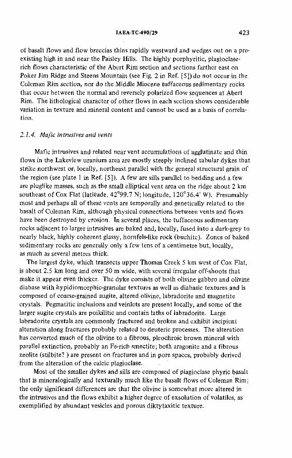
IAEA-TC-490/29 423
of basalt flows and flow breccias thins rapidly westward and wedges out on a preexisting high in and near the Paisley Hills. The highly porphyritic, plagioclase- rich flows characteristic of the Abert Rim section and sections farther east on Poker Jim Ridge and Steens M ountain (see Fig. 2 in Ref. [5]) do no t occur in the Coleman Rim section, nor do the Middle Miocene tuffaceous sedim entary rocks that occur between the normal and reversely polarized flow sequences at Abert Rim. The lithological character o f o ther flows in each section shows considerable variation in texture and mineral content and cannot be used as a basis of correlation.
2.1.4. Mafic intrusives and vents
Mafic intrusives and related near vent accumulations of agglutinate and thin flows in the Lakeview uranium area are mostly steeply inclined tabular dykes that strike northw est or, locally, northeast parallel with the general structural grain of the region (see plate 1 in Ref. [5]). A few are sills parallel to bedding and a few are pluglike masses, such as the small elliptical vent area on the ridge about 2 km southeast o f Cox Flat (latitude, 42°99.7 N; longitude, 120°36.4' W). Presumably most and perhaps all o f these vents are temporally and genetically related to the basalt o f Coleman Rim, although physical connections between vents and flows have been destroyed by erosion. In several places, the tuffaceous sedimentary rocks adjacent to larger intrusives are baked and, locally, fused into a dark-grey to nearly black, highly coherent glassy, hornfels-like rock (buchite). Zones o f baked sedimentary rocks are generally only a few tens of a centim etre but, locally, as much as several metres thick.
The largest dyke, which transects upper Thomas Creek 5 km west of Cox Flat, is about 2.5 km long and over 50 m wide, with several irregular off-shoots that make it appear even thicker. The dyke consists of both olivine gabbro and olivine diabase with hypidiomorphic-granular textures as well as diabasic textures and is composed of coarse-grained augite, altered olivine, labradorite and magnetite crystals. Pegmatitic inclusions and veinlets are present locally, and some o f the larger augite crystals are poikilitic and contain laths o f labradorite. Large labradorite crystals are commonly fractured and broken and exhibit incipient alteration along fractures probably related to deuteric processes. The alteration has converted much of the olivine to a fibrous, pleochroic brown mineral with parallel extinction, probably an Fe-rich smectite; both aragonite and a fibrous zeolite (stilbite? ) are present on fractures and in pore spaces, probably derived from the alteration o f the calcic plagioclase.
Most o f the smaller dykes and sills are composed of plagioclase phyric basalt that is mineralogically and texturally much like the basalt flows o f Coleman Rim; the only significant differences are that the olivine is somewhat more altered in the intrusives and the flows exhibit a higher degree o f exsolution of volatiles, as exemplified by abundant vesicles and porous diktytaxitic texture.

424 WALKER
East of Shoestring Creek mafic vent areas are characterized by linear outcrops o f red, scoriaceous and partly agglutinated basaltic tephra that probably represents the surface or near-surface expression of basaltic feeder systems. The oxidized cindery material is in an area of Oligocene or Miocene tuffaceous sedimentary rocks and its possible relation to younger basaltic flows is indeterminate.
/2.1.5. Surficial deposits
Poorly consolidated surficial deposits of Pleistocene and Holocene age are present throughout much of the Lakeview uranium area. Pleistocene pluvial lake beds are localized in the southern part of the area in and along the margins of Goose Lake Valley. Landslides, probably mostly Pleistocene in age, occur in the steeper, more m ountainous parts of the region. Several ages of Late Pleistocene and Holocene alluvium are present along stream valleys. All these deposits, except for a few diatomaceous layers in the lake beds and airborne volcanic ash and pumice lapilli erupted from young volcanoes in neighbouring regions to the west, are composed of volcanic and volcaniclastic debris derived by erosion from adjoining bluffs and highlands.
The lake beds are commonly thinly laminated and mostly fine to medium grained in the central parts o f the pluvial lake basin but are coarser grained and poorly sorted near the margins of the basin. The near-shore deposits commonly consist of unconsolidated to poorly consolidated pebble conglomerate along old shoreline bars and beaches and occur as high as about 5100 ft (1544 m) on the walls o f Goose Lake Valley. Similar gravelly deposits occur in palaeo-deltaic deposits built at the time of high still stands of the pluvial lakes.
Both older and younger alluviums are present in the area. The older alluvium occurs as gravel and poorly consolidated sandstone beds capping terraces 10 m or less above present stream drainages, particularly around the margins of Cox Flat and in erosional remnants of terraces centrally located in the flat. Younger alluvium of unconsolidated sand and gravel covers the bottom s o f most stream valleys of the area and is present in thin discontinuous patches along the smaller drainages.
Landslide deposits, which consist almost entirely of disaggregated blocks and rubble of the basalt of Coleman Rim interm ixed with material from the underlying tuffs and tuffaceous sedimentary rocks, are mostly on or below steep bluffs and escarpments capped by relatively thick sections of basalt. Faulting, slumping and erosion of massive basalt sequences and subsequent slumping and erosion of the disaggregated landslide material have spread basalt blocks and rubble widely over much of the area, particularly below (east of) Coleman Rim and between Augur Meadow and Thomas Creek. The widespread basaltic debris gives the erroneous impression tha t many areas are underlain by fairly continuous basalt when, in fact, they are underlain by Late(? ) Oligocene and Miocene clastic rocks capped by landslide and lag debris.

IAEA-TC-490/29 425
2.1.6. R hyolite
By far the m ost im portant rocks in terms of uranium mineralization and potential uranium source rocks are intrusive and extrusive rhyolites in the form of bulbous domelike masses, plugs, dykes and extrusive flows. Most o f these rocks occur in an indistinct northwest-trending belt (or belts) in the central part o f the Lakeview uranium area (see plate 1 in Ref. [5]). Many additional silicic intrusive and extrusive masses of several different ages occur in the region (see Fig. 2 in Ref. [5]); some contain anomalous am ounts o f uranium but, as yet, no economic deposits o f uranium have been found associated with them. Some o f the rhyolite masses in the Lakeview uranium area occur as separate small domes or plugs, whereas others represent clusters o f several domes or plugs that apparently are connected at depth or, in a few places, by thick dykelike bodies that are now exposed at the surface. Good outcrops of the domes and plugs are rare except in a few man-made cuts and in steep canyon walls, in large part because o f thick mantles o f talus that result from the disaggregation o f the strongly flow-banded and flow-jointed rhyolite, aided in a few places by the intense hydration and alteration along the peripheries of the masses. Most of the rhyolite bodies erode to rounded or locally steep-sided hills, with only a few massive outcrops projecting through the talus. In several road cuts and borrow (or prospect) pits the domes and intrusives are shown to have chilled marginal facies composed of grey to black, mostly flow-banded, perlitic glass or, more commonly, o f silvery grey, thoroughly hydrated granular glass containing sparse to abundant obsidian spheres or blebs (apache tears) that are dense and unaltered. Where visible, the cores o f the rhyolite bodies are composed o f either partly to thoroughly devitrified, commonly spherulitic perlitic glass or flow-banded felsite largely derived from the devitrification and alteration of flow-banded perlitic glass.
The presence o f rhyolite flows associated with a dome or intrusive south of Bear Flat probably indicates near-surface emplacement for the rhyolite body in that area, bu t elsewhere diagnostic criteria to establish depth o f emplacement are lacking. Presumably all the intrusives and domelike masses in the Lakeview uranium area were emplaced either at the surface or within a few hundred metres of the surface, based on their structures and the textures of the rhyolite, including the presence o f abundant perlitic glass, obsidian breccias and, locally, fairly abundant miarolitic cavities. Silicic intrusives of Oligocene age in the Paisley Hills, about 20 km to the northeast, exhibit hypidiom orphic granular and porphyritic textures that are quite different from those in the rhyolites in the Lakeview uranium area and probably denote crystallization under several hundred metres or more o f cover.
Much of the rhyolite in the region is aphanitic or glassy, locally autobrecciated, and m oderately to strongly flow banded, commonly with many o f the bands manifested by perlitic texture. The flows are partly inflated, in contrast to the domes and intrusives, showing abundant miarolitic cavities that are lined with

426 WALKER
vapour-phase alkali feldspar, cristobalite, opal and, in places, iron-stained material tha t may be finely divided haematite. Both the flows and intrusives are micro- to macroporphyritic, with rare to fairly abundant phenocrysts mostly of alkali feldspar (soda sanidine and sanidine), oligoclase, some iron-rich dark-brown biotite and m inor iron oxides, some o f which appear on morphological grounds to be derived from the oxidation o f pyrite. In a few rhyolites, there are rare elongate prisms of what originally was probably basaltic hornblende but which is now largely iron oxides. Seen in thin section, the groundmass is glassy or cryptocrystalline and where crystallized commonly shows a well-defined spherulitic texture. Where the glass is fresh, crystallites and fine microlites are visible in thin section and perlitic texture is common. The crystallites and microlites are mostly aligned and, where identifiable under oil immersion microscopy, consist of feldspar, rare prisms, o f clinopyroxene or hypersthene, rare pleochroic brown hornblende and dark pleochroic brown, probably iron-rich biotite and minor apatite. Microscopic opaque grains are probably mostly magnetite or ilmenite and the reddish to reddish-brown colour of some fresh glass suggests submicroscopic dusting of haematite. M icrophenocrysts of alkali feldspar are randomly distributed in some of the obsidian and are generally less than 0.01 mm in dimension (maximum). A few obsidians contain small clots o f plagioclase and clinopyroxene. Most of the domes and intrusives exhibit extensive hydration of glass and some devitrification and vapour-phase crystallization, but only the intrusive mass at the White King Mine and marginal parts of the intrusive at the southwest edge of Cox Flat (latitude, 42°20 '10 '' N, longitude, 120°35'53" W) show extensive alteration and silicification.
Alteration and silicification show some vague spatial relation with the margins of the rhyolitic bodies but apparently a more direct relation with the current ground surface, which probably means tha t the present surface and that at the time o f emplacement were more or less coincident. Study of cores from drill holes in the rhyolite intrusive at the White King Mine suggests that the kind and degree of alteration changes with depth. At and near the surface the rhyolite is altered to kaolinite and is intensely silicified with opal, quartz and lesser chalcedony(? ). Argillic alteration persists with depth, perhaps with some slight decrease in intensity, bu t the intensity of silicification decreases noticeably event though the rhyolite at depth is also composed partly of silica minerals, mostly quartz and m inor opal. In places, a few tens of metres beneath the surface the silica minerals appear to be residual, following hydrotherm al acid leach o f the rhyolite, whereas at and near the surface silica has been introduced. A silicic opaline and chalcedonic(? ) cap on the rhyolite intrusive at the White King Mine and on the uranium deposit itself is nearly identical with the many opalite deposits o f mercury characteristic of nearby areas in the northern Basin and Range. Good examples o f this type of deposit are found at Quartz M ountain [4, 34], Opalite [35] and Glass Buttes [36].
Most o f the rhyolite intrusives and domes in the Lakeview uranium area appear to be part o f a single, short-lived volcanic episode that took place slightly

IAEA-TC-490/29 427
more than 7 million years ago. Rhyolites o f this same episode are found over a much larger area (see Fig. 2 in Réf. [5]) and include those at Owen Butte and Drews Ranch, located west o f the Lakeview area, at McComb Butte and Tucker Hills, to the north and northeast o f the area, and in the area near Fandango Pass, in northeastern Modoc County, California. Rhyolitic volcanism o f this same type and age may extend further north, west and south of the Lakeview uranium area, bu t there is no evidence o f Late Miocene silicic volcanism to the east [17]. Exceptions to this Late Miocene age assignment are found in the rhyolite at Drum Hill, which is 16 million years old, several rhyolites in the Warner Range, northeast o f Lakeview, and probably in the intrusives on Morgan Creek, which are undated, bu t seem to be geologically more closely allied to Drum Hill than to the rhyolites near Cox Flat. Also exceptions to this age assignment are the Oligocene hypabyssal and near-surface intrusives in the Paisley Hills.
Field relations among rhyolite domes and intrusives and other bedrock units indicate that: (1) a few rhyolites only intrude older parts of the Late(?) Oligocene and Miocene sequence o f tuffs and tuffaceous sedimentary rocks and perhaps are local vents for some of these volcaniclastic units; (2) a few have erupted rhyolite flows that lap on to the upper parts o f the tuffaceous sedimentary section; and (3) in those few places where basalt o f Coleman Rim impinges on rhyolite bodies, all appear to be lapped by the basalt. This stratigraphie relation o f rhyolite to capping basalt appears to be in contradiction to the few available potassium-argon dates for the basalts, although the dates indicate that the youngest basalt and the young rhyolites are very close in time and are bo th of Late Miocene age. The age range on the youngest group of rhyolites is about 7 to 8 million years and on the youngest basalt flows apparently about 6 to 8.5 million years, based mostly on age determ inations o f flows in nearby areas. The apparent lapping of basalt on rhyolite in a few places is contrary to the age relations among rhyolites and basalt flows established by Peterson and M cIntyre [12 p. 22, 26], so that rhyolites both younger and older than young parts of the basalt section are possible.
Except for the older intrusives in the Paisley Hills, the rhyolite intrusive at the White King Mine is the m ost altered and exhibits no t only intense silicification bu t also extensive evidence o f hydrotherm al alteration of feldspar and glass to kaolinite. A similar, bu t m uch less intense, alteration occurs in a part of the intrusive on the southw est side of Cox Flat. Neither of these intrusives has been dated, although a dated fragment o f perlite from brecciated material above and probably related to the White King intrusive suggests a 7 million year age for the intrusive. Also their textural characteristics and relations to impinging stratigraphie units suggest that they bo th belong to the younger (7 to 8 million years) episode o f silicic volcanism. If the intrusive at the White King Mine is part of this Late Miocene episode, why is it so thoroughly altered, silicified and mineralized, whereas the other intrusives and domes o f the episode are manifested by only slight alteration and little or no mineralization? A possible explanation is that the White King rhyolite intrusive was emplaced at deeper levels than the

428 WALKER
other intrusives and domes, the thicker section of cover trapping associated volatiles that altered both the rhyolite and the adjacent wallrocks. An alternative explanation is that the intrusive invaded water-saturated rocks or a water-saturated fault zone, creating a hydrotherm al system that was effective in altering and mineralizing the rocks. Available data perm it either or both alternatives, although the la tter is favoured because of a complete lack of textural or stratigraphie data to suggest different levels of emplacement and because the White King intrusive is localized in a complex fault zone.
2.2i Isotopic ages of units
Isotopic ages of a num ber o f intrusive and extrusive volcanic units exposed in the region, as well as several from deep drill holes, supplement very meagre dating of these units by palaeontological methods. These isotopic ages (see Table 2 and Fig. 2 in Ref. [5], [36]) are mostly from published references. Ages range from about 80 million years (Late Cretaceous) on andesite from cores taken at over 2918 m (9576 to 9579 ft) in a test well (Leavitt No. 1) a few miles south of Lakeview [24] to 6.8 + 0 .90 million years on a basalt flow exposed in Picture Rock Pass, 50 to 60 km north of the Lakeview uranium area. A few isotopic ages on units identified as correlative in the field are not precisely the same, but are not sufficiently different to significantly change any of the stratigraphie or tem poral relations. No attem pt is made here to rationalize these isotopic age differences, except to indicate that they were done at different times in different laboratories and perhaps on material collected from different outcrops manifested by slight differences in alteration.
Andesites as old as those from deep in the Leavitt No. 1 well (see Fig. 2 in Ref. [5]) have no surface counterparts in the Lakeview uranium area. Isotopic ages on basalt from deep in th e Thomas Creek No. 1 well, within the Lakeview uranium area, are about 30 million years, which make it highly unlikely that rocks at the bottom of the well, only about 75 m (~ 240 ft) deeper, are as old as those in the Leavitt well. Nor is there any evidence tha t rocks as old as 80 million years are exposed anywhere in the Paisley Hills, although the only isotopic dating there is on 32 on 33 million year old intrusives that invade a sequence o f flows, breccias and tuffs thought to be of Late Eocene or Early Oligocene age.
The dated domes and intrusives, some of which are genetically related to the uranium mineralization, appear to be separable into three age groups, the oldest represented by the hypabyssal granitoid intrusives in the Paisley Hills at about 32 to 33 million years, an interm ediate age group about 14 to 16 million years that includes two widely separated complexes at Drakes Peak in the Warner Range and at Drum Hill, and the youngest at about 7 to 8 million years. The youngest group, whose ages are so close tha t they suggest essentially a single period of rhyolitic magmatism, is spread over a rather large geographical area and represents a significant part o f the pattern of decreasing age progression in silicic volcanism

IAEA-TC-490/29 429
extending through southeast Oregon from the vicinity o f Harney Basin westward toward the Cascade Range [17, 37]. Most an d perhaps all o f the domes and intrusives clustered in the vicinity o f the White King Mine, including those on Thomas Creek and Shoestring Creek, as well as those peripheral to Cox Flat, are thought to represent parts of this younger group. The rhyolitic masses on Morgan Creek and near Paxton Meadow have no t been dated; on geological relations it appears likely tha t the rhyolite on Morgan Creek is part o f the interm ediate age group and that near Paxton Meadow is either part o f the interm ediate or younger group.
The rhyolite intrusive at the White King Mine is so thoroughly altered that no material has yet been found within the intrusive that is suitable for isotopic dating. Above the intrusive, however, is highly brecciated rock that contains numerous angular fragments and chunks o f slightly hydrated but otherwise unaltered perlitic obsidian, as well as other volcanic rock types. The obsidian fragments are thought to represent part o f the same rhyolite found in the intrusive but in the form of an overlying explosion breccia; the larger angular perlite fragments are fragile so that normal stream or lahar transport probably would destroy them and, hence, it is unlikely that they were derived from other rhyolite bodies. A potassium-argon date on one o f the larger fragments o f perlite from this breccia is 7.0 ± 0.4 million years, which is corroborative evidence in support of temporal equivalence of the White King intrusive with o ther intrusives of the younger group in and near the margins of Cox Flat.
2.3. Structure
Many of the uranium-bearing rhyolite intrusives and domes of the Lakeview uranium area are localized in highly faulted and complex volcanic terrane related to a regional northw est-trending structure or set o f structures defined by some workers as a broad anticlinal warp (or anticlinorium) probably developed during compression and by others as a series o f opposing and outward dipping fault blocks (or antiform ) tha t resulted from tensional rather than compressive forces.An extensional stress regime oriented generally east-west, or perhaps west-north- west and east-southeast, is consistent with regional structures throughout the northern Basin and Range, but this does not eliminate the possibility o f some squeezing and compression of crustal blocks between regionally extensive transverse faults that have been recognized or suspected by several workers [11,36 (p.79), 37, 38]. A com bination o f east-west extension and northwest- and southeast-trending couples tha t are related to these suspected transverse faults may explain the rhombic fracture system delineated by D onath [16] for similar terrane near Summer Lake (see Fig. 2 in Ref. [5]), about 50 km north o f the Lakeview uranium area. Because o f the uncertainty o f the mechanism or mechanisms that formed this broad and faulted regional warp (Fig. 3(a)), it is referred to here as an anti form.

Q a l Tb T b i T r T s v Ta
A l l u v i u m B a s a l t B a s a l t i n t r u s i v e R h y o l i t e S i l i c i c v o l c a n i c s A n d e s i t i ca n d s e d im e n t s v o l c a n i c s
FIG.3(a). Sketch section o f antiform from Coleman R im northeastw ard to A b er t R im (vertical exaggeration, 4X); (b) Sketch section, approxim ately north-south, through the White K ing M ine area. Show s landslide block on south slope betw een Thom as and A uger Creeks (vertical exaggeration, 2X).
430 W
AL
KE
R

IAEA-TC-490/29 431
The axis o f the antiform trends N 20°—25° W, approxim ately through the middle of the Lakeview uranium area. The antiform can be recognized for several tens of kilometres both north and south o f the area, and its w idth is o f the order of 30 km. On the west, at Coleman Rim, flows dip gently westward and are ' ultim ately lapped by younger flows and tuffaceous sedim entary rocks [5, 12]. A m ajor northw ard extension of this west limb includes the westward-dipping flows and underlying tuffaceous sedimentary rocks on Winter Ridge. The eastern limb of the antiform is more complex and difficult to delineate as a result o f disruption by several major northwest-trending faults and several areas o f probable volcanic- tectonic collapse near Summer Lake and Chewaucan Marsh. The eastern limb includes the eastward-dipping flows and sedimentary rocks o f the large Warner Mountains fault block, bounded on the west.by Abert Rim and its southern extension on the east side of Goose Lake Valley and by northeast-dipping flows, tuffs and tuffaceous sedimentary rocks northeast of the Paisley Hills and Chewaucan Marsh in the vicinity o f Cogían Butte. Older rocks in the Paisley Hills, on the Buck and Doe Mountains and near the axis of the antiform are more steeply inclined than the younger basaltic rocks away from the axial region.
Structural details within this broad antiform are obscured by lack of critical outcrops and by the extensive cover of poorly exposed basaltic flow breccias, extensive basalt talus and lag deposits, and numerous large and small slide blocks of'basalt and breccia. The bedrock geology in many areas is also obscured by dense vegetation cover. Numerous unconform ities between volcanic units, some with several tens of metres of gentle or locally abrupt relief, complicate the recognition and unravelling of fault structures. Geological maps that cover all or parts of the antiform (see plate 1 in Ref. [5], [8, 11, 12, 15]) show a large num ber of northwest-trending and a few northeast-trending faults, most of which are thought to exhibit normal displacements. The precise location and character o f many of these faults are poorly docum ented and based on physiography and the recognition of slightly eroded fault scarps, on apparent discontinuity of units, on obvious linear stream drainages commonly separating structural blocks with beds inclined in different directions, and seldom on observed and measured displacements. The am ount o f displacement on most faults is probably only a few tens of metres at most, but on the large faults, such as those at Abert Rim and Winter Ridge, displacements greater than 600 to 700 m can be demonstrated.In the few places where faults can be traced across stratigraphie sections, inclination of the fault planes is generally moderate to steep, mostly in the range of 60 to 80°. On the geological map (see plate 1 in Ref. [5]) only the more prom inent and well-documented faults are shown; they probably represent less than 10% o f the total num ber of faults present in the area.
Where exposures are good, as for example on the walls o f the open pits at the White King and Lucky Lass Mines, it is obvious that, in addition to the large through-going faults, there are myriad small faults with displacements o f a few metres or less and w ith both normal and reverse displacements. Most o f the small

432 WALKER
faults strike northw est parallel with the larger faults and a few strike northeast. Inclinations are both steep and, for a few small faults, relatively gentle; for a few of the small reverse faults that probably represent local adjustments to movements on larger nearby normal faults the dip is only a few tens of degrees.
The White King and Lucky Lass Mines, as well as several o f the rhyolite domes and intrusives northwest of these mines, are in a northwest-trending steeply inclined fault zone in which the major block northeast of the fault zone is depressed relative to the block southwest o f the fault (Fig. 3(b). The zone is made up of several more or less parallel strands. Within this zone are numerous disrupted blocks of the basalt of Coleman Rim that in part have slid on the incom petent underlying altered tuffs and tuffaceous sedimentary rocks. A prom inent northeast-trending linear feature, evident on aerial photographs, projects across Thomas Creek from just southeast of Cougar Peak into the area near the Lucky Lass and White King Mines (see plate 1 in Ref. [5]). On the ground the linear' feature can be recognized only by a narrow zone or band of aligned drainages. Inasmuch as inclined ash-flow tuffs can be traced w ithout apparent offset across the linear feature, in areas south of Thomas Creek, the zone probably represents en echelon fractures, perhaps reflecting some underlying older structure. Several short parallel linear features manifested by straight drainages are present a kilometre or so south of the prom inent linear feature.
2.3.1. Regional aeromagnetic data
An airborne m agnetom eter survey was made o f the Klamath Falls 1 ° by 2° Quadrangle [39] as part o f an evaluation of the geothermal potential o f southeast Oregon. This survey, which covers the Lakeview uranium area as well as adjacent regions, is of a reconnaissance nature, with east-west flight lines spaced at approxim ately 3 km (2 miles) intervals and at an average barom etric elevation o f 9000 ft above sea level. The magnetic data were compiled relative to an arbitrary datum at a scale o f 1:250 000 and were contoured mostly at an interval o f 100 gammas bu t locally at 20 gammas.
A small part of this regional survey covering the Lakeview uranium area and some adjacent terrane is shown in Fig. 4 and the position o f individual rhyolite domes and intrusives indicated. No clearly defined regional gradients can be recognized on the aeromagnetic map, although m ost of the uranium-bearing domes and intrusives occur in and on the southern flanks of a broad, northeast-trending elliptical magnetic high more or less centred on rhyolite bodies north o f Cox Flat. The positive anomaly has a relative magnitude of about 400 gammas; it lies athw art the northwest-trending antiform and may represent an up-doming of normally polarized Late(? ) Oligocene and Miocene volcaniclastic rocks or, more likely, a reflection o f higher average elevation and some hills capped with normally polarized Late Miocene basalt near the centre of the high. The greater abundance of rhyolite domes and intrusives in and near this anomaly may only be a fortuitous

2500
IAEA-TC-490/29 433
FIG.4. Regional aeromagnetic map o f Lakeview area, Oregon (from R ef. [39]). Outline o f area covered in geological map (see plate 1 in Ref.[5]j. Location o f dom es and intrusives (*) and White King M ine (X).

434 WALKER
result of erosion and exposure; they may also be weakly normally polarized. No other surficial geological phenom ena that would explain this broad elliptical magnetic high have been recognized.
3. CHEMICAL COMPOSITION OF RHYOLITES
To more completely understand the petrochemical nature of the rhyolites in the Lakeview region and to ascertain the content and distribution of selected trace elements, chemical analyses were made o f representative samples of intrusive and extrusive rocks collected from the uranium-bearing area and of some similar rocks in adjoining areas. Where possible, fresh undevitrified and non-hydrated obsidian from chilled marginal facies of the intrusives and domes was selected for analysis, although for the altered and silicified rhyolite at the White King Mine no such material has yet been found. A few samples of partly hydrated and thoroughly devitrified rhyolite were also analysed for comparison with the analyses of unaltered obsidian. Many of the samples are obsidian blebs (apache tears) collected from zones of hydrated glass on the margins of the rhyolite masses; larger blebs from these zones were crushed, and only the non-hydrated fresh glass from the cores of the apache tears was analysed.
Chemically, most o f the domes and intrusives in the Lakeview uranium area are surprisingly similar (see columns 1 -1 2 in Table 3 in Ref. [5]), particularly if analyses from chilled marginal facies are compared; they are also much like other Miocene rhyolites exposed in nearby areas (see columns 13—20 in Table 3 in Ref. [5]). In most volcanic rock classifications [40—43], all these intrusive and extrusive rocks are within the range o f rhyolite to soda rhyolite, although those at Owen Butte, Cougar Peak, Morgan Creek, northeast of Paxton Meadow, and several from the Drake Peak complex [9] are slightly more mafic than the other rhyolites. The unaltered glassy rhyolites are all slightly peraluminous, with A120 3 > N a 20 + K20 + Ca0, and in most rocks some corundum is present in the norm. Normatively, the rocks are composed of more or less equal am ounts of quartz, orthoclase and albite; they contain only m inor am ounts o f other constituents. A normative Q-Or-Ab plot (Fig. 5) shows a close grouping of all analysed rhyolite and only a slight and probably non-diagnostic tendency for rhyolites o f the younger age group to be slightly enriched in quartz and perhaps . in orthoclase over those in the 14 to 16 million year age groups and in the undated group of rhyolites.
The one analysis of altered and silicified rhyolite from the White King Mine (see column 1 in Table 3 in Ref. [5]) shows some leaching o f A120 3, to ta l Fe, Na20 and CaO and some addition o f silica. A pparently the processes that altered the rhyolite had relatively little effect on the content o f K20 , T i0 2 and P2O s, although K20 may be slightly depleted and P20 5 slightly enriched. Rhyolite at the White King Mine is too altered to perm it meaningful comparisons w ith the

IAEA-TC-490/29 435
Q 30
F IG .5. N orm ative Q-Or-Ab p lo t o f analysed rhyolites.
unaltered glassy rhyolites and obsidians, although the ratio o f one oxide to another seems to follow a pattern similar to that in the other rocks analysed. It seems likely tha t before silicification and alteration the White King intrusive was similar to, if not identical with, the o ther young rhyolites exposed adjacent to Cox Flat and on Thomas Creek.
Differentiation indexes o f all the rhyolitic rocks that have been analysed, except for the altered intrusive at the White King Mine, are in the range of 90 to 98. The most highly differentiated rocks are those at Drum Hill (DI = 98) and the dome northeast o f Cox Flat (D I= 97) and the least differentiated at Drake Peak (DI = 91 ) and Owen Butte (DI = 90). Comparisons o f these differentiation indexes with those published by Thornton and Tuttle [44] for Daly’s averages o f several major igneous rock types show (1) the high degree of differentiation in all the Lakeview area rhyolites, and (2) that they are most like Daly’s alkali rhyolites. Examples of both the youngest and interm ediate age groups of rhyolites are included in bo th the m ost highly and least differentiated material. Whether any of the rhyolites are comagmatic remains to be proved. The only suggestion of consanguinity is the similarity in chemistry and close age grouping o f the youngest rhyolites.
Selected m inor element chemistry (see Table 3 in Ref. [5]) shows expectable patterns of abundance and distribution not unlike those found in other silicic crustal rocks [45, 46 p. 17], particularly rhyolitic rocks of the western United States o f America [47, 48].

(Ы
£ Ba and Sr
1000 1200
10
As
(ppm)
90
о As
• Average As<c>
92 94 96 98
Differentiation Index
10
As
(ppm)
о As
» Mo
( d )
ItOO 1000 1200
Ba and Sr
- Hg
(ppm)
Mo
(ppm)
F IG .6. Variation diagrams o f Sb, Hg, A s and M o with differentia tion index and to ta l Ba and Sr con ten t, (a) M ercury and an tim ony d ifferentiation index diagram; (b) Variation o f mercury and antim ony w ith to ta l barium and stron tium ; (сj Arsenic d ifferen tia tion index diagram; (d) Variation o f arsenic and m o lybdenum w ith total barium and strontium .
436 W
AL
KE
R

IAEA-TC-490/29 437
The F and Cl contents in the rhyolites o f the Lakeview uranium area are highly variable. The variations are somewhat comparable to those found throughout the middle and upper Cenozoic rhyolite domes o f southeast Oregon [17] and perhaps reflect mainly the depth o f emplacement and the effect this has on exsolution and escape of volatiles. Fluorine ranges from 18 ppm at the White King Mine and 50 ppm in the large dome on Thomas Creek to 1400 ppm in the rhyolites near Paxton Meadow and Cox Creek. Chlorine ranges from 39 ppm in rhyolite from the White King Mine to 2800 ppm in the intrusive on upper Morgan Creek. Note tha t the lowest contents o f both F and Cl occur in the altered rock from the White King Mine, showing tha t the alteration leached rather than deposited halogens.
The presence o f m inor am ounts of cinnabar (HgS) and stibnite (Sb2S3) and substantial am ounts o f realgar (AsS), orpim ent (As2S2), jordiste (amorphous MoS2) and ilsemannite (Mo30 8 • NH20 ? ) in the White King Mine indicates probable enrichm ent in the metallic elements that comprise these minerals, although it may only dem onstrate redistribution of elements within a large body o f rock to form local concentrations. Geochemical data suggest that mercury is enriched in the rhyolite at the White King Mine and in the large dome on Thomas Creek, but show no correlation with the differentiation index (Fig. 6(a)) or with feldspar fractionation, as indicated by the content of Ba and Sr (Fig. 6(b)). Arsenic, which is a major constituent of the ores at the White King Mine, is abundant (160 ppm) in the White King rhyolite and slightly enriched in the dome or intrusive west of the Lucky Lass Mine and in the rhyolite northeast o f the US Forest Service Thomas Creek Work Camp (see Table 3 in Ref. [5]); it also shows little, if any, correlation with the degree of differentiation (Fig. 6(c)) and questionable correlation with total Ba and Sr (Fig. 6(d)). In the White King Mine some jordisite and its widespread alteration product ilsemannite indicate at least local enrichment of molybdenum and analyses for Mo in some of the rhyolite obsidians of the Lakeview uranium area indicate several times normal crustal abundances. Analyses of rhyolites of the younger, age group in and near the White King and Lucky Lass Mines indicate a molybdenum content o f about 3 ppm or less, whereas the intermediate-age rhyolite at Drum Hill contains 7 ppm and the tw o nearby rhyolite masses on Morgan Creek, both of which are thought to represent the interm ediate age group, contain 11 and 7 ppm. W hether the high values in these geographically closely grouped rhyolite masses are provincial, age related or fortuitous is, as yet, unresolved. Little, if any, correlation can be dem onstrated between the molybdenum content and the differentiation index (Fig. 7(a)) or with the depletion of barium and strontium (Fig. 6(d)).
None of the rhyolites shows any appreciable enrichm ent in either Au or Ag. Slight enrichm ent o f Cu characterizes the rhyolite mass northeast o f Cox Flat and on upper Morgan Creek and Zn may be slightly enriched in rhyolite exposed lower on Morgan Creek and near Paxton Meadow.

Mo
(ppm)
10 •
o Mo
• Average Mo
(al
Л / \
7 —
90 92 gît 96
Differentiation Index
98
15
U
10
(ppm)
5
20
U
Th
Average U
Average Th
(b)
90 92 9<t 96
Differentiation Index
Th
(ppm)
4̂LOoo
Ba an Sr Ba and Sr
FIG. 7. Variation diagrams o f M o, U and Th with differentiation index and to ta l Ba and Sr content, (a) M olybdenum d ifferen tia tion index diagram; (b) Uranium and thorium differentiation index diagram; (с) Variation diagram show ing distribution o f uranium and thorium versus Ba and Sr fo r rhyolites o f both younger and interm ediate age; (d) Variation diagram show ing d istribution o f uranium and thorium versus Ba and Sr fo r rhyolites o f you n g er age only.
>Яw70

IAEA-TC-490/29 439
Invariably the rhyolite domes and intrusives are several times m ore radioactive than any o f the wallrocks and analyses for uranium and thorium indicate some enrichm ent in these elements. Chilled glass from the margins of the domes and intrusives contains from 3.3 to 9.4 ppm uranium, as determined by instrum ental neutron activation analyses, and from 6.8 to 21.4 ppm thorium , whereas the somewhat more crystalline core facies generally contain a little less uranium and thorium. Uranium contents similar to those presented here were found in samples from several domes in the region using fluorom etric analytical techniques [49].The single analysis o f altered rhyolite from the White King Mine shows about the same am ount of thorium as that found in other rhyolite bodies in the area. The abundance and distribution pattern for uranium is comparable to that in most calc-alkaline rhyolites of the western USA and matches a few of the peralkaline rhyolites [48], although the peralkaline rhyolites of the central and northern Basin and Range tend to be richer in uranium, reaching levels o f 9 to 10 ppm in ash-flow tuffs and even higher values in the Middle Miocene peralkaline rhyolite domes of the McDermitt Caldera area [48, 50, 51].
The abundance of uranium and thorium in the Lakeview uranium area tends to increase with the differentiation index (Fig. 7(b)), although among those peraluminous rhyolites of both Middle and Late Miocene age increases are nonlinear and the highest values occur between differentiation indexes o f 96 and 97. Differences in barium and strontium abundances suggest tha t some feldspar fractionation may have occurred and that this fractionation also affected the uranium and thorium abundances (Fig. 7(c)), the high values being associated with rhyolites depleted in Ba and Sr and, hence, feldspar. However, because rhyolites o f both Middle and Late Miocene age are involved, the fractionation patterns are tenuous a t best.
If one assumes that rhyolites of the younger age group are all part of a single episode o f volcanism and in some way genetically related to a common body of differentiating magma at depth, the chemistry indicates no t only a high degree of differentiation bu t also suggests some feldspar fractionation. Spectrographic analyses o f samples of the younger rhyolites mostly show low barium and strontium values (see Table 3 in Ref. [5]), except for samples of the rhyolite at Cougar Peak (840 ppm Ba; 190 ppm Sr) and Owen Butte (920 ppm Ba; 190 ppm Sr). Further comparisons o f the abundances of uranium and thorium in all the younger group of rhyolites with a to tal content o f Ba and Sr (Fig. 7(d)) suggest an enrichm ent in both uranium and thorium in the residual melt as a result of the crystallization and fractionation o f feldspar. These data also show a strong tendency for all the young domes and intrusives within a kilometre or two o f the White King Mine to be characterized by high differentiation indexes, low to tal Ba and Sr and high uranium and thorium values. This may imply a significant geographical separation of those rhyolites of potential economic interest from those o f little or no interest.
Among the dated rhyolites with ages between 7 and 8 million years, there seems to be no recognizable correlation o f feldspar fractionation, as indicated by

440 WALKER
abundances of Ba and Sr, or o f the degree of differentiation with age. The youngest of these rhyolite bodies (7.11 million years) contains the highest value of combined Ba and Sr and the lowest differentiation index. This would imply that no systematic differentiation trend can be established with available data for the young group of rhyolites.
4. URANIUM ORE DEPOSITS AND URANIUM POTENTIAL
The only deposits that have yielded significant tonnages or uranium ore in the Lakeview uranium area are at the White King and Lucky Lass Mines, both located on upper Augur Creek about 1.5 km apart. Neither of these properties has been actively mined since the mid-1960s, although study and exploration of these and other nearby uranium-bearing areas have continued interm ittently and have recently (1977 and 1978) been at a relatively high level. Workings at both properties are largely inaccessible, owing to extensive flooding of open pits and all the underground workings connected to them. Descriptions of these workings and the geology exposed in them, as well as docum entation o f the early history o f uranium discovery and exploitation in the region, are covered in several reports [12, 14, 15] and will not be repeated here. The following discussion is based on new data obtained by the author and on older inform ation that has a bearing on the genesis o f the ore bodies and on an evaluation of the uranium potential of the region.
By far the larger of these two deposits is the White King Mine, located at the west end of the meadow on upper Augur Creek, where mineralization is associated with a silicified and altered rhyolite intrusive and with the altered tuffs and tuffaceous sedimentary wallrocks. Introduced metallic minerals in veinlets, fracture coatings and disseminations include pyrite and marcasite, jordisite, uraninite and coffinite, galena, realgar, orpiment, stibnite and cinnabar; orpim ent is probably derived from the hydrotherm al alteration o f realgar. A variety of secondary minerals has resulted from the oxidation and hydration of the primary assemblage, including hydrated iron oxides, ilsemannite, heinrichite, metaheinrichite and possibly autunite, tobernite, abernathyite, uranospinite and novacekite (see Ref. [15, p.21]).
The rhyolite intrusive at the White King Mine is pluglike with irregular apophyses and intrudes a complex northwest-trending fault zone characterized by several en echelon shears and much brecciation that separates a down-dropped fault block north of the fault zone relative to the block south of the fault zone (see plate 1 and Fig. 11 in Ref. [5]; Fig. 2 in Ref. [15]). Post-intrusive and postm ineralization faulting has disrupted ore bodies and locally has brecciated mineralized ground.
The Lucky Lass Mine is entirely within a southward dipping, faulted and locally brecciated and sheared sequence of upper(?) Oligocene to Miocene bedded

IAEA-TC-490/29 441
tuffaceous sedimentary rocks identified by some workers [14, 15] as part o f the upperm ost Cedarville Form ation. No rhyolite is present in surface exposures and apparently none has been encountered in drill holes on the property, several of which have reached depths o f over 500 ft (~ 152 m). Most of the ore appears to be localized in a steeply inclined pipelike body of sheared and argillized tuffaceous rock between steeply dipping faults. The nearest exposed rhyolite body, which exhibits little or no hydrotherm al alteration, is located about 1 km west-northwest o f the mine and the next nearest, at the surface, is the altered intrusive at the White King Mine, about 1.5 km to the east. Rocks exposed in the open pit at the Lucky Lass Mine are not as silicified or altered as those at the White King Mine; m ost o f the ore that was shipped contained secondary uranium minerals and some iron oxides, but apparently none of the o ther metallic minerals found at the White King Mine. Some sooty black to grey pitchblende or coffinite present in the subsurface probably denotes primary mineralization, however.
O ther small prospects in the Lakeview uranium area, including the Marty K, Lucky Day and Topper claims, Los Oros and B.V.D. groups, S & M claims and Hope claims (see Fig. 2 in Ref. [5]), are characterized principally by secondary uranium minerals occurring on fractures and in gouge and breccia along faults that cut bedded tuffaceous sedimentary rocks, referred to as upperm ost Cedarville by Cohenour [15]. A large num ber o f additional claims, bo th old and recently located, cover much of the intervening areas. Although a small am ount o f ore- grade material was mined at the Marty К property, there is no record o f any production from any o f these prospects.
Secondary uranium minerals also have been reported to occur in vesicles in basalt flows both in drill cores and shallow prospects in the northern part o f Section 35 (latitude, 42°19 ' N, longitude, 120°33.2' W) on the northeast wall o f Thomas Creek Canyon. These occurrences o f secondary uranium minerals in vesicles have no t been substantiated by this study nor is their identity known but, because o f the m obility o f 6-valent uranyl compounds, redistribution of uranium in the zone of oxidation is to be expected. Whether this association has any bearing on the age relations o f primary uranium mineralization and the emplacem ent of basalt flows and rhyolite intrusives remains to be established; no primary uranium minerals have been found in basalts exposed at the surface and presumably representing part o f the isotopically dated Coleman Rim sequence.
Inform ation in reports prepared during the period when the mines were active and some additional geological and geochemical data collected during this investigation bear on the genesis of the ore bodies and on an evaluation o f the uranium potential o f the region. With the possible exception o f the rhyolite intrusive northeast o f Paxton Meadow, which contains about 3 ppm uranium (see Table 3 in Ref. [5]), all the unaltered rhyolites and associated obsidians of the Lakeview uranium area contain several times the am ount o f uranium normally found in silicic crustal rocks [45, 52]. They tend to follow the abundance pattern dem onstrated by Coats [47] for silicic volcanic rocks of the Shoshone comagmatic

442 WALKER
province o f northern Nevada and adjacent parts of Oregon and Idaho. From analyses of samples o f obsidian and rhyolite (see Table 3 in Ref. [5]) and from the uniformly high radiation measurements throughout most of the unaltered domes and intrusives, it would appear that the uranium (and probably thorium ) is more or less uniformly distributed and that most o f the unaltered material contains in the range of 6.5 ppm to about 9.5 ppm uranium. Presumably the uranium in these unaltered rocks was originally enriched both by differentiation and feldspar fractionation, as indicated by comparing uranium contents with differentiation index (Fig. 7(b)) and with total barium plus strontium (Fig. 7(c)); uranium is obviously enriched in those highly differentiated rocks depleted in barium and strontium .
If one assumes that the distribution of uranium is more or less uniform and that the surface area of the rhyolite masses is an indication o f the shape of the body with depth, some impressive volumes of uranium can be calculated for the Lakeview uranium area. For example, the total uranium content o f the large dome on Thomas Creek to a depth of 1 km, assuming a cylindrical shape 1.3 km in diameter, an average uranium content o f 6.5 ppm and a specific gravity of2.5, is:
Volume of rock = (3.14)(0.65 km)2 X 1 km = 1.33 km 3
6.5(ppm ) X 2.5(SG) X 1.33(km3) X 109 „ ............ ... .Total uranium = -------------------------------------------------------- - 2 1 .6 X 1 CP t
106
For unaltered rhyolite masses in the area with 9 ppm or more uranium, such as the bodies northeast of Cox Flat (9.7 ppm), west o f Lucky Lass Mine (9.4 ppm) and east of Cox Flat (9.2 ppm), the am ount of uranium in each cubic kilometre is proportionately larger. Just how much total uranium is present in the many unaltered silicic domes and intrusives is impossible to calculate, but it is assuredly large and has represented a readily available source for the uranium found in ore- grade deposits.
Availability of this uranium is dependent on how it is fixed in the unaltered obsidian and rhyolite and whether its release and redistribution is possible through normal geological, hydrological and weathering processes. A small am ount of the uranium appears to be fixed in rare and minute refractory accessory minerals, such as apatite and zircon, and is also associated with opaque grains, mostly Fe and Ti oxides. However, most o f the uranium in the unaltered obsidian appears to be in a dispersed state in some form as yet unrecognized, but probably not as submicroscopic discrete mineral grains. Such a dispersed and homogeneous distribution was obtained on both synthetic and natural uranium- bearing glasses [47, p.411 ], and it indicates that the uranium is highly soluble in silicate melts.

IAEA-TC-490/29 443
Leaching of the uranium from refractory accessory minerals is accomplished with difficulty, but the dispersed uranium in the meta-stable glass is readily available through devitrification or alteration of the glass. Conditions of uranium depletion in crystalline felsites over that in obsidian have been dem onstrated by Zielinski [48], and these conditions seem applicable to the uranium occurrences in the Lakeview area.
In most glassy rhyolite bodies in the Lakeview uranium area that are neither altered nor silicified, both uranium and thorium appear to be more or less uniformly distributed and at abundance levels in the range of 3 to nearly 10 ppm for uranium and 9 to 19 ppm for thorium. Hydration of the glass with little or no accompanying crystallization, alteration or silicification appears to have little effect on the redistribution of the uranium and thorium , which is in accord with the results of investigations of hydrated and non-hydrated glasses by Rosholt et al. [53]. Where devitrification and subsequent crystallization o f the glassy phases has occurred, however, the pattern of uranium and thorium distribution is more erratic and, further, where argillic alteration and silicification are more pervasive, such as found at the White King Mine, uranium has been redistributed to form local ore-grade concentrations (> 1000 ppm).
Alteration o f the White King intrusive and adjoining wallrocks most likely resulted from the development of a low to moderate tem perature, near-surface hydrotherm al system in which argillic alteration occurred both at or near the surface and downward for at least several hundred metres — currently the depth of exploration — and silica was leached from the lower parts o f the system and deposited at or near the surface to form a silicic cap. Because uranium abundances in am ounts significantly greater than those found in unaltered rhyolites appear to be largely, if no t wholly, dependent on the development of a hydrotherm al system and the resultant redistribution of uranium and other metallic elements and concentration into deposits, the question arises as to what unique geological conditions prevailed during emplacement and subsequent alteration of the rhyolite intrusive at the White King Mine, in contrast to other nearly identical rhyolite bodies intruding similar rocks in adjacent areas. A further question arises as to the relation, if any, o f the Lucky Lass Mine to the intrusive at the White King Mine, inasmuch as there is no known intrusive in or near the Lucky Lass Mine.
It is reasonable to assume that the unique characteristics o f the alteration and associated mineralization at the White King Mine are the result o f the rhyolite body (1) being emplaced at depths greater than o ther rhyolite bodies in the area, the thicker section of roof rocks forming a cap or mantle that prevented escape of exsolving volatiles, (2) intruding into water-saturated tuffs and tuffaceous sedimentary rocks or, more likely, into water-saturated fault breccia along the northwest-trending fault zone that localized the intrusive, or (3) a com bination of emplacement both at greater depth and in water-saturated rocks. Textural and structural characteristics o f the rhyolite bodies suggest that they were all emplaced at or just below the surface, so that it seems more likely that the hydrotherm al

444 WALKER
system (or cell) resulted from intrusion o f a dry rhyolitic melt into water-saturated rocks. Uranium-bearing fluids generated from the hydrotherm al system at the site o f the White King Mine may have migrated laterally along the fault zone to the vicinity o f the Lucky Lass Mine, depositing uranium in a structurally and probably stratigraphically defined trap in essentially unaltered tuffs and tuffaceous sedimentary rocks. Faults that displace ore and rhyolite, including silicified sections of it, may, in part, be concurrent with the hydrotherm al system, inasmuch as some silicified breccia is recemented by a later stage o f silicification. Some faults appear to post-date all the silicification and primary mineralization.
5. PRELIMINARY EVALUATION OF AREA
From what is known o f the surface geology and from subsurface drilling and mining operations, the rhyolite domes of the Lakeview uranium area are commonly hydrated, particularly on and near contacts with wallrocks, and locally devitrified, bu t are intensely kaolinized, silicified and mineralized only in and near the White King Mine. At the Lucky Lass Mine, 1.5 km west of the White King Mine, there is no evidence of a separate buried rhyolite intrusive nor is there extensive silicification or kaolinization of the mineralized tuffs and tuffaceous sedimentary rocks. Both mines are located in the same regionally extensive fault zone, but not on the same shear or shears within this zone. If the hydrotherm al model for the form ation of the White King and Lucky Lass ore bodies is correct, in which crystallization, alteration and leaching of rhyolite at depth have provided metals and silica for deposition at and near the surface, it would appear that these favourable geological conditions are not repeated elsewhere in the region, at least not close enough to the present ground surface to be recognizable. Currently available geological, geochemical and geophysical data have not, ás yet, identified areas in which highly favourable geological conditions might have existed at depth.
The lack of kaolinitic alteration and extensive silicification in the domes away from the White King Mine and in their wallrocks suggests that no comparable hydrotherm al systems developed, either because the rhyolite bodies reached the surface and vented volatiles or because the rhyolites and the invaded wallrocks were comparatively dry. W ithout a suitable hydrotherm al system it seems unlikely that large, high-grade concentrations o f uranium and other metals comparable to those at the White King Mine were formed, although smaller deposits or deposits with much lower concentrations o f metals may be present beneath cover that is sufficiently thick to hinder recognition at the surface. Lack of a suitable hydro- thermal system would probably also preclude form ation of deposits comparable to the Lucky Lass ore body.
At both the White King and Lucky Lass Mines there are still substantial quantities o f uranium, some o f it in local concentrations with grades comparable

IAEA-TC-490/29 445
to the ores mined before the mid-1960s (grades up to several tenths of a per cent) and in very large tonnages, both underground and in dumps, with grades in the range of a few hundredths to a few tenths of a per cent uranium.
ACKNOWLEDGEMENTS
The author was ably assisted in the field and briefly in the office by D. Horley (summer 1978; spring 1979) and J.M. Baker (summer 1977).
Isotopic dating of several samples o f rhyolite and basalt was provided byE.H. McKee, United States Geological Survey, Menlo Park, California. Considerable help was provided through numerous conversations with personnel o f Western Nuclear, Inc., particularly with J.A. McGlasson and Т.Н. Thomas, concerning the geology of the Lakeview uranium area. The investigation was also facilitated by the co-operation of local residents and landowners and by personnel o f the United States Forest Service.
REFERENCES
[1] RUSSELL, I.C., A Geological Reconnaissance in Southern Oregon, U nited States Geological Survey Annu. Rep. 4 (1884) 431.
[2] RUSSELL, I.C., Prelim inary R eport on the Geology and W ater Resources o f Central Oregon, U nited States Geological Survey Bull. 252 (1905).
[3] WARING, G.A., Geology and W ater Resources o f a Portion of South-Central Oregon,U nited States Geological Survey W ater-Supply Pap. 220 (1908).
[4] JOHNS, W.R., The Geology and Quicksilver Occurrences at Quartz M ountain, Oregon,MS Thesis, University of Oregon, Eugene, 1949.
[5] WALKER, G.W., Prelim inary R eport on the Geology of the Lakeview Uranium Area,Lake C ounty, Oregon, U nited States Geological Survey Open-File Rep. 80-532 (1980).
[6] APPLING, R.N., Econom ic Geology of the B rattain Mining Area, Paisley, Oregon,MS Thesis, University o f Oregon, Eugene, 1950.
[7] MUNTZERT, J.K ., Geology and Mineral Deposits o f the Brattain D istrict, Lake C ounty, Oregon, MS Thesis, Oregon State University, Corvallis, 1969.
[8] HADDOCK, G.H., Geology of the Cougar Peak Volcanic Area, Lake C ounty, Oregon,MS Thesis, W ashington S tate University, Pullman, 1959.
[9] WELLS, R .E., The Geology of the Drake Peak R hyolite Complex and the Surrounding Area, Lake C ounty, Oregon, MS Thesis, University o f Oregon, Eugene, 1975.
[10] TRAUGER, F.D., Factual Ground-w ater Data in Lake C ounty, Oregon, U nited States Geological Survey Open-File Rep. (1950).
[11] WALKER, G.W., Reconnaissance Geologic Map of the Eastern Half o f the K lam ath Falls (AMS) Quádrangle, Lake and K lam ath Counties, Oregon, U nited States Geological Survey Map MF-260 (1963).
[12] PETERSON, N.V., McINTYRE, J.R ., The reconnaissance geology and m ineral resources of eastern K lam ath C ounty and western Lake C ounty, Oregon, Oregon S tate Dept.Geol. Min. Ind. Bull. 66 (1970).
[13] PETERSON, N.V., 1958, Oregon’s uranium p icture, The Ore Bin 20 12 (1958) 111.

[14]
[15]
[16]
[17]
[18]
[19]
[20]
[21]
[22]
[23][24][25]
[26][27]
[28]
[29]
[30]
[31]
[32]
[33] [.34][35]
[36]
[37]
446
PETERSON, N.V., Preliminary geology of the Lakeview uranium area, Oregon, The Ore Bin 21 2 (1959) 11.COHENOUR, R.E., Geology and Uranium Occurrences Near Lakeview, Oregon, USAEC Division of Production and Materials Management, Washington, DC, Rep. RME-2070 (1960).DONATH, F.A., Analysis o f Basin-Range structure, south-central Oregon, Geol. Soc. Am. Bull. 73 1 (1962).MacLEOD, N.S., WALKER, G.W., McKEE, E.H., “ Geotherm al significance o f eastw ard increase in age of upper Cenozoic rhyolitic domes in southeast Oregon” , Developm ent and Use of G eotherm al Resources (Proc. 2nd Int. Symp. San Francisco, 1975), Vol. 1,UN, New York (1976) 465.ARMSTRONG, R.L., TAUBENECK, W.H., HALES, P.O., Rb-Sr and К -Ar ages and Sr isotopic com positions o f some granitic rocks o f Oregon and W ashington, Isochron West 17 (1 9 7 6 )2 7 .BERGGREN, W.A., VAN COUVERING, J.A ., The Late Neogene: Developm ents in Paleontology and Stratigraphy, Vol. 2, Elsevier, Am sterdam (1974).MERRIAM, J.C., A con tribu tion to the geology of the John Day Basin (Oregon), Calif. Univ. Geol. Bull. 2 9 (1901) 269.RUSSELL, R .J:, Basin-Range structure and stratigraphy of the Warner Range, n o rth eastern California, Calif. Univ. Dept. Geol. Sci. Bull. 17 11 (1928) 381.DU FFIELD, W.A., McKEE, E.H., Tertiary stratigraphy and tim ing of Basin and Range faulting of the Warner M ountains, northeast California, Geol. Soc. Am., Abs. Prog. 6 3 (1974) 168 (abstract only).McKEE, E.H., personal com m unication, 1979.DENISON, R.E., Oil test cores age dated, The Ore Bin 32 9 (1970) 184.EVERNDEN, J.F ., JAMES, G.T., Potassium-argon dates and the Tertiary floras of N orth America, Am. J. Sci. 262 (1964) 945.McKEE, E.H., personal com m unication, 1978.GAY, T.E., Jr., AUNE, Q.A., Geologic map of California - Alturas sheet, Calif. Div.Mines (1958).FU LLER, R .E., The geomorphology and volcanic sequence of Steens M ountain in southeastern Oregon, Wash. Univ. Pub. Geol. 3 1 (1931).BAKSI, A.K., YORK, D., WATKINS, N.D., Age of the Steens M ountain geomagnetic polarity transition, J. Geophys. Res. 72 24 (1967) 6299.WALKER, G.W., “ Age and correlation of some unnam ed volcanic rocks in south-central Oregon” , Geological Survey Research 1960, Short Papers in the Geological Sciences,U nited States Geological Survey Prof. Pap. 400-B (1960) B298.WATKINS, N.D., Behaviour o f the geomagnetic field during the Miocene period in sou th eastern Oregon, Nature (L ondon) 197 4863 (1963) 126.WATKINS, N.D., A palaeom agnetic observation o f Miocene geomagnetic sécular variation in Oregon, Nature (L ondon) 206 4987 (1965) 879.WATKINS, N.D., Personal com m unication, 1962.BROOKS, H.C., Quicksilver in Oregon, Oregon State Dept. Geol. Min. Ind. Bull. 55 (1963). YATES, R.G., 1942, Quicksilver deposits o f the Opalite district, Malheur C ounty, Oregon and H um boldt C ounty, Nevada, United States Geological Survey Bull. 931-N (1942) 319. McKEE, E.H., MacLEOD, N.S., WALKER, G.W., Potassium-argon ages o f Late Cenozoic silicic volcanic rocks, southeast Oregon, Isochron West 15 (1976) 37.WALKER, G.W., Some im plications of Late Cenozoic volcanism to geotherm al potential in the High Lava Plains o f south-central Oregon, The Ore Bin 36 7 (1974) 109.
WALKER

IAEA-TC-490/29 447
[38] W ALKER, G.W., “ Geology of the High Lava Plains province” , Mineral and W ater Resources o f Oregon, Oregon State Dept. Geol. Min. Ind. Bull. 64 (1969) 77.
[39] UNITED STATES GEOLOGICAL SURVEY, Aerom agnetic Map of the K lam ath Falls and Part of the Crescent I o by 2° Quadrangles, Oregon, Open-File Rep. (1972).
[40] RITTM AN, A., N om enclature o f volcanic rocks, proposed for use in the catalogue of volcanoes, and keytables for the determ ination o f volcanic rocks, Volcanol. Bull., Ser. II, XII (1952) 75.
[41] NOCKOLDS, S.R., Average chemical com positions o f some igneous rocks, Geol. Soc.Am., Bull. 65 12 (1954) 1007.
[42] WAHLSTROM, E.E ., Pétrographie Mineralogy, Wiley, New Y ork (1955).[43] O’CONNOR, J.T ., A classification for quartz-rich igneous rocks based on feldspar ratios,
U nited States Geological Survey Prof. Pap. 525-B (1965) B79.[44] THORNTON, C.P., TUTTLE, O .F., Chemistry o f igneous rocks. I. D ifferentiation index,
Am. J. Sci. NS 258 (1960) 664.[45] TUREKIAN, K.K., WEDEPOHL, K.H., D istribution o f the elem ents in some m ajor units
o f the earth ’s crust, Geol. Soc. Am., Bull. 72 2 (1961) 175.[46] DEFFEY ES, K., M acGREGOR, I., Uranium D istribution in Mined Deposits and in the
E arth ’s Crust, U nited States D epartm ent o f Energy, Grand Junction Office, Rep. GJBX-1 79 (1978).
[47] COATS, R .R ., Uranium and certain o ther trace elem ents in felsic volcanic rocks of Cenozoic age in w estern U nited States, U nited States Geological Survey Prof. Pap. 300 (1956) 75.
[48] ZIELINSKI, R.A., Uranium abundances and distribution in associated glassy and crystalline rhyolites of the western U nited States, Geol. Soc. Am., Bull. 89 (1978) 409.
[49] ERIKSON, E.H., CURRY, W.E., Prelim inary S tudy o f the Uranium Favorability of Tertiary Rocks, Southeast Oregon, U nited States D epartm ent o f Energy, Grand Junction Office, Rep. GJBX-92 (77) (1977).
[50] RYTUBA, J.J., CONRAD, W.K., GLANZMAN, R.K., Uranium , Thorium , and Mercury D istribution Through the Evolution of the M cDermitt Caldera Com plex, U nited States Geological Survey Open-File Rep. 79-541 (1979).
[51] RYTUBA, J.J., personal com m unication, 1978.[52] CLARK, S.P., Jr., PETERM AN, Z.E., HEIER, K.S., “ Abundances o f u ranium , thorium ,
and potassium ” , H andbook of Physical Constants (CLARK, S.P., Jr., E d.), Geol. Soc.Am., Mem. 97 (1966) 522.
[53] ROSHOLT, J.H ., e t al., M obility of uranium and thorium in glassy and crystallized volcanic rocks, Econ. Geol. 66 (1971) 1061.


PANELS


PANEL 1
GENESIS OF VOLCANOGENIC URANIUM DEPOSITS
Chairman: R.I. Grauch (United States o f America)
Members: D.M. Burt (United States of America)R.D. Day vault (United States of America) T.W. Duex (United States of America)A. Kwarteng (Ghana)J. Leroy (France)I. Lindahl (Norway)E. Pardo-Leyton (Bolivia)R.A. Zielinski (United States of America)
ScientificSecretary: J.A. Patterson (IAEA)
The charge given to the Panel was to enumerate what is known about the genesis o f volcanogenic uranium deposits, what research areas are m ost critical, and what future work is practical.
To address the question o f how volcanogenic uranium deposits are formed, the entire volcanic system m ust be considered. The system includes the region starting at the magma cham ber and ending on the surface, and encompasses any hydrotherm al cells that might have developed as a result o f volcanic processes. The region o f interest may be extended below the actual magma cham ber to include the magma’s source region. However, because of tim e lim itations we excluded that region from our discussion. Obviously, genetic research would involve the definition of a num ber o f subsystems within the overall volcanogenic system. Tables I and II briefly summarize the areas of agreement, unresolved problems and recom m endations for future work.
451

PANEL 1
TABLE I. GENESIS OF VOLCANOGENIC URANIUM DEPOSITS
Areas o f agreem ent Unresolved problem s
Source o f uranium
(1) Source rocks con tain greater than 60% ( 1 )S i0 2
W hat is the relative role o f di v itrification versus th a t o f w eathering/diagenesis in liberating uranium ?
W hat o th e r processes liberate u ranium (deu te ric , hot springs a lte ra tion )?
(2 ) Ind ica tion o f u ranium loss from the (2) source rocks is a favourable indication o f nearby u ranium con cen tra tio n
(3(a)) Glassy rocks are b e tte r sources than crystalline rocks
(b) Unw elded rocks are b e tte r sources than w elded ones
(4 ) Large volum es o f low -grade (a fewppm U) rocks are equally as favourable sources as small volum es o f high-grade (tens o f ppm U) rocks
Transport o f uranium
( 1 ) The m ajor transpo rting agent is w ater ( 1 ) How m uch u ran ium is released duringe ru p tio n (p n eum ato ly tica lly ) and during fum oralic activity?
(2(a)) Are there ‘non -conven tiona l’ tran sp o rta tio n m echanism s?
(b) Is it possible to tran sp o rt u ran ium in highly alkaline fluids (such as those developed in evaporative alkali basins) or in reduced, strongly acidic fluids?
(3 ) W hat are the relative roles o f F , C 0 2,SO„, Cl and P 0 4 in com plexing u ran ium ?
(2) O xidizing, slightly acidic cond itions favour the tran sp o rta tio n o f u ran ium
(3(a)) Fluorine seems to facilita te tran sp o rta tion , b u t it is no t a necessary com p o n en t
(b) The sam e is true fo r C 0 2
(4) W hat are the roles o f clim ate and the g roundw ater table?
Deposition o f uranium
(1)
(2)
(3)
(4)
V olcanogenic u ranium deposits can ( 1 )form relatively rapid ly , w ith in the lifetim e o f a caldera system
Processes th a t tend to fix u ran ium are reduction , neu tra lization by wall/ rock in te rac tions, absorp tion , evaporatio n and boiling (changes in pressure an d /o r tem pera tu re)
T he above-listed processes appear to (3 )destabilize w hatever com plexes carry the u ranium
N ot all these processes need to have (4 )operated in o rder to form any given deposit
How long does it take to form a significant deposit?
(2 ) Can any single process form a deposit?
W hat is the role o f cop recip ita tion o f u ran ium by iron-oxides, vanadium -oxides and o th e r minerals?
W hat is the role o f deposition a t the g roundw ater table?

PANEL 1 453
TABLE II. RECOMMENDATIONS FOR FUTURE WORK
(1) A database o f volcanogenic uranium deposits is needed. It should be on an interactive com puter base and should be released periodically as a hard-copy publication.
(2) There is a dire need for geochemical research on the stabilities o f uranium minerals and complexes. Those data need to be com piled as a com puterized database and released as a handbook.
(3) Both item s (1) and (2) would be quite expensive. Even an update and collation of U nited S tates D epartm ent of Energy/U nited States Geological Survey type data would, a t this time, be prohibitively costly.
(4) An effort should be made to relate research on volcanogenic uranium deposits to o ther com m odities (Mo, Sn, Be, Ag, Au, REE) th a t occur in the same geological environments. Ongoing research at m any institu tions already incorporates the m ulticom m odity approach.


RECOGNITION CRITERIA AND DEPOSIT CHARACTERIZATION
PANEL 2
Chairwoman: K.J. Wenrich (United States of America)
Members:
ScientificSecretary:
F .J. Altamirano-Ramirez (Mexico)G. Arroyo Pauca (Peru)F .J. Dahlkamp (Federal Republic o f Germany) M. Defosse (France)E. Locardi (Italy)E. Rodríguez-Soto (Mexico)P.A.J. Samson (France)M.L. Silberman (United States o f America)M. Treuil (France)Xihengl Fang (China)Yuan Deren (China)
J.A. Patterson (IAEA)
To characterize an area as favourable for volcanic-hosted uranium deposits it is necessary to characterize both a source rock and a favourable host rock. In some instances, most notably the Sierra Peña Blanca, they are one and the same.
1. SOURCE ROCKS
Acid volcanic rocks (specifically rhyolites) associated w ith taphrogenetic tectonism or subduction zones with extensional tectonism are considered the most favourable source rock areas (often this occurs shortly after periods of compressional tectonism ). The source o f the volcanic rocks involves the question of genesis o f the deposits, but some specific examples were provided as a possible help in locating source regions:
(1) In Peru the source o f the volcanic rocks is believed to be from Precambrian or Palaeozoic rocks. This is based on 87Sr/86Sr isotopes which are high, and geophysical evidence which suggests that the magma source was 8 to 12 km deep.(2) In Latium, Italy, isotopic evidence suggests a mantle origin.
455

456 PANEL 2
T ap h ro ge n ic tecton ics and in tru sion s (m ost ly
---------— w d y ke s) o f
T h ic k I i I I I
m antle and
. crustal o r ig in
crustalco n d it io n s
(a) (b)
F IG .l. Relationship betw een crustal thickness in: (a) anatexis; (b) mantle uplift.
In contrast to the above, the Chinese do not believe that volcanic rocks are the source for volcanic-hosted uranium deposits, but rather that the uranium was released during anatexis from the Precambrian or lower crust.
In any event, both thesou rce and host for most uranium deposits seem to occur in areas which have undergone long periods o f volcanic activity (perhaps 20 to 100 million years) and several tectonic magmatic cycles which have resulted in large expanses of silicic volcanic rocks. It is im portant for the form ation of this type o f deposit that there are a series o f thermal events and this requires a significant period o f time.
The geochemistry o f favourable source rocks suggests that they are, in general, calc-alkaline in nature and often peraluminous. The rocks are normally low in the alkaline-earths, most notably Ca. Some peralkaline rocks may be good source rocks, but most are not (see Figs 8 and 9 in Wenrich’s paper, IAEA-TC-490/1, these Proceedings; all definitions o f calc-alkaline and peraluminous are according to Irvine and Barager, Can. J. Earth Sci. (1972)). High concentrations of volatile elements are common and this can be recognized by the presence o f such mineral phases as fluorite, topaz and tourm aline in the lavas.
Uranium should be present in concentrations exceeding the average crustal abundance for rhyolites (5 to 7 ppm ) in a leachable form so that it is not tied up in resístate minerals (such as zircon, allanite, monazite, apatite or xenotim e). This is reflected in chemistries w ith higher Th/Zr or U /Zr (or U or Th to any other REE, Nb or Ta). It is also best to have lavas w ith lower Ti. In addition, it is preferable to have a poorly welded glassy goundmass; in finely crystalline ground- mass some o f the uranium may be lost to resistate minerals, as well as to the more leachable biotite and pyroxene. One very im portant feature for a good source rock is that uranium should not be held in the structure of the resistate minerals.
A note for source rock areas that comes from work done by geologists in China and the USSR (more needs to be done in o ther parts o f the world), is that

PANEL 2 457
they believe a thick crust exists in the region o f volcanic-hosted uranium deposits with a locally thin crust over a very narrow mantle uplift directly under the area o f mineralization (F ig .l).
2. HOST ROCKS
(1) Host rocks have high silica, high alumina and, very low iron and calcium (less than 1%) rhyolites and ignimbrites, e.g. in Peru. The deposits appear to be structurally controlled along fractures and faults that extend into the carboniferous and Permian quartzite basement; mineralization also extends into the basement. Kaolinite, melnikovite and pitchblende occur along these fractures. There is an increase in topaz as the mineralized fractures are approached. In this case the host rock is only 4 million years old.(2) In another example, the Sierra Peña Blanca, again m ost deposits arestructurally controlled, although some o f the uranium deposits appear in vitro- phyres, vein deposits and stratiform volcaniclastic sediments. Here, source and host rocks are often the same rhyolitic unit.(3) In general, it can be said that volcaniclastic sediments in a caldera settingare very im portant, particularly the lacustrine sediments rich in organic material, such as diatomites.
3. RECOMMENDATIONS
More data com pilation is needed o f major elements in possible silicic volcanic source rocks and trace element compilations in the unaltered volcanic rocks and the mineral deposits. In addition, detailed case studies are needed wherever uranium associated w ith volcanic rocks occurs. The geochemical characteristics of volcanic rocks need to be established and also how they are associated with global tectonics; this should be done for both source and host rocks.


PANEL 3
EXPLORATION FOR URANIUM ORE DEPOSITS IN VOLCANIC ENVIRONMENTS
Chairman: H. Férriz (Mexico)
Members: F .J. Altamirano-Ramirez (Mexico)R. Bell (Canada)S.B. Castor (United States of America)M.A. Diaz-Salazar (Ecuador)P.C. Goodell (United States o f America)J.D. Rasmussen (United States of America)I.A. Reyes-Cortés (Mexico)J.M. Saldarriaga-Ramos (Peru)M. Tauchid (IAEA)
Scientific Secretary: J.A. Patterson (IAEA)
1. ANTECEDENTS
From the standpoint o f the explorationist, characterization of known ore deposits w ith respect to grade, tonnage and detailed alteration patterns is considered incomplete. The lack o f well-defined deposit characteristics and recognition criteria is one of the m ajor hindrances in establishing an exploration strategy.
Current expertise is largely limited to exploration in semi-arid environments, so we have arbitrarily lim ited ourselves to this type o f region. Exploration strategies in tropical or heavily forested regions have been the object o f an IAEA Advisory Group Meeting.1
D ocum entation o f successful exploration efforts is sorely needed. Dynamic management, broad exploration expertise, frontier exploration concepts, judicious use of consultant expertise and luck will all have an influence on the success o f any exploration effort.
The products o f felsic magmatism, from its roots (granitoids) to its most distal volcaniclastic and epiclastic equivalents, provide favourable conditions for the development o f a wide variety o f uranium deposits. An exploration
1 INTERNATIONAL ATOMIC ENERGY AGENCY, Uranium E xploration in Wet Tropical Environm ents (Proc. Panel Vienna, 1981), IAEA, V ienna (1983).
459

460 PANEL 3
programme should recognize this and be flexible, being especially alert for potential mineralizations in interlayered, underlying and laterally equivalent epiclastics, or in subvolcanic intrusive bodies.
2. EXPLORATION
On an empirical basis, volcanic provinces with voluminous rhyolitic volcanism are considered prime targets. Back-arc portions o f subduction-related volcanic belts, and the edges o f related intracontinental basins have been suggested as further favourable target regions.
Radiometry has been the most successful geophysical exploration technique in semi-arid environments.
Current results suggest that non-discrete regional stream-sediment geochemistry is o f limited use in this environment (but compare with findings of Panels 1 and 2). Small-scale stream-sediment geochemistry in discrete geological environments has proved successful in exploration for o ther metals, and with careful planning of the media to be sampled and the analytical technique to be used, together with improved interpretation algorithms, it will probably become a useful tool for uranium exploration in semi-arid volcanic terranes. The uranium contents o f vitrophyric rock samples collected during reconnaissance traverses are considered potentially useful for the recognition o f areally extensive exploration targets.
We consider that an ideal exploration programme should encompass three different levels of exploration activity: (a) generative, aimed at the discovery of deposits in regions in which no uranium occurrences have previously been located;(b) developmental, aimed at finding new deposits in areas in which mineralization is known to occur; (c) expansive, aimed at increasing ore reserves within a discrete uranium district. Generative exploration is the starting point o f the exploration strategy described in Section 3.
3. EXPLORATION STRATEGY
The general exploration scheme presented here differs little from the exploration schemes used in other environments. Differences include: (a) less emphasis on regional geochemical surveys; (b) recommended use o f simple radiom etric techniques; (c) strong emphasis on radiom etry by ground crews;(d) strong emphasis on stratigraphie, structural and alteration mapping.

PANEL 3 461
3.1. First stage
Duration: ideally three m onths to one year.
(1) Goal: Starting with an area o f 100 000 km 2 , select one or more areas of 10 000 km 2.(2) Procedures: (a) Review of available geological inform ation; (b) interpretation o f high altitude or satellite imagery; (c) carborne radiom etry along major existing roads, coupled with verification o f the presence of thick rhyolitic volcanic sequences.(3) Favourable criteria: (a) Areas with particularly thick rhyolitic volcanic sequences; (b) areas with prom inent arcuate fracturing; (c) areas with dense planar fracturing; (d) areas in which mineral deposits o f base and precious metals are known; (e) areas with high radiom etric background.
3.2. Second stage
Duration: ideally three m onths to two years.
(1) Goal: Starting with an area o f 10 000 km 2, select one or more areas of 1000 km 2.(2) Procedures: (a) Photogeological interpretation o f high altitude aerial photographs to construct a preliminary 1:250 00 base map, and identification of obviously altered zones; (b) map regional geology to guide orientation and location o f radiom etry; (c) carborne radiom etry along m inor existing roads; probably simultaneous with item (b); (d) sampling of vitrophyric and obviously altered samples to establish background uranium content and to recognize units with high contents of U, Mo, Sn and/or W; simultaneous w ith items (b) and (c);(e) aerial reconnaissance.coupled with simple airborne.radiom etry; (f) reinterpretation o f aerial photographs — reinterpretation of all data is essential throughout the exploration process.(3) Favourable criteria: (a) Obviously altered areas; (b) volcanic sequences with high uranium contents or radiom etric values; (c) volcanic sequences with major permeability variations (due to welding or fracturing); (d) areas in which dykes, domes or subvolcanic intrusives are clustered; (e) potential intracaldera sequences; (f) thick rhyolitic sequences in contact with limestones or mafic lavas;(g) areas in which lavas or pyroclastic units with anomalous trace am ounts o f F,Mo, Sn and/or W are present.
3.3. Third stage
Duration: ideally six m onths to two years.
( 1) Goal: Starting with an area o f 1000 km 2, select one or more areas o f 100 km 2.(2) Procedures: (a) Detailed photogeological interpretation, w ith extensive field verification; (b) detailed aerial radiom etry by the least expensive m ethod,

462 PANEL 3
probably simultaneous with m agnetom etry; (c) aerial reconnaissance; simultaneous with item (b); (d) reconnaissance stratigraphie, structural and alteration geological mapping on a 1:50 000 scale; (e) radiom etry by ground crews in obviously altered areas; (f) sampling of vitrophyres, chalcedony and obviously altered rocks in order to establish geochemical background; (g) interpretation of volcanic environments with the objectives o f identifying and predicting favourable facies, trends and zones;(h) experienced consulting.(3) Favourable criteria: Similar to those o f the second stage, but more detailed.
3.4. Fourth stage
Duration: ideally six m onths to three years.
(1) Goal: Starting with an area o f 100 km 2 , define and secure one or more prospects.(2) Procedures: (a) Detailed 1:10 000 stratigraphie, structural and alteration geological mapping; (b) systematic ground radiom etry of altered areas;(c) detailed 1:500 alteration mapping o f potential prospects; (d) detailed 1:200 mapping of exploratory trenches; (e) detailed rock or soil geochemistry;(f) detailed electric and/or gravimetric surveys o f potential prospects;(g) experienced consulting.(3) Favourable criteria: (a) Presence o f uranium minerals; (b) major radio- metric anomalies; (c) strongly advanced argillic alteration, particularly where it overlaps previous feldspathization; (d) strong haem atitic alteration, particularly where it overlaps strongly welded portions o f ignimbrites or previously pyritized rocks; (e) major As, Hg, Mo and U geochemical anomalies; (f) intersections of major faults; (g) fracture zones in the neighbourhood of major dykes, domes or subvolcanic intrusions; (h) zones o f major changes in permeability; (i) contacts between thick rhyolitic sequences and limestones or mafic lavas; (j) major electric or gravimetric anomalies.
3.5. Direct prospect exploration
We consider that direct exploration should be tailored according to each individual prospect, and is thus hot amenable for the general treatm ent followed here. We want to stress, however, tha t although core drilling, or developing shafts, drifts, pits and trenches is often more expensive than rotary drilling, a premium value should be assigned to the am ount of inform ation obtained through the former.
4. RECOMMENDATIONS
In conjunction with the emphasis we have placed on geological criteria, we strongly encourage basic regional mapping and continuous upgrading of same,

PANEL 3 463
for both bedrock and surficial materials. Such mapping is of prime importance to the search for all mineral or fossil-fuel resources.
We consider that basic research co-ordination by the IAEA would be fruitful in the following areas: (a) relations between mineralization type o f magmatism- tectonic environment; (b) ore petrology and ore genesis; (c) relations between small-scale volcanic environments and mineralization.
We consider that applied research co-ordination by the IAEA would be fruitful in the following areas: (a) detailed alteration-mineralization relationships; (b) docum entation o f successful exploration efforts in tropical and heavily forested regions; (c) characterization of known ore deposits with respect to grade and tonnage.
We feel that the success o f an exploration programme is not only dependent on the technical abilities of the.participants, but also on the ability o f those people to make sound decisions from the geotechnical data generated. We therefore recommend that training sessions be held on data interpretation and on exploration decision making.


LIST OF PARTICIPANTS
Altamirano-Ramlrez, F.
Arroyo-Pauca, G.
Badia, D.
Bell, R.T.
Burt, D.M.
Cárdenas-Flores, D.
Caree, D.
Castor, S.B.
Chávez-Aguirre, R.
Cortés-Urazán, L.A.
Dahlkamp, F.J.
Dardel, J.R.M.
Dayvault, R.D.
Defosse, M.
Berua No. 1803, Col. Hirador,31270 Chihuahua City, Chihuahua, Mexico
Instituto Peruano de Energía Nuclear,Avenida Canadá No. 1470,Apartado 1687, Lima 13, Peru
Laboratoire de géochimie et métallogénie, Université Pierre et Marie Curie (Paris VI),4, place Jussieu, Tour,16, 5. ét.,F-75230 Paris, Cedex 05, France
Geological Survey of Canada,601 Booth Street, Ottawa, Ontario K1A 0E8, Canada
Department of Geology,Arizona State University,Tempe, AZ 85287, United States of America
5 de febrero no. 68,Col. Aragón, México 14,07000 Mexico, D.F., Mexico
Cogéma,2, rue Paul Dautier,B.P. 4, F-78141 Vélizy Villacoublay, France
Modycorp, Inc.,N 2314 Cherry Road,Spokane, WA 99216, United States of America
Ramírez 2504,Chihuahua City, Chihuahua, Mexico
Instituto de Asuntos Nucleares,Apartado Aéreo 8595, Bogotá, Columbia
Oelbergstrasse 10, D-5307 Wachtberg,Federal Republic of Germany
Commissariat à l'énergie atomique,31-33, rue de la Fédération,F-75752 Paris, Cedex 15, France
Bendix Field Engineering Corporation,P.O. Box 1569,Grand Junction, СО 81501, United States of America
Minatome,T.C.M. Ile de France,4, place de la Pyramide, F-92070 Puteaux, France
465

466 LIST OF PARTICIPANTS
Deren , Yuan
Diaz-Salazar, M.A.
Duex, T.W.
Fang, Xiheng
Férriz, H.
Fouch, T.D.
Gehnes, P.
George-Aniel, B.
Gómez-Parra, F.
Goodell, P.O.
Grauch, R.I.
Kwarteng, A.
Leroy, J.
Lindahl, I.
Locardi, E.
Magonthier, M.C.
University of Texas at El Paso,El Paso, TX 79968, United States of America
Comisión Ecuatoriana de Energía Atómica,San Xavier No. 295 y Av. Orellana,Apartado Postal 2517, Quito, Ecuador
Geology Department,Trinity university,San Antonio, TX 78212, United States of America
Beijing Research Institute of Uranium Geology, P.O. Box 764, Beijing, China
J. de la Barrera No. 37,Cd. Satélite 53100,Mexico, D.F., Mexico
United States Geological Survey,Denver Federal Center,P.O. Box 25046,Denver, CO 80225, United States of America
Federal Institute for Geosciences and Natural Resources,
Stilleweg 2, D-3000 Hannover 51,Federal Republic of Germany
CREGU,B.P. 23, F-54501 Vandoeuvre-lès-Nancy, France
Laguna del Pilar 721,Chihuahua City, Chihuahua, Mexico
Department of Geological Sciences,University of Texas at El Paso,El Paso, TX 79968, United States of America
United States Geological Survey,Denver Federal Center,P.O. Box 25046,Denver, CO 80225, United States of America
Geological Survey Department,P.O. Box M80, Accra, Ghana
CREGU,B.P. 23, F-54501 Vandoeuvre-lès-Nancy, France
Geological Survey of Norway,P.O. Box 3006, N-7001 Trondheim, Norway
Comitato Nazionale per la Ricercae per lo Sviluppo dell'Energia Nucleare et delle Energie Alternative (ENEA),
CRE Casaccia, S.P. Anguilarese km 1 + 300, 1-00600 Rome, Italy
Laboratoire de pétrologie des laves,Université Pierre et Marie Curie (Paris VI),4, place Jussieu, Tour 26, 3. ét.,F-75230 Paris, Cedex 05, France

LIST OF PARTICIPANTS 467
Miranda, M.A.
Morales, M.
Ortega-Montero, C.R.
Pardo-Leyton, E.
Pinzón-Pérez, O.E.
Rasmussen, J.D.
Reyes-Cortés, I.A.
Reyes-Cortés, M.
Reyes-Guillén, G.
Rodríguez-Soto, E.
Saldarriaga-Ramos, J.
Samson, P.A.J.
Silberman, M.L.
Treuil, M.
Wenrich, K.J.
Calle 44 no. 4401,Col. Rosario,Chihuahua City, Chihuahua, Mexico
Laguna del Pilar 721,Chihuahua City, Chihuahua, Mexico
Calle 33, No. 17-77, Piso 5,Bucaramanga, Columbia
Servicio Geológico de Bolivia,Casilla 9626, La Paz, Bolivia
Ministerio de Energía y Minas,Dirección General de Energía Nuclear,Diagonal 17, 29-79, Zona 11,Apartado Postal 1421,Guatemala City, Guatemala
Energy Fuels Nuclear, Inc.,P.O. Box 1320,Kanab, UT 84701, United States of America
Departamento de Geología,Universidad Autónoma de Chihuahua,Chihuahua City, Chihuahua, Mexico
Departamento de Geología,Universidad Autónoma de Chihuahua,Chihuahua City, Chihuahua, Mexico
Centro de Investigaciones Geotécnicas,Ministerio de Obras Públicas,Calle a La Chacra, San Salvador, El Salvador
Torres de Mixcoac A-l Dpto. 2,01490 Mexico, D.F., Mexico
Instituto Peruano de Energía Nuclear,Avenida Canadá No. 1470,Apartado 1687, Lima 13, Peru
Minatome,T.C.M. lie de France,4, place de la Pyramide, F-92070 Puteaux, France
Branch of Exploration Geochemistry,United States Geological Survey,Denver Federal Center,P.O. Box 25046,Denver, CO 80225, United States of America
Laboratoire de géochimie comparée et systématique. Université Pierre et Marie Curie (Paris VI),4, place Jussieu, Tour 26, 16. ét.,F-75230 Paris, Cedex 05, France
United States Geological Survey,Denver Federal Center,P.O. Box 25046,Denver, CO 80225, United States of America

468 LIST OF PARTICIPANTS
Zielinski, R.A. United States Geological Survey,Denver Federal Center,P.O. Box 25046,Denver, CO 80225, United States of America
INTERNATIONAL ATOMIC ENERGY AGENCY (IAEA)
Patterson, J.A. Division of Nuclear Fuel Cycle,(Scientific Secretary) Wagramerstrasse 5, P.O. Box 100,Tauchid, М. A-1400 Vienna, Austria

HOW TO ORDER IAEA PUBLICATIONSAn exclusive sales agent for IAEA publications, to whom all orders
and inquiries should be addressed, has been appointed in the following country:
UNITED STATES OF AMERICA UNIPUB, P.O. Box 433, Murray Hill Station, New York, NY 10157
In the following countries IAEA publications may be purchased from the sales agents or booksellers listed or through your major local booksellers. Payment can be made in local currency or with UNESCO coupons.
ARGENTINA
AUSTRALIABELGIUM
CHILE
CZECHOSLOVAKIA
FRANCE.
HUNGARY
INDIA .
ISRAEL
ITALY
JAPANNETHERLANDS
PAKISTANPOLAND
ROMANIA SOUTH AFRICA
SPAIN
SWEDEN
UNITED KINGDOM
U.S.S.R.YUGOSLAVIA
Comisión Nacional de Energfa Atómica, Avenida del Libertador 8250, RA-1429 Buenos AiresHunter Publications, 58 A Gipps Street, Collingwood, Victoria 3066 Service Courrier UNESCO, 202, Avenue du Roi, B-1060 Brussels Comisión Chilena de Energía Nuc)ear,\/enta de Publicaciones Amunategui 95, Casilla 188-D, SantiagoS.N.T.L., Mikulandska 4, CS-116 86 Praha 1 Alfa, Publishers, Hurbanovo námestie 3, CS-815 89 Bratislava Office-International de Documentation et Librairie, 48, rue Gay-Lussac, F-75240 Paris Cedex 05Kultura, Hungarian Foreign Trading Company P.O. Box 149, H-1389 Budapest 62Oxford Book and Stationery Co., 17, Park Street, Calcutta-700 016 Oxford Book and Stationery Co., Scindia House, New Delhi-110 001 Heiliger and Co., Ltd., Scientific and Medical Books, 3, Nathan Strauss Street, Jerusalem 94227Librería Scientifica, Dott. Lucio de Biasio "aeiou",Via Meravigli 16, 1-20123 MilanMaruzen Company, Ltd., P.O. Box 5050, 100-31 Tokyo International Martinus Nijhoff B.V., Booksellers, Lange Voorhout 9-11, P.O. Box 269, NL-2501 The HagueMirza Book Agency, 65, Shahrah Quaid-e-Azam, P.O. Box 729, Lahore 3 Ars Polona-Ruch, Céntrala Handlu Zagranicznego,Krakowskie Przedmiescie 7, PL-00-068 Warsaw llexim, P.O. Box 136-137, Bucarest Van Schaik Bookstore (Pty) Ltd.,P.O. Box 724, Pretoria 0001Di'az de Santos, Lagasca 95, E-28006 MadridDíaz de Santos, Balmes 417, E-08022 BarcelonaAB Fritzes Kungl. Hovbokhandel, Fredsgatan 2, P.O. Box 16356,S-103 27 StockholmHer Majesty's Stationery Office, Publications Centre, Agency Section 51 Nine Elms Lane, London SW8 5DRMezhdunarodnaya Kniga, Smolenskaya-Sennaya 32-34, Moscow G-200 Jugoslovenska Knjiga, Terazije 27, P.O. Box 36, YU-11001 Belgrade
Orders from countries where sales agents have not yet been appointed and requests for information should be addressed directly to:
Division of Publications ̂u w f International Atomic Energy Agency
Wagramerstrasse 5, P.O. Box 100, A-1400 Vienna, Austria

INTERNATIONAL SUBJECT GROUP: IVATOMIC ENERGY AGENCY Chemistry, Geology and Raw Materials/GeologyVIENNA, 1985 PRICE: Austrian Schillings 920,—
Related Documents