PANORAMA IRALE NEWS # 8 • JANUARY 2022 Indian Regional Association for Landscape Ecology This issue In Focus: Western Ghats PAGE 01 PANORAMA Page 01 High Range Landscape PAGE 06 Importance of Scale PAGE 03 Updates from IRALE EC PAGE 11 Members' Page PAGE 10 News & Views PAGE 08 In Focus: Western Ghats AMRITA NEELAKANTAN | NETWORK FOR CONSERVING CENTRAL INDIA Photo: Shah Nawaz Jelil Introduction: The Western Ghats are older than the Himalayas and represent a geomorphic unit of immense importance with unique diversity, biophysical characteristics and ecological functioning. The chain of mountains runs parallel to India’s western coast and are around 30 to 50 kilometres inland spanning states such as Tamil Nadu, Kerala, Karnataka, Maharashtra, Goa and Gujarat. From high montane forests influencing the Indian monsoon (rain giver to much of the Indian subcontinent’s agrarian humanity) to lowland forests, the region is known as one of the world’s biodiversity hotspots. These Ghats are home to more than 325 globally threatened biodiversity and are increasingly human dominated, but provide some great examples of how consistent and scientific conservation attention can result in truly well-managed bio-cultural landscapes. Biodiversity: The Western Ghats has an exceptionally high level of the biological diversity and endemism. It has some of the best representation of non-equatorial tropical evergreen forests across the whole planet. Strange and uniquely suited to their microhabitat creatures abound – from burrowing frogs to resplendent avian diversity alongside megafauna like tigers and elephants. This amazing diversity of natural life is through high speciation as a result of the geographic complexity as well as moisture and temperature gradients within the region. Notable among the multitudes of species that call the western Ghats home are the Nilgiri tahr, the lion tailed macaque, etc.. People: Feel the names of the peoples of the western Ghats – Badaga, Irula, Kota, Kurumba, Nayaka and Toda. These guardians of ancient knowledge are woven into the well-being of these lands and their forests. They remain woven with each other and live the way nature intended – in webs of interdependence and care for each other and their world. The communities have traditionally relied on one another for different goods and services in complex social-dynamics, from trading cloth for music during funeral rights and thatching or carpentry. These associations are alive and well even today with weavers trading with honey collectors or those in the know of traditional medicine. While living in more modern landscapes than before ,traditions of tattoos, polygamy and absence of casteism can still be found within these communities.

Welcome message from author
This document is posted to help you gain knowledge. Please leave a comment to let me know what you think about it! Share it to your friends and learn new things together.
Transcript

PANORAMA IRALE NEWS # 8 • JANUARY 2022
Indian Regional Association for Landscape Ecology
This issue
In Focus: Western GhatsPAGE 01
PANORAMA Page 01
High Range LandscapePAGE 06
Importance of ScalePAGE 03
Updates from IRALE ECPAGE 11
Members' PagePAGE 10
News & ViewsPAGE 08
In Focus: Western GhatsAMRITA NEELAKANTAN | NETWORK FOR CONSERVING CENTRAL INDIA
Phot
o: S
hah
Naw
az Je
lil
Introduction: The Western Ghats are older than the Himalayas and represent ageomorphic unit of immense importance with unique diversity, biophysicalcharacteristics and ecological functioning. The chain of mountains runs parallel toIndia’s western coast and are around 30 to 50 kilometres inland spanning states suchas Tamil Nadu, Kerala, Karnataka, Maharashtra, Goa and Gujarat. From high montaneforests influencing the Indian monsoon (rain giver to much of the Indiansubcontinent’s agrarian humanity) to lowland forests, the region is known as one ofthe world’s biodiversity hotspots. These Ghats are home to more than 325 globallythreatened biodiversity and are increasingly human dominated, but provide somegreat examples of how consistent and scientific conservation attention can result intruly well-managed bio-cultural landscapes.
Biodiversity: The Western Ghats has an exceptionally high level of the biologicaldiversity and endemism. It has some of the best representation of non-equatorialtropical evergreen forests across the whole planet. Strange and uniquely suited totheir microhabitat creatures abound – from burrowing frogs to resplendent aviandiversity alongside megafauna like tigers and elephants. This amazing diversity ofnatural life is through high speciation as a result of the geographic complexity as wellas moisture and temperature gradients within the region. Notable among themultitudes of species that call the western Ghats home are the Nilgiri tahr, the liontailed macaque, etc..
People: Feel the names of the peoples of the western Ghats – Badaga, Irula, Kota,Kurumba, Nayaka and Toda. These guardians of ancient knowledge are woven intothe well-being of these lands and their forests. They remain woven with each otherand live the way nature intended – in webs of interdependence and care for eachother and their world. The communities have traditionally relied on one another fordifferent goods and services in complex social-dynamics, from trading cloth for musicduring funeral rights and thatching or carpentry. These associations are alive and welleven today with weavers trading with honey collectors or those in the know oftraditional medicine. While living in more modern landscapes than before ,traditionsof tattoos, polygamy and absence of casteism can still be found within thesecommunities.
PANORAMA Page 02
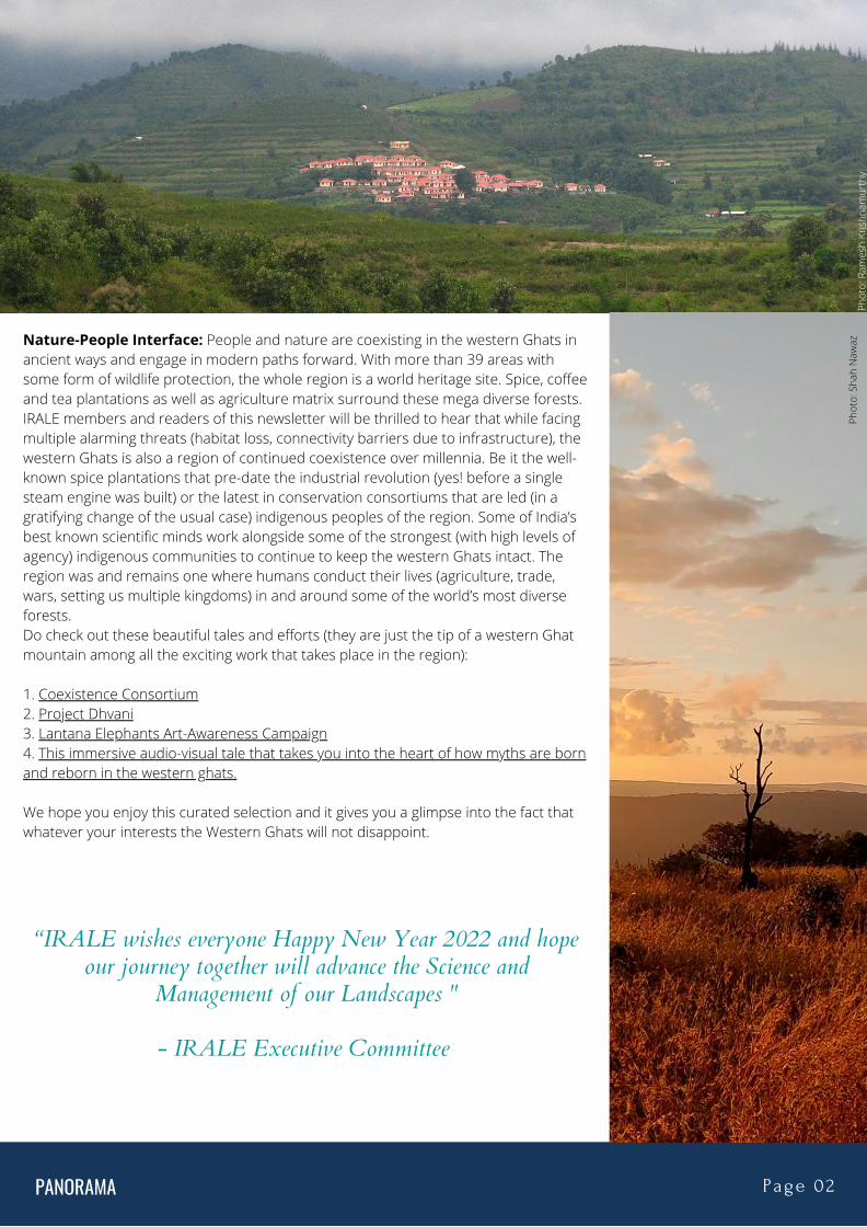
Nature-People Interface: People and nature are coexisting in the western Ghats inancient ways and engage in modern paths forward. With more than 39 areas withsome form of wildlife protection, the whole region is a world heritage site. Spice, coffeeand tea plantations as well as agriculture matrix surround these mega diverse forests.IRALE members and readers of this newsletter will be thrilled to hear that while facingmultiple alarming threats (habitat loss, connectivity barriers due to infrastructure), thewestern Ghats is also a region of continued coexistence over millennia. Be it the well-known spice plantations that pre-date the industrial revolution (yes! before a singlesteam engine was built) or the latest in conservation consortiums that are led (in agratifying change of the usual case) indigenous peoples of the region. Some of India’sbest known scientific minds work alongside some of the strongest (with high levels ofagency) indigenous communities to continue to keep the western Ghats intact. Theregion was and remains one where humans conduct their lives (agriculture, trade,wars, setting us multiple kingdoms) in and around some of the world’s most diverseforests.Do check out these beautiful tales and efforts (they are just the tip of a western Ghatmountain among all the exciting work that takes place in the region):
1. Coexistence Consortium2. Project Dhvani3. Lantana Elephants Art-Awareness Campaign4. This immersive audio-visual tale that takes you into the heart of how myths are bornand reborn in the western ghats.
We hope you enjoy this curated selection and it gives you a glimpse into the fact thatwhatever your interests the Western Ghats will not disappoint.
Phot
o: R
ames
h Kr
ishn
amur
thy
Phot
o: S
hah
Naw
az
“IRALE wishes everyone Happy New Year 2022 and hopeour journey together will advance the Science and
Management of our Landscapes "
- IRALE Executive Committee

PANORAMA Page 03
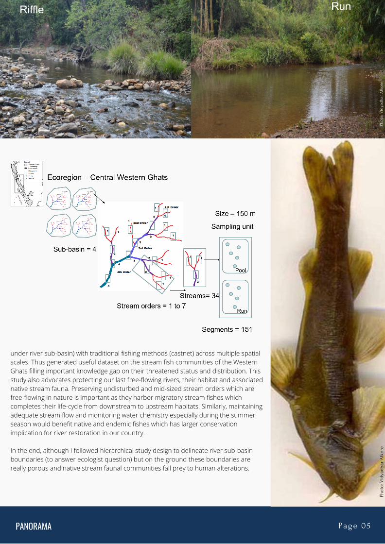
Importance of Scale in Studying Stream Fish CommunitiesVIDYADHAR ATKORESÁLIM ALI CENTRE FOR ORNITHOLOGY AND NATURAL HISTORY (SACON)
I began my academic research by studying stream fish communities in and aroundCorbett Tiger Reserve in 2005. I was fascinated by shallow and wadable streams ofShivalik Himalayas. Back then I wasn’t sure what a small stream and big river is. I waspassionate to walk along every possible bend and curve that each stream provided me.I was interested in understanding and mapping the stream fish community structure.With the help of GIS tools, I chose three streams for comparing fish fauna. Khoh, Kolhuand Mandal were three small to medium sized tributaries of river Ramganga. I enjoyedsampling these streams more than anything else during my fieldwork. I slowlyunderstood what each stream habitat actually meant and how to distinguish onestream habitat from another. And it all depends upon the scale at which you investigateand you analyse your data. I learnt that to understand fine scale differences in fishassemblages with respect to stream habitat and water quality parameters, I had to onlyanalyse data at stream segment or habitat level. On the other hand, to understand thelarge scale differences between fish diversity and their environmental covariates, I hadto rely on either stream size (stream order) or sub-basin (river catchment).
For instance, the stream habitats mentioned in the research paper were run, riffle, pooland cascades which first time appeared very abstract. When I started my field sampling, I realized how each of these habitats were different and yielded somewhat similar butdifferent fish assemblages. During my six-month fieldwork, I sampled around 104steam segments across three stream orders and found total 45 fish species with 12000individuals! I also observed that these stream habitats were extremely altered due toillegal and harmful activities such as dynamiting, pollution and sand-boulder mining.
While I stumbled upon run habitat (a small stretch of stream ~50-100 m having a gentleto moderate flow and encompass homogenous stream substratum without anyturbulence), I observed that many fry and fingerlings of Barilius, Salmostoma, Tor sppwere happily playing in the shallow stream substratum. Initial attempts were failed tocapture them using castnet – a traditional fishing method originated in India and latergot accepted worldwide to capture fishes for subsistence as well as for ecologicalsampling. It is one of the most non-invasive fishing method. If one operated carefully,there would be minimal fish mortality as against other harmful fishing methods such asgillnet or electrofishing which severely alter not only stream fish population but alsostream benthic macroinvertebrates on which many stream fishes survive.
Phot
o: V
idya
dhar
Atk
ore
Phot
o: V
idya
dhar
Atk
ore

PANORAMA Page 04
At riffle habitat (a stream stretch of ~50-100m, with moderate to high turbulence dueto submergence of stream substrate composition) would yield interesting fish species.Often I was able to capture Salmostoma spp and Barilius spp. Morphologically thesespecies have upward mouth, an adaptation to slow to fast flowing water with higherdissolved oxygen concentration, hence these fishes can be easily classified into Surfacedwelling fishes. This shows their high affinity towards the rich dissolved oxygenatedwater. On the other hand, pool habitat (a stream stretch ~50-100m, either shallow (0.1-1m) or deep (>1m) water would often yield two kinds of fishes. One with mid-watercolumn dwelling and other one was bottom dwelling fishes. Examples includes – Torspp, Labeo spp, Chagunius spp (mid-column dwelling-mouth position is in the terminal,specialized on submerged aquatic macrophytes) and Mystus spp, Glyptothorax spp(bottom dwelling fishes since their mouth position is situated downward side as theyspecialized feeding on stream benthic insects, detritus).
At stream order scale (regional scale), I was thrilled to find that fish diversity was higherin pool habitats than run and riffle and that was primarily due to its size and volume ofwater (akin to the species-area relationship) in stream communities. I did not haveopportunity to understand how fish communities vary with riverscape (river-sub-basinscale) during my master’s dissertation.
Subsequently I pursued this idea for my PhD in the Western Ghats region (Karnatakaand Goa) where I sampled four large river sub-basins with 34 streams covering 151stream segments. In total I captured more than 18,000 individuals of fishesencompassing 92 species! At stream segment scale, I found, water chemistry andstream habitat played important role in shaping stream fish communities, at streamorder scale, it was mid-stream order (3rd-5th) that resulted in higher number ofspecies than smaller or larger stream order, whereas at riverscape (sub-basin scale), itwas bigger sub-basins (Malaprabha, Mhadei) that were species rich as compared tosmaller river sub-basins (Tunga and Bhadra). Again at habitat scale, pools were the fishdiversity hotpots.
Interestingly, I found free-flowing river stretches (Bhadra-Tunga flowing in theKudremukh National Park, therefore had adequate protection from anthropogenicdisturbances including barriers and fishing) were higher in their endemic fish faunathan rivers which were hydrologically modified (Malaprabha and Mhadei-had manysmall to large sized barrages and check dams. The headwater regions of Mhadei-Malaprabha witnessed an inter-river basin water transfer affecting fragile headwaterhabitat thereby affecting few habitat specialist fishes such as Homaloptera, Schisturaand Glyptothorax spp) which not only affected stream habitat for endemic species butfavored many generalist fish species. This study was one of the systematically designedand followed a hierarchically nested study design (stream habitat was nested understream segment and stream segment was nested under stream order, and streamorder was nested
Phot
o: V
idya
dhar
Atk
ore
Phot
o: V
idya
dhar
Atk
ore
PANORAMA Page 05
under river sub-basin) with traditional fishing methods (castnet) across multiple spatialscales. Thus generated useful dataset on the stream fish communities of the WesternGhats filling important knowledge gap on their threatened status and distribution. Thisstudy also advocates protecting our last free-flowing rivers, their habitat and associatednative stream fauna. Preserving undisturbed and mid-sized stream orders which arefree-flowing in nature is important as they harbor migratory stream fishes whichcompletes their life-cycle from downstream to upstream habitats. Similarly, maintainingadequate stream flow and monitoring water chemistry especially during the summerseason would benefit native and endemic fishes which has larger conservationimplication for river restoration in our country.
In the end, although I followed hierarchical study design to delineate river sub-basinboundaries (to answer ecologist question) but on the ground these boundaries arereally porous and native stream faunal communities fall prey to human alterations.
Phot
o: V
idya
dhar
Atk
ore
Phot
o: V
idya
dhar
Atk
ore

PANORAMA Page 06
The High Range Landscape epitomizes the Western Ghats in terms of ecologicalcharacteristics, socio-economic profile and development course. The key attributes ofthis landscape are; high levels of endemism and biological diversity, World Heritage Sitesand Important Bird Area, presence of globally threatened flora and fauna, part of one ofthe five viable breeding centres of tiger population in India, harbour the largest viablepopulation of Nilgiri tahr and a significant population of grizzled giant squirrel (both arethreatened as per IUCN), catchment of three major river systems of peninsular India, strong eco-cultural affinities, support important economic sectors like commercialplantations and tourism. These attributes and bourgeoning development process,depleting resources, expanding various production sectors and climate vulnerability hasmade this landscape a focal center for planners and managers. Part of the WesternGhats, one of hottest global biodiversity hotspots and running parallel to the west coast,the landmass is so complex resembling a ‘fossil landscape’. It is also identified as animportant area for fresh water biodiversity by World Conservation Monitoring Centre.
High Range landscape lies (an extend of ~3000 sq. km; 93 deg 8’ to 10 deg 21’ N & 76deg 33’ to 77 deg 18’ E) between the interstate boarder of Kerala and Tamil Nadu on theeast and the Periyar River on the west. The northern part consists of Edamala andPooyamkutty Valleys is connected to Vazhachal Forest Division. On the Tamil Nadu side,the landscape is connected to Anamalai Tiger Reserve and Palni Hills reserve forests. Ithas high mountain peaks, including the highest peak south of Himalayas, Anaimudi (2695m) and Misappuli Malai (2637 m). The High Ranges of the Cardamom Hills is one of thewidest stretches of Western Ghats. The unique topographical features coupled withclimate ranging from extreme wet to dry spells and sub-zero (frost is a commonphenomenon during the winter months) to 42 degree celsius makes this area suitablefor a wide range of wild biological elements. The landscape has ecological contiguity,though interrupted by settlements, enclosures, plantations, reservoirs and linearinfrastructures. The landscape straddles PAs such as Eravikulam, Anamudi Shola,Pampadum Shola national parks and Chinnar, Kurinjimala and Thattekkad wildlifesanctuaries. The non-PAs include Munnar, Marayoor, Mankulam, Malayattoor, Vazhachaland Chalakudy forest divisions.
The natural vegetation of the landscape includes high elevation montane shola forestsand grasslands, wet evergreen forests of low, medium and high elevation, moist and drydeciduous forests, wet and dry scrub and thorn forests, reed (Ochalndra spp.) andbamboo thickets, riparian forests, tree savanna and various plantations and homegardens. The plantations comprise both commercial (tea, cardamom, coffee, rubber, oil
THE HIGH RANGE LANDSCAPE – NEED SECTORAL MAINSTREAMING FORBIODIVERSITY CONSERVATIONP V KARUNAKARAN & NANDU V S SÁLIM ALI CENTRE FOR ORNITHOLOGY AND NATURAL HISTORY (SACON)
Phot
o: N
andu
VS
Phot
o: R
ames
h K
rish
nam
urth
y

PANORAMA Page 07
palm, cashew and cocoa) and forestry (teak, eucalyptus, wattle, pine, alnus, mahoganyand many miscellaneous species). Among the vegetation types, the shola grasslandformations considered as Pleistocene refugia, are unique and one among the mostendangered ecosystems of the world. More than 30% of flowering plants found in thisregion are endemic and the floral elements have phylogenetic affinities with variousother biomes of the world. The occurrence of Neelakurinji (Strobilanthes kunthiana) aplietesial shrub which blooms gregariously literally carpet the grassland with its mauveblue flowers enhance the grandeur of the landscape.
According to available information, the landscape harbours 265 species of butterflies(22 are endemic to WG), 110 species of Odonata (44 endemic), 72 species of fishes (23endemic), 50 species of amphibians (43 endemic), 122 species of reptiles (42endemic), 310 species of birds (15 endemic) and 79 species of mammals (nineendemic). Globally significant species include Nilgiri tahr, Indian elephant, tiger, gaur,Nilgiri langur, lion-tailed macaque, slender loris, leopard, jungle cat, sambar deer,grizzled giant squirrel, Malabar giant squirrel, Nilgiri marten, Travancore flying squirrel,wild dog, great Indian hornbill, Malabar pied hornbill, Kerala laughing thrush, Nilgiriwood pigeon, Nilgiri pipit, etc.
The High Range landscape has diverse cultural and linguistic affinities. Peoplemigrated from the central Travancore for centuries, the estate labours who had comefrom the Tamil Nadu plains and the native ethnic groups, inhabit the area. Themigration was focused on plantations and wealth creation and for subsistence. Thereare thirteen tribal communities such as Muthuvan, Mannan, Hill Pulaya, Oorali,Malavedan, Malayan, Kadar, Paliyar, Ulladar, Malaipandaram, Malayarayar, Irular, andKattunaikkar inhabit the landscape. Agriculture, forestry and commercial plantationsare the mainstay of employment in the High Ranges. The tribal communities arelargely engaged in subsistence farming and non-forest produce collection from theforest area. Commercial plantations include large-scale cultivation of cardamom, tea,coffee and rubber in the western slopes and farming in the Anchanad Valley andVattavada village. The forestry operations include teak plantations and reedextractions in the lower valleys and eucalyptus and wattle in the higher places. Theheterogeneous cultivation of crops in the home garden too diversify the land uses.The economic setbacks to the agricultural and production sectors in the recent pastand the charisma and magnificence of the landscape promoted tourism as one of themain economic activities.Hence, at present the High Range landscape is a mosaic of land uses with a blend ofconservation, economic and livelihood activities. The dynamics of various land usesfrom conservation of natural forests to subsistence farming to commercial plantationsand to mass tourism at different instances of historical time scale engraved thepresent complexity of this landscape. A multitude of stakeholders with competing andcontradicting interests on the resources of this nearly 3000 km2 area in the backdropof climate vulnerability worsened the situation. A prudent strategy to mainstream themanagement of natural resource and biological richness with the economic /production activities would be the only alternate for the sustainability of the HighRanges for posterity.
Phot
o: R
ames
h Kr
ishn
amur
thy
Phot
o: R
ames
h K
rish
nam
urth
y

PANORAMA Page 08
News
Phot
o :R
ames
h Kr
ishn
amur
thy
Read more here
Read more here
Read more here
Read more here
Read more here
Read more here
Read more here
Read more here
Phot
o :R
ames
h K
rish
nam
urth
y

PANORAMA Page 09
Views S A T Y A M V E R M A | U N I V E R S I T Y O F W A S H I N G T O N , S E A T T L E Decline of Forest Fires in The Nilgiri Biosphere Reserve in Last Three Decades
In the 2019 fire season, Nilgiri Biosphere Reserve (NBR) witnessed more than 100,000acres of forest razed by forest fires killing a forest guard and injuring many others. Suchfigures might lead people to believe that forest fires are getting more intense in theWestern Ghats. However, several studies since last decade show that the amount ofburned area declined significantly in NBR. The 2019 fire season in NBR was most damaginglast 9 years.
Forest fires have been important part of NBR. Particularly, dry deciduous forests of NBR aremost significantly affected by the Fires. NBR was the first Biosphere Reserve designatedunder Man and Biosphere program in 1986. NBR extends over an area of 5,520 km2 withan elevation of 80 to 2,600 m. Nilgiri forests host largest population Asian elephantsanywhere in the world and NBR plays a significant role in biodiversity conservation ofparticularly large mammals, by providing diverse and contiguous habitat.
Kodandapani et al. (2004) reported that a fire return interval (FRI) of 3.3 years in Mudumalaiin 2004 which was significantly higher than 1920s when FRI was 10 years in the sameregion. They also reported that approximately 19% (1029 km2/Year) of the forest areburning every year in the NBR between 1989 and 2002. Later, Verma et al. (2015) reportedthat FRI again reached back to 10 between 1999 and 2013 in Mudumalai. They stated thatfire is now burning only 10% of the forest compared to 30% between 1989 and 2002.Further study by Reddy et al. (2018) also concluded that burned area has been significantlyreduced in NBR in last 3 decades. They reported that only 149 km2/Year was burning inNBR which 2.7% of NBR.
These results stand in contradiction to most of the prediction models that project anincrease in global burned areas as global temperatures rise. The results of these studiesprove that human activity is the most important driver of wildfire frequency and intensity,and this offsets the warming and drying effects of climate change. The reduction in theburned area could be ascribed to the anti-causal factors, particularly stationing of the anti-poaching-cum fire camps in the year 2000 and ban on the operation of private vehicles insome parts as well as resettlement of several hamlets from core zones of Tiger Reserves inNBR.
References:1) Kodandapani, N., Cochrane, M. A., & Sukumar, R. (2004). Conservation threat of increasing fire frequencies inthe Western Ghats, India. Conservation Biology, 18(6), 1553-1561.2) Verma, S., & Jayakumar, S. (2015). Post-fire regeneration dynamics of tree species in a tropical dry deciduousforest, Western Ghats, India. Forest Ecology and Management, 341, 75-82.3) Reddy, C. S., Satish, K. V., & Rao, P. P. (2018). Significant decline of forest fires in Nilgiri Biosphere Reserve,India. Remote Sensing Applications: Society and Environment, 11, 172-185.
“The culture of theforest has fuelled
the culture ofIndian society."
-Rabindra Nath
Tagore
Phot
o :R
ames
h K
rish
nam
urth
y Ph
oto
:Ram
esh
Kri
shna
mur
thy

The Sahyadris (northern Western Ghats) boast a splendid milieu of landscapes; anamalgamation of spectacular mountain peaks, thirst quenching rivers, picturesque waterfallsand serene woods. Not only does it house rare and endemic flora and fauna, it provides themuch-needed escape to a drab city-dweller. To find an opportunity to spend a substantialamount of time here is an incredibly humbling feeling. I luckily scored an opportunity to studythis diverse landscape in 2017 through the Sahyadri Tiger Recovery Project led by Dr. K.Ramesh. The Sahyadri Tiger Reserve is formed by combining Chandoli National Park andKoyna Wildlife Sanctuary.
The western Maharashtra/Sahyadri region area is known for water security as major damsare built here, chief amongst them is the Koyna dam which forms the Shivasagar reservoirand now the Koyna Wildlife Sanctuary. Awestruck with the beauty of Koyna, I decided to focuson Koyna Wildlife Sanctuary for my PhD research. A challenge here was to assess all sites viaa boat, which is altogether a unique and refreshing experience. To understand mammaloccupancy and factors affecting their occupancy along riparian forests in Koyna WildlifeSanctuary, camera traps were used nested in an occupancy modelling framework. Weadopted a field design wherein riparian forests along perennial and temporary streams wereassessed. Using dynamic occupancy models with camera trapping data collected from April2018 to January 2020, we aimed to understand mammal occupancy and the factors affectingoccupancy of mammals along riparian forests. We found three key patterns emerging fromthis study. Firstly, ungulates dominate riparian forests within Koyna reservoir, in terms ofoccupancy. Secondly, smaller sized ungulates are more vulnerable to local extinction ascompared to large ungulates. Thirdly, stream proximity was a dominant predictor formammal detection. We observed that as distance from stream increased, mammal detectionprobabilities dropped.
Within riparian forests in India, such studies have been limited, especially from alteredecosystems such as large reservoirs. The findings from this study have high relevance formanagement of riparian forests and accordingly how species can be managed within areservoir. In addition to highlighting species-habitat relationship patterns, the informationgenerated provides a strong empirical basis for developing catchment-wide and multi-speciesstrategies for conservation management. Multi-landscape planning that encompassesstreams, rivers and associated riparian habitats which go beyond conventional planning havebeen recorded to achieve overarching benefits. Finally, the approach and design employed inthis study can be scaled up and/or be used in other India riverine landscapes and beyond.*The full paper can be accessed at https://doi.org/10.3389/fevo.2021.643285
PANORAMA Page 10
Members' Page: Members in actionResearch in an Under-explored Haven – Sahyadri
Shah Nawaz presently works as a Project Fellow in the Sahyadri Tiger Recovery Projectcollaboratively run by the Wildlife Institute of India, Maharashtra Forest Department andNational Tiger Conservation Authority. Along with the project objectives, his PhD researchfocuses on understanding terrestrial mammal assemblages at the interface of terrestrialand freshwater realms.
SHAH NAWAZ JELIL | WILDLIFE INSTITUTE OF INDIA
Phot
o: S
hah
Naw
az
Phot
o: S
hah
Naw
az

PANORAMA Page 11 Editors: Vaishali Vasudeva, Amrita Neelakantan, Ramesh Krishnamurthy
IRALE Executive Committee 2022-2024 PRESIDENT DR K RAMESH | WILDLIFE INSTITUTE OF INDIA
VICE PRESIDENT DR. PV KARUNAKARAN | SACON
SECRETARY DR. PARABITA BASU | EKJUT
DEPUTY SECRETARYDR. AMRITA NEELAKANTAN | NCCI
TREASURER DR. G. AREENDRAN | WWF INDIA
REGIONAL COORDINATOR NORTHDR. SANJAY UNIYAL | CSIR-IHBT
REGIONAL COORDINATOR SOUTHDR. BINDU RAGHAVAN | CENTRE FOR WILDLIFE STUDIES
REGIONAL COORDINATOR EASTDR. DEBAJIT DATTA | JADAVPUR UNIVERSITY
REGIONAL COORDINATOR WEST/CENTRALMR. ARUN KUMAR | INDEPENDENT RESEARCHER
YOUNG PROFESSIONAL REPRESENTATIVEMS. JYOTI KASHYAP | GREEN FUTURE FOUNDATIONS
Phot
o: R
ames
h Kr
ishn
amur
thy
Updates from the Executive Committe Highlights from the EC meeting held on January 7, 2022
Plan 2022-2024: Discussion on annual plan of operation for 2022 is initiated and includes IRALE delegationparticipation and chapter contribution in World IALE Congress 2023 in Nairobi, Kenya.Roles & Responsibilities of new EC Members will be communicated. The role of regional coordinators will besubstantial in taking the IRALE plan forward, but it will be a team effort with a somewhat flexible structure. The roleand participation of advisory board will be reviewed further.Membership: There will be membership renewal in 2022 for each registered member, however, this time therewill be addition options for (1) Term Membership (3 Years) and (2) Lifetime membership. Working Group Discussions & Webinars: working group discussion through webinar/panel discussion/etc. willbe initiated with first meeting tentatively planned to be first Friday of February 2022. Working groups canbrainstorm on different project ideas. SOP: Guideline and Standard Operating Procedure to guide members for association with IRALE will be done.
Related Documents