Introduction to GEO Water and IGWCO activities Rick Lawford GEO-DRI WORKSHOP May 10, 11, 2010 Winnipeg, MB, Canada

Welcome message from author
This document is posted to help you gain knowledge. Please leave a comment to let me know what you think about it! Share it to your friends and learn new things together.
Transcript

Introduction to GEO Water and
IGWCO activities
Rick Lawford
GEO-DRI WORKSHOP
May 10, 11, 2010
Winnipeg, MB, Canada

27. (Decided) Improve water resource
management and scientific understanding of the
water cycle through cooperation in joint
observation and research, and encourage and
promote knowledge sharing, and provide
capacity-building and the transfer of technology,
as mutually agreed, including remote-sensing
and satellite technologies, particularly to
developing countries as well as countries with
economies in transition, for this purpose.
IN 2000- 2004, THE IGWCO THEME WAS
DEVELOPED WITHIN IGOS-P TO ASSIST IN
ADDRESSING WSSD RESOLUTION #27

1. Provide a framework for guiding decisions on
priorities and strategies regarding water cycle
observations for:
- Monitoring climate variability and change,
- Effective water management and
sustainable development of the world’s
water resources,
- Societal applications for resource
development and environmental
management,
- Specification of initial conditions for
weather and climate forecasts,
- Research directed at priority water cycle
questions
2. Promote strategies that facilitate the
processing, archiving and distribution of water
cycle data products
THE INTEGRATED GLOBAL WATER CYCLE
OBSERVING THEME (IGWCO) IS A “BEST EFFORTS”
ACTIVITY WITH THE FOLLOWING OBJECTIVES:
WaterOCEANS CARBONAIR
CHEMCOASTAL
IGOS-PCEOS-SIT CEOS
GEO
HAZARDSLAND
COVER
CRYO-
SPHERE
IOCGTOS
UNEP
UNESCOGOOS
FAO
ICSU
WMO
IGBPWCRP
GCOS
IGFACEOS
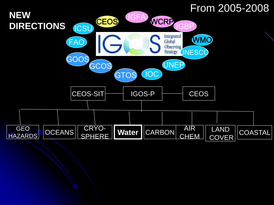
NEW
DIRECTIONS
From 2005-2008

INTEGRATED
PRECIP
SOIL
MOISTURE
RUNOFFGROUND
WATER
WATER
QUALITY
CEOP
GLOBAL
WATER
SYSTEM
CAPACITY
BUILDING
OUTREACH
& POLICY
LINKS
VARIABLES
INTEGRATION
APPLICATIONS
THE IGWCO
UMBRELLA
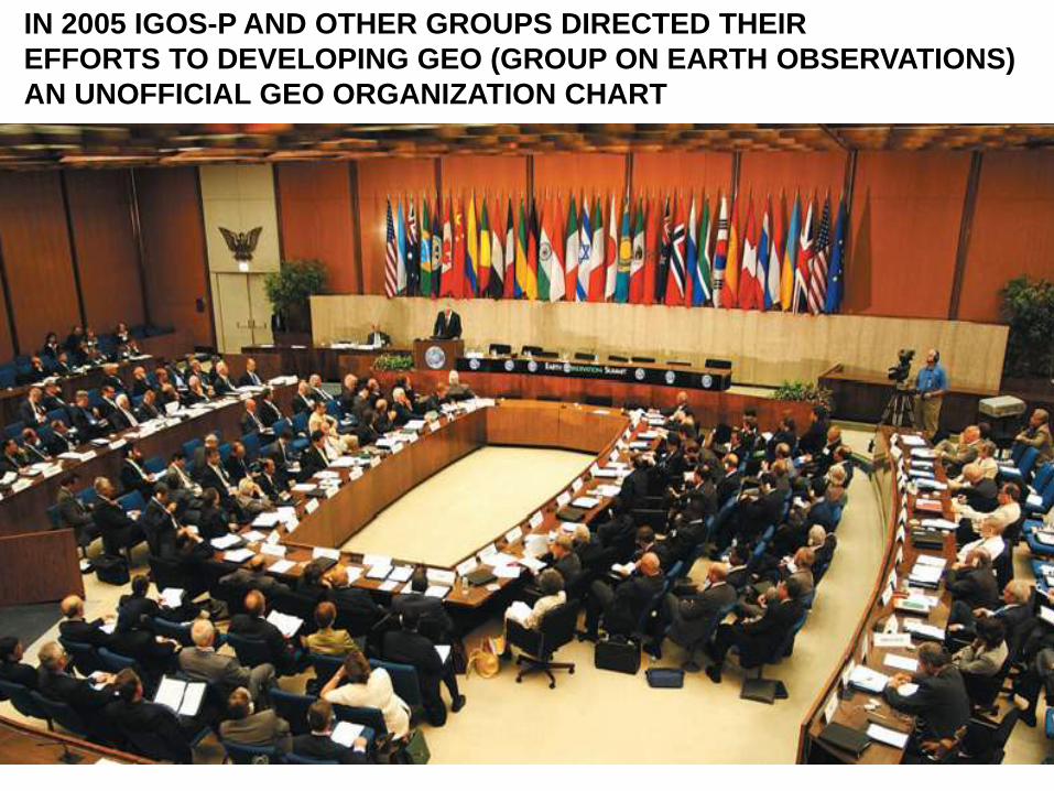
IN 2005 IGOS-P AND OTHER GROUPS DIRECTED THEIR
EFFORTS TO DEVELOPING GEO (GROUP ON EARTH OBSERVATIONS)
AN UNOFFICIAL GEO ORGANIZATION CHART
GEO PLENARY
GEO EXECUTIVE
Science & Technology Committee
Architecture and Data
Committee
User Interface
Committee
Capacity Building
Committee
Societal Benefit Areas
& Communities
of Practice
GEOSS Common
Infra-Structure
Supported by the
GEO Secretariat

Relevant Facts:- Involves ~80 nations and ~50 international
organizations who have agreed to work together
to build the GEOSS.
- Coordinated by the Group on Earth Observations
(GEO) which implements the GEOSS work plan
through the best efforts of its community.
Targets
Tasks
Sub Tasks
The Primary Framework: GEOSS: A Global, Coordinated,
Comprehensive and Sustained System of Observing Systems
By 2015, produce comprehensive sets
of data, information products and
services to support decision-making
for efficient management of the world's
water resources, based on coordinated,
sustained observations of the water
cycle on multiple scales.
The Water Target
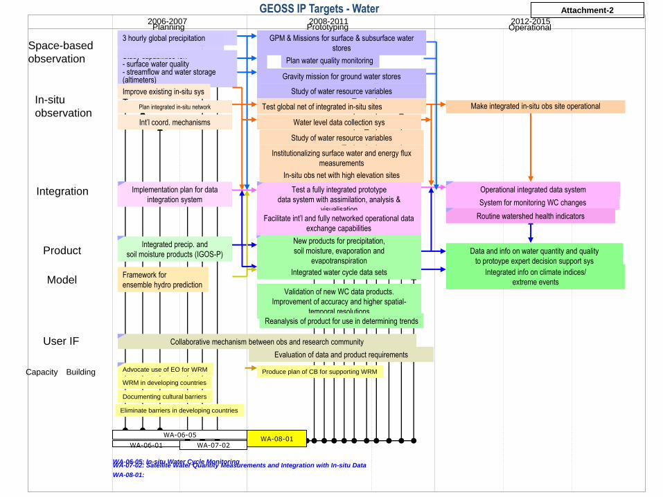
2006-2007 2008-2011 2012-2015
In-situ
observation
Integration
Product
Model
User IF
Test global net of integrated in-situ sites
Test a fully integrated prototype
data system with assimilation, analysis &
visualisation
Operational integrated data system
Space-based
observation Study capabilities for:- surface water quality- streamflow and water storage (altimeters)
Integrated info on climate indices/
extreme events
Implementation plan for data
integration system
Plan integrated in-situ network
3 hourly global precipitation
Integrated precip. and
soil moisture products (IGOS-P)
Int’l coord. mechanisms
GPM & Missions for surface & subsurface water
stores
System for monitoring WC changes
Data and info on water quantity and quality
to protoype expert decision support sys
Collaborative mechanism between obs and research community
Framework for
ensemble hydro prediction
New products for precipitation,
soil moisture, evaporation and
evapotranspiration
Integrated water cycle data sets
Water level data collection sys
Planning Prototyping Operational
Routine watershed health indicators
Capacity Building Advocate use of EO for WRM Produce plan of CB for supporting WRM
WA-06-05
WA-06-05: In-situ Water Cycle Monitoring
Plan water quality monitoring
Gravity mission for ground water stores
Make integrated in-situ obs site operational
Improve existing in-situ sys
WRM in developing countries
Documenting cultural barriers
Eliminate barriers in developing countries
Validation of new WC data products.
Improvement of accuracy and higher spatial-
temporal resolutions
Facilitate int’l and fully networked operational data
exchange capabilities
Study of water resource variables
Study of water resource variables
Evaluation of data and product requirements
Institutionalizing surface water and energy flux
measurements
In-situ obs net with high elevation sites
WA-07-02WA-06-01WA-08-01
Reanalysis of product for use in determining trends
WA-07-02: Satellite Water Quantity Measurements and Integration with In-situ Data
WA-08-01:
GEOSS IP Targets - Water Attachment-2

SOME 2009 HIGHLIGHTS1. Workshops held by a number of variable-specific groups:
- Soil moisture in Portugal
- CEOP meeting in Melbourne Australia
2. The 5th IGWCO planning meeting was held in Kyoto in February, 2009. The
workshop resulted in a number of recommendations including the E2E
activity.
3. Three major regional Capacity Building meetings related to the Water Cycle
were held including Asia (in Tokyo, Japan), Africa (Tunisia) and Latin and
Caribbean America (Lima, Peru).
4. The IGWCO SAG continued to support its activities through regular
teleconference calls supported by GEO.
5. An archive centre for soil moisture data was established at the University of
Vienna.
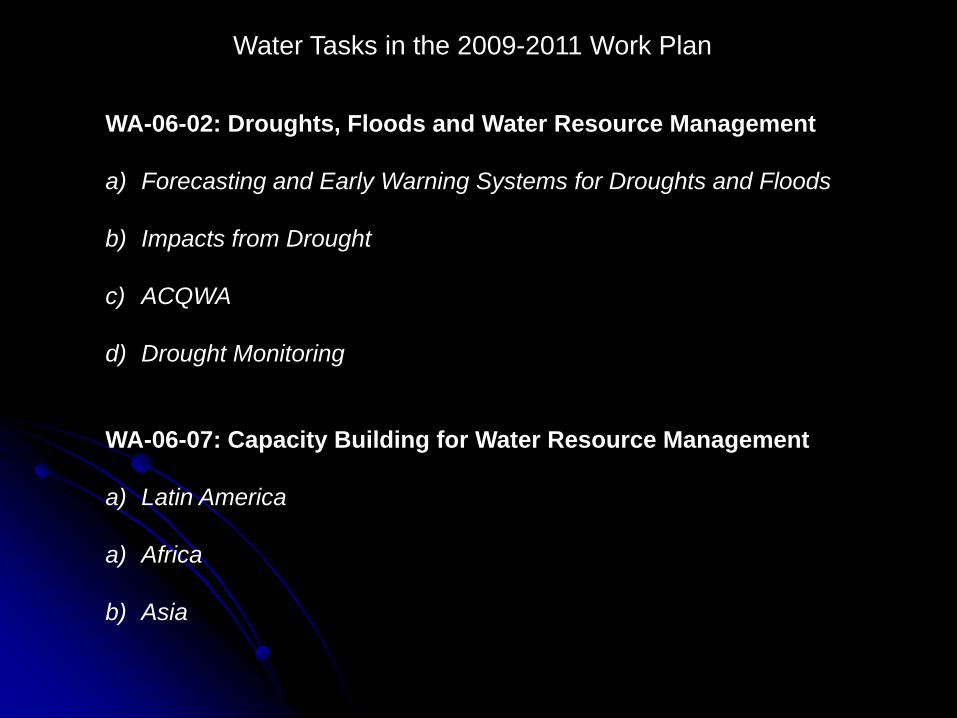
WA-06-02: Droughts, Floods and Water Resource Management
a) Forecasting and Early Warning Systems for Droughts and Floods
b) Impacts from Drought
c) ACQWA
d) Drought Monitoring
WA-06-07: Capacity Building for Water Resource Management
a) Latin America
a) Africa
b) Asia
Water Tasks in the 2009-2011 Work Plan

© GEO Secretariat
TIGER
Water Information
& Knowledge Network
• TIGER involves more than 200 African
experts (universities, technical centers,
water authorities
• Actions dedicated to:
• Facilitate sharing of water
knowledge, information and data;
• Support the development of common
water research programs;
• Identify and promote best practices;
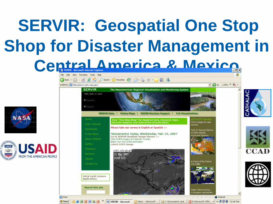
SERVIR: Geospatial One Stop
Shop for Disaster Management in
Central America & Mexico
© GEO Secretariat
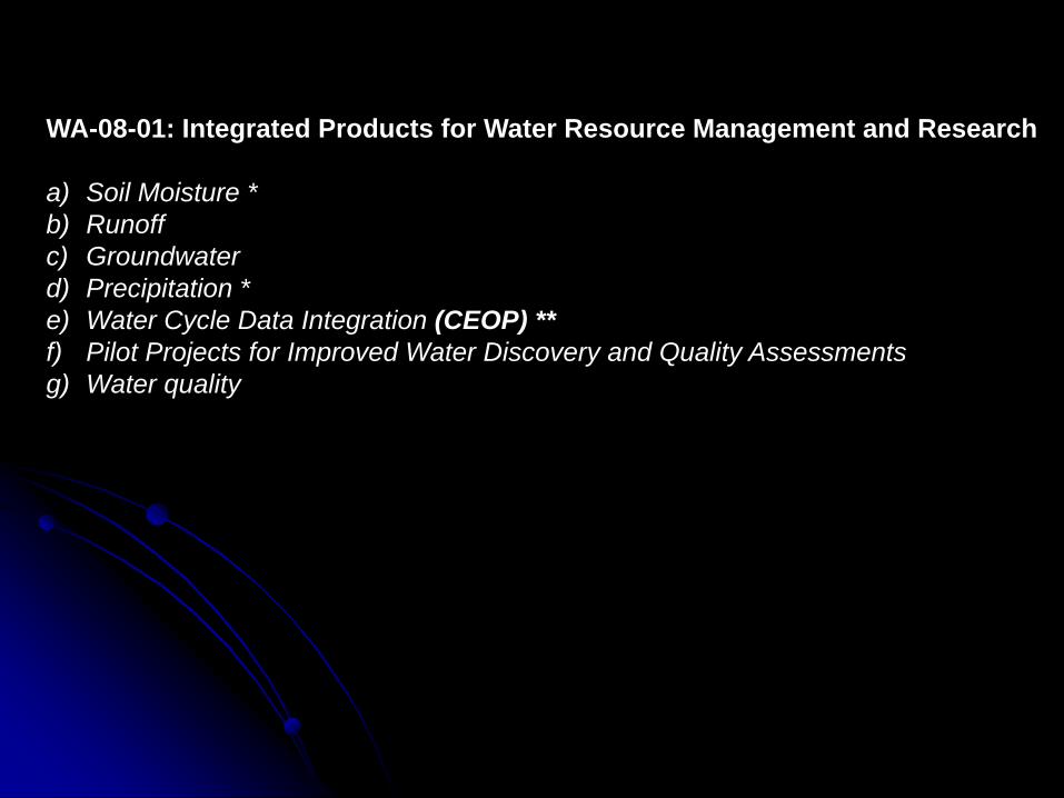
WA-08-01: Integrated Products for Water Resource Management and Research
a) Soil Moisture *
b) Runoff
c) Groundwater
d) Precipitation *
e) Water Cycle Data Integration (CEOP) **
f) Pilot Projects for Improved Water Discovery and Quality Assessments
g) Water quality

WA-08-01: Integrated Products for Water Resource Management and
Research
Improvements and expansion of in-situ networks, combined with new and
existing
satellite missions and emerging assimilation and prediction capabilities, are
opening the door to a new era in global water-cycle management.
a) Soil Moisture
b) Runoff
c) Groundwater
d) Precipitation
e) Water Cycle Data Integration
f) Pilot Projects for Improved Water Discovery and Quality Assessments
g) Global Water Quality Monitoring
Primary Water Cycle Sub-Tasks under WA-08-01.
Storages Anomalies in Saskatchew River Basin
-12
-8
-4
0
4
8
12
Apr-02 Oct-02 Apr-03 Oct-03 Apr-04 Sep-04 Mar-05 Sep-05 Mar-06
Time (Months)
Am
ount
(cm
)
Surface Storage GRACE Storage
Drought Flood
ASTER Soil
Moisture

Global Terrestrial Network
Hydrology
(GTN-H)
"Network of Networks"
Snow cover*
Glaciers and ice
caps*
NSIDC
WGMS / GTN-G
Precipitation*
GPCC
GPCP
NCDC / GSN
River discharge*
GRDC / GTN-R
Water vapour*
WMO WWW
Ground water*
IGRAC
GEMS/Water
In-situ Soil Moisture
Network (planned);
SMOS
Soil moisture
Water quality /
BGC fluxes
FAO/AQUASTAT
Water use*
FLUXNET
Evapotranspiration
HYDROLARE /
GTN-L
SHI St. Petersburg?
Lake level/area*
IAEA / GNIP
Isotopic
Composition
GTN-H is recognized as a major contributor to
many
of these subtasks especially discharge, surface
water storage and groundwater.

IEEE “Water for the World” Program
• Developing country focus
• In the field within one year
• Sustainable
• Scalable
• Reusable
• Fundable
Food Security: Water and Sustainable Agriculture - India
Urban Water - Ghana
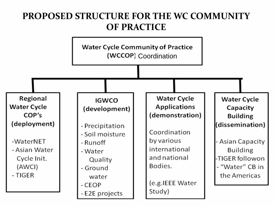
PROPOSED STRUCTURE FOR THE WC COMMUNITYOF PRACTICE
Coordination

RGL
The IJC and EPA have recentlycompleted studies that are the basis of continued monitoring activities in
this area.
US/CANADA GEO PLANS AND ACTIVITIES WILL TEST ANDDEMONSTRATE GEO WC TOOLS IN SHARED CANADA/US BASINS
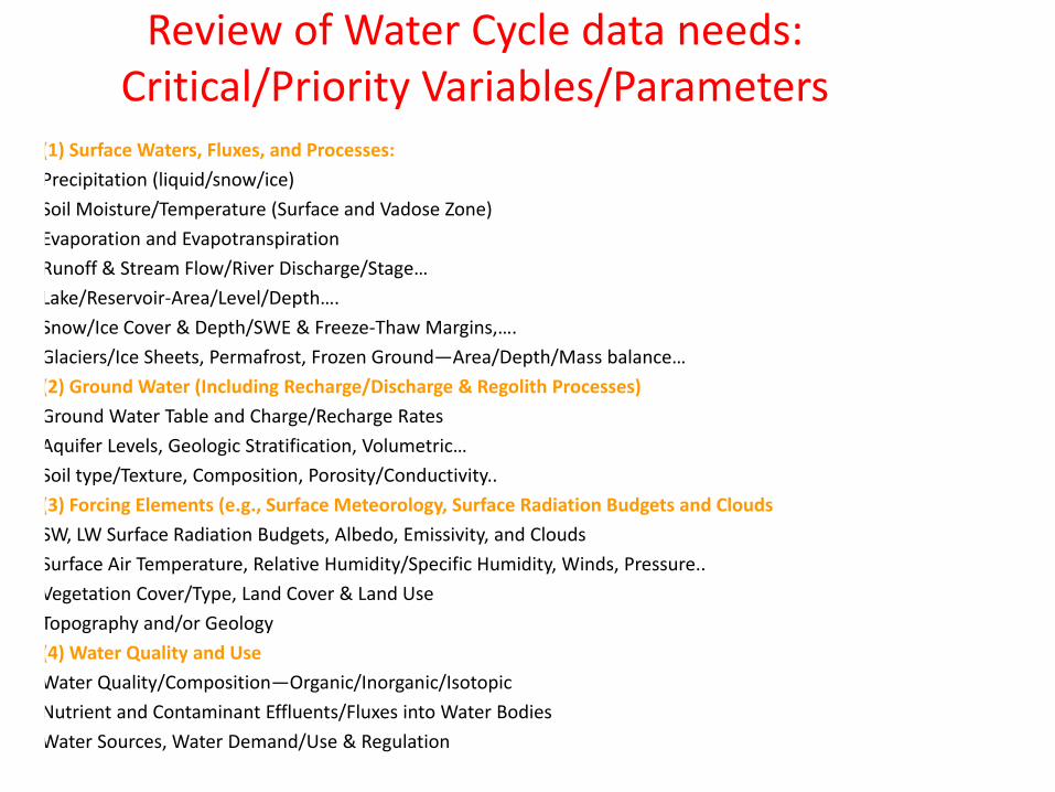
Review of Water Cycle data needs: Critical/Priority Variables/Parameters
• (1) Surface Waters, Fluxes, and Processes:
• Precipitation (liquid/snow/ice)
• Soil Moisture/Temperature (Surface and Vadose Zone)
• Evaporation and Evapotranspiration
• Runoff & Stream Flow/River Discharge/Stage…
• Lake/Reservoir-Area/Level/Depth….
• Snow/Ice Cover & Depth/SWE & Freeze-Thaw Margins,….
• Glaciers/Ice Sheets, Permafrost, Frozen Ground—Area/Depth/Mass balance…
• (2) Ground Water (Including Recharge/Discharge & Regolith Processes)
• Ground Water Table and Charge/Recharge Rates
• Aquifer Levels, Geologic Stratification, Volumetric…
• Soil type/Texture, Composition, Porosity/Conductivity..
• (3) Forcing Elements (e.g., Surface Meteorology, Surface Radiation Budgets and Clouds
• SW, LW Surface Radiation Budgets, Albedo, Emissivity, and Clouds
• Surface Air Temperature, Relative Humidity/Specific Humidity, Winds, Pressure..
• Vegetation Cover/Type, Land Cover & Land Use
• Topography and/or Geology
• (4) Water Quality and Use
• Water Quality/Composition—Organic/Inorganic/Isotopic
• Nutrient and Contaminant Effluents/Fluxes into Water Bodies
• Water Sources, Water Demand/Use & Regulation
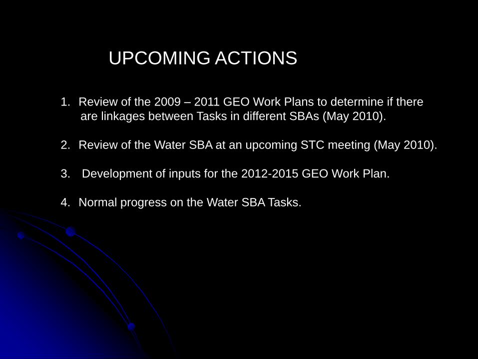
UPCOMING ACTIONS
1. Review of the 2009 – 2011 GEO Work Plans to determine if there
are linkages between Tasks in different SBAs (May 2010).
2. Review of the Water SBA at an upcoming STC meeting (May 2010).
3. Development of inputs for the 2012-2015 GEO Work Plan.
4. Normal progress on the Water SBA Tasks.
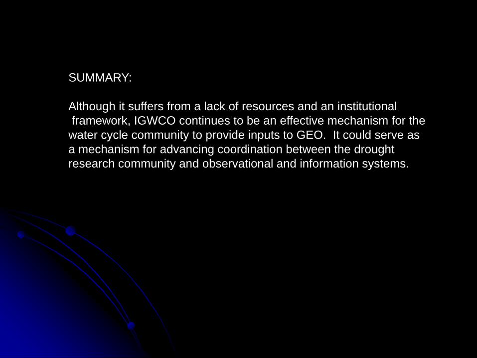
SUMMARY:
Although it suffers from a lack of resources and an institutional
framework, IGWCO continues to be an effective mechanism for the
water cycle community to provide inputs to GEO. It could serve as
a mechanism for advancing coordination between the drought
research community and observational and information systems.
Related Documents