Paola De Salvo Technical Account Manager Non Profit and Global Organization Introduction to ArcGIS Online Technical workshop 8 April 2014

Welcome message from author
This document is posted to help you gain knowledge. Please leave a comment to let me know what you think about it! Share it to your friends and learn new things together.
Transcript

Paola De Salvo
Technical Account Manager
Non Profit and Global Organization
Introduction to ArcGIS Online
Technical workshop
8 April 2014

Humanitarian &
Food Aid Agriculture &
Development
Nuclear Power
Health
Telecommunication
A Global Network of GIS Professionals
Demining
Refugees
Industrial Development

Our World Is Facing Serious Challenges
• Collectively We Need to Create a Better Future
Social Conflict
Biodiversity
Resource Shortage
Climate Change
Energy
Land Use Urbanization
Inequality
Pollution
Water
Ecological Change
Natural Resources
Economic Development
Wealth and Poverty
Loss of Nature Human Health
Food
Population
Growth Cultural Diversity
Migration
s

GIS Is Already Helping Us Understand
Providing the Practical Means
for Transforming Our World
Integrative
Visual
Quantitative
Systematic
Comprehensive
“Technology does not have a mind of its own. It has to be directed and put to its most effective use “
US Ambassador for the UN Betty King @ the GIS for the UN Conference 2012
GIS Changes How We Think and Act
• Integrating Geographic Science into What We Do
• We Need to Embrace This Approach . . . Making It Pervasive
• Involving Our Organizations and All of Us
Evaluate
Analyze
Predict
Prepare
Manage
Act
Decide
Design
Measure
Plan

GIS Is Being Transformed - (r)Evolution
• Into a Web GIS
• Making GIS Easier, Always Available, and More Social
Web GIS

Earth Observation Satellites: high resolution Imagery
GPS Satellite constellation
6.8 Billion people with Mobile devices
Advanced Interoperable & Easy to use GIS technology
ArcGIS Online
Desktop
Tablets
Smartphones
Websites
Browsers
Social media
“Geo-spatial systems are helping us understand our world" by turning information into action.

When disaster strikes the most important information to know is where the disaster has happened,
how many people have been affected and what have been the consequences and impact
of the given hazard over the local population, livelihoods and infrastructure.
These information need to be accurately acquired and timely communicated to the decision makers
and to the humanitarian community for planning of appropriate humanitarian responses both in .
SLOW Onset Disasters and Rapid Onset disasters
Type of disasters
Total n. of people affected in 10 years %
Complex Disasters 10'853'900 0.39%
Drought 906'264'297 32.39%
Earthquake (seismic activity) 77'758'949 2.78%
Epidemic 6'549'892 0.23%
Extreme temperature 87'738'697 3.14%
Flood 1'261'413'080 45.08%
Industrial Accident 1'002'080 0.04%
Mass movement wet 3'548'145 0.13%
Miscellaneous accident 133'684 0.00%
Storm 439'072'596 15.69%
Transport Accident 47'257 0.00%
Volcano 1'550'534 0.06%
Wildfire 2'139'269 0.08%
Total 2'798'072'380 100.00%
In the last 10 years 1/3 of the world population has been affected by hazards
1 India
2 China P Rep
3 Ethiopia
4 Thailand
5 Kenya
6 Niger
7 South Africa
8 Somalia
9 Zimbabwe
10 Malawi
11 Sudan
12 Tanzania Uni Rep

Real time spatial information is critical for
all UN interventions fields:
Disaster management, food security, health, migration, conflicts, epidemics
Data
Quality
Availability
TIME
Data Readiness
1. Satellite Communication
Technologies
(Inmarsat, Thuraya,
Iridium)
2. «Where»
Map, Spatial Data,
Analysis
Shock / Need of data

Challenges of Geospatial data management from the field to Decision makers
Regional
Bureau
CO
CO CO
Country Level Data Collection
Map creation
Data Analysis
Report Writing
Regional Bureau Level Countries Data management
Map creation
Data Analysis
Report writing
Head Quarter Level RB & CO Data management
Map creation
Data Analysis & Spatial Data Analysis
Report writing
Decision Making
Field data collected
Maps
Spatial Analysis
Reports
HQ Web
Mobile
Desktop
ArcGIS Online

Data
People
Communities Software
INTEGRATION COLLABORATION
ACCESSIBILITY
Socioeconomic
Health
Nutrition
Demographic
Socioeconomic
Agricultural,
Livestock data
Land Use
Land cover
Climatic
Meteorological
Data
Infrastructure Data
Food Security
Imagery
ArcGIS
As a platform
Field data
ArcGIS is a Complete System
with a cloud component

ArcGIS is a Complete System
with a cloud component
Managing and working with geographic information
• Desktop
• Server
• Mobile/devices
• Online
Cloud
Enterprise Mobile
Desktop
Web
•Discover
•Create
•Manage
•Visualize
•Analyze
•Collaborate
Local
GIS has evolved fast over time towards
a collaborative approach.

Web GIS Can Represent All Data Types • As Web Maps and Web Services
• Providing a New Medium for GIS
Imagery
Social Media
Big Data
Services
Sensor
Networks
Maps
Enterprise Data
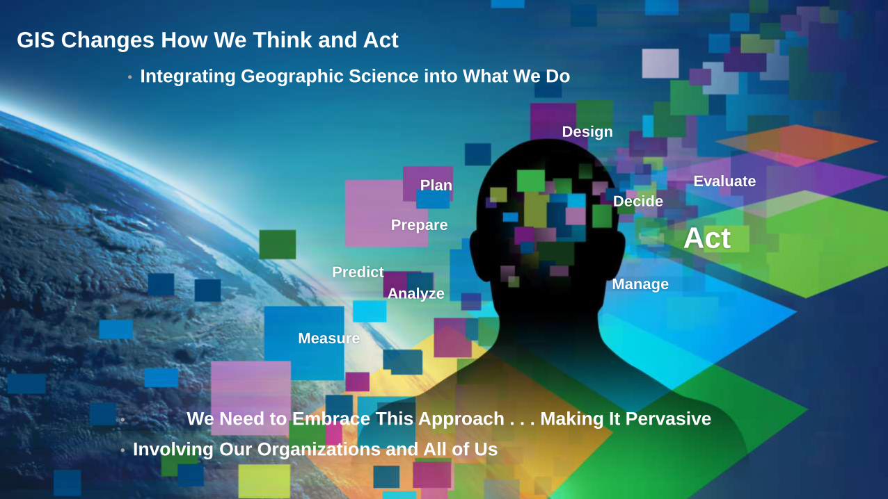
Web GIS Can Integrate Anything • Linking and Combining Information
• Helping to Discover Patterns and Relationships
Mashup
Visual Overlay
Modeling
Spatial Analysis
Dynamic Linking
Hyperlinks

Web GIS Also Integrates Organizations and People
• Breaking Down the Barriers
• Sharing Resources . . .
• . . . Supporting Collaborative Approaches
Creating New
Relationships

ArcGIS – A Web GIS • For Mapping, Analyzing, and Managing Geographic Information
Simple
Integrated
Open

ArcGIS – Accessible from Any Client
Simple
Integrated
Open
Desktop Web Device

ArcGIS – Powered by Services
Simple
Integrated
Open
Server Online Content
and Services

ArcGIS – Organizes Content and Manages Access
Simple
Integrated
Open
Portal
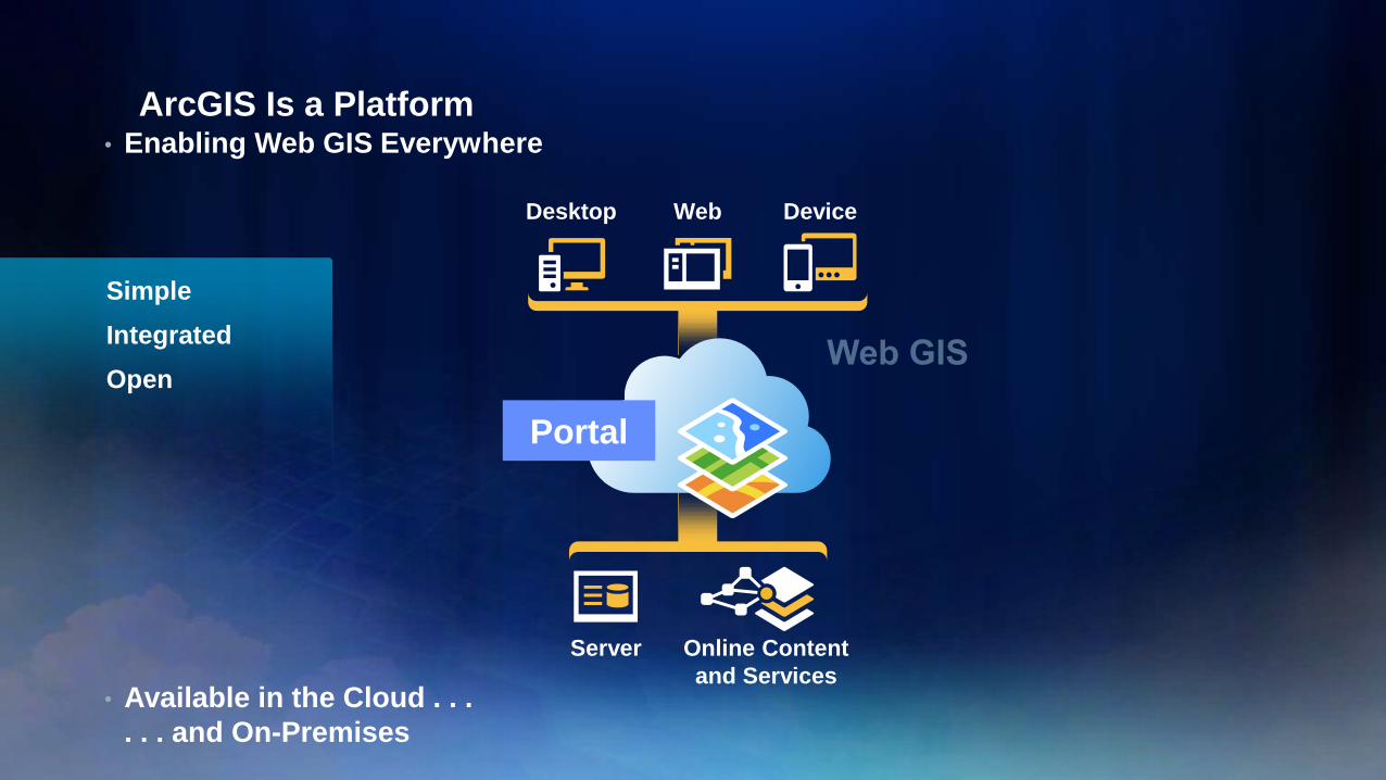
ArcGIS Is a Platform • Enabling Web GIS Everywhere
• Available in the Cloud . . .
. . . and On-Premises
Simple
Integrated
Open
Desktop Web Device
Server Online Content
and Services
Portal
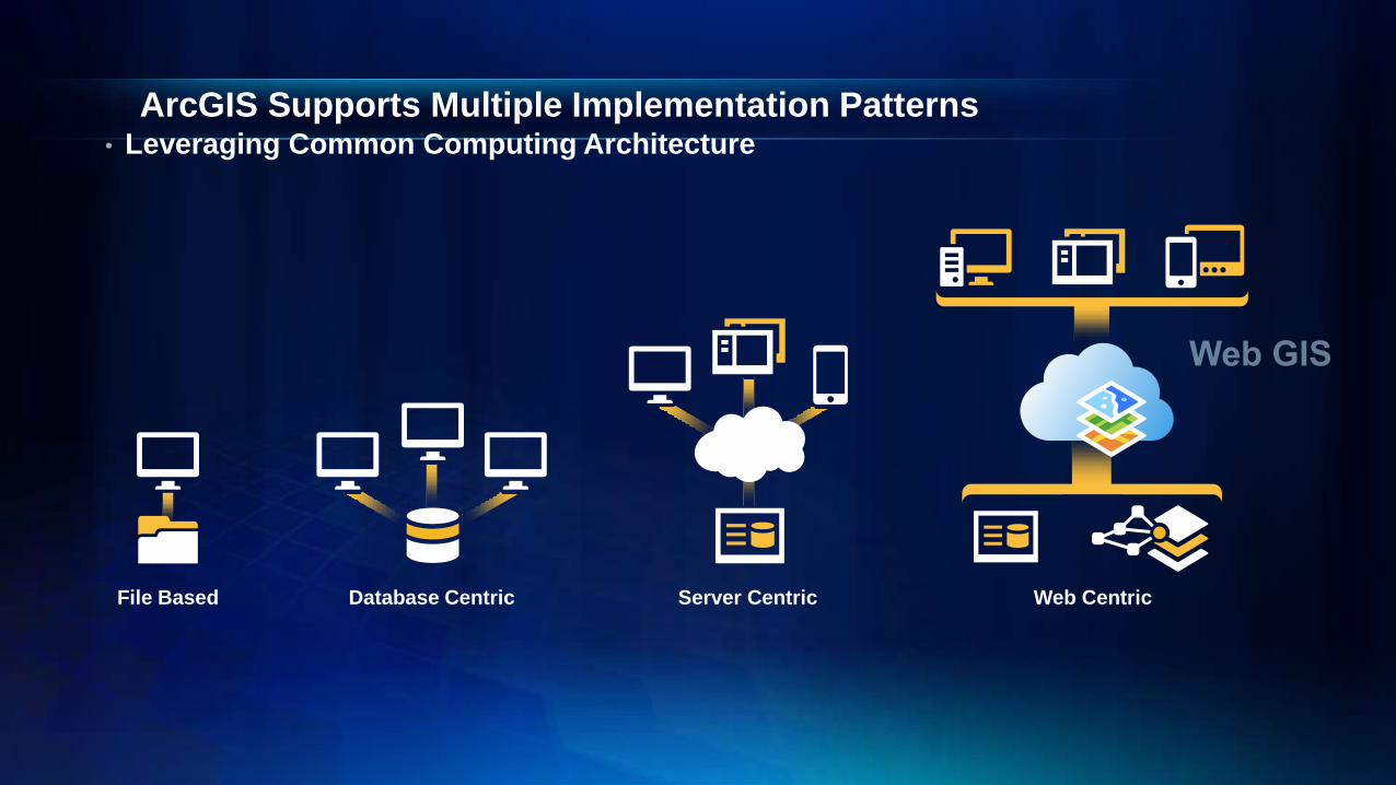
Web Centric
ArcGIS Supports Multiple Implementation Patterns • Leveraging Common Computing Architecture
File Based Server Centric Database Centric

ArcGIS Supports the Enterprise
Transforming the Role of GIS
Making Mapping and GIS
Available across Your Organization Professional
GIS
ArcGIS
Executive
Access
Public
Engagement
Work
Anywhere
Knowledge
Workers
Enterprise
Integration

ArcGIS Provides Content – A Living Atlas
Global
Best Available
Ready to Use
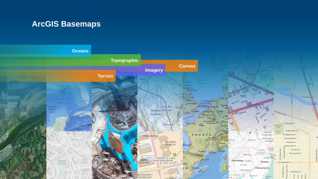
ArcGIS Basemaps
Canvas Imagery
Topographic
Oceans
Terrain
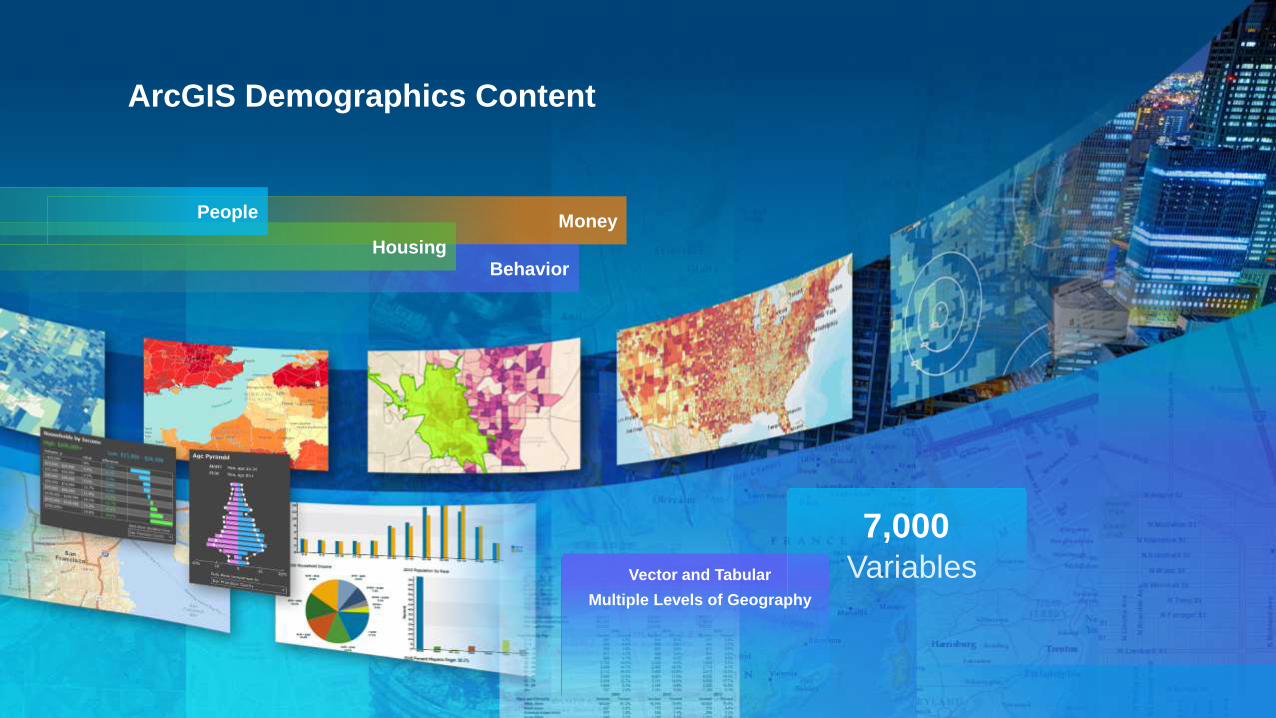
ArcGIS Demographics Content
Money
Behavior Housing
People
Vector and Tabular
Multiple Levels of Geography
7,000 Variables

ArcGIS Landscape Content
Watersheds
Elevation
Slope
Aspect
NHD+
Soils
Landforms
Faults
Wetlands
Evapotranspiration
Physical Geography
Critical Habitat
Ecological Systems
Land Cover
Roads
Rail
Flood Risk
Historic Sites
Transmission Lines
Pipelines
Oil Shale Basins
Coal Bed Methane Basins
Earthquake Risks
Cultural Geography
Bio-Geography
Federal Land
Native Land
Land Management
500+ Variables

Content is Published by Esri and Users
• Built by and for ArcGIS User Community
User Content Esri Content
Community Maps
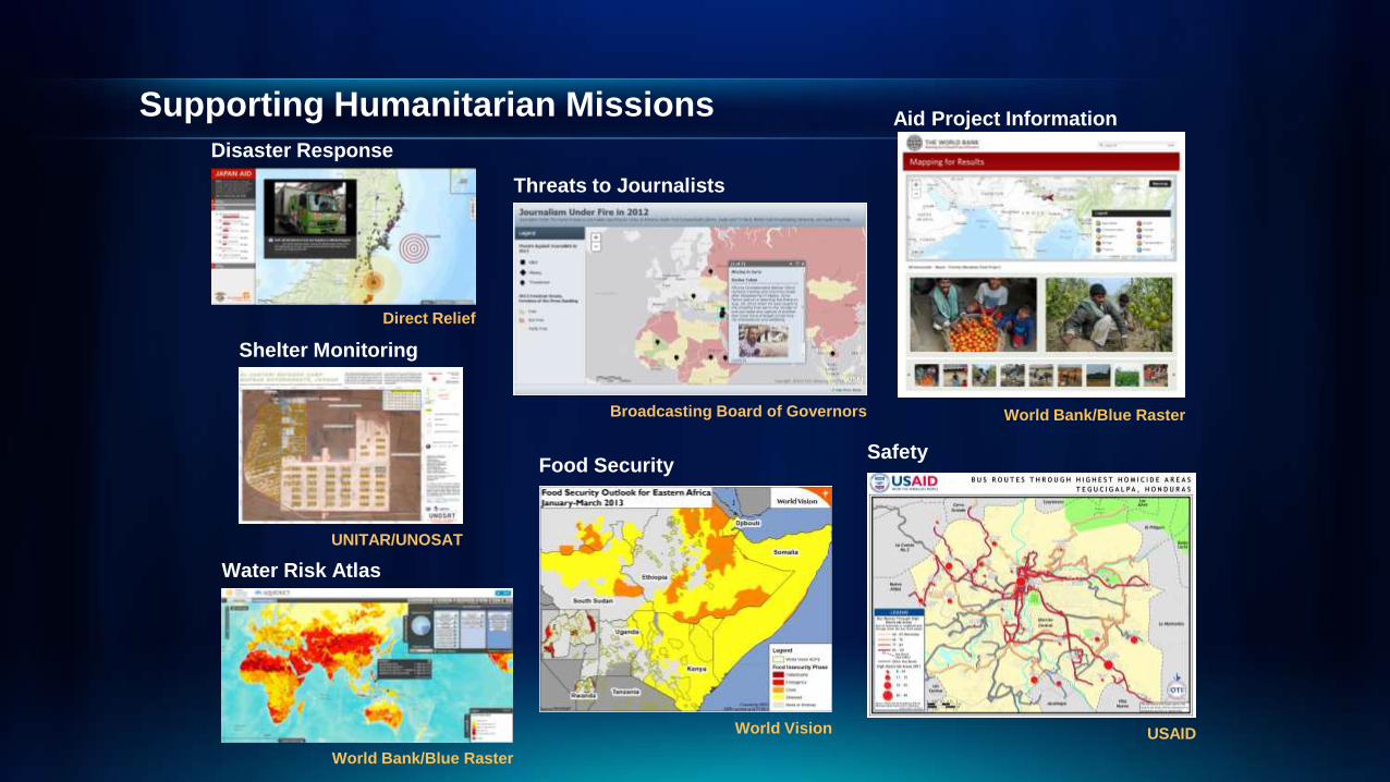
Supporting Humanitarian Missions
Disaster Response
Direct Relief
Food Security
World Vision
UNITAR/UNOSAT
Shelter Monitoring
Aid Project Information
World Bank/Blue Raster
Water Risk Atlas
Broadcasting Board of Governors
Threats to Journalists
World Bank/Blue Raster
USAID
Safety

Philippines
Tracking Disease
Medicare Costs
National and Regional US
MS & UV Exposure
Simon Fraser University
Homeless Population
Washington, DC
Food Security
World Vision East Africa
Swaziland
Malaria
Nutrition Priorities
Ethiopia
Breast Cancer
DNA Guide
Lifesaving Surgery
Direct Relief
Gates Foundation
Polio Eradication
Understanding Human Health

Web-Based Analytics Are Now Part of ArcGIS
• Leverage Cloud Infrastructure
• Enabling New Approaches
Drive-Time Areas
Enrich Layer
Merge Layers

ArcGIS GeoEnables Business Systems
• Providing Mapping, Spatial Analysis, and Reporting
• Supporting Location Analytics Everywhere
Microsoft Office
Esri Maps for . . .
• Office
• IBM Cognos
• SharePoint
• MicroStrategy
• SAP
• Salesforce
• Dynamics
Spreadsheets
Enterprise Systems

Solution Templates
• Provide Apps, Maps, Data Models, and Tools
• Improving Productivity and Leveraging Best Practices
• Free to Users
• Easily Configured
• Fully Supported
• Open Source
Military / Security
Emergency
Management
Utilities
Government

ArcGIS Is a Platform • Enabling Web GIS Everywhere
• Available in the Cloud . . .
. . . and On-Premises
Simple
Integrated
Open
Desktop Web Device
Server Online Content
and Services

Related Documents