Interpretive Guide for Docents “How to Make the Park Come Alive for the Visitor” South Yuba River State Park South Yuba River Park Association P.O. Box 1658 Penn Valley, CA 95946 http://southyubariverstatepark.org South Yuba River State Park 17660 Pleasant Valley Road Penn Valley, CA 95946 January 2015

Welcome message from author
This document is posted to help you gain knowledge. Please leave a comment to let me know what you think about it! Share it to your friends and learn new things together.
Transcript

Interpretive Guide for Docents“How to Make the Park Come Alive for the Visitor”
South Yuba River State Park
South Yuba River Park AssociationP.O. Box 1658Penn Valley, CA 95946
http://southyubariverstatepark.org
South Yuba River State Park17660 Pleasant Valley RoadPenn Valley, CA 95946
January 2015

2
Table of Contents
Introduction to the Park Page
Welcome from the Supervising Ranger 3 Park Description 3 Cooperating Association-SYRPA 3
The Interpretive Guide
Auto Tours 4 Bridge & Barn Stations 6 Beautification 7 Bird Walks 7 Facilities & Maintenance 12 Gas Station & Store 4 Gold Panning 14 Greeter Station 14 Historical Research & Oral History 10 Independence Trail 15 Native Plant Garden & Landscaping 12 Pine Needle Basketry 9 School Tours 10 Fall Festival 11 Trail Patrol 11 Visitor Center 13 Wildflower Walks 8
Bridgeport History 16
Upstream Parcels
Independence Trail 18 Upstream River Crossings 19
Park Map 20, 21

3
INTRODUCTION TO THE PARK
Welcome from Supervising Ranger Dan Youngren
On behalf of California State Parks and the Sierra District / Sierra Gold staff, I would like to thankyou for your interest and support for South Yuba River State Park. Without the combined effortsof our employees, volunteers, and park partners, the beauty and history of our local parks wouldbe lost forever. The mission of California State Parks is to provide for the health, inspiration andeducation of the people of California by helping to preserve the state’s extraordinary biologicaldiversity, protecting its most valued natural and cultural resources, and creating opportunities forhigh-quality outdoor recreation. We accomplish our mission with the help of our non-profit part-ners who provide funding for the interpretive and education programs that our staff and volunteerspresent to the public. Whether it is a Buttermilk Bend wildflower hike, an overnight living historyprogram, or assisting with the design of new interpretive facilities, it is our job to assure that parkvisitors are given opportunities to learn and experience all they can about the park. Through edu-cation, visitors will then not only increase their knowledge, but will hopefully become park support-ers like you.Remember that a few quality minutes spent with a park visitor will foster a lifetime of love andlearning about the world around us. Thank you for choosing the path of supporting your CaliforniaState Parks! Dan Youngren
Park Description
The South Yuba River State Park contains several parcels of land along the South Yuba Riverextending more than 22 miles from Point Defiance on Lake Engelbright toward the town of Wash-ington. The Park was established in 1986 for its scenic, recreational, and historic values. It con-tains the Bridgeport Covered Bridge and Ranch, the Independence Trail, and historic river cross-ings at Highway 49, Hoits Crossing, Purdon Crossing, Edwards Crossing and Illinois Crossing.
Cooperating Association
The South Yuba River Park Association (SYRPA) provides interpretive materials and financialsupport to enhance the public's enjoyment of the Park. SYRPA's vision is to advance the public'senthusiasm for the Park through interpretation, education, and appreciation of the park's historyand culture. All volunteers are encouraged to join SYRPA and help enhance the Park’s future.
THE INTERPRETIVE GUIDE
This Guide summarizes interpretation areas for prospective and new docent volunteers. Thesesummaries help new volunteers evaluate the complete scope of interpretation at the Park, so theycan select one or more for their own. The Interpretative Guide is a two-part document:
Part I provides a description of each docent activity. Each article has been writtenby the activity coordinator to provide a broad look at interpretive, educational andrecreational opportunities in the specific area. The article is meant to help new volun-teers choose an activity they can feel passionate about. We want to capture thatpassion and use it to build long lasting connections with visitors of all ages.
Part II summarizes Park history and helps the new Docent give visitors an under-standing of the unique and interesting cultural history at this State Park.

4
Auto Tours
The Park is an interesting destination for auto club tours. Volunteers arrange the tour date, meetthe group on arrival, and explain the historical connection to yesteryear's transportation over theVirginia Turnpike. The tour usually begins near the Kneebone Cemetery and continues down the
Turnpike to the Gas Station. A docent explainsthe historic buildings and the route of 1860steamsters over the Henness Pass to the Ne-vada silver mines. There are plenty of photo op-portunities for the cars alongside the gas sta-tion, in front of the Barn, or in front of the Cov-
ered Bridge. Each auto club usually is formedaround a particular make. In the past, ownershave brought Model A Fords, Mazda Miatas,Corvettes, Porsches, Bentleys, P.T. Cruisers,Packards and Jeeps.
Gas Station & Store
The South Yuba River Park Association, in close partnership with the State Park, has undertakenrestoration of the Historic 1927 Shell Gas Station as a high priority for historical preservation andvisitor education. The mission of CaliforniaState Parks is to protect our cultural resourcessuch as historic structures, provide visitor edu-cation, and enable high-quality recreation op-portunities.
Restoration of the Historic Shell Gas Stationwas divided into three phases: the accurate re-construction of the original structure and itsexterior; restoration of the Kneebone store; andtransformation of the garage area into an inter-pretive center. Reconstruction of the building,purchase of a 1927 gas pump and signage,and the store restoration have been completed.
The interior of the station and store features 1927-1933 era historic Shell products, automotiveitems, emergency vehicle supplies, and simple store products such as flour, fruits, vegetable,canned goods, cold drinks, candy and basic food. The garage section incorporates a model of theBridgeport Swimming Resort and gas station areas plus other interpretive materials. There will
18¢ Per Gallon!
Auto Tour at the Barn for Photos
Gas Station in the 1930s

5
also be items that gold miners may have required and a variety of products that people would haveneeded while on vacation in the 1920's and 1930's.
This restoration is a critical part of our history at South Yuba River State Park. It brings togetherthe 1927 Gas Station, the 1862 covered bridge and the 1860s barn. Some of the specific projectsplanned or underway are:
Design and install interior displays for an accurate representation of the store andstation
Design, fabricate and install educational displays, murals, photographs and interpretivesigns
Develop interpretive exhibits of transportation throughout the region Develop interactive opportunities and activities for children Provide descriptions of the Shell Gas Station and its role at Bridgeport in 1927 Portray the daily activities of the Kneebone family during the post gold rush period Develop exhibits and materials describing the Bridgeport Swimming Resort
Restored Gas Station on Festival Day

6
Bridge & Barn Tours
In the eyes of the visitor, the standoutattraction--the crown jewel of the en-tire Park site--is the Bridgeport Cov-ered Bridge. Built in 1862 by DavidWood, following flooding the previouswinter that destroyed the 1850 bridgeat this location, this Park icon is thelongest single-span wooden coveredbridge in the country.
Our visitors are fascinated by the ap-pearance, construction, views fromthe porthole windows, survival(barely) during the 1997 flooding, andlongevity of the structure. Docentsexplain the bridge history and its partin the wagon route to California goldmines in the 1850s and to NevadaComstock Lode silver mines in the 1860s. The story can be told in a compelling way to visitors:the trek across the heavy Douglas fir flooring, the surge of the South Yuba River below theimagined shouts of the teamsters as they urge their oft-spooked horse & mule teams across,the heavy timber trusses and the vertical iron rods that reinforce this solid structure, the 27,000hand split sugar pine shakes that make up the side walls and roof, the grip of the leather reinsin your hands, the jangle of the harnesses pulling together, the smell of sweat streaming off thebacks of the team as they make the difficult climb from the heat of the valley below, and theechoes of the sixteen hooves pounding the Bridge planks.
Complementing the Covered Bridge isthe recently restored Historic Barnconstructed about the same time asthe Bridge. Built in the classic Dutchstyle, it served several functions in-cluding animal stalls and pens, haystorage loft, storage of farm equip-ment, and repairs to the wagons.Long unused, this historic structurecame to life in 2006 when the SouthYuba River Park Association beganits barn restoration project. The struc-ture now is an interpretive exhibit areafeaturing the Barn as a transportationcenter. During the day, the screenedoff observation area is open to the public, and for group tours (by reservation) the barn doorsare swung open and Docents describe each of the horse-drawn vehicles as well as the impos-ing hay press. The barn tours are a favorite with school groups, especially when accompaniedby stories of Black Bart and his holdups of local stage coaches!
The Covered Bridge. Photo by Betty Kelly
Festival Day at the Barn

7
Beautification
The Beautification Committee assures that the grounds around theVisitor Center are presentable, so the historic features are themain attraction. Grounds are cleared of brush, rid of as muchblackberry as possible, and free from star thistle (to the extent pos-sible). Once that is accomplished, the grounds begin to sparkleand show their natural beauty. We add our own touches to en-hance the Park's appearance by taking on projects, such as add-ing large flower boxes to the entrance of the VC and working withthe Native Plant Garden docents. We like to see visitors wanderingthrough the Park and the Native Plant Garden, and we like towatch families enjoying a picnic lunch at one of the picnic tablesscattered about the Park. The goal is to keep the look as naturalas possible and the way it may have been 100 or so years ago. Toaccomplish these projects, we ask docents to participate in a workparty about three or four times a year. These work parties last nolonger than an hour and a half, and we do have a good time.
Bird Walks
Birding in the Park can be enjoyed during mostseasons of the year. Experienced docents leadscheduled walks, especially during the springand fall. Visitors have seen 120 different spe-cies of birds at Bridgeport.
Bird interpretation in the wild always beginswith finding a bird, whether flying, perching ornesting. Size and shape are the first obviousindicators in assessing the different species.The song or short calls are a significant particu-lar to consider in the spring or mating season.Different shapes and sizes of bills are a greatdividing category in selecting the different birdfamilies. Bird activities are important features.Is the bird scratching in the dirt and leaves,pecking at a tree, or snatching flies, etc. out ofthe air? Where and how do the birds build or obtain their nest? What do the birds feed on?What is the color of its eyes? Is there an eye line through or above the eye? How long are itstail feathers? Is it a year-long resident or does it only stop by during a migrating season?
Some of the commonly-seen species are Canyon Wren, California Quail, Yellow-breastedChat, four or five different woodpeckers, six or so sparrows, Northern Mockingbird, CedarWaxwing, Phainopepla, King Fisher, American Dippers, Wren-tit, Oak Titmouse, Yellow War-bler, Orange-crowned Warbler, Audubon Warbler, Black-throated Gray Warbler, Cliff and Vio-let-green Swallow, Western Tanager, Black-headed Grosbeak, Bullocks Oriole, Spotted Tow-hee, Red-tailed and Red-shouldered Hawk and Bald Eagle.
New Boxes and Plantingat the Visitor Center
8
Wildflower Walks
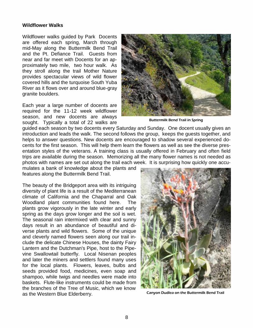
Wildflower walks guided by Park Docentsare offered each spring, March throughmid-May along the Buttermilk Bend Trailand the Pt. Defiance Trail. Guests fromnear and far meet with Docents for an ap-proximately two mile, two hour walk. Asthey stroll along the trail Mother Natureprovides spectacular views of wild flowercovered hills and the turquoise South YubaRiver as it flows over and around blue-graygranite boulders.
Each year a large number of docents arerequired for the 11-12 week wildflowerseason, and new docents are alwayssought. Typically a total of 22 walks areguided each season by two docents every Saturday and Sunday. One docent usually gives anintroduction and leads the walk. The second follows the group, keeps the guests together, andhelps to answer questions. New docents are encouraged to shadow several experienced do-cents for the first season. This will help them learn the flowers as well as see the diverse pres-entation styles of the veterans. A training class is usually offered in February and often fieldtrips are available during the season. Memorizing all the many flower names is not needed asphotos with names are set out along the trail each week. It is surprising how quickly one accu-mulates a bank of knowledge about the plants andfeatures along the Buttermilk Bend Trail.
The beauty of the Bridgeport area with its intriguingdiversity of plant life is a result of the Mediterraneanclimate of California and the Chaparral and OakWoodland plant communities found here. Theplants grow vigorously in the late winter and earlyspring as the days grow longer and the soil is wet.The seasonal rain intermixed with clear and sunnydays result in an abundance of beautiful and di-verse plants and wild flowers. Some of the uniqueand cleverly named flowers seen along our trail in-clude the delicate Chinese Houses, the dainty FairyLantern and the Dutchman's Pipe, host to the Pipe-vine Swallowtail butterfly. Local Nisenan peoplesand later the miners and settlers found many usesfor the local plants. Flowers, leaves, bulbs andseeds provided food, medicines, even soap andshampoo, while twigs and needles were made intobaskets. Flute-like instruments could be made fromthe branches of the Tree of Music, which we knowas the Western Blue Elderberry.
Buttermilk Bend Trail in Spring
Canyon Dudlea on the Buttermilk Bend Trail

9
The South Yuba River canyon is somewhatrugged and would be inaccessible for manypark visitors had it not been for early resi-dent Caleb Cooley. In the summer of 1877he claimed the water rights one and a halfmiles above Bridgeport. There he dug aditch two feet wide and two feet deep onthe north side of the river for irrigation andmining purposes. That gently sloping wa-terway is now the Buttermilk Bend Trail,providing easy access through the fields offlowers.
Numbered markers along the ButtermilkBend Trail identify the trees and shrubs,and a Self-guided Trail brochure is available.
Pine Needle Basketry
The indigenous Nisenan were pine needle basket experts. The Park offers a chance to learnthe art pine needle basket making. Docents have been teaching the art weaving pine needlebaskets for over 15 years. On several Sundays through out the year, classes are held in theVisitor Center.
Docents teach how and where to collect thepine needles, how to think through the de-sign, and finally the enjoyment of the fin-ished product. Docents provide the materi-als, including pine needles, string and in-struction. By the end of the class a small,woven basket is completed. Each of the stu-dents feel “it's an art that I'd like to share.”The class is about 3 hours long, on sched-uled days, and pre-registration is necessary.Several baskets are on display in the VisitorCenter. Many visitors comment “these arereally special; they would make great Christ-mas gifts, especially if I can make them my-self”.
Pipevine Swallowtail Butterfly
Basket Weaving Demonstration

10
Historic Research & Oral History
The South Yuba River State Parkowes its existence to the history ofthe people and events that playedsuch a prominent part in the eras be-fore, during and after the Gold Rush.Many docents are drawn to the Parkbecause of an interest in history. Vol-unteers are helping research and re-cord historical facts to fill in and elimi-nate the gaps in our current knowl-edge. There are still some fundamental gaps in our understanding of early times, especially atBridgeport immediately after the discovery of gold in California. Whenever possible we conductoral histories with individuals who have knowledge of local history and record them with audio-visual techniques. The information gained is used to update the current history and trainingmanuals. The latest history information is provided to docents, so they can accurately informvisitors and conduct school and public group tours. Finally, the History Research Committeeprovides information to living history participants and for Park restoration projects.
School Tours
The Park is a wonderful destination for students of California History. Park history and its con-nection to the gold rush and regional transportation are highlighted. Docents have fun and sat-isfaction sharing the wonders of nature, wildflowers, gold panning, early-day transportation andBridgeport history with groups of enthusiastic students from our Elementary Schools.
Several student groups visit each year with their teachers and parents. All tours are in themorning, usually start at 9:00 or 10:00 and end around noon. This is an opportunity to see firsthand what kind of job our schools are doing and to contribute to their teaching programs.
Docent Don Denton and a School Group at the Bridge

11
Fall Festival
South Yuba River State Park has an Annual FallFestival that involves nearly all Docents and Staffand which hosts about 600 visitors.
The Fall Festival at Bridgeport in late October fea-tures living history by trained docents. The“Friendly” Ghosts return to Bridgeport, as the Fes-tival is held close to Halloween. The Ghosts(representing former residents) come alive in thehistoric 1860s Barn, with each Ghost telling a por-tion of its life on the South Yuba River.
The Penn Valley Chamber of Commerce serveshot dogs, sodas, chili and baked potatoes, andother vendors provide cakes, pies, brownies andcookies and ice cream. Members of the SYRPABoard sell coffee and cider.
Usually the activities include face painting, pump-kin painting, pioneer games for kids, a worm gar-den, a craft table, wagon rides, gold panning, toursof the historic Shell Gas Station, Barn Tours andBlacksmithing. Local authors may be there to signbooks. All this takes place while music fills the air, provided by local bands and singers.
Trail Patrol
Trail Rovers patrol the many trails at Bridgeportand Hwy 49 providing answers and direction topark visitors, reporting unsafe or malicious activityand generally being ambassadors for the park.While roving around the park we also pick up trashand report downed trees or visitor emergencies topark rangers. Rovers carry a radio for direct contactwith park rangers and carry a small hiking pack foressentials such as water. Roving activities arescheduled from Memorial Day through Labor Dayand usually last from two to four hours.
Fall Festival at the Bridge
12
Facilities & Maintenance
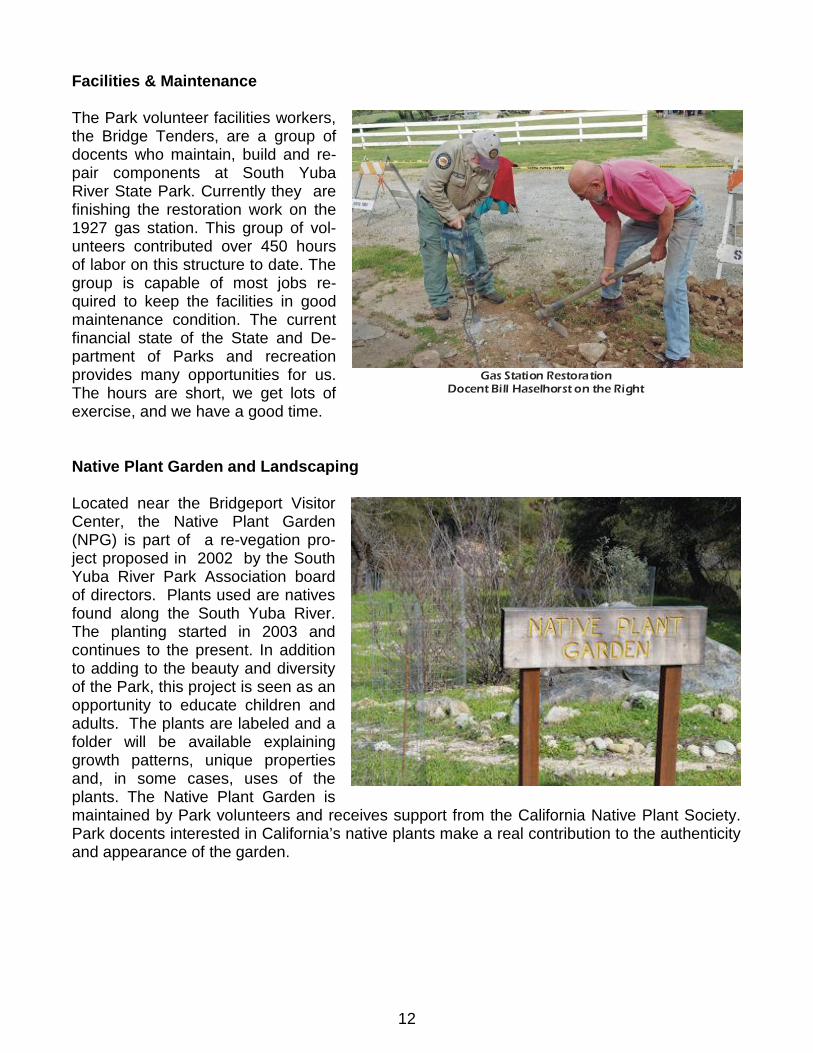
The Park volunteer facilities workers,the Bridge Tenders, are a group ofdocents who maintain, build and re-pair components at South YubaRiver State Park. Currently they arefinishing the restoration work on the1927 gas station. This group of vol-unteers contributed over 450 hoursof labor on this structure to date. Thegroup is capable of most jobs re-quired to keep the facilities in goodmaintenance condition. The currentfinancial state of the State and De-partment of Parks and recreationprovides many opportunities for us.The hours are short, we get lots ofexercise, and we have a good time.
Native Plant Garden and Landscaping
Located near the Bridgeport VisitorCenter, the Native Plant Garden(NPG) is part of a re-vegation pro-ject proposed in 2002 by the SouthYuba River Park Association boardof directors. Plants used are nativesfound along the South Yuba River.The planting started in 2003 andcontinues to the present. In additionto adding to the beauty and diversityof the Park, this project is seen as anopportunity to educate children andadults. The plants are labeled and afolder will be available explaininggrowth patterns, unique propertiesand, in some cases, uses of theplants. The Native Plant Garden ismaintained by Park volunteers and receives support from the California Native Plant Society.Park docents interested in California’s native plants make a real contribution to the authenticityand appearance of the garden.
Gas Station RestorationDocent Bill Haselhorst on the Right

13
Visitor Center
The Bridgeport Visitor Center at theSouth Yuba River State Park in manyways represents what goes on in theentire Park. Docents have the opportu-nity to interact with visitors as tourguides, historians, naturalists, educatorsand as a sales person for the itemsavailable to be purchased.
The Park sales center offers visitors theopportunity to take a memento or bookhome with them. The sales items havebeen selected because they are signifi-cant to the Park. Educational books,note cards, t-shirts, and much more cangive visitors something that is personalto them and their visit to Bridgeport.
Docents guide visitors to explore the Park, learn about history, treasure the fragile ego systemthat the State Park protects, and to enjoy their time at the River. Working in the Visitor Centeris fun. Meeting and talking with interesting park visitors is what the Park gives back to the Do-cents. Whether it is recommending a trail, picnic site or swimming area or giving a child a newlook at wildlife, it is always rewarding to help the visitors and to represent the Park.
The displays and artifacts from Bridgeport's indigenous inhabitants, the Nisenan Indians, tellthe story of how native plants and animals were part of life along the Yuba River. As visitorsview the original headdress of red-shafted flicker feathers, musical instruments made from el-derberry branches and brushes fashioned from soap plant roots, they can feel and understandthe Native American's life along the River.
The Visitor Center has a display of thePark's natural history. Majestic raptors,secretive ringtail cats, red foxes, agolden eagle, snake skins and bird nestsare just a portion of the wildlife repre-sented. There are cones, seeds and nutsthat grow on the trees and shrubs withinthe Park. All of this gives visitors, espe-cially children, a close look at life that isever present at Bridgeport.
Artifacts, photographs, murals, newspa-per accounts and personal histories areavailable for Docents to provide eachvisitor with true stories of the Park’s for-mer residents.
Festival Day in the Visitor Center
14
Gold Panning
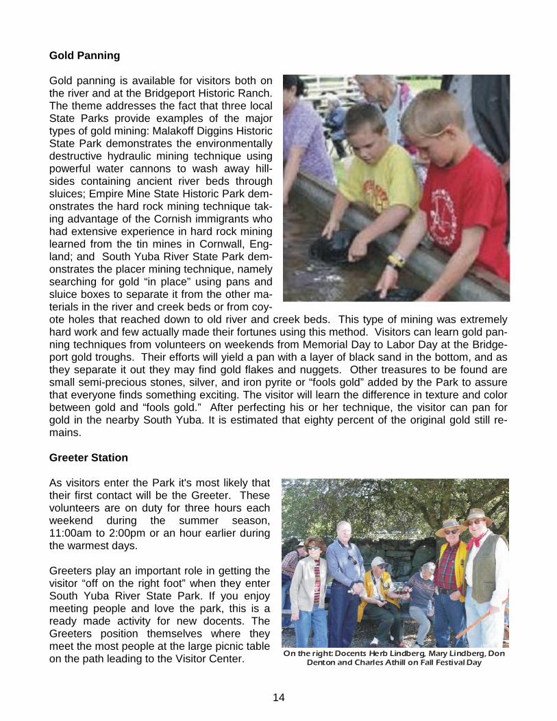
Gold panning is available for visitors both onthe river and at the Bridgeport Historic Ranch.The theme addresses the fact that three localState Parks provide examples of the majortypes of gold mining: Malakoff Diggins HistoricState Park demonstrates the environmentallydestructive hydraulic mining technique usingpowerful water cannons to wash away hill-sides containing ancient river beds throughsluices; Empire Mine State Historic Park dem-onstrates the hard rock mining technique tak-ing advantage of the Cornish immigrants whohad extensive experience in hard rock mininglearned from the tin mines in Cornwall, Eng-land; and South Yuba River State Park dem-onstrates the placer mining technique, namelysearching for gold “in place” using pans andsluice boxes to separate it from the other ma-terials in the river and creek beds or from coy-ote holes that reached down to old river and creek beds. This type of mining was extremelyhard work and few actually made their fortunes using this method. Visitors can learn gold pan-ning techniques from volunteers on weekends from Memorial Day to Labor Day at the Bridge-port gold troughs. Their efforts will yield a pan with a layer of black sand in the bottom, and asthey separate it out they may find gold flakes and nuggets. Other treasures to be found aresmall semi-precious stones, silver, and iron pyrite or “fools gold” added by the Park to assurethat everyone finds something exciting. The visitor will learn the difference in texture and colorbetween gold and “fools gold.” After perfecting his or her technique, the visitor can pan forgold in the nearby South Yuba. It is estimated that eighty percent of the original gold still re-mains.
Greeter Station
As visitors enter the Park it's most likely thattheir first contact will be the Greeter. Thesevolunteers are on duty for three hours eachweekend during the summer season,11:00am to 2:00pm or an hour earlier duringthe warmest days.
Greeters play an important role in getting thevisitor “off on the right foot” when they enterSouth Yuba River State Park. If you enjoymeeting people and love the park, this is aready made activity for new docents. TheGreeters position themselves where theymeet the most people at the large picnic tableon the path leading to the Visitor Center. On the right: Docents Herb Lindberg, Mary Lindberg, Don
Denton and Charles Athill on Fall Festival Day

15
Greeters have on display park brochures, maps, pamphlets, photos, activities, and new thingsto learn: Gold Panning, Nature Walks, Bridge and Barn tours and Park history. Visitors are en-couraged to see the Bridge, Barn, Gas Station and the exhibits and sales center in the VisitorCenter.
Independence Trail
The Independence Trail provides a place where visi-tors, especially those who are disabled, may enjoy thescenic beauty and the natural plants and wildlife of theSouth Yuba River Canyon. The origin of the Trail is anold, abandoned miners' ditch, previously known as theExcelsior Canal, which was used to transport water forhydraulic mining in the mid-1800s. In 1969, John Olm-sted, a docent at the Oakland Museum, discovered therock-lined ditches, adjacent paths for ditch tenders,and wooden bridges (flumes) providing access overravines. He had the vision to recognize that this un-usual path could be the answer to a friend's lifelongdream: “Find me a level wilderness trail where I canreach out and touch the wildflowers from my wheel-chair.” After many tireless years and with help fromgenerous donors and numerous hard-working volun-teers, the country's first wheelchair-accessible wilder-ness trail was created
Docents interpret the Trail in many ways: forest habi-tats, wildflower identification, stream ecology, naturecycles, and Native American uses of plants and ani-mals. Interpretive techniques include stories, games,and songs geared to the ages and abilities of the par-ticipants. Key goals and objectives are to enhance appreciation for the flora and fauna of theSouth Yuba River Canyon, to encourage a perception of people as “a part of” rather than“apart from” the environment, and to emphasize the importance of protection for all natural andhistoric features.
The main entrance to the two trailheads is located 6 miles north of Nevada City on Highway49, shortly before the South Yuba River Bridge. The West Trail has an overlook of the YubaRiver built on a roofed platform. Further on is a multi-tiered waterfall, with a switchback rampleading down to the swirling waters of Rush Creek where California Newts proliferate in thespring. The East Trail features many cliff-hanging flumes, a huge rock tunnel, and more viewsof the river and foothill landscapes.
Rush Creek Ramp

16
BRIDGEPORT HISTORY
The Native People of the Bridgeport Region
Ancient Cultures. From about 2000BC to about 500AD, the Bridgeport area was inhabited bythe Martis people. These nomadic residents hunted big game in groups using the atlatl (spearthrower). They gathered various kinds of seeds and used grinding stones to process them.They lived wherever food and game were most plentiful.
Southern Maidu. About 500AD, the Southern Maidu came to the Northern Sierra Nevada.These people were also known as the “Hill Nisenan” or “Nisenan”. They were hunter-gatherers, and the land provided them with plentiful running water, game and plant foods, andbasic materials needed to fabricate homes, tools and finely crafted baskets. They brought withthem a technology for leaching tannic acid from acorns. Acorns were easily stored for long pe-riods of time and were abundant. All these resources gave the Nisenan the capability to settlein one place and establish villages. Their presence is evidenced today by mortar holes inrocks used to grind acorns and in midden mounds, the organic residue from long periods offood preparation. The acorns were shelled, ground in the bedrock mortars, and leached to re-move bitter acids. Mortar holes can be seen near the Bridgeport Visitor Center and Barn.
Village Life. Villages consisted of a central sweat lodge, or dance house (where the chieflived), and five to ten family dwellings. Several villages made up a 'triblet'. Tribal boundarieswere marked, sometimes with petroglyphs and may have been patrolled. In the spring andsummer, the members of the village would move to higher elevations to collect ripening plantsand to follow the migration of game. In the fall, they would return to the village to harvest theacorn crop. Winter was the social season and the beginning of the ceremonial cycle. Groupsspent long winter nights in the dance houses listening to stories. People from other villageswere invited to visit and join in. It was a time for dancing and looking for mates. In the Bridge-port area, Nisenan villages were located on the west side of the Yuba River near and aboveRice's Crossing, on Deer Creek near Lake Wildwood and at Bridgeport. Other villages were atMooney Flat and Indian Springs. Nisenan descendants are still present in the area.
Basket Making. The Nisenan, like the rest of the Maidu People, were expert basket makers.There is no evidence that they made or used pottery, but their baskets were so tightly woventhat they could hold water. They cooked their acorn gruel by placing hot rocks in the basketwith the mix. Baskets were used for cooking, for serving, for gathering and for storing. Somebaskets were woven for special purposes such as for use in netting fish and for men to wearas hats. The baskets were made from a variety of materials, the most basic being peeled wil-low and peeled or unpeeled redbud. Though these functional baskets were simple in the two-color design, they were as beautiful as any in California and were finely crafted.
Trading. Because of the steepness of the river canyons, most of the trading was done with thepeople to the west. The Nisenan traded out black oak acorns and sugar pine nuts. Theytraded for shell beads, salt, feathers and obsidian. The Nisenan did some trading with the Pai-ute and the Washoe to the east, primarily for wild tobacco.
The Effect of the Gold Rush. In June 1848 gold was discovered on the Yuba River near Rose'sBar downstream from Bridgeport. By 1850 the area swarmed with more than 2000 miners.European contact brought a halt to the well-established Nisenan way of life. With the discov-

17
ery of gold came devastating diseases and loss of the native people's traditional resources.Settlers seeking land for grazing and lumber for construction simply took over the available re-sources. In the process they polluted the river with mining debris and cut down many trees in-cluding the oaks that provided food and shelter materials for the Nisenan.
The Early Settlers at Bridgeport
With gold rush activity on both sides of the Yuba River, safe crossings were vital. Ferriescame first, made by overturning wagons and connecting them to form barges or by refittingwagons to travel across water. It is believed the name “Bridgeport” came from a ford locatednear the present site of the covered wooden bridge.
Early in 1849, brothers Urias and Emanuel Nye established a ferry across the main Yuba River(near present-day Pt. Defiance) and set up a trading post at Nye's Landing (present-dayBridgeport). They sold out in 1851, possibly to David Wood who arrived that year and pur-chased two bridges. William Thompson, a sea Captain, began ranching in 1849 at Bridgeportafter his crew deserted ship to pursue California gold. Thompson is buried in the cemeterynear Kentucky Creek later used by the Cole and Kneebone families. In the early 1850sMathew Sparks built the original bridge across the South Yuba River at Bridgeport. In 1855David Wood bought the Sparks Bridge from Thomas P. Hess.
David Wood also purchased a lumber mill at Forest City and established a store at nearbyFrench Corral. The original South Yuba bridges washed out on January 4, 1862. The presentcovered bridge was built later in 1862 using lumber and shakes from Wood's Forest City mill.The bridge is of a unique construction, consisting of a Howe truss, patented in 1840, and aBurr arch believed to be modeled after a Burr-truss design, invented in 1806 and the basis ofmany bridges built in Chester County, Pennsylvania around 1850. Wood covered the bridgewith sugar pine shakes to protect the wood frame from the weather.
The Virginia Turnpike and Henness Pass Road
In 1853 the State authorized Counties to license toll turnpikes. In 1856, Wood and othersformed the Virginia Turnpike Company to serve miners traveling up country from San Fran-cisco and the central valley to California gold mines and to Nevada silver mines following dis-covery of the Comstock Lode in 1859. The Virginia Turnpike ran from the Anthony House onDeer Creek (now under Lake Wildwood) to North San Juan and was fourteen miles long. In the1860s upwards of 100 wagons a day passed over the Turnpike on their way to and from theNevada mines. Many of the teams consisted of two or three heavy freight wagons pulled bysixteen horses and mules. The Turnpike connected to the Henness Pass Road at North SanJuan establishing a route over the Sierra and into Nevada. Completion of the TranscontinentalRailroad to Reno in 1868 doomed the toll road, as freight from the Bay Area could be deliveredby train to Nevada. The Turnpike continued in operation until 1901, when it was declared afree County road. Automobile traffic continued over the bridge until 1972.
In 1866, David Wood lost the Turnpike and the bridge in a sheriff's sale. With completion ofthe railroad , the importance of the Virginia Turnpike was diminished, and it was used primarilyfor support of local commerce and mines. In 1873, control and ownership of the Virginia Turn-pike and Bridge transferred to Samuel Wood, David Wood's son. In January 1900, SamuelWood renewed his license to charge tolls, however the turnpike and bridge were taken over by

18
Nevada County in 1901 and declared a free and public highway. Today, 0.37 miles of the origi-nal turnpike still exist in the Park including the stone walls constructed to confine travelers tothe roadway.
The Bridgeport Ranch
Ranching began at Bridgeport with arrival of Charles Cole. He married Capt. Thompson'swidow, Mary Ann, in 1854. In 1862, Cole built Bridgeport House, and operated it as his resi-dence and a hostelry for the mining men, teamsters and travelers using the Turnpike. Bridge-port House included nineteen rooms and was widely known and popular. The hotel operatedsuccessfully until August 1919 when it burned to the ground. It is thought that Cole built the bigred barn. The barn is lined up with the bridge so that teamsters approaching or exiting thebridge could drive directly into the barn, obtain services, feed livestock, or make repairs towagons or equipment. The barn features a unique Jackson hayfork to lift hay from ground levelto the loft opening and then on a rail into the loft. Following the Coles, the ranch was owned bythe Kneebone family who rebuilt a house on the 1862 foundation following the 1919 fire. An-drew Kneebone had married Charles Cole's daughter Victoria Cole in 1868. Andrew was anexpert and widely known teamster and was famous for his ability to intricately maneuver largeteams with multiple wagons in tight quarters using the “jerk line” method. From 1927 to 1935,Andrew's son, Alfred, ranched and operated the Bridgeport Pleasure Resort. The Resort in-cluded the Shell gas station and store plus a swimming hole, picnic area, dance hall, changingrooms, soft drink sales, and cabins upstream from the Ranch (now Kneebone Beach). Re-mains of the soft drink cold storage can be seen near Kneebone Beach. The South Yuba RiverPark Association is leading a project to restore the gas station to its 1927 appearance. TheResort closed about 1932 when illegal upstream hydraulic mining tailings fouled the swim hole.The store continued in operation through 1943.
Following the Kneebones, the Ranch was owned by Charles White, Evan Harrison, MelvinMaish, Jack Cowan, Robert Spitzer, Bridgeport Ponderosa (Spitzer, Murray, and Mastin) andSequoya Challenge. Harrison demolished the Kneebone 1920 house in 1956 and built theranch house nearby that became today's Visitor Center.
After the 1971 restoration of the covered bridge, Sequoya Challenge developed a cooperativemanagement agreement with Nevada County to protect the bridge. Between 1979 and 1984the Department of Parks and Recreation (DPR) and Sequoya Challenge made land acquisi-tions along the South Yuba River and the Excelsior Mining Ditch. In December 1984, DPR ac-quired the Sequoya Challenge property, creating the South Yuba Project and, later, SouthYuba River State Park.
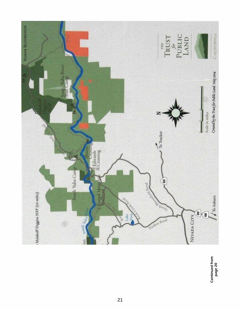
UPSTREAM PARCELS
Independence Trail
The purpose of the Independence Trail is to provide a place where visitors, especially thosewho are disabled, may enjoy the scenic beauty and the natural plants and wildlife of the SouthYuba River Canyon. The origin of the Trail is an old, abandoned miners' ditch, previouslyknown as the Excelsior Canal, which was used to transport water for hydraulic mining in themid-1800s. The Canal delivered South Yuba water to Smartsville, 25 miles away, for hydraulic

19
mining. In 1969, John Olmsted, a docent at the Oakland Museum, discovered the rock-linedditches, adjacent paths for ditch tenders, and wooden bridges (flumes) providing access overravines. He had the vision to recognize that this unusual path could be the answer to a friend'slifelong dream: “Find me a level wilderness trail where I can reach out and touch the wildflow-ers from my wheelchair.” After many tireless years and with help from generous donors andnumerous hard-working volunteers, the country's first wheelchair accessible wilderness trailwas created.
The Independence Trail is a truly unique slice of foothill ecology where individuals, schools,and other groups are invited to experience its natural and historic qualities firsthand. Popularthemes for guided walks include: forest habitats, wildflower identification, stream ecology, na-ture cycles, and Native American uses of plants and animals. Interpretive activities may consistof stories, games, and songs geared to the ages and abilities of the participants. Key goalsand objectives are to enhance appreciation for the flora and fauna of the South Yuba RiverCanyon, to encourage a perception of people as “a part of” rather than “apart from” the envi-ronment, and to emphasize the importance of protection for all natural and historic features.
The main entrance to the Trail is located 6 miles north of Nevada City on Highway 49, shortlybefore the South Yuba River Bridge. There are two directions to choose from, both filled withspectacular views. Less than ½ mile from the entrance, the West Trail has an overlook of theYuba River built on a roofed platform. Further on is a multi-tiered waterfall, with a switchbackramp leading down to the swirling waters of Rush Creek where California Newts can be seenproliferating in the Spring. The East Trail features many cliff-hanging flumes, a huge rock tun-nel, and more views of the river and foothill landscapes. The configuration of the Trail remainsunchanged from its original route and does not follow a circular pattern. Whichever directionone decides to take, they must retrace their steps for the return trip.
The following is an example of how this very special place can make a difference in so manypeople's lives, as written by Sandra for Dave:
“A hike in the woods. This singular joy has eluded my darling for thirteen years. Alarge battery claims credit for propelling him along in his chair. But we know whatreally moves him, what carries us to rushing waters and gliding newts: the hungerto be here, in this river canyon. And the hearts that saw to remove all barriers asshadows lengthen and the wind picks up we leave, satiated by the IndependenceTrail, a profound miracle.”
Upstream River Crossings
Ferries and bridges across the South Yuba River were established in the 1850s at Jones' Bar(Rush Creek Ferry), Hoit's Crossing, Purdon Crossing (Lower Robinson), Cooper's Crossing(Illinois Bar), and Edward's Crossing (Upper Robinson). The concrete arch bridge at Highway49 Crossing was built in 1921 and replaced by the modern bridge just upstream. These sitesform the upstream elements of South Yuba River State Park.

20
Co
nti
nu
ed o
np
age
21
21
Co
nti
nu
ed f
rom
pag
e 2
0
Related Documents