INTERNATIONAL HYDROGRAPHIC ORGANIZATION ENC VALIDATION CHECKS Publication S-58 Edition 5.0.0, June 2014 Published by the International Hydrographic Bureau MONACO

Welcome message from author
This document is posted to help you gain knowledge. Please leave a comment to let me know what you think about it! Share it to your friends and learn new things together.
Transcript

INTERNATIONAL HYDROGRAPHIC ORGANIZATION
ENC VALIDATION CHECKS
Publication S-58
Edition 5.0.0, June 2014
Published by the International Hydrographic Bureau
MONACO

© Copyright International Hydrographic Organization 2014
This work is copyright. Apart from any use permitted in accordance with the Berne Convention for the Protection of Literary and Artistic Works (1886), and except in the circumstances described below, no part may be translated, reproduced by any process, adapted, communicated or commercially exploited without prior written permission from the International Hydrographic Bureau (IHB). Copyright in some of the material in this publication may be owned by another party and permission for the translation and/or reproduction of that material must be obtained from the owner.
This document or partial material from this document may be translated, reproduced or distributed for general information, on no more than a cost recovery basis. Copies may not be sold or distributed for profit or gain without prior written agreement of the IHB and any other copyright holders.
In the event that this document or partial material from this document is reproduced, translated or distributed under the terms described above, the following statements are to be included:
“Material from IHO publication [reference to extract: Title, Edition] is reproduced with the permission of the International Hydrographic Bureau (IHB) (Permission No ……./…) acting for the International Hydrographic Organization (IHO), which does not accept responsibility for the correctness of the material as reproduced: in case of doubt, the IHO’s authentic text shall prevail. The incorporation of material sourced from IHO shall not be construed as constituting an endorsement by IHO of this product.”
“This [document/publication] is a translation of IHO [document/publication] [name]. The IHO has not checked this translation and therefore takes no responsibility for its accuracy. In case of doubt the source version of [name] in [language] should be consulted.”
The IHO Logo or other identifiers shall not be used in any derived product without prior written permission from the IHB.
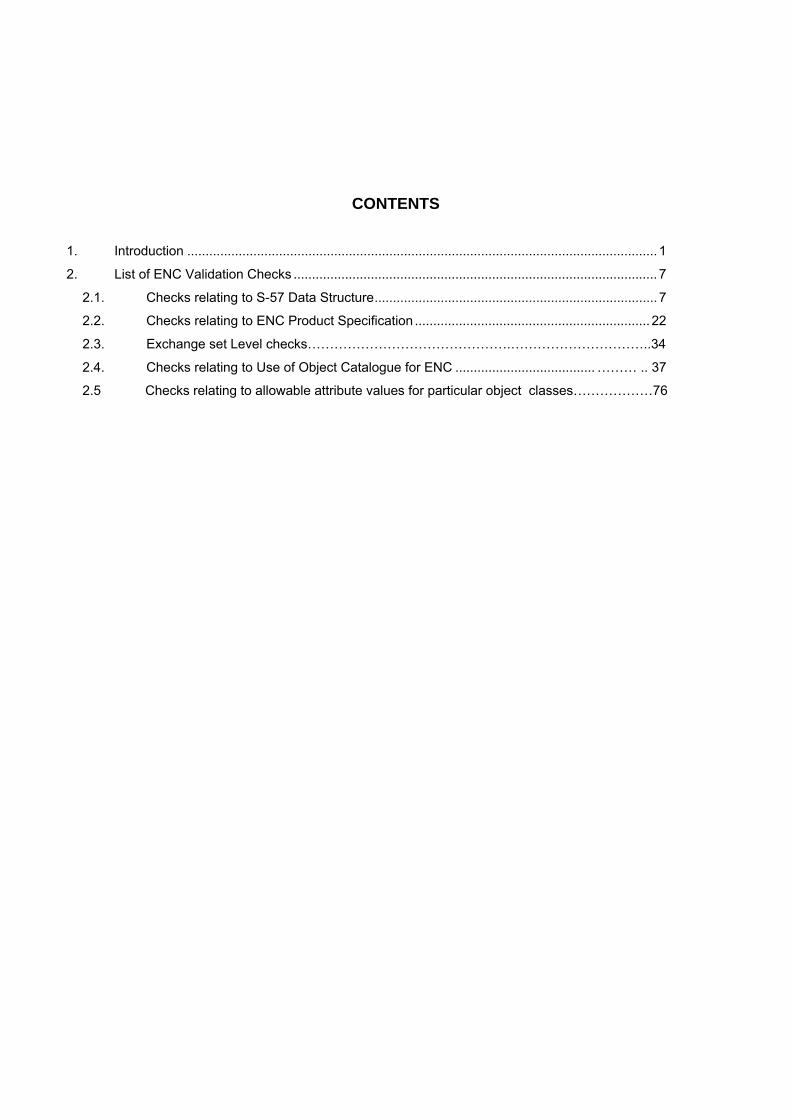
CONTENTS
1. Introduction ................................................................................................................................ 1
2. List of ENC Validation Checks ................................................................................................... 7
2.1. Checks relating to S-57 Data Structure ............................................................................. 7
2.2. Checks relating to ENC Product Specification ................................................................ 22
2.3. Exchange set Level checks……………………………………….…………………………..34
2.4. Checks relating to Use of Object Catalogue for ENC ...................................... ……… .. 37
2.5 Checks relating to allowable attribute values for particular object classes………………76

ii
S-58 (Ed. 5.0.0) June 2014
Page intentionally left blank

1
S-58 (Ed. 5.0.0) June 2014
1. INTRODUCTION This document was previously Appendix B1, Annex C of S-57 Edition 3.1. It specifies the checks that at a minimum, producers of ENC validation tools should include in their validation software. This software must be used by hydrographic offices to help ensure that their ENC data are compliant with the S-57, Appendix B1 ENC Product Specification. The checklist has been compiled for the IHO from lists of checks provided by a number of Hydrographic offices and software companies. The document will be maintained by means of new editions. In order to assist software developers, those checks that have been removed from all previous editions of S-58 have been retained in Edition 5.0.0 as struck out text strings. The document provides checks for individual ENC cells however additional checks applicable to ENC Exchange Sets are included in part 2.3. 1.1 Document Layout The validation checks are laid out as follows; Columns are as follows 1. Check number (in order to retain the existing numbering system checks restructured in S-58 edition 5.0.0 have been given suffixes a,b,c etc) 2. Check description written in a defined syntax (wherever feasible) syntax defined in this document (1.3). 3. Check message to provide user with meaningful information. 4. Check solution, suggested action to rectify a warning or error. 5. Conformity to, reference to relevant location within the UOC or PS 6. Check classification - Critical Error (C), Error (E), Warning (W) (see 1.2) 1.2 Check Classification The check classification is intended to ensure errors which would affect the use of the ENC in ECDIS are not included in published ENC data. In some cases it has been necessary to diverge from the strength of wording used in the S-57 ENC Product Specification or Use of the Object Catalogue for ENC. In such cases the user impact has been the overriding factor for consideration. The classifications have the following meanings; C Critical Error An error which would make an ENC unusable in ECDIS through
not loading or causing an ECDIS to crash or presenting data upon which is unsafe for navigation.
E Error An error which may degrade the quality of the ENC through appearance or usability but which will not pose a significant danger when used to support navigation.
W Warning An error which may be duplication or and inconsistency which will not noticeably degrade the usability of an ENC in ECDIS.
At a minimum validation software must group validation reports using these categories. They may also support sub-grouping of related checks such as those relating to geometric validity or attribute consistency. Software may allow checks of type error or warning to be deselected completely or by such categories.

2
S-58 (Ed. 5.0.0) June 2014
1.3 Minimum Check Standard S-57 Supplement 3 specifies that ENC data must meet the minimum validation requirements defined in this standard. At the time of publication of S-58 5.0.0 no checks are mandatory. The intention is that Critical Errors will become mandatory once software conforming to S-58 5.0.0 is available and in use by ENC producers. The IHO will issue circular letters to identify when producers are able to meet the minimum check standard for new and updated ENC data. At that time a new version of S-58 will be published to specify that ENC data must not contain any Critical Errors. In order to support this transition a test dataset will be developed and a means to certify validation tools as reflecting the standard will be developed. 1.4 Guidelines on the check syntax In order to ensure that checks can be interpreted clearly and consistently a defined syntax has been used for the reworded checks wherever possible. Each check is a statement which generates a warning/error if the expression returns ‘true’. In the below example the reworded check (in blue text) would return true and give an error for each BERTHS object which carries the attribute VERDAT; No Check description Check Message Check solution Conformity to: Cat 1571 Check that no BERTHS object
contains the attribute VERDAT. 4.6.2 E
1571 For each BERTHS object where VERDAT is present.
BERTHS object includes VERDAT.
Remove values of VERACC or VERDAT.
4.6.2 E
The elements of the syntax are defined as follows; 1.4.1 Comparison and Logical Operators The following comparison and logical operators are used; Equal Not equal Less than Less than or equal to Greater than Greater than or equal to AND OR (inclusive OR) 1.4.2 Spatial Operators Within this document operators based on those laid out in the ISO standard 19125-1 are used to describe spatial relationships tested within the checks. They are described in annex A of this document. For all spatial operators a default tolerance of 0.125mm at compilation scale should be applied in validation software.

3
S-58 (Ed. 5.0.0) June 2014
1.4.3 Values The following terms are used for types of values;
Present – An attribute is present either with or without a value. Null – An attribute has a value of null (255) notNull – The attribute has been populated with a value.
1.4.4 Statements The checks must be structured using the following statements;
If – A conditional statement which determines whether a further statement should be executed. For – repeat a statement until a statement is met (evaluates to “true”). For the purposes of the checks
the statement being met generates the error or warning specified. Switch – test against a variable if this does not match move on to the next test
Examples No Check description Check Message Check solution Conformity to: Cat
1571 Check that no BERTHS object contains the attribute VERDAT.
4.6.2 E
1571 For each BERTHS object where VERDAT is present.
BERTHS object includes VERDAT.
Remove values of VERACC or VERDAT.
4.6.2 E
Annex A (In the diagrams within this annex LineString corresponds to the S-57 Line geometric primitive) EQUALS – geometric object 1 is exactly equal to geometric object 2 The two geometries are the same.
Examples of the Equals relationship DISJOINT – the geometries of object 1 and geometric object 2 do not touch or overlap.
(a) (b) (c)
Examples of the Disjoint relationship

4
S-58 (Ed. 5.0.0) June 2014
TOUCHES – geometric object 1 shares one or more component (node) with geometric object 2. The two geometries have one or more common nodes.
Examples of the Touches relationship. WITHIN –geometric 1 object is completely contained in geometric object 2
Examples of the Within relationship — Polygon/Polygon (a), Polygon/LineString (b), LineString/LineString (c), and Polygon/Point (d)
OVERLAPS - the intersection of geometric object 1 and geometric object 2 returns a value which is not the same as geometric object 1 or 2. The geometries both cover a common line or area.

5
S-58 (Ed. 5.0.0) June 2014
CROSSES -
INTERSECTS The inverse of DISJOINT. The two geometries cross or overlap. CONTAINS CONTAINS is identical in meaning to WITHIN. COINCIDENT (not an ISO 19124 operator) Two geometries share two or more consecutive nodes.

6
S-58 (Ed. 5.0.0) June 2014
2.1 Checks relating to S-57 Data Structure
No Check description Check message Check solution Conformity to: Cat
1 If any parts of two edges are COINCIDENT.
Partially duplicated edges.
Remove duplication, add nodes and edit edges as required.
Part 2 (2.2.1.2) E
2 For all VE edges which do not have a beginning or end node
VE edge missing beginning or end node
Add nodes as required. Part 2 (2.2.1.2) C
3 For each record where the record identifier NAME is not unique within the file
Record identifier NAME is not unique.
Amend Record identifier NAME to be unique.
Part 3 (2.2) C
4 For each Record Name (RCNM) where the value is not in table 2.2 S-57
Invalid value of Record Name (RCNM)
Amend value of Record Name (RCNM)
Part 3 (2.2.1) C
5 For each Record Identification Number (RCID) which is less than 1 and greater than 232-2 (4294967294).
Record Identification Number (RCID) is out of range.
Amend Record Identification Number (RCID) value.
Part 3 (2.2.2) C
6 For each file with an invalid CRC
CRC is invalid Amend CRC Part 3 (3..4) E
7 For each object with illegal AGEN, FIDN or FIDS values.
Illegal values of AGEN, FIDN or FIDS
Amend values of AGEN, FIND or FIDS.
Part 3 (4.3.1) and (4.3.2)
C
8 For each object where an attribute code is repeated.
Duplicate attribute code on an object.
Remove or amend duplicate attribute code.
Part 3 (4.4), (4.5) and (5.1.2)
C
9a For each line object where ORNT is not equal to 1 [forward] or 2 [reverse]
ORNT not set to ‘forward ‘or ‘reverse’.
Set value of ORNT to ‘forward’ or ‘reverse’.
Part 3 (4.7.2) and Appendix B.1 (3.8)
C
9b For each line object where USAG is not equal to 255 [null]
USAG not set to ‘null’.
Set value of USAG to ‘null’.
Part 3 (4.7.2) and Appendix B.1 (3.8)
C
9c For each line object where MASK is not equal to 1 [mask] or 2 [show] or 255 [masking is not relevant].
MASK not set to ‘mask’, ‘show’ or ‘masking is not relevant’.
Set MASK to ‘mask’, ‘show’ or ‘masking is not relevant’.
Part 3 (4.7.2) and Appendix B.1 (3.8)
C
10a For each object of type point where ORNT does not equal 255 [direction is not relevant]
ORNT not set to ‘direction is not relevant’.
Set ORNT to ‘direction is not relevant’.
Part 3 (4.7.1) E
10b For each object of type point where USAG does not equal 255 [null]
USAG not set to ‘null’.
Set USAG to ‘null’. Part 3 (4.7.1) E
10c For each object of type point where MASK does not equal 255 [masking is not relevant]
MASK not set to ‘masking is not relevant’.
Set MASK to ‘masking is not relevant’.
Part 3 (4.7.1) C
11 For each edge where USAG = 3 [exterior boundary truncated by the data limit] not referencing an M_COVR object.
Edge with USAG = 3 [exterior boundary truncated by the data limit] does not reference an M_COVR object.
Set USAG to 1 or 2. Part 3 (4.7.3.3) E
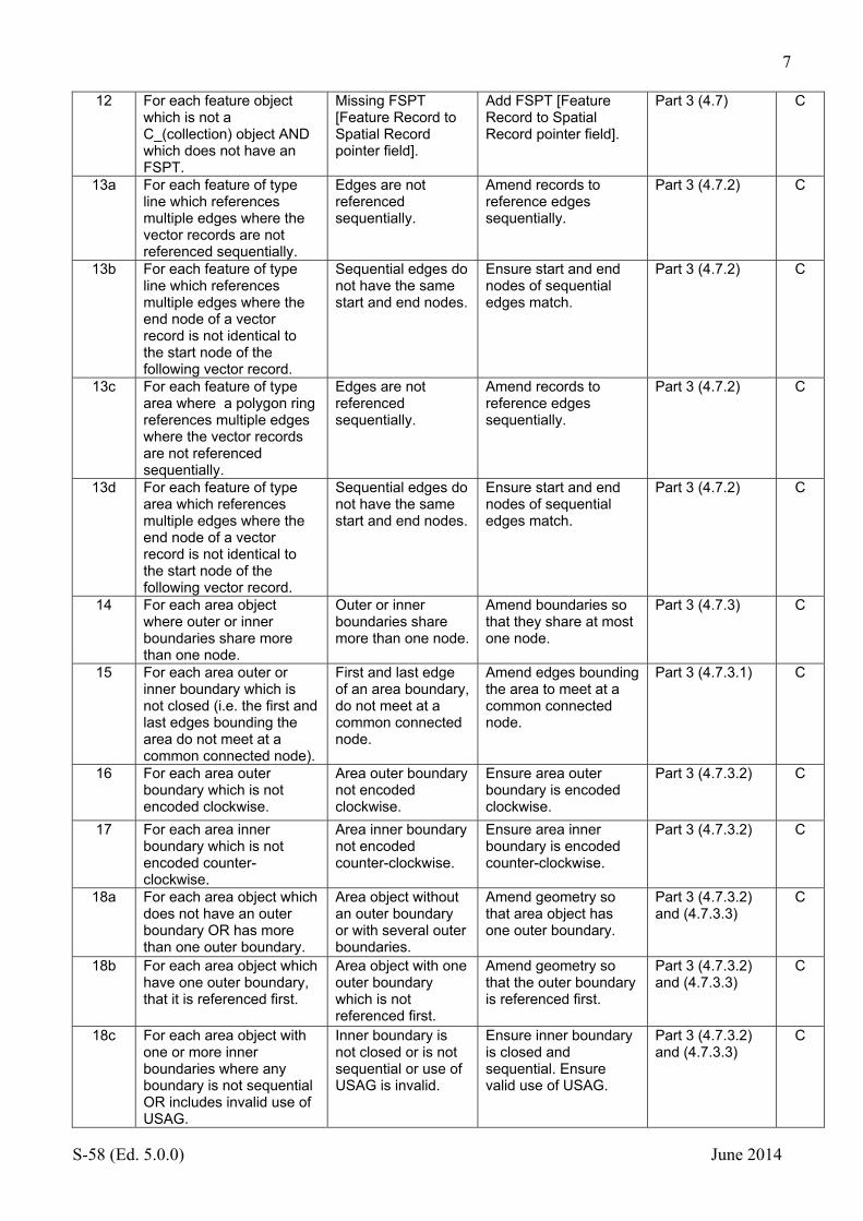
7
S-58 (Ed. 5.0.0) June 2014
12 For each feature object which is not a C_(collection) object AND which does not have an FSPT.
Missing FSPT [Feature Record to Spatial Record pointer field].
Add FSPT [Feature Record to Spatial Record pointer field].
Part 3 (4.7) C
13a For each feature of type line which references multiple edges where the vector records are not referenced sequentially.
Edges are not referenced sequentially.
Amend records to reference edges sequentially.
Part 3 (4.7.2) C
13b For each feature of type line which references multiple edges where the end node of a vector record is not identical to the start node of the following vector record.
Sequential edges do not have the same start and end nodes.
Ensure start and end nodes of sequential edges match.
Part 3 (4.7.2) C
13c For each feature of type area where a polygon ring references multiple edges where the vector records are not referenced sequentially.
Edges are not referenced sequentially.
Amend records to reference edges sequentially.
Part 3 (4.7.2) C
13d For each feature of type area which references multiple edges where the end node of a vector record is not identical to the start node of the following vector record.
Sequential edges do not have the same start and end nodes.
Ensure start and end nodes of sequential edges match.
Part 3 (4.7.2) C
14 For each area object where outer or inner boundaries share more than one node.
Outer or inner boundaries share more than one node.
Amend boundaries so that they share at most one node.
Part 3 (4.7.3) C
15 For each area outer or inner boundary which is not closed (i.e. the first and last edges bounding the area do not meet at a common connected node).
First and last edge of an area boundary, do not meet at a common connected node.
Amend edges bounding the area to meet at a common connected node.
Part 3 (4.7.3.1) C
16 For each area outer boundary which is not encoded clockwise.
Area outer boundary not encoded clockwise.
Ensure area outer boundary is encoded clockwise.
Part 3 (4.7.3.2) C
17 For each area inner boundary which is not encoded counter-clockwise.
Area inner boundary not encoded counter-clockwise.
Ensure area inner boundary is encoded counter-clockwise.
Part 3 (4.7.3.2) C
18a For each area object which does not have an outer boundary OR has more than one outer boundary.
Area object without an outer boundary or with several outer boundaries.
Amend geometry so that area object has one outer boundary.
Part 3 (4.7.3.2) and (4.7.3.3)
C
18b For each area object which have one outer boundary, that it is referenced first.
Area object with one outer boundary which is not referenced first.
Amend geometry so that the outer boundary is referenced first.
Part 3 (4.7.3.2) and (4.7.3.3)
C
18c For each area object with one or more inner boundaries where any boundary is not sequential OR includes invalid use of USAG.
Inner boundary is not closed or is not sequential or use of USAG is invalid.
Ensure inner boundary is closed and sequential. Ensure valid use of USAG.
Part 3 (4.7.3.2) and (4.7.3.3)
C
8
S-58 (Ed. 5.0.0) June 2014
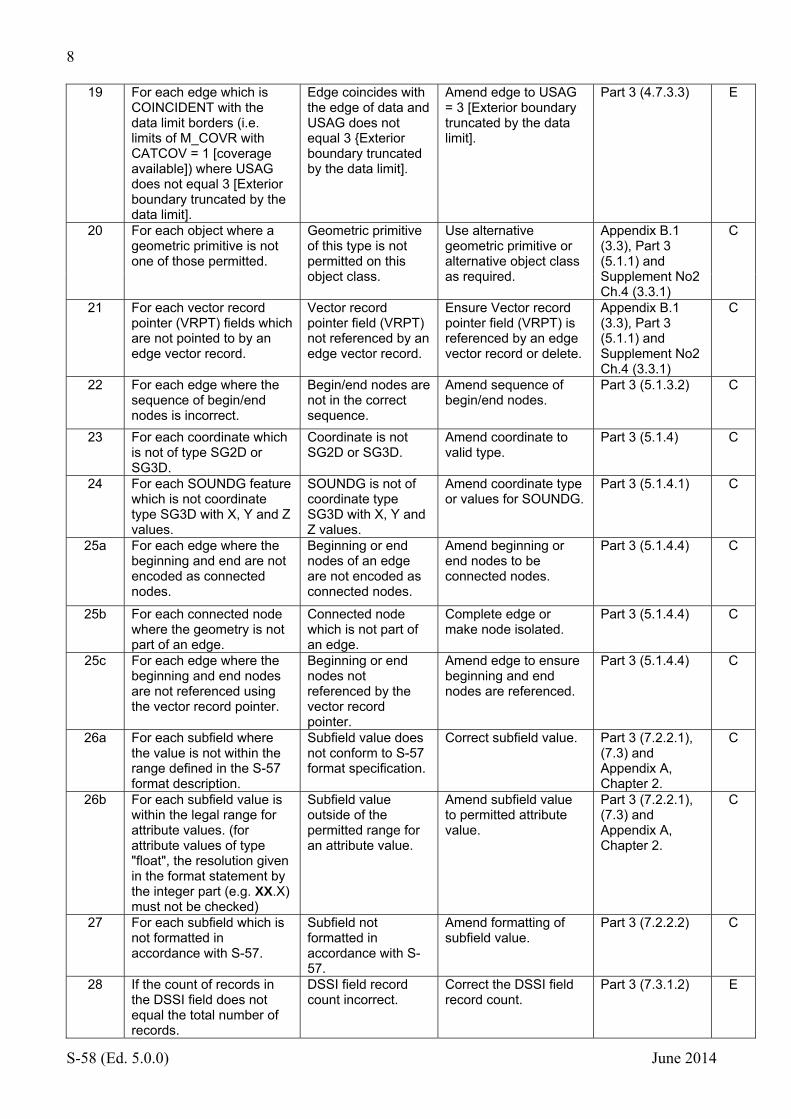
19 For each edge which is COINCIDENT with the data limit borders (i.e. limits of M_COVR with CATCOV = 1 [coverage available]) where USAG does not equal 3 [Exterior boundary truncated by the data limit].
Edge coincides with the edge of data and USAG does not equal 3 {Exterior boundary truncated by the data limit].
Amend edge to USAG = 3 [Exterior boundary truncated by the data limit].
Part 3 (4.7.3.3) E
20 For each object where a geometric primitive is not one of those permitted.
Geometric primitive of this type is not permitted on this object class.
Use alternative geometric primitive or alternative object class as required.
Appendix B.1 (3.3), Part 3 (5.1.1) and Supplement No2 Ch.4 (3.3.1)
C
21 For each vector record pointer (VRPT) fields which are not pointed to by an edge vector record.
Vector record pointer field (VRPT) not referenced by an edge vector record.
Ensure Vector record pointer field (VRPT) is referenced by an edge vector record or delete.
Appendix B.1 (3.3), Part 3 (5.1.1) and Supplement No2 Ch.4 (3.3.1)
C
22 For each edge where the sequence of begin/end nodes is incorrect.
Begin/end nodes are not in the correct sequence.
Amend sequence of begin/end nodes.
Part 3 (5.1.3.2) C
23 For each coordinate which is not of type SG2D or SG3D.
Coordinate is not SG2D or SG3D.
Amend coordinate to valid type.
Part 3 (5.1.4) C
24 For each SOUNDG feature which is not coordinate type SG3D with X, Y and Z values.
SOUNDG is not of coordinate type SG3D with X, Y and Z values.
Amend coordinate type or values for SOUNDG.
Part 3 (5.1.4.1) C
25a For each edge where the beginning and end are not encoded as connected nodes.
Beginning or end nodes of an edge are not encoded as connected nodes.
Amend beginning or end nodes to be connected nodes.
Part 3 (5.1.4.4) C
25b For each connected node where the geometry is not part of an edge.
Connected node which is not part of an edge.
Complete edge or make node isolated.
Part 3 (5.1.4.4) C
25c For each edge where the beginning and end nodes are not referenced using the vector record pointer.
Beginning or end nodes not referenced by the vector record pointer.
Amend edge to ensure beginning and end nodes are referenced.
Part 3 (5.1.4.4) C
26a For each subfield where the value is not within the range defined in the S-57 format description.
Subfield value does not conform to S-57 format specification.
Correct subfield value. Part 3 (7.2.2.1), (7.3) and Appendix A, Chapter 2.
C
26b For each subfield value is within the legal range for attribute values. (for attribute values of type "float", the resolution given in the format statement by the integer part (e.g. XX.X) must not be checked)
Subfield value outside of the permitted range for an attribute value.
Amend subfield value to permitted attribute value.
Part 3 (7.2.2.1), (7.3) and Appendix A, Chapter 2.
C
27 For each subfield which is not formatted in accordance with S-57.
Subfield not formatted in accordance with S-57.
Amend formatting of subfield value.
Part 3 (7.2.2.2) C
28 If the count of records in the DSSI field does not equal the total number of records.
DSSI field record count incorrect.
Correct the DSSI field record count.
Part 3 (7.3.1.2) E

9
S-58 (Ed. 5.0.0) June 2014
29 For each of the following: FFPC-NFPT, FSPC-NSPT, SGCC-CCNC, and VRPC-NVPT where the index position for updating is invalid.
Invalid index position for updating in the following FFPC-NFPT, FSPC-NSPT, SGCC-CCNC or VRPC-NVPT.
Amend to valid index position for updating.
Part 3 (7.6.5) (7.6.7), (7.7.1.5) and (7.7.1.3)
C
30 For each of the following: FFPC-FFIX, FSPC-FSIX, SGCC-CCIX, and VRPC-VPIX where the index position for updating is invalid.
Invalid index position for updating in the following FFPC-FFIX, FSPC-FSIX, SGCC-CCIX or VRPC.
Amend to valid index position for updating.
Part 3 (7.7.1.5), (7.6.5), (7.6.7) and (7.7.1.3)
C
31 For each edge where SG2D coordinates are identical to the start and end node coordinates.
Edge where start and end node coordinates are the same as the SG2D coordinates.
Amend SG2D coordinates to differ from start and end node coordinates.
Part 3 (7.7.1.6) C
32 For each record update which does not refer to a valid record NAME.
Record update does not refer to a valid record NAME.
Amend record update to refer to a valid record NAME.
Part 3 (8.3.2) C
33 For each attribute update which does not refer to a valid record NAME and attribute label.
Attribute update does not refer to valid record NAME and attribute label.
Amend attribute update to refer to valid values.
Part 3 (8.3.3) C
34 For each of the following fields FFPT, FSPT and VRPT where the update pointer index does not refer to a valid record NAME and index.
Update pointer index does not refer to a valid record NAME and index for FFPT, FSPT or VRPT.
Ensure update pointer index refers to a valid record NAME and index.
Part 3 (8.3.4) C
35 For each object where RVER is out of sequence.
RVER is out of sequence.
Ensure RVER is sequential.
Part 3 (8.4.2.1) and (8.4.3.1)
C
36a For each update record of type feature or vector which is DELETE and contains further fields.
DELETE update contains additional fields.
Remove additional fields from update record.
Part 3 (8.4.2.2) and (8.4.3.1)
C
36b For each update record of type feature or vector which is MODIFY/INSERT and contains no further fields.
MODIFY/INSERT update does not contain additional fields.
Add additional fields to update record.
Part 3 (8.4.2.2) and (8.4.3.1)
C
37 If an update and its base cell do not have the same lexical level. Moved to section 2.3 as check 1000
Update and base cell do not have the same lexical level.
Correct the lexical level of the update.
Part 3 (8.4.2.2a) C
38 For each update record which contains more than one of the following: FFPC field [8.4.2.3] VRPC field [8.4.3.2b] FSPC field [8.4.2.4] SGCC field [8.4.3.3]
Update record contains more than one of the following fields: FFPC, VRPC, FSPC, SGCC.
Remove additional fields from update record.
See references in the column to the left.
C
39 For all edges where line segments are not complete.
Line segments are not complete within edge.
Complete line segments.
Part 3 (8.4.3.3) C
10
S-58 (Ed. 5.0.0) June 2014
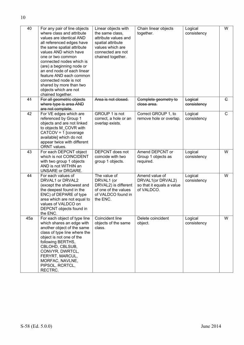
40 For any pair of line objects where class and attribute values are identical AND all referenced edges have the same spatial attribute values AND which have one or two common connected nodes which is (are) a beginning node or an end node of each linear feature AND each common connected node is not shared by more than two objects which are not chained together.
Linear objects with the same class, attribute values and spatial attribute values which are connected are not chained together.
Chain linear objects together.
Logical consistency
W
41 For all geometric objects where type is area AND are not complete.
Area is not closed. Complete geometry to close area.
Logical consistency
C
42 For VE edges which are referenced by Group 1 objects and are not linked to objects M_COVR with CATCOV = 1 [coverage available] which do not appear twice with different ORNT values.
GROUP 1 is not correct, a hole or an overlap exists.
Correct GROUP 1, to remove hole or overlap.
Logical consistency
C
43 For each DEPCNT object which is not COINCIDENT with two group 1 objects AND is not WITHIN an UNSARE or DRGARE.
DEPCNT does not coincide with two group 1 objects.
Amend DEPCNT or Group 1 objects as required.
Logical consistency
W
44 For each values of DRVAL1 or DRVAL2 (except the shallowest and the deepest found in the ENC) of DEPARE of type area which are not equal to values of VALDCO on DEPCNT objects found in the ENC.
The value of DRVAL1 (or DRVAL2) is different of one of the values of VALDCO found in the ENC.
Amend value of DRVAL1(or DRVAL2) so that it equals a value of VALDCO.
Logical consistency
W
45a For each object of type line which shares an edge with another object of the same class of type line where the object is not one of the following BERTHS, CBLOHD, CBLSUB, CONVYR, DWRTCL, FERYRT, MARCUL, MORFAC, NAVLNE, PIPSOL, RCRTCL, RECTRC.
Coincident line objects of the same class.
Delete coincident object.
Logical consistency
W

11
S-58 (Ed. 5.0.0) June 2014
45b For each object of type line which shares an edge with another object of the same class and attribute values of type line where the object is one of the following BERTHS, CBLOHD, CBLSUB, CONVYR, DWRTCL, FERYRT, MARCUL, MORFAC, NAVLNE, PIPSOL, RCRTCL, RECTRC.
Coincident line objects of the same class and attribute values.
Delete coincident object.
Logical consistency
W
46 For each object where DATEND and DATSTA are notNull DATEND is less than or equal to DATSTA.
DATEND less than DATSTA.
Amend values of DATEND or DATSTA accordingly.
Logical consistency
E
47a For each LIGHTS or RTPBCN object where SECTR1 is notNull and SECTR2 is null or equal to SECTR1. (0 and 360 must be treated as the same value.)
SECTR2 not populated with a valid value, must not be the same as SECTR1.
Populate SECTR2 with a valid value.
Logical consistency
E
47b For each LIGHTS or RTPBCN object where SECTR2 is notNull and SECTR1 is null or equal to SECTR2.(0 and 360 must be treated as the same value.)
SECTR1 not populated with a valid value, must not be the same as SECTR2.
Populate SECTR1 with a valid value.
Logical consistency
E
48 For each M_SREL object where SCVAL1 and SCVAL2 are notNull AND SCVAL2 is less than SCVAL1.
SCVAL2 is less than SCVAL1.
Amend values of SCVAL1/2 value of SCVAL2 must be greater than SCVAL1.
Logical consistency
E
49 For each object where DRVAL1 AND DRVAL2 are notNull AND DRVAL2 is less than DRVAL1.
DRVAL2 is less than DRVAL 1, DRVAL 2 must be greater than or equal to DRVAL1.
Amend the values of DRVAL1 or DRVAL2 as required.
Logical consistency
E
50 For each RECTRC where CATTRK=1 or NAVLNE object where its nodes/vertices do not lie on a straight line.
RECTREC where CATTRK=1 or NAVLNE is not a straight line.
Amend geometry to a straight line.
Logical consistency
E
51a For each COALNE object which is COINCIDENT with a SLCONS object of type line.
COALNE and SLCONS objects share an edge.
Amend objects so that they do not share an edge.
Logical consistency
W
51b For each COALNE object which is COINCIDENT with a SLCONS object of type area where WATLEV is not populated or encoded with the values (2) [always dry] or (1) [partly submerged at high water] that is WITHIN an area LNDARE.
COALNE and SLCONS with illogical values of WATLEV overlap.
Amend objects so that they do not overlap or amend WATLEV values.
Logical consistency
W
52a For each LNDELV object of type line which is not WITHIN a LNDARE of type area
Linear LNDELV object not situated on area LNDARE
Ensure linear LNDELV object is situated on a LNDARE.
Appendix B1, Annex A (4.7.2, 4.7.4, 6.1.1 and 6.2.1).
E

12
S-58 (Ed. 5.0.0) June 2014
52b For each LNDELV object of type point which is not WITHIN a LNDARE of type area AND does not touch a LNDARE of type line or point AND is not WITHIN a WRECKS object of type area which is always dry WATLEV=2 or partially submerged WATLEV=1.
LNDELV object not situated on LNDARE or on a drying or partially submerged WRECKS object.
Ensure LNDELV object is situated on a LNDARE or on a drying/partially submerged WRECKS object.
Appendix B1, Annex A (4.7.2, 4.7.4, 6.1.1 and 6.2.1).
E
53a For each SLOGRD object which is not within a LNDARE object of type area.
SLOGRD not covered by LNDARE.
Amend LNDARE or SLOGRD accordingly.
Appendix B1, Annex A (4.7.4, 4.7.5, 4.8.4)
E
53b For each SLOTOP object which is not within a LNDARE object of type area.
SLOTOP not covered by LNDARE.
Amend LNDARE or SLOTOP accordingly.
Appendix B1, Annex A (4.7.4, 4.7.5, 4.8.4)
E
54a For each CRANES, FORSTC, LNDMRK or SILTNK object of type area that is not WITHIN a LNDARE, BRIDGE, FLODOC, OFSPLF or PONTON object of type area.
CRANES, FORSTC, LNDMRK or SILTNK not within a LNDARE, BRIDGE, FLODOC, OFSPLF or PONTON.
Amend object to ensure it is situated on a suitable object.
Logical consistency
C
54b For each CRANES, FORSTC, LNDMRK, DAYMAR or SILTNK object of type point that is not WITHIN a LNDARE, BRIDGE, FLODOC, OFSPLF or PONTON object of type area OR it does not EQUAL a LNDARE, PILPNT, PYLONS, OFSPLF, SLCONS or UWTROC of type point OR it is not COINCIDENT with a COALNE, DAMCON, BRIDGE, FLODOC, LNDARE, PONTON or SLCONS of type line.
CRANES, FORSTC, LNDMRK, DAYMAR or SILTNK not situated on a suitable supporting object.
Amend object to ensure it is situated on a suitable object.
Logical consistency
C

13
S-58 (Ed. 5.0.0) June 2014
54c For each BUISGL object of type area that is not within a LNDARE, BRIDGE, FLODOC, HRBFAC, OFSPLF, or PONTON object of type area OR for each BUISGL of type point that is not WITHIN a LNDARE, BRIDGE, FLODOC, OFSPLF or PONTON of type area OR it does not EQUAL a LNDARE, PILPNT, PYLONS, OFSPLF, SLCONS or UWTROC of type point OR it is not COINCIDENT with a COALNE, DAMCON, BRIDGE, FLODOC, LNDARE, PONTON or SLCONS of type line.
BUISGL not situated on a suitable supporting object
Amend object to ensure it is situated on a suitable object.
Logical consistency
W
55 For each LNDARE object of type point or line which is WITHIN a LNDARE object of type area AND not WITHIN an object LAKARE or RIVERS or DOCARE or LOKBSN or CANALS of type area
Point LNDARE lies on land.
Amend point LNDARE or area LNDARE accordingly.
Logical consistency
W
56 For each BUAARE object not WITHIN a LNDARE object of type area or which is COINCIDENT with a LNDARE object of type point or line.
BUAARE not located on LNDARE.
Amend BUAARE so that it sits on LNDARE.
Logical consistency
E
57a For each COALNE object which is not COINCIDENT with a LNDARE AND is not WITHIN a LNDARE object of type area.
COALNE object not bounding LNDARE
Ensure that COALNE coincides LNDARE boundary.
Logical consistency UOC.4.5
E
57b For each COALNE object which is WITHIN a LNDARE object of type area or is COINCIDENT with LNDARE objects on both sides AND is COINCIDENT with a SLCONS or DRYDOC object where CONDTN does not equal 1(under construction) or 3(under reclamation) or 5(planned construction)
COALNE is inside LNDARE coincident with permanent SLCONS or DRYDOC object.
Remove COALNE or amend CONDTN values.
Logical consistency. UOC.4.6.10
E
57c For each COALNE object which is COINCIDENT with LNDARE objects on both sides NOT one of them has CONDTN equal 1(under construction) or 3(under reclamation) or 5(planned construction)
COALNE is COINCIDENT with LNDARE objects on both sides
Remove COALNE or amend CONDTN values.
Logical consistency. UOC.4.6.10
E

14
S-58 (Ed. 5.0.0) June 2014
58 For each SBDARE object of type line which is COINCIDENT with an SBDARE object of type area.
Line SBDARE bounds an area SBDARE.
Delete line SBDARE. Logical consistency
W
59 For each OBSTRN object of type line which is COINCIDENT with an OBSTRN object of type area.
Line OBSTRN bounds an area OBSTRN.
Amend or delete OBSTRN of type line.
Logical consistency
W
60 For each CBLSUB object INTERSECTS a LNDARE object of type Area.
CBLSUB lies on land.
Amend CBLSUB object accordingly.
Logical consistency
W
61a For each object of type line or area where WATLEV = 3 [always underwater/submerged] which OVERLAPS or is WITHIN an inter-tidal area (DEPARE with DRVAL2 ≤0) OR LNDARE object of type area.
Line or area object which is WATLEV = 3 [always underwater/submerged] lies within or overlapping an inter-tidal area (DEPARE with DRVAL2 ≤ 0) or land area.
Amend value of WATLEV.
Logical consistency
E
61b For each object of type point where WATLEV = 3 [always underwater/submerged] which is WITHIN an inter-tidal (DEPARE with DRVAL2 ≤0) area OR is WITHIN a LNDARE of type area OR EQUALS a LNDARE of type point or is situated on a LNDARE of type line.
Point object which is WATLEV = 3 [always underwater/submerged] lies within an inter-tidal area (DEPARE with DRVAL2 ≤ 0) or is within or coincident with a land area object.
Amend value of WATLEV.
Logical consistency
E
62 For each PONTON, HULKES or FLODOC object of type area where any edge shares the geometry of a line COALNE or SLCONS object AND the edge does not also share the geometry of a LNDARE object of type area.
PONTON, HULKES or FLODOC which uses an SLCONS or COALNE edge which is not on the edge of LNDARE.
Ensure all SLCONS or COALNE objects are backed by LNDARE objects.
Logical consistency
W
63 For each RECTRC object which INTERSECTS line or area objects of the following types LNDARE, PONTON, HULKES, FLODOC OR any object where WATLEV = 1 [partly submerged at high water] or 2 [always dry].
RECTRC intersects prohibited objects.
Amend RECTRC or other objects to ensure RECTRC is within navigable objects.
Logical consistency
E
64 For each ACHARE object of type point or area where CATACH does not equal 8 [small craft mooring area] which OVERLAPS another object where RESTRN includes the value 1 [anchoring prohibited].
ACHARE object within an area with RESTRN = 1 [anchoring prohibited].
Amend ACHARE object or object carrying RESTRN=1.
Logical consistency
W

15
S-58 (Ed. 5.0.0) June 2014
65 For each LIGHTS object which EQUALS another LIGHTS object AND STATUS does not equal 4 [not in use], 6 [reserved] or 11 [extinguished] where sectors overlap AND none of the values of the following attributes are different CATLIT, EXCLIT, LITCHR, SIGPER or SIGGRP.
Coincident lights with overlapping sectors and the same characteristics.
Modify light sectors so that they do not overlap, or delete duplicated sectors.
Logical consistency
W
66 For each SOUNDG where EXPSOU = (1) or is not populated AND the depth value is less than DRVAL1 of the underlying DEPARE or DRGARE OR the depth value is greater than or equal to the DRVAL2 of underlying DEPARE or DRGARE.
Sounding outside of the range of the corresponding DEPARE , DRGARE.
Amend depth value or populate EXPSOU accordingly.
Logical consistency
W
67 For each object where its object class, attribution and geometry is identical to another object.
Duplicate object exists.
Delete duplicate object. Data structure E
68 For each object which references a text/graphic file and the text/graphic file is not present in the exchange set. Moved to section 2.3 as check 1001
Text or graphic file referenced by update is not present.
Add text or graphic files to exchnage set.
C
69 For each object where the Agency Code in invalid.
Invalid agency code. Amend Agency code to valid value.
Appendix A, Annex A
W
70a For each DEPARE object of type line which does not EQUAL a Group 1 boundary.
Hanging' linear depth area of type line.
Delete 'hanging' linear DEPARE.
Logical consistency
E
70b For each DEPARE objects of type line.
DEPARE of type line exit in the ENC
Delete linear DEPARE as no longer required in ENC.
Logical consistency
W
71a For each object of type area where all edges have not USAG = 3 [exterior boundary truncated by the data limit] AND all edges are masked (i.e. USAG = 3 or MASK = 1 [mask]).
Area object has all of its edges masked and is not the edge of the data coverage.
Remove masking. Logical consistency
W
71b For each object of type line which has any edges masked (i.e. MASK = 1 [mask]).
Line object with masked edges.
Remove masking from line object,
Logical consistency
E
72 For each set of hierarchical relationships which form a loop (e.g. no master object is slave of its own slave).
Relationships form a loop.
Amend relationships to remove loop.
Logical consistency
E
73a For each attribute value which contains a leading or trailing space.
Attribute value contains leading or trailing spaces.
Remove leading or trailing spaces.
Logical consistency
W

16
S-58 (Ed. 5.0.0) June 2014
73b For each attribute value of type list which contains spaces.
List attribute value contains spaces.
Remove spaces. Logical consistency
W
74 For each DEPCNT object which does not share an edge with a Group 1 object AND is WITHIN an area DEPARE object with DRVAL1 AND DRVAL2 equal to notNull AND DRVAL2 <= VALDCO <= DRVAL1.
Floating DEPCNT within a DEPARE with VALDCO less than DRVAL1 or greater than DRVAL2.
Amend floating contour VALDCO between DRVAL1 and DRVAL2 of the underlying DEPARE.
Logical consistency
C
75 For each DEPCNT object which does not share an edge with a Group 1 object AND is WITHIN an area DRGARE object with DRVAL1 equal to notNull AND VALDCO <= DRVAL1.
Floating DEPCNT within a DRGARE with VALDCO less than DRVAL1 of the DRGARE.
Amend floating contour VALDCO to be greater than the DRVAL1 of the underlying DRGARE. Or amend DRVAL1 of the DRGARE.
Logical consistency
C
76 For each DEPCNT object INTERSECTS a FLODOC, HULKES, LNDARE or PONTON object of type Area.
DEPCNT intersects prohibited objects.
Amend DEPCNT to be WITHIN appropriate objects.
Logical consistency.
E
77 For each object of type DEPCNT which crosses another object of type DEPCNT
DEPCNT objects cross.
Amend DEPCNT objects so they do not cross.
Logical consistency
C
78 For each area object where its boundary CROSSES itself.
Boundary of an area object crosses itself.
Amend boundary to remove part which crosses itself.
Logical consistency
C
79 For each line object where component edges CROSSES without a connected node at the crossing point
Component edges of a line object cross without a connected node at the crossing point.
Insert connected node at crossing point.
Topology E
80a For each area object where an internal boundary is WITHIN an internal boundary.
Internal boundary within an internal boundary.
Amend boundaries so that internal boundary is not within another internal boundary.
Topology C
80b For each area object where an internal boundary is not WITHIN an external boundary.
Internal boundary outside of an external boundary.
Amend boundaries so that internal boundary is within external boundary.
Topology C
80c For each area object where an external boundary is WITHIN an internal boundary.
External boundary within an internal boundary.
Amend boundaries so that internal boundary is within external boundary.
Topology C
81 For each SOUNDG object which is COINCIDENT another SOUNDG object. (COINCIDENT applies to the horizontal component only).
SOUNDG objects are coincident.
Delete coincident SOUNDG objects
Topology E
82 For each object of type line or area which references the same edge more than once.
Object references the same edge more than once.
Remove duplicate reference to the edge.
Topology C
17
S-58 (Ed. 5.0.0) June 2014
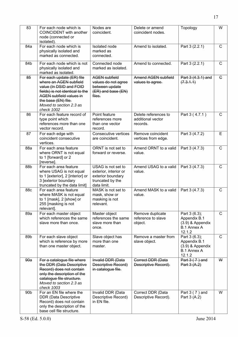
83 For each node which is COINCIDENT with another node (connected or isolated).
Nodes are coincident.
Delete or amend coincident nodes.
Topology W
84a For each node which is physically isolated and marked as connected.
Isolated node marked as connected.
Amend to isolated. Part 3 (2.2.1) C
84b For each node which is not physically isolated and marked as isolated.
Connected node marked as isolated.
Amend to connected. Part 3 (2.2.1) C
85 For each update (ER) file where an AGEN subfield value (In DSID and FOID fields) is not identical to the AGEN subfield values in the base (EN) file. Moved to section 2.3 as check 1002
AGEN subfield values do not agree between update (ER) and base (EN) files.
Amend AGEN subfield values to agree.
Part 3 (4.3.1) and (7.3.1.1)
C
86 For each feature record of type point which references more than one vector record.
Point feature references more than one vector record.
Delete references to additional vector records.
Part 3 ( 4.7.1 ) C
87 For each edge with coincident consecutive vertices.
Consecutive vertices are coincident.
Remove coincident vertices from edge.
Part 3 (4.7.2) E
88a For each area feature where ORNT is not equal to 1 [forward] or 2 [reverse].
ORNT is not set to forward or reverse.
Amend ORNT to a valid value.
Part 3 (4.7.3) C
88b For each area feature where USAG is not equal to 1 [exterior], 2 [interior] or 3 [exterior boundary truncated by the data limit]
USAG is not set to exterior, interior or exterior boundary truncated by the data limit.
Amend USAG to a valid value.
Part 3 (4.7.3) C
88c For each area feature where MASK is not equal to 1 [mask], 2 [show] or 255 [masking is not relevant].
MASK is not set to mask, show or masking is not relevant.
Amend MASK to a valid value.
Part 3 (4.7.3) C
89a For each master object which references the same slave more than once.
Master object references the same slave more than once.
Remove duplicate reference to slave object.
Part 3 (6.3); Appendix B.1 (3.9) & Appendix B.1 Annex A 12.1.2
C
89b For each slave object which is reference by more than one master object.
Slave object has more than one master.
Remove a master from slave object.
Part 3 (6.3); Appendix B.1 (3.9) & Appendix B.1 Annex A 12.1.2
C
90a For a catalogue file where the DDR (Data Descriptive Record) does not contain only the description of the catalogue file structure. Moved to section 2.3 as check 1003
Invalid DDR (Data Descriptive Record) in catalogue file.
Correct DDR (Data Descriptive Record).
Part 3 ( 7 ) and Part 3 (A.2)
W
90b For an EN file where the DDR (Data Descriptive Record) does not contain only the description of the base cell file structure.
Invalid DDR (Data Descriptive Record) in EN file.
Correct DDR (Data Descriptive Record).
Part 3 ( 7 ) and Part 3 (A.2)
W

18
S-58 (Ed. 5.0.0) June 2014
90c For an ER file where the DDR (Data Descriptive Record) does not contain only the description of the update cell file structure.
Invalid DDR (Data Descriptive Record) in ER file.
Correct DDR (Data Descriptive Record).
Part 3 ( 7 ) and Part 3 (A.2)
W
91 For each attribute value of type ‘float’ where the number of digits in the integer part is greater than the number of digits given in the format statement (e.g. XX.X).
Incorrect number of digits for value of float attribute.
Amend the value to conform to the format statement.
Part 3 (7.2.2.1), (7.3) and Appendix A, Chapter 2.
C,E,W
92 For each FRID field in an update (ER) file where RUIN = 3 [modify] and the FOID for the modified object is not identical in the base (EN) and update (ER) files. Moved to section 2.3 as check 1004
FOIDS do not match for a modify update between update ER and base EN files.
Correct FOIDs to be identical or make separate insert and delete updates.
Part 3 (8.4.2) C
93a For each object where WATLEV = 4 [covers and uncovers] or 5 [awash] of type line or area which is WITHIN or OVERLAPS a LNDARE object of type area.
Object with WATLEV 4 or 5 on a LNDARE object.
Amend LNDARE object to ensure object is within inter-tidal zone.
Logical consistency
E
93b For each object where WATLEV = 4 [covers and uncovers] or 5 [awash] of type point which OVERLAPS a LNDARE object of type area or EQUALS a LNDARE object of type point or is COINCIDENT with a LNDARE object of type line.
Object with WATLEV 4 or 5 on a LNDARE object.
Amend LNDARE object to ensure object is within inter-tidal zone.
Logical consistency
E
94 For each ER file which contains instructions for the FSPC field to modify an FSPT field of a feature object to a value it already contains.
Update (ER) file contains instructions to modify an FSPT field to a value it already contains.
Remove pointless FSPC field from update (ER) file.
Logical consistency
E
95 If the COMT subfield of the DISD and DSPM fields contains text which is not lexical level (0).
COMT subfield contains text which is not lexical level (0).
Amend text to conform to lexical level (0).
Part 3 (2.4) E
96 For each relationship which does not reference an object of type C_ASSO OR C_AGGR and the Relationship Indicator [RIND] subfield of the Feature Record to Feature object Pointer [FFPT] field set to (3) [peer].
Relationship indicator has an incorrect value for a master slave relationship.
Amend the relationship indicator to (3) [peer].
3.9 E
97 For each object where SUREND and SURSTA are notNull SUREND is less than SURSTA.
SUREND less than SURSTA.
Amend values of SUREND or SURSTA accordingly.
Logical consistency
E

19
S-58 (Ed. 5.0.0) June 2014
98 For each object which has a relationship AND references an object which does not exist.
Object references an object that does not exist
Remove reference to non-existent object
Logical consistency.
E

20
S-58 (Ed. 5.0.0) June 2014
2.2 Checks relating to ENC Product Specification
No Check description Check message Check solution Conformity to: Cat
500 For each object where its geometry is not within an M_COVR object where CATCOV=1.
Objects fall outside the coverage object;
Ensure objects are not outside of the limits of the cell.
2.2 C
501 If the combined coverage of all M_COV R objects limits are not rectangular
Cell is not rectangular.
Amend cell limits to make them rectangular.
2.2 E
502 If the cell file size is greater than 5 megabytes.
The cell is larger than 5Mb in size.
Ensure that the cell is not larger than 5Mb.
2.2 E
503 For each object If the FOID is not unique within this dataset.
Duplicate FOIDs exist within the dataset.
Ensure that no duplicate FOIDs exist.
3.1 W
504 For each object of type CANBNK, LAKSHR, RIVBNK SQUARE, M_HDAT, M_PROD, M_UNIT, C_STAC, $AREAS, $LINES, $CSYMB,$COMPS, $TEXTS.
Prohibited objects exist within the dataset.
Delete prohibited objects.
3.2 C
505 If objects of type M_COVR, M_NSYS OR M_QUAL do not exist within the dataset.
Mandatory meta objects are missing;
Include mandatory meta objects M_COVR, M_NSYS and M_QUAL.
3.4 C
506 If mandatory subfields in EN and ER files are NULL
Mandatory sub fields are not populated.
Populate mandatory sub fields.
3.5.1 and Part 3 (2.1)
C
507 If any mandatory attributes are not populated.
Mandatory attributes are not populated
Populate mandatory attributes.
3.5.2 and SuppNo2 Ch.4 (3.5.2.1)
C
508a For each object where more than one value of COLOUR are encoded that COLPAT is ‘Null’.
COLOUR has multiple values without a value for COLPAT.
Ensure COLPAT has a value where multiple COLOUR values are encoded.
3.5.2 Logical consistency
E
508b For each object where COLPAT is ‘notNull’ that COLOUR is 'Null' OR only has one value.
COLPAT is populated without multiple COLOUR values.
Ensure multiple COLOUR values are populated or delete COLPAT value.
3.5.2 Logical consistency
E

21
S-58 (Ed. 5.0.0) June 2014
509 For all objects listed below where the attribute stated is ‘Null’ or 'not present'; ARCSLN: NATION ASLXIS: NATION CTNARE: INFORM or TXTDSC DEPARE: DRVAL1 and DRVAL2 DRGARE: DRVAL1 NEWOBJ: CLSDEF and CLSNAM SWPARE: DRVAL1 DEPCNT: VALDCO LNDELV: ELEVAT MAGVAR: VALMAG CONZNE: NATION COSARE: NATION CUSZNE: NATION EXEZNE: NATION FSHZNE: NATION STSLNE: NATION TESARE: NATION M_COVR: CATCOV M_CSCL: CSCALE M_QUAL: CATZOC M_SDAT: VERDAT M_VDAT: VERDAT TS_PAD: TS_TSP DWRTPT: ORIENT DWRTCL: ORIENT M_NSYS: MARSYS or ORIENT RCTLPT: ORIENT
Mandatory attribute has not been populated with a value.
Populate mandatory attributes; in these cases the object is meaningless without this value.
3.5.2 and Supplement No2 Ch.4 (3.5.2.1)
E
510 For all objects except M_HOPA where HORDAT is 'notNull' OR 'Null'
HORDAT is encoded on objects other than M_HOPA.
Delete value of HORDAT encoded on object other than M_HOPA.
3.5.3 E
511 For each object where any of DUNITS, HUNITS, RECDAT, RECIND, SCAMAX, PUNITS, CATQUA are null or notNull.
Prohibited attributes have been encoded.
Delete prohibited attributes.
3.5.3 C
512 For each object with an attribute of type Float or Integer where the value contains zeroes before the first numerical digit or after the last numerical digit.
Values have been padded with non-significant zeroes. E.g. : For a signal period of 2.5 sec, the value of SIGPER must be 2.5 and not 02.500
Remove non-significant zeroes. E.g. : For a signal period of 2.5 sec, the value of SIGPER must be 2.5 and not 02.500.
3.5.4 E
513 For each geo object with an attribute value identical to a the corresponding meta object WITHIN which it is situated.
An attribute value given on a meta object is duplicated on a geo object.
Delete duplicate value from geo object.
3.5.6 E
514 For each $AREAS,$CLOLN,$COMPS,$CSYMB,$LINES,$SHABL,$TEXTS
Cartographic objects exist within the dataset.
Delete cartographic objects.
3.6 E

22
S-58 (Ed. 5.0.0) June 2014
515 For all edges where USAG = 3 [exterior boundary, truncated by the data limit] AND MASK does not equal 255 [null].
Exterior edges truncated by the data limit are not masked.
MASK exterior edges truncated by the data limit.
3.8 W
516a For all master objects of type point which does not EQUAL the slave objects linked in the same master/slave relationship.
Master and slave point objects do not share the same node.
Ensure master and slave point objects share the same node.
3.9 and Appendix B1, Annex A (12.1.1 & 12.1.2)
E
516b For all master objects of type line where the slave object does not OVERLAP the master object.
Master and slave line objects do not overlap.
Ensure the Master and Slave overlap.
3.9 and Appendix B1, Annex A (12.1.1 & 12.1.2)
E
516c For all master objects of type area where the slave object is not WITHIN or TOUCHING the master object.
Slave object of type area does not touch or fall within the master object.
Ensure the Slave object touches or lies within the Master.
3.9 and Appendix B1, Annex A (12.1.1 & 12.1.2)
E
517a For a collection feature record which does not reference at least 1 feature object.
Collection feature record does not reference any objects.
Ensure the collection feature record references at least 1 feature object
3.9 and Appendix B1, Annex A (15), and Part 3 (6.2).
E
517b For a collection feature record which references itself.
Collection feature references itself.
Remove circular reference.
3.9 and Appendix B1, Annex A (15), and Part 3 (6.2)
E
517c For a collection feature record has a value of PRIM not equal to 255 [no geometry].
Invalid value of geometric primitive subfield.
Amend PRIM subfield to 255 [no geometry].
3.9 and Appendix B1, Annex A (15), and Part 3 (6.2)
E
517d For a collection feature record which references another master feature.
Collection feature references another master feature.
Remove reference to a master feature.
3.9 and Appendix B1, Annex A (15), and Part 3 (6.2)
E
517e For a collection feature where the RNID subfield is not 3 [peer] or which references features where RNID is not 3 [peer].
Collection feature which is peer references non-peer features.
Amend features to peer.
3.9 and Appendix B1, Annex A (15), and Part 3 (6.2).
E
518a For all objects FLODOC, DRGARE, LNDARE, HULKES, PONTON, DEPARE, UNSARE of type area where the GROUP subfield [GRUP] of the Feature Record Identifier [FRID] is not equal to (1) [Group 1].
Skin of the earth objects are not encoded as Group 1.
Ensure that Skin of the earth objects are encoded with Feature Record Identifier [FRID] set to (1) [Group 1].
3.1 C
518 b For all objects except FLODOC, DRGARE, LNDARE, HULKES, PONTON, DEPARE, UNSARE of type area, where the GROUP subfield [GRUP] of the Feature Record Identifier [FRID] is not equal to (2) [Group 2].
Group 2 objects are not encoded as group 2.
Ensure that Group 2 objects are encoded with Feature Record Identifier [FRID] set to (1) [Group 1].
3.1 C

23
S-58 (Ed. 5.0.0) June 2014
519a For all objects FLODOC, DRGARE, LNDARE, HULKES, PONTON, DEPARE, UNSARE that their combined coverage EQUALS the data coverage M_COVR CATCOV=1
Skin of the earth (TG1) objects do not cover the data coverage (M_COVR=1)
Adjust TG1 object limits to match data coverage.
3.10.1 C
519b For all objects FLODOC, DRGARE, LNDARE, HULKES, PONTON, DEPARE, UNSARE that OVERLAP.
Skin of the earth (TG1) objects overlap.
Ensure TG1 objects do not overlap.
3.10.1 C
520a If DSSI-AALL is not encoded with (0) or (1).
DSSI-AALL is not encoded correctly.
Amend AALL sub field. 3.11 and 3.5.5 E
520b If DSSI-NALL is not with (0) (1) or (2).
DSSI-NALL is not encoded correctly.
Amend NALL sub field. 3.11 and 3.5.5 E
520c For each attribute NINFOM, NTXTDS or NPLDST which are notNull where INFORM, TXTDSC or PILDST are Null or Not populated.
NINFOM, NTXTDS or NPLDST populated without corresponding value of INFORM, TXTDSC or PILDST.
Populate INFORM, TXTDSC or PILDST as required.
3.11 and 3.5.5 E
520d If lexical level (2) has been used anywhere other than the NATF field.
Lexical level (2) used outside of the NATF field. [Return character sets used and the sequence found.]
Correct text to remove lexical level 2.
3.11 and 3.5.5 E
520e If any ATTF or NATF field contains characters of a lexical level greater than that in the DSSI -AALL/NALL subfields correspondingly.
Lexical level of characters in the attribute or encoding of DSSI-AALL/NALL is inconsistent.
Correct characters or the subfield encoding as required.
3.11 and 3.5.5 E
520f If the UT or FT are not encoded at the lexical level specified for that field.
The UT and FT are not of the correct lexical level.
Correct UT and FT to the correct lexical level.
3.11 and 3.5.5 E
520g For all national language attributes which are not encoded in the Feature Record National Attribute (NATF) field.
National language attributes not encoded in the Feature Record National Attribute (NATF) field.
Encoded national language attributes using the Feature Record National Attribute (NATF) field.
3.11 and 3.5.5 E
520h For all feature object attributes (non national) that are not encoded in the Feature Record Attribute (ATTF) field.
Feature object attributes not encoded in the Feature Record Attribute (ATTF) field.
Encode feature object attributes in the feature record attribute (ATTF) field.
3.11 and 3.5.5 E
521a For all objects where OBJNAM AND NOBJNM are ‘notNull’ AND that they are EQUAL
Values for OBJNAM and NOBJNM are identical.
Ensure that national language attributes are populated with the correct values.
3.11.1 W
521b For all objects where INFORM and NINFOM are ‘notNull’ AND that they are EQUAL
Values for INFORM and NINFOM are identical.
Ensure that national language attributes are populated with the correct values.
3.11.1 W

24
S-58 (Ed. 5.0.0) June 2014
521c For all objects where PILDST and NPLDST are ‘notNull’ AND that they are EQUAL
Values for PILDST and NPLDST are identical.
Ensure that national language attributes are populated with the correct values.
3.11.1 W
521d For all objects where TXTDSC and NTXTDS are ‘notNull’ AND that they are EQUAL
Values for TXTDSC and NTXTDS are identical.
Ensure that national language attributes are populated with the correct values.
3.11.1 W
522 For all objects where NOBJNM is ‘notNull’ AND OBJNAM is ‘Null’ OR not present
Object name in national language is populated without Object name.
Populate Object name. 3.11.1 E
523 Where HDAT does not equal 2 [WGS 84].
HDAT does not equal 2 WGS 84.
Ensure HDAT equals 2 WGS 84.
4.1 C
524 Where DUNI does not equal 1 [metres].
DUNI does not equal 1 [metres].
Ensure DUNI equals 1 [metres].
4.4 C
525 Where PUNI does not equal 1 [metres].
PUNI does not equal 1 [metres].
Ensure PUNI equals 1 [metres].
4.4 C
526 Where COUN does not equal 1 [latitude/longitude].
COUN does not equal 1 latitude/longitude.
Ensure COUN equals 1 latitude/longitude.
4.4 C
527 For all attributes TXTDSC,NTXTDS,PICREP which are ‘notNull’ and referenced files do not exist or their names do not conform to the ENC Product Specification. Moved to section 2.3 as check 1005
Referenced files are missing or their names are non-conformant.
Ensure referenced files exist and are named correctly.
5.4.1 and 5.6.4 C
528 If a catalogue file does not exist. Moved to section 2.3 as check 1006
No catalogue file exists.
Create a catalogue file. 5.4.1 C
529 If volume name is not in accordance with the ENC Product Specification. Moved to section 2.3 as check 1007
Volume name is not in accordance with the ENC Product Specification.
Correct the volume name.
5.4.2 C
530 If the directory structure for physical media is not in accordance with the ENC Product Specification. · An ENC_ROOT directory must exist in the first volume. Moved to section 2.3 as check 1008
The directory structure for physical media is not in accordance with the ENC Product Specification.
Correct the directory structure of the physical media.
5.4.3 C
531 If the file names are not in accordance with the ENC Product Specification.
File names are not in accordance with the ENC Product Specification.
Correct file names. 5.6.1, 5.6.2 and 5.6.3
C
532 If the text and graphic file names are NOT unique, OR NOT with extension (e.g. .TXT and .TIF). for new editions and re-issues. Moved to section 2.3 as check 1009
Text and graphic file names incorrect incorrect format/name.
Use correctly formatted and named text and graphic files.
5.6.4 C

25
S-58 (Ed. 5.0.0) June 2014
533 If the DSID-UADT subfield is used in an ER file.
DSID-UADT subfield populated in an ER file.
Remove value of DSID-UADT subfield.
5.7 C
534 If a delete cell message contains anything other than the DSID field with EDTN = 0
Incorrect delete cell message.
Remove additional information from delete cell message.
5.7 C
535 If the CRC value in the catalogue file does not equal that in the dataset. Moved to section 2.3 as check 1010
CRC values do not match.
Correct CRC value. 5.9.1 C
536 If a field without a repetition factor repeats.
Field without a repetition factor repeats.
Remove repeating value.
6.1.3 C
537 If the format of the catalogue file is not correct. Moved to section 2.3 as check 1011
Catalogue file format not correct.
Correct format of the catalogue file.
6.2 C
538 If CADT-IMPL DOES NOT EQUAL “BIN” Moved to section 2.3 as check 1012
CADT-IMPL is not set to “BIN”
Correct CADT-IMPL. 6.2.2 E
539 If DSID-PROF is NOT either 1 [EN] or 2 [ER].
DSID-PROF is not set to either 1 [EN] or 2 [ER].
Correct DSID-PROF. 6.3 and 6.4, Part 3 (7.3.1.1)
C
540a If mandatory records fields and subfields are not included or are null.
Mandatory records, fields or subfields are not used.
Add mandatory records/values.
6.3 and 6.4 C
540b If prohibited records, fields or subfields are used.
Prohibited records, fields or subfields used.
Remove prohibited records/values.
6.3 and 6.4 C
541a For all objects of type LIGHTS If CATLIT is EQUAL TO 1 [Fixed] AND SIGGRP is encoded.
SIGGRP is encoded for a fixed light.
Delete SIGGRP from fixed light.
Appendix A Ch.2 (code 141)
E
541b For all objects of type LIGHTS If CATLIT is NOT EQUAL TO 1 [Fixed] where SIGGRP does not start and finish with a bracket.
SIGGRP is incorrectly formatted.
Ensure SIGGRP is correctly formatted with appropriate brackets.
Appendix A Ch.2 (code 141)
E
542 For all objects of type LIGHTS If CATLIT is NOT EQUAL TO 1 [Fixed] where SIGGRP does not start and finish with a bracket.
SIGGRP is not formatted correctly.
Correct the formatting of SIGGRP.
Appendix A Ch.2 (code 141)
E
543 If any TS_TSP attribute value does not conform to the correct structure, (i.e. values separated by commas).
TS_TSP value not formatted correctly.
Correct formatting of TS_TSP value.
Appendix A Ch.2 (code 159)
E
544 If an object OVERLAPS or is WITHIN an area of M_COVR where CATCOV=2.
Object within an area of no coverage.
Remove object or amend coverage.
2.2 C
26
S-58 (Ed. 5.0.0) June 2014
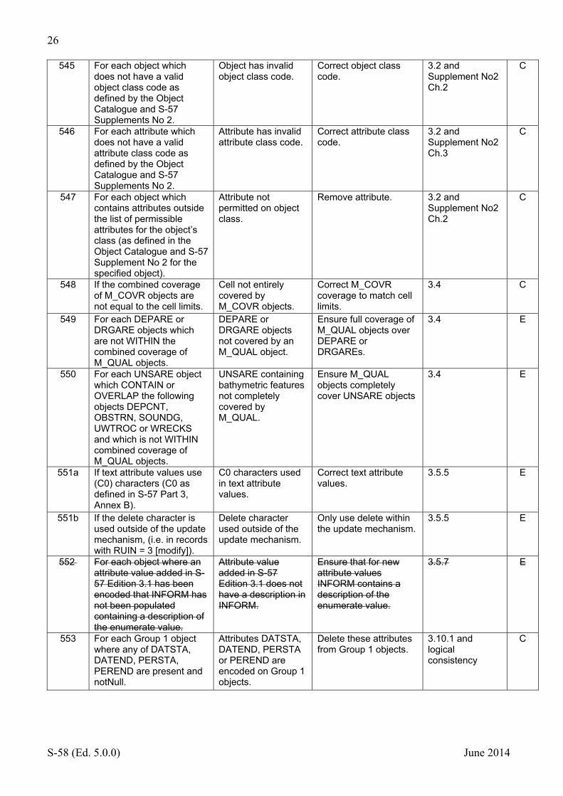
545 For each object which does not have a valid object class code as defined by the Object Catalogue and S-57 Supplements No 2.
Object has invalid object class code.
Correct object class code.
3.2 and Supplement No2 Ch.2
C
546 For each attribute which does not have a valid attribute class code as defined by the Object Catalogue and S-57 Supplements No 2.
Attribute has invalid attribute class code.
Correct attribute class code.
3.2 and Supplement No2 Ch.3
C
547 For each object which contains attributes outside the list of permissible attributes for the object’s class (as defined in the Object Catalogue and S-57 Supplement No 2 for the specified object).
Attribute not permitted on object class.
Remove attribute. 3.2 and Supplement No2 Ch.2
C
548 If the combined coverage of M_COVR objects are not equal to the cell limits.
Cell not entirely covered by M_COVR objects.
Correct M_COVR coverage to match cell limits.
3.4 C
549 For each DEPARE or DRGARE objects which are not WITHIN the combined coverage of M_QUAL objects.
DEPARE or DRGARE objects not covered by an M_QUAL object.
Ensure full coverage of M_QUAL objects over DEPARE or DRGAREs.
3.4 E
550 For each UNSARE object which CONTAIN or OVERLAP the following objects DEPCNT, OBSTRN, SOUNDG, UWTROC or WRECKS and which is not WITHIN combined coverage of M_QUAL objects.
UNSARE containing bathymetric features not completely covered by M_QUAL.
Ensure M_QUAL objects completely cover UNSARE objects
3.4 E
551a If text attribute values use (C0) characters (C0 as defined in S-57 Part 3, Annex B).
C0 characters used in text attribute values.
Correct text attribute values.
3.5.5 E
551b If the delete character is used outside of the update mechanism, (i.e. in records with RUIN = 3 [modify]).
Delete character used outside of the update mechanism.
Only use delete within the update mechanism.
3.5.5 E
552 For each object where an attribute value added in S-57 Edition 3.1 has been encoded that INFORM has not been populated containing a description of the enumerate value.
Attribute value added in S-57 Edition 3.1 does not have a description in INFORM.
Ensure that for new attribute values INFORM contains a description of the enumerate value.
3.5.7 E
553 For each Group 1 object where any of DATSTA, DATEND, PERSTA, PEREND are present and notNull.
Attributes DATSTA, DATEND, PERSTA or PEREND are encoded on Group 1 objects.
Delete these attributes from Group 1 objects.
3.10.1 and logical consistency
C

27
S-58 (Ed. 5.0.0) June 2014
554 For each edge referenced by only one M_COVR object with CATCOV = 1 [coverage available], that is also shared by more than one Group 1 object.
Edge of M_COVR coverage available referenced by more than one Group 1 object.
Ensure edges on the edge of data coverage only reference one Group 1 object.
3.10.1 C
555 If the order of the data in a base or update file is not correct.
Incorrect data order. Correct data order. 6.1.1 C
556a For a base cell file if the limits contained in the Catalogue Directory field (CATD) of the catalogue file (subfields SLAT, WLON, NLAT, ELON): are not equal to the furthest coordinates of the M_COVR object in the corresponding base cell file. Moved to section 2.3 as check 1018a
Limits in catalogue do not correspond to M_COVR limits for a base cell file.
Amend limits in catalogue or base cell file M_COVR object to agree.
5.6.3, 6.2.2 and logical consistency
C
556b For an update cell file if the limits are not identical to the limits of the base cell to which they apply. Moved to section 2.3 as check 1018b
Update with limits different to that of the target base cell.
Correct limits of update file.
5.6.3, 6.2.2 and logical consistency
C
557 For each SIGSEQ attribute value which does not conform to the correct structure (i.e. string content in accordance with format specification).
SIGSEQ attribute not formatted correctly.
Correct formatting of SIGSEQ attribute value.
Appendix A Ch.2 (code 143)
E
558 For each object where SIGSEQ is ‘not null’ and SIGPER is ‘not equal to’ the sum of the intervals of lit and eclipse given in SIGSEQ.
SIGPER does not correspond to SIGSEQ.
Ensure SIGPER corresponds to the value of SIGSEQ
Appendix A Ch.2 (code 143) and logical consistency
E
559a For all objects where STATUS =1 [permanent] with at least one of 2 [occasional], 5 [periodic/intermittent], 7 [temporary];
Illogical combination of STATUS values.
Amend values for STATUS.
Appendix A Ch.2 (code 149) and logical consistency
E
559b For all objects where STATUS =3 [recommended] with at least one of 4 [not in use], 11 [extinguished];
Illogical combination of STATUS values.
Amend values for STATUS.
Appendix A Ch.2 (code 149) and logical consistency
E
559c For all objects where STATUS =4 [not in use] with at least one of 5 [periodic/intermittent], 9 [mandatory];
Illogical combination of STATUS values.
Amend values for STATUS.
Appendix A Ch.2 (code 149) and logical consistency
E
559d For all objects where STATUS =5 [periodic/intermittent] with 11 [extinguished];
Illogical combination of STATUS values.
Amend values for STATUS.
Appendix A Ch.2 (code 149) and logical consistency
E

28
S-58 (Ed. 5.0.0) June 2014
559e For all objects where STATUS =9 [mandatory] with 11 [extinguished];
Illogical combination of STATUS values.
Amend values for STATUS.
Appendix A Ch.2 (code 149) and logical consistency
E
559f For all objects where STATUS =16 [watched] with 17 [un-watched];
Illogical combination of STATUS values.
Amend values for STATUS.
Appendix A Ch.2 (code 149) and logical consistency
E
559g For all objects where STATUS =8 [private] with 14 [public];
Illogical combination of STATUS values.
Amend values for STATUS.
Appendix A Ch.2 (code 149) and logical consistency
E
560a For all objects with the same FOID where the object class and attribute values are not identical.
Objects with the same FOID are not identical.
Ensure objects with the same FOID have the same object class and attribute values.
3.1 C
560b For all objects with the same FOID where the geometric primitives are of type Point OR are not of the same geometric primitive.
Objects with the same FOID are of type point or have geometric primitives of a different type.
Ensure point objects do not have the same FOID and that line and area objects which share FOIDs have the same geometric primitive type.
3.1 C
561 For all objects with identical FOIDs which are part of a collection object or master/slave relationship.
Objects with the same FOID part of a collection or master/slave relationship.
Ensure that objects with the same FOID are not part of collections or master slave relationships.
3.1 E
562 For all objects of type NEWOBJ where INFORM or TXTDSC does not contain the CLSNAM of the feature.
CLSNAM not included in INFORM or TXTDSC for a NEWOBJ object.
Populate INFORM or TXTDSC with the CLSNAM of the New Object.
Supplement No2 Ch.4 (3.3.1) and Appendix B1, Annex A (16)
C
563 For all objects of type RESARE where CATREA = 27 or 28 AND INFORM or TXTDSC do not contain the meaning of the value.
Attribute values of RESARE used without their meaning in INFORM or TXTDSC.
Populate TXTDSC or INFORM with value meaning.
Supplement No1 Ch.4 (3.5.7.1)
E
564 For all objects of type ARCSLN, ASLXIS, NEWOBJ or RESARE with CATREA = 27 [Environmentally Sensitive Sea Area (ESSA)] or 28 [Particularly Sensitive Sea Area (PSSA)], If the DSID subfield STED does not equal (03.1) OR PRED does not equal (2.0) OR COMT does
DSID subfields not correctly populated for a dataset containing new attribute values.
Correct DSID subfields STED (03.1) and PRED (2.0) and ensure COMT contains “STED:3.1.1;”.
Supplement No1 Ch.4 (6.3.2.1 and 6.4.2.1)
E
565 For all update (ER) files being applied to a base (EN) file where the COMT subfield of the DSID field contains “STED:3.1.1;” If STED is not equal to (03.1) AND PRED is not equal to (2.0).
Values of STED or PRED are not correct.
Ensure that where the COMT field contains “STED:3.1.1;” STED equals (03.1) and PRED equals (2.0).
Supplement No1 Ch.4 (6.4.2.1)
E

29
S-58 (Ed. 5.0.0) June 2014
566
Check that any NEWOBJ object has attributes CLSDEF, CLSNAM and SYMINS populated with exactly one of the following combinations:
Invalid use of New Object.
Amend to reflect TSMAD guidance.
EB 54 E
CLSDEF CLSNAM SYMINS
A Virtual object which indicates navigable water lies northwards
Virtual AtoN, North Cardinal SY(BRTHNO01);SY(BCNCAR01); TX('V-AIS',3,2,2,'15110',2,0,CHMGD,11)
A Virtual object which indicates navigable water lies eastwards
Virtual AtoN, East Cardinal SY(BRTHNO01);SY(BCNCAR02); TX('V-AIS',3,2,2,'15110',2,0,CHMGD,11)
A Virtual object which indicates navigable water lies southwards
Virtual AtoN, South Cardinal
SY(BRTHNO01);SY(BCNCAR03); TX('V-AIS',3,2,2,'15110',2,0,CHMGD,11)
A Virtual object which indicates navigable water lies westwards
Virtual AtoN, West Cardinal SY(BRTHNO01);SY(BCNCAR04); TX('V-AIS',3,2,2,'15110',2,0,CHMGD,11)
A Virtual object marking the port side of a channel
Virtual AtoN, Port Lateral SY(BRTHNO01);SY(BOYLAT24); TX('V-AIS',3,2,2,'15110',2,0,CHMGD,11)
A Virtual object marking the starboard side of a channel
Virtual AtoN, Starboard Lateral
SY(BRTHNO01);SY(BOYLAT13); TX('V-AIS',3,2,2,'15110',2,0,CHMGD,11)
A Virtual object marking the port side of a channel
Virtual AtoN, Port Lateral SY(BRTHNO01);SY(BOYLAT23); TX('V-AIS',3,2,2,'15110',2,0,CHMGD,11)
A Virtual object marking the starboard side of a channel
Virtual AtoN, Starboard Lateral
SY(BRTHNO01);SY(BOYLAT14); TX('V-AIS',3,2,2,'15110',2,0,CHMGD,11)
A Virtual object marking an isolated danger
Virtual AtoN, Isolated Danger
SY(BRTHNO01);SY(BCNISD21); TX('V-AIS',3,2,2,'15110',2,0,CHMGD,11)
A Virtual object marking safe water Virtual AtoN, Safe Water SY(BRTHNO01);SY(BOYSAW12); TX('V-AIS',3,2,2,'15110',2,0,CHMGD,11)
A Virtual object used to mark an area or feature referred to in nautical documents
Virtual AtoN, Special Purpose
SY(BRTHNO01);SY(BOYSPP11); TX('V-AIS',3,2,2,'15110',2,0,CHMGD,11)
A Virtual object marking a wreck Virtual AtoN, Wreck Marking
SY(BRTHNO01);SY(BOYSPP11); TX('V-AIS',3,2,2,'15110',2,0,CHMGD,11)
567 For each attribute of type 'list' where more than one instance of the same value is present AND the attribute is not COLOUR, NATQUA and NATSUR.
List attribute contains more than one of the same value.
Remove unnecessary attribute value.
Logical consistency
E
568 For each object where PERSTA AND PEREND are notNull AND their values are identical.
Object has identical values of PERSTA and PEREND.
Ensure values of PERSTA and PEREND are logical.
Logical consistency
E
569 For each object where PERSTA is notNull and PEREND is null or not present.
Object has PERSTA without a value of PEREND.
Populate PEREND or remove PERSTA.
Logical consistency
E
570 For each object where PEREND is notNull and PERSTA is null or not present.
Object has PEREND without a value of PERSTA.
Populate PERSTA or remove PEREND.
Logical consistency
E
571 For each edge which contains vertices at a density greater than 0.3mm at compilation scale.
Vertex density too great.
Generalise edge(s). 3.8
W

30
S-58 (Ed. 5.0.0) June 2014
572 For all objects where NINFOM is ‘notNull’ AND INFORM is ‘Null’ OR not present.
Information in national language is populated without Information.
Populate Information. 3.11.1 E
573 For all objects where NPLDST is ‘notNull’ AND PILDST is ‘Null’ OR not present.
Pilot district in national language is populated without Pilot district.
Populate Pilot district. 3.11.1 E
574 For all objects where NTXTDS is ‘notNull’ AND TXTDSC is ‘Null’ OR not present.
Textual description in national language is populated without Textual Description.
Populate TXTDSC and include relevant Text file
3.11.1 E

31
S-58 (Ed. 5.0.0) June 2014
2.3 Exchange Set Level Checks
No Check description Check message Check solution Conformity to: Cat
1000 (37)
If an update and its base cell do not have the same lexical level.
Update and base cell do not have the same lexical level.
Correct the lexical level of the update.
Part 3 (8.4.2.2a) C
1001 (68)
For each object which references a text/graphic file and the text/graphic file is not present in the exchange set.
Text or graphic file referenced by update is not present.
Add text or graphic files to exchange set.
C
1002 (85)
For each update (ER) file where an AGEN subfield value (In DSID and FOID fields) is not identical to the AGEN subfield values in the base (EN) file.
AGEN subfield values do not agree between update (ER) and base (EN) files.
Amend AGEN subfield values to agree.
Part 3 (4.3.1) and (7.3.1.1)
C
1003 (90a)
For a catalogue file where the DDR (Data Descriptive Record) does not contain only the description of the catalogue file structure.
Invalid DDR (Data Descriptive Record) in catalogue file.
Correct DDR (Data Descriptive Record).
Part 3 ( 7 ) and Part 3 (A.2)
W
1004 (92)
For each FRID field in an update (ER) file where RUIN = 3 [modify] and the FOID for the modified object is not identical in the base (EN) and update (ER) files.
FOIDS do not match for a modify update between update ER and base EN files.
Correct FOIDs to be identical or make separate insert and delete updates.
Part 3 (8.4.2) C
1005 (527)
For all attributes TXTDSC,NTXTDS,PICREP which are ‘notNull’ and referenced files do not exist or their names do not conform to the ENC Product Specification.
Referenced files are missing or their names are non-conformant.
Ensure referenced files exist and are named correctly.
Appendix B.1 5.4.1 and 5.6.4
C
1006 (528)
If a catalogue file does not exist.
No catalogue file exists.
Create a catalogue file. Appendix B.1 5.4.1
C
1007 (529)
If volume name is not in accordance with the ENC Product Specification.
Volume name is not in accordance with the ENC Product Specification.
Correct the volume name.
Appendix B.1 5.4.2
C
1008 (530)
If the directory structure for physical media is not in accordance with the ENC Product Specification.
The directory structure for physical media is not in accordance with the ENC Product Specification.
Correct the directory structure of the physical media.
Appendix B.1 5.4.3
C
1009 (532)
If the text and graphic file names are NOT unique, OR NOT with extension (e.g. .TXT and .TIF). for new editions and re-issues.
Text and graphic file names incorrect format/name.
Use correctly formatted and named text and graphic files.
Appendix B.1 5.6.4
C
1010 (535)
If the CRC value in the catalogue file does not equal that in the dataset.
CRC values do not match.
Correct CRC value. Appendix B.1 5.9.1
C
1011 (537)
If the format of the catalogue file is not correct.
Catalogue file format not correct.
Correct format of the catalogue file.
Appendix B.1 6.2 C

32
S-58 (Ed. 5.0.0) June 2014
1012 (538)
If CATD-IMPL DOES NOT EQUAL “BIN”
CATD-IMPL is not set to “BIN”
Correct CADT-IMPL. Appendix B.1 6.2.2
E
1013 For each object where TXTDSC AND NTXTDS are notNull and the files referenced are identical or empty.
Files referenced by TXTDSC and NTXTDS are the same or empty.
Ensure files are different.
Logical consistency
W
1014 (1520)
If the value of the EDTN (Edition Number) subfield of the DSID (Data Set Identification) field is incorrect.
Incorrect value of Edition Number.
Correct Edition Number.
Appendix B.1 Annex A 2.2.2
C
1015a (1521a)
If the data set is not a reissue AND UPDN (Update Number) subfield of the DSID (data Set Identification) field is incorrect OR it is not equivalent to the extension of the data set file name.
Update number is incorrect or not equivalent to the data set file name extension.
Amend Update number.
Appendix B.1 Annex A 2.2.2
C
1015b (1521b)
If the data set is a reissue AND UPDN (Update Number) subfield of the DSID (data Set Identification) field is not equal to the last update number.
Reissue data set where Update number is not equal to the last update number.
Amend Update number to the value of the last update number.
Appendix B.1 Annex A 2.2.2
C
1016 (1556)
For each text file forming part of the dataset which is not an ASCII file AND is not referenced by the attribute NTXTDS.
Non ASCII text file included in the dataset.
Include as an ASCII file or ensure referenced by NTXTDS when NATF lexical level subfield [NALL] of the Data Set Structure Information field [DSSI] is set to (2).
Appendix B.1 Annex A 2.3
C
1017 (1638)
For each picture file which is not in the TIFF format.
Picture file not in Tiff format.
Replace picture file with Tiff format version.
Appendix B.1 Annex A 4.8.20
C
1018a (556a)
For a base cell file if the limits contained in the Catalogue Directory field (CATD) of the catalogue file (subfields SLAT, WLON, NLAT, ELON): are not equal to the furthest coordinates of the M_COVR object in the corresponding base cell file.
Limits in catalogue do not correspond to M_COVR limits for a base cell file.
Amend limits in catalogue or base cell file M_COVR object to agree.
Appendix B.1 5.6.3, 6.2.2 and logical consistency
C
1018b (556b)
For an update cell file if the limits are not identical to the limits of the base cell to which they apply.
Update with limits different to that of the target base cell.
Correct limits of update file.
Appendix B.1 5.6.3, 6.2.2 and logical consistency
C

33
S-58 (Ed. 5.0.0) June 2014
2.4 Checks relating to Use of the Object Catalogue for ENC
No Check description Check message Check solution Conformity to: Cat
1500 For each LNDARE of type area which OVERLAPS a CBLARE or SBDARE of type area.
SBDARE or CBLARE sit on a LNDARE object.
Amend CBLARE or SBDARE objects these objects should not sit on land.
Logical consistency
W
1501 For each object of type M_HDAT.
M_HDAT object present.
Remove M_HDAT object.
2.1.1 E
1502 For each spatial object which contains the attribute HORDAT
HORDAT used in a spatial object.
Remove HORDAT. 2.1.1 E
1503 For each object not of type M_VDAT and M_SDAT where VERDAT is notNull AND none of the following are notNull ELEVAT, HEIGHT, VERCCL, VERCLR, VERCOP or VERCSA.
Value of VERDAT without corresponding vertical distance value.
Remove VERDAT or populate vertical distance attribute.
2.1.2 E
1504 If the value of VDAT (Vertical Datum subfield) of the DPSM (Data set Parameter field) is NULL.
Vertical Datum subfield (VDAT) not populated within DPSM field.
Populate VDAT with the vertical datum of the cell.
2.1.2 C
1505 For each M_VDAT meta object where VERDAT is notNull AND equal to the value of VERDAT in the Vertical Datum subfield (VDAT) of the Data Set Parameter field (DSPM).
Value of VERDAT matches that in the VDAT subfield of the DPSM field.
Remove unnecessary value of VERDAT.
2.1.2 E
1506 For each object where any of ELEVAT, HEIGHT, VERCCL, VERCLR, VERCOP or VERCSA is notNull AND which OVERLAPS more than one M_VDAT object.
Object with height value not split at boundary of M_VDAT object.
Split object at boundary of M_VDAT object.
2.1.2 E
1507 For each object of type M_VDAT which OVERLAPS another object of type M_VDAT.
M_VDAT objects overlap.
Edit M_VDAT objects so that they do not overlap.
2.1.2 E
1508 For each object of type M_SDAT which OVERLAPS another object of type M_SDAT.
M_SDAT objects overlap.
Edit M_SDAT objects so that they do not overlap.
2.1.3 E
1509 For each object of type DEPARE DEPCNT, DRGARE, OBSTRN, SOUNDG, UWTROC, or WRECKS where VERDAT is present.
VERDAT on object which cannot have a height or elevation value.
Remove VERDAT from inappropriate object.
2.1.3 E
1510 If the SDAT (Sounding Datum subfield) of the DPSM (Data Set Parameter field) is null.
SDAT (Sounding Datum subfield) is not populated.
Populate SDAT (Sounding Datum subfield).
2.1.3 C

34
S-58 (Ed. 5.0.0) June 2014
1511 For each M_SDAT object where VERDAT is equal to the value of SDAT (Sounding Datum subfield) of the DSPM (Data Set Parameter field).
M_SDAT object has the same VERDAT as in the SDAT subfield of the DSPM.
Delete M_SDAT object or amend value of VERDAT.
2.1.3 E
1512a For each object of type SOUNDG which OVERLAPS more than one M_SDAT object.
SOUNDG object overlaps multiple M_SDAT objects.
Split SOUNDG object at boundary of M_SDAT objects.
2.1.3 E
1512b For each object of where any of VALSOU, VALDCO, WATLEV, EXPSOU, DRVAL1 or DRVAL2 is notNull AND which OVERLAPS more than one M_SDAT object.
Object with depth information overlaps multiple M_SDAT objects.
Split object at boundary of M_SDAT objects.
2.1.3 E
1513 If the value of the HUNI (Units of Height measurement subfield) of the DSPM (Data Set Parameter field) is not equal to (1) [metre]
Units of Height measurement subfield is not set to (1) [metres].
Set Units of Height measurement to (1) [metres].
2.1.4 C
1514 For each object of type M_UNIT
M_UNIT object present in cell.
Delete M_UNIT object. 2.1.4 E
1515a For each object where a value of DATEND, DATSTA, PEREND, PERSTA, does not conform to the formatting defined in ISO 8601:1988.
Date attribute not formatted according to ISO 8601:1988.
Amend formatting to conform to ISO 8601:1988.
2.1.5 C
1515b For each object where a value of SORDAT, CPDATE, SUREND or SURSTA does not conform to the formatting defined in ISO 8601:1988.
Date attribute not formatted according to ISO 8601:1988.
Amend formatting to conform to ISO 8601:1988.
2.1.5 E
1516 For each Group 2 object having STATUS, PERSTA and PEREND allowable where STATUS equals (5) [periodic/intermittent] AND PERSTA or PEREND are null or not present.
PERSTA or PEREND not populated where STATUS equals 5
Populate PERSTA or PEREND with values or remove STATUS (5) [periodic/intermittent]
2.1.5.1 W
1517 For each object where TIMSTA OR TIMEND is notNull AND their values do not conform to the format defined in Chapter 2 of S-57 Appendix A.
TIMEND or TIMSTA are not formatted correctly.
Correct the formatting of TIMEND or TIMSTA.
2.1.6 E
1518a If the AGEN (Producing Agency subfield) of the DSID (Data Set Identification field) is not one of the values listed in S-62 sections I and II.
Producing Agency code not a valid value as defined in S-62.
Amend AGEN sub field to a valid S-62 value.
2.2.1 C

35
S-58 (Ed. 5.0.0) June 2014
1518b If the first 2 characters of the data set file name do not correspond to the value of the AGEN (Producing agency subfield) of the DSID (Data Set Identification field).
Data set file name does not begin with the agency code corresponding to that set in the AGEN subfield of the DSID field.
Correct the first 2 characters of the data set file name.
2.2.1 C
1519 For each object of type M_PROD.
M_PROD object present in cell.
Delete M_PROD object.
2.2.1 E
1520 If the value of the EDTN (Edition Number) subfield of the DSID (Data Set Identification) field is incorrect. Moved to section 2.3 as check 1014
Incorrect value of Edition Number.
Correct Edition Number.
2.2.2 C
1521a If the data set is not a reissue AND UPDN (Update Number) subfield of the DSID (data Set Identification) field is incorrect OR it is not equivalent to the extension of the data set file name. Moved to section 2.3 as check 1015a
Update number is incorrect or not equivalent to the data set file name extension.
Amend Update number.
2.2.2 C
1521b If the data set is a reissue AND UPDN (Update Number) subfield of the DSID (data Set Identification) field is not equal to the last update number. Moved to section 2.3 as check 1015b
Reissue data set where Update number is not equal to the last update number.
Amend Update number to the value of the last update number.
2.2.2 C
1522a If the file extension if “.000” AND the value of the UADT (Update application date) subfield of the DSID (Data Set Identification) field is incorrect.
Incorrect value of Update application date for a base cell.
Amend Update application date.
2.2.2 C
1522b If the file extension is not “.000” AND the UADT (Update application date) subfield of the DSID (Data Set Identification) field is notNull.
Update application date is not NULL for an update.
Make Update application date NULL.
2.2.2 & Appendix B.1 (5.7)
C
1523a If the value of the ISDT (Issue date) subfield of the DSID (Data Set Identification) field is incorrect.
Issue date is incorrect.
Amend Issue date. 2.2.2 C
1523b If the data set file name extension equals “.000” AND the ISDT (Issue date) subfield of the DSID (Data Set Identification) field is less than the value of the UADT (Update application date) subfield.
For a base data set the update application date falls before the issue date.
Amend update application date or issue date accordingly.
2.2.2 & Appendix B.1 (5.7)
C

36
S-58 (Ed. 5.0.0) June 2014
1524 For each M_QUAL object which is not completely WITHIN a SWPARE object AND where DRVAL1 is notNull.
M_QUAL which is not covered by a SWPARE object contains DRVAL1.
Remove value of DRVAL1.
2.2.3.1 E
1525 For each M_QUAL object where POSACC is notNull AND DRVAL1 is notNull.
M_QUAL object where DRVAl1 and POSACC are populated.
Amend attribute values accordingly.
2.2.3.1 E
1526 For each M_QUAL object where SOUACC is notNull AND DRVAL1 is NULL.
M_QUAL object where SOUACC is populated without a value for DRVAL1.
Populate DRVAL1 o 2.2.3.1 E
1527 For each M_QUAL object where DRVAL2 is less than the maximum depth value WITHIN the CATZOC category for that M_QUAL object indicates.
2.2.3.1 E
1528 For each M_QUAL object where TECSOU is notNull AND any object WITHIN the object contains a different value of TECSOU.
TECSOU value of M_QUAL differs from a value used within that M_QUAL.
Amend or remove TECSOU from M_QUAL.
2.2.3.1 E
1529 For each object within an M_QUAL object where TECSOU is notNull AND the value of TECSOU is equivalent to the TECSOU on the M_QUAL object.
TECSOU value on object is equivalent to value used on the M_QUAL it lies within.
Remove unnecessary value of TECSOU.
2.2.3.1 and 2.2.3.5
E
1530 For each object within an M_QUAL object where SOUACC is notNull AND the value of SOUACC is equivalent to the SOUACC or CATZOC values on the M_QUAL object.
SOUACC value on object is equivalent to value used on the M_QUAL it lies within.
Remove unnecessary value of SOUACC.
2.2.3.1 and 2.2.3.4
E
1531 For each object within an M_QUAL object where POSACC, SOUACC, QUASOU or TECSOU is notNull AND the value of SOUACC is equivalent to or degrades the accuracy of the value of CATZOC on the M_QUAL object.
Value of POSACC, SOUACC, QUASOU or TECSOU on object is equivalent to or degrades the accuracy of CATZOC on the M_QUAL it lies within.
Remove inappropriate value of POSACC, SOUACC, QUASOU or TECSOU.
2.2.3.1 E
1532 For each M_QUAL object where SURSTA is not equal to the smallest (oldest) value of SURSTA on any M_SREL objects within the M_QUAL object.
SURSTA on M_QUAL object does not relate to the oldest survey within the M_QUAL object.
Amend value of SURSTA on M_QUAL to reflect the oldest survey within it.
2.2.3.1 E
1533 For each DRGARE object where SOUACC is notNull AND it is equivalent to or degrades the value of CATZOC on the M_QUAL object it is WITHIN.
SOUACC on DRGARE is equivalent to or degrades the value of CATZOC on the underlying M_QUAL object.
Amend CATZOC on M_QUAL.
2.2.3.1 E
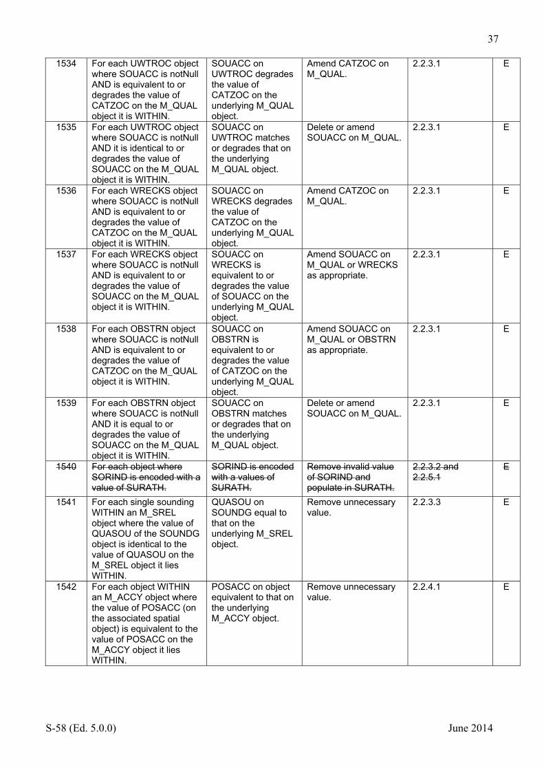
37
S-58 (Ed. 5.0.0) June 2014
1534 For each UWTROC object where SOUACC is notNull AND is equivalent to or degrades the value of CATZOC on the M_QUAL object it is WITHIN.
SOUACC on UWTROC degrades the value of CATZOC on the underlying M_QUAL object.
Amend CATZOC on M_QUAL.
2.2.3.1 E
1535 For each UWTROC object where SOUACC is notNull AND it is identical to or degrades the value of SOUACC on the M_QUAL object it is WITHIN.
SOUACC on UWTROC matches or degrades that on the underlying M_QUAL object.
Delete or amend SOUACC on M_QUAL.
2.2.3.1 E
1536 For each WRECKS object where SOUACC is notNull AND is equivalent to or degrades the value of CATZOC on the M_QUAL object it is WITHIN.
SOUACC on WRECKS degrades the value of CATZOC on the underlying M_QUAL object.
Amend CATZOC on M_QUAL.
2.2.3.1 E
1537 For each WRECKS object where SOUACC is notNull AND is equivalent to or degrades the value of SOUACC on the M_QUAL object it is WITHIN.
SOUACC on WRECKS is equivalent to or degrades the value of SOUACC on the underlying M_QUAL object.
Amend SOUACC on M_QUAL or WRECKS as appropriate.
2.2.3.1 E
1538 For each OBSTRN object where SOUACC is notNull AND is equivalent to or degrades the value of CATZOC on the M_QUAL object it is WITHIN.
SOUACC on OBSTRN is equivalent to or degrades the value of CATZOC on the underlying M_QUAL object.
Amend SOUACC on M_QUAL or OBSTRN as appropriate.
2.2.3.1 E
1539 For each OBSTRN object where SOUACC is notNull AND it is equal to or degrades the value of SOUACC on the M_QUAL object it is WITHIN.
SOUACC on OBSTRN matches or degrades that on the underlying M_QUAL object.
Delete or amend SOUACC on M_QUAL.
2.2.3.1 E
1540 For each object where SORIND is encoded with a value of SURATH.
SORIND is encoded with a values of SURATH.
Remove invalid value of SORIND and populate in SURATH.
2.2.3.2 and 2.2.5.1
E
1541 For each single sounding WITHIN an M_SREL object where the value of QUASOU of the SOUNDG object is identical to the value of QUASOU on the M_SREL object it lies WITHIN.
QUASOU on SOUNDG equal to that on the underlying M_SREL object.
Remove unnecessary value.
2.2.3.3 E
1542 For each object WITHIN an M_ACCY object where the value of POSACC (on the associated spatial object) is equivalent to the value of POSACC on the M_ACCY object it lies WITHIN.
POSACC on object equivalent to that on the underlying M_ACCY object.
Remove unnecessary value.
2.2.4.1 E

38
S-58 (Ed. 5.0.0) June 2014
1543 For each object WITHIN an M_ACCY object where the value of QUAPOS is equivalent to the value of QUAPOS on the M_ACCY object it lies WITHIN
QUAPOS on object equivalent to that on the underlying M_ACCY object.
Remove unnecessary value.
2.2.4.1 E
1544 For each M_ACCY object where HORACC, SOUACC or VERACC are present.
M_ACCY object includes HORACC, SOUACC or VERACC.
Remove attribute values.
2.2.4.1 E
1545 For each object where HORACC is notNull AND HORCLR is NULL or not present.
Value for HORACC without a value of HORCLR.
Add HORCLR value or remove HORACC.
2.2.4.2 E
1546 For each object where VERACC is notNull AND VERCLR, VERCOP, VERCSA VERCCL are all NULL or not present.
Value for VERACC without value of VERCLR, VERCOP, VERCSA or VERCCL.
Remove VERACC of populate vertical clearance value.
2.2.4.3 E
1547 For each object where SORIND is notNull and SORDAT is notNul AND the values are not identical to those on the M_SREL object the object is within.
SORIND and SORDAT are identical to those on M_SREL.
Delete unnecessary values of SORIND and SORDAT.
2.2.5.1 W
1548 For each object which is not of type SOUNDG, DEPCNT, DEPARE, DRGARE, OBSTRN where SORIND is notNull and SORDAT is NULL or not present.
Value of SORIND without a value of SORDAT on non-bathymetric object.
Populate SORDAT with an appropriate value.
2.2.5.2 W
1549 If the value of CSCL (Compilation Scale of data subfield) of the DPSM (Data Set Parameter field) is NULL.
CSCL is not populated with a value.
Populate CSCL with an appropriate value.
2.2.6 C
1550 For each M_CSCL object where CSCALE is equal to the value of CSCL (Compilation scale of data) subfield in the DPSM (Data Set Parameter) field.
CSCALE of M_CSCL is identical to the value given as the Compilation scale of the dataset.
Remove unnecessary M_CSCL object.
2.2.6 E
1551 For each M_CSCL object which OVERLAPS another M_CSCL object.
M_CSCL object overlap.
Amend M_CSCL objects so that they do not overlap.
2.2.6 E
1552 For each object where SCAMAX is present.
SCAMAX encoded on an object.
Remove SCAMAX. 2.2.7 E
1553 For each value of SCAMIN which is less than or equal to the compilation scale of the data for the area.
SCAMIN value less than compilation scale.
Amend SCAMIN value accordingly.
2.2.6 and 2.2.7 E
1554a For each Group 1 object where SCAMIN is present.
SCAMIN present on a Group 1 object.
Remove SCAMIN. 2.2.7 C
1554b For each meta object where SCAMIN is present.
SCAMIN present on a meta object.
Remove SCAMIN. 2.2.7 C
1555 For each object where INFORM or NINFOM contain formatting characters (C0 as defined in S-57 Part 3, Annex B).
INFORM or NINFOM contain formatting characters.
Remove formatting characters from attribute values.
2.3 E

39
S-58 (Ed. 5.0.0) June 2014
1556 For each text file forming part of the dataset which is not an ASCII file AND is not referenced by the attribute NTXTDS. Moved to section 2.3 as check 1016
Non ASCII text file included in the dataset.
Include as an ASCII file or ensure referenced by NTXTDS when NATF lexical level subfield [NALL] of the Data Set Structure Information field [DSSI] is set to (2).
2.3 C
1557 For each T_HMON object where T_MTOD does not equal (1) [simplified harmonic method of tidal prediction] or (2) [full harmonic method of tidal prediction].
T_HMON object where the value of T_MTOD is not (1) or (2).
Amend T_MTOD to valid value.
3.2.2 E
1558 For each T_NHMN object where T_MTOD does not equal (3) [time and height difference non-harmonic method].
T_NHNM object where the value of T_MTOD is not (3).
Amend T_MTOD to a valid value.
3.2.3 E
1559 For each T_NHMN object which is not associated (using the C_ASSO collection object with a T_TIMS or T_HMON object).
T_NHMN which is not associated with an appropriate object.
Associate T_NHNM with a T_TIMS or T_HMON object.
3.2.3 E
1560 For each TS_PRH object where T_MTOD is not equal to (1) [simplified harmonic method of tidal prediction] OR (2) [full harmonic method of tidal prediction].
TS_PRH object has a value other than (1) or (2) for T_MTOD.
Amend T_MTOD to a valid value.
3.3.3 E
1561 For each TS_PNH object where T_MTOD does not equal (3) (time and height difference non-harmonic method).
For TS_PNH T_MTOD is not (3) (time and height difference non-harmonic method).
Amend T_MTOD to (3). 3.3.4 E
1562 For each TS_PNH object which is not associated with (using the collection object C_ASSO) a TS_TIS OR TS_PRH object.
TS_PNH not associated to a TS_TIS or TS_PRH object.
Associate TS_PNH to a TS_TIS or TS_PRH object using C_ASSO.
3.3.4 E
1563 For each RIVERS, CANALS, LAKARE, DOCARE or LOKBSN object which is not WITHIN a LNDARE or UNSARE object of type area.
Non navigable water objects not covered by UNSARE or LNDARE.
Amend LNDARE Or UNSARE to cover these object types.
4.1 W
1564 For each CTRPNT object where VERDAT or VERACC are present.
VERDAT or VERACC present on a CTRPNT object.
Remove VERDAT or VERACC.
4.3 E

40
S-58 (Ed. 5.0.0) June 2014
1565 For each edge of a LNDARE object of type area which is not COINCIDENT with one of the following objects; a) COALNE, SLCONS, GATCON, DAMCON of type line. OR b) M_COVR, GATCON, DAMCON, RIVERS, TUNNEL, DRYDOC, CANALS, LAKARE, LOKBSN, DOCARE, LNDARE of type area. OR c) CAUSWY, SLCONS, MORFAC, WRECKS, OBSTRN, PYLONS where WATLEV = 1 [partly submerged at high water], 2 [always dry] or 6 [subject to inundation or flooding].
LNDARE not enclosed by appropriate linear or area object.
Ensure LNDARE is enclosed by an appropriate object.
4.5 E
1566 For each edge of a COALNE object OR SLCONS object of type line which is COINCIDENT with a RIVERS, CANALS, LAKARE, DOCARE, DRYDOC or LOKBSN object AND is not COINCIDENT with a DEPARE, DRGARE, UNSARE, PONTON, FLODOC or HULKES object.
COALNE or SLCONS used as the boundary of objects on LAND.
Not required therefore remove COALNE or SLCONS object.
4.5, 4.6.6.1, 4.6.6.3
E
1567 For each COALNE object where VERDAT or VERACC are present.
COALNE object includes VERACC or VERDAT.
Remove values of VERACC or VERDAT.
4.5.1 E
1568 For each SLCONS object of type area which is not WITHIN a LNDARE, DEPARE or UNSARE of type area.
Area SLCONS not covered by a appropriate TG1 object.
Amend appropriate TG1 object to cover SLCONS object.
4.5.2 E
1569 For each SLCONS object of type area where WATLEV = 3 [always under water/submerged], 4 [covers and uncovers] or 5 [awash] AND which is not WITHIN a DEPARE and/or UNSARE of type area.
Area SLCONS not covered by a appropriate TG1 object.
Amend appropriate TG1 object to cover SLCONS object.
4.5.2 E
1570 For each SLCONS object where VERDAT or VERACC are present.
SLCONS object includes VERACC or VERDAT.
Remove values of VERACC or VERDAT.
4.5.2 E
1571 For each BERTHS object where VERDAT is present.
BERTHS object includes VERDAT.
Remove value of VERDAT.
4.6.2 E
1572 For each DRYDOC object where VERDAT is present.
DRYDOC object includes VERDAT.
Remove value of VERDAT.
4.6.6.1 E

41
S-58 (Ed. 5.0.0) June 2014
1573 For each DRYDOC object which is not WITHIN a LNDARE object of type area.
DRYDOC not covered by LNDARE.
Amend LNDARE or DRYDOC as required.
4.6.6.1 E
1574 For each edge of a DRYDOC object which does not TOUCH a GATCON object AND TOUCHES an SLCONS or COALNE object.
DRYDOC object is bounded by an SLCONS or COALNE object.
Amend or delete SLCONS or COALNE objects.
4.6.6.1 E
1575 For each FLODOC object where VERDAT or VERACC are present.
FLODOC object includes VERACC or VERDAT.
Remove values of VERACC or VERDAT.
4.6.6.2 E
1576 For each edge of a DOCARE object which does not TOUCH a GATCON object AND TOUCHES an SLCONS or COALNE object.
DOCARE object is bounded by an SLCONS or COALNE object.
Amend or delete SLCONS or COALNE objects.
4.6.6.3 E
1577 For each DOCARE where its geometric primitive EQUALS OVERLAPS a SEAARE object.
DOCARE overlaps SEAARE.
Amend or delete SEAARE as required.
4.6.6.3 W
1578 For each GATCON object where VERDAT is notNull AND VERCLR is not present.
VERDAT populated without VERCLR being present.
Remove VERDAT or populate VERCLR.
4.6.6.4 E
1579 For each GATCON object where VERACC is notNull AND VERCLR is not present.
VERACC populated without VERCLR being present.
Remove VERACC or populate VERCLR.
4.6.6.4 E
1580 For each GATCON which is not WITHIN a DEPARE, DRGARE, UNSARE or LNDAREof type area.
GATCON not covered by DEPARE, DRGARE, UNSARE or LNDARE.
Amend objects to ensure GATCON is covered by DEPARE, DRGARE, UNSARE or LNDARE.
4.6.6.4 E
1581 For each LOKBSN where its geometric primitive EQUALS OVERLAPS a SEAARE object.
LOKBSN overlaps SEAARE.
Amend or delete SEAARE as required.
4.6.6.5 W
1582 For each GRIDRN object where HORACC or VERACC are present.
GRIDRN object includes VERACC or HORACC.
Remove values of VERACC or HORDAT.
4.6.6.6 E
1583 For each MORFAC object where VERDAT or VERACC are present.
MORFAC object includes VERACC or VERDAT.
Remove values of VERACC or VERDAT.
4.6.7.1 E
1584 For each MORFAC object where WATLEV = 1 [partly submerged at high water] OR 2 [always dry] OR 6 [subject to inundation or flooding] which is not WITHIN a LNDARE object of type area.
MORFAC with WATLEV=1, 2 or 6 not covered by LNDARE.
Amend MORFAC or LNDARE as required.
4.6.7.1 E
1585 For each PILPNT object where VERDAT or VERACC are present.
PILPNT object includes VERACC or VERDAT.
Remove values of VERACC or VERDAT.
4.6.7.2 E
1586 For each PONTON object where VERACC is present.
PONTON object includes VERACC.
Remove value of VERACC.
4.6.7.3 E

42
S-58 (Ed. 5.0.0) June 2014
1587 For each HULKES object where HORACC OR VERACC are present.
HULKES object includes HORACC or VERACC.
Remove value of VERACC or HORACC.
4.6.8 E
1588 For each CRANES object where VERACC is notNull AND VERCLR is not present.
CRANES object includes VERACC without a value of VERCLR.
Populate VERCLR or remove VERACC.
4.6.9.3 E
1589 For each object where CONDTN equals (1) [under construction], (3) [under reclamation] or (5) [planned construction] AND SORDAT is null or not present.
Object has a value of CONDTN equal to 1,3 or 5 without a value for SORDAT.
Populate SORDAT. 4.6.10 W
1590 For each LNDRGN object which is not OVERLAPPED by a LNDARE object.
LNDRGN not covered by LNDARE object.
Ensure LNDRGN is covered by or contains a LNDARE object.
4.7.1 W
1591 For each LNDELV object where VERDAT or VERACC are present.
LNDELV object includes VERACC or VERDAT.
Remove values of VERACC or VERDAT.
4.7.2 E
1592 For each COALNE object which is COINCIDENT with a LNDRGN object where CATLND equals (2) [marsh] AND CATCOA on the COALNE object does not equal (8) [marshy shore] OR QUAPOS does not equal (4)[approximate].
Invalid value of QUAPOS or CATCOA for a COALNE object adjacent to a LNDRGN where CATLND equals (2) [marsh].
Amend value of QUAPOS or CATCOA as required.
4.7.3 W
1593 For each SLOGRD object where NATCON OR NATQUA are present.
SLOGRD object includes NATCON or NATQUA.
Remove values of NATCON or NATQUA.
4.7.4 E
1594 For each SLOTOP object where NATCON, NATQUA, VERACC OR VERDAT are present.
SLOTOP contains values for NATCON, NATQUA, VERACC or VERDAT.
Remove unnecessary values of NATCON, NATQUA, VERACC or VERDAT.
4.7.5 E
1595 For each SLOTOP object where CATSLO equals (6) [cliff] AND the object is COINCIDENT with a COALNE object.
SLOTOP object where CATSLO=(6) coincides with a COALNE object.
Delete SLOTOPobject only COALNE with CATCOA=(1) should be encoded.
4.7.5 W
1596 For each SLOGRD object where CATSLO equals (6) [cliff] AND the object TOUCHES a COALNE object.
SLOGRD object where CATSLO=(6) touches a COALNE object.
Delete SLOGRD object only COALNE with CATCOA=(1) should be encoded.
4.7.5 W
1597 For each RIVERS object where its geometric primitive EQUALS OVERLAPS a SEAARE object.
RIVERS object overlaps a SEAARE object.
Amend SEAARE object.
4.7.6 E
1598 For each RAPIDS object where VERACC is present.
RAPIDS object includes value of VERACC.
Remove value of VERACC.
4.7.7.1 E
1599a For each RAPIDS or WATFAL object which is not WITHIN or COINICIDENT with a RIVERS object.
RAPIDS or WATFAL not within or touching a RIVERS object.
Ensure within or touching RIVERS.
4.7.7.1 and 4.7.7.2
W

43
S-58 (Ed. 5.0.0) June 2014
1599b For each RAPIDS or WATFAL object which is not WITHIN a LNDARE or UNSARE object.
RAPIDS or WATFAL not within LNDARE or UNSARE.
Ensure covered by LNDARE or UNSARE.
4.7.7.1 and 4.7.7.2
W
1600 For each WATFAL object where VERACC is present.
WATFAL object includes value of VERACC.
Remove value of VERACC.
4.7.7.2 E
1601 For each LAKARE object where VERDAT or VERACC is present.
LAKARE object includes value of VERACC or VERDAT.
Remove values of VERACC and VERDAT.
4.7.8 E
1602 For each LAKARE where its geometric primitive EQUALS OVERLAPS a SEAARE object.
LAKARE overlaps SEAARE object.
Amend objects to remove overlap.
4.7.8 W
1603 For each LAKSHR object. LAKSHR object present.
Delete prohibited object LAKSHR.
4.7.8 E
1604 For each COALNE object which is COINCIDENT with a LNDRGN object where CATLND equals (15) [salt pan] AND CATCOA on the COALNE object does not equal (2) [flat coast).
COALNE object adjacent to LNDRGN with CATLND = salt pans does not have CATCOA = flat coast.
Amend CATCOA on COALNE object to (2) [flat coast].
4.7.9 W
1605 For each ICEARE object which is not WITHIN a LNDARE or UNSARE or DEPARE object of type area.
ICEARE not covered by appropriate TG1 objects.
Amend objects to ensure TG1 objects cover.
4.7.10 E
1606 For each COALNE object where CATCOA is not equal to (6) [glacier (seaward end)] AND which is COINCIDENT with an ICEARE object where CATICE = (5) [glacier].
COALNE without CATCOA (6) touching an ICEARE with CATICE (5) [glacier].
Populate CATCOA = (6) ) [glacier (seaward end)] for the COALNE object.
4.7.10 W
1607a For each COALNE object where CATCOA is not (7) [mangrove] AND is COINCIDENT with a VEGATN object where CATVEG = (7) [mangroves].
Value of CATCOA is not (7) [mangrove] where a VEGATN object with CATVEG = (7) [mangroves] is coincident.
Populate CATCOA (7) [mangrove] on the COALNE object.
4.7.11 W
1607b For each VEGATN object where CATVEG = (7) [mangroves] AND the QUAPOS of the spatial object is not (4) [approximate].
VEGATN object where CATVEG = (7) [mangroves] without QUAPOS = (4) [approximate].
Populate QUAPOS = (4) [approximate].
4.7.11 W
1608 For each VEGATN object where VERDAT OR VERACC are present.
VEGATN object includes VERDAT or VERACC.
Remove values of VERDAT or VERACC.
4.7.11 E
1609 For each CANALS object where its geometric primitive EQUALS OVERLAPS a SEAARE object.
CANALS overlaps SEAARE object.
Amend objects to remove overlap.
4.8.1 W
1610 For each RAILWY object where VERACC is present.
RAILWY object includes value of VERACC.
Remove value of VERACC.
4.8.2 E

44
S-58 (Ed. 5.0.0) June 2014
1611 For each TUNNELS object where BURDEP is present.
TUNNELS object includes value of BURDEP.
Remove value of BURDEP.
4.8.3 E
1612 For each TUNNEL object which is not WITHIN a LNDARE, DEPARE, UNSARE or DRGARE object.
TUNNEL not within a LNDARE, DEPARE, UNSARE or DRGARE object.
Ensure TUNNEL is within an appropriate object.
4.8.3 W
1613 For each TUNNEL object which CONTAINS a CANALS object AND where any of HORCLR, VERACC or VERCLR are notNull.
TUNNEL which covers a CANALS object has values of HORCLR, VERACC or VERCLR.
Remove unnecessary attribute values.
4.8.3 E
1614 For each object of type TUNNEL which CONTAINS any non-hydrographic object. (for this check hydrographic objects are DEPARE, DEPCNT, DRGARE, LNDARE)
TUNNEL contains non Hydrographic object.
Delete objects within TUNNEL which are unnecessary.
4.8.3 W
1615 For each TUNNEL object where VERACC is notNull AND VERCLR is null or not present.
VERACC is populated without value for VERCLR.
Remove VERACC or populate VERCLR.
4.8.3 E
1616 For each DAMCON object where VERDAT OR VERACC are present.
DAMCON object includes VERDAT or VERACC.
Remove values of VERDAT or VERACC.
4.8.5 E
1617 For each DAMCON object of type area which is not WITHIN a LNDARE object of type area.
DAMCON not covered by LNDARE.
Ensure DAMCON is covered by LNDARE.
4.8.5 C
1618 For each DYKCON object where VERDAT OR VERACC are present.
DYKCON object includes VERDAT or VERACC.
Remove values of VERDAT or VERACC.
4.8.7 E
1619 For each DYKCON object of type area which is not WITHIN a LNDARE object of type area.
DYKCON not covered by LNDARE.
Ensure DYKCON is covered by LNDARE.
4.8.7 E
1620 For each edge of a DYKCON object which is COINCIDENT with both a LNDARE object AND a DEPARE or DRGARE or UNSARE object of type area AND is not COINCIDENT with an SLCONS of type line where CATSLC is not present.
DYKCON not enclosed by SLCONS object where it forms the boundary between water and land.
Add SLCONS to ensure boundary between land and water is shown.
4.8.7 E
1621 For each ROADWY object where CATROD equals (7).
CATROD equals (7) for ROADWY object.
Remove CATROD value (7).
4.8.8 W
1622 For each BRIDGE object where VERACC is notNull AND none of VERCLR, VERCCL or VERCOP are notNull.
BRDIGE object has value of VERACC without a value of VERCLR or VERCCL or VERCOP.
Add value of VERCLR, VERCCL or VERCOP.
4.8.10 E
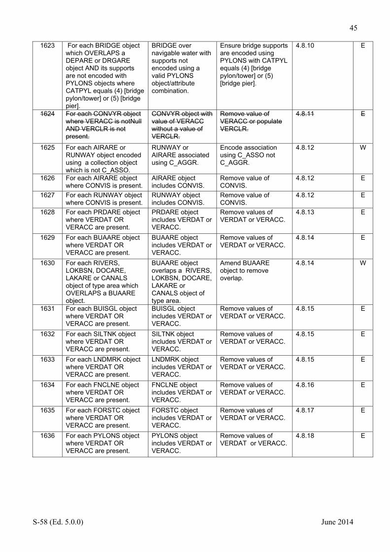
45
S-58 (Ed. 5.0.0) June 2014
1623 For each BRIDGE object which OVERLAPS a DEPARE or DRGARE object AND its supports are not encoded with PYLONS objects where CATPYL equals (4) [bridge pylon/tower] or (5) [bridge pier].
BRIDGE over navigable water with supports not encoded using a valid PYLONS object/attribute combination.
Ensure bridge supports are encoded using PYLONS with CATPYL equals (4) [bridge pylon/tower] or (5) [bridge pier].
4.8.10 E
1624 For each CONVYR object where VERACC is notNull AND VERCLR is not present.
CONVYR object with value of VERACC without a value of VERCLR.
Remove value of VERACC or populate VERCLR.
4.8.11 E
1625 For each AIRARE or RUNWAY object encoded using a collection object which is not C_ASSO.
RUNWAY or AIRARE associated using C_AGGR.
Encode association using C_ASSO not C_AGGR.
4.8.12 W
1626 For each AIRARE object where CONVIS is present.
AIRARE object includes CONVIS.
Remove value of CONVIS.
4.8.12 E
1627 For each RUNWAY object where CONVIS is present.
RUNWAY object includes CONVIS.
Remove value of CONVIS.
4.8.12 E
1628 For each PRDARE object where VERDAT OR VERACC are present.
PRDARE object includes VERDAT or VERACC.
Remove values of VERDAT or VERACC.
4.8.13 E
1629 For each BUAARE object where VERDAT OR VERACC are present.
BUAARE object includes VERDAT or VERACC.
Remove values of VERDAT or VERACC.
4.8.14 E
1630 For each RIVERS, LOKBSN, DOCARE, LAKARE or CANALS object of type area which OVERLAPS a BUAARE object.
BUAARE object overlaps a RIVERS, LOKBSN, DOCARE, LAKARE or CANALS object of type area.
Amend BUAARE object to remove overlap.
4.8.14 W
1631 For each BUISGL object where VERDAT OR VERACC are present.
BUISGL object includes VERDAT or VERACC.
Remove values of VERDAT or VERACC.
4.8.15 E
1632 For each SILTNK object where VERDAT OR VERACC are present.
SILTNK object includes VERDAT or VERACC.
Remove values of VERDAT or VERACC.
4.8.15 E
1633 For each LNDMRK object where VERDAT OR VERACC are present.
LNDMRK object includes VERDAT or VERACC.
Remove values of VERDAT or VERACC.
4.8.15 E
1634 For each FNCLNE object where VERDAT OR VERACC are present.
FNCLNE object includes VERDAT or VERACC.
Remove values of VERDAT or VERACC.
4.8.16 E
1635 For each FORSTC object where VERDAT OR VERACC are present.
FORSTC object includes VERDAT or VERACC.
Remove values of VERDAT or VERACC.
4.8.17 E
1636 For each PYLONS object where VERDAT OR VERACC are present.
PYLONS object includes VERDAT or VERACC.
Remove values of VERDAT or VERACC.
4.8.18 E

46
S-58 (Ed. 5.0.0) June 2014
1637 For each PYLONS object of type area where WATLEV equals 1 [partly submerged at high water], 2 [always dry] or 6 [subject to inundation or flooding] which is not WITHIN a LNDARE object of type area.
PYLONS object with WATLEV 1,2 or 6 not situated on a LNDARE object.
Ensure PYLONS object is situated on LNDARE of type area.
4.8.18 E
1638 For each picture file which is not in the TIFF format. Moved to section 2.3 as check 1017
Picture file not in Tiff format.
Replace picture file with Tiff format version.
4.8.20 C
1639 For each DEPCNT object where VERDAT is present.
VERDAT present on DEPCNT.
Remove VERDAT. 5.2 E
1640 For each SOUNDG object where VERDAT is present.
SOUNDG object includes VERDAT.
Remove VERDAT. 5.3 E
1641 For each UWTROC object which is COINCIDENT with a SOUNDG object. (COINCIDENT applies to the horizontal component only).
UWTROC object coincident with SOUNDG object.
Remove object which is not required.
5.3 E
1642 For each DEPARE object where VERDAT OR SOUACC are present.
VERDAT or SOUACC present on a DEPARE object.
Remove VERDAT or SOUACC.
5.4.1 E
1643 Check that where depth contours merge, a DEPAR (type Line) object is created, and that the value for VALDCO on the DEPCNT object is equal to the value for DRVAL! On the DEPARE object.
W
1644 For each edge bounding a DEPARE object which is COINCIDENT with an M_COVR object AND is COINCIDENT with a geo object of type line.
DEPARE objects on the edge of data coverage not bounded by line spatial objects without geo objects.
Ensure DEPARE objects at the edge of dataset only have spatial objects without geo objects as their outer boundary.
5.4.2 (Fig.5) W
1645 Check that the overall succession of DRVAL1 and DRVAL2 in the whole maritime area is continuous.
5.4.3 W
1646 For each DRGARE object where DRVAL2 is notNull and it is equal to the value of DRVAL1
DRVAL1 and DRVAL2 have the same value for a DRGARE object.
Amend values or remove value of DRVAL2.
5.5 W
1647 For each DRGARE object where VERDAT is present.
DRGARE object includes VERDAT.
Remove VERDAT. 5.5 E
1648 For each DRGARE object where QUASOU is notNull AND its value is NOT (10) [maintained depth] or (11) [not regularly maintained].
Invalid value of QUASOU on DRGARE.
Remove invalid value of QUASOU.
5.5 E
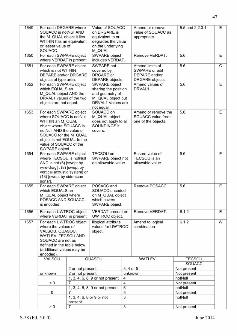
47
S-58 (Ed. 5.0.0) June 2014
1649 For each DRGARE where SOUACC is notNull AND the M_QUAL object it lies WITHIN has an equivalent or lesser value of SOUACC.
Value of SOUACC on DRGARE is equivalent to or degrades the value on the underlying M_QUAL.
Amend or remove value of SOUACC as appropriate.
5.5 and 2.2.3.1 E
1650 For each SWPARE object where VERDAT is present.
SWPARE object includes VERDAT.
Remove VERDAT. 5.6 E
1651 For each SWPARE object which is not WITHIN DEPARE and/or DRGARE objects of type area.
SWPARE not covered by DRGARE or DEPARE objects.
Amend limits of SWPARE or edit DEPARE and/or DRGARE objects.
5.6 C
1652 For each SWPARE object which EQUALS an M_QUAL object AND the DRVAL1 values of the two objects are not equal.
SWPARE object sharing the position and geometry of M_QUAL object but DRVAL1 Values are not equal.
Amend values of DRVAL1.
5.6 E
1653 For each SWPARE object where SOUACC is notNull WITHIN an M_QUAL object where SOUACC is notNull AND the value of SOUACC for the M_QUAL object is not EQUAL to the value of SOUACC of the SWPARE object .
SOUACC on M_QUAL object does not apply to all SOUNDINGS it covers.
Amend or remove the SOUACC value from one of the objects.
5.6 E
1654 For each SWPARE object where TECSOU is notNull AND is not (6) [swept by wire-drag] , (8) [swept by vertical acoustic system] or (13) [swept by side-scan sonar].
TECSOU on SWPARE object not an allowable value.
Ensure value of TECSOU is an allowable value.
5.6 E
1655 For each SWPARE object which EQUALS an M_QUAL object where POSACC AND SOUACC is encoded.
POSACC and SOUACC encoded on M_QUAL object which covers SWPARE object.
Remove POSACC. 5.6 E
1656 For each UWTROC object where VERDAT is present.
VERDAT present on UWTROC object.
Remove VERDAT. 6.1.2 E
1657 For each UWTROC object where the values of VALSOU, QUASOU, WATLEV, TECSOU AND SOUACC are not as defined in the table below (additional values may be encoded).
Illogical attribute values for UWTROC object.
Amend to logical combination.
6.1.2 W
VALSOU QUASOU WATLEV TECSOU SOUACC
unknown 2 or not present 3, 4 or 5 Not present 2 or not present unknown Not present
< 0 1, 3, 4, 6, 8, 9 or not present 4 notNull 7 4 Not present
0 1, 3, 4, 6, 8, 9 or not present 5 notNull 7 5 Not present
> 0
1, 3, 4, 6, 8 or 9 or not present
3 notNull
7 3 Not present

48
S-58 (Ed. 5.0.0) June 2014
1658 For each WRECKS object where any of VERDAT, VERACC and VERLEN are present.
VERDAT, VERACC or VERLEN present on WRECKS object.
Remove VERDAT, VERACC or VERLEN.
6.2.1 E
1659 For each WRECKS object where VALSOU is notNull AND EXPSOU is equal to (1) or is not present AND VALSOU is less than or equal to the DRVAL1 OR greater than DRVAL2 of the DEPARE OR DRGARE object it is WITHIN AND DRVAL1 AND DRVAL2 are notNull AND not equal..
VALSOU on WRECKS object with EXPSOU = 1 or not present and is outside of the range of the underlying depth area.
Populate an appropriate value of EXPSOU.
6.2.1 E
1660 For each WRECKS object where VALSOU is notNull AND EXPSOU is equal to (2) AND the value of VALSOU is greater than the DRVAL1 of the DEPARE or DRGARE object it is WITHIN AND DRVAL1 is notNull.
WRECKS object where EXPSOU equals (2) but with a VALSOU greater than the underlying DRVAL1.
Populate appropriate value of EXPSOU.
06.2.1 E
1661a For each WRECKS object where VALSOU is notNull AND EXPSOU = (3) AND the VALSOU is less than or equal to DRVAL2 of the DEPARE it is WITHIN where DRVAL2 is not unknown.
WRECKS with EXPSOU = (3) and a VALSOU less than DRVAL2 of the underlying DEPARE.
Amend value of EXPSOU to a logical value.
6.2.1 E
1661b For each WRECKS object where EXPSOU = (3) AND the VALSOU is less than or equal to the DRVAL2 of the DRGARE it is WITHIN where DRVAL1 AND DRVAL2 are notNull.
WRECKS with EXPSOU = (3) and a VALSOU less than DRVAL2 of the underlying DRGARE.
Amend value of EXPSOU to a logical value.
6.1.2 E
1661c For each WRECKS object where EXSPOU = (3) where the VALSOU is less than or equal to the DRVAL1 of the DRGARE object it is within where DRVAL2 is not present.
WRECKS with EXPSOU= (3) but with a VALSOU less than DRVAL1 of the underlying DRGARE when only DRVAL1 is populated.
Amend value of EXPSOU to a logical value.
6.1.2 E
1662 For each WRECKS object OR OBSTRN object of type area which is not WITHIN a DEPARE,LNDARE or UNSARE object of type area.
Area WRECKS or OBSTRN object not within a DEPARE, LNDARE or UNSARE type object.
Amend to ensure appropriate group 1 object is the underlying object.
6.2.1 and 6.2.2 E
1663 For each WRECKS objects where the attribute values do not correspond to the table below;
WRECKS object with illogical attribute combination.
Amend attributes in accordance with the logical values defined in the table.
6.2.1 W

49
S-58 (Ed. 5.0.0) June 2014
VALSOU WATLEV CATWRK QUASOU HEIGHT TECSOU SOUACC
Undefined
3 or unknown 1, 2, 3 or unknown
2 or undefined Undefined Undefined
4 or 5 Any value 2 or undefined Undefined Undefined 1 or 2 4, 5 or unknown Undefined Any value Undefined
Unknown
3 or unknown 1, 2, 3 or undefined
2 or undefined Undefined Undefined
4 or 5 Any value 2 or undefined Undefined Undefined 1 or 2 Undefined Any value Undefined
< 0 4 Any value 7 Undefined Undefined 4 Any value 1, 3, 4, 6, 8, 9
or undefined Undefined Any value
0
5 1, 2, 3 or undefined
7 Undefined Undefined
5 Any value 1, 3, 4, 6, 8, 9 or undefined
Undefined Any value
> 0
3 1, 2, 3 or undefined
7 Undefined Undefined
3 1, 2, 3 or undefined
1, 3, 4, 6, 8, 9 or undefined
Undefined Any value
1664 For each OBSTRN object where VERACC or VERDAT is present.
VERACC or VERDAT present on OBSTRN object.
Remove VERACC or VERDAT.
6.2.2 E
1665 For each OBSTRN object where VALSOU is notNull AND EXPSOU is equal to (1) or not present AND VALSOU is less than or equal to DRVAL1 OR greater than DRVAL2 of the DEPARE or DRGARE object it is WITHIN where DRVAL1 AND DRVAL2 are notNull.
OBSTRN object with EXPSOU = (1) or not present which is outside of the range of DRVAL1 and DRVAL2.
Populate an appropriate value of EXPSOU.
6.2.2 E
1666 For each OBSTRN object where VALSOU is notNull AND EXPSOU is equal to (2) AND the value of VALSOU is greater than the DRVAL1 of the DEPARE or DRGARE object it is WITHIN AND DRVAL1 is notNull.
OBSTRN object where EXPSOU equals (2) but with a VALSOU greater than the underlying DRVAL1.
Populate appropriate value of EXPSOU.
6.2.2 E
1667a For each OBSTRN object where VALSOU is notNull AND EXPSOU = (3) AND the VALSOU is less than or equal to DRVAL2 of the DEPARE it is WITHIN where DRVAL2 is not unknown.
OBSTRN with EXPSOU = (3) and a VALSOU less than DRVAL2 of the underlying DEPARE.
Amend value of EXPSOU to a logical value.
6.2.2 E
1667b For each OBSTRN object where EXPSOU = (3) AND the VALSOU is less than or equal to the DRVAL2 of the DRGARE it is WITHIN where DRVAL1 AND DRVAL2 are notNull.
OBSTRN with EXPSOU = (3) and a VALSOU less than DRVAL2 of the underlying DRGARE.
Amend value of EXPSOU to a logical value.
6.2.2 E

50
S-58 (Ed. 5.0.0) June 2014
1667c For each OBSTRN object where EXSPOU = (3) where the VALSOU is less than or equal to the DRVAL1 of the DRGARE object it is within where DRVAL2 is not present.
OBSTRN with EXPSOU= (3) but with a VALSOU less than DRVAL1 of the underlying DRGARE when only DRVAL1 is populated.
Amend value of EXPSOU to a logical value.
6.2.2 E
1668 For each OBSTRN object where PRODCT is present AND CATOBS is not (2) [wellhead] or (3) [diffuser].
OBSTRN object with a value for PRODCT without a logical value of CATOBS.
Remove value of PRODCT or populate logical value of CATOBS.
Logical consistency
W
1669 For each OBSTRN objects where the attribute values do not correspond to the table below;
OBSTRN object with illogical attribute value combinations.
Populate logical attribute value combinations.
6.2.2 E
VALSOU WATLEV QUASOU TECSOU SOUACC HEIGHT
Unknown
3, 4, 5 or unknown
2 or undefined Undefined Undefined
1 or 2 Undefined Undefined Any value 7 Undefined Undefined Undefined
< 0 4 1, 3, 4, 6, 8, 9 or
undefined Any value Undefined
4 7 Undefined Undefined
0 5 1, 3, 4, 6, 8, 9 or
undefined Any value Undefined
> 0 3 1, 3, 4, 6, 8, 9 or
undefined Any value Undefined
3 7 Undefined Undefined

51
S-58 (Ed. 5.0.0) June 2014
1670 For each WRECKS or
OBSTRN object of type area which CONTAINS objects of type WRECKS or OBSTRN of type point AND the values of EXPSOU, QUASOU, SOUACC, VALSOU and WATLEV of the area object are not equal to the values of the shallowest point object.
Point WRECKS or OBSTRN within area WRECKS or OBSTRN have attribute values not reflected on the area object.
Ensure area object attribute values reflect the shallowest point object.
6.3.2 W
1671 For each object of type line which is COINCIDENT with an area object of the same object type and attribute values except attributes SORIND, SORDAT and SCAMIN.
Line object touching object with the same attribute values except SORIND, SORDAT and SCAMIN.
Delete unnecessary object.
Logical consistency
W
1672 For each object of type point which is WITHIN an object of the same class AND which has the same attribute values AND is not of type LNDARE, OBSTRN or WRECKS.
Object with the same attributes within an identical object.
Delete repeated object or amend attributes accordingly.
Logical consistency
E
1673a For each SBDARE object where NATSUR values are not separated by a slash or comma (without spaces).
NATSUR values not separated by comma or slash.
Insert slash or comma as required.
7.1 E
1673b For each SBDARE object where NATSUR starts or ends with a comma or a slash.
NATSUR starts or ends with a comma or a slash.
Remove unnecessary comma or slash.
7.1 E
1673c For each SBDARE where NATSUR contains ‘,,’ or ‘//’.
Consecutive comma or slash within NATSUR on SBDARE object.
Remove unnecessary comma or slash.
7.1 E
1673d For each SBDARE where the NATQUA and NATSUR attributes do not contain an equal number of commas (or slashes).
NATQUA and NATSUR have different numbers of commas (or slashes).
Ensure appropriate commas (or slashes) are used to separate values.
7.1 E
1673e For each SBDARE object where NATSUR contains ‘ 9/ ‘.
NATSUR contains ‘ 9/ ‘. (Rock is encoded as the surface layer, it should be underlying).
Remove inappropriate NATSUR contents.
7.1 E
1674 For each SBDARE or type Area WITHIN a DEPARE where DRVAL1 is less than 0 AND WATLEV is not equal to (4) [covers and uncovers].
SBDARE object in drying area without WATLEV = (4).
Populate WATLEV = (4) [covers and uncovers].
7.1(e) and 7.1 (g) W
1675 For each SNDWAV object where VERACC is present.
VERACC present on SNDWAV object.
Remove VERACC. 7.2.1 E

52
S-58 (Ed. 5.0.0) June 2014
1676 Check that any RESARE object having a value of (24) for the attribute CATREA also has a value of (13) for the attribute RESTRN.
9.1.2 W
1677 For each MORFAC object where BOYSHP is present AND CATMOR is not equal to (7) [mooring buoy].
MORFAC with BOYSHP without CATMOR = (7) [mooring buoy].
Populated CATMOR = (7) or remove BOYSHP.
4.6.7.1 E
1678 For each RECTRC object where VERDAT OR DRVAL2 are present.
VERDAT or DRVAL2 present on RECTRC object.
Remove VERDAT or DRVAL2.
10.1.1 E
1679 For each object where attributes of the following types enumerated ('E'), float ('F'), integer ('I') or code string ('A') have more than one value.
More than one value present for attributes of the following types; enumerated ('E'), float ('F'), integer ('I') or code string ('A').
Remove unnecessary values.
C
1680 Check that no RECTRC object contains a value of (3) for the attribute STATUS.
10.1.1 W
1681 For each RECTRC object of type line where ORIENT is notNull AND the direction of digitising is not greater than 5 degrees greater than or less than the value of ORIENT.
RECTRC where ORIENT does not correspond to the direction of digitising.
Amend value of ORIENT.
10.1.1 C
1682 For each RECTRC or NAVLNE object which is not part of a C_AGGR collection object AND is not a RECTRC object with CATTRK equal to (2) [not based on a system of fixed marks].
RECTRC or NAVLNE object not part of C_AGGR collection (except RECTRC where CATTRK=2).
Add to C_AGGR collection object.
10.1.2 W
1683 For each C_AGGR object with a single instance of both NAVLNE AND RECTRC AND their ORIENT values are not equal or reciprocal.
RECTRC and NAVLNE as part of a C_AGGR do not have consistent values of ORIENT.
Amend values of ORIENT to agree.
10.1.2 C
1684 For each group of objects forming a measured distance where the beacons and transit lines are not aggregated into a C_AGGR collection object AND the C_AGGR collection objects are not aggregated into another C_AGGR object including the track to be followed.
Measured distance not grouped using C_AGGR collection objects.
Encode C_AGGR objects and relate as appropriate.
10.1.3 E

53
S-58 (Ed. 5.0.0) June 2014
1685 For each object of type TSSBND is not COINCIDENT with the outer limit of a TSSRON, TSSLPT or TSSZNE.
TSSBND not on the outer limit of an appropriate TSS object.
Amend TSSBND or other TSS objects so that it forms the outer limit.
10.2.1.2 E
1686 For each TSELNE object which is not COINCIDENT with two TSSLPT objects OR one TSSLPT object and one ISTZNE object.
TSSLNE does not separate TSSLPT objects or TSSPLT and ISTZNE objects.
Amend TSELNE to ensure it separates appropriate objects.
10.2.1.3 E
1687 For each TSEZNE object which is not COINCIDENT with two TSSLPT objects OR one TSSLPT object and one ISTZNE object OR COINCIDENT with a TSSRON object.
TSEZNE does not separate appropriate TSS objects.
Amend TSSZNE to separate appropriate objects.
10.2.1.4 E
1688 For each TSSCRS object which does not touch greater than 3 TSSLPT or TWRTPT objects.
TSSCRS object does not encode a crossing of 4 or more lanes.
Encode all lane parts or use another object.
10.2.1.5 E
1689 For each TSSCRS object which OVERLAPS a TSEZNE object.
TSSCRS object overlaps TSEZNE object.
Amend objects to remove overlap.
10.2.1.5 E
1690 For each TSSRON object which OVERLAPS a TSEZNE object.
TSSRON object overlaps TSEZNE object.
Amend objects to remove overlap.
10.2.1.6 E
1691 For each DWRTPT object where VERDAT or DRVAL2 are present.
DWRTPT object carries VERDAT or DRVAL2 attribute.
Remove inappropriate attribute value.
10.2.2.1 E
1692 For each DWRTPT object which is NOT WITHIN the combined coverage of objects of type DEPARE or DRGARE.
DWRTPT object not covered DEPARE or DRGARE objects.
Encode appropriate DEPARE or DRGARE objects.
10.2.2.1 E
1693 For each object of type DWRTPT and DWRTCL where OBJNAM is notNull AND the object is aggregated in a collection object.
DWRTPT or DWRTCL objects with OBJNAM form part of a collection object.
Remove object from collection object. Encode the name using the C_AGGR meta object or create a SEARRE. Remove it from DWRTPT or/and DWRTCL.
10.2.2.1 W
1694 For each DWRTCL object where ORIENT is notNull AND TRAFIC equals (1),(2) or (3) AND the direction of digitising is not greater than 5 degrees greater than or less than the value of ORIENT.
One way DWRTCL where ORIENT does not correspond to the direction of digitising.
Amend value of ORIENT.
10.2.2.2 C
1695 For each DWRTCL object where VERDAT or DRVAL2 are present.
VERDAT or DRVAL2 present for DWRTCL object.
Remove VERDAT or DRVAL2.
10.2.2.2 E
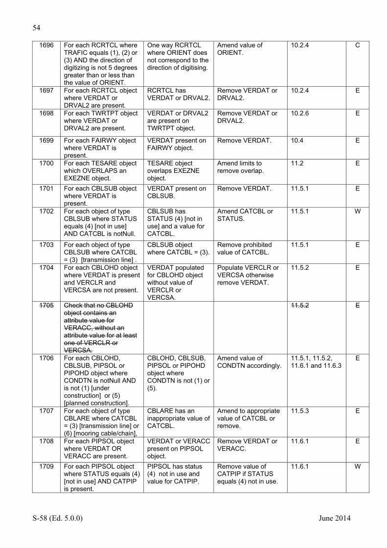
54
S-58 (Ed. 5.0.0) June 2014
1696 For each RCRTCL where TRAFIC equals (1), (2) or (3) AND the direction of digitizing is not 5 degrees greater than or less than the value of ORIENT.
One way RCRTCL where ORIENT does not correspond to the direction of digitising.
Amend value of ORIENT.
10.2.4 C
1697 For each RCRTCL object where VERDAT or DRVAL2 are present.
RCRTCL has VERDAT or DRVAL2.
Remove VERDAT or DRVAL2.
10.2.4 E
1698 For each TWRTPT object where VERDAT or DRVAL2 are present.
VERDAT or DRVAL2 are present on TWRTPT object.
Remove VERDAT or DRVAL2.
10.2.6 E
1699 For each FAIRWY object where VERDAT is present.
VERDAT present on FAIRWY object.
Remove VERDAT. 10.4 E
1700 For each TESARE object which OVERLAPS an EXEZNE object.
TESARE object overlaps EXEZNE object.
Amend limits to remove overlap.
11.2 E
1701 For each CBLSUB object where VERDAT is present.
VERDAT present on CBLSUB.
Remove VERDAT. 11.5.1 E
1702 For each object of type CBLSUB where STATUS equals (4) [not in use] AND CATCBL is notNull.
CBLSUB has STATUS (4) [not in use] and a value for CATCBL.
Amend CATCBL or STATUS.
11.5.1 W
1703 For each object of type CBLSUB where CATCBL = (3) [transmission line] .
CBLSUB object where CATCBL = (3).
Remove prohibited value of CATCBL.
11.5.1 E
1704 For each CBLOHD object where VERDAT is present and VERCLR and VERCSA are not present.
VERDAT populated for CBLOHD object without value of VERCLR or VERCSA.
Populate VERCLR or VERCSA otherwise remove VERDAT.
11.5.2 E
1705 Check that no CBLOHD object contains an attribute value for VERACC, without an attribute value for at least one of VERCLR or VERCSA.
11.5.2 E
1706 For each CBLOHD, CBLSUB, PIPSOL or PIPOHD object where CONDTN is notNull AND is not (1) [under construction] or (5) [planned construction].
CBLOHD, CBLSUB, PIPSOL or PIPOHD object where CONDTN is not (1) or (5).
Amend value of CONDTN accordingly.
11.5.1, 11.5.2, 11.6.1 and 11.6.3
E
1707 For each object of type CBLARE where CATCBL = (3) [transmission line] or (6) [mooring cable/chain],
CBLARE has an inappropriate value of CATCBL.
Amend to appropriate value of CATCBL or remove.
11.5.3 E
1708 For each PIPSOL object where VERDAT OR VERACC are present.
VERDAT or VERACC present on PIPSOL object.
Remove VERDAT or VERACC.
11.6.1 E
1709 For each PIPSOL object where STATUS equals (4) [not in use] AND CATPIP is present.
PIPSOL has status (4) not in use and value for CATPIP.
Remove value of CATPIP if STATUS equals (4) not in use.
11.6.1 W
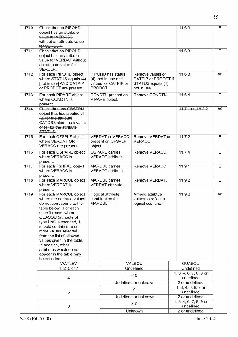
55
S-58 (Ed. 5.0.0) June 2014
1710 Check that no PIPOHD object has an attribute value for VERACC without an attribute value for VERCLR.
11.6.3 E
1711 Check that no PIPOHD object has an attribute value for VERDAT without an attribute value for VERCLR.
11.6.3 E
1712 For each PIPOHD object where STATUS equals (4) [not in use] AND CATPIP or PRODCT are present.
PIPOHD has status (4) not in use and values for CATPIP or PRODCT.
Remove values of CATPIP or PRODCT if STATUS equals (4) not in use.
11.6.3 W
1713 For each PIPARE object where CONDTN is present.
CONDTN present on PIPARE object.
Remove CONDTN. 11.6.4 E
1714 Check that any OBSTRN object that has a value of (2) for the attribute CATOBS also has a value of (4) for the attribute STATUS.
11.7.1 and 6.2.2 W
1715 For each OFSPLF object where VERDAT OR VERACC are present.
VERDAT or VERACC present on OFSPLF object.
Remove VERDAT or VERACC.
11.7.2 E
1716 For each OSPARE object where VERACC is present.
OSPARE carries VERACC attribute.
Remove VERACC 11.7.4 E
1717 For each FSHFAC object where VERACC is present.
MARCUL carries VERACC attribute.
Remove VERACC 11.9.1 E
1718 For each MARCUL object where VERDAT is present.
MARCUL carries VERDAT attribute.
Remove VERDAT. 11.9.2 E
1719 For each MARCUL object where the attribute values do not correspond to the table below; For each specific case, when QUASOU (attribute of type List) is encoded, it should contain one or more values selected from the list of allowed values given in the table. In addition, other attributes which do not appear in the table may be encoded.
Illogical attribute combination for MARCUL.
Amend attribtue values to reflect a logical scenario.
11.9.2 W
WATLEV VALSOU QUASOU 1, 2, 5 or 7 Undefined Undefined
4 < 0
1, 3, 4, 6, 7, 8, 9 or undefined
Undefined or unknown 2 or undefined
5 0
1, 3, 4, 6, 8, 9 or undefined
Undefined or unknown 2 or undefined
3 > 0
1, 3, 4, 6, 7, 8, 9 or undefined
Unknown 2 or undefined
56
S-58 (Ed. 5.0.0) June 2014
Unknown Unknown 2 or undefined1720 For each ICEARE object
where VERDAT OR VERACC are present.
VERDAT or VERACC present on ICEARE object.
Remove VERDAT or VERACC.
11.13.1 E
1721 For each RADRFL object which is associated with a navigational aid (BCNXXX, BOYXXX, LITFLT, LITVES objects).
RADRFL encoded on a navigational aid.
Encode CONRAD = (3) [radar conspicuous (has radar reflector)} on the navigational aid object.
12.1.1 E
1722a For each navigational aid equipment object which is not a slave to a navigational aid structure object OR another navigational aid equipment object. NOTE: CRANES, FLODOC, FORSTC, FSHFAC, HULKES, PONTON, OBSTRN, PYLONS, SILTNK and WRECKS objects must be considered as possible structure objects, in addition to the list given in Annex A (12.1.1).
Equipment object which is not a slave of a structure or another equipment object.
Amend equipment object to slave.
12.1.2 and 12.1.1
W
1722b For each DAYMAR object EQUALS another structure object and is not marked as an equipment object NOTE: CRANES, FLODOC, FORSTC, FSHFAC, HULKES, PONTON, OBSTRN, PYLONS, SILTNK and WRECKS objects must be considered as possible structure objects, in addition to the list given in Annex A (12.1.1).
DAYMAR marked as structure object where another exists.
Amend DAYMAR to slave.
12.1.2 and 12.1.1
W
1723 For each point object forming the same navigational aid which does not point to the same spatial object.
Object forming a navigational aid does not point to the same spatial object.
Ensure all components point to the same spatial object.
12.1.2 C
1724 For each navigational aid equipment object where OBJNAM equals the OBJNAM of the master object.
OBJNAM on navigational aid equipment object repeats that of the master object.
Remove repeated OBJNAM value.
12.1.2 W

57
S-58 (Ed. 5.0.0) June 2014
1725 For each master/slave relationship where all component objects (master and slaves) are of the classes DAYMAR, FOGSIG, LIGHTS, RADSTA, RDOSTA, RETRFL, RTPBCN, SISTAT, SISTAW and/or TOPMAR AND where at least one object DAYMAR or LIGHTS is in the list AND where a DAYMAR or a LIGHTS is not the master object.
Equipment object does not have coincident DAYMAR or LIGHTS object as a master.
Amend relationship so that the equipment object is slave to the LIGHTS or DAYMAR object.
12.1.2 W
1726 If the M_COVR object where CATCOV=1 does not EQUAL the combined coverage of M_NSYS objects where MARSYS is notNull.
Data coverage not completely covered by M_NSYS objects with a value for MARSYS.
Ensure complete coverage of M_NSYS objects with MARSYS populated.
12.2 C
1727 For each M_NSYS object where MARSYS is notNull which OVERLAPS an M_NSYS object where MARSYS is notNull.
M_NSYS objects with MARSYS values overlap.
Amend limits of M_NSYS objects to remove overlap.
12.2 C
1728 For each M_NSYS object where ORIENT is notNull which OVERLAPS an M_NSYS object where ORIENT is notNull.
M_NSYS objects with ORIENT values overlap.
Amend limits of M_NSYS objects to remove overlap.
12.2 E
1729 For each geo object forming part of a BCNXX or BOYXX object AND MARSYS is not (9) or (10) where the attributes for structure, topmark and lights do not conform to the value of MARSYS on the geo object or the M_NSYS object it is within.
Component of an aid to navigation does not conform to the IALA system defined on the object or in M_NSYS.
Ensure attributes conform to the IALA system encoded in MARSYS.
12.2 and 12.4.1.1
E
1730 For each BCNCAR object where VERDAT OR VERACC are present.
VERDAT or VERACC are present on BCNCAR object.
Remove VERDAT or VERACC.
12.3.1 E
1731 For each BCNISD object where VERDAT OR VERACC are present.
VERDAT or VERACC are present on BCNISD object.
Remove VERDAT or VERACC.
12.3.1 E
1732 For each BCNLAT object where VERDAT OR VERACC are present.
VERDAT or VERACC are present on BCNLAT object.
Remove VERDAT or VERACC.
12.3.1 E
1733 For each BCNSAW object where VERDAT OR VERACC are present.
VERDAT or VERACC are present on BCNSAW object.
Remove VERDAT or VERACC.
12.3.1 E
1734 For each BCNSPP object where VERDAT OR VERACC are present.
VERDAT or VERACC are present on BCNSPP object.
Remove VERDAT or VERACC.
12.3.1 E

58
S-58 (Ed. 5.0.0) June 2014
1735 For each BCNXXX or BOYXXX object where MARSYS is present and equal to the value of MARSYS on the M_NSYS object it is WITHIN.
Value of MARSYS on Beacon object is the same as the value on M_NSYS object.
Remove duplicate value.
12.3.1 E
1736 For each DAYMAR object where VERDAT OR VERACC are present.
VERDAT or VERACC are present on DAYMAR object.
Remove VERDAT or VERACC.
12.3.3 E
1737 For each BOYCAR object where VERACC is present.
VERACC is present on BOYCAR object.
Remove VERACC. 12.4.1 E
1738 For each BOYINB object where VERACC is present.
VERACC is present on BOYINB object.
Remove VERACC. 12.4.1 E
1739 For each BOYISD object where VERACC is present.
VERACC is present on BOYISD object.
Remove VERACC. 12.4.1 E
1740 For each BOYLAT object where VERACC is present.
VERACC is present on BOYLAT object.
Remove VERACC. 12.4.1 E
1741 For each BOYSPP object where VERACC is present.
VERACC is present on BOYSPP object.
Remove VERACC. 12.4.1 E
1742 For each BOYSAW object where VERACC is present.
VERACC is present on BOYSAW object.
Remove VERACC. 12.4.1 E
1743 For each BOYXXX object where MARSYS is present and not equal to the value of MARSYS on the M_NSYS object the BCNXXX is WITHIN.
Value of MARSYS on Buoy object differs from value on M_NSYS object.
Ensure values of MARSYS agree.
12.4.1 W
1744 For each LITVES object where HORACC OR VERACC are present.
HORACC or VERACC are present on LITVES object.
Remove HORACC or VERACC.
12.4.2 E
1745 For each LITFLT object where HORACC OR VERACC are present.
HORACC or VERACC are present on LITFLT object.
Remove HORACC or VERACC.
12.4.2 E
1746 For each TOPMAR object where VERACC, VERDAT, VERLEN, HEIGHT OR MARSYS are present.
VERACC, VERDAT, VERLEN, HEIGHT or MARSYS are present on TOPMAR object.
Remove VERACC, VERDAT, VERLEN, HEIGHT or MARSYS.
12.6 E
1747 For each RETRFL object where MARSYS, VERDAT OR VERACC are present.
MARSYS, VERDAT or VERACC are present on RETRFL object.
Remove MARSYS, VERDAT or VERACC.
12.7 E
1748 For each RETRFL object where VERDAT is present.
VERDAT is present on RETRFL object.
Remove VERDAT. 12.7 E
1749 For each LIGHTS object where VERACC is present.
VERACC present on LIGHTS object.
Remove VERACC. 12.8.1 E
1750 For each LIGHTS object which is a slave to a BOYXXX object where HEIGHT is present.
HEIGHT present on LIGHTS object which is slave to a BOYXXX object.
Remove HEIGHT. 12.8.1 E

59
S-58 (Ed. 5.0.0) June 2014
1751 For each LIGHTS object where ORIENT is present AND CATLIT is not (1) [directional function] OR (16) [moiré effect].
ORIENT populated without CATLIT (1) or (16).
Populate appropriate value of CATLIT or remove ORIENT.
12.8.1 and Appendix B.1 (3.5.2)
E
1752 For each LIGHTS object where LITCHR is equal to (1) [fixed] AND SIGGRP, SIGPER OR SIGSEQ are present.
SIGGRP, SIGPER or SIGSEQ present for LIGHTS object where LITCHR = (1) [fixed].
Remove SIGGRP, SIGPER or SEGSEQ, not applicable to fixed lights.
12.8.1 E
1753 For each LIGHTS object where VERDAT is notNull AND HEIGHT is not present.
LIGHTS object has a value of VERDAT without a value for HEIGHT.
Populate HEIGHT or remove VERDAT.
12.8.1 E
1754 For each LIGHTS object where VERDAT is notNull AND equal to the value of VERDAT on the M_VDAT object it is WITHIN.
LIGHTS object with VERDAT which is identical to that on the underlying M_VDAT object.
Remove unnecessary value of VERDAT from the LIGHTS object.
12.8.1 E
1755 For each LIGHTS object where VERDAT is notNull AND equal to the value of VERDAT in the Vertical Datum subfield (VDAT) of the Data Set Parameter field (DSPM).
LIGHTS object with VERDAT which is identical to that in the VDAT subfield of the DPSM field.
Remove unnecessary value of VERDAT.
12.8.1 E
1756 For each LIGHTS object where CATLIT equals (4) [leading light] AND without CATLIT equals (1) [directional function] AND ORIENT is present.
ORIENT present for non-directional leading light LIGHTS object.
Remove value of ORIENT.
12.8.6.4 and 12.8.6.5
E
1757 For each LIGHTS object where CATLIT equals (19) [horizontally disposed] or (20) [vertically disposed] AND MLTYLT does not contain a value greater than 1.
LIGHTS object where CATLIT = (19) or (20) without a value of MLTYLT.
Populate the value of MLTYLT.
12.8.7 E
1758 For each LIGHTS object where CATLIT equals (17) [emergency] AND it is not COINCIDENT with another LIGHTS object.
LIGHTS object isolated and with CATLIT (17) [emergency].
Encode primary LIGHTS object.
12.8.7 E
1759 For each RDOSTA object where ORIENT is notNull AND CATROS is not (2) [directional radiobeacon].
RDOSTA with ORIENT but without CATROS = (2).
Populate CATROS = (2).
12.9.1 E
1760 For each RADSTA object where VERDAT OR VERACC are present.
VERDAT or VERACC present on RADSTA object.
Remove VERDAT or VERACC.
12.11.3 E
1761 For each RADRFL object where VERDAT OR VERACC are present.
VERDAT or VERACC present on RADRFL object.
Remove VERDAT or VERACC.
12.12 E
1762 For each RADRFL object which TOUCHES an object of type area or point having CONRAD as an allowable attribute.
Unnecessary RADRFL encoded.
Remove unnecessary RADRFL and encode CONRAD = 3 on the associated object.
12.12 E

60
S-58 (Ed. 5.0.0) June 2014
1763 For each C_ASSO or C_AGGR object where the Relationship Indicator [RIND] subfield of the Feature Record to Feature object Pointer [FFPT] field is not (3) [peer].
Relationship Indicator field value for C_ASSO or C_AGGR not (3) [peer] Unnecessary RADRFL encoded.
Amend RIND subfield to (3) [peer].
15 and Appendix B.1 (3.9)
E
1764 For each object where STATUS is equal to (1) [permanent] and PERSTA and/or PEREND are present.
PERSTA and/or PEREND are present for an object with STATUS=permanent.
Remove PERSTA/PEREND if value of STATUS is valid.
2.1.5.1 and logical consistency
E
1765a If the cell contains both M_QUAL and M_ACCY objects and their combined coverage does not EQUAL the M_COVR objects where CATCOV equals (1) [coverage available].
M_QUAL or M_ACCY do not provide full coverage.
Amend objects to provide complete coverage.
2.2.3.1 W
1765b If objects of type M_QUAL and M_ACCY OVERLAP.
M_QUAL and M_ACCY objects overlap.
Amend objects to remove overlap.
2.2.4.1 W
1766 For each attribute of type PICREP, TXTDSC and NTXTDS where the attribute value contains more than one file name.
PICREP, TSTDSC or NTXTDS contain more that one file name.
Amend value to only contain a single file name.
2.3 and 4.8.20 E
1767 For each edge which is COINCIDENT with a SBDARE object of type area where WATLEV = 4 [covers and uncovers] AND is COINCIDENT with an area DEPARE or DRGARE object where DRVAL2=< 0 AND is COINCIDENT with an area DEPARE or DRGARE object where DRVAL1 >=0 OR an UNSARE object AND is not COINCIDENT with a DAMCON, GATCON, SLCONS or LNDARE object AND is not COINCIDENT with a DEPCNT object where VALDCO = 0.
Missing zero metre depth contour
Capture an appropriate zero metre DEPCNT.
5.2 W
1768 For each SOUNDG object where the depth value is less than or equal to the DRVAL1 of the DEPARE or DRGARE it lies WITHIN AND DRVAL1 of that object is notNull.
SOUNDG object with depth less than or equal to the underlying value of DRVAL1.
Amend DRVAL1 value of depth objects accordingly.
5.3 E
61
S-58 (Ed. 5.0.0) June 2014
1769 For each SOUNDG object where EXPSOU is not (3) [deeper than the range of the depth of the surrounding depth area] AND the depth value is greater than the DRVAL2 of the overlying DEPARE object AND DRVAL2 of this object is notNull.
SOUNDG object deeper than DRVAL2 value without EXPSOU equal to (3).
Populate appropriate value of EXPSOU.
5.3 E
1770a For each SOUNDG object where EXPSOU = (3) AND the depth value is less than or equal to DRVAL2 of the DEPARE it is WITHIN where DRVAL2 is not unknown.
SOUNDG with EXPSOU = (3) and a depth value less than DRVAL2 of the underlying DEPARE.
Amend value of EXPSOU to a logical value.
5.3 W
1770b For each SOUNDG object where EXPSOU = (3) that the depth value is less than or equal to the DRVAL2 of the DRGARE it is WITHIN where DRVAL1 AND DRVAL2 are notNull.
SOUNDG with EXPSOU = (3) and a depth value less than DRVAL2 of the underlying DRGARE.
Amend value of EXPSOU to a logical value.
5.3 W
1770c For each SOUNDG object where EXSPOU = (3) where the depth value is less than or equal to the DRVAL1 of the DRGARE object it is within where DRVAL2 is not present.
SOUNDG with EXPSOU= (3) but with a depth value less than DRVAL1 of the underlying DRGARE when only DRVAL1 is populated.
Amend value of EXPSOU to a logical value.
5.3 W
1771 For each edge which is COINCIDENT with a DEPCNT object AND two area DEPARE objects AND maximum DRVAL2 <= VALDCO < minimum DRVAL1 AND minimum DRVAL2 = VALDCO AND the edge is COINCIDENT with a DEPARE object of type line.
VALDCO on DEPCNT between two DEPARE objects has illogical value.
Amend VALDCO to a logical value.
5.4.3 E
1772 For each UWTROC object where VALSOU is notNull AND EXPSOU is not present OR (1) [within the range of depth of the surrounding depth area] AND VALSOU is greater than the DRVAL2 OR less than or equal to DRVAL1 of the overlying DEPARE OR DRGARE object AND DRVAL1 AND DRVAL2 of this object are notNull.
UWTROC with EXPSOU (1) or not present has a VALSOU outside the range of DRVAL1 and DRVAL2 the group 1 object.
Populate appropriate value of EXPSOU.
6.1.2 W

62
S-58 (Ed. 5.0.0) June 2014
1773 For each UWTROC object where VALSOU is notNull AND EXPSOU = (2) AND VALSOU is greater than the value of DRVAL1 of the DEPARE or DRGARE object it is WITHIN AND DRVAL1 is not ‘unknown’.
UWTROC with EXPSOU = (2) within a DEPARE or DRGARE where the VALSOU is not shoaler than the range of the surrounding depth area.
Amend EXPSOU to a logical value.
6.1.2 W
1774a For each UWTROC object where VALSOU is notNull AND EXPSOU = (3) AND the VALSOU is less than or equal to DRVAL2 of the DEPARE it is WITHIN where DRVAL2 is not unknown.
UWTROC with EXPSOU = (3) and a VALSOU less than DRVAL2 of the underlying DEPARE.
Amend value of EXPSOU to a logical value.
6.1.2 E
1774b For each UWTROC object where EXPSOU = (3) that the depth value is less than or equal to the DRVAL2 of the DRGARE it is WITHIN where DRVAL1 AND DRVAL2 are notNull.
UWTROC with EXPSOU = (3) and a VALSOU less than DRVAL2 of the underlying DRGARE.
Amend value of EXPSOU to a logical value.
6.1.2 E
1774c For each UWTROC object where EXSPOU = (3) where VALSOU is less than or equal to the DRVAL1 of the DRGARE object it is within where DRVAL2 is not present.
UWTROC with EXPSOU= (3) but with a VALSOU less than DRVAL1 of the underlying DRGARE when only DRVAL1 is populated.
Amend value of EXPSOU to a logical value.
6.1.2 E
1775 For each equipment object (UOC 12.1.1) which is WITHIN a DEPARE, DRGARE or UNSARE AND does not have a navigational aid structure as a master OR does not TOUCH a HULKES, LNDARE or PYLONS point object OR does not TOUCH a line CBLOHD, CONVYR, COALNE, DAMCON (with CATDAM = 3 [flood barrage]), BRIDGE, FLODOC, LNDARE, MORFAC, PIPOHD, PONTON or SLCONS object OR is not WITHIN a area CONVYR or BRIDGE object.
Equipment object within DEPARE, DRGARE or UNSARE without an appropriate supporting structure object or underlying object.
Ensure equipment object is encoded with an appropriate structure object or underlying object.
12.1.1 and 12.8.8
C
1776 For each LIGHTS object where the value of LITCHR is as listed in the table below AND SIGGRP is not as listed in the table below.
Values of LITCHR and SIGGRP are not consistent.
Amend values to be consistent.
12.8.3 W
LITCHR SIGGRP 6 (1) 7 (1) 9 ()

63
S-58 (Ed. 5.0.0) June 2014
10 () 11 () 28 ()
1777 For each collection object which references objects which do not exist in the cell.
Collection object references objects which do not exist within the cell.
Remove invalid references.
15 E
1778 For each LIGHTS object where CATLIT = 1 [directional function] AND SECTR1 – SECTR2 is greater than or equal to 10.
LIGHTS object with CATLIT = (1) with a sector arc greater than 10 degrees.
Check SECTR1/2 values, or remove CATLIT = (1).
12.8.6.5 and Appendix A Ch.2 (code 37)
E
1779 For each DEPARE object where DRVAL1 is equal to DRVAL2.
DRVAL1 is equal to DRVAL2 on a DEPARE object.
Amend DRVAL1 or DRVAL2 to logical values.
5.4 and logical consistency
C
1780 For each SBDARE object where NATSUR AND NATQUA are notNull AND the combination of values of NATSUR AND NATQUA are not as listed in the table below;
Illogical combination of NATSUR and NATQUA.
Amend NATSUR and NATQUA to logical combinations.
logical consistency
W
NATQUA 1 2 3 4 5 6 7 8 9 10 NATSUR
1 x x x x x x 2 x x x x 3 x x x x x x x 4 x x x x x x x 5 x x x x x 6 x x x x x
7 x x x x x 8 x x 9 x x 11 x 14 x 17 x x x x x 18 x x
1781 For each BUISGL or LNDMRK object which is part of a master slave relationship AND references a LIGHTS object where CATLIT is not (6), (8) or (9) as slave AND FUNCTN does not contain value (33) [light support.
BUISGL or LNDMRK object with a slave LIGHTS object without FUNCTN = (33) [light support]
12.3.2 and S-52 W
1782 For each SWPARE object which OVERLAPS another SWPARE object.
SWPARE objects overlap.
Amend objects so that there is no overlap.
logical consistency
E
1783a For each object of type area where WATLEV = 4 [covers and uncovers] OVERLAPS a DEPARE object where DRVAL1>=0.
Illogical value of WATLEV given the DRVAL1 of the underlying object.
Populate appropriate value of WATLEV.
logical consistency
E
64
S-58 (Ed. 5.0.0) June 2014
1783b For each object of type area where WATLEV = 5 [awash] OVERLAPS a DEPARE object where DRVAL1 > 0.
Illogical value of WATLEV given the DRVAL1 of the underlying object.
Populate appropriate value of WATLEV.
logical consistency
E
1784 For each spatial object where the value of HORDAT, POSACC or QUAPOS is Null. populated with an unknown value.
POSACC, HORDAT or QUAPOS populated with an unknown value.
Remove unknown value or populate with a known value.
Logical consistency
W
1785 For each object with CONDTN = 4 [wingless] that does NOT have CATLMK = 18 [windmill] OR 19 [windmotor]
Object other than windmill or windmotor with CONDTN = 4 [wingless].
Remove value of CONDTN or use LNDMRK object.
Logical consistency.
E
1786 For each object of type Area where WATLEV equals (2) [always dry] AND is not WITHIN a LNDARE object of type area.
Area object with WATLEV = (2) but not on an area LNDARE object.
Amend WATLEV value or ensure object is on land.
Logical consistency
E
1787 For each NAVLNE and RECTRC which are COINCIDENT AND have values of ORIENT which are not equal or reciprocal.
ORIENT values for NAVLNE and RECTRC objects sharing an edge are not equal or reciprocal.
Ensure values of ORIENT agree or are reciprocal.
Logical consistency
E
1788 For each NAVLNE object which is COINCIDENT with a RECTRC object AND are not part of the same C_AGGR object.
NAVLNE and RECTRC share an edge but are not aggregated using C_AGGR.
Aggregate objects using C_AGGR object.
10.1.2 W
1789 For each object of type DWRTCL, NAVLNE, RECTRC and RCRTCL of type line where ORIENT is notNull AND the orientation of the spatial geometry is more than 5 degrees greater than or less than the value (or reciprocal) of the value of ORIENT.
DWRTCL, NAVLNE, RECTRC or RCRTCL where the orientation of the geometry is not consistent with the value of ORIENT.
Populate an appropriate value of ORIENT consistent with the geometry of the object.
Logical consistency
C
1790a For each LIGHTS object where ORIENT is notNull AND SECTR1 OR SECTR2 are notNull.
LIGHTS object where ORIENT and SECTR1/SECTR2 are populated.
Remove values of SECTR1/SECTR2 or ORIENT.
12.8.6.5 and 12.8.6.6
E
1790b For each LIGHTS object where ORIENT is notNull AND it is aggregated to a RECTRC or NAVLNE within a collection object C_AGGR.
LIGHTS object where ORIENT and is aggregated within a C_AGGR collection object.
Set Orient to NULL 12.8.6.5 and 12.8.6.6
E
1790c For each LIGHTS object where ORIENT is notNull AND the structure object of this LIGHTS object is aggregated to a RECTRC or NAVLNE within a collection object C_AGGR.
LIGHTS object where ORIENT and the master structure object is aggregated within a C_AGGR collection object.
Remove the LIGHTS structure master object from C_AGGR collection object aggregation.
12.8.6.5 and 12.8.6.6
E

65
S-58 (Ed. 5.0.0) June 2014
1791 For each NAVLNE object where CATNAV = 3 which is not COINCIDENT with a RECTRC where CATTRK = 1.
NAVLNE with CATNAV =3 but does not share the line geometry of a RECTRC with CATTRK = 1.
Ensure NAVLNE with CATNAV = 3 has a coincident RECTRC with CATTRK = 1.
logical consistency
E
1792 If the cell OVERLAPS the 180° meridian.
Cell overlaps 180° meridian.
Amend cell limits accordingly.
2.1.8.2 C
1793 For each master/slave relationship which references more than one LIGHTS object AND all of the LIGHTS objects are encoded with LITVIS = 6 or 7.
Group of LIGHTS where all are LITVES = 6 or 7.
Confirm values of LITVES or encode primary light.
logical consistency
E
1794 For each LIGHTS object where CATLIT = (1) AND is a slave in a master/slave relationship AND the master object is any of BOYXXX, LITVES or LITFLT.
Directional light a slave to a master object of type BOYXXX, LITVES or LITFLT.
Amend master to a logical object or remove value of CATLIT.
logical consistency
E
1795 For each object which is a master in a master/slave relationship AND where DATEND, DATSTA, PEREND or PERSTA are notNull AND the values of DATEND, DATSTA, PEREND or PERSTA are not identical to those on the slave objects.
Temporal attributes on a master object do not match those on slave objects.
Populate appropriate temporal attributes on slave objects.
logical consistency
C
1796 For each SOUNDG object where EXPSOU equals (2) [shoaler than the range of depth of the surrounding depth area].
SOUNDG object where EXPSOU = (2).
See EB 27. UOC? 5.3 and 5.5 W
1797 For each of the object type, geometry and attribute combinations in the table below;
Object, geometry and attribute combination which do not display in ECDIS present.
Delete objects which do not display in ECDIS or use alternative encoding.
Clauses 2.5; 4.6.6.6; 4.7.4; 4.7.7.1; 4.7.7.2; 4.7.11; 4.8.3; 4.8.5; 4.8.8; 4.8.10; 4.8.12; 4.8.13 and 11.6.1
E
Object Geom Attributes BRIDGE P -
DAMCON P CATDAM ≠ 3 GRIDRN P PIPSOL P PRDARE P CATPRA = not present RAPIDS P
ROADWY P RUNWAY P
SLOGRD A CATSLO = 1,2,3,4,5,7 AND CONRAD ≠ 1, or
CATSLO = not present TUNNEL P VEGATN P,A CATVEG = 1, 10, 11, 12 or not present WATFAL P

66
S-58 (Ed. 5.0.0) June 2014
1798 For each value of INFORM OR NINFOM which contains greater than 300 characters.
INFORM or NINFOM contains more than 300 characters.
Amend value of INFORM or NINFOM. Use TXTDSC or NTXTDS if appropriate.
UOC 2.3 E
1799 For each BRIDGE object where VERCCL or VERCOP are notNull AND CATBRG does not equal (2) [opening bridge], (3) [swing bridge], (4) [lifting bridge], (5) [bascule bridge], (7) [draw bridge] or (8) [transporter bridge].
BRIDGE object has values of VERCCL or VERCOP without appropriate value of CATBRG.
Ensure appropriate value of CATBRG is populated.
LogicaL consistency
W
1800 For each BRIDGE object where VERCLR is notNull AND CATBRG equals (2) [opening bridge], (3) [swing bridge], (4) [lifting bridge], (5) [bascule bridge], (7) [draw bridge] or (8) [transporter bridge].
VERCLR populated without an appropriate value of CATBRG.
Ensure appropriate value of CATBRG is populated.
Logical consistency
W
1801 For each attribute value of type "list", which is not of type COLOUR, NATQUA or NATSUR that contains more than one instance of the same value.
Value repeated for a list attribute where not permitted.
Remove duplicate value.
Logical consistency
W
1802 For each M_VDAT meta object where VERDAT is notNull AND equal to the value of VERDAT in the Vertical Datum subfield (VDAT) of the Data Set Parameter field (DSPM).
M_VDAT object has the same value as I the VDAT subfield of the dataset header.
Delete unnesssary M_VDAT object
Logical consistency
W
1803 For each Master/Slave relationship where referenced objects have been populated with different values for SCAMIN.
Different values of SCAMIN on objects which are in a master slave relationship.
Amend values of SCAMIN to agree.
Logical consistency
W
1804 For each OBSTRN, UWTROC or WRECKS object of type point which is coincident with the geometry of an DEPARE, DRGARE or UNSARE .
Object is on the edge between group 1 objects.
Amend group 1 object geometry so that it is not coincident with the point object.
6.1 C
1805 For each SMCFAC object of type area which overlaps a DEPARE, DRGARE or UNSARE of type area.
Area SMCFAC falls within a water feature.
Clip object to clear all water features.
4.6.5 W
1806 For each CTNARE object of type area which is coincident with a DEPCNT object.
CTNARE object shares geometry with DEPCNT.
Offset the CTNARE limits clear of the DEPCNT.
6.6 W

67
S-58 (Ed. 5.0.0) June 2014
2.5 Checks relating to allowable attribute values for particular object classes
No Check description Check message Check solution
Conformity to:
Cat
2000 For each object that attributes of type "L" (list) and "E" (enumerated) only contain allowable values listed in the following table for the given object class. - x-y-z allowable values (alone or in a list); * all the pre-defined attribute values as listed in S-57 3.1 Appendix A, Chapter 2 are allowed.; # the attribute is mandatory, and the missing value (Unknown) is allowed. (#) the attribute is mandatory, but the missing value (Unknown) is prohibited (no logical sense).
Attribute value which is not allowed use on an object.
Remove disallowed attribute value.
Logical consistency
E
Attribute code Allowable attribute values
BCNSHP 2
BCNCAR 5 * #
BCNISD 6 * #
BCNLAT 7 * #
BCNSAW 8 * #
BCNSPP 9 * #
BUISHP 3
BUISGL 12 *
SILTNK 125 *
BOYSHP 4
BOYCAR 14 * #
BOYINB 15 * #
BOYISD 16 * #
BOYLAT 17 * #
BOYSAW 18 * #
BOYSPP 19 * #
MORFAC 84 *
CATAIR 7
AIRARE 2 *

68
S-58 (Ed. 5.0.0) June 2014
CATACH 8
ACHBRT 3 *
ACHARE 4 *
CATBRG 9
BRIDGE 11 * #
CATBUA 10
BUAARE 13 *
CATCBL 11
CBLARE 20 1-4-5 (see check 1707)
CBLOHD 21 1-3-4-5
CBLSUB 22 1-4-5-6 (see check 1703)
CATCAN 12
CANALS 23 *
CATCAM 13
BCNCAR 5 * #
BOYCAR 14 * #
CATCHP 14
CHKPNT 28 *
CATCOA 15
COALNE 30 *
CATCTR 16
CTRPNT 33 *
CATCON 17
CONVYR 34 *
CATCOV 18
M_COVR 302 * (#)
CATCRN 19
CRANES 35 *

69
S-58 (Ed. 5.0.0) June 2014
CATDAM 20
DAMCON 38 *
CATDIS 21
DISMAR 44 *
CATDOC 22
DOCARE 45 *
CATDPG 23
DMPGRD 48 *
CATFNC 24
FNCLNE 52 *
CATFRY 25
FERYRT 53 * #
CATFIF 26
FSHFAC 55 *
CATFOG 27
FOGSIG 58 * #
CATFOR 28
FORSTC 59 *
CATGAT 29
GATCON 61 *
CATHAF 30
HRBFAC 64 * #
CATHLK 31
HULKES 65 *
CATICE 32
ICEARE 66 * #
CATINB 33
BOYINB 15 *

70
S-58 (Ed. 5.0.0) June 2014
CATLND 34
LNDRGN 73 * #
CATLMK 35
LNDMRK 74 * #
CATLAM 36
BCNLAT 7 * #
BOYLAT 17 * #
CATLIT 37
LIGHTS 75 * #
CATMFA 38
MARCUL 82 *
CATMPA 39
MIPARE 83 *
CATMOR 40
MORFAC 84 * #
CATNAV 41
NAVLNE 85 * #
CATOBS 42
OBSTRN 86 *
CATOFP 43
OFSPLF 87 *
CATOLB 44
OILBAR 89 *
CATPLE 45
PILPNT 90 *
CATPIL 46
PILBOP 91 *

71
S-58 (Ed. 5.0.0) June 2014
CATPIP 47
PIPARE 92 *
PIPOHD 93 2-3-4-6
PIPSOL 94 *
CATPRA 48
OSPARE 88 1-2-5-8-9
PRDARE 97 * #
CATPYL 49
PYLONS 98 * #
CATRAS 51
RADSTA 102 *
CATRTB 52
RTPBCN 103 * #
CATROS 53
RDOSTA 105 *
CATTRK 54
DWRTCL 40 * #
RCRTCL 108 * #
RECTRC 109 * #
TWRTPT 152 *
CATRSC 55
RSCSTA 111 *
CATREA 56
RESARE 112 * #
CATROD 57
ROADWY 116 1-2-3-4-5-6 (replaces check 1621)
CATRUN 58
RUNWAY 117 *
CATSEA 59
SEAARE 119 * #

72
S-58 (Ed. 5.0.0) June 2014
CATSLC 60
SLCONS 122 *
CATSIT 61
SISTAT 123 * #
CATSIW 62
SISTAW 124 * #
CATSIL 63
SILTNK 125 *
CATSLO 64
SLOTOP 126 *
SLOGRD 127 *
CATSCF 65
SMCFAC 128 * #
CATSPM 66
BCNSPP 9 * #
BOYSPP 19 * #
DAYMAR 39 *
CAT_TS 188
TS_FEB 160 * #
CATTSS 67
ISTZNE 68 *
TSELNE 145 *
TSSBND 146 *
TSSCRS 147 *
TSSLPT 148 *
TSSRON 149 *
TSEZNE 150 *
CATVEG 68
VEGATN 155 * #
CATWAT 69
WATTUR 156 * #

73
S-58 (Ed. 5.0.0) June 2014
CATWED 70
WEDKLP 158 *
CATWRK 71
WRECKS 159 * #
CATZOC 72
M_QUAL 308 * (#)
COLOUR 75
BCNCAR 5 * #
BCNISD 6 * #
BCNLAT 7 * #
BCNSAW 8 * #
BCNSPP 9 * #
BRIDGE 11 *
BUISGL 12 *
BOYCAR 14 * #
BOYINB 15 * #
BOYISD 16 * #
BOYLAT 17 * #
BOYSAW 18 * #
BOYSPP 19 * #
COALNE 30 *
CONVYR 34 *
CRANES 35 *
DAMCON 38 *
DAYMAR 39 * #
FNCLNE 52 *
FLODOC 57 *
HULKES 65 *
LNDMRK 74 *
LIGHTS 75 1-3-4-5-6-9-10-11 #
LITFLT 76 * #
LITVES 77 * #
MORFAC 84 *
NEWOBJ 163 *
OFSPLF 87 *
PILPNT 90 *
PYLONS 98 *
RETRFL 113 1-3-4-5-6-7-8-9-10-11-12-13
SBDARE 121 *
SLCONS 122 *
SILTNK 125 *
SLOTOP 126 *
SLOGRD 127 *
TOPMAR 144 *

74
S-58 (Ed. 5.0.0) June 2014
COLPAT 76
BCNCAR 5 * #
BCNISD 6 * #
BCNLAT 7 * #
BCNSAW 8 * #
BCNSPP 9 * #
BRIDGE 11 * #
BUISGL 12 * #
BOYCAR 14 * #
BOYINB 15 * #
BOYISD 16 * #
BOYLAT 17 * #
BOYSAW 18 * #
BOYSPP 19 * #
CONVYR 34 * #
CRANES 35 * #
DAMCON 38 * #
DAYMAR 39 * #
FNCLNE 52 * #
FLODOC 57 * #
HULKES 65 * #
LNDMRK 74 * #
LITFLT 76 * #
LITVES 77 * #
MORFAC 84 * #
NEWOBJ 163 * #
OFSPLF 87 * #
PILPNT 90 * #
PYLONS 98 * #
RETRFL 113 * #
SLCONS 122 * #
SILTNK 125 * #
TOPMAR 144 * #
CONDTN 81
AIRARE 2 1-2-3-5
BCNCAR 5 1-2-5
BCNISD 6 1-2-5
BCNLAT 7 1-2-5
BCNSAW 8 1-2-5
BCNSPP 9 1-2-5
BRIDGE 11 1-2-5
BUISGL 12 1-2-5
BUAARE 13 1-2-5
CBLOHD 21 1-5 (see check 1706)
CBLSUB 22 1-5 (see check 1706)
CANALS 23 1-2-3-5
CAUSWY 26 1-2-3-5

75
S-58 (Ed. 5.0.0) June 2014
CONVYR 34 1-2-5
CRANES 35 1-2-5
DAMCON 38 1-2-3-5
DOCARE 45 1-2-3-5
DRYDOC 47 1-2-3-5
DYKCON 49 1-2-3-5
FNCLNE 52 1-2-5
FLODOC 57 1-2-3-5
FORSTC 59 1-2-5
GATCON 61 1-2-5
HRBFAC 64 1-2-3-5
HULKES 65 1-2-5
LNDARE 71 1-3-5 LNDMRK 74 1-2-4-5
MORFAC 84 1-2-5
NEWOBJ 163 *
OBSTRN 86 1-2-5
OFSPLF 87 1-2-5
OSPARE 88 1-2-3-5
OILBAR 89 1-2-5
PILPNT 90 1-2-5
PIPOHD 93 1-5 (see check 1706)
PIPSOL 94 1-5 (see check 1706)
PONTON 95 1-2-5
PRDARE 97 1-2-3-5
PYLONS 98 1-2-5
RAILWY 106 1-3-5
ROADWY 116 1-2-3-5 RUNWAY 117 1-2-3-5
SLCONS 122 1-2-3-5
SILTNK 125 1-2-5
TUNNEL 151 1-2-3-5
CONRAD 82
BCNCAR 5 *
BCNISD 6 *
BCNLAT 7 *
BCNSAW 8 *
BCNSPP 9 *
BRIDGE 11 *
BUISGL 12 *
BUAARE 13 *
BOYCAR 14 *
BOYINB 15 *
BOYISD 16 *
BOYLAT 17 *
BOYSAW 18 *
BOYSPP 19 *

76
S-58 (Ed. 5.0.0) June 2014
CBLOHD 21 *
COALNE 30 *
CONVYR 34 * CRANES 35 *
DAMCON 38 *
DYKCON 49 *
FNCLNE 52 *
FLODOC 57 *
FORSTC 59 *
HULKES 65 *
LNDMRK 74 *
LITFLT 76 *
LITVES 77 *
MORFAC 84 *
NEWOBJ 163 *
OFSPLF 87 *
OSPARE 88 *
PIPOHD 93 *
PONTON 95 *
PRDARE 97 *
PYLONS 98 *
SLCONS 122 *
SILTNK 125 *
SLOTOP 126 *
SLOGRD 127 *
WRECKS 159 *
CONVIS 83
BCNCAR 5 *

77
S-58 (Ed. 5.0.0) June 2014
BCNISD 6 *
BCNLAT 7 *
BCNSAW 8 *
BCNSPP 9 *
BRIDGE 11 *
BUISGL 12 *
BUAARE 13 *
CBLOHD 21 *
COALNE 30 *
CONVYR 34 *
CRANES 35 *
DAMCON 38 *
FNCLNE 52 *
FLODOC 57 *
FORSTC 59 *
HULKES 65 *
ICEARE 66 *
LNDELV 72 *
LNDMRK 74 * #
LITFLT 76 *

78
S-58 (Ed. 5.0.0) June 2014
LITVES 77 *
MORFAC 84 *
NEWOBJ 163 *
OFSPLF 87 *
OSPARE 88 *
PILPNT 90 *
PIPOHD 93 *
PONTON 95 *
PRDARE 97 *
PYLONS 98 *
SLCONS 122 *
SILTNK 125 *
SLOTOP 126 *
SLOGRD 127 *
VEGATN 155 *
WATFAL 157 *
WRECKS 159 * EXCLIT 92
LIGHTS 75 *
EXPSOU 93
MARCUL 82 *
OBSTRN 86 *
SOUNDG 129 *
UWTROC 153 *
WRECKS 159 *
FUNCTN 94
BUISGL 12 *
LNDMRK 74 *
JRSDTN 103
ADMARE 1 * #
LITCHR 107
LIGHTS 75 * #
LITVIS 108
LIGHTS 75 *
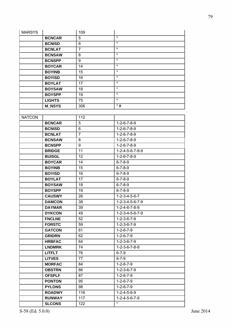
79
S-58 (Ed. 5.0.0) June 2014
MARSYS 109
BCNCAR 5 *
BCNISD 6 *
BCNLAT 7 *
BCNSAW 8 *
BCNSPP 9 *
BOYCAR 14 *
BOYINB 15 *
BOYISD 16 *
BOYLAT 17 *
BOYSAW 18 *
BOYSPP 19 *
LIGHTS 75 *
M_NSYS 306 * #
NATCON 112
BCNCAR 5 1-2-6-7-8-9
BCNISD 6 1-2-6-7-8-9
BCNLAT 7 1-2-6-7-8-9
BCNSAW 8 1-2-6-7-8-9
BCNSPP 9 1-2-6-7-8-9
BRIDGE 11 1-2-4-5-6-7-8-9
BUISGL 12 1-2-6-7-8-9
BOYCAR 14 6-7-8-9
BOYINB 15 6-7-8-9
BOYISD 16 6-7-8-9
BOYLAT 17 6-7-8-9
BOYSAW 18 6-7-8-9
BOYSPP 19 6-7-8-9
CAUSWY 26 1-2-3-4-5-6-7
DAMCON 38 1-2-3-4-5-6-7-9
DAYMAR 39 1-2-4-6-7-8-9
DYKCON 49 1-2-3-4-5-6-7-9
FNCLNE 52 1-2-3-6-7-9
FORSTC 59 1-2-3-6-7-9
GATCON 61 1-2-6-7-9
GRIDRN 62 1-2-6-7-9
HRBFAC 64 1-2-3-6-7-9
LNDMRK 74 1-2-3-6-7-8-9
LITFLT 76 6-7-9
LITVES 77 6-7-9
MORFAC 84 1-2-6-7-9
OBSTRN 86 1-2-3-6-7-9
OFSPLF 87 1-2-6-7-9
PONTON 95 1-2-6-7-9
PYLONS 98 1-2-6-7-9
ROADWY 116 1-2-4-5-6-9
RUNWAY 117 1-2-4-5-6-7-9
SLCONS 122 *

80
S-58 (Ed. 5.0.0) June 2014
SILTNK 125 1-2-6-7-8-9
NATSUR 113
LNDRGN 73 *
OBSTRN 86 *
SBDARE 121 * #
SLOTOP 126 *
SLOGRD 127 *
UWTROC 153 9-14-18
NATQUA 114
LNDRGN 73 *
OBSTRN 86 *
SBDARE 121 * #
UWTROC 153 4-8-9-10
PRODCT 123
BOYINB 15 1-2-18-19
CONVYR 34 4-5-6-7-10-11-12-13-14-15-16-17-21-22
OBSTRN 86 1-2-3-8
OFSPLF 87 1-2
OSPARE 88 1-2-4-6-10-14
PIPARE 92 1-2-3-7-8-18-19-20
PIPOHD 93 1-2-3-7-8-9-18-19-20-22
PIPSOL 94 1-2-3-7-8-9-18-19-20-22
PRDARE 97 *
SILTNK 125 1-2-3-7-8-9-14-18-19-20-21-22
QUASOU 125
BERTHS 10 1-2-3-4
DWRTCL 40 1-2-3-4
DWRTPT 41 1-2-3-4
DEPARE 42 1-2-3-4
DRGARE 46 10-11 (replaces check 1648)
DRYDOC 47 2-3-4-6-7-8-9
FAIRWY 51 1-2-3-4
GATCON 61 2-3-4-6-7
MARCUL 82 1-2-3-4-6-7-8-9
OBSTRN 86 1-2-3-4-6-7-8-9
RCRTCL 108 1-2-3-4
RECTRC 109 1-2-3-4-6
SOUNDG 129 1-3-4-5-8-9-10-11
SWPARE 134 1-3-4-5-8-9-10-11
TWRTPT 152 1-2-3-4
UWTROC 153 1-2-3-4-6-7-8-9
WRECKS 159 1-2-3-4-6-7-8-9

81
S-58 (Ed. 5.0.0) June 2014
M_SREL 310 1-2-3-4-5-6-7-8-9-10-11

82
S-58 (Ed. 5.0.0) June 2014
RESTRN 131 ACHARE 4 2-3-4-5-6-8-9-10-11-12-13-15-16-17-
18-19-20-21-23-24-27 CBLARE 20 1-2-3-4-5-6-7-8-9-10-11-12-13-16-17-
18-19-20-21-22-23-24-25-27 DWRTPT 41 1-2-3-4-5-6-8-9-10-11-12-13-16-17-
18-19-20-21-22-23-24-25-27 DRGARE 46 1-2-3-4-5-6-7-8-11-12-13-16-17-18-
19-20-21-22-23-25-27 DMPGRD 48 1-2-3-4-5-6-7-8-9-10-11-12-13-16-17-
18-19-20-21-22-23-24-25-27 FAIRWY 51 1-2-3-4-5-6-8-9-10-11-12-13-15-16-
17-18-19-20-21-22-23-24-25-27 ICNARE 67 1-2-3-4-5-6-7-8-9-10-11-12-13-16-17-
18-19-20-21-22-23-24-25-27 ISTZNE 68 1-2-3-4-5-6-8-9-10-11-12-13-18-19-
20-21-22-23-24-25-27 MARCUL 82 1-2-3-4-5-6-8-9-10-11-12-13-15-16-
17-18-19-20-21-22-23-24-25-27 MIPARE 83 1-2-3-4-5-6-8-9-10-11-12-13-15-16-
17-18-19-20-21-22-23-24-25-27 NEWOBJ 163 * OSPARE 88 1-2-3-4-5-6-7-8-9-10-11-12-13-15-16-
17-18-19-20-21-22-23-24-25-27 PIPARE 92 1-2-3-4-5-6-7-8-9-10-11-12-13-15-16-
17-18-19-20-21-22-23-24-25-27 PRCARE 96 1-2-3-4-5-6-8-9-10-11-12-13-16-17-
18-19-20-21-22-23-24-25-27 RESARE 112 *# SPLARE 120 1-2-3-4-5-6-7-8-9-10-11-12-13-15-16-
17-18-19-20-21-22-23-24-25-27 SUBTLN 133 1-2-3-4-5-6-7-8-9-10-11-12-13-16-17-
18-19-20-21-22-23-24-25-27 TESARE 135 1-2-3-4-5-6-7-8-9-10-11-12-13-16-17-
18-19-20-21-22-23-24-25-26-27 TSSCRS 147 1-2-3-4-5-6-8-9-10-11-12-13-16-17-
18-19-20-21-22-23-24-25-27 TSSLPT 148 1-2-3-4-5-6-8-9-10-11-12-13-16-17-
18-19-20-21-22-23-24-25-27 TSSRON 149 1-2-3-4-5-6-8-9-10-11-12-13-16-17-
18-19-20-21-22-23-24-25-27
SIGGEN 140
FOGSIG 58 *
STATUS 149
AIRARE 2 1-2-4-5-6-7-8-12-14-16-17 ACHBRT 3 1-2-3-4-5-6-7-8-9-14 ACHARE 4 1-2-3-5-6-7-8-9-14 BCNCAR 5 1-2-4-5-7-8-12-18 BCNISD 6 1-2-4-5-7-8-12-18
BCNLAT 7 1-2-4-5-7-8-12-18
BCNSAW 8 1-2-4-5-7-8-12-18
BCNSPP 9 1-2-4-5-7-8-12-18
BERTHS 10 1-2-3-5-6-7-8-9-12-14
BUISGL 12 1-4-6-7-8-12-13-14-16-17

83
S-58 (Ed. 5.0.0) June 2014
BOYCAR 14 1-2-5-7-8-18
BOYINB 15 1-2-4-5-7-8-18
BOYISD 16 1-2-5-7-8-18
BOYLAT 17 1-2-5-7-8-18
BOYSAW 18 1-2-5-7-8-18
BOYSPP 19 1-2-5-7-8-18
CBLARE 20 1-7-13
CBLOHD 21 1-4-5-7-12
CBLSUB 22 1-4-13
CANALS 23 1-3-4-5-6-8-14
CTSARE 25 1-2-3-5-6-7-9
CAUSWY 26 1-8-12-14
CHKPNT 28 1-2-5-7-9-12-16-17
CGUSTA 29 1-4-5-16-17
CONZNE 31 1
CONVYR 34 1-4-6-12
CRANES 35 1-4-6-12
DAYMAR 39 1-4-5-7-8-12
DWRTCL 40 1-3-6-9
DWRTPT 41 1-3-6-9
DOCARE 45 1-4-6-8-14
DRYDOC 47 1-4-6-8-12-14
DMPGRD 48 1-2-4-6-7
FAIRWY 51 1-3-6-7-9
FNCLNE 52 1-12
FERYRT 53 1-2-4-5-6-7-8-9
FSHZNE 54 1-5-6-7
FSHFAC 55 1-4-5-6-7-8-12-16-17
FSHGRD 56 1-5-6-7-8-14-16-17
FLODOC 57 1-4-6-7-8-12
FOGSIG 58 1-2-4-5-7-8-15
FRPARE 60 1-6-8-14
GATCON 61 1-4-6-16-17
GRIDRN 62 1-4-6-8-14-16-17
HRBARE 63 1-4-6-8-14-16-17
HRBFAC 64 1-4-5-6-7-8-9-12-13-14-16-17 ICEARE 66 1-2-5-16-17
ICNARE 67 1-2-5-6-7-16-17
ISTZNE 68 1-3-6-9-16-17
LNDARE 71 6-7-8-12-14-16-17-18
LNDMRK 74 1-2-4-5-7-8-12-13-14-16-17 LIGHTS 75 1-2-4-5-6-7-8-11-14-15-16-17 LITFLT 76 1-2-4-5-7-8-14-16-17 LITVES 77 1-2-4-5-7-8-14-16-17 LOKBSN 79 1-4-6-8-13-14-16-17 LOGPON 80 1-2-4-5-6-7-8 MARCUL 82 1-2-4-5-6-7-8-14-16-17 MIPARE 83 1-2-5-6-7-16-17 MORFAC 84 1-2-3-4-5-6-7-8-9-12-14-18 NAVLNE 85 1-2-5-7-8-14 NEWOBJ 163 *

84
S-58 (Ed. 5.0.0) June 2014
OBSTRN 86 1-4-5-7-8-13-18 OFSPLF 87 1-2-4-7-8-12-16-17 OSPARE 88 1-4-7-8-12 OILBAR 89 1-2-4-7-8 PILBOP 91 1-2-3-5-6-9-16-17 PIPARE 92 1-4-7 PIPOHD 93 1-4-7-12 PIPSOL 94 1-4-7-12 PONTON 95 1-2-4-5-6-7-8-12-14
PRCARE 96 1-9 PRDARE 97 1-4-8 RADLNE 99 1-2-4-7 RADRNG 100 1-2-4-7 RADRFL 101 1-4-8 RADSTA 102 1-2-4-7-8 RTPBCN 103 1-2-4-5-7-8 RDOCAL 104 1-3-4-5-6-7-9 RDOSTA 105 1-2-4-5-7-8 RAILWY 106 1-4-6-12 RCRTCL 108 1-5-6-9 RECTRC 109 1-2-5-6-8-9-14
(replaces check 1680) RCTLPT 110 1-6-9 RSCSTA 111 1-2-4-5-7-8-14-16-17 RESARE 112 1-2-3-4-5-6-7-9-18 RETRFL 113 1-4-8 RIVERS 114 1-2-5-8-14 ROADWY 116 1-2-4-6-8-12-14 RUNWAY 117 1-2-4-5-6-8-12-14
SPLARE 120 1-2-3-4-5-6-7-8-9-14
SLCONS 122 1-2-3-4-6-7-8-9-12-14-16-17 SISTAT 123 1-2-4-5-7-8-12-14-15-16-17 SISTAW 124 1-2-4-5-7-8-12-14-15-16-17 SILTNK 125 1-4-12 SMCFAC 128 1-2-3-4-5-6-7-8-9-12-14-16-17 SOUNDG 129 18 TS_PRH 136 1-2-5-7-18 TS_PNH 137 1-2-5-7-18 TS_TIS 139 1-2-5-7-18 T_HMON 140 5 T_NHMN 141 5 T_TIMS 142 5 TOPMAR 144 1-5-7-8-12-14 TSELNE 145 1-3-9 TSSBND 146 1-3-9 TSSCRS 147 1-3-6-9 TSSLPT 148 1-3-6-9 TSSRON 149 1-3-6-9 TSEZNE 150 1-3-9
TUNNEL 151 1-3-4-6-8-14-16-17
TWRTPT 152 1-3-6-9
UWTROC 153 13-18
WRECKS 159 7-13-18
SURTYP 153
M_SREL 310 *

85
S-58 (Ed. 5.0.0) June 2014
TECSOU 156
DWRTCL 40 1-2-3-6-7-8-9-11-13
DWRTPT 41 1-2-3-6-7-8-9-11-13
DRGARE 46 1-2-3-6-7-8-9-11-13
OBSTRN 86 1-2-3-4-5-6-7-8-9-10-11-12-13
RCRTCL 108 1-2-3-6-7-8-9-11-13
RECTRC 109 1-2-3-6-7-8-9-11-13
SOUNDG 129 *
SWPARE 134 6-8-13 (see check 1654)
TWRTPT 152 1-2-3-6-7-8-9-10-11-13
UWTROC 153 1-2-3-4-5-6-7-8-9-10-11-12-13
WRECKS 159 1-2-3-4-5-6-7-8-9-10-11-12-13
M_QUAL 308 *
T_ACWL 161
TS_TIS 139 *
T_HMON 140 *
T_NHMN 141 *
T_MTOD 163
TS_PRH 136 1-2 # (see check 1560)
TS_PNH 137 3 (#) (see check 1561)
T_HMON 140 1-2 # (see check 1557)
T_NHMN 141 3 (#) (see check 1558)
TOPSHP 171
DAYMAR 39 * #
TOPMAR 144 * #
TRAFIC 172
DWRTCL 40 * #
DWRTPT 41 * #
FAIRWY 51 *
RDOCAL 104 * #
RCRTCL 108 *
RECTRC 109 * #
TWRTPT 152 * #
VERDAT 185
BRIDGE 11 *
CBLOHD 21 *
CONVYR 34 *
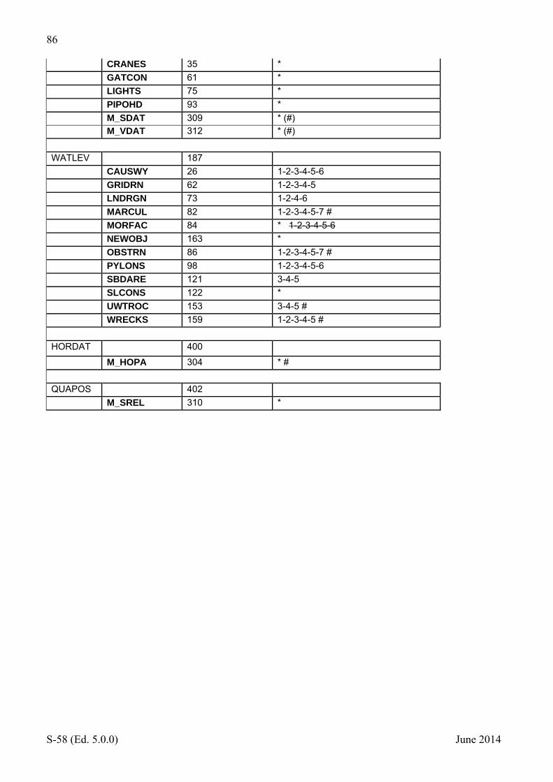
86
S-58 (Ed. 5.0.0) June 2014
CRANES 35 *
GATCON 61 *
LIGHTS 75 *
PIPOHD 93 *
M_SDAT 309 * (#)
M_VDAT 312 * (#)
WATLEV 187
CAUSWY 26 1-2-3-4-5-6
GRIDRN 62 1-2-3-4-5
LNDRGN 73 1-2-4-6
MARCUL 82 1-2-3-4-5-7 #
MORFAC 84 * 1-2-3-4-5-6
NEWOBJ 163 *
OBSTRN 86 1-2-3-4-5-7 #
PYLONS 98 1-2-3-4-5-6
SBDARE 121 3-4-5
SLCONS 122 *
UWTROC 153 3-4-5 #
WRECKS 159 1-2-3-4-5 #
HORDAT 400 M_HOPA 304 * #
QUAPOS 402
M_SREL 310 *
Related Documents