1 23 SPRINGER BRIEFS IN CLIMATE STUDIES Tetsuji Ito Makoto Tamura Akihiko Kotera Yuki Ishikawa-Ishiwata Editors Interlocal Adaptations to Climate Change in East and Southeast Asia Sharing Lessons of Agriculture, Disaster Risk Reduction, and Resource Management

Welcome message from author
This document is posted to help you gain knowledge. Please leave a comment to let me know what you think about it! Share it to your friends and learn new things together.
Transcript
1 23
S P R I N G E R B R I E F S I N C L I M AT E S T U D I E S
Tetsuji ItoMakoto TamuraAkihiko KoteraYuki Ishikawa-Ishiwata Editors
Interlocal Adaptations to Climate Change in East and Southeast AsiaSharing Lessons of Agriculture, Disaster Risk Reduction, and Resource Management

SpringerBriefs in Climate Studies
SpringerBriefs in Climate Studies present concise summaries of cutting-edge research and practical applications. The series focuses on interdisciplinary aspects of Climate Science, including regional climate, climate monitoring and modeling, palaeoclimatology, as well as vulnerability, mitigation and adaptation to climate change. Featuring compact volumes of 50 to 125 pages (approx. 20,000- 70,000 words), the series covers a range of content from professional to academic such as: a timely reports of state-of-the art analytical techniques, literature reviews, in-depth case studies, bridges between new research results, snapshots of hot and/or emerging topics Author Benefits: SpringerBriefs in Climate Studies allow authors to present their ideas and readers to absorb them with minimal time investment. Books in this series will be published as part of Springer’s eBook collection, with millions of users worldwide. In addition, Briefs will be available for individual print and electronic purchase. SpringerBriefs books are characterized by fast, global electronic dissemination and standard publishing contracts. Books in the program will benefit from easy-to-use manuscript preparation and formatting guidelines, and expedited production schedules. Both solicited and unsolicited manuscripts are considered for publication in this series. Projects will be submitted to editorial review by editorial advisory boards and/or publishing editors. For a proposal document please contact the Publisher.
More information about this series at https://link.springer.com/bookseries/11581
Tetsuji Ito • Makoto Tamura Akihiko Kotera • Yuki Ishikawa-IshiwataEditors
Interlocal Adaptations to Climate Change in East and Southeast AsiaSharing Lessons of Agriculture, Disaster Risk Reduction, and Resource Management
ISSN 2213-784X ISSN 2213-7858 (electronic)SpringerBriefs in Climate StudiesISBN 978-3-030-81206-5 ISBN 978-3-030-81207-2 (eBook)https://doi.org/10.1007/978-3-030-81207-2
© The Editor(s) (if applicable) and The Author(s) 2022Open Access This book is licensed under the terms of the Creative Commons Attribution 4.0 International License (http://creativecommons.org/licenses/by/4.0/), which permits use, sharing, adaptation, distribution and reproduction in any medium or format, as long as you give appropriate credit to the original author(s) and the source, provide a link to the Creative Commons license and indicate if changes were made.The images or other third party material in this book are included in the book’s Creative Commons license, unless indicated otherwise in a credit line to the material. If material is not included in the book’s Creative Commons license and your intended use is not permitted by statutory regulation or exceeds the permitted use, you will need to obtain permission directly from the copyright holder.The use of general descriptive names, registered names, trademarks, service marks, etc. in this publication does not imply, even in the absence of a specific statement, that such names are exempt from the relevant protective laws and regulations and therefore free for general use.The publisher, the authors and the editors are safe to assume that the advice and information in this book are believed to be true and accurate at the date of publication. Neither the publisher nor the authors or the editors give a warranty, expressed or implied, with respect to the material contained herein or for any errors or omissions that may have been made. The publisher remains neutral with regard to jurisdictional claims in published maps and institutional affiliations.
This Springer imprint is published by the registered company Springer Nature Switzerland AGThe registered company address is: Gewerbestrasse 11, 6330 Cham, Switzerland
EditorsTetsuji ItoCollege of Humanities and Social Sciences/Global and Local Environment Co-creation InstituteIbaraki UniversityIbaraki, Japan
Akihiko KoteraGlobal and Local Environment Co-creation InstituteIbaraki UniversityIbaraki, Japan
Makoto TamuraGlobal and Local Environment Co-creation InstituteIbaraki UniversityIbaraki, Japan
VNU Vietnam Japan UniversityHanoi, Vietnam
Yuki Ishikawa-IshiwataGlobal and Local Environment Co-creation InstituteIbaraki UniversityIbaraki, Japan
. This book is an open access publication.
v
Foreword
We live in a rapidly changing world.The significant factors causing environmental change today are the COVID-19
pandemic and climate change. We cannot yet foresee when COVID-19 will end, even though it has been spreading since its first report in December 2019. As of May 2021, more than 150 million people have been infected, and the number of COVID- related deaths has exceeded 3 million people worldwide. With such direct damages, COVID-19 has profoundly influenced the living conditions of vulnerable people such as those living in poverty, non-regular workers, the elderly, children, and women.
It has been pointed out that a potential cause of its occurrence and spread is the expansion of human activities, which degrades natural ecosystems and increases the risks of encountering unknown viruses. Recent globalization trends have contrib-uted to the rapid diffusion of the virus and the expansion of the pandemic. The COVID-19 pandemic also highlights essential issues in today’s society, such as the relationship between humans and nature, the vulnerable sides of globalization, and various socioeconomic divides among and within countries.
Climate change has also been progressing, making its impacts more apparent globally, particularly over the past 10 years. For example, India was hit by extraor-dinary heatwaves of more than 50°C in 2019, and the Philippines has suffered from severe damage from super typhoons. Simultaneously, Japan has been experiencing the increased impact of larger-scale floods caused by torrential rains and typhoons, which have caused escalating levels of damage. Bushfires in Australia in 2020 and California in 2021 gave a strong shock to the world. Although the times and places were different, all of these events were similarly reported using words such as “unprecedented” or “once a lifetime” occurrences. Hence, it is clear that among the features of today’s rapidly changing world is the reality that environmental changes are confronting us with unparalleled challenges and risks.
In the face of this situation, world society has started to act. In terms of respond-ing to climate change, 2015 was the epoch-making year when the Paris Agreement and Sustainable Development Goals (SDGs) were agreed upon in the international arena. The Paris Agreement set targets to hold the increase in the global average
vi
temperature to well below 2 °C above pre-industrial levels and pursue efforts to limit the temperature increase to 1.5 °C. Following this agreement, measures aimed at decarbonization, such as changing energy sources from fossil fuels to renewables and electric vehicle promotion, have advanced worldwide. In 2020, many countries declared to achieve carbon neutral by 2050.
These international trends have shown substantial advancements in response to the challenges of climate change. However, achieving the Paris goals will require time, which means that climate change and its effects will inevitably continue to increase for several decades. Therefore, we need another measure, i.e., adaptation, to increase preparedness for the adverse effects of climate change. To realize a safe, secure, climate-resilient, and sustainable society, the two pillars of mitigation (decarbonization) and adaptation are essential.
The shape and scale of climate change impacts vary with location. This is because climate change manifests itself differently from place to place, and because natural environments and societies are highly variable in each locality. As a result, each location requires specific adaptation approaches that correspond to their unique-ness. If we looked at the Asia and Pacific region, we see immense geographical, environmental, and socio-cultural variety. These include low-lying deltas vulnera-ble to sea-level rise, small islands with fragile ecosystems and traditional indige-nous societies, high mountains and arid inland desert areas. They are all the homes of diverse communities and cultures. Therefore, it is necessary to craft suitable approaches to adaptation for each region.
This is why we need a participatory approach that includes a wide variety of local stakeholders for identifying problems, planning adaptation strategies, and implementing their options. This approach also makes it possible to meet other challenges facing local communities, such as agricultural and fisheries promotion, water resource management, while also addressing vitalization of local economy and socioeconomic divides. Since these efforts are all interconnected, they will require the adequate support of central governments and international institutes.
I sincerely expect this book Interlocal Adaptations to Climate Change in East and Southeast Asia: Sharing Lessons of Agriculture, Disaster Risk Reduction, and Resource Management to help us visualize the current impacts and levels of adapta-tion in the Asia and Pacific region, and I am sure it will contribute to sharing lessons acquired from them. Now that we have begun to advance climate change responses based on the two pillars of mitigation and adaptation, I hope this effort will clear and expand the way toward a sustainable future society.
Global and Local Environment Nobuo MimuraCo-creation Institute Ibaraki University Ibaraki, Japan
Foreword
vii
Preface
This book, titled Interlocal Adaptations to Climate Change in East and Southeast Asia: Sharing Lessons of Agriculture, Disaster Risk Reduction, and Resource Management, was written by researchers from Japan, Vietnam, Thailand, Indonesia, the Philippines, and China involved in climate change adaptation in East and Southeast Asia. Although each author has a different specialty, we have all agreed to engage in either interdisciplinary or even transdisciplinary collaboration to accom-plish this project.
This book aims to achieve the following:
1. Promote interlocal lessons learned by sharing climate change adaptations, such as through “agriculture and natural resource management” and “disaster risk reduction and human resource development”
2. Develop new adaptation measures and research approaches that can consider the regional nature of East and Southeast Asia
3. Share practical adaptation options that have permeated society in each coun-try/region
∗ ∗ ∗
As is well known, Asia is one of the regions most vulnerable to the impacts of climate change, as more than 60% of the world’s population lives in this region, making it the growth center of the world. Although Asia is composed of a wide variety of countries and incredibly vast territories, in this book, we focus on East and Southeast Asia, including Japan, based on our research network.
The term “climate crisis” offers a more comprehensive description of contempo-rary global conditions compared with “climate change,” which might be insuffi-cient. The current climate crisis not only alters the natural environment, but also affects the social environment and deeply impacts cultures and customs.
What should be done about the climate crisis? More importantly, what can be done? Although single individuals do not have substantial power, there are still many things that can be accomplished. We are researchers. We have the wisdom to
viii
make connections across countries and disciplines. Even if each individual pos-sesses only marginal power, we believe that we can facilitate noticeable change by consolidating our connections and forming a network.
∗ ∗ ∗
The term “interlocal,” which is not very common in English, is one of the main keywords of this book. In relation to environmental issues, this term often refers to the concept of “Think globally, act locally.” However, the emergence of environ-mental problems, in terms of both the natural and social environment, has not neces-sarily spread uniformly globally, and differs depending on the locality, such as countries or regions. Therefore, we believe it is necessary to “Think interlocally,” which means to connect the dots (locality). At the same time, we believe it is also necessary to “Act interlocally.” Researchers who have conducted research in local areas with different social practices can exchange knowledge with each other to connect these localities, transforming points into lines, lines into planes, and finally planes into three-dimensional objects. We envision such a composition. We believe that “sharing lessons” will allow us to obtain truly useful practical knowledge.
The focus of “adaptation” in this book does not mean that “mitigation” is not important. As is often said, “adaptation” and “mitigation” are similar to the wheels of a car. We believe that we can respond to climate change or the climate crisis by turning all wheels at the same time. However, it is clear based on reports from the Intergovernmental Panel on Climate Change (IPCC) that these problems cannot be solved by “mitigation” alone. Human beings have survived and built prosperity through “adaptation.” Therefore, we now believe that the main question should be: “How can we ‘adapt’ to this situation?”
Regarding specific issues, this book focuses primarily on agriculture, disaster risk reduction, and resource management. Of course, these topics do not cover all related issues. We hope that sharing the lessons learned about these issues can serve as practical examples. As an additional note, “resources” include not only “natural resources,” but also “human resources.” We think that the term management for people (human resource management) is not always suitable, but we understand that it also refers to education, nurturing, and growth.
∗ ∗ ∗
At Ibaraki University, to which we editors belong, an organization called the Institute for Global Change Adaptation Science (ICAS), which was established in 2006, has established a strong track record of research and education focusing on “climate change adaptation” from a relatively early stage. In recognition of this, Ibaraki University will be in charge of the master’s program in climate change and development (MCCD) at VNU Vietnam Japan University (VJU), which opened in September 2018, and will be responsible for supervising the research conducted by many master’s students in Vietnam. Based on the establishment of a base in Hanoi, the capital of Vietnam, our project has been adopted by the Core-to-Core Program
Preface
ix
of the Japan Society for the Promotion of Science (JSPS) with the theme of “Southeast Asia Research-based Network on Climate Change Adaptation Science” and promoted to expand networking in East and Southeast Asia. In April 2020, the organization of Ibaraki University evolved into the Global and Local Environment Co-creation Institute (GLEC).
∗ ∗ ∗
In recent years, as the world started to come together to tackle such global issues, the emergence of ultra-nationalism has fostered the notion that global warming is a hoax, a narrative designed to divide people. We should not give credence to this idea, but combat it instead in solidarity.
The source of severe acute respiratory syndrome coronavirus 2 (SARS-CoV-2) that caused the coronavirus disease 2019 (COVID-19) pandemic in 2020 remains unclear according to a World Health Organization (WHO) survey, but climate change is a leading theory. Although scientific verification is needed to clarify this, the theory highlights the fact that climate change may impact numerous issues that are even more unexpected in the future.
Our network and the GLEC also want to carry out such work to “create a healthy environment together.” May our small actions eventually build to become a big wave. Let’s become planters of a “tree of hope” by collaborating together.
On behalf of the editors, Tetsuji Ito
Ibaraki, Japan Tetsuji Ito Makoto Tamura Akihiko Kotera Yuki Ishikawa-Ishiwata
Preface
xi
Acknowledgement
This book was funded by Core-to-Core Program of the Japan Society for the Promotion of Science (JSPS) with the theme of “Southeast Asia Research-based Network on Climate Change Adaptation Science”, Environment Research and Technology Development Fund (JPMEERF15S11413, JPMEERF20S11811) of the Environmental Restoration and Conservation Agency of Japan.

xiii
Contents
1 Climate Change Risk and Adaptation. . . . . . . . . . . . . . . . . . . . . . . . . . 1Makoto Tamura
Part I Agriculture and Natural Resource Management
2 Participatory Climate Change Adaptation Using Watershed Approach: Processes and Lessons from the Philippines . . . . . . . . . . . 19Juan M. Pulhin, Maricel A. Tapia-Villamayor, Josephine E. Garcia, Catherine C. De Luna, Rex Victor O. Cruz, Florencia B. Pulhin, and Mark Anthony M. Ramirez
3 Climate Change Adaptation Practices Towards Sustainable Watershed Management: The Case of Abuan Watershed in Ilagan City, Philippines . . . . . . . . . . . . . . . . . . . . . . . . . . . . . . . . . . . 33Orlando F. Balderama
4 Economic Evaluation and Climate Change Adaptation Measures for Rice Production in Vietnam Using a Supply and Demand Model: Special Emphasis on the Mekong River Delta Region in Vietnam . . . . . . . . . . . . . . . . . . . . . . . . . . . . . . . 45Yuki Ishikawa-Ishiwata and Jun Furuya
5 Small Coastal Island Ecosystems and Conservation Perspectives Within Adaptation Efforts . . . . . . . . . . . . . . . . . . . . . . . . 55Dietriech Geoffrey Bengen
Part II Disater Risk Reduction and Human Resource Development
6 Geotechnical Approaches to Disaster Risk Reduction in Japan and Vietnam . . . . . . . . . . . . . . . . . . . . . . . . . . . . . . . . . . . . . . . 65Kazuya Yasuhara and Satoshi Murakami
xiv
7 Climate Change Adaptation in Fisheries Livelihoods Associated with Mangrove Forests in Xuan Thuy National Park, Vietnam: A Case Study in Giao An Commune, Giao Thuy District, Nam Dinh Province . . . . . . . . . . . . . . . . . . . . . . . . . 77Thu Hoai Nguyen
8 Community-Based Disaster Risk Reduction Education in Japan . . . . . . . . . . . . . . . . . . . . . . . . . . . . . . . . . . . . . . . . . 89Aiko Sakurai and Tetsuji Ito
9 The Practice of Education for Disaster Risk Reduction in Vietnam: Lessons Learned from a Decade of Implementation 2010–2020 . . . . . . . . . . . . . . . . . . . . . . . . . . . . . . . . 101Thi Thi My Tong, Duong Thi Hong Nguyen, Hung The Nguyen, and Tae Yoon Park
Part III Conclusion
10 Sharing Interlocal Adaptation Lessons . . . . . . . . . . . . . . . . . . . . . . . . . 115Makoto Tamura and Tetsuji Ito
Columns
Column 1 The Southeast Asia Research-Based Network on Climate Change Adaptation Science (SARNCCAS) -Weaving the Wisdom of Climate Change Adaptation into Glocal Networks- . . . . . . 125Tetsuji Ito and Akihiko Kotera
Column 2 Variations of Short-Lived Climate Pollutants in Hanoi, Vietnam . . . . . . . . . . . . . . . . . . . . . . . . . . . . . . . . . . . . . . . . . . . . 129Tung Duy Do and Kazuyuki Kita
Column 3 Mixing Grey and Green Infrastructures for Coastal Adaptation in Vietnam . . . . . . . . . . . . . . . . . . . . . . . . . 135Makoto Tamura and Oanh Thi Pham
Column 4 The Effect of Climate Change and Natural Disasters on Mangrove Forests in Xuan Thuy National Park: Proposed Adaptation Measures for Mangrove Forests . . . . . 141Quang Van Nguyen
Column 5 Climate Change and Crop Management in Indonesia . . . . . . 145Eri Matsuura and Nobuo Sakagami
Column 6 Stakeholder Perception and Empirical Evidence: Oil Palm Biomass Utilization as Climate-Smart Smallholder Practice . . . . . . . . . . . . . . . . . . . . . . . . . . . . . . . . . 149Sachnaz Desta Oktarina, Ratnawati Nurkhoiry, Rizki Amalia, and Zulfi Prima Sani Nasution
Contents

xv
Column 7 Water Resource Assessment and Management in Phuket, Thailand . . . . . . . . . . . . . . . . . . . . . . . . . . . . . . . . . . 153Sukanya Vongtanaboon
Column 8 Analysis of Measures for Preventing Desertification in Inner Mongolia in China . . . . . . . . . . . . . . . . . . . . . . . . . . . 157Yulu Ma
Column 9 The Power of Dialogical Tools in Participatory Learning . . . . . . . . . . . . . . . . . . . . . . . . . . . . . . . . . . . . . . . . . . . 161Akihiko Kotera
Contents
xvii
Contributors
Rizki Amalia Indonesian Oil Palm Research Institute, Kota Medan, North Sumatra, Indonesia
Orlando F. Balderama College of Engineering, Isabela State University, Isabela, Philippines
Dietriech Geoffrey Bengen Faculty of Fisheries and Marine Science, IPB University, Bogor, Indonesia
Rex Victor O. Cruz College of Forestry and Natural Resources, University of the Philippines Los Baños, College, Los Baños, Laguna, Philippines
Duong Thi Hong Nguyen Department of Climate Change and Sustainable Development, Hanoi University of Natural Resource and Environment, Hanoi, Vietnam
Jun Furuya Social Sciences Division, Japan International Research Center for Agricultural Sciences, Ibaraki, Japan
Josephine E. Garcia College of Forestry and Natural Resources, University of the Philippines Los Baños, College, Los Baños, Laguna, Philippines
Thu Hoai Nguyen VNU Vietnam Japan University, Hanoi, Vietnam
Hung The Nguyen Department of Climate Change and Sustainable Development, Hanoi University of Natural resource and Environment, Hanoi, Vietnam
Yuki Ishikawa-Ishiwata Global and Local Environment Co-creation Institute, Ibaraki University, Ibaraki, Japan
Tetsuji Ito College of Humanities and Social Sciences/Global and Local Environment Co-creation Institute, Ibaraki University, Ibaraki, Japan
Kazuyuki Kita Graduate School of Science and Engineering, Ibaraki University, Ibaraki, Japan
xviii
Akihiko Kotera Global and Local Environment Co-creation Institute, Ibaraki University, Ibaraki, Japan
Catherine C. De Luna Interdisciplinary Studies Center for Integrated Natural Resources and Environment Management, University of the Philippines Los Baños, College, Los Baños, Laguna, Philippines
Eri Matsuura College of Agriculture, Ibaraki University, Ibaraki, Japan
Yulu Ma College of Agriculture, Inner Mongolia Minzu University, Tongliao, China
Nobuo Mimura Global and Local Environment Co-creation Institute, Ibaraki University, Ibaraki, Japan
Satoshi Murakami Faculty of engineering, Fukuoka University, Fukuoka, Japan
Zulfi Prima Sani Nasution Indonesian Oil Palm Research Institute, Kota Medan, North Sumatra, Indonesia
Quang Van Nguyen VNU Vietnam Japan University, Hanoi, Vietnam
Ratnawati Nurkhoiry Indonesian Oil Palm Research Institute, Kota Medan, North Sumatra, Indonesia
Sachnaz Desta Oktarina Indonesian Oil Palm Research Institute, Kota Medan, North Sumatra, Indonesia
Tae Yoon Park Graduate School of Education, Yonsei University, Seoul, South Korea
Oanh Thi Pham VNU Vietnam Japan University, Hanoi, Vietnam
Florencia B. Pulhin College of Forestry and Natural Resources, University of the Philippines Los Baños, College, Los Baños, Laguna, Philippines
Juan M. Pulhin Interdisciplinary Studies Center for Integrated Natural Resources and Environment Management, University of the Philippines Los Baños, College, Los Baños, Laguna, PhilippinesCollege of Forestry and Natural Resources, University of the Philippines Los Baños, College, Los Baños, Laguna, Philippines
Mark Anthony M. Ramirez Resources, Environment and Economics Center for Studies, Inc. (REECS), Quezon, Philippines
Nobuo Sakagami College of Agriculture, Ibaraki University, Ibaraki, Japan
Aiko Sakurai Department of Social Sciences, Toyo Eiwa University, Kanagawa, JapanInternational Research Institute of Disaster Science, Tohoku University, Miyagi, Japan
Contributors
xix
Makoto Tamura Global and Local Environment Co-creation Institute, Ibaraki University, Ibaraki, JapanVNU Vietnam Japan University, Hanoi, Vietnam
Maricel A. Tapia-Villamayor College of Forestry and Natural Resources, University of the Philippines Los Baños, College, Los Baños, Laguna, Philippines
Thi Thi My Tong Vietnam Institute of Economics, Vietnam Academy of Social Science, Hanoi, Vietnam
Tung Duy Do VNU Vietnam Japan University, Hanoi, Vietnam
Sukanya Vongtanaboon Faculty of Science and Technology, Phuket Rajabhat University, Phuket, Thailand
Kazuya Yasuhara Global and Local Environment Co-creation Institute, Ibaraki University, Ibaraki, Japan
Contributors
xxi
Abbreviations
AHP Analytical Hierarchy ProcessAIWMP Abuan Integrated Watershed Management ProjectA-PLAT Climate Change Adaptation Information PlatformAP-PLAT Asia-Pacific Climate Change Adaptation Information PlatformASTI Advance Science and Technology InstituteBAPPENAS Ministry of National Development Planning, IndonesiaBC Black CarbonBPTP Balai Pengkajian Teknologi PertanianCBDRR Community-Based Disaster Risk ReductionCBMS Community-Based Management SystemCC Climate ChangeCCA Climate Change AdaptationCCS Carbon Capture and StorageCDP Comprehensive Development PlanCLUP Comprehensive Land Use PlanCOP Conference of PartiesCPI Consumer Price IndexCRF Climate Resilience FrameworkCSA Climate-Smart AgricultureCSIRO Commonwealth Scientific and Industrial Research OrganizationCSTP Committee for Scientific and Technological PolicyDENR Department of Environment and Natural ResourcesDILG Department of Local GovernmentDOST Department of Science and TechnologyDOST-ASTI Advanced Science and Technology Institute of the DOSTDPL Community-Based Marine Protected AreaDREAM Disaster Risk and Exposure Assessment for Mitigation ProjectDRR Disaster Risk ReductionDRRM Disaster Risk Reduction and ManagementDRRMO Disaster Risk Reduction and Management OfficeDRRTHG Disaster Risk Reduction X Treasure Hunting Game
xxii
DSSAT Decision Support System for Agro-Technology TransferEWS Early Warning SystemsFAO Food and Agricultural OrganizationFAO-STAT Food and Agricultural Organization Corporate Statistical DatabasesFDSS Farmer Decision Support SystemGAP Good Agricultural PracticesGCM Global Circulation ModelGEJE 2011 Great East Japan EarthquakeGHG Green House GasGSO General Statistical Office of VietnamHCM Ho Chi Minh CityHEC-HMS Hydrologic Engineering Center-Hydrologic Modeling SystemHEC-RAS Hydrologic Engineering Center-River Analysis SystemIBM International Business MachinesIBM-WEDA Weather Data Solutions of IBMICT Information and Communication TechnologyiLCCAC Ibaraki Local Climate Change Adaptation CenterInSAR Interferometry Synthetic Aperture RadarIPCC Intergovernmental Panel on Climate ChangeIRR Implementing Rules and RegulationISET Institute for Social and Environmental Transition-InternationalIUCN International Union for Conservation of NatureJICA Japan International Cooperation AgencyKCDA Katahira Community Development AssociationLCCAC Local Climate Change Adaptation CenterLCCAP Local Climate Change Action PlansLDCs Least Developed CountriesLDRRMC Local Disaster Risk and Reduction Management CouncilLGC Local Government CodeLGU Local Government UnitLIDAR Light Detection and RagingLS Land SubsidenceM&E Monitoring and EvaluationMCCD Master’s Program in Climate Change and DevelopmentMCD Centre for Marinelife Conservation and Community DevelopmentMEXT Ministry of Education, Culture, Sports, Science and Technology
in JapanMFAJ Ministry of Foreign Affairs in JapanMLIT Ministry of Land, Infrastructure, Transportation and Tourism
in JapanMOA Memorandum of AgreementMOEJ Ministry of the Environment in JapanMONRE Ministry of Natural Resources and EnvironmentMOU Memorandum of UnderstandingMRD Mekong River Delta
Abbreviations
xxiii
NAPA National Adaptation Programmes of ActionNCCAP The Philippine's National Climate Change Action PlanNDRRMC National Disaster Risk Reduction and Management CouncilNOAH Nationwide Operational Assessment of Hazards ProjectNPAs National Adaptation PlansPHP Philippines PesoPM2.5 Particulate Matter with diameter smaller than 2.5μmRA Republic ActRAN-API Rencana Aksi National Adaptasi Perubahan IklimRCP Representative Concentration PathwaysR-DRRMP Reconstruction and DRR Mapping ProgramSDGs Sustainable Development GoalsSFDRR Sendai Framework for Disaster Risk ReductionSLCPs Short-Lived Climate PollutantsSLR Sea Level RiseSME Small-Medium EnterpriseSMS Short Messaging SystemSNS Social Networking ServiceSRES Special Report on Emission ScenariosSRI System of Rice IntensificationSSP Shared Socioeconomic PathwaysSub-NIAPP Sub-National Institute of Agricultural Planning and ProjectionSRTM3 Shuttle Radar Topography Mission, Ver.3TO3 Tropospheric ozoneUAVs Unmanned Aerial VehiclesUNDESA United Nations Department of Economic and Social AffairsUNFCCC United Nations Framework Convention on Climate ChangeUNISDR United Nations International Strategy for Disaster ReductionUS EPA United States Environmental Protection AgencyUSDA PS&D United States Department of Agriculture, Production, Supply and
DistributionWB World BankWDI World Development IndicatorWISE Weather Information-Integration for System EnhancementWLR Water Level RiseXTNP Xuan Thuy National Park
Abbreviations
1© The Author(s) 2022T. Ito et al. (eds.), Interlocal Adaptations to Climate Change in East and Southeast Asia, SpringerBriefs in Climate Studies, https://doi.org/10.1007/978-3-030-81207-2_1
Chapter 1Climate Change Risk and Adaptation
Makoto Tamura
1.1 The Impacts of Climate Change in East and Southeast Asia
Climate change is considered by many to be the most critical issue of our time, pos-ing a threat to security and socio-economic prosperity at the global level (MFAJ 2017). Asia is very vulnerable to the impacts of climate change, as more than 60% (approximately 4.5 billion) of the world’s people live in the region, making it a growth center of the world (UNDESA 2017).
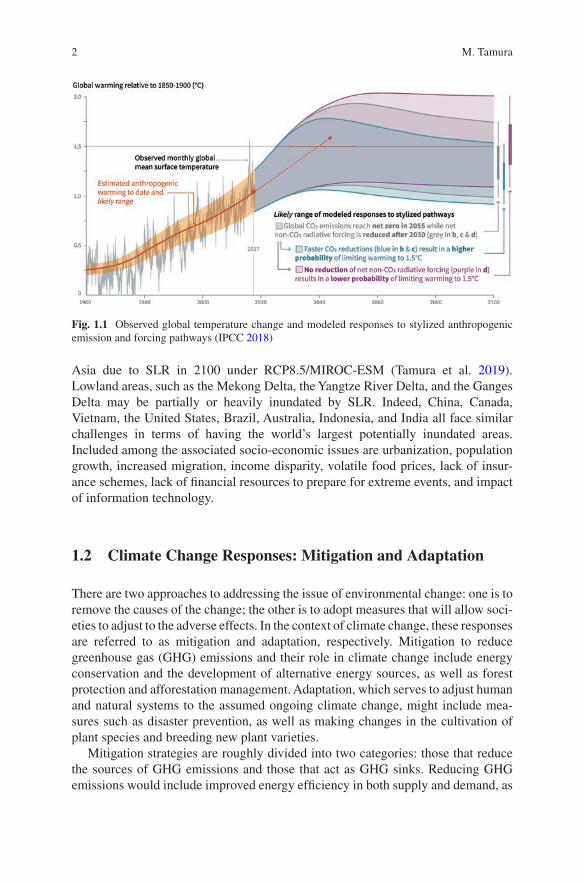
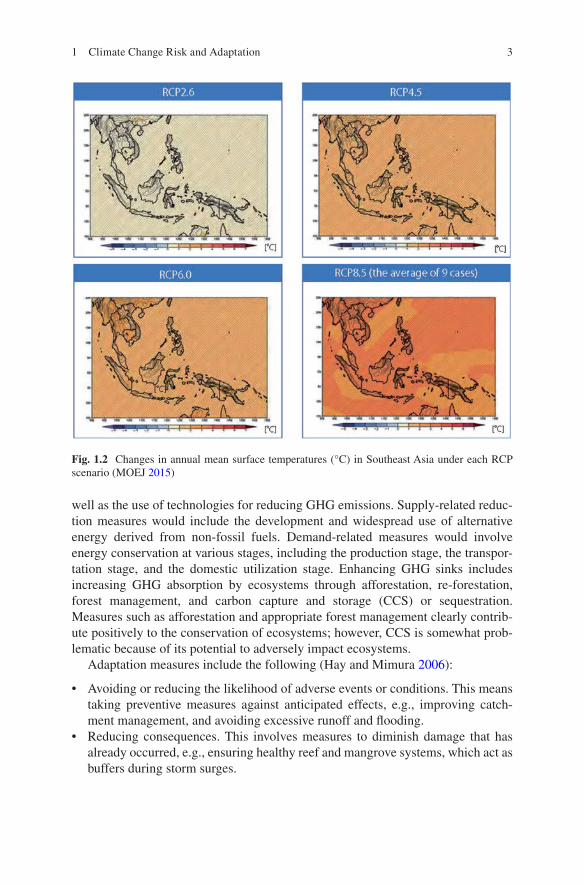
In 2017, human-induced global warming reached approximately 1 °C (between 0.8 °C and 1.2 °C) above pre-industrial levels, increasing at a rate of 0.2 °C (likely between 0.1 °C and 0.3 °C) per decade (Fig. 1.1; IPCC 2018). Figure 1.2 shows projected temperature changes in Southeast Asia, as calculated by Japan’s Ministry of the Environment and the Japan Meteorological Agency (MOEJ 2015). It shows expected temperature differences between the recent past (1984–2004) and future climate conditions (2080–2100) in the region. The colors indicate the average val-ues for the RCP2.6, RCP4.5, and RCP6.0 scenarios, and nine RCP8.5 scenarios. In all scenarios, temperatures show a distinct increasing tendency. These increasing temperatures will have serious physical and socio-economic impacts.
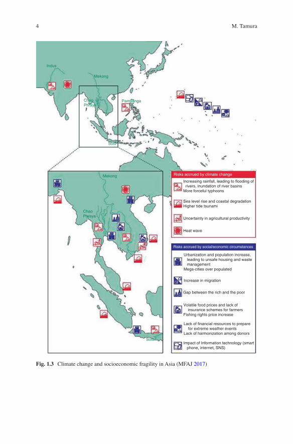
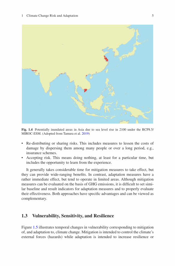
Climate change poses a variety of threats. Figure 1.3 shows a map of the risks attributable to climate change and attendant socio-economic circumstances. The former includes increasing rainfall, storms, flooding, inundation, sea level rise (SLR), uncertainty in terms of agricultural production, and the occurrence of heat waves. To illustrate such risks, Fig. 1.4 shows the potentially inundated areas of
M. Tamura (*) Global and Local Environment Co-creation Institute, Ibaraki University, Ibaraki, Japan
VNU Vietnam Japan University, Hanoi, Vietname-mail: [email protected]
2
Asia due to SLR in 2100 under RCP8.5/MIROC-ESM (Tamura et al. 2019). Lowland areas, such as the Mekong Delta, the Yangtze River Delta, and the Ganges Delta may be partially or heavily inundated by SLR. Indeed, China, Canada, Vietnam, the United States, Brazil, Australia, Indonesia, and India all face similar challenges in terms of having the world’s largest potentially inundated areas. Included among the associated socio-economic issues are urbanization, population growth, increased migration, income disparity, volatile food prices, lack of insur-ance schemes, lack of financial resources to prepare for extreme events, and impact of information technology.
1.2 Climate Change Responses: Mitigation and Adaptation
There are two approaches to addressing the issue of environmental change: one is to remove the causes of the change; the other is to adopt measures that will allow soci-eties to adjust to the adverse effects. In the context of climate change, these responses are referred to as mitigation and adaptation, respectively. Mitigation to reduce greenhouse gas (GHG) emissions and their role in climate change include energy conservation and the development of alternative energy sources, as well as forest protection and afforestation management. Adaptation, which serves to adjust human and natural systems to the assumed ongoing climate change, might include mea-sures such as disaster prevention, as well as making changes in the cultivation of plant species and breeding new plant varieties.
Mitigation strategies are roughly divided into two categories: those that reduce the sources of GHG emissions and those that act as GHG sinks. Reducing GHG emissions would include improved energy efficiency in both supply and demand, as
Fig. 1.1 Observed global temperature change and modeled responses to stylized anthropogenic emission and forcing pathways (IPCC 2018)
M. Tamura
3
well as the use of technologies for reducing GHG emissions. Supply-related reduc-tion measures would include the development and widespread use of alternative energy derived from non-fossil fuels. Demand-related measures would involve energy conservation at various stages, including the production stage, the transpor-tation stage, and the domestic utilization stage. Enhancing GHG sinks includes increasing GHG absorption by ecosystems through afforestation, re-forestation, forest management, and carbon capture and storage (CCS) or sequestration. Measures such as afforestation and appropriate forest management clearly contrib-ute positively to the conservation of ecosystems; however, CCS is somewhat prob-lematic because of its potential to adversely impact ecosystems.
Adaptation measures include the following (Hay and Mimura 2006):
• Avoiding or reducing the likelihood of adverse events or conditions. This means taking preventive measures against anticipated effects, e.g., improving catch-ment management, and avoiding excessive runoff and flooding.
• Reducing consequences. This involves measures to diminish damage that has already occurred, e.g., ensuring healthy reef and mangrove systems, which act as buffers during storm surges.
Fig. 1.2 Changes in annual mean surface temperatures (°C) in Southeast Asia under each RCP scenario (MOEJ 2015)
1 Climate Change Risk and Adaptation
4
Risks accrued by climate change
Risks accrued by social/economic circumstances
Indus
Mekong
Mekong
PampangaChaoPhraya
ChaoPhraya
Solo
Solo
Increasing rainfall, leading to flooding of rivers, inundation of river basinsMore forceful typhoons
Urbanization and population increase, leading to unsafe housing and waste managementMega-cities over populated
Increase in migration
Gap between the rich and the poor
Volatile food prices and lack of insurance schemes for farmersFishing rights price increase
Lack of financial resources to prepare for extreme weather eventsLack of harmonization among donors
Impact of Information technology (smart phone, internet, SNS)
Sea level rise and coastal degradationHigher tide tsunami
Uncertainty in agricultural productivity
Heat wave
Fig. 1.3 Climate change and socioeconomic fragility in Asia (MFAJ 2017)
M. Tamura
5
• Re-distributing or sharing risks. This includes measures to lessen the costs of damage by dispersing them among many people or over a long period, e.g., insurance schemes.
• Accepting risk. This means doing nothing, at least for a particular time, but includes the opportunity to learn from the experience.
It generally takes considerable time for mitigation measures to take effect, but they can provide wide-ranging benefits. In contrast, adaptation measures have a rather immediate effect, but tend to operate in limited areas. Although mitigation measures can be evaluated on the basis of GHG emissions, it is difficult to set simi-lar baseline and result indicators for adaptation measures and to properly evaluate their effectiveness. Both approaches have specific advantages and can be viewed as complementary.
1.3 Vulnerability, Sensitivity, and Resilience
Figure 1.5 illustrates temporal changes in vulnerability corresponding to mitigation of, and adaptation to, climate change. Mitigation is intended to control the climate’s external forces (hazards) while adaptation is intended to increase resilience or
Fig. 1.4 Potentially inundated areas in Asia due to sea level rise in 2100 under the RCP8.5/MIROC-ESM. (Adopted from Tamura et al. 2019)
1 Climate Change Risk and Adaptation

6
adaptive capacity. The risk of climate-related impacts is a product of the interaction of climate-related hazards and the vulnerability and exposure of humans and natural systems (Fig. 1.6). Here, hazards refer to threats, and includes both hazardous events and trends. Exposure refers to the presence of people and assets in places that could be adversely affected.
Vulnerability to climate change is determined by (1) the magnitude of external forces, such as an increase in air temperature, SLR, and changing rainfall patterns; (2) the susceptibility of nature and society to these external forces; and (3) the
Fig. 1.5 Temporal change in vulnerability corresponding to mitigation and adaptation to climate change (Komatsu et al. 2013)
Fig. 1.6 Interaction among exposure, vulnerability, and their adaptations (IPCC 2019)
M. Tamura
7
capacity of society to adapt to these external forces. Accordingly, societies that are easily damaged by climate change are considered to be highly vulnerable. Thus, the combination of larger climate hazards (external forces) and less adaptive capacity (less resilience) means higher vulnerability. Even under conditions where there is the same level of hazard, the risk will be dependent on the local situation. If the region has small exposure (e.g., slightly affected population and small assets) and good adaptive capacity to climate change, then the risk will not be so serious (and vice versa).
1.4 Approaches and Categories of Adaptation
1.4.1 Approaches
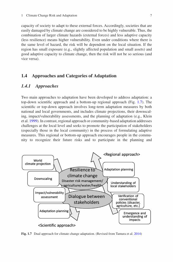
Two main approaches to adaptation have been developed to address adaptation: a top-down scientific approach and a bottom-up regional approach (Fig. 1.7). The scientific or top-down approach involves long-term adaptation measures by both national and local governments, and includes climate projections, their downscal-ing, impact/vulnerability assessments, and the planning of adaptation (e.g., Klein et al. 1999). In contrast, regional approach or community-based adaptation addresses challenges at the local level and seeks to promote the participation of stakeholders (especially those in the local community) in the process of formulating adaptive measures. This regional or bottom-up approach encourages people in the commu-nity to recognize their future risks and to participate in the planning and
Fig. 1.7 Dual approach for climate change adaptation. (Revised from Tamura et al. 2014)
1 Climate Change Risk and Adaptation

8
implementation of adaptation measures (e.g., Adger et al. 2005). Dialogue between stakeholders may bridge these two approaches.
This book covers both research and activities among some East and Southeast Asia countries so that it can fill in the gap between two approaches including agri-culture, disaster risk management, resource management, and human resource development.
1.4.2 Categories
Based on the timescale (short-term, mid-term, and long-term), adaptation measures can be further categorized as follows: (1) efforts to strengthen existing measures related to adaptation, (2) adaptive management for middle and long-term impacts, and (3) measures aimed at a fundamental improvements in sensitivity (Fig. 1.8). Enhancing adaptive capacity is the main objective at the initial level of adaptation, while improvement in sensitivity, including reconstruction and transformation, is the main goal at the latter level.
Fig. 1.8 Level and time scale of adaptation (Shirai et al. 2014)
M. Tamura
9
1.5 Trends in International Policy and National Adaptation Plans (NAPs)
The Paris Agreement, adopted in December 2015 at the 21st Conference of the Parties (COP21) by the UN Framework Convention on Climate Change (UNFCCC), has a shared international long-term goal of “holding the increase in the global aver-age temperature to well below 2°C above pre-industrial levels” and sets the direc-tion toward net zero anthropogenic GHG emissions by the second half of the twenty-first century. With respect to adaptation, the agreement calls for “enhancing adaptive capacity, strengthening resilience and reducing vulnerability to climate change”, and urges the parties to “engage in a process to formulate and implement national adaptation plans.”
The UNFCCC began its National Adaptation Programmes of Action (NAPA) in 2001 to support the efforts of the Least Developed Countries (LDCs) in addressing their urgent and immediate need to cope with the impacts of climate change. In 2010, the UNFCCC established the NAP process at COP16 in Cancun. Comparing the two approaches, NAPA is rather urgent and reactive and focuses on actions for LDCs to be taken primarily based on observed or past events. The NAP process is more proactive and, in addition to observed information, relies on future climate projections and their likely impacts (UNFCCC 2012). Of 153 developing countries, 91 have initiated the NAP process and 11 have submitted NAPs as of 2018 (UNFCCC 2018). Since the adverse impacts of climate change have been recognized by nearly all countries, NAPs are not limited to LDCs, but are promoted by both developing and developed countries, including the EU countries (UK, Germany, etc.), the USA, Japan, South Korea, and China. Japan formulated its “National Plan for Adaptation to the Impacts of Climate Change” in November 2015 (Cabinet decision 2015) and enacted the “Climate Change Adaptation Act” in June 2018. After formulating their NAP, national governments need to develop methodologies for monitoring and eval-uating (M & E) the progress of their adaptation efforts.
1.6 Key Elements of a National-Level Adaptation Plan/Strategy
National-level adaptation plays a key role in adaptation planning and implementa-tion. It serves to coordinate adaptation responses at subnational and local levels, where diverse processes and outcomes are called for (IPCC 2014). National-level coordination includes the provision of information about potential risks in order to strengthen the actions of state and local governments. These activities provide pol-icy frameworks that guide decisions at the subnational level, coordinating the cre-ation of legal frameworks, directing sectoral action and targeting resources for national development (agriculture, fisheries, health, ecosystem protection, among
1 Climate Change Risk and Adaptation
10
others), protecting vulnerable groups, and providing financial support for the vari-ous levels of government.
As adaptation activities have progressed, multiple challenges have emerged, including how to manage the decision-making process, how to develop effective strategies and plans, and how to implement them. In this regard, individual roles within a multilevel governance system have become an issue made more complex by the need for horizontal coordination among different agencies and departments, and vertical coordination among various stakeholders, from national to regional to local actors (IPCC 2014). National governments need to coordinate and enhance appropriate multilevel adaptations. Accordingly, they should (1) share common understanding among the line ministries in order to ensure that concerted actions are taken with minimum effort and cost, and that duplication is avoided, (2) priori-tize actions according to evidence, recognizing the limitations of time and budget, and (3) allocate a portion of the national budget to adaptation policy, that is suffi-cient to assess the potential effectiveness of adaptation measures.
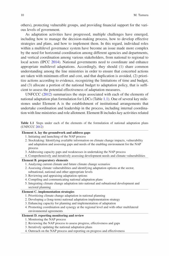
UNFCCC (2012) summarizes the steps associated with each of the elements of national adaptation plan formulation for LDCs (Table 1.1). One of several key mile-stones under Element A is the establishment of institutional arrangements that undertake coordination and leadership in the process, including internal coordina-tion with line ministries and role allotment. Element B includes key activities related
Table 1.1 Steps under each of the elements of the formulation of national adaptation plans (UNFCCC 2012)
Element A. lay the groundwork and address gaps 1. Initiating and launching of the NAP process 2. Stocktaking: Identifying available information on climate change impacts, vulnerability
and adaptation and assessing gaps and needs of the enabling environment for the NAP process
3. Addressing capacity gaps and weaknesses in undertaking the NAP process 4. Comprehensively and iteratively assessing development needs and climate vulnerabilitiesElement B. preparatory elements 1. Analyzing current climate and future climate change scenarios 2. Assessing climate vulnerabilities and identifying adaptation options at the sector,
subnational, national and other appropriate levels 3. Reviewing and appraising adaptation options 4. Compiling and communicating national adaptation plans 5. Integrating climate change adaptation into national and subnational development and
sectoral planningElement C. implementation strategies 1. Prioritizing climate change adaptation in national planning 2. Developing a (long-term) national adaptation implementation strategy 3. Enhancing capacity for planning and implementation of adaptation 4. Promoting coordination and synergy at the regional level and with other multilateral
environmental agreementsElement D. reporting monitoring and review 1. Monitoring the NAP process 2. Reviewing the NAP process to assess progress, effectiveness and gaps 3. Iteratively updating the national adaptation plans 4. Outreach on the NAP process and reporting on progress and effectiveness
M. Tamura
11
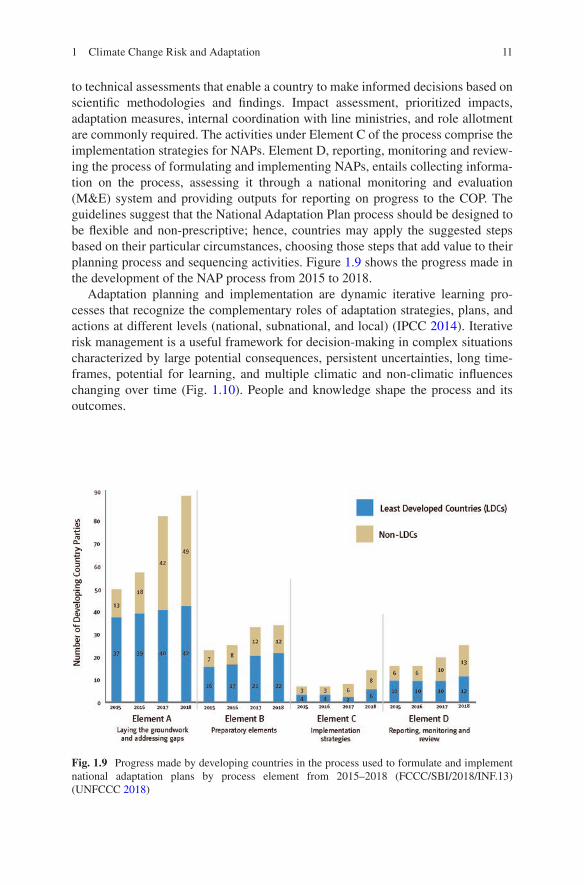
to technical assessments that enable a country to make informed decisions based on scientific methodologies and findings. Impact assessment, prioritized impacts, adaptation measures, internal coordination with line ministries, and role allotment are commonly required. The activities under Element C of the process comprise the implementation strategies for NAPs. Element D, reporting, monitoring and review-ing the process of formulating and implementing NAPs, entails collecting informa-tion on the process, assessing it through a national monitoring and evaluation (M&E) system and providing outputs for reporting on progress to the COP. The guidelines suggest that the National Adaptation Plan process should be designed to be flexible and non-prescriptive; hence, countries may apply the suggested steps based on their particular circumstances, choosing those steps that add value to their planning process and sequencing activities. Figure 1.9 shows the progress made in the development of the NAP process from 2015 to 2018.
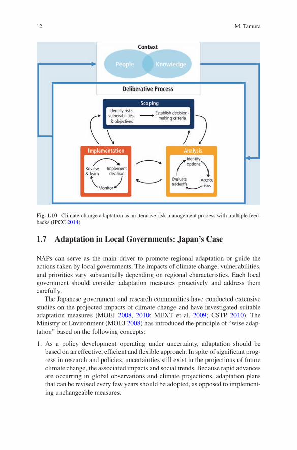
Adaptation planning and implementation are dynamic iterative learning pro-cesses that recognize the complementary roles of adaptation strategies, plans, and actions at different levels (national, subnational, and local) (IPCC 2014). Iterative risk management is a useful framework for decision-making in complex situations characterized by large potential consequences, persistent uncertainties, long time-frames, potential for learning, and multiple climatic and non-climatic influences changing over time (Fig. 1.10). People and knowledge shape the process and its outcomes.
Fig. 1.9 Progress made by developing countries in the process used to formulate and implement national adaptation plans by process element from 2015–2018 (FCCC/SBI/2018/INF.13) (UNFCCC 2018)
1 Climate Change Risk and Adaptation
12
1.7 Adaptation in Local Governments: Japan’s Case
NAPs can serve as the main driver to promote regional adaptation or guide the actions taken by local governments. The impacts of climate change, vulnerabilities, and priorities vary substantially depending on regional characteristics. Each local government should consider adaptation measures proactively and address them carefully.
The Japanese government and research communities have conducted extensive studies on the projected impacts of climate change and have investigated suitable adaptation measures (MOEJ 2008, 2010; MEXT et al. 2009; CSTP 2010). The Ministry of Environment (MOEJ 2008) has introduced the principle of “wise adap-tation” based on the following concepts:
1. As a policy development operating under uncertainty, adaptation should be based on an effective, efficient and flexible approach. In spite of significant prog-ress in research and policies, uncertainties still exist in the projections of future climate change, the associated impacts and social trends. Because rapid advances are occurring in global observations and climate projections, adaptation plans that can be revised every few years should be adopted, as opposed to implement-ing unchangeable measures.
Fig. 1.10 Climate-change adaptation as an iterative risk management process with multiple feed-backs (IPCC 2014)
M. Tamura
13
2. Wise adaptation considers climate change adaptation in the wider context of sustainability and the well-being of society. Adaptation to climate change should contribute to other social goals, such as mitigation of climate change, the cre-ation of an environmentally friendly, safe and secure society in accordance with sustainable development goals (SDGs).
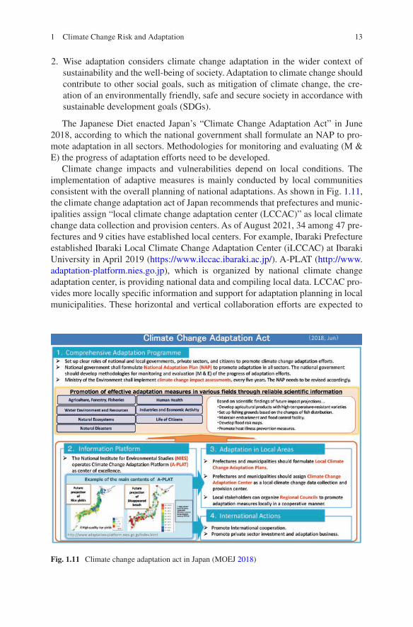
The Japanese Diet enacted Japan’s “Climate Change Adaptation Act” in June 2018, according to which the national government shall formulate an NAP to pro-mote adaptation in all sectors. Methodologies for monitoring and evaluating (M & E) the progress of adaptation efforts need to be developed.
Climate change impacts and vulnerabilities depend on local conditions. The implementation of adaptive measures is mainly conducted by local communities consistent with the overall planning of national adaptations. As shown in Fig. 1.11, the climate change adaptation act of Japan recommends that prefectures and munic-ipalities assign “local climate change adaptation center (LCCAC)” as local climate change data collection and provision centers. As of August 2021, 34 among 47 pre-fectures and 9 cities have established local centers. For example, Ibaraki Prefecture established Ibaraki Local Climate Change Adaptation Center (iLCCAC) at Ibaraki University in April 2019 (https://www.ilccac.ibaraki.ac.jp/). A-PLAT (http://www.adaptation- platform.nies.go.jp), which is organized by national climate change adaptation center, is providing national data and compiling local data. LCCAC pro-vides more locally specific information and support for adaptation planning in local municipalities. These horizontal and vertical collaboration efforts are expected to
Fig. 1.11 Climate change adaptation act in Japan (MOEJ 2018)
1 Climate Change Risk and Adaptation
14
fill the gap between scientific and regional approaches for adaptation, as shown in Fig. 1.7, and are significant for promoting resilient adaptations.
1.8 Lessons Learned
Developing countries with high vulnerability that face serious adverse impacts from climate change will need to increase their adaptive capacities. Long-term targets would include the ability to apply their own traditional experiences and knowledge of natural disasters, and to develop the capacity to implement their own monitoring and prediction techniques. To enhance these adaptive capacities, it is critical to establish a social system that can promote information collection and to share and raise awareness of the importance of these activities. Similar methodologies have been implemented to promote regional development. Indeed, adaptation is some-times regarded as a means to accomplish development objectives, while develop-ment can be seen as the means to achieve adaptation objectives (McGray et al. 2007). In other words, because of the overlap between adaptation and regional development, increasing adaptive capacity depends, to a significant extent, on regional development paths. In this sense, it is difficult to separate actions to reduce vulnerability to climate change from those promoting sustainable development when there are limited resources that can be allocated to both action streams. Not surprisingly, some of the SDGs adopted at the Sustainable Development Summit in 2015 recognize this close connection. In particular, the targets for SDG 13 “Climate action (Take urgent action to combat climate change and its impacts)” include strengthening resilience and adaptive capacity to deal with climate hazards (United Nations 2018). Thus, decision makers have come to realize that ‘mainstreaming’ or incorporating adaptation policies into existing socioeconomic policies without dis-tinguishing between climate change policies and, for example, land use and agricul-ture planning, is a logical evolution of the preferred solution.
Adaptation and mitigation serve as twin pillars in the battle against climate change. Together, they represent the main strategies for improving social resilience to climate change, ensuring human security and promoting sustainable develop-ment. As part of the battle plan, it is essential to review and reconstruct our national policies on land use, environmental use and city/rural planning. The ideal of a low- carbon and resilient society needs to be aggressively promoted so that a sustainable society can ultimately be created. The high-level target is to adopt a flexible response to climate change in order to sustain a dynamic and vital society. Importantly, wise adaptation to climate change must be implemented according to regional realities, changing regional and social modalities while simultaneously producing solutions to other pressing problems.
M. Tamura
15
References
Adger WN, Hughes TP, Folke C, Carpenter SR, Rockstrom J (2005) Social-ecological resilience to costal disasters. Science 309(5737):1036–1039
Cabinet Decision in Japan (2015) National Plan for adaptation to the impacts of climate change. Cabinet Decision on 27 November 2015
CSTP (Council for Science and Technology Promotion) (2010) Planning technological devel-opment towards realizing a society adapting to climate change (Final Report). Task Force for Planning Technological Development towards Realizing a Society Adapting to Climate Change, The Cabinet Office, 28p (in Japanese)
Hay J, Mimura N (2006) Supporting climate change vulnerability and adaptation assessments in the Asia-Pacific region: an example of sustainability science. Sustain Sci 1(1):23–35
IPCC (2014) Climate change 2014 -impacts, adaptation and vulnerability: working group II contri-bution to the fifth assessment report of the IPCC. Cambridge University Press, London
IPCC (2018) Special report on global warming of 1.5 °CIPCC (2019) Special report on the ocean and cryosphere in a changing climateKlein RJT, Nicholls RJ, Mimura N (1999) Coastal adaptation to climate change: can the IPCC
technical guidelines be applied? Mitig Adapt Strateg Glob Chang 4(3–4):239–252Komatsu T, Shirai N, Tanaka M, Harasawa H, Tamura M, Yasuhara K (2013) Adaptation phi-
losophy and strategy against climate change-induced geo-disasters. In: Proceedings of 10th JGS. Symposium on Environmental Geotechnics, 76–82
McGray H, Hammill A, Bradley R (2007) Weathering the storm: options for framing adaptation and development. World Resource Institute, Washington DC, 57p
MEXT (Ministry of Education, Culture, Sports, Science and Technology), JMA (Japan Meteorological Agency), and MOE (Ministry of Environment) (2009) Synthesis report on observations, projections, and impact assessments of climate change climate change and its impacts in Japan. MEXT, 74p (in Japanese)
MFAJ (2017) Analysis and proposal of foreign policies regarding the impact of climate change on fragility in the Asia-Pacific region- with focus on natural disasters in the region. Ministry of Foreign Affairs in Japan, 49p
MOEJ (2008) Wise adaptation to climate change, the committee on climate change impacts and adaptation research. Ministry of Environment in Japan, 70p
MOEJ (2010) Approaches to climate change adaptation. The committee on approaches to climate change adaptation, Ministry of Environment in Japan, 80p
MOEJ (2015) Climate change in Southeast Asia: outputs from GCM. Ministry of Environment in Japan, 12p
MOEJ (2018) Climate change adaptation act. https://www.env.go.jp/en/earth/cc/adaptation.htmlShirai N, Tanaka M, Tamura M, Yasuhara K, Harasawa H, Komatsu T (2014) Building and verifi-
cation of a theoretical framework for climate change adaptation: strategies of climate change adaptation. Environ Sci 27(5):313–323. (in Japanese)
Tamura M, Yasuhara K, Shirai N, Tanaka M (2014) Wise adaptation to climate change: Japan’s case. In: Prutsch A, McCallum S, Grothmann T, Swart R, Chauser I (eds) Climate change adap-tation manual: lessons learned from European and other industrialized countries. Routledge, pp 314–319
Tamura M, Yotsukuri M, Kumano N, Yokoki H (2019) Global assessment of the effectiveness of adaptation in coastal areas based on RCP/SSP scenarios. Clim Chang 152(3–4):363–377
UNDESA (2017) World population prospects: the 2017 revision. United Nations, New YorkUNFCCC (2012) National adaptation plans: technical guidelines for the National Adaptation Plan
Process. LDC expert group, 148pUNFCCC (2018) National Adaptation Plans 2018: Progress in the process to formulate and imple-
ment National Adaptation Plans. LDC expert group, 33pUnited Nations (2018) The sustainable development goals report 2018, 40p
1 Climate Change Risk and Adaptation

16
Open Access This chapter is licensed under the terms of the Creative Commons Attribution 4.0 International License (http://creativecommons.org/licenses/by/4.0/), which permits use, sharing, adaptation, distribution and reproduction in any medium or format, as long as you give appropriate credit to the original author(s) and the source, provide a link to the Creative Commons license and indicate if changes were made.
The images or other third party material in this chapter are included in the chapter’s Creative Commons license, unless indicated otherwise in a credit line to the material. If material is not included in the chapter’s Creative Commons license and your intended use is not permitted by statutory regulation or exceeds the permitted use, you will need to obtain permission directly from the copyright holder.
M. Tamura

Part IAgriculture and Natural Resource
Management
19© The Author(s) 2022T. Ito et al. (eds.), Interlocal Adaptations to Climate Change in East and Southeast Asia, SpringerBriefs in Climate Studies, https://doi.org/10.1007/978-3-030-81207-2_2
Chapter 2Participatory Climate Change Adaptation Using Watershed Approach: Processes and Lessons from the Philippines
Juan M. Pulhin, Maricel A. Tapia-Villamayor, Josephine E. Garcia, Catherine C. De Luna, Rex Victor O. Cruz, Florencia B. Pulhin, and Mark Anthony M. Ramirez
2.1 Introduction
The Philippine’s National Climate Change Action Plan (NCCAP) aims primarily to build the adaptive capacity of local communities and increase the resilience of natu-ral ecosystems to climate change to promote climate-risk resilience. Climate change is expected to have far-reaching impacts on the structure, ecological conditions, and functions of various ecosystems, diminishing their capacity to support people and communities. Thus, it is important to anticipate the conditions of a socio-ecological system considering climate change, and to maintain its integrity through adaptation.
The watershed approach, which uses the watershed as a planning unit and exem-plifies a coordinated environmental management that focuses on public and private
J. M. Pulhin (*) Interdisciplinary Studies Center for Integrated Natural Resources and Environment Management, University of the Philippines Los Baños, College, Los Baños, Laguna, Philippines
College of Forestry and Natural Resources, University of the Philippines Los Baños, College, Los Baños, Laguna, Philippinese-mail: [email protected]
M. A. Tapia-Villamayor · J. E. Garcia · R. V. O. Cruz · F. B. Pulhin College of Forestry and Natural Resources, University of the Philippines Los Baños, College, Los Baños, Laguna, Philippines
C. C. De Luna Interdisciplinary Studies Center for Integrated Natural Resources and Environment Management, University of the Philippines Los Baños, College, Los Baños, Laguna, Philippines
M. A. M. Ramirez Resources, Environment and Economics Center for Studies, Inc. (REECS), Quezon, Philippines
20
sector efforts (US EPA 2008), ensures a holistic method of managing ecosystems. Designing strategies to sustainably use and manage the resources in the watershed in view of changes in climate constitute an important step towards moderating the potential impacts of climate change and taking advantage of the opportunities that climate change presents. This also contributes towards building the resilience of the people and various ecosystems in the watershed.
In the Philippines, watershed areas are under the administration of the Department of Environment and Natural Resources (DENR) and management is under the con-trol of respective local government units (LGU). Nevertheless, watershed manage-ment entails collective action or a public involvement to influence collective action. This means different stakeholders, particularly in communities, mobilizing them-selves for this common cause, or a public entity acting as a champion to pursue a common goal.
This paper presents the processes and lessons learned in developing a participa-tory climate change framework in two watersheds in the Philippines, namely Baroro Watershed and Saug Watershed. In the end, the project came up with a protocol on participatory climate change adaptation using watershed approach to enhance resil-ience of communities and ecosystems.
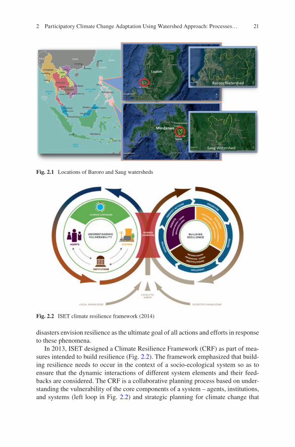
The Baroro Watershed is located in the northeastern part of the province of La Union and encompasses the municipalities of San Gabriel, San Juan, Bagulin, Bacnotan and Santol, and the city of San Fernando. It comprises a total of 19,486 hectares. The watershed is the main source of water for both irrigation and domestic purposes in all of the municipalities and city, except for Bagulin and Santol. Agriculture is the main source of income in the watershed.
The Saug Watershed, on the other hand, is located in the provinces of Davao del Norte and Compostela Valley. The watershed comprises the municipalities of Asuncion, Kapalong, New Corella and San Isidro and the city of Tagum in Davao del Norte, and the municipalities of Laak, Mawab, Monkayo, Montevista and Nabunturan in Compostela Valley. It has a total land area of 99,866 hectares, 60% of which is occupied by Davao del Norte and 40% by Compostela Valley. The watershed is an economically important catchment that hosts the agricultural pro-duction in the two provinces and supplies these areas with water, particularly the low-lying municipalities. Figure 2.1 shows the location of the two watersheds.
2.2 Planning for Resilience: An Integrated Approach
The complexity of the climate change problem demands an approach that would tackle its dynamic, multi-sectoral, multi-scalar and highly variable impacts. The risks and uncertainties associated with it also takes planning beyond the traditional ‘predict and act’ framework (Institute for Social and Environmental Transition- International (ISET) 2013), and strives for a system that is prepared for any distur-bance or sudden change. Hence, national strategic plans for climate change and
J. M. Pulhin et al.
21
disasters envision resilience as the ultimate goal of all actions and efforts in response to these phenomena.
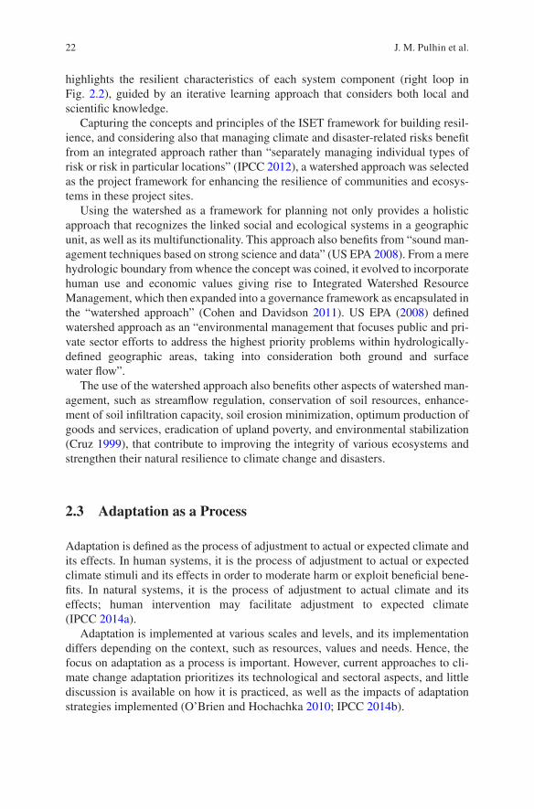
In 2013, ISET designed a Climate Resilience Framework (CRF) as part of mea-sures intended to build resilience (Fig. 2.2). The framework emphasized that build-ing resilience needs to occur in the context of a socio-ecological system so as to ensure that the dynamic interactions of different system elements and their feed-backs are considered. The CRF is a collaborative planning process based on under-standing the vulnerability of the core components of a system – agents, institutions, and systems (left loop in Fig. 2.2) and strategic planning for climate change that
Fig. 2.1 Locations of Baroro and Saug watersheds
Fig. 2.2 ISET climate resilience framework (2014)
2 Participatory Climate Change Adaptation Using Watershed Approach: Processes…
22
highlights the resilient characteristics of each system component (right loop in Fig. 2.2), guided by an iterative learning approach that considers both local and scientific knowledge.
Capturing the concepts and principles of the ISET framework for building resil-ience, and considering also that managing climate and disaster-related risks benefit from an integrated approach rather than “separately managing individual types of risk or risk in particular locations” (IPCC 2012), a watershed approach was selected as the project framework for enhancing the resilience of communities and ecosys-tems in these project sites.
Using the watershed as a framework for planning not only provides a holistic approach that recognizes the linked social and ecological systems in a geographic unit, as well as its multifunctionality. This approach also benefits from “sound man-agement techniques based on strong science and data” (US EPA 2008). From a mere hydrologic boundary from whence the concept was coined, it evolved to incorporate human use and economic values giving rise to Integrated Watershed Resource Management, which then expanded into a governance framework as encapsulated in the “watershed approach” (Cohen and Davidson 2011). US EPA (2008) defined watershed approach as an “environmental management that focuses public and pri-vate sector efforts to address the highest priority problems within hydrologically- defined geographic areas, taking into consideration both ground and surface water flow”.
The use of the watershed approach also benefits other aspects of watershed man-agement, such as streamflow regulation, conservation of soil resources, enhance-ment of soil infiltration capacity, soil erosion minimization, optimum production of goods and services, eradication of upland poverty, and environmental stabilization (Cruz 1999), that contribute to improving the integrity of various ecosystems and strengthen their natural resilience to climate change and disasters.
2.3 Adaptation as a Process
Adaptation is defined as the process of adjustment to actual or expected climate and its effects. In human systems, it is the process of adjustment to actual or expected climate stimuli and its effects in order to moderate harm or exploit beneficial bene-fits. In natural systems, it is the process of adjustment to actual climate and its effects; human intervention may facilitate adjustment to expected climate (IPCC 2014a).
Adaptation is implemented at various scales and levels, and its implementation differs depending on the context, such as resources, values and needs. Hence, the focus on adaptation as a process is important. However, current approaches to cli-mate change adaptation prioritizes its technological and sectoral aspects, and little discussion is available on how it is practiced, as well as the impacts of adaptation strategies implemented (O’Brien and Hochachka 2010; IPCC 2014b).
J. M. Pulhin et al.
23
Treating adaptation as a process, the project documented the steps it undertook to develop a protocol for participatory climate change adaptation. Following the principle that “all responses to climate change rely on information about risk and vulnerability” (IPCC 2012), the project conducted biophysical, socioeconomic, institutional, vulnerability and risk assessments that aimed to determine the current situation in the Baroro and Saug watersheds. The assessments relied on participa-tory rural appraisal techniques: spatial (fragmentation) analysis, water and green-house gas modeling; collection of secondary data for the watersheds’ biophysical characteristics; household surveys; and in-depth interviews of municipal/city officers.
Consistent with the watershed approach, communities living across the different gradients of the watershed (upstream, midstream and downstream) were selected as samples, particularly for the participatory rural appraisal techniques and household surveys. A key strategy of the project was to harvest the local knowledge of the communities and municipal officers through a historical situational analysis of the watershed. This narrative focused on the changes in specific ecosystem services: freshwater production; soil productivity; food, fiber and raw materials; maintenance and biodiversity; cultural services; and micro-climate. The process, together with other participatory techniques, served as an eye-opener to the communities on the challenges currently faced by the watershed, its impacts on them, and the acknowl-edgement that climate change could bring greater danger to their already fragile ecosystems.
Through several workshops and seminars, the results of the above activities were presented to the communities and the different watershed stakeholders. These ven-ues served as sites for integration of local and scientific knowledge, as the project team also explained the biophysical and socioeconomic assessments based on the data gathered and computer modeling, and the leaders (mayors) in the municipali-ties and cities within the watershed shared their current programs and projects which concern the watershed.
Based on these assessments, both Baroro and Saug watersheds were found to be approaching critical ecological limit based on the significant degrees of fragmenta-tion from 1988 to 2015, notably from agriculture and urban expansion. Both water-sheds were also found to be highly at risk to flooding, which is aggravated by siltation of the river systems, and the Saug Watershed is also facing serious erosion problems. Institutions were also found to have limited knowledge on climate change and even the use of the watershed as a planning unit, hence the lack of coordination with other municipalities in implementing environment and disaster-related strate-gies. Such lack of coordination has the potential to result in conflicts among the municipal/city leaders.
With the knowledge of the current situation of the watersheds, a visioning exer-cise was performed among the various stakeholders to ascertain the desired situa-tion that they would like to achieve for the watershed in the future. Strategies that would also lead to the attainment of the desired future were also identified in a workshop environment. These stakeholders crafted their visions and encapsulated
2 Participatory Climate Change Adaptation Using Watershed Approach: Processes…
24
their strategies in a ‘brand name’ that represents the values and opinions of the com-munities and stakeholders for the watershed.
After working with the community and the municipal government in the watersheds, the project team sought an audience with the members of the Provincial Councils in each of the watersheds. All of the findings on the status and condition of the watershed, including the ways forward that were desired by the communities and municipalities to attain the vision they crafted, were also presented. This activity, particularly in the case of Baroro Watershed, persuaded the provincial government to unite and mend the differences among the munici-pal/city leaders and act as one for the benefit of the integrity of the watershed and the local communities that depend on it. A Memorandum of Agreement (MOA) and Memorandum of Understanding (MOU) were also signed by the leaders in both Baroro and Saug watersheds, respectively, to institutionalize their commitment and support for the action plans and to promote resilience in the watershed in the face of environmental degradation and climate change. A seed fund was even earmarked for these activities in the Baroro Watershed by the Provincial Council.
The legal frameworks, as represented by the MOA and MOU, provided the basis for the different stakeholders at the community and municipal levels, including other relevant agencies, to craft an action plan for climate change adaptation. This details the strategies, potential sources of funds, responsible groups or stakeholders, and the timeline for implementation. A monitoring and evaluation system was developed to ensure that the objectives of the plans are satisfied, leading to the attainment of the vision for the watershed. Pilot communities were also identified to implement the plan, and it is expected that this would ripple to the other communi-ties as their impacts become visible, finally leading to the scaling up of the approach.
2.4 Demystifying Participation
Developing an adaptation plan to be led and piloted by the communities is not an easy feat. Nevertheless, giving them the capacity for such task is an indispensable aspect of adaptation as communities are at the forefront of impacts, and therefore, of the actions to mitigate climate change.
Community participation, similar to adaptation, is also a process. It refers to the process in which individuals and communities engage in decisions about things that affect their lives (Burns et al. 2004). Community-based adaptation to climate change is characterized by the following (Dodman and Soltesova 2012):
• Based on the premise that local communities have skills, experience, knowledge and networks to undertake locally appropriate activities to increase resilience;
• Recognizes limits to/failure of planned, ‘top down’ approaches to adaptation;
J. M. Pulhin et al.
25
• Generates adaptation strategies through participatory processes involving local stakeholders—recognizes the need to include vulnerable people in decisions; and
• Builds on existing cultural norms and addresses local development issues that underlie vulnerability.
Guided by the above principles, the project explored what it takes to have suc-cessful community participation in environmental or development projects. In a workshop environment, stakeholders, including community members, were asked to share projects that exemplified successful participatory approaches. Concepts that emerged from their narratives were highlighted and synthesized to form guide-lines for participation that the project could implement.
In the Baroro Watershed, the concepts related to participation that emerged from the narratives included: different actors; participation of enablers (i.e., the LGU as represented by the mayor) and the influencers (selected community members who will first join the project); identification of different organizations that could provide support; knowledge enhancement that leads to the realization and acceptance of the problem; and integration of livelihoods. All of these were summed up into four principles: (1) setting up a framework to guide participa-tory action; (2) sustainable action through enabling policies and institutional arrangement; (3) capacity building and communication planning; and (4) inno-vative financing. Similar concepts emerged during the discussion with commu-nities and stakeholders in the Saug Watershed, but with an emphasis on incentives and livelihoods.
The framework for participatory action represents who would champion the cause and the availability of willing community members who could demon-strate how the project operates, as well as the benefits that could be obtained from it. This framework emphasizes that community-based adaptation is not just a private act, but more often than not, a public, influence-based collective action. Enabling policies and institutional arrangements guarantee the perma-nence of the initiative, as well as the support across different levels of gover-nance (i.e., provincial, city/municipal, barangay/community). This is where the dialogues with the Provincial Council and their seal of commitment as repre-sented by MOA/MOU were instrumental. Hence, both bottom-up and top-down approaches were necessary to lend legitimacy and unanimity for a community-based project.
Integral to adaptation planning is the change in knowledge and values of the communities through awareness raising and capacity building. This enhances the adaptive capacity of the communities through better understanding of these phe-nomena affecting them. Their involvement in each level of the participation process also empowered them and made their voices heard in planning. Lastly, innovative financing, which should also consider the livelihood of residents and other incen-tives, represent the primary tangible benefits that makes participation more worth-while for the communities.
2 Participatory Climate Change Adaptation Using Watershed Approach: Processes…
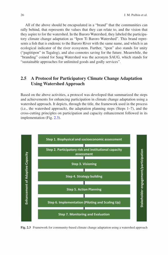
26
All of the above should be encapsulated in a “brand” that the communities can rally behind, that represents the values that they can relate to, and the vision that they aspire to for the watershed. In the Baroro Watershed, they labeled the participa-tory climate change adaptation as “Ipon Ti Baroro Watershed”. This brand repre-sents a fish that is endemic to the Baroro River with the same name, and which is an ecological indicator of the river ecosystem. Further, “ipon” also stands for unity (“pagtitipon” in Tagalog), and also connotes saving for the future. Meanwhile, the “branding” coined for Saug Watershed was the acronym SAUG, which stands for “sustainable approaches for unlimited goods and godly services”.
2.5 A Protocol for Participatory Climate Change Adaptation Using Watershed Approach
Based on the above activities, a protocol was developed that summarized the steps and achievements for enhancing participation in climate change adaptation using a watershed approach. It depicts, through the title, the framework used in the process (i.e., the watershed approach), the adaptation planning steps (Steps 1–7), and the cross-cutting principles on participation and capacity enhancement followed in its implementation (Fig. 2.3).
Fig. 2.3 Framework for community-based climate change adaptation using a watershed approach
J. M. Pulhin et al.

27
2.5.1 Biophysical and Socio-economic Assessment
This step was guided by a systems approach, i.e., the watershed approach, that was used to analyze the different biophysical (climate, land use, soil and geology, water, biodiversity) and socio-economic (population, livelihood, policies and institutions) components of the watershed, and how these affect ecosystem services in the water-shed. The process relied on several assessment methodologies, such as, carbon stocks assessment, water modeling, fragmentation analysis, household surveys, his-torical situational analysis and key informant interviews. The design of methodol-ogy for this step is not limited to the above examples, but would depend on the goals of the adaptation project, particularly the ecosystem functions and services that require strengthening.
2.5.2 Participatory Risk and Institutional Capacity Assessment
Participatory risk assessment involved the identification of hazards and their prob-ability of occurrence, impacts, and the effectiveness of current adaptation strategies. It is an investigative method that employs a variety of participatory tools to engage local stakeholders in their own climate change-risk and vulnerability diagnosis. The institutional capacity assessment, on the other hand, guided by the elements of resil-ient institutions in the ISET framework, determined the access rights and entitle-ments, information flows, application of new knowledge, decision-making processes, as well as the capacity to anticipate risk, capacity to respond, and capac-ity to recover and change, of the different institutions in the watershed.
Included under this step is the participatory scenario development, which explored the future with the communities and other stakeholders in a creative and policy-relevant way. Given the current risks and impacts of climate-related events, the results of climate, water, and carbon stock modeling were presented, and this provided planners with a glimpse of what they should consider when developing planning frameworks.
2.5.3 Visioning
A vision represents the future that the stakeholders would like to achieve for them-selves and the watershed. In a workshop environment, participants were asked to dis-cuss how they wanted to see the watershed in the future and to write these visions on metacards (one item per metacard). All metacards were collected and similar responses were grouped. The top responses were placed together and used to create a vision statement, which was further refined by the participants until they reached a consensus.
The vision statements developed for the Baroro and Saug watersheds are as follows:
2 Participatory Climate Change Adaptation Using Watershed Approach: Processes…
28
• Baroro Watershed – We envision the Baroro Watershed to be a sustainable and climate-resilient source of water, capable of providing a sufficient livelihood, and an ecotourism destination in La Union.
• Saug Watershed – A well-managed, climate-resilient Saug watershed sustaining multiple uses of goods and services for its constituents through science-based approaches and local participation.
2.5.4 Strategy Building
Strategy building refers to the actual strategies formulated by different stakeholders to respond to issues and problems identified in the assessment, considering future climate change and progress towards achieving the vision that they aspire to achieve. Strategies were identified per sector or ecosystem, and, considering the watershed gradient (upstream, mid-stream and downstream), were consolidated for consistency.
2.5.5 Action Planning
Action planning, following the legal framework emanating from the provincial gov-ernment, entailed the detailed community-based adaptation planning for the differ-ent pilot communities. At this stage, commitment was already secured from different stakeholders, particularly the communities, to effectively implement the proposed action plan. Potential sources of funds are also identified. In the case of Baroro Watershed, part of the MOA stipulated seed funding for this initiative.
Some important strategies identified for the pilot communities were reforestation using native species, organic farming, regulation of harmful agricultural inputs, fish pen regulation, alternative livelihood creation, and solid waste management. This action plan is encapsulated in a “brand” that represents the overall values and objec-tives of the initiative.
2.5.6 Implementation (Piloting and Scaling Up)
Implementation included setting up of a pilot barangay or community for each watershed site to implement the participatory climate change adaptation. It requires the recognition and assistance of the LGU to ensure that the barangay has a legal identity, availability of resources, and to secure guarantees for the continuity. An organization structure and specific work plan were laid out, including the Monitoring and Evaluation System, to guide the implementation of the adaptation project. This part, however, was not covered by the project. Nevertheless, mechanisms were
J. M. Pulhin et al.
29
installed to regularly assess the status/progress of the community-based adaptation, as well as plans for potential scaling up.
2.5.7 Monitoring and Evaluation
Indicators for monitoring and evaluating the participatory community-based adap-tation were developed from parameters measured before the project. This would then be compared to the future status of the watershed following implementation of the project. The indicators included: stream discharge, meteorological (rainfall and temperature), soil moisture, water use efficiency, biodiversity and ecosystems, water balance, and socioeconomic characteristics. Scale-appropriate indicators for the communities were also developed, and this would also be implemented using par-ticipatory approaches.
2.6 Lessons Learned
The project succeeded in formulating a protocol for participatory community-based adaptation using a watershed approach. This protocol contained the critical know- how in climate change adaptation and watershed management, particularly in improving the integrity of the ecosystems and ensuring the continuity of the goods and services that they provide for the welfare of the people.
The following are the lessons learned in the process of formulating the protocol:
• Continuing ecosystems degradation increases communities’ risks and vulnera-bility to climate-induced hazards and disasters and undermines their resiliency.
• Recognizing the different scales of adaptation through the watershed approach (communities, municipal, and provincial levels) should consider each group’s role —i.e., the context of their adaptation (values, resources, and needs).
• A participatory framework, such as that described above, is important for cata-lyzing collective action among stakeholders to enhance climate change adaptation.
• Solutions-based analysis that incorporates local knowledge will empower the community to be more mindful, prepared and proactive in addressing the poten-tial negative impacts of climate change acting on their person, their livelihood and the environment.
• Recognizing the roles of communities in watershed management positively affects their status and stimulates their creativity in crafting adaptation strategies that are effective and bring about rehabilitation.
• Local stakeholders need recognition and assistance from LGUs, national agen-cies and other organizations to enable them to perform as effective watershed stewards.
2 Participatory Climate Change Adaptation Using Watershed Approach: Processes…
30
• Local communities are willing to participate in implementing adaptation strate-gies that will conserve watersheds as well as their livelihoods.
• Lastly, community-based adaptation in the context of participatory watershed management cannot operate solely at the local level; it needs to be effectively linked to the higher scales of governance in order to enhance the resilience of communities and ecosystems.
References
Burns D, Heywood F, Taylor M, Wilde P, Wilson M (2004) Making community participation meaningful: a handbook for development and assessment. The Policy Press, Bristol. Retrieved from URL: https://www.jrf.org.uk/sites/default/files/jrf/migrated/files/jr163- community- participation- development.pdf
Cohen A, Davidson S (2011) The watershed approach: challenges, antecedents, and the transition from technical too to governance unit. Water Altern 4(1): 1–14. Retrieved from URL: http://www.water- alternatives.org/index.php/allabs/123- a4- 1- 1/file
Cruz RVO (1999) Integrated land use planning and sustainable watershed management. J Philippine Dev, Number 47 26(1) First Semester 1999. Retrieved from URL: https://dirp3.pids.gov.ph/ris/pjd/pidsjpd99- 1land.pdf
Dodman D, Soltesova K (2012) Community-based adaptation in urban areas: potential and limits. Paper presented during the Third Global Forum on Urban Resilience and Adaptation. Session D1: Mitigating and adapting from the bottom up: community-based solutions. Retrieved from URL: https://www.slurc.org/uploads/1/0/9/7/109761391/dodman_- _cba_potential_and_limits.pdf
Institute for Social and Environmental Transition (ISET) – International (2013) Climate resilience framework: putting resilience into practice. ISET-International, Boulder, 22 p
Intergovernmental Panel on Climate Change (IPCC) (2012) Managing the risks of extreme events and disasters to advance climate change adaptation. In: Field CB, Barros V, Stocker TF, Qin D, Dokken DJ, Ebi KL, Mastrandrea MD, Mach KJ, Plattner G-K, Allen SK, Tignor M, Midgley PM (eds) A special report of working groups I and II of the intergovernmental panel on climate change. Cambridge University Press, Cambridge, UK/New York, NY, p 582
Intergovernmental Panel on Climate Change (IPCC) (2014a) Annex II: Glossary. Climate change 2014. Mach KJ, Planton S, von Stechow C (eds) Synthesis Report. Contribution of Working Groups I, II and III to the Fifth Assessment Report of the Intergovernmental Panel on Climate Change. [Core Writing Team, RK Pachauri and LA Meyer (eds)]. IPCC, Geneva, Switzerland, pp 117–130
Intergovernmental Panel on Climate Change (IPCC) (2014b) Climate change 2014: impacts, adap-tation and vulnerability–summary for policymakers. Contribution of Working Group II to the Fifth Assessment Report of the Intergovernmental Panel on Climate Change: Field CB, Barros VR, Dokken DJ, Mach KJ, Mastrandrea MD, Billir TE, Chatterjee M, Ebi KL, Estrada YO, Genva RC, Girma B, Kissel ES, Levy AN, MacCracket S, Mastrandrea PR, White LL (eds) World Meteorological Organization, Geneva, Switzerland, 34. pp
O’Brien K, Hochachka G (2010) Integral adaptation to climate change. J Integral Theory Pract 5(1):89–102
PROVIA (2013) PROVIA guidance on assessing vulnerability, impacts and adaptation to climate change. Consultation Document, United Nations Environment Programme, Nairobi, 198 p
United States Environmental Protection Agency (USEPA) (2008) Watershed approach frame-work. https://www.epa.gov/sites/production/files/2015- 06/documents/watershed- approach- framework.pdf
J. M. Pulhin et al.
31
Open Access This chapter is licensed under the terms of the Creative Commons Attribution 4.0 International License (http://creativecommons.org/licenses/by/4.0/), which permits use, sharing, adaptation, distribution and reproduction in any medium or format, as long as you give appropriate credit to the original author(s) and the source, provide a link to the Creative Commons license and indicate if changes were made.
The images or other third party material in this chapter are included in the chapter’s Creative Commons license, unless indicated otherwise in a credit line to the material. If material is not included in the chapter’s Creative Commons license and your intended use is not permitted by statutory regulation or exceeds the permitted use, you will need to obtain permission directly from the copyright holder.
2 Participatory Climate Change Adaptation Using Watershed Approach: Processes…
33© The Author(s) 2022T. Ito et al. (eds.), Interlocal Adaptations to Climate Change in East and Southeast Asia, SpringerBriefs in Climate Studies, https://doi.org/10.1007/978-3-030-81207-2_3
Chapter 3Climate Change Adaptation Practices Towards Sustainable Watershed Management: The Case of Abuan Watershed in Ilagan City, Philippines
Orlando F. Balderama
Abbreviations
AIWMP Abuan Integrated Watershed Management ProjectASTI Advance Science and Technology InstituteCBMS Community-Based Management SystemLGU Local Government UnitCCA Climate Change AdaptationCDP Comprehensive Development PlanCLUP Comprehensive Land Use PlanDILG Department of Local GovernmentDREAM Disaster Risk and Exposure Assessment for Mitigation ProjectDRRM Disaster Risk Reduction and ManagementDRRMO Disaster Risk Reduction and Management OfficeDSSAT Decision Support System for Agro-Technology TransferFDSS Farmer Decision Support SystemIBM International Business MachinesICT Information and Communication TechnologyIRR Implementing Rules and RegulationLCCAP Local Climate Change Action PlansLDRRMC Local Disaster Risk and Reduction Management CouncilLGC Local Government CodeNOAH Nationwide Operational Assessment of Hazards ProjectRA Republic ActSMS Short Messaging System
O. F. Balderama (*) College of Engineering, Isabela State University, Isabela, Philippinese-mail: [email protected]
34
3.1 Introduction
In the Philippines, it is the local government units (LGUs) who are at the forefront in implementing initiatives related to disaster risk reduction and management (DRRM) and climate change adaptation (CCA) in their respective jurisdictions. The legal framework governing DRRM and CCA devolves to the LGUs the responsibil-ity to prepare and integrate local CCA and DRRM into locally mandated plans, particularly into the Comprehensive Land Use Plan (CLUP) and Comprehensive Development Plans (CDP). The legal framework governing the country’s climate change and disaster risk reduction and management policies are as follows:
(a) The Local Government Code (LGC) of 1991 (Republic Act [RA] No. 7160). The LGC devolves to LGUs the responsibility of delivering basic services in agri-culture, health, environment, and social services to the local constituents. The Act mandates each LGU to prepare their CDP and CLUP.
(b) The Climate Change Act of 2010 (RA 9729) and its Implementing Rules and Regulations (IRR) (Administrative Order 2010–01). The Act acknowledges the Philippines’ vulnerability to climate change and the need for appropriate adap-tation. This Act creates a comprehensive framework for systematically integrat-ing climate change and disaster risk reduction (DRR) into various phases of policy formulation, development plans, poverty reduction strategies, and other development tools and techniques. The Act establishes the Climate Change Commission as the sole policymaking body to prepare a National Climate Change Framework, National Climate Change Action Plan, and guidelines for the preparation of local climate change action plans (LCCAP).
(c) Disaster Risk Reduction and Management Act of 2010 (RA 10121) and IRR. Section 11 (b)(2) of the Act mandates the Local Disaster Risk and Reduction Management Council (LDRRMC) to ensure that DRR and CCA are integrated into local development plans, programs, and budgets as a strategy in sustainable development and poverty reduction. This provision integrates DRRM and CCA into physical and land-use planning, budget, infrastructure, education, health, environment, housing, and other sectors. The law requires LGUs to set aside 5% of their regular revenues for DRRM.
This chapter discusses highlights and lessons learned from the Abuan Integrated Watershed Management Project (AIWMP), a five-year program funded by the United States Agency for International Development-Philippines, which focused on the implementation of bottom-up, self-initiated CCA strategies in the watershed. The initiated measures have led to policy outcomes that have enhanced the resil-iency of communities and watershed ecosystems against natural disasters and cli-mate change. In addition, the activities, institutional arrangements, and policy outcomes are also discussed. Innovations in the use of information communication technology (ICT), mobile technologies, and remote sensing offer opportunities to modernize the agriculture sector; however, barriers to upscaling require the estab-lishment of an enabling policy environment and capacity building in order to extend the potential application of these technologies.
O. F. Balderama
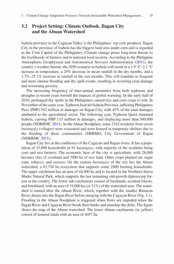
35
3.2 Project Setting: Climate Outlook, Ilagan City and the Abuan Watershed
Isabela province in the Cagayan Valley is the Philippines’ top corn producer. Ilagan City in the province of Isabela has the biggest land area under corn and is regarded as the Corn Capital of the Philippines. Climate change poses long-term threats to the livelihoods of farmers and to national food security. According to the Philippine Atmospheric Geophysical and Astronomical Services Administration (2011), the country’s weather bureau, the 2050 scenario in Isabela will result in a 1.9 °C–2.1 °C increase in temperature, a 29% decrease in mean rainfall in the dry months, and a 1.7%–25.1% increase in rainfall in the wet months. This will translate to frequent and more intense flooding and dry spell events, resulting in recurring crop damage and worsening poverty.
The increasing frequency of inter-annual anomalies from both typhoons and droughts in recent years foretell the impacts of global warming. In the early half of 2010, prolonged dry spells in the Philippines caused rice and corn crops to wilt. In November of the same year, Typhoon Juan hit Isabela Province, inflicting Philippines Peso (PHP) 542 million in damages on Ilagan City, with 45% of the total damages attributed to the agricultural sector. The following year, Typhoon Quiel slammed Isabela, causing PHP 115 million in damages, and displacing more than 500,000 people (NDRRMC 2011). In the Abuan floodplain, some 2342 residents from seven barangays (villages) were evacuated and were housed in temporary shelters due to the flooding of those communities (DRRMO, City Government of Ilagan (NDRRMC 2011).
Ilagan City lies at the confluence of the Cagayan and Ilagan rivers. It has a popu-lation of 33,000 households in 91 barangays, with majority of the residents being corn and rice farmers. The economic base of the city is agriculture, with 28,000 hectares (ha) of cornland and 7000 ha of rice land. Other crops planted are sugar cane, tobacco, and cassava. On the eastern barangays of the city lies the Abuan watershed, a 63,754 ha ecosystem that supports some 2900 farming households. The upper catchment has an area of 44,000 ha and is located in the Northern Sierra Madre Natural Park, which supports the last remaining old-growth dipterocarp for-ests in the country. The lower sub-catchments consist of farmlands, residual forests, and brushland, with an area of 19,000 ha (or 31%) of the watershed area. The water-shed is named after the Abuan River, which, together with the smaller Bintacan River, drains into the Ilagan River before merging with the Cagayan River (Fig. 3.1). Flooding in the Abuan floodplain is triggered when flows are impeded when the Ilagan River and Cagayan River break their banks and inundate the delta. The figure shows the map of the Abuan watershed. The lower Abuan catchments (in yellow) consist of tenured lands with an area of 4057 ha.
3 Climate Change Adaptation Practices Towards Sustainable Watershed Management…
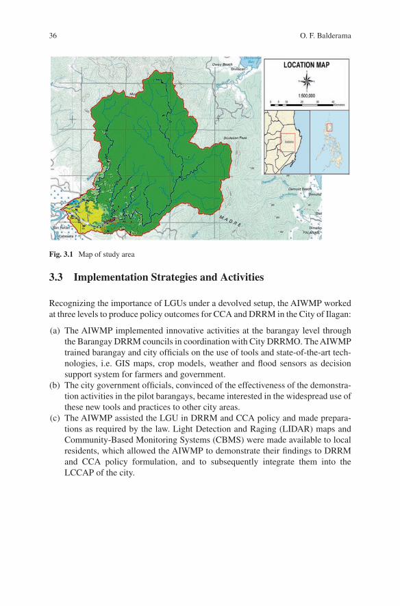
36
3.3 Implementation Strategies and Activities
Recognizing the importance of LGUs under a devolved setup, the AIWMP worked at three levels to produce policy outcomes for CCA and DRRM in the City of Ilagan:
(a) The AIWMP implemented innovative activities at the barangay level through the Barangay DRRM councils in coordination with City DRRMO. The AIWMP trained barangay and city officials on the use of tools and state-of-the-art tech-nologies, i.e. GIS maps, crop models, weather and flood sensors as decision support system for farmers and government.
(b) The city government officials, convinced of the effectiveness of the demonstra-tion activities in the pilot barangays, became interested in the widespread use of these new tools and practices to other city areas.
(c) The AIWMP assisted the LGU in DRRM and CCA policy and made prepara-tions as required by the law. Light Detection and Raging (LIDAR) maps and Community-Based Monitoring Systems (CBMS) were made available to local residents, which allowed the AIWMP to demonstrate their findings to DRRM and CCA policy formulation, and to subsequently integrate them into the LCCAP of the city.
Fig. 3.1 Map of study area
O. F. Balderama

37
3.3.1 Flood Risk Mitigation Activities
3.3.1.1 Installation of Automated Weather Stations
The project installed rain gauges and water-level sensors at bridges along the Abuan River and Bintacan River as part of establishing an Early Flood Warning Systems. A Memorandum of Agreement (MOA) with the Department of Science and Technology (DOST) enabled the project team to include these stations in Project NOAH (Nationwide Operational Assessment of Hazards), the Philippine’s flagship program on disaster prevention and mitigation, and to be allowed access to data from its eastern stations in Isabela, where most storms originate. The contribution of the Ilagan River to flooding in the Abuan floodplain is considerable.
3.3.1.2 Topographic Mapping and Flood Simulation
The project completed topographic and bathymetric surveys using unmanned aerial vehicles (UAVs). A digital elevation model and hydrologic data were produced and inputted into a hydrologic model to simulate flooding in the Abuan floodplain. Flood inundation maps for 5-, 25-, and 100-year storm return periods were pro-duced. Figure 3.2 shows a 100-year return period. Flood depths of 2.5 m (red areas) were found to overlap with human settlements threatening households. Flood mod-els were generated using HEC-HMS, HEC-RAS and ARC-INFO.
Fig. 3.2 Development of flood maps: before-and-after flood risk map of Abuan flood plain
3 Climate Change Adaptation Practices Towards Sustainable Watershed Management…
38
3.3.1.3 Vulnerability Mapping and BDRRM Planning
Use of digital spatial mapping was introduced to analyze climate hazard vulnerabil-ities in community study areas. The flood inundation maps that had been produced were presented in Abuan barangays for community validation. This was followed by barangay training and planning workshops. Through the barangay focus group discussions, the vulnerable groups (i.e., flood-prone sitios,1 elderly, persons with disabilities, women, and children) were identified by the community. Accordingly, barangay plans were prepared, which included the establishment of early warning systems (EWS), evacuation sites and camp management plans. The community also identified schools and covered courts as future evacuation centers. Should these places prove to be unfeasible, the barangay LGU identified elevated areas that could be used as temporary staging areas.
3.3.1.4 EWS
The City DRRMO established coordination protocols for barangay officials in issu-ing typhoon warnings to residents. As part of the established EWS, barangay offi-cials are now using SMS, two-way radios, light-emitting diodes boards, and megaphones to issue alerts. Following the practice in the province, forced evacua-tion is also being implemented in flood-prone barangays whenever a typhoon enters Isabela. In a typhoon alert, the City DRRMO monitors the rainfall and water level readings via internet (www.fmon.asti.dost.gov.ph). The limitation of this service, however, is it depends on power and an internet connection, which may not function during a typhoon.
3.3.2 Drought Risk Mitigation Activities
3.3.2.1 Crop Modelling for Corn Production and Climate Change Impact Assessment
Crop models enable scientists to understand and to predict crop responses to global warming, as indicated by increasing CO2, temperatures, and water scarcity. Accordingly, the project installed an agro-meteorological station and soil moisture sensors in the Abuan watershed to record rainfall, temperature, and other parame-ters. Two crop models (i.e., Decision Support System for Agri-Technological Transfer [DSSATT] and AquaCrop) were calibrated and validated within reason-able accuracy during two cropping seasons (Tongson et al. 2017; Balderama et al. 2017). The crop model simulated the impacts of climate change on biomass and yield. The model can also simulate present impacts, which can provide valuable
1 A sitio is a territorial enclave that forms part of a barangay.
O. F. Balderama
39
insights for farmers and help them to make informed decisions regarding the day- to- day activities on their farms.
3.3.2.2 Text Messages of Daily Weather Forecasts
The DSSAT crop model was automated to generate weather and crop advisories to farmers via SMS. Daily weather forecasts were made available using a numerical weather forecasting model called Weather Information-Integration for System Enhancement (WISE), which was developed by IBM Philippines and the Institute of Environmental Science and Meteorology (IESM) of the University of Philippines under Project NOAH. These daily forecasts can be viewed on the internet (www.weather- manila.com) or at the Project NOAH website.
The proof of concept for the weather and crop advisories was developed in 2016–2017 (Trogo et al. 2015a, b; Ebardaloza et al. 2015). The system was then tested to a pilot group of 30 farmers using GSM cellular phones. Each of the pilot farmers was given a prepaid SIM card, and was tasked to enroll their farms, send SMS queries, and receive replies from the system. The system can respond to que-ries about daily rainfall, amount of fertilizers required, best planting dates, yields, etc. The system then processes each query using these parameters, and responds to the farmer. The SMS queries were tallied and categorized during the pilot imple-mentation. Almost all of the queries tallied were about rainfall forecasts, indicating the importance of this parameter to farmers. The list expanded to more than 1000 farmers as the LGU enrolled more farmers to receive text messages from the system.
3.3.3 Policy-Level Activities
3.3.3.1 Vulnerability Assessments and Mapping
The DILG introduced the CBMS as a tool that LGUs can use to target households, for bottom-up planning, and budgeting (DILG-MC 2014). Accordingly, the CBMS of Ilagan City consists of a database of 33,000 geo-tagged households and includes indicators relating to income, education, housing, access to basic services, water, sanitation, flood risks, etc. that are generated at the household and individual levels.
The city government then obtained copies of high-resolution (0.5 m) LIDAR maps and flood inundation maps from the Disaster Risk and Exposure Assessment for Mitigation (DREAM) Project of the DOST. The AIWMP overlaid flood inunda-tion maps (Fig. 3.3) with CBMS household maps to generate maps of vulnerable households (i.e., low income, lacking access to safe water, lacking access to toilets, people living in makeshift shelters, and people with informal tenure), and maps of corn and rice growing areas. Figure 3.4 shows a vulnerability map of central Ilagan City overlain with households classified as poor and not poor.
3 Climate Change Adaptation Practices Towards Sustainable Watershed Management…
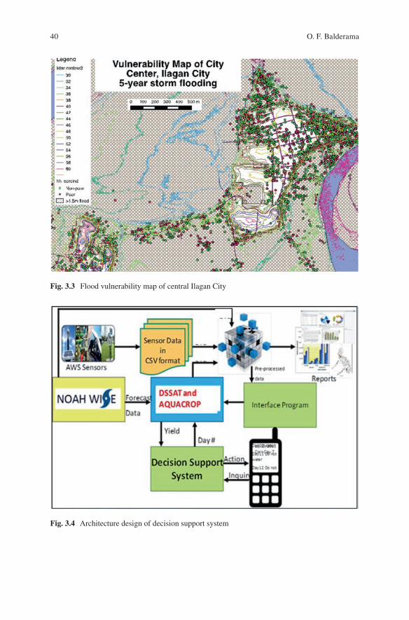
40
Fig. 3.3 Flood vulnerability map of central Ilagan City
Fig. 3.4 Architecture design of decision support system
O. F. Balderama
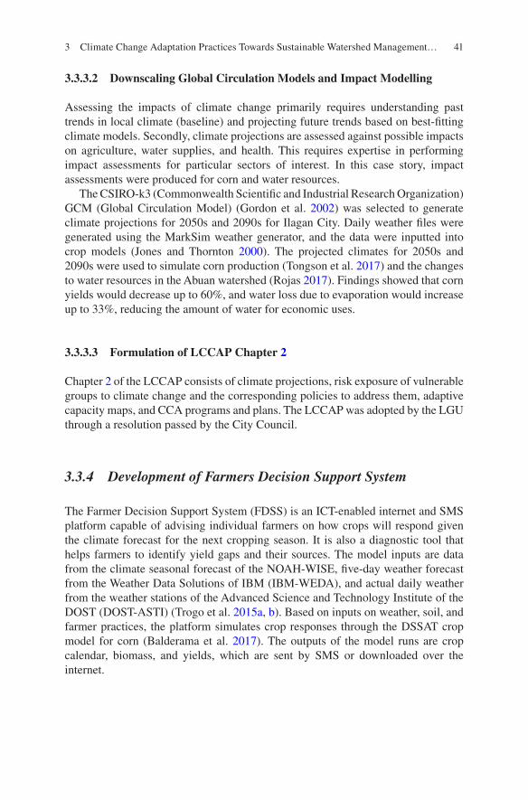
41
3.3.3.2 Downscaling Global Circulation Models and Impact Modelling
Assessing the impacts of climate change primarily requires understanding past trends in local climate (baseline) and projecting future trends based on best-fitting climate models. Secondly, climate projections are assessed against possible impacts on agriculture, water supplies, and health. This requires expertise in performing impact assessments for particular sectors of interest. In this case story, impact assessments were produced for corn and water resources.
The CSIRO-k3 (Commonwealth Scientific and Industrial Research Organization) GCM (Global Circulation Model) (Gordon et al. 2002) was selected to generate climate projections for 2050s and 2090s for Ilagan City. Daily weather files were generated using the MarkSim weather generator, and the data were inputted into crop models (Jones and Thornton 2000). The projected climates for 2050s and 2090s were used to simulate corn production (Tongson et al. 2017) and the changes to water resources in the Abuan watershed (Rojas 2017). Findings showed that corn yields would decrease up to 60%, and water loss due to evaporation would increase up to 33%, reducing the amount of water for economic uses.
3.3.3.3 Formulation of LCCAP Chapter 2
Chapter 2 of the LCCAP consists of climate projections, risk exposure of vulnerable groups to climate change and the corresponding policies to address them, adaptive capacity maps, and CCA programs and plans. The LCCAP was adopted by the LGU through a resolution passed by the City Council.
3.3.4 Development of Farmers Decision Support System
The Farmer Decision Support System (FDSS) is an ICT-enabled internet and SMS platform capable of advising individual farmers on how crops will respond given the climate forecast for the next cropping season. It is also a diagnostic tool that helps farmers to identify yield gaps and their sources. The model inputs are data from the climate seasonal forecast of the NOAH-WISE, five-day weather forecast from the Weather Data Solutions of IBM (IBM-WEDA), and actual daily weather from the weather stations of the Advanced Science and Technology Institute of the DOST (DOST-ASTI) (Trogo et al. 2015a, b). Based on inputs on weather, soil, and farmer practices, the platform simulates crop responses through the DSSAT crop model for corn (Balderama et al. 2017). The outputs of the model runs are crop calendar, biomass, and yields, which are sent by SMS or downloaded over the internet.
3 Climate Change Adaptation Practices Towards Sustainable Watershed Management…
42
3.4 Lessons Learned
1. The local agricultural landscape in Abuan watershed consists of a mosaic of smallholder farms characterized by high landscape variability and heterogeneity. This study provided a clear understanding of climate change, the El Niño- Southern Oscillation, and increasing intensity of natural disasters that adds to the complexity of issues that are faced by small farmers. The other realities high-lighted by this study are the ineffective agriculture extension services, which are constrained by lack of capacity and resources. Hence, these smallholder farmers are facing an uphill battle against poverty, degraded ecosystems, and worsening climate change.
2. From the project strategies implemented, the bottom-up demonstration activities and policy level activities resulted in the following policy outcomes:
(a) Development of Sangguniang Panlungsod Resolution (Provincial Council Resolution) No. 038. Resolution approving the climate change action plan of Ilagan City for CY 2017–2022. This provides an effective strategy for main-streaming research and development outputs into policies that can be imple-mented by the local governments of the province.
(b) City Ordinance No. 117–2016. On a municipal level, an ordinance imple-menting flood evacuation drills in all flood-prone barangays in Ilagan City on a regular basis to increase the barangays’ capacity and to ensure that the communities are prepared in cases of disasters and/or calamities. This activ-ity can now be easily rolled-out to other localities, given a legal mandate and actual demonstration showcase.
3. Looking at the current legal framework used in the Philippines for CCA and DRRM, which has involved extensive stakeholder consultations, a suitable method has been found through which the legal framework can provide entry points for projects like AIWMP to embed its activities within the framework of LGU plans and programs. This study provided a good example of how to align and plan the interface of a project framework to involve local governments and facilitate the effective adaption among stakeholders.
4. It was also concluded that while technologies and innovations introduced by the project show great potential and offer opportunities for modernizing agriculture, farmers and city extension workers’ knowledge of crop models, remote sensing, and their potential use in decision making are still rudimentary and still needs more field validations. This could be made part of future training programs and other future endeavors to improve and sustain initial success of the project
5. It was also determined that access to ICT is also expensive in rural areas, and thus constrains use of state-of-the-art technology. There is therefore a need for a national broadband policy and ICT investments in underserved areas. The pilot introduction of information and communication technologies-enabled (ICT-
O. F. Balderama
43
enabled) crop and weather advisories have demonstrated great promise for mod-ernizing agriculture; however, such a feat would require an enabling policy environment in the ICT sector in order to stimulate growth and benefit the agri-culture sector.
6. Another important lesson is mainstreaming of multidisciplinary approaches to CCA and DRRM drawing from natural, social, and ICT fields that were facili-tated at the local level. Parallel interventions at the national level (involving the Department of Information and Communications Technology, Department of Agriculture, Department of Science and Technology, state universities and col-leges, and the private sector) will require an enabling policy environment.
7. Finally, the AIWMP demonstrated use of innovative ICT-enabled technologies that can help to modernize the agricultural sector. Precision agriculture and indi-vidualized advice to farmers using remote sensing, SMS, and internet show great promise. However, there is a need for more capacity building among LGU agri-culture workers in ICT and crop modeling. An enabling policy environment in the ICT sector will spur development in applications that benefit the agricultural sector and small farmers.
References
Balderama O, Alejo L, Tongson E, Pantola RR (2017) Development and application of corn model for climate change impact assessment and decision support system: enabling Philippine farm-ers to adapt to climate variability. In: Leahl Filho W (ed) Climate change research at universi-ties. Hamburg University, Springer, pp 373–387
DILG-MC (Department of Interior and Local Government Memorandum Circular) 2014-135. Guidelines on the Formulation of Local Climate Change Action Plan (LCCAP). DILG. (21 October 2014)
Ebardaloza JBR, Trogo R, Sabido DJ, Tongson E, Bagtasa G, Balderama OF (2015) Enabling Philippine farmers to adapt to climate variability using seasonal climate and weather forecast with a crop simulation model in an SMS-based Farmer Decision Support System. Accessed 7 Oct 2017. http://adsabs.harvard.edu/abs/2015AGUFMGC53G1298E
Gordon HB, Rotstayn LD, McGregor JL, Dix MR, Kowalczyk EA, O’Farrell SP, Waterman LJ, Hirst AC, Wilson SG, Collier MA, Watterson IG, Elliot TI (2002). The CSIRO Mk3 Climate System Model. CSIRO Atmospheric Research Technical Paper No. 60. Aspendale. Commonwealth Scientific and Industrial Research Organisation, Victoria
Jones PG, Thornton PK (2000) MarkSim software to generate daily weather data for Latin America and Africa. Agron J 92(3):445–453
NDRRMC (National Disaster Risk Reduction and Management Council) (2011) NDRRMC SitRep No. 12: Effects of Typhoon ‘QUIEL’ (Nalgae). Accessed 4 April 2016. http://www.ndrrmc.gov.ph/attachments/article/1763/SitRep_No_12_effects_of_Typhoon_QUIEL_as_ of_10OCT2011_0600H.pdf
Philippine Atmospheric Geophysical and Astronomical Services Administration (2011) Climate projection for Isabel Province, Quezon City
Rojas D (2017) Hydrology of Abuan watershed. Internal Report to Worldwide Fund for Nature. Quezon City Philippines
3 Climate Change Adaptation Practices Towards Sustainable Watershed Management…
44
Tongson EE, Alejo L, Balderama OF (2017) Simulating impacts of El Niño and climate change on corn yield in Isabela, Philippines. Clim Disaster Dev J 2(1):29–39
Trogo R, Ebardaloza JB, Sabido DJ, Bagtasa G, Tongson E, Balderama OF (2015a) SMS- Based Smarter Agriculture Decision Support System for Yellow Corn Farmers in Isabela. In: Proceedings of the 2015 IEEE Canada International Humanitarian Technology Conference (IHTC2015), 31 May 2015 to 4 June 2015, Ottawa, Canada. Ottawa, Canada: Institute of Electrical and Electronics Engineers
Trogo R, Ebardaloza JB, Sabido J, Tongson E, Bagtasav G, Balderama OF (2015b) Enabling Philippine farmers to adapt to climate variability using seasonal climate and weather forecast with a crop simulation model in an SMS-based Farmer Decision Support System. Paper pre-sented at the 2015 AGU Fall Meeting, San Francisco, CA, 14–18 December 2015
Open Access This chapter is licensed under the terms of the Creative Commons Attribution 4.0 International License (http://creativecommons.org/licenses/by/4.0/), which permits use, sharing, adaptation, distribution and reproduction in any medium or format, as long as you give appropriate credit to the original author(s) and the source, provide a link to the Creative Commons license and indicate if changes were made.
The images or other third party material in this chapter are included in the chapter’s Creative Commons license, unless indicated otherwise in a credit line to the material. If material is not included in the chapter’s Creative Commons license and your intended use is not permitted by statutory regulation or exceeds the permitted use, you will need to obtain permission directly from the copyright holder.
O. F. Balderama
45© The Author(s) 2022T. Ito et al. (eds.), Interlocal Adaptations to Climate Change in East and Southeast Asia, SpringerBriefs in Climate Studies, https://doi.org/10.1007/978-3-030-81207-2_4
Chapter 4Economic Evaluation and Climate Change Adaptation Measures for Rice Production in Vietnam Using a Supply and Demand Model: Special Emphasis on the Mekong River Delta Region in Vietnam
Yuki Ishikawa-Ishiwata and Jun Furuya
4.1 Background
Of the countries most affected by the impact of climate change between 1999 and 2018, Vietnam ranked sixth when factors such as monetary losses, mortality, and frequency of extraordinary climatic events are considered (Eckstein et al. 2020). The agricultural sector is one of the most susceptible to climate change because crop production is directly influenced by climate conditions. Rice is the staple food in Vietnam and, as of 2018, 65.3% of crop production in the country was dedicated to rice cultivation (General Statistical Office of Vietnam, GSO 2020). Flooding and saline intrusion due to sea level rise (SLR), as well as droughts associated with El Niño events, have caused serious problems in the country in the past, and these events have the potential to adversely affect rice production in the future (Lasco et al. 2011; Nhung et al. 2019). Surplus rice can be exported and sold on the global rice market, and Vietnam was the second largest rice exporter and fifth largest pro-ducer in 2020 (United States Department of Agriculture, Production, Supply and Distribution, USDA PS&D 2020). Consequently, the effects of climate change on rice production in Vietnam can affect the global rice market. Measures such as shift-ing transplanting dates, introducing irrigation systems, improving irrigation effi-ciency, using short-duration and salinity- or thermo-tolerant cultivars have been adopted as adaptation measures to tackle climate change (Masumoto and Tada 2008; Yu et al. 2010, 2013; Shrestha et al. 2014; Trinh et al. 2014). Adaptation is
Y. Ishikawa-Ishiwata (*) Global and Local Environment Co-creation Institute, Ibaraki University, Ibaraki, Japane-mail: [email protected]
J. Furuya Social Sciences Division, Japan International Research Center for Agricultural Sciences, Ibaraki, Japan
46
complicated by the fact that the effects of climate differ by region; for example, saline water intrusion, drought, flooding, and coastal erosion are the main issues affecting the Mekong River Delta region, while drought is a serious problem in the northern mountainous areas (Trinh et al. 2014). Thus, the development of adapta-tion measures needs to consider these differences and target specific regions. Investigating the effect of climate change on rice production and the rice market after the introduction of appropriate adaptation measures in each region can be eval-uated economically using a supply and demand model (Furuya and Meyer 2008).
The supply and demand model considers yield, planted area, exports, imports, stock changes, and food demand functions of rice. From these functions, supply and demand equilibrium prices can be estimated and the outlook of future rice produc-tion and equilibrium prices can be assessed. Inserting climate variables, such as temperature or evapotranspiration into yield and planted area functions, facilitates projections of the effect of climate change on rice production and the market. With these projections as a baseline, rice production and equilibrium prices can then be estimated, and adaptation measures can be implemented based on different scenar-ios. These methods facilitate analyses based on quantitative values and allow man-agers to consider adaptation measures that are appropriate for each region. In the next section, we will introduce the concept of the supply and demand model for rice in Vietnam. In Sect. 3, we will demonstrate the economic evaluation methods used to develop adaptation measures in response to climate change using this model. In Sect. 4, we will examine extant adaptation measures and problems for farmers in the Mekong River Delta, which is the main agricultural production region in Vietnam. Finally, we will consider future research prospects.
4.2 Supply and Demand Model with Climate Variables
Market equilibrium is the basic concept of the supply and demand model. The rela-tionship between price (P) and quantity (Q) is shown in Fig. 4.1. The intersection between the supply and demand curves is the equilibrium price. If production is reduced due to climate change, then the price will increase, all things being equal. On the other hand, if the personal income of consumers increases and consumption increases, then prices will increase. The equilibrium price is thus determined based on a balance between the production of farmers (supply) and consumption by con-sumers (demand). The supply curve can be shifted through technological advance-ment or large-scale agricultural development (Fig. 4.1), and these would cause the price to decline. In addition to consumer behavior, price reduction can also be affected by trends in exports and/or imports to/from other countries. Thus, the influ-ence of these factors agricultural markets can be assessed using the supply and demand model. In this model, the planted area function with farm prices as explana-tory variables can be regarded as a supply function, and the food demand function with farm prices can be regarded as a demand function. The equilibrium prices can be estimated by convergence using the Gauss-Seidel iterative method. By
Y. Ishikawa-Ishiwata and J. Furuya
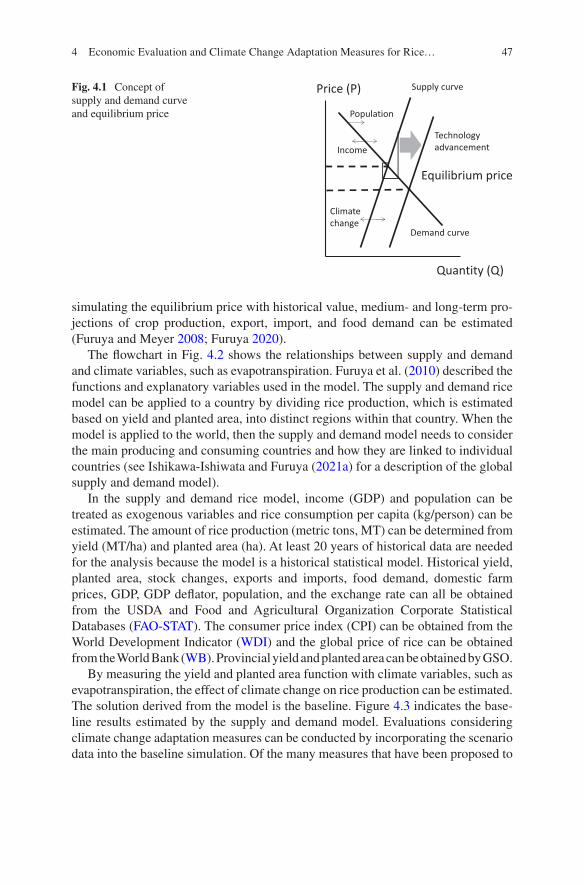
47
simulating the equilibrium price with historical value, medium- and long-term pro-jections of crop production, export, import, and food demand can be estimated (Furuya and Meyer 2008; Furuya 2020).
The flowchart in Fig. 4.2 shows the relationships between supply and demand and climate variables, such as evapotranspiration. Furuya et al. (2010) described the functions and explanatory variables used in the model. The supply and demand rice model can be applied to a country by dividing rice production, which is estimated based on yield and planted area, into distinct regions within that country. When the model is applied to the world, then the supply and demand model needs to consider the main producing and consuming countries and how they are linked to individual countries (see Ishikawa-Ishiwata and Furuya (2021a) for a description of the global supply and demand model).
In the supply and demand rice model, income (GDP) and population can be treated as exogenous variables and rice consumption per capita (kg/person) can be estimated. The amount of rice production (metric tons, MT) can be determined from yield (MT/ha) and planted area (ha). At least 20 years of historical data are needed for the analysis because the model is a historical statistical model. Historical yield, planted area, stock changes, exports and imports, food demand, domestic farm prices, GDP, GDP deflator, population, and the exchange rate can all be obtained from the USDA and Food and Agricultural Organization Corporate Statistical Databases (FAO-STAT). The consumer price index (CPI) can be obtained from the World Development Indicator (WDI) and the global price of rice can be obtained from the World Bank (WB). Provincial yield and planted area can be obtained by GSO.
By measuring the yield and planted area function with climate variables, such as evapotranspiration, the effect of climate change on rice production can be estimated. The solution derived from the model is the baseline. Figure 4.3 indicates the base-line results estimated by the supply and demand model. Evaluations considering climate change adaptation measures can be conducted by incorporating the scenario data into the baseline simulation. Of the many measures that have been proposed to
Price (P)
Quantity (Q)
Supply curve
Demand curve
Equilibrium price
Population
Income
Climate change
Technology advancement
Fig. 4.1 Concept of supply and demand curve and equilibrium price
4 Economic Evaluation and Climate Change Adaptation Measures for Rice…
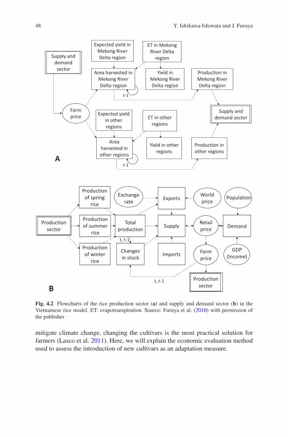
48
mitigate climate change, changing the cultivars is the most practical solution for farmers (Lasco et al. 2011). Here, we will explain the economic evaluation method used to assess the introduction of new cultivars as an adaptation measure.
Expected yield in Mekong River Delta region
Area harvested in Mekong River Delta region
ET in Mekong River Delta
region
Yield in Mekong River Delta region
Production in Mekong River Delta region
Farm price Expected yield
in other regions
Area harvested in other regions
ET in other regions
Yield in other regions
Production in other regions
Supply and demand sector
Supply and demand sector
t-1
t-1A
Production sector
Production of spring
rice
Production of summer
rice
Production of winter
rice
Total production
Changes in stock
Exports
Supply
Imports
Retail price
World price
Farm price
Demand
Production sector
PopulationExchange rate
t, t-1
t, t-1
B
GDP(Income)
Fig. 4.2 Flowcharts of the rice production sector (a) and supply and demand sector (b) in the Vietnamese rice model. ET: evapotranspiration. Source: Furuya et al. (2010) with permission of the publisher
Y. Ishikawa-Ishiwata and J. Furuya
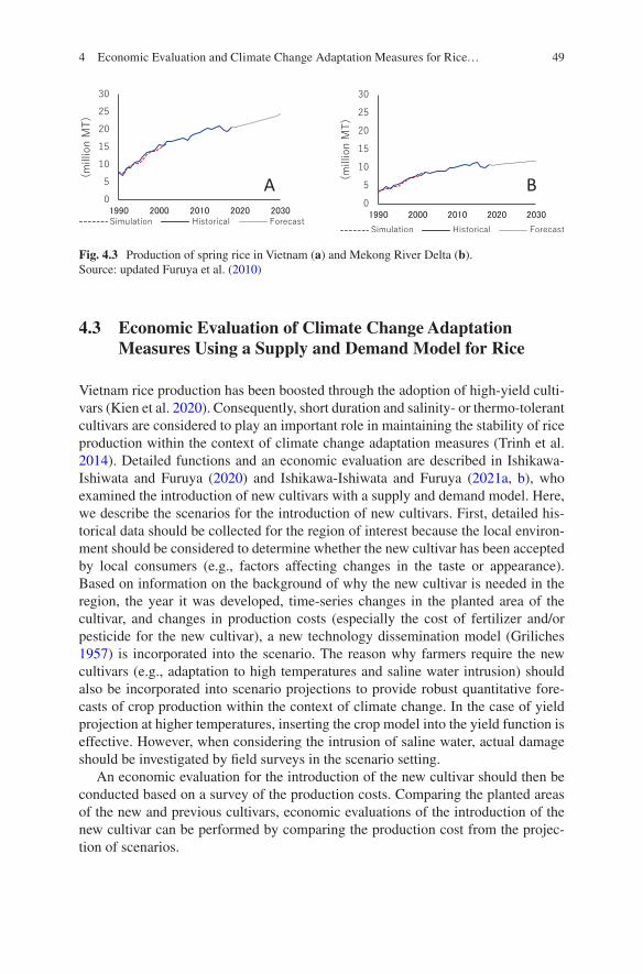
49
4.3 Economic Evaluation of Climate Change Adaptation Measures Using a Supply and Demand Model for Rice
Vietnam rice production has been boosted through the adoption of high-yield culti-vars (Kien et al. 2020). Consequently, short duration and salinity- or thermo- tolerant cultivars are considered to play an important role in maintaining the stability of rice production within the context of climate change adaptation measures (Trinh et al. 2014). Detailed functions and an economic evaluation are described in Ishikawa- Ishiwata and Furuya (2020) and Ishikawa-Ishiwata and Furuya (2021a, b), who examined the introduction of new cultivars with a supply and demand model. Here, we describe the scenarios for the introduction of new cultivars. First, detailed his-torical data should be collected for the region of interest because the local environ-ment should be considered to determine whether the new cultivar has been accepted by local consumers (e.g., factors affecting changes in the taste or appearance). Based on information on the background of why the new cultivar is needed in the region, the year it was developed, time-series changes in the planted area of the cultivar, and changes in production costs (especially the cost of fertilizer and/or pesticide for the new cultivar), a new technology dissemination model (Griliches 1957) is incorporated into the scenario. The reason why farmers require the new cultivars (e.g., adaptation to high temperatures and saline water intrusion) should also be incorporated into scenario projections to provide robust quantitative fore-casts of crop production within the context of climate change. In the case of yield projection at higher temperatures, inserting the crop model into the yield function is effective. However, when considering the intrusion of saline water, actual damage should be investigated by field surveys in the scenario setting.
An economic evaluation for the introduction of the new cultivar should then be conducted based on a survey of the production costs. Comparing the planted areas of the new and previous cultivars, economic evaluations of the introduction of the new cultivar can be performed by comparing the production cost from the projec-tion of scenarios.
Fig. 4.3 Production of spring rice in Vietnam (a) and Mekong River Delta (b).Source: updated Furuya et al. (2010)
4 Economic Evaluation and Climate Change Adaptation Measures for Rice…
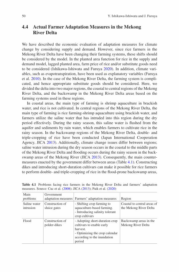
50
4.4 Actual Farmer Adaptation Measures in the Mekong River Delta
We have described the economic evaluation of adaptation measures for climate change by considering supply and demand. However, since rice farmers in the Mekong River Delta have been changing their farming systems, these shifts should be considered by the model. In the planted area function for rice in the supply and demand model, lagged planted area, farm price of rice and/or substitute goods need to be considered (Ishikawa-Ishiwata and Furuya 2020). In addition, climate vari-ables, such as evapotranspiration, have been used as explanatory variables (Furuya et al. 2010). In the case of the Mekong River Delta, the farming system is compli-cated, and hence appropriate substitute goods should be considered. Here, we divided the delta into two major regions, the coastal to central regions of the Mekong River Delta, and the backswamp in the Mekong River Delta areas based on the farming systems used in these regions.
In coastal areas, the main type of farming is shrimp aquaculture in brackish water, and rice is not cultivated. In central regions of the Mekong River Delta, the main type of farming is rice farming-shrimp aquaculture using brackish water, and farmers utilize the saline water that has intruded into this region during the dry period effectively. During the rainy season, this saline water is flushed from the aquifer and sediments by rain water, which enables farmers to cultivate rice in the rainy season. In the backswamp regions of the Mekong River Delta, double- and triple-cropping of rice have been conducted (Japan International Cooperation Agency, JICA 2013). Additionally, climate change issues differ between regions; saline water intrusion during the dry season occurs in the coastal to the middle parts of the Mekong River Delta and flooding occurs during the rainy season in the back-swamp areas of the Mekong River (JICA 2013). Consequently, the main counter-measures enacted by the government differ between areas (Table 4.1). Constructing dikes and introducing short-duration cultivars can make it possible for rice farmers to perform double- and triple-cropping of rice in the flood-prone backswamp areas,
Table 4.1 Problems facing rice farmers in the Mekong River Delta and farmers’ adaptation measures. Source: Cuc et al. (2008); JICA (2013); Paik et al. (2020)
Main problems
Government adaptation measures Farmers’ adaptation measures Region
Saline water intrusion
Construction of sluice gates
- Shifting crop farming to aquaculture-based farming.- Introducing salinity tolerant crop cultivars
Coastal to central areas of the Mekong River Delta
Flood Construction of polder-dikes
- Adopting short-duration crop cultivars to enable early harvest.- Optimizing the crop calendar according to the inundation period
Backswamp areas in the Mekong River Delta
Y. Ishikawa-Ishiwata and J. Furuya
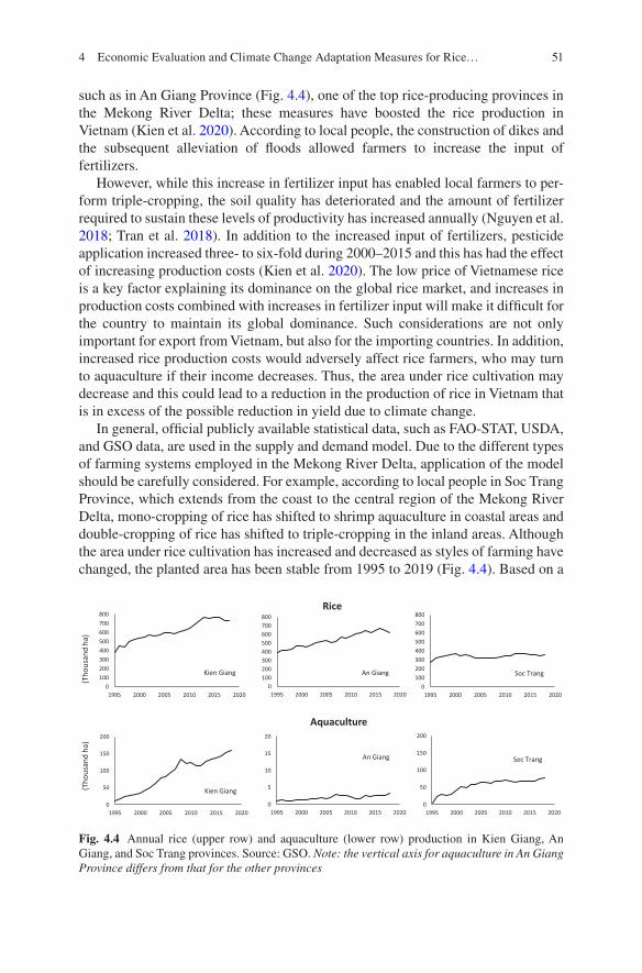
51
such as in An Giang Province (Fig. 4.4), one of the top rice-producing provinces in the Mekong River Delta; these measures have boosted the rice production in Vietnam (Kien et al. 2020). According to local people, the construction of dikes and the subsequent alleviation of floods allowed farmers to increase the input of fertilizers.
However, while this increase in fertilizer input has enabled local farmers to per-form triple-cropping, the soil quality has deteriorated and the amount of fertilizer required to sustain these levels of productivity has increased annually (Nguyen et al. 2018; Tran et al. 2018). In addition to the increased input of fertilizers, pesticide application increased three- to six-fold during 2000–2015 and this has had the effect of increasing production costs (Kien et al. 2020). The low price of Vietnamese rice is a key factor explaining its dominance on the global rice market, and increases in production costs combined with increases in fertilizer input will make it difficult for the country to maintain its global dominance. Such considerations are not only important for export from Vietnam, but also for the importing countries. In addition, increased rice production costs would adversely affect rice farmers, who may turn to aquaculture if their income decreases. Thus, the area under rice cultivation may decrease and this could lead to a reduction in the production of rice in Vietnam that is in excess of the possible reduction in yield due to climate change.
In general, official publicly available statistical data, such as FAO-STAT, USDA, and GSO data, are used in the supply and demand model. Due to the different types of farming systems employed in the Mekong River Delta, application of the model should be carefully considered. For example, according to local people in Soc Trang Province, which extends from the coast to the central region of the Mekong River Delta, mono-cropping of rice has shifted to shrimp aquaculture in coastal areas and double-cropping of rice has shifted to triple-cropping in the inland areas. Although the area under rice cultivation has increased and decreased as styles of farming have changed, the planted area has been stable from 1995 to 2019 (Fig. 4.4). Based on a
0100200300400500600700800
1995 2000 2005 2010 2015 2020
Soc Trang
0
50
100
150
200
1995 2000 2005 2010 2015 2020
Soc Trang
Aquaculture
Rice
0
5
10
15
20
1995 2000 2005 2010 2015 2020
An Giang
0100200300400500600700800
1995 2000 2005 2010 2015 2020
An Giang
(Tho
usan
d ha
)(T
hous
and
ha)
0100200300400500600700800
1995 2000 2005 2010 2015 2020
Kien Giang
0
50
100
150
200
1995 2000 2005 2010 2015 2020
Kien Giang
Fig. 4.4 Annual rice (upper row) and aquaculture (lower row) production in Kien Giang, An Giang, and Soc Trang provinces. Source: GSO. Note: the vertical axis for aquaculture in An Giang Province differs from that for the other provinces
4 Economic Evaluation and Climate Change Adaptation Measures for Rice…
52
report published by the Sub-National Institute of Agricultural Planning and Projection (Sub-NIAPP), extensive areas of rice paddies will be converted to brack-ish water aquaculture due to saline intrusion by 2050 (JICA 2013). This implies that the area under rice cultivation will be reduced significantly in the future. Since the selection of farming systems by farmers varies and affected by profit, competition or changing farming systems based on profitability and risks should be considered by managers when allocating areas to rice cultivation using the supply and demand model in the future.
4.5 Lessons Learned
The climate change adaptation measures required for continued rice production in Vietnam have been investigated in terms of technology, such as by adopting short- duration or salinity-tolerant cultivars. However, farmers not only adopted new tech-nology but also changed the farming systems. For example, rice farmers have shifted to aquaculture-based farming in the coastal and central regions of the Mekong River Delta. Farming systems are expected to change further due to saline intrusion caused by climate change in the future. Considering the actual farmers’ situation and a variety of scenarios, practicable evaluations can be conducted in each region. The effect of the area under cultivation on the profitability of different farming systems can be complemented with more practical simulations in the future.
References
Cuc NH, Cruz PCS, Borromeo TH, Hernandez JE, Tin HQ (2008) Rice seed supply systems and production in Mekong Delta, Vietnam. Asia Life Sci 17:1–20
Eckstein D, Künzel V, Schäfer L, Winges M (2020) Global climate risk index 2020. Who suffers most from extreme weather events? Weather-related loss events in 2018 and 1999 to 2018. Germanwatch
FAO Statistical Databases (FAO-STAT). http://www.fao.org/faostat/en/#homeFuruya J (2020) Development of an economic model for evaluation of climate change in the long-
run for international agriculture: EMELIA. JIRCAS Working Report 89Furuya J, Meyer SD (2008) Impacts of water cycle changes on the rice market in Cambodia: sto-
chastic supply and demand model analysis. Paddy Water Environ 6:139–151Furuya J, Meyer SD, Kagyama M, Jin S (2010) Development of supply and demand models of
rice in Lower Mekong River Basin Countries: REMEW-Mekong. JIRCAS Working Report 68General Statistics Office of Vietnam (GSO) (2020). https://www.gso.gov.vn/
Default_en.aspx?tabid=491Griliches A (1957) Hybrid corn: an exploration in the economics of technological change.
Econometrica 4:501–522Ishikawa-Ishiwata Y, Furuya J (2020) Evaluating the contribution of soybean rust-resistant cul-
tivars to soybean production and the soybean market in Brazil: a supply and demand model analysis. Sustainability 12:1422
Ishikawa-Ishiwata Y, Furuya J (2021a) Soybean rust and resistant cultivar effects on global soy-bean supply and demand. Jpn Agric Res Q 55(1):59–67
Y. Ishikawa-Ishiwata and J. Furuya
53
Ishikawa-Ishiwata Y, Furuya J (2021b) Fungicide cost reduction with soybean rust-resistant culti-vars in Paraguay: a supply and demand model approach. Sustainability 13:887
Japan International Cooperation Agency (JICA) (2013) The project for climate change adaptation for sustainable agriculture and rural development in the coastal Mekong Delta in Vietnam. Final report: priority project
Kien NV, Han NH, Cramb R (2020) Trends in rice-based farming systems in the Mekong Delta. In: Cramb R (ed) White gold: the commercialization of rice farming in the lower Mekong Basin, pp 347–374
Lasco RD, Habito CMD, Delfino RJP, Pulhin FB, Concepcion RN (2011) Climate change adapta-tion for smallholder farmers in Southeast Asia. World Agroforestry Centre, Los Baños
Masumoto T, Tada M (eds) (2008) The assessment of changes in water cycle on food production and alternative scenarios. –Implications for policy making. ISBN 978-4-9902838-7-2 C3061. (in Japanese)
Nguyen VK, Dumaresq D, Pittock J (2018) Impacts of rice intensification on rural households in the Mekong Delta: emerging relationships between agricultural production, wild food supply and food consumption. Food Sec 10:1615–1629
Nhung TT, Vo PL, Nghi VV, Bang HQ (2019) Salt intrusion adaptation measures for sustainable agricultural development under climate change effects: a case of Ca Mau peninsula, Vietnam. Clim Risk Manag 23:88–100
Paik SY, Le DTP, Nhu LT, Mills BF (2020) Salt-tolerant rice variety adoption in the Mekong river Delta: farmer adaptation to sea-level rise. Plos-One 15:e0229464
Shrestha S, Deb P, Bui TTT (2014) Adaptation strategies for rice cultivation under climate change in Central Vietnam. Mitig Adapt Strateg Glob Chang
Tran DD, Halsema G, Hellegers PJGJ, Ludwig F, Wyatt A (2018) Questioning triple rice intensifi-cation on the Vietnamese Mekong delta floodplains: an environmental and economic analysis of current land-use trends and alternatives. J Environ Manag 217:429–441
Trinh MV, Bo NV, Minh HG, Dzung NX (2014) Climate change and impacts on rice production in Vietnam: pilot testing of potential adaptation and mitigation measures. Deliverable 1.2 a benchmark report characterizing the three project areas and rice farming systems in the three provinces. Bioforsk:1–39
United States Department of Agriculture. Production, Supply, and Distribution. (USDA PS&D) (2020). https://apps.fas.usda.gov/psdonline/app/index.html#/app/advQuery
World Bank (WB). http://www.worldbank.org/World Develop Indicators (WDI). https://databank.worldbank.org/source/
world- development- indicatorsYu B, Zhu T, Breisinger C, Hai NM (2010) Impacts of climate change on agriculture and policy
options for adaptation. The case of Vietnam. IFPRI Discussion Paper, 01015Yu B, Zhu T, Breisinger C, Hai NM (2013) How are farmers adapting to climate change in Vietnam?
Endogeneity and sample selection in a rice yield model. IFPRI Discussion Paper, 01248
Open Access This chapter is licensed under the terms of the Creative Commons Attribution 4.0 International License (http://creativecommons.org/licenses/by/4.0/), which permits use, sharing, adaptation, distribution and reproduction in any medium or format, as long as you give appropriate credit to the original author(s) and the source, provide a link to the Creative Commons license and indicate if changes were made.
The images or other third party material in this chapter are included in the chapter’s Creative Commons license, unless indicated otherwise in a credit line to the material. If material is not included in the chapter’s Creative Commons license and your intended use is not permitted by statutory regulation or exceeds the permitted use, you will need to obtain permission directly from the copyright holder.
4 Economic Evaluation and Climate Change Adaptation Measures for Rice…
55© The Author(s) 2022T. Ito et al. (eds.), Interlocal Adaptations to Climate Change in East and Southeast Asia, SpringerBriefs in Climate Studies, https://doi.org/10.1007/978-3-030-81207-2_5
Chapter 5Small Coastal Island Ecosystems and Conservation Perspectives Within Adaptation Efforts
Dietriech Geoffrey Bengen
5.1 Introduction
Indonesia, which consists of 16,671 named islands and 104,000 km of coastline, is the biggest archipelagic state and a host to precious and essential coastal and small island goods and services.
While perceiving the extensive mangrove forests and vast coral reefs along the coasts of more than 10,000 small scattered islands from Aceh to Papua of the Indonesian archipelago, how many people stop appreciating the role of those eco-systems in human lives? These two primary coastal-small island ecosystems high-light strategic values for human lives. Mangroves and coral reefs perform four essential functions: (1) provide useful natural resources, (2) support essential ser-vices for human livelihood, (3) maintain leisure services, and (4) protect coastal areas from natural disasters. Small coastal island ecosystems contain various natural resources, which are essential for human lives and daily livelihood. As a support system for critical human services, Small coastal island ecosystems provide a clean environment to support human activities, in addition to providing aesthetic tourism sites and protection from numerous natural disasters that threaten coastal and small island areas (Bengen 2020).
Thus, referring to the four integral ecosystem functions, coastal areas, and the thousands of small islands in Indonesia is challenging and promising. Small coastal islands should not merely be exploited for their natural resources; they should also be placed at the center of human welfare and different forms of utilization, e.g., ports and transportation hubs, marine-based industry, and community housing. A survey of research and literature showed that at least 85% of marine species are con-nected in some way to small coastal island ecosystems at some stage in their life
D. G. Bengen (*) Faculty of Fisheries and Marine Science, IPB University, Bogor, Indonesiae-mail: [email protected]
56
cycle, and about 90% of fisheries yields originated from small coastal island ecosys-tems (FAO 2000).
Unfortunately, extensive damage has occurred to small coastal island ecosys-tems, not only threatening the natural capacity of the small coastal island in restor-ing their resources but reducing their capacity to mitigate natural disasters and exposing their vulnerabilities. Impacts include the loss of spawning habitats, degra-dation of nurseries and foraging areas for various species, and reductions in fish stocks. Further impacts include the loss of coastal ecosystems’ physical functions, such as erosion prevention, wave reduction, seawater intrusion prevention, and waste absorption. Ecosystem damage originated from destructive practices associ-ated with exploiting natural resources and nonenvironmentally friendly develop-ment in the small coastal island areas, e.g., blast fishing, extensive mangrove clearance, habitat alteration, and coral reef mining. Destruction of small coastal island ecosystems will lead to more adverse impacts when climate change impacts are considered. To restore valuable small coastal island ecosystem functions and services, particularly vital services for disaster mitigation, coastal-small island eco-system protection and rehabilitation efforts should be undertaken in previously degraded areas.
5.2 Threats Related to Climate Change to Coastal-Small Island Ecosystems
As the interface between the terrestrial and marine ecosystems, small coastal islands are highly dynamic environments continually changing over relatively short peri-ods. Typically, these dynamics are at equilibrium, but any significant change can negatively impact large and complicated ramifications. The increase in atmospheric greenhouse gas (GHG) emissions has changed the climate, warming air and sea surface temperatures, and increasing ocean acidification due to CO2 diffusion into the ocean. Further heating may change rainfall patterns, causing sea level rise (SLR) and extreme weather events, like tropical cyclones (Anonymous 2008). Tangible consequences of climate change on small coastal island ecosystems include a rising sea surface, changes in seawater alkalinity, alterations in ocean circulation, local-ized upwelling due to vertical changes in seawater properties, sea-level rise, and increased frequency of extreme storm events, high tides, and heavy precipitation (Alongi 1998).
Regarding sea level rise, the last assessment by Working Group I of IPCC in February 2007 (IPCC 2007) showed that the sea level has risen by an average of 2.5 mm annually, and it was predicted to rise by 31 mm over the next decade. Indonesia, an island nation with over 10,000 small islands and 104,000 km of coast-line, is very vulnerable to SLR. If SLR continues, Indonesia may lose as many as 2000 low-lying islands, including small coastal island ecosystems, by 2030 (Ministry of Environment of Republic of Indonesia 2007). Additionally, an SLR of
D. G. Bengen
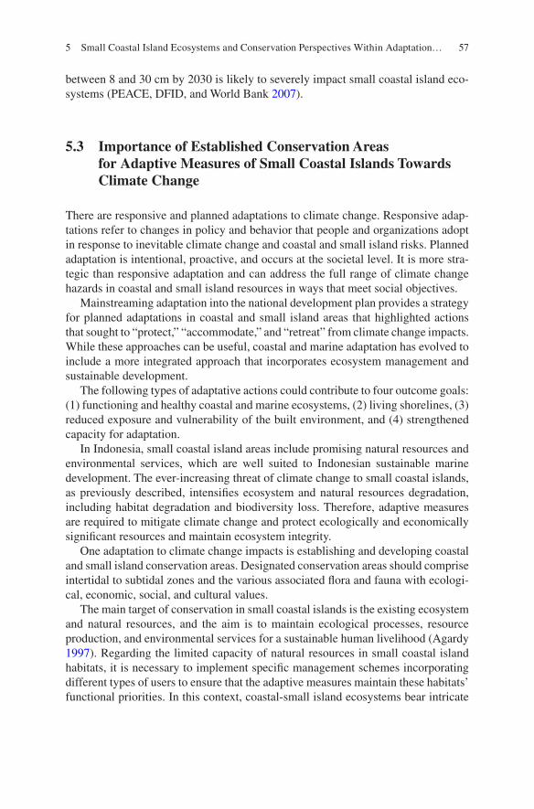
57
between 8 and 30 cm by 2030 is likely to severely impact small coastal island eco-systems (PEACE, DFID, and World Bank 2007).
5.3 Importance of Established Conservation Areas for Adaptive Measures of Small Coastal Islands Towards Climate Change
There are responsive and planned adaptations to climate change. Responsive adap-tations refer to changes in policy and behavior that people and organizations adopt in response to inevitable climate change and coastal and small island risks. Planned adaptation is intentional, proactive, and occurs at the societal level. It is more stra-tegic than responsive adaptation and can address the full range of climate change hazards in coastal and small island resources in ways that meet social objectives.
Mainstreaming adaptation into the national development plan provides a strategy for planned adaptations in coastal and small island areas that highlighted actions that sought to “protect,” “accommodate,” and “retreat” from climate change impacts. While these approaches can be useful, coastal and marine adaptation has evolved to include a more integrated approach that incorporates ecosystem management and sustainable development.
The following types of adaptative actions could contribute to four outcome goals: (1) functioning and healthy coastal and marine ecosystems, (2) living shorelines, (3) reduced exposure and vulnerability of the built environment, and (4) strengthened capacity for adaptation.
In Indonesia, small coastal island areas include promising natural resources and environmental services, which are well suited to Indonesian sustainable marine development. The ever-increasing threat of climate change to small coastal islands, as previously described, intensifies ecosystem and natural resources degradation, including habitat degradation and biodiversity loss. Therefore, adaptive measures are required to mitigate climate change and protect ecologically and economically significant resources and maintain ecosystem integrity.
One adaptation to climate change impacts is establishing and developing coastal and small island conservation areas. Designated conservation areas should comprise intertidal to subtidal zones and the various associated flora and fauna with ecologi-cal, economic, social, and cultural values.
The main target of conservation in small coastal islands is the existing ecosystem and natural resources, and the aim is to maintain ecological processes, resource production, and environmental services for a sustainable human livelihood (Agardy 1997). Regarding the limited capacity of natural resources in small coastal island habitats, it is necessary to implement specific management schemes incorporating different types of users to ensure that the adaptive measures maintain these habitats’ functional priorities. In this context, coastal-small island ecosystems bear intricate
5 Small Coastal Island Ecosystems and Conservation Perspectives Within Adaptation…
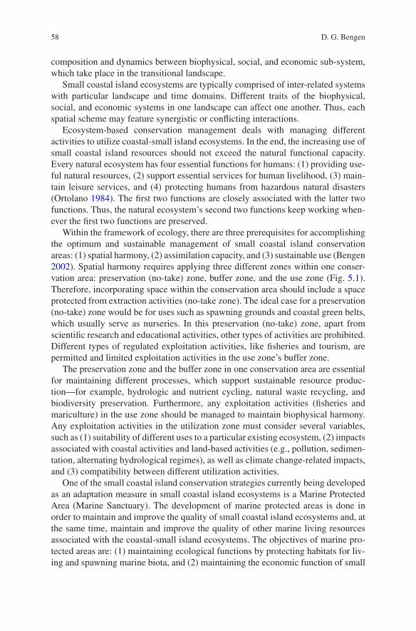
58
composition and dynamics between biophysical, social, and economic sub-system, which take place in the transitional landscape.
Small coastal island ecosystems are typically comprised of inter-related systems with particular landscape and time domains. Different traits of the biophysical, social, and economic systems in one landscape can affect one another. Thus, each spatial scheme may feature synergistic or conflicting interactions.
Ecosystem-based conservation management deals with managing different activities to utilize coastal-small island ecosystems. In the end, the increasing use of small coastal island resources should not exceed the natural functional capacity. Every natural ecosystem has four essential functions for humans: (1) providing use-ful natural resources, (2) support essential services for human livelihood, (3) main-tain leisure services, and (4) protecting humans from hazardous natural disasters (Ortolano 1984). The first two functions are closely associated with the latter two functions. Thus, the natural ecosystem’s second two functions keep working when-ever the first two functions are preserved.
Within the framework of ecology, there are three prerequisites for accomplishing the optimum and sustainable management of small coastal island conservation areas: (1) spatial harmony, (2) assimilation capacity, and (3) sustainable use (Bengen 2002). Spatial harmony requires applying three different zones within one conser-vation area: preservation (no-take) zone, buffer zone, and the use zone (Fig. 5.1). Therefore, incorporating space within the conservation area should include a space protected from extraction activities (no-take zone). The ideal case for a preservation (no-take) zone would be for uses such as spawning grounds and coastal green belts, which usually serve as nurseries. In this preservation (no-take) zone, apart from scientific research and educational activities, other types of activities are prohibited. Different types of regulated exploitation activities, like fisheries and tourism, are permitted and limited exploitation activities in the use zone’s buffer zone.
The preservation zone and the buffer zone in one conservation area are essential for maintaining different processes, which support sustainable resource produc-tion—for example, hydrologic and nutrient cycling, natural waste recycling, and biodiversity preservation. Furthermore, any exploitation activities (fisheries and mariculture) in the use zone should be managed to maintain biophysical harmony. Any exploitation activities in the utilization zone must consider several variables, such as (1) suitability of different uses to a particular existing ecosystem, (2) impacts associated with coastal activities and land-based activities (e.g., pollution, sedimen-tation, alternating hydrological regimes), as well as climate change-related impacts, and (3) compatibility between different utilization activities.
One of the small coastal island conservation strategies currently being developed as an adaptation measure in small coastal island ecosystems is a Marine Protected Area (Marine Sanctuary). The development of marine protected areas is done in order to maintain and improve the quality of small coastal island ecosystems and, at the same time, maintain and improve the quality of other marine living resources associated with the coastal-small island ecosystems. The objectives of marine pro-tected areas are: (1) maintaining ecological functions by protecting habitats for liv-ing and spawning marine biota, and (2) maintaining the economic function of small
D. G. Bengen
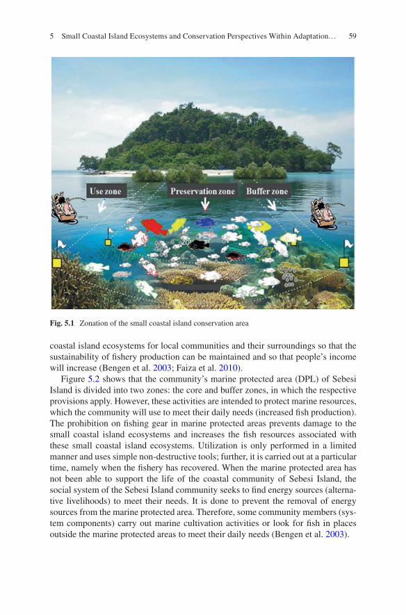
59
coastal island ecosystems for local communities and their surroundings so that the sustainability of fishery production can be maintained and so that people’s income will increase (Bengen et al. 2003; Faiza et al. 2010).
Figure 5.2 shows that the community’s marine protected area (DPL) of Sebesi Island is divided into two zones: the core and buffer zones, in which the respective provisions apply. However, these activities are intended to protect marine resources, which the community will use to meet their daily needs (increased fish production). The prohibition on fishing gear in marine protected areas prevents damage to the small coastal island ecosystems and increases the fish resources associated with these small coastal island ecosystems. Utilization is only performed in a limited manner and uses simple non-destructive tools; further, it is carried out at a particular time, namely when the fishery has recovered. When the marine protected area has not been able to support the life of the coastal community of Sebesi Island, the social system of the Sebesi Island community seeks to find energy sources (alterna-tive livelihoods) to meet their needs. It is done to prevent the removal of energy sources from the marine protected area. Therefore, some community members (sys-tem components) carry out marine cultivation activities or look for fish in places outside the marine protected areas to meet their daily needs (Bengen et al. 2003).
Fig. 5.1 Zonation of the small coastal island conservation area
5 Small Coastal Island Ecosystems and Conservation Perspectives Within Adaptation…
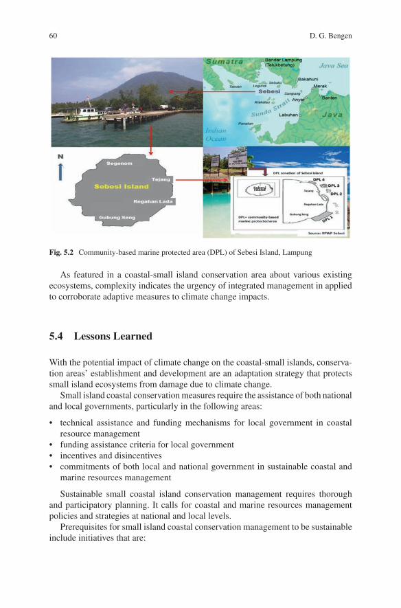
60
As featured in a coastal-small island conservation area about various existing ecosystems, complexity indicates the urgency of integrated management in applied to corroborate adaptive measures to climate change impacts.
5.4 Lessons Learned
With the potential impact of climate change on the coastal-small islands, conserva-tion areas’ establishment and development are an adaptation strategy that protects small island ecosystems from damage due to climate change.
Small island coastal conservation measures require the assistance of both national and local governments, particularly in the following areas:
• technical assistance and funding mechanisms for local government in coastal resource management
• funding assistance criteria for local government• incentives and disincentives• commitments of both local and national government in sustainable coastal and
marine resources management
Sustainable small coastal island conservation management requires thorough and participatory planning. It calls for coastal and marine resources management policies and strategies at national and local levels.
Prerequisites for small island coastal conservation management to be sustainable include initiatives that are:
Fig. 5.2 Community-based marine protected area (DPL) of Sebesi Island, Lampung
D. G. Bengen
61
• in concordance with formal and informal local policies• inline with local communities’ social and cultural conditions• supported by human resources and institutional capacities• have the involvement stakeholders• a clear plan and program• positive impacts on the environment, including local communities’ socio- cultural
and economic conditions.
For small island coastal conservation programs to have a widespread impact, careful consideration needs to be given to conservation replication design. The design requirement will include:
• a complete set of data and information (documentation process)• evaluation of program relevance to conditions of particular areas• evaluation of program impacts on the environment and communities• involvement of stakeholders and communities in planning• dissemination of information strategies.
Integrated small island coastal conservation management is one of the require-ments to achieve optimal and sustainable management.
References
Agardy TS (1997) Marine protected areas and ocean conservation. Academic, San DiegoAlongi DM (1998) Coastal ecosystem processes. CRC Press LLCAnonymous (2008) Adapting to coastal climate change. United States Agency for International
DevelopmentBengen DG (2002) Coastal resources and ecosystems and its integrated and sustainable manage-
ment. Marine Journalist Training Paper, organized by WWF-Wallacea Program, Bali, April 9–11, 2002
Bengen DG (2020) Integrated coastal zone management for coastal-small island ecosystem resil-ience in the face of climate crisis. Proceeding of the international workshop (Natural resource and risk management in the context of climate change: Southeast Asia Research-based Network on Climate Change Adaptation Science), Hanoi, January 9–10, 2020
Bengen DG, Tahir A, Wiryawan B (2003) Tinjauan Sustainabilitas, Akuntabilitas, Replikabilitas Pengembangan Daerah Perlindungan Laut di Pulau Sebesi, Lampung Selatan, Provinsi Lampung. Proyek Pesisir, Jakarta
Faiza R, Kusumastanto T, Bengen DG, Boer M, Yulianda F (2010) Sustainability of community- based marine protected area (case study: Blongko village, North Sulawesi, Sebesi Island, Lampung and Harapan Island, Jakarta). J Bijak dan Riset Sosek KP 5(1):19–30. (in Indonesian)
FAO (2000) The status of world fisheries and aquaculture. FAO Fisheries Department, RomeIPCC (2007) Climate Change 2007: impacts, adaptation, and vulnerability. In: Parry ML, Canziani
OF, Palutikof JP, van der Linden PJ, Hanson CE (eds) Contribution of Working Group II to the Fourth Assessment Report of the Intergovernmental Panel on Climate Change. Cambridge University Press, Cambridge
Ministry of Environment of Republic of Indonesia (2007) Climate variability and climate changes, and their adaptation. Ministry of Environment of the Republic of Indonesia, Jakarta
Ortolano L (1984) Environmental planning and decision making. Wiley, TorontoPEACE, DFID, World Bank (2007) Indonesia and Climate Change status and policies. PEACE,
DFID, and the World Bank
5 Small Coastal Island Ecosystems and Conservation Perspectives Within Adaptation…

62
Open Access This chapter is licensed under the terms of the Creative Commons Attribution 4.0 International License (http://creativecommons.org/licenses/by/4.0/), which permits use, sharing, adaptation, distribution and reproduction in any medium or format, as long as you give appropriate credit to the original author(s) and the source, provide a link to the Creative Commons license and indicate if changes were made.
The images or other third party material in this chapter are included in the chapter’s Creative Commons license, unless indicated otherwise in a credit line to the material. If material is not included in the chapter’s Creative Commons license and your intended use is not permitted by statutory regulation or exceeds the permitted use, you will need to obtain permission directly from the copyright holder.
D. G. Bengen
Part IIDisater Risk Reduction and Human
Resource Development
65© The Author(s) 2022T. Ito et al. (eds.), Interlocal Adaptations to Climate Change in East and Southeast Asia, SpringerBriefs in Climate Studies, https://doi.org/10.1007/978-3-030-81207-2_6
Chapter 6Geotechnical Approaches to Disaster Risk Reduction in Japan and Vietnam
Kazuya Yasuhara and Satoshi Murakami
6.1 Introduction
One of the factors responsible for the increased severity of disasters in recent years is overlapping events that are caused by a combination of climate change- and cli-mate change-non-associated events. These compound disasters are common in Japan and Vietnam. This study attempts to explore ways in which to increase resil-ience against the risk of disasters, particularly in cases where residents encounter such compound disasters, in Japan and Vietnam.
6.2 Importance of Compound Disasters
Compound disasters require special attention because they magnify the extent of loss and damage. Figure 6.1a shows the characteristics of compound disasters. Typically, compound disasters have the following characteristics: (i) a second natu-ral disaster occurs immediately before or after a major disaster, generating cata-strophic consequences; (ii) damage is compounded through the combination of the natural disaster with a vulnerable natural background and/or human and social situ-ations (see Fig. 6.1b); and (iii) the psychological aftermath amplifies the damage. This classification corresponds well with that proposed by Kokusho (2005).
K. Yasuhara (*) Global and Local Environment Co-creation Institute, Ibaraki University, Ibaraki, Japane-mail: [email protected]
S. Murakami Faculty of Engineering, Fukuoka University, Fukuoka, Japan
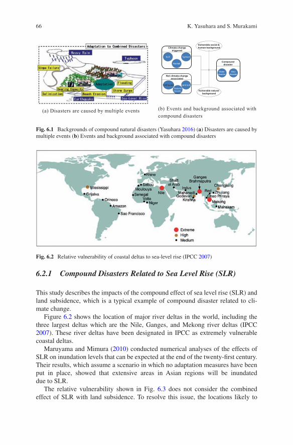
66
6.2.1 Compound Disasters Related to Sea Level Rise (SLR)
This study describes the impacts of the compound effect of sea level rise (SLR) and land subsidence, which is a typical example of compound disaster related to cli-mate change.
Figure 6.2 shows the location of major river deltas in the world, including the three largest deltas which are the Nile, Ganges, and Mekong river deltas (IPCC 2007). These river deltas have been designated in IPCC as extremely vulnerable coastal deltas.
Maruyama and Mimura (2010) conducted numerical analyses of the effects of SLR on inundation levels that can be expected at the end of the twenty-first century. Their results, which assume a scenario in which no adaptation measures have been put in place, showed that extensive areas in Asian regions will be inundated due to SLR.
The relative vulnerability shown in Fig. 6.3 does not consider the combined effect of SLR with land subsidence. To resolve this issue, the locations likely to
Climate-change triggered
No climate- change associated
Vulnerable natural background
Compound disaster
Water disaster
Geo-disaster
Earthquake. Land sub.
Tectonicmovem.
No climate- change associated
Vulnerable social & human background
SLR Typhoon
Rainfall
Not climate-change associated
(a) Disasters are caused by multiple events (b) Events and background associated withcompound disasters
Fig. 6.1 Backgrounds of compound natural disasters (Yasuhara 2016) (a) Disasters are caused by multiple events (b) Events and background associated with compound disasters
Fig. 6.2 Relative vulnerability of coastal deltas to sea-level rise (IPCC 2007)
K. Yasuhara and S. Murakami
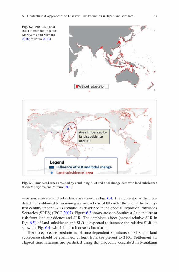
67
Fig. 6.3 Predicted areas (red) of inundation (after Maruyama and Mimura 2010; Mimura 2013)
Fig. 6.4 Inundated areas obtained by combining SLR and tidal change data with land subsidence (from Maruyama and Mimura 2010)
experience severe land subsidence are shown in Fig. 6.4. The figure shows the inun-dated areas obtained by assuming a sea-level rise of 88 cm by the end of the twenty- first century under a A1B scenario, as described in the Special Report on Emissions Scenarios (SRES) (IPCC 2007). Figure 6.3 shows areas in Southeast Asia that are at risk from land subsidence and SLR. The combined effect (named relative SLR in Fig. 6.5) of land subsidence and SLR is expected to increase the relative SLR, as shown in Fig. 6.4, which in turn increases inundation.
Therefore, precise predictions of time-dependent variations of SLR and land subsidence should be estimated, at least from the present to 2100. Settlement vs. elapsed time relations are predicted using the procedure described in Murakami
6 Geotechnical Approaches to Disaster Risk Reduction in Japan and Vietnam
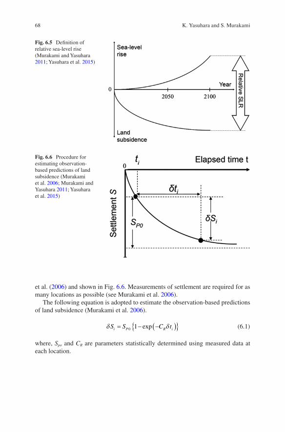
68
Fig. 6.5 Definition of relative sea-level rise (Murakami and Yasuhara 2011; Yasuhara et al. 2015)
Fig. 6.6 Procedure for estimating observation- based predictions of land subsidence (Murakami et al. 2006; Murakami and Yasuhara 2011; Yasuhara et al. 2015)
et al. (2006) and shown in Fig. 6.6. Measurements of settlement are required for as many locations as possible (see Murakami et al. 2006).
The following equation is adopted to estimate the observation-based predictions of land subsidence (Murakami et al. 2006).
δ δS S C ti P R i= − −( ){ }0 1 exp
(6.1)
where, Spo and CR are parameters statistically determined using measured data at each location.
K. Yasuhara and S. Murakami
69
6.2.2 Case Study: Mekong Delta, Vietnam
Similar to a case study conducted in the Chao Phraya Delta, Thailand, by Murakami et al. (2006), an attempt was made by Kawase et al. (2012) to predict the effects of sea-level rise and land subsidence in the Mekong Delta in Vietnam, although avail-able data for land subsidence was insufficient and not reliable.
Land subsidence is known to have taken place in the Mekong Delta for many years (e.g, Karlsrud and Vangelsten 2017), but the manner and extent of settlement in the region remain unknown. Here the authors quantitatively describe the present and future situations of land subsidence in the Mekong Delta.
Interferometry Synthetic Aperture Radar (InSAR) was used to investigate land subsidence in the Mekong Delta. Computer software (SIGMA-SAR Cloud Platform) is useful for analyzing the variations in ground surface level caused by land subsid-ence over time (Murakami et al. 2006). Data for the InSAR dataset were obtained from JERS-1 image data received from December 28, 1993 through January 1, 1997. The data were modified to adapt to the SRTM3 (Shuttle Radar Topography Mission, Ver.3) and were used to produce a digital elevation model.
Land subsidence (LS) was inferred from the InSAR results and representative regions that experienced land subsidence in the Mekong Delta were identified. Finally, future settlement in the representative regions was predicted as described by Kawase et al. (2012).
The land subsidence map produced using InSAR shows that extensive settlement has occurred in Ho Chi Minh City (HCM), My Tho, and Can Tho in the period 1996–1998. The settlement rate was approximately 5–10 mm/year in HCM and around 15–20 mm/year in My Tho and Can Tho. Predictions of land subsidence in HCM, My Tho and Can Tho until 2100 appear to differ, with settlement continuing until 2100 in HMC and settlement being unlikely in My Tho and Can Tho in the future.
LS is accelerated by human activities such as excessive abstraction of groundwa-ter. Therefore, adaptation to observed settlement over time is important as the extent of inundation damage increases due to SLR and LS. Figure 6.7 shows the following inundation scenarios in the Mekong Delta: the present, the future considering SLR, and the future considering both SLR and LS. The results emphasize the importance of considering not only the influence of SLR, but also that of land subsidence in reducing the extent of inundated areas.
6 Geotechnical Approaches to Disaster Risk Reduction in Japan and Vietnam

70
6.3 Resilience and the Increase Thereof
6.3.1 Definition of Resilience
In the current manuscript, resilience is defined as the human potential that is capable of minimizing the gap between the external force caused by climate change and the defensive actions against climatic events, as shown in Fig. 6.8. This gap is some-times called “vulnerability”. Therefore, it can be said that resilience decreases vulnerability.
Fig. 6.7 Predicted inundation in Mekong Delta of Vietnam for the end of twenty-first century (Kawase et al. 2012) (a) Current situation (b) Considering SLR (c) Considering SLR and LS
Fig. 6.8 Definition of resilience (modified from Komatsu et al. 2013)
K. Yasuhara and S. Murakami

71
6.3.2 Scientific Considerations Underlying Burying the Gap Between External and Defensive Forces
In addition to mitigation, adaptation, and combination of mitigation with adapta-tion, the concept of reactive to proactive responses should also be considered. For example, in a case study on flooding in 2015 in which torrential rainfall at Jyoso City in Ibaraki caused extensive damage to infrastructure and residential areas, the Kinu river dyke height was raised from 4.5 m to 6.0 m. As a result, the following active measures have been proposed by The Ministry of Land, Infrastructure, Transportation and Tourism (MLIT) as mitigation measures against heavy rainfall (see Fig. 6.9).
(i) Drain work at dyke heels (ii) Replacement of high-quality soils for avoiding differential settlement (iii) Installation of impermeable sheet pile walls to prevent river water seepage (iv) Surfacing work combined with concrete blocks and permeable sheets (v) Paved top for preventing rainwater seepage
Generally, the methodology for strengthening river dykes is divided into the fol-lowing steps: (1) structural reinforcement using pile installation and geosynthetics and (2) improvement of dyke soils mixed with additive materials such as cement and/or fibers (Sato et al. 2013; Yasuhara 2016). Combined adaptation is ideal, but their selection depends on government decisions. The method adopted by the MLIT can be classified as structural reinforcement (Fig. 6.9). However, the authors con-ducted numerical analysis to propose how dyke soils could be improved to increase overall dyke stability. Results of numerical analyses demonstrate that increased cohesion is the most important contributing factor for increased stability of sandy dykes undergoing water level rise (WLR). From a practical perspective, the results
Fig. 6.9 Countermeasures for remediation of damaged river dykes (after MLIT, Japan)
6 Geotechnical Approaches to Disaster Risk Reduction in Japan and Vietnam
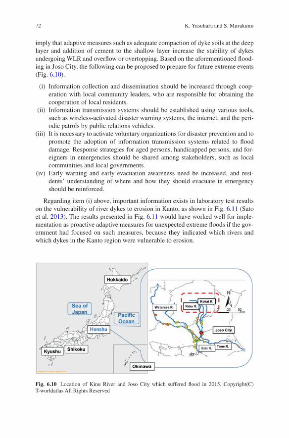
72
imply that adaptive measures such as adequate compaction of dyke soils at the deep layer and addition of cement to the shallow layer increase the stability of dykes undergoing WLR and overflow or overtopping. Based on the aforementioned flood-ing in Joso City, the following can be proposed to prepare for future extreme events (Fig. 6.10).
(i) Information collection and dissemination should be increased through coop-eration with local community leaders, who are responsible for obtaining the cooperation of local residents.
(ii) Information transmission systems should be established using various tools, such as wireless-activated disaster warning systems, the internet, and the peri-odic patrols by public relations vehicles.
(iii) It is necessary to activate voluntary organizations for disaster prevention and to promote the adoption of information transmission systems related to flood damage. Response strategies for aged persons, handicapped persons, and for-eigners in emergencies should be shared among stakeholders, such as local communities and local governments.
(iv) Early warning and early evacuation awareness need be increased, and resi-dents’ understanding of where and how they should evacuate in emergency should be reinforced.
Regarding item (i) above, important information exists in laboratory test results on the vulnerability of river dykes to erosion in Kanto, as shown in Fig. 6.11 (Sato et al. 2013). The results presented in Fig. 6.11 would have worked well for imple-mentation as proactive adaptive measures for unexpected extreme floods if the gov-ernment had focused on such measures, because they indicated which rivers and which dykes in the Kanto region were vulnerable to erosion.
Fig. 6.10 Location of Kinu River and Joso City which suffered flood in 2015. Copyright(C) T-worldatlas All Rights Reserved
K. Yasuhara and S. Murakami
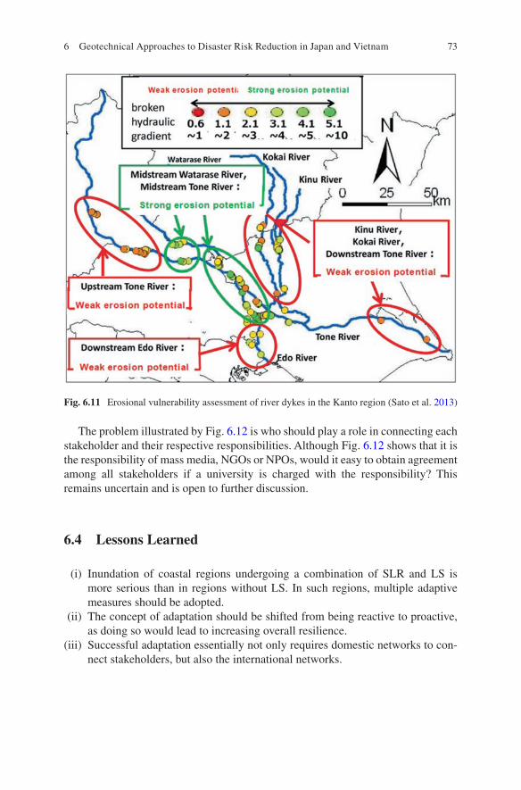
73
The problem illustrated by Fig. 6.12 is who should play a role in connecting each stakeholder and their respective responsibilities. Although Fig. 6.12 shows that it is the responsibility of mass media, NGOs or NPOs, would it easy to obtain agreement among all stakeholders if a university is charged with the responsibility? This remains uncertain and is open to further discussion.
6.4 Lessons Learned
(i) Inundation of coastal regions undergoing a combination of SLR and LS is more serious than in regions without LS. In such regions, multiple adaptive measures should be adopted.
(ii) The concept of adaptation should be shifted from being reactive to proactive, as doing so would lead to increasing overall resilience.
(iii) Successful adaptation essentially not only requires domestic networks to con-nect stakeholders, but also the international networks.
Fig. 6.11 Erosional vulnerability assessment of river dykes in the Kanto region (Sato et al. 2013)
6 Geotechnical Approaches to Disaster Risk Reduction in Japan and Vietnam
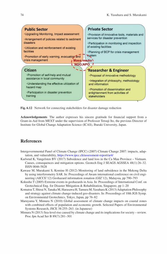
74
Acknowledgements The author expresses his sincere gratitude for financial support from a Grant-in-Aid from MEXT under the supervision of Professor Tetsuji Ito, the previous Director of Institute for Global Change Adaptation Science (ICAS), Ibaraki University, Japan.
References
Intergovernmental Panel of Climate Change (IPCC) (2007) Climate Change 2007: impacts, adap-tation, and vulnerability, https://www.ipcc.ch/assessment- report/ar4/
Karlsrud K, Vangelsten BV (2017) Subsidence and land loss in the Ca Mau Province – Vietnam. Causes, consequences and mitigation options. Geotech Eng J SEAGS AGSSEA 48(1):26–32. ISSN 0046-5828
Kawase M, Murakami S, Komine H (2012) Monitoring of land subsidence in the Mekong Delta by using interferometry SAR. In: Proceedings of Awam international conference on civil engi-neering (AICCE’12) Geohazard information zonation (GIZ’12), Malaysia, pp 790–793
Kokusho T (2005) Extreme events in geohazards in Asia. In: Proceedings of International Conf. on Geotechnical Eng. for Disaster Mitigation & Rehabilitation, Singapore, pp 1–20
Komatsu T, Shirai N, Tanaka M, Harasawa H, Tamura M, Yasuhara K (2013) Adaptation Philosophy and strategy against climate change-induced geo-disasters. In: Proceedings of 10th JGS Symp. on Environmental Geotechnics, Tokyo, Japan, pp 76–82
Maruyama Y, Mimura N (2010) Global assessment of climate change impacts on coastal zones with combined effects of population and economic growth. Selected Papers of Environmental Systems Research, JSCE 38:255–263. (in Japanese)
Mimura N (2013) Sea-level rise caused by climate change and its implications for society – review. Proc Jpn Acad Ser B 89(7):281–301
Fig. 6.12 Network for connecting stakeholders for disaster damage reduction
K. Yasuhara and S. Murakami

75
Murakami S, Yasuhara K (2011) Inundation due to global warming and land subsidence in Chao Phraya Delta. In: Proceedings of the 14th Asian Regional Conference on Soil Mechanics and Geotechnical Engineering, CD-ROM, Hong Kong
Murakami S, Yasuhara K, Suzuki K, Komine H (2006) Reliable land subsidence mapping using a spatial interpolation procedure based on geo-statistics. Soils Found 46(2):123–134
Sato K, Komine H, Murakami S, Yasuhara K (2013) Experimental evaluation of seepage fail-ure of river dykes with natural Fiber mixed with soils. Proceedings of Geotech-Hanoi, Hanoi, Vietnam, pp 1–8
Yasuhara K (2016) Geotechnical responses to natural disasters and environmental impacts in the context of climate change. In: Proceedings of International Conference on Geotechnics for Sustainable Infrastructure Development – Geotech Hanoi 2016, Phung (Editor), Hanoi, Vietnam, pp 957–981
Yasuhara K, Murakami S, Mimura N (2015) Inundation caused by sea-level rise combined with land subsidence. Geotech Eng J SEAGS AGSSEA 46(4). December 2015, ISSN 0046-5828
Open Access This chapter is licensed under the terms of the Creative Commons Attribution 4.0 International License (http://creativecommons.org/licenses/by/4.0/), which permits use, sharing, adaptation, distribution and reproduction in any medium or format, as long as you give appropriate credit to the original author(s) and the source, provide a link to the Creative Commons license and indicate if changes were made.
The images or other third party material in this chapter are included in the chapter’s Creative Commons license, unless indicated otherwise in a credit line to the material. If material is not included in the chapter’s Creative Commons license and your intended use is not permitted by statutory regulation or exceeds the permitted use, you will need to obtain permission directly from the copyright holder.
6 Geotechnical Approaches to Disaster Risk Reduction in Japan and Vietnam
77© The Author(s) 2022T. Ito et al. (eds.), Interlocal Adaptations to Climate Change in East and Southeast Asia, SpringerBriefs in Climate Studies, https://doi.org/10.1007/978-3-030-81207-2_7
Chapter 7Climate Change Adaptation in Fisheries Livelihoods Associated with Mangrove Forests in Xuan Thuy National Park, Vietnam: A Case Study in Giao An Commune, Giao Thuy District, Nam Dinh Province
Thu Hoai Nguyen
7.1 Introduction
Giao An, a commune located in the southeast of Giao Thuy District, Nam Dinh Province in Vietnam, is one of five communes in the buffer zone of Xuan Thuy National Park with a history associated with the development of the Red River Delta. About 300 to 400 years ago, this land was comprised of pristine beaches with lots of reeds and mudflats. Over time, the people of Giao An built dikes, encroached on the sea, and leveled the land. By the end of 1860, Giao An was established, com-prising Trung Uyen, Hanh Thien, Xuan Hy, Thuy Nhai, Hoanh Lo, Tra Huong, and Tra Lu villages (divided into 16 hamlets). The period from 1960 to 1985 was char-acterized by continued expansion of arable land by building dikes under the motto, “Rice encroached on sedge, sedge encroached on Bruguiera (genus of mangrove plants), Bruguiera encroached on the sea”. At this stage, the commune had reclaimed approximately 300 ha of land from the sea, close to the foot of Ngu Han dike, and established six hamlets in the Dien Bien New Economic Zone Area (from hamlet 16 to hamlet 22). The period from 1985 to 1995 was characterized by the adoption of the marine economic development strategy under the motto “Bruguiera encroached on the sea, shrimp encroached on Bruguiera”, which created thousands of hectares of shrimp ponds in Bai Trong and Con Ngan. Due to economic development, the natural mangrove forests in Giao An Commune decreased, especially in Bai Trong.
However, realizing the important role of mangroves in coastal area protection, the local government has implemented numerous solutions, simultaneously, such as planting more than 1000 ha of mangrove in Con Ngan and a part of Con Lu from 1997 to 2003. In addition, Giao An has pioneered the development of climate
T. H. Nguyen (*) VNU Vietnam Japan University, Hanoi, Vietnam
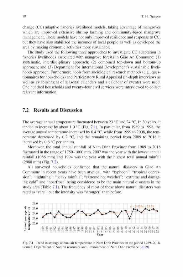
78
change (CC) adaptive fisheries livelihood models, taking advantage of mangroves which are improved extensive shrimp farming and community-based mangrove management. These models have not only improved resilience and response to CC, but they have also stabilized the incomes of local people as well as developed the area by making economic activities more sustainable.
The study used the following three approaches to investigate CC adaptation in fisheries livelihoods associated with mangrove forests in Giao An Commune: (1) systematic, interdisciplinary approach; (2) combined top-down and bottom-up approach; and (3) Department for International Development’s sustainable liveli-hoods approach. Furthermore, tools from sociological research methods (e.g., ques-tionnaires for households) and Participatory Rural Appraisal (in-depth interviews as well as establishment of seasonal calendars and a calendar of events) were used. One hundred households and twenty-four civil services were interviewed to collect relevant information.
7.2 Results and Discussion
The average annual temperature fluctuated between 23 °C and 24 °C. In 30 years, it tended to increase by about 1.0 °C (Fig. 7.1). In particular, from 1989 to 1998, the average annual temperature increased by 0.4 °C, while from 1999 to 2008, the tem-perature decreased by 0.2 °C, and the remaining period from 2009 to 2018 it increased by 0.6 °C per annum.
Moreover, the total annual rainfall of Nam Dinh Province from 1989 to 2018 fluctuated in the range of 1750–1800 mm. 2007 was the year with the lowest annual rainfall (1086 mm) and 1994 was the year with the highest total annual rainfall (2988 mm) (Fig. 7.2).
All surveyed households confirmed that the natural disasters in Giao An Commune in recent years have been atypical, with “typhoon”; “tropical depres-sion”; “lightning”; “heavy rainfall”; “extreme hot weather”; “extreme and damag-ing cold” and “hoarfrost” being considered to be the main natural disasters in the study area (Table 7.1). The frequency of most of these above natural disasters was rated as “rare”, but the intensity was “stronger” than before.
y = 0.035x + 23.58
22.0
23.0
24.0
25.0
26.0
19
89
19
90
19
91
19
92
19
93
19
94
19
95
19
96
19
97
19
98
19
99
20
00
20
01
20
02
20
03
20
04
20
05
20
06
20
07
20
08
20
09
20
10
20
11
20
12
20
13
20
14
20
15
20
16
20
17
20
18
Ann
ual a
vera
ge a
ir
tem
pera
ture
(ºC
)
Year
Fig. 7.1 Trend in average annual air temperature in Nam Dinh Province in the period 1989–2018. Source: Department of Natural resources and Environment of Nam Dinh Province (2019)
T. H. Nguyen

79
During the survey, in addition to in-depth interviews with local people and authorities, the impacts of natural disasters were reported as follows (Table 7.2).
In addition, agriculture and fisheries were the main livelihood activities account-ing for a large proportion of the local economy (67%) (People’s Committee of Giao An Commune 2017). In terms of fishery production, two activities are very impor-tant: aquaculture and capture fisheries (or called community-based mangrove man-agement). The entire commune utilized an aquaculture area of 669.2 ha, which comprised a freshwater area of 59 ha and a shrimp pond area of 610.2 ha. The total aquatic production in 2019 was estimated at 2200 tons (People’s Committee of Giao An Commune 2019).
a. AquaculturePeaks in aquaculture production coincided with the different types of natural
disasters. Consequently, without careful preparation, the risk to aquaculture house-holds was quite large. The natural disasters markedly affected these activities in the Giao An Commune, especially “typhoon”, “tropical depression”, “heavy rainfall”, “saltwater intrusion”, “extreme hot weather”, “extreme and damaging cold”, “hoar-frost” and “other”, which comprised changes in climate and weather. Together, these phenomena “reduced productivity”, “changed the water environment”, which can lead to “lost all aquaculture products”. Table 7.3 shows the valid percent of
Fig. 7.2 Trend in total annual rainfall in Nam Dinh Province in the period 1989–2018. Source: Department of Natural resources and Environment of Nam Dinh Province (2019)
Table 7.1 Assessment of survey respondents about natural disasters that have occurred in Giao An Commune in recent years
Types of natural disastersValid percentage (%)
Types of natural disasters
Valid percentage (%)
Typhoons 97.0 Hail 4.0Tropical depressions 98.0 Drought 30.0Whirlwinds 56.0 Hoarfrost 82.0Lighting 94.0 Other 20.0Heavy rainfall 78.0 - acid rain 1.0Inundation 32.0 - showers 1.0Sea level rise 19.0 - fog 1.0Saltwater intrusion 19.0 - change in weather 16.0Extreme hot weather 95.0 - humidity 1.0Extreme and damaging cold
60.0
7 Climate Change Adaptation in Fisheries Livelihoods Associated with Mangrove…
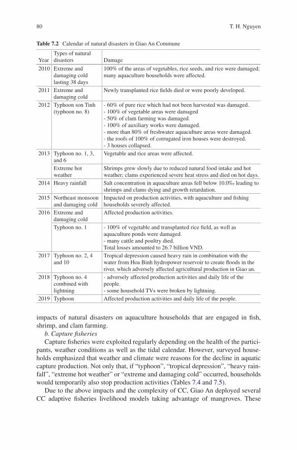
80
impacts of natural disasters on aquaculture households that are engaged in fish, shrimp, and clam farming.
b. Capture fisheriesCapture fisheries were exploited regularly depending on the health of the partici-
pants, weather conditions as well as the tidal calendar. However, surveyed house-holds emphasized that weather and climate were reasons for the decline in aquatic capture production. Not only that, if “typhoon”, “tropical depression”, “heavy rain-fall”, “extreme hot weather” or “extreme and damaging cold” occurred, households would temporarily also stop production activities (Tables 7.4 and 7.5).
Due to the above impacts and the complexity of CC, Giao An deployed several CC adaptive fisheries livelihood models taking advantage of mangroves. These
Table 7.2 Calendar of natural disasters in Giao An Commune
YearTypes of natural disasters Damage
2010 Extreme and damaging cold lasting 38 days
100% of the areas of vegetables, rice seeds, and rice were damaged; many aquaculture households were affected.
2011 Extreme and damaging cold
Newly transplanted rice fields died or were poorly developed.
2012 Typhoon son Tinh(typhoon no. 8)
- 60% of pure rice which had not been harvested was damaged.- 100% of vegetable areas were damaged- 50% of clam farming was damaged.- 100% of auxiliary works were damaged.- more than 80% of freshwater aquaculture areas were damaged.- the roofs of 100% of corrugated iron houses were destroyed.- 3 houses collapsed.
2013 Typhoon no. 1, 3, and 6
Vegetable and rice areas were affected.
Extreme hot weather
Shrimps grew slowly due to reduced natural food intake and hot weather; clams experienced severe heat stress and died on hot days.
2014 Heavy rainfall Salt concentration in aquaculture areas fell below 10.0‰ leading to shrimps and clams dying and growth retardation.
2015 Northeast monsoon and damaging cold
Impacted on production activities, with aquaculture and fishing households severely affected.
2016 Extreme and damaging cold
Affected production activities.
Typhoon no. 1 - 100% of vegetable and transplanted rice field, as well as aquaculture ponds were damaged.- many cattle and poultry died.Total losses amounted to 26.7 billion VND.
2017 Typhoon no. 2, 4 and 10
Tropical depression caused heavy rain in combination with the water from Hoa Binh hydropower reservoir to create floods in the river, which adversely affected agricultural production in Giao an.
2018 Typhoon no. 4 combined with lightning
- adversely affected production activities and daily life of the people.- some household TVs were broken by lightning.
2019 Typhoon Affected production activities and daily life of the people.
T. H. Nguyen
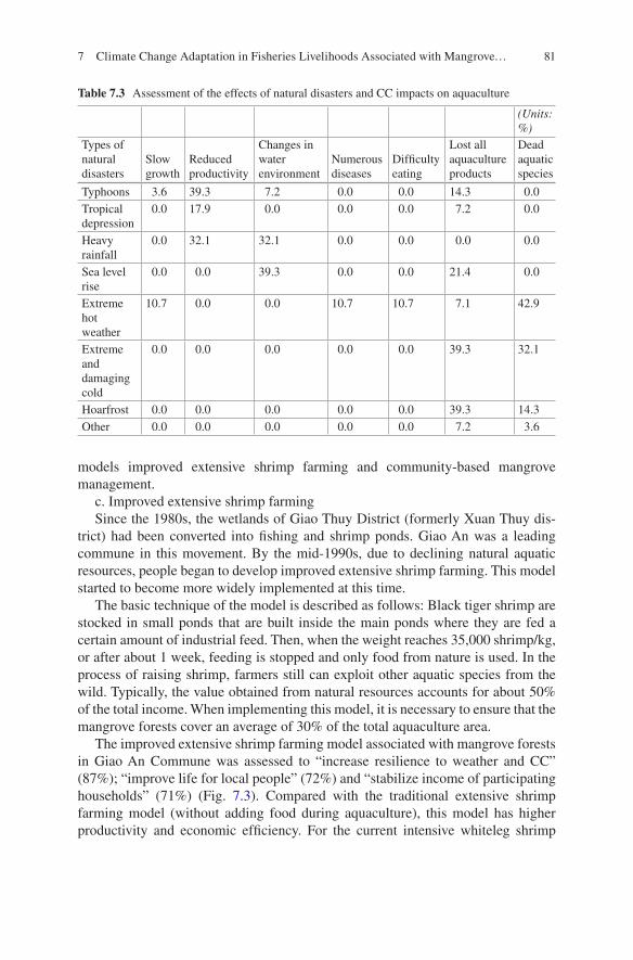
81
models improved extensive shrimp farming and community-based mangrove management.
c. Improved extensive shrimp farmingSince the 1980s, the wetlands of Giao Thuy District (formerly Xuan Thuy dis-
trict) had been converted into fishing and shrimp ponds. Giao An was a leading commune in this movement. By the mid-1990s, due to declining natural aquatic resources, people began to develop improved extensive shrimp farming. This model started to become more widely implemented at this time.
The basic technique of the model is described as follows: Black tiger shrimp are stocked in small ponds that are built inside the main ponds where they are fed a certain amount of industrial feed. Then, when the weight reaches 35,000 shrimp/kg, or after about 1 week, feeding is stopped and only food from nature is used. In the process of raising shrimp, farmers still can exploit other aquatic species from the wild. Typically, the value obtained from natural resources accounts for about 50% of the total income. When implementing this model, it is necessary to ensure that the mangrove forests cover an average of 30% of the total aquaculture area.
The improved extensive shrimp farming model associated with mangrove forests in Giao An Commune was assessed to “increase resilience to weather and CC” (87%); “improve life for local people” (72%) and “stabilize income of participating households” (71%) (Fig. 7.3). Compared with the traditional extensive shrimp farming model (without adding food during aquaculture), this model has higher productivity and economic efficiency. For the current intensive whiteleg shrimp
Table 7.3 Assessment of the effects of natural disasters and CC impacts on aquaculture
(Units: %)
Types of natural disasters
Slow growth
Reduced productivity
Changes in water environment
Numerous diseases
Difficulty eating
Lost all aquaculture products
Dead aquatic species
Typhoons 3.6 39.3 7.2 0.0 0.0 14.3 0.0Tropical depression
0.0 17.9 0.0 0.0 0.0 7.2 0.0
Heavy rainfall
0.0 32.1 32.1 0.0 0.0 0.0 0.0
Sea level rise
0.0 0.0 39.3 0.0 0.0 21.4 0.0
Extreme hot weather
10.7 0.0 0.0 10.7 10.7 7.1 42.9
Extreme and damaging cold
0.0 0.0 0.0 0.0 0.0 39.3 32.1
Hoarfrost 0.0 0.0 0.0 0.0 0.0 39.3 14.3Other 0.0 0.0 0.0 0.0 0.0 7.2 3.6
7 Climate Change Adaptation in Fisheries Livelihoods Associated with Mangrove…
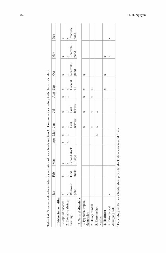
82
Tabl
e 7.
4 Se
ason
al c
alen
dar
in fi
sher
ies
activ
ities
of
hous
ehol
ds in
Gia
o A
n C
omm
une
(acc
ordi
ng to
the
luna
r ca
lend
ar)
Jan
Feb
Mar
Apr
May
Jun
Jul
Aug
Sep
Oct
Nov
Dec
I. F
ishe
ries
act
ivit
ies
1. C
aptu
re fi
sher
ies
xx
xx
xx
xx
xx
xx
2. E
xten
sive
shr
imp
farm
inga
x Ren
ovat
e po
nd
x Firs
t st
ock
x Seco
nd s
tock
(i
f an
y)
xx
x Firs
t ha
rves
t
x Firs
t ha
rves
t
xx H
arve
st
all
x Ren
ovat
e po
nd
x Ren
ovat
e po
nd
x Ren
ovat
e po
ndII
. Nat
ural
dis
aste
rs1.
Typ
hoon
, tro
pica
l de
pres
sion
xx
xx
x
2. H
eavy
rai
nfal
lx
xx
x3.
Ext
rem
e ho
t w
eath
erx
xx
4. H
oarf
rost
xx
x5.
Ext
rem
e an
d da
mag
ing
cold
xx
x
a Dep
endi
ng o
n th
e ho
useh
olds
, shr
imp
can
be s
tock
ed o
nce
or s
ever
al ti
mes
T. H. Nguyen
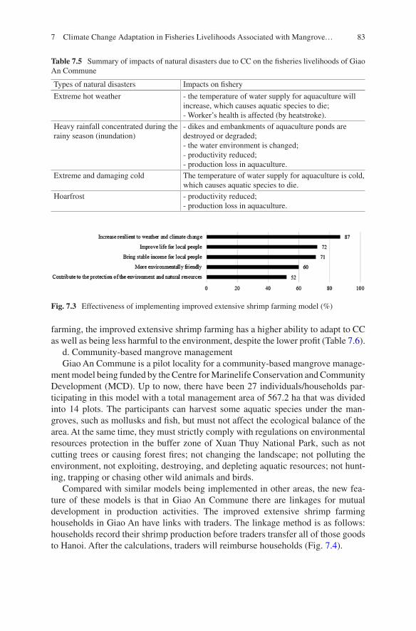
83
farming, the improved extensive shrimp farming has a higher ability to adapt to CC as well as being less harmful to the environment, despite the lower profit (Table 7.6).
d. Community-based mangrove managementGiao An Commune is a pilot locality for a community-based mangrove manage-
ment model being funded by the Centre for Marinelife Conservation and Community Development (MCD). Up to now, there have been 27 individuals/households par-ticipating in this model with a total management area of 567.2 ha that was divided into 14 plots. The participants can harvest some aquatic species under the man-groves, such as mollusks and fish, but must not affect the ecological balance of the area. At the same time, they must strictly comply with regulations on environmental resources protection in the buffer zone of Xuan Thuy National Park, such as not cutting trees or causing forest fires; not changing the landscape; not polluting the environment, not exploiting, destroying, and depleting aquatic resources; not hunt-ing, trapping or chasing other wild animals and birds.
Compared with similar models being implemented in other areas, the new fea-ture of these models is that in Giao An Commune there are linkages for mutual development in production activities. The improved extensive shrimp farming households in Giao An have links with traders. The linkage method is as follows: households record their shrimp production before traders transfer all of those goods to Hanoi. After the calculations, traders will reimburse households (Fig. 7.4).
Table 7.5 Summary of impacts of natural disasters due to CC on the fisheries livelihoods of Giao An Commune
Types of natural disasters Impacts on fishery
Extreme hot weather - the temperature of water supply for aquaculture will increase, which causes aquatic species to die;- Worker’s health is affected (by heatstroke).
Heavy rainfall concentrated during the rainy season (inundation)
- dikes and embankments of aquaculture ponds are destroyed or degraded;- the water environment is changed;- productivity reduced;- production loss in aquaculture.
Extreme and damaging cold The temperature of water supply for aquaculture is cold, which causes aquatic species to die.
Hoarfrost - productivity reduced;- production loss in aquaculture.
Fig. 7.3 Effectiveness of implementing improved extensive shrimp farming model (%)
7 Climate Change Adaptation in Fisheries Livelihoods Associated with Mangrove…
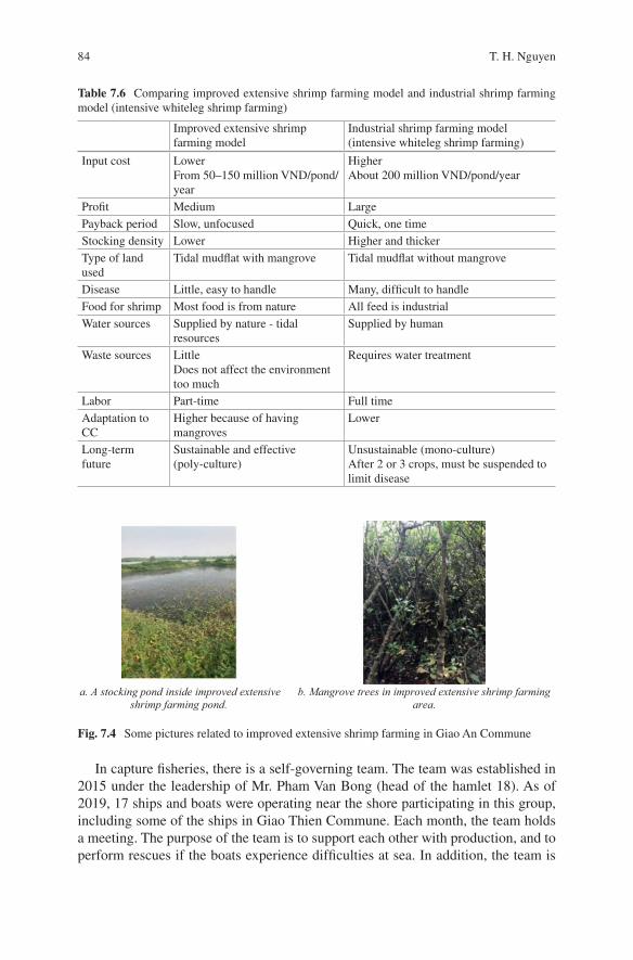
84
In capture fisheries, there is a self-governing team. The team was established in 2015 under the leadership of Mr. Pham Van Bong (head of the hamlet 18). As of 2019, 17 ships and boats were operating near the shore participating in this group, including some of the ships in Giao Thien Commune. Each month, the team holds a meeting. The purpose of the team is to support each other with production, and to perform rescues if the boats experience difficulties at sea. In addition, the team is
Table 7.6 Comparing improved extensive shrimp farming model and industrial shrimp farming model (intensive whiteleg shrimp farming)
Improved extensive shrimp farming model
Industrial shrimp farming model (intensive whiteleg shrimp farming)
Input cost LowerFrom 50–150 million VND/pond/year
HigherAbout 200 million VND/pond/year
Profit Medium LargePayback period Slow, unfocused Quick, one timeStocking density Lower Higher and thickerType of land used
Tidal mudflat with mangrove Tidal mudflat without mangrove
Disease Little, easy to handle Many, difficult to handleFood for shrimp Most food is from nature All feed is industrialWater sources Supplied by nature - tidal
resourcesSupplied by human
Waste sources LittleDoes not affect the environment too much
Requires water treatment
Labor Part-time Full timeAdaptation to CC
Higher because of having mangroves
Lower
Long-term future
Sustainable and effective (poly-culture)
Unsustainable (mono-culture)After 2 or 3 crops, must be suspended to limit disease
a. A stocking pond inside improved extensive
shrimp farming pond. b. Mangrove trees in improved extensive shrimp farming
area.
Fig. 7.4 Some pictures related to improved extensive shrimp farming in Giao An Commune
T. H. Nguyen
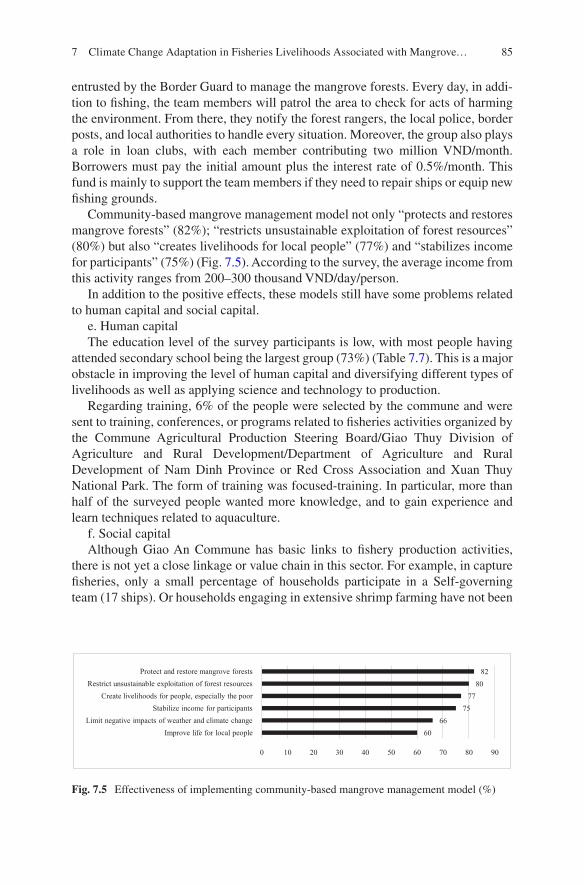
85
entrusted by the Border Guard to manage the mangrove forests. Every day, in addi-tion to fishing, the team members will patrol the area to check for acts of harming the environment. From there, they notify the forest rangers, the local police, border posts, and local authorities to handle every situation. Moreover, the group also plays a role in loan clubs, with each member contributing two million VND/month. Borrowers must pay the initial amount plus the interest rate of 0.5%/month. This fund is mainly to support the team members if they need to repair ships or equip new fishing grounds.
Community-based mangrove management model not only “protects and restores mangrove forests” (82%); “restricts unsustainable exploitation of forest resources” (80%) but also “creates livelihoods for local people” (77%) and “stabilizes income for participants” (75%) (Fig. 7.5). According to the survey, the average income from this activity ranges from 200–300 thousand VND/day/person.
In addition to the positive effects, these models still have some problems related to human capital and social capital.
e. Human capitalThe education level of the survey participants is low, with most people having
attended secondary school being the largest group (73%) (Table 7.7). This is a major obstacle in improving the level of human capital and diversifying different types of livelihoods as well as applying science and technology to production.
Regarding training, 6% of the people were selected by the commune and were sent to training, conferences, or programs related to fisheries activities organized by the Commune Agricultural Production Steering Board/Giao Thuy Division of Agriculture and Rural Development/Department of Agriculture and Rural Development of Nam Dinh Province or Red Cross Association and Xuan Thuy National Park. The form of training was focused-training. In particular, more than half of the surveyed people wanted more knowledge, and to gain experience and learn techniques related to aquaculture.
f. Social capitalAlthough Giao An Commune has basic links to fishery production activities,
there is not yet a close linkage or value chain in this sector. For example, in capture fisheries, only a small percentage of households participate in a Self-governing team (17 ships). Or households engaging in extensive shrimp farming have not been
6066
7577
8082
0 10 20 30 40 50 60 70 80 90
Improve life for local peopleLimit negative impacts of weather and climate change
Stabilize income for participantsCreate livelihoods for people, especially the poor
Restrict unsustainable exploitation of forest resourcesProtect and restore mangrove forests
Fig. 7.5 Effectiveness of implementing community-based mangrove management model (%)
7 Climate Change Adaptation in Fisheries Livelihoods Associated with Mangrove…
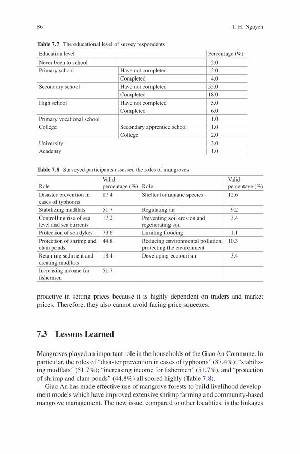
86
proactive in setting prices because it is highly dependent on traders and market prices. Therefore, they also cannot avoid facing price squeezes.
7.3 Lessons Learned
Mangroves played an important role in the households of the Giao An Commune. In particular, the roles of “disaster prevention in cases of typhoons” (87.4%); “stabiliz-ing mudflats” (51.7%); “increasing income for fishermen” (51.7%), and “protection of shrimp and clam ponds” (44.8%) all scored highly (Table 7.8).
Giao An has made effective use of mangrove forests to build livelihood develop-ment models which have improved extensive shrimp farming and community-based mangrove management. The new issue, compared to other localities, is the linkages
Table 7.7 The educational level of survey respondents
Education level Percentage (%)
Never been to school 2.0Primary school Have not completed 2.0
Completed 4.0Secondary school Have not completed 55.0
Completed 18.0High school Have not completed 5.0
Completed 6.0Primary vocational school 1.0College Secondary apprentice school 1.0
College 2.0University 3.0Academy 1.0
Table 7.8 Surveyed participants assessed the roles of mangroves
RoleValid percentage (%) Role
Valid percentage (%)
Disaster prevention in cases of typhoons
87.4 Shelter for aquatic species 12.6
Stabilizing mudflats 51.7 Regulating air 9.2Controlling rise of sea level and sea currents
17.2 Preventing soil erosion and regenerating soil
3.4
Protection of sea dykes 73.6 Limiting flooding 1.1Protection of shrimp and clam ponds
44.8 Reducing environmental pollution, protecting the environment
10.3
Retaining sediment and creating mudflats
18.4 Developing ecotourism 3.4
Increasing income for fishermen
51.7
T. H. Nguyen
87
in production to promote livelihood development. These models not only bring eco-nomic value, but they also contribute to the resilience of the local people to CC as well as ensuring sustainable development in the region.
The models of fisheries livelihoods and how they can be used to adapt to CC associated with mangroves have generated positive results. To continue to develop livelihood activities as well as the models, the local authorities of Giao An Commune need to focus on two livelihood assets; human capital and social capital. For human capital: (1) Organizing training courses, short-term and long-term courses depend-ing on the characteristics of the livelihoods to equip local people with the necessary knowledge and skills in production activities in the context of CC; (2) Organizing community events combined with contests related to CC. For social capital: Studying how to create more effective production groups, teams, and areas. For example, establishing an aquaculture farming group with the task of equipping nec-essary knowledge and skills in aquaculture through exchanging, sharing experi-ences as well as supporting and helping each other in areas of finance, mechanization, or equipment.
References
Department of Natural resources and Environment of Nam Dinh Province (2019) Climate assess-ment report in Nam Dinh Province
People’s Committee of Giao An Commune (2017) Report on results of the implementation of new rural construction criteria for Giao An Commune, Giao Thuy District, Nam Dinh Province
People’s Committee of Giao An Commune (2019) Report on the implementation of socio- economic development and national defense tasks in the first six months and key tasks for the last 6 months of 2019
Open Access This chapter is licensed under the terms of the Creative Commons Attribution 4.0 International License (http://creativecommons.org/licenses/by/4.0/), which permits use, sharing, adaptation, distribution and reproduction in any medium or format, as long as you give appropriate credit to the original author(s) and the source, provide a link to the Creative Commons license and indicate if changes were made.
The images or other third party material in this chapter are included in the chapter’s Creative Commons license, unless indicated otherwise in a credit line to the material. If material is not included in the chapter’s Creative Commons license and your intended use is not permitted by statutory regulation or exceeds the permitted use, you will need to obtain permission directly from the copyright holder.
7 Climate Change Adaptation in Fisheries Livelihoods Associated with Mangrove…
89© The Author(s) 2022T. Ito et al. (eds.), Interlocal Adaptations to Climate Change in East and Southeast Asia, SpringerBriefs in Climate Studies, https://doi.org/10.1007/978-3-030-81207-2_8
Chapter 8Community-Based Disaster Risk Reduction Education in Japan
Aiko Sakurai and Tetsuji Ito
8.1 Introduction
Community-based disaster risk reduction (CBDRR) is considered to be the core of any risk reduction approach. CBDRR is defined as an approach that seeks to: (1) reduce the vulnerabilities and increase the capacities of vulnerable groups and com-munities to cope with, prevent, or minimize loss and damage to life, property, and the environment, (2) minimize human suffering, and (3) hasten recovery (Shaw 2016).
CBDRR has been emphasized from the beginning of the United Nations International Decade of Natural Disaster Reduction (1990–1999). From the 1994 Yokohama Plan of Action to the latest Sendai Framework for Disaster Risk Reduction (SFDRR) 2015–2030, a massive change has occurred in the concepts, approaches, and methods used to reduce the impacts of disasters. In the 1990s, the focus was more on multi-stakeholder and local governance; however, since 2000, more risk-sensitive investment planning has been emphasized, and risk-informed decision-making has become the core of risk reduction (Shaw 2016). In relation to understanding risk, the SFDRR emphasizes that disaster risks have local and spe-cific characteristics that must be understood to devise measures that reduce disaster risk. Since the scale and degree of a natural disaster depend on local conditions, each community needs to enhance its capacities (UNISDR 2015).
A. Sakurai (*) Department of Social Sciences, Toyo Eiwa University, Kanagawa, Japan
International Research Institute of Disaster Science, Tohoku University, Miyagi, Japane-mail: [email protected]
T. Ito College of Humanities and Social Sciences/Global and Local Environment Co-creation Institute, Ibaraki University, Ibaraki, Japan
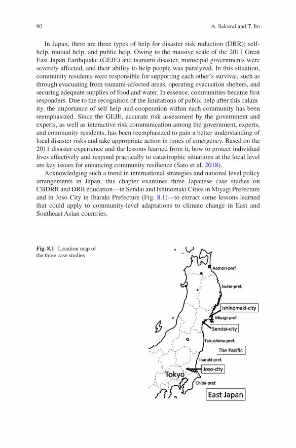
90
In Japan, there are three types of help for disaster risk reduction (DRR): self- help, mutual help, and public help. Owing to the massive scale of the 2011 Great East Japan Earthquake (GEJE) and tsunami disaster, municipal governments were severely affected, and their ability to help people was paralyzed. In this situation, community residents were responsible for supporting each other’s survival, such as through evacuating from tsunami-affected areas, operating evacuation shelters, and securing adequate supplies of food and water. In essence, communities became first responders. Due to the recognition of the limitations of public help after this calam-ity, the importance of self-help and cooperation within each community has been reemphasized. Since the GEJE, accurate risk assessment by the government and experts, as well as interactive risk communication among the government, experts, and community residents, has been reemphasized to gain a better understanding of local disaster risks and take appropriate action in times of emergency. Based on the 2011 disaster experience and the lessons learned from it, how to protect individual lives effectively and respond practically to catastrophic situations at the local level are key issues for enhancing community resilience (Sato et al. 2018).
Acknowledging such a trend in international strategies and national level policy arrangements in Japan, this chapter examines three Japanese case studies on CBDRR and DRR education—in Sendai and Ishinomaki Cities in Miyagi Prefecture and in Joso City in Ibaraki Prefecture (Fig. 8.1)—to extract some lessons learned that could apply to community-level adaptations to climate change in East and Southeast Asian countries.
Fig. 8.1 Location map of the three case studies
A. Sakurai and T. Ito
91
8.2 Development of Community-Based Human Resources for Disaster Risk Reduction (DRR)
8.2.1 Promoting Sustainable Community-Based Disaster Risk Reduction (CBDRR) in Community Development
In Japan, mutual help has been promoted through activities by community-based disaster management organizations (jishu-bousai-soshiki or jishubo), which are volunteer-based community governance units within neighborhood associations (chonaikai). Local government agencies make full use of these organizations to transmit information and instructions to neighborhood residents. Although neigh-borhood associations in Japan have long histories and deep roots in their communi-ties, their capacities have been weakened, and they increasing face the prospect of disappearing due to urbanization, the diversification of lifestyles, and the aging of the population. Therefore, although the jishubo to household ratio remains high, individuals are not necessarily motivated to volunteer, and the role of the chonaikai leader rotates among its members. Moreover, members have passive attitudes and lack a proactive approach toward promoting disaster preparedness in the commu-nity (Kuroda 1998). In this situation, DRR efforts represent an additional burden imposed on these neighborhood associations, on top of their regular daily activities, including neighborhood cleaning, garbage collection, and recycling, as well as organizing community activities such as athletic and cultural events (Sakurai and Sato 2017).
The case of Katahira district, Sendai City, Miyagi Prefecture is an example of an innovative approach to develop sustainable CBDRR. Katahira district has a long history of development with the castle town of Sendai Han (a feudal domain). The southwest side of the district is bordered by the meandering Hirose River, while the east side connects to the central business district of Sendai City, including Japan Rail Sendai Station. The major local disaster risks include earthquakes and flood-ing. The main body to promote DRR is the Katahira Community Development Association (KCDA), which was formed in 2013 as an organization to implement community development plans representing four major goals: establishing safety and security, energizing the community, conserving and making active use of his-tory and the environment, and developing a sustainable community development system. Within the KCDA, the Katahira Union Neighborhood Association, a union of nine chonaikai in the district, plays a central role in aligning various related organizations.
The KCDA responded to the GEJE disaster by establishing and managing evacu-ation facilities in their district. Katahira-cho Elementary School was designated as an evacuation center by the city and opened as a shelter to accommodate about 1500 evacuees. The original capacity of the shelter, which was mainly for local residents, was 350 evacuees; however, 85% of all the evacuees, including tourists, business travelers, employees at neighboring businesses, and foreign students, were stranded. Having such experiences, since 2011, the KCDA has been working increasingly
8 Community-Based Disaster Risk Reduction Education in Japan
92
harder on strengthening their DRR capacities by developing disaster response, disaster survival, and shelter management manuals, conducting emergency drills, and transmitting DRR information to local residents, including foreigners, in coop-eration with related local stakeholders (Sato et al. 2018). These DRR activities were led by community disaster management leaders, called Sendaishi-chiiki bosai lead-ers (SBLs), who are trained and certified by the Sendai City government to serve their community’s DRR activities. In addition to adult activities, school-aged chil-dren from elementary to high school formed a Katahira district community develop-ment team for children in 2015 under the KCDA to conduct community development activities.
As a model project under the fiscal year 2016 Cabinet Office Community Disaster Management Plan, the KCDA developed a CBDRR education activity that involved the entire community, called the “Disaster Risk Reduction X Treasure Hunting Game (DRRTHG)”, to foster human resources from the next generation. As a result, treasure hunting conducted by event planning firms and local municipalities to revi-talize the community and attract tourists became a popular activity in Japan. In a basic procedure of the treasure hunting game, the participants follow a “treasure map” to explore the town and search on foot for a treasure chest hidden at a location in the town. The DRRTHG was developed by the KCDA as an application of a trea-sure hunting game for DRR. In the DRRTHG, the SBLs and KCDA members guide elementary and junior high school children across the district to explain the abun-dant nature, culture, and resources for DRR by walking around in the manner of a treasure hunting game. The “Crescent Corps” certificate, on which five rules to become a good community member are printed, is awarded to the children who participate in this activity and pass the evaluation test; these children are expected to become the local human resources for next-generation DRR. The “Crescent Corps” is named after the crescent that was decorated on the front side of Masamune Date, a founder of Sendai Han. These rules are fundamental to the concepts of self- help and mutual help, and to the spirit of incorporating DRR into community devel-opment planning.
The KCDA continued to implement the DRRTHG from 2016 to 2019 by chang-ing the search area in the district. In the 2019 implementation, elementary school children who participated in the first DRRTHG became senior high school students and served as guides to the participants from local elementary and junior high schools. Fig. 8.2 shows the Katahira DRR survival map (left) and a photo of partici-pants in the 2016 DRRTHG event (Sato et al. 2020).
A. Sakurai and T. Ito
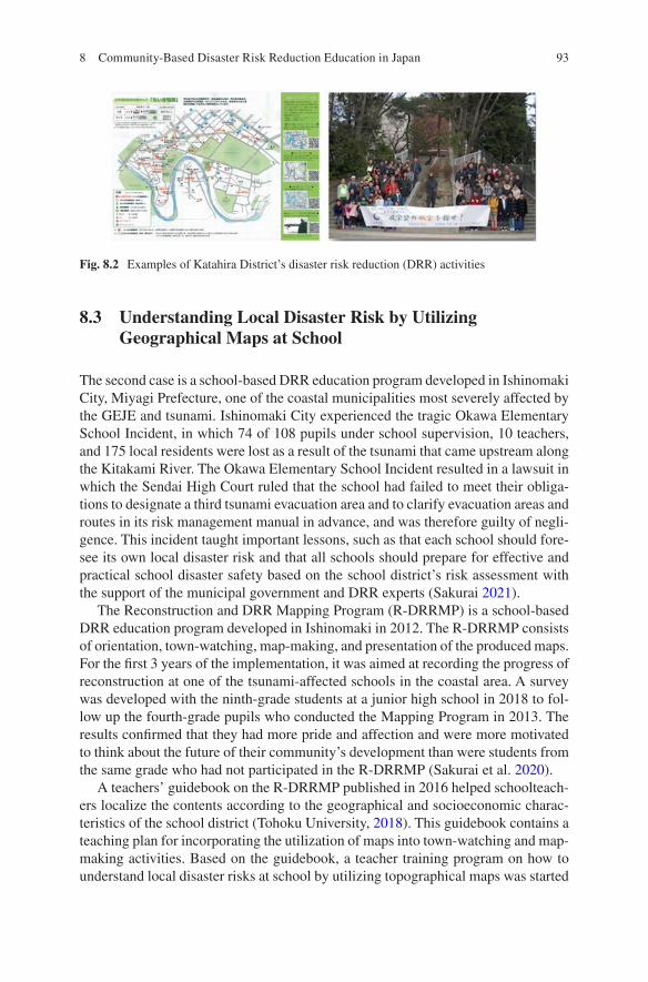
93
8.3 Understanding Local Disaster Risk by Utilizing Geographical Maps at School
The second case is a school-based DRR education program developed in Ishinomaki City, Miyagi Prefecture, one of the coastal municipalities most severely affected by the GEJE and tsunami. Ishinomaki City experienced the tragic Okawa Elementary School Incident, in which 74 of 108 pupils under school supervision, 10 teachers, and 175 local residents were lost as a result of the tsunami that came upstream along the Kitakami River. The Okawa Elementary School Incident resulted in a lawsuit in which the Sendai High Court ruled that the school had failed to meet their obliga-tions to designate a third tsunami evacuation area and to clarify evacuation areas and routes in its risk management manual in advance, and was therefore guilty of negli-gence. This incident taught important lessons, such as that each school should fore-see its own local disaster risk and that all schools should prepare for effective and practical school disaster safety based on the school district’s risk assessment with the support of the municipal government and DRR experts (Sakurai 2021).
The Reconstruction and DRR Mapping Program (R-DRRMP) is a school-based DRR education program developed in Ishinomaki in 2012. The R-DRRMP consists of orientation, town-watching, map-making, and presentation of the produced maps. For the first 3 years of the implementation, it was aimed at recording the progress of reconstruction at one of the tsunami-affected schools in the coastal area. A survey was developed with the ninth-grade students at a junior high school in 2018 to fol-low up the fourth-grade pupils who conducted the Mapping Program in 2013. The results confirmed that they had more pride and affection and were more motivated to think about the future of their community’s development than were students from the same grade who had not participated in the R-DRRMP (Sakurai et al. 2020).
A teachers’ guidebook on the R-DRRMP published in 2016 helped schoolteach-ers localize the contents according to the geographical and socioeconomic charac-teristics of the school district (Tohoku University, 2018). This guidebook contains a teaching plan for incorporating the utilization of maps into town-watching and map- making activities. Based on the guidebook, a teacher training program on how to understand local disaster risks at school by utilizing topographical maps was started
Fig. 8.2 Examples of Katahira District’s disaster risk reduction (DRR) activities
8 Community-Based Disaster Risk Reduction Education in Japan

94
in 2019 (Sakurai et al. 2019). This training program aims at enhancing map-reading skills and fostering teachers’ capacity to understand local disaster risks, even beyond those expected, through the reading of topographical and hazard maps. Teachers who participate in the training are expected to utilize these skills in their school’s DRR education and improve their school disaster response manual.
Figure 8.3 shows a series of maps prepared for a school district located inland of Ishinomaki City nearby the Kitakami River. The far right panel shows a DRR map made by seventh-grade students in 2019. Students compared these maps in the classroom and conducted town-watching by interviewing local residents to deter-mine the actual damage caused by Typhoon Hagibis in their school district in 2019. The red-colored area indicates the flooded area. The R-DRRMP in Ishinomaki City thus became one of the main approaches for teachers and students to gain a better understanding of their local disaster risks.
8.4 Local Social Networking Service (SNS) Broadcasting System for Facilitating Communication Among Local Residents and a Customized Evacuation Action Plan (“My-TimeLine”)
In September 2015, heavy rains in the Kanto and Tohoku regions caused massive flooding in Joso City, Ibaraki Prefecture. Vast fields occupy the area between the Kinugawa and Kokaigawa Rivers, and Mt. Tsukuba (877 m above sea level) can be seen in the distance. Ground level is lower than the river level in some places. Historically, flooding has occurred in this area many times. When the Kinugawa embankment broke during the rainfall of 2015, one-third of Joso City was inun-dated—even the first floor of the relatively new city hall was flooded. In addition, more than 5000 houses were completely or partially destroyed and more than 4200 people needed to be rescued.
Fig. 8.3 Sample maps at a school district in Ishinomaki City(Source: [Left] edited by authors based on a topographic classification map created by the Geospatial Information Authority of Japan; [Center left] edited by authors based on the Kitakami River inundation forecast map created by the Ministry of Land, Infrastructure, Transport and Tourism; [Center right] edited by authors based on a landslide hazard map created by the Ishinomaki City government; [Right] photo of a disaster risk reduction (DRR) map created by a junior high school in Ishinomaki City)
A. Sakurai and T. Ito
95
Many residents of Neshinden district in Joso City were able to take refuge before the flooding and earlier than the residents in other areas. One of the reasons for the earlier evacuations in this district was the utilization of a local social networking service (SNS) broadcasting system, “Neshinden Hot Mail”, which has been in oper-ation in the district since 2014. Before 2014, the leader of the chonaikai had to call each household individually (Wagamachi Neshinden (My hometown Neshinden) (n.d.)). The introduction of the “Neshinden Hot Mail” system allowed the local chonaikai leader to deliver short textual information to all local residents at the same time. The new system makes it possible to display textual information on mobile and smartphones through a single operation on a personal computer.
As the rainfall was becoming increasingly heavy, the local leader sent a series of short text messages informing residents of the Neshinden district about the flood stage of the Kinugawa River and issuing evacuation warnings. These SNS messages urged local residents to take early evacuation actions. The success of this system highlighted two main points:
1. Receiving information is possible with only a mobile phone
Even though the SNS broadcasting is only one-way communication, local residents, includ-ing older people, could receive information easily and instantly on their phones. As most of the older people in the area have simple mobile phones as opposed to high-performance smartphones, all they needed to do to be able to receive messages was register their phone number.
2. SNS is routinely used as a means of communication in the community
SNS has been used as a daily communication channel to share information about district events and condolences, so residents have become accustomed to using it. Therefore, it was a reliable communication tool during the emergency.
Although this idea is very simple, the “Nishiden Hot Mail” example shows the potential of SNS to become a powerful communication tool to facilitate CBDRR. As discussed earlier in the chapter, in Japan, the local community has been declining, and thus, the capacities of the chonaikai have been weakened. In addition, people are increasingly likely to not know their neighbors’ names or faces. The SNS broad-casting system does not allow two-way communication, but in the areas where there are still trusted local leaders, even one-way communication could help facilitate communication among the chonaikai networks. The SNS broadcasting system could have worked to disseminate risk and evacuation information during the emer-gency in Neshinden district to encourage “mutual help” in regard to CBDRR.
However, to introduce such a system, the following steps are required: (1) have a trusted local leader; (2) obtain the understanding of the residents to introduce it; and (3) be prepared for some required costs (e.g., contracts with a company that has a system for sending Hotmail).
In addition, in Joso City, another advanced example of CBDRR, called “My-TimeLine” (Fig. 8.4), was developed by the River Office of the Japanese Ministry of Land, Infrastructure, Transport and Tourism based on lessons learned from the 2015 disaster. “My-TimeLine” formulates evacuation action plans from
8 Community-Based Disaster Risk Reduction Education in Japan
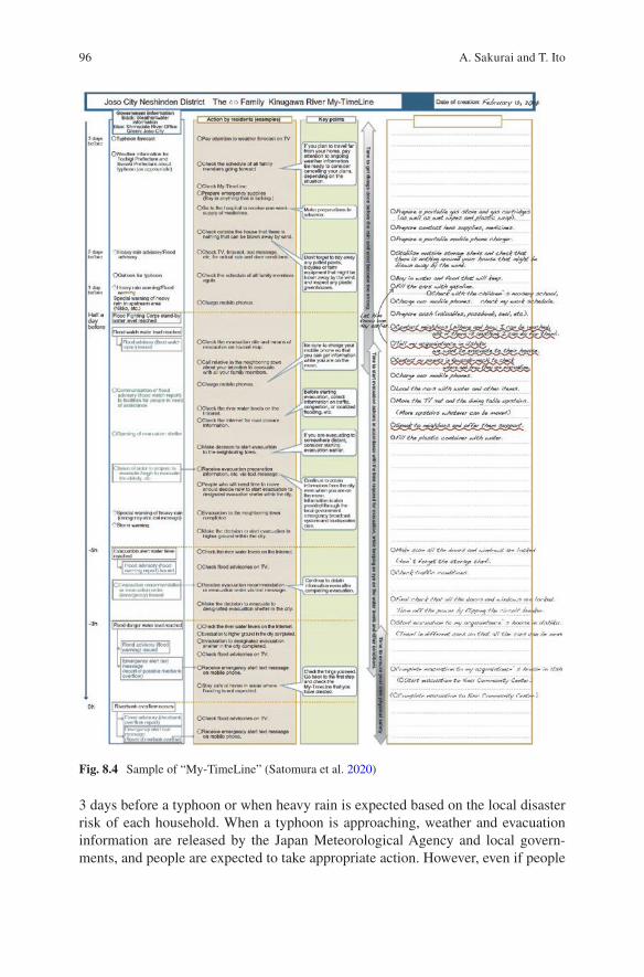
96
3 days before a typhoon or when heavy rain is expected based on the local disaster risk of each household. When a typhoon is approaching, weather and evacuation information are released by the Japan Meteorological Agency and local govern-ments, and people are expected to take appropriate action. However, even if people
Fig. 8.4 Sample of “My-TimeLine” (Satomura et al. 2020)
A. Sakurai and T. Ito
97
receive evacuation information, they may be unsure about the timing of evacuations, how to avoid risks during evacuation, and who to evacuate with. For example, if a person with a disability is in the family, earlies evacuation actions will be required, and if a family member has a chronic disease, it will be necessary to secure medi-cine. The “My” in “My-TimeLine” implies that the information should be “custom-ized for individual circumstances”.
The “My-TimeLine” tool was developed following the flood in Joso City. A ver-sion for children was also created, and this is used in disaster reduction classrooms in the area and disaster reduction education in schools. Piloted in Joso City, “My-TimeLine” now enjoys widespread use in Japan, where the risk of flood dam-age caused by powerful typhoons is increasing because of climate change. For more details on “My-TimeLine”, please refer to Satomura et al. (2020).
The combination of the SNS broadcasting system and “My-TimeLine” in Joso City could greatly contribute to enhancing CBDRR in Japan.
8.5 Lessons Learned
As discussed in the beginning of this chapter, CBDRR is thought to be the core of any risk reduction approach, and local disaster risks must be clearly understood to determine community countermeasures. In Japan, the expectation of enhancing.
CBDRR has been emphasized because local communities have been weakened. The three cases in this chapter highlight some lessons learned that could enhance the adaptative capabilities of communities in East and Southeastern Asian countries.
First, the Katahira case described a model for developing sustainable CBDRR. This case positioned DRR activities as part of a community development plan that motivated children to participate in community activities by institutional-izing a children’s group in the community development structure, organizing ‘fun’ events for children, such as the DRRTHG, and demonstrating the devotion of local adults to their community. Fostering the next generation to work for community development is key to sustainable CBDRR.
Second, the case of Ishinomaki’s school-based DRR education program described one of the approaches being taken to understand local disaster risks. This program is composed of several steps, including strengthening map-reading skills, under-standing the actual geography of the school district, comparing topographical and hazard maps of the school district, confirming local disaster risks by town-watching, and producing DRR maps to present the findings. These are useful steps for both children and adults to realize collaboration between schools and communities in examining local disaster risks and producing original DRR maps.
Third, the case in Joso City demonstrated the importance of facilitating daily communication within the community to ensure smooth communication in the event of a disaster. Although wide variation is seen in local communities among regions and countries, most have deteriorated along with modernization, as more people consider community ties to be annoying. However, in a world in which
8 Community-Based Disaster Risk Reduction Education in Japan
98
climate change is accelerating and catastrophic disasters are expected to occur increasingly frequently, the local community is more important than ever. Of course, in that case, the local community is not simply a thing of the past; it is a hybrid type of community that includes, for example, encouraging intergenerational communi-cation through various community development activities, facilitating mutual learn-ing about the local community between local residents and schoolchildren, and building new communication networks via the use of SNS. Communities in differ-ent regions and countries should therefore pursue their ideal form according to actual local conditions.
References
International Collaborating Center of Disaster Education Research and Implementation, Tohoku University (2018) The Practical Guide to a “Reconstruction-Disaster Risk Reduction Mapping- Understanding the natural environment and the lives of those in your hometown. http://drredu- collabo.sakura.ne.jp/cms/wp- content/uploads/jissen_no_tebiki_en.pdf
Sakurai A (2021) School safety management: international framework and Japanese practice. In: Jing Y et al (eds) Risk Management in East Asia. Springer Nature. (in print)
Sakurai A, Sato T (2017) Enhancing community resilience through capacity development after GEJE: the case of Sendaishi-chiiki Bousai leaders (SBLs) in Miyagi prefecture. In: Santiago- Fandiño V, Sato S, Maki N, Iuchi K (eds) The 2011 Japan earthquake and tsunami: reconstruc-tion and restoration: insights and assessment after 5 years. Springer, pp 113–126
Sakurai A et al (2019) Linking geomorphological features and disaster risk in a school district: the development of an in-service teacher training programme. IOP Conference Series: Earth and Environmental Science, Vol 630, The 12th Aceh International Workshop and Expo on Sustainable Tsunami Disaster Recovery 7–8 November 2019, Sendai, Japan
Sakurai A et al (2020) Impact evaluation of a school-based disaster education program in a city affected by the 2011 great East Japan earthquake and tsunami disaster. Int J Disaster Risk Reduct 47. https://doi.org/10.1016/j.ijdrr.2020.101632Get
Sato T, Sakurai A, et al (2018) Sustainable community development for disaster resilience and human resource development for disaster risk reduction- KAHATIRA-style disaster resilient community development. J Disaster Res 13(7):1288–1297
Sato T, Sakurai A, et al (2020) Sustainable community development for disaster resilience and human resource development for disaster risk reduction: growth and community contribution of the Katahira Children’s Board for Community Development. J Disaster Res 15(7):931–942
Satomura S, Sutou J, Itou K, Hiraide R, Kandatsu T, Mizokami H, Kobayashi H, Kawashima H, Shirakawa N, Ito T, Tomioka H, Ayukawa K (2020) Social experiment for my-timeline devel-opment to improve residents’ awareness of flood disaster prevention. J JSCE 8(1):261–273
Shaw R (2016) Community-based disaster risk reduction. Oxford Research Encyclopedia of Natural Hazard Science. https://doi.org/10.1093/acrefore/9780199389407.013.47
United Nations Office for Disaster Risk Reduction (2015) Sendai framework for disaster risk reduction 2015–2030. UNISDR, Geneva
Wagamachi Neshinden (My hometown Neshinden). http://neshinden.com/hotmail (in Japanese)
A. Sakurai and T. Ito

99
Open Access This chapter is licensed under the terms of the Creative Commons Attribution 4.0 International License (http://creativecommons.org/licenses/by/4.0/), which permits use, sharing, adaptation, distribution and reproduction in any medium or format, as long as you give appropriate credit to the original author(s) and the source, provide a link to the Creative Commons license and indicate if changes were made.
The images or other third party material in this chapter are included in the chapter’s Creative Commons license, unless indicated otherwise in a credit line to the material. If material is not included in the chapter’s Creative Commons license and your intended use is not permitted by statutory regulation or exceeds the permitted use, you will need to obtain permission directly from the copyright holder.
8 Community-Based Disaster Risk Reduction Education in Japan
101© The Author(s) 2022T. Ito et al. (eds.), Interlocal Adaptations to Climate Change in East and Southeast Asia, SpringerBriefs in Climate Studies, https://doi.org/10.1007/978-3-030-81207-2_9
Chapter 9The Practice of Education for Disaster Risk Reduction in Vietnam: Lessons Learned from a Decade of Implementation 2010–2020
Thi Thi My Tong, Duong Thi Hong Nguyen, Hung The Nguyen, and Tae Yoon Park
9.1 Introduction
The increasing damage caused by natural disasters, particularly climatic disasters such as typhoons, floods, droughts, and heatwaves, threatens the development of all economic sectors in Vietnam. In particular, the impact of natural disasters on the education sector affects thousands of students and teachers, because it interrupts their education and significantly reduces educational quality. At the same time, edu-cation is increasingly being viewed as more essential for mitigating risk and for strengthening people’s capacity to respond to disasters. Disaster risk reduction edu-cation (DRRE) initiatives have become more widely adopted among international and national organizations. The importance of disaster risk reduction (DRR) is cur-rently a major concern of the United Nations, and has resulted in the establishment of numerous initiatives such as the International Decade for Natural Disaster Reduction, the International Framework for Action for the International Decade for Natural Disaster Reduction, the Yokohama Strategy, the Plan of Action for a Safer World adopted by the 1st World Conference on Natural Disaster Reduction (UNISDR 2004), the International Strategy for Disaster Reduction, and the adop-tion of the Hyogo Framework for Action at the 2nd World Conference on Disaster Reduction in 2005 (UNISDR 2005). The role of education was highlighted as an
T. T. M. Tong (*) · D. T. H. Nguyen Vietnam Institute of Economics, Vietnam Academy of Social Science, Hanoi, Vietnam
H. T. Nguyen Department of Climate Change and Sustainable Development, Hanoi University of Natural Resource and Environment, Hanoi, Vietnam
T. Y. Park Graduate School of Education, Yonsei University, Seoul, South Korea
102
important strategy for achieving the four priorities set out in the Sendai Framework for Disaster risk reduction 2015–2030 (UNFCCC 2015).
Vietnam was ranked sixth among countries most affected by extreme climatic events in 1999–2018 by the Global Climate Risk Index (David Eckstein 2019). The country frequently experiences severe and unpredictable climatic events, and it is estimated that these will likely become worse under the RCP4.5 scenario as the average temperature, rainfall and sea-level rise increase by 0.1 °C, 5–15%, and 20%, respectively (MONRE 2016).
With the proportion of children making up almost a quarter of Vietnam’s popula-tion, an increase in the intensity of natural disasters and climate change will have a considerable impact on their development. Children are always the group most affected by natural disasters due to their physical and psychosocial vulnerability, as well as their lack of access to essential services such as health and education. In this context, DRRE is considered to be an essential strategy for sustainable development in the long-term. DRRE initiatives will better prepare children, families, and com-munities for shocks and significant recovery. Consequently, investing in risk reduc-tion measures in schools is considered to be fundamental to social growth, development, and cohesion in Vietnam and for achieving the Sustainable Development Goals.
Since the beginning of the 2010s, numerous education projects on climate change response and DRR have been conducted throughout Vietnam. Most of these projects promote two main initiatives; making schools safer, and mainstreaming climate change and DRR into the school curriculum. In 2011, the Ministry of Education and Training (MOET) published the Action Plan on implementing National Strategy for Natural Disaster Prevention, Response, and Mitigation to 2020 (MOET 2011). This plan has facilitated the development of content on climate change and DRR for use in the national curriculum of public schools. In 2014, the Ministry of Education approved the project “Information and propaganda on climate change response and natural disaster prevention and control in schools in the period 2013-2020”. In 2016, specific guidance for carrying out DRRE in schools was developed and applied nationwide (MOET 2016).
Within this context, this study attempts to review the DRRE initiatives over one decade of implementation (2010–2020). The findings will clarify the lessons learned from DRRE by various stakeholders, including government and non-governmental organizations.
9.2 DRRE Initiatives in Vietnam
DRRE arose out of a long history of coping with natural disasters in Vietnam. The local communities have prepared for, responded to, and recovered from natural disasters using their wisdom and knowledge, which they passed from one genera-tion to the next. In some ways, these indigenous practices can be seen as one of the
T. T. M. Tong et al.
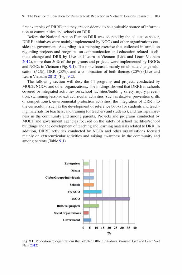
103
first examples of DRRE and they are considered to be a valuable source of informa-tion to communities and schools on DRR.
Before the National Action Plan on DRR was adopted by the education sector, DRRE initiatives were mainly implemented by NGOs and other organizations out-side the government. According to a mapping exercise that collected information regarding projects and programs on communication and education related to cli-mate change and DRR by Live and Learn in Vietnam (Live and Learn Vietnam 2012), more than 50% of the programs and projects were implemented by INGOs and NGOs in Vietnam (Fig. 9.1). The topic focused mainly on climate change edu-cation (52%), DRR (28%), and a combination of both themes (20%) (Live and Learn Vietnam 2012) (Fig. 9.2).
The following section will describe 14 programs and projects conducted by MOET, NGOs, and other organizations. The findings showed that DRRE in schools covered or integrated activities on school facilities/building safety, injury preven-tion, swimming lessons, extracurricular activities (such as disaster prevention drills or competitions), environmental protection activities, the integration of DRR into the curriculum (such as the development of reference books for students and teach-ing materials for teachers, and training for teachers and students), and raising aware-ness in the community and among parents. Projects and programs conducted by MOET and government agencies focused on the safety of school facilities/school buildings and the development of teaching and learning materials related to DRR. In addition, DRRE activities conducted by NGOs and other organizations focused mainly on extracurricular activities and raising awareness in the community and among parents (Table 9.1).
Fig. 9.1 Proportion of organizations that adopted DRRE initiatives. (Source: Live and Learn Viet Nam 2012)
9 The Practice of Education for Disaster Risk Reduction in Vietnam: Lessons Learned…
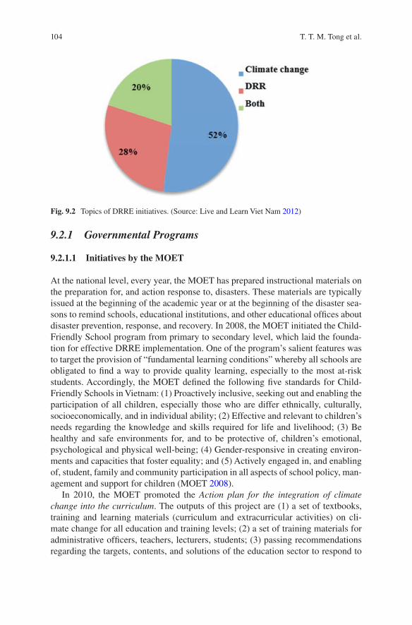
104
9.2.1 Governmental Programs
9.2.1.1 Initiatives by the MOET
At the national level, every year, the MOET has prepared instructional materials on the preparation for, and action response to, disasters. These materials are typically issued at the beginning of the academic year or at the beginning of the disaster sea-sons to remind schools, educational institutions, and other educational offices about disaster prevention, response, and recovery. In 2008, the MOET initiated the Child- Friendly School program from primary to secondary level, which laid the founda-tion for effective DRRE implementation. One of the program’s salient features was to target the provision of “fundamental learning conditions” whereby all schools are obligated to find a way to provide quality learning, especially to the most at-risk students. Accordingly, the MOET defined the following five standards for Child- Friendly Schools in Vietnam: (1) Proactively inclusive, seeking out and enabling the participation of all children, especially those who are differ ethnically, culturally, socioeconomically, and in individual ability; (2) Effective and relevant to children’s needs regarding the knowledge and skills required for life and livelihood; (3) Be healthy and safe environments for, and to be protective of, children’s emotional, psychological and physical well-being; (4) Gender-responsive in creating environ-ments and capacities that foster equality; and (5) Actively engaged in, and enabling of, student, family and community participation in all aspects of school policy, man-agement and support for children (MOET 2008).
In 2010, the MOET promoted the Action plan for the integration of climate change into the curriculum. The outputs of this project are (1) a set of textbooks, training and learning materials (curriculum and extracurricular activities) on cli-mate change for all education and training levels; (2) a set of training materials for administrative officers, teachers, lecturers, students; (3) passing recommendations regarding the targets, contents, and solutions of the education sector to respond to
Fig. 9.2 Topics of DRRE initiatives. (Source: Live and Learn Viet Nam 2012)
T. T. M. Tong et al.

105
Table 9.1 Review of 14 DRRE projects and programs in schools carried out by various stakeholders during 2010–2020 in Vietnam
Name of projects/programs Year Organizations
DRR-related contents(1) (2) (3) (4) (5)
Child-friendly school 2008–2009 (pilot)2013 (scale up)
MOET Y N N N Y
Strengthening the infrastructure capacity of schools
2008 MOET Y N N N N
Integration of climate change into the curriculum
2010 MOET N Y N N N
Raising community awareness and community-based disaster risk management
2009 MARD N N Y Y Y
Communication programs using multi-media to raise awareness about climate change and DRR
2011 MOIT N N N N Y
Introducing disaster preparedness in primary schools
2001 Vietnamese Red Cross (VNRC)
Y Y Y Y Y
Adaptation to Climate change through the Promotion of Biodiversity
2005 GIZ Vietnam N N Y N Y
Integration of DRR into schools 2008 Development Workshop France (DWF)
N Y Y N N
Integrated disaster preparedness in Thua Thien Hue Province
2010 VNRC N N Y Y Y
Partnership for community action on climate change
2011 The Centre for Development of Community Initiative and Environment (C&E)
N N Y N Y
Capacity building for DRR education for schools in Central Vietnam
2011–2013
SEEDs Asia N Y Y N N
Introducing climate change and DRR education into the secondary school system in Hanoi, Quang Ninh, Hai Phong, Danang, and Ho Chi Minh City
2012 Live and Learn Vietnam N Y Y N N
Building resilience to climate change in urban areas through integrated education
2012–2014
Institute for Environmental and Social Transition (ISET)
N Y Y N N
(continued)
9 The Practice of Education for Disaster Risk Reduction in Vietnam: Lessons Learned…
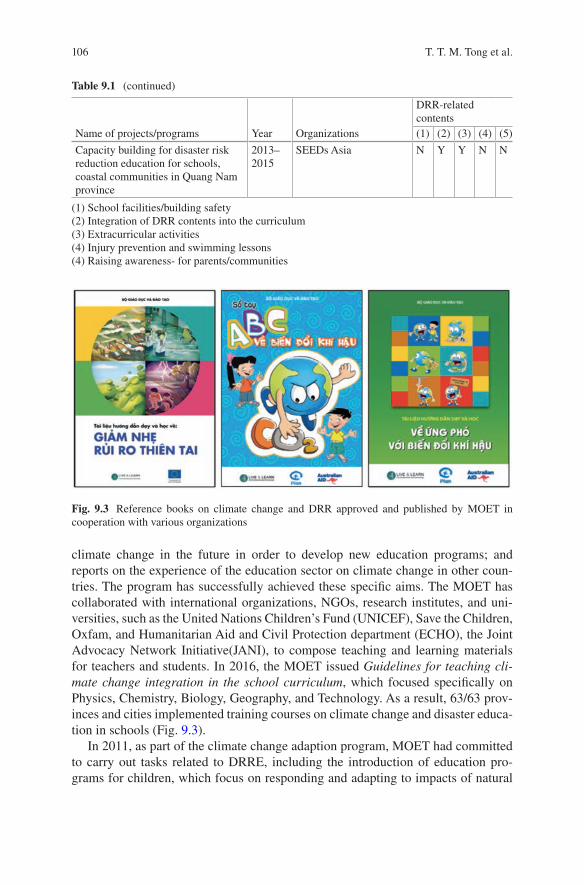
106
climate change in the future in order to develop new education programs; and reports on the experience of the education sector on climate change in other coun-tries. The program has successfully achieved these specific aims. The MOET has collaborated with international organizations, NGOs, research institutes, and uni-versities, such as the United Nations Children’s Fund (UNICEF), Save the Children, Oxfam, and Humanitarian Aid and Civil Protection department (ECHO), the Joint Advocacy Network Initiative(JANI), to compose teaching and learning materials for teachers and students. In 2016, the MOET issued Guidelines for teaching cli-mate change integration in the school curriculum, which focused specifically on Physics, Chemistry, Biology, Geography, and Technology. As a result, 63/63 prov-inces and cities implemented training courses on climate change and disaster educa-tion in schools (Fig. 9.3).
In 2011, as part of the climate change adaption program, MOET had committed to carry out tasks related to DRRE, including the introduction of education pro-grams for children, which focus on responding and adapting to impacts of natural
Table 9.1 (continued)
Name of projects/programs Year Organizations
DRR-related contents(1) (2) (3) (4) (5)
Capacity building for disaster risk reduction education for schools, coastal communities in Quang Nam province
2013–2015
SEEDs Asia N Y Y N N
(1) School facilities/building safety(2) Integration of DRR contents into the curriculum(3) Extracurricular activities(4) Injury prevention and swimming lessons(4) Raising awareness- for parents/communities
Fig. 9.3 Reference books on climate change and DRR approved and published by MOET in cooperation with various organizations
T. T. M. Tong et al.
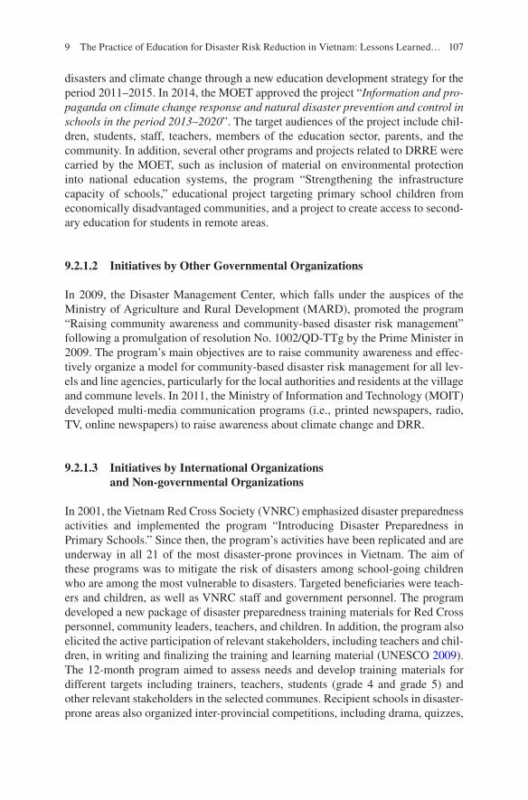
107
disasters and climate change through a new education development strategy for the period 2011–2015. In 2014, the MOET approved the project “Information and pro-paganda on climate change response and natural disaster prevention and control in schools in the period 2013–2020”. The target audiences of the project include chil-dren, students, staff, teachers, members of the education sector, parents, and the community. In addition, several other programs and projects related to DRRE were carried by the MOET, such as inclusion of material on environmental protection into national education systems, the program “Strengthening the infrastructure capacity of schools,” educational project targeting primary school children from economically disadvantaged communities, and a project to create access to second-ary education for students in remote areas.
9.2.1.2 Initiatives by Other Governmental Organizations
In 2009, the Disaster Management Center, which falls under the auspices of the Ministry of Agriculture and Rural Development (MARD), promoted the program “Raising community awareness and community-based disaster risk management” following a promulgation of resolution No. 1002/QD-TTg by the Prime Minister in 2009. The program’s main objectives are to raise community awareness and effec-tively organize a model for community-based disaster risk management for all lev-els and line agencies, particularly for the local authorities and residents at the village and commune levels. In 2011, the Ministry of Information and Technology (MOIT) developed multi-media communication programs (i.e., printed newspapers, radio, TV, online newspapers) to raise awareness about climate change and DRR.
9.2.1.3 Initiatives by International Organizations and Non-governmental Organizations
In 2001, the Vietnam Red Cross Society (VNRC) emphasized disaster preparedness activities and implemented the program “Introducing Disaster Preparedness in Primary Schools.” Since then, the program’s activities have been replicated and are underway in all 21 of the most disaster-prone provinces in Vietnam. The aim of these programs was to mitigate the risk of disasters among school-going children who are among the most vulnerable to disasters. Targeted beneficiaries were teach-ers and children, as well as VNRC staff and government personnel. The program developed a new package of disaster preparedness training materials for Red Cross personnel, community leaders, teachers, and children. In addition, the program also elicited the active participation of relevant stakeholders, including teachers and chil-dren, in writing and finalizing the training and learning material (UNESCO 2009). The 12-month program aimed to assess needs and develop training materials for different targets including trainers, teachers, students (grade 4 and grade 5) and other relevant stakeholders in the selected communes. Recipient schools in disaster- prone areas also organized inter-provincial competitions, including drama, quizzes,
9 The Practice of Education for Disaster Risk Reduction in Vietnam: Lessons Learned…
108
and painting competitions based on a guidance from disaster preparedness booklet. However, the program faced significant challenges in integrating a disaster pre-paredness component into the official training curricula due to the risk of overbur-dening school children. This challenge has not yet been overcome, although the VNRC insisted on providing disaster preparedness training until 2010 to teachers and children in eight coastal provinces in northern Vietnam with financial support from the Japanese Red Cross. As a result, the program and its subsequent replication have helped train 15,000 teachers and over 500,000 school children over the last 6 years (UNISDR 2007).
In 2005, the Deutsche Gesellschaft für Internationale Zusammenarbeit (GIZ) GmbH Vietnam carried out a project titled, “Adaptation to climate change through the promotion of biodiversity,” which was financed by the German Federal Ministry for Environment, Nature Conservation, Nuclear Safety. It targeted communities, school teachers, and students, and tried to raise awareness of environmental and natural resource protection and biodiversity conservation. The primary approach were infused through the curriculum, specifically in Biology, Geography, Civic Education subjects and extracurricular activities, such as the Green and Clean Day, environmental drawing competitions, bird sanctuary visits, etc. As a result, the proj-ects benefited teachers and students from grade 1–12 at 154 primary schools, 74 secondary schools, and 19 high schools in Bac Lieu Province.
In addition, an excellent example of integrating DRR into schools was imple-mented by Development Workshop France (DWF) in Hue Province in 2008. DWF worked as an important partner of many communes in Hue Province to strengthen existing public infrastructure and build safe, new schools, markets, and health facili-ties. At the village level, DWF accompanied with communes to build safe kinder-gartens and to strengthen primary schools so that children could learn about safety and safe construction techniques in a safe environment and take these principles back to their families. DWF also trained teachers about disaster prevention and ran workshops with children about disaster prevention and the child’s role and needs before, during, and after disasters. Children were active in school and the commu-nity in promoting the vulnerability reduction message (DWF 2009).
Other projects implemented in Hue Province included, “Integrated Disaster Preparedness in Thua Thien Hue Province” which was undertaken by the German Red Cross (GRC) in cooperation with the Vietnamese Red Cross (VNRC) in 2010, “Partnership for community action on climate change” by the Centre for Development of Community Initiative and Environment (C&E) and Global Action Plan International (GAP) in 2011. The project used schools as hubs for sustainabil-ity actions by households and communities, engaging teachers in civil society, link-ing schools and students with existing Vietnam government programs and priorities as well as existing Swedish government programs and priorities, which also helped to build partnerships between organizations. The activities included raising aware-ness among junior secondary schools’ students to perform actions related to climate change, carrying out community outreach (family, school, neighbors) through undertaking Eco-team sustainable projects and activities, and establishing a “Green living model” at schools. The outcomes of the project included materials for
T. T. M. Tong et al.
109
community climate action through schools which were adopted for Vietnamese rural and urban contexts; teachers and youth leaders/facilitators received training to engage students in climate action; schools facilitated community climate activities; eco-team models were shared and advocated in project sites; and links to interna-tional development and learning about climate actions and education for sustainable development (ESD) were strengthened. Further, a household-level climate mitiga-tion model has been developed, including teaching materials, materials for students, and a process to mainstream content into the curriculum. The project has benefited 3000 students, 500 junior secondary students, 93 teachers, 50 VNGO staff have participated and received training, and 20 education and sustainability decision- makers have been trained in Hanoi, Thua Thien Hue, and Thai Binh.
In 2012, Live and Learn cooperated with the British Council in Vietnam and made considerable efforts to introduce climate change and DRR education into the secondary school system in Hanoi, Quang Ninh, Hai Phong, Danang, and Ho Chi Minh City. In addition to developing interactive multi-media materials (video and website) on “child/youth and climate change,” the project also focused on the devel-opment of educational materials which could be used for adopting climate and disaster prevention actions in schools and communities. It also included various activities, such as training resource teachers and active youth clubs on climate change education; organizing extracurricular activities for students using the educa-tional materials with the help from the resource teachers and volunteers of youth clubs; establishing a child-led forum at schools and in communities on climate change adaptation and mitigation; running competitions for every school that took part in the project to motivate them throughout the year and to identify good initia-tives to support and potentially expand. Small grants were awarded for children-led initiatives on climate change adaptation and mitigation, and British Council schools were used as an online platform for promoting different initiatives.
In Da Nang, numerous projects and programs related to DRRE were carried out in the city. The project “Building resilience to climate change in urban areas through integrated education” was funded by the Rockefeller Foundation and implemented through a collaboration between the Institute for Environmental and Social Transition (ISET) and DoET Da Nang from 2012 through 2014. This project is widely considered to be a successful case study. Briefly, it started in January 2012 at three core schools (Ngo Quyen Primary School, Nguyen Van Linh Secondary School, and Hoa Vang High School) with the aim of developing a sepa-rate teaching syllabus on climate change and DRR based on the actual local situa-tion. The project established a group of 30 core teachers to compile a syllabus for three subjects at the primary level (Geography, Biology, and Civics education). In addition, the project also targeted extracurricular activities in many forms, such as competitions, drills.
Another project that focused specifically on DRRE at the school level was car-ried out in Da Nang City in 2012. The project, which was implemented by SEEDS Asia and funded by JICA, aimed to build a disaster education network among schools and related organizations to enhance school DRRE in Da Nang city. The primary outcomes of the project were: (1) Core Schools for DRR (DRR Core
9 The Practice of Education for Disaster Risk Reduction in Vietnam: Lessons Learned…
110
schools) were established in every district of Da Nang city; (2) DRR Core Schools built a network on DRR; (3) More than one teacher at each school would be capable of conducting DRR classes; (4) Teachers and related governmental officials enhanced their knowledge of DRR education in Thua Thien Hue Province and Quang Nam Province; (5) A module for active teachers was developed; and (6) Experiences and outcomes were shared among a variety of disaster-related organi-zation staff. As a result, seven core DRR schools were selected, 88 teachers were trained to become Training of trainers (ToT), 357 lessons and learning DRR classes were organized, and a working group comprising members from a variety of orga-nizations (including MOET, BOET, vice-principal, and teachers of DRR core schools) was established (Ueda et al. 2016).
Other organizations from social organizations, private organizations, academia, and media have also contributed to the promotion of DRRE. In 2010, the Youth Union of the Information Technology Department at Hanoi University developed the software program “Awareness education for youngsters on climate change responses,” which can be accessed both online and offline. This is an excellent resource for disseminating knowledge about climate change and disaster impacts for Youth Union members. The website “What can youngsters do about climate change?” provides activities, such as writing and drawing competitions with content reflecting the methods and responsibilities of individuals and organizations in response to climate change and disasters. Interestingly, the integration of climate and disaster issues has also been incorporated into the Mathematics curriculum. The project had been carried out by Kien Hung Secondary in Ha Noi with financial sup-port from the World Bank. The project provided about 40 mathematics questions that were related to climate change topics. The results from the project have been shared with other schools and replicated in other provinces.
9.3 Lessons Learned from a Decade of DRRE Implementation in Vietnam
This review and analysis of the activities of 14 projects implemented in the period 2010–2020 in Vietnam have shown that many lessons related to the cohesion and role of local government have been learned through sustainable and innovative design initiatives.
One of the first lessons is that close cooperation between the local authorities and the Department of Education and Training during project implementation has been critical to a project’s success. The project “Building resilience to climate change in urban areas through integrated education” that was implemented by ISET estab-lished a close relationship between the project management board, the local govern-ment, and the Da Nang Department of Education. This close relationship played a central role in facilitating and encouraging schools to participate both actively and proactively to achieve the project’s aims. Furthermore, thanks to the involvement of
T. T. M. Tong et al.
111
the local government and the Department of Education and Training from the proj-ect design stage, the project received considerable support from government organi-zations throughout its implementation and the results of the project have been widely shared. Importantly, the lessons of the project have been reviewed thor-oughly and many aspects have been integrated into the policies of local authorities to promote local DRR activities.
Secondly, it is clear that those projects that consider sustainability from the out-set, i.e., from the project design stage, will achieve greater efficiency and sustain-ability. With the establishment of DRR core schools and working groups, the projects have promoted a strong connection between all stakeholders, creating space for them to learn from each other and to share what they have learned; indeed, such a connection is the key to the sustainability of a project. For example, although SEEDS Asia’s project ended more than 5 years ago, some of the project’s activities are still being implemented, especially at DRR core schools.
Another lesson is about incorporating indigenous knowledge when implement-ing the DRRE project. Vietnam has a long history of responding to disasters, and the local communities have prepared, responded, and recovered from these natural disasters using their experience and knowledge, which they have passed from one generation to the next. Indeed, these indigenous practices could be considered to be one of the first DRRE initiatives, and they are a valuable source of information and make an important contribution to both the community and school-based education initiative related to DRR.
Acknowledgement This research is funded by Vietnam National Foundation for Science and Technology Development (NAFOSTED) under grant number 507.01-2019.302.
References
David Eckstein VK (2019) The global climate risk index 2020, who suffers Most from extreme weather events? Weather-related loss events in 2018 and 1999 to 2018. Germanwatch, Berlin
DWF (2009) Developing Access to Safe and Good Quality Schools and Health Centres in Rural Central Viet Nam
Live and Learn Viet Nam (2012) Mapping climate change and disaster risk reduction education and communication in Viet Nam. Live and Learn, Plan Viet Nam, AID Australia
MOET (2008) Directive No. 40/2008/CT-BGDĐT dated 22/7/2008 on launching the emulation movement to build friendly schools, active students in high schools in the period 2008–2013. Ministry of Education and Training, Hanoi
MOET (2011) The action plan to implement the National Strategy on natural disaster mitigation, prevention and control in the education sector. Ministry of Education and training, Hanoi
MOET (2016) Guidelines for teaching climate change integration in the school curriculum. Ministry of Education and Training, Hanoi
MONRE (2016) Climate Change and Sea Level Rise Scenarios for Vietnam. https://www.preven-tionweb.net/files/11348_ClimateChangeSeaLevelScenariosforVi.pdf
Ueda Y, Matsumoto E, Nakagawa Y, Shaw R (2016) International cooperation: grassroots experi-ence sharing in Vietnam. https://doi.org/10.1007/978- 4- 431- 55982- 5_13
9 The Practice of Education for Disaster Risk Reduction in Vietnam: Lessons Learned…
112
UNESCO (2009) Policy guidelines on inclusion in education. Paris, France. https://unesdoc.unesco.org/ark:/48223/pf0000177849
UNFCCC (2015) Adoption of the Paris Agreement, vol 21932. United Nations Framework Convention on Climate Change. http://unfccc.int/resource/docs/2015/cop21/eng/l09r01.pdf
UNISDR (2004) Living with risk. A global review of disaster reduction initiatives, Strategy, vol 1. United Nations Inter-Agency Secretariat of the International Strategy for Disaster Reduction, Geneva
UNISDR (2005) Knowledge, innovation and education: building culture of safety and resilience. In: World conference on disaster reduction. United Nations/International Strategy for Disaster Reduction, Kobe
UNISDR (2007) Hyogo framework for action 2005–2015: Building the Resilience of Nations and Communities to Disasters. http://www.unisdr.org/files/1037_hyogoframeworkforac-tionenglish.pdf
Open Access This chapter is licensed under the terms of the Creative Commons Attribution 4.0 International License (http://creativecommons.org/licenses/by/4.0/), which permits use, sharing, adaptation, distribution and reproduction in any medium or format, as long as you give appropriate credit to the original author(s) and the source, provide a link to the Creative Commons license and indicate if changes were made.
The images or other third party material in this chapter are included in the chapter’s Creative Commons license, unless indicated otherwise in a credit line to the material. If material is not included in the chapter’s Creative Commons license and your intended use is not permitted by statutory regulation or exceeds the permitted use, you will need to obtain permission directly from the copyright holder.
T. T. M. Tong et al.

Part IIIConclusion
115© The Author(s) 2022T. Ito et al. (eds.), Interlocal Adaptations to Climate Change in East and Southeast Asia, SpringerBriefs in Climate Studies, https://doi.org/10.1007/978-3-030-81207-2_10
Chapter 10Sharing Interlocal Adaptation Lessons
Makoto Tamura and Tetsuji Ito
10.1 Sharing Lessons from Case Studies
As seen in the previous chapters, Asia is one of the regions most vulnerable to the impacts of climate change, as it represents more than 60% of the world’s popula-tion, making it the growth center of the world. The climate in East and Southeast Asia is incredibly diverse and includes many climate zones, from tropical to subarc-tic. The impacts of and adaptations to climate change is this region are also diverse. A variety of adaptation practices have already employed to minimize the risk of climate change among the countries in this area, and a number of similarities and ongoing challenges are apparent. Therefore, to adapt more effectively to climate change, it is essential for these countries to share their knowledge and experiences with each other.
Table 10.1 summarizes the impacts and adaptations discussed in this book, which mainly deals with “agriculture and natural resource management” and “disaster risk reduction and human resource development”. This book discusses numerous impacts and diverse adaptations measures, both hard and soft. The impacts on these two sectors are classified in Table 10.1, with some overlap.
Table 10.2 shows some of the extracted lessons discussed in this book. The fol-lowing commonalities and implications were observed:
M. Tamura (*) Global and Local Environment Co-creation Institute, Ibaraki University, Ibaraki, Japan
VNU Vietnam Japan University, Hanoi, Vietname-mail: [email protected]
T. Ito College of Humanities and Social Sciences/Global and Local Environment Co-creation Institute, Ibaraki University, Ibaraki, Japan
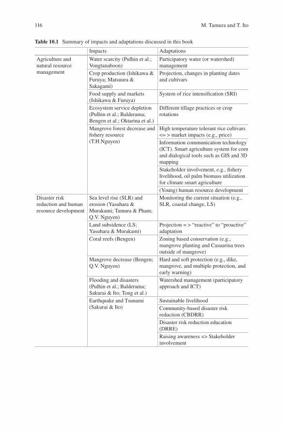
116
Table 10.1 Summary of impacts and adaptations discussed in this book
Impacts Adaptations
Agriculture and natural resource management
Water scarcity (Pulhin et al.; Vongtanaboon)
Participatory water (or watershed) management
Crop production (Ishikawa & Furuya; Matsuura & Sakagami)
Projection, changes in planting dates and cultivars
Food supply and markets (Ishikawa & Furuya)
System of rice intensification (SRI)
Ecosystem service depletion (Pulhin et al.; Balderama; Bengen et al.; Oktarina et al.)
Different tillage practices or crop rotations
Mangrove forest decrease and fishery resource (T.H.Nguyen)
High temperature tolerant rice cultivars <= > market impacts (e.g., price)Information communication technology (ICT). Smart agriculture system for corn and dialogical tools such as GIS and 3D mappingStakeholder involvement, e.g., fishery livelihood, oil palm biomass utilization for climate smart agriculture(Young) human resource development
Disaster risk reduction and human resource development
Sea level rise (SLR) and erosion (Yasuhara & Murakami; Tamura & Pham; Q.V. Nguyen)
Monitoring the current situation (e.g., SLR, coastal change, LS)
Land subsidence (LS; Yasuhara & Murakami)
Projection = > “reactive” to “proactive” adaptation
Coral reefs (Bengen) Zoning based conservation (e.g., mangrove planting and Casuarina trees outside of mangrove)
Mangrove decrease (Bengen; Q.V. Nguyen)
Hard and soft protection (e.g., dike, mangrove, and multiple protection, and early warning)
Flooding and disasters (Pulhin et al.; Balderama; Sakurai & Ito; Tong et al.)
Watershed management (participatory approach and ICT)
Earthquake and Tsunami (Sakurai & Ito)
Sustainable livelihoodCommunity-based disaster risk reduction (CBDRR)Disaster risk reduction education (DRRE)Raising awareness => Stakeholder involvement
M. Tamura and T. Ito
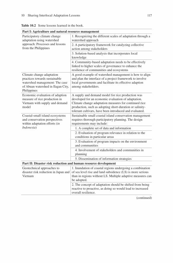
117
Table 10.2 Some lessons learned in the book.
Part I: Agriculture and natural resource managementParticipatory climate change adaptation using watershed approach: Processes and lessons from the Philippines
1. Recognizing the different scales of adaptation through a watershed approach2. A participatory framework for catalyzing collective action among stakeholders3. Solution-based analysis that incorporates local knowledge4. Community-based adaptation needs to be effectively linked to higher scales of governance to enhance the resilience of communities and ecosystems
Climate change adaptation practices towards sustainable watershed management: The case of Abuan watershed in Ilagan City, Philippines
A good example of watershed management is how to align and plan the interface of a project framework to involve local governments and facilitate its effective adaption among stakeholders.
Economic evaluation of adaption measure of rice production in Vietnam with supply and demand model
A supply and demand model for rice production was developed for an economic evaluation of adaptation. Climate change adaptation measures for continued rice production, such as adopting short-duration or salinity- tolerant cultivars, have been introduced and evaluated.
Coastal-small island ecosystems and conservation perspectives within adaptation efforts (in Indonesia)
Sustainable small coastal island conservation management requires thorough participatory planning. The design requirements may include: 1. A complete set of data and information 2. Evaluation of program relevance in relation to the
conditions in particular areas 3. Evaluation of program impacts on the environment
and communities 4. Involvement of stakeholders and communities in
planning 5. Dissemination of information strategies
Part II: Disaster risk reduction and human resource developmentGeotechnical approaches to disaster risk reduction in Japan and Vietnam
1. Inundation of coastal regions undergoing a combination of sea level rise and land subsidence (LS) is more serious than in regions without LS. Multiple adaptive measures can be adopted.2. The concept of adaptation should be shifted from being reactive to proactive, as doing so would lead to increased overall resilience.
(continued)
10 Sharing Interlocal Adaptation Lessons
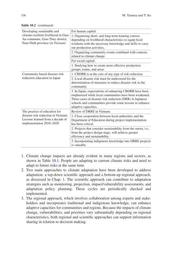
118
1. Climate change impacts are already evident in many regions and sectors, as shown in Table 10.1. People are adapting to current climate risks and need to adapt to future risks at the same time.
2. Two main approaches to climate adaptation have been developed to address adaptation: a top-down scientific approach and a bottom-up regional approach, as discussed in Chap. 1. The scientific approach can contribute to adaptation strategies such as monitoring, projection, impact/vulnerability assessments, and adaptation policy planning. These cycles are periodically checked and implemented.
3. The regional approach, which involves collaboration among experts and stake-holders and incorporates traditional and indigenous knowledge, can enhance adaptive capacities for communities and regions. Because the impacts of climate change, vulnerabilities, and priorities vary substantially depending on regional characteristics, both regional and scientific approaches can support information sharing in relation to decision making.
Table 10.2 (continued)
Developing sustainable and climate-resilient livelihood in Giao An commune, Giao Thuy district, Nam Dinh province (in Vietnam)
For human capital:1. Organizing short- and long-term training courses depending on livelihood characteristics to equip local residents with the necessary knowledge and skills to carry out production activities.2. Organizing community events combined with contests related to climate changeFor social capital:1. Studying how to create more effective production groups, teams, and areas
Community-based disaster risk reduction education in Japan
1. CBDRR is at the core of any type of risk reduction.2. Local disaster risk must be understood for the determination of measures to reduce disaster risk in the community.3. In Japan, expectations of enhancing CBDRR have been emphasized while local communities have been weakened. Three cases of disaster risk reduction (DRR) in Japanese schools and communities provide some lessons to enhance adaptive capacities.
The practice of education for disaster risk reduction in Vietnam: Lessons learned from a decade of implementation 2010–2020
Review of DRRE in Vietnam1. Close cooperation between local authorities and the Department of Education during project implementation has been critical.2. Projects that consider sustainability from the outset, i.e., from the project design stage, will achieve greater efficiency and sustainability.3. Incorporating indigenous knowledge into DRRE projects is valuable.
M. Tamura and T. Ito
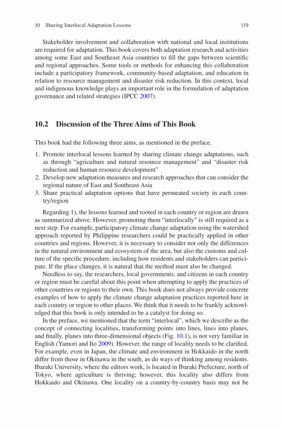
119
Stakeholder involvement and collaboration with national and local institutions are required for adaptation. This book covers both adaptation research and activities among some East and Southeast Asia countries to fill the gaps between scientific and regional approaches. Some tools or methods for enhancing this collaboration include a participatory framework, community-based adaptation, and education in relation to resource management and disaster risk reduction. In this context, local and indigenous knowledge plays an important role in the formulation of adaptation governance and related strategies (IPCC 2007).
10.2 Discussion of the Three Aims of This Book
This book had the following three aims, as mentioned in the preface.
1. Promote interlocal lessons learned by sharing climate change adaptations, such as through “agriculture and natural resource management” and “disaster risk reduction and human resource development”
2. Develop new adaptation measures and research approaches that can consider the regional nature of East and Southeast Asia
3. Share practical adaptation options that have permeated society in each coun-try/region
Regarding 1), the lessons learned and rooted in each country or region are drawn as summarized above. However, promoting them “interlocally” is still required as a next step. For example, participatory climate change adaptation using the watershed approach reported by Philippine researchers could be practically applied in other countries and regions. However, it is necessary to consider not only the differences in the natural environment and ecosystem of the area, but also the customs and cul-ture of the specific procedure, including how residents and stakeholders can partici-pate. If the place changes, it is natural that the method must also be changed.
Needless to say, the researchers, local governments, and citizens in each country or region must be careful about this point when attempting to apply the practices of other countries or regions to their own. This book does not always provide concrete examples of how to apply the climate change adaptation practices reported here in each country or region to other places. We think that it needs to be frankly acknowl-edged that this book is only intended to be a catalyst for doing so.
In the preface, we mentioned that the term “interlocal”, which we describe as the concept of connecting localities, transforming points into lines, lines into planes, and finally, planes into three-dimensional objects (Fig. 10.1), is not very familiar in English (Yamori and Ito 2009). However, the range of locality needs to be clarified. For example, even in Japan, the climate and environment in Hokkaido in the north differ from those in Okinawa in the south, as do ways of thinking among residents. Ibaraki University, where the editors work, is located in Ibaraki Prefecture, north of Tokyo, where agriculture is thriving; however, this locality also differs from Hokkaido and Okinawa. One locality on a country-by-country basis may not be
10 Sharing Interlocal Adaptation Lessons
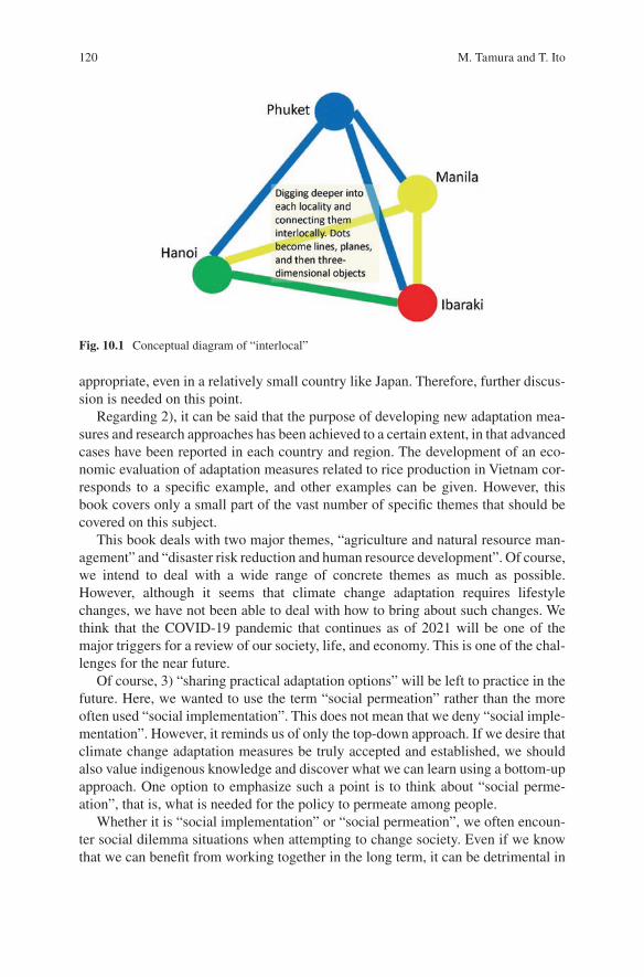
120
appropriate, even in a relatively small country like Japan. Therefore, further discus-sion is needed on this point.
Regarding 2), it can be said that the purpose of developing new adaptation mea-sures and research approaches has been achieved to a certain extent, in that advanced cases have been reported in each country and region. The development of an eco-nomic evaluation of adaptation measures related to rice production in Vietnam cor-responds to a specific example, and other examples can be given. However, this book covers only a small part of the vast number of specific themes that should be covered on this subject.
This book deals with two major themes, “agriculture and natural resource man-agement” and “disaster risk reduction and human resource development”. Of course, we intend to deal with a wide range of concrete themes as much as possible. However, although it seems that climate change adaptation requires lifestyle changes, we have not been able to deal with how to bring about such changes. We think that the COVID-19 pandemic that continues as of 2021 will be one of the major triggers for a review of our society, life, and economy. This is one of the chal-lenges for the near future.
Of course, 3) “sharing practical adaptation options” will be left to practice in the future. Here, we wanted to use the term “social permeation” rather than the more often used “social implementation”. This does not mean that we deny “social imple-mentation”. However, it reminds us of only the top-down approach. If we desire that climate change adaptation measures be truly accepted and established, we should also value indigenous knowledge and discover what we can learn using a bottom-up approach. One option to emphasize such a point is to think about “social perme-ation”, that is, what is needed for the policy to permeate among people.
Whether it is “social implementation” or “social permeation”, we often encoun-ter social dilemma situations when attempting to change society. Even if we know that we can benefit from working together in the long term, it can be detrimental in
Fig. 10.1 Conceptual diagram of “interlocal”
M. Tamura and T. Ito
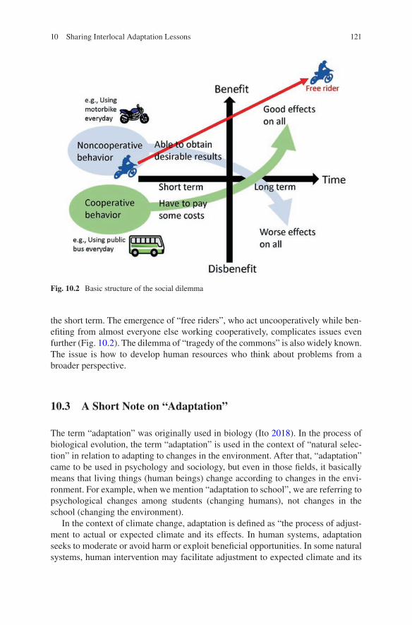
121
the short term. The emergence of “free riders”, who act uncooperatively while ben-efiting from almost everyone else working cooperatively, complicates issues even further (Fig. 10.2). The dilemma of “tragedy of the commons” is also widely known. The issue is how to develop human resources who think about problems from a broader perspective.
10.3 A Short Note on “Adaptation”
The term “adaptation” was originally used in biology (Ito 2018). In the process of biological evolution, the term “adaptation” is used in the context of “natural selec-tion” in relation to adapting to changes in the environment. After that, “adaptation” came to be used in psychology and sociology, but even in those fields, it basically means that living things (human beings) change according to changes in the envi-ronment. For example, when we mention “adaptation to school”, we are referring to psychological changes among students (changing humans), not changes in the school (changing the environment).
In the context of climate change, adaptation is defined as “the process of adjust-ment to actual or expected climate and its effects. In human systems, adaptation seeks to moderate or avoid harm or exploit beneficial opportunities. In some natural systems, human intervention may facilitate adjustment to expected climate and its
Fig. 10.2 Basic structure of the social dilemma
10 Sharing Interlocal Adaptation Lessons
122
effects” (IPCC 2014, p.1758). The object of climate adaptation includes both chang-ing society and human systems.
10.4 The Way Forward
This book has introduced ideas regarding both research and activities for climate change adaptation among some East and Southeast Asia countries, such as Vietnam, Thailand, Indonesia, Philippines, China, and Japan. As the impacts of climate change are expected to be increasingly serious, many promising activities and proj-ects for climate adaptation have been proposed. These adaptations can be shared interlocally among countries, regions, and residents.
To enhance the adaptive capacities of climate change, it is critical to establish a social system that can promote information collection and the sharing and raising of awareness regarding the importance of these activities. In addition, this dialogue must be promoted among researchers in diverse fields. Adaptation to climate change should contribute to other social goals, such as the mitigation of climate change and the creation of an environmentally safe, friendly, and secure society in accordance with the Sustainable Development Goals established by the United Nations General Assembly.
It cannot be said that aims of this book have been achieved through its publica-tion alone, and some problems still remain. However, there is no doubt that this book can contribute to the creation of new opportunities to tackle these challenges.
References
IPCC (2007) Climate change 2007 -impacts, adaptation and vulnerability: working group II con-tribution to the fourth assessment report of the IPCC. Cambridge University Press, London
IPCC (2014) Climate change 2014 -impacts, adaptation and vulnerability: working group II contri-bution to the fifth assessment report of the IPCC. Cambridge University Press, London
Ito T (2018) Prospects for a research dialogue toward the world: considering the cross-border concept of “adaptation”. Jpn J Dev Psychol 29:189–198. (in Japanese)
Yamori K, Ito T (2009) Consideration of “inter-locality” using an epistolary style. Jpn J Qualit Psychol 8:43–63. (in Japanese)
M. Tamura and T. Ito
123
Open Access This chapter is licensed under the terms of the Creative Commons Attribution 4.0 International License (http://creativecommons.org/licenses/by/4.0/), which permits use, sharing, adaptation, distribution and reproduction in any medium or format, as long as you give appropriate credit to the original author(s) and the source, provide a link to the Creative Commons license and indicate if changes were made.
The images or other third party material in this chapter are included in the chapter’s Creative Commons license, unless indicated otherwise in a credit line to the material. If material is not included in the chapter’s Creative Commons license and your intended use is not permitted by statutory regulation or exceeds the permitted use, you will need to obtain permission directly from the copyright holder.
10 Sharing Interlocal Adaptation Lessons
125© The Author(s) 2022T. Ito et al. (eds.), Interlocal Adaptations to Climate Change in East and Southeast Asia, SpringerBriefs in Climate Studies, https://doi.org/10.1007/978-3-030-81207-2_11
Column 1The Southeast Asia Research-Based Network on Climate Change Adaptation Science (SARNCCAS) -Weaving the Wisdom of Climate Change Adaptation into Glocal Networks-
Tetsuji Ito and Akihiko Kotera
In the twenty-first century, the problems caused by climate change are becoming increasingly apparent, especially in developing countries such as those in Southeast Asia. As scientists, we have been hoping to strengthen our academic relationship on this thesis to cooperate and fight against such global problems. Nevertheless, the effects of climate change are not the same in any region of the world. Therefore, attention must be paid to each individual, and it is vital to connect them interlocally. If we could relativize the problems of each country and region, and analyze and examine them more objectively from different angles by networking such research bases, we would likely be able to produce significant results in regard to the sustain-able development of this region.
We spent a lot of time fostering these ideas among our colleagues from Vietnam, the Philippines, Thailand, and Indonesia until finally launching our network project in late 2018. This ambitious network, named “The Southeast Asia Research-based Network on Climate Change Adaptation Science (SARNCCAS),” aims to network researchers from various disciplines in Southeast Asian countries and Japan to encourage different voices toward a common message for climate change adapta-tion science and contribute to the research base and community-based research (Fig. C1.1). The next generation of young researchers and students also plays an essential role in this network.
Like other countries, Japan also has been strongly affected by climate change in recent years, for example, by experiencing heavy rainfall disasters. Hence Japan has
T. Ito (*) College of Humanities and Social Sciences/Global and Local Environment Co-creation Institute, Ibaraki University, Ibaraki, Japane-mail: [email protected]
A. Kotera Global and Local Environment Co-creation Institute, Ibaraki University, Ibaraki, Japan
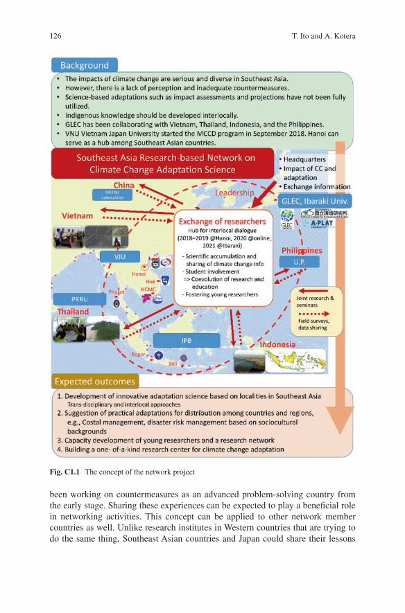
126
been working on countermeasures as an advanced problem-solving country from the early stage. Sharing these experiences can be expected to play a beneficial role in networking activities. This concept can be applied to other network member countries as well. Unlike research institutes in Western countries that are trying to do the same thing, Southeast Asian countries and Japan could share their lessons
Fig. C1.1 The concept of the network project
T. Ito and A. Kotera
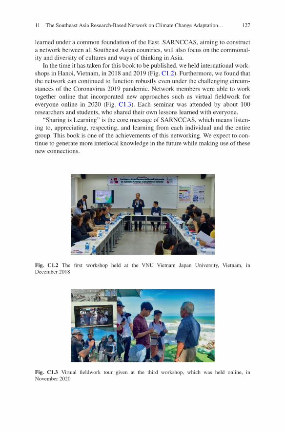
127
learned under a common foundation of the East. SARNCCAS, aiming to construct a network between all Southeast Asian countries, will also focus on the commonal-ity and diversity of cultures and ways of thinking in Asia.
In the time it has taken for this book to be published, we held international work-shops in Hanoi, Vietnam, in 2018 and 2019 (Fig. C1.2). Furthermore, we found that the network can continued to function robustly even under the challenging circum-stances of the Coronavirus 2019 pandemic. Network members were able to work together online that incorporated new approaches such as virtual fieldwork for everyone online in 2020 (Fig. C1.3). Each seminar was attended by about 100 researchers and students, who shared their own lessons learned with everyone.
“Sharing is Learning” is the core message of SARNCCAS, which means listen-ing to, appreciating, respecting, and learning from each individual and the entire group. This book is one of the achievements of this networking. We expect to con-tinue to generate more interlocal knowledge in the future while making use of these new connections.
Fig. C1.2 The first workshop held at the VNU Vietnam Japan University, Vietnam, in December 2018
Fig. C1.3 Virtual fieldwork tour given at the third workshop, which was held online, in November 2020
11 The Southeast Asia Research-Based Network on Climate Change Adaptation…

128
Open Access This chapter is licensed under the terms of the Creative Commons Attribution 4.0 International License (http://creativecommons.org/licenses/by/4.0/), which permits use, sharing, adaptation, distribution and reproduction in any medium or format, as long as you give appropriate credit to the original author(s) and the source, provide a link to the Creative Commons license and indicate if changes were made.
The images or other third party material in this chapter are included in the chapter’s Creative Commons license, unless indicated otherwise in a credit line to the material. If material is not included in the chapter’s Creative Commons license and your intended use is not permitted by statutory regulation or exceeds the permitted use, you will need to obtain permission directly from the copyright holder.
T. Ito and A. Kotera

129© The Author(s) 2022T. Ito et al. (eds.), Interlocal Adaptations to Climate Change in East and Southeast Asia, SpringerBriefs in Climate Studies, https://doi.org/10.1007/978-3-030-81207-2_12
Column 2Variations of Short-Lived Climate Pollutants in Hanoi, Vietnam
Tung Duy Do and Kazuyuki Kita
Emissions of air pollutants have been increasing significantly in Asian countries due to the rapid development of industry and economy. Long-range, transboundary transport of these pollutants probably affects the atmospheric environment and the regional climate in this region (Kita et al. 2009). Climate change, air pollution, and sustainable development are inter-linked, and co-benefits of cutting short-lived cli-mate pollutants (SLCP) will avoid global warming higher than 1.5 °C and negative trade-offs (CCAC 2019; IPCC 2018). Therefore, identification of SLCP emission/production/ transportation sources is critical for planning mitigative measures to reduce SLCP.
In this study, simultaneous observation of black carbon (BC), tropospheric ozone (TO3) and particulate matter 2.5 (PM2.5), which are significant climate forcers, was carried out at VNU Vietnam Japan University in Hanoi to clarify the concentrations and variations of SLCP in Hanoi and Northern Vietnam. The research applied HYSPLIT trajectory model to distinguish contribution source regions of SLCPs to Hanoi and deployed remote PM2.5 stations surrounding Hanoi and coastal region in Northeast sector of Northern Vietnam to compare upwind and downwind concentrations.
Figure C2.1 shows the maximum episodes of BC and PM2.5 observed in winter-time, especially in January with periods lasting from 1 day to 1 week. Monthly averaged concentrations of BC, TO3 and PM2.5 were in range of 1–3 μg/m3, 20–50 ppbv and 18–65 μg/m3, respectively (Fig. C2.2). BC concentration was estimated
T. D. Do VNU Vietnam Japan University, Hanoi, Vietnam
K. Kita (*) Graduate School of Science and Engineering, Ibaraki University, Ibaraki, Japane-mail: [email protected]
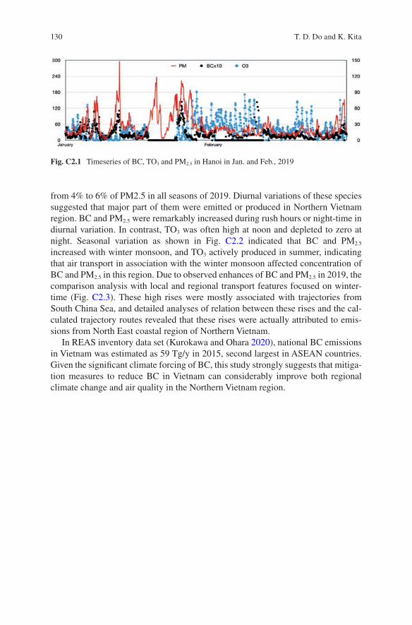
130
from 4% to 6% of PM2.5 in all seasons of 2019. Diurnal variations of these species suggested that major part of them were emitted or produced in Northern Vietnam region. BC and PM2.5 were remarkably increased during rush hours or night-time in diurnal variation. In contrast, TO3 was often high at noon and depleted to zero at night. Seasonal variation as shown in Fig. C2.2 indicated that BC and PM2.5 increased with winter monsoon, and TO3 actively produced in summer, indicating that air transport in association with the winter monsoon affected concentration of BC and PM2.5 in this region. Due to observed enhances of BC and PM2.5 in 2019, the comparison analysis with local and regional transport features focused on winter-time (Fig. C2.3). These high rises were mostly associated with trajectories from South China Sea, and detailed analyses of relation between these rises and the cal-culated trajectory routes revealed that these rises were actually attributed to emis-sions from North East coastal region of Northern Vietnam.
In REAS inventory data set (Kurokawa and Ohara 2020), national BC emissions in Vietnam was estimated as 59 Tg/y in 2015, second largest in ASEAN countries. Given the significant climate forcing of BC, this study strongly suggests that mitiga-tion measures to reduce BC in Vietnam can considerably improve both regional climate change and air quality in the Northern Vietnam region.
Fig. C2.1 Timeseries of BC, TO3 and PM2.5 in Hanoi in Jan. and Feb., 2019
T. D. Do and K. Kita
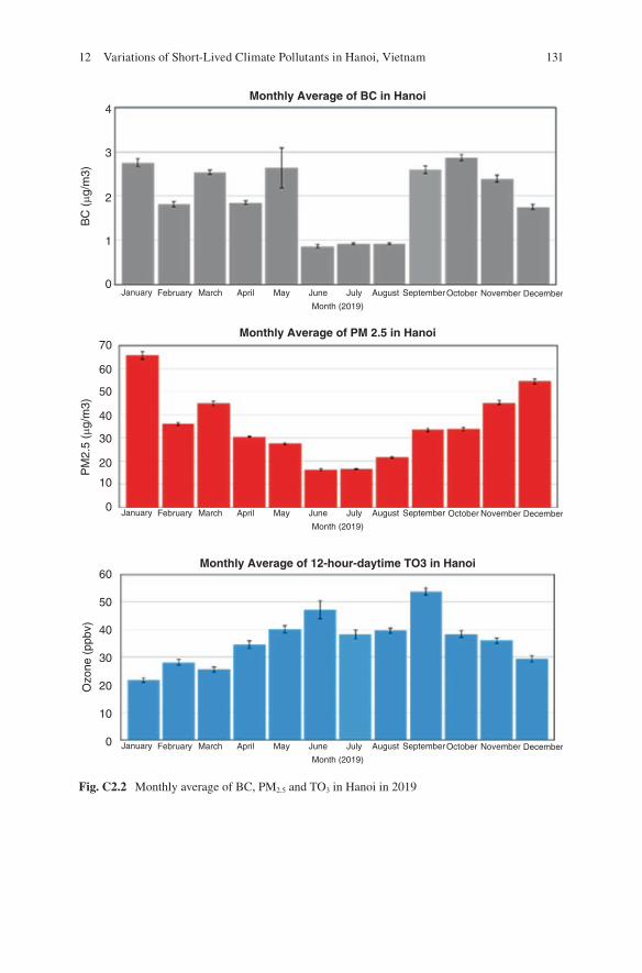
131
Monthly Average of BC in Hanoi
Monthly Average of PM 2.5 in Hanoi
Monthly Average of 12-hour-daytime TO3 in Hanoi
4
3
2
1
0
70
60
50
40
30
PM
2.5
(�g/
m3)
BC
(�g
/m3)
20
10
0
60
50
40
30
Ozo
ne (
ppbv
)
20
10
0
January February March April May June
Month (2019)
July August September November DecemberOctober
January February March April May June
Month (2019)
July August September November DecemberOctober
January February March April May June
Month (2019)
July August September November DecemberOctober
Fig. C2.2 Monthly average of BC, PM2.5 and TO3 in Hanoi in 2019
12 Variations of Short-Lived Climate Pollutants in Hanoi, Vietnam
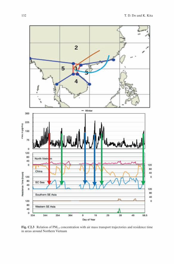
132
Fig. C2.3 Relation of PM2.5 concentration with air mass transport trajectories and residence time in areas around Northern Vietnam
T. D. Do and K. Kita
133
References
CCAC (2019) Climate and clean air coalition to reduce short lived climate pollutants. (2019, March 15). http://www.ccacoalition.org/en/content/short- lived- climate- pollutants- slcps
IPCC (2018) Global warming of 1.5 °C. An IPCC Special Report on the impacts of global warm-ing of 1.5 °C above pre-industrial levels and related global greenhouse gas emission pathways, in the context of strengthening the global response to the threat of climate change, sustain-able development, and efforts to eradicate poverty (Masson-Delmotte V, Zhai P, Pörtner HO, Roberts D, Skea J, Shukla PR, Pirani A, Moufouma-Okia W, Péan C, Pidcock R, Connors S, Matthews JBR, Chen Y, Zhou X, Gomis MI, Lonnoy E, Maycock T, Tignor M, Waterfield T (eds)). In Press
Kita K, Kasai Y, Sagi K, Hayashida S, Irie H, Kanaya Y, Miyazaki K, Takigawa M, Noguchi K, Kondo Y, Koike M, Akimoto H (2009) Transboundary air pollution in East/Southeast Asia and geostationary measurement. AGU Fall Meeting Abstracts
Kurokawa J, Ohara T (2020) Long-term historical trends in air pollutant emissions in Asia: Regional Emission inventory in ASia (REAS) version 3. Atmos Chem Phys 20:12761–12793. https://doi.org/10.5194/acp- 20- 12761- 2020
Open Access This chapter is licensed under the terms of the Creative Commons Attribution 4.0 International License (http://creativecommons.org/licenses/by/4.0/), which permits use, sharing, adaptation, distribution and reproduction in any medium or format, as long as you give appropriate credit to the original author(s) and the source, provide a link to the Creative Commons license and indicate if changes were made.
The images or other third party material in this chapter are included in the chapter’s Creative Commons license, unless indicated otherwise in a credit line to the material. If material is not included in the chapter’s Creative Commons license and your intended use is not permitted by statutory regulation or exceeds the permitted use, you will need to obtain permission directly from the copyright holder.
12 Variations of Short-Lived Climate Pollutants in Hanoi, Vietnam
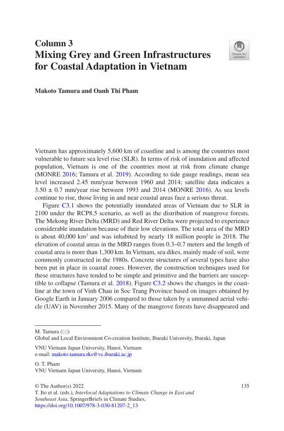
135© The Author(s) 2022T. Ito et al. (eds.), Interlocal Adaptations to Climate Change in East and Southeast Asia, SpringerBriefs in Climate Studies, https://doi.org/10.1007/978-3-030-81207-2_13
Column 3Mixing Grey and Green Infrastructures for Coastal Adaptation in Vietnam
Makoto Tamura and Oanh Thi Pham
Vietnam has approximately 5,600 km of coastline and is among the countries most vulnerable to future sea level rise (SLR). In terms of risk of inundation and affected population, Vietnam is one of the countries most at risk from climate change (MONRE 2016; Tamura et al. 2019). According to tide gauge readings, mean sea level increased 2.45 mm/year between 1960 and 2014; satellite data indicates a 3.50 ± 0.7 mm/year rise between 1993 and 2014 (MONRE 2016). As sea levels continue to rise, those living in and near coastal areas face a serious threat.
Figure C3.1 shows the potentially inundated areas of Vietnam due to SLR in 2100 under the RCP8.5 scenario, as well as the distribution of mangrove forests. The Mekong River Delta (MRD) and Red River Delta were projected to experience considerable inundation because of their low elevations. The total area of the MRD is about 40,000 km2 and was inhabited by nearly 18 million people in 2018. The elevation of coastal areas in the MRD ranges from 0.3–0.7 meters and the length of coastal area is more than 1,300 km. In Vietnam, sea dikes, mainly made of soil, were commonly constructed in the 1980s. Concrete structures of several types have also been put in place in coastal zones. However, the construction techniques used for these structures have tended to be simple and primitive and the barriers are suscep-tible to collapse (Tamura et al. 2018). Figure C3.2 shows the changes in the coast-line at the town of Vinh Chau in Soc Trang Province based on images obtained by Google Earth in January 2006 compared to those taken by a unmanned aerial vehi-cle (UAV) in November 2015. Many of the mangrove forests have disappeared and
M. Tamura (*) Global and Local Environment Co-creation Institute, Ibaraki University, Ibaraki, Japan
VNU Vietnam Japan University, Hanoi, Vietname-mail: [email protected]
O. T. Pham VNU Vietnam Japan University, Hanoi, Vietnam

136
areas of the coastline showed extensive erosion at some locations due to a decrease in sediments from upstream river reaches, economic activities, and long-term SLR.
Adaptation measures can reduce the adverse impacts of climate change. There are three main approaches to adapt to the impact of SLR in coastal areas: retreat, accommodation, and protection. For reliable adaptations in the future, it is neces-sary to examine the effectiveness and cost of coastal protection. This study evalu-ated the effectiveness of adaptation scenarios in the MRD—one involving dikes only, the other combining dikes and mangrove planting—and estimated their costs. The coastline of the MRD is 1,302 km long and includes 945 km of mangrove forest in estuary areas.
The total population at risk of SLR in the MRD may increase roughly early in this century and then decrease during the rest of twenty-first century under five socio-economic scenarios (Fig. C3.3). Figure C3.4 shows an overview of economic losses due to SLR in the MRD without adaptation under five Shared Socioeconomic
Fig. C3.1 Inundated area due to SLR by 2100 under the RCP8.5 (MIROC- ESM) scenario and mangrove distribution
M. Tamura and O. T. Pham
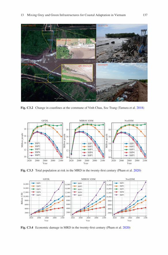
137
Fig. C3.2 Change in coastlines at the commune of Vinh Chau, Soc Trang (Tamura et al. 2018)
18
SSP1
GFDL
SSP2SSP3SSP4SSP5
16
14
Mill
ion
peop
le
12
10
18
16
14
Mill
ion
peop
le
12
10
18
16
14
Mill
ion
peop
le
12
10
SSP1
MIROC-ESM
SSP2SSP3SSP4SSP5
SSP1
NorESM
SSP2SSP3SSP4SSP5
2020 2040 2060Year
2080 2100 2020 2040 2060Year
2080 2100 2020 2040 2060Year
2080 2100
Fig. C3.3 Total population at risk in the MRD in the twenty-first century (Pham et al. 2020)
GFDL
SSP1
SSP2
SSP3
SSP4
SSP5
SSP1
SSP2
SSP3
SSP4
SSP5
SSP1
SSP2
SSP3
SSP4
SSP5
Bill
ion
US$
MIROC-ESM18,000
16,000
14,000
12,000
10,000
8000
6000
4000
2000
16,000
14,000
12,000
10,000
8000
6000
4000
2000
16,000
14,000
12,000
10,000
8000
6000
4000
2000
NorESM
2020 2040 2060
Year
2080 2100 2020 2040 2060
Year
2080 2100 2020 2040 2060
Year
2080 2100
Fig. C3.4 Economic damage in MRD in the twenty-first century (Pham et al. 2020)
13 Mixing Grey and Green Infrastructures for Coastal Adaptation in Vietnam
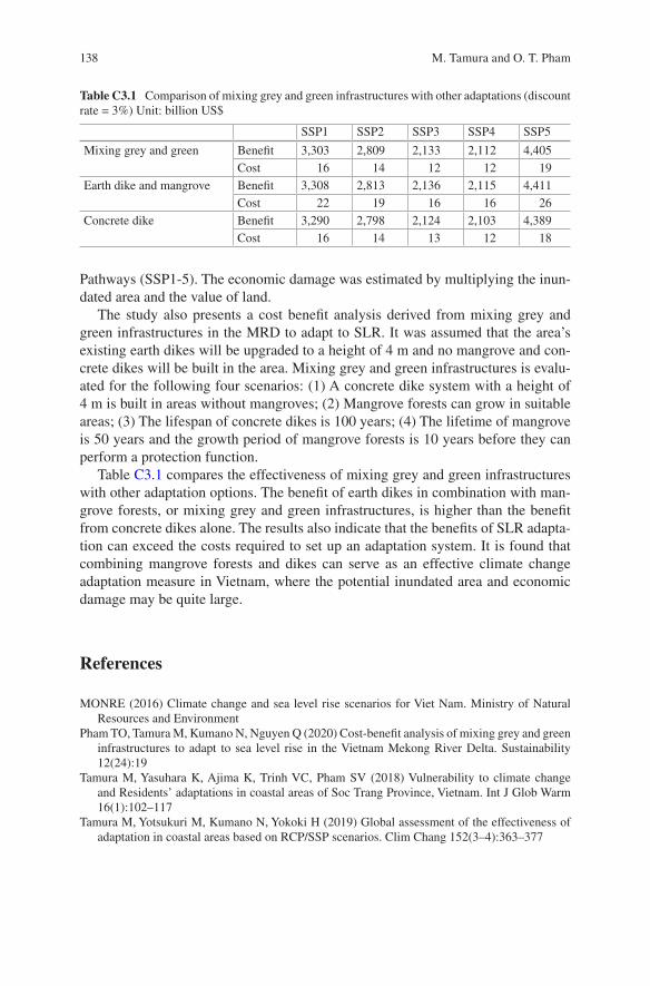
138
Pathways (SSP1-5). The economic damage was estimated by multiplying the inun-dated area and the value of land.
The study also presents a cost benefit analysis derived from mixing grey and green infrastructures in the MRD to adapt to SLR. It was assumed that the area’s existing earth dikes will be upgraded to a height of 4 m and no mangrove and con-crete dikes will be built in the area. Mixing grey and green infrastructures is evalu-ated for the following four scenarios: (1) A concrete dike system with a height of 4 m is built in areas without mangroves; (2) Mangrove forests can grow in suitable areas; (3) The lifespan of concrete dikes is 100 years; (4) The lifetime of mangrove is 50 years and the growth period of mangrove forests is 10 years before they can perform a protection function.
Table C3.1 compares the effectiveness of mixing grey and green infrastructures with other adaptation options. The benefit of earth dikes in combination with man-grove forests, or mixing grey and green infrastructures, is higher than the benefit from concrete dikes alone. The results also indicate that the benefits of SLR adapta-tion can exceed the costs required to set up an adaptation system. It is found that combining mangrove forests and dikes can serve as an effective climate change adaptation measure in Vietnam, where the potential inundated area and economic damage may be quite large.
References
MONRE (2016) Climate change and sea level rise scenarios for Viet Nam. Ministry of Natural Resources and Environment
Pham TO, Tamura M, Kumano N, Nguyen Q (2020) Cost-benefit analysis of mixing grey and green infrastructures to adapt to sea level rise in the Vietnam Mekong River Delta. Sustainability 12(24):19
Tamura M, Yasuhara K, Ajima K, Trinh VC, Pham SV (2018) Vulnerability to climate change and Residents’ adaptations in coastal areas of Soc Trang Province, Vietnam. Int J Glob Warm 16(1):102–117
Tamura M, Yotsukuri M, Kumano N, Yokoki H (2019) Global assessment of the effectiveness of adaptation in coastal areas based on RCP/SSP scenarios. Clim Chang 152(3–4):363–377
Table C3.1 Comparison of mixing grey and green infrastructures with other adaptations (discount rate = 3%) Unit: billion US$
SSP1 SSP2 SSP3 SSP4 SSP5
Mixing grey and green Benefit 3,303 2,809 2,133 2,112 4,405Cost 16 14 12 12 19
Earth dike and mangrove Benefit 3,308 2,813 2,136 2,115 4,411Cost 22 19 16 16 26
Concrete dike Benefit 3,290 2,798 2,124 2,103 4,389Cost 16 14 13 12 18
M. Tamura and O. T. Pham

139
Open Access This chapter is licensed under the terms of the Creative Commons Attribution 4.0 International License (http://creativecommons.org/licenses/by/4.0/), which permits use, sharing, adaptation, distribution and reproduction in any medium or format, as long as you give appropriate credit to the original author(s) and the source, provide a link to the Creative Commons license and indicate if changes were made.
The images or other third party material in this chapter are included in the chapter’s Creative Commons license, unless indicated otherwise in a credit line to the material. If material is not included in the chapter’s Creative Commons license and your intended use is not permitted by statutory regulation or exceeds the permitted use, you will need to obtain permission directly from the copyright holder.
13 Mixing Grey and Green Infrastructures for Coastal Adaptation in Vietnam
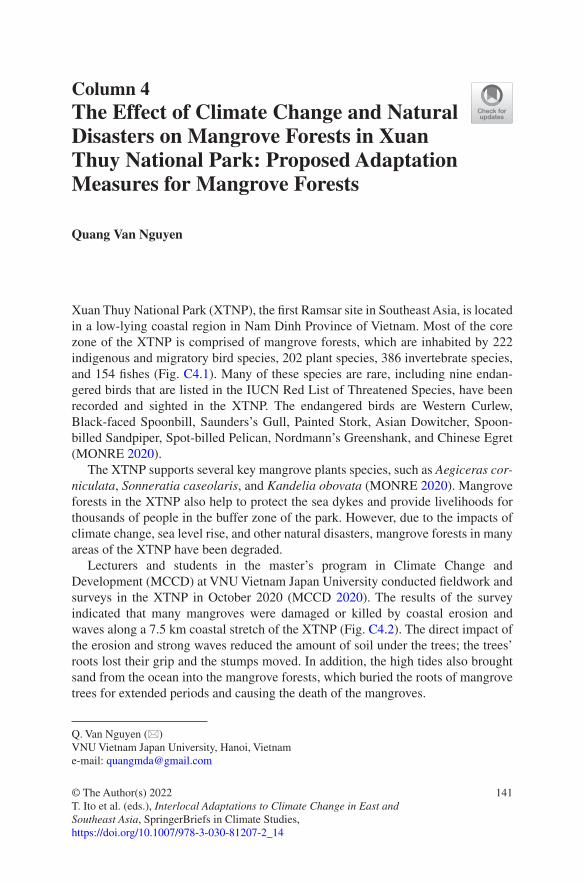
141© The Author(s) 2022T. Ito et al. (eds.), Interlocal Adaptations to Climate Change in East and Southeast Asia, SpringerBriefs in Climate Studies, https://doi.org/10.1007/978-3-030-81207-2_14
Column 4The Effect of Climate Change and Natural Disasters on Mangrove Forests in Xuan Thuy National Park: Proposed Adaptation Measures for Mangrove Forests
Quang Van Nguyen
Xuan Thuy National Park (XTNP), the first Ramsar site in Southeast Asia, is located in a low-lying coastal region in Nam Dinh Province of Vietnam. Most of the core zone of the XTNP is comprised of mangrove forests, which are inhabited by 222 indigenous and migratory bird species, 202 plant species, 386 invertebrate species, and 154 fishes (Fig. C4.1). Many of these species are rare, including nine endan-gered birds that are listed in the IUCN Red List of Threatened Species, have been recorded and sighted in the XTNP. The endangered birds are Western Curlew, Black-faced Spoonbill, Saunders’s Gull, Painted Stork, Asian Dowitcher, Spoon- billed Sandpiper, Spot-billed Pelican, Nordmann’s Greenshank, and Chinese Egret (MONRE 2020).
The XTNP supports several key mangrove plants species, such as Aegiceras cor-niculata, Sonneratia caseolaris, and Kandelia obovata (MONRE 2020). Mangrove forests in the XTNP also help to protect the sea dykes and provide livelihoods for thousands of people in the buffer zone of the park. However, due to the impacts of climate change, sea level rise, and other natural disasters, mangrove forests in many areas of the XTNP have been degraded.
Lecturers and students in the master’s program in Climate Change and Development (MCCD) at VNU Vietnam Japan University conducted fieldwork and surveys in the XTNP in October 2020 (MCCD 2020). The results of the survey indicated that many mangroves were damaged or killed by coastal erosion and waves along a 7.5 km coastal stretch of the XTNP (Fig. C4.2). The direct impact of the erosion and strong waves reduced the amount of soil under the trees; the trees’ roots lost their grip and the stumps moved. In addition, the high tides also brought sand from the ocean into the mangrove forests, which buried the roots of mangrove trees for extended periods and causing the death of the mangroves.
Q. Van Nguyen (*) VNU Vietnam Japan University, Hanoi, Vietname-mail: [email protected]
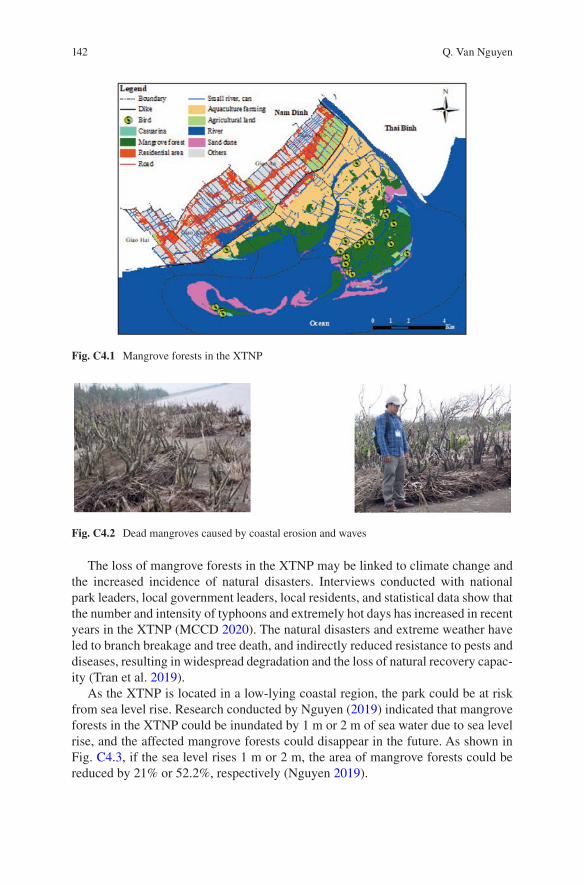
142
The loss of mangrove forests in the XTNP may be linked to climate change and the increased incidence of natural disasters. Interviews conducted with national park leaders, local government leaders, local residents, and statistical data show that the number and intensity of typhoons and extremely hot days has increased in recent years in the XTNP (MCCD 2020). The natural disasters and extreme weather have led to branch breakage and tree death, and indirectly reduced resistance to pests and diseases, resulting in widespread degradation and the loss of natural recovery capac-ity (Tran et al. 2019).
As the XTNP is located in a low-lying coastal region, the park could be at risk from sea level rise. Research conducted by Nguyen (2019) indicated that mangrove forests in the XTNP could be inundated by 1 m or 2 m of sea water due to sea level rise, and the affected mangrove forests could disappear in the future. As shown in Fig. C4.3, if the sea level rises 1 m or 2 m, the area of mangrove forests could be reduced by 21% or 52.2%, respectively (Nguyen 2019).
Fig. C4.1 Mangrove forests in the XTNP
Fig. C4.2 Dead mangroves caused by coastal erosion and waves
Q. Van Nguyen
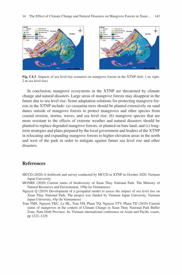
143
In conclusion, mangrove ecosystems in the XTNP are threatened by climate change and natural disasters. Large areas of mangrove forests may disappear in the future due to sea level rise. Some adaptation solutions for protecting mangrove for-ests in the XTNP include: (a) casuarina trees should be planted extensively on sand dunes outside of mangrove forests to protect mangroves and other species from coastal erosion, storms, waves, and sea level rise; (b) mangrove species that are more resistant to the effects of extreme weather and natural disasters should be planted to replace degraded mangrove forests, or planted on bare land; and (c) long- term strategies and plans prepared by the local government and leaders of the XTNP in relocating and expanding mangrove forests to higher-elevation areas in the north and west of the park in order to mitigate against future sea level rise and other disasters.
References
MCCD (2020) A fieldwork and survey conducted by MCCD in XTNP in October 2020. Vietnam Japan University
MONRE (2020) Current status of biodiversity of Xuan Thuy National Park. The Ministry of Natural Resources and Environment, 199p (in Vietnamese)
Nguyen Q (2019) Development of a geospatial model to assess the impact of sea level rise on Xuan Thuy National Park. The project was funded by Vietnam Japan University. Vietnam Japan University, 45p (In Vietnamese)
Tran TMS, Nguyen TKC, Le HL, Tran VH, Pham TQ, Nguyen TTV, Pham TD (2019) Current status of mangroves in the context of Climate Change in Xuan Thuy National Park Buffer Zone, Nam Dinh Province. In: Vietnam international conference on Asian and Pacific coasts, pp 1221–1228
Fig. C4.3 Impacts of sea level rise scenarios on mangrove forests in the XTNP (left: 1 m; right: 2 m sea level rise)
14 The Effect of Climate Change and Natural Disasters on Mangrove Forests in Xuan…

144
Open Access This chapter is licensed under the terms of the Creative Commons Attribution 4.0 International License (http://creativecommons.org/licenses/by/4.0/), which permits use, sharing, adaptation, distribution and reproduction in any medium or format, as long as you give appropriate credit to the original author(s) and the source, provide a link to the Creative Commons license and indicate if changes were made.
The images or other third party material in this chapter are included in the chapter’s Creative Commons license, unless indicated otherwise in a credit line to the material. If material is not included in the chapter’s Creative Commons license and your intended use is not permitted by statutory regulation or exceeds the permitted use, you will need to obtain permission directly from the copyright holder.
Q. Van Nguyen
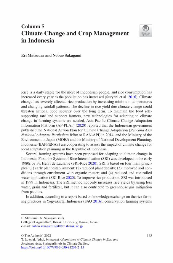
145© The Author(s) 2022T. Ito et al. (eds.), Interlocal Adaptations to Climate Change in East and Southeast Asia, SpringerBriefs in Climate Studies, https://doi.org/10.1007/978-3-030-81207-2_15
Column 5Climate Change and Crop Management in Indonesia
Eri Matsuura and Nobuo Sakagami
Rice is a daily staple for the most of Indonesian people, and rice consumption has increased every year as the population has increased (Suryani et al. 2016). Climate change has severely affected rice production by increasing minimum temperatures and changing rainfall patterns. The decline in rice yield due climate change could threaten national food security over the long term. To maintain the food self- supporting rate and support farmers, new technologies for adapting to climate change in farming systems are needed. Asia-Pacific Climate Change Adaptation Information Platform (AP-PLAT) (2020) reported that the Indonesian government published the National Action Plan for Climate Change Adaptation (Rencana Aksi Nasional Adaptasi Perubahan Iklim or RAN-API) in 2014, and the Ministry of the Environment in Japan (MOEJ) and the Ministry of National Development Planning, Indonesia (BAPPENAS) are cooperating to assess the impact of climate change for local adaptation planning in the Republic of Indonesia.
Several farming systems have been proposed for adapting to climate change in Indonesia. First, the System of Rice Intensification (SRI) was developed in the early 1980s by Fr. Henri de Laulanie (SRI-Rice 2020). SRI is based on four main princi-ples: (1) early plant establishment; (2) reduced plant density; (3) improved soil con-ditions through enrichment with organic matter; and (4) reduced and controlled water application (SRI-Rice 2020). To improve rice production, SRI was introduced in 1999 in Indonesia. The SRI method not only increases rice yields by using less water, grain and fertilizer, but it can also contribute to greenhouse gas mitigation from paddies.
In addition, according to a report based on knowledge exchange on the rice farm-ing practices in Yogyakarta, Indonesia (FAO 2016), conservation farming systems
E. Matsuura · N. Sakagami (*) College of Agriculture, Ibaraki University, Ibaraki, Japane-mail: [email protected]
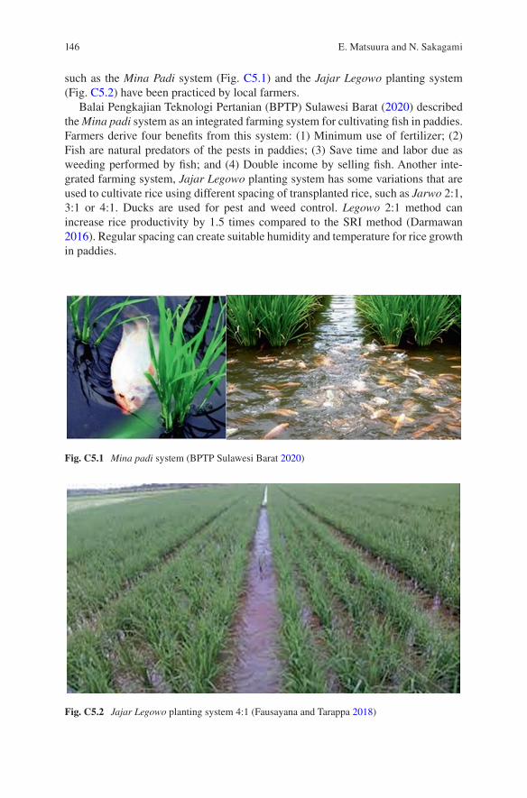
146
such as the Mina Padi system (Fig. C5.1) and the Jajar Legowo planting system (Fig. C5.2) have been practiced by local farmers.
Balai Pengkajian Teknologi Pertanian (BPTP) Sulawesi Barat (2020) described the Mina padi system as an integrated farming system for cultivating fish in paddies. Farmers derive four benefits from this system: (1) Minimum use of fertilizer; (2) Fish are natural predators of the pests in paddies; (3) Save time and labor due as weeding performed by fish; and (4) Double income by selling fish. Another inte-grated farming system, Jajar Legowo planting system has some variations that are used to cultivate rice using different spacing of transplanted rice, such as Jarwo 2:1, 3:1 or 4:1. Ducks are used for pest and weed control. Legowo 2:1 method can increase rice productivity by 1.5 times compared to the SRI method (Darmawan 2016). Regular spacing can create suitable humidity and temperature for rice growth in paddies.
Fig. C5.1 Mina padi system (BPTP Sulawesi Barat 2020)
Fig. C5.2 Jajar Legowo planting system 4:1 (Fausayana and Tarappa 2018)
E. Matsuura and N. Sakagami
147
Kusumasari (2016) noticed that farmers understand climate change occurring in their region and its influences on their cultivation method. She also pointed out that changing the planting pattern, using soil cultivation technique, plant pest manage-ment technique, and watering/irrigation technique can be used as countermeasures. Various integrated farming systems might be resilient to climate change and sus-tainable by saving water, less use of fertilizers and increasing soil organic matter. Moreover, farmers can manage the system better and adapt to the local environment in different islands of Indonesia. Farmers know the best farming practices in their region based on experience. Climate-smart agricultural technologies do not need to be expensive; rather, farmers’ experience and new knowledge can be combined to produce better outcomes in farmers’ livelihoods and mitigate global warming.
References
AP-PLAT (2020) Assessing the impact of climate change for local adaptation planning in the Republic of Indonesia. https://ap- plat.nies.go.jp/plan_implementation/international/Indonesia/index.html
BPTP Sulawesi Barat (2020) Teknologi Mina Padi Dengan Sistim Tanam Jajar Legowo. http://sulbar.litbang.pertanian.go.id/ind/index.php/info- teknologi/344- teknologi- mina- padi- dengan- sistim- tanam- jajar- legowo (In Indonesian)
Darmawan M (2016) Analysis of Legowo row planting system and system of rice intensification of paddy field (Oryza sativa L.) toward growth and production. AgroTech J 1:14–18
FAO (2016) Report of the knowledge exchange on the promotion of efficient rice farming practices, farmer field school curriculum development and value chains. FAO Fisheries and Aquaculture Report No 1181. http://www.fao.org/3/a- i6617e.pdf
Fausayana I, Tarappa W (2018) The technology adoption of jajar legowo system and direct seeding system on rice farming in the village of Duria Asi, Wonggeduku District of Konawe regency, Indonesia. Int J Bus Manag Technol 2:28–33
Kusumasari B (2016) Climate change and agricultural adaptation in Indonesia. MIMBAR J Soc Dev 32:243–353
SRI-Rice (2020) SRI International Network and Resources Center. http://sri.ciifad.cornell.edu/Suryani N, Abdurrachim R, Alindah N (2016) Analysis of carbohydrate, fiber and glycemic index
of processed rice cultivar Siam Unus as an alternative snack for diabetes mellitus. Indonesian J Health 7:1–9. (In Indonesian)
Open Access This chapter is licensed under the terms of the Creative Commons Attribution 4.0 International License (http://creativecommons.org/licenses/by/4.0/), which permits use, sharing, adaptation, distribution and reproduction in any medium or format, as long as you give appropriate credit to the original author(s) and the source, provide a link to the Creative Commons license and indicate if changes were made.
The images or other third party material in this chapter are included in the chapter’s Creative Commons license, unless indicated otherwise in a credit line to the material. If material is not included in the chapter’s Creative Commons license and your intended use is not permitted by statutory regulation or exceeds the permitted use, you will need to obtain permission directly from the copyright holder.
15 Climate Change and Crop Management in Indonesia
149© The Author(s) 2022T. Ito et al. (eds.), Interlocal Adaptations to Climate Change in East and Southeast Asia, SpringerBriefs in Climate Studies, https://doi.org/10.1007/978-3-030-81207-2_16
Column 6Stakeholder Perception and Empirical Evidence: Oil Palm Biomass Utilization as Climate-Smart Smallholder Practice
Sachnaz Desta Oktarina, Ratnawati Nurkhoiry, Rizki Amalia, and Zulfi Prima Sani Nasution
Little is known about smallholder perception and adaptation of climate-smart prac-tices. More precisely, smallholder’s oil palm plots were frequently accused of being the driving force of ecosystem service depletion. This was arguably due to the vicious cycle facing the smallholder as the push factor. At first, smallholders did not plant legitim seeds and were not equipped with good agricultural practices (GAP), which decreased productivity. Since their earnings are low, they are motivated to expand the farm through deforestation (Bennett et al. 2018). This low-income situ-ation is mainly due the absence of other income-generating activities to support their livelihoods. In the long run, this kind of practice has caused climate change. Scientists have suggested that climate-smart agricultural (CSA) practices are applied by smallholders in order to overcome this problem. Fortunately, palm oil plantation has offered a pull factor to answer this challenge. Palm oil biomass utili-zation might act as a pull factor that can be performed to the smallholder context. Specifically, palm oil products are cheap and eco-friendly because they have ubiq-uitous and versatile functions, ranging from food to fuel. In addition, little is known that we still can make the most of its left-over as well. Indonesian oil palm small-holders might apply oil palm biomass to grow food; make crafts; or use as wood, fiber, and energy. Thus, the versatility of palm oil definitely mitigates depletion of the environment and its use can be expanded to other smallholders nationwide. The act of using biomass is also considered to be a CSA practice that is specific to oil palm plantations. While most studies have examined CSA in terms of mechanistic or biophysical aspects, relatively little research has examined the interest, percep-tion, or acceptance of CSA in oil palm cultivation, particularly among smallholders.
This research was supported by INSINAS Research Grant No: 18/INS-1/PPK/E4/2019.
S. D. Oktarina (*) · R. Nurkhoiry · R. Amalia · Z. P. S. Nasution Indonesian Oil Palm Research Institute, Kota Medan, North Sumatera, Indonesiae-mail: [email protected]
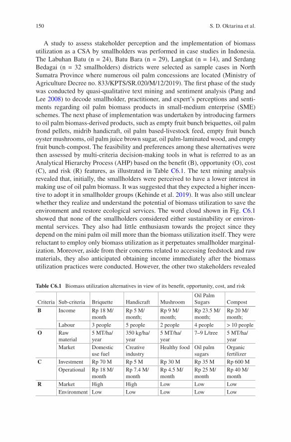
150
A study to assess stakeholder perception and the implementation of biomass utilization as a CSA by smallholders was performed in case studies in Indonesia. The Labuhan Batu (n = 24), Batu Bara (n = 29), Langkat (n = 14), and Serdang Bedagai (n = 32 smallholders) districts were selected as sample cases in North Sumatra Province where numerous oil palm concessions are located (Ministry of Agriculture Decree no. 833/KPTS/SR.020/M/12/2019). The first phase of the study was conducted by quasi-qualitative text mining and sentiment analysis (Pang and Lee 2008) to decode smallholder, practitioner, and expert’s perceptions and senti-ments regarding oil palm biomass products in small-medium enterprise (SME) schemes. The next phase of implementation was undertaken by introducing farmers to oil palm biomass-derived products, such as empty fruit bunch briquettes, oil palm frond pellets, midrib handicraft, oil palm based-livestock feed, empty fruit bunch oyster mushrooms, oil palm juice brown sugar, oil palm-laminated wood, and empty fruit bunch-compost. The feasibility and preferences among these alternatives were then assessed by multi-criteria decision-making tools in what is referred to as an Analytical Hierarchy Process (AHP) based on the benefit (B), opportunity (O), cost (C), and risk (R) features, as illustrated in Table C6.1. The text mining analysis revealed that, initially, the smallholders were perceived to have a lower interest in making use of oil palm biomass. It was suggested that they expected a higher incen-tive to adopt it in smallholder groups (Kehinde et al. 2019). It was also still unclear whether they realize and understand the potential of biomass utilization to save the environment and restore ecological services. The word cloud shown in Fig. C6.1 showed that none of the smallholders considered either sustainability or environ-mental services. They also had little enthusiasm towards the project since they depend on the mini palm oil mill more than the biomass utilization itself. They were reluctant to employ only biomass utilization as it perpetuates smallholder marginal-ization. Moreover, aside from their concerns related to accessing feedstock and raw materials, they also anticipated obtaining income immediately after the biomass utilization practices were conducted. However, the other two stakeholders revealed
Table C6.1 Biomass utilization alternatives in view of its benefit, opportunity, cost, and risk
Criteria Sub-criteria Briquette Handicraft MushroomOil Palm Sugars Compost
B Income Rp 18 M/month
Rp 5 M/month;
Rp 9 M/month;
Rp 23.5 M/month;
Rp 20 M/month;
Labour 3 people 5 people 2 people 4 people > 10 peopleO Raw
material5 MT/ha/year
350 kg/ha/year
5 MT/ha/year
7–9 L/tree 5 MT/ha/year
Market Domestic use fuel
Creative industry
Healthy food Oil palm sugars
Organic fertilizer
C Investment Rp 70 M Rp 5 M Rp 30 M Rp 35 M Rp 600 MOperational Rp 18 M/
monthRp 7.4 M/month
Rp 4.5 M/month
Rp 25 M/month
Rp 40 M/month
R Market High High Low Low LowEnvironment Low Low Low Low Low
S. D. Oktarina et al.
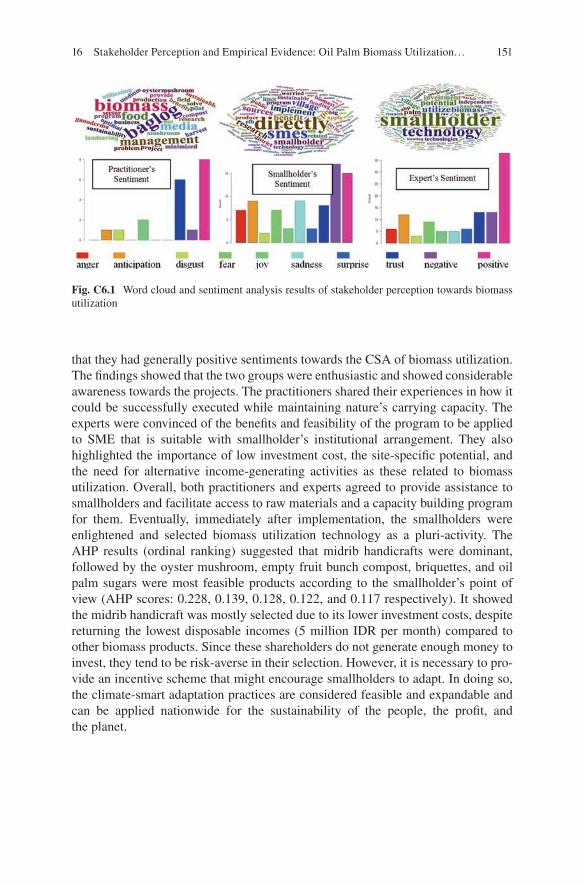
151
that they had generally positive sentiments towards the CSA of biomass utilization. The findings showed that the two groups were enthusiastic and showed considerable awareness towards the projects. The practitioners shared their experiences in how it could be successfully executed while maintaining nature’s carrying capacity. The experts were convinced of the benefits and feasibility of the program to be applied to SME that is suitable with smallholder’s institutional arrangement. They also highlighted the importance of low investment cost, the site-specific potential, and the need for alternative income-generating activities as these related to biomass utilization. Overall, both practitioners and experts agreed to provide assistance to smallholders and facilitate access to raw materials and a capacity building program for them. Eventually, immediately after implementation, the smallholders were enlightened and selected biomass utilization technology as a pluri-activity. The AHP results (ordinal ranking) suggested that midrib handicrafts were dominant, followed by the oyster mushroom, empty fruit bunch compost, briquettes, and oil palm sugars were most feasible products according to the smallholder’s point of view (AHP scores: 0.228, 0.139, 0.128, 0.122, and 0.117 respectively). It showed the midrib handicraft was mostly selected due to its lower investment costs, despite returning the lowest disposable incomes (5 million IDR per month) compared to other biomass products. Since these shareholders do not generate enough money to invest, they tend to be risk-averse in their selection. However, it is necessary to pro-vide an incentive scheme that might encourage smallholders to adapt. In doing so, the climate-smart adaptation practices are considered feasible and expandable and can be applied nationwide for the sustainability of the people, the profit, and the planet.
Fig. C6.1 Word cloud and sentiment analysis results of stakeholder perception towards biomass utilization
16 Stakeholder Perception and Empirical Evidence: Oil Palm Biomass Utilization…
152
References
Bennett A, Ravikumar A, Paltán H (2018) The political ecology of oil palm company-community partnerships in the Peruvian Amazon: deforestation consequences of the privatization of rural development. World Dev 109:29–41
Kehinde MO, Shittu AM, Osunsina IOO (2019) Willingness to accept incentives for a shift to climate-smart agriculture among lowland Rice farmers in Nigeria. Nigerian J Agric Econ 9(2066-2020-1439):29–44
Pang B, Lee L (2008) Opinion mining and sentiment analysis. Found Trends Inf Retr 2(1–2):1–135
Open Access This chapter is licensed under the terms of the Creative Commons Attribution 4.0 International License (http://creativecommons.org/licenses/by/4.0/), which permits use, sharing, adaptation, distribution and reproduction in any medium or format, as long as you give appropriate credit to the original author(s) and the source, provide a link to the Creative Commons license and indicate if changes were made.
The images or other third party material in this chapter are included in the chapter’s Creative Commons license, unless indicated otherwise in a credit line to the material. If material is not included in the chapter’s Creative Commons license and your intended use is not permitted by statutory regulation or exceeds the permitted use, you will need to obtain permission directly from the copyright holder.
S. D. Oktarina et al.
153© The Author(s) 2022T. Ito et al. (eds.), Interlocal Adaptations to Climate Change in East and Southeast Asia, SpringerBriefs in Climate Studies, https://doi.org/10.1007/978-3-030-81207-2_17
Column 7Water Resource Assessment and Management in Phuket, Thailand
Sukanya Vongtanaboon
Within the context of climate change, the province of Phuket in Thailand is the only province in Thailand without any large rivers, which means that it is potentially at risk from problems associated with water scarcity in the future. Phuket Island is also the largest island in Thailand with an area of 543 km2 comprised of three districts (Thalang, Muang and Kathu); 77% of the island is mountainous and 23% consists of plains, primarily in the central and eastern regions. Most water is derived from rainfall, which is stored in reservoirs, mine shafts, and groundwater sources. Due to geography, Phuket is a popular tourist destination. Rates of development in the hotel industry and residential areas, as well as the population, have been rapid in recent decades. However, these developments have severely degraded watershed areas. Economic growth and increases in the number of tourists has resulted in an increase in demand for water, and in the year 2020 consumption exceeded 100,000 m3/day (Provincial Waterworks Authority 2020). Moreover, trends of water use in Phuket are expected to increase by 12% annually, and it is forecasted that the water demand for local consumption and tourism will rise to 103.07 million m3/year in 2032 (Patong Municipality 2020). As the water supply in the three major reservoirs (Bang Wad, Bang Niew Dam and Klong Katha) are limited due to long periods of a dry weather (Provincial Waterworks Authority 2020), there are problems of water scar-city in Phuket and other areas with public water systems in the province. The droughts in 2002 and 2019–2020 caused severe water scarcity in Phuket, and this has become an important issue that the province needs to address.
Rainfall Phuket typically experiences a tropical monsoon climate with a seven- month dry season (mid-October to mid-May) with occasional rain, and a five-month rainy season. A study of monthly rainfall in Phuket found that the rainfall was low-
S. Vongtanaboon (*) Faculty of Science and Technology, Phuket Rajabhat University, Phuket, Thailande-mail: [email protected]

154
est in January–February (30–35 mm) and highest in August–October (303–385 mm). Monthly rainfall increases from March to October. Figure C7.1 shows monthly rain-fall of the three districts and average monthly rainfall of Phuket. Annual rainfall of Phuket is in the range of 1882.7-2713.5 mm, with the average value of 2200 mm/year. The annual rainfall was below average in 1997, 2002, 2005, 2019–2020, which might be caused by the El Nino phenomenon (Golden Gate Weather Services 2020).
Groundwater Groundwater resources in Phuket can be classified into two types based on the degree of compaction and cementation, which are unconsolidated aquifers and consolidated aquifers (Department of Mineral Resources 2020). An evaluation of groundwater resources showed that 5.11 million m3 was extracted from 1024 groundwater wells.
Surface Water Surface water in Phuket consists of reservoirs, mine shafts, peat bogs, and canals (Irrigation Office 2020). The major source of water supply in Phuket is from the Bang Wad Watershed located in Kathu District (Fig. C7.2). The main canals are the Bangyai, Krang and Tha Yang canals, which have annual dis-charges of 49.02, 45.17 and 45.09 million m3, respectively. The average annual discharge is 153.29 million m3. Water storage capacity in the three main reservoirs of Phuket, i.e., Bang Wad, Bang Niew Dam and Klong Katha were 10.20, 7.20 and 4.32 million m3 respectively. In addition, the water storage capacity of 109 old tin mines was 21.02 million m3.
Water Resource Management The problem of water shortage due to climate change and tourism development of Phuket requires good planning and manage-ment. The main issues related to water resource management in Phuket are as fol-lows: (1) insufficient water supply for consumption by the local population and increasing inbound tourists; (2) incomplete area coverage by Phuket Provincial Water Works Authority; (3) lack of land to expand the main water lines; and (4) lack of budget for water resource development and service area expansion. To resolve the water supply problem, it is necessary to identify potential water sources, including feasibility studies in various fields that will resolve the problem of water shortages
Fig. C7.1 Monthly rainfall (mm) of Thalang, Muang, Kathu districts and average monthly rainfall in Phuket
S. Vongtanaboon
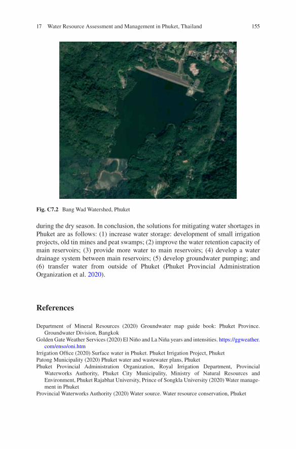
155
during the dry season. In conclusion, the solutions for mitigating water shortages in Phuket are as follows: (1) increase water storage: development of small irrigation projects, old tin mines and peat swamps; (2) improve the water retention capacity of main reservoirs; (3) provide more water to main reservoirs; (4) develop a water drainage system between main reservoirs; (5) develop groundwater pumping; and (6) transfer water from outside of Phuket (Phuket Provincial Administration Organization et al. 2020).
References
Department of Mineral Resources (2020) Groundwater map guide book: Phuket Province. Groundwater Division, Bangkok
Golden Gate Weather Services (2020) El Niño and La Niña years and intensities. https://ggweather.com/enso/oni.htm
Irrigation Office (2020) Surface water in Phuket. Phuket Irrigation Project, PhuketPatong Municipality (2020) Phuket water and wastewater plans, PhuketPhuket Provincial Administration Organization, Royal Irrigation Department, Provincial
Waterworks Authority, Phuket City Municipality, Ministry of Natural Resources and Environment, Phuket Rajabhat University, Prince of Songkla University (2020) Water manage-ment in Phuket
Provincial Waterworks Authority (2020) Water source. Water resource conservation, Phuket
Fig. C7.2 Bang Wad Watershed, Phuket
17 Water Resource Assessment and Management in Phuket, Thailand

156
Open Access This chapter is licensed under the terms of the Creative Commons Attribution 4.0 International License (http://creativecommons.org/licenses/by/4.0/), which permits use, sharing, adaptation, distribution and reproduction in any medium or format, as long as you give appropriate credit to the original author(s) and the source, provide a link to the Creative Commons license and indicate if changes were made.
The images or other third party material in this chapter are included in the chapter’s Creative Commons license, unless indicated otherwise in a credit line to the material. If material is not included in the chapter’s Creative Commons license and your intended use is not permitted by statutory regulation or exceeds the permitted use, you will need to obtain permission directly from the copyright holder.
S. Vongtanaboon
157© The Author(s) 2022T. Ito et al. (eds.), Interlocal Adaptations to Climate Change in East and Southeast Asia, SpringerBriefs in Climate Studies, https://doi.org/10.1007/978-3-030-81207-2_18
Column 8Analysis of Measures for Preventing Desertification in Inner Mongolia in China
Yulu Ma
Since the early 1990s, with the economic development and population growth, desertification has increasingly attracted the attention of governments, international organizations, and scientists around the world. The evaluation of desertification has become a new interest in land science research. Inner Mongolia is a largely deserted province in China, with the deserted land covering 640,000 km2; 91.16%, 41.4%, and 41.0% of the desertification was caused by wind erosion, water erosion, and saline desertification, respectively. Desertification is so disastrous that it can cause additional ecological problems (Liu and Wang 2006; Ye 2008). The causes of desertification in Inner Mongolia can be classified into human and natural causes. Regarding human causes, irrational irrigation methods are the main causes, mainly due to the pressure of population growth, overgrazing (Fig. C8.1), the expansion of dry land reclamation (Fig. C8.2), woodcutting, and the harvesting of Chinese herbal medicine (Fig. C8.3). Regarding natural causes, climate change and the geographi-cal environment are the main issues. Within Inner Mongolia, the arid, semi-arid, and sub-humid arid regions deep in the hinterland of the continent and far away from the ocean comprise the most arid and fragile environmental zone, which lies in the same latitude as areas with the lowest precipitation and highest evaporation. In the past 40 years, precipitation has shown a decreasing trend in parts of the arid, semi-arid, and sub-humid arid regions of Inner Mongolia, whereas the temperature in other areas has shown an increasing trend. These changes in the climate have led to an increase in evaporative power and contributed to soil salinization, which have exac-erbated desertification to a certain extent.
To avoid desertification, several measures can be taken, including planting new vegetation, practicing reasonable water use, and strengthening ecological agricul-ture construction. The favorable conditions of light and heat in the arid and
Y. Ma (*) College of Agriculture, Inner Mongolia Minzu University, Tongliao, Chinae-mail: [email protected]
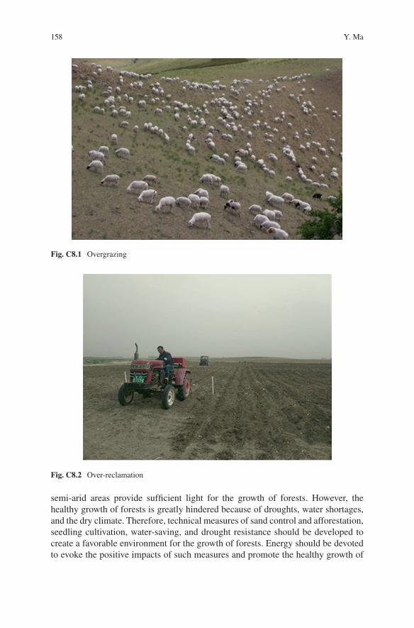
158
semi- arid areas provide sufficient light for the growth of forests. However, the healthy growth of forests is greatly hindered because of droughts, water shortages, and the dry climate. Therefore, technical measures of sand control and afforestation, seedling cultivation, water-saving, and drought resistance should be developed to create a favorable environment for the growth of forests. Energy should be devoted to evoke the positive impacts of such measures and promote the healthy growth of
Fig. C8.1 Overgrazing
Fig. C8.2 Over-reclamation
Y. Ma
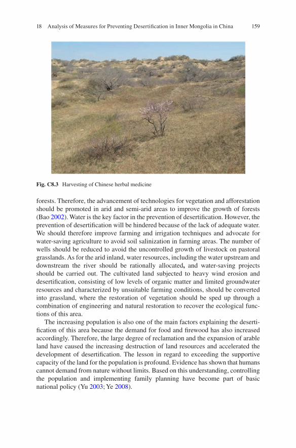
159
forests. Therefore, the advancement of technologies for vegetation and afforestation should be promoted in arid and semi-arid areas to improve the growth of forests (Bao 2002). Water is the key factor in the prevention of desertification. However, the prevention of desertification will be hindered because of the lack of adequate water. We should therefore improve farming and irrigation techniques and advocate for water-saving agriculture to avoid soil salinization in farming areas. The number of wells should be reduced to avoid the uncontrolled growth of livestock on pastoral grasslands. As for the arid inland, water resources, including the water upstream and downstream the river should be rationally allocated, and water-saving projects should be carried out. The cultivated land subjected to heavy wind erosion and desertification, consisting of low levels of organic matter and limited groundwater resources and characterized by unsuitable farming conditions, should be converted into grassland, where the restoration of vegetation should be sped up through a combination of engineering and natural restoration to recover the ecological func-tions of this area.
The increasing population is also one of the main factors explaining the deserti-fication of this area because the demand for food and firewood has also increased accordingly. Therefore, the large degree of reclamation and the expansion of arable land have caused the increasing destruction of land resources and accelerated the development of desertification. The lesson in regard to exceeding the supportive capacity of the land for the population is profound. Evidence has shown that humans cannot demand from nature without limits. Based on this understanding, controlling the population and implementing family planning have become part of basic national policy (Yu 2003; Ye 2008).
Fig. C8.3 Harvesting of Chinese herbal medicine
18 Analysis of Measures for Preventing Desertification in Inner Mongolia in China
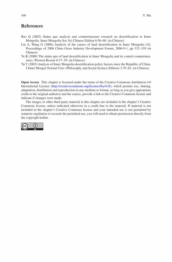
160
References
Bao Q (2002) Status quo analysis and countermeasure research on desertification in Inner Mongolia. Inner Mongolia Soc Sci Chinese Edition 6:56–60. (in Chinese)
Liu A, Wang G (2006) Analysis of the causes of land desertification in Inner Mongolia [A]. Proceedings of 2006 China Grass Industry Development Forum, 2006-9-1, pp 332–339 (in Chinese)
Ye R (2008) The status quo of land desertification in Inner Mongolia and its control countermea-sures. Western Resour 6:37–39. (in Chinese)
Yu Y (2003) Analysis of Inner Mongolia desertification policy factors since the Republic of China. J Inner Mongol Normal Univ (Philosophy and Social Science Edition) 3:79–83. (in Chinese)
Open Access This chapter is licensed under the terms of the Creative Commons Attribution 4.0 International License (http://creativecommons.org/licenses/by/4.0/), which permits use, sharing, adaptation, distribution and reproduction in any medium or format, as long as you give appropriate credit to the original author(s) and the source, provide a link to the Creative Commons license and indicate if changes were made.
The images or other third party material in this chapter are included in the chapter’s Creative Commons license, unless indicated otherwise in a credit line to the material. If material is not included in the chapter’s Creative Commons license and your intended use is not permitted by statutory regulation or exceeds the permitted use, you will need to obtain permission directly from the copyright holder.
Y. Ma
161© The Author(s) 2022T. Ito et al. (eds.), Interlocal Adaptations to Climate Change in East and Southeast Asia, SpringerBriefs in Climate Studies, https://doi.org/10.1007/978-3-030-81207-2_19
Column 9The Power of Dialogical Tools in Participatory Learning
Akihiko Kotera
How Can We Promote Dialogue?
It seems that most of the complex problems in the world are made difficult to solve by a lack of dialogue. Needless to say, “dialogue” does not immediately solve everything, but at least we can find much more hope compared with a situation without dialogue.
Participatory learning is one method for acquiring new knowledge and skills (Fig. C9.1). It is a method that emphasizes the importance of encouraging partici-pants to take spontaneous actions such as experiencing and interacting and to learn from the process by themselves. In reality, however, it is quite difficult to establish a rich dialogue between participants and the facilitators of participatory learning.
One of the factors that inhibit dialogue in participatory learning is the means of communication of scientific knowledge and information. Various devices and tools, such as geographic information maps, illustrations, and models, have been used to convey information in an easy-to-understand manner. However, in many cases, the very tools that are supposed to provide useful information unintentionally interfere with the dialogue with the participants because their expertise is not translated well. This is because the act of reading and understanding geographical maps and graphs correctly is a specialized skill that requires a certain amount of training. In addition, most tools are designed for one-way transmission of information and have not been designed to be used in dialogue. In this context, new information communication tools/interfaces such as “Tangible Bit” are expected to be utilized.
A. Kotera (*) Global and Local Environment Co-creation Institute, Ibaraki University, Ibaraki, Japane-mail: [email protected]
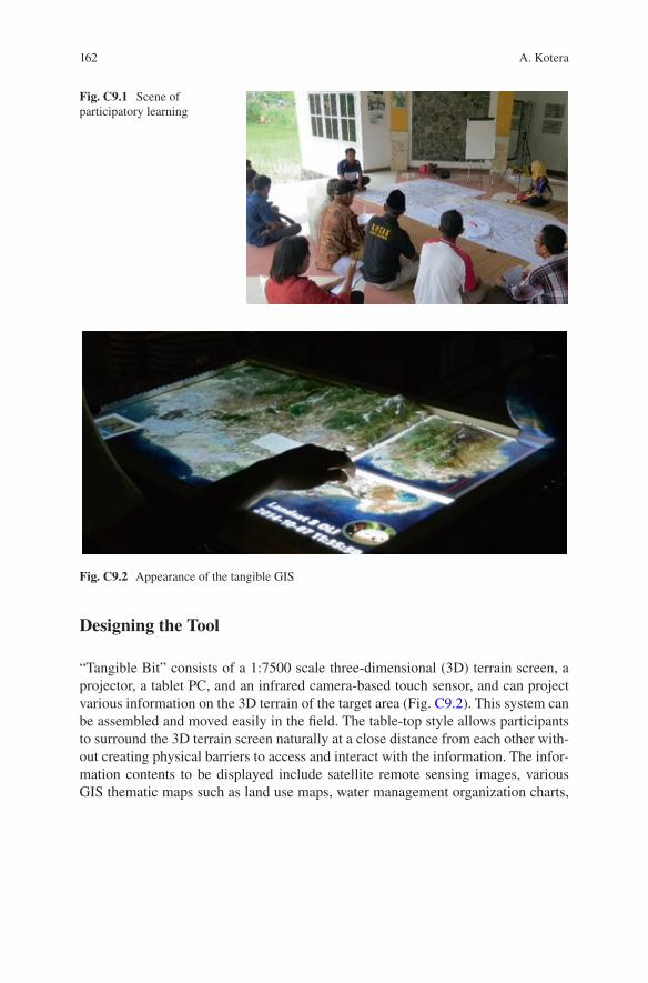
162
Designing the Tool
“Tangible Bit” consists of a 1:7500 scale three-dimensional (3D) terrain screen, a projector, a tablet PC, and an infrared camera-based touch sensor, and can project various information on the 3D terrain of the target area (Fig. C9.2). This system can be assembled and moved easily in the field. The table-top style allows participants to surround the 3D terrain screen naturally at a close distance from each other with-out creating physical barriers to access and interact with the information. The infor-mation contents to be displayed include satellite remote sensing images, various GIS thematic maps such as land use maps, water management organization charts,
Fig. C9.1 Scene of participatory learning
Fig. C9.2 Appearance of the tangible GIS
A. Kotera
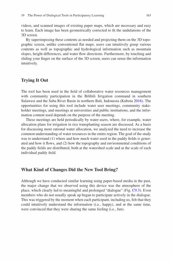
163
videos, and scanned images of existing paper maps, which are necessary and easy to learn. Each image has been geometrically corrected to fit the undulations of the 3D screen.
By superimposing these contents as needed and projecting them on the 3D topo-graphic screen, unlike conventional flat maps, users can intuitively grasp various contents as well as topographic and hydrological information such as mountain slopes, height differences, and water flow directions. Furthermore, by touching and sliding your finger on the surface of the 3D screen, users can sense the information intuitively.
Trying It Out
The tool has been used in the field of collaborative water resources management with community participation in the Bilibili Irrigation command in southern Sulawesi and the Saba River Basin in northern Bali, Indonesia (Kubota 2016). The opportunities for using this tool include water user meetings, community stake-holder meetings, and meetings at universities and public institutions, and the infor-mation content used depends on the purpose of the meeting.
These meetings are held periodically by water users, where, for example, water allocation plans for irrigation in rice transplanting season are discussed. As a basis for discussing more rational water allocation, we analyzed the need to increase the common understanding of water resources in the entire region. The goal of the study was to understand (1) where and how much water used in the paddy fields is gener-ated and how it flows, and (2) how the topography and environmental conditions of the paddy fields are distributed, both at the watershed scale and at the scale of each individual paddy field.
What Kind of Changes Did the New Tool Bring?
Although we have conducted similar learning using paper-based media in the past, the major change that we observed using this device was the atmosphere of the place, which clearly led to meaningful and prolonged “dialogue” (Fig. C9.3). Even members who do not usually speak up began to participate actively in the dialogue. This was triggered by the moment when each participant, including us, felt that they could intuitively understand the information (i.e., happy), and at the same time, were convinced that they were sharing the same feeling (i.e., fun).
19 The Power of Dialogical Tools in Participatory Learning
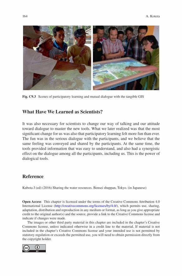
164
What Have We Learned as Scientists?
It was also necessary for scientists to change our way of talking and our attitude toward dialogue to master the new tools. What we later realized was that the most significant change for us was also that participatory learning felt more fun than ever. The fun was in the serious dialogue with the participants, and we believe that the same feeling was conveyed and shared by the participants. At the same time, the tools provided information that was easy to understand, and also had a synergistic effect on the dialogue among all the participants, including us. This is the power of dialogical tools.
Reference
Kubota J (ed) (2016) Sharing the water resources. Bensei shuppan, Tokyo. (in Japanese)
Open Access This chapter is licensed under the terms of the Creative Commons Attribution 4.0 International License (http://creativecommons.org/licenses/by/4.0/), which permits use, sharing, adaptation, distribution and reproduction in any medium or format, as long as you give appropriate credit to the original author(s) and the source, provide a link to the Creative Commons license and indicate if changes were made.
The images or other third party material in this chapter are included in the chapter’s Creative Commons license, unless indicated otherwise in a credit line to the material. If material is not included in the chapter’s Creative Commons license and your intended use is not permitted by statutory regulation or exceeds the permitted use, you will need to obtain permission directly from the copyright holder.
Fig. C9.3 Scenes of participatory learning and mutual dialogue with the tangible GIS
A. Kotera
Related Documents