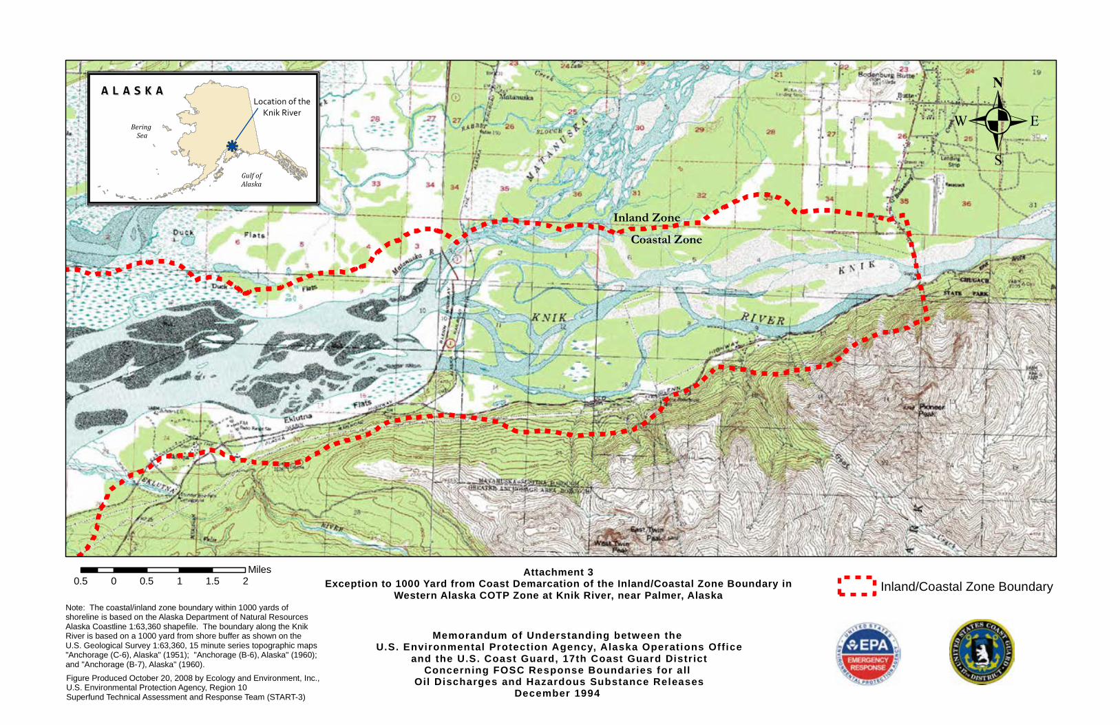
Memorandum of Understanding between the U.S. Environmental Protection Agency, Alaska Operations Office and the U.S. Coast Guard, 17th Coast Guard District Concerning FOSC Response Boundaries for all Oil Discharges and Hazardous Substance Releases December 1994 Attachment 3 Exception to 1000 Yard from Coast Demarcation of the Inland/Coastal Zone Boundary in Western Alaska COTP Zone at Knik River, near Palmer, Alaska Note: The coastal/inland zone boundary within 1000 yards of shoreline is based on the Alaska Department of Natural Resources Alaska Coastline 1:63,360 shapefile. The boundary along the Knik River is based on a 1000 yard from shore buffer as shown on the U.S. Geological Survey 1:63,360, 15 minute series topographic maps "Anchorage (C-6), Alaska" (1951); "Anchorage (B-6), Alaska" (1960); and "Anchorage (B-7), Alaska" (1960). Figure Produced October 20, 2008 by Ecology and Environment, Inc., U.S. Environmental Protection Agency, Region 10 Superfund Technical Assessment and Response Team (START-3) . 0.5 0 0.5 1 1.5 2 Miles Inland/Coastal Zone Boundary k j ALASKA ALASKA Bering Sea Gulf of Alaska Location of the Knik River Coastal Zone Inland Zone

Welcome message from author
This document is posted to help you gain knowledge. Please leave a comment to let me know what you think about it! Share it to your friends and learn new things together.
Transcript
Memorandum of Understanding between the U.S. Environmental Protection Agency, Alaska Operations Office
and the U.S. Coast Guard, 17th Coast Guard Distr ictConcerning FOSC Response Boundaries for all
Oil Discharges and Hazardous Substance ReleasesDecember 1994
Attachment 3Exception to 1000 Yard from Coast Demarcation of the Inland/Coastal Zone Boundary in
Western Alaska COTP Zone at Knik River, near Palmer, AlaskaNote: The coastal/inland zone boundary within 1000 yards ofshoreline is based on the Alaska Department of Natural ResourcesAlaska Coastline 1:63,360 shapefile. The boundary along the KnikRiver is based on a 1000 yard from shore buffer as shown on theU.S. Geological Survey 1:63,360, 15 minute series topographic maps "Anchorage (C-6), Alaska" (1951); "Anchorage (B-6), Alaska" (1960); and "Anchorage (B-7), Alaska" (1960).Figure Produced October 20, 2008 by Ecology and Environment, Inc.,U.S. Environmental Protection Agency, Region 10Superfund Technical Assessment and Response Team (START-3)
.
0.5 0 0.5 1 1.5 2Miles
Inland/Coastal Zone Boundary
kj
A L A S K AA L A S K A
Bering Sea
Gulf ofAlaska
Location of theKnik River
Coastal ZoneInland Zone
Memorandum of Understanding between the U.S. Environmental Protect ion Agency, Alaska Operations Office
and the U.S. Coast Guard, 17th Coast Guard Distr ictConcerning FOSC Response Boundaries for all
Oil Discharges and Hazardous Substance ReleasesDecember 1994
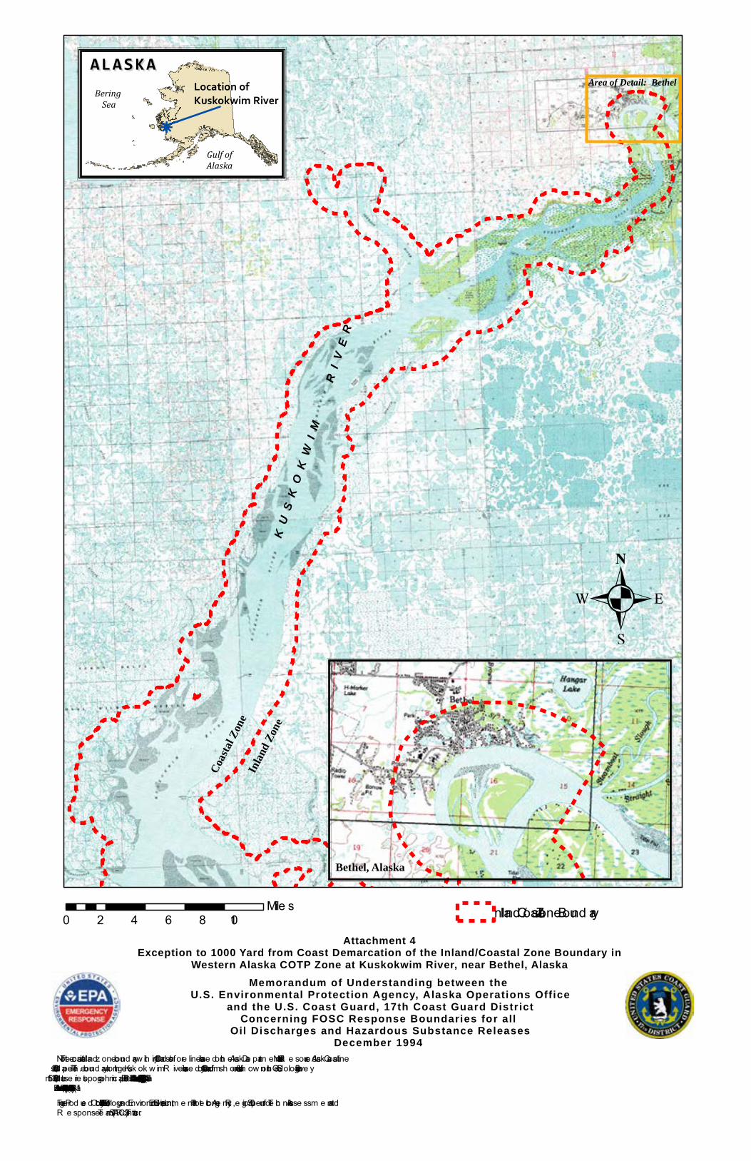
Attachment 4Exception to 1000 Yard from Coast Demarcation of the Inland/Coastal Zone Boundary in
Western Alaska COTP Zone at Kuskokwim River, near Bethel, Alaska
Note : Th e coastal/inland z one bound ary w ith in 1000 y ard s of sh ore line is base d on th e Alask a De partm e nt of Natural R e source s Alask a Coastline 1:63,360 sh ape file . Th e bound ary along th e Kusk ok w im R ive r is base d on a 1000 y ard from sh ore buffe r as sh ow n on th e U.S. Ge ological Surve y 1:63,360, 15 m inute se rie s topograph ic m aps “Be th e l (D-8), Alask a” (1954); “Be th e l (C-8), Alask a” (1954); “Baird Inle t (C-1), Alask a” (1954); “Baird Inle t (B-1), Alask a” (1954); and “Baird Inle t (B-2), Alask a” (1954). Figure Prod uce d Octobe r 24, 2008 by Ecology and Environm e nt, Inc., U.S. Environm e ntal Prote ction Age ncy , R e gion 10 Supe rfund Te ch nical Asse ssm e nt and R e sponse Te am (STAR T-3) Contractor.
0 2 4 6 8 10Mile s Inland /Coastal Zone Bound ary
k
ALASKAALASKABering
Sea
Gulf ofAlaska
Location ofKuskokwim River
.
KU
SK
OK
WI M
RI V
ER
Coast
al Zon
eInl
and Zo
ne
Area of Detail: Bethel
Bethel, Alaska

Memorandum of Understanding between the U.S. Environmental Protect ion Agency, Alaska Operations Office
and the U.S. Coast Guard, 17th Coast Guard Distr ictConcerning FOSC Response Boundaries for all
Oil Discharges and Hazardous Substance ReleasesDecember 1994
Attachment 5Exception to 1000 Yard from Coast Demarcation of the Inland/Coastal Zone Boundary in
Western Alaska COTP Zone at Kvichak River, near Levelock, Alaska
Note : Th e coastal/inland z one bound ary w ith in 1000 y ard s of sh ore line is base d on th e Alask a De partm e nt of Natural R e source s Alask a Coastline 1:63,360 sh ape file . Th e bound ary along th e Kvich ak R ive r is base d on a 1000 y ard from sh ore buffe r as sh ow n on th e U.S. Ge ological Surve y 1:63,360, 15 m inute se rie s topograph ic m aps “Dillingh am (A-3), Alask a” (1952); “Nak ne k (D-3), Alask a” (1952); and “Nak ne k (D-4), Alask a” (1952).
Figure Prod uce d Octobe r 24, 2008 by Ecology and Environm e nt, Inc., U.S. Environm e ntal Prote ction Age ncy , R e gion 10 Supe rfund Te ch nical Asse ssm e nt and R e sponse Te am (STAR T-3) Contractor.
.
0 1 2 3 4Mile s Inland /Coastal Zone Bound ary
ALASKAALASKABering
Sea
Gulf ofAlaska
Location ofKvichak River
k
Coastal Zone
Inland ZoneKvich
ak River
Memorandum of Understanding between the U.S. Environmental Protection Agency, Alaska Operations Office
and the U.S. Coast Guard, 17th Coast Guard Distr ictConcerning FOSC Response Boundaries for all
Oil Discharges and Hazardous Substance ReleasesDecember 1994
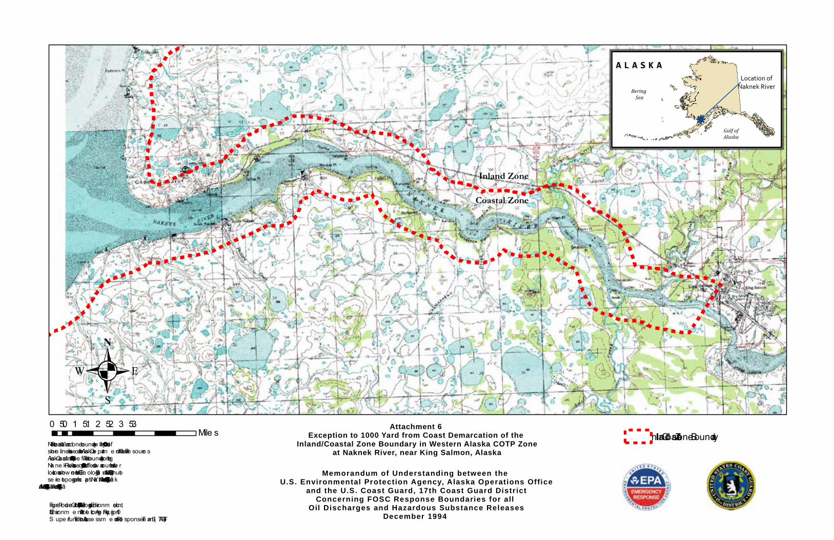
Attachment 6Exception to 1000 Yard from Coast Demarcation of the
Inland/Coastal Zone Boundary in Western Alaska COTP Zone at Naknek River, near King Salmon, Alaska
Note : The coastal/inland z one boundary w ithin 1000 yards of shore line is base d on the Alask a De partm e nt of Natural Re source s Alask a Coastline 1:63,360 shape file . The boundary along theNak ne k Rive r is base d on a 1000 yard buffe r draw n around the rive r location as show n on the U.S . Ge ological S urve y 1:63,360, 15 m inute se rie s topographic m aps “Nak ne k (C-2), Alask a” (1952); “Nak ne k (C-3), Alask a” (1952); and “Nak ne k (C-4), Alask a” (1952).
Figure Produce d Octobe r 24, 2008 by Ecology and Environm e nt, Inc.,U.S . Environm e ntal Prote ction Age ncy, Re gion 10S upe rfund Te chnical Asse ssm e nt and Re sponse Te am (S TART-3)
.Inland/Coastal Zone Boundary
kj
A L A S K AA L A S K A
Bering Sea
Gulf ofAlaska
Location ofNaknek River
Coastal Zone
Inland Zone
0 0.5 1 1.5 2 2.5 3 3.5Mile s
Memorandum of Understanding between the U.S. Environmental Protection Agency, Alaska Operations Office
and the U.S. Coast Guard, 17th Coast Guard Distr ictConcerning FOSC Response Boundaries for all
Oil Discharges and Hazardous Substance ReleasesDecember 1994
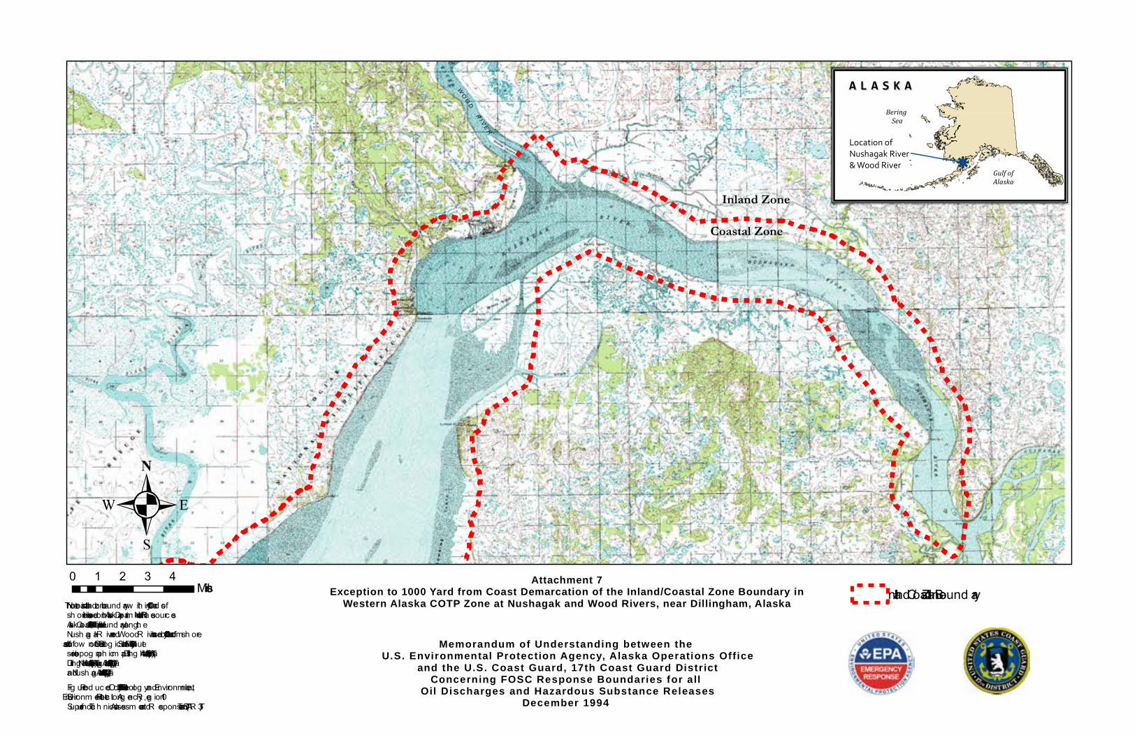
Attachment 7Exception to 1000 Yard from Coast Demarcation of the Inland/Coastal Zone Boundary in
Western Alaska COTP Zone at Nushagak and Wood Rivers, near Dillingham, AlaskaNote: Th e c oastal/inland zone bound ary w ith in 1000 y ard s ofsh oreline is based on th e Alask a Departm ent of Natural R esourc esAlask a Coastline 1:63,360 sh apefile. Th e bound ary along th eNush ag ak R iver and Wood R iver is based on a 1000 y ard from sh ore buffer as sh ow n on th e U.S. Geolog ic al Survey 1:63,360, 15 m inuteseries topog raph ic m aps “Dilling h am (A-6), Alask a” (1952); Dilling h am (A-7), Alask a” (1952); “Nush ag ak Bay (D-1), Alask a” (1952); and “Nush ag ak Bay (D-2), Alask a” (1952).Fig ure Prod uc ed Oc tober 24, 2008 by Ec olog y and Environm ent, Inc .,U.S. Environm ental Protec tion Ag enc y , R eg ion 10Superfund Tec h nic al Assessm ent and R esponse Team (STAR T-3)
.Inland /Coastal Zone Bound ary
kj
A L A S K AA L A S K ABering
Sea
Gulf ofAlaska
Location ofNushagak River & Wood River
Coastal Zone
Inland Zone
0 1 2 3 4Miles
WO O D
R I V E R
Memorandum of Understanding between the U.S. Environmental Protect ion Agency, Alaska Operations Office
and the U.S. Coast Guard, 17th Coast Guard Distr ictConcerning FOSC Response Boundaries for all
Oil Discharges and Hazardous Substance ReleasesDecember 1994
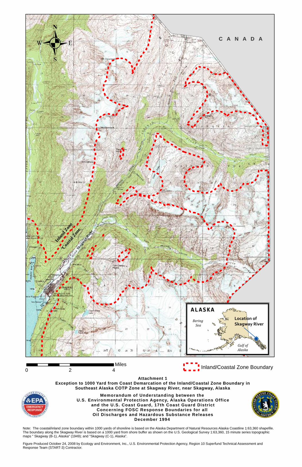
Attachment 1Exception to 1000 Yard from Coast Demarcation of the Inland/Coastal Zone Boundary in
Southeast Alaska COTP Zone at Skagway River, near Skagway, Alaska
Note: The coastal/inland zone boundary within 1000 yards of shoreline is based on the Alaska Department of Natural Resources Alaska Coastline 1:63,360 shapefile. The boundary along the Skagway River is based on a 1000 yard from shore buffer as shown on the U.S. Geological Survey 1:63,360, 15 minute series topographic maps " Skagway (B-1), Alaska" (1949); and "Skagway (C-1), Alaska".Figure Produced October 24, 2008 by Ecology and Environment, Inc., U.S. Environmental Protection Agency, Region 10 Superfund Technical Assessment and Response Team (START-3) Contractor.
0 2 4Miles Inland/Coastal Zone Boundary
k
ALASKAALASKABering
Sea
Gulf ofAlaska
Location ofSkagway River
.Inl
andZone
Coastal
ZoneSka
gway
River
C A N A D AC A N A D A
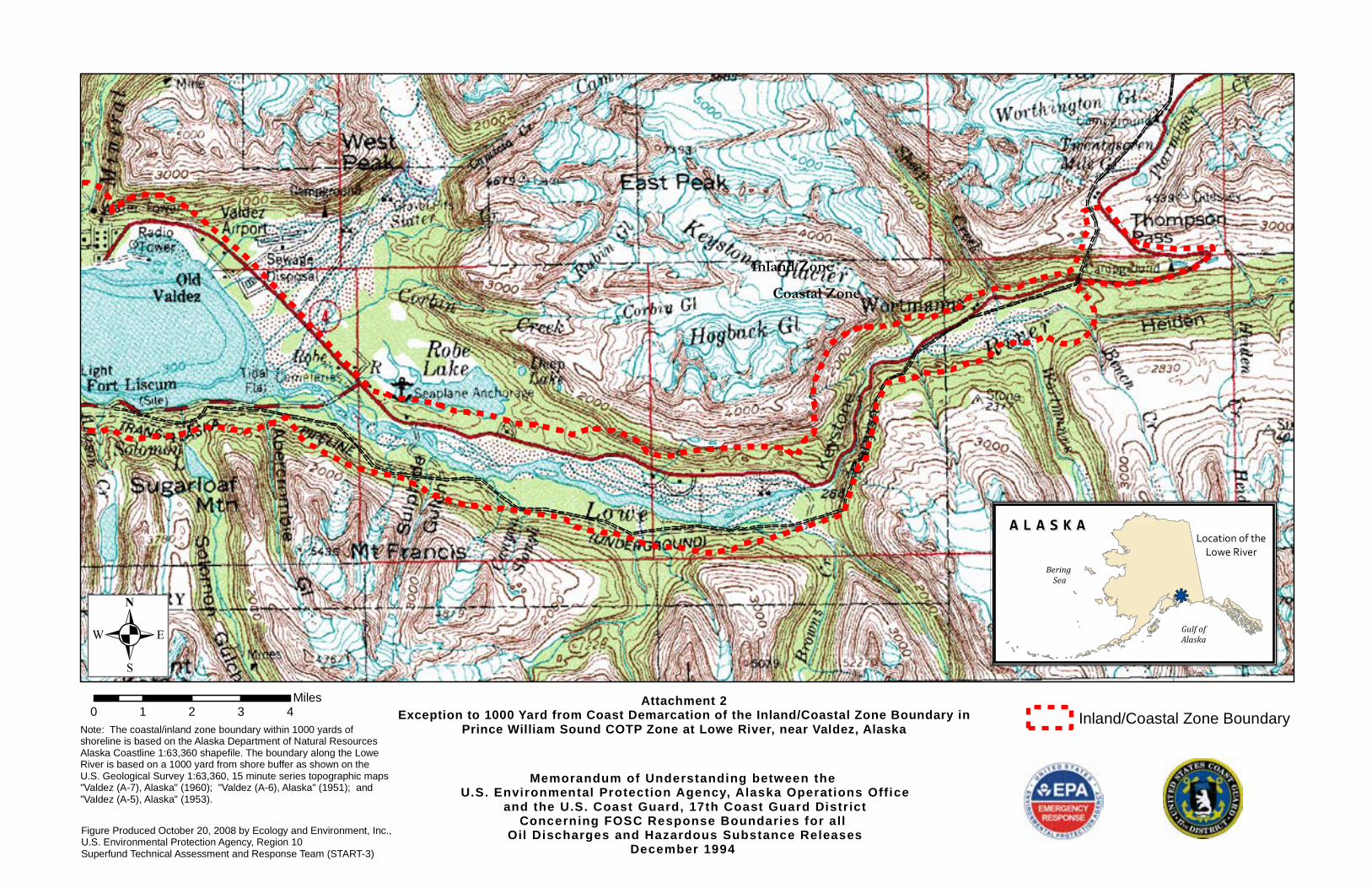
Memorandum of Understanding between the U.S. Environmental Protection Agency, Alaska Operations Office
and the U.S. Coast Guard, 17th Coast Guard Distr ictConcerning FOSC Response Boundaries for all
Oil Discharges and Hazardous Substance ReleasesDecember 1994
Attachment 2Exception to 1000 Yard from Coast Demarcation of the Inland/Coastal Zone Boundary in
Prince William Sound COTP Zone at Lowe River, near Valdez, AlaskaNote: The coastal/inland zone boundary within 1000 yards ofshoreline is based on the Alaska Department of Natural ResourcesAlaska Coastline 1:63,360 shapefile. The boundary along the LoweRiver is based on a 1000 yard from shore buffer as shown on the U.S. Geological Survey 1:63,360, 15 minute series topographic maps "Valdez (A-7), Alaska" (1960); "Valdez (A-6), Alaska" (1951); and"Valdez (A-5), Alaska" (1953).
Figure Produced October 20, 2008 by Ecology and Environment, Inc.,U.S. Environmental Protection Agency, Region 10Superfund Technical Assessment and Response Team (START-3)
0 1 2 3 4Miles
Inland/Coastal Zone Boundary
Coastal ZoneInland Zone
kj
A L A S K AA L A S K A
Bering Sea
Gulf ofAlaska
Location of theLowe River
.
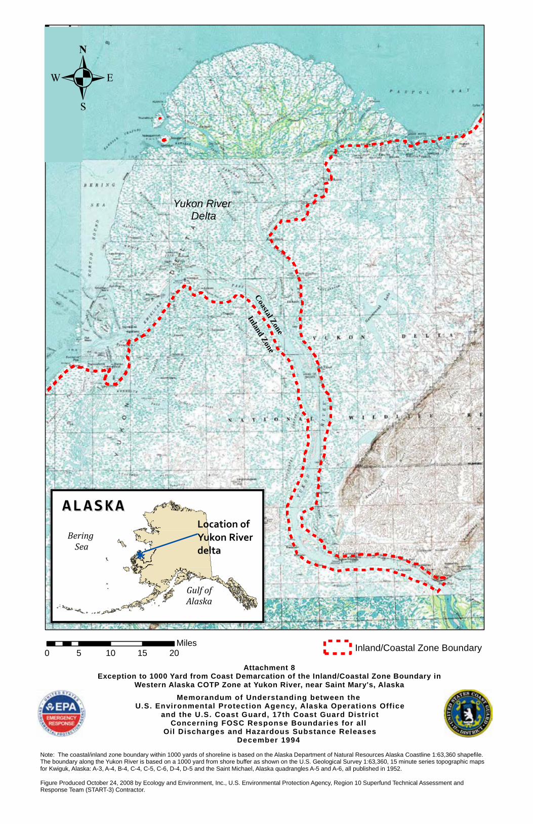
Memorandum of Understanding between the U.S. Environmental Protect ion Agency, Alaska Operations Office
and the U.S. Coast Guard, 17th Coast Guard Distr ictConcerning FOSC Response Boundaries for all
Oil Discharges and Hazardous Substance ReleasesDecember 1994
Attachment 8Exception to 1000 Yard from Coast Demarcation of the Inland/Coastal Zone Boundary in
Western Alaska COTP Zone at Yukon River, near Saint Mary's, Alaska
Note: The coastal/inland zone boundary within 1000 yards of shoreline is based on the Alaska Department of Natural Resources Alaska Coastline 1:63,360 shapefile. The boundary along the Yukon River is based on a 1000 yard from shore buffer as shown on the U.S. Geological Survey 1:63,360, 15 minute series topographic maps for Kwiguk, Alaska: A-3, A-4, B-4, C-4, C-5, C-6, D-4, D-5 and the Saint Michael, Alaska quadrangles A-5 and A-6, all published in 1952. Figure Produced October 24, 2008 by Ecology and Environment, Inc., U.S. Environmental Protection Agency, Region 10 Superfund Technical Assessment and Response Team (START-3) Contractor.
0 5 10 15 20Miles Inland/Coastal Zone Boundary
k
ALASKAALASKABering
Sea
Gulf ofAlaska
Location ofYukon River delta
Coastal Zone
Inland Zone
Yukon River Delta
.
Related Documents