Ocean & Coastal Management 48 (2005) 632–653 Coastal regulation zone rules in coastal panchayats (villages) of Kerala, India vis-a`-vis socio-economic impacts from the recently introduced peoples’ participatory program for local self-governance and sustainable development A. Ramachandran a, , B. Enserink b , A.N. Balchand c a Centre for Integrated Management of Coastal Zones, School of Industrial Fisheries, Cochin University of Science & Technology, Fine Arts Avenue, Cochin-682 016, India b Faculty of Technology, Policy and Management, Delft University of Technology, (and Centre for Integrated Management of Coastal Zones, India) P.O. Box 5015, 2600 GA Delft, The Netherlands c Centre for Integrated Management of Coastal Zones, Department of Physical Oceanography, Cochin University of Science & Technology, Fine Arts Avenue, Cochin-682 016, India Abstract Coastal Regulation Zone (CRZ) notification was issued by the Ministry of Environment and Forest of Government of India in February 1991 as a part of the Environmental Protection Act of 1986 to protect the coast from eroding and to preserve its natural resources. The initial notification did not distinguish the variability and diversity of various coastal states before enforcing it on the various states and Union Territories. Impact assessments were not carried out to assess its impact on socio-economic life of the coastal population. For the very same reason, it was unnoticed or rather ignored till 1994 when the Supreme Court of India made a land mark judgment on the fate of the coastal aquaculture which by then had established as an economically successful industry in many South Indian States. Coastal aquaculture in its modern form was a prohibited activity within CRZ. Lately, only various stakeholders of the coast realized the real impact of the CRZ rules on their property rights and ARTICLE IN PRESS www.elsevier.com/locate/ocecoaman 0964-5691/$ - see front matter r 2005 Published by Elsevier Ltd. doi:10.1016/j.ocecoaman.2005.03.011 Corresponding author. Tel.: +91 484 2354711; fax: +91 484 2365952. E-mail address: [email protected] (A. Ramachandran).

Welcome message from author
This document is posted to help you gain knowledge. Please leave a comment to let me know what you think about it! Share it to your friends and learn new things together.
Transcript
ARTICLE IN PRESS
Ocean & Coastal Management 48 (2005) 632–653
0964-5691/$ -
doi:10.1016/j
�CorrespoE-mail ad
www.elsevier.com/locate/ocecoaman
Coastal regulation zone rules in coastalpanchayats (villages) of Kerala, India vis-a-vis
socio-economic impacts from the recentlyintroduced peoples’ participatory program
for local self-governance andsustainable development
A. Ramachandrana,�, B. Enserinkb, A.N. Balchandc
aCentre for Integrated Management of Coastal Zones, School of Industrial Fisheries, Cochin University of
Science & Technology, Fine Arts Avenue, Cochin-682 016, IndiabFaculty of Technology, Policy and Management, Delft University of Technology, (and Centre for Integrated
Management of Coastal Zones, India) P.O. Box 5015, 2600 GA Delft, The NetherlandscCentre for Integrated Management of Coastal Zones, Department of Physical Oceanography, Cochin
University of Science & Technology, Fine Arts Avenue, Cochin-682 016, India
Abstract
Coastal Regulation Zone (CRZ) notification was issued by the Ministry of Environment
and Forest of Government of India in February 1991 as a part of the Environmental
Protection Act of 1986 to protect the coast from eroding and to preserve its natural resources.
The initial notification did not distinguish the variability and diversity of various coastal states
before enforcing it on the various states and Union Territories. Impact assessments were not
carried out to assess its impact on socio-economic life of the coastal population. For the very
same reason, it was unnoticed or rather ignored till 1994 when the Supreme Court of India
made a land mark judgment on the fate of the coastal aquaculture which by then had
established as an economically successful industry in many South Indian States. Coastal
aquaculture in its modern form was a prohibited activity within CRZ. Lately, only various
stakeholders of the coast realized the real impact of the CRZ rules on their property rights and
see front matter r 2005 Published by Elsevier Ltd.
.ocecoaman.2005.03.011
nding author. Tel.: +91484 2354711; fax: +91 484 2365952.
dress: [email protected] (A. Ramachandran).
ARTICLE IN PRESS
A. Ramachandran et al. / Ocean & Coastal Management 48 (2005) 632–653 633
business. To overcome the initial drawbacks several amendments were made in the regulation
to suit regional needs.
In 1995, another great transformation took place in the State of Kerala as a part of the re-
organization of the local self government institutions into a decentralized three tier
system called ‘‘Panchayathi Raj System’’. In 1997, the state government also decided to
transfer the power with the required budget outlay to the grass root level panchayats
(villages) and municipalities to plan and implement the various projects in their localities
with the full participation of the local people by constituting Grama Sabhas (Peoples’ Forum).
It is called the ‘‘Peoples’ Planning Campaign’’(Peoples’ Participatory Programme—PPP
for Local Level Self-Governance). The management of all the resources including the local
natural resources was largely decentralized to the level of local communities and villages.
Integrated, sustainable coastal zone management has become the concern of the local
population.
The paper assesses the socio-economic impact of the centrally enforced CRZ and the state
sponsored PPP on the coastal community in Kerala and suggests measures to improve the
system and living standards of the coastal people within the framework of CRZ.
r 2005 Published by Elsevier Ltd.
1. Introduction
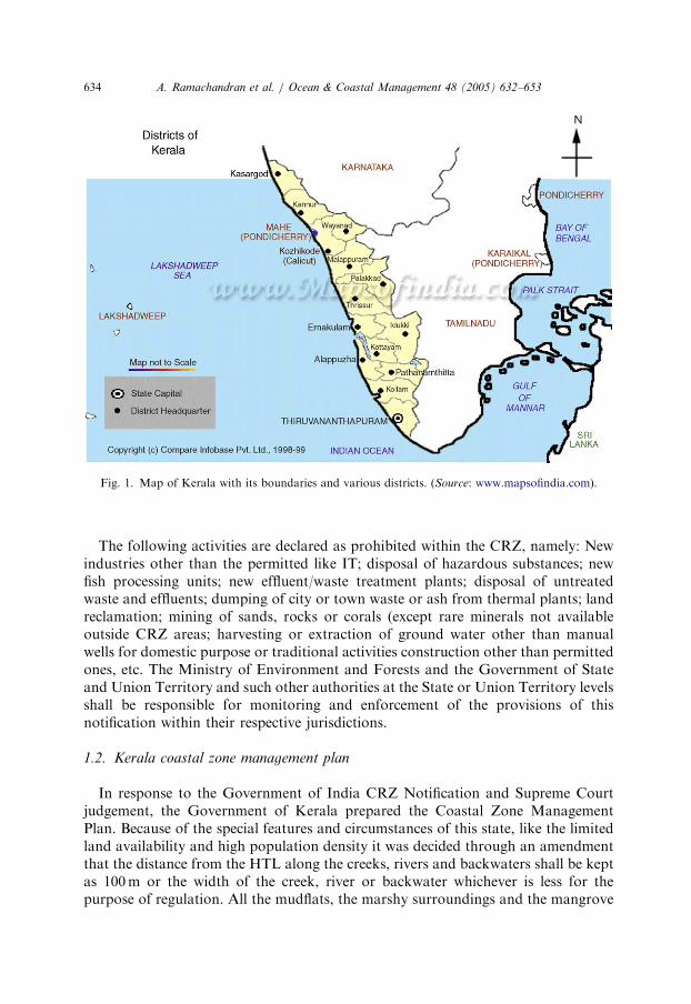
Awareness on sustainable development of the coastal belts for humanity is on theincrease [1,2]. Like in several coastal countries, many coastal zones of India too havefragile ecosystems and these continue to degrade due to human interference. Keralastate, a narrow strip of land with a mean width of only 67 km is bordered by theArabian Sea on the west and the Western Ghats on the east (Fig. 1). The total lengthof coastline is 560 km. Kerala has some 6250 sq km of brackish water area includingmarshes, backwaters, mangroves, inter and sub-tidal zones. This is a good feedingand nursery ground for a variety of commercially important fish, prawns, crabs andseveral marine organisms. These waters are also used extensively for inlandtransportation and were once blessed with mangroves. The state has a population of31 million as per the latest census (2001). As most people live in the coastal area,population pressure is even higher and economic and subsistence activity infringe onthe environmental quality of the region.
1.1. Coastal zone management
The Government of India, in 1991, issued a major notification under theEnvironment Protection Act, 1986, framing rules for regulation of various coastalzone activities. These rules are called the Coastal Regulation Zone (CRZ) rules.Under these Rules, the entire coastal stretch from the lowest low tide to highest hightide line and the coastal land within 500m from the high tide line on the landwardside is termed as CRZ. The latter is classified into four categories depending onthe sensitivity of the zones. Prohibited and regulated activities have been listed foreach zone.
ARTICLE IN PRESS
Fig. 1. Map of Kerala with its boundaries and various districts. (Source: www.mapsofindia.com).
A. Ramachandran et al. / Ocean & Coastal Management 48 (2005) 632–653634
The following activities are declared as prohibited within the CRZ, namely: Newindustries other than the permitted like IT; disposal of hazardous substances; newfish processing units; new effluent/waste treatment plants; disposal of untreatedwaste and effluents; dumping of city or town waste or ash from thermal plants; landreclamation; mining of sands, rocks or corals (except rare minerals not availableoutside CRZ areas; harvesting or extraction of ground water other than manualwells for domestic purpose or traditional activities construction other than permittedones, etc. The Ministry of Environment and Forests and the Government of Stateand Union Territory and such other authorities at the State or Union Territory levelsshall be responsible for monitoring and enforcement of the provisions of thisnotification within their respective jurisdictions.
1.2. Kerala coastal zone management plan
In response to the Government of India CRZ Notification and Supreme Courtjudgement, the Government of Kerala prepared the Coastal Zone ManagementPlan. Because of the special features and circumstances of this state, like the limitedland availability and high population density it was decided through an amendmentthat the distance from the HTL along the creeks, rivers and backwaters shall be keptas 100m or the width of the creek, river or backwater whichever is less for thepurpose of regulation. All the mudflats, the marshy surroundings and the mangrove
ARTICLE IN PRESS
A. Ramachandran et al. / Ocean & Coastal Management 48 (2005) 632–653 635
ecosystem have been classified as CRZ-I. A buffer zone of 50m distance belt aroundthem will be maintained even if the width of the creek, backwater and river is lessthan 50m. Reclamation is not permitted, nor shall there be any construction onlands reclaimed after February 1991. Dredging is allowed, but the land formed as aresult of dumping of the dredged materials should not be used for developmentactivities. Dredged materials are not allowed to be dumped in the CRZ areas. Onlyrare minerals not available outside the CRZ areas are allowed to be mined. Noreclamation of kayals (backwaters) will be permitted within the CRZ areas. Nocoastal roads or railways are permitted in CRZ-I. (Letter No. J-1711/23/92-IA-III,Dated 27th September 1996, issued by the Government of India & draft notificationS.O. 51 (E) dated 11-1-2002)
With this regulation in force the State Government and the Local bodies are liableto follow the guidelines while granting sanction for any developmental activities intheir territory. Also, the State Governments and Union Territories have toimplement and monitor the whole process. A State level committee has beenconstituted in each and every state to monitor the various processes and to attend tothe grievances. The Local Self-Governments (villages, municipalities or cities) are theactual bodies to practice the various regulations when sanctioning any developmentactivities including the construction of dwelling houses, factories or any resort. Thelocal people who were already living in the CRZ have to abide by the newregulations whenever they are planning modifications to their buildings or conductreconstruction. The investors in the unoccupied or vacant private lands in the CRZare the real losers as they may not be able to use these lands for any future projects oftheir choice. Thus Local Self-Governments in the coastal belt have to plan all thedevelopment projects within the framework of CRZ.
1.3. Peoples’ participatory programme (PPP) for self-governance of local
governments
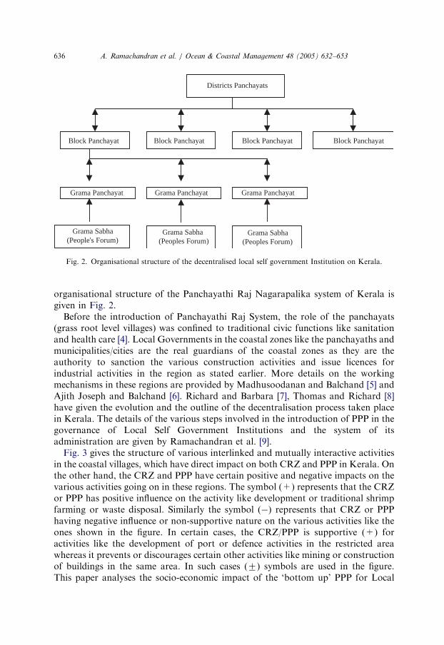
In deep contrast to the top-down instituted CRZ regulations are the ‘‘PanchayathiRaj Nagarapalika’’ Legislation and the subsequent administrative reforms that leadto decentralisation of powers and empowerment of local bodies or localGovernments. This was mooted by the Planning Board of Kerala State in 1995[3]. PPP first started in the year 1997–98, which was one of experimentation followedby a year of rectification of weaknesses and defects. Based on the Panchayathi RajNagarapalika Legislations, the powers for local administrations and governancewere transferred to a three-tier administrative set up. The base unit of development isthe grama panchayat. Few grama panchayats in an area constitute a blockpanchayat and few block panchayats in turn constitutes a district panchayat. Nowthere are 991 grama panchayats, 152 block panchayats and 14 District panchayat inKerala State. This three-tier panchayathi raj system came into existence in Kerala on2nd October 1995. Besides these rural local bodies, there are 52 municipal councilsand 5 municipal corporations in the state. The average population in gramapanchayat and municipality were 25,199 and 48,785 (1991 census) respectively. The
ARTICLE IN PRESS
Districts Panchayats
Block Panchayat Block Panchayat Block Panchayat Block Panchayat
Grama Panchayat Grama Panchayat Grama Panchayat
Grama Sabha Grama Sabha Grama Sabha(People's Forum) (Peoples Forum) (Peoples Forum)
Fig. 2. Organisational structure of the decentralised local self government Institution on Kerala.
A. Ramachandran et al. / Ocean & Coastal Management 48 (2005) 632–653636
organisational structure of the Panchayathi Raj Nagarapalika system of Kerala isgiven in Fig. 2.
Before the introduction of Panchayathi Raj System, the role of the panchayats(grass root level villages) was confined to traditional civic functions like sanitationand health care [4]. Local Governments in the coastal zones like the panchayaths andmunicipalities/cities are the real guardians of the coastal zones as they are theauthority to sanction the various construction activities and issue licences forindustrial activities in the region as stated earlier. More details on the workingmechanisms in these regions are provided by Madhusoodanan and Balchand [5] andAjith Joseph and Balchand [6]. Richard and Barbara [7], Thomas and Richard [8]have given the evolution and the outline of the decentralisation process taken placein Kerala. The details of the various steps involved in the introduction of PPP in thegovernance of Local Self Government Institutions and the system of itsadministration are given by Ramachandran et al. [9].
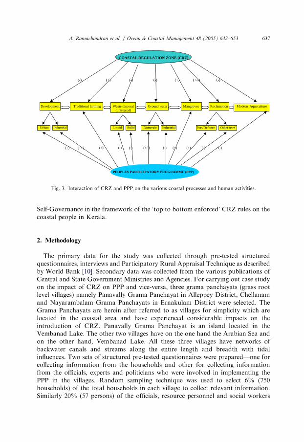
Fig. 3 gives the structure of various interlinked and mutually interactive activitiesin the coastal villages, which have direct impact on both CRZ and PPP in Kerala. Onthe other hand, the CRZ and PPP have certain positive and negative impacts on thevarious activities going on in these regions. The symbol (+) represents that the CRZor PPP has positive influence on the activity like development or traditional shrimpfarming or waste disposal. Similarly the symbol (�) represents that CRZ or PPPhaving negative influence or non-supportive nature on the various activities like theones shown in the figure. In certain cases, the CRZ/PPP is supportive (+) foractivities like the development of port or defence activities in the restricted areawhereas it prevents or discourages certain other activities like mining or constructionof buildings in the same area. In such cases (7) symbols are used in the figure.This paper analyses the socio-economic impact of the ‘bottom up’ PPP for Local
ARTICLE IN PRESS
COASTAL REGULATION ZONE (CRZ)
(-) (+) (-) (-) (+) (+/-) (-)
Development Traditional farming Waste disposal Ground water Mangroves Reclamation Modern Aquaculture(untreated)
Urban Industrial Liquid Solid Domestic Industrial Port/Defence Other uses
(+) (+/-) (+) (-) (-) (+/-) (-) (+) (+) (-) (-)
PEOPLES PARTICIPATORY PROGRAMME (PPP)
Fig. 3. Interaction of CRZ and PPP on the various coastal processes and human activities.
A. Ramachandran et al. / Ocean & Coastal Management 48 (2005) 632–653 637
Self-Governance in the framework of the ‘top to bottom enforced’ CRZ rules on thecoastal people in Kerala.
2. Methodology
The primary data for the study was collected through pre-tested structuredquestionnaires, interviews and Participatory Rural Appraisal Technique as describedby World Bank [10]. Secondary data was collected from the various publications ofCentral and State Government Ministries and Agencies. For carrying out case studyon the impact of CRZ on PPP and vice-versa, three grama panchayats (grass rootlevel villages) namely Panavally Grama Panchayat in Alleppey District, Chellanamand Nayarambalam Grama Panchayats in Ernakulam District were selected. TheGrama Panchayats are herein after referred to as villages for simplicity which arelocated in the coastal area and have experienced considerable impacts on theintroduction of CRZ. Panavally Grama Panchayat is an island located in theVembanad Lake. The other two villages have on the one hand the Arabian Sea andon the other hand, Vembanad Lake. All these three villages have networks ofbackwater canals and streams along the entire length and breadth with tidalinfluences. Two sets of structured pre-tested questionnaires were prepared—one forcollecting information from the households and other for collecting informationfrom the officials, experts and politicians who were involved in implementing thePPP in the villages. Random sampling technique was used to select 6% (750households) of the total households in each village to collect relevant information.Similarly 20% (57 persons) of the officials, resource personnel and social workers
ARTICLE IN PRESS
A. Ramachandran et al. / Ocean & Coastal Management 48 (2005) 632–653638
involved in the implementation of the PPP in the villages were selected forinterviewing and collecting data.
3. Observation, results and discussion
3.1. Kerala state and case study
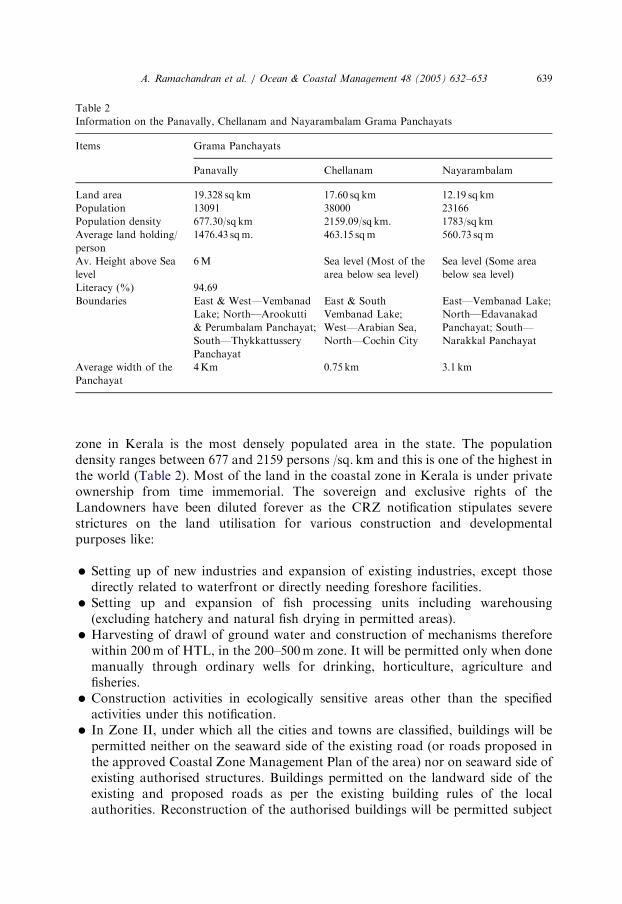
The general information of the state is given in Table 1. The coastal area is having ahigher density of population than the state average. This area is more dynamic and isused by several stakeholders for multiple purposes from ancient times. This alsostimulates competition for utilising the resources and hence, obviously results inmulti-user conflicts. More detailed information on the three villages selected for thecase study is given in Table 2. Population density in Nayarambalam and Chellanamvillages are more than double the population density of the state. The Insularity Indexof the State is worked out to be 0.0144. Gommes et al. [11] report that the averageand median values of Insularity Index for Asia are 0.611 and 0.0226, respectively.Similarly the global average and median values are 0.272 and 0.0077. This showspositive skewness of the values in which the large difference between median andaverage is due to the occurrence of a limited number of very high values. They havealso reported the co-relation between the insularity and the population density. Theless insular countries are claimed to have less population [11]. However, Kerala fallsfar below the Asian and global averages and still have very high population density.
3.2. Impact on property rights
The most important single impact of the CRZ declaration is the change in theproperty rights of the land holdings in the coastal zone. As already stated, the coastal
Table 1
General information of the State of Kerala
Items Units
Land area 38,828 sq km
Continental shelf 40,000 sq km
Territorial sea (up to) 12 nautical miles 13,000 sq km
Population (2001) 31 million
Population density per sq. km 798.39
Coast line 560 km
Average breath of the state 67 km
Brackish water estuary having tidal influence 30 Rivers 44
West flowing (to Arabian Sea) rivers 41
Fishermen who live in the coastal belt 7,70,000
Active fishermen 2,00,000
No. of coastal districts 9 out of 14
Insularity index (Coastline/Land area) 0.0144
ARTICLE IN PRESS
Table 2
Information on the Panavally, Chellanam and Nayarambalam Grama Panchayats
Items Grama Panchayats
Panavally Chellanam Nayarambalam
Land area 19.328 sq km 17.60 sq km 12.19 sq km
Population 13091 38000 23166
Population density 677.30/sq km 2159.09/sq km. 1783/sq km
Average land holding/
person
1476.43 sqm. 463.15 sqm 560.73 sqm
Av. Height above Sea
level
6M Sea level (Most of the
area below sea level)
Sea level (Some area
below sea level)
Literacy (%) 94.69
Boundaries East & West—Vembanad
Lake; North—Arookutti
& Perumbalam Panchayat;
South—Thykkattussery
Panchayat
East & South
Vembanad Lake;
West—Arabian Sea,
North—Cochin City
East—Vembanad Lake;
North—Edavanakad
Panchayat; South—
Narakkal Panchayat
Average width of the
Panchayat
4Km 0.75 km 3.1 km
A. Ramachandran et al. / Ocean & Coastal Management 48 (2005) 632–653 639
zone in Kerala is the most densely populated area in the state. The populationdensity ranges between 677 and 2159 persons /sq. km and this is one of the highest inthe world (Table 2). Most of the land in the coastal zone in Kerala is under privateownership from time immemorial. The sovereign and exclusive rights of theLandowners have been diluted forever as the CRZ notification stipulates severestrictures on the land utilisation for various construction and developmentalpurposes like:
�
Setting up of new industries and expansion of existing industries, except thosedirectly related to waterfront or directly needing foreshore facilities.�
Setting up and expansion of fish processing units including warehousing(excluding hatchery and natural fish drying in permitted areas).�
Harvesting of drawl of ground water and construction of mechanisms thereforewithin 200m of HTL, in the 200–500m zone. It will be permitted only when donemanually through ordinary wells for drinking, horticulture, agriculture andfisheries.�
Construction activities in ecologically sensitive areas other than the specifiedactivities under this notification.�
In Zone II, under which all the cities and towns are classified, buildings will bepermitted neither on the seaward side of the existing road (or roads proposed inthe approved Coastal Zone Management Plan of the area) nor on seaward side ofexisting authorised structures. Buildings permitted on the landward side of theexisting and proposed roads as per the existing building rules of the localauthorities. Reconstruction of the authorised buildings will be permitted subject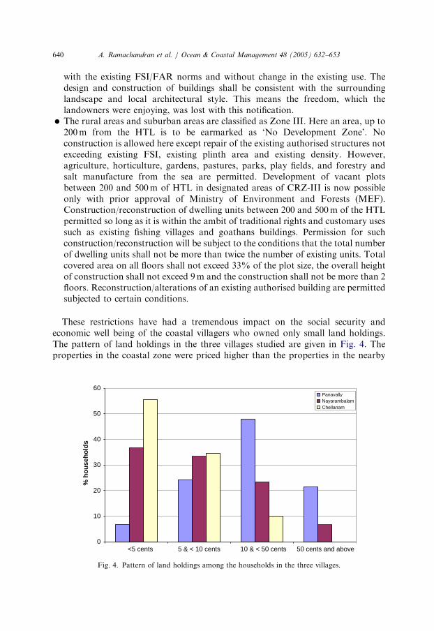
ARTICLE IN PRESS
A. Ramachandran et al. / Ocean & Coastal Management 48 (2005) 632–653640
with the existing FSI/FAR norms and without change in the existing use. Thedesign and construction of buildings shall be consistent with the surroundinglandscape and local architectural style. This means the freedom, which thelandowners were enjoying, was lost with this notification.
�
The rural areas and suburban areas are classified as Zone III. Here an area, up to200m from the HTL is to be earmarked as ‘No Development Zone’. Noconstruction is allowed here except repair of the existing authorised structures notexceeding existing FSI, existing plinth area and existing density. However,agriculture, horticulture, gardens, pastures, parks, play fields, and forestry andsalt manufacture from the sea are permitted. Development of vacant plotsbetween 200 and 500m of HTL in designated areas of CRZ-III is now possibleonly with prior approval of Ministry of Environment and Forests (MEF).Construction/reconstruction of dwelling units between 200 and 500m of the HTLpermitted so long as it is within the ambit of traditional rights and customary usessuch as existing fishing villages and goathans buildings. Permission for suchconstruction/reconstruction will be subject to the conditions that the total numberof dwelling units shall not be more than twice the number of existing units. Totalcovered area on all floors shall not exceed 33% of the plot size, the overall heightof construction shall not exceed 9m and the construction shall not be more than 2floors. Reconstruction/alterations of an existing authorised building are permittedsubjected to certain conditions.These restrictions have had a tremendous impact on the social security andeconomic well being of the coastal villagers who owned only small land holdings.The pattern of land holdings in the three villages studied are given in Fig. 4. Theproperties in the coastal zone were priced higher than the properties in the nearby
0
10
20
30
40
50
60
<5 cents 5 & < 10 cents 10 & < 50 cents 50 cents and above
% h
ou
seh
old
s
PanavallyNayarambalamChellanam
Fig. 4. Pattern of land holdings among the households in the three villages.
ARTICLE IN PRESS
A. Ramachandran et al. / Ocean & Coastal Management 48 (2005) 632–653 641
area before the enforcement of CRZ. During the survey, interviews and workshops,the authors could understand that the lands close to sea or backwaters were rated ata premium and the price before these regulations were imposed were runningbetween Indian Rs. 20,000 to Rs. 1,50,000 (US $444 to 3333) for approx. 40 sqm.Now there are no takers for the land properties in the coastal zones even at throw-away prices. The restrictions have put them in a fix and no economic activity otherthan conventional agriculture, animal husbandry and traditional fisheries areallowed as listed above. But these permitted activities are now economically notproductive (and declining) due to various reasons described elsewhere. This has beenthe main negative impact of CRZ on the economic growth of the villages in thecoastal belt.
3.3. Change in land use pattern
Over the years, the changes in the land use pattern in the coastal belt has beencreating considerable negative effects on the ecology and sustainability of theecosystem. The three panchayats studied have indicated a similar transition over theyears as far as the agriculture practices and land utilisation is concerned. All thepanchayats, in general and the Panavally and the Nayarambalam Grama Panchayats,in particular, had well-established practices in coconut plantation and paddycultivation. It is estimated that about 75% of the agricultural land were used forcoconut cultivation in Panavally [12]. More recently the unscientific cultivationpractices and poor breeds have considerably reduced the yield from this crop. Thecoconut plantation is also affected with several types of infections. It was estimated thatTaycattucherry Block under which the Panavally Grama Panchayat is located, alonehad 19.50 sqkm of paddy fields and 108.95 sqkm of other agriculture lands during thebeginning of the century according to the government documents [12]. Now about 43%of the paddy fields have already been converted for construction of buildings or forplanting other crops (just prior to introduction of CRZ). Till the introduction of CRZand PPP most of the remaining agricultural fields were either not cultivated due tovarious reasons like high production costs or non-availability of farm labour inaddition to the scope for selling these lands at high prices for various developmentalconstruction purposes. Coconut and paddy cultivation as an occupation has now beenreduced to 11.7% and 10%, respectively. This change in agriculture practice hasdefinitely affected the ground water sources too. The paddy cultivation facilitates forfresh water infiltration to the ground, which prevents saline water intrusion. Now, withthe change in cropping pattern and agricultural practices, coupled with the constructionof dams in high ranges, the farmers in the coastal belts have to pump water from theground. This has resulted in the establishment of more and more bore wells, which inturn has seriously affected the (fresh) water table of the region.
The intervening fresh water canals and ponds were once the storehouses of freshwater for various agriculture purposes, especially paddy cultivation and coconutplantations. However, with changes in the joint family system and the fragmentationof the families into small units, the division of land holdings of the joint familiesultimately led to the fill-up of canals and ponds for the construction of new dwelling
ARTICLE IN PRESS
A. Ramachandran et al. / Ocean & Coastal Management 48 (2005) 632–653642
houses—a good example is noticed at Nayarambalam, one among the seven gramapanchayats of Vypeen Block Panchayat. Vypeen Island is considered to be the mostdensely populated island in the world with a population of 2,158 persons/sq km [13].It is to be remembered that the density of population in The Netherlands is only 370/sq km and that of the United Kingdom, 240/sq km. The global population densityaccording to the United Nations is only 39/sq km.
The Pokkali paddy cultivation was very common along the ridges of the land andinter-tidal areas in all the coastal Kerala villages during rainy season. This preventedthe intrusion of saline waters into the land. These fields are now mainly used forprawn filtration by constructing sluices on the bunds of the fields and letting in sea/brackish water. This, over the years has had some definite effect on the saltwaterintrusion into the land and the inland water bodies close to the shore. With theintroduction of PPP there is an increasing awareness among the people to restartpaddy cultivation in the fields by encouraging active participation from the public,availing development support from the villages. More projects are now identifiedand implemented to rejuvenate the lost glory in agriculture, especially paddycultivation by providing financial support through the decentralised planningprocess. CRZ, of course has prevented the remaining coastal zone land from beingconverted for any industrial or construction purpose. According to CRZ rules theselands can be used only for traditional activities and for setting up of very selectedindustrial units like IT companies, which do not alter the coastal ecosystem orpollute it. The CRZ and PPP have also triggered the proper implementation of LandUtilisation Act by the concerned authorities whereever required, which was mainlydesigned for the midland and highland usage.
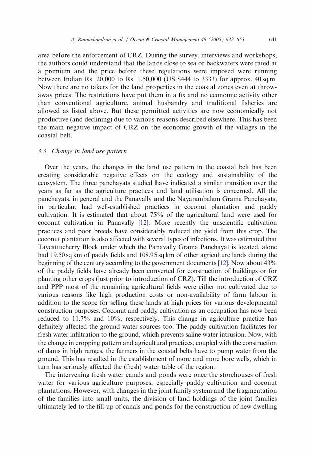
Fig. 5 shows the pattern of occupation among the villagers at present, in the threevillages studied. Only a negligible percentage of the population now lives on coconut
0
10
20
30
40
50
60
70
Agriculture Fishing Fish culture others
% p
eop
le
NayarambalamChellanamPanavally
Fig. 5. Pattern of occupation among the villagers in the three villages.
ARTICLE IN PRESS
A. Ramachandran et al. / Ocean & Coastal Management 48 (2005) 632–653 643
or paddy cultivation. Currently, agriculture has shrunken into a minor sectoroffering limited employment. In all the three panchayats there has been a transitionover the years in employment opportunities and the land use pattern from theagriculture oriented to fishery or fishery related activities like fishing, shrimp farmingor fish processing, which has improved considerably. Pokkali paddy fields had beennow converted into full time prawn farming units in some places which has resultedin severe conflicts between the fishermen and the agriculture labourers, of coursewith the blessings of various trade unions and political parties. This was because,agriculture as a commercial activity is not income generating as the production costsespecially that of labour, had gone up in the recent times; whereas, the prawnfarming results in more income generation due to its very high export demand.
3.4. Physical achievements during the first two years of introduction of PPP
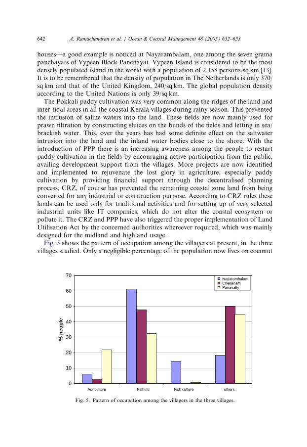
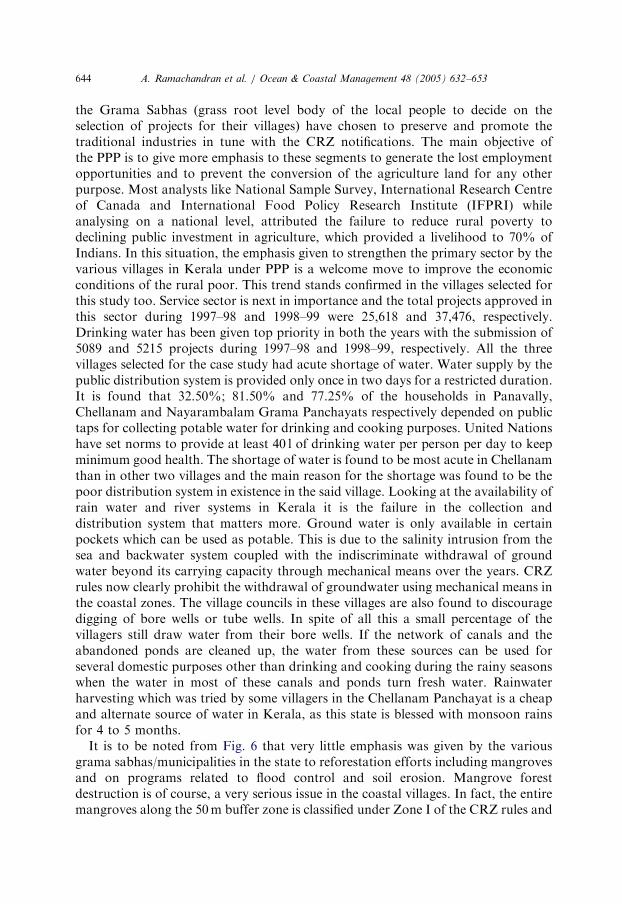
In this section on PPP, of the total 1,01,554 projects approved in the productive,infrastructure and service sectors by the Local Bodies in Kerala during 1998–99,32,585 projects were in the productive sector. Out of the total projects, 73,548 werethe proposals from the grama panchayats (villages). Fig. 6 shows the percentageallocation of the financial outlay during 1997–98 and 1998–99 in the whole of Keralain the Productive Sector under PPP. Major allocation was given in both the years topromote projects in the agriculture, animal husbandry and fisheries. This shows that
64.18
0.38 0.54
7.46
15.59
0.58
11.25
46.8
0.16 0.8
12.9
20.8
2.4
16.1
0
10
20
30
40
50
60
70
Agriculture,Animal
Husbandry &Fisheries
Afforestation Co-operation(Agriculture &
allied)
Soil & WaterConservation
Minor Irrigation Flood Control Small Scale &Traditionalindustries
%
Outlay -1997-98
Outlay - 1998-99
Fig. 6. Pattern of allocation of financial outlay of Productive Sector in Kerala during 1997–98 and
1998–99.
ARTICLE IN PRESS
A. Ramachandran et al. / Ocean & Coastal Management 48 (2005) 632–653644
the Grama Sabhas (grass root level body of the local people to decide on theselection of projects for their villages) have chosen to preserve and promote thetraditional industries in tune with the CRZ notifications. The main objective ofthe PPP is to give more emphasis to these segments to generate the lost employmentopportunities and to prevent the conversion of the agriculture land for any otherpurpose. Most analysts like National Sample Survey, International Research Centreof Canada and International Food Policy Research Institute (IFPRI) whileanalysing on a national level, attributed the failure to reduce rural poverty todeclining public investment in agriculture, which provided a livelihood to 70% ofIndians. In this situation, the emphasis given to strengthen the primary sector by thevarious villages in Kerala under PPP is a welcome move to improve the economicconditions of the rural poor. This trend stands confirmed in the villages selected forthis study too. Service sector is next in importance and the total projects approved inthis sector during 1997–98 and 1998–99 were 25,618 and 37,476, respectively.Drinking water has been given top priority in both the years with the submission of5089 and 5215 projects during 1997–98 and 1998–99, respectively. All the threevillages selected for the case study had acute shortage of water. Water supply by thepublic distribution system is provided only once in two days for a restricted duration.It is found that 32.50%; 81.50% and 77.25% of the households in Panavally,Chellanam and Nayarambalam Grama Panchayats respectively depended on publictaps for collecting potable water for drinking and cooking purposes. United Nationshave set norms to provide at least 40 l of drinking water per person per day to keepminimum good health. The shortage of water is found to be most acute in Chellanamthan in other two villages and the main reason for the shortage was found to be thepoor distribution system in existence in the said village. Looking at the availability ofrain water and river systems in Kerala it is the failure in the collection anddistribution system that matters more. Ground water is only available in certainpockets which can be used as potable. This is due to the salinity intrusion from thesea and backwater system coupled with the indiscriminate withdrawal of groundwater beyond its carrying capacity through mechanical means over the years. CRZrules now clearly prohibit the withdrawal of groundwater using mechanical means inthe coastal zones. The village councils in these villages are also found to discouragedigging of bore wells or tube wells. In spite of all this a small percentage of thevillagers still draw water from their bore wells. If the network of canals and theabandoned ponds are cleaned up, the water from these sources can be used forseveral domestic purposes other than drinking and cooking during the rainy seasonswhen the water in most of these canals and ponds turn fresh water. Rainwaterharvesting which was tried by some villagers in the Chellanam Panchayat is a cheapand alternate source of water in Kerala, as this state is blessed with monsoon rainsfor 4 to 5 months.
It is to be noted from Fig. 6 that very little emphasis was given by the variousgrama sabhas/municipalities in the state to reforestation efforts including mangrovesand on programs related to flood control and soil erosion. Mangrove forestdestruction is of course, a very serious issue in the coastal villages. In fact, the entiremangroves along the 50m buffer zone is classified under Zone I of the CRZ rules and
ARTICLE IN PRESS
A. Ramachandran et al. / Ocean & Coastal Management 48 (2005) 632–653 645
needs to be protected. No reclamation, construction or destruction is permittedunder the law. Tourism is one such industry, which was not given sufficient priorityin the plans as there were only 63 and 75 projects, respectively, during the two yearsunder analysis. The outlay for tourism was also very negligible. Taking into accountthe scope of expanding the tourism industry, the investment in this area could beenhanced substantially. This will help in augmenting the income of the villages andhelp in generating additional employment opportunities. Eco-friendly tourism haspromotional incentives in the CRZ rules and can be explored in the coastal zoneswithout much investment needs. Environment education under PPP was given onlylow priority in educating and training the public on preserving natural resource andits management. This could be taken as one of the priority segment while preparingprojects under PPP to sustain the coast and its natural resources. For instance, theunscientific harvesting of clams from the Vembanad Lake has not only affected thestock but also the stability of the islands in the lake region by enhancing siltation andsoil erosion.
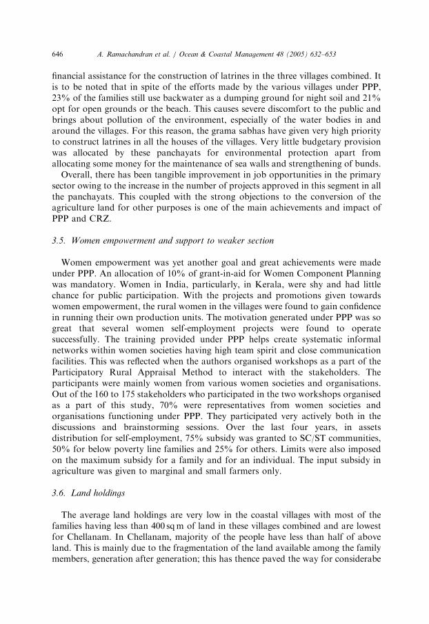
Fig. 7 shows the major achievements from the annual plans under PPP during1997–98 and 1998–99 in the state of Kerala. The agriculture and animal husbandrysectors got maximum priority in both the years at state level. The next in importancewas the construction of sanitation facilities/latrines as it poses severe social andenvironmental problems in most villages. The trend was similar in the villagesselected for case study also. About 20% of the households have been provided
1985
52125
1423
24 44124
25 10 9 3 0.81.3 0.4 0.5
815
30 45
275
27 54116
25 9 7 50
500
1000
1500
2000
2500
Benef
iciar
ies fo
rsee
ds, s
eedin
gs, f
ertili
sers
, etc.
Cow
s dist
ribut
ed
Goa
ts dis
tribu
ted
Hen
s dist
ribut
ed
New
cowsh
eds
Lat
rines
Hou
ses c
onstr
ucte
d
New
wells
Newta
ps
Pon
ds cl
eane
d
New ro
ads (
km)
New cu
lverts
New b
ridge
s
1997-98
1998-99
Selected Physical Achievement in Annual Plan during 1997-98 & 1998-99 ( in '000 Nos)
Fig. 7. Selected Physical Achievements in Annual Plan during 1997–98 and 1998–99 by the
implementation of PPP in the state.
ARTICLE IN PRESS
A. Ramachandran et al. / Ocean & Coastal Management 48 (2005) 632–653646
financial assistance for the construction of latrines in the three villages combined. Itis to be noted that in spite of the efforts made by the various villages under PPP,23% of the families still use backwater as a dumping ground for night soil and 21%opt for open grounds or the beach. This causes severe discomfort to the public andbrings about pollution of the environment, especially of the water bodies in andaround the villages. For this reason, the grama sabhas have given very high priorityto construct latrines in all the houses of the villages. Very little budgetary provisionwas allocated by these panchayats for environmental protection apart fromallocating some money for the maintenance of sea walls and strengthening of bunds.
Overall, there has been tangible improvement in job opportunities in the primarysector owing to the increase in the number of projects approved in this segment in allthe panchayats. This coupled with the strong objections to the conversion of theagriculture land for other purposes is one of the main achievements and impact ofPPP and CRZ.
3.5. Women empowerment and support to weaker section
Women empowerment was yet another goal and great achievements were madeunder PPP. An allocation of 10% of grant-in-aid for Women Component Planningwas mandatory. Women in India, particularly, in Kerala, were shy and had littlechance for public participation. With the projects and promotions given towardswomen empowerment, the rural women in the villages were found to gain confidencein running their own production units. The motivation generated under PPP was sogreat that several women self-employment projects were found to operatesuccessfully. The training provided under PPP helps create systematic informalnetworks within women societies having high team spirit and close communicationfacilities. This was reflected when the authors organised workshops as a part of theParticipatory Rural Appraisal Method to interact with the stakeholders. Theparticipants were mainly women from various women societies and organisations.Out of the 160 to 175 stakeholders who participated in the two workshops organisedas a part of this study, 70% were representatives from women societies andorganisations functioning under PPP. They participated very actively both in thediscussions and brainstorming sessions. Over the last four years, in assetsdistribution for self-employment, 75% subsidy was granted to SC/ST communities,50% for below poverty line families and 25% for others. Limits were also imposedon the maximum subsidy for a family and for an individual. The input subsidy inagriculture was given to marginal and small farmers only.
3.6. Land holdings
The average land holdings are very low in the coastal villages with most of thefamilies having less than 400 sqm of land in these villages combined and are lowestfor Chellanam. In Chellanam, majority of the people have less than half of aboveland. This is mainly due to the fragmentation of the land available among the familymembers, generation after generation; this has thence paved the way for considerabe
ARTICLE IN PRESS
A. Ramachandran et al. / Ocean & Coastal Management 48 (2005) 632–653 647
reduction in the agriculture practices in this region as it is not economical to conductagriculture in small holdings. Similarly, the people in Chellanam are relatively poorerthan in the other two villages. Further, this has resulted in the shifting of occupationand the change in the land use pattern as described elsewhere in this paper.
Since the families have very small land holdings in these panchayats (Table 2) andthe people have been staying in the CRZ areas for generations, there arises a socialproblem in the panchayats. According to the CRZ regulations, these panchayats fallin CRZ-III and 200 from the HTL which has to be maintained as ‘‘No developmentZone’’ and within 200m to 500m from the HTL, only permitted constructions canbe carried out. If we take the case of Chellanam Grama Panchayat, 70–80% of thehuman settlements fall in this zone [14]. The resultant situation is that the peoplehere cannot contemplate any future expansion programs other than conduct ofroutine repair work or avail the concessions granted to the traditional settlers forusing land for housing purposes alone. This has considerably changed the propertyrights regime in the coastal zone as stated earlier. Just because these panchayats werewrongly classified under CRZ-III of the CRZ notification instead of CRZ-II, thelocal governments are neither in a position to use their financial resources allotted tothem for local level planning and development nor the citizens who are livinghere have any opportunity to improve their standard of living. Currently,these differences are being sorted out but there has already been a set back todevelopmental activities.
With the enforcement of CRZ, there is a real positive impact on the tendency tobuild houses very close to the sea or to the backwater system. Largely, this has beenstopped and the rules adhered to by the authorities. However, our study shows thatthere are certain new constructions (violations) in the CRZ areas in these villageswithout the approval of the village authorities who are supposed to clear theseconstructions under restraint of social conflicts. This amounts to financial losses tothe village by way of non-taxing the property or buildings on one side and adverselyaffecting the overall planning of the village architecture and landscaping on the other.However, it is noticed that some of the houses which were denied construction by thepanchayats are in fact allowable as per the latest amendments in the CRZ. Accordingto the latest amendment, construction of dwelling units for use by local inhabitantsmay be permitted on a case to case basis provided that such constructions followthese conditions: the height of an individual unit shall be restricted to 4.5m; the totalplinth area shall be limited to 100 sqm; the house shall be constructed for his bonafideresidential purpose, etc. Similarly permissions can be obtained to construct dwellingunits and infrastructural facilities for the local inhabitants, housing schemes of UrbanDevelopment Authorities which had been approved prior to 19th February 1991;facilities and activities including setting up of non polluting industries in the field ofinformation technology and other service industries in the Special Economic Zonesare permitted activities. Another important amendment to CRZ-III is theconstruction of dispensaries, schools, public rain shelters, community toilets, bridges,roads and provision of facilities for water supply, drainage, sewage which arerequired for local inhabitants on a case to case basis, by the Central Government orCoastal Zone Management Authority constituted for the State/Union Territory
ARTICLE IN PRESS
A. Ramachandran et al. / Ocean & Coastal Management 48 (2005) 632–653648
(Anon., 2002). With persistent demands from the state governments, the rule fordemarcating a 100m zone on either side of the canals and rivers have been reduced to50m. This leads us to believe that even the panchayat officials are in the darkness onthe various provisions of the CRZ rules. Since CRZ is a ‘Top to Bottom’ enforcedrule, proper dialogue has not taken place among the various stakeholders and evenamong the implementing agencies. To avoid hardships to the local people, asystematic training program on the various provisions of CRZ is to be given to thelocal people along with politicians and the officials of the villages and municipalitiesby the concerned authorities. This will help ease unnecessary stress and conflicts andavoid legal battles in the villages and other local bodies.
3.7. Prawn farming and CRZ
Traditional prawn farming had been practised during summer season in all thesevillage areas after a crop of Pokalli rice cultivation which was held during the rainyseason only. This practice had been going on for the past so many years; however,with the introduction of intensive and semi-intensive prawn farming techniques inKerala and neighbouring states, yielding high profits, the situation has altogetherchanged. All these coastal farms are within the CRZ, as it required tidal waters toflush in and out of the fields, during high/low tides, to bring in and preserve thejuveniles of prawns and other fishes. During low tide, some quantum of water fromthe field will be flushed out along with the wastes and other organic debris. Thefarmers also stopped the practice of cultivating rice during the rainy season andallowed the prawn farming to continue in these fields throughout the year simply as itis more lucrative. In this process, several agriculture labourers became jobless on onehand and due to the continuous retention of saline water, pumped from the sea orcanal for longer durations, the region became more saline. Counting on the success ofprawn farming, more people started converting the traditional rice fields into prawnfarms. In some areas, where the tidal impact was less, the prawn farmers started usingmechanical pumps to siphon the saline water into the farms and waste water out of thefarms to the canals. This, the agriculture farmers and other villagers claim, did affectthe fresh water table of the region and frequent conflicts crept between agriculture andprawn farmers. Since all these activities fall in the CRZ, the Supreme Court of Indiaproclaimed a land mark judgment that no aquaculture practices should be carried outwithin CRZ other than the traditional or improved traditional practices (SupremeCourt Writ Petition (Civil) No 561 of 1994). This judgement restricts the conduct ofsemi-intensive and intensive prawn or fish farming in the CRZ area. Consequently, thefarmers who had engaged in this practice had to suffer huge economic losses.However, Kerala region was not immediately affected, as many prawn farms weretraditional ones. But this judgement has restricted further expansion of these farmswhich could have given better returns. An Aquaculture Authority Bill has now beingproposed in the Indian Parliament to formulate plans and policies related toaquaculture industry in India. Ramachandran (1995), Alagarswamy and Ramachan-dran (1995) has assessed the impact of semi-intensive and intensive prawn farmingalong the east coast of India and reported several environmental and social problems
ARTICLE IN PRESS
A. Ramachandran et al. / Ocean & Coastal Management 48 (2005) 632–653 649
related to coastal aquaculture [15–17]. The Grama Sabhas under the PPP also opposethe conversion of the Pokalli paddy fields to be used continuously for prawn farmingand are willingly giving more financial support and motivation to carry out paddycultivation during rainy season as was done in the past.
3.8. Mangroves and CRZ
Mangroves in Kerala have almost disappeared due to various anthropogenicinfluences and acts of urbanization. Reclamation of Vembanad Lake for varioushuman activities like the development of ports; dumping of dredged clay from thesea mouth and ship channels; reclamation for the construction of bridges; housing &agriculture activities; additionally, locating factories too, destroyed a considerablepart of the mangrove vegetation from this region. In addition to this, discharge ofpollutants from these factories, located in Cochin and nearby places brought aboutloss in mangroves; construction of bunds and barriers along the coast and cutting ofmangroves for fire wood over the years have drastically reduced the mangrove coverfor this region. The estuaries and backwaters of Kerala which once occupied an areaof 2426 sq km have now shrunken to 652 sq km. due to the serious alterations duringthe past 150 years through reclamation for agriculture and human settlements [18].With the introduction of CRZ, these areas have been classified under CRZ-I wheresuch activities are not permitted. With the strict enforcement of CRZ, since 1996,backed by the Supreme Court verdict, coastal villages have not allowed any furtherreclamation of backwaters. Due to the changes in the ecosystem, other land plants inthe coast have replaced the mangroves wherever open spaces were available. The ricecum prawn farms too had a greater role for the destruction of mangroves in theseregions. Reports from other regions also show that the development of shrimp farmswas fast replacing the mangrove forests before the strict implementation of CRZ.Had there not been any CRZ, the country would have lost the entire mangroveforests with the development of shrimp farms than by any other means [16,19,20]. Arecent survey by the aquaculture sector found that about 5% of the shrimpaquaculture farms in India have been constructed in former mangrove area [21].With the enforcement of CRZ, the villages surveyed were found to be very vigil inprotecting the remaining (natural) ecosystem. The environmental activism is alsovery high among people, which in return helps the panchayats to enforce the lawstrictly. It was particularly noted that a good portion of the amount sanctioned forinfrastructure building under PPP in these panchayats have been used forconstruction and strengthening of bunds to prevent further encroachment of canalsand backwaters. In addition to above, disposal facilities for liquid and solid wasteswill warrant necessary attention as such measures need to be strengthened too.
3.9. Fishing pressure
Fishing and fishery related industry is the one, which provide employment formajority of the people in these coastal villages. There was a shift for the jobopportunities from agriculture sector to fishery sector in the recent past (Fig. 5). This
ARTICLE IN PRESS
A. Ramachandran et al. / Ocean & Coastal Management 48 (2005) 632–653650
was also one of the main reasons for the changes in the land use pattern over theyears in these villages as described earlier. Kerala has 2,00,000 active fishermenengaged in daily fishing and 1,50,000 people externally engaged in fisheries activities.Fisheries sector provides job opportunities for about another 1.5 million people andcontributes to 3% of state income. The state has 28,000 non-mechanised, 17,000motorised and 7300 mechanised fishing vessels, operating mostly within the 50mdepth in the coastline. It is estimated that 8000 non-mechanised, 14,050 motorisedand 6155 mechanised vessels are held in excess of operational capacity [22]. Majorityof the fishermen in the villages use traditional fishing methods with low investment.41% of the people who are in fisheries field use stake net in these villages followed by27% Chinese net. Only 8% of the local villagers have mechanised trawlers. Sincethere is no restriction on fishing in this area by boats coming from other areas, thefishing pressure in both backwaters and the coastal sea is very high; returns onefforts have gone down considerably. There are several reports of over fishing inthese waters. Even though CRZ rules do not regulate activities in the seaward side ofthe low tide region, the Marine Fisheries Regulation Act 1980 of Government ofKerala envisages protection of all the aquatic resources and has provisions toregulate these activities. Due to poor enforcement, it has had a severe impact on thecoastal resources and the socio-economic life of the coastal people. Again,unfortunately, the PPP in these villages have not developed any strategy or planto sustain the fishery resources of this region as most of the measures are shorttermed, like distribution of nets, webbing, etc.
4. Conclusion
Kerala state has a literacy rate of 90%, which is also the highest in the country[23]. This achievement in the educational sector was achieved through a series ofplanned programmes over the past 3 decades as described by McKibben [24]. This iscomparable to several of the developed countries. The initial CRZ notification of1991 and the subsequent verdicts of the various courts in India upholding theprovisions of the CRZ had a noticeable positive impact to reduce coastal zonedestruction on one hand and at the same time had a significant negative impact onthe socio-economic life of the coastal people. The property rights and economicdevelopment in the coastal zones were severely hampered with several unrealistic andunachievable restrictions when applied with a common yardstick through out thecountry. According to Libcap and Steven (1989), just not only currently heldproperty rights stand affected, but also the credibility on application effect efficiencyand economic growth. This may also stimulate rapid exploitation and discouragetheir continued preservation [25]. Johanny Ali feels that greater the perceived risk ofloosing existing property rights, the less likely the holders of these rights will be toforego current consumption to accumulate property, thus slowing investment thatcontributes importantly to economic growth [26]. Obviously, government plays animportant role in the credibility of the persistence of property rights [27]. Theresultant conflicts and slow down of the economic activity in the coastal zone could
ARTICLE IN PRESS
A. Ramachandran et al. / Ocean & Coastal Management 48 (2005) 632–653 651
have been avoided to a greater extend if a Strategic Environmental Assessment(SEA) and EIA were carried out at the beginning. The assessment should have thecomplete integration of environmental, social and economic issues framed in aholistic manner. The analysis of this kind in India should involve systematic analysisof social, political and economic interactions with natural resources and naturalresource systems in different ecological and cultural segments. Several countries haverecognised the importance of SEA and EIA for long-term sustainability [28–34]. Atpresent, the approach of the Ministry of Environment and Forest who is responsiblefor the notifications seems to adjust to the diversity and variation by issuing requiredamendments to the various clauses to suit regional environment. Here also beforeissue of each amendment, proper SEA has to be carried out to avoid imbalance inthe region rather than yielding to political pressure.
The PPP introduced in Kerala is a unique experimentation for decentralisation andlocal level governance. This has inculcated greater socio-economic and socio-politicalstrength at grass root level in villages. The success of PPP in Kerala was due to thecreation of a social network of all the stakeholders from the Chief Minister down toground level politicians, from chief secretary to local village level clerks, fromprofessors in the universities to school teachers, from scientists to the local publiclaymen. This was made possible due to the then prevailing political environment in thestate where the state level administration and majority of the local level administrationwere in the hands of a single coalition set up. They could gear up the whole machineryof the state to motivate and train the volunteers at various levels to put into practicethe theory of peoples participation in Local Level Governance. 30,00,000 peopleparticipated in the planning and development of various development projects. 12,000task force members and experts made this possible with the training of about 1,00,000facilitators through out the state. With the initial setback in adjusting to the newenvironment, the system picked up gear subsequently to a peoples’ mass movement.The system mainly worked in a highly informal environment where several open-ended groups connected the network with linkages to other groups to perform the settasks in a congenial atmosphere. This system worked in somewhat like the modeldescribed by Rob and Laurence [35]. With local level planning and active participationfrom people, priorities stood changed. This stimulated the traditional and small-scaleindustries, which were the backbone of rural areas. FAO also has recognised that theeconomic development in the developing world is possible only through promotingprimary and small-scale sectors. However, with the change in the political scenariolately, this network seems to be loosening up and broken at several places. In order tosustain this unique and successful system beyond political barriers, the stewardship ofthe central connectors and other linking pins should be given to leaders with non-political affiliations having good command in the society.
References
[1] CEC. Communication from the commission to the council and the european parliament on the
integrated management of coastal zones. (COM 95-511). Brussels-Luxembourg: ECSC-EEC-EAEC.
1995.
ARTICLE IN PRESS
A. Ramachandran et al. / Ocean & Coastal Management 48 (2005) 632–653652
[2] United Nations. National Information Analysis Unit, Division for Sustainable Development. New
York, USA: United Nations Department of Economic and Social Affairs; 2002.
[3] Isaac T, Tharakan M. Kerala: towards a new agenda. Economics and Political Weekly 1995;30:31–2.
[4] Balchand AN, Nambisan PNK. On the integration of traditional practices in coastal zones.
Proceedings of International Symposium on Techno–Ocean’ 88, Japan, 1988; vol. A–IV(4): p. 1–13.
[5] Madhusoodanan MS, Balchand AN. Coastal zone management plans for central parts of the State of
Kerala. INCHOE’ 97, Trivandrum, India; 1997, p. 1266–273.
[6] Ajith Joseph K, Balchand AN. The application of coastal regulatory zones in coastal management—
appraisal of Indian Experience. Journal of Ocean and Coastal Management 2000;43:515–26.
[7] Richard WF, Barbara HC. The Kerala decentralisation experiment; achievements, origins, and
implications. Proceedings of the international conference on democratic decentralisation, Thiru-
vanthapuram, India; 2000.
[8] Thomas ITM, Richard WF. Local Democracy and development: the people’s campaign for
decentralised planning in Kerala, Proceedings of the international conference on democratic
decentralisation, Thiruvanthapuram, India; 2000.
[9] Ramachandran A, Balchand AN, Enserink B. Assessing the impact of public participation in coastal
zone management—An evaluation of the peoples’ participatory programmes in coastal villages in
Kerala, India, Proceedings of the international conference on impact assessment for impact
assessment, IAIA, The Hague, The Netherlands, 2002.
[10] World Bank. Notes. No. 6, Agriculture Technology and Services Division (AGRTN). Washington,
D.C.: Agriculture Technology, 1994.
[11] Gommes R, du Guerny G, Nachtergaele F, Brinkman R. Potential impacts of sea-level rise on
populations and agriculture, Food & Agriculture Organisation of the United Nations, Rome, 1998.
[12] Haridas, TK. 2002 Peoples’ planning programme—power in the hands of the people, Technical Notes
at Thykattuserry Block Panchayat, Kerala, India; 2002. p. 199.
[13] Narayanan S. Project document of 9th Five-Year Plan, Technical Notes at Vypeen Block Panchayat,
Kerala; India. 2002. p. 112.
[14] Reghu VB. 2000 Review report on peoples planning programme, Technical Notes at Chellanam
Grama Panchayat, Kerala, India; 2000. p. 16.
[15] Ramachandran A. Current issues in promotion/financing of hi-tech aquaculture Projects,
Proceedings of the third programme on hi-tech aquaculture Projects, College of Agriculture Banking,
Reserve Bank of India; Pune, India. 1995.
[16] Alagarswami K., editor., with Ramachandran A. India country case study. In: Regional study and
workshop on the environmental assessment and management of aquaculture development (TCP/
RAS/2253). NACA Environment and Aquaculture Development Series No. 1. Network of Aqua-
culture Centres in Asia and the Pacific, Bangkok, Thailand; 1995.
[17] Ramachandran A. Strategic planning to tide over the present crisis to sustain the brackish water
shrimp aquaculture industry in India, Proceedings of the second world fisheries congress, Brisbane,
Australia; 1996.
[18] George G. Report on coastal zone management of India, Report by school of industrial fisheries,
Cochin University of Science & Technology, Cochin, India. 2002.
[19] Holmgren S., editor., An environmental assessment of the Bay of Bengal Region. Swedish Centre for
Coastal Development and Management of Aquatic Resources, Bay of Bengal Programme, Madras,
India. 1994.
[20] Krishnamoorthy. Remote sensing of mangrove forests in Tamil Nadu Coast, India. Faculty of Civil
Engineering, Anna University, Madras (Thesis), India. 1995.
[21] ADB/NACA. Aquaculture sustainability and the environment. Report on a regional study and
workshop on aquaculture sustainability and the environment, Asian Development Bank and
Network of Aquaculture Centres in Asia and the Pacific, Bangkok, Thailand. 1998.
[22] Ramesh PB. Economic analysis of traditional and mechanised fishing operations along the Cochin
Coast, Report by School of Industrial Fisheries, Cochin University of Science and Technology,
Cochin, (Dissertation), India. 2001.
[23] Kerala Facts, Government of Kerala, Thiruvanthapuram; India. 2000.
ARTICLE IN PRESS
A. Ramachandran et al. / Ocean & Coastal Management 48 (2005) 632–653 653
[24] McKibben B. The Enigma of Kerala, Utne Reader, March/April, 1996.
[25] Libcap GD, Steven NW. the political economy of crude oil cartelization in the United States:
1933–1972. Journal of Economic History 1989;49:833–56.
[26] Johanny Ali D. OPEC and the price of oil: cartelization or alteration of property rights. J. Energy &
Development 1979;5:72–80.
[27] David LW, editor. The Political Economy of Property Rights—Institutional Change and Credibility
in reform of centrally planned economies. United Kingdom: Cambridge University Press; 1977 p. 363.
[28] Dixon J, Fookes T. Environmental assessment in New Zealand: prospects and practical realities.
Australian Journal of Environmental Management 1995;2:104–11.
[29] Bailey J, Dixon J. Policy Environmental Assessment. In: Petts J, editor. Handbook of Environmental
Impact Assessment. Oxford: Blackwell Science; 1999.
[30] Partidario MdR. Strategic environmental assessment—principles and potential. In: Petts J, editor.
Handbook of environmental assessment vol. I: environmental impact assessment: process, methods
and potential. Birmingham: Blackwell Science; 1999. p. 60–71.
[31] Brown A, Therival R. The Principles to guide the development of strategic environmental assessment
methodology, Impact assessment and project appraisal, Special issue: strategic environmental
assessment, planning and policy-making, 2000, vol. 18, p.183–90.
[32] Buckley R. strategic environmental assessment of policies and plans: legislation and implementation,
impact assessment and project appraisal, Special issue: strategic environmental assessment, planning
and policy-making, 2000. vol. 18. p. 209–16.
[33] Elling Bo. Integration of strategic environmental assessment into regional spatial planning, impact
assessment and project appraisal, Special issue: strategic environmental assessment, planning and
policy-making, 2000, vol. 18. p. 233–44.
[34] Freeman P, Patricia V. Strategic environmental planning in the development of country strategic
plans—a proposal, environmental policy and institutional strengthening indefinite quantity contract
(EPIQ), USAID Africa Bureau Environment Natural Resource Policy Support, III, 2000. p. 61.
[35] Rob C, Laurence P. The people who make organisations go or stop, Harward Business Review, 2002.
105–12.
Related Documents


