INFORMATION REGARDING ENVIRONMENTAL AUDIT REPORTS August 2007 VICTORIA’S AUDIT SYSTEM An environmental audit system has operated in Victoria since 1989. The Environment Protection Act 1970 (the Act) provides for the appointment by the Environment Protection Authority (EPA Victoria) of environmental auditors and the conduct of independent, high quality and rigorous environmental audits. An environmental audit is an assessment of the condition of the environment, or the nature and extent of harm (or risk of harm) posed by an industrial process or activity, waste, substance or noise. Environmental audit reports are prepared by EPA- appointed environmental auditors who are highly qualified and skilled individuals. Under the Act, the function of an environmental auditor is to conduct environmental audits and prepare environmental audit reports. Where an environmental audit is conducted to determine the condition of a site or its suitability for certain uses, an environmental auditor may issue either a certificate or statement of environmental audit. A certificate indicates that the auditor is of the opinion that the site is suitable for any beneficial use defined in the Act, whilst a statement indicates that there is some restriction on the use of the site. Any individual or organisation may engage appointed environmental auditors, who generally operate within the environmental consulting sector, to undertake environmental audits. The EPA administers the environmental audit system and ensures its ongoing integrity by assessing auditor applications and ensuring audits are independent and conducted with regard to guidelines issued by EPA. AUDIT FILES STRUCTURE Environmental audit reports are stored digitally by EPA in three parts: the audit report (part A), report appendices (part B) and, where applicable, the certificate or statement of environmental audit and an executive summary (part C). A report may be in colour and black-and-white formats. Generally, only black- and-white documents are text searchable. Report executive summaries, findings and recommendations should be read and relied upon only in the context of the document as a whole, including any appendices and, where applicable, any certificate or statement of environmental audit. AUDIT REPORT CURRENCY Audit reports are based on the conditions encountered and information reviewed at the time of preparation and do not represent any changes that may have occurred since the date of completion. As it is not possible for an audit to present all data that could be of interest to all readers, consideration should be made to any appendices or referenced documentation for further information. When information regarding the condition of a site changes from that at the time an audit report is issued, or where an administrative or computation error is identified, environmental audit reports, certificates and statements may be withdrawn or amended by an environmental auditor. Users are advised to check EPA’s website to ensure the currency of the audit document. PDF SEARCHABILITY AND PRINTING EPA Victoria can only certify the accuracy and correctness of the audit report and appendices as presented in the hardcopy format. EPA is not responsible for any issues that arise due to problems with PDF files or printing. Except where PDF normal format is specified, PDF files are scanned and optical character recognised by machine only. Accordingly, while the images are consistent with the scanned original, the searchable hidden text may contain uncorrected recognition errors that can reduce search reliability. Therefore, keyword searches undertaken within the document may not retrieve all references to the queried text. This PDF has been created using the Adobe-approved method for generating Print Optimised Output. To assure proper results, proofs must be printed, rather than viewed on the screen. This PDF is compatible with Adobe Acrobat Reader Version 4.0 or any later version which is downloadable free from Adobe’s Website, www.adobe.com. FURTHER INFORMATION For more information on Victoria’s environmental audit system, visit EPA’s website or contact EPA’s Environmental Audit Unit. Web: www.epa.vic.gov.au/envaudit Email: [email protected] Page 1 of 117

Welcome message from author
This document is posted to help you gain knowledge. Please leave a comment to let me know what you think about it! Share it to your friends and learn new things together.
Transcript

INFORMATION REGARDING ENVIRONMENTAL AUDIT REPORTS August 2007
VICTORIA’S AUDIT SYSTEM An environmental audit system has operated in Victoria since 1989. The Environment Protection Act 1970 (the Act) provides for the appointment by the Environment Protection Authority (EPA Victoria) of environmental auditors and the conduct of independent, high quality and rigorous environmental audits.
An environmental audit is an assessment of the condition of the environment, or the nature and extent of harm (or risk of harm) posed by an industrial process or activity, waste, substance or noise. Environmental audit reports are prepared by EPA-appointed environmental auditors who are highly qualified and skilled individuals.
Under the Act, the function of an environmental auditor is to conduct environmental audits and prepare environmental audit reports. Where an environmental audit is conducted to determine the condition of a site or its suitability for certain uses, an environmental auditor may issue either a certificate or statement of environmental audit.
A certificate indicates that the auditor is of the opinion that the site is suitable for any beneficial use defined in the Act, whilst a statement indicates that there is some restriction on the use of the site.
Any individual or organisation may engage appointed environmental auditors, who generally operate within the environmental consulting sector, to undertake environmental audits. The EPA administers the environmental audit system and ensures its ongoing integrity by assessing auditor applications and ensuring audits are independent and conducted with regard to guidelines issued by EPA.
AUDIT FILES STRUCTURE Environmental audit reports are stored digitally by EPA in three parts: the audit report (part A), report appendices (part B) and, where applicable, the certificate or statement of environmental audit and an executive summary (part C). A report may be in colour and black-and-white formats. Generally, only black-and-white documents are text searchable.
Report executive summaries, findings and recommendations should be read and relied upon only in the context of the document as a whole, including any appendices and, where applicable, any certificate or statement of environmental audit.
AUDIT REPORT CURRENCY
Audit reports are based on the conditions encountered and information reviewed at the time of preparation and do not represent any changes that may have occurred since the date of completion. As it is not possible for an audit to present all data that could be of interest to all readers, consideration should be made to any appendices or referenced documentation for further information.
When information regarding the condition of a site changes from that at the time an audit report is issued, or where an administrative or computation error is identified, environmental audit reports, certificates and statements may be withdrawn or amended by an environmental auditor. Users are advised to check EPA’s website to ensure the currency of the audit document.
PDF SEARCHABILITY AND PRINTING EPA Victoria can only certify the accuracy and correctness of the audit report and appendices as presented in the hardcopy format. EPA is not responsible for any issues that arise due to problems with PDF files or printing.
Except where PDF normal format is specified, PDF files are scanned and optical character recognised by machine only. Accordingly, while the images are consistent with the scanned original, the searchable hidden text may contain uncorrected recognition errors that can reduce search reliability. Therefore, keyword searches undertaken within the document may not retrieve all references to the queried text.
This PDF has been created using the Adobe-approved method for generating Print Optimised Output. To assure proper results, proofs must be printed, rather than viewed on the screen.
This PDF is compatible with Adobe Acrobat Reader Version 4.0 or any later version which is downloadable free from Adobe’s Website, www.adobe.com.
FURTHER INFORMATION For more information on Victoria’s environmental audit system, visit EPA’s website or contact EPA’s Environmental Audit Unit.
Web: www.epa.vic.gov.au/envaudit
Email: [email protected]
Page 1 of 117
Vic Audits | ABN: 22 511 496 326 | PO Box 525, Bentleigh East VIC 3165
0405 192 478 | [email protected] | www.vicaudits.com.au
Environmental Audit Report 15 Union Street Brunswick VIC 3056 Baronel Nominees Pty Ltd EPA Service Order: 8006561 EPA CARMs: 78639-1 09 August 2021
Page 2 of 117
Vic Audits | ABN: 22 511 496 326 | PO Box 525, Bentleigh East VIC 3165
0405 192 478 | [email protected] | www.vicaudits.com.au
Statement of Limitations
This Environmental Audit Report and Statement of Environmental Audit (“Report”) has been prepared in response to specific instructions from the Client to whom the report has been addressed. The use of this report by other parties may lead to misinterpretation of the issues contained within. The work has been undertaken with the usual care and thoroughness of the consulting profession. The Report is based on the investigation and analytical results by the assessment consultant and site inspections carried out by the Environmental Auditor and/or Auditor's Representative. The work is based on generally accepted standards and practices of the time the work was undertaken.
It is acknowledged that the Report may also be used by the Environment Protection Authority Victoria (EPA) and the relevant Planning Authority in reaching their conclusions in respect to the environmental condition of the site. To avoid misuse of this report, Vic Audits advise that the Report should only be relied upon by the Client and those parties expressly referred to in the introduction of the report. The Statement of Environmental Audit forms part of the Environmental Audit Report. The Report should not be separated or reproduced in part and should be read in its entirety.
Vic Audits acknowledges that any scientifically designed sampling program cannot guarantee all sub-surface contamination will be detected. Sampling programs are designed based on known or suspected site conditions and the extent and nature of the sampling and analytical programs will be designed to achieve a level of confidence in the detection of known or suspected subsurface contamination. It should be noted that because of inherent uncertainties in evaluation of sub-surface conditions, no responsibility is accepted by Vic Audits or the Auditor for any consequences of significant variances in site conditions over time, or between locations tested as part of the Audit.
The Report, whilst representing the results of the detailed site Investigation prepared for the purposes of assessing the contamination status of the site, does not assess the geotechnical suitability of the land for development, the structural integrity of the proposed development, or whether the soil is suitable for agricultural or other soil cultivation. In addition, the Report does not assess or provide comment upon any geotechnical investigations undertaken at the site.
The Report provides the Auditor’s opinion regarding the condition of the subject site and its suitability for particular beneficial uses at the time of the environmental audit. Should changes in conditions on or near the site occur, the suitability of the site for the proposed use or any other land use may change. Should conditions be encountered that are not consistent with this Report, the occurrence should be reported to EPA for further consideration and action as appropriate.
Vic Audits notes that where information has been provided by other parties in order for the works to be undertaken, Vic Audits cannot guarantee the accuracy or completeness of this information.
Distribution List Recipient Environmental Audit Report Format
Environment Protection Authority (Victoria) 1 electronic copy
Council 1 electronic copy
Client 1 electronic copy
Mrs Sally Bonham 1 electronic copy
Vic Audits Files 1 electronic copy
Page 3 of 117
15 Union Street, Brunswick - CARMs: 78639-1 / SO: 8006561 Page 1 of 3
Environment Protection Act 1970
STATEMENT OF ENVIRONMENTAL AUDIT
I, Sally Bonham of Vic Audits, a person appointed by the Environment Protection Authority (‘the Authority’) under the
Environment Protection Act 1970 (‘the Act’) as an environmental auditor for the purposes of the Act, having
1. been requested by Baronel Nominees Pty Ltd, to issue a certificate of environmental audit in relation to the site
located at 15 Union Street, Brunswick defined as Lot 1 on Title Plan 230956L, Certificate of Title Volume 8068,
Folio 875 ('the site') owned/occupied by Baronel Nominees Pty Ltd
2. had regard to, among other things,
i. guidelines issued by the Authority for the purposes of Part IXD of the Act
ii. the beneficial uses that may be made of the site
iii. relevant State environment protection policies/industrial waste management policies, namely:
SEPP Waters
SEPP Prevention and Management of Contamination of Land
SEPP Ambient Air Quality
SEPP Air Quality Management
IWRG Environment Protection (Industrial Waste Resource) Regulations (2009)
in making a total assessment of the nature and extent of any harm or detriment caused to, or the risk of any
possible harm or detriment which may be caused to, any beneficial use made of the site by any industrial
processes or activity, waste or substance (including any chemical substance), and
3. completed an environmental audit report in accordance with section 53X of the Act, a copy of which has been
sent to the Authority and the relevant planning and responsible authority.
HEREBY STATE that I am of the opinion that
The site is suitable for the beneficial uses associated with
Sensitive use (high-density);
Commercial; and
Industrial
subject to the following conditions attached thereto:
Condition 1 Groundwater at the site is polluted with nitrate (as N), nitrite (as N) and nitrogen (as N) and currently
precludes the beneficial uses Agriculture and Irrigation (Irrigation), Traditional Owner Cultural
Values and Cultural and Spiritual Values. Groundwater must not be used for any precluded beneficial
use without prior testing and review of results by a suitably qualified professional to confirm its
suitability for the proposed use. It may be extracted for the purpose of environmental monitoring or
remediation.
Condition 2 This statement is directly referable to and based upon the layout and construction of the
development shown and described in the attached development plans [Metaxas Architects Pty Ltd,
Mixed Use Development, 15 Union Street, Brunswick, revision BP2 dated 19 May 2021]. Any
substantive change(s) [i.e. changes to the building footprint or incorporation of a basement] must
be verified by an environmental auditor appointed pursuant to Division 1 of Part 8.3 of the
Environment Protection Act 2017, and this verification advised in writing to EPA and the planning
authority.
Page 4 of 117
15 Union Street, Brunswick - CARMs: 78639-1 / SO: 8006561 Page 2 of 3
The condition of the site is detrimental or potentially detrimental to any (one or more) beneficial uses of the site.
Accordingly, I have not issued a certificate of environmental audit for the site in its current condition, the reasons for
which are presented in the environmental audit report.
The terms and conditions that need to be complied with before a certificate of environmental audit may be issued are
set out as follows:
Groundwater pollution (from off-site) would need to be cleaned up to restore all beneficial uses at the site.
Any remnant soil impacts, and aesthetically unsuitable material located on-site would need to be remediated
and removed so that all beneficial uses of the land are restored.
If a certificate of environmental audit was required for this site, a further environmental audit of the site would be
needed.
Other related information:
i. Groundwater at the site is polluted with nitrate (as N), nitrite (as N) and total nitrogen (as N) and currently
precludes the beneficial uses Agriculture and Irrigation (Irrigation), Traditional Owner Cultural Values and Cultural
and Spiritual Values. The groundwater is suitable for the beneficial uses Agriculture and Irrigation (Stock
Watering) and Buildings and Structures.
ii. The auditor is satisfied that groundwater at the site has been cleaned up to the extent practicable and
recommends the Authority identify the site as a Groundwater Quality Restricted Use Zone (also known as a
GQRUZ). The extent of the recommended GQRUZ is shown on a plan appended to the Statement of
Environmental Audit.
iii. In accordance with Clause 58(4) of SEPP (Waters), the Authority may require periodic reassessment of the
practicability of the groundwater clean-up.
iv. Groundwater at the site also contains elevated concentrations of heavy metals (boron, chromium (total), cobalt,
copper, lead, manganese, nickel, selenium and zinc) and inorganics (sulphate [as SO4], sodium, chloride and TDS.
The levels are considered typical of background groundwater conditions and do not constitute pollution.
v. The remaining groundwater monitoring wells present on-site should be appropriately decommissioned within 12
months of cessation of use in accordance with the requirements of "Minimum Construction Requirements for
Water Bores in Australia", published by the Land and Water Biodiversity Committee, 2012 (or most recent
version).
vi. Any groundwater extracted at the site for the purpose of dewatering, construction or control of infiltration into
basements, is likely to be contaminated and will require disposal to sewer (potentially requiring pre-treatment)
or a licensed treatment plant, subject to the requirements of the relevant water authority.
vii. Asbestos containing materials were found on the site and have been removed as far as practicable. Small
quantities of bonded asbestos cement (AC) fragments may remain within the soil and be uncovered during
excavation works. These AC fragments are not anticipated to represent a health risk to occupiers of the completed
development. If encountered during future development or use of the site, any fragments must be handled and
disposed in accordance with the relevant regulations.
viii. Scattered pieces of gravel, brick, concrete and glass and trace amounts of coke ash and charcoal have been
reported on the site. Minor occurrences may remain within the soil and be exposed during excavation works,
development or occupation of the site.
ix. Some soil may contain slight odours at some locations on the site. This material is not considered to represent a
health or ecological risk but may cause a noticeable odour if exposed during excavation works, development or
occupation of the site.
x. The pH levels, sulphate and chloride concentrations in the on-site soil and groundwater soil indicate non-
aggressive exposure settings for steel and concrete structures in accordance with AS2159 (2009). Cognisance
should be given to the exposure classifications for concrete and/or steel piles as provided in AS2159 (2009).
xi. Soil pH is neutral to alkaline across the site but is considered natural in origin. Local plants and grasses are likely
to be adapted to these pH levels; however, there may be some impact on the growth and development of some
introduced plants, grasses and fauna.
xii. Any soil material proposed to be removed from site and disposed off-site must be classified and managed in
accordance with relevant statutory regulations and Environment Protection Authority guidelines.
Page 5 of 117
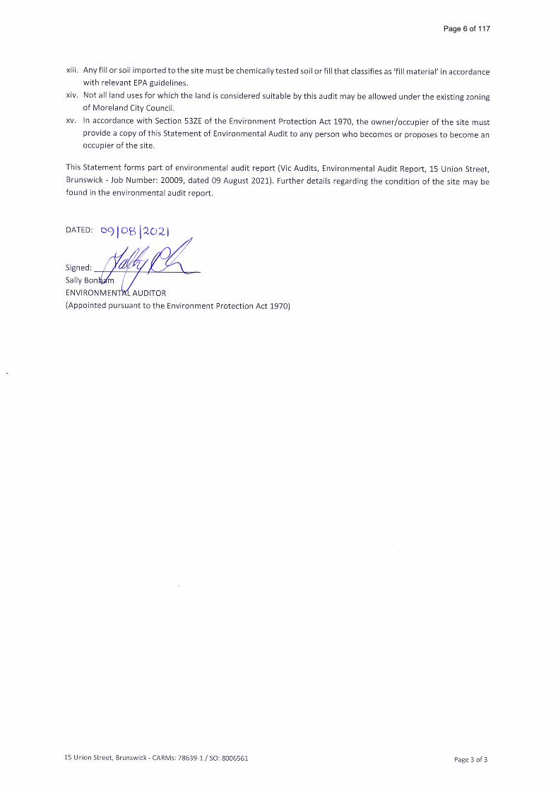
Xiii. AnY剛orsoil importedtothesite mustbechemica=vtested so= orfi=thatclassifiesas′f=I materia=n acco「dance
With reIevant EPA guidelines.
Xiv・ Not a旧and uses fo「which the land is considered suitabIe bythis audit mav be ailowed unde「the existing zoning
Of MoreIand City CounciI.
×∨・ ln accordance with Section 53ZE ofthe Environment P「otection Act 1970, the owner/occupie「 of the site must
P「OVide a copy ofthis Statement of Environmentai Audit to any person who becomes or proposes to become an
OCCuPie「 of the site.
This Statement forms part of envi「onmental audit report (Vic Audits, EnvironmentaI Audit Report, 15 Union Street,
Brunswick - 」ob Number: 20009, dated O9 August 2021). F…he「 deta帖e regarding the condition of the site may be
found in the envi「onmental audit report.
DATED: D9l。叫2O劉
(Appointed pu「su∂nt tO the Environment Protection Act 1970〉
15 Union Street, BrunswiCk - CARMs: 78639-1 / SO; 8OO6561
Page 6 of 117

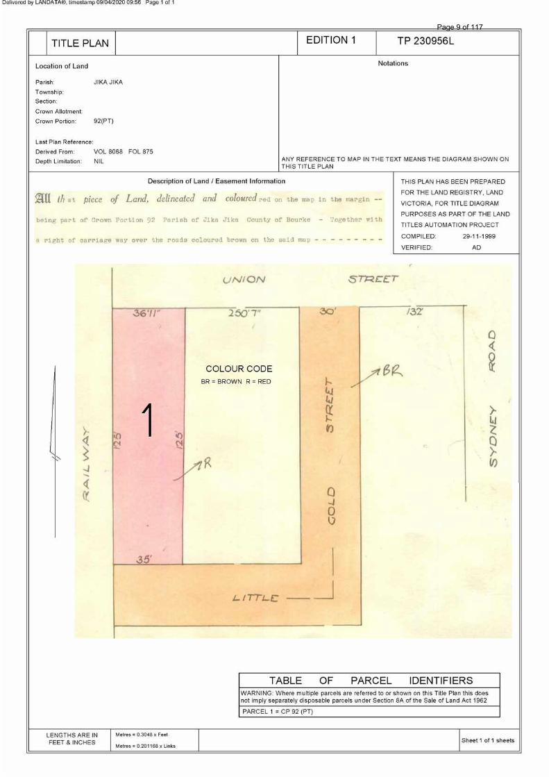
VOLUME 08068 FOLIO 875 Security no : 124082528497Q Produced 09/04/2020 09:54 AM
LAND DESCRIPTION
Lot 1 on Title Plan 230956L (formerly known as part of Portion 92 Parish ofJika Jika).PARENT TITLE Volume 01653 Folio 495Created by instrument 2686469 03/11/1954
REGISTERED PROPRIETOR
Estate Fee SimpleSole Proprietor BARONEL NOMINEES PTY LTD of 22 VIEW POINT RD NORTH BALWYN 3104 T121366L 02/06/1994
ENCUMBRANCES, CAVEATS AND NOTICES
Any encumbrances created by Section 98 Transfer of Land Act 1958 or Section 24 Subdivision Act 1988 and any other encumbrances shown or entered on the plan set out under DIAGRAM LOCATION below.
DIAGRAM LOCATION
SEE TP230956L FOR FURTHER DETAILS AND BOUNDARIES
ACTIVITY IN THE LAST 125 DAYS
NUMBER STATUS DATEBP003648S (B) BOUNDARY PLAN Unregistered 01/04/2020
------------------------END OF REGISTER SEARCH STATEMENT------------------------
Additional information: (not part of the Register Search Statement)
Street Address: 15 UNION STREET BRUNSWICK VIC 3056
DOCUMENT END
Copyright State of Victoria. This publication is copyright. No part may be reproduced by any process except in accordance with the provisions of the CopyrightAct 1968 (Cth) and for the purposes of Section 32 of the Sale of Land Act 1962 (Vic) or pursuant to a written agreement. The information is only valid at the timeand in the form obtained from the LANDATA REGD TM System. None of the State of Victoria, LANDATA REGD TM System, Victorian Land Registry ServicesPty. Ltd. ABN 86 627 986 396 as trustee for the Victorian Land Registry Services Trust ABN 83 206 746 897 accept responsibility for any subsequent release,publication or reproduction of the information.
Title 8068/875 Page 1 of 1
Page 7 of 117
Imaged Document Cover Sheet
The document following this cover sheet is an imaged document supplied by LANDATA®, Victorian Land Registry Services.
Document Type Plan
Document Identification TP230956L
Number of Pages
(excluding this cover sheet)
1
Document Assembled 09/04/2020 09:56
Copyright and disclaimer notice:© State of Victoria. This publication is copyright. No part may be reproduced by any process exceptin accordance with the provisions of the Copyright Act 1968 (Cth) and for the purposes of Section 32of the Sale of Land Act 1962 or pursuant to a written agreement. The information is only valid at thetime and in the form obtained from the LANDATA® System. None of the State of Victoria,LANDATA®, Victorian Land Registry Services Pty. Ltd. ABN 86 627 986 396 as trustee for theVictorian Land Registry Services Trust ABN 83 206 746 897 accept responsibility for anysubsequent release, publication or reproduction of the information.
The document is invalid if this cover sheet is removed or altered.
Page 8 of 117
Page 9 of 117

Project: 20009 - Environmental Audit
Client: B0006 – Baronel Nominees Pty Ltd
Address: 15 Union Street, Brunswick VIC 3056
Legend: Site Boundary
GQRUZ* *Recommended GQRUZ extent
N
Figure 2: Recommended GQRUZ Extent
Date: July 2021
Source: Nearmap Imagery© 2021
Page 10 of 117
Date Amendments Rev14-Aug-20
19-May-21
BUILDING PERMIT ISSUE 1
BUILDING PERMIT ISSUE 2
BP1
BP2
N
Drawing Title:
COVER PAGEDate:
Drawn:
Project No.: 17.004
Scale:
Drawing No. Rev
19-May-21Plot Date:
METAXAS ARCHITECTS PTY LTD ABN 180 791 78626U25/ 22-24 BOSISTO ST RICHMOND, VIC 3121, AUSTRALIATEL 03_9349 5344EMAIL [email protected] WEB: www.metaxasarch.com
Client:
19-May-21
Checked:
DD100
NOTE:FOR DETAILS TO ALL CONCRETE SLABS, WALLS ANDCOLUMNS INCLUDING LOCATION OF EXPANSIONJOINTS, CONTROL JOINTS AND REINFORCEMENT DETAILSREFER TO THE STRUCTURAL ENGINEERS DRAWINGS.
FOR DETAILS TO NEW CROSSOVERS, PATHWAYS ANDROADWAYS REFER TO THE CIVIL ENGINEER'S DRAWINGS.
FOR DETAILS AND DIMENSIONS TO LANDSCAPED PATHS,TERRACES, EXTERNAL FENCES AND PLANTER AREAS REFERTO THE LANDSCAPE DRAWINGS.
THESE DRAWINGS ARE TO BE READ IN CONJUCTION WITH THESPECIFICATIONS AND ENGINEERS' DRAWINGS AS WELL ASALL CONSULTANT REPORTS.
DO NOT SCALE DRAWINGS, REFER TO FIGURED DIMENSIONSONLY. THE CONTRACTOR SHALL NOTIFY THE ARCHITECT IFANY DISCREPANCIES ARISE.
CHECK ALL DIMENSIONS AND ALL SITE CONDITIONSPRIOR TO:THE COMMENCEMENT OF ANY WORK,PURCHASE OR ORDER OF ANY MATERIALS AND FITTINGS,PLANT SERVICES OR EQUIPMENT AND PREPARATION OFSHOP DRAWINGS AND OR FABRICATION OF ANYCOMPONENTS.
BARONEL NOMINEES
MIXED USEDEVELOPMENT15 UNION STREET BRUNSWICK BRUNSWICK
BP2
88.78º WEST
NOT FORCONSTRUCTION
BUILDING PERMIT ISSUE
DRAWING INDEXCOVER & SITE
PLANS & REFLECTED CEILING PLANS
ELEVATIONS
SECTIONS
DETAILS
SCHEDULES
DD100
DD101
DD200
DD201
DD202
DD203
DD204
DD205
DD206
DD207
DD208
DD209
DD300
DD301
DD302
DD400
DD401
DD402
DD403
DD500
DD501
DD502
DD503
DD504
DD505
DD506
DD600
DD601
DD602
COVER PAGE
SITE & DEMOLITION PLAN
CAR STACKER PIT & SETOUT PLAN
GROUND FLOOR PLAN & RCP
LEVEL 01 PLAN & RCP
LEVEL 02 PLAN & RCP
LEVEL 03 PLAN & RCP
LEVEL 04 PLAN & RCP
LEVEL 05 PLAN & RCP
LEVEL 06 PLAN & RCP
LEVEL 07 PLAN & RCP
LEVEL 08 & ROOF PLAN
NORTH & SOUTH ELEVATION
EAST ELEVATION
WEST ELEVATION
SECTION AA
SECTION BB & CC
SECTION DD
SECTION EE
WALL TYPES
STAIR DETAIL
BALUSTRADE & TYPICAL WATERPROOFING DETAILS
KITCHEN & JOINERY DETAILS
BATHROOM DETAILS
FOYER DETAILS
CONSTRUCTION DETAILS
DOOR & WINDOW SCHEDULE
CURTAIN WALL SCHEDULE
SIGNAGE & LIGHT/VENTILATION SCHEDULE)
1:100
1:100
1:100
1:100
1:100
1:100
1:100
1:100
1:100
1:100
1:100
1:100
1:100
1:100
1:100
1:100
1:100
1:100, 1:50
1:10
1:50
1:5, 1:20
1:50
1:50
1:50
1:20
1:1
1:100
SYSTEMFLOORING TYPE
MIN. SLAB
THICKNESS
MIN.
CAVITYRw + Ctr Ln, w+Cl
TIMBER FLOORING + 4.5mm
ACOUSTIC UNDERLAY200 100 55 54
CARPET + FOAM UNDERLAY200 100 53 35
TILED FLOOR + 4.5mm
ACOUSTIC UNDERLAY 200 100 55 52
SYSTEMFLOORING TYPE
MIN. SLAB
THICKNESS
MIN.
CAVITYRw + Ctr Ln, w+Cl
TIMBER FLOORING + 4.5mm
ACOUSTIC UNDERLAY200 300 57 52
CARPET + FOAM UNDERLAY200 200 55 35
TILED FLOOR + FLEXIBLE
ADHESIVE 200 200 55 58
BORAL
CC.1B
BORAL
CC.3B
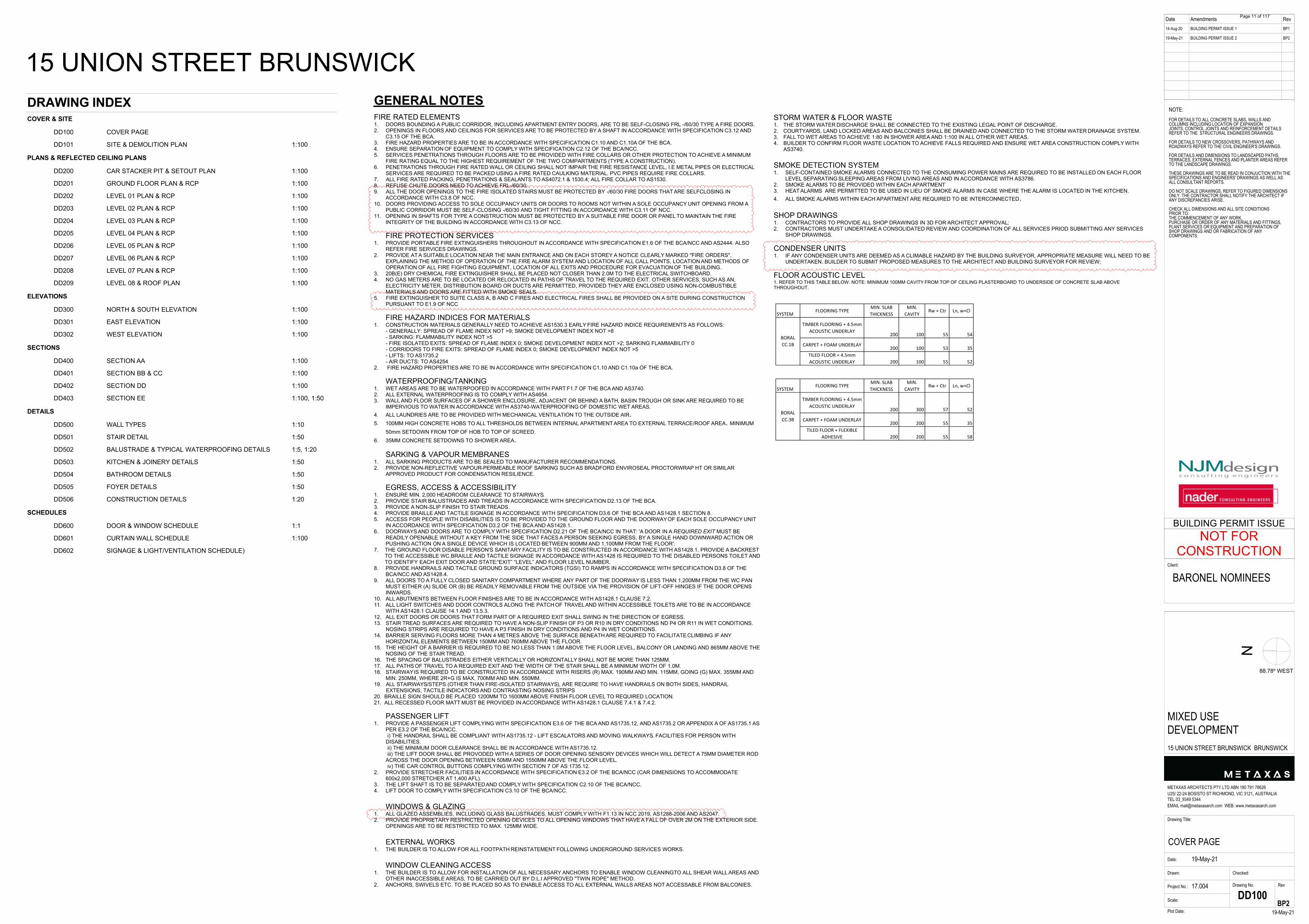
GENERAL NOTESFIRE RATED ELEMENTS1. DOORS BOUNDING A PUBLIC CORRIDOR, INCLUDING APARTMENT ENTRY DOORS, ARE TO BE SELF-CLOSING FRL -/60/30 TYPE A FIRE DOORS.2. OPENINGS IN FLOORS AND CEILINGS FOR SERVICES ARE TO BE PROTECTED BY A SHAFT IN ACCORDANCE WITH SPECIFICATION C3.12 AND
C3.15 OF THE BCA.3. FIRE HAZARD PROPERTIES ARE TO BE IN ACCORDANCE WITH SPECIFICATION C1.10 AND C1.10A OF THE BCA.4. ENSURE SEPARATION OF EQUIPMENT TO COMPLY WITH SPECIFICATION C2.12 OF THE BCA/NCC.5. SERVICES PENETRATIONS THROUGH FLOORS ARE TO BE PROVIDED WITH FIRE COLLARS OR OTHER PROTECTION TO ACHIEVE A MINIMUM
FIRE RATING EQUAL TO THE HIGHEST REQUIREMENT OF THE TWO COMPARTMENTS (TYPE A CONSTRUCTION).6. PENETRATIONS THROUGH FIRE RATED WALL OR CEILING SHALL NOT IMPAIR THE FIRE RESISTANCE LEVEL, I.E METAL PIPES OR ELECTRICAL
SERVICES ARE REQUIRED TO BE PACKED USING A FIRE RATED CAULKING MATERIAL. PVC PIPES REQUIRE FIRE COLLARS.7. ALL FIRE RATED PACKING, PENETRATIONS & SEALANTS TO AS4072.1 & 1530.4; ALL FIRE COLLAR TO AS1530.8. REFUSE CHUTE DOORS NEED TO ACHIEVE FRL-/60/30.9. ALL THE DOOR OPENINGS TO THE FIRE ISOLATED STAIRS MUST BE PROTECTED BY -/60/30 FIRE DOORS THAT ARE SELFCLOSING IN
ACCORDANCE WITH C3.8 OF NCC.10. DOORS PROVIDING ACCESS TO SOLE OCCUPANCY UNITS OR DOORS TO ROOMS NOT WITHIN A SOLE OCCUPANCY UNIT OPENING FROM A
PUBLIC CORRIDOR MUST BE SELF-CLOSING -/60/30 AND TIGHT FITTING IN ACCORDANCE WITH C3.11 OF NCC.11. OPENING IN SHAFTS FOR TYPE A CONSTRUCTION MUST BE PROTECTED BY A SUITABLE FIRE DOOR OR PANEL TO MAINTAIN THE FIRE
INTEGRITY OF THE BUILDING IN ACCORDANCE WITH C3.13 OF NCC.
FIRE PROTECTION SERVICES1. PROVIDE PORTABLE FIRE EXTINGUISHERS THROUGHOUT IN ACCORDANCE WITH SPECIFICATION E1.6 OF THE BCA/NCC AND AS2444. ALSO
REFER FIRE SERVICES DRAWINGS.2. PROVIDE AT A SUITABLE LOCATION NEAR THE MAIN ENTRANCE AND ON EACH STOREY A NOTICE CLEARLY MARKED "FIRE ORDERS",
EXPLAINING THE METHOD OF OPERATION OF THE FIRE ALARM SYSTEM AND LOCATION OF ALL CALL POINTS, LOCATION AND METHODS OFOPERATION OF ALL FIRE FIGHTING EQUIPMENT, LOCATION OF ALL EXITS AND PROCEDURE FOR EVACUATION OF THE BUILDING.
3. 20B(E) DRY CHEMICAL FIRE EXTINGUISHER SHALL BE PLACED NOT CLOSER THAN 2.0M TO THE ELECTRICAL SWITCHBOARD.4. NO GAS METERS ARE TO BE LOCATED OR RELOCATED IN PATHS OF TRAVEL TO THE REQUIRED EXIT. OTHER SERVICES, SUCH AS AN,
ELECTRICITY METER, DISTRIBUTION BOARD OR DUCTS ARE PERMITTED, PROVIDED THEY ARE ENCLOSED USING NON-COMBUSTIBLEMATERIALS AND DOORS ARE FITTED WITH SMOKE SEALS.
5. FIRE EXTINGUISHER TO SUITE CLASS A, B AND C FIRES AND ELECTRICAL FIRES SHALL BE PROVIDED ON A SITE DURING CONSTRUCTIONPURSUANT TO E1.9 OF NCC
FIRE HAZARD INDICES FOR MATERIALS1. CONSTRUCTION MATERIALS GENERALLY NEED TO ACHIEVE AS1530.3 EARLY FIRE HAZARD INDICE REQUIREMENTS AS FOLLOWS: - GENERALLY: SPREAD OF FLAME INDEX NOT >9; SMOKE DEVELOPMENT INDEX NOT >8 - SARKING: FLAMMABILITY INDEX NOT >5 - FIRE ISOLATED EXITS: SPREAD OF FLAME INDEX 0; SMOKE DEVELOPMENT INDEX NOT >2; SARKING FLAMMABILITY 0 - CORRIDORS TO FIRE EXITS: SPREAD OF FLAME INDEX 0; SMOKE DEVELOPMENT INDEX NOT >5 - LIFTS: TO AS1735.2 - AIR DUCTS: TO AS42542. FIRE HAZARD PROPERTIES ARE TO BE IN ACCORDANCE WITH SPECIFICATION C1.10 AND C1.10a OF THE BCA.
WATERPROOFING/TANKING1. WET AREAS ARE TO BE WATERPOOFED IN ACCORDANCE WITH PART F1.7 OF THE BCA AND AS3740.2. ALL EXTERNAL WATERPROOFING IS TO COMPLY WITH AS4654.3. WALL AND FLOOR SURFACES OF A SHOWER ENCLOSURE, ADJACENT OR BEHIND A BATH, BASIN TROUGH OR SINK ARE REQUIRED TO BE
IMPERVIOUS TO WATER IN ACCORDANCE WITH AS3740-WATERPROOFING OF DOMESTIC WET AREAS.4. ALL LAUNDRIES ARE TO BE PROVIDED WITH MECHANICAL VENTILATION TO THE OUTSIDE AIR.5. 100MM HIGH CONCRETE HOBS TO ALL THRESHOLDS BETWEEN INTERNAL APARTMENT AREA TO EXTERNAL TERRACE/ROOF AREA. MINIMUM
50mm SETDOWN FROM TOP OF HOB TO TOP OF SCREED.6. 35MM CONCRETE SETDOWNS TO SHOWER AREA.
SARKING & VAPOUR MEMBRANES1. ALL SARKING PRODUCTS ARE TO BE SEALED TO MANUFACTURER RECOMMENDATIONS.2. PROVIDE NON-REFLECTIVE VAPOUR-PERMEABLE ROOF SARKING SUCH AS BRADFORD ENVIROSEAL PROCTORWRAP HT OR SIMILAR
APPROVED PRODUCT FOR CONDENSATION RESILIENCE.
EGRESS, ACCESS & ACCESSIBILITY1. ENSURE MIN. 2,000 HEADROOM CLEARANCE TO STAIRWAYS.2. PROVIDE STAIR BALUSTRADES AND TREADS IN ACCORDANCE WITH SPECIFICATION D2.13 OF THE BCA.3. PROVIDE A NON-SLIP FINISH TO STAIR TREADS.4. PROVIDE BRAILLE AND TACTILE SIGNAGE IN ACCORDANCE WITH SPECIFICATION D3.6 OF THE BCA AND AS1428.1 SECTION 8.5. ACCESS FOR PEOPLE WITH DISABILITIES IS TO BE PROVIDED TO THE GROUND FLOOR AND THE DOORWAY OF EACH SOLE OCCUPANCY UNIT
IN ACCORDANCE WITH SPECIFICATION D3.2 OF THE BCA AND AS1428.1.6. DOORWAYS AND DOORS ARE TO COMPLY WITH SPECIFICATION D2.21 OF THE BCA/NCC IN THAT: 'A DOOR IN A REQUIRED EXIT MUST BE
READILY OPENABLE WITHOUT A KEY FROM THE SIDE THAT FACES A PERSON SEEKING EGRESS, BY A SINGLE HAND DOWNWARD ACTION ORPUSHING ACTION ON A SINGLE DEVICE WHICH IS LOCATED BETWEEN 900MM AND 1,100MM FROM THE FLOOR'.
7. THE GROUND FLOOR DISABLE PERSON'S SANITARY FACILITY IS TO BE CONSTRUCTED IN ACCORDANCE WITH AS1428.1. PROVIDE A BACKRESTTO THE ACCESSIBLE WC.BRAILLE AND TACTILE SIGNAGE IN ACCORDANCE WITH AS1428 IS REQUIRED TO THE DISABLED PERSONS TOILET ANDTO IDENTIFY EACH EXIT DOOR AND STATE:“EXIT” “LEVEL” AND FLOOR LEVEL NUMBER.
8. PROVIDE HANDRAILS AND TACTILE GROUND SURFACE INDICATORS (TGSI) TO RAMPS IN ACCORDANCE WITH SPECIFICATION D3.8 OF THEBCA/NCC AND AS1428.4.
9. ALL DOORS TO A FULLY CLOSED SANITARY COMPARTMENT WHERE ANY PART OF THE DOORWAY IS LESS THAN 1,200MM FROM THE WC PANMUST EITHER (A) SLIDE OR (B) BE READILY REMOVABLE FROM THE OUTSIDE VIA THE PROVISION OF LIFT-OFF HINGES IF THE DOOR OPENSINWARDS.
10. ALL ABUTMENTS BETWEEN FLOOR FINISHES ARE TO BE IN ACCORDANCE WITH AS1428.1 CLAUSE 7.2.11. ALL LIGHT SWITCHES AND DOOR CONTROLS ALONG THE PATCH OF TRAVEL AND WITHIN ACCESSIBLE TOILETS ARE TO BE IN ACCORDANCE
WITH AS1428.1 CLAUSE 14.1 AND 13.5.3.12. ALL EXIT DOORS OR DOORS THAT FORM PART OF A REQUIRED EXIT SHALL SWING IN THE DIRECTION OF EGRESS.13. STAIR TREAD SURFACES ARE REQUIRED TO HAVE A NON-SLIP FINISH OF P3 OR R10 IN DRY CONDITIONS ND P4 OR R11 IN WET CONDITIONS.
NOSING STRIPS ARE REQUIRED TO HAVE A P3 FINISH IN DRY CONDITIONS AND P4 IN WET CONDITIONS.14. BARRIER SERVING FLOORS MORE THAN 4 METRES ABOVE THE SURFACE BENEATH ARE REQUIRED TO FACILITATE CLIMBING IF ANY
HORIZONTAL ELEMENTS BETWEEN 150MM AND 760MM ABOVE THE FLOOR.15. THE HEIGHT OF A BARRIER IS REQUIRED TO BE NO LESS THAN 1.0M ABOVE THE FLOOR LEVEL, BALCONY OR LANDING AND 865MM ABOVE THE
NOSING OF THE STAIR TREAD.16. THE SPACING OF BALUSTRADES EITHER VERTICALLY OR HORIZONTALLY SHALL NOT BE MORE THAN 125MM.17. ALL PATHS OF TRAVEL TO A REQUIRED EXIT AND THE WIDTH OF THE STAIR SHALL BE A MINIMUM WIDTH OF 1.0M.18. STAIRWAY IS REQUIRED TO BE CONSTRUCTED IN ACCORDANCE WITH RISERS (R) MAX. 190MM AND MIN. 115MM, GOING (G) MAX. 355MM AND
MIN. 250MM, WHERE 2R+G IS MAX. 700MM AND MIN. 550MM.19. ALL STAIRWAYS/STEPS (OTHER THAN FIRE-ISOLATED STAIRWAYS), ARE REQUIRE TO HAVE HANDRAILS ON BOTH SIDES, HANDRAIL EXTENSIONS, TACTILE INDICATORS AND CONTRASTING NOSING STRIPS20. BRAILLE SIGN SHOULD BE PLACED 1200MM TO 1600MM ABOVE FINISH FLOOR LEVEL TO REQUIRED LOCATION.21. ALL RECESSED FLOOR MATT MUST BE PROVIDED IN ACCORDANCE WITH AS1428.1 CLAUSE 7.4.1 & 7.4.2.
PASSENGER LIFT1. PROVIDE A PASSENGER LIFT COMPLYING WITH SPECIFICATION E3.6 OF THE BCA AND AS1735.12, AND AS1735.2 OR APPENDIX A OF AS1735.1 AS
PER E3.2 OF THE BCA/NCC. i) THE HANDRAIL SHALL BE COMPLIANT WITH AS1735.12 - LIFT ESCALATORS AND MOVING WALKWAYS. FACILITIES FOR PERSON WITH
DISABILITIES. ii) THE MINIMUM DOOR CLEARANCE SHALL BE IN ACCORDANCE WITH AS1735.12. iii) THE LIFT DOOR SHALL BE PROVODED WITH A SERIES OF DOOR OPENING SENSORY DEVICES WHICH WILL DETECT A 75MM DIAMETER ROD
ACROSS THE DOOR OPENING BETWEEEN 50MM AND 1550MM ABOVE THE FLOOR LEVEL. iv) THE CAR CONTROL BUTTONS COMPLYING WITH SECTION 7 OF AS 1735.12.2. PROVIDE STRETCHER FACILITIES IN ACCORDANCE WITH SPECIFICATION E3.2 OF THE BCA/NCC (CAR DIMENSIONS TO ACCOMMODATE
600x2,000 STRETCHER AT 1,400 AFL).3. THE LIFT SHAFT IS TO BE SEPARATED AND COMPLY WITH SPECIFICATION C2.10 OF THE BCA/NCC.4. LIFT DOOR TO COMPLY WITH SPECIFICATION C3.10 OF THE BCA/NCC.
WINDOWS & GLAZING1. ALL GLAZED ASSEMBLIES, INCLUDING GLASS BALUSTRADES, MUST COMPLY WITH F1.13 IN NCC 2019, AS1288-2006 AND AS2047.2. PROVIDE PROPRIETARY RESTRICTED OPENING DEVICES TO ALL OPENING WINDOWS THAT HAVE A FALL OF OVER 2M ON THE EXTERIOR SIDE.
OPENINGS ARE TO BE RESTRICTED TO MAX. 125MM WIDE.
EXTERNAL WORKS1. THE BUILDER IS TO ALLOW FOR ALL FOOTPATH REINSTATEMENT FOLLOWING UNDERGROUND SERVICES WORKS.
WINDOW CLEANING ACCESS1. THE BUILDER IS TO ALLOW FOR INSTALLATION OF ALL NECESSARY ANCHORS TO ENABLE WINDOW CLEANINGTO ALL SHEAR WALL AREAS AND
OTHER INACCESSIBLE AREAS, TO BE CARRIED OUT BY D.L.I APPROVED "TWIN ROPE" METHOD.2. ANCHORS, SWIVELS ETC. TO BE PLACED SO AS TO ENABLE ACCESS TO ALL EXTERNAL WALLS AREAS NOT ACCESSABLE FROM BALCONIES.
STORM WATER & FLOOR WASTE1. THE STORM WATER DISCHARGE SHALL BE CONNECTED TO THE EXISTING LEGAL POINT OF DISCHARGE.2. COURTYARDS, LAND LOCKED AREAS AND BALCONIES SHALL BE DRAINED AND CONNECTED TO THE STORM WATER DRAINAGE SYSTEM.3. FALL TO WET AREAS TO ACHIEVE 1:80 IN SHOWER AREA AND 1:100 IN ALL OTHER WET AREAS.4. BUILDER TO CONFIRM FLOOR WASTE LOCATION TO ACHIEVE FALLS REQUIRED AND ENSURE WET AREA CONSTRUCTION COMPLY WITH AS3740.
SMOKE DETECTION SYSTEM1. SELF-CONTAINED SMOKE ALARMS CONNECTED TO THE CONSUMING POWER MAINS ARE REQUIRED TO BE INSTALLED ON EACH FLOOR
LEVEL SEPARATING SLEEPING AREAS FROM LIVING AREAS AND IN ACCORDANCE WITH AS3786.2. SMOKE ALARMS TO BE PROVIDED WITHIN EACH APARTMENT3. HEAT ALARMS ARE PERMITTED TO BE USED IN LIEU OF SMOKE ALARMS IN CASE WHERE THE ALARM IS LOCATED IN THE KITCHEN.4. ALL SMOKE ALARMS WITHIN EACH APARTMENT ARE REQUIRED TO BE INTERCONNECTED.
SHOP DRAWINGS1. CONTRACTORS TO PROVIDE ALL SHOP DRAWINGS IN 3D FOR ARCHITECT APPROVAL;2. CONTRACTORS MUST UNDERTAKE A CONSOLIDATED REVIEW AND COORDINATION OF ALL SERVICES PRIOD SUBMITTING ANY SERVICES
SHOP DRAWINGS.
CONDENSER UNITS1. IF ANY CONDENSER UNITS ARE DEEMED AS A CLIMABLE HAZARD BY THE BUILDING SURVEYOR, APPROPRIATE MEASURE WILL NEED TO BE
UNDERTAKEN. BUILDER TO SUBMIT PROPOSED MEASURES TO THE ARCHITECT AND BUILDING SURVEYOR FOR REVIEW;
FLOOR ACOUSTIC LEVEL1. REFER TO THIS TABLE BELOW. NOTE: MINIMUM 100MM CAVITY FROM TOP OF CEILING PLASTERBOARD TO UNDERSIDE OF CONCRETE SLAB ABOVETHROUGHOUT.
15 UNION STREET BRUNSWICK
Page 11 of 117
Date Amendments Rev14-Aug-20
19-May-21
BUILDING PERMIT ISSUE 1
BUILDING PERMIT ISSUE 2
BP1
BP2
N
Drawing Title:
SITE & DEMOLITION PLANDate:
Drawn:
Project No.: 17.004
Scale:
Drawing No. Rev
19-May-21Plot Date:
METAXAS ARCHITECTS PTY LTD ABN 180 791 78626U25/ 22-24 BOSISTO ST RICHMOND, VIC 3121, AUSTRALIATEL 03_9349 5344EMAIL [email protected] WEB: www.metaxasarch.com
Client:
19-May-21
Checked:
1:100 DD101
NOTE:FOR DETAILS TO ALL CONCRETE SLABS, WALLS ANDCOLUMNS INCLUDING LOCATION OF EXPANSIONJOINTS, CONTROL JOINTS AND REINFORCEMENT DETAILSREFER TO THE STRUCTURAL ENGINEERS DRAWINGS.
FOR DETAILS TO NEW CROSSOVERS, PATHWAYS ANDROADWAYS REFER TO THE CIVIL ENGINEER'S DRAWINGS.
FOR DETAILS AND DIMENSIONS TO LANDSCAPED PATHS,TERRACES, EXTERNAL FENCES AND PLANTER AREAS REFERTO THE LANDSCAPE DRAWINGS.
THESE DRAWINGS ARE TO BE READ IN CONJUCTION WITH THESPECIFICATIONS AND ENGINEERS' DRAWINGS AS WELL ASALL CONSULTANT REPORTS.
DO NOT SCALE DRAWINGS, REFER TO FIGURED DIMENSIONSONLY. THE CONTRACTOR SHALL NOTIFY THE ARCHITECT IFANY DISCREPANCIES ARISE.
CHECK ALL DIMENSIONS AND ALL SITE CONDITIONSPRIOR TO:THE COMMENCEMENT OF ANY WORK,PURCHASE OR ORDER OF ANY MATERIALS AND FITTINGS,PLANT SERVICES OR EQUIPMENT AND PREPARATION OFSHOP DRAWINGS AND OR FABRICATION OF ANYCOMPONENTS.
BARONEL NOMINEES
MIXED USEDEVELOPMENT15 UNION STREET BRUNSWICK BRUNSWICK
BP2
88.78º WEST
NOT FORCONSTRUCTION
BUILDING PERMIT ISSUE
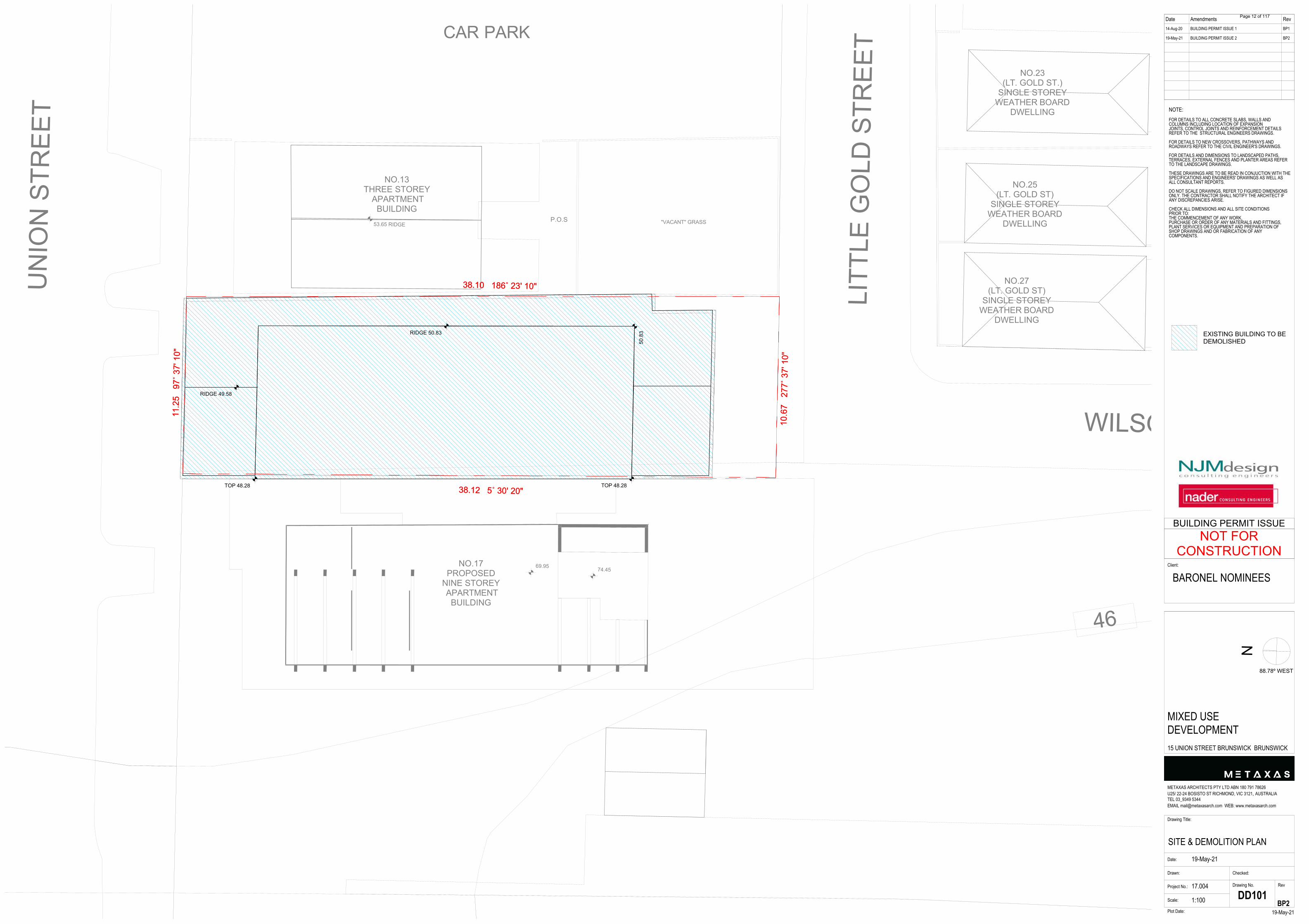
53.65 RIDGE
69.95 74.45
11.2
5 9
7˚ 3
7' 1
0"
10.6
7 2
77˚ 3
7' 1
0"
38.10 186˚ 23' 10"
38.12 5˚ 30' 20"
NO.13THREE STOREY
APARTMENTBUILDING
UN
ION
STR
EET
LITT
LE G
OLD
STR
EET
WILSON AVENUE
"VACANT" GRASS
CAR PARK
NO.27(LT. GOLD ST)
SINGLE STOREYWEATHER BOARD
DWELLING
NO.25(LT. GOLD ST)
SINGLE STOREYWEATHER BOARD
DWELLING
NO.23(LT. GOLD ST.)
SINGLE STOREYWEATHER BOARD
DWELLING
NO.17PROPOSED
NINE STOREY APARTMENT
BUILDING
46
P.O.S
50.8
3
TOP 48.28TOP 48.28
RIDGE 49.58
RIDGE 50.83
11.2
5 9
7˚ 3
7' 1
0"
10.6
7 2
77˚ 3
7' 1
0"
38.10 186˚ 23' 10"
38.12 5˚ 30' 20"
EXISTING BUILDING TO BEDEMOLISHED
Page 12 of 117
INDICATES CEILING MATERIAL & HEIGHT ABOVEFINISHED FLOOR LEVELCONCRETE BEAMCONCRETE FINISH - SEALEDALUMINIUM PANELPLASTERBOARD PAINT FINISHSKYLIGHTACCESS HATCHCOLUMN - REFER TO STRUCTURAL DRAWINGJAMES HARDIE "HARDIEGROOVE" LINING.PANELLING TO RUN EAST-WEST25mm KINGSPAN KOOLTHERM K10 SOFFITBOARD R1.1 (OR EQUIVALENT. MINIMUM R1.1)40mm KINGSPAN KOOLTHERM K10 SOFFITBOARD R1.75 (OR EQUIVALENT. MINIMUM R1.5)45mm KINGSPAN KOOLTHERM K10 SOFFITBOARD R2.15 (OR EQUIVALENT. MINIMUM R2.0)70mm KINGSPAN KOOLTHERM K10 SOFFITBOARD R3.35 (OR EQUIVALENT. MINIMUM R3.0)MECHANICAL RUNHYDRAULIC DOWN PIPE RUNS
CBCSALPBS/LAH
COLFC01
INS1
INS2
INS3
INS4
PB2400
GENERAL LEGEND:AIR-CONDITIONING CONDENSING UNITBOLLARD LIGHTINGCLOTHESLINECHUTECAR STACKER REMOTECARPARK EXHAUSTKITCHEN EXHAUSTBIN EXHAUSTDISTRIBUTION BOARDDOWNPIPEFIRE HOSE REELFIRE INDICATOR PANELFLASHINGFIRE PUMP ROOMFLOOR WASTEGRATED PITGRATED TRENCHGREASE INTERCEPTOR TRAPHOT WATER STORAGEPUMP WELL PITPUMP CONTROL PANELSTORAGE CAGESTORAGE OVER BONNETSPRINKLER CONTROL VALVE ASSEMBLYSPOON DRAINWATER TANKRETAIL WATER METERFIRE WATER TANKSKYLIGHT - MIN 6mm TOUGHENED GLAZING
FINISHES LEGEND:CONCRETE FINISH (SEALED)POLISHED CONCRETE FINISHLYSAGHT TRIMDEK WITH SARKING TO UNDERSIDE
ACBL
C/LCH
CSRCPE
KEBEDBDP
FHRFIPFLSFPRFWGPGTGIT
HWSPW
PCPS
SOSCVA
SDWT
RWMFWT
SK
CORRUGATED METAL PANEL BALUSTRADE1100mm ABOVE SFL, 300mm BELOW SFL
CORRUGATED METAL PANEL BALUSTRADE1100mm ABOVE SFL, 500mm BELOW SFL
CORRUGATED METAL PANEL BALUSTRADE1000mm ABOVE SFL, 300mm BELOW SFL
OBSCURE GLASS BALUSTRADE1800mm ABOVE SFL
PRECAST PARAPET + PERFORATED METAL SCREEN ABOVE1000mm ABOVE SFL (PRECAST PARAPET) + 700mm HIGH SCREEN ABOVE
LOW HEIGHT MASONRY1200mm ABOVE SFL
LOW HEIGHT MASONRY1100mm ABOVE SFL
LOW HEIGHT MASONRY1500mm ABOVE SFL
LOW HEIGHT MASONRY + PERFORATED METAL SCREEN ABOVE1100mm ABOVE SFL (MASONRY) + 600mm HIGH SCREEN ABOVE
BAL01
BAL01A
BAL01B
BAL02
BAL03
BAL04
BAL04A
BAL04B
BAL05
TL2
CO
TL1
TIM
TL3
CPT
PWM1
PWM4
PWM3
PWM2
PLANS LEGEND:CONCRETE FINISH
SELECTED E C CARPET
SELECTED GRAND OAK TIMBER FLOOR
SELECTED TILE FINISH
SELECTED TILE FINISH
SELECTED TILE FINISH
WATERPROOFING MEMBRANE TO EXPOSED ROOF
WATERPROOFING MEMBRANE TO TERRACE
WATERPROOFING MEMBRANE TO WET AREA
WATERPROOFING MEMBRANE TO PLANTER BOX
DDA TURNING CIRCLE WITH 1540x2070mmDDA
Date Amendments Rev14-Aug-20
19-May-21
BUILDING PERMIT ISSUE 1
BUILDING PERMIT ISSUE 2
BP1
BP2
N
Drawing Title:
CAR STACKER PIT & SETOUTPLANDate:
Drawn:
Project No.: 17.004
Scale:
Drawing No. Rev
19-May-21Plot Date:
METAXAS ARCHITECTS PTY LTD ABN 180 791 78626U25/ 22-24 BOSISTO ST RICHMOND, VIC 3121, AUSTRALIATEL 03_9349 5344EMAIL [email protected] WEB: www.metaxasarch.com
Client:
19-May-21
Checked:
1:100 DD200
NOTE:FOR DETAILS TO ALL CONCRETE SLABS, WALLS ANDCOLUMNS INCLUDING LOCATION OF EXPANSIONJOINTS, CONTROL JOINTS AND REINFORCEMENT DETAILSREFER TO THE STRUCTURAL ENGINEERS DRAWINGS.
FOR DETAILS TO NEW CROSSOVERS, PATHWAYS ANDROADWAYS REFER TO THE CIVIL ENGINEER'S DRAWINGS.
FOR DETAILS AND DIMENSIONS TO LANDSCAPED PATHS,TERRACES, EXTERNAL FENCES AND PLANTER AREAS REFERTO THE LANDSCAPE DRAWINGS.
THESE DRAWINGS ARE TO BE READ IN CONJUCTION WITH THESPECIFICATIONS AND ENGINEERS' DRAWINGS AS WELL ASALL CONSULTANT REPORTS.
DO NOT SCALE DRAWINGS, REFER TO FIGURED DIMENSIONSONLY. THE CONTRACTOR SHALL NOTIFY THE ARCHITECT IFANY DISCREPANCIES ARISE.
CHECK ALL DIMENSIONS AND ALL SITE CONDITIONSPRIOR TO:THE COMMENCEMENT OF ANY WORK,PURCHASE OR ORDER OF ANY MATERIALS AND FITTINGS,PLANT SERVICES OR EQUIPMENT AND PREPARATION OFSHOP DRAWINGS AND OR FABRICATION OF ANYCOMPONENTS.
BARONEL NOMINEES
MIXED USEDEVELOPMENT15 UNION STREET BRUNSWICK BRUNSWICK
BP2
88.78º WEST
NOT FORCONSTRUCTION
BUILDING PERMIT ISSUE
E
E
C
C
D
D
B
B
F
F
G
G
A
A
4 4
3 3
2b
2a
1 1
BBD
D40
1
CC
DD
401
SFL 39.70
SFL 42.80
3000L PUMPWELL.REFER CIVIL
DRAWINGS
SD
SD
SD
SD
CAR STACKERSQUADRUPLE
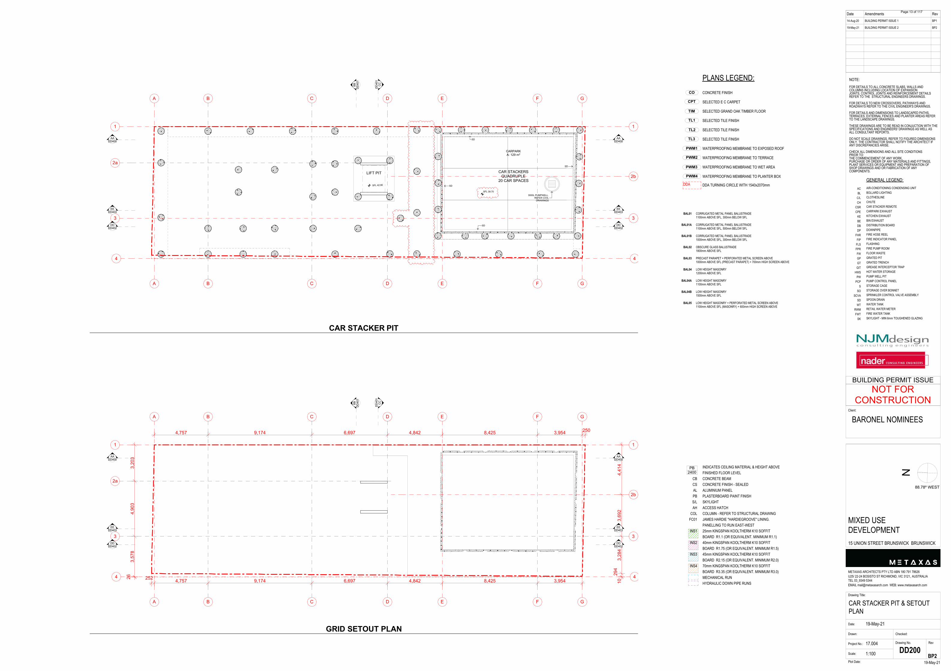
20 CAR SPACES
LIFT PIT
CARPARKA: 129 m2
DDDD402
DDDD402
EEDD403
EEDD403
AADD400
AADD400
E
E
C
C
D
D
B
B
F
F
G
G
A
A
4 4
3 3
2b
2a
1 1
BBD
D40
1
CC
DD
401
2503,9548,4254,8426,6979,1744,757
4,41
43,
692
3,28
429
4103,9548,4254,8426,6979,1744,757252
3,20
34,
903
3,57
826
DDDD402
DDDD402
EEDD403
EEDD403
AADD400
AADD400
CAR STACKER PIT
GRID SETOUT PLAN
Page 13 of 117
INDICATES CEILING MATERIAL & HEIGHT ABOVEFINISHED FLOOR LEVELCONCRETE BEAMCONCRETE FINISH - SEALEDALUMINIUM PANELPLASTERBOARD PAINT FINISHSKYLIGHTACCESS HATCHCOLUMN - REFER TO STRUCTURAL DRAWINGJAMES HARDIE "HARDIEGROOVE" LINING.PANELLING TO RUN EAST-WEST25mm KINGSPAN KOOLTHERM K10 SOFFITBOARD R1.1 (OR EQUIVALENT. MINIMUM R1.1)40mm KINGSPAN KOOLTHERM K10 SOFFITBOARD R1.75 (OR EQUIVALENT. MINIMUM R1.5)45mm KINGSPAN KOOLTHERM K10 SOFFITBOARD R2.15 (OR EQUIVALENT. MINIMUM R2.0)70mm KINGSPAN KOOLTHERM K10 SOFFITBOARD R3.35 (OR EQUIVALENT. MINIMUM R3.0)MECHANICAL RUNHYDRAULIC DOWN PIPE RUNS
CBCSALPBS/LAH
COLFC01
INS1
INS2
INS3
INS4
PB2400
GENERAL LEGEND:AIR-CONDITIONING CONDENSING UNITBOLLARD LIGHTINGCLOTHESLINECHUTECAR STACKER REMOTECARPARK EXHAUSTKITCHEN EXHAUSTBIN EXHAUSTDISTRIBUTION BOARDDOWNPIPEFIRE HOSE REELFIRE INDICATOR PANELFLASHINGFIRE PUMP ROOMFLOOR WASTEGRATED PITGRATED TRENCHGREASE INTERCEPTOR TRAPHOT WATER STORAGEPUMP WELL PITPUMP CONTROL PANELSTORAGE CAGESTORAGE OVER BONNETSPRINKLER CONTROL VALVE ASSEMBLYSPOON DRAINWATER TANKRETAIL WATER METERFIRE WATER TANKSKYLIGHT - MIN 6mm TOUGHENED GLAZING
FINISHES LEGEND:CONCRETE FINISH (SEALED)POLISHED CONCRETE FINISHLYSAGHT TRIMDEK WITH SARKING TO UNDERSIDE
ACBL
C/LCH
CSRCPE
KEBEDBDP
FHRFIPFLSFPRFWGPGTGIT
HWSPW
PCPS
SOSCVA
SDWT
RWMFWT
SK
CORRUGATED METAL PANEL BALUSTRADE1100mm ABOVE SFL, 300mm BELOW SFL
CORRUGATED METAL PANEL BALUSTRADE1100mm ABOVE SFL, 500mm BELOW SFL
CORRUGATED METAL PANEL BALUSTRADE1000mm ABOVE SFL, 300mm BELOW SFL
OBSCURE GLASS BALUSTRADE1800mm ABOVE SFL
PRECAST PARAPET + PERFORATED METAL SCREEN ABOVE1000mm ABOVE SFL (PRECAST PARAPET) + 700mm HIGH SCREEN ABOVE
LOW HEIGHT MASONRY1200mm ABOVE SFL
LOW HEIGHT MASONRY1100mm ABOVE SFL
LOW HEIGHT MASONRY1500mm ABOVE SFL
LOW HEIGHT MASONRY + PERFORATED METAL SCREEN ABOVE1100mm ABOVE SFL (MASONRY) + 600mm HIGH SCREEN ABOVE
BAL01
BAL01A
BAL01B
BAL02
BAL03
BAL04
BAL04A
BAL04B
BAL05
TL2
CO
TL1
TIM
TL3
CPT
PWM1
PWM4
PWM3
PWM2
PLANS LEGEND:CONCRETE FINISH
SELECTED E C CARPET
SELECTED GRAND OAK TIMBER FLOOR
SELECTED TILE FINISH
SELECTED TILE FINISH
SELECTED TILE FINISH
WATERPROOFING MEMBRANE TO EXPOSED ROOF
WATERPROOFING MEMBRANE TO TERRACE
WATERPROOFING MEMBRANE TO WET AREA
WATERPROOFING MEMBRANE TO PLANTER BOX
DDA TURNING CIRCLE WITH 1540x2070mmDDA
Date Amendments Rev14-Aug-20
19-May-21
BUILDING PERMIT ISSUE 1
BUILDING PERMIT ISSUE 2
BP1
BP2
N
Drawing Title:
GROUND FLOOR PLAN & RCPDate:
Drawn:
Project No.: 17.004
Scale:
Drawing No. Rev
19-May-21Plot Date:
METAXAS ARCHITECTS PTY LTD ABN 180 791 78626U25/ 22-24 BOSISTO ST RICHMOND, VIC 3121, AUSTRALIATEL 03_9349 5344EMAIL [email protected] WEB: www.metaxasarch.com
Client:
19-May-21
Checked:
1:100 DD201
NOTE:FOR DETAILS TO ALL CONCRETE SLABS, WALLS ANDCOLUMNS INCLUDING LOCATION OF EXPANSIONJOINTS, CONTROL JOINTS AND REINFORCEMENT DETAILSREFER TO THE STRUCTURAL ENGINEERS DRAWINGS.
FOR DETAILS TO NEW CROSSOVERS, PATHWAYS ANDROADWAYS REFER TO THE CIVIL ENGINEER'S DRAWINGS.
FOR DETAILS AND DIMENSIONS TO LANDSCAPED PATHS,TERRACES, EXTERNAL FENCES AND PLANTER AREAS REFERTO THE LANDSCAPE DRAWINGS.
THESE DRAWINGS ARE TO BE READ IN CONJUCTION WITH THESPECIFICATIONS AND ENGINEERS' DRAWINGS AS WELL ASALL CONSULTANT REPORTS.
DO NOT SCALE DRAWINGS, REFER TO FIGURED DIMENSIONSONLY. THE CONTRACTOR SHALL NOTIFY THE ARCHITECT IFANY DISCREPANCIES ARISE.
CHECK ALL DIMENSIONS AND ALL SITE CONDITIONSPRIOR TO:THE COMMENCEMENT OF ANY WORK,PURCHASE OR ORDER OF ANY MATERIALS AND FITTINGS,PLANT SERVICES OR EQUIPMENT AND PREPARATION OFSHOP DRAWINGS AND OR FABRICATION OF ANYCOMPONENTS.
BARONEL NOMINEES
MIXED USEDEVELOPMENT15 UNION STREET BRUNSWICK BRUNSWICK
BP2
88.78º WEST
NOT FORCONSTRUCTION
BUILDING PERMIT ISSUE
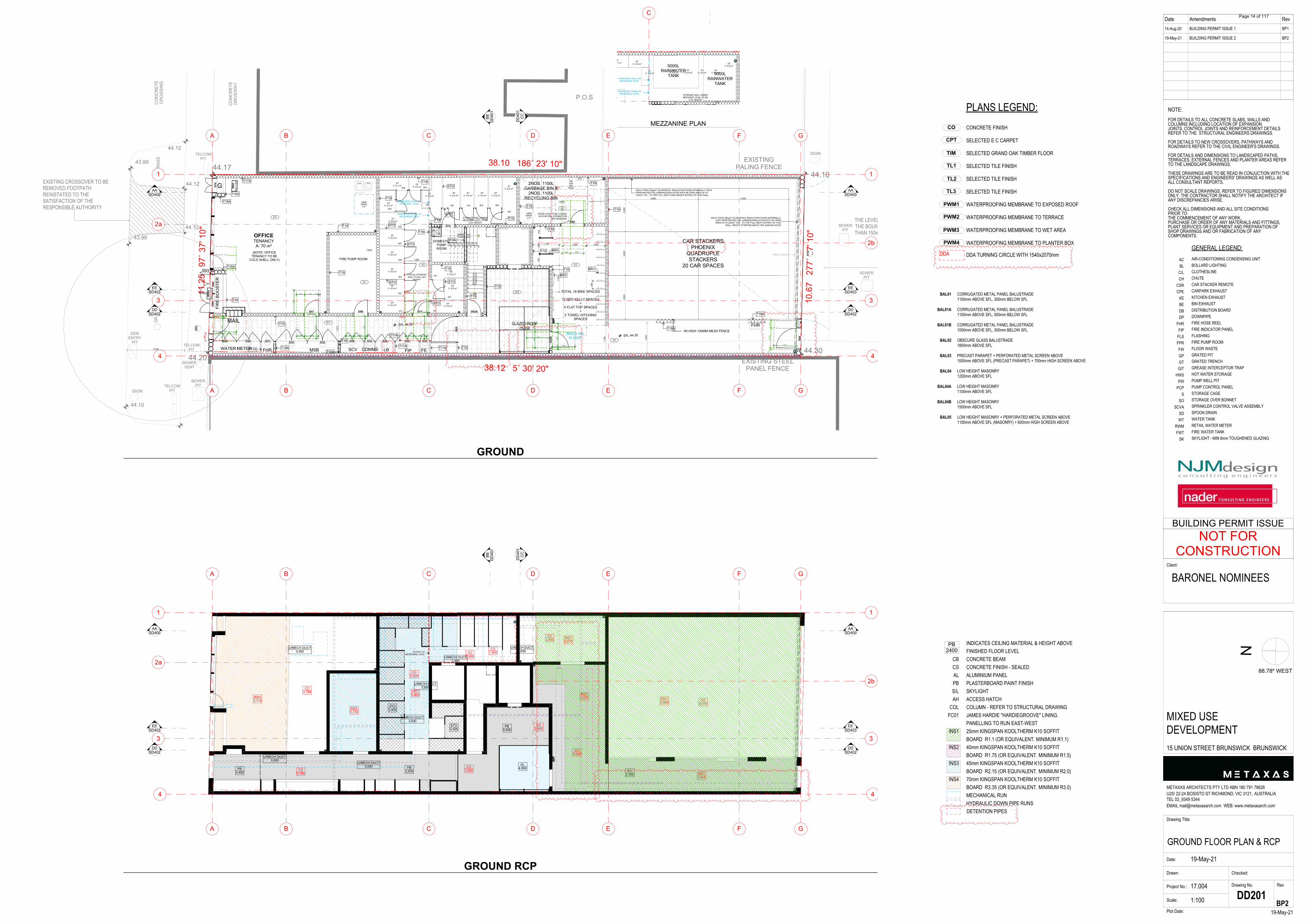
44.10
44.3044.20
44.17
44.12
44.12
44.12
43.99
43.99
44.10
11.2
5 9
7˚ 3
7' 1
0"
10.6
7 2
77˚ 3
7' 1
0"
38.10 186˚ 23' 10"
38.12 5˚ 30' 20"
CO
NC
RET
ED
RIV
EWAY
CO
NC
RET
EC
RO
SSIN
G
SIGNTELCOM
PIT
TELCOMPIT
SEWERVENT
SIDEENTRY
PIT
SEWERPIT
SEWERPIT
SEWERPIT
TELCOMPIT EXISTING
PALING FENCE
EXISTING STEELPANEL FENCE
GR
ASS
CO
NC
RET
EC
RO
SSIN
GG
RAS
SSIGN
P.O.S
12345678
9 10 11 12 13 14 15 16
UP16R(188 mm)
15G(250 mm)
1
2
3
4
5
6
7
8
UP
8R(1
69 m
m)
7G(2
50 m
m)
W05
o S
ILL1
,500
D09
D03
D09
D19
D33 D33 D04
D08
D05
A
D12
D02A
W04
SIL
L1,0
00
D10
D05
D29 D29 D31
D06 D07 OFFICE
D11
D32 D29 D30 D29 D32
E
E
C
C
D
D
B
B
F
F
G
G
A
A
4 4
3 3
2b
2a
1 1
FW
FW
BBD
D40
1
CC
DD
401
5,800 5,800
1,70
0
2,80
02,
800
2,80
0
1,93
4
1,700 1,200
500
1,500
700
1,00
070
0
3,700
1,76
9
1,61
0
1,551
593
110
1,27
447
9
530 850
464 510 854 510 854 510 854
1,02
053
0
530
1,02
011
0 1,450
530 854 1101,
450
1,45
0
1,45
0
1,45
0
1,450464
1,00
011
0
1,450
1,450
SFL 44.20
SFL 44.20
DDDD402
DDDD402
HARDWASTE
2 m2
HARDWASTE
2 m2
T15A
T17A
T19
T19
T19
T18A
T19
T19 T19
T19
T19
T19
T19
T19
T19
T19
T19
T19
T19
T18A
T18A
T10T11A
T11A
T11AT15A
T15
T15AT11A
T18A
90mm THICK 25kg/m3 GLASSWOOL INSULATION FACED INTERNALLY WITHPERFORATED FOIL SARKING/SISALATION WITH AN OPEN AREA OF ATLEAST 10% - TO THE FULL WIDTH AND HEIGHT EXTENT OF THIS WALL
90mm THICK 25kg/m3 GLASSWOOL INSULATION FACED INTERNALLYWITH PERFORATED FOIL SARKING/SISALATION WITH AN OPENAREA OF AT LEAST 10% - TO THE FULL WIDTH EXTENT OF THIS
WALL, HEIGHT STARTING ABOVE THE GARAGE DOOR
BR2
BR3
BR1
STO
STO
STO
STO
CO
CO
CO
CO
CO
T19
T19
CO
T15A
RAINWATER TANKS ONMEZZANINE LEVEL
TRENCH GRATE
DOOR LEAF TO BE LOCKEDIN POSITION, OPENED FOR
BIN HANDLING
STOSTO
CHAIN MESH WALL ONMEZZANINE LEVEL
STO
FLT
FLT
1M HIGH 100MM MESH FENCE
G
FIR
E BO
OST
ER
2NOS. 1100LGARBAGE BIN &
2NOS. 1100LRECYCLING BIN
TOTAL 18 BIKE SPACES
12 NED KELLY SPACES+
4 FLAT TOP SPACES+
2 TOWEL HITCHINGSPACES
CAR STACKERSPHOENIX
QUADRUPLESTACKERS
20 CAR SPACES
GLAZED ROOFOVER
EXISTING CROSSOVER TO BEREMOVED.FOOTPATHREINSTATED TO THESATISFACTION OF THERESPONSIBLE AUTHORITY
RAILS ONFLOOR
WATER METER FHR SCV COMMS LBMSB FIP
THE LEVEL OF THE CROSSING ATTHE BOUNDARY TO BE NO MORETHAN 150mm ABOVE THE STREET
CHANNEL
FIRE PUMP ROOM
DOMESTICPUMPROOM
TAPFORBIN
WASH
(NOTE: OFFICETENANCY TO BE
COLD SHELL ONLY)
FE
FHR
PCP
DDA
DDA
DDA
DDA
201
701
702
101
301
401
303
203 403
502
601
602
501
402
302 103202
102
TYPICAL STORAGEWALL TO BE 3.4m
HEIGHT
STORAGE WALL UNDERMEZZANIE LEVEL TO BE
2.2m HEIGHT
OFFICETENANCYA: 70 m2
STV: 6.0 m3
STV: 6.3 m3
STV: 5.0 m3
STV: 4.0 m3
STV: 5.0 m3
STV: 6.0 m3
STV: 6.2 m3
STV: 6.0 m3
STV: 5.1 m3
STV: 6.0 m3
STV: 6.0 m3
STV: 6.0 m3
STV: 6.0 m3
STV: 6.0 m3
STV: 4.0 m3
STV: 4.0 m3
STV: 4.0 m3
STV: 5.4 m3
EEDD403
EEDD403
AADD400
AADD400
E
E
C
C
D
D
B
B
F
F
G
G
A
A
4 4
3 3
2b
2a
1 1
BBD
D40
1
CC
DD
401
DDDD402
DDDD402
FC3,400
PB3,000
GL4,890
INS13,945
INS13,875
INS33,855
INS33,735
INS43,710
INS13,945
INS13,875
CO2,200
CO3,970
CO3,900
CO1,500
CO3,900
EXTENT OFMEZZANINE LEVEL
CO3,900
CO3,900
CO3,900
U/MECH DUCT3,500
U/MECH DUCT3,500
U/MECH DUCT3,500
U/MECH DUCT3,650
U/MECH DUCT1,300
U/MECH DUCT3,650
U/MECH DUCT3,450
CO3,780
CO3,780
PB3,400
PB3,400
STO3,400
STO3,400
EEDD403
EEDD403
AADD400
AADD400
C
RAINWATER TANKS ONMEZZANINE LEVEL
CHAIN MESH WALL ONMEZZANINE LEVEL
5000LRAINWATER
TANK 5000LRAINWATER
TANK
STORAGE WALL UNDERMEZZANIE LEVEL TO BE
2.2m HEIGHT
STV: 6.0 m3
STV: 4.0 m3
STV: 5.0 m3
STV: 5.1 m3
V: 6.0 m3
STV: 4.0 m3
STV: 4.0 m3
STV: 4.0 m3
STV: 5.4 m3
GROUND
GROUND RCP
MEZZANINE PLAN
DETENTION PIPES
Page 14 of 117

INDICATES CEILING MATERIAL & HEIGHT ABOVEFINISHED FLOOR LEVELCONCRETE BEAMCONCRETE FINISH - SEALEDALUMINIUM PANELPLASTERBOARD PAINT FINISHSKYLIGHTACCESS HATCHCOLUMN - REFER TO STRUCTURAL DRAWINGJAMES HARDIE "HARDIEGROOVE" LINING.PANELLING TO RUN EAST-WEST25mm KINGSPAN KOOLTHERM K10 SOFFITBOARD R1.1 (OR EQUIVALENT. MINIMUM R1.1)40mm KINGSPAN KOOLTHERM K10 SOFFITBOARD R1.75 (OR EQUIVALENT. MINIMUM R1.5)45mm KINGSPAN KOOLTHERM K10 SOFFITBOARD R2.15 (OR EQUIVALENT. MINIMUM R2.0)70mm KINGSPAN KOOLTHERM K10 SOFFITBOARD R3.35 (OR EQUIVALENT. MINIMUM R3.0)MECHANICAL RUNHYDRAULIC DOWN PIPE RUNS
CBCSALPBS/LAH
COLFC01
INS1
INS2
INS3
INS4
PB2400
GENERAL LEGEND:AIR-CONDITIONING CONDENSING UNITBOLLARD LIGHTINGCLOTHESLINECHUTECAR STACKER REMOTECARPARK EXHAUSTKITCHEN EXHAUSTBIN EXHAUSTDISTRIBUTION BOARDDOWNPIPEFIRE HOSE REELFIRE INDICATOR PANELFLASHINGFIRE PUMP ROOMFLOOR WASTEGRATED PITGRATED TRENCHGREASE INTERCEPTOR TRAPHOT WATER STORAGEPUMP WELL PITPUMP CONTROL PANELSTORAGE CAGESTORAGE OVER BONNETSPRINKLER CONTROL VALVE ASSEMBLYSPOON DRAINWATER TANKRETAIL WATER METERFIRE WATER TANKSKYLIGHT - MIN 6mm TOUGHENED GLAZING
FINISHES LEGEND:CONCRETE FINISH (SEALED)POLISHED CONCRETE FINISHLYSAGHT TRIMDEK WITH SARKING TO UNDERSIDE
ACBL
C/LCH
CSRCPE
KEBEDBDP
FHRFIPFLSFPRFWGPGTGIT
HWSPW
PCPS
SOSCVA
SDWT
RWMFWT
SK
CORRUGATED METAL PANEL BALUSTRADE1100mm ABOVE SFL, 300mm BELOW SFL
CORRUGATED METAL PANEL BALUSTRADE1100mm ABOVE SFL, 500mm BELOW SFL
CORRUGATED METAL PANEL BALUSTRADE1000mm ABOVE SFL, 300mm BELOW SFL
OBSCURE GLASS BALUSTRADE1800mm ABOVE SFL
PRECAST PARAPET + PERFORATED METAL SCREEN ABOVE1000mm ABOVE SFL (PRECAST PARAPET) + 700mm HIGH SCREEN ABOVE
LOW HEIGHT MASONRY1200mm ABOVE SFL
LOW HEIGHT MASONRY1100mm ABOVE SFL
LOW HEIGHT MASONRY1500mm ABOVE SFL
LOW HEIGHT MASONRY + PERFORATED METAL SCREEN ABOVE1100mm ABOVE SFL (MASONRY) + 600mm HIGH SCREEN ABOVE
BAL01
BAL01A
BAL01B
BAL02
BAL03
BAL04
BAL04A
BAL04B
BAL05
TL2
CO
TL1
TIM
TL3
CPT
PWM1
PWM4
PWM3
PWM2
PLANS LEGEND:CONCRETE FINISH
SELECTED E C CARPET
SELECTED GRAND OAK TIMBER FLOOR
SELECTED TILE FINISH
SELECTED TILE FINISH
SELECTED TILE FINISH
WATERPROOFING MEMBRANE TO EXPOSED ROOF
WATERPROOFING MEMBRANE TO TERRACE
WATERPROOFING MEMBRANE TO WET AREA
WATERPROOFING MEMBRANE TO PLANTER BOX
DDA TURNING CIRCLE WITH 1540x2070mmDDA
Date Amendments Rev14-Aug-20
19-May-21
BUILDING PERMIT ISSUE 1
BUILDING PERMIT ISSUE 2
BP1
BP2
N
Drawing Title:
LEVEL 01 PLAN & RCPDate:
Drawn:
Project No.: 17.004
Scale:
Drawing No. Rev
19-May-21Plot Date:
METAXAS ARCHITECTS PTY LTD ABN 180 791 78626U25/ 22-24 BOSISTO ST RICHMOND, VIC 3121, AUSTRALIATEL 03_9349 5344EMAIL [email protected] WEB: www.metaxasarch.com
Client:
19-May-21
Checked:
1:100 DD202
NOTE:FOR DETAILS TO ALL CONCRETE SLABS, WALLS ANDCOLUMNS INCLUDING LOCATION OF EXPANSIONJOINTS, CONTROL JOINTS AND REINFORCEMENT DETAILSREFER TO THE STRUCTURAL ENGINEERS DRAWINGS.
FOR DETAILS TO NEW CROSSOVERS, PATHWAYS ANDROADWAYS REFER TO THE CIVIL ENGINEER'S DRAWINGS.
FOR DETAILS AND DIMENSIONS TO LANDSCAPED PATHS,TERRACES, EXTERNAL FENCES AND PLANTER AREAS REFERTO THE LANDSCAPE DRAWINGS.
THESE DRAWINGS ARE TO BE READ IN CONJUCTION WITH THESPECIFICATIONS AND ENGINEERS' DRAWINGS AS WELL ASALL CONSULTANT REPORTS.
DO NOT SCALE DRAWINGS, REFER TO FIGURED DIMENSIONSONLY. THE CONTRACTOR SHALL NOTIFY THE ARCHITECT IFANY DISCREPANCIES ARISE.
CHECK ALL DIMENSIONS AND ALL SITE CONDITIONSPRIOR TO:THE COMMENCEMENT OF ANY WORK,PURCHASE OR ORDER OF ANY MATERIALS AND FITTINGS,PLANT SERVICES OR EQUIPMENT AND PREPARATION OFSHOP DRAWINGS AND OR FABRICATION OF ANYCOMPONENTS.
BARONEL NOMINEES
MIXED USEDEVELOPMENT15 UNION STREET BRUNSWICK BRUNSWICK
BP2
88.78º WEST
NOT FORCONSTRUCTION
BUILDING PERMIT ISSUE
DW
DW
5678
9 10 11 12 13 14 15 16
16R(188 mm)15G(250 mm)
12345
D02
D01
A10
2
D17
A A
103
D16
A A
102
D28 A103
D27 A103
D28 A102
D27
A10
2
D27 A101
D28 A101
D28
A10
1
W03
A S
ILL1
,000
D22 D20
D28 A101
D25
A 101
D21
D14
A A
101
D13
A A
101
D25 A102
D01 A103
D28 A102
D01
A10
1
E
E
C
C
D
D
B
B
F
F
G
G
A
A
4 4
3 3
2b
2a
1 1
DW
W
W
W
BBD
D40
1
CC
DD
401
DDDD402
DDDD402
3,18
5
3,20
3
2,70
0
1,000
1,200
1,20
0
1,200
1,20
0
1,200
846
1,415
5,035
11,388
854
510
1,450
854 510
1,45
0
510
854
1,450
2,97
7
3,242
SFL 48.50
FFL 48.55
SFL 48.55
SFL 48.55SFL 48.55
SFL 48.55
SFL 48.55SFL 48.55
T10
T10
T07A
T07B
T08A
T07A
T02A
T07AiT08Ai
T08
T05
T01BT06A
T01
T09
T10T06
T07Ai
T06B
T07AT06A
T07Ai
T10T02
T02C
T07Ai
T01A
T20
BAL02
T21A
TL3
TL1
CPT
TIM
CPT
CPT
TL1
CPT
CPT CPT
TL1
TL1
TIM
TIM
TL2
TL2 TL2
TL2
TL2
TL1
T11T13
T12
T16
T10A
T14
T14
T14
T10A
T16
T15A
T15A
TOW RL 49.35
TOW RL 49.35 T15A
PWM4
PWM4
PWM4
PWM3
PWM3
PWM2
PWM2 PWM2
PWM2
PWM1
CO
PWM2
PWM2
PWM3
PWM3
PWM3
TOW RL 49.31
T15A
T02A
REFER TO MECHNICAL DRAWINGSFOR A/C UNIT PROTECTION
SKLANDSCAPE PLANTER600MM SOIL DEPTH
GLAZED ROOF3 STAINLESS STEELWIRES BOLTED TO FACADETO ACCOMODATECLIMBING PLANTS
1M HIGH BALASTRADE
CO
MM
KITC
HEN
A
KITC
HEN
C
KITC
HEN
BFE
B-D
B-E
B-A
B-C
B-F
DDA
DD
A
G WM ELECBE
A1013 BED
A: 102 m2
A1031 BED
A: 58 m2
TERRACEA: 34 m2
TERRACEA: 17 m2
TERRACEA: 20 m2
A1022 BED
A: 88 m2
TERRACEA: 8 m2
TERRACEA: 8 m2
EEDD403
EEDD403
AADD400
AADD400
F
F
FWFW
FW
FW
FW
FW
FWFW
FWFW
FW FW
FW
FWFW
FWFW
FW
FWFW
FW
FW
FW
FWFW
FW
F
FW
FW FW
FW FW
PLANTER BOX
PLANTER BOX
WD1
WD1
LD1
WD1
LD1
WD1WD1
WD1
WD1
LD1
BED 2
BED 1
BED 3
BED 1BED 2
BED 1
P
WD2
P
E
E
C
C
D
D
B
B
F
F
G
G
A
A
4 4
3 3
2b
2a
1 1
BBD
D40
1
CC
DD
401
DDDD402
DDDD402
PB2,400
PB2,400
PB2,400
PB2,650
FC2,550
PB2,600
PB2,400
PB2,400
PB2,650
PB2,650PB
2,400
PB2,600
PB2,400
PB2,400
PB2,400
PB2,650
PB2,600
PB2,650
PB2,600
PB2,400
PB2,400
PB2,400
CONC.2,700
CONC.2,700
CONC.2,800
CONC.2,800
CONC.2,800
CONC.2,800
CONC.2,800
CONC.2,800
CONC.2,800
CONC.2,800
CONC.2,800
CONC.2,800
CONC.2,800
CONC.2,800
PB2,400
PB2,400
PB2,400
PB2,400
PB2,400
LIFTCORE
STAIRCORE
VOIDABOVE
VOIDABOVE
VOIDABOVE
VOIDABOVE
EEDD403
EEDD403
AADD400
AADD400
LEVEL 01
LEVEL 01 RCP
Page 15 of 117
INDICATES CEILING MATERIAL & HEIGHT ABOVEFINISHED FLOOR LEVELCONCRETE BEAMCONCRETE FINISH - SEALEDALUMINIUM PANELPLASTERBOARD PAINT FINISHSKYLIGHTACCESS HATCHCOLUMN - REFER TO STRUCTURAL DRAWINGJAMES HARDIE "HARDIEGROOVE" LINING.PANELLING TO RUN EAST-WEST25mm KINGSPAN KOOLTHERM K10 SOFFITBOARD R1.1 (OR EQUIVALENT. MINIMUM R1.1)40mm KINGSPAN KOOLTHERM K10 SOFFITBOARD R1.75 (OR EQUIVALENT. MINIMUM R1.5)45mm KINGSPAN KOOLTHERM K10 SOFFITBOARD R2.15 (OR EQUIVALENT. MINIMUM R2.0)70mm KINGSPAN KOOLTHERM K10 SOFFITBOARD R3.35 (OR EQUIVALENT. MINIMUM R3.0)MECHANICAL RUNHYDRAULIC DOWN PIPE RUNS
CBCSALPBS/LAH
COLFC01
INS1
INS2
INS3
INS4
PB2400
GENERAL LEGEND:AIR-CONDITIONING CONDENSING UNITBOLLARD LIGHTINGCLOTHESLINECHUTECAR STACKER REMOTECARPARK EXHAUSTKITCHEN EXHAUSTBIN EXHAUSTDISTRIBUTION BOARDDOWNPIPEFIRE HOSE REELFIRE INDICATOR PANELFLASHINGFIRE PUMP ROOMFLOOR WASTEGRATED PITGRATED TRENCHGREASE INTERCEPTOR TRAPHOT WATER STORAGEPUMP WELL PITPUMP CONTROL PANELSTORAGE CAGESTORAGE OVER BONNETSPRINKLER CONTROL VALVE ASSEMBLYSPOON DRAINWATER TANKRETAIL WATER METERFIRE WATER TANKSKYLIGHT - MIN 6mm TOUGHENED GLAZING
FINISHES LEGEND:CONCRETE FINISH (SEALED)POLISHED CONCRETE FINISHLYSAGHT TRIMDEK WITH SARKING TO UNDERSIDE
ACBL
C/LCH
CSRCPE
KEBEDBDP
FHRFIPFLSFPRFWGPGTGIT
HWSPW
PCPS
SOSCVA
SDWT
RWMFWT
SK
CORRUGATED METAL PANEL BALUSTRADE1100mm ABOVE SFL, 300mm BELOW SFL
CORRUGATED METAL PANEL BALUSTRADE1100mm ABOVE SFL, 500mm BELOW SFL
CORRUGATED METAL PANEL BALUSTRADE1000mm ABOVE SFL, 300mm BELOW SFL
OBSCURE GLASS BALUSTRADE1800mm ABOVE SFL
PRECAST PARAPET + PERFORATED METAL SCREEN ABOVE1000mm ABOVE SFL (PRECAST PARAPET) + 700mm HIGH SCREEN ABOVE
LOW HEIGHT MASONRY1200mm ABOVE SFL
LOW HEIGHT MASONRY1100mm ABOVE SFL
LOW HEIGHT MASONRY1500mm ABOVE SFL
LOW HEIGHT MASONRY + PERFORATED METAL SCREEN ABOVE1100mm ABOVE SFL (MASONRY) + 600mm HIGH SCREEN ABOVE
BAL01
BAL01A
BAL01B
BAL02
BAL03
BAL04
BAL04A
BAL04B
BAL05
TL2
CO
TL1
TIM
TL3
CPT
PWM1
PWM4
PWM3
PWM2
PLANS LEGEND:CONCRETE FINISH
SELECTED E C CARPET
SELECTED GRAND OAK TIMBER FLOOR
SELECTED TILE FINISH
SELECTED TILE FINISH
SELECTED TILE FINISH
WATERPROOFING MEMBRANE TO EXPOSED ROOF
WATERPROOFING MEMBRANE TO TERRACE
WATERPROOFING MEMBRANE TO WET AREA
WATERPROOFING MEMBRANE TO PLANTER BOX
DDA TURNING CIRCLE WITH 1540x2070mmDDA
Date Amendments Rev14-Aug-20
19-May-21
BUILDING PERMIT ISSUE 1
BUILDING PERMIT ISSUE 2
BP1
BP2
N
Drawing Title:
LEVEL 02 PLAN & RCPDate:
Drawn:
Project No.: 17.004
Scale:
Drawing No. Rev
19-May-21Plot Date:
METAXAS ARCHITECTS PTY LTD ABN 180 791 78626U25/ 22-24 BOSISTO ST RICHMOND, VIC 3121, AUSTRALIATEL 03_9349 5344EMAIL [email protected] WEB: www.metaxasarch.com
Client:
19-May-21
Checked:
1:100 DD203
NOTE:FOR DETAILS TO ALL CONCRETE SLABS, WALLS ANDCOLUMNS INCLUDING LOCATION OF EXPANSIONJOINTS, CONTROL JOINTS AND REINFORCEMENT DETAILSREFER TO THE STRUCTURAL ENGINEERS DRAWINGS.
FOR DETAILS TO NEW CROSSOVERS, PATHWAYS ANDROADWAYS REFER TO THE CIVIL ENGINEER'S DRAWINGS.
FOR DETAILS AND DIMENSIONS TO LANDSCAPED PATHS,TERRACES, EXTERNAL FENCES AND PLANTER AREAS REFERTO THE LANDSCAPE DRAWINGS.
THESE DRAWINGS ARE TO BE READ IN CONJUCTION WITH THESPECIFICATIONS AND ENGINEERS' DRAWINGS AS WELL ASALL CONSULTANT REPORTS.
DO NOT SCALE DRAWINGS, REFER TO FIGURED DIMENSIONSONLY. THE CONTRACTOR SHALL NOTIFY THE ARCHITECT IFANY DISCREPANCIES ARISE.
CHECK ALL DIMENSIONS AND ALL SITE CONDITIONSPRIOR TO:THE COMMENCEMENT OF ANY WORK,PURCHASE OR ORDER OF ANY MATERIALS AND FITTINGS,PLANT SERVICES OR EQUIPMENT AND PREPARATION OFSHOP DRAWINGS AND OR FABRICATION OF ANYCOMPONENTS.
BARONEL NOMINEES
MIXED USEDEVELOPMENT15 UNION STREET BRUNSWICK BRUNSWICK
BP2
88.78º WEST
NOT FORCONSTRUCTION
BUILDING PERMIT ISSUE
DW
DW
5678
9 10 11 12 13 14 15 16
12345
UP16R(188 mm)
15G(250 mm)
D01
A20
2
D17
A20
3 D
16 A
202
W03
SIL
L1,0
00
D02
D14
A20
1 D
13 A
201
D28 A201
D28 A201
D28
A20
1
D28 A203
D27 A203
D01 A203
D28 A202
D28 A202
D25 A202
D27
A20
2
D22 D20
D21 D
01 A
201
D27 A201
D25
A 201
E
E
C
C
D
D
B
B
F
F
G
G
A
A
4 4
3 3
2b
2a
1 1
DW
W
W
W
BBD
D40
1
CC
DD
401
DDDD402
DDDD402
2,46
1
3,18
5
3,34
4
3,20
3
1,200
2,70
0
1,000
5,035
11,388
1,450
510
854
854 510
854
510
1,450
1,45
0
1,200
1,20
0
1,20
0
1,200
SFL 51.50
FFL 51.55SFL 51.55
SFL 51.55 SFL 51.55
SFL 51.55
SFL 51.55
SFL 51.55
1.8M HIGH SCREENT10
T07B
T08A
T07A
T07A
T07Ai T08Ai
T08
T06A
T02A
T02A
T07A
T03T01AT03 T01A T06B
T10
T04
T09
T06
T07Ai T07Ai
T01A
T10T02
T02C
T07AiT07Ai
T07A
T06A
T11
T16
T13
T12
T19 T19
T19
T05
T19
T21
T21
T21T17
BAL01A
BAL02
T01B
CPT
TIM
CPT
CPT
CPT
CPT CPT
TL1
TL1
TIM
TIM
TL3
TL2
TL2
TL2
T14
T14
T14
T10A
T16
T15CTOW RL 52.40
TOW RL 52.40 T15C
TL3
TL1
PWM4
PWM2
PWM4
PWM3
PWM2
PWM2
PWM2
PWM3
PWM3
PWM3
T02A
REFER TO MECHNICAL DRAWINGSFOR A/C UNIT PROTECTION
TL1
T10A
PWM3
PLANTER BOX
PLANTER BOX
CO
MM
FE
KITC
HEN
A
KITC
HEN
C
KITC
HEN
B
B-E
B-A
B-C
B-F
DDA
DD
A
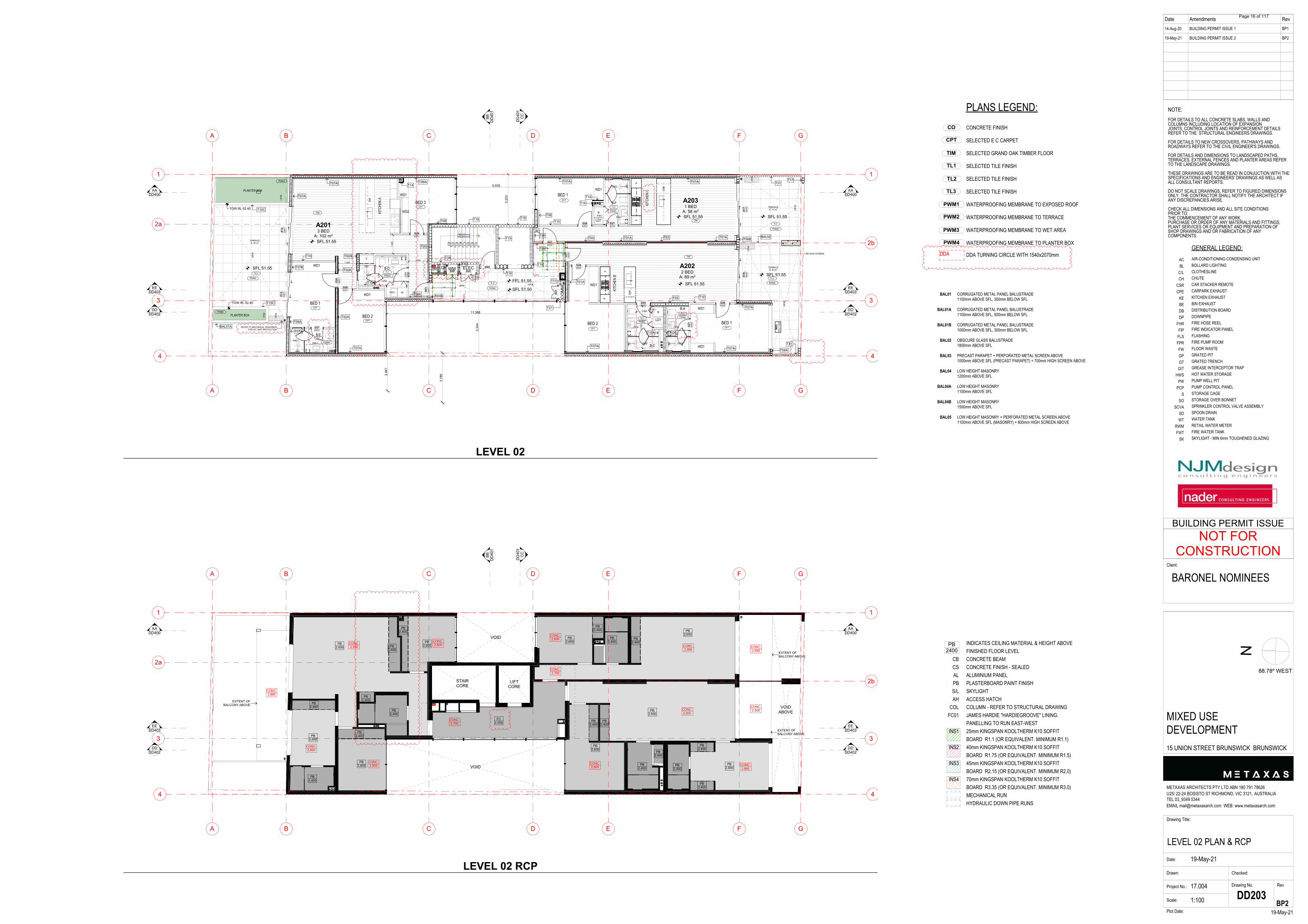
G WM ELECBEB-D
A2031 BED
A: 58 m2
A2013 BED
A: 102 m2
A2022 BED
A: 89 m2
TERRACEA: 17 m2
TERRACEA: 20 m2
TERRACEA: 34 m2
EEDD403
EEDD403
AADD400
AADD400
F
F
FWFW
FW
FW
FW
FW
FWFW
FWFW
FWFW
FW
FW
FW
FW FW
FW
F
FW FW
FW FW
FW
WD1
WD1
LD1
LD1
WD1
WD1
WD1
WD1
JR2
BED 2
BED 1
BED 3
BED 1BED 2
BED 1
P
WD1
WD2
P
E
E
C
C
D
D
B
B
F
F
G
G
A
A
4 4
3 3
2b
2a
1 1
BBD
D40
1
CC
DD
401
DDDD402
DDDD402
PB2,400
PB2,650
PB2,400
PB2,400
PB2,400
PB2,600
PB2,600
PB2,650
PB2,400
PB2,400
PB2,650
PB2,650
FC2,550
PB2,400
PB2,600
PB2,600
PB2,650
PB2,400
PB2,400
PB2,400
CONC.2,800
CONC.2,700
CONC.2,800
CONC.2,800
CONC.2,800
CONC.2,800
CONC.2,800
CONC.2,800
CONC.2,800
CONC.2,800
CONC.2,800
CONC.2,700
CONC.2,800
CONC.2,800
PB2,400
PB2,400
EXTENT OFBALCONY ABOVE
EXTENT OFBALCONY ABOVE
EXTENT OFBALCONY ABOVE
PB2,400
PB2,400
PB2,400
PB2,400
PB2,400
LIFTCORE
STAIRCORE
VOID
VOID
VOIDABOVE
EEDD403
EEDD403
AADD400
AADD400
LEVEL 02
LEVEL 02 RCP
Page 16 of 117
INDICATES CEILING MATERIAL & HEIGHT ABOVEFINISHED FLOOR LEVELCONCRETE BEAMCONCRETE FINISH - SEALEDALUMINIUM PANELPLASTERBOARD PAINT FINISHSKYLIGHTACCESS HATCHCOLUMN - REFER TO STRUCTURAL DRAWINGJAMES HARDIE "HARDIEGROOVE" LINING.PANELLING TO RUN EAST-WEST25mm KINGSPAN KOOLTHERM K10 SOFFITBOARD R1.1 (OR EQUIVALENT. MINIMUM R1.1)40mm KINGSPAN KOOLTHERM K10 SOFFITBOARD R1.75 (OR EQUIVALENT. MINIMUM R1.5)45mm KINGSPAN KOOLTHERM K10 SOFFITBOARD R2.15 (OR EQUIVALENT. MINIMUM R2.0)70mm KINGSPAN KOOLTHERM K10 SOFFITBOARD R3.35 (OR EQUIVALENT. MINIMUM R3.0)MECHANICAL RUNHYDRAULIC DOWN PIPE RUNS
CBCSALPBS/LAH
COLFC01
INS1
INS2
INS3
INS4
PB2400
GENERAL LEGEND:AIR-CONDITIONING CONDENSING UNITBOLLARD LIGHTINGCLOTHESLINECHUTECAR STACKER REMOTECARPARK EXHAUSTKITCHEN EXHAUSTBIN EXHAUSTDISTRIBUTION BOARDDOWNPIPEFIRE HOSE REELFIRE INDICATOR PANELFLASHINGFIRE PUMP ROOMFLOOR WASTEGRATED PITGRATED TRENCHGREASE INTERCEPTOR TRAPHOT WATER STORAGEPUMP WELL PITPUMP CONTROL PANELSTORAGE CAGESTORAGE OVER BONNETSPRINKLER CONTROL VALVE ASSEMBLYSPOON DRAINWATER TANKRETAIL WATER METERFIRE WATER TANKSKYLIGHT - MIN 6mm TOUGHENED GLAZING
FINISHES LEGEND:CONCRETE FINISH (SEALED)POLISHED CONCRETE FINISHLYSAGHT TRIMDEK WITH SARKING TO UNDERSIDE
ACBL
C/LCH
CSRCPE
KEBEDBDP
FHRFIPFLSFPRFWGPGTGIT
HWSPW
PCPS
SOSCVA
SDWT
RWMFWT
SK
CORRUGATED METAL PANEL BALUSTRADE1100mm ABOVE SFL, 300mm BELOW SFL
CORRUGATED METAL PANEL BALUSTRADE1100mm ABOVE SFL, 500mm BELOW SFL
CORRUGATED METAL PANEL BALUSTRADE1000mm ABOVE SFL, 300mm BELOW SFL
OBSCURE GLASS BALUSTRADE1800mm ABOVE SFL
PRECAST PARAPET + PERFORATED METAL SCREEN ABOVE1000mm ABOVE SFL (PRECAST PARAPET) + 700mm HIGH SCREEN ABOVE
LOW HEIGHT MASONRY1200mm ABOVE SFL
LOW HEIGHT MASONRY1100mm ABOVE SFL
LOW HEIGHT MASONRY1500mm ABOVE SFL
LOW HEIGHT MASONRY + PERFORATED METAL SCREEN ABOVE1100mm ABOVE SFL (MASONRY) + 600mm HIGH SCREEN ABOVE
BAL01
BAL01A
BAL01B
BAL02
BAL03
BAL04
BAL04A
BAL04B
BAL05
TL2
CO
TL1
TIM
TL3
CPT
PWM1
PWM4
PWM3
PWM2
PLANS LEGEND:CONCRETE FINISH
SELECTED E C CARPET
SELECTED GRAND OAK TIMBER FLOOR
SELECTED TILE FINISH
SELECTED TILE FINISH
SELECTED TILE FINISH
WATERPROOFING MEMBRANE TO EXPOSED ROOF
WATERPROOFING MEMBRANE TO TERRACE
WATERPROOFING MEMBRANE TO WET AREA
WATERPROOFING MEMBRANE TO PLANTER BOX
DDA TURNING CIRCLE WITH 1540x2070mmDDA
Date Amendments Rev14-Aug-20
19-May-21
BUILDING PERMIT ISSUE 1
BUILDING PERMIT ISSUE 2
BP1
BP2
N
Drawing Title:
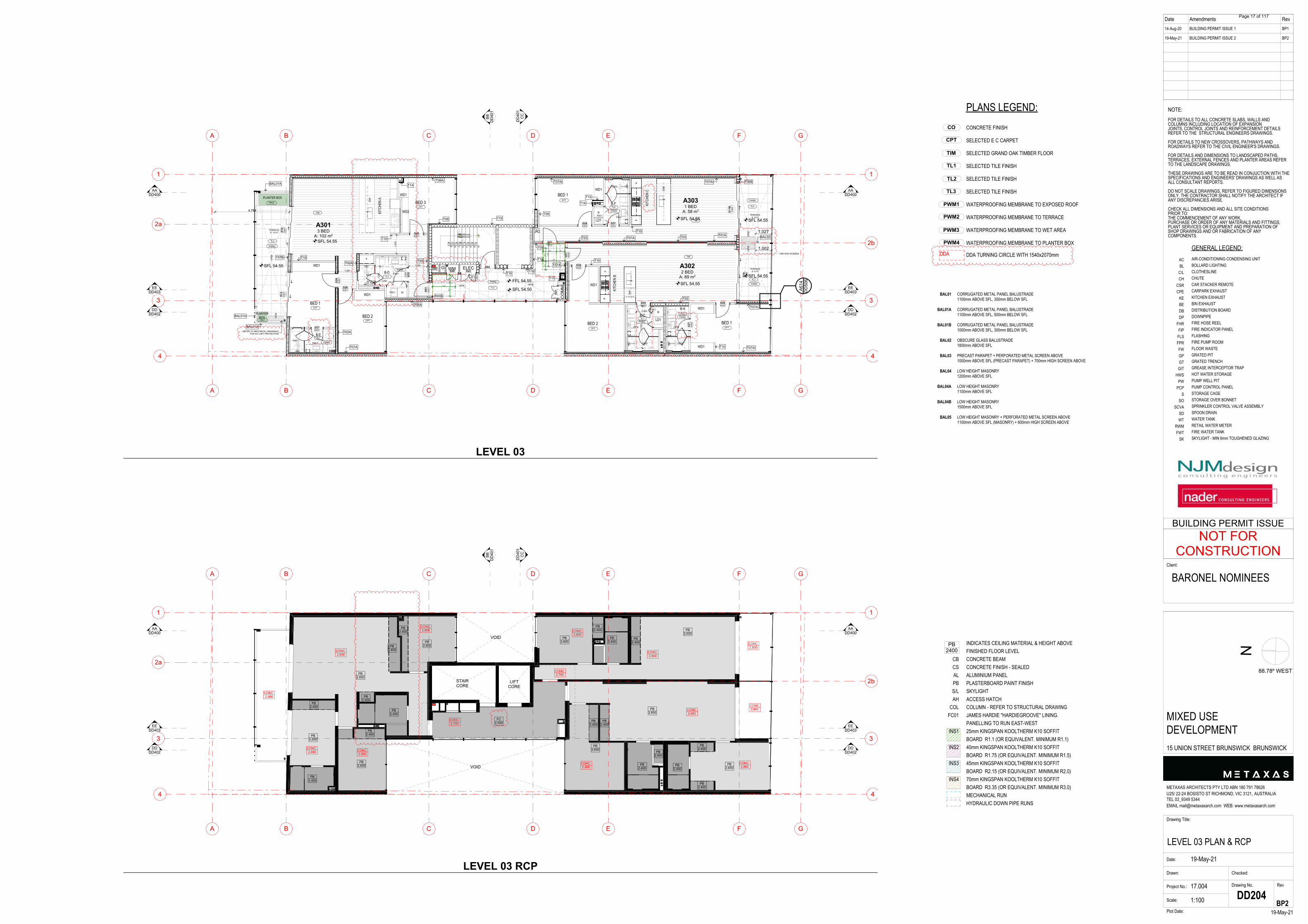
LEVEL 03 PLAN & RCPDate:
Drawn:
Project No.: 17.004
Scale:
Drawing No. Rev
19-May-21Plot Date:
METAXAS ARCHITECTS PTY LTD ABN 180 791 78626U25/ 22-24 BOSISTO ST RICHMOND, VIC 3121, AUSTRALIATEL 03_9349 5344EMAIL [email protected] WEB: www.metaxasarch.com
Client:
19-May-21
Checked:
1:100 DD204
NOTE:FOR DETAILS TO ALL CONCRETE SLABS, WALLS ANDCOLUMNS INCLUDING LOCATION OF EXPANSIONJOINTS, CONTROL JOINTS AND REINFORCEMENT DETAILSREFER TO THE STRUCTURAL ENGINEERS DRAWINGS.
FOR DETAILS TO NEW CROSSOVERS, PATHWAYS ANDROADWAYS REFER TO THE CIVIL ENGINEER'S DRAWINGS.
FOR DETAILS AND DIMENSIONS TO LANDSCAPED PATHS,TERRACES, EXTERNAL FENCES AND PLANTER AREAS REFERTO THE LANDSCAPE DRAWINGS.
THESE DRAWINGS ARE TO BE READ IN CONJUCTION WITH THESPECIFICATIONS AND ENGINEERS' DRAWINGS AS WELL ASALL CONSULTANT REPORTS.
DO NOT SCALE DRAWINGS, REFER TO FIGURED DIMENSIONSONLY. THE CONTRACTOR SHALL NOTIFY THE ARCHITECT IFANY DISCREPANCIES ARISE.
CHECK ALL DIMENSIONS AND ALL SITE CONDITIONSPRIOR TO:THE COMMENCEMENT OF ANY WORK,PURCHASE OR ORDER OF ANY MATERIALS AND FITTINGS,PLANT SERVICES OR EQUIPMENT AND PREPARATION OFSHOP DRAWINGS AND OR FABRICATION OF ANYCOMPONENTS.
BARONEL NOMINEES
MIXED USEDEVELOPMENT15 UNION STREET BRUNSWICK BRUNSWICK
BP2
88.78º WEST
NOT FORCONSTRUCTION
BUILDING PERMIT ISSUE
DW
DW
5678
9 10 11 12 13 14 15 16
16R(188 mm)15G(250 mm)
12345
UP16R(188 mm)
15G(250 mm)
D17
B A
303
D16
A30
2
D02
D01
A30
2
D28 A303
D27 A303
D01 A303
D28 A302
D28 A302
D25 A302
D27
A30
2
D28 A301
D28 A301
D28
A30
1
D14
A30
1 D
13 A
301
D22 D20
D21 D
01 A
301
D27 A301
D25
A 301
E
E
C
C
D
D
B
B
F
F
G
G
A
A
4 4
3 3
2b
2a
1 1
DW
W
W
W
A614
DD506
BBD
D40
1
CC
DD
401
DDDD402
DDDD402
4,764
2,70
0
1,000
1,002
1,027
510
854
1,450
510
854
1,450
854 510
1,45
0
1,200
1,20
0
1,200
1,20
0
1,200
SFL 54.50
FFL 54.55 SFL 54.55
SFL 54.55 SFL 54.55
SFL 54.55
SFL 54.55
SFL 54.55
1.8M HIGH SCREEN
BAL01A
BAL01A
BAL02
T01B
PBX1
PBX2
CPT
TIM
CPT
CPT
CPT
CPT CPT
TL1
TL1
TIM
TIM
TL2
TL2
TL2
TL3
T14
T14
T14
T16T11
T01A
T16
T16
T09
T10
T01A T03 T01A
T06BT07Ai
T10
T06
T07Ai
T03
T19
T08Ai
T08
T10
T10T07B
T07A
T02A
T05
T06A
T02
T10
T07A
T07Ai
T13
TL3
TL1
PWM2
PWM3
PWM3
PWM3
PWM3
PWM2
PWM2
PWM2
T02A
REFER TO MECHNICAL DRAWINGSFOR A/C UNIT PROTECTION
BAL01A
TL1
T10A
PWM3
PLANTER BOX
PLANTERBOX
CO
MM
FE
KITC
HEN
A
KITC
HEN
B
B-E
B-A
B-C
B-F KITC
HEN
C
DDA
DD
A
G WM ELECBEB-D
A3031 BED
A: 58 m2
A3013 BED
A: 102 m2
TERRACEA: 8 m2
TERRACEA: 9 m2
TERRACEA: 15 m2
A3022 BED
A: 89 m2
EEDD403
EEDD403
AADD400
AADD400
F
F
FWFW
FW
FW
FWFW
FWFW
FWFW
FW
FW FW
FW
F
FW FW
FW FW
FW
WD1
WD1
LD1
LD1
WD1
WD1
WD1
WD1
JR2
BED 2
BED 1
BED 3
BED 1BED 2
BED 1
P
WD1
WD2
P
E
E
C
C
D
D
B
B
F
F
G
G
A
A
4 4
3 3
2b
2a
1 1
BBD
D40
1
CC
DD
401
DDDD402
DDDD402
CONC.2,800
CONC.2,700
CONC.2,700
CONC.2,800
CONC.2,800
CONC.2,800
CONC.2,800
CONC.2,800
CONC.2,800
CONC.2,800
CONC.2,800
CONC.2,800
CONC.2,800
CONC.2,800
PB2,400
PB2,650
PB2,400
PB2,400
PB2,400
PB2,600
PB2,600
PB2,650
PB2,400
PB2,400
PB2,650
FC2,550
PB2,400
PB2,600
PB2,600
PB2,650
PB2,400
PB2,400
PB2,400
PB2,400
PB2,400
PB2,650
PB2,400
PB2,400
PB2,400
PB2,400
PB2,400
LIFTCORE
STAIRCORE
VOID
VOID
EEDD403
EEDD403
AADD400
AADD400
LEVEL 03
LEVEL 03 RCP
Page 17 of 117
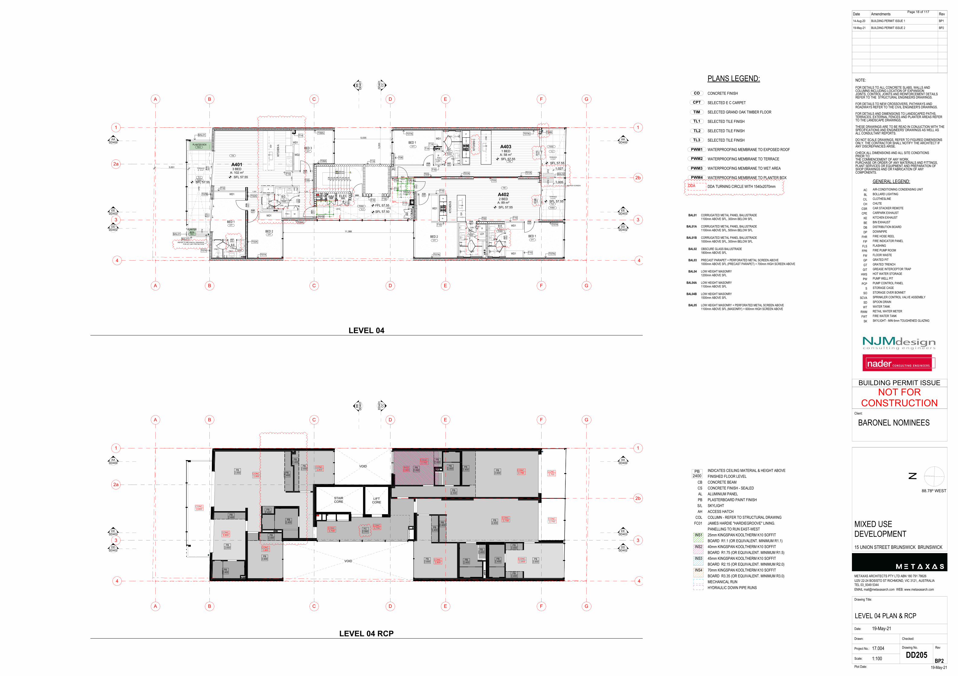
INDICATES CEILING MATERIAL & HEIGHT ABOVEFINISHED FLOOR LEVELCONCRETE BEAMCONCRETE FINISH - SEALEDALUMINIUM PANELPLASTERBOARD PAINT FINISHSKYLIGHTACCESS HATCHCOLUMN - REFER TO STRUCTURAL DRAWINGJAMES HARDIE "HARDIEGROOVE" LINING.PANELLING TO RUN EAST-WEST25mm KINGSPAN KOOLTHERM K10 SOFFITBOARD R1.1 (OR EQUIVALENT. MINIMUM R1.1)40mm KINGSPAN KOOLTHERM K10 SOFFITBOARD R1.75 (OR EQUIVALENT. MINIMUM R1.5)45mm KINGSPAN KOOLTHERM K10 SOFFITBOARD R2.15 (OR EQUIVALENT. MINIMUM R2.0)70mm KINGSPAN KOOLTHERM K10 SOFFITBOARD R3.35 (OR EQUIVALENT. MINIMUM R3.0)MECHANICAL RUNHYDRAULIC DOWN PIPE RUNS
CBCSALPBS/LAH
COLFC01
INS1
INS2
INS3
INS4
PB2400
GENERAL LEGEND:AIR-CONDITIONING CONDENSING UNITBOLLARD LIGHTINGCLOTHESLINECHUTECAR STACKER REMOTECARPARK EXHAUSTKITCHEN EXHAUSTBIN EXHAUSTDISTRIBUTION BOARDDOWNPIPEFIRE HOSE REELFIRE INDICATOR PANELFLASHINGFIRE PUMP ROOMFLOOR WASTEGRATED PITGRATED TRENCHGREASE INTERCEPTOR TRAPHOT WATER STORAGEPUMP WELL PITPUMP CONTROL PANELSTORAGE CAGESTORAGE OVER BONNETSPRINKLER CONTROL VALVE ASSEMBLYSPOON DRAINWATER TANKRETAIL WATER METERFIRE WATER TANKSKYLIGHT - MIN 6mm TOUGHENED GLAZING
FINISHES LEGEND:CONCRETE FINISH (SEALED)POLISHED CONCRETE FINISHLYSAGHT TRIMDEK WITH SARKING TO UNDERSIDE
ACBL
C/LCH
CSRCPE
KEBEDBDP
FHRFIPFLSFPRFWGPGTGIT
HWSPW
PCPS
SOSCVA
SDWT
RWMFWT
SK
CORRUGATED METAL PANEL BALUSTRADE1100mm ABOVE SFL, 300mm BELOW SFL
CORRUGATED METAL PANEL BALUSTRADE1100mm ABOVE SFL, 500mm BELOW SFL
CORRUGATED METAL PANEL BALUSTRADE1000mm ABOVE SFL, 300mm BELOW SFL
OBSCURE GLASS BALUSTRADE1800mm ABOVE SFL
PRECAST PARAPET + PERFORATED METAL SCREEN ABOVE1000mm ABOVE SFL (PRECAST PARAPET) + 700mm HIGH SCREEN ABOVE
LOW HEIGHT MASONRY1200mm ABOVE SFL
LOW HEIGHT MASONRY1100mm ABOVE SFL
LOW HEIGHT MASONRY1500mm ABOVE SFL
LOW HEIGHT MASONRY + PERFORATED METAL SCREEN ABOVE1100mm ABOVE SFL (MASONRY) + 600mm HIGH SCREEN ABOVE
BAL01
BAL01A
BAL01B
BAL02
BAL03
BAL04
BAL04A
BAL04B
BAL05
TL2
CO
TL1
TIM
TL3
CPT
PWM1
PWM4
PWM3
PWM2
PLANS LEGEND:CONCRETE FINISH
SELECTED E C CARPET
SELECTED GRAND OAK TIMBER FLOOR
SELECTED TILE FINISH
SELECTED TILE FINISH
SELECTED TILE FINISH
WATERPROOFING MEMBRANE TO EXPOSED ROOF
WATERPROOFING MEMBRANE TO TERRACE
WATERPROOFING MEMBRANE TO WET AREA
WATERPROOFING MEMBRANE TO PLANTER BOX
DDA TURNING CIRCLE WITH 1540x2070mmDDA
Date Amendments Rev14-Aug-20
19-May-21
BUILDING PERMIT ISSUE 1
BUILDING PERMIT ISSUE 2
BP1
BP2
N
Drawing Title:
LEVEL 04 PLAN & RCPDate:
Drawn:
Project No.: 17.004
Scale:
Drawing No. Rev
19-May-21Plot Date:
METAXAS ARCHITECTS PTY LTD ABN 180 791 78626U25/ 22-24 BOSISTO ST RICHMOND, VIC 3121, AUSTRALIATEL 03_9349 5344EMAIL [email protected] WEB: www.metaxasarch.com
Client:
19-May-21
Checked:
1:100 DD205
NOTE:FOR DETAILS TO ALL CONCRETE SLABS, WALLS ANDCOLUMNS INCLUDING LOCATION OF EXPANSIONJOINTS, CONTROL JOINTS AND REINFORCEMENT DETAILSREFER TO THE STRUCTURAL ENGINEERS DRAWINGS.
FOR DETAILS TO NEW CROSSOVERS, PATHWAYS ANDROADWAYS REFER TO THE CIVIL ENGINEER'S DRAWINGS.
FOR DETAILS AND DIMENSIONS TO LANDSCAPED PATHS,TERRACES, EXTERNAL FENCES AND PLANTER AREAS REFERTO THE LANDSCAPE DRAWINGS.
THESE DRAWINGS ARE TO BE READ IN CONJUCTION WITH THESPECIFICATIONS AND ENGINEERS' DRAWINGS AS WELL ASALL CONSULTANT REPORTS.
DO NOT SCALE DRAWINGS, REFER TO FIGURED DIMENSIONSONLY. THE CONTRACTOR SHALL NOTIFY THE ARCHITECT IFANY DISCREPANCIES ARISE.
CHECK ALL DIMENSIONS AND ALL SITE CONDITIONSPRIOR TO:THE COMMENCEMENT OF ANY WORK,PURCHASE OR ORDER OF ANY MATERIALS AND FITTINGS,PLANT SERVICES OR EQUIPMENT AND PREPARATION OFSHOP DRAWINGS AND OR FABRICATION OF ANYCOMPONENTS.
BARONEL NOMINEES
MIXED USEDEVELOPMENT15 UNION STREET BRUNSWICK BRUNSWICK
BP2
88.78º WEST
NOT FORCONSTRUCTION
BUILDING PERMIT ISSUE
DW
DW
5678
9 10 11 12 13 14 15 16
16R(188 mm)15G(250 mm)
12345
UP16R(188 mm)
15G(250 mm)
D17
C A
403
D16
B A
402
D02
D01
A40
2
D28 A403
D27 A403
D01 A403
D28 A402
D28 A402
D25 A402
D27
A40
2
D28 A401
D28 A401
D28
A40
1
D14
A40
1 D
13 A
401
D22 D20
D21 D
01 A
401
D27 A401
D25
A 401
E
E
C
C
D
D
B
B
F
F
G
G
A
A
4 4
3 3
2b
2a
1 1
DW
W
W
W
BBD
D40
1
CC
DD
401
DDDD402
DDDD402
3,001
3,20
3
2,70
0
1,000
11,388
5,035
1,005
1,027
1,450
854
510
510
854
854 510
1,45
0
1,450
1,200
1,20
0
1,200
1,20
0
1,200
SFL 57.50
FFL 57.55 SFL 57.55
SFL 57.55SFL 57.55
SFL 57.55
SFL 57.55SFL 57.55
1.8M HIGH SCREEN
BAL01
BAL01
BAL01
BAL02
T01B
PBX1
PBX2
CPT
TIM
CPT
CPT
CPT
CPT CPT
TL1
TL1
TIM
TIM
TL2
TL2
TL2
TL3
T14
T14
T14
T16
T07Ai T07AiT10
T07A
T10T02
T10
T01A
T03
T03 T01A
T06BT07Ai
T10
T07Ai
T06
T16
T16
T19
T09
T01A
T11
T10
T08A
T08Ai
T10
T10
T02AT07B
T07A
T02A
T07A
T06A
T13
T05
TL3
TL1
PWM2
PWM3
PWM3
PWM3
PWM3
PWM2
PWM2
PWM2
T09
REFER TO MECHNICAL DRAWINGSFOR A/C UNIT PROTECTION
TL1
T10A
PWM3
PLANTER BOX
PLANTERBOX
CO
MM
FE
KITC
HEN
A
KITC
HEN
B
B-E
B-AB-C
B-F KITC
HEN
C
DDA
DD
A
G WM ELECBEB-D
A4031 BED
A: 58 m2
A4013 BED
A: 102 m2
TERRACEA: 8 m2
TERRACEA: 9 m2
TERRACEA: 15 m2
A4022 BED
A: 89 m2
EEDD403
EEDD403
AADD400
AADD400
F
F
FWFW
FW
FW
FWFW
FWFW
FWFW
FW FW
FW
FW FW
FW
F
FW
FW FW
FW
WD1
WD1
LD1
LD1
WD1
WD1
WD1
WD1
JR2
BED 2
BED 1
BED 3
BED 1BED 2
BED 1
P
WD1
WD2
P
E
E
C
C
D
D
B
B
F
F
G
G
A
A
4 4
3 3
2b
2a
1 1
BBD
D40
1
CC
DD
401
DDDD402
DDDD402
PB2,400
PB2,650
FC2,550
PB2,450
PB2,400
PB2,400
PB2,400
PB2,600
PB2,400
PB2,400
PB2,400
PB2,650
PB2,600
PB2,600
PB2,400
PB2,500
PB2,600
PB2,650
PB2,600
PB2,400
CONC.2,700
CONC.2,700
CONC.2,700
CONC.2,700
CONC.2,800
CONC.2,800
CONC.2,800
CONC.2,800
CONC.2,800
CONC.2,700 CONC.
2,700
CONC.2,700
CONC.2,800
PB2,400
PB2,400
PB2,400
CONC.2,800
INS22,660
PB2,400
PB2,400
PB2,400
PB2,400
PB2,400
LIFTCORE
STAIRCORE
VOID
VOID
EEDD403
EEDD403
AADD400
AADD400
LEVEL 04
LEVEL 04 RCP
Page 18 of 117
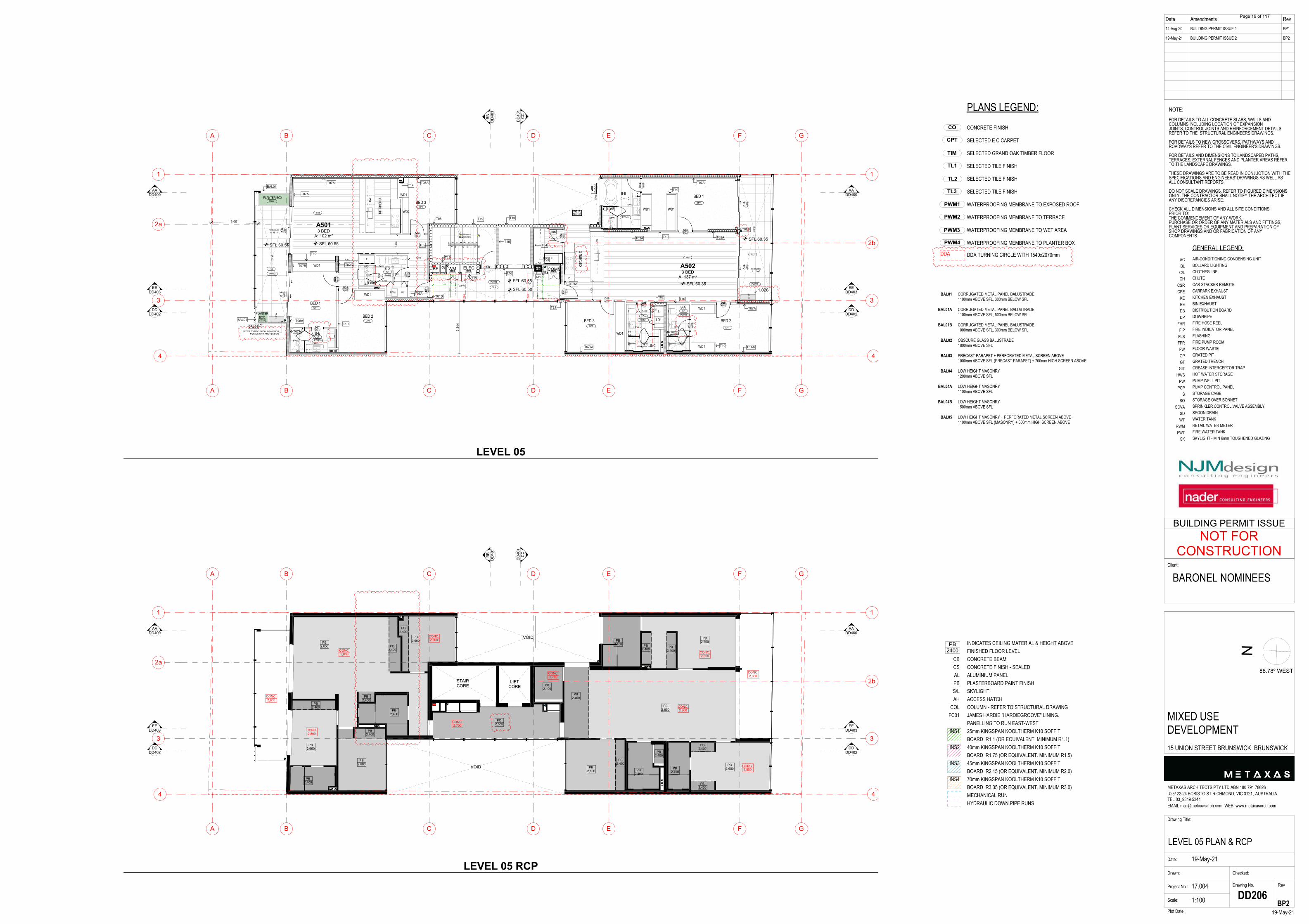
INDICATES CEILING MATERIAL & HEIGHT ABOVEFINISHED FLOOR LEVELCONCRETE BEAMCONCRETE FINISH - SEALEDALUMINIUM PANELPLASTERBOARD PAINT FINISHSKYLIGHTACCESS HATCHCOLUMN - REFER TO STRUCTURAL DRAWINGJAMES HARDIE "HARDIEGROOVE" LINING.PANELLING TO RUN EAST-WEST25mm KINGSPAN KOOLTHERM K10 SOFFITBOARD R1.1 (OR EQUIVALENT. MINIMUM R1.1)40mm KINGSPAN KOOLTHERM K10 SOFFITBOARD R1.75 (OR EQUIVALENT. MINIMUM R1.5)45mm KINGSPAN KOOLTHERM K10 SOFFITBOARD R2.15 (OR EQUIVALENT. MINIMUM R2.0)70mm KINGSPAN KOOLTHERM K10 SOFFITBOARD R3.35 (OR EQUIVALENT. MINIMUM R3.0)MECHANICAL RUNHYDRAULIC DOWN PIPE RUNS
CBCSALPBS/LAH
COLFC01
INS1
INS2
INS3
INS4
PB2400
GENERAL LEGEND:AIR-CONDITIONING CONDENSING UNITBOLLARD LIGHTINGCLOTHESLINECHUTECAR STACKER REMOTECARPARK EXHAUSTKITCHEN EXHAUSTBIN EXHAUSTDISTRIBUTION BOARDDOWNPIPEFIRE HOSE REELFIRE INDICATOR PANELFLASHINGFIRE PUMP ROOMFLOOR WASTEGRATED PITGRATED TRENCHGREASE INTERCEPTOR TRAPHOT WATER STORAGEPUMP WELL PITPUMP CONTROL PANELSTORAGE CAGESTORAGE OVER BONNETSPRINKLER CONTROL VALVE ASSEMBLYSPOON DRAINWATER TANKRETAIL WATER METERFIRE WATER TANKSKYLIGHT - MIN 6mm TOUGHENED GLAZING
FINISHES LEGEND:CONCRETE FINISH (SEALED)POLISHED CONCRETE FINISHLYSAGHT TRIMDEK WITH SARKING TO UNDERSIDE
ACBL
C/LCH
CSRCPE
KEBEDBDP
FHRFIPFLSFPRFWGPGTGIT
HWSPW
PCPS
SOSCVA
SDWT
RWMFWT
SK
CORRUGATED METAL PANEL BALUSTRADE1100mm ABOVE SFL, 300mm BELOW SFL
CORRUGATED METAL PANEL BALUSTRADE1100mm ABOVE SFL, 500mm BELOW SFL
CORRUGATED METAL PANEL BALUSTRADE1000mm ABOVE SFL, 300mm BELOW SFL
OBSCURE GLASS BALUSTRADE1800mm ABOVE SFL
PRECAST PARAPET + PERFORATED METAL SCREEN ABOVE1000mm ABOVE SFL (PRECAST PARAPET) + 700mm HIGH SCREEN ABOVE
LOW HEIGHT MASONRY1200mm ABOVE SFL
LOW HEIGHT MASONRY1100mm ABOVE SFL
LOW HEIGHT MASONRY1500mm ABOVE SFL
LOW HEIGHT MASONRY + PERFORATED METAL SCREEN ABOVE1100mm ABOVE SFL (MASONRY) + 600mm HIGH SCREEN ABOVE
BAL01
BAL01A
BAL01B
BAL02
BAL03
BAL04
BAL04A
BAL04B
BAL05
TL2
CO
TL1
TIM
TL3
CPT
PWM1
PWM4
PWM3
PWM2
PLANS LEGEND:CONCRETE FINISH
SELECTED E C CARPET
SELECTED GRAND OAK TIMBER FLOOR
SELECTED TILE FINISH
SELECTED TILE FINISH
SELECTED TILE FINISH
WATERPROOFING MEMBRANE TO EXPOSED ROOF
WATERPROOFING MEMBRANE TO TERRACE
WATERPROOFING MEMBRANE TO WET AREA
WATERPROOFING MEMBRANE TO PLANTER BOX
DDA TURNING CIRCLE WITH 1540x2070mmDDA
Date Amendments Rev14-Aug-20
19-May-21
BUILDING PERMIT ISSUE 1
BUILDING PERMIT ISSUE 2
BP1
BP2
N
Drawing Title:
LEVEL 05 PLAN & RCPDate:
Drawn:
Project No.: 17.004
Scale:
Drawing No. Rev
19-May-21Plot Date:
METAXAS ARCHITECTS PTY LTD ABN 180 791 78626U25/ 22-24 BOSISTO ST RICHMOND, VIC 3121, AUSTRALIATEL 03_9349 5344EMAIL [email protected] WEB: www.metaxasarch.com
Client:
19-May-21
Checked:
1:100 DD206
NOTE:FOR DETAILS TO ALL CONCRETE SLABS, WALLS ANDCOLUMNS INCLUDING LOCATION OF EXPANSIONJOINTS, CONTROL JOINTS AND REINFORCEMENT DETAILSREFER TO THE STRUCTURAL ENGINEERS DRAWINGS.
FOR DETAILS TO NEW CROSSOVERS, PATHWAYS ANDROADWAYS REFER TO THE CIVIL ENGINEER'S DRAWINGS.
FOR DETAILS AND DIMENSIONS TO LANDSCAPED PATHS,TERRACES, EXTERNAL FENCES AND PLANTER AREAS REFERTO THE LANDSCAPE DRAWINGS.
THESE DRAWINGS ARE TO BE READ IN CONJUCTION WITH THESPECIFICATIONS AND ENGINEERS' DRAWINGS AS WELL ASALL CONSULTANT REPORTS.
DO NOT SCALE DRAWINGS, REFER TO FIGURED DIMENSIONSONLY. THE CONTRACTOR SHALL NOTIFY THE ARCHITECT IFANY DISCREPANCIES ARISE.
CHECK ALL DIMENSIONS AND ALL SITE CONDITIONSPRIOR TO:THE COMMENCEMENT OF ANY WORK,PURCHASE OR ORDER OF ANY MATERIALS AND FITTINGS,PLANT SERVICES OR EQUIPMENT AND PREPARATION OFSHOP DRAWINGS AND OR FABRICATION OF ANYCOMPONENTS.
BARONEL NOMINEES
MIXED USEDEVELOPMENT15 UNION STREET BRUNSWICK BRUNSWICK
BP2
88.78º WEST
NOT FORCONSTRUCTION
BUILDING PERMIT ISSUE
DW
5678
9 10 11 12 13 14 15 16
16R(188 mm)15G(250 mm)
12345
UP16R(188 mm)
15G(250 mm)
D01
A50
2
D28
A50
1
W02
SIL
L1,7
00
W01A SILL100
D15
A50
2 D
18 A
502
D24
A50
2
D24
A50
2
D28 A502
D28 A502
D20 D02
D27
A50
2
D28 A502 D28
A501
D28 A501
D14
A50
1 D
13 A
501
D22 D20
D01
A50
1
D25 A502
D27 A501
D25
A 501
E
E
C
C
D
D
B
B
F
F
G
G
A
A
4 4
3 3
2b
2a
1 1
DW
W
W
BBD
D40
1
CC
DD
401
DDDD402
DDDD402
3,001
1,000
2,70
0
3,34
4
1,20
0
854
510
1,450
854
510
1,450
1,028
1,200
1,20
0
1,200
1,20
0
1,200
SFL 60.50
FFL 60.55SFL 60.35
SFL 60.35SFL 60.55SFL 60.55
EEDD403
EEDD403
T10
T02A
T10
T07A
T08A
T07B
T07A
T07Ai T08Ai
T08
T06A
T01A
T04
T06
T02A T10 T02A
T07Ai
T06A
T06B
T07A
T07AiT07Ai
T10
T02C
T13
T11
T11
T19 T19
T19
T19
T21
T05
BAL01
BAL01
BAL01
T01B
PBX1
PBX2
CPT
TIM
CPT
CPT
CPT
TL1
TL1
CPT
CPT
TL1
TIM
T02
TL2
TL2
TL3
T14
T16
T10
T10
TIM
TL1
PWM2
PWM3
PWM3
PWM3
PWM3
PWM2
PWM2
REFER TO MECHNICAL DRAWINGSFOR A/C UNIT PROTECTION
TL1
T10A
PWM3
PLANTERBOX
PLANTER BOX
COMM
KITC
HEN
A
FE
B-A
B-B
B-C
B-E
KITC
HEN
D
DD
A
DD
A
G WM ELECBEB-D
A5013 BED
A: 102 m2
A5023 BED
A: 137 m2
TERRACEA: 17 m2
TERRACEA: 15 m2
AADD400
AADD400
F
P
FW
FW
FW
FW
FW
FWFW
FWFW
FW
FW FW
FW
FW
FW FW
FW
F
FW FW
T09
WD1
WD1
LD1
WD1
WD1
WD1
WD1
WD1
BED 1
BED 2BED 3BED 2
BED 1
BED 3
WD1
WD2
E
E
C
C
D
D
B
B
F
F
G
G
A
A
4 4
3 3
2b
2a
1 1
BBD
D40
1
CC
DD
401
DDDD402
DDDD402
EEDD403
EEDD403
PB2,600
PB2,650
PB2,400
PB2,650
PB2,600
FC2,550
PB2,400
PB2,400
PB2,650
PB2,600 PB
2,400
PB2,400
PB2,650
PB2,400
PB2,400
PB2,400 PB
2,400PB
2,400
PB2,650
PB2,400
CONC.2,800
CONC.2,700
CONC.2,800
CONC.2,800
CONC.2,800
CONC.2,700
CONC.2,800
CONC.2,800
CONC.2,800
CONC.2,800
PB2,400
PB2,400
PB2,400
PB2,400
PB2,400
PB2,400
PB2,400
LIFTCORE
STAIRCORE
VOID
VOID
AADD400
AADD400
LEVEL 05
LEVEL 05 RCP
Page 19 of 117

INDICATES CEILING MATERIAL & HEIGHT ABOVEFINISHED FLOOR LEVELCONCRETE BEAMCONCRETE FINISH - SEALEDALUMINIUM PANELPLASTERBOARD PAINT FINISHSKYLIGHTACCESS HATCHCOLUMN - REFER TO STRUCTURAL DRAWINGJAMES HARDIE "HARDIEGROOVE" LINING.PANELLING TO RUN EAST-WEST25mm KINGSPAN KOOLTHERM K10 SOFFITBOARD R1.1 (OR EQUIVALENT. MINIMUM R1.1)40mm KINGSPAN KOOLTHERM K10 SOFFITBOARD R1.75 (OR EQUIVALENT. MINIMUM R1.5)45mm KINGSPAN KOOLTHERM K10 SOFFITBOARD R2.15 (OR EQUIVALENT. MINIMUM R2.0)70mm KINGSPAN KOOLTHERM K10 SOFFITBOARD R3.35 (OR EQUIVALENT. MINIMUM R3.0)MECHANICAL RUNHYDRAULIC DOWN PIPE RUNS
CBCSALPBS/LAH
COLFC01
INS1
INS2
INS3
INS4
PB2400
GENERAL LEGEND:AIR-CONDITIONING CONDENSING UNITBOLLARD LIGHTINGCLOTHESLINECHUTECAR STACKER REMOTECARPARK EXHAUSTKITCHEN EXHAUSTBIN EXHAUSTDISTRIBUTION BOARDDOWNPIPEFIRE HOSE REELFIRE INDICATOR PANELFLASHINGFIRE PUMP ROOMFLOOR WASTEGRATED PITGRATED TRENCHGREASE INTERCEPTOR TRAPHOT WATER STORAGEPUMP WELL PITPUMP CONTROL PANELSTORAGE CAGESTORAGE OVER BONNETSPRINKLER CONTROL VALVE ASSEMBLYSPOON DRAINWATER TANKRETAIL WATER METERFIRE WATER TANKSKYLIGHT - MIN 6mm TOUGHENED GLAZING
FINISHES LEGEND:CONCRETE FINISH (SEALED)POLISHED CONCRETE FINISHLYSAGHT TRIMDEK WITH SARKING TO UNDERSIDE
ACBL
C/LCH
CSRCPE
KEBEDBDP
FHRFIPFLSFPRFWGPGTGIT
HWSPW
PCPS
SOSCVA
SDWT
RWMFWT
SK
CORRUGATED METAL PANEL BALUSTRADE1100mm ABOVE SFL, 300mm BELOW SFL
CORRUGATED METAL PANEL BALUSTRADE1100mm ABOVE SFL, 500mm BELOW SFL
CORRUGATED METAL PANEL BALUSTRADE1000mm ABOVE SFL, 300mm BELOW SFL
OBSCURE GLASS BALUSTRADE1800mm ABOVE SFL
PRECAST PARAPET + PERFORATED METAL SCREEN ABOVE1000mm ABOVE SFL (PRECAST PARAPET) + 700mm HIGH SCREEN ABOVE
LOW HEIGHT MASONRY1200mm ABOVE SFL
LOW HEIGHT MASONRY1100mm ABOVE SFL
LOW HEIGHT MASONRY1500mm ABOVE SFL
LOW HEIGHT MASONRY + PERFORATED METAL SCREEN ABOVE1100mm ABOVE SFL (MASONRY) + 600mm HIGH SCREEN ABOVE
BAL01
BAL01A
BAL01B
BAL02
BAL03
BAL04
BAL04A
BAL04B
BAL05
TL2
CO
TL1
TIM
TL3
CPT
PWM1
PWM4
PWM3
PWM2
PLANS LEGEND:CONCRETE FINISH
SELECTED E C CARPET
SELECTED GRAND OAK TIMBER FLOOR
SELECTED TILE FINISH
SELECTED TILE FINISH
SELECTED TILE FINISH
WATERPROOFING MEMBRANE TO EXPOSED ROOF
WATERPROOFING MEMBRANE TO TERRACE
WATERPROOFING MEMBRANE TO WET AREA
WATERPROOFING MEMBRANE TO PLANTER BOX
DDA TURNING CIRCLE WITH 1540x2070mmDDA
Date Amendments Rev14-Aug-20
19-May-21
BUILDING PERMIT ISSUE 1
BUILDING PERMIT ISSUE 2
BP1
BP2
N
Drawing Title:
LEVEL 06 PLAN & RCPDate:
Drawn:
Project No.: 17.004
Scale:
Drawing No. Rev
19-May-21Plot Date:
METAXAS ARCHITECTS PTY LTD ABN 180 791 78626U25/ 22-24 BOSISTO ST RICHMOND, VIC 3121, AUSTRALIATEL 03_9349 5344EMAIL [email protected] WEB: www.metaxasarch.com
Client:
19-May-21
Checked:
1:100 DD207
NOTE:FOR DETAILS TO ALL CONCRETE SLABS, WALLS ANDCOLUMNS INCLUDING LOCATION OF EXPANSIONJOINTS, CONTROL JOINTS AND REINFORCEMENT DETAILSREFER TO THE STRUCTURAL ENGINEERS DRAWINGS.
FOR DETAILS TO NEW CROSSOVERS, PATHWAYS ANDROADWAYS REFER TO THE CIVIL ENGINEER'S DRAWINGS.
FOR DETAILS AND DIMENSIONS TO LANDSCAPED PATHS,TERRACES, EXTERNAL FENCES AND PLANTER AREAS REFERTO THE LANDSCAPE DRAWINGS.
THESE DRAWINGS ARE TO BE READ IN CONJUCTION WITH THESPECIFICATIONS AND ENGINEERS' DRAWINGS AS WELL ASALL CONSULTANT REPORTS.
DO NOT SCALE DRAWINGS, REFER TO FIGURED DIMENSIONSONLY. THE CONTRACTOR SHALL NOTIFY THE ARCHITECT IFANY DISCREPANCIES ARISE.
CHECK ALL DIMENSIONS AND ALL SITE CONDITIONSPRIOR TO:THE COMMENCEMENT OF ANY WORK,PURCHASE OR ORDER OF ANY MATERIALS AND FITTINGS,PLANT SERVICES OR EQUIPMENT AND PREPARATION OFSHOP DRAWINGS AND OR FABRICATION OF ANYCOMPONENTS.
BARONEL NOMINEES
MIXED USEDEVELOPMENT15 UNION STREET BRUNSWICK BRUNSWICK
BP2
88.78º WEST
NOT FORCONSTRUCTION
BUILDING PERMIT ISSUE
DW
5678
9 10 11 12 13 14 15 16
16R(188 mm)15G(250 mm)
12345
UP16R(188 mm)
15G(250 mm)
D15
A60
2 D
18 A
602
W02
SIL
L1,7
00
W01 SILL0
D02
D01
A60
2
D24
A60
2
D24
A60
2
D28 A602
D28 A602
D27
A60
2
D28 A602 D28
A601
D28 A601
D14
A60
1 D
13 A
601
D28
A60
1
D22 D20 D20
D01
A60
1
D25 A602
D27 A601
D25
A 601
E
E
C
C
D
D
B
B
F
F
G
G
A
A
4 4
3 3
2b
2a
1 1
DW
W
W
BBD
D40
1
CC
DD
401
DDDD402
DDDD402
EEDD403
EEDD403
3,001
3,34
4
3,20
3
1,000
2,70
0
9,100
1,027
11,388
854
510
1,450
1,450
854
5101,200
1,20
0
1,200
1,20
0
1,200
SFL 60.50
FFL 63.55SFL 63.55
SFL 63.55SFL 63.55
SFL 63.55
AADD400
AADD400
BAL01
BAL01
BAL01
T01B
PBX1
PBX2
CPT
TIM
CPT
CPT
CPT
TL1TL1
CPT
CPT
TL1
TIMTL2
TL2
TL3
T14
T02A T10
T02A
T07Ai
T10
T06A
T06
T04
T06
T10T02
T07AiT10
T16
T01A
T11
T19T08
T05
T08AiT07Ai
T07B
T10
T10
T07AT07A
T06A
T13
TL1
TIM
PWM2
PWM3
PWM3
PWM3
PWM3
PWM2
PWM2
T07A
REFER TO MECHNICAL DRAWINGSFOR A/C UNIT PROTECTION
TL1
T10A
PWM3
PLANTER BOX
PLANTERBOX
G WM ELEC COMMFE
KITC
HEN
A
B-A
B-B
B-C
B-E
KITC
HEN
D
DD
A
DD
A
BEB-D
A6013 BED
A: 102 m2
A6023 BED
A: 137 m2
TERRACEA: 15 m2
TERRACEA: 17 m2
F
P
FW
FW
FW
FW
FWFW
FWFW FW
FW
FW
FW
FW
F
FW FW
FW
FW
FW
T09
WD1
WD1
LD1
WD1
WD1
WD1
WD1
WD1
BED 1
BED 2BED 3BED 2
BED 1
BED 3
WD1
WD2
E
E
C
C
D
D
B
B
F
F
G
G
A
A
4 4
3 3
2b
2a
1 1
BBD
D40
1
CC
DD
401
DDDD402
DDDD402
EEDD403
EEDD403
AADD400
AADD400
PB2,600
PB2,650
PB2,400
PB2,650
PB2,600
FC2,550
PB2,400
PB2,400
PB2,650
PB2,600 PB
2,400
PB2,400
PB2,650
PB2,400
PB2,400
PB2,400 PB
2,400PB
2,400
PB2,650
PB2,400
PB2,400
PB2,400
CONC.2,800
CONC.2,800
CONC.2,800
CONC.2,800
CONC.2,800
CONC.2,800
CONC.2,800
CONC.2,800
CONC.2,700
CONC.2,700
PB2,400
PB2,400
PB2,400
PB2,400
PB2,400
LIFTCORE
STAIRCORE
VOID
VOID
LEVEL 06
LEVEL 06 RCP
Page 20 of 117

INDICATES CEILING MATERIAL & HEIGHT ABOVEFINISHED FLOOR LEVELCONCRETE BEAMCONCRETE FINISH - SEALEDALUMINIUM PANELPLASTERBOARD PAINT FINISHSKYLIGHTACCESS HATCHCOLUMN - REFER TO STRUCTURAL DRAWINGJAMES HARDIE "HARDIEGROOVE" LINING.PANELLING TO RUN EAST-WEST25mm KINGSPAN KOOLTHERM K10 SOFFITBOARD R1.1 (OR EQUIVALENT. MINIMUM R1.1)40mm KINGSPAN KOOLTHERM K10 SOFFITBOARD R1.75 (OR EQUIVALENT. MINIMUM R1.5)45mm KINGSPAN KOOLTHERM K10 SOFFITBOARD R2.15 (OR EQUIVALENT. MINIMUM R2.0)70mm KINGSPAN KOOLTHERM K10 SOFFITBOARD R3.35 (OR EQUIVALENT. MINIMUM R3.0)MECHANICAL RUNHYDRAULIC DOWN PIPE RUNS
CBCSALPBS/LAH
COLFC01
INS1
INS2
INS3
INS4
PB2400
GENERAL LEGEND:AIR-CONDITIONING CONDENSING UNITBOLLARD LIGHTINGCLOTHESLINECHUTECAR STACKER REMOTECARPARK EXHAUSTKITCHEN EXHAUSTBIN EXHAUSTDISTRIBUTION BOARDDOWNPIPEFIRE HOSE REELFIRE INDICATOR PANELFLASHINGFIRE PUMP ROOMFLOOR WASTEGRATED PITGRATED TRENCHGREASE INTERCEPTOR TRAPHOT WATER STORAGEPUMP WELL PITPUMP CONTROL PANELSTORAGE CAGESTORAGE OVER BONNETSPRINKLER CONTROL VALVE ASSEMBLYSPOON DRAINWATER TANKRETAIL WATER METERFIRE WATER TANKSKYLIGHT - MIN 6mm TOUGHENED GLAZING
FINISHES LEGEND:CONCRETE FINISH (SEALED)POLISHED CONCRETE FINISHLYSAGHT TRIMDEK WITH SARKING TO UNDERSIDE
ACBL
C/LCH
CSRCPE
KEBEDBDP
FHRFIPFLSFPRFWGPGTGIT
HWSPW
PCPS
SOSCVA
SDWT
RWMFWT
SK
CORRUGATED METAL PANEL BALUSTRADE1100mm ABOVE SFL, 300mm BELOW SFL
CORRUGATED METAL PANEL BALUSTRADE1100mm ABOVE SFL, 500mm BELOW SFL
CORRUGATED METAL PANEL BALUSTRADE1000mm ABOVE SFL, 300mm BELOW SFL
OBSCURE GLASS BALUSTRADE1800mm ABOVE SFL
PRECAST PARAPET + PERFORATED METAL SCREEN ABOVE1000mm ABOVE SFL (PRECAST PARAPET) + 700mm HIGH SCREEN ABOVE
LOW HEIGHT MASONRY1200mm ABOVE SFL
LOW HEIGHT MASONRY1100mm ABOVE SFL
LOW HEIGHT MASONRY1500mm ABOVE SFL
LOW HEIGHT MASONRY + PERFORATED METAL SCREEN ABOVE1100mm ABOVE SFL (MASONRY) + 600mm HIGH SCREEN ABOVE
BAL01
BAL01A
BAL01B
BAL02
BAL03
BAL04
BAL04A
BAL04B
BAL05
TL2
CO
TL1
TIM
TL3
CPT
PWM1
PWM4
PWM3
PWM2
PLANS LEGEND:CONCRETE FINISH
SELECTED E C CARPET
SELECTED GRAND OAK TIMBER FLOOR
SELECTED TILE FINISH
SELECTED TILE FINISH
SELECTED TILE FINISH
WATERPROOFING MEMBRANE TO EXPOSED ROOF
WATERPROOFING MEMBRANE TO TERRACE
WATERPROOFING MEMBRANE TO WET AREA
WATERPROOFING MEMBRANE TO PLANTER BOX
DDA TURNING CIRCLE WITH 1540x2070mmDDA
Date Amendments Rev14-Aug-20
19-May-21
BUILDING PERMIT ISSUE 1
BUILDING PERMIT ISSUE 2
BP1
BP2
N
Drawing Title:
LEVEL 07 PLAN & RCPDate:
Drawn:
Project No.: 17.004
Scale:
Drawing No. Rev
19-May-21Plot Date:
METAXAS ARCHITECTS PTY LTD ABN 180 791 78626U25/ 22-24 BOSISTO ST RICHMOND, VIC 3121, AUSTRALIATEL 03_9349 5344EMAIL [email protected] WEB: www.metaxasarch.com
Client:
19-May-21
Checked:
1:100 DD208
NOTE:FOR DETAILS TO ALL CONCRETE SLABS, WALLS ANDCOLUMNS INCLUDING LOCATION OF EXPANSIONJOINTS, CONTROL JOINTS AND REINFORCEMENT DETAILSREFER TO THE STRUCTURAL ENGINEERS DRAWINGS.
FOR DETAILS TO NEW CROSSOVERS, PATHWAYS ANDROADWAYS REFER TO THE CIVIL ENGINEER'S DRAWINGS.
FOR DETAILS AND DIMENSIONS TO LANDSCAPED PATHS,TERRACES, EXTERNAL FENCES AND PLANTER AREAS REFERTO THE LANDSCAPE DRAWINGS.
THESE DRAWINGS ARE TO BE READ IN CONJUCTION WITH THESPECIFICATIONS AND ENGINEERS' DRAWINGS AS WELL ASALL CONSULTANT REPORTS.
DO NOT SCALE DRAWINGS, REFER TO FIGURED DIMENSIONSONLY. THE CONTRACTOR SHALL NOTIFY THE ARCHITECT IFANY DISCREPANCIES ARISE.
CHECK ALL DIMENSIONS AND ALL SITE CONDITIONSPRIOR TO:THE COMMENCEMENT OF ANY WORK,PURCHASE OR ORDER OF ANY MATERIALS AND FITTINGS,PLANT SERVICES OR EQUIPMENT AND PREPARATION OFSHOP DRAWINGS AND OR FABRICATION OF ANYCOMPONENTS.
BARONEL NOMINEES
MIXED USEDEVELOPMENT15 UNION STREET BRUNSWICK BRUNSWICK
BP2
88.78º WEST
NOT FORCONSTRUCTION
BUILDING PERMIT ISSUE
DW
5678
9 10 11 12 13 14 15 16
16R(188 mm)15G(250 mm)
12345
UP16R(188 mm)
15G(250 mm)
W02
A S
ILL1
,700
W01B SILL0
D15
A A
702
D18
A A
702
D02
D13
B A
701
D14
B A
701
D01
A70
2
D24
A70
2
D24
A70
2
D28 A702
D28 A702
D27
A70
2
D28 A702 D28
A701
D28 A701
D28
A70
1
D22 D20 D20
D01
A70
1
D27 A701
D25
A 701
D25 A702
E
E
C
C
D
D
B
B
F
F
G
G
A
A
4 4
3 3
2b
2a
1 1
DW
W
W
BBD
D40
1
CC
DD
401
DDDD402
DDDD402
EEDD403
EEDD403
AADD400
AADD400
3,001
3,18
5
3,34
4
1,000
2,70
0
1,028
854
510
1,450
1,450
510
854
1,200
1,20
0
1,200
1,20
0
1,200
SFL 60.50
FFL 66.55SFL 66.55
SFL 66.55SFL 66.55SFL 66.55
BAL01
BAL01
BAL01
T01B
PBX1
PBX2
CPT
TIM
CPT
CPT
TL1TL1
CPT
CPT
TL1
TIM TL2
TL2
TL3
T14
T07AiT10
CPTTL1
T10
T07A
T02A
T10
T06
T10
T07Ai
T02A
T07Ai
T06A
T06
T04
T01A
T11T16
T13
T19T08
T08AiT07Ai
T07B T10
T02A
T10
T07A
T06A
T05
T07Ai
PWM2
PWM3
PWM3
PWM3
PWM3
PWM2
PWM2
REFER TO MECHNICAL DRAWINGSFOR A/C UNIT PROTECTION
TL1
T10A
PWM3
PLANTER BOX
PLANTERBOX
G WM ELEC COMMFE
KITC
HEN
A
KITC
HEN
D
B-A
B-B
B-C
B-E
DD
A
DD
A
BEB-D
A7013 BED
A: 102 m2
A7023 BED
A: 137 m2
TERRACEA: 15 m2
TERRACEA: 17 m2
P
FW
FW
FWFW
FWFW
FWFW
FW
FW
FW
FW
F
FW FW
FW
F
FW FW
FW
T09
WD1
WD1
LD1
WD1
WD1
WD1
WD1
WD1
WD1
BED 1
BED 2BED 3BED 2
BED 1
BED 3
WD1
WD2
E
E
C
C
D
D
B
B
F
F
G
G
A
A
4 4
3 3
2b
2a
1 1
BBD
D40
1
CC
DD
401
DDDD402
DDDD402
EEDD403
EEDD403
AADD400
AADD400
PB2,500
PB2,600
PB2,400
PB2,400
PB2,400
PB2,600
PB2,500
FC2,550
PB2,400
PB2,400
PB2,600
PB2,500 PB
2,400
PB2,400
PB2,600
PB2,400
PB2,400
PB2,400 PB
2,400PB
2,400
PB2,600
PB2,400
PB2,400
PB2,400
PB2,400
PB2,400
CONC.2,750
CONC.2,750
CONC.2,750
CONC.2,750
INS22,710
INS22,710
INS22,710
INS22,710
INS22,710
CONC.2,750
INS22,710
CONC.2,750
CONC.2,750
INS22,710
CONC.2,750
INS22,710
CONC.2,750
CONC.2,750
INS22,710
INS22,710
CONC.2,750
PB2,400
LIFTCORE
STAIRCORE
VOID
VOID
VOID
LEVEL 07
LEVEL 07 RCP
Page 21 of 117
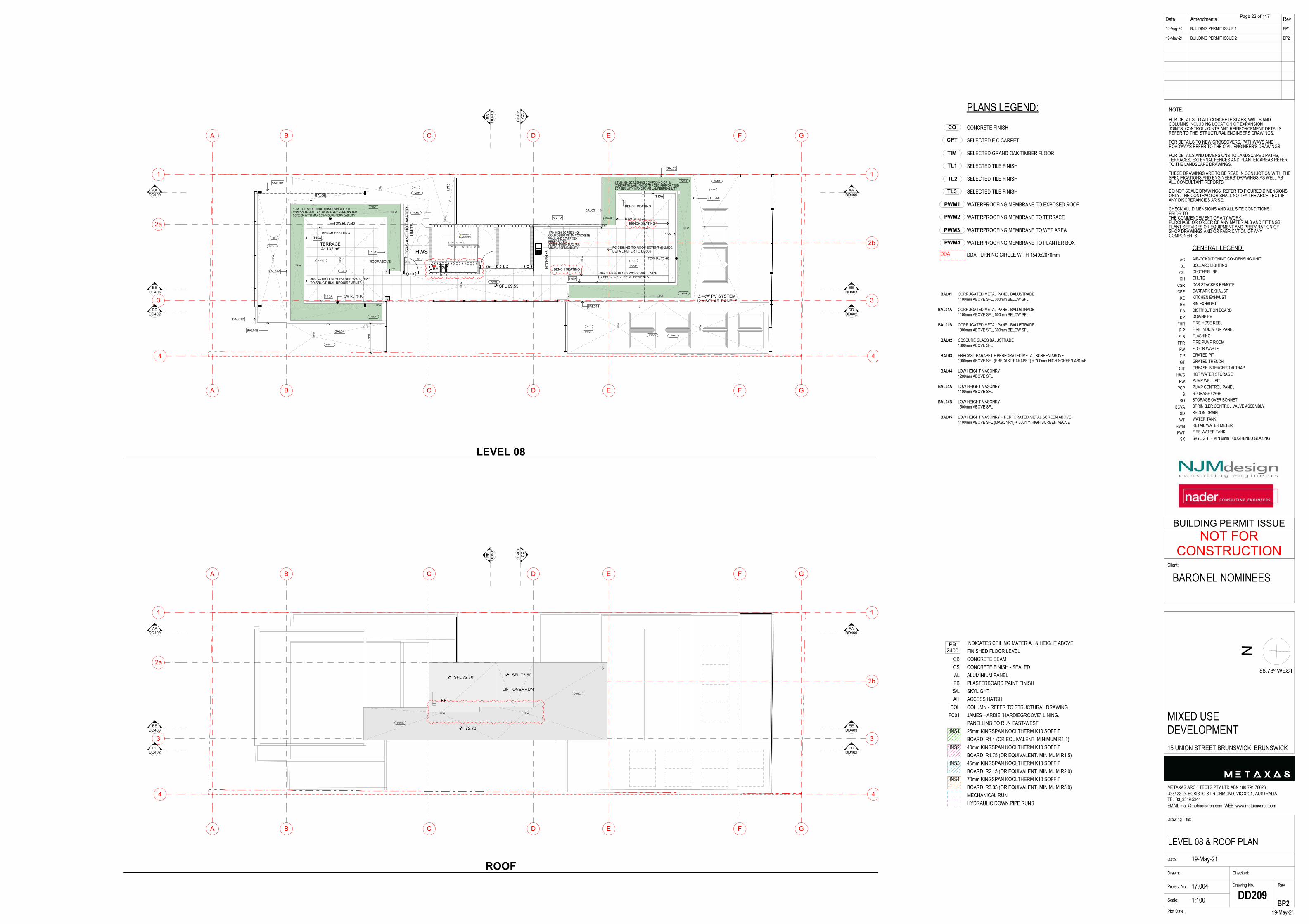
INDICATES CEILING MATERIAL & HEIGHT ABOVEFINISHED FLOOR LEVELCONCRETE BEAMCONCRETE FINISH - SEALEDALUMINIUM PANELPLASTERBOARD PAINT FINISHSKYLIGHTACCESS HATCHCOLUMN - REFER TO STRUCTURAL DRAWINGJAMES HARDIE "HARDIEGROOVE" LINING.PANELLING TO RUN EAST-WEST25mm KINGSPAN KOOLTHERM K10 SOFFITBOARD R1.1 (OR EQUIVALENT. MINIMUM R1.1)40mm KINGSPAN KOOLTHERM K10 SOFFITBOARD R1.75 (OR EQUIVALENT. MINIMUM R1.5)45mm KINGSPAN KOOLTHERM K10 SOFFITBOARD R2.15 (OR EQUIVALENT. MINIMUM R2.0)70mm KINGSPAN KOOLTHERM K10 SOFFITBOARD R3.35 (OR EQUIVALENT. MINIMUM R3.0)MECHANICAL RUNHYDRAULIC DOWN PIPE RUNS
CBCSALPBS/LAH
COLFC01
INS1
INS2
INS3
INS4
PB2400
GENERAL LEGEND:AIR-CONDITIONING CONDENSING UNITBOLLARD LIGHTINGCLOTHESLINECHUTECAR STACKER REMOTECARPARK EXHAUSTKITCHEN EXHAUSTBIN EXHAUSTDISTRIBUTION BOARDDOWNPIPEFIRE HOSE REELFIRE INDICATOR PANELFLASHINGFIRE PUMP ROOMFLOOR WASTEGRATED PITGRATED TRENCHGREASE INTERCEPTOR TRAPHOT WATER STORAGEPUMP WELL PITPUMP CONTROL PANELSTORAGE CAGESTORAGE OVER BONNETSPRINKLER CONTROL VALVE ASSEMBLYSPOON DRAINWATER TANKRETAIL WATER METERFIRE WATER TANKSKYLIGHT - MIN 6mm TOUGHENED GLAZING
FINISHES LEGEND:CONCRETE FINISH (SEALED)POLISHED CONCRETE FINISHLYSAGHT TRIMDEK WITH SARKING TO UNDERSIDE
ACBL
C/LCH
CSRCPE
KEBEDBDP
FHRFIPFLSFPRFWGPGTGIT
HWSPW
PCPS
SOSCVA
SDWT
RWMFWT
SK
CORRUGATED METAL PANEL BALUSTRADE1100mm ABOVE SFL, 300mm BELOW SFL
CORRUGATED METAL PANEL BALUSTRADE1100mm ABOVE SFL, 500mm BELOW SFL
CORRUGATED METAL PANEL BALUSTRADE1000mm ABOVE SFL, 300mm BELOW SFL
OBSCURE GLASS BALUSTRADE1800mm ABOVE SFL
PRECAST PARAPET + PERFORATED METAL SCREEN ABOVE1000mm ABOVE SFL (PRECAST PARAPET) + 700mm HIGH SCREEN ABOVE
LOW HEIGHT MASONRY1200mm ABOVE SFL
LOW HEIGHT MASONRY1100mm ABOVE SFL
LOW HEIGHT MASONRY1500mm ABOVE SFL
LOW HEIGHT MASONRY + PERFORATED METAL SCREEN ABOVE1100mm ABOVE SFL (MASONRY) + 600mm HIGH SCREEN ABOVE
BAL01
BAL01A
BAL01B
BAL02
BAL03
BAL04
BAL04A
BAL04B
BAL05
TL2
CO
TL1
TIM
TL3
CPT
PWM1
PWM4
PWM3
PWM2
PLANS LEGEND:CONCRETE FINISH
SELECTED E C CARPET
SELECTED GRAND OAK TIMBER FLOOR
SELECTED TILE FINISH
SELECTED TILE FINISH
SELECTED TILE FINISH
WATERPROOFING MEMBRANE TO EXPOSED ROOF
WATERPROOFING MEMBRANE TO TERRACE
WATERPROOFING MEMBRANE TO WET AREA
WATERPROOFING MEMBRANE TO PLANTER BOX
DDA TURNING CIRCLE WITH 1540x2070mmDDA
Date Amendments Rev14-Aug-20
19-May-21
BUILDING PERMIT ISSUE 1
BUILDING PERMIT ISSUE 2
BP1
BP2
N
Drawing Title:
LEVEL 08 & ROOF PLANDate:
Drawn:
Project No.: 17.004
Scale:
Drawing No. Rev
19-May-21Plot Date:
METAXAS ARCHITECTS PTY LTD ABN 180 791 78626U25/ 22-24 BOSISTO ST RICHMOND, VIC 3121, AUSTRALIATEL 03_9349 5344EMAIL [email protected] WEB: www.metaxasarch.com
Client:
19-May-21
Checked:
1:100 DD209
NOTE:FOR DETAILS TO ALL CONCRETE SLABS, WALLS ANDCOLUMNS INCLUDING LOCATION OF EXPANSIONJOINTS, CONTROL JOINTS AND REINFORCEMENT DETAILSREFER TO THE STRUCTURAL ENGINEERS DRAWINGS.
FOR DETAILS TO NEW CROSSOVERS, PATHWAYS ANDROADWAYS REFER TO THE CIVIL ENGINEER'S DRAWINGS.
FOR DETAILS AND DIMENSIONS TO LANDSCAPED PATHS,TERRACES, EXTERNAL FENCES AND PLANTER AREAS REFERTO THE LANDSCAPE DRAWINGS.
THESE DRAWINGS ARE TO BE READ IN CONJUCTION WITH THESPECIFICATIONS AND ENGINEERS' DRAWINGS AS WELL ASALL CONSULTANT REPORTS.
DO NOT SCALE DRAWINGS, REFER TO FIGURED DIMENSIONSONLY. THE CONTRACTOR SHALL NOTIFY THE ARCHITECT IFANY DISCREPANCIES ARISE.
CHECK ALL DIMENSIONS AND ALL SITE CONDITIONSPRIOR TO:THE COMMENCEMENT OF ANY WORK,PURCHASE OR ORDER OF ANY MATERIALS AND FITTINGS,PLANT SERVICES OR EQUIPMENT AND PREPARATION OFSHOP DRAWINGS AND OR FABRICATION OF ANYCOMPONENTS.
BARONEL NOMINEES
MIXED USEDEVELOPMENT15 UNION STREET BRUNSWICK BRUNSWICK
BP2
88.78º WEST
NOT FORCONSTRUCTION
BUILDING PERMIT ISSUE
5678
9 10 11 12 13 14 15 16
16R(188 mm)15G(250 mm)
D23
D02
E
E
C
C
D
D
B
B
F
F
G
G
A
A
4 4
3 3
2b
2a
1 1
FW
FW
FW
FW
FW
FW
FW
FW
FW
FWFW
FW
FW
FW
FW
FW
FW
FW
BBD
D40
1
CC
DD
401
DDDD402
DDDD402
EEDD403
EEDD403
AADD400
AADD400
1,71
3
1,86
8
SFL 69.55
BAL01B
BAL01B
BAL01B
BAL04
BAL04A
BAL05
BAL04B
BAL04A
BAL03
BAL03
BAL03
800mm HIGH BLOCKWORK WALL, SIZETO SRUCTURAL REQUIREMENTS
BENCH SEATTING
800mm HIGH BLOCKWORK WALL, SIZETO SRUCTURAL REQUIREMENTS
BENCH SEATING
TL3
TL3TL2
T15A
T15A
T15A
T15A
T15A
T15A
TOW RL 70.40
TOW RL 70.40
TOW RL 70.40
TOW RL 70.40
CO
CO
CO
CO
PWM4
PWM2
PWM1
PWM4
PWM3 PWM3
PWM1
PWM1
PWM1
PWM4
PWM4
PWM2
PWM2
PWM2
PWM1
PWM4
ROOF ABOVE
FC CEILING TO ROOF EXTENT @ 2,600,DETAIL REFER TO DD506
BENCH SEATING
BENCH SEATING
HWS
3.4kW PV SYSTEM12 x SOLAR PANELS
1.7M HIGH SCREENING COMPOSING OF 1MCONCRETE WALL AND 0.7M FIXEX PERFORATEDSCREEN WITH MAX 25% VISUAL PERMEABILITY
1.7M HIGH SCREENING COMPOSING OF 1MCONCRETE WALL AND 0.7M FIXEX PERFORATEDSCREEN WITH MAX 25% VISUAL PERMEABILITY
1.7M HIGH SCREENINGCOMPOSING OF 1M CONCRETEWALL AND 0.7M FIXEXPERFORATEDSCREEN WITH MAX 25%VISUAL PERMEABILITY
GAS
AN
D H
OT
WAT
ERU
NIT
S
G
V V
V
KITC
HEN
K5
BE
TERRACEA: 132 m2
E
E
C
C
D
D
B
B
F
F
G
G
A
A
4 4
3 3
2b
2a
1 1
BBD
D40
1
CC
DD
401
DDDD402
DDDD402
EEDD403
EEDD403
AADD400
AADD400
SFL 72.70
72.70
CONC.
CONC.
BE
V
FW FW
SFL 73.50
LIFT OVERRUN
LEVEL 08
ROOF
Page 22 of 117
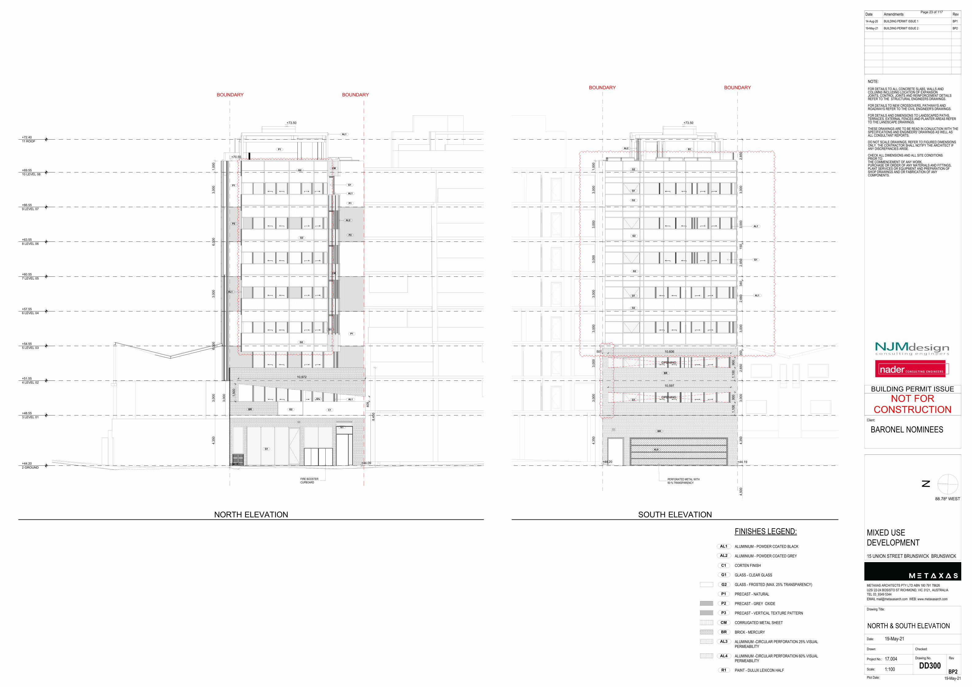
Date Amendments Rev14-Aug-20
19-May-21
BUILDING PERMIT ISSUE 1
BUILDING PERMIT ISSUE 2
BP1
BP2
N
Drawing Title:
NORTH & SOUTH ELEVATIONDate:
Drawn:
Project No.: 17.004
Scale:
Drawing No. Rev
19-May-21Plot Date:
METAXAS ARCHITECTS PTY LTD ABN 180 791 78626U25/ 22-24 BOSISTO ST RICHMOND, VIC 3121, AUSTRALIATEL 03_9349 5344EMAIL [email protected] WEB: www.metaxasarch.com
Client:
19-May-21
Checked:
1:100 DD300
NOTE:FOR DETAILS TO ALL CONCRETE SLABS, WALLS ANDCOLUMNS INCLUDING LOCATION OF EXPANSIONJOINTS, CONTROL JOINTS AND REINFORCEMENT DETAILSREFER TO THE STRUCTURAL ENGINEERS DRAWINGS.
FOR DETAILS TO NEW CROSSOVERS, PATHWAYS ANDROADWAYS REFER TO THE CIVIL ENGINEER'S DRAWINGS.
FOR DETAILS AND DIMENSIONS TO LANDSCAPED PATHS,TERRACES, EXTERNAL FENCES AND PLANTER AREAS REFERTO THE LANDSCAPE DRAWINGS.
THESE DRAWINGS ARE TO BE READ IN CONJUCTION WITH THESPECIFICATIONS AND ENGINEERS' DRAWINGS AS WELL ASALL CONSULTANT REPORTS.
DO NOT SCALE DRAWINGS, REFER TO FIGURED DIMENSIONSONLY. THE CONTRACTOR SHALL NOTIFY THE ARCHITECT IFANY DISCREPANCIES ARISE.
CHECK ALL DIMENSIONS AND ALL SITE CONDITIONSPRIOR TO:THE COMMENCEMENT OF ANY WORK,PURCHASE OR ORDER OF ANY MATERIALS AND FITTINGS,PLANT SERVICES OR EQUIPMENT AND PREPARATION OFSHOP DRAWINGS AND OR FABRICATION OF ANYCOMPONENTS.
BARONEL NOMINEES
MIXED USEDEVELOPMENT15 UNION STREET BRUNSWICK BRUNSWICK
BP2
88.78º WEST
NOT FORCONSTRUCTION
BUILDING PERMIT ISSUE
FIRE BOOSTERCUPBOARD
+44.202 GROUND
+48.553 LEVEL 01
+51.554 LEVEL 02
+54.555 LEVEL 03
+57.556 LEVEL 04
+60.557 LEVEL 05
+63.558 LEVEL 06
+66.559 LEVEL 07
+69.5510 LEVEL 08
+72.4011 ROOF
+73.50
+70.55
+44.00 +44.09
4,35
03,
000
6,00
03,
000
6,00
03,
000
1,00
0
3,00
0
8,45
0
1,50
0
10,972
409
BOUNDARYBOUNDARY
AL1
G1
G1
G1
G2
G2
AL1
G2
P1
P1
C1 BR
G1
G1
P1
G2
AL1
AL1
AL2 P2
P2
CM
CM
P1
PERFORATED METAL WITH60 % TRANSPARENCY
+44.20 +44.19
+73.50
4,35
03,
000
3,00
03,
000
3,00
03,
000
3,00
03,
000
1,00
0
10,597
1,10
090
0
501 10,606
1,10
090
0
4,50
04,
350
3,00
02,
650
350
3,00
02,
660
340
2,85
015
03,
000
3,00
02,
850
BR
G2
G2
G2
BOUNDARYBOUNDARY
OPENING
OPENING
G2
AL1
AL1
G1
BR
R1 AL2
G2
G1
G1
G1
AL4
G2
AL1
G1
C1
P1
CM
BR
P2
AL2
AL3
AL4
R1
P3
FINISHES LEGEND:ALUMINIUM - POWDER COATED BLACK
ALUMINIUM - POWDER COATED GREY
CORTEN FINISH
GLASS - CLEAR GLASS
GLASS - FROSTED (MAX. 25% TRANSPARENCY)
PRECAST - NATURAL
PRECAST - GREY OXIDE
PRECAST - VERTICAL TEXTURE PATTERN
CORRUGATED METAL SHEET
BRICK - MERCURY
ALUMINIUM -CIRCULAR PERFORATION 25% VISUALPERMEABILITY
ALUMINIUM -CIRCULAR PERFORATION 60% VISUALPERMEABILITY
PAINT - DULUX LEXICON HALF
NORTH ELEVATION SOUTH ELEVATION
Page 23 of 117
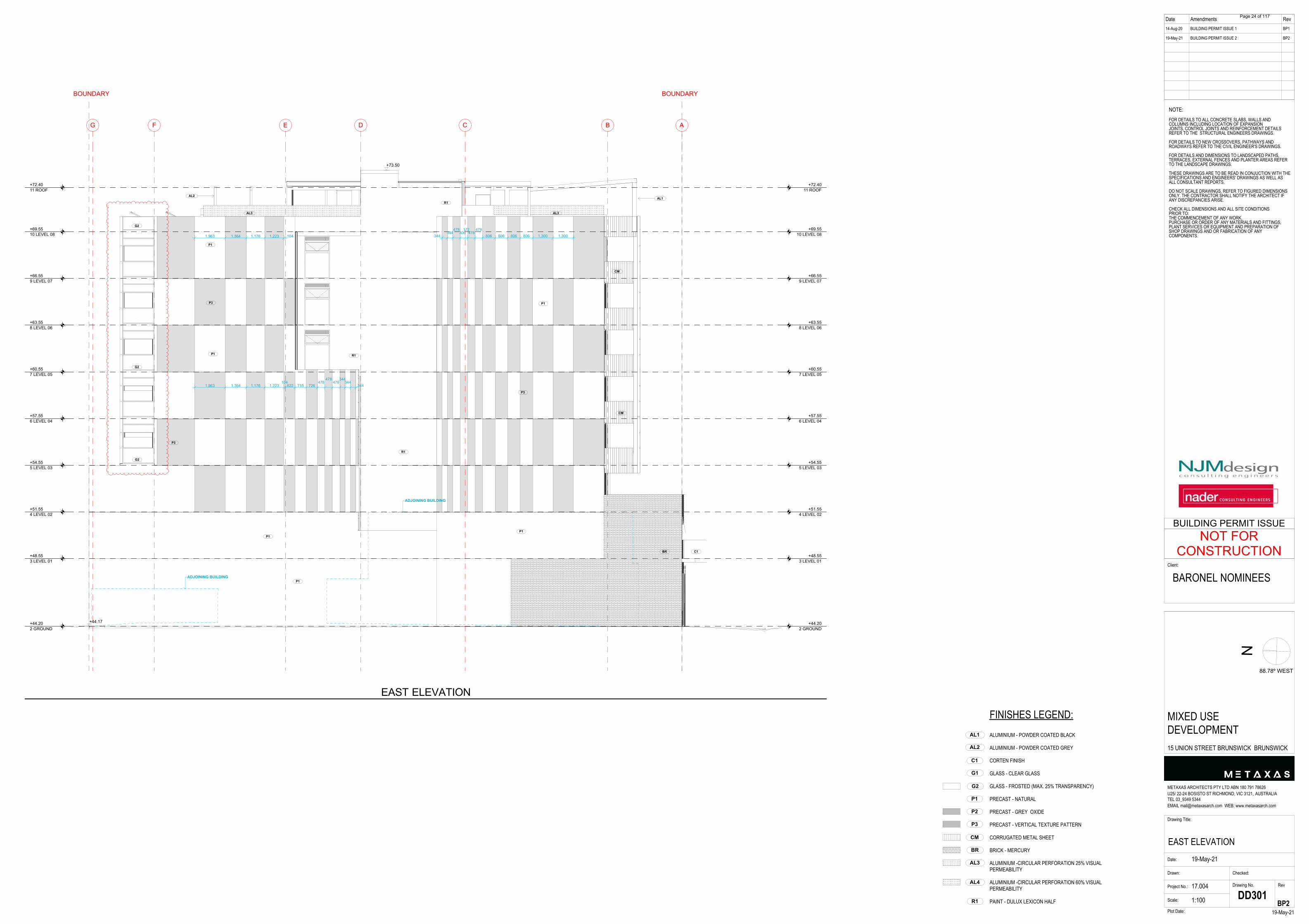
Date Amendments Rev14-Aug-20
19-May-21
BUILDING PERMIT ISSUE 1
BUILDING PERMIT ISSUE 2
BP1
BP2
N
Drawing Title:
EAST ELEVATIONDate:
Drawn:
Project No.: 17.004
Scale:
Drawing No. Rev
19-May-21Plot Date:
METAXAS ARCHITECTS PTY LTD ABN 180 791 78626U25/ 22-24 BOSISTO ST RICHMOND, VIC 3121, AUSTRALIATEL 03_9349 5344EMAIL [email protected] WEB: www.metaxasarch.com
Client:
19-May-21
Checked:
1:100 DD301
NOTE:FOR DETAILS TO ALL CONCRETE SLABS, WALLS ANDCOLUMNS INCLUDING LOCATION OF EXPANSIONJOINTS, CONTROL JOINTS AND REINFORCEMENT DETAILSREFER TO THE STRUCTURAL ENGINEERS DRAWINGS.
FOR DETAILS TO NEW CROSSOVERS, PATHWAYS ANDROADWAYS REFER TO THE CIVIL ENGINEER'S DRAWINGS.
FOR DETAILS AND DIMENSIONS TO LANDSCAPED PATHS,TERRACES, EXTERNAL FENCES AND PLANTER AREAS REFERTO THE LANDSCAPE DRAWINGS.
THESE DRAWINGS ARE TO BE READ IN CONJUCTION WITH THESPECIFICATIONS AND ENGINEERS' DRAWINGS AS WELL ASALL CONSULTANT REPORTS.
DO NOT SCALE DRAWINGS, REFER TO FIGURED DIMENSIONSONLY. THE CONTRACTOR SHALL NOTIFY THE ARCHITECT IFANY DISCREPANCIES ARISE.
CHECK ALL DIMENSIONS AND ALL SITE CONDITIONSPRIOR TO:THE COMMENCEMENT OF ANY WORK,PURCHASE OR ORDER OF ANY MATERIALS AND FITTINGS,PLANT SERVICES OR EQUIPMENT AND PREPARATION OFSHOP DRAWINGS AND OR FABRICATION OF ANYCOMPONENTS.
BARONEL NOMINEES
MIXED USEDEVELOPMENT15 UNION STREET BRUNSWICK BRUNSWICK
BP2
88.78º WEST
NOT FORCONSTRUCTION
BUILDING PERMIT ISSUE
G F E D C B A
+44.202 GROUND
+44.202 GROUND
+48.553 LEVEL 01
+48.553 LEVEL 01
+51.554 LEVEL 02
+51.554 LEVEL 02
+54.555 LEVEL 03
+54.555 LEVEL 03
+57.556 LEVEL 04
+57.556 LEVEL 04
+60.557 LEVEL 05
+60.557 LEVEL 05
+63.558 LEVEL 06
+63.558 LEVEL 06
+66.559 LEVEL 07
+66.559 LEVEL 07
+69.5510 LEVEL 08
+69.5510 LEVEL 08
+72.4011 ROOF
+72.4011 ROOF
+73.50
+44.17
1,963 1,364 1,176 1,223 104
1,963 1,364 1,176 1,223104
622 715 726478
478478
344344
344
344344
478306
172478
478806 806 806 806 1,300 1,300
ADJOINING BUILDING
ADJOINING BUILDING
P1
BOUNDARYBOUNDARY
P3
G2
P1
BR
CM
G2
G2
CM
C1
P1 P3
AL1 AL2
P3
P1
P1
P1
R1
AL3 AL3
R1
R1
G2
AL1
G1
C1
P1
CM
BR
P2
AL2
AL3
AL4
R1
P3
FINISHES LEGEND:ALUMINIUM - POWDER COATED BLACK
ALUMINIUM - POWDER COATED GREY
CORTEN FINISH
GLASS - CLEAR GLASS
GLASS - FROSTED (MAX. 25% TRANSPARENCY)
PRECAST - NATURAL
PRECAST - GREY OXIDE
PRECAST - VERTICAL TEXTURE PATTERN
CORRUGATED METAL SHEET
BRICK - MERCURY
ALUMINIUM -CIRCULAR PERFORATION 25% VISUALPERMEABILITY
ALUMINIUM -CIRCULAR PERFORATION 60% VISUALPERMEABILITY
PAINT - DULUX LEXICON HALF
EAST ELEVATION
Page 24 of 117
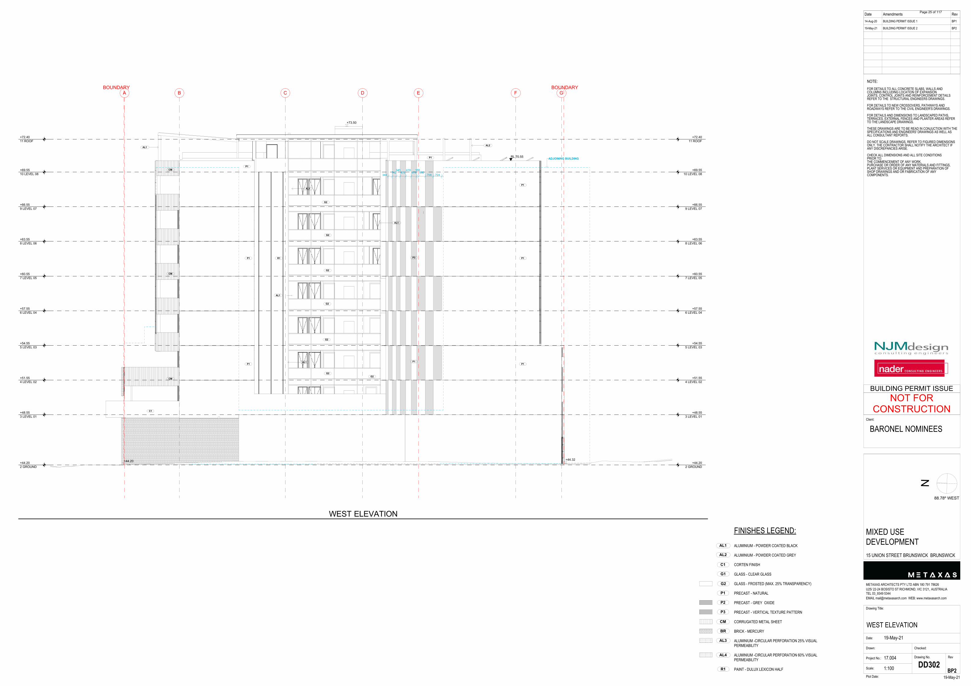
Date Amendments Rev14-Aug-20
19-May-21
BUILDING PERMIT ISSUE 1
BUILDING PERMIT ISSUE 2
BP1
BP2
N
Drawing Title:
WEST ELEVATIONDate:
Drawn:
Project No.: 17.004
Scale:
Drawing No. Rev
19-May-21Plot Date:
METAXAS ARCHITECTS PTY LTD ABN 180 791 78626U25/ 22-24 BOSISTO ST RICHMOND, VIC 3121, AUSTRALIATEL 03_9349 5344EMAIL [email protected] WEB: www.metaxasarch.com
Client:
19-May-21
Checked:
1:100 DD302
NOTE:FOR DETAILS TO ALL CONCRETE SLABS, WALLS ANDCOLUMNS INCLUDING LOCATION OF EXPANSIONJOINTS, CONTROL JOINTS AND REINFORCEMENT DETAILSREFER TO THE STRUCTURAL ENGINEERS DRAWINGS.
FOR DETAILS TO NEW CROSSOVERS, PATHWAYS ANDROADWAYS REFER TO THE CIVIL ENGINEER'S DRAWINGS.
FOR DETAILS AND DIMENSIONS TO LANDSCAPED PATHS,TERRACES, EXTERNAL FENCES AND PLANTER AREAS REFERTO THE LANDSCAPE DRAWINGS.
THESE DRAWINGS ARE TO BE READ IN CONJUCTION WITH THESPECIFICATIONS AND ENGINEERS' DRAWINGS AS WELL ASALL CONSULTANT REPORTS.
DO NOT SCALE DRAWINGS, REFER TO FIGURED DIMENSIONSONLY. THE CONTRACTOR SHALL NOTIFY THE ARCHITECT IFANY DISCREPANCIES ARISE.
CHECK ALL DIMENSIONS AND ALL SITE CONDITIONSPRIOR TO:THE COMMENCEMENT OF ANY WORK,PURCHASE OR ORDER OF ANY MATERIALS AND FITTINGS,PLANT SERVICES OR EQUIPMENT AND PREPARATION OFSHOP DRAWINGS AND OR FABRICATION OF ANYCOMPONENTS.
BARONEL NOMINEES
MIXED USEDEVELOPMENT15 UNION STREET BRUNSWICK BRUNSWICK
BP2
88.78º WEST
NOT FORCONSTRUCTION
BUILDING PERMIT ISSUE
A B C D E F G
+44.202 GROUND
+44.202 GROUND
+48.553 LEVEL 01
+48.553 LEVEL 01
+51.554 LEVEL 02
+51.554 LEVEL 02
+54.555 LEVEL 03
+54.555 LEVEL 03
+57.556 LEVEL 04
+57.556 LEVEL 04
+60.557 LEVEL 05
+60.557 LEVEL 05
+63.558 LEVEL 06
+63.558 LEVEL 06
+66.559 LEVEL 07
+66.559 LEVEL 07
+69.5510 LEVEL 08
+69.5510 LEVEL 08
+72.4011 ROOF
+72.4011 ROOF
+73.50
+44.32+44.20
344342
345478
478478
155580
708 724
RL 70.55 ADJOINING BUILDING
G2
G2
G2
G2
G2
BOUNDARYBOUNDARY
P1
AL1
AL1
G2
P3
P1
P1
P1 P1
C1
CM
G2
AL1
AL1
CM
CM
AL2
AL1
R1 P1
P1
P1
G2
AL1
G1
C1
P1
CM
BR
P2
AL2
AL3
AL4
R1
P3
FINISHES LEGEND:ALUMINIUM - POWDER COATED BLACK
ALUMINIUM - POWDER COATED GREY
CORTEN FINISH
GLASS - CLEAR GLASS
GLASS - FROSTED (MAX. 25% TRANSPARENCY)
PRECAST - NATURAL
PRECAST - GREY OXIDE
PRECAST - VERTICAL TEXTURE PATTERN
CORRUGATED METAL SHEET
BRICK - MERCURY
ALUMINIUM -CIRCULAR PERFORATION 25% VISUALPERMEABILITY
ALUMINIUM -CIRCULAR PERFORATION 60% VISUALPERMEABILITY
PAINT - DULUX LEXICON HALF
WEST ELEVATION
Page 25 of 117
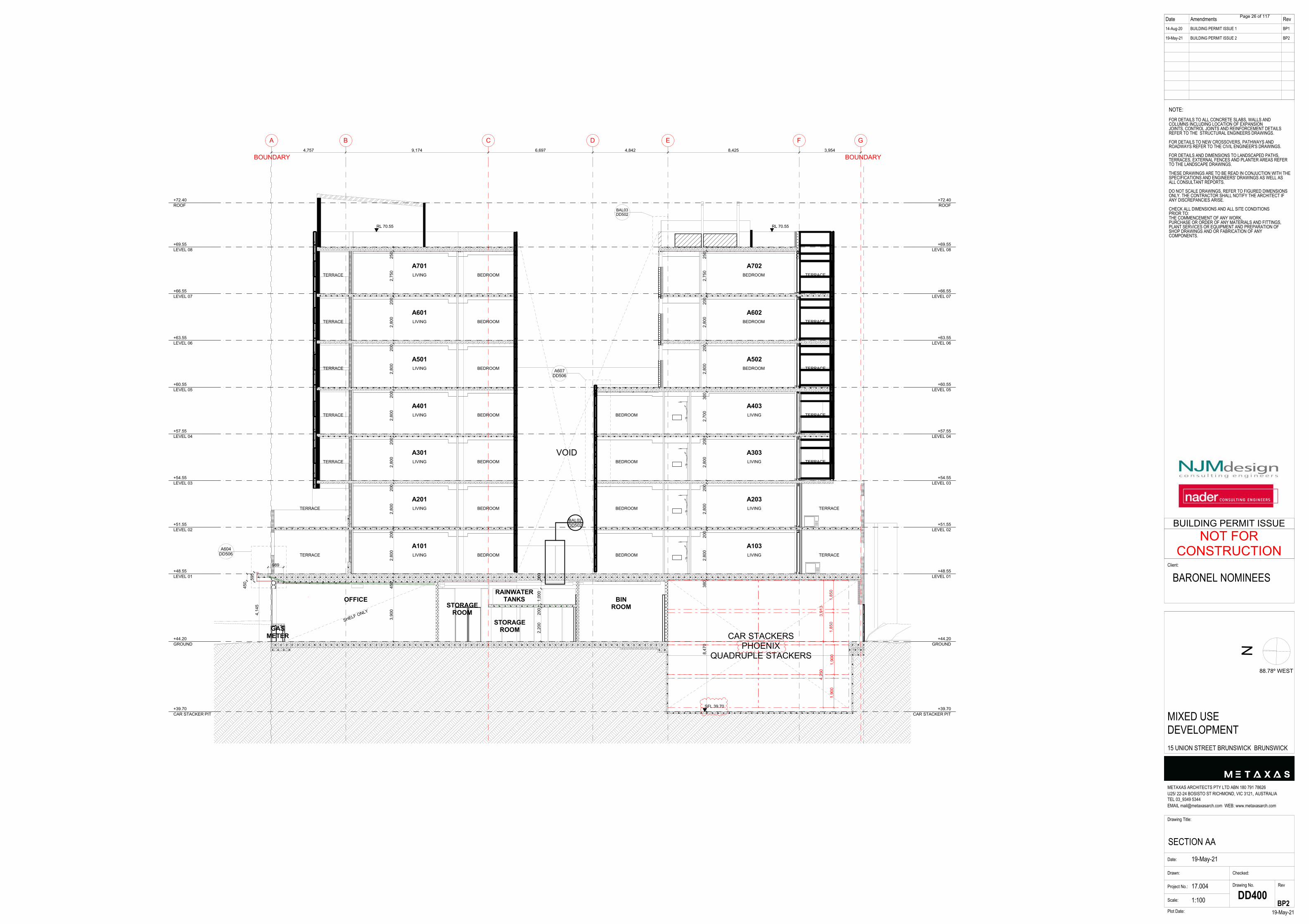
Date Amendments Rev14-Aug-20
19-May-21
BUILDING PERMIT ISSUE 1
BUILDING PERMIT ISSUE 2
BP1
BP2
N
Drawing Title:
SECTION AADate:
Drawn:
Project No.: 17.004
Scale:
Drawing No. Rev
19-May-21Plot Date:
METAXAS ARCHITECTS PTY LTD ABN 180 791 78626U25/ 22-24 BOSISTO ST RICHMOND, VIC 3121, AUSTRALIATEL 03_9349 5344EMAIL [email protected] WEB: www.metaxasarch.com
Client:
19-May-21
Checked:
1:100 DD400
NOTE:FOR DETAILS TO ALL CONCRETE SLABS, WALLS ANDCOLUMNS INCLUDING LOCATION OF EXPANSIONJOINTS, CONTROL JOINTS AND REINFORCEMENT DETAILSREFER TO THE STRUCTURAL ENGINEERS DRAWINGS.
FOR DETAILS TO NEW CROSSOVERS, PATHWAYS ANDROADWAYS REFER TO THE CIVIL ENGINEER'S DRAWINGS.
FOR DETAILS AND DIMENSIONS TO LANDSCAPED PATHS,TERRACES, EXTERNAL FENCES AND PLANTER AREAS REFERTO THE LANDSCAPE DRAWINGS.
THESE DRAWINGS ARE TO BE READ IN CONJUCTION WITH THESPECIFICATIONS AND ENGINEERS' DRAWINGS AS WELL ASALL CONSULTANT REPORTS.
DO NOT SCALE DRAWINGS, REFER TO FIGURED DIMENSIONSONLY. THE CONTRACTOR SHALL NOTIFY THE ARCHITECT IFANY DISCREPANCIES ARISE.
CHECK ALL DIMENSIONS AND ALL SITE CONDITIONSPRIOR TO:THE COMMENCEMENT OF ANY WORK,PURCHASE OR ORDER OF ANY MATERIALS AND FITTINGS,PLANT SERVICES OR EQUIPMENT AND PREPARATION OFSHOP DRAWINGS AND OR FABRICATION OF ANYCOMPONENTS.
BARONEL NOMINEES
MIXED USEDEVELOPMENT15 UNION STREET BRUNSWICK BRUNSWICK
BP2
88.78º WEST
NOT FORCONSTRUCTION
BUILDING PERMIT ISSUE
A B C D E F G
A604DD506
A607DD506
BAL02DD502
BAL03DD502
+39.70CAR STACKER PIT
+39.70CAR STACKER PIT
+44.20GROUND
+44.20GROUND
+48.55LEVEL 01
+48.55LEVEL 01
+51.55LEVEL 02
+51.55LEVEL 02
+54.55LEVEL 03
+54.55LEVEL 03
+57.55LEVEL 04
+57.55LEVEL 04
+60.55LEVEL 05
+60.55LEVEL 05
+63.55LEVEL 06
+63.55LEVEL 06
+66.55LEVEL 07
+66.55LEVEL 07
+69.55LEVEL 08
+69.55LEVEL 08
+72.40ROOF
+72.40ROOF
1,85
01,
850
1,90
01,
900
3,91
34,
250
4,14
5
3,90
045
02,
800
200
2,80
020
02,
800
200
2,80
020
02,
800
200
2,80
020
02,
750
250
8,47
038
02,
800
200
2,80
020
02,
800
200
2,70
030
02,
800
200
2,80
020
02,
750
250
SFL 39.70
4,757 9,174 6,697 4,842 8,425 3,954
RL 70.55 RL 70.55
595
450
989
2,20
020
01,
000
500
CAR STACKERSPHOENIX
QUADRUPLE STACKERS
BOUNDARYBOUNDARY
A101
A201
A301
A401
A501
A601
A701
A103LIVING BEDROOM
LIVING BEDROOM
LIVING BEDROOM
LIVING BEDROOM
LIVING BEDROOM
LIVING BEDROOM
LIVING BEDROOM
A203
A303
A403
A502
BEDROOM LIVING
BEDROOM LIVING
BEDROOM LIVING
BEDROOM LIVING
A602
A702
BEDROOM
BEDROOM
BEDROOM
TERRACE
TERRACE
TERRACE
TERRACE
TERRACE
TERRACE
TERRACETERRACE
TERRACE
TERRACE
TERRACE
TERRACE
TERRACE
TERRACE
VOID
BINROOM
STORAGEROOM
OFFICE
SHELF ONLY
GASMETER
STORAGEROOM
RAINWATERTANKS
Page 26 of 117

Date Amendments Rev14-Aug-20
19-May-21
BUILDING PERMIT ISSUE 1
BUILDING PERMIT ISSUE 2
BP1
BP2
N
Drawing Title:
SECTION BB & CCDate:
Drawn:
Project No.: 17.004
Scale:
Drawing No. Rev
19-May-21Plot Date:
METAXAS ARCHITECTS PTY LTD ABN 180 791 78626U25/ 22-24 BOSISTO ST RICHMOND, VIC 3121, AUSTRALIATEL 03_9349 5344EMAIL [email protected] WEB: www.metaxasarch.com
Client:
19-May-21
Checked:
1:100 DD401
NOTE:FOR DETAILS TO ALL CONCRETE SLABS, WALLS ANDCOLUMNS INCLUDING LOCATION OF EXPANSIONJOINTS, CONTROL JOINTS AND REINFORCEMENT DETAILSREFER TO THE STRUCTURAL ENGINEERS DRAWINGS.
FOR DETAILS TO NEW CROSSOVERS, PATHWAYS ANDROADWAYS REFER TO THE CIVIL ENGINEER'S DRAWINGS.
FOR DETAILS AND DIMENSIONS TO LANDSCAPED PATHS,TERRACES, EXTERNAL FENCES AND PLANTER AREAS REFERTO THE LANDSCAPE DRAWINGS.
THESE DRAWINGS ARE TO BE READ IN CONJUCTION WITH THESPECIFICATIONS AND ENGINEERS' DRAWINGS AS WELL ASALL CONSULTANT REPORTS.
DO NOT SCALE DRAWINGS, REFER TO FIGURED DIMENSIONSONLY. THE CONTRACTOR SHALL NOTIFY THE ARCHITECT IFANY DISCREPANCIES ARISE.
CHECK ALL DIMENSIONS AND ALL SITE CONDITIONSPRIOR TO:THE COMMENCEMENT OF ANY WORK,PURCHASE OR ORDER OF ANY MATERIALS AND FITTINGS,PLANT SERVICES OR EQUIPMENT AND PREPARATION OFSHOP DRAWINGS AND OR FABRICATION OF ANYCOMPONENTS.
BARONEL NOMINEES
MIXED USEDEVELOPMENT15 UNION STREET BRUNSWICK BRUNSWICK
BP2
88.78º WEST
NOT FORCONSTRUCTION
BUILDING PERMIT ISSUE
4 3 2a 1
A605DD506
A606DD506
+39.70CAR STACKER PIT
+44.20GROUND
+48.55LEVEL 01
+51.55LEVEL 02
+54.55LEVEL 03
+57.55LEVEL 04
+60.55LEVEL 05
+63.55LEVEL 06
+66.55LEVEL 07
+69.55LEVEL 08
+72.40ROOF
3,90
02,
700
2,70
02,
700
2,70
02,
700
2,70
02,
750
2,85
0
600
72.70
2,20
020
01,
000
500
G2
G2
G2 G2
G2
G2
G2
G2
G2
G2
G2
G2
G2
BOUNDARY BOUNDARY
FIRESTAIRCORRIDOR
FIRESTAIRCORRIDOR
FIRESTAIRCORRIDOR
FIRESTAIRCORRIDOR
FIRESTAIRCORRIDOR
FIRESTAIRCORRIDOR
FIRESTAIRCORRIDOR
FIRESTAIRLOBBY
STORAGEROOM
RAINWATERTANKS
1 2a 2b 3 4
A613DD506
+39.70CAR STACKER PIT
+44.20GROUND
+48.55LEVEL 01
+51.55LEVEL 02
+54.55LEVEL 03
+57.55LEVEL 04
+60.55LEVEL 05
+63.55LEVEL 06
+66.55LEVEL 07
+69.55LEVEL 08
+72.40ROOF
3,90
0
2,70
02,
700
2,70
02,
700
300
2,70
02,
700
2,75
0
1,70
01,
700
1,70
0
1,80
0
SFL 42.80
SFL 73.50
3,90
0
72.70
G2
G2
G2
G1
G1
G1
G1
G1 G1
G1
G1
BOUNDARY BOUNDARY
LIFTCORE
LIFT PIT
CORRIDOR
CORRIDOR
CORRIDOR
CORRIDOR
CORRIDOR
CORRIDOR
CORRIDOR
LOBBYBIN ROOM
R1
R1
AL3
BB Section CC SECTION
Page 27 of 117

Date Amendments Rev14-Aug-20
19-May-21
BUILDING PERMIT ISSUE 1
BUILDING PERMIT ISSUE 2
BP1
BP2
N
Drawing Title:
SECTION DDDate:
Drawn:
Project No.: 17.004
Scale:
Drawing No. Rev
19-May-21Plot Date:
METAXAS ARCHITECTS PTY LTD ABN 180 791 78626U25/ 22-24 BOSISTO ST RICHMOND, VIC 3121, AUSTRALIATEL 03_9349 5344EMAIL [email protected] WEB: www.metaxasarch.com
Client:
19-May-21
Checked:
1:100 DD402
NOTE:FOR DETAILS TO ALL CONCRETE SLABS, WALLS ANDCOLUMNS INCLUDING LOCATION OF EXPANSIONJOINTS, CONTROL JOINTS AND REINFORCEMENT DETAILSREFER TO THE STRUCTURAL ENGINEERS DRAWINGS.
FOR DETAILS TO NEW CROSSOVERS, PATHWAYS ANDROADWAYS REFER TO THE CIVIL ENGINEER'S DRAWINGS.
FOR DETAILS AND DIMENSIONS TO LANDSCAPED PATHS,TERRACES, EXTERNAL FENCES AND PLANTER AREAS REFERTO THE LANDSCAPE DRAWINGS.
THESE DRAWINGS ARE TO BE READ IN CONJUCTION WITH THESPECIFICATIONS AND ENGINEERS' DRAWINGS AS WELL ASALL CONSULTANT REPORTS.
DO NOT SCALE DRAWINGS, REFER TO FIGURED DIMENSIONSONLY. THE CONTRACTOR SHALL NOTIFY THE ARCHITECT IFANY DISCREPANCIES ARISE.
CHECK ALL DIMENSIONS AND ALL SITE CONDITIONSPRIOR TO:THE COMMENCEMENT OF ANY WORK,PURCHASE OR ORDER OF ANY MATERIALS AND FITTINGS,PLANT SERVICES OR EQUIPMENT AND PREPARATION OFSHOP DRAWINGS AND OR FABRICATION OF ANYCOMPONENTS.
BARONEL NOMINEES
MIXED USEDEVELOPMENT15 UNION STREET BRUNSWICK BRUNSWICK
BP2
88.78º WEST
NOT FORCONSTRUCTION
BUILDING PERMIT ISSUE
A B C D E F G
A601DD506
A602DD506
A603DD506
A609DD506
A608DD506
BAL01ADD502
BAL01DD502
BAL01BDD502
BAL04ADD502
+39.70CAR STACKER PIT
+39.70CAR STACKER PIT
+44.20GROUND
+44.20GROUND
+48.55LEVEL 01
+48.55LEVEL 01
+51.55LEVEL 02
+51.55LEVEL 02
+54.55LEVEL 03
+54.55LEVEL 03
+57.55LEVEL 04
+57.55LEVEL 04
+60.55LEVEL 05
+60.55LEVEL 05
+63.55LEVEL 06
+63.55LEVEL 06
+66.55LEVEL 07
+66.55LEVEL 07
+69.55LEVEL 08
+69.55LEVEL 08
+72.40ROOF
+72.40ROOF
SFL 39.70
70.65 70.55
8,47
537
52,
800
200
2,80
020
02,
800
200
2,80
020
02,
800
200
2,80
020
02,
710
3,85
549
52,
800
200
2,80
020
02,
800
200
2,80
020
02,
800
200
2,80
020
0
BOUNDARYBOUNDARY
CAR STACKERSPHOENIX
QUADRUPLE STACKERS
A101BEDROOMBEDROOMTERRACE
A201BEDROOMBEDROOMTERRACE
A201BEDROOMBEDROOM
A201BEDROOMBEDROOM
A201BEDROOMBEDROOM
A201BEDROOMBEDROOM
A201BEDROOMBEDROOM
TERRACE
TERRACE
TERRACE
TERRACE
TERRACE
A102BEDROOMBEDROOM TERRACE
A202BEDROOMBEDROOM TERRACE
A302BEDROOMBEDROOM
A402BEDROOMBEDROOM
A502BEDROOMBEDROOM
A602BEDROOMBEDROOM
A702BEDROOMBEDROOM
VOID
OFFCEFIRE
PUMPROOM
STORAGECADE
LOBBY BIKE ROOM
Page 28 of 117

Date Amendments Rev14-Aug-20
19-May-21
BUILDING PERMIT ISSUE 1
BUILDING PERMIT ISSUE 2
BP1
BP2
N
Drawing Title:
SECTION EEDate:
Drawn:
Project No.: 17.004
Scale:
Drawing No. Rev
19-May-21Plot Date:
METAXAS ARCHITECTS PTY LTD ABN 180 791 78626U25/ 22-24 BOSISTO ST RICHMOND, VIC 3121, AUSTRALIATEL 03_9349 5344EMAIL [email protected] WEB: www.metaxasarch.com
Client:
19-May-21
Checked:
1:100, 1:50 DD403
NOTE:FOR DETAILS TO ALL CONCRETE SLABS, WALLS ANDCOLUMNS INCLUDING LOCATION OF EXPANSIONJOINTS, CONTROL JOINTS AND REINFORCEMENT DETAILSREFER TO THE STRUCTURAL ENGINEERS DRAWINGS.
FOR DETAILS TO NEW CROSSOVERS, PATHWAYS ANDROADWAYS REFER TO THE CIVIL ENGINEER'S DRAWINGS.
FOR DETAILS AND DIMENSIONS TO LANDSCAPED PATHS,TERRACES, EXTERNAL FENCES AND PLANTER AREAS REFERTO THE LANDSCAPE DRAWINGS.
THESE DRAWINGS ARE TO BE READ IN CONJUCTION WITH THESPECIFICATIONS AND ENGINEERS' DRAWINGS AS WELL ASALL CONSULTANT REPORTS.
DO NOT SCALE DRAWINGS, REFER TO FIGURED DIMENSIONSONLY. THE CONTRACTOR SHALL NOTIFY THE ARCHITECT IFANY DISCREPANCIES ARISE.
CHECK ALL DIMENSIONS AND ALL SITE CONDITIONSPRIOR TO:THE COMMENCEMENT OF ANY WORK,PURCHASE OR ORDER OF ANY MATERIALS AND FITTINGS,PLANT SERVICES OR EQUIPMENT AND PREPARATION OFSHOP DRAWINGS AND OR FABRICATION OF ANYCOMPONENTS.
BARONEL NOMINEES
MIXED USEDEVELOPMENT15 UNION STREET BRUNSWICK BRUNSWICK
BP2
88.78º WEST
NOT FORCONSTRUCTION
BUILDING PERMIT ISSUE
A B C D E F G
A610DD506
+39.70CAR STACKER PIT
+39.70CAR STACKER PIT
+44.20GROUND
+44.20GROUND
+48.55LEVEL 01
+48.55LEVEL 01
+51.55LEVEL 02
+51.55LEVEL 02
+54.55LEVEL 03
+54.55LEVEL 03
+57.55LEVEL 04
+57.55LEVEL 04
+60.55LEVEL 05
+60.55LEVEL 05
+63.55LEVEL 06
+63.55LEVEL 06
+66.55LEVEL 07
+66.55LEVEL 07
+69.55LEVEL 08
+69.55LEVEL 08
+72.40ROOF
+72.40ROOF
8,85
02,
800
200
2,80
020
02,
800
200
2,70
030
02,
800
200
2,80
020
02,
750
250
2,68
0
450
2,70
030
02,
700
300
2,70
030
02,
700
300
2,70
030
02,
700
300
2,75
025
0RL 48.15
72.48
3,80
055
02,
800
200
2,80
020
02,
800
200
2,80
020
02,
800
200
2,80
020
02,
710
290
TOW RL54.35
TOW RL 52.65
SFL 39.70
4,757 9,174 6,697 4,842 8,425 3,954
KINGSPAN INSULATIONBOARD REFER TO RCP
CAR STACKERSPHOENIX
QUADRUPLE STACKERS
CORRIDOR
CORRIDOR
CORRIDOR
CORRIDOR
CORRIDOR
CORRIDOR
CORRIDOR
OFFICE
SHELF ONLY
FIREPUMPROOM
STORAGECAGE LOBBY BIKE
ROOM
A101BEDROOMBEDROOM
A201BEDROOMBEDROOM
A301BEDROOMBEDROOM
A401BEDROOMBEDROOM
A501BEDROOMBEDROOM
A601BEDROOMBEDROOM
A701BEDROOMBEDROOM
TERRACE
TERRACE
TERRACE
TERRACE
TERRACE
TERRACE
TERRACE
TERRACE
TERRACE
A102LIVINGKITCHEN
A202LIVINGKITCHEN
A302LIVINGKITCHEN
A402LIVINGKITCHEN
A502LIVING
A602LIVING
A702LIVING
TERRACE
TERRACE
TERRACE
TERRACE
TERRACE
2,55
015
0
2,40
0
2,70
030
0
TL3
FC
LIFTFIRE
STAIRSAPT
ENTRYELEC WATER
CORRIDOR
TYPICAL CORRIDOR ELEVATION 1:50
Page 29 of 117

20009: 15 Union Street, Brunswick EAR | CARMs: 78639-1 | August 2021
Table of Contents
1 Introduction 4
1.1 Audit Objective 5
1.2 Auditor work elements 5
1.3 Auditor Site Inspections 6
2 Site Information 7
2.1 Site History and Potential for Contamination 7
2.2 Site Conditions 9
2.3 Surrounding Land Use 10
2.4 Cathodic Protection Systems Search 10
2.5 WorkSafe Dangerous Goods Database Search 10
2.6 EPA Victoria Information Searches 10
2.7 Geology and On-Site Soil Profile 14
2.8 Hydrogeology 15
3 Potential Contaminants of Concern 17
4 Adopted Audit Criteria and Investigation Levels 18
4.1 Beneficial Uses of Land 18
4.2 Adopted Soil Assessment Criteria 19
4.3 Beneficial Uses of Groundwater 20
4.4 Adopted Groundwater Assessment Criteria 21
4.5 Surface Water 23
4.6 Air 23
5 Applicable Beneficial Uses 24
5.1 Beneficial Uses of Land 24
5.2 Beneficial Uses of Groundwater 24
6 Summary of Assessment Works Undertaken 27
6.1 Pre-Audit Assessment Works 27
6.2 Audit Assessment Works 27
6.3 Summary of Site Investigation Works 27
7 Soil Assessment and Remediation 30
7.1 Soil Investigation Works 30
7.2 Site Remediation Works 30
7.3 Asbestos Containing Materials 30
7.4 UST Excavation and Removal 32
7.5 Importation of Fill 33
7.6 Post-remediation Site Status 34
7.7 Assessment of Soil Contamination – Final Land Surface 34
7.8 Risk to Beneficial Uses of Land 42
Page 30 of 117
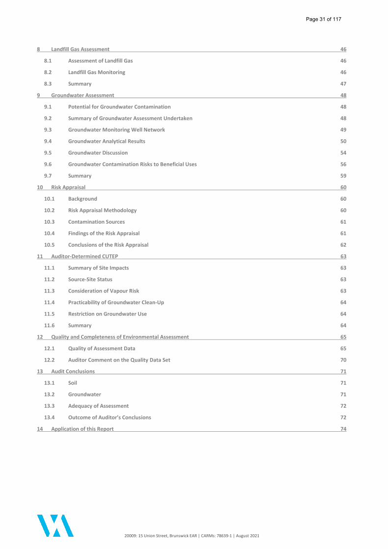
20009: 15 Union Street, Brunswick EAR | CARMs: 78639-1 | August 2021
8 Landfill Gas Assessment 46
8.1 Assessment of Landfill Gas 46
8.2 Landfill Gas Monitoring 46
8.3 Summary 47
9 Groundwater Assessment 48
9.1 Potential for Groundwater Contamination 48
9.2 Summary of Groundwater Assessment Undertaken 48
9.3 Groundwater Monitoring Well Network 49
9.4 Groundwater Analytical Results 50
9.5 Groundwater Discussion 54
9.6 Groundwater Contamination Risks to Beneficial Uses 56
9.7 Summary 59
10 Risk Appraisal 60
10.1 Background 60
10.2 Risk Appraisal Methodology 60
10.3 Contamination Sources 61
10.4 Findings of the Risk Appraisal 61
10.5 Conclusions of the Risk Appraisal 62
11 Auditor-Determined CUTEP 63
11.1 Summary of Site Impacts 63
11.2 Source-Site Status 63
11.3 Consideration of Vapour Risk 63
11.4 Practicability of Groundwater Clean-Up 64
11.5 Restriction on Groundwater Use 64
11.6 Summary 64
12 Quality and Completeness of Environmental Assessment 65
12.1 Quality of Assessment Data 65
12.2 Auditor Comment on the Quality Data Set 70
13 Audit Conclusions 71
13.1 Soil 71
13.2 Groundwater 71
13.3 Adequacy of Assessment 72
13.4 Outcome of Auditor’s Conclusions 72
14 Application of this Report 74
Page 31 of 117
20009: 15 Union Street, Brunswick EAR | CARMs: 78639-1 | August 2021
Abbreviations
References
Figures
Appendix A: Certificate of Title
Appendix B: Planning Permit and Development Plans
Appendix C: Assessor Reports
Appendix D: enRiskS (2021) Risk Appraisal
Appendix E: Auditor Verification Sample Documentation
Appendix F: Recommended GQRUZ Extent
Appendix G: Groundwater Summary Tables
Appendix H: CUTEP Checklist
Appendix I: Auditor Supporting Documentation
Page 32 of 117

20009: 15 Union Street, Brunswick EAR | CARMs: 78639-1 | August 2021 1
Executive Summary Table 1: Summary of Environmental Audit Information
Auditor Sally Bonham
Auditor account number 75656
Auditor appointment end date 09 November 2023
Audit type 53X
Date EPA notified of audit 09/04/2020
Audit service order number 8006561
Name of person requesting audit Danny Gunn
Relationship of person requesting audit to site Landowner
Name of premises owner Baronel Nominees Pty Ltd
Date of auditor engagement 03/04/2020
Completion date of the audit 09 August 2021
Reason for audit Environmental Audit Overlay (EAO) under Moreland City Council planning policy. The Environmental Audit is a requirement of the Planning Permit (Condition 17 - MPS/2018/601).
Audit categorisation Risk
Environmental segments Air, land, groundwater, surface water
If the audit was required by an EPA notice, licence or other, please provide EPA service order number
Not applicable
Current land use zoning Mixed Use Zone (MUZ)
EPA Region Metro
Municipality Moreland City Council
Dominant Lot on title plan Lot 1 on Title Plan 230956L
Additional Lot on title plan(s) Not applicable
Site/Premises name Not applicable
Building/complex sub-unit/Lot No. Not applicable
Street/Lot – Lower No. 15
Street/Lot – Upper No Not applicable
Street Name Union
Street Type Street
Street suffix Not applicable
Suburb Brunswick
Postcode 3056
GIS Coordinate of Site Centroid:
Latitude (GDA94) 37.774125 S
Longitude (GDA94) 144.959362 E
Site area (in square metres) Approximately 440 m2
Page 33 of 117
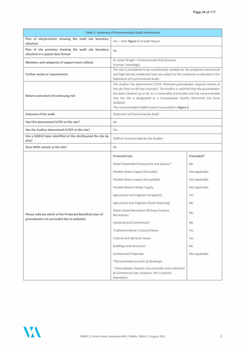
20009: 15 Union Street, Brunswick EAR | CARMs: 78639-1 | August 2021 2
Table 1: Summary of Environmental Audit Information
Plan of site/premises showing the audit site boundary attached
Yes – refer Figure 1 of Audit Report
Plan of site premises showing the audit site boundary attached in a spatial data format
No
Members and categories of support team utilised Dr Jackie Wright – Environmental Risk Sciences (Human Toxicology).
Further works or requirements The site is considered to be conditionally suitable for the proposed commercial and high-density residential land use subject to the conditions as detailed in the Statement of Environmental Audit.
Nature and extent of continuing risk
The Auditor has determined CUTEP. Remnant groundwater impacts remain at the site from an off-site source(s). The Auditor is satisfied that the groundwater has been cleaned up so far as is reasonably practicable and has recommended that the site is designated as a Groundwater Quality Restricted Use Zone (GQRUZ). The recommended GQRUZ extent is provided in Figure 2.
Outcome of the audit Statement of Environmental Audit
Has EPA determined CUTEP at this site? No
Has the Auditor determined CUTEP at this site? Yes
Has a GQRUZ been identified at the site/beyond the site by EPA?
GQRUZ recommended by the Auditor
Does NAPL remain at the site? No
Please indicate which of the Protected Beneficial Uses of groundwater are precluded due to pollution
Protected Use Precluded?
Water Dependent Ecosystems and Species* No
Potable Water Supply (Desirable) Not applicable
Potable Water Supply (Acceptable) Not applicable
Potable Mineral Water Supply Not applicable
Agriculture and Irrigation (Irrigation) Yes
Agriculture and Irrigation (Stock Watering) No
Water-based Recreation (Primary Contact Recreation)
No
Industrial and Commercial^ No
Traditional Owner Cultural Values Yes
Cultural and Spiritual Values Yes
Buildings and Structures No
Geothermal Properties Not applicable
*Not precluded at point of discharge.
^ Groundwater impacts may preclude some Industrial & Commercial uses; however, this is process dependent.
Page 34 of 117
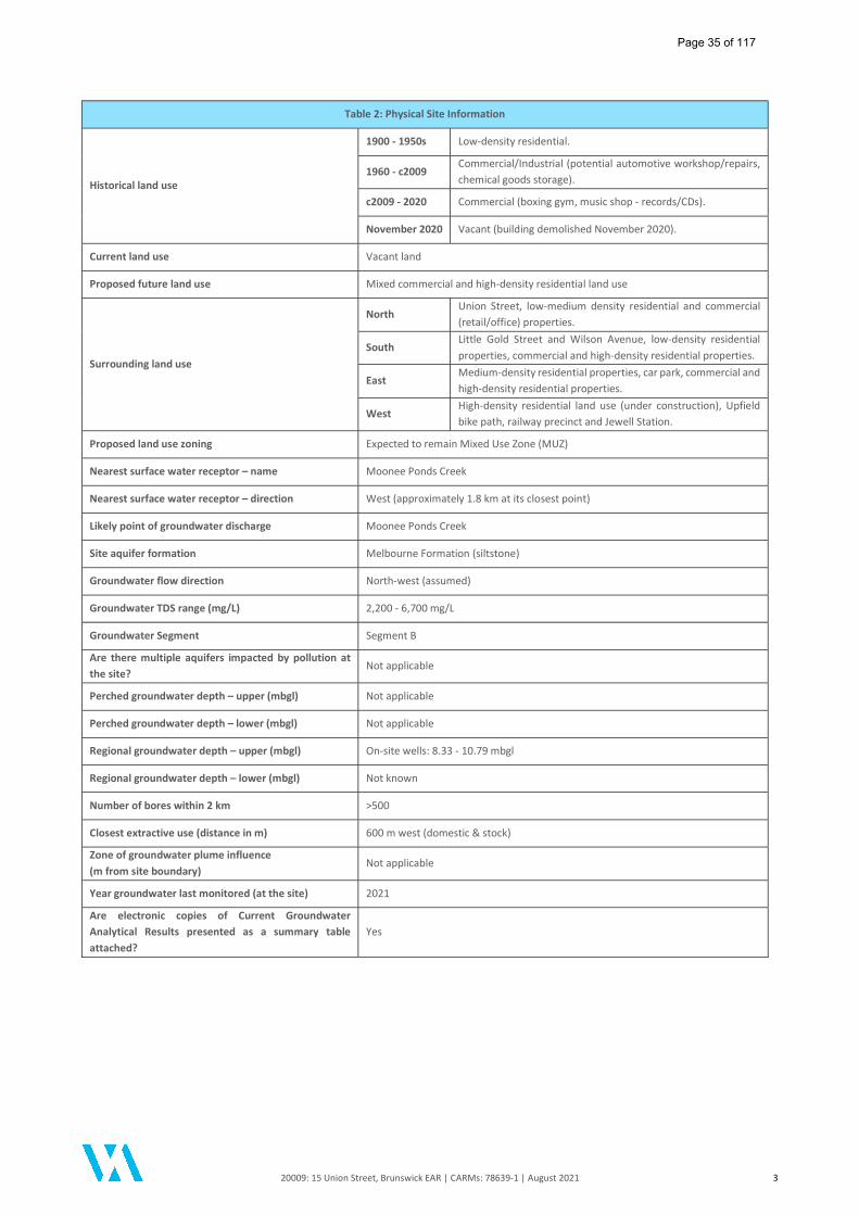
20009: 15 Union Street, Brunswick EAR | CARMs: 78639-1 | August 2021 3
Table 2: Physical Site Information
Historical land use
1900 - 1950s Low-density residential.
1960 - c2009 Commercial/Industrial (potential automotive workshop/repairs, chemical goods storage).
c2009 - 2020 Commercial (boxing gym, music shop - records/CDs).
November 2020 Vacant (building demolished November 2020).
Current land use Vacant land
Proposed future land use Mixed commercial and high-density residential land use
Surrounding land use
North Union Street, low-medium density residential and commercial (retail/office) properties.
South Little Gold Street and Wilson Avenue, low-density residential properties, commercial and high-density residential properties.
East Medium-density residential properties, car park, commercial and high-density residential properties.
West High-density residential land use (under construction), Upfield bike path, railway precinct and Jewell Station.
Proposed land use zoning Expected to remain Mixed Use Zone (MUZ)
Nearest surface water receptor – name Moonee Ponds Creek
Nearest surface water receptor – direction West (approximately 1.8 km at its closest point)
Likely point of groundwater discharge Moonee Ponds Creek
Site aquifer formation Melbourne Formation (siltstone)
Groundwater flow direction North-west (assumed)
Groundwater TDS range (mg/L) 2,200 - 6,700 mg/L
Groundwater Segment Segment B
Are there multiple aquifers impacted by pollution at the site?
Not applicable
Perched groundwater depth – upper (mbgl) Not applicable
Perched groundwater depth – lower (mbgl) Not applicable
Regional groundwater depth – upper (mbgl) On-site wells: 8.33 - 10.79 mbgl
Regional groundwater depth – lower (mbgl) Not known
Number of bores within 2 km >500
Closest extractive use (distance in m) 600 m west (domestic & stock)
Zone of groundwater plume influence (m from site boundary)
Not applicable
Year groundwater last monitored (at the site) 2021
Are electronic copies of Current Groundwater Analytical Results presented as a summary table attached?
Yes
Page 35 of 117

20009: 15 Union Street, Brunswick EAR | CARMs: 78639-1 | August 2021 4
1 Introduction
Sally Bonham, an Environmental Auditor (Contaminated Land) appointed pursuant to the Environment Protection Act 1970 (Section 53S Part IXD), was requested on 03 April 2020 by Danny Gunn of Baronel Nominees Pty Ltd to issue a Certificate of Environmental Audit for 15 Union Street, Brunswick (the site). On 01 July 2021, the new Environment Protection Act 2017 (new EP Act) came into effect. As outlined in EPA Publication 1978: Transition Guidance for Environmental Auditors (June 2020), Section 478 of the new EP Act provides that an Environmental Auditor can complete an existing Environmental Audit (that has not been completed as of 01 July 2021) under EP Act 1970. Under section 478(3)(a) of EP Act 2017, if an Auditor proceeds to continue to conduct an Audit under EP Act 1970 then Part IXD of EP Act 1970 continues in effect as if it had not been repealed. An Environmental Audit Report and Certificate or Statement of Environmental Audit issued under Part IXD of EP Act 1970 after 1 July 2021 are also taken to satisfy the requirements of Part 8.3 of the EP Act 2017. Background information relating to the Audit is provided in Table 3 below.
Table 3: Further Audit Information
Item Discussion
Title Information Lot 1 on Title Plan 230956L within Certificate of Title Volume 8068, Folio 875. The current Certificate of Title is provided in Appendix A of this report.
Land Size The site occupies an approximate surface area of 0.044 hectares (440 m2). The location of the site is presented in Figure 1.
Audit Trigger Environmental Audit Overlay (EAO) under Moreland City Council planning policy. The Environmental Audit is a requirement of the Planning Permit (Condition 17 - MPS/2018/601). A copy of the Planning Permit is provided in Appendix B of this report.
Proposed Development
The site is proposed to be redeveloped for mixed commercial and high-density residential land use, comprising a multi-level building with ground floor commercial (office) and car parking (including 4.5 m car stacker pit) uses and high-density residential apartments from Level 1 to Level 8. The ground floor of the development is proposed to be encapsulated by the building footprint with no landscaping or garden beds proposed. Development plans are provided in Appendix B of this report. Based on the proposed residential use of the site, the development is consistent with the definition of 'sensitive use' in accordance with Appendix 4 of the Auditor Guidelines (EPA Publication 759.3, 2015). As such, the proposed development is associated with the protected beneficial uses for the land uses Sensitive Use: High Density and Commercial in accordance with State Environment Protection Policy (SEPP) Prevention and Management of Contamination of Land, 2002.
Assessment Consultant
Pre-Audit Investigations: ESG Environmental Pty Ltd (ESG) completed a Preliminary Site Investigation (PSI) in August 2017 and a Preliminary Targeted Environmental Site Assessment (ESA) in January 2019. The findings of the previous ESG (2019) ESA have been incorporated into the overall assessment of the site and evaluation of the site data by DRC. Audit Investigations: DRC Environmental Pty Ltd (DRC) was the appointed assessment consultant for the duration of the Audit. A geotechnical investigation was carried out at the site by GeoAust Geotechnical Engineers Pty Ltd (GeoAust) in November 2020 and one (1) geotechnical groundwater bore installed on the site by GeoAust was also utilised as part of the site assessment works by DRC. The Auditor is not aware of any additional environmental assessments having been performed by other parties at the site during the Audit process.
List of Documents Reviewed/Referenced
DRC and Baronel Nominees Pty Ltd supplied the primary sources of information that the Auditor used to form an opinion regarding the environmental condition of the site. This information comprised the following: DRC (2021) Detailed Site Investigation, 15 Union Street, Brunswick, dated 18 June 2021 (ref:
DRC DSI Final V2); DRC (2021) Re: Visual Inspection and Cleared Asbestos Containing Materials (ACM) Located
at 15 Union Street, Brunswick, Victoria, dated 28 June 2021 (addendum letter report); ESG (2017) Preliminary Site Investigation (PSI), 15 Union Street, Brunswick, 3056 dated 4
August 2017 (ref: ESG2017-071_PSI V1.0) - provided in Appendix B of the DRC (2021) DSI report;
Page 36 of 117

20009: 15 Union Street, Brunswick EAR | CARMs: 78639-1 | August 2021 5
Table 3: Further Audit Information
ESG (2019) Preliminary Targeted Environmental Site Assessment - 15 Union Street, Brunswick, Victoria, dated 30 January 2019 (ref: ESG2018-149_Preliminary Targeted ESA V1.0) - provided in Appendix B of the DRC (2021) DSI report; and
GeoAust Geotechnical Engineers Pty Ltd (2021) Stage 2 Geotechnical Investigation Report, Proposed Mixed Use Development, 15 Union Street, Brunswick VIC, dated 12 January 2021 (ref: 6655-3-R) - provided in Appendix Q of the DRC (2021) DSI report.
A copy of the DRC (2021) DSI report and DRC (2021) addendum letter report is provided in Appendix C of this report. In addition, the following document was also reviewed as part of the Audit:
Environmental Risk Sciences Pty Ltd (enRiskS) (2021) Vapour Risk Assessment: 15 Union Street, Brunswick, dated 5 August 2021.
A copy of the enRiskS (2021) Risk Appraisal report is presented in Appendix D of this report.
Laboratories Utilised
Primary Laboratory: Eurofins (soil and groundwater)
Secondary Laboratory: ALS Environmental (soil and groundwater)
Auditor Verification Eurofins (soil and groundwater)
Guideline Documents Referenced Refer to Section 4 for adopted Audit Criteria and References Section.
Adopted Criteria Soil – refer Section 4.2. Groundwater – refer Section 4.4.
Involvement of Auditor’s Support Team
Auditor’s Support Team: Christie Batiste – Auditor’s Representative. Madeleine Parris - Auditor's Representative. Expert Support Team Member: Dr Jackie Wright (Environmental Risk Sciences Pty Ltd) – Human Toxicology.
1.1 Audit Objective The objective of the Environmental Audit was to undertake an independent assessment of the condition of the site and form an opinion regarding its suitability for any beneficial use. Once the Auditor is satisfied that there is sufficient information, that the dataset and evidence provided is robust and reliable and has adequate information to form an opinion regarding the condition of the site, the Auditor will issue a Certificate of Environmental Audit certifying that the site is suitable for any beneficial use. If the site is not suitable for one or more beneficial uses, then a Statement of Environmental Audit will be issued, stating which uses it is suitable for.
1.2 Auditor work elements The following major work elements were carried out by the Auditor and support team:
Reviewed and evaluated the relevant site assessment documents to gain an understanding of the environmental condition of the site and the completeness / adequacy of the site assessment works. The review included an appraisal of:
- methodologies used by the assessment consultant;
- nature and extent of any identified contamination;
- potential impacts of the condition of the subject site on the beneficial uses associated with the site; and
- quality assurance and quality control procedures followed by the assessment consultant.
Conducted a walkover of the site on several occasions to observe site conditions;
Undertook site inspections during a soil validation sampling event and a groundwater sampling event conducted by the assessment consultant;
Collected soil and groundwater verification samples at the site;
Conducted confirmatory landfill gas monitoring at and nearby to the site;
Page 37 of 117

20009: 15 Union Street, Brunswick EAR | CARMs: 78639-1 | August 2021 6
Identified the beneficial use(s) of land and groundwater requiring protection as defined by relevant State Environment Protection Policies (SEPPs);
Provided comment on the presence of, or potential for, off-site contamination including any recommendations for any investigations or clean-up;
Formed an opinion on the condition of the site, and the nature and extent of any harm, detriment or risk posed by the condition of the site to beneficial uses to be protected;
Formed an opinion regarding clean up to the extent practicable (Auditor-determined CUTEP) and notified EPA Victoria on the intention for an Auditor-determined CUTEP process;
Undertook a site inspection following asbestos remediation works conducted on-site;
Performed an inspection of the site at the time of the completion of the Audit;
Concluded as to the suitability of the site in its final condition for its existing and intended use;
Prepared an Environmental Audit Report (EAR) detailing the above work elements prior to determining whether to issue a Certificate/Statement of Environmental Audit for the site. The EAR also includes an assessment of the compatibility of the proposed development of the site with the environmental condition of the site; and
Provided a Statement of Environmental Audit in accordance with the findings of the assessment works and the Environmental Audit Report.
1.3 Auditor Site Inspections The Auditor and/or Auditor Representative visited the site on the following occasions:
Table 4: Summary of Auditor Site Inspections
Date Comment
13 November 2020
The Auditor conducted an initial site inspection to observe site conditions during the excavation and validation of the underground storage tank (UST). Auditor Verification sample AV01 was collected from the base of the UST excavation corresponding to DRC soil sample location VAL_B.
24 April 2021 The Auditor and Auditor's Representative conducted a site inspection to observe site conditions following asbestos remedial works and off-site disposal of waste soil stockpile generated during the UST excavation works.
13 May 2021
The Auditor conducted a site inspection during the GME3 groundwater sampling event and collected a groundwater Auditor Verification sample (AV02) in conjunction with DRC sample collection at MW02. The Auditor collected soil verification samples AV03 and AV04 from imported soil material and exposed surface fill soils respectively for confirmatory laboratory analysis.
06 July 2021
The Auditor and Auditor's Representative conducted a visual inspection at the site following completion of additional asbestos removal and clearance inspection conducted by DRC in June 2020. No access to the site was made during the site inspection. The Auditor also conducted confirmatory landfill gas monitoring at nearby off-site utility pits and drains.
29 July 2021 The Auditor conducted a final inspection of the site conditions.
Page 38 of 117
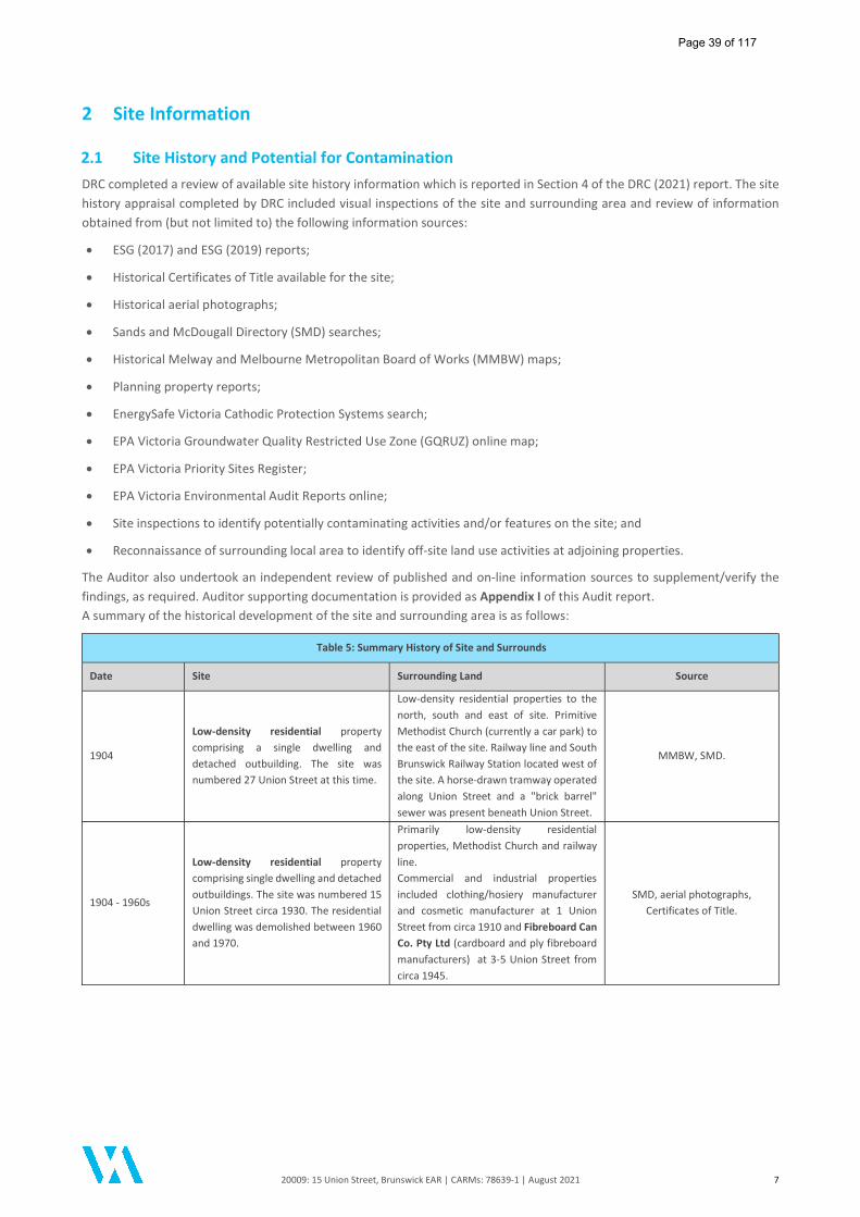
20009: 15 Union Street, Brunswick EAR | CARMs: 78639-1 | August 2021 7
2 Site Information
2.1 Site History and Potential for Contamination DRC completed a review of available site history information which is reported in Section 4 of the DRC (2021) report. The site history appraisal completed by DRC included visual inspections of the site and surrounding area and review of information obtained from (but not limited to) the following information sources:
ESG (2017) and ESG (2019) reports;
Historical Certificates of Title available for the site;
Historical aerial photographs;
Sands and McDougall Directory (SMD) searches;
Historical Melway and Melbourne Metropolitan Board of Works (MMBW) maps;
Planning property reports;
EnergySafe Victoria Cathodic Protection Systems search;
EPA Victoria Groundwater Quality Restricted Use Zone (GQRUZ) online map;
EPA Victoria Priority Sites Register;
EPA Victoria Environmental Audit Reports online;
Site inspections to identify potentially contaminating activities and/or features on the site; and
Reconnaissance of surrounding local area to identify off-site land use activities at adjoining properties.
The Auditor also undertook an independent review of published and on-line information sources to supplement/verify the findings, as required. Auditor supporting documentation is provided as Appendix I of this Audit report. A summary of the historical development of the site and surrounding area is as follows:
Table 5: Summary History of Site and Surrounds
Date Site Surrounding Land Source
1904
Low-density residential property comprising a single dwelling and detached outbuilding. The site was numbered 27 Union Street at this time.
Low-density residential properties to the north, south and east of site. Primitive Methodist Church (currently a car park) to the east of the site. Railway line and South Brunswick Railway Station located west of the site. A horse-drawn tramway operated along Union Street and a "brick barrel" sewer was present beneath Union Street.
MMBW, SMD.
1904 - 1960s
Low-density residential property comprising single dwelling and detached outbuildings. The site was numbered 15 Union Street circa 1930. The residential dwelling was demolished between 1960 and 1970.
Primarily low-density residential properties, Methodist Church and railway line. Commercial and industrial properties included clothing/hosiery manufacturer and cosmetic manufacturer at 1 Union Street from circa 1910 and Fibreboard Can Co. Pty Ltd (cardboard and ply fibreboard manufacturers) at 3-5 Union Street from circa 1945.
SMD, aerial photographs, Certificates of Title.
Page 39 of 117

20009: 15 Union Street, Brunswick EAR | CARMs: 78639-1 | August 2021 8
Table 5: Summary History of Site and Surrounds
Date Site Surrounding Land Source
1960s - circa 2009
Commercial/Industrial use - a warehouse building was established on the site between 1960 and 1970. Site uses included potential automotive garage and chemical goods storage with proprietary occupiers listed in the SMD as Brockley Pty Ltd (packaging), Elasta Chemicals Pty Ltd (importers), Quality Packaging Services Pty Ltd (packaging) between 1965 and 1974.
Low-density residential, railway, commercial and industrial land uses. Commercial and industrial land uses on the south side of Union Street (between Sydney Road and railway included) wholesale chemists, silicone products manufacturers, aerosol and chemical manufacturers, fibreboard and cardboard box manufacturers and plastics manufacturing.
SMD, aerial photographs, Certificates of Title, Google
imagery.
circa 2009 - 2020
Commercial use including boxing gym and music retail store (vinyl records and CDs), bowser and underground storage tank (UST) noted to be present.
Low-density to high-density residential properties, railway, commercial properties (retail cafés, offices).
Aerial photographs, Certificates of Title, Google imagery, site
inspections.
2020 - Current Vacant (building October-November 2020)
Low-density to high-density residential properties, railway and Jewell railway station, commercial properties (retail cafés, offices). Adjoining property at 15a Union Street under construction for multi-level high-density residential apartments and multiple basement levels.
Site inspections, Google imagery, NearMap imagery.
Notes: MMBW - Melbourne Metropolitan Board of Works; SMD - Sands and McDougall Directory.
In summary, the documented history indicates that the site was occupied by a low-density residential property from as early as 1904 until circa 1960s. A single-level warehouse building was constructed on the site between 1960 and 1970. The site was used for commercial/industrial purposes including potential automotive workshop, chemical goods storage, boxing gym and most recently a music retail store. The on-site warehouse building was demolished during October-November 2020 and the site was vacant at the time of completion of the Audit. The surrounding area historically comprised a mixture of low-density residential properties and commercial/industrial land uses including clothing manufacturing and various chemical, plastics, cardboard and fibreboard manufacturing premises on the south side of Union Street between Sydney Road and the Upfield Railway Line. The railway line and Jewell Railway Station (formerly South Brunswick Railway Station) located west of the site have remained surrounding land use features prior to 1900. The site history information provided by DRC was generally considered sufficient to identify potentially contaminating on-site and off-site land uses and activities. Several clay holes associated with former brickworks and brickmaking activities were historically located on the eastern and western sides of Sydney Road, Brunswick including Brunswick Brick Works/Hoffman Brick and Pottery Works, Cornwell's Pottery and Gillbrook Pottery. Many of the clay pits were used for municipal waste disposal or uncontrolled filling following their closure. Several of the former clay holes/brickworks are located within 500 m of the site including:
Barkly Square shopping centre and carpark (approximately 380 m south-east of the site);
Temple Park (approximately 460 m west of the site);
Industrial precinct bounded by Albert Street, Fallon Street, Phoenix Street and Upfield Railway Line (approximately 520 m north-west of the site);
Woolworths Brunswick (approximately 530 m north of the site); and
Industrial and residential precinct bounded by Fallon Street, Dawson Street, Pearson Street and Albert Street (including Gilpin Park) (approximately 730 m north-west of the site);
Additional information relied upon by the Auditor is provided in Appendix I of this report.
Page 40 of 117

20009: 15 Union Street, Brunswick EAR | CARMs: 78639-1 | August 2021 9
2.2 Site Conditions The Auditor conducted an initial site walkover on 13 November 2020, with the observations made during subsequent site inspections conducted by the Audit team generally consistent with the site condition findings presented in the DRC (2021) report. During the course of the Audit, the following observations were made in regard to site conditions and off-site activities:
The site comprised a rectangular-shaped land parcel bounded by Union Street to the north, Little Gold Street and Wilson Avenue to the south, medium-density residential properties to the east and high-density residential development (under construction) to the west of the site.
The site was noted to be generally flat.
The site was accessible via frontage to Union Street and rear access via Little Gold Street/Wilson Avenue.
The site was vacant with no buildings or hardstand surfaces present.
The surface of the site comprised bare exposed soils.
No vegetation was present on the site.
An excavation was present in the south-eastern portion of the site where a single underground storage tank (UST) and associated pipework and remote fill point were removed. Waste soil generated during the excavation works was stockpiled on-site adjacent to the UST excavation.
No evidence of other underground infrastructure (e.g. USTs, triple interceptor traps - TITs, etc) was observed at the time of the Auditor inspections.
Minor amounts of asbestos-containing materials (ACM) in the form of bonded cement sheet were observed on the surface of the site during the initial site inspection undertaken post-building demolition and during the Auditor's subsequent site visit undertaken on 13 May 2021.
A former commercial/industrial premises located immediately west of the site at 15a Union Street, Brunswick was observed to be undergoing redevelopment as a multi-storey building including construction of multiple basement levels.
During the final site walkover conducted by the Auditor on 29 July 2021, the following observations were made:
The site was vacant.
Fragments of gravel, brick, concrete and glass were visible on the exposed surface of remnant fill soils in the western portion of the site.
Imported siltstone/mudstone was present across the site surface in the eastern portion of the site, within the former UST excavation and extending along the eastern boundary from the former excavation towards the Union Street entrance to the site.
Two (2) fragments of suspected asbestos containing material (ACM) were noted to be present during the final site walkover, however these were appropriately bagged and removed off-site by the Auditor.
No visible ACM was observed on-site at the completion of the site walkover.
There was no evidence of stained or discoloured soils or obvious odours noted.
The on-site groundwater monitoring wells MW01 and MW02 remained on-site.
The surrounding land uses remained generally unchanged.
Page 41 of 117

20009: 15 Union Street, Brunswick EAR | CARMs: 78639-1 | August 2021 10
2.3 Surrounding Land Use The current surrounding land use consists of the following:
Table 6: Surrounding Land Use
Direction Surrounding Land Use
North Union Street, low-medium density residential properties, commercial property (café/office). Further north are mixed commercial and medium-density residential properties and industrial land use (Gordon Brothers Industries Pty Ltd).
South Little Gold Street and Wilson Avenue, low-density residential properties then mixed commercial and high-density residential properties.
East Medium-density residential properties, car park, then mixed commercial and high-density residential properties. Sydney Road commercial precinct located approximately 100 m east of the site.
West High-density residential property (under construction) located immediately west, then Upfield Railway Line and Jewell Station precinct, Watson Street and low-density to high-density residential properties.
2.4 Cathodic Protection Systems Search A search of the Cathodic Protection Systems Database administered by Energy Safe Victoria was requested by DRC in November 2020. The search failed to identify any cathodic protection systems registered for the site address. The Energy Safe Victoria search statement is included in Appendix E of the DRC (2021) report.
2.5 WorkSafe Dangerous Goods Database Search A search of the WorkSafe Victoria Dangerous Goods database was previously requested as part of the ESG Environmental (2017) Preliminary Site Investigation works, however the requested search information was not obtained at time of issuance of the ESG Environmental (2017) report. A search request of the WorkSafe Dangerous Goods Database was not undertaken by DRC.
2.6 EPA Victoria Information Searches
2.6.1 Priority Sites Register
Priority Sites are sites for which EPA Victoria has issued a Clean-Up Notice pursuant to Section 62A, or a Pollution Abatement Notice pursuant to Section 31A or 31B (relevant to land and/or groundwater) of the Environment Protection Act 1970. Typically, these are sites where pollution of land and/or groundwater presents a potential risk to human health or to the environment. A review of the EPA Victoria Priority Sites Register (PSR) was initially undertaken by ESG Environmental in August 2017 as part of the Preliminary Site Investigation. The PSR review completed by ESG Environmental (2017) identified the site was not listed as a Priority Site, nor was located in the vicinity of a Priority Site. DRC (2021) completed an updated review of the EPA Victoria PSR (dated 28 February 2021) and confirmed that the site was not listed, nor any surrounding properties in the vicinity of the site, were listed on the PSR. The Auditor performed an independent review of the EPA Priority Sites Register (dated 31 May 2021) and the Victoria Unearthed online mapping system during July 2021 and noted that the closest sites listed on the Register were as follows:
EPA Notice 90008501: 699-701 Park Street, 2-4 Sydney Road 182, 184-186, 188 and 190-192 Brunswick Road, Brunswick, located approximately 360 m south-east of the site. A former industrial site requiring assessment and/or clean up.
EPA Notice 90009119: 225 and 227-231 Barkly Street and 1-77 Amelia Street, Brunswick, located approximately 575 m south-east of the site. A former industrial site requiring assessment and/or clean up.
EPA Notice 90010613: Building 5 and 6, 72-106 Dawson Street, Brunswick, located approximately 770 m north-west of the site. A former industrial site requiring assessment and/or clean up.
EPA Notice 90009126: 4-6 Barkly Street, Brunswick East, located approximately 1.65 km south-east of the site. A former industrial site requiring assessment and/or clean up.
No other properties were listed as a Priority Site within a 2 km radius of the site. Based on the distance of the above properties to the Audit site, it is the Auditor’s opinion that the nearest listed Priority Sites were unlikely to impact upon the site.
Page 42 of 117
20009: 15 Union Street, Brunswick EAR | CARMs: 78639-1 | August 2021 11
2.6.2 Review of Landfill Register and List of Assessed Landfills
DRC (2021) completed a review of the Victorian Landfill Register (VLR) which lists all ‘current and known closed landfills in Victoria’. The VLR was accessed by DRC via the Victoria Unearthed online database during May 2021 which identified the site was not located on, nor in the vicinity of a property, used for waste disposal. The Auditor completed an independent review of the VLR (ww.epa.vic.gov.au, accessed 05 July 2021) and Appendix 1 of EPA Publication 1270 (2009) ‘Assessment of the Potential for Methane Gas Movement from Victorian Landfills’ and confirmed that there are no 'registered' landfills within 2 km of the site. As detailed in Section 2.1 above, several clay pits were historically located on the eastern and western sides of Sydney Road, Brunswick associated with former brickworks and brickmaking activities. Many of the clay pits were used for municipal waste disposal or uncontrolled filling following their closure. Several of the former clay holes/brickworks are located within approximately 500 m of the site including:
Former Barkly Brick Company: currently Barkly Square shopping centre and carpark (approximately 300 m south-east of the site) - operations ceased circa 1962 and clay hole filled with municipal waste.
Former Gillbrook Pottery: current Temple Park (approximately 460 m west of the site).
Former Brunswick Brick Works/Hoffman Brickworks: current industrial precinct bounded by Albert Street, Fallon Street, Phoenix Street and Upfield Railway Line (approximately 520 m north-west of the site).
Former Cornwell's Pottery: current Woolworths Brunswick (approximately 530 m north of the site).
Based on the historical landfilling activities identified within 500 m of the site and the potential for legacy landfill gases to pose a potential risk to the site, a direct assessment of landfill gases was included as part of the site investigations completed by DRC (2021) and verification landfill gas monitoring completed by the Auditor during July 2021. Based on the distance of the former clay pits to the Audit site, given that the pottery closed in 1965 and given that landfilling activities occurred over 50 years ago, it is the Auditor’s opinion that the former clay holes/pits listed above were unlikely to impact upon the site. However, a direct assessment of landfill gases was included as part of the site investigations completed by DRC (and independently verified by the Auditor - refer to Section 8).
2.6.3 Review of Nearby Completed Audit Reports
DRC (2021) completed a search of EPA Victoria’s online List of Environmental Audit Reports and reported that twenty-three (23) Environmental Audits had been completed for properties located within 500 m of the site. DRC also reviewed a copy of the Environmental Audit Report completed for the adjoining property at 15A Union Street, Brunswick which was supplied by the client. A summary of the findings of selected Environmental Audit Reports for properties within 100 m of the site was provided in the DRC (2021) report. The Auditor performed an independent review of the EPA Victoria’s online List of Environmental Audit Reports and Victoria Unearthed (accessed 05 July 2021) and generally confirmed DRC’s findings. A summary of a selection of properties situated within approximately 100 metres of the site for which a Certificate or Statement of Environmental Audit had been issued, based on information provided by DRC Environmental and the Auditor, is provided in Table 7. The review of the available surrounding completed Audit reports provided by DRC (2021) (and as supplemented by the Auditor, where required) found the information presented to be generally adequate to establish an understanding of surrounding former land uses and associated contamination issues.
Page 43 of 117
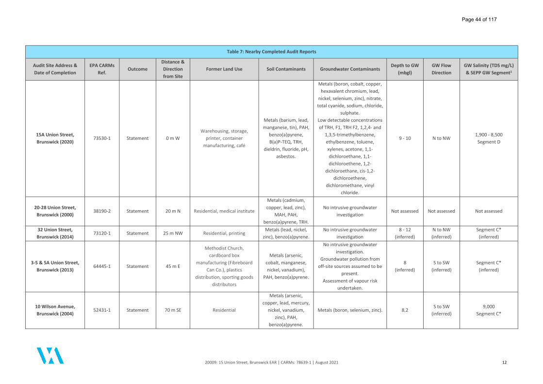
20009: 15 Union Street, Brunswick EAR | CARMs: 78639-1 | August 2021 12
Table 7: Nearby Completed Audit Reports
Audit Site Address & Date of Completion
EPA CARMs Ref.
Outcome Distance & Direction from Site
Former Land Use Soil Contaminants Groundwater Contaminants Depth to GW
(mbgl) GW Flow Direction
GW Salinity (TDS mg/L) & SEPP GW Segment1
15A Union Street, Brunswick (2020)
73530-1 Statement 0 m W Warehousing, storage,
printer, container manufacturing, café
Metals (barium, lead, manganese, tin), PAH,
benzo(a)pyrene, B(a)P-TEQ, TRH,
dieldrin, fluoride, pH, asbestos.
Metals (boron, cobalt, copper, hexavalent chromium, lead,
nickel, selenium, zinc), nitrate, total cyanide, sodium, chloride,
sulphate. Low detectable concentrations of TRH, F1, TRH F2, 1,2,4- and
1,3,5-trimethylbenzene, ethylbenzene, toluene, xylenes, acetone, 1,1-dichloroethane, 1,1-dichloroethene, 1,2-
dichloroethane, cis-1,2-dichloroethene,
dichloromethane, vinyl chloride.
9 - 10 N to NW 1,900 - 8,500 Segment D
20-28 Union Street, Brunswick (2000)
38190-2 Statement 20 m N Residential, medical institute
Metals (cadmium, copper, lead, zinc),
MAH, PAH, benzo(a)pyrene, TRH.
No intrusive groundwater investigation
Not assessed Not assessed Not assessed
32 Union Street, Brunswick (2014)
73120-1 Statement 25 m NW Residential, printing Metals (lead, nickel,
zinc), benzo(a)pyrene. No intrusive groundwater
investigation 8 - 12
(inferred) N to NW (inferred)
Segment C* (inferred)
3-5 & 5A Union Street, Brunswick (2013)
64445-1 Statement 45 m E
Methodist Church, cardboard box
manufacturing (Fibreboard Can Co.), plastics
distribution, sporting goods distributors
Metals (arsenic, cobalt, manganese, nickel, vanadium),
PAH, benzo(a)pyrene.
No intrusive groundwater investigation.
Groundwater pollution from off-site sources assumed to be
present. Assessment of vapour risk
undertaken.
8 (inferred)
S to SW (inferred)
Segment C* (inferred)
10 Wilson Avenue, Brunswick (2004)
52431-1 Statement 70 m SE Residential
Metals (arsenic, copper, lead, mercury,
nickel, vanadium, zinc), PAH,
benzo(a)pyrene.
Metals (boron, selenium, zinc). 8.2 S to SW
(inferred) 9,000
Segment C*
Page 44 of 117
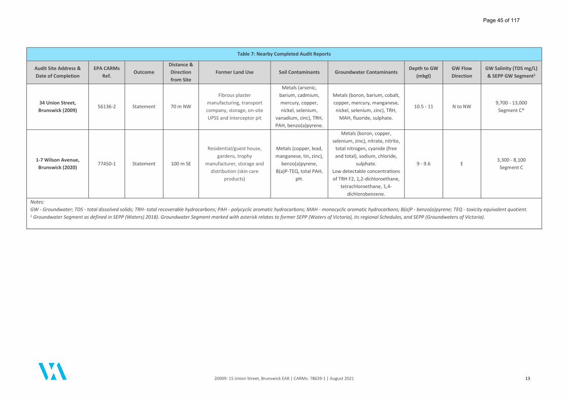
20009: 15 Union Street, Brunswick EAR | CARMs: 78639-1 | August 2021 13
Table 7: Nearby Completed Audit Reports
Audit Site Address & Date of Completion
EPA CARMs Ref.
Outcome Distance & Direction from Site
Former Land Use Soil Contaminants Groundwater Contaminants Depth to GW
(mbgl) GW Flow Direction
GW Salinity (TDS mg/L) & SEPP GW Segment1
34 Union Street, Brunswick (2009)
56136-2 Statement 70 m NW
Fibrous plaster manufacturing, transport company, storage, on-site UPSS and interceptor pit
Metals (arsenic, barium, cadmium, mercury, copper, nickel, selenium,
vanadium, zinc), TRH, PAH, benzo(a)pyrene.
Metals (boron, barium, cobalt, copper, mercury, manganese, nickel, selenium, zinc), TRH,
MAH, fluoride, sulphate.
10.5 - 11 N to NW 9,700 - 13,000
Segment C*
1-7 Wilson Avenue, Brunswick (2020)
77450-1 Statement 100 m SE
Residential/guest house,
gardens, trophy manufacturer, storage and
distribution (skin care products)
Metals (copper, lead, manganese, tin, zinc),
benzo(a)pyrene, B(a)P-TEQ, total PAH,
pH.
Metals (boron, copper, selenium, zinc), nitrate, nitrite,
total nitrogen, cyanide (free and total), sodium, chloride,
sulphate. Low detectable concentrations of TRH F2, 1,2-dichloroethane,
tetrachloroethane, 1,4-dichlorobenzene.
9 - 9.6 E 3,300 - 8,100
Segment C
Notes: GW - Groundwater; TDS - total dissolved solids; TRH- total recoverable hydrocarbons; PAH - polycyclic aromatic hydrocarbons; MAH - monocyclic aromatic hydrocarbons; B(a)P - benzo(a)pyrene; TEQ - toxicity equivalent quotient. 1 Groundwater Segment as defined in SEPP (Waters) 2018). Groundwater Segment marked with asterisk relates to former SEPP (Waters of Victoria), its regional Schedules, and SEPP (Groundwaters of Victoria).
Page 45 of 117

20009: 15 Union Street, Brunswick EAR | CARMs: 78639-1 | August 2021 14
2.6.4 Groundwater Quality Restricted Use Zones
DRC (2021) also undertook a search of the EPA Victoria Map of Groundwater Quality Restricted Use Zones (GQRUZ) in Victoria (accessed February 2021) and reported that the site is not currently listed as a GQRUZ. DRC identified four (4) GQRUZ were located within 1 km of the site:
225 and 227-231 Barkly Street, Brunswick, located approximately 645 m south-east of the site;
1 Heller Street, Brunswick, located approximately 600 m west of the site;
29-31 Frith Street, Brunswick, located approximately 850 m north-east of the site; and
417-419 Brunswick Road, Brunswick West, former dry-cleaner located approximately 965 m south-west of the site.
The Auditor completed an independent review of the EPA Map of Groundwater Quality Restricted Use Zones in Victoria and Victoria Unearthed online database (both accessed 5 July 2021) and confirmed the above properties and/or designated areas were listed as a GQRUZ, with the exception of 225 and 227-231 Barkly Street, Brunswick, which at the time of reporting was not subject to a GQRUZ in the online data resources available for review, however this property was noted to be listed on the EPA Priority Sites Register - refer Section 2.6.1 above. The Auditor also identified the following designated GQRUZ within proximity to the site:
699-701 Park Street, 2-4 Sydney Road, 182, 184-186, 188 and 190-192 Brunswick Road, Brunswick (CARMs: 75376-1) located approximately 350 m south-east of the site.
Based on the distance of the above GQRUZs with respect to the site and the regional north to north-west groundwater flow direction, it is the Auditor's opinion that the identified GQRUZs are unlikely to impact upon the site. Based on the available information detailed in Table 7, it was considered likely that regional groundwater was polluted. Groundwater pollution in the area was reported to include nitrate, VOCs, heavy metals, cyanide, TRH and PAH. Based on the distance of some of the above properties and the presence of reported regional groundwater pollution, it is the Auditor’s opinion that regional groundwater pollution has potential to impact upon the site.
2.7 Geology and On-Site Soil Profile DRC reviewed the Geological Survey of Victoria (GSV) Melbourne 1:63,360 map and reported the site to be underlain by siltstone and sandstone of the Silurian age Dargile Formation (Melbourne Formation). The Auditor reviewed the GSV Melbourne and Suburbs 1:31,680 map and Visualising Victoria's Groundwater (VVG) geological map and confirmed the above findings and also identified the site to be located close to the geological boundary of the Quaternary age Newer Volcanics basalt (east of the site) and Tertiary age Brighton Group (west of the site). Based on review of the soil logs and the GeoAust (2021) Geotechnical Investigation Report provided in the DRC (2021) report, the soil profile encountered on-site generally supports the published documentation. A summary of the soil conditions encountered on-site is provided in the table below.
Table 8: Generalised On-Site Soil Profile
Approximate Depth (mbgl) Description
0.0 - 0.5
Fill: SILT/gravelly SILT/silty CLAY, dark brown to grey, fine to medium grained gravel, trace organic material, trace anthropogenic material including fragments of brick, metal (nails) and tiles, plastic, trace charcoal and coke ash fragments (BH04). Fill: Sandy GRAVEL, dark brown, fine to coarse grained rounded sand. Black discoloured soil and mild hydrocarbon and/or solvent-like odour observed at select locations.
0.5 - 5.0 Natural: CLAY/silty CLAY/clayey SILT/silty SAND, grey to brown and orange-brown, trace fine to coarse-grained sand, fine to medium-grained Gravel and rounded ferricrete gravel, medium to high plasticity. Mild petroleum hydrocarbon/solvent odour reported at select locations.
5.0 - 12.0* Natural: completely weathered SILTSTONE, pale grey to pale brown, yellow-brown to red-brown and orange and pink mottles.
Note: *Maximum depth of investigation
Page 46 of 117

20009: 15 Union Street, Brunswick EAR | CARMs: 78639-1 | August 2021 15
Mild petroleum hydrocarbon odour and black discoloured soil was recorded at selected investigation locations during the initial intrusive assessment works completed by ESG in 2019. The odorous and stained soils were generally encountered in fill soils at depths typically from surface to approximately 0.4 mbgl. Mild hydrocarbon and/or solvent-like odour and black discoloured soil was encountered in natural clay directly underlying the fill at depths of approximately 0.5 mbgl at ESG investigation locations T03 and T04. No odorous or discoloured soils were recorded in the natural soil profile at other locations assessed. There were no visual observations of suspected asbestos containing material (ACM) during the intrusive sub-surface investigations completed by ESG (2019) and DRC (2021). Several fragments of bonded asbestos cement sheet debris were identified on the site surface following building demolition. Soil borehole log sheets of the sub-surface profile recorded by ESG and DRC are provided in Appendix B and Appendix L of the DRC (2021) report respectively.
2.7.1 Acid Sulphate Soil
The Auditor reviewed the Australian Soil Resource Information System (ASRIS) online interactive map (www.asris.csiro.au), which indicated that the site had a low probability of occurrence for acid sulphate soils. Acid sulphate soil was not encountered during intrusive investigation works at the site and has not been considered further as part of this report.
2.8 Hydrogeology
2.8.1 Groundwater Occurrence
Two (2) groundwater monitoring wells were installed on the site as part of the geotechnical assessment completed by GeoAust (MW01) and the environmental investigation completed by DRC (MW02). Both groundwater monitoring wells were installed in November 2020. Review of the groundwater well construction logs provided in Appendix L of the DRC (2021) report indicates that the strike depth of groundwater was not observed due to the introduction of water required for drilling below a depth of approximately 2 mbgl. Groundwater standing water levels (SWLs) recorded in the on-site wells over three (3) consecutive groundwater monitoring events ranged between 8.33 mbgl and 10.79 mbgl. The SWL of groundwater within both MW01 and MW02 was reported to be present within weathered siltstone. The groundwater occurrence on-site is generally consistent with the local geological and hydrogeological interpretations provided in nearby completed Audit reports.
2.8.2 Groundwater Segment
DRC (2021) completed a review of the Department of Environment, Land, Water and Planning (DELWP) Groundwater Resource Report which indicated that regional groundwater in the vicinity of the site is likely to be associated with the basement aquifer (sandstone, siltstone, mudstone) with groundwater salinity typically in the range of 1,001 to 3,500 mg/L as total dissolved solids (TDS). Auditor review of the DELWP Groundwater Resource Report and VVG online data for the site locality generally confirmed these findings. The salinity of groundwater reported at the site ranged from 2,200 mg/L to 6,700 mg/L TDS. The lowest TDS concentration was conservatively adopted placing groundwater within Segment B of State Environment Protection Policy (SEPP) Waters (2018). Whilst the TDS of groundwater reported on-site (in particular at MW02) was generally greater than the expected regional salinity range, the variable groundwater TDS reported in on-site wells is noted to be generally consistent with groundwater TDS concentrations reported at nearby completed Environmental Audit sites (refer to Table 7 above). Based on the hydrogeological setting and available information for surrounding completed Audit sites, the Auditor is in agreement with DRC in the adoption of Segment B as the appropriate groundwater Segment. Refer to Section 5 for further discussion pertaining to the relevance of the beneficial use of local groundwater.
Page 47 of 117
20009: 15 Union Street, Brunswick EAR | CARMs: 78639-1 | August 2021 16
2.8.3 Groundwater Flow Direction
Regional groundwater flow direction was noted by DRC to be variable but was considered to flow north to north-westerly generally towards the closest surface water receptor (Moonee Ponds Creek). This was consistent with groundwater flow direction reported at the adjoining property at 15a Union Street, Brunswick. Given the existence of only two (2) groundwater bores on the site, groundwater elevation contours and groundwater flow direction at the site locality were not able to be determined. The inferred north to north-westerly groundwater flow direction is generally consistent with the local topography and several of the nearby Audit reports which in general reported north-westerly to south-westerly components of flow. As such, the Auditor considered that the likely discharge point for groundwater was Moonee Ponds Creek located approximately 1.8 km west of the site (at its closest point). The Auditor notes, however, that Moonee Ponds Creek exists as a concrete-lined culvert both north-west and west of the site and the interactions of groundwater with surface waters at the inferred discharge point are largely unknown. Moonee Ponds Creek becomes an unlined surface water feature approximately 2.2 km south-west of the site and discharges to the Yarra River at Victoria Dock (Docklands) approximately 5.4 km south-west of the site.
2.8.4 Potential Groundwater Receptors and Groundwater Use
No on-site surface water bodies exist at the site. DRC (2021) reported that groundwater was likely to discharge to Moonee Ponds Creek, located approximately 1.8 km west of the site (at its closest point). DRC performed a search of the DELWP Water Measurement Information System (WMIS) online groundwater information database to establish the presence (or otherwise) of registered groundwater bores and/or use of the local groundwater flow system/s in the surrounding area to the site. DRC identified 87 registered groundwater bores within 1.5 km radius of the site, with several bores reported to be registered for domestic and stock use. The location of registered groundwater bores within approximately 1.5 km of the site was provided in Figure 3 of the DRC (2021) report. The Auditor performed a search of the DELWP WMIS and VVG online databases (accessed 5 July 2021) and confirmed the information provided by DRC to be generally correct. There were over 500 registered groundwater bores within an approximate 2 km search radius of the site. Based on the available information reviewed by the Auditor, groundwater bores within the vicinity of the site were registered for the following abstractive uses:
One (1) Domestic bore (decommissioned); and
Eight (8) Domestic and Stock bores.
The remaining groundwater bores were registered for observation, groundwater investigation and unspecified uses. The closest extractive groundwater bore in relation to the site (Bore ID WRK963742) was located approximately 600 metres west of the site. This groundwater bore was registered for both 'Domestic and Stock' and 'Groundwater Investigation' uses and was noted to coincide with a current high-density residential land use previously subject to Environmental Audit. There are restrictions on the abstractive uses of groundwater in the immediate vicinity of bore WRK963742 and the use of groundwater for domestic or stock uses at this locality is considered unlikely. The closest extractive groundwater bores located inferred hydraulic down-gradient (Bore ID 68324) and cross-gradient (Bore ID WRK057763) from the site were situated approximately 2 km north-west and 1.6 km west of the site respectively. These two (2) inferred down-gradient/cross-gradient bores were registered for 'Domestic' and 'Domestic and Stock' uses and corresponded to low-density residential land use where the abstraction of groundwater for domestic uses may be realised. The geology, hydrogeology, local on-site soil profile information and appraisal of potential off-site features/sources of impact to groundwater provided by DRC (and supplemented by the Auditor) was considered to be sufficient to gain insight into the local geological and hydrogeological setting.
Page 48 of 117

20009: 15 Union Street, Brunswick EAR | CARMs: 78639-1 | August 2021 17
3 Potential Contaminants of Concern
The potential sources of contamination and associated contaminants of concern were identified by DRC via:
Review of historical information for the site and surrounding area;
A desktop study of regional geological and hydrogeological conditions;
Review of nearby completed Environmental Audit Reports; and
Observations of the site conditions and immediate surrounds.
A summary of potential on-site and off-site sources of contamination and contaminants of potential concern was provided within Section 5.2 of the DRC (2021) report. The potential sources of contamination on the site were considered by DRC to be associated with the presence of imported/uncontrolled fill, presence of an on-site underground petroleum storage system (UPSS) and previous on-site activities which potentially included automotive workshop and chemical goods storage. Historical and/or current off-site land uses with the potential to impact soil and groundwater at the site were identified by DRC to include historical commercial/industrial land uses in the vicinity of the site and the presence of regionally polluted groundwater. The investigation of potential contaminants of concern provided by DRC was reviewed by the Auditor and was found to be generally adequate for identifying the likely contaminants of concern to be considered in the site investigation process. The potential contaminants of concern associated with on-site and off-site activities identified during DRC's assessment (and supplemented by the Auditor as required) are summarised in Table 9 below.
Table 9: Potential Contamination Sources and Contaminants of Concern
Relative Location Potential Source/Activity Potential Contaminants of Concern
On-site
Historical fill importation Metals, TRH, PAH, MAH, asbestos
UPSS (comprising one disused underground storage tank, former bowser dispenser, remote fill and vent pipe)
TRH, BTEXN, PAH, VOCs, heavy metals
Building materials Asbestos, PAH (asphalt, bitumen), lead, PCBs
Off-site
Former industrial/manufacturing: Printing, chemical storage and distribution, cardboard box and container manufacturing, fibrous plaster manufacturing, transport company
TRH, BTEXN, PAH, VOCs, heavy metals
UPSS TRH, BTEXN, PAH, VOCs, heavy metals
Railway TRH, PAH, MAH, OCP, OPP, heavy metals, cresols/creosote, phenol, asbestos
Regional leaking sewer infrastructure Nitrate, sulphate, ammonia, heavy metals
Former quarries and filling with uncontrolled wastes Landfill gases (methane), VOCs
Notes: TRH – total recoverable hydrocarbons; PAH – polycyclic aromatic hydrocarbons; MAH - monocyclic aromatic hydrocarbons; BTEXN - benzene, toluene, ethylbenzene, xylene, naphthalene; OCP - organochlorine pesticides; OPP - organophosphorus pesticides, VOCs - volatile organic compounds; PCB - polychlorinated biphenyls.
Page 49 of 117

20009: 15 Union Street, Brunswick EAR | CARMs: 78639-1 | August 2021 18
4 Adopted Audit Criteria and Investigation Levels
In accordance with Part IXD of the Environment Protection Act 1970 (the Act), the Auditor must have regard to the guidelines issued by the EPA pursuant to the Act, the State Environment Protection Policies (SEPPs), Industrial Waste Management Policies (IWMPs), National Environment Protection Measures (NEPM) and other published guidelines and standards in conducting this Audit.
4.1 Beneficial Uses of Land The SEPP (Prevention and Management of Contaminated Land), dated 4 June 2002 (Land SEPP) outlines indicators and objectives to protect beneficial uses of land. Objectives include that contamination must not adversely affect the maintenance of relevant ecosystems or human health and the level of any indicator must not be greater than investigation levels developed in accordance with the National Environment Protection (Assessment of Site Contamination) Measure 1999 (April 2013), published by the National Environment Protection Council (NEPC), Canberra, 2013 (herein referred to as NEPM 2013). The NEPM 2013 provides a range of investigation levels and screening levels for the protection of ecological health and human health, referred to as EIL/ESLs (within the ecological risk assessment framework) and HILs/HSLs, respectively. Based on the proposed land use (high-density residential and commercial), the applicable land use for the site in accordance with the Land SEPP (2002) is considered to fall under Sensitive Use (High-Density) and Commercial. The beneficial uses of land required to be protected for a Sensitive Use (High-Density) and Commercial land use scenario are indicated in Table 10.
Table 10: Protected Beneficial Uses of the Land Environment
Beneficial Uses
Land Use
Parks & Reserves
Agricultural Sensitive Use
Recreation/ Open Space
Commercial Industrial High Density
Other
Maintenance of ecosystems: – natural ecosystems
– modified ecosystems – highly modified ecosystems Human health Buildings and structures Aesthetics Production of food, flora & fibre
Notes: Reproduced from Table 1 of SEPP Prevention and Management of Contamination of Land, June 2002. Indicates land use to be protected for the nominated beneficial use. Shading denotes beneficial use to be protected applicable to the proposed land use setting. Other beneficial uses have been considered in the context of determining whether the site would be suitable for the beneficial uses of land relevant to a type of development different than the proposed use.
Based on the above table and with specific consideration to the Land SEPP (2002), the following beneficial uses would require to be protected for an ‘unrestricted use’ of the site:
Maintenance of Modified and Highly Modified Ecosystems;
Human Health;
Building & Structures;
Aesthetics; and
Production of Food, Flora and Fibre.
In order for a Certificate of Environmental Audit to be issued, the site must be shown to be neither detrimental nor potentially detrimental to any (one or more) beneficial uses of the site.
Page 50 of 117
20009: 15 Union Street, Brunswick EAR | CARMs: 78639-1 | August 2021 19
The Audit will ensure that the selection of the most appropriate investigation levels are adopted for use in a range of environmental setting and land use scenarios which considers factors including the protection of human health, ecosystems, groundwater resources and aesthetics.
4.2 Adopted Soil Assessment Criteria
4.2.1 Ecological / Environmental
The following guidelines were adopted by the assessment consultant to assess the impact upon the local ecology and environment:
Ecological Investigation Levels (EILs) and Ecological Screening Levels (ESLs) for Urban Residential and Public Open Space and Commercial/Industrial land uses as presented in Schedule B(1) NEPM 2013; and
Site-specific EILs were derived by the assessment consultant for copper, total chromium, nickel and zinc using NEPM EIL calculation spreadsheets. The EIL derivation outputs and calculations were provided in Appendix N of the DRC (2021) report.
Where an EIL or ESL for certain inorganic or organic parameters were not provided or derived in accordance with the NEPM (2013), alternative criteria provided in international guidelines or guidance documents were adopted by the Auditor from the following source:
ANZECC/NHMRC (1992) Australian and New Zealand Guidelines for the Assessment and Management of Contaminated Site - Background 'A' Environmental Soil Quality Guidelines (the Auditor has adopted screening criteria for pH from ANZECC/NHMRC 1992); and
Canadian Environmental Quality Guidelines (CCME 2002, and updates) Soil Quality Guidelines for the Protection of Environmental and Human Health published by the Canadian Council of Ministers for the Environment (CCME) – ‘Resident/Parkland’ and 'Commercial' soil quality guidelines.
4.2.2 Human Health
The following investigation or screening levels were adopted by the assessment consultant and/or the Auditor to assess the impact upon the beneficial use Human Health in consideration of the final land surface conditions being audited:
NEPM 2013 HIL A and HSL A/B - for the protection of health for future maintenance/construction workers and in consideration of ‘unrestricted use’ for the site; and
NEPM 2013 HIL B, HIL D, HSL A/B, and HSL D – for the protection of health of future site users in consideration of the proposed high-density residential and commercial land use. Based on the proposed development which includes ground floor commercial use (with no habitable ground floor spaces or access to remnant on-site soils), primary reference has been given to commercial/industrial screening criteria.
Where HIL/HSL levels have not been defined in the NEPM 2013, the Auditor adopted alternative soil screening criteria from the following international sources for the assessment of human health:
United States Environmental Protection Agency, Region 9 Regional Screening Levels (RSLs) Summary Table – Resident Soil (Target Hazard Quotient = 1.0], May 2021; and
CRC CARE Technical Report No. 10 (2011) Health screening levels for petroleum hydrocarbons in soil and groundwater has been referenced for the assessment of direct contact exposure risks to future users of the site and to construction workers and workers involved in the maintenance of subsurface services. The soil health screening levels for certain petroleum hydrocarbon compounds provided in Table B4 of the CRC CARE (2011) have been adopted by the Auditor.
In accordance with the Land SEPP, the proposed land use is defined under the Land SEPP (2002) as Sensitive Use (High-Density) and Commercial. However, all beneficial uses of land will be considered for this Audit as outlined in EPA Publication 759.3 (2015).
Page 51 of 117

20009: 15 Union Street, Brunswick EAR | CARMs: 78639-1 | August 2021 20
4.2.3 Buildings and Structures
The Land SEPP states, “contamination must not cause the land to be corrosive to or adversely affect the integrity of structures or building materials.” The potential for the condition of soils at the site to adversely impact upon buildings may include elevated sulphate and chloride concentrations or acidic (low pH) soil conditions which are detrimental to some concrete and steel structures. Australian Standard 2159 Piling – Design and Installation (AS2159, 2009) has been considered in assessing this beneficial use – in particular for sulphate, chloride and pH levels.
4.2.4 Aesthetics
The Land SEPP states, “contamination must not cause the land to be offensive to the senses of human beings”. Consideration has been given to the following condition of soil to assess this beneficial use:
Discolouration and staining;
Offensive odours; and
Presence of wastes (i.e. metals, plastics, building debris, etc.).
4.2.5 Production of Food, Flora and Fibre
The Land SEPP states, “contamination of land must not:
Adversely affect produce quality of yield; nor
Affect the level of any indicator in food, flora and fibre produced at the site (or that may be produced) such that the level of that indicator is greater than that specified by the Australia New Zealand Food Authority, Food Standards Code".
Soil quality objectives are not currently available for the protection of this beneficial use. In their absence, NEPM 2013 EIL/ESL guideline values have been used to assess this beneficial use which is considered appropriate. In accordance with the Land SEPP, Production of Food, Flora and Fibre is not a protected beneficial use for land uses associated with Sensitive Use (High-Density) and Commercial. However, all beneficial uses of land have considered for this Audit as outlined in EPA Publication 759.3 (2015).
4.2.6 Auditor Adopted Soil Criteria
The Auditor was in general agreement (with minor qualifications) with the soil screening criteria adopted by DRC for the assessment. The adopted soil criteria were considered to be appropriate for interpretative use for the protection of the beneficial uses of land.
4.3 Beneficial Uses of Groundwater
4.3.1 Groundwater Policy Framework Criteria
The State Environment Protection Policy (Waters), referred to herein as SEPP (Waters), provides a framework for the protection and management of water quality in Victoria, covering surface waters, estuarine and marine waters and groundwaters across the State. SEPP (Waters) was formally gazetted on 19 October 2018 and replaces the State Environment Protection Policy (Waters of Victoria), its regional Schedules, and the State Environment Protection Policy (Groundwaters of Victoria).
4.3.2 Adopted Groundwater Policy
SEPP (Waters) applies to the management of environmental quality required to protect the beneficial uses of waters. The purpose of the policy is "to provide a framework to protect and improve the quality of Victoria's waters having regard to the principles of environment protection set out in the Environment Protection Act 1970 (the Act)." The relevant beneficial uses of groundwater to be protected are primarily based on the background level of total dissolved solids (TDS) which is a measure of salinity. The salinity of groundwater affects what it can be used for. SEPP (Waters) divides groundwater environments in Victoria into seven (7) segments. These segments are defined by the background levels of TDS in the groundwater and are provided in Table 11. Each segment requires specific beneficial uses to be protected as outlined in Table 11.
Page 52 of 117

20009: 15 Union Street, Brunswick EAR | CARMs: 78639-1 | August 2021 21
Table 11: Protected Beneficial Uses for Groundwater
Beneficial Uses
Segments (TDS mg/L)
A1 A2 B C D E F
0-6
00
60
1-1
,20
0
1,2
01
-3,1
00
3,1
01
-5,4
00
5,4
01
-7,1
00
7,0
01
-10
,00
0
>10
,00
0
Water Dependent Ecosystems and Species
Potable Water Supply (desirable)
Potable Water Supply (acceptable)
Potable Mineral Water Supply
Agriculture and Irrigation (Irrigation)
Agriculture and Irrigation (Stock Watering)
Industrial and Commercial
Water-based Recreation (Primary Contact Recreation)
Traditional Owner Cultural Values
Cultural and Spiritual Values
Buildings and Structures
Geothermal Properties
Indicates beneficial use required to be protected applicable to the groundwater segment of the environment.
Shading denotes adopted/relevant groundwater segment and the groundwater beneficial uses applicable to the site.
Other beneficial uses may be considered in the context of determining whether groundwater at the site would be suitable for any beneficial
use.
4.3.3 Relevant Groundwater Segment
Laboratory reported TDS concentrations of groundwater tested on-site ranged from 2,200 mg/L to 6,700 mg/L.
Segment B was conservatively adopted as the applicable groundwater segment.
Based on the salinity of groundwater at the site, the beneficial uses required to be protected under the SEPP (Waters)
are shown as shaded in Table 11.
In order for a Certificate of Environmental Audit to be issued, the site must be shown to be neither detrimental nor
potentially detrimental to any (one or more) beneficial uses of the site.
4.4 Adopted Groundwater Assessment Criteria
The table below outlines the adopted guidelines and associated criteria used to assess the potential impact on relevant
groundwater beneficial uses for the site. Where groundwater quality objectives were not available in Australian
publications, alternative criteria have been adopted as appropriate.
The Auditor was in general agreement with the groundwater quality objectives adopted by the assessment consultant
(with some qualifications), which have also been adopted for interpretative use by the Auditor for consideration of
the beneficial uses of groundwater.
Table 12: Auditor Adopted Groundwater Criteria
Beneficial Use Adopted Water Quality Objectives
Water Dependent
Ecosystems and Species
The site and likely receiving point of groundwater falls within the Urban segment of SEPP (Waters) where
a highly modified ecosystem requiring 90% level of protection applies.
Adopted groundwater quality objectives:
SEPP (Waters) (2018).
ANZG (2018) Australian and New Zealand Guidelines for Fresh and Marine Water Quality. Toxicant
default guideline values (DGVs) for freshwater with 90% level of protection (LOP) as default or 95%
LOP where recommended.
ANZECC/ARMCANZ (2000) Australian and New Zealand Guidelines for Fresh and Marine Water
Quality (in the absence of available ANZG 2018 DGVs). Trigger values for freshwater species with
95% LOP or Low Reliability Trigger Values (LRTVs) (where available in the absence of 90% LOP
criteria).
NEPM (2013) Groundwater Investigation Levels (GILs).
Page 53 of 117

20009: 15 Union Street, Brunswick EAR | CARMs: 78639-1 | August 2021 22
Table 12: Auditor Adopted Groundwater Criteria
Beneficial Use Adopted Water Quality Objectives
Canadian Council of Ministers for the Environment (2007), Canadian Environmental Quality
Guidelines (CEQG) - Water Quality Guidelines for the Protection of Aquatic Life, "Freshwater".
New Zealand National Institute of Water & Atmospheric Research (NIWA) (2013) Updating nitrate
toxicity effects on freshwater aquatic species – “Grading” value for chronic, slightly to moderately
disturbed systems (90% protection) for nitrate (as N).
Potable Water Supply
(desirable / acceptable)
NHMRC/NRMMC (2011, updated March 2021) Australian Drinking Water Guidelines – Health and
Aesthetic values.
US EPA (May 2021) Regional Screening Levels, “Tap water”.
World Health Organization (WHO) (2017) Guidelines for Drinking Water Quality.
Potable Mineral Water Groundwater results have not been assessed against criteria for the beneficial use Potable Mineral Water
Supply. The site is not considered to be located within or in the vicinity of a designated minter water
supply zone. Potable Mineral Water Supply is not considered further in the appraisal of beneficial uses.
Agriculture and Irrigation
(Irrigation)
ANZECC/ARMCANZ (2000) Australian and New Zealand Guidelines for Fresh and Marine Water
Quality – Primary Industries, “Water quality for irrigation and general water use” trigger values and
Long-term trigger values (LTV) for heavy metals and metalloids.
Canadian Council of Ministers for the Environment (2007), Canadian Environmental Quality
Guidelines (CEQG) – Water Quality Guidelines for the Protection of Agriculture, “Irrigation”.
Agriculture and Irrigation
(Stock Watering)
ANZECC/ARMCANZ (2000) Australian and New Zealand Guidelines for Fresh and Marine Water
Quality – Primary Industries, “Livestock drinking water quality” trigger values.
NHMRC/NRMMC (2011, updated March 2021) Australian Drinking Water Guidelines – Health
values.
US EPA (May 2021) Regional Screening Levels, “Tap water”.
Canadian Council of Ministers for the Environment (2007), Canadian Environmental Quality
Guidelines (CEQG) – Water Quality Guidelines for the Protection of Agriculture, “Livestock”.
Industrial and Commercial In accordance with the SEPP (Waters), groundwater must not be affected to the extent that industrial or
commercial water quality is impacted. The ANZG (2018)/ANZECC (2000) guidelines provide no specific
guidance for industrial and commercial water use.
Groundwater results have not been assessed against criteria for the beneficial use Industrial and
Commercial due to the wide range of possible industrial uses of water. Industrial and Commercial water
use is not considered further in the appraisal of beneficial uses.
Consideration may be given to Section 2.2.4 of ANZECC (2000) for derivation of screening criteria should
Industrial and Commercial water use be considered an existing beneficial use in the area.
Water-based Recreation
(Primary Contact Recreation)
This is defined in SEPP (Waters) as water quality that is suitable for primary contact recreation (e.g.
swimming, diving, water skiing, caving and spas), secondary contact recreation (e.g. boating and fishing)
and for aesthetic enjoyment.
Adopted groundwater quality objectives:
SEPP (Waters) (2018).
NHMRC (2008) Guidelines for Managing Risk in Recreational Water – Heath and Aesthetic values
have been referenced by the Auditor in the first instance. This guideline advocates a simple
screening approach allowing for a “substance occurring in recreational water at a concentration of
10 times that stipulated in the drinking water guidelines may merit further consideration”. The
Auditor has adopted screening values of 10 x the potable water “health” guideline value (based on
daily consumption of 200 mL from recreational water exposure) for the majority of analytes, with
the exception of organics to account for aesthetic (odour and tainting) thresholds.
NHMRC/NRMMC (2011, updated March 2021) Australian Drinking Water Guidelines – Health
values.
US EPA (May 2021) Regional Screening Levels, “Tap water”.
World Health Organization (WHO) (2017) Guidelines for Drinking Water Quality.
ANZECC/ARMCANZ (2000) Australian and New Zealand Guidelines for Fresh and Marine Water
Quality – Guideline values for recreational water quality and aesthetics.
Traditional Owner Cultural
Values*
This is defined in SEPP (Waters) as water quality that protects the cultural values of Traditional Owners,
to ensure that Traditional Owner cultural practices can continue. Values may include traditional
aquaculture, fishing, harvesting, cultivation of freshwater and marine foods, fish, grasses, medicines and
filtration of water holes.
No specific environmental quality indicators or objectives are provided in SEPP (Waters) for this
beneficial use. The Auditor has adopted default groundwater quality objectives as per Water Dependent
Ecosystems and Species (WDES), Potable Water Supply (PWS) and Primary Contact Recreation (PCR).
Page 54 of 117

20009: 15 Union Street, Brunswick EAR | CARMs: 78639-1 | August 2021 23
Table 12: Auditor Adopted Groundwater Criteria
Beneficial Use Adopted Water Quality Objectives
Cultural and Spiritual Values* This is defined in SEPP (Waters) as water quality that is suitable for cultural and spiritual needs and that
will ensure that cultural, spiritual and ceremonial practices can continue. These include the cultural
values held by communities such as baptisms, water-based festivities and cultural celebrations.
No specific environmental quality indicators or objectives are provided in SEPP (Waters) for this
beneficial use. The Auditor has adopted default groundwater quality objectives as per Water Dependent
Ecosystems and Species (WDES), Potable Water Supply (PWS) and Primary Contact Recreation (PCR).
Buildings and Structures In accordance with SEPP (Waters), introduced contaminants must not cause groundwater quality to
become corrosive to buildings, structures, property and materials. Specific indicators include pH,
sulphate, chloride, redox potential, salinity or any chemical substance or waste that may have a
detrimental impact on the structural integrity of buildings or other structures.
Australian Standard (AS2159-2009) Piling – Design and Installation has been referenced for assessing this
beneficial use, in particular pH, sulphate and chloride.
Geothermal Properties In accordance with SEPP (Waters), no activity must affect the geothermal properties of groundwater
and groundwater quality must not affect the natural thermal capacity of the groundwater (e.g.
temperature). Specific indicators include temperature between 30 and 70 degrees Celsius.
Where the site is not considered to be located within or in the vicinity of a designated geothermal zone,
groundwater results will not be assessed against criteria for this beneficial use.
* SEPP (Waters): No specific environmental quality indicators or objectives are provided for the two beneficial uses of Traditional Owner
Cultural Values and Cultural and Spiritual Values. Environmental quality objectives for other beneficial uses such as Water Dependent
Ecosystems and Species (WDES) go some way to protecting the Cultural and Spiritual Values, including spiritual relationships, sacred sites
and customary use.
Where environmental quality indicators and objectives specified for other beneficial uses do not adequately protect Cultural and Spiritual
Values or Traditional Owner Cultural Values then subclause (4) applies. Traditional Owners should be engaged in the development of
environmental quality indicators or objectives through local management and planning processes for waterways and catchments.
Subclause 4(b) refers to Schedule B1, Section 6, Table 1C – Groundwater Investigation Levels of the National Environment Protection
(Assessment of Site Contamination) Measure (NEPM 2013).
Subclause 4(c) refers to Schedule B4 of the National Environment Protection (Assessment of Site Contamination) Measure (NEPM 2013).
Groundwater Health Screening Levels (HSLs) have been developed in NEPM 2013 for select petroleum compounds
(including BTEX, naphthalene and volatile TRH fractions) and are applicable to assessing potential human health risk
via the vapour inhalation exposure pathway. The HSLs are dependent on the specific land use setting of a site and the
characteristics of building structures. The Groundwater HSLs apply to different soil types (sand, clay or silt) and depth
to source below surface from 2 m to >8 mbgl.
In the context of the proposed high-density residential and commercial land use of the site and the standing water
levels recorded on-site, the NEPM 2013 groundwater HSLs A/B and HSL D for “sand” soil type and groundwater depth
range of >2-4 mbgl (depth of groundwater below the car stacker pit) have been adopted as applicable groundwater
criteria for the assessment of potential petroleum hydrocarbon vapour intrusion risks at the site.
4.5 Surface Water
There are no existing surface waters at the site and the proposed development does not include any surface water
features. As such, the off-site, down-gradient surface waters have been considered in relation to the protection of
ecology and human health.
The closest surface water receptor and likely point of discharge is considered to be Moonee Ponds Creek, located
approximately 1.8 km west of the site (at its closest point).
4.6 Air
Beneficial uses of air may be considered relevant in determining the outcome of the Environmental Audit, where those
beneficial uses may be adversely affected by air emissions from adjacent segments of the environment. The SEPP Air
Quality Management (2001) and SEPP Ambient Air Quality (1999) are the applicable references.
Page 55 of 117

20009: 15 Union Street, Brunswick EAR | CARMs: 78639-1 | August 2021 24
5 Applicable Beneficial Uses
As outlined in Section 1, the Auditor must consider the Land SEPP and SEPP (Waters) when evaluating the beneficial use/s to be protected at the site. A summary of the applicable beneficial uses of the site (land and groundwater) are provided below.
5.1 Beneficial Uses of Land Section 4.1 of this report identifies the beneficial uses of land that would need to be protected for unrestricted use of the site (i.e. Certificate of Environmental Audit) in accordance with the Land SEPP (2002). In the context of the proposed high-density residential and commercial land use (i.e. Sensitive Use – High-Density and Commercial) the Land SEPP identifies the following applicable beneficial uses to be protected for the site.
Table 13: Relevant Beneficial Uses of the Land Environment to be Protected for Sensitive Use (High-Density) and Commercial
Beneficial Use Required to be
Protected Relevance of Beneficial Use
Maintenance of ecosystems – natural ecosystems
No The site is not located within a natural environment of ecological significance.
Maintenance of ecosystems – modified ecosystems
No The site is located within an urban setting where the ecosystem has been highly modified by human activity.
Maintenance of ecosystems – highly modified ecosystems
Yes
The site is located within an urban setting where the ecosystem has been highly modified by human activity. The site is proposed for high-density residential and commercial land use with no opportunity for direct soil access by future occupiers/users of the site.
Human health Yes The proposed use is for high-density residential and commercial land use.
Buildings and structures Yes
The site is proposed for high-density residential and commercial land use and will involve the construction of an eight (8) storey building with a car stacker pit to approximately 4.5 mbgl within the southern portion of the site.
Aesthetics Yes The site is proposed for high-density residential and commercial land use with no opportunity for direct soil access.
Production of food, flora & fibre No The site is proposed for high-density residential and commercial land use with no opportunity for direct soil access.
A detailed description of the applicable beneficial uses of the land is provided in Section 7.8.
5.2 Beneficial Uses of Groundwater Based on the laboratory-reported TDS concentration range reported on-site, groundwater salinity at the site falls within Segment B to Segment D in accordance with the SEPP (Waters) 2018. The lower of the TDS range has been conservatively adopted placing groundwater salinity within Segment B of the SEPP (Waters). Section 4.3 of this report identifies the beneficial uses of groundwater that would need to be protected for Segment B groundwater in accordance with the SEPP (Waters). The Auditor was in general agreement with the appraisal of protected and relevant beneficial uses of groundwater provided in the DRC (2021) report. The Auditor has provided a separate assessment in the table below of the applicable beneficial uses of the groundwater to be protected for Segment B and the likelihood of each beneficial use being realised both on-site and off-site.
Table 14: Likelihood of Groundwater Beneficial Uses Being Realised
Beneficial Use Relevance of Beneficial Use
On-Site Off-site
Water Dependent Ecosystems and Species
UNLIKELY USE No aquatic ecosystem currently exists (or likely to exist) at the site
EXISTING USE Moonee Ponds Creek is located approximately 1.8 km west of the site and is the inferred receiving surface water body of groundwater from the site.
Page 56 of 117

20009: 15 Union Street, Brunswick EAR | CARMs: 78639-1 | August 2021 25
Table 14: Likelihood of Groundwater Beneficial Uses Being Realised
Beneficial Use Relevance of Beneficial Use
On-Site Off-site
Potable Water Supply (Desirable / Acceptable)
UNLIKELY USE The site is serviced by a reticulated water supply and the abstraction of groundwater for drinking purposes is considered unlikely. In addition, the variable TDS of regional groundwater is typically >1,000 mg/L and would generally be unsuitable for drinking.
EXISTING USE The local area is serviced by a reticulated water supply and the abstraction of groundwater for drinking purposes is considered unlikely. However, the groundwater database search identified extractive bores registered for 'domestic & stock' and 'domestic' purposes within a 2 km radius of the site.
Potable Mineral Water Supply
UNLIKELY USE The site is not located in a designated mineral water supply area and no observations of effervescence were reported.
UNLIKELY USE The local area is not located in a designated mineral water supply area and no observations of effervescence have been reported locally.
Agriculture and Irrigation (Irrigation)
UNLIKELY USE The proposed use of the site is for high-density residential and commercial land use and this groundwater use is inconsistent with the existing land use zoning. A high-quality reticulated water supply is available on-site and the yield of groundwater in the uppermost aquifer is considered unlikely to process the volume of water required for irrigation and/or watering purposes.
UNLIKELY USE This groundwater use is inconsistent with the existing land use zoning. In addition, the local area is serviced by a reticulated water supply and the abstraction of groundwater for irrigation purposes is considered unlikely. The groundwater database search did not identify any extractive bores registered for ‘irrigation' use within a 2 km radius of the site.
Agriculture and Irrigation (Stock Watering)
UNLIKELY USE The proposed use of the site is for high-density residential and commercial land use and this groundwater use is inconsistent with the existing land use zoning. The site is serviced by a reticulated water supply and the abstraction of groundwater for stock watering purposes is considered unlikely.
EXISTING USE This groundwater use is inconsistent with the existing land use zoning. In addition, the local area is serviced by a reticulated water supply and the abstraction of groundwater for stock watering purposes is considered unlikely. However, the groundwater database search identified extractive bores registered for 'domestic & stock' purposes within a 2 km radius of the site.
Industrial and Commercial UNLIKELY USE The proposed use of the site is for high-density residential and commercial land use and whilst located within a Mixed Use Zone, the abstraction of groundwater for the proposed commercial use (office) on the site is considered unlikely. The site is also serviced by a reticulated water supply and the abstraction of groundwater for industrial and commercial purposes is considered unlikely.
UNLIKELY USE The local area is serviced by a reticulated water supply and the abstraction of groundwater for industrial and commercial purposes is considered unlikely. The groundwater database search did not identify any extractive bores registered for ‘industrial or commercial uses’ within a 2 km radius of the site.
Water-based Recreation (Primary Contact Recreation)
UNLIKELY USE The proposed use of the site is for high-density residential and commercial land use which does not include spas and/or swimming pools. Given that a high quality, low cost reticulated water supply is available on-site and the low groundwater yield in the uppermost aquifer, this beneficial use is unlikely to be realised.
EXISTING USE Moonee Ponds Creek is located approximately 1.8 km west of the site and is the inferred receiving surface water body of groundwater from the site. Potential exists for groundwater to be used locally for swimming pool/spa ‘make up’ water. In addition, the groundwater database search identified extractive bores registered for 'domestic and stock' and 'domestic' purposes within a 2 km radius of the site where the abstraction of groundwater for recreation uses may be realised.
Page 57 of 117
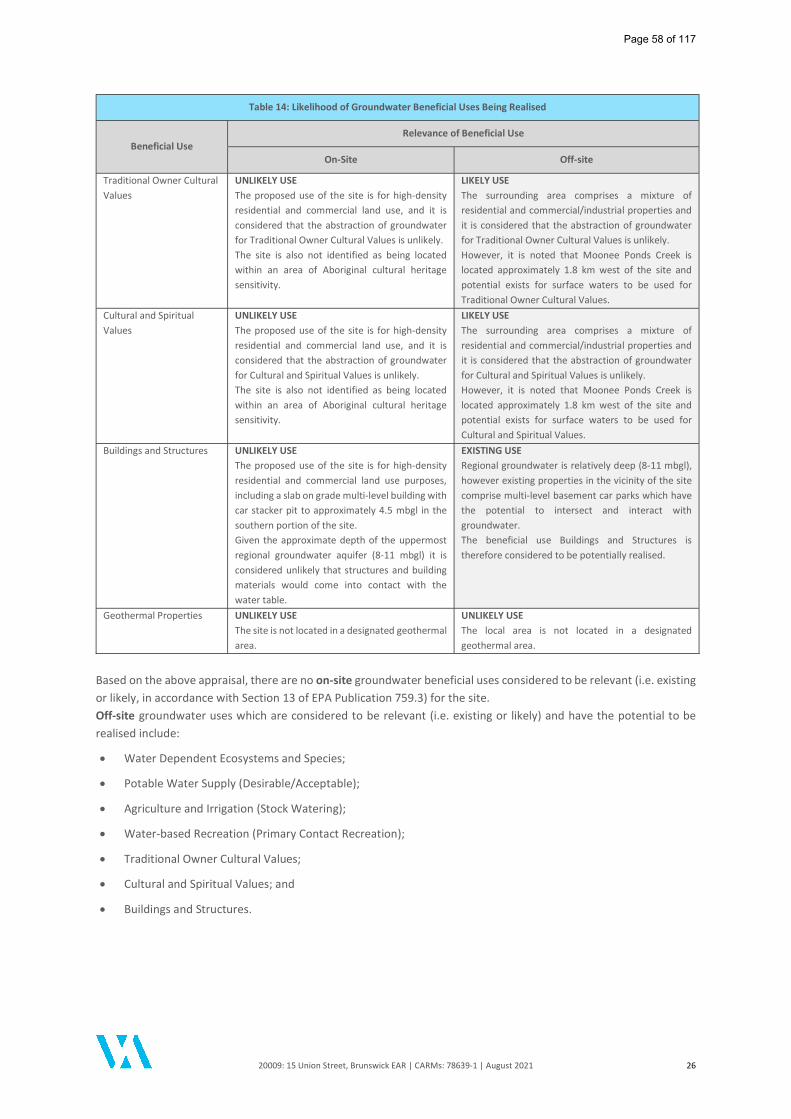
20009: 15 Union Street, Brunswick EAR | CARMs: 78639-1 | August 2021 26
Table 14: Likelihood of Groundwater Beneficial Uses Being Realised
Beneficial Use Relevance of Beneficial Use
On-Site Off-site
Traditional Owner Cultural Values
UNLIKELY USE The proposed use of the site is for high-density residential and commercial land use, and it is considered that the abstraction of groundwater for Traditional Owner Cultural Values is unlikely. The site is also not identified as being located within an area of Aboriginal cultural heritage sensitivity.
LIKELY USE The surrounding area comprises a mixture of residential and commercial/industrial properties and it is considered that the abstraction of groundwater for Traditional Owner Cultural Values is unlikely. However, it is noted that Moonee Ponds Creek is located approximately 1.8 km west of the site and potential exists for surface waters to be used for Traditional Owner Cultural Values.
Cultural and Spiritual Values
UNLIKELY USE The proposed use of the site is for high-density residential and commercial land use, and it is considered that the abstraction of groundwater for Cultural and Spiritual Values is unlikely. The site is also not identified as being located within an area of Aboriginal cultural heritage sensitivity.
LIKELY USE The surrounding area comprises a mixture of residential and commercial/industrial properties and it is considered that the abstraction of groundwater for Cultural and Spiritual Values is unlikely. However, it is noted that Moonee Ponds Creek is located approximately 1.8 km west of the site and potential exists for surface waters to be used for Cultural and Spiritual Values.
Buildings and Structures UNLIKELY USE The proposed use of the site is for high-density residential and commercial land use purposes, including a slab on grade multi-level building with car stacker pit to approximately 4.5 mbgl in the southern portion of the site. Given the approximate depth of the uppermost regional groundwater aquifer (8-11 mbgl) it is considered unlikely that structures and building materials would come into contact with the water table.
EXISTING USE Regional groundwater is relatively deep (8-11 mbgl), however existing properties in the vicinity of the site comprise multi-level basement car parks which have the potential to intersect and interact with groundwater. The beneficial use Buildings and Structures is therefore considered to be potentially realised.
Geothermal Properties UNLIKELY USE The site is not located in a designated geothermal area.
UNLIKELY USE The local area is not located in a designated geothermal area.
Based on the above appraisal, there are no on-site groundwater beneficial uses considered to be relevant (i.e. existing or likely, in accordance with Section 13 of EPA Publication 759.3) for the site. Off-site groundwater uses which are considered to be relevant (i.e. existing or likely) and have the potential to be realised include:
Water Dependent Ecosystems and Species;
Potable Water Supply (Desirable/Acceptable);
Agriculture and Irrigation (Stock Watering);
Water-based Recreation (Primary Contact Recreation);
Traditional Owner Cultural Values;
Cultural and Spiritual Values; and
Buildings and Structures.
Page 58 of 117
20009: 15 Union Street, Brunswick EAR | CARMs: 78639-1 | August 2021 27
6 Summary of Assessment Works Undertaken
6.1 Pre-Audit Assessment Works ESG Environmental Pty Ltd (ESG) completed a Preliminary Site Investigation (PSI) for the site in August 2017 and subsequently undertook a Preliminary Targeted Environmental Site Assessment (ESA) in January 2019 involving an intrusive soil investigation. The ESG (2017) PSI and ESG (2019) ESA were both completed prior to demolition of the on-site building and prior to commencement of the Audit. The findings of the previous assessments have been incorporated into the current site assessment by DRC and a summary of the environmental assessment works completed at the site is provided in the sections below. Copies of the previous reports are provided in Appendix B of the DRC (2021) report.
6.2 Audit Assessment Works DRC was the appointed assessment consultant for the duration of the Audit process. A summary of the Audit site investigation work completed is provided in the sections below.
6.3 Summary of Site Investigation Works A chronology of the environmental assessment works undertaken prior to and during the Audit process are summarised in Table 15.
Table 15: Summary of Events and Site Assessment/Remediation Works
Date Party Description of Activity/Works
PRE-AUDIT WORKS: August 2017 - January 2019
August 2017 ESG
Preliminary Site Investigation (PSI) Desktop site history review and reporting on environmental setting. Site inspection carried out on 2 August 2017 identified that the site was used for
commercial/retail purposes (music record store). One (1) disused UST and remote fill point was identified on the site. Identification of potential contaminants of concern. The findings were presented in ESG (2017) report "Preliminary Site Investigation, 15 Union Street, Brunswick" dated 4 August 2017.
January 2019 ESG
Preliminary Targeted Environmental Site Assessment (ESA) Site inspection. Soil sampling from six (6) soil bores (T01-T06) targeting the in-situ UST, remote fill
point and former dangerous goods storage areas on the site. Soil bores were established with a hand auger to depths of approximately 0.3 - 1.0
mbgl. The findings were presented in ESG (2019) report "Preliminary Targeted Environmental Site Assessment - 15 Union Street, Brunswick, Victoria" dated 30 January 2019.
AUDIT WORKS: March 2020 - August 2021 - the Environmental Auditor was appointed on 31 March 2020
20 May 2020 DRC
Sampling and Analysis Quality Plan (SAQP) Review of previous ESG (2017) and ESG (2019) reports. Preparation of a Sampling and Analysis Quality Plan (SAQP) outlining a scope of works
for Detailed Site Investigation (DSI) for Auditor review and approval.
12 October 2020
All Care Asbestos Removal /
Express Demolition
Asbestos Removal and Building Demolition Works Asbestos removal works carried out by All Care Asbestos Removal prior to building
demolition. Asbestos clearance inspection. Building demolition.
13 November 2020
Enviro Liquid Waste Service /
Express Demolition /
DRC
UST Removal and Soil Validation Liquid waste removal from in-situ UST. Decommissioning and removal of UST, remote fill point and associated pipework. Collection of five (5) soil validation samples from the base (VAL_B) and walls
(VAL_NW, VAL_WW, VAL_EW and VAL_SW) of the UST excavation.
Page 59 of 117

20009: 15 Union Street, Brunswick EAR | CARMs: 78639-1 | August 2021 28
Table 15: Summary of Events and Site Assessment/Remediation Works
Date Party Description of Activity/Works
Auditor Verification sample (AV01) was collected during UST validation sampling corresponding to DRC sample location VAL_B.
Collection of three (3) soil samples from waste soil generated during the UST removal works and stockpiled on the site (SP1).
Preparation of Soil Classification Report for the off-site disposal of waste soil comprising SP1.
The soil stockpile was chemically characterised as Category C Contaminated Soil.
16 November 2020 GeoAust
Geotechnical Engineers Pty Ltd
Geotechnical Investigation and Installation of Groundwater Monitoring Wells Drilling and installation of one (1) geotechnical groundwater bore (BH2 - renamed
MW01 by DRC) in the northern portion of the site. MW01 was drilled to a maximum depth of approximately 11.85 mbgl and screened
from 8.85 m to 11.85 m. Distinct soil domains encountered were described as Fill (to approximately 0.1 mbgl)
underlain by Clayey SILT, CLAY, Silty SAND, Clayey SILT (completely weathered Siltstone) and SILTSTONE. Siltstone was encountered at a depth of approximately 6.45 mbgl.
Groundwater was not encountered during drilling. MW01 was included in the groundwater monitoring events (GME) conducted by DRC.
27 November 2020 DRC
Installation of Groundwater Monitoring Well Drilling and installation of one (1) groundwater monitoring well (MW02) targeting the
former UPSS in the southern portion of the site. MW02 was drilled to a maximum depth of approximately 12.0 mbgl and screened
from approximately 8.7 - 11.7 m. Distinct soil domains encountered were described as Fill (to approximately 0.5 mbgl)
underlain by Silty CLAY and weathered MUDSTONE at approximately 6.0 mbgl. PID field recordings were reported in the range of 0.2 - 88.3 ppm.
02 December 2020 DRC
Well Development Groundwater monitoring wells MW01 and MW02 were developed using a stainless-
steel hand bailer. No odours or hydrocarbon sheen were recorded during well development.
10 December 2020 DRC
Groundwater Monitoring Event (GME1) Groundwater gauging and sampling from MW01 and MW02 using low-flow sampling
techniques. One (1) existing off-site groundwater monitoring well (MW38) utilised in the
environmental assessment of the adjoining property at 15A Union Street was also gauged for measurement of local off-site groundwater standing level.
12 & 29 March 2021 DRC
Intrusive Soil Assessment Soil sampling from ten (10) soil bores (BH01 - BH10) established across the site using
a hand auger. Soil bores were established to a maximum depth of approximately 0.5-0.6 mbgl.
22 April 2021 DRC
Stockpile Removal Works Stockpile SP1 was removed from site as Category C Contaminated Soil. Approximately 96.8 tonnes of Category C waste soil was transported and disposed to
landfill. One soil validation sample (SP01_BASE) was collected from the footprint of Stockpile
SP1 following removal.
22 April 2021 DRC
Asbestos Remediation and Surface Clearance Removal of bonded asbestos cement sheet debris from surface soils via "hand pick". Cross-directional raking of the site surface to approximately 0.1 m depth. Additional hand pick and visual inspection following raking activities. DRC Visual Clearance Statement - Visual inspection of cleared asbestos containing
material (ACM), dated 22 April 2021. Refer Appendix S of DRC (2021) report for further details and supporting documentation.
April 2021 RF Construction Backfilling of UST Pit Approximately 40 m3 of siltstone/mudstone was imported to site for backfilling of the
UST excavation.
Page 60 of 117
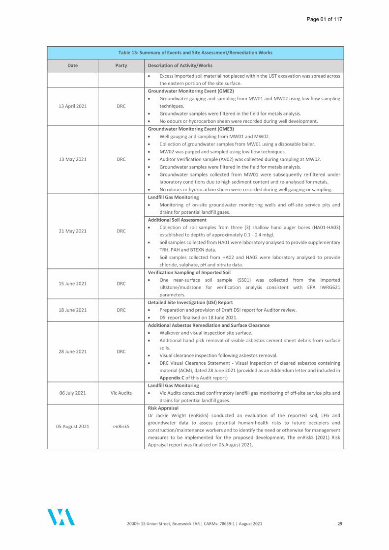
20009: 15 Union Street, Brunswick EAR | CARMs: 78639-1 | August 2021 29
Table 15: Summary of Events and Site Assessment/Remediation Works
Date Party Description of Activity/Works
Excess imported soil material not placed within the UST excavation was spread across the eastern portion of the site surface.
13 April 2021 DRC
Groundwater Monitoring Event (GME2) Groundwater gauging and sampling from MW01 and MW02 using low flow sampling
techniques. Groundwater samples were filtered in the field for metals analysis. No odours or hydrocarbon sheen were recorded during well development.
13 May 2021 DRC
Groundwater Monitoring Event (GME3) Well gauging and sampling from MW01 and MW02. Collection of groundwater samples from MW01 using a disposable bailer. MW02 was purged and sampled using low flow techniques. Auditor Verification sample (AV02) was collected during sampling at MW02. Groundwater samples were filtered in the field for metals analysis. Groundwater samples collected from MW01 were subsequently re-filtered under
laboratory conditions due to high sediment content and re-analysed for metals. No odours or hydrocarbon sheen were recorded during well gauging or sampling.
21 May 2021 DRC
Landfill Gas Monitoring Monitoring of on-site groundwater monitoring wells and off-site service pits and
drains for potential landfill gases. Additional Soil Assessment Collection of soil samples from three (3) shallow hand auger bores (HA01-HA03)
established to depths of approximately 0.1 - 0.4 mbgl. Soil samples collected from HA01 were laboratory analysed to provide supplementary
TRH, PAH and BTEXN data. Soil samples collected from HA02 and HA03 were laboratory analysed to provide
chloride, sulphate, pH and nitrate data.
15 June 2021 DRC
Verification Sampling of Imported Soil One near-surface soil sample (SS01) was collected from the imported
siltstone/mudstone for verification analysis consistent with EPA IWRG621 parameters.
18 June 2021 DRC Detailed Site Investigation (DSI) Report Preparation and provision of Draft DSI report for Auditor review. DSI report finalised on 18 June 2021.
28 June 2021 DRC
Additional Asbestos Remediation and Surface Clearance Walkover and visual inspection site surface. Additional hand pick removal of visible asbestos cement sheet debris from surface
soils. Visual clearance inspection following asbestos removal. DRC Visual Clearance Statement - Visual inspection of cleared asbestos containing
material (ACM), dated 28 June 2021 (provided as an Addendum letter and included in Appendix C of this Audit report)
06 July 2021 Vic Audits Landfill Gas Monitoring Vic Audits conducted confirmatory landfill gas monitoring of off-site service pits and
drains for potential landfill gases.
05 August 2021 enRiskS
Risk Appraisal Dr Jackie Wright (enRiskS) conducted an evaluation of the reported soil, LFG and groundwater data to assess potential human-health risks to future occupiers and construction/maintenance workers and to identify the need or otherwise for management measures to be implemented for the proposed development. The enRiskS (2021) Risk Appraisal report was finalised on 05 August 2021.
Page 61 of 117
20009: 15 Union Street, Brunswick EAR | CARMs: 78639-1 | August 2021 30
7 Soil Assessment and Remediation
7.1 Soil Investigation Works
7.1.1 Pre-Audit Investigations
A limited intrusive soil investigation was completed at the site by ESG in 2019 involving the establishment of six (6) boreholes (T01 to T06) which generally targeted on-site features observed during the ESG (2017) PSI including the underground storage tank (UST), remote fill point, former chemical storage areas, vicinity of former extraction vents (considered to be associated with former ovens), as well as providing general coverage across the site. At the time of assessment, the commercial/industrial warehouse building was present on the site. Soil bores were established with a hand auger to depths ranging between approximately 0.3 m and 1.0 mbgl. Fill soils comprising minor amounts of anthropogenic materials (e.g. brick fragments, angular gravels) were encountered at each soil bore beneath the concrete hardstand and generally extended to depths of approximately 0.5 mbgl. Deeper fill extending below 1.0 mbgl was encountered in the vicinity of the UST (T02) and borehole refusal on a potential footing was encountered at one location (T05). Natural soils were encountered and assessed at four (4) of the ESG investigation location. Mild petroleum hydrocarbon odours and minor black-grey discoloured soils were reported at ESG borehole locations T01, T02, T03 and T04 and were generally recorded within the shallow fill and immediate underlying natural soil. The ESG (2019) soil investigation reported concentrations of heavy metals (namely lead and zinc), PAHs (including benzo[a]pyrene) and TRH C6-C10 less BTEX (F1), TRH >C10-C16, TRH >C16-C34 above the adopted screening criteria predominantly in the fill soils. The findings of the ESG (2019) ESA have been considered in the current site investigation by DRC.
7.1.2 Audit Investigations
Additional grid soil sampling was performed by DRC in March 2021 via the establishment of ten (10) soil bores (BH01-BH10) to in-fill spatial data gaps in the previous ESG (2019) assessment data and/or to target previous soil impacts reported in the ESG (2019) assessment to provide a current representation of the on-site soil conditions. Based on the approximate surface area of the site (440 m2), the number of grid sample locations assessed satisfied the minimum sampling frequency for site characterisation in accordance with Australian Standard AS4482.1-2005, which recommends a minimum number of five (5) sampling locations. Soil bores were established with a hand auger to generally shallow depths of approximately 0.4 mbgl to 0.6 mbgl. Fill soils were encountered at each soil bore to depths of approximately 0.2 mbgl to 0.4 m bgl with trace amounts of anthropogenic materials (e.g. gravel, brick, concrete and glass and trace amounts of coke ash and charcoal) reported, consistent with the previous ESG (2019) observations. Each of the soil bores were terminated within the natural soil profile. No odour or stained soils were recorded by DRC within the final land surface samples, with the exception of localised mild 'decomposing' odour and black discoloured soil recorded in shallow fill at BH09. In addition, no ACM was identified during intrusive, sub-surface soil investigation works by DRC, consistent with the previous ESG (2019) observations. Details of the ESG (2019) and DRC (2021) soil assessment locations are provided in Figure 4 and Figure 9 of the DRC (2021) report.
7.2 Site Remediation Works Site remediation works, comprising UST removal, off-site disposal of soil and asbestos remediation, were undertaken between November 2020 and June 2021. Details of all site remediation works are outlined in the sections below.
7.3 Asbestos Containing Materials
7.3.1 Building Infrastructure
No Division 5 or Division 6 Hazardous Materials Survey report or documentation pertaining to the removal and off-site disposal of any building materials identified as containing asbestos was provided for Auditor review. Asbestos removal works were completed by All Care Asbestos Removal prior to demolition of the on-site building in October 2020.
Page 62 of 117

20009: 15 Union Street, Brunswick EAR | CARMs: 78639-1 | August 2021 31
A clearance inspection was completed by Glenn Cook following the asbestos removal works involving a visual inspection of the asbestos removal areas which were specifically recorded as including the roof (Supersix corrugated cement sheet), meter boxes (two), loose flues and cement sheet. The undated Asbestos Clearance Certificate provided in Appendix S of the DRC (2021) report indicated that no visual asbestos residue remained as a result of the asbestos removal works.
7.3.2 Surface Asbestos Fragments
No suspected asbestos containing material was identified during intrusive, sub-surface soil investigations undertaken by ESG prior to commencement of the Audit and prior to building demolition. Further, no suspected ACM was identified during the intrusive, sub-surface soil investigation works undertaken as part of the Audit by DRC. Following the demolition of on-site buildings in October 2020, suspected asbestos cement sheet fragments were observed on the surface of the site during a post-demolition site inspection conducted by DRC and the Auditor. The fragments (approximately 80-100) were noted to be in good condition and were not significantly degraded. Due to the lack of observed asbestos during intrusive investigations prior to building demolition, the ACM was suspected by DRC to be due to poor demolition practices and likely limited to surface soils (rather than associated with fill soils located at the site). Following the identification of suspected asbestos cement sheet fragments, asbestos remediation works were undertaken, as outlined in Section 7.3.3 below. DRC conducted a final visual inspection of the site on 28 June 2021 and did not observe any ACM fragments on the surface of the site during the walkover. Visual clearance inspection statements prepared by DRC following the removal of ACM debris from the site surface are included in Appendix S of the DRC (2021) report and Appendix C of this Audit report. Minor amounts of ACM (2 fragments) were observed during the final site inspection conducted by the Auditor on 29 July 2021 which were collected and removed from the site. At completion of the Audit, no visible ACM was present on the site surface. Based on findings of the visual observations recorded during intrusive investigations and the final inspection of the site, the ACM is considered to have been cleaned up to the extent practicable. Given the presence of ACM fragments on the ground surface, the Other Related Information section on the Statement of Environmental Audit (SoEA) for the site will contain reference to the former presence of ACM fragments and the required procedures should any further ACM fragments be identified.
7.3.3 Asbestos Removal Works
Building Infrastructure Removal - October 2020 Removal of asbestos containing building materials was undertaken by a licenced Class B asbestos removalist (All Care Asbestos Removal) in October 2020. Information regarding the quantity or waste transportation of removed ACM was not provided for Auditor review. Following the asbestos removal works a visual clearance certificate was issued (undated), which stated that:
"An inspection of the site has found no visual asbestos residue, as a result of the asbestos removal works. The inspection confirms that the asbestos removal and subsequent clean-up has been performed to a satisfactory standard".
A copy of the clearance certificate is provided in Appendix S of the DRC (2021) report.
Asbestos in Soils Remediation - April and June 2021 Asbestos cement sheet fragments were observed on the exposed soil surface of the site during a post-demolition site inspection conducted by DRC and the Auditor during May 2021. Asbestos Removal April 2021 - Removal of the surface ACM debris was contracted directly by the Client and details of the asbestos removal works was generally not provided in the DRC (2021) report. It is understood that the ACM remediation process involved a detailed site inspection, hand picking of visible asbestos cement sheet fragments from the exposed surface soils (i.e. chicken picking) and cross-directional raking to a depth of 10cm across the site. Details regarding the waste tracking and disposal of ACM was not provided to DRC or the Auditor for review. Asbestos Removal June 2021 - Additional removal of surface ACM debris was undertaken by DRC involving a detailed site inspection and hand picking of visible asbestos cement sheet fragments. Details regarding the waste tracking and disposal of ACM was not provided in the DRC (2021) report.
Page 63 of 117

20009: 15 Union Street, Brunswick EAR | CARMs: 78639-1 | August 2021 32
Clearance Inspection - Following the ACM removal works, DRC conducted a visual inspection of the site on two (2) occasions and issued two (2) separate clearance certificates, dated 22 April 2021 and 28 June 2021. Copies of the DRC Surface Clearance Statements are provided in Appendix S of the DRC (2021) report.
7.4 UST Excavation and Removal Underground petroleum storage system (UPSS) infrastructure was identified during an inspection of the site carried out by ESG in 2017. The UPSS was located in the southern portion of the on-site building and was described in the ESG (2017) report as comprising:
One (1) disused underground storage tank (UST) with an estimated 5,000 - 10,000 L capacity;
One (1) remote fill point and breather pipe adjoining the exterior southern wall of the on-site building; and
One (1) disused bowser dispenser.
At the time of the ESG (2017) inspection the UST was reported to contain residual product at the base of the tank which was described as displaying "a mix of paint thinner and petroleum" odour. Following building demolition works in October 2020, the UPSS infrastructure was excavated and removed under the supervision of DRC.
7.4.1 Primary Source Removal
Prior to removal, approximately 2,900 L of liquid waste was pumped out of the in-situ UST by Enviro Liquid Waste Service Pty Ltd and transported under EPA Waste Transport Certification for disposal at an appropriately licenced facility (Transwaste Technologies Pty Ltd) on 12 November 2020. EPA Waste Transport Certificate (WTC) (50988751) for disposal of the liquid waste was provided in Appendix H of the DRC (2021) report. Express Demolition and Excavation Pty Ltd was engaged to remove the in-situ UST, bowser base and product pipework under the supervision of DRC on 13 November 2020. It is understood that the bowser, remote fill point and breather pipe had been previously removed during the building demolition works and DRC were not present on-site to observe the excavation and removal of these infrastructure. The 5,000 L capacity UST was removed using an excavator and was observed to be in generally good condition, with no holes, corrosion, rust or noticeable damage reported. The UST had an exterior bituminous coating. DRC reported petroleum hydrocarbon and paint thinner-like odour during exhumation of the UST however no significant staining or odours were noted to be associated with residual soils within the tank pit excavation. A mild hydrocarbon odour was reported within the exhumed tank pit sands which were stockpiled adjacent to the UST excavation. The Auditor attended site during the UST excavation works on 13 November 2020 and visually observed the resultant UST excavation comprised no significant odour or stained soils. The Auditor also visually confirmed that no residual pipework or sub-surface infrastructure remained visible within the UST excavation. The UST was transferred to Pacific Metal Group for appropriate destruction. A copy of the Pacific Metal Group receipt was provided in Appendix H of the DRC (2021) report.
7.4.2 Secondary Source Removal
Tank pit sands and soil removed from the UST excavation was stockpiled on-site and three (3) samples (SP1-1, SP1-2 and SP1-3) were collected from the stockpiled material by DRC for classification and re-use/off-site disposal. One (1) stockpile (SP1) comprising an approximate volume of 100 m3 was generated as part of UST remediation works. Mild hydrocarbon odour was reported within the stockpiled waste soil.
7.4.3 Validation Sampling
Five (5) soil validation samples (VAL_NW, VAL_SW, VAL_EW, VAL_WW and VAL_B) were collected from the walls and base of the UST excavation. No odorous or stained soils were reported during validation of the UST excavation and field screening of soil samples for potential volatile contaminants with a photoionisation detector (PID) reported relatively low concentrations in the range of 0.5 - 0.9 parts per million (ppm). Analytical results of the soil validation samples reported concentrations of petroleum hydrocarbon contaminants of concern less than the adopted investigation and screening levels.
Page 64 of 117
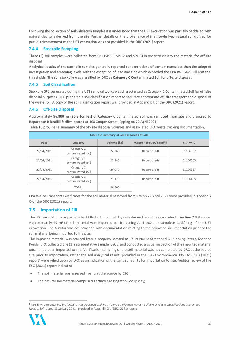
20009: 15 Union Street, Brunswick EAR | CARMs: 78639-1 | August 2021 33
Following the collection of soil validation samples it is understood that the UST excavation was partially backfilled with natural clay soils derived from the site. Further details on the provenance of the site-derived natural soil utilised for partial reinstatement of the UST excavation was not provided in the DRC (2021) report.
7.4.4 Stockpile Sampling
Three (3) soil samples were collected from SP1 (SP1-1, SP1-2 and SP1-3) in order to classify the material for off-site disposal. Analytical results of the stockpile samples generally reported concentrations of contaminants less than the adopted investigation and screening levels with the exception of lead and zinc which exceeded the EPA IWRG621 Fill Material thresholds. The soil stockpile was classified by DRC as Category C Contaminated Soil for off-site disposal.
7.4.5 Soil Classification
Stockpile SP1 generated during the UST removal works was characterised as Category C Contaminated Soil for off-site disposal purposes. DRC prepared a soil classification report to facilitate appropriate off-site transport and disposal of the waste soil. A copy of the soil classification report was provided in Appendix K of the DRC (2021) report.
7.4.6 Off-Site Disposal
Approximately 96,800 kg (96.8 tonnes) of Category C contaminated soil was removed from site and disposed to Repurpose-It landfill facility located at 460 Cooper Street, Epping on 22 April 2021. Table 16 provides a summary of the off-site disposal volumes and associated EPA waste tracking documentation.
Table 16: Summary of Soil Disposed Off-Site
Date Category Volume (kg) Waste Receiver/ Landfill EPA WTC
22/04/2021 Category C
(contaminated soil) 24,360 Repurpose-It 51106357
22/04/2021 Category C
(contaminated soil) 25,280 Repurpose-It 51106365
22/04/2021 Category C
(contaminated soil) 26,040 Repurpose-It 51106367
22/04/2021 Category C
(contaminated soil) 21,120 Repurpose-It 51106495
TOTAL 96,800
EPA Waste Transport Certificates for the soil material removed from site on 22 April 2021 were provided in Appendix O of the DRC (2021) report.
7.5 Importation of Fill The UST excavation was partially backfilled with natural clay soils derived from the site - refer to Section 7.4.3 above. Approximately 40 m3 of soil material was imported to site during April 2021 to complete backfilling of the UST excavation. The Auditor was not provided with documentation relating to the proposed soil importation prior to the soil material being imported to the site. The imported material was sourced from a property located at 17-19 Puckle Street and 6-14 Young Street, Moonee Ponds. DRC collected one (1) representative sample (SS01) and conducted a visual inspection of the imported material once it had been imported to site. Verification sampling of the soil material was not completed by DRC at the source site prior to importation, rather the soil analytical results provided in the ESG Environmental Pty Ltd (ESG) (2021) report1 were relied upon by DRC as an indication of the soil's suitability for importation to site. Auditor review of the ESG (2021) report indicated:
The soil material was assessed in-situ at the source by ESG;
The natural soil material comprised Tertiary age Brighton Group clay;
1 ESG Environmental Pty Ltd (2021) 17-19 Puckle St and 6-14 Young St, Moonee Ponds - Soil IWRG Waste Classification Assessment - Natural Soil, dated 11 January 2021 - provided in Appendix O of DRC (2021) report.
Page 65 of 117
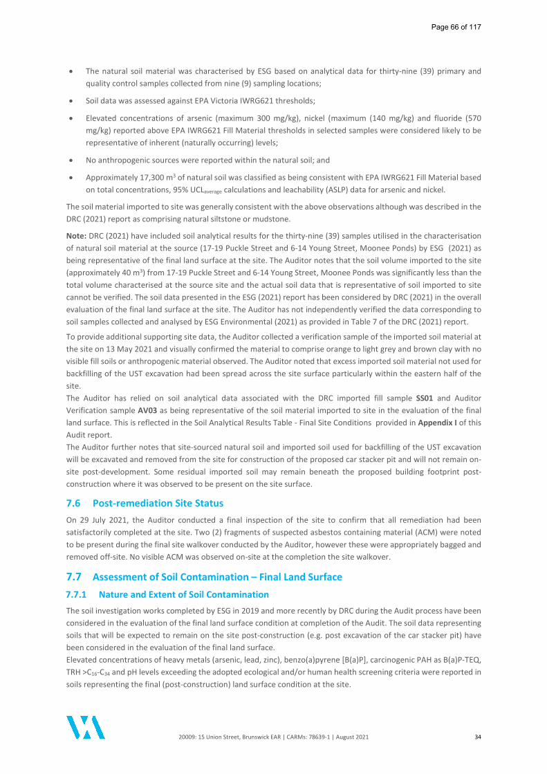
20009: 15 Union Street, Brunswick EAR | CARMs: 78639-1 | August 2021 34
The natural soil material was characterised by ESG based on analytical data for thirty-nine (39) primary and quality control samples collected from nine (9) sampling locations;
Soil data was assessed against EPA Victoria IWRG621 thresholds;
Elevated concentrations of arsenic (maximum 300 mg/kg), nickel (maximum (140 mg/kg) and fluoride (570 mg/kg) reported above EPA IWRG621 Fill Material thresholds in selected samples were considered likely to be representative of inherent (naturally occurring) levels;
No anthropogenic sources were reported within the natural soil; and
Approximately 17,300 m3 of natural soil was classified as being consistent with EPA IWRG621 Fill Material based on total concentrations, 95% UCLaverage calculations and leachability (ASLP) data for arsenic and nickel.
The soil material imported to site was generally consistent with the above observations although was described in the DRC (2021) report as comprising natural siltstone or mudstone.
Note: DRC (2021) have included soil analytical results for the thirty-nine (39) samples utilised in the characterisation of natural soil material at the source (17-19 Puckle Street and 6-14 Young Street, Moonee Ponds) by ESG (2021) as being representative of the final land surface at the site. The Auditor notes that the soil volume imported to the site (approximately 40 m3) from 17-19 Puckle Street and 6-14 Young Street, Moonee Ponds was significantly less than the total volume characterised at the source site and the actual soil data that is representative of soil imported to site cannot be verified. The soil data presented in the ESG (2021) report has been considered by DRC (2021) in the overall evaluation of the final land surface at the site. The Auditor has not independently verified the data corresponding to soil samples collected and analysed by ESG Environmental (2021) as provided in Table 7 of the DRC (2021) report.
To provide additional supporting site data, the Auditor collected a verification sample of the imported soil material at the site on 13 May 2021 and visually confirmed the material to comprise orange to light grey and brown clay with no visible fill soils or anthropogenic material observed. The Auditor noted that excess imported soil material not used for backfilling of the UST excavation had been spread across the site surface particularly within the eastern half of the site. The Auditor has relied on soil analytical data associated with the DRC imported fill sample SS01 and Auditor Verification sample AV03 as being representative of the soil material imported to site in the evaluation of the final land surface. This is reflected in the Soil Analytical Results Table - Final Site Conditions provided in Appendix I of this Audit report. The Auditor further notes that site-sourced natural soil and imported soil used for backfilling of the UST excavation will be excavated and removed from the site for construction of the proposed car stacker pit and will not remain on-site post-development. Some residual imported soil may remain beneath the proposed building footprint post-construction where it was observed to be present on the site surface.
7.6 Post-remediation Site Status On 29 July 2021, the Auditor conducted a final inspection of the site to confirm that all remediation had been satisfactorily completed at the site. Two (2) fragments of suspected asbestos containing material (ACM) were noted to be present during the final site walkover conducted by the Auditor, however these were appropriately bagged and removed off-site. No visible ACM was observed on-site at the completion the site walkover.
7.7 Assessment of Soil Contamination – Final Land Surface 7.7.1 Nature and Extent of Soil Contamination
The soil investigation works completed by ESG in 2019 and more recently by DRC during the Audit process have been considered in the evaluation of the final land surface condition at completion of the Audit. The soil data representing soils that will be expected to remain on the site post-construction (e.g. post excavation of the car stacker pit) have been considered in the evaluation of the final land surface. Elevated concentrations of heavy metals (arsenic, lead, zinc), benzo(a)pyrene [B(a)P], carcinogenic PAH as B(a)P-TEQ, TRH >C16-C34 and pH levels exceeding the adopted ecological and/or human health screening criteria were reported in soils representing the final (post-construction) land surface condition at the site.
Page 66 of 117
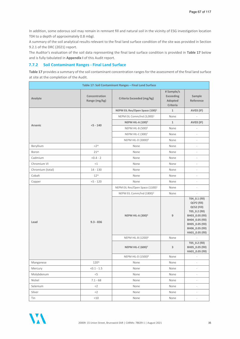
20009: 15 Union Street, Brunswick EAR | CARMs: 78639-1 | August 2021 35
In addition, some odorous soil may remain in remnant fill and natural soil in the vicinity of ESG investigation location T04 to a depth of approximately 0.8 mbgl. A summary of the soil analytical results relevant to the final land surface condition of the site was provided in Section 9.2.1 of the DRC (2021) report. The Auditor's evaluation of the soil data representing the final land surface condition is provided in Table 17 below and is fully tabulated in Appendix I of this Audit report.
7.7.2 Soil Contaminant Ranges - Final Land Surface
Table 17 provides a summary of the soil contaminant concentration ranges for the assessment of the final land surface at site at the completion of the Audit.
Table 17: Soil Contaminant Ranges – Final Land Surface
Analyte Concentration Range (mg/kg)
Criteria Exceeded (mg/kg)
# Sample/s Exceeding Adopted Criteria
Sample Reference
Arsenic <5 - 140
NEPM EIL Res/Open Space (100)1 1 AV03 (IF)
NEPM EIL Comm/Ind (3,000)1 None -
NEPM HIL-A (100)5 1 AV03 (IF)
NEPM HIL-B (500)6 None -
NEPM HIL-C (300)7 None -
NEPM HIL-D (3000)8 None -
Beryllium <2^ None None -
Boron 21^ None None -
Cadmium <0.4 - 2 None None -
Chromium VI <1 None None -
Chromium (total) 14 - 130 None None -
Cobalt 12^ None None -
Copper <5 - 120 None None -
Lead 9.3 - 836
NEPM EIL Res/Open Space (1100)1 None -
NEPM EIL Comm/Ind (1800)2 None -
NEPM HIL-A (300)5 9
T04_0.1 (fill) QCP2 (fill) QCS2 (Fill)
T05_0.2 (fill) BH03_0.05 (fill) BH04_0.05 (fill) BH05_0.05 (fill) BH06_0.05 (fill) HA01_0.05 (fill)
NEPM HIL-B (1200)6 None -
NEPM HIL-C (600)7 3 T05_0.2 (fill)
BH05_0.05 (fill) HA01_0.05 (fill)
NEPM HIL-D (1500)8 None -
Manganese 120^ None None -
Mercury <0.1 - 1.5 None None -
Molybdenum <5 None None -
Nickel 7.1 - 68 None None -
Selenium <2 None None -
Silver <2 None None -
Tin <10 None None -
Page 67 of 117

20009: 15 Union Street, Brunswick EAR | CARMs: 78639-1 | August 2021 36
Table 17: Soil Contaminant Ranges – Final Land Surface
Analyte Concentration Range (mg/kg)
Criteria Exceeded (mg/kg)
# Sample/s Exceeding Adopted Criteria
Sample Reference
Zinc 10 - 2,590
EIL Res/Open Space (400)* 6
T04_0.1 (fill) QCP2 (fill) QCS2 (fill)
T05_0.2 (fill) BH03_0.05 (fill) BH05_0.05 (fill)
EIL Comm/Ind (590)* 6
T04_0.1 (fill) QCP2 (fill) QCS2 (fill)
T05_0.2 (fill) BH03_0.05 (fill) BH05_0.05 (fill)
NEPM HIL-A (7,400)5 None -
NEPM HIL-B (60,000)6 None -
NEPM HIL-C (30,000)7 None -
NEPM HIL-D (400,000)8 None -
Cyanide (total) <5 None None -
pH 7.1 - 8.8^ ANZECC 1992 (6 - 8 pH units)11 2 T06_0.2 (fill)
AV03 (IF)
Sulphate (as SO4) 100^ - 2,800 None - -
Chloride 14^ - 61 None - -
Nitrate (as N) 6.6^ - 33 None - -
Fluoride 110 - 230 None - -
TRH >C6-C10 <10 - <20 None - -
TRH > C6-C10 less BTEX (F1) <10 - <20 None - -
TRH >C10-C16 <50 None - -
TRH > C10-C16 less Naphthalene (F2) <50 None - -
TRH >C16-C34 <100 - 2,980
NEPM ESL Res/Open Space (300)1 2 T04_0.35 (fill) T05_0.2 (fill)
NEPM ESL Comm/Ind (1,700)2 1 T04_0.35 (fill)
NEPM Management Limits (2,500)9 1 T04_0.35 (fill)
NEPM Management Limits (3,500)10 None -
CRC Care HSLs Direct Contact12 None -
TRH >C34-C40 <100 - 1,110 None - -
Naphthalene <0.5 None - -
Benzo(a)pyrene <0.5 - 3.7
NEPM ESL Res/Open Space (0.7)1 7
T04_0.1 (fill) QCS2 (fill)
T05_0.2 (fill) BH03_0.05 (fill) BH04_0.05 (fill) BH05_0.05 (fill) BH06_0.05 (fill)
NEPM ESL Comm/Ind (1.4)2 5
T05_0.2 (fill) BH03_0.05 (fill) BH04_0.05 (fill) BH05_0.05 (fill) BH06_0.05 (fill)
Page 68 of 117
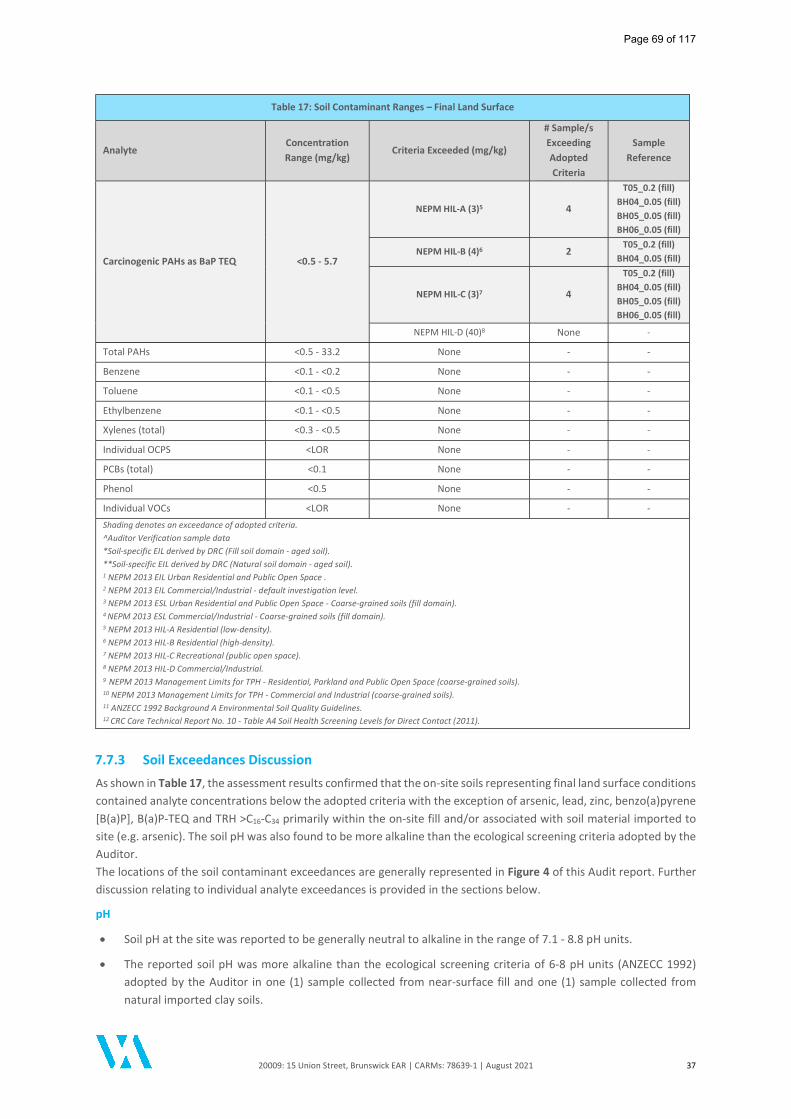
20009: 15 Union Street, Brunswick EAR | CARMs: 78639-1 | August 2021 37
Table 17: Soil Contaminant Ranges – Final Land Surface
Analyte Concentration Range (mg/kg)
Criteria Exceeded (mg/kg)
# Sample/s Exceeding Adopted Criteria
Sample Reference
Carcinogenic PAHs as BaP TEQ <0.5 - 5.7
NEPM HIL-A (3)5 4
T05_0.2 (fill) BH04_0.05 (fill) BH05_0.05 (fill) BH06_0.05 (fill)
NEPM HIL-B (4)6 2 T05_0.2 (fill)
BH04_0.05 (fill)
NEPM HIL-C (3)7 4
T05_0.2 (fill) BH04_0.05 (fill) BH05_0.05 (fill) BH06_0.05 (fill)
NEPM HIL-D (40)8 None -
Total PAHs <0.5 - 33.2 None - -
Benzene <0.1 - <0.2 None - -
Toluene <0.1 - <0.5 None - -
Ethylbenzene <0.1 - <0.5 None - -
Xylenes (total) <0.3 - <0.5 None - -
Individual OCPS <LOR None - -
PCBs (total) <0.1 None - -
Phenol <0.5 None - -
Individual VOCs <LOR None - - Shading denotes an exceedance of adopted criteria. ^Auditor Verification sample data *Soil-specific EIL derived by DRC (Fill soil domain - aged soil). **Soil-specific EIL derived by DRC (Natural soil domain - aged soil). 1 NEPM 2013 EIL Urban Residential and Public Open Space . 2 NEPM 2013 EIL Commercial/Industrial - default investigation level. 3 NEPM 2013 ESL Urban Residential and Public Open Space - Coarse-grained soils (fill domain). 4 NEPM 2013 ESL Commercial/Industrial - Coarse-grained soils (fill domain). 5 NEPM 2013 HIL-A Residential (low-density). 6 NEPM 2013 HIL-B Residential (high-density). 7 NEPM 2013 HIL-C Recreational (public open space). 8 NEPM 2013 HIL-D Commercial/Industrial. 9 NEPM 2013 Management Limits for TPH - Residential, Parkland and Public Open Space (coarse-grained soils). 10 NEPM 2013 Management Limits for TPH - Commercial and Industrial (coarse-grained soils). 11 ANZECC 1992 Background A Environmental Soil Quality Guidelines. 12 CRC Care Technical Report No. 10 - Table A4 Soil Health Screening Levels for Direct Contact (2011).
7.7.3 Soil Exceedances Discussion
As shown in Table 17, the assessment results confirmed that the on-site soils representing final land surface conditions contained analyte concentrations below the adopted criteria with the exception of arsenic, lead, zinc, benzo(a)pyrene [B(a)P], B(a)P-TEQ and TRH >C16-C34 primarily within the on-site fill and/or associated with soil material imported to site (e.g. arsenic). The soil pH was also found to be more alkaline than the ecological screening criteria adopted by the Auditor. The locations of the soil contaminant exceedances are generally represented in Figure 4 of this Audit report. Further discussion relating to individual analyte exceedances is provided in the sections below.
pH
Soil pH at the site was reported to be generally neutral to alkaline in the range of 7.1 - 8.8 pH units.
The reported soil pH was more alkaline than the ecological screening criteria of 6-8 pH units (ANZECC 1992) adopted by the Auditor in one (1) sample collected from near-surface fill and one (1) sample collected from natural imported clay soils.
Page 69 of 117

20009: 15 Union Street, Brunswick EAR | CARMs: 78639-1 | August 2021 38
The pH levels reported in fill and imported soil samples were similar to those reported in the natural on-site soil.
The pH levels reported in the on-site soils were also similar to the levels reported at nearby completed Audit sites; 15A Union Street, Brunswick (pH range 7.3 to 9.2) and 1-7 Wilson Avenue, Brunswick (pH range 7.3 to 8.3).
The on-site soil pH was reported above the AS2159-2009 screening criteria of 5.5 pH units and is unlikely to be corrosive to concrete and steel structures in direct contact with the on-site soil.
In relation to groundwater, the Auditor notes that pH levels in groundwater beneath the site were reported to be generally neutral to slightly alkaline (pH 7.2 - 7.9) typical of regional groundwater conditions. As such, pH levels in soil were considered unlikely to have adversely impacted groundwater beneath the site.
Lead and Zinc
Concentrations of lead exceeded the health investigation level for low-density residential land use (HIL A) and recreation open space (HIL C) in samples collected from several locations at approximate depths of 0.05 m and 0.2 m depth within fill. Sample results for lead were reported below the relevant investigation levels for the proposed high-density residential (HIL B) and commercial (HIL D) land use. As the reported concentrations of lead were below the respective health investigation levels for the proposed land use, the exceedances were not discussed in the DRC (2021) report. All reported concentrations of lead were below the adopted ecological screening criteria.
Concentrations of zinc exceeded the site-specific ecological investigation levels (EIL) derived by DRC for residential and commercial land use in six (6) samples collected from near-surface fill at depths of approximately 0.05 - 0.2 mbgl. All reported concentrations of zinc were below the health investigation levels for all land uses.
The elevated concentrations of lead and zinc were reported in samples collected from the shallow on-site fill. Vertical delineation of the elevated concentrations was generally achieved at each location with the underlying natural soil samples reporting concentrations below the ecological and health screening criteria for all land uses.
ASLP testing for lead and zinc was undertaken for samples BH05_0.05 and/or T05_0.2 which reported the leachable concentrations of these metals to be relatively low (e.g. <0.1 - 0.14 mg/L), therefore indicating a relative low mobility of lead and zinc within the on-site fill soils. Furthermore, as noted above no elevated concentrations of lead and zinc were reported in samples collected from the natural soil profile.
As shown in the table below, concentrations of lead and zinc were reported in shallow fill soils at nearby completed Audit sites suggest a broader presence of elevated metals concentrations in the local area potentially associated with historical filling.
Analyte On-Site Concentration
Range1 (mg/kg)
Off-Site Concentration Range (mg/kg)
15A Union Street, Brunswick 2
1-7 Wilson Avenue, Brunswick 3
10 Wilson Avenue, Brunswick 4
Lead 9.3 - 836 9.6 - 5,700 5.5 - 1,400 3,200 (maximum) Zinc 10 - 2,590 <5 - 480 <5 - 690 960 (maximum)
1 On-site: post-remediation final land surface soil data. 2 Audit Site: 15A Union Street, Brunswick (CARMs 73530-1). 3 Audit Site: 1-7 Wilson Avenue, Brunswick (CARMs 77450-1). 4 Audit Site: 10 Wilson Avenue, Brunswick (CARMs 52431-1).
A statistical appraisal of the reported zinc concentrations representing the final land surface confirmed that:
The maximum zinc concentration (2,590 mg/kg) exceeded 250% of the site-derived EILs for residential and commercial land uses, but was below the HIL B and HIL D for the proposed land use;
The standard deviation of results (667.3 mg/kg) was more than 50% of the site-derived EILs for residential and commercial land uses, but was but was below the HIL B and HIL D for the proposed land use; and
The 95% UCLaverage (885.5 mg/kg) of the zinc concentrations exceeded the site-derived EILs for residential and commercial land uses, but was but was below the HIL B and HIL D for the proposed land use.
Page 70 of 117
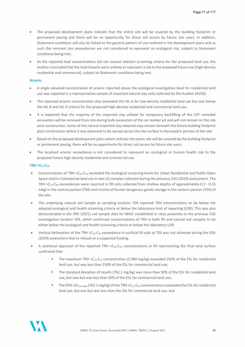
20009: 15 Union Street, Brunswick EAR | CARMs: 78639-1 | August 2021 39
The proposed development plans indicate that the entire site will be covered by the building footprint or permanent paving and there will be no opportunity for direct soil access by future site users. In addition, Statement conditions will also be linked to the general pattern of use outlined in the development plans and as such the remnant zinc exceedances are not considered to represent an ecological risk, subject to Statement conditions being met.
As the reported lead concentrations did not exceed relevant screening criteria for the proposed land use, the Auditor concluded that the lead impacts were unlikely to represent a risk to the proposed future use (high-density residential and commercial), subject to Statement conditions being met.
Arsenic
A single elevated concentration of arsenic reported above the ecological investigation level for residential land use was reported in a representative sample of imported natural clay soils collected by the Auditor (AV03).
The reported arsenic concentration also exceeded the HIL A for low-density residential land use but was below the HIL B and HIL D criteria for the proposed high-density residential and commercial land use.
It is expected that the majority of the imported clay utilised for temporary backfilling of the UST remedial excavation will be removed from site during bulk excavation of the car stacker pit and will not remain on the site post-construction. Some of the natural imported clay material may remain beneath the future building footprint post-construction where it was observed to be spread across the site surface in the eastern portion of the site.
Based on the proposed development plans which indicate the entire site will be covered by the building footprint or permanent paving, there will be no opportunity for direct soil access by future site users.
The localised arsenic exceedance is not considered to represent an ecological or human health risk to the proposed future high-density residential and commercial use.
TRH >C16-C34
Concentrations of TRH >C16-C34 exceeded the ecological screening levels for Urban Residential and Public Open Space and/or Commercial land use in two (2) samples collected during the previous ESG (2019) assessment. The TRH >C16-C34 exceedances were reported in fill soils collected from shallow depths of approximately 0.2 - 0.35 mbgl in the central portion (T04) and vicinity of former dangerous goods storage in the eastern portion (T05) of the site.
The underlying natural soil sample at sampling location T04 reported TRH concentrations to be below the adopted ecological and health screening criteria or below the laboratory limit of reporting (LOR). This was also demonstrated in the DRC (2021) soil sample data for BH01 established in close proximity to the previous ESG investigation location T04, which confirmed concentrations of TRH in both fill and natural soil samples to be either below the ecological and health screening criteria or below the laboratory LOR.
Vertical delineation of the TRH >C16-C34 exceedance in surficial fill soils at T05 was not achieved during the ESG (2019) assessment due to refusal on a suspected footing.
A statistical appraisal of the reported TRH >C16-C34 concentrations in fill representing the final land surface confirmed that:
The maximum TRH >C16-C34 concentration (2,980 mg/kg) exceeded 250% of the ESL for residential land use, but was less than 250% of the ESL for commercial land use;
The standard deviation of results (762.1 mg/kg) was more than 50% of the ESL for residential land use, but was but was less than 50% of the ESL for commercial land use;
The 95% UCLaverage (762.1 mg/kg) of the TRH >C16-C34 concentrations exceeded the ESL for residential land use, but was but was less than the ESL for commercial land use; and
Page 71 of 117

20009: 15 Union Street, Brunswick EAR | CARMs: 78639-1 | August 2021 40
The maximum concentration, standard deviation and 95% UCLaverage of results also satisfied the statistical appraisal when compared to NEPM Management Limits for TRH fractions for both Residential and Commercial/Industrial land uses.
The reported TRH >C16-C34 concentrations were also well below the HSLs for Direct Contact for all land uses as defined in CRC Care (2011).
The source of the elevated TRH >C16-C34 is likely to be associated with former commercial/industrial activities undertaken on the site and/or historical residential land use activities undertaken prior to development of the former on-site warehouse building. The maximum concentration reported (2,980 mg/kg at T04) corresponds to "hydrocarbon to oily odour between 0.1 m and 0.5 m in fill" reported by ESG (2019).
The proposed development plans indicate the entire site will be covered by the building footprint or permanent paving and there will be no opportunity for direct soil access by future site users. In addition, Statement conditions will also be linked to the general pattern of use outlined in the development plans. As such, the localised TRH >C16-C34 exceedances are not considered to represent an ecological risk, subject to Statement conditions being met.
The reported TRH >C16-C34 concentrations are not volatile and are not considered to pose a vapour intrusion risk to future site users.
With respect to groundwater, elevated concentrations of TRH were not reported during GME2 or GME3 and the localised TRH concentrations in soil were considered unlikely to have adversely impacted groundwater beneath the site.
Polycyclic Aromatic Hydrocarbons (PAH)
Benzo(a)pyrene
Concentrations of benzo(a)pyrene were reported to exceed the ecological screening levels for both Urban Residential and Public Open Space in seven (7) samples and Commercial/Industrial land use in five (5) samples.
The elevated concentrations were reported in fill soil samples collected across the site from shallow depths of approximately 0.05 to 0.2 mbgl.
Although no underlying sample was collected beneath ESG soil sample T05_0.2, the elevated concentrations of benzo(a)pyrene were vertically delineated at all other soil investigation locations and soil samples collected from the natural soil profile across the site reported concentrations of benzo(a)pyrene less than the adopted screening level or less than the laboratory LOR.
As shown in the table below, comparable concentrations of benzo(a)pyrene were reported in shallow fill soils at nearby completed Audit sites suggest a broader presence of elevated polycyclic aromatic hydrocarbon concentrations in the local area potentially associated with historical filling.
Analyte On-Site Concentration
Range1 (mg/kg)
Off-Site Concentration Range (mg/kg)
15A Union Street, Brunswick 2
1-7 Wilson Avenue, Brunswick 3
10 Wilson Avenue, Brunswick 4
Benzo(a)pyrene <0.5 - 3.7 <0.5 - 4.5 <0.5 - 7 2.08 (maximum) 1 On-site: post-remediation final land surface soil data. 2 Audit Site: 15A Union Street, Brunswick (CARMs 73530-1). 3 Audit Site: 1-7 Wilson Avenue, Brunswick (CARMs 77450-1). 4 Audit Site: 10 Wilson Avenue, Brunswick (CARMs 52431-1).
A statistical appraisal of the reported benzo(a)pyrene concentrations in fill confirmed that:
The maximum concentration (3.7 mg/kg) exceeded 250% of the ESLs for both residential and commercial land use;
The standard deviation of results (1.08 mg/kg) was more than 50% of the ESLs for both residential and commercial land use; and
The 95% UCLaverage (1.78 mg/kg) exceeded the ESLs for both residential and commercial land use.
Page 72 of 117
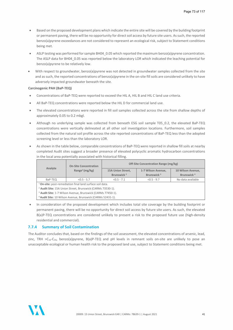
20009: 15 Union Street, Brunswick EAR | CARMs: 78639-1 | August 2021 41
Based on the proposed development plans which indicate the entire site will be covered by the building footprint or permanent paving, there will be no opportunity for direct soil access by future site users. As such, the reported benzo(a)pyrene exceedances are not considered to represent an ecological risk, subject to Statement conditions being met.
ASLP testing was performed for sample BH04_0.05 which reported the maximum benzo(a)pyrene concentration. The ASLP data for BH04_0.05 was reported below the laboratory LOR which indicated the leaching potential for benzo(a)pyrene to be relatively low.
With respect to groundwater, benzo(a)pyrene was not detected in groundwater samples collected from the site and as such, the reported concentrations of benzo(a)pyrene in the on-site fill soils are considered unlikely to have adversely impacted groundwater beneath the site.
Carcinogenic PAH (BaP-TEQ)
Concentrations of BaP-TEQ were reported to exceed the HIL A, HIL B and HIL C land use criteria.
All BaP-TEQ concentrations were reported below the HIL D for commercial land use.
The elevated concentrations were reported in fill soil samples collected across the site from shallow depths of approximately 0.05 to 0.2 mbgl.
Although no underlying sample was collected from beneath ESG soil sample T05_0.2, the elevated BaP-TEQ concentrations were vertically delineated at all other soil investigation locations. Furthermore, soil samples collected from the natural soil profile across the site reported concentrations of BaP-TEQ less than the adopted screening level or less than the laboratory LOR.
As shown in the table below, comparable concentrations of BaP-TEQ were reported in shallow fill soils at nearby completed Audit sites suggest a broader presence of elevated polycyclic aromatic hydrocarbon concentrations in the local area potentially associated with historical filling.
Analyte On-Site Concentration
Range1 (mg/kg)
Off-Site Concentration Range (mg/kg)
15A Union Street, Brunswick 2
1-7 Wilson Avenue, Brunswick 3
10 Wilson Avenue, Brunswick 4
BaP-TEQ <0.5 - 5.7 <0.5 - 7.1 <0.5 - 9.7 No data available 1 On-site: post-remediation final land surface soil data. 2 Audit Site: 15A Union Street, Brunswick (CARMs 73530-1). 3 Audit Site: 1-7 Wilson Avenue, Brunswick (CARMs 77450-1). 4 Audit Site: 10 Wilson Avenue, Brunswick (CARMs 52431-1).
In consideration of the proposed development which includes total site coverage by the building footprint or permanent paving, there will be no opportunity for direct soil access by future site users. As such, the elevated B(a)P-TEQ concentrations are considered unlikely to present a risk to the proposed future use (high-density residential and commercial).
7.7.4 Summary of Soil Contamination
The Auditor concludes that, based on the findings of the soil assessment, the elevated concentrations of arsenic, lead, zinc, TRH >C16-C34, benzo(a)pyrene, B(a)P-TEQ and pH levels in remnant soils on-site are unlikely to pose an unacceptable ecological or human health risk to the proposed land use, subject to Statement conditions being met.
Page 73 of 117
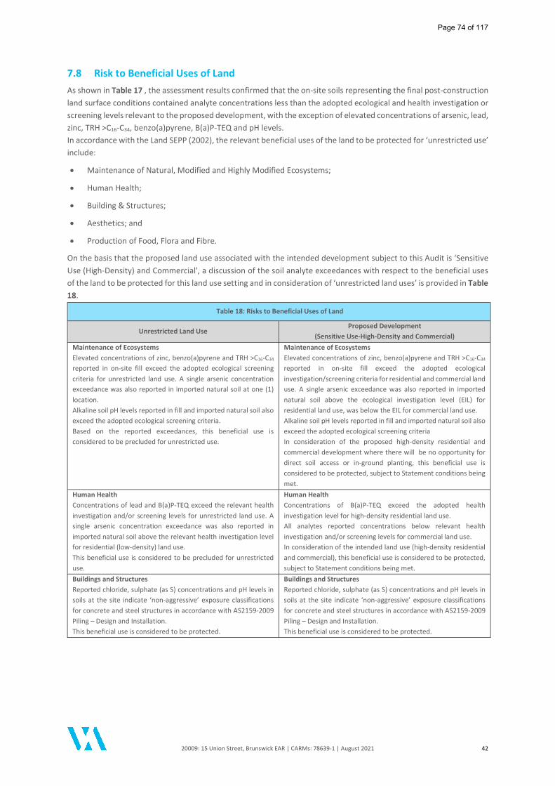
20009: 15 Union Street, Brunswick EAR | CARMs: 78639-1 | August 2021 42
7.8 Risk to Beneficial Uses of Land As shown in Table 17 , the assessment results confirmed that the on-site soils representing the final post-construction land surface conditions contained analyte concentrations less than the adopted ecological and health investigation or screening levels relevant to the proposed development, with the exception of elevated concentrations of arsenic, lead, zinc, TRH >C16-C34, benzo(a)pyrene, B(a)P-TEQ and pH levels. In accordance with the Land SEPP (2002), the relevant beneficial uses of the land to be protected for ‘unrestricted use’ include:
Maintenance of Natural, Modified and Highly Modified Ecosystems;
Human Health;
Building & Structures;
Aesthetics; and
Production of Food, Flora and Fibre.
On the basis that the proposed land use associated with the intended development subject to this Audit is ‘Sensitive Use (High-Density) and Commercial', a discussion of the soil analyte exceedances with respect to the beneficial uses of the land to be protected for this land use setting and in consideration of ‘unrestricted land uses’ is provided in Table 18.
Table 18: Risks to Beneficial Uses of Land
Unrestricted Land Use Proposed Development
(Sensitive Use-High-Density and Commercial) Maintenance of Ecosystems Elevated concentrations of zinc, benzo(a)pyrene and TRH >C16-C34 reported in on-site fill exceed the adopted ecological screening criteria for unrestricted land use. A single arsenic concentration exceedance was also reported in imported natural soil at one (1) location. Alkaline soil pH levels reported in fill and imported natural soil also exceed the adopted ecological screening criteria. Based on the reported exceedances, this beneficial use is considered to be precluded for unrestricted use.
Maintenance of Ecosystems Elevated concentrations of zinc, benzo(a)pyrene and TRH >C16-C34 reported in on-site fill exceed the adopted ecological investigation/screening criteria for residential and commercial land use. A single arsenic exceedance was also reported in imported natural soil above the ecological investigation level (EIL) for residential land use, was below the EIL for commercial land use. Alkaline soil pH levels reported in fill and imported natural soil also exceed the adopted ecological screening criteria In consideration of the proposed high-density residential and commercial development where there will be no opportunity for direct soil access or in-ground planting, this beneficial use is considered to be protected, subject to Statement conditions being met.
Human Health Concentrations of lead and B(a)P-TEQ exceed the relevant health investigation and/or screening levels for unrestricted land use. A single arsenic concentration exceedance was also reported in imported natural soil above the relevant health investigation level for residential (low-density) land use. This beneficial use is considered to be precluded for unrestricted use.
Human Health Concentrations of B(a)P-TEQ exceed the adopted health investigation level for high-density residential land use. All analytes reported concentrations below relevant health investigation and/or screening levels for commercial land use. In consideration of the intended land use (high-density residential and commercial), this beneficial use is considered to be protected, subject to Statement conditions being met.
Buildings and Structures Reported chloride, sulphate (as S) concentrations and pH levels in soils at the site indicate ‘non-aggressive’ exposure classifications for concrete and steel structures in accordance with AS2159-2009 Piling – Design and Installation. This beneficial use is considered to be protected.
Buildings and Structures Reported chloride, sulphate (as S) concentrations and pH levels in soils at the site indicate ‘non-aggressive’ exposure classifications for concrete and steel structures in accordance with AS2159-2009 Piling – Design and Installation. This beneficial use is considered to be protected.
Page 74 of 117
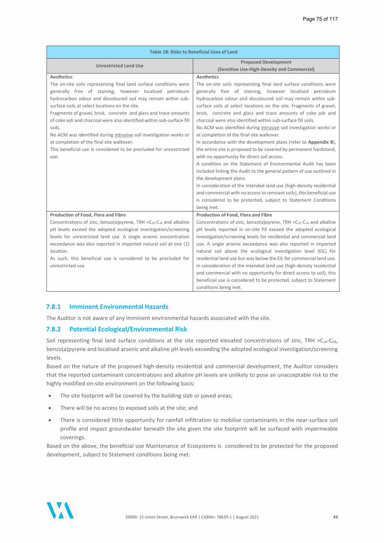
20009: 15 Union Street, Brunswick EAR | CARMs: 78639-1 | August 2021 43
Table 18: Risks to Beneficial Uses of Land
Unrestricted Land Use Proposed Development
(Sensitive Use-High-Density and Commercial) Aesthetics The on-site soils representing final land surface conditions were generally free of staining, however localised petroleum hydrocarbon odour and discoloured soil may remain within sub-surface soils at select locations on the site. Fragments of gravel, brick, concrete and glass and trace amounts of coke ash and charcoal were also identified within sub-surface fill soils. No ACM was identified during intrusive soil investigation works or at completion of the final site walkover. This beneficial use is considered to be precluded for unrestricted use.
Aesthetics The on-site soils representing final land surface conditions were generally free of staining, however localised petroleum hydrocarbon odour and discoloured soil may remain within sub-surface soils at select locations on the site. Fragments of gravel, brick, concrete and glass and trace amounts of coke ash and charcoal were also identified within sub-surface fill soils. No ACM was identified during intrusive soil investigation works or at completion of the final site walkover. In accordance with the development plans (refer to Appendix B), the entire site is proposed to be covered by permanent hardstand, with no opportunity for direct soil access. A condition on the Statement of Environmental Audit has been included linking the Audit to the general pattern of use outlined in the development plans. In consideration of the intended land use (high-density residential and commercial with no access to remnant soils), this beneficial use is considered to be protected, subject to Statement Conditions being met.
Production of Food, Flora and Fibre Concentrations of zinc, benzo(a)pyrene, TRH >C16-C34 and alkaline pH levels exceed the adopted ecological investigation/screening levels for unrestricted land use. A single arsenic concentration exceedance was also reported in imported natural soil at one (1) location. As such, this beneficial use is considered to be precluded for unrestricted use.
Production of Food, Flora and Fibre Concentrations of zinc, benzo(a)pyrene, TRH >C16-C34 and alkaline pH levels reported in on-site fill exceed the adopted ecological investigation/screening levels for residential and commercial land use. A single arsenic exceedance was also reported in imported natural soil above the ecological investigation level (EIL) for residential land use but was below the EIL for commercial land use. In consideration of the intended land use (high-density residential and commercial with no opportunity for direct access to soil), this beneficial use is considered to be protected, subject to Statement conditions being met.
7.8.1 Imminent Environmental Hazards
The Auditor is not aware of any imminent environmental hazards associated with the site.
7.8.2 Potential Ecological/Environmental Risk
Soil representing final land surface conditions at the site reported elevated concentrations of zinc, TRH >C16-C34, benzo(a)pyrene and localised arsenic and alkaline pH levels exceeding the adopted ecological investigation/screening levels. Based on the nature of the proposed high-density residential and commercial development, the Auditor considers that the reported contaminant concentrations and alkaline pH levels are unlikely to pose an unacceptable risk to the highly modified on-site environment on the following basis:
The site footprint will be covered by the building slab or paved areas;
There will be no access to exposed soils at the site; and
There is considered little opportunity for rainfall infiltration to mobilise contaminants in the near-surface soil profile and impact groundwater beneath the site given the site footprint will be surfaced with impermeable coverings.
Based on the above, the beneficial use Maintenance of Ecosystems is considered to be protected for the proposed development, subject to Statement conditions being met.
Page 75 of 117

20009: 15 Union Street, Brunswick EAR | CARMs: 78639-1 | August 2021 44
7.8.3 Potential Human Health Risk
Direct Contact Soil representing final land surface conditions at the site reported concentrations of analytes below the adopted health investigation and/or screening levels for commercial land use, which is the applicable screening criteria for the proposed development which includes commercial uses and car parking on the ground floor. Concentrations of B(a)P-TEQ reported in the remnant on-site fill exceed the health screening level for high-density residential land use. Statistical appraisal of the site-reported TRH >C16-C34 concentrations confirmed that the maximum concentration was less than 250% and the standard deviation of results was less than 50% of the NEPM 2013 management limits for petroleum hydrocarbons for both residential and commercial/industrial land uses. Future Users - following completion of the development no site-related soil will be accessible to future occupants or any terrestrial environments (subject to Statement conditions being met). In accordance with the proposed development plans (refer to Appendix B), the site will be covered by permanent hardstand or paving, with no direct access to soil. The occasional incidental contact with soil that may occur during future maintenance works would not be of concern to the health of future occupants and there are no specific requirements for implementation of a management plan during the construction or occupation stages. The Auditor considered that the soil impacts are unlikely to pose an unacceptable risk to future users of the site via direct contact (subject to Statement conditions being met). Construction / Maintenance Workers - there is the potential for workers to come into direct contact with contamination in fill soils. However, for these activities it is appropriate to review the soil concentrations against guidelines for commercial/industrial workers, with no exceedances being reported above HIL D/HSL D criteria. Giving consideration to Section 14.6 in EPA Publication 759.3 (2015), it is considered that typical contractor occupational health and safety (OHS) procedures and personal protective equipment (PPE) adopted by building contractors and sub-surface utility contractors are sufficient to manage potential risks associated with remnant impacted soils. Therefore, the Auditor considered that the soil impacts are unlikely to pose an unacceptable risk to construction/maintenance workers working at the site via direct contact. Vapour Considerations Soil - The on-site soils did not report elevated concentrations of volatile contaminants above the adopted health screening levels for the proposed high-density residential and commercial land use. As such, it is considered that soils representing final land surface conditions are unlikely to pose a vapour intrusion risk to the proposed development or to construction and maintenance personnel working at the site. Groundwater - Detectable concentrations of volatile contaminants were reported in groundwater beneath the site and although not considered to represent pollution, the concentrations were considered further as part of the site-specific Risk Appraisal completed by the Auditor's expert support team member, Dr. Jackie Wright (enRiskS). The Auditor concludes that based on the findings of the enRiskS (2021) Risk Appraisal, it is considered that the groundwater impacts at the site are unlikely to pose a vapour risk to future occupants of the proposed development or to construction and maintenance personnel working in the sub-surface at the site (subject to Statement conditions being met). Should any substantive change/s (i.e. changes to the proposed land use or incorporation of a basement) be made to the development plans, these changes must be verified by an Environmental Auditor appointed under Division 1 of Part 8.3 of the Environment Protection Act 2017, and this verification advised in writing to EPA and the relevant planning authority. A Statement condition has been included to address this issue. Landfill Gases - Monitoring for potential landfill gases was completed by DRC and independently verified by the Auditor. The landfill gas data was evaluated by enRiskS (2021) who concluded "there are no hazards or risk issues identified in relation to landfill gas beneath the site, that would affect the proposed development or intrusive works". Aesthetic Vapour Considerations ESG (2019) reported the presence of petroleum hydrocarbon odour and discoloured soil in the sub-surface fill at several investigation locations beneath the former building. Localised odours and minor black stained soils were also reported at one (1) location (BH09) within the shallow on-site fill during intrusive investigations completed by DRC.
Page 76 of 117
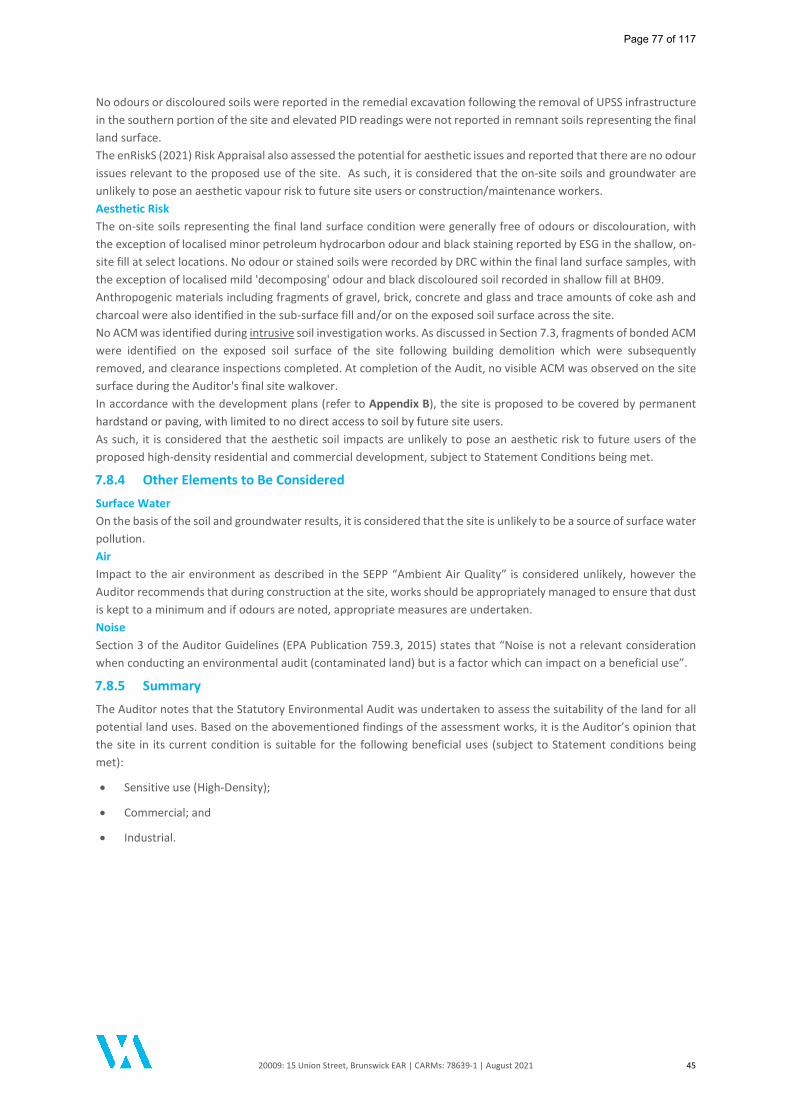
20009: 15 Union Street, Brunswick EAR | CARMs: 78639-1 | August 2021 45
No odours or discoloured soils were reported in the remedial excavation following the removal of UPSS infrastructure in the southern portion of the site and elevated PID readings were not reported in remnant soils representing the final land surface. The enRiskS (2021) Risk Appraisal also assessed the potential for aesthetic issues and reported that there are no odour issues relevant to the proposed use of the site. As such, it is considered that the on-site soils and groundwater are unlikely to pose an aesthetic vapour risk to future site users or construction/maintenance workers. Aesthetic Risk The on-site soils representing the final land surface condition were generally free of odours or discolouration, with the exception of localised minor petroleum hydrocarbon odour and black staining reported by ESG in the shallow, on-site fill at select locations. No odour or stained soils were recorded by DRC within the final land surface samples, with the exception of localised mild 'decomposing' odour and black discoloured soil recorded in shallow fill at BH09. Anthropogenic materials including fragments of gravel, brick, concrete and glass and trace amounts of coke ash and charcoal were also identified in the sub-surface fill and/or on the exposed soil surface across the site. No ACM was identified during intrusive soil investigation works. As discussed in Section 7.3, fragments of bonded ACM were identified on the exposed soil surface of the site following building demolition which were subsequently removed, and clearance inspections completed. At completion of the Audit, no visible ACM was observed on the site surface during the Auditor's final site walkover. In accordance with the development plans (refer to Appendix B), the site is proposed to be covered by permanent hardstand or paving, with limited to no direct access to soil by future site users. As such, it is considered that the aesthetic soil impacts are unlikely to pose an aesthetic risk to future users of the proposed high-density residential and commercial development, subject to Statement Conditions being met.
7.8.4 Other Elements to Be Considered
Surface Water On the basis of the soil and groundwater results, it is considered that the site is unlikely to be a source of surface water pollution. Air Impact to the air environment as described in the SEPP “Ambient Air Quality” is considered unlikely, however the Auditor recommends that during construction at the site, works should be appropriately managed to ensure that dust is kept to a minimum and if odours are noted, appropriate measures are undertaken. Noise Section 3 of the Auditor Guidelines (EPA Publication 759.3, 2015) states that “Noise is not a relevant consideration when conducting an environmental audit (contaminated land) but is a factor which can impact on a beneficial use”.
7.8.5 Summary
The Auditor notes that the Statutory Environmental Audit was undertaken to assess the suitability of the land for all potential land uses. Based on the abovementioned findings of the assessment works, it is the Auditor’s opinion that the site in its current condition is suitable for the following beneficial uses (subject to Statement conditions being met):
Sensitive use (High-Density);
Commercial; and
Industrial.
Page 77 of 117
20009: 15 Union Street, Brunswick EAR | CARMs: 78639-1 | August 2021 46
8 Landfill Gas Assessment
8.1 Assessment of Landfill Gas The site history and desktop review of nearby completed Environmental Audit reports (refer to Section 2.6) identified the site to be located within 500 m of former quarries where historical landfilling activities were undertaken. The closest former quarries or clay holes are located approximately 300 m south-east and approximately 460 m west of the site. The Environmental Audit completed for 225-231 Barkly Street, Brunswick indicated that an intrusive investigation was carried out at the former 'quarry' (currently Barkly Street Park) to characterise the filling materials and conduct an assessment of risks due to landfill gas and leachate generation. The assessment report concluded that the former quarry was filled with non-putrescible waste. Given the age of the 'inert' fill and results of the soil gas measurements for methane (between <3.8 - 7.1 ppm), the assessment concluded that the quarry area did not appear to be generating methane or other potentially hazardous substances. The Environmental Audit report did not address other former 'clay holes' associated with the former Brunswick Brick Works which would currently be located beneath the Barkly Square Shopping Centre and car park approximately 300 m south-east of the site. Auditor review of the completed Environmental Audit report completed for 27-29 Hodgson Street, Brunswick indicated that Temple Park (approximately 460 m west of the site) was formerly a 'clay hole' associated with Gillbrook Pottery located on Gray Street, Brunswick. The 'clay hole' was used for municipal waste disposal (including putrescible wastes) in the early 1900s. No detectable levels of methane were reported in soil vapour bores sampled on the Audit site. An assessment of landfill gas was undertaken as a component of the Environmental Audit completed for 15A Union Street, Brunswick (adjoining the western boundary of the site). No methane or carbon dioxide was detected during the landfill gas monitoring completed for the adjoining property and the Audit concluded that the presence of nearby filled quarries/clay holes (within 500 m) were unlikely to present a landfill gas risk. A direct assessment of potential landfill gases was completed by DRC in May 2021 to confirm the above findings. Based on the distance to the former quarries (and associated historical landfilling activities), the potential pathways for landfill gas migration to the site were considered to be via sub-surface utilities and as such, landfill gas sampling of select sub-surface utilities within the vicinity of the site was also considered to be an appropriate screening assessment for the presence of landfill gas.
8.2 Landfill Gas Monitoring The DRC assessment included the collection of data from the on-site groundwater monitoring wells and existing off-site service pits and drains to determine the potential for build-up of landfill gases within sub-surface utilities adjacent to the site and to evaluate potential pathways of gas migration from the identified former quarries. Landfill gas monitoring data was collected from twenty (20) service pits/drains (G1-G20) and from the on-site groundwater monitoring wells (MW01-MW02) on one (1) occasion to supplement the existing local data collected by Prensa during March 2020 as part of the Environmental Audit completed for the adjoining property at 15A Union Street, Brunswick. Landfill gas monitoring was undertaken by DRC using a Huberg gas analyser to measure ambient concentrations of methane. A confirmatory round of landfill gas monitoring of the off-site service pits/drains was also completed by the Auditor on 6 July 2021 using a GFM340 landfill gas analyser to provide additional data in relation to carbon dioxide and oxygen. The locations of the on-site and off-site landfill gas monitoring locations are included in Figure 11 of the DRC (2021) report, which generally replicated the landfill gas monitoring points for the completed Environmental Audit at adjoining 15A Union Street, Brunswick. The landfill gas monitoring data was included in Table 8 of the DRC (2021) report and Appendix I of this Audit report.
Page 78 of 117
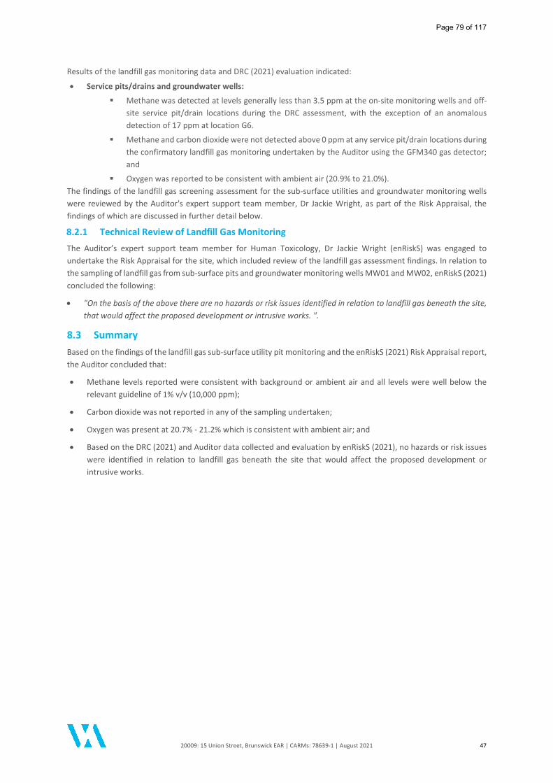
20009: 15 Union Street, Brunswick EAR | CARMs: 78639-1 | August 2021 47
Results of the landfill gas monitoring data and DRC (2021) evaluation indicated:
Service pits/drains and groundwater wells:
Methane was detected at levels generally less than 3.5 ppm at the on-site monitoring wells and off-site service pit/drain locations during the DRC assessment, with the exception of an anomalous detection of 17 ppm at location G6.
Methane and carbon dioxide were not detected above 0 ppm at any service pit/drain locations during the confirmatory landfill gas monitoring undertaken by the Auditor using the GFM340 gas detector; and
Oxygen was reported to be consistent with ambient air (20.9% to 21.0%). The findings of the landfill gas screening assessment for the sub-surface utilities and groundwater monitoring wells were reviewed by the Auditor's expert support team member, Dr Jackie Wright, as part of the Risk Appraisal, the findings of which are discussed in further detail below.
8.2.1 Technical Review of Landfill Gas Monitoring
The Auditor’s expert support team member for Human Toxicology, Dr Jackie Wright (enRiskS) was engaged to undertake the Risk Appraisal for the site, which included review of the landfill gas assessment findings. In relation to the sampling of landfill gas from sub-surface pits and groundwater monitoring wells MW01 and MW02, enRiskS (2021) concluded the following:
"On the basis of the above there are no hazards or risk issues identified in relation to landfill gas beneath the site, that would affect the proposed development or intrusive works. ".
8.3 Summary Based on the findings of the landfill gas sub-surface utility pit monitoring and the enRiskS (2021) Risk Appraisal report, the Auditor concluded that:
Methane levels reported were consistent with background or ambient air and all levels were well below the relevant guideline of 1% v/v (10,000 ppm);
Carbon dioxide was not reported in any of the sampling undertaken;
Oxygen was present at 20.7% - 21.2% which is consistent with ambient air; and
Based on the DRC (2021) and Auditor data collected and evaluation by enRiskS (2021), no hazards or risk issues were identified in relation to landfill gas beneath the site that would affect the proposed development or intrusive works.
Page 79 of 117

20009: 15 Union Street, Brunswick EAR | CARMs: 78639-1 | August 2021 48
9 Groundwater Assessment
Based on Section 13 of the Auditor Guidelines (2015), the Auditor must address the following questions:
Is groundwater likely to be polluted?
Is groundwater polluted?
If groundwater is determined to be polluted, then are the beneficial uses of groundwater precluded?
Based on an appraisal of the above questions and site data, the assessment works undertaken at site incorporated a desktop hydrogeological study and an intrusive groundwater investigation via the installation and sampling of two (2) on-site groundwater monitoring wells (MW01 and MW02) undertaken by DRC Environmental. MW1 was also utilised as a geotechnical well. A discussion of the following pertinent aspects is provided below:
Potential for groundwater contamination;
Assessment of groundwater conditions;
Summary of groundwater contamination status and comparison to applicable screening criteria;
Applicable beneficial uses to be protected; and
Auditor’s opinion regarding whether the site is/is not considered to be a source of groundwater pollution.
9.1 Potential for Groundwater Contamination The Auditor has considered the potential for off-site and/or on-site sources to be impacting on the local groundwater underlying the site (i.e. is groundwater likely to be polluted?). In consideration of the site and surrounding site history the Auditor considered that the potential existed for the site to be a contributing source of the groundwater impacts identified. Section 3 provides details of the potential on-site and off-site sources of contamination identified as part of the assessment by DRC. The Auditor has formed an independent opinion in this regard and provides the following multiple lines of evidence in support of the monitoring of groundwater as part of the assessment:
The presence of imported fill soils;
The former commercial/industrial on-site land uses;
The presence of an on-site underground storage tank (UST);
The various former and/or current industrial land uses in the vicinity of the site; and
The potential presence of background and/or regional levels of groundwater contaminants.
Sections 9.4 and 9.5 (below) provide further details pertaining to the contamination status of the groundwater monitored as part of the groundwater investigations.
9.2 Summary of Groundwater Assessment Undertaken
9.2.1 Groundwater Assessment
Two (2) groundwater monitoring wells were installed on-site as part of groundwater investigations undertaken by DRC. Assessment of the on-site groundwater was completed over three (3) discrete monitoring events completed between December 2020 - May 2021. Details are included in the sections below.
Page 80 of 117
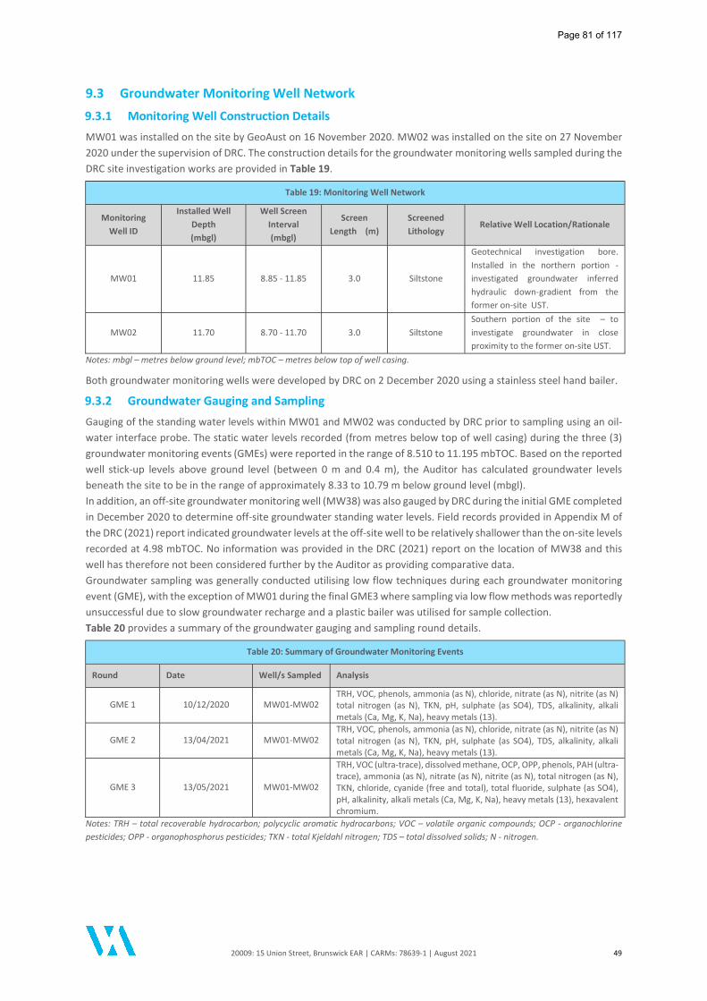
20009: 15 Union Street, Brunswick EAR | CARMs: 78639-1 | August 2021 49
9.3 Groundwater Monitoring Well Network
9.3.1 Monitoring Well Construction Details
MW01 was installed on the site by GeoAust on 16 November 2020. MW02 was installed on the site on 27 November 2020 under the supervision of DRC. The construction details for the groundwater monitoring wells sampled during the DRC site investigation works are provided in Table 19.
Table 19: Monitoring Well Network
Monitoring Well ID
Installed Well Depth (mbgl)
Well Screen Interval (mbgl)
Screen Length (m)
Screened Lithology
Relative Well Location/Rationale
MW01 11.85 8.85 - 11.85 3.0 Siltstone
Geotechnical investigation bore. Installed in the northern portion - investigated groundwater inferred hydraulic down-gradient from the former on-site UST.
MW02 11.70 8.70 - 11.70 3.0 Siltstone Southern portion of the site – to investigate groundwater in close proximity to the former on-site UST.
Notes: mbgl – metres below ground level; mbTOC – metres below top of well casing.
Both groundwater monitoring wells were developed by DRC on 2 December 2020 using a stainless steel hand bailer.
9.3.2 Groundwater Gauging and Sampling
Gauging of the standing water levels within MW01 and MW02 was conducted by DRC prior to sampling using an oil-water interface probe. The static water levels recorded (from metres below top of well casing) during the three (3) groundwater monitoring events (GMEs) were reported in the range of 8.510 to 11.195 mbTOC. Based on the reported well stick-up levels above ground level (between 0 m and 0.4 m), the Auditor has calculated groundwater levels beneath the site to be in the range of approximately 8.33 to 10.79 m below ground level (mbgl). In addition, an off-site groundwater monitoring well (MW38) was also gauged by DRC during the initial GME completed in December 2020 to determine off-site groundwater standing water levels. Field records provided in Appendix M of the DRC (2021) report indicated groundwater levels at the off-site well to be relatively shallower than the on-site levels recorded at 4.98 mbTOC. No information was provided in the DRC (2021) report on the location of MW38 and this well has therefore not been considered further by the Auditor as providing comparative data. Groundwater sampling was generally conducted utilising low flow techniques during each groundwater monitoring event (GME), with the exception of MW01 during the final GME3 where sampling via low flow methods was reportedly unsuccessful due to slow groundwater recharge and a plastic bailer was utilised for sample collection. Table 20 provides a summary of the groundwater gauging and sampling round details.
Table 20: Summary of Groundwater Monitoring Events
Round Date Well/s Sampled Analysis
GME 1 10/12/2020 MW01-MW02 TRH, VOC, phenols, ammonia (as N), chloride, nitrate (as N), nitrite (as N) total nitrogen (as N), TKN, pH, sulphate (as SO4), TDS, alkalinity, alkali metals (Ca, Mg, K, Na), heavy metals (13).
GME 2 13/04/2021 MW01-MW02 TRH, VOC, phenols, ammonia (as N), chloride, nitrate (as N), nitrite (as N) total nitrogen (as N), TKN, pH, sulphate (as SO4), TDS, alkalinity, alkali metals (Ca, Mg, K, Na), heavy metals (13).
GME 3 13/05/2021 MW01-MW02
TRH, VOC (ultra-trace), dissolved methane, OCP, OPP, phenols, PAH (ultra-trace), ammonia (as N), nitrate (as N), nitrite (as N), total nitrogen (as N), TKN, chloride, cyanide (free and total), total fluoride, sulphate (as SO4), pH, alkalinity, alkali metals (Ca, Mg, K, Na), heavy metals (13), hexavalent chromium.
Notes: TRH – total recoverable hydrocarbon; polycyclic aromatic hydrocarbons; VOC – volatile organic compounds; OCP - organochlorine pesticides; OPP - organophosphorus pesticides; TKN - total Kjeldahl nitrogen; TDS – total dissolved solids; N - nitrogen.
Page 81 of 117

20009: 15 Union Street, Brunswick EAR | CARMs: 78639-1 | August 2021 50
Groundwater samples for metals analysis were field filtered using 0.45 µm filters with each sample collected and stored in appropriately preserved sample bottles. Samples collected from MW01 during the final GME3 were re-filtered at the primary laboratory to 0.1 µm due to high sediment load and the sampling method applied (bailer) at this location. DRC noted that during GME1 the split sample was not forwarded to the secondary laboratory for analysis, however the sample was analysed by the primary laboratory. Further details pertaining to groundwater monitoring methodologies were provided in Section 6.4 of the DRC (2021) report. The Auditor notes that the on-site monitoring wells MW01 and MW02 were present at the completion of the Audit.
9.3.3 Groundwater Flow Direction
As only two (2) groundwater monitoring wells (MW01 and MW02) were installed as part of groundwater investigations on-site, the groundwater flow was unable to be calculated. The Auditor's review of nearby completed Audit sites suggested that the predominant groundwater flow direction within the uppermost aquifer was in a north to north-westerly direction towards Moonee Ponds Creek. Based on the above the Auditor was in agreement with DRC that Moonee Ponds Creek, located approximately 1.8 km west (at its closest point) of the site was the likely point of groundwater discharge from the site locality.
9.4 Groundwater Analytical Results
9.4.1 Volatile Organic Compounds
Low concentrations of volatile contaminants including dissolved phase petroleum hydrocarbons and chlorinated hydrocarbons were reported in on-site wells during one or more groundwater monitoring events. The detected concentrations of xylenes, TRH F2, acetone, bromodichloromethane and chloroform were reported in groundwater samples collected during GME1 only and were not replicated in the two (subsequent) GMEs. The detected concentration of dichloromethane (methylene chloride) was reported in Auditor Verification sample AV04 only collected from MW03 during the final GME3. The reported dissolved phase concentrations of volatile compounds were less than the adopted criteria for the protection of beneficial uses. A screening level assessment was conducted by the Auditor to review the significance of the reported volatile contaminant, which were also considered in the site-specific Risk Appraisal conducted by enRiskS. The evaluation of volatile contaminant concentrations has conservatively taken into consideration the maximum reported concentrations for each of the three (3) groundwater monitoring events undertaken.
Table 20: VOC Concentrations in Groundwater
Analyte Concentration Range in on-site wells (µg/L) Screening Value – Drinking Water (µg/L)
Toluene <1 - 23 800 1 25 2
Xylenes <2 - 3 600 1 20 2
TRH F2 <50 - 430 NL4
Bromodichloromethane <1 - 2 250 1
Dichloromethane (methylene chloride) <2 - 0.08 ** 4 1
Chloroform <1 - 38 250 1
2-Propanone (acetone) <1 - 3 14,000 3
1 Australian Drinking Water Guidelines (NHMRC 2011, updated March 2021) - health guideline 2 Australian Drinking Water Guidelines (NHMRC 2011, updated March 2021) - aesthetic guideline 3 US EPA Regional Screening Levels (May 2021) - Tap water (non-carcinogenic screening level for children). 4 NEPM 2013 Health Screening Levels (HSLs): NL - non-limiting (HSL-D, 2 - 4 m, SILT/CLAY) **Auditor Verification sample data.
Page 82 of 117

20009: 15 Union Street, Brunswick EAR | CARMs: 78639-1 | August 2021 51
The reported VOC concentrations were less than the criteria adopted by DRC and were also less than the screening criteria adopted by the Auditor in the evaluation of potential vapour intrusion risks. In addition, the detectable concentrations of contaminants in groundwater were also compared to relevant screening criteria as part of the enRiskS (2021) Risk Appraisal to identify (i) whether the analyte detected was considered volatile, and (ii) whether the concentrations reported exceed the available human health risk-based screening criteria. Further to discussions with enRiskS and given the nature of the development, the potential off-site issues and the depth to groundwater, further conservative assessment of vapour intrusion risk was undertaken in the risk assessment. Based on the appraisal of groundwater data undertaken by enRiskS, no vapour intrusion risk issues associated with VOC groundwater impacts were identified as an outcome of the Risk Appraisal, for the proposed development. Based on the low levels of detectable VOCs, and given elevated chlorinated hydrocarbons were not reported in on-site soils, the Auditor considers the impacts did not indicate an on-site source and were considered likely to be attributable to off-site/regional impacts. Given that the detectable VOC concentrations were reported to be below criteria, the Auditor considers that the reported VOC concentrations do not represent pollution and have not been discussed further in this section of the report. Further discussion on the potential vapour intrusion risk issues associated with the detectable VOC concentrations are provided in Section 9.
9.4.2 Total Recoverable Hydrocarbons
An elevated concentration of TRH C10-C36 exceeding the adopted screening criteria of 600 µg/L was reported in well MW01 during GME1. Detectable concentrations of TRH C10-C36 were not repeated during sampling of well MW01 during the subsequent GME2 and GME3. Detectable concentrations of TRH C10-C36 were reported in well MW02 during GME1 and GME3 albeit at levels less than the adopted screening criteria. Low concentrations of volatile TRH fractions were reported in MW01 during GME3 and in MW02 during GME2. The low detections of volatile TRH were considered to associated with the presence of chlorinated hydrocarbons in groundwater rather than a petroleum hydrocarbon source. Based on the presence of a former underground storage tank (UST) on the site, where the storage, dispensing and potential spillage or leakage of petroleum hydrocarbons may have occurred, there is potential for the TRH impacts reported in groundwater to have been sourced from the site. However, complete primary and secondary source removal was undertaken as part of the DRC assessment which did not identity significant petroleum hydrocarbon impacts in the sub-surface soil in the vicinity of the removed UST. Furthermore, elevated concentrations of TRH in groundwater beneath the site were not reported during GME2 and GME3. The Auditor also notes that all three (3) GMEs were undertaken following primary and secondary source removal of the UST and associated infrastructure (i.e. post-remediation). In consideration of the above and given that the concentrations of TRH C10-C36 in groundwater were reported below the adopted screening criteria for the penultimate and final GMEs, the Auditor considers that the reported concentrations do not represent pollution and have not been considered further in this report.
9.4.3 Comparison to Applicable Screening Criteria
Full details of the groundwater sampling results for all groundwater sampling rounds (GME1 – GME3) are provided in Table 3 (Groundwater Analytical Results) of the DRC (2021) report. It is noted that during the well gauging and sampling, no evidence of non-aqueous phase liquid (LNAPL or DNAPL) was reported by DRC in the on-site wells monitored over the sampling period. A summary of exceedances of the adopted groundwater quality objectives for the final GME (GME3) (except where stated) adopted by DRC and the Auditor is provided in Table 21.
Page 83 of 117
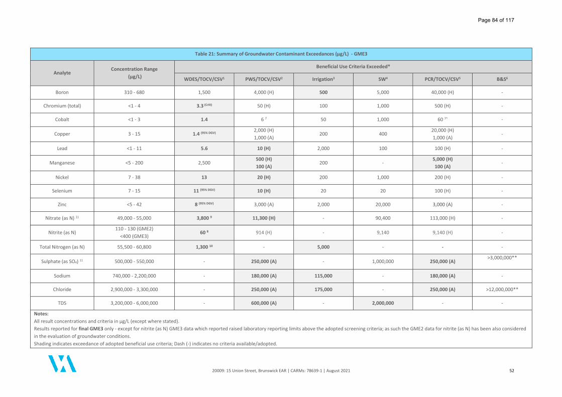
20009: 15 Union Street, Brunswick EAR | CARMs: 78639-1 | August 2021 52
Table 21: Summary of Groundwater Contaminant Exceedances (µg/L) - GME3
Analyte Concentration Range
(µg/L)
Beneficial Use Criteria Exceeded*
WDES/TOCV/CSV1 PWS/TOCV/CSV2 Irrigation3 SW4 PCR/TOCV/CSV5 B&S6
Boron 310 - 680 1,500 4,000 (H) 500 5,000 40,000 (H) -
Chromium (total) <1 - 4 3.3 (CrIII) 50 (H) 100 1,000 500 (H) -
Cobalt <1 - 3 1.4 6 7 50 1,000 60 7^ -
Copper 3 - 15 1.4 (95% DGV) 2,000 (H) 1,000 (A)
200 400 20,000 (H) 1,000 (A)
-
Lead <1 - 11 5.6 10 (H) 2,000 100 100 (H) -
Manganese <5 - 200 2,500 500 (H) 100 (A)
200 - 5,000 (H) 100 (A)
-
Nickel 7 - 38 13 20 (H) 200 1,000 200 (H) -
Selenium 7 - 15 11 (95% DGV) 10 (H) 20 20 100 (H) -
Zinc <5 - 42 8 (95% DGV) 3,000 (A) 2,000 20,000 3,000 (A) -
Nitrate (as N) 11 49,000 - 55,000 3,800 9 11,300 (H) - 90,400 113,000 (H) -
Nitrite (as N) 110 - 130 (GME2)
<400 (GME3) 60 8 914 (H) - 9,140 9,140 (H) -
Total Nitrogen (as N) 55,500 - 60,800 1,300 10 - 5,000 - - -
Sulphate (as SO4) 11 500,000 - 550,000 - 250,000 (A) - 1,000,000 250,000 (A) >3,000,000**
Sodium 740,000 - 2,200,000 - 180,000 (A) 115,000 - 180,000 (A) -
Chloride 2,900,000 - 3,300,000 - 250,000 (A) 175,000 - 250,000 (A) >12,000,000**
TDS 3,200,000 - 6,000,000 - 600,000 (A) - 2,000,000 - -
Notes: All result concentrations and criteria in µg/L (except where stated). Results reported for final GME3 only - except for nitrite (as N) GME3 data which reported raised laboratory reporting limits above the adopted screening criteria; as such the GME2 data for nitrite (as N) has been also considered in the evaluation of groundwater conditions. Shading indicates exceedance of adopted beneficial use criteria; Dash (-) indicates no criteria available/adopted.
Page 84 of 117
20009: 15 Union Street, Brunswick EAR | CARMs: 78639-1 | August 2021 53
Groundwater criteria for the protection of beneficial uses Water Dependent Ecosystems and Species, Potable Water Supply and Primary Contact Recreation have been conservatively adopted for the protection of beneficial uses Traditional Owner Cultural Values and Cultural and Spiritual Values. *WDES – Water Dependent Ecosystems and Species; PWS – Potable Water Supply; Irrigation – Agriculture and Irrigation (Irrigation), SW – Agriculture and Irrigation (Stock Watering); PCR – Water-based Recreation (Primary Contact Recreation); TOCV - Traditional Owner Cultural Values; CSV - Cultural and Spiritual Values; B&S – Buildings and Structures. 1 – ANZG 2018 Default guideline values (DGVs) for the protection of Freshwater Ecosystems (90% protection unless otherwise stated) or ANZECC/ARMCANZ 2000 low reliability trigger value (LRTV). 2 – NHMRC 2011 (updated March 2021) Australian Drinking Water Guidelines – Health (H) & Aesthetic (A) values. 3 – ANZECC 2000 Irrigation and general water use (long term use). 4 – ANZECC 2000 Livestock drinking water quality. 5 – NHMRC 2008 Guidelines for Managing Risk in Recreational Water – Health (H) & Aesthetic (A) values. ^Note: x10 multiplication factor applied for “health” values for non-volatile chemicals. 6 – AS2159-2009 Piling - Design and Installation. Refer Tables 6.4.2(C) and 6.5.2(C) - exposure conditions for concrete and steel piles in soil/groundwater (**concentrations less than adopted exposure conditions are equivalent to mild to non-aggressive exposure classification for Soil Conditions A). 7 – US EPA (May 2021) Regional Screening Levels – Tapwater (toxicity equivalent quotient [TEQ] of 1.0; non-carcinogenic screening level for child). 8 – CCME Water Quality Guidelines for the Protection of Aquatic Life - Freshwater; Water Quality Guidelines for the Protection of Agriculture - Irrigation & Livestock. 9 – NIWA (2014) Nitrate Toxicity Guidelines for the National Objectives Framework - Grading value (equivalent to ANZECC 2000 trigger value), 90% species protection. 10 – SEPP (Waters) 2018. Table 1: Environmental Quality Indicators and Objectives for Rivers and Streams - Urban (highly modified). 11 - Conversions applied to adopted criteria where necessary: Nitrate (as NO3) to Nitrate (as N) - divided by factor of 4.43; Sulphate (as SO4) to Sulphate (as S) - divided by factor of 3.0.
Page 85 of 117

20009: 15 Union Street, Brunswick EAR | CARMs: 78639-1 | August 2021 54
In summary, concentrations of metals (boron, chromium (total), cobalt, copper, lead, manganese, nickel, selenium and zinc), nitrate (as N), nitrite (as N), total nitrogen (as N), sulphate (as SO4), sodium, chloride and TDS were reported in excess of one or more adopted beneficial use criterion in groundwater beneath the site. DRC considered the elevated groundwater concentrations to be generally consistent with background conditions or regional groundwater pollution. The Auditor is satisfied that the chemical analytes reported in excess of the groundwater quality objectives adopted by DRC were generally consistent with the analytes reported greater than the groundwater criteria adopted by the Auditor. Refer to Figure 4 of this Audit report for the groundwater exceedances at each monitoring well. Discussion relating to the groundwater contaminants reported and the associated risk to the relevant beneficial uses is provided in the following sections.
9.5 Groundwater Discussion
9.5.1 Heavy Metals
Boron, Chromium (total), Cobalt, Copper, Lead, Manganese, Nickel, Selenium, Zinc Groundwater concentrations for boron, chromium (total), cobalt, copper, lead, manganese, nickel, selenium and zinc were reported to exceed the beneficial use criteria adopted for the protection of Water Dependent Ecosystems and Species, Potable Water Supply, Irrigation, Primary Contact Recreation, Traditional Owner Cultural Values and/or Cultural and Spiritual Values. The Auditor is in general agreement that the elevated concentrations are representative of background groundwater conditions based on the following multiple lines of evidence:
The on-site soil concentrations for boron, chromium (total), cobalt, copper, lead, manganese, nickel, selenium and zinc were generally reported to be below the laboratory limit of reporting or below the adopted criteria, with the exception of lead and zinc. The reported concentrations of metals in the on-site fill were generally typical of the concentrations reported at nearby completed Audit sites;
Elevated concentrations of lead and zinc in the on-site soils were limited to the relatively shallow fill profile. No elevated concentrations of lead and zinc were reported in soil samples collected from the on-site natural soil profile. ASLP testing for lead and zinc reported leachable concentrations to be relatively low to negligible and therefore indicating a relative low mobility of lead and zinc within the on-site fill soils; and
A review of the range of available dissolved metals concentrations reported in groundwater regionally (i.e. within the same hydrogeological setting) was undertaken by DRC (and supplemented by the Auditor) and identified the ranges of site-reported metals concentrations were generally consistent with the concentrations reported regionally (refer to table below).
Analyte Hydraulic up-gradient
concentration range (µg/L) 1
On-site concentration (µg/L) 2
Hydraulic down-gradient concentration range (µg/L) 3
Boron 520 - 840 310 - 680 700 - 760 Chromium <1 - <10 <1 - 4 <1 - 21
Cobalt <1 - 6 <1 - 3 4 - 7 Copper <1 - 2 3 - 15 3 - 21
Lead <1 - <10 <1 - 11 3 - 9 Manganese 16 - 40 <5 - 200 8 - 15
Nickel <1 - 9 7 - 38 12 - 110 Selenium 11 - 55 7 - 15 18 - 36
Zinc <5 - 19 <5 - 42 59 - 88 1 Audit sites: 10 Wilson Avenue, Brunswick (CARMs 52431-1); 1-7 Wilson Avenue, Brunswick (CARMs 77450-1). 2 On-site wells: MW01 and MW02 (GME3). 3 Audit site: 15A Union Street, Brunswick (CARMs 73530-1, final GME data).
Based on the above, including the appraisal of on-site soil data and results of nearby off-site groundwater conditions provided by DRC, the Auditor is in agreement that the elevated concentrations of boron, chromium (total), cobalt, copper, lead, manganese, nickel, selenium and zinc in groundwater are likely representative of background groundwater conditions and are not considered to represent pollution. In addition, the Auditor considers that the site is not a source for the reported boron, chromium (total), cobalt, copper, lead, manganese, nickel, selenium and zinc impacts.
Page 86 of 117
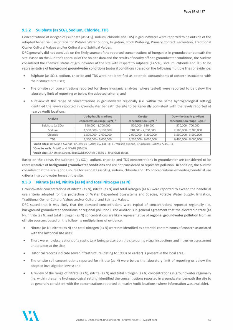
20009: 15 Union Street, Brunswick EAR | CARMs: 78639-1 | August 2021 55
9.5.2 Sulphate (as SO4), Sodium, Chloride, TDS
Concentrations of inorganics (sulphate [as SO4], sodium, chloride and TDS) in groundwater were reported to be outside of the adopted beneficial use criteria for Potable Water Supply, Irrigation, Stock Watering, Primary Contact Recreation, Traditional Owner Cultural Values and/or Cultural and Spiritual Values. DRC generally did not conclude on the likely source of the reported concentrations of inorganics in groundwater beneath the site. Based on the Auditor's appraisal of the on-site data and the results of nearby off-site groundwater conditions, the Auditor considered the chemical status of groundwater at the site with respect to sulphate (as SO4), sodium, chloride and TDS to be representative of background groundwater conditions (natural conditions) based on the following multiple lines of evidence:
Sulphate (as SO4), sodium, chloride and TDS were not identified as potential contaminants of concern associated with the historical site uses;
The on-site soil concentrations reported for these inorganic analytes (where tested) were reported to be below the laboratory limit of reporting or below the adopted criteria; and
A review of the range of concentrations in groundwater regionally (i.e. within the same hydrogeological setting) identified the levels reported in groundwater beneath the site to be generally consistent with the levels reported at nearby Audit locations.
Analyte Up-hydraulic gradient
concentration range (µg/L) 1
On-site concentration (µg/L) 2
Down-hydraulic gradient concentration range (µg/L) 3
Sulphate (as SO4) 390,000 - 1,700,000 500,000 - 550,000 570,000 - 700,000 Sodium 1,500,000 - 3,100,000 740,000 - 2,200,000 2,100,000 - 2,300,000 Chloride 1,800,000 - 2,600,000 2,900,000 - 3,300,000 3,500,000 - 3,900,000
TDS 3,300,000 - 9,000,000 3,200,000 - 6,000,000 6,400,000 - 8,000,000 1 Audit sites: 10 Wilson Avenue, Brunswick (CARMs 52431-1); 1-7 Wilson Avenue, Brunswick (CARMs 77450-1). 2 On-site wells: MW01 and MW02 (GME3). 3 Audit site: 15A Union Street, Brunswick (CARMs 73530-1, final GME data).
Based on the above, the sulphate (as SO4), sodium, chloride and TDS concentrations in groundwater are considered to be representative of background groundwater conditions and are not considered to represent pollution. In addition, the Auditor considers that the site is not a source for sulphate (as SO4), sodium, chloride and TDS concentrations exceeding beneficial use criteria in groundwater beneath the site.
9.5.3 Nitrate (as N), Nitrite (as N) and total Nitrogen (as N)
Groundwater concentrations of nitrate (as N), nitrite (as N) and total nitrogen (as N) were reported to exceed the beneficial use criteria adopted for the protection of Water Dependent Ecosystems and Species, Potable Water Supply, Irrigation, Traditional Owner Cultural Values and/or Cultural and Spiritual Values. DRC stated that it was likely that the elevated concentrations were typical of concentrations reported regionally (i.e. background groundwater conditions or regional pollution). The Auditor is in general agreement that the elevated nitrate (as N), nitrite (as N) and total nitrogen (as N) concentrations are likely representative of regional groundwater pollution from an off-site source/s based on the following multiple lines of evidence:
Nitrate (as N), nitrite (as N) and total nitrogen (as N) were not identified as potential contaminants of concern associated with the historical site uses;
There were no observations of a septic tank being present on the site during visual inspections and intrusive assessment undertaken at the site;
Historical records indicate sewer infrastructure (dating to 1900s or earlier) is present in the local area;
The on-site soil concentrations reported for nitrate (as N) were below the laboratory limit of reporting or below the adopted investigation levels; and
A review of the range of nitrate (as N), nitrite (as N) and total nitrogen (as N) concentrations in groundwater regionally (i.e. within the same hydrogeological setting) identified the concentrations reported in groundwater beneath the site to be generally consistent with the concentrations reported at nearby Audit locations (where information was available).
Page 87 of 117
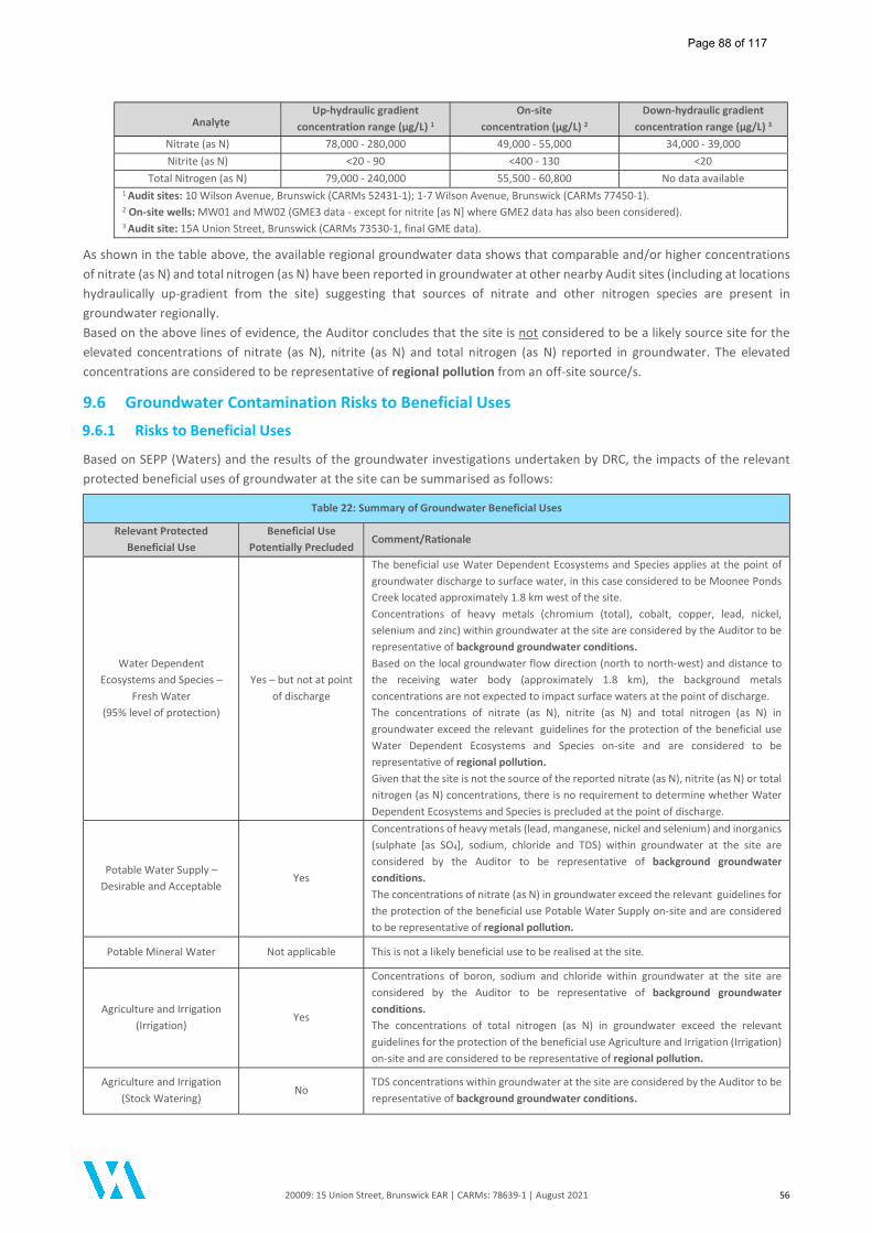
20009: 15 Union Street, Brunswick EAR | CARMs: 78639-1 | August 2021 56
Analyte Up-hydraulic gradient
concentration range (µg/L) 1
On-site concentration (µg/L) 2
Down-hydraulic gradient concentration range (µg/L) 3
Nitrate (as N) 78,000 - 280,000 49,000 - 55,000 34,000 - 39,000 Nitrite (as N) <20 - 90 <400 - 130 <20
Total Nitrogen (as N) 79,000 - 240,000 55,500 - 60,800 No data available 1 Audit sites: 10 Wilson Avenue, Brunswick (CARMs 52431-1); 1-7 Wilson Avenue, Brunswick (CARMs 77450-1). 2 On-site wells: MW01 and MW02 (GME3 data - except for nitrite [as N] where GME2 data has also been considered). 3 Audit site: 15A Union Street, Brunswick (CARMs 73530-1, final GME data).
As shown in the table above, the available regional groundwater data shows that comparable and/or higher concentrations of nitrate (as N) and total nitrogen (as N) have been reported in groundwater at other nearby Audit sites (including at locations hydraulically up-gradient from the site) suggesting that sources of nitrate and other nitrogen species are present in groundwater regionally. Based on the above lines of evidence, the Auditor concludes that the site is not considered to be a likely source site for the elevated concentrations of nitrate (as N), nitrite (as N) and total nitrogen (as N) reported in groundwater. The elevated concentrations are considered to be representative of regional pollution from an off-site source/s.
9.6 Groundwater Contamination Risks to Beneficial Uses
9.6.1 Risks to Beneficial Uses
Based on SEPP (Waters) and the results of the groundwater investigations undertaken by DRC, the impacts of the relevant protected beneficial uses of groundwater at the site can be summarised as follows:
Table 22: Summary of Groundwater Beneficial Uses
Relevant Protected Beneficial Use
Beneficial Use Potentially Precluded
Comment/Rationale
Water Dependent Ecosystems and Species –
Fresh Water (95% level of protection)
Yes – but not at point of discharge
The beneficial use Water Dependent Ecosystems and Species applies at the point of groundwater discharge to surface water, in this case considered to be Moonee Ponds Creek located approximately 1.8 km west of the site. Concentrations of heavy metals (chromium (total), cobalt, copper, lead, nickel, selenium and zinc) within groundwater at the site are considered by the Auditor to be representative of background groundwater conditions. Based on the local groundwater flow direction (north to north-west) and distance to the receiving water body (approximately 1.8 km), the background metals concentrations are not expected to impact surface waters at the point of discharge. The concentrations of nitrate (as N), nitrite (as N) and total nitrogen (as N) in groundwater exceed the relevant guidelines for the protection of the beneficial use Water Dependent Ecosystems and Species on-site and are considered to be representative of regional pollution. Given that the site is not the source of the reported nitrate (as N), nitrite (as N) or total nitrogen (as N) concentrations, there is no requirement to determine whether Water Dependent Ecosystems and Species is precluded at the point of discharge.
Potable Water Supply – Desirable and Acceptable
Yes
Concentrations of heavy metals (lead, manganese, nickel and selenium) and inorganics (sulphate [as SO4], sodium, chloride and TDS) within groundwater at the site are considered by the Auditor to be representative of background groundwater conditions. The concentrations of nitrate (as N) in groundwater exceed the relevant guidelines for the protection of the beneficial use Potable Water Supply on-site and are considered to be representative of regional pollution.
Potable Mineral Water Not applicable This is not a likely beneficial use to be realised at the site.
Agriculture and Irrigation (Irrigation)
Yes
Concentrations of boron, sodium and chloride within groundwater at the site are considered by the Auditor to be representative of background groundwater conditions. The concentrations of total nitrogen (as N) in groundwater exceed the relevant guidelines for the protection of the beneficial use Agriculture and Irrigation (Irrigation) on-site and are considered to be representative of regional pollution.
Agriculture and Irrigation (Stock Watering)
No TDS concentrations within groundwater at the site are considered by the Auditor to be representative of background groundwater conditions.
Page 88 of 117
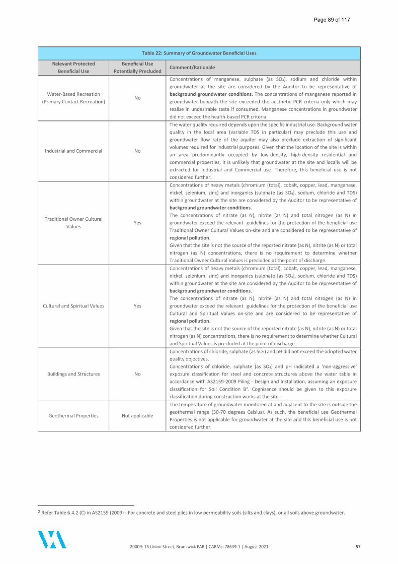
20009: 15 Union Street, Brunswick EAR | CARMs: 78639-1 | August 2021 57
Table 22: Summary of Groundwater Beneficial Uses
Relevant Protected Beneficial Use
Beneficial Use Potentially Precluded
Comment/Rationale
Water-Based Recreation (Primary Contact Recreation)
No
Concentrations of manganese, sulphate (as SO4), sodium and chloride within groundwater at the site are considered by the Auditor to be representative of background groundwater conditions. The concentrations of manganese reported in groundwater beneath the site exceeded the aesthetic PCR criteria only which may realise in undesirable taste if consumed. Manganese concentrations in groundwater did not exceed the health-based PCR criteria.
Industrial and Commercial No
The water quality required depends upon the specific industrial use. Background water quality in the local area (variable TDS in particular) may preclude this use and groundwater flow rate of the aquifer may also preclude extraction of significant volumes required for industrial purposes. Given that the location of the site is within an area predominantly occupied by low-density, high-density residential and commercial properties, it is unlikely that groundwater at the site and locally will be extracted for Industrial and Commercial use. Therefore, this beneficial use is not considered further.
Traditional Owner Cultural Values
Yes
Concentrations of heavy metals (chromium (total), cobalt, copper, lead, manganese, nickel, selenium, zinc) and inorganics (sulphate [as SO4], sodium, chloride and TDS) within groundwater at the site are considered by the Auditor to be representative of background groundwater conditions. The concentrations of nitrate (as N), nitrite (as N) and total nitrogen (as N) in groundwater exceed the relevant guidelines for the protection of the beneficial use Traditional Owner Cultural Values on-site and are considered to be representative of regional pollution. Given that the site is not the source of the reported nitrate (as N), nitrite (as N) or total nitrogen (as N) concentrations, there is no requirement to determine whether Traditional Owner Cultural Values is precluded at the point of discharge.
Cultural and Spiritual Values Yes
Concentrations of heavy metals (chromium (total), cobalt, copper, lead, manganese, nickel, selenium, zinc) and inorganics (sulphate [as SO4], sodium, chloride and TDS) within groundwater at the site are considered by the Auditor to be representative of background groundwater conditions. The concentrations of nitrate (as N), nitrite (as N) and total nitrogen (as N) in groundwater exceed the relevant guidelines for the protection of the beneficial use Cultural and Spiritual Values on-site and are considered to be representative of regional pollution. Given that the site is not the source of the reported nitrate (as N), nitrite (as N) or total nitrogen (as N) concentrations, there is no requirement to determine whether Cultural and Spiritual Values is precluded at the point of discharge.
Buildings and Structures No
Concentrations of chloride, sulphate (as SO4) and pH did not exceed the adopted water quality objectives. Concentrations of chloride, sulphate (as SO4) and pH indicated a 'non-aggressive' exposure classification for steel and concrete structures above the water table in accordance with AS2159-2009 Piling - Design and Installation, assuming an exposure classification for Soil Condition B2. Cognisance should be given to this exposure classification during construction works at the site.
Geothermal Properties Not applicable
The temperature of groundwater monitored at and adjacent to the site is outside the geothermal range (30-70 degrees Celsius). As such, the beneficial use Geothermal Properties is not applicable for groundwater at the site and this beneficial use is not considered further.
2 Refer Table 6.4.2 (C) in AS2159 (2009) - For concrete and steel piles in low permeability soils (silts and clays), or all soils above groundwater.
Page 89 of 117
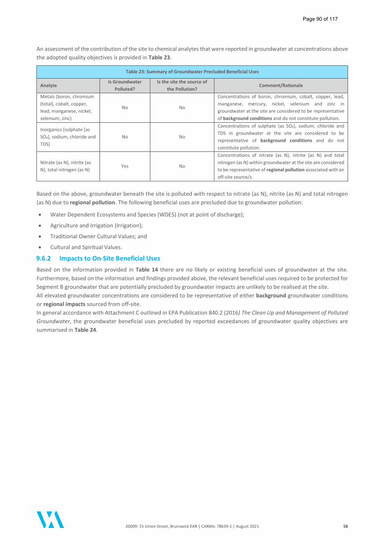
20009: 15 Union Street, Brunswick EAR | CARMs: 78639-1 | August 2021 58
An assessment of the contribution of the site to chemical analytes that were reported in groundwater at concentrations above the adopted quality objectives is provided in Table 23.
Table 23: Summary of Groundwater Precluded Beneficial Uses
Analyte Is Groundwater
Polluted? Is the site the source of
the Pollution? Comment/Rationale
Metals (boron, chromium (total), cobalt, copper, lead, manganese, nickel, selenium, zinc)
No No
Concentrations of boron, chromium, cobalt, copper, lead, manganese, mercury, nickel, selenium and zinc in groundwater at the site are considered to be representative of background conditions and do not constitute pollution.
Inorganics (sulphate [as SO4], sodium, chloride and TDS)
No No
Concentrations of sulphate (as SO4), sodium, chloride and TDS in groundwater at the site are considered to be representative of background conditions and do not constitute pollution.
Nitrate (as N), nitrite (as N), total nitrogen (as N)
Yes No
Concentrations of nitrate (as N), nitrite (as N) and total nitrogen (as N) within groundwater at the site are considered to be representative of regional pollution associated with an off-site source/s.
Based on the above, groundwater beneath the site is polluted with respect to nitrate (as N), nitrite (as N) and total nitrogen (as N) due to regional pollution. The following beneficial uses are precluded due to groundwater pollution:
Water Dependent Ecosystems and Species (WDES) (not at point of discharge);
Agriculture and Irrigation (Irrigation);
Traditional Owner Cultural Values; and
Cultural and Spiritual Values.
9.6.2 Impacts to On-Site Beneficial Uses
Based on the information provided in Table 14 there are no likely or existing beneficial uses of groundwater at the site. Furthermore, based on the information and findings provided above, the relevant beneficial uses required to be protected for Segment B groundwater that are potentially precluded by groundwater impacts are unlikely to be realised at the site. All elevated groundwater concentrations are considered to be representative of either background groundwater conditions or regional impacts sourced from off-site. In general accordance with Attachment C outlined in EPA Publication 840.2 (2016) The Clean Up and Management of Polluted Groundwater, the groundwater beneficial uses precluded by reported exceedances of groundwater quality objectives are summarised in Table 24.
Page 90 of 117
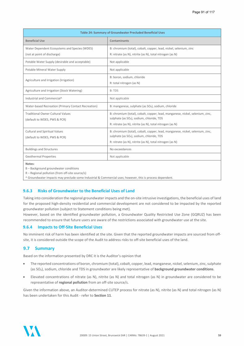
20009: 15 Union Street, Brunswick EAR | CARMs: 78639-1 | August 2021 59
Table 24: Summary of Groundwater Precluded Beneficial Uses
Beneficial Use Contaminants
Water Dependent Ecosystems and Species (WDES)
(not at point of discharge)
B: chromium (total), cobalt, copper, lead, nickel, selenium, zinc
R: nitrate (as N), nitrite (as N), total nitrogen (as N)
Potable Water Supply (desirable and acceptable) Not applicable
Potable Mineral Water Supply Not applicable
Agriculture and Irrigation (Irrigation) B: boron, sodium, chloride
R: total nitrogen (as N)
Agriculture and Irrigation (Stock Watering) B: TDS
Industrial and Commercial^ Not applicable
Water-based Recreation (Primary Contact Recreation) B: manganese, sulphate (as SO4), sodium, chloride
Traditional Owner Cultural Values
(default to WDES, PWS & PCR)
B: chromium (total), cobalt, copper, lead, manganese, nickel, selenium, zinc, sulphate (as SO4), sodium, chloride, TDS
R: nitrate (as N), nitrite (as N), total nitrogen (as N)
Cultural and Spiritual Values
(default to WDES, PWS & PCR)
B: chromium (total), cobalt, copper, lead, manganese, nickel, selenium, zinc, sulphate (as SO4), sodium, chloride, TDS
R: nitrate (as N), nitrite (as N), total nitrogen (as N)
Buildings and Structures No exceedances
Geothermal Properties Not applicable
Notes: B – Background groundwater conditions R – Regional pollution (from off-site source/s) ^ Groundwater impacts may preclude some Industrial & Commercial uses; however, this is process dependent.
9.6.3 Risks of Groundwater to the Beneficial Uses of Land
Taking into consideration the regional groundwater impacts and the on-site intrusive investigations, the beneficial uses of land for the proposed high-density residential and commercial development are not considered to be impacted by the reported groundwater pollution (subject to Statement conditions being met). However, based on the identified groundwater pollution, a Groundwater Quality Restricted Use Zone (GQRUZ) has been recommended to ensure that future users are aware of the restrictions associated with groundwater use at the site.
9.6.4 Impacts to Off-Site Beneficial Uses
No imminent risk of harm has been identified at the site. Given that the reported groundwater impacts are sourced from off-site, it is considered outside the scope of the Audit to address risks to off-site beneficial uses of the land.
9.7 Summary Based on the information presented by DRC it is the Auditor’s opinion that
The reported concentrations of boron, chromium (total), cobalt, copper, lead, manganese, nickel, selenium, zinc, sulphate (as SO4), sodium, chloride and TDS in groundwater are likely representative of background groundwater conditions.
Elevated concentrations of nitrate (as N), nitrite (as N) and total nitrogen (as N) in groundwater are considered to be representative of regional pollution from an off-site source/s.
Given the information above, an Auditor-determined CUTEP process for nitrate (as N), nitrite (as N) and total nitrogen (as N) has been undertaken for this Audit - refer to Section 11.
Page 91 of 117
20009: 15 Union Street, Brunswick EAR | CARMs: 78639-1 | August 2021 60
10 Risk Appraisal
10.1 Background The Auditor’s Expert Support Team Member, Dr Jackie Wright of Environmental Risk Sciences Pty Ltd (enRiskS) was engaged to undertake a Risk Appraisal in relation to the presence of volatile contaminants in groundwater beneath the site. A copy of the Risk Appraisal is provided as Appendix D of this report. The objectives of the enRiskS (2021) Risk Appraisal were to provide expert support advice to the Auditor on the following:
Provide an assessment of risks to human health, in relation to the proposed development of the site, based on the available data. This includes consideration of impacts identified in groundwater and landfill gas.; and
Where required, identify any risk management measures that may be required in relation to the proposed development.
The Risk Appraisal addressed possible on-site risks to human health via the direct exposure and vapour inhalation pathways based on the high-density residential and commercial development proposed. The Risk Appraisal has also included an assessment of aesthetic issues, specifically odours. No assessment was made in relation to any off-site risks or environmental risks. The enRiskS (2021) Risk Appraisal identified the following receptors in the context of the proposed high-density residential and commercial development of the site:
Future residents (adults and children) in the car stacker, commercial space or residential units;
Future retail and office workers in the car stacker and working on the ground floor of the proposed building;
Construction workers (adults); and
Intrusive maintenance workers (adults).
Groundwater is not expected to be intersected during construction or any future intrusive works on the site. Hence the focus of the Risk Appraisal related to the vapour inhalation pathway. Exposures by residents were considered to be more significant than commercial/retail workers, as such the focus of the Risk Appraisal related to residents. In relation to direct contact, the Risk Appraisal noted that groundwater should not be intersected during construction or future maintenance of drains beneath the basement. Hence, no direct contact exposure pathways required evaluation in the Risk Appraisal.
10.2 Risk Appraisal Methodology The Risk Appraisal has evaluated vapour intrusion risk issues on the basis of modelling from groundwater. The Risk Appraisal has considered results from all groundwater monitoring events completed at the site. For this site, it was not considered relevant to collect soil vapour data for the following reasons:
No volatile chemicals of potential concern were identified in on-site soil;
Vapour pins were not considered to be appropriate based on the large excavation undertaken at the site. In addition, the former slab was not retained as part of the proposed development (and hence was considered less representative of future conditions); and
Modelling of groundwater data was considered sufficient to address potential vapour intrusion risks and was utilised by enRiskS to draw conclusions, without a requirement for soil vapour data.
enRiskS' previous advice to the Auditor is that the modelling of vapour intrusion risks from groundwater remains a valid approach to the assessment of risk, as detailed in the NEPM (NEPC 1999 amended 2013). The uncertainties in modelling chlorinated hydrocarbons (CHC) vapour intrusion risks from groundwater data would more likely result in overestimating risk, rather than underestimating risk, as the groundwater data provides concentrations from depths below the top of the water table, or as an average over a more significant depth (which are likely to be higher for CHCs). For the assessment of vapour intrusion, the hydrocarbon (HC) concentrations at the very top of the aquifer is relevant.
Page 92 of 117

20009: 15 Union Street, Brunswick EAR | CARMs: 78639-1 | August 2021 61
10.3 Contamination Sources In relation to vapour risk issues, the Risk Appraisal noted that potential contamination sources on-site included the former commercial site uses (chemical goods storage, potential automotive workshop), the presence of a UST and the historical importation of fill. Off-site sources of contamination were also noted to include clothing manufacturing and various chemical, plastics, cardboard and fibreboard manufacturing premises as well as railway-related activities.
10.4 Findings of the Risk Appraisal
10.4.1 Soil
In relation to soil impacts, enRiskS (2021) noted that there are no direct contact exposures relevant for future occupants of the site, although during construction and intrusive maintenance works there is potential for workers to come into direct contact with soil. On this basis, soil data was reviewed by enRiskS for exposures that may occur during construction and future maintenance works with enRiskS noting the following:
No volatile chemicals have been detected in soil; hence the vapour inhalation pathway is not of concern.
All concentrations of metals and inorganics are below commercial/industrial soil guidelines.
All concentrations of polycyclic aromatic hydrocarbons (PAHs) are below commercial/industrial soil guidelines.
TRH has been detected in soil, but only for the non-volatile compounds in the range TRH F3 and TRH F4. The maximum concentrations of TRH F3 and F4 are below management limits from the NEPM which are protective of direct contact exposures by workers (including intrusive workers), odours and staining.
On the basis of the above there are no soil impacts identified on the site that would be of concern in relation to the proposed development of the site.
10.4.2 Groundwater
The findings of the groundwater assessments undertaken by DRC on three (3) occasions between December 2020 and May 2021 were evaluated as part of the screening assessment undertaken within the Risk Appraisal completed by enRiskS. An evaluation of the vapour intrusion risk posed by the groundwater contaminants is reported as part of the Risk Appraisal - full details are provided in the enRiskS (2021) Risk Appraisal report presented in Appendix D of this report. Based on the findings of the screening assessment, enRiskS (2021) concluded the following:
All concentrations in groundwater are well below guidelines adopted that are protective of exposures during construction and intrusive maintenance works; and
All concentrations are below the guidelines adopted that are protective of exposures that may be relevant to future occupation by residents and workers.
The enRiskS (2021) Risk Appraisal concluded that no further assessment of vapour intrusion risks was required. .
10.4.3 Odour
In relation to odours, enRiskS (2021) noted that "the maximum concentrations of bromodichloromethane, chloroform and dichloromethane are below drinking water criteria which also consider odours". On this basis, there are no odour issues relevant to the proposed use of the site.
10.4.4 Landfill Gases
The enRiskS (2021) Risk Appraisal also included review of the landfill gas assessment findings. In relation to the sampling of landfill gas from sub-surface pits and groundwater monitoring wells MW01 and MW02, enRiskS (2021) concluded the following:
"On the basis of the above there are no hazards or risk issues identified in relation to landfill gas beneath the site, that would affect the proposed development or intrusive works. ".
Further discussion of the landfill gas assessment is provided in Section 8 of this report.
Page 93 of 117
20009: 15 Union Street, Brunswick EAR | CARMs: 78639-1 | August 2021 62
10.5 Conclusions of the Risk Appraisal Based on the available information and the review undertaken, the enRiskS (2021) Risk Appraisal concluded that:
"There are no risk issues of concern in relation to potential exposures that may occur during intrusive works for construction and the maintenance of subsurface services, or residential and commercial use of the site once developed; and
On the basis of the assessment undertaken, no vapour mitigation measures need to be considered in the construction design for the proposed building".
Full details are provided in the enRiskS (2021) Risk Appraisal report presented in Appendix D of this report. It is noted that the Risk Appraisal is linked to a general pattern of use as outlined in the existing development plans and has considered the construction of a high-density residential and commercial development, comprising a car stacker in the southern portion of the site to a depth of 4.5 mbgl. Should any substantive change/s (i.e. changes to the building footprint or incorporation of a basement) be made to the development plans, these changes must be verified by an Environmental Auditor appointed pursuant to Division 1 of Part 8.3 of the Environment Protection Act 2017, and this verification advised in writing to EPA and the planning authority. A Statement condition has been included to address this issue.
Page 94 of 117

20009: 15 Union Street, Brunswick EAR | CARMs: 78639-1 | August 2021 63
11 Auditor-Determined CUTEP
In accordance with Section 13.7 of Publication 759.3 (2015), the Auditor may assess and determine that clean-up to the extent practicable (CUTEP) of groundwater for sites that are identified to be a non-source site for groundwater pollution. On 03 May 2021, the Auditor formally advised EPA that in accordance with EPA Publication 840.2 (2016) and Section 13 of EPA Publication 759.3 (2015), an Auditor-determined CUTEP was being undertaken for the site.
11.1 Summary of Site Impacts The condition of the on-site soil at the completion of the Audit is reported to be characterised by elevated concentrations of arsenic, lead, zinc, benzo(a)pyrene, B(a)P-TEQ and TRH >C16-C34 primarily within the on-site fill and/or associated with soil material imported to site (e.g. arsenic). The soil pH was also found to be more alkaline than the ecological screening criteria adopted by the Auditor. The concentrations of arsenic, lead and zinc were less than the relevant health screening levels for the proposed high-density residential and commercial land use. The groundwater contamination status reported during the final groundwater monitoring event (GME3) was characterised by elevated concentrations (in excess of criteria) of metals (boron, chromium (total), cobalt, copper, lead, manganese, nickel, selenium, zinc), inorganics (sulphate [as SO4], sodium, chloride, TDS), nitrate (as N), nitrite (as N) and total nitrogen (as N).
11.2 Source-Site Status The Auditor notes that the abovementioned information indicates that the groundwater impacts are likely to be representative of background groundwater conditions and do not constitute pollution, with the exception of:
Elevated concentrations of nitrate (as N), nitrite (as N) and total nitrogen (as N) which were attributed to regional pollution.
On the basis that local groundwater is polluted with nitrate (as N), nitrite (as N) and total nitrogen (as N) a Statement of Environmental Audit has been issued, which includes conditions regarding the use of the site.
11.3 Consideration of Vapour Risk Based on the intrusive soil, landfill gas and groundwater investigation results the current contaminant concentrations at the site do not represent a vapour intrusion risk. Soil - The on-site soils did not report elevated concentrations of volatile contaminants above the adopted health screening levels for the proposed high-density residential and commercial land use. As such, it is considered that soils representing final land surface conditions are unlikely to pose a vapour intrusion risk to the proposed development or to construction and maintenance personnel working at the site. Groundwater - Detectable concentrations of volatile contaminants were reported in groundwater beneath the site. Although the concentrations reported were below the adopted screening levels, potential vapour issues associated with the detectable concentrations of volatile contaminants were assessed by the Auditor's expert support team member, Dr. Jackie Wright (enRiskS). The findings of the enRiskS (2021) report confirmed that the concentrations of volatile contaminants reported in groundwater do not pose an unacceptable risk to intrusive maintenance/construction workers or future occupants / users of the proposed development. The conclusions provided by enRiskS relate to the proposed development, which comprises a high-density residential and commercial development, with car stackers in the southern portion of the site and no basement levels. Landfill Gases - Monitoring for potential landfill gases was completed by DRC and independently by the Auditor. The landfill gas data was evaluated by enRiskS who concluded "there are no hazards or risk issues identified in relation to landfill gas beneath the site, that would affect the proposed development or intrusive works". The Auditor concludes that, based on the findings of the DRC assessment works and the enRiskS (2021) Risk Appraisal, the presence of remnant soil impacts and groundwater pollution beneath the site is considered unlikely to pose a vapour risk to the beneficial use ‘Human Health’ for future users of the site.
Page 95 of 117
20009: 15 Union Street, Brunswick EAR | CARMs: 78639-1 | August 2021 64
It is noted that the Risk Appraisal is linked to a general pattern of use (high-density residential and commercial) as presented in the proposed development plans, and has considered the construction of a multi-level slab-on grade residential and commercial development with commercial ground floor areas and a car stacker pit extending to 4.5 m depth. Should any substantive change/s (i.e. changes to the building footprint or incorporation of a basement) be made to the development plans, these changes must be verified by an Environmental Auditor appointed pursuant to Division 1 of Part 8.3 of the Environment Protection Act 2017, and this verification advised in writing to EPA and the planning authority. A Statement condition has been included to address this issue.
11.4 Practicability of Groundwater Clean-Up The Auditor has considered the practicability of groundwater clean-up within the groundwater flow system being monitored at the site. Based on the nature of the aquifer system, the findings of the assessment works and the financial, logistical and technical constraints associated with clean-up of groundwater associated with off-site sources, it is the Auditor’s opinion that the site has been cleaned up to the extent practicable. Given that the site is not considered to be the source of the reported nitrate (as N), nitrite (as N) or total nitrogen (as N) impacts, clean-up of the on-site groundwater is not considered necessary nor practicable.
11.5 Restriction on Groundwater Use The current status of the groundwater pollution is such that it precludes several on-site beneficial uses of the groundwater environment. As such, there is a condition included on the Statement of Environmental Audit restricting the abstraction of groundwater at the site. A Groundwater Quality Restricted Use Zone (GQRUZ) has been recommended for the site. Given that full delineation of the reported impacts from off-site sources falls outside the scope of this assessment (as the site is a non-source site), the GQRUZ has been limited to the site boundaries (i.e. protective of future site users). Therefore, in accordance with Section 13.6 of EPA Publication 759.3 (2015), the site is nominated as a GQRUZ – refer to GQRUZ plan provided in Appendix F and attached to the Statement of Environmental Audit. There is no recommendation for ongoing monitoring of groundwater at the site, post completion of the Audit process and as such no Groundwater Quality Management Plan (GQMP) has been provided. Given that the site is not considered to be a source of polluted groundwater (i.e. not the source site), there is no requirement for notification of affected stakeholders. The recommended GQRUZ extent is also provided in Figure 2.
11.6 Summary Based on the information presented, it is the Auditor’s opinion that:
the site is not the source (or likely source) of the reported pollution by nitrate (as N), nitrite (as N) or total nitrogen (as N);
NAPL is not present (nor has ever been present) on the site;
based on the above information, the on-site beneficial uses of groundwater are not considered to be relevant (i.e. existing or likely); and
access to the site is not required to affect the only practicable clean-up options to protect surface water from the effects of groundwater pollution.
As such:
the GQRUZ should be limited to the site boundaries (i.e. the site is nominated as a GQRUZ in accordance with Section 13.6 of Publication 759.3);
there is no recommendation for ongoing monitoring of groundwater at the site, post completion of the Audit process and as such no GQMP has been provided; and
there is no requirement for notification of affected stakeholders.
A copy of the Summary Groundwater Table and a copy of the DRC Groundwater Table for GME1 - GME3 is provided in Appendix G of this Audit report and a copy of the CUTEP Checklist is provided in Appendix H of this Audit report.
Page 96 of 117
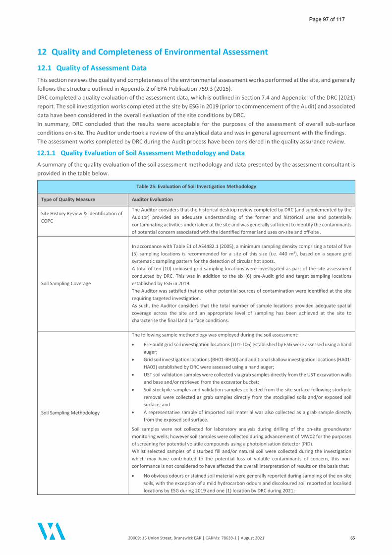
20009: 15 Union Street, Brunswick EAR | CARMs: 78639-1 | August 2021 65
12 Quality and Completeness of Environmental Assessment
12.1 Quality of Assessment Data This section reviews the quality and completeness of the environmental assessment works performed at the site, and generally follows the structure outlined in Appendix 2 of EPA Publication 759.3 (2015). DRC completed a quality evaluation of the assessment data, which is outlined in Section 7.4 and Appendix I of the DRC (2021) report. The soil investigation works completed at the site by ESG in 2019 (prior to commencement of the Audit) and associated data have been considered in the overall evaluation of the site conditions by DRC. In summary, DRC concluded that the results were acceptable for the purposes of the assessment of overall sub-surface conditions on-site. The Auditor undertook a review of the analytical data and was in general agreement with the findings. The assessment works completed by DRC during the Audit process have been considered in the quality assurance review.
12.1.1 Quality Evaluation of Soil Assessment Methodology and Data
A summary of the quality evaluation of the soil assessment methodology and data presented by the assessment consultant is provided in the table below.
Table 25: Evaluation of Soil Investigation Methodology
Type of Quality Measure Auditor Evaluation
Site History Review & Identification of COPC
The Auditor considers that the historical desktop review completed by DRC (and supplemented by the Auditor) provided an adequate understanding of the former and historical uses and potentially contaminating activities undertaken at the site and was generally sufficient to identify the contaminants of potential concern associated with the identified former land uses on-site and off-site .
Soil Sampling Coverage
In accordance with Table E1 of AS4482.1 (2005), a minimum sampling density comprising a total of five (5) sampling locations is recommended for a site of this size (i.e. 440 m2), based on a square grid systematic sampling pattern for the detection of circular hot spots. A total of ten (10) unbiased grid sampling locations were investigated as part of the site assessment conducted by DRC. This was in addition to the six (6) pre-Audit grid and target sampling locations established by ESG in 2019. The Auditor was satisfied that no other potential sources of contamination were identified at the site requiring targeted investigation. As such, the Auditor considers that the total number of sample locations provided adequate spatial coverage across the site and an appropriate level of sampling has been achieved at the site to characterise the final land surface conditions.
Soil Sampling Methodology
The following sample methodology was employed during the soil assessment:
Pre-audit grid soil investigation locations (T01-T06) established by ESG were assessed using a hand auger;
Grid soil investigation locations (BH01-BH10) and additional shallow investigation locations (HA01-HA03) established by DRC were assessed using a hand auger;
UST soil validation samples were collected via grab samples directly from the UST excavation walls and base and/or retrieved from the excavator bucket;
Soil stockpile samples and validation samples collected from the site surface following stockpile removal were collected as grab samples directly from the stockpiled soils and/or exposed soil surface; and
A representative sample of imported soil material was also collected as a grab sample directly from the exposed soil surface.
Soil samples were not collected for laboratory analysis during drilling of the on-site groundwater monitoring wells; however soil samples were collected during advancement of MW02 for the purposes of screening for potential volatile compounds using a photoionisation detector (PID). Whilst selected samples of disturbed fill and/or natural soil were collected during the investigation which may have contributed to the potential loss of volatile contaminants of concern, this non-conformance is not considered to have affected the overall interpretation of results on the basis that:
No obvious odours or stained soil material were generally reported during sampling of the on-site soils, with the exception of a mild hydrocarbon odours and discoloured soil reported at localised locations by ESG during 2019 and one (1) location by DRC during 2021;
Page 97 of 117
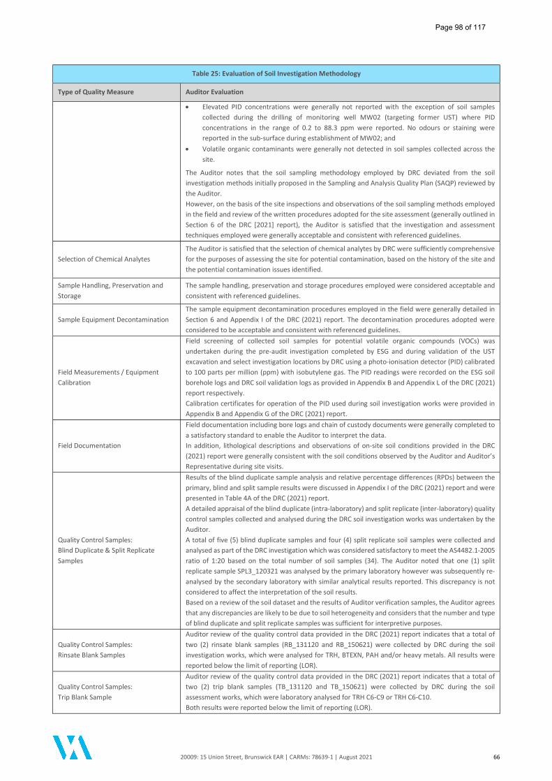
20009: 15 Union Street, Brunswick EAR | CARMs: 78639-1 | August 2021 66
Table 25: Evaluation of Soil Investigation Methodology
Type of Quality Measure Auditor Evaluation
Elevated PID concentrations were generally not reported with the exception of soil samples collected during the drilling of monitoring well MW02 (targeting former UST) where PID concentrations in the range of 0.2 to 88.3 ppm were reported. No odours or staining were reported in the sub-surface during establishment of MW02; and
Volatile organic contaminants were generally not detected in soil samples collected across the site.
The Auditor notes that the soil sampling methodology employed by DRC deviated from the soil investigation methods initially proposed in the Sampling and Analysis Quality Plan (SAQP) reviewed by the Auditor. However, on the basis of the site inspections and observations of the soil sampling methods employed in the field and review of the written procedures adopted for the site assessment (generally outlined in Section 6 of the DRC [2021] report), the Auditor is satisfied that the investigation and assessment techniques employed were generally acceptable and consistent with referenced guidelines.
Selection of Chemical Analytes The Auditor is satisfied that the selection of chemical analytes by DRC were sufficiently comprehensive for the purposes of assessing the site for potential contamination, based on the history of the site and the potential contamination issues identified.
Sample Handling, Preservation and Storage
The sample handling, preservation and storage procedures employed were considered acceptable and consistent with referenced guidelines.
Sample Equipment Decontamination The sample equipment decontamination procedures employed in the field were generally detailed in Section 6 and Appendix I of the DRC (2021) report. The decontamination procedures adopted were considered to be acceptable and consistent with referenced guidelines.
Field Measurements / Equipment Calibration
Field screening of collected soil samples for potential volatile organic compounds (VOCs) was undertaken during the pre-audit investigation completed by ESG and during validation of the UST excavation and select investigation locations by DRC using a photo-ionisation detector (PID) calibrated to 100 parts per million (ppm) with isobutylene gas. The PID readings were recorded on the ESG soil borehole logs and DRC soil validation logs as provided in Appendix B and Appendix L of the DRC (2021) report respectively. Calibration certificates for operation of the PID used during soil investigation works were provided in Appendix B and Appendix G of the DRC (2021) report.
Field Documentation
Field documentation including bore logs and chain of custody documents were generally completed to a satisfactory standard to enable the Auditor to interpret the data. In addition, lithological descriptions and observations of on-site soil conditions provided in the DRC (2021) report were generally consistent with the soil conditions observed by the Auditor and Auditor’s Representative during site visits.
Quality Control Samples: Blind Duplicate & Split Replicate Samples
Results of the blind duplicate sample analysis and relative percentage differences (RPDs) between the primary, blind and split sample results were discussed in Appendix I of the DRC (2021) report and were presented in Table 4A of the DRC (2021) report. A detailed appraisal of the blind duplicate (intra-laboratory) and split replicate (inter-laboratory) quality control samples collected and analysed during the DRC soil investigation works was undertaken by the Auditor. A total of five (5) blind duplicate samples and four (4) split replicate soil samples were collected and analysed as part of the DRC investigation which was considered satisfactory to meet the AS4482.1-2005 ratio of 1:20 based on the total number of soil samples (34). The Auditor noted that one (1) split replicate sample SPL3_120321 was analysed by the primary laboratory however was subsequently re-analysed by the secondary laboratory with similar analytical results reported. This discrepancy is not considered to affect the interpretation of the soil results. Based on a review of the soil dataset and the results of Auditor verification samples, the Auditor agrees that any discrepancies are likely to be due to soil heterogeneity and considers that the number and type of blind duplicate and split replicate samples was sufficient for interpretive purposes.
Quality Control Samples: Rinsate Blank Samples
Auditor review of the quality control data provided in the DRC (2021) report indicates that a total of two (2) rinsate blank samples (RB_131120 and RB_150621) were collected by DRC during the soil investigation works, which were analysed for TRH, BTEXN, PAH and/or heavy metals. All results were reported below the limit of reporting (LOR).
Quality Control Samples: Trip Blank Sample
Auditor review of the quality control data provided in the DRC (2021) report indicates that a total of two (2) trip blank samples (TB_131120 and TB_150621) were collected by DRC during the soil assessment works, which were laboratory analysed for TRH C6-C9 or TRH C6-C10. Both results were reported below the limit of reporting (LOR).
Page 98 of 117
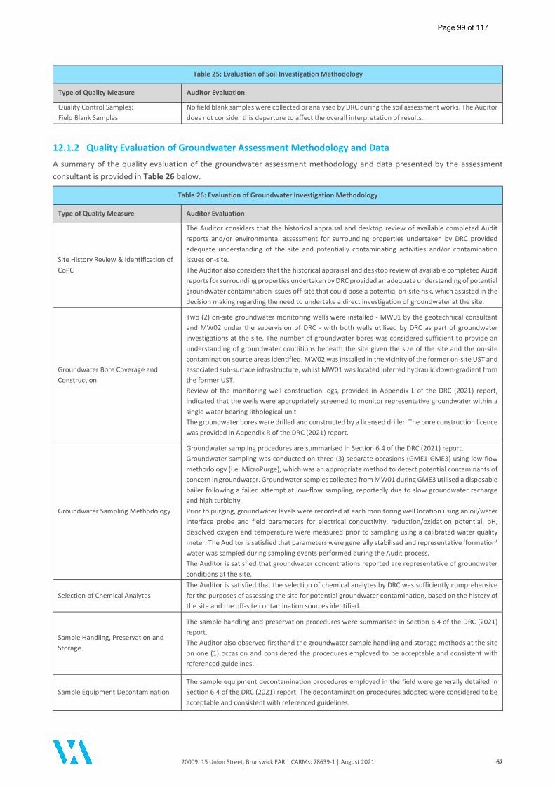
20009: 15 Union Street, Brunswick EAR | CARMs: 78639-1 | August 2021 67
Table 25: Evaluation of Soil Investigation Methodology
Type of Quality Measure Auditor Evaluation
Quality Control Samples: Field Blank Samples
No field blank samples were collected or analysed by DRC during the soil assessment works. The Auditor does not consider this departure to affect the overall interpretation of results.
12.1.2 Quality Evaluation of Groundwater Assessment Methodology and Data
A summary of the quality evaluation of the groundwater assessment methodology and data presented by the assessment consultant is provided in Table 26 below.
Table 26: Evaluation of Groundwater Investigation Methodology
Type of Quality Measure Auditor Evaluation
Site History Review & Identification of CoPC
The Auditor considers that the historical appraisal and desktop review of available completed Audit reports and/or environmental assessment for surrounding properties undertaken by DRC provided adequate understanding of the site and potentially contaminating activities and/or contamination issues on-site. The Auditor also considers that the historical appraisal and desktop review of available completed Audit reports for surrounding properties undertaken by DRC provided an adequate understanding of potential groundwater contamination issues off-site that could pose a potential on-site risk, which assisted in the decision making regarding the need to undertake a direct investigation of groundwater at the site.
Groundwater Bore Coverage and Construction
Two (2) on-site groundwater monitoring wells were installed - MW01 by the geotechnical consultant and MW02 under the supervision of DRC - with both wells utilised by DRC as part of groundwater investigations at the site. The number of groundwater bores was considered sufficient to provide an understanding of groundwater conditions beneath the site given the size of the site and the on-site contamination source areas identified. MW02 was installed in the vicinity of the former on-site UST and associated sub-surface infrastructure, whilst MW01 was located inferred hydraulic down-gradient from the former UST. Review of the monitoring well construction logs, provided in Appendix L of the DRC (2021) report, indicated that the wells were appropriately screened to monitor representative groundwater within a single water bearing lithological unit. The groundwater bores were drilled and constructed by a licensed driller. The bore construction licence was provided in Appendix R of the DRC (2021) report.
Groundwater Sampling Methodology
Groundwater sampling procedures are summarised in Section 6.4 of the DRC (2021) report. Groundwater sampling was conducted on three (3) separate occasions (GME1-GME3) using low-flow methodology (i.e. MicroPurge), which was an appropriate method to detect potential contaminants of concern in groundwater. Groundwater samples collected from MW01 during GME3 utilised a disposable bailer following a failed attempt at low-flow sampling, reportedly due to slow groundwater recharge and high turbidity. Prior to purging, groundwater levels were recorded at each monitoring well location using an oil/water interface probe and field parameters for electrical conductivity, reduction/oxidation potential, pH, dissolved oxygen and temperature were measured prior to sampling using a calibrated water quality meter. The Auditor is satisfied that parameters were generally stabilised and representative ‘formation’ water was sampled during sampling events performed during the Audit process. The Auditor is satisfied that groundwater concentrations reported are representative of groundwater conditions at the site.
Selection of Chemical Analytes The Auditor is satisfied that the selection of chemical analytes by DRC was sufficiently comprehensive for the purposes of assessing the site for potential groundwater contamination, based on the history of the site and the off-site contamination sources identified.
Sample Handling, Preservation and Storage
The sample handling and preservation procedures were summarised in Section 6.4 of the DRC (2021) report. The Auditor also observed firsthand the groundwater sample handling and storage methods at the site on one (1) occasion and considered the procedures employed to be acceptable and consistent with referenced guidelines.
Sample Equipment Decontamination The sample equipment decontamination procedures employed in the field were generally detailed in Section 6.4 of the DRC (2021) report. The decontamination procedures adopted were considered to be acceptable and consistent with referenced guidelines.
Page 99 of 117
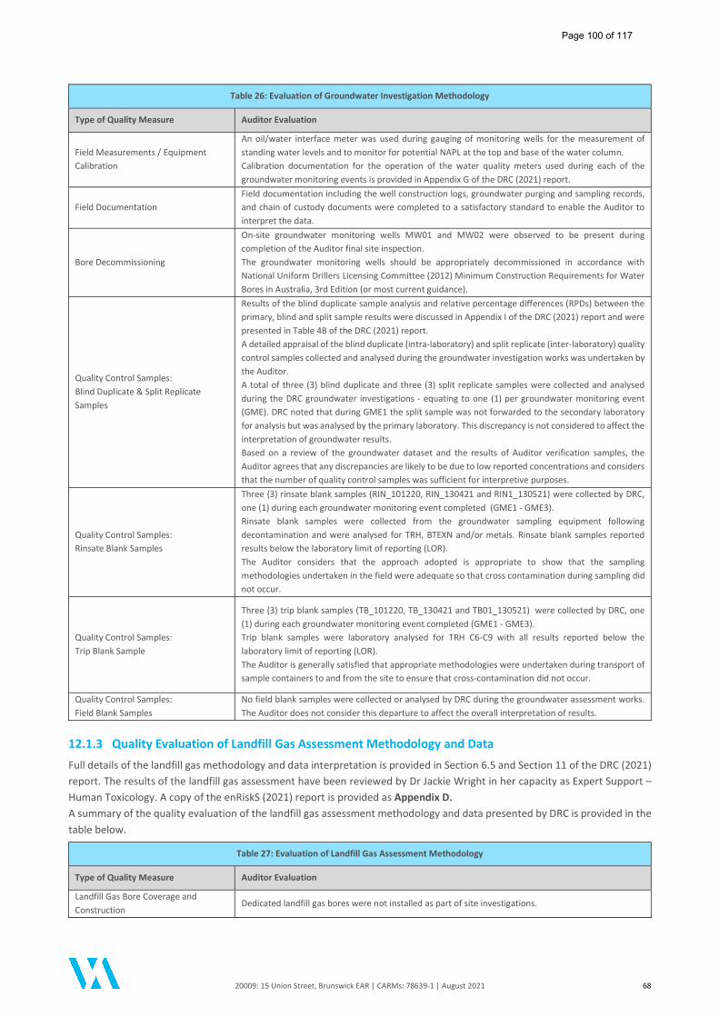
20009: 15 Union Street, Brunswick EAR | CARMs: 78639-1 | August 2021 68
Table 26: Evaluation of Groundwater Investigation Methodology
Type of Quality Measure Auditor Evaluation
Field Measurements / Equipment Calibration
An oil/water interface meter was used during gauging of monitoring wells for the measurement of standing water levels and to monitor for potential NAPL at the top and base of the water column. Calibration documentation for the operation of the water quality meters used during each of the groundwater monitoring events is provided in Appendix G of the DRC (2021) report.
Field Documentation Field documentation including the well construction logs, groundwater purging and sampling records, and chain of custody documents were completed to a satisfactory standard to enable the Auditor to interpret the data.
Bore Decommissioning
On-site groundwater monitoring wells MW01 and MW02 were observed to be present during completion of the Auditor final site inspection. The groundwater monitoring wells should be appropriately decommissioned in accordance with National Uniform Drillers Licensing Committee (2012) Minimum Construction Requirements for Water Bores in Australia, 3rd Edition (or most current guidance).
Quality Control Samples: Blind Duplicate & Split Replicate Samples
Results of the blind duplicate sample analysis and relative percentage differences (RPDs) between the primary, blind and split sample results were discussed in Appendix I of the DRC (2021) report and were presented in Table 4B of the DRC (2021) report. A detailed appraisal of the blind duplicate (intra-laboratory) and split replicate (inter-laboratory) quality control samples collected and analysed during the groundwater investigation works was undertaken by the Auditor. A total of three (3) blind duplicate and three (3) split replicate samples were collected and analysed during the DRC groundwater investigations - equating to one (1) per groundwater monitoring event (GME). DRC noted that during GME1 the split sample was not forwarded to the secondary laboratory for analysis but was analysed by the primary laboratory. This discrepancy is not considered to affect the interpretation of groundwater results. Based on a review of the groundwater dataset and the results of Auditor verification samples, the Auditor agrees that any discrepancies are likely to be due to low reported concentrations and considers that the number of quality control samples was sufficient for interpretive purposes.
Quality Control Samples: Rinsate Blank Samples
Three (3) rinsate blank samples (RIN_101220, RIN_130421 and RIN1_130521) were collected by DRC, one (1) during each groundwater monitoring event completed (GME1 - GME3). Rinsate blank samples were collected from the groundwater sampling equipment following decontamination and were analysed for TRH, BTEXN and/or metals. Rinsate blank samples reported results below the laboratory limit of reporting (LOR). The Auditor considers that the approach adopted is appropriate to show that the sampling methodologies undertaken in the field were adequate so that cross contamination during sampling did not occur.
Quality Control Samples: Trip Blank Sample
Three (3) trip blank samples (TB_101220, TB_130421 and TB01_130521) were collected by DRC, one (1) during each groundwater monitoring event completed (GME1 - GME3). Trip blank samples were laboratory analysed for TRH C6-C9 with all results reported below the laboratory limit of reporting (LOR). The Auditor is generally satisfied that appropriate methodologies were undertaken during transport of sample containers to and from the site to ensure that cross-contamination did not occur.
Quality Control Samples: Field Blank Samples
No field blank samples were collected or analysed by DRC during the groundwater assessment works. The Auditor does not consider this departure to affect the overall interpretation of results.
12.1.3 Quality Evaluation of Landfill Gas Assessment Methodology and Data
Full details of the landfill gas methodology and data interpretation is provided in Section 6.5 and Section 11 of the DRC (2021) report. The results of the landfill gas assessment have been reviewed by Dr Jackie Wright in her capacity as Expert Support – Human Toxicology. A copy of the enRiskS (2021) report is provided as Appendix D. A summary of the quality evaluation of the landfill gas assessment methodology and data presented by DRC is provided in the table below.
Table 27: Evaluation of Landfill Gas Assessment Methodology
Type of Quality Measure Auditor Evaluation
Landfill Gas Bore Coverage and Construction
Dedicated landfill gas bores were not installed as part of site investigations.
Page 100 of 117
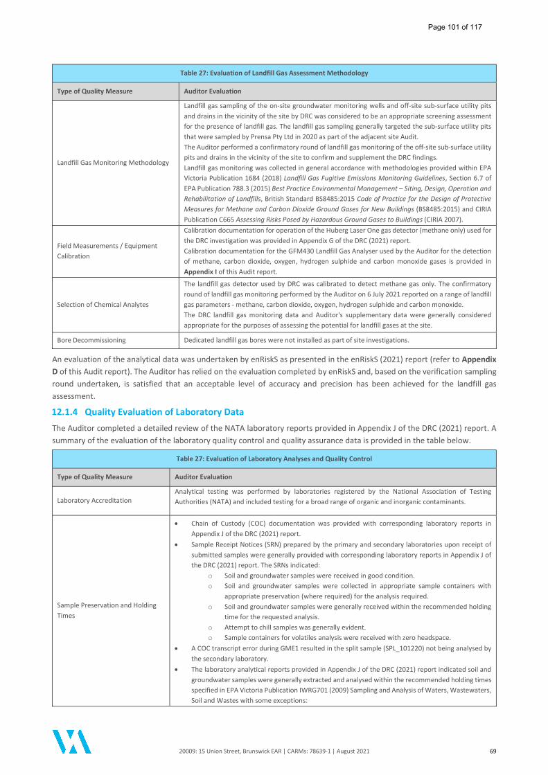
20009: 15 Union Street, Brunswick EAR | CARMs: 78639-1 | August 2021 69
Table 27: Evaluation of Landfill Gas Assessment Methodology
Type of Quality Measure Auditor Evaluation
Landfill Gas Monitoring Methodology
Landfill gas sampling of the on-site groundwater monitoring wells and off-site sub-surface utility pits and drains in the vicinity of the site by DRC was considered to be an appropriate screening assessment for the presence of landfill gas. The landfill gas sampling generally targeted the sub-surface utility pits that were sampled by Prensa Pty Ltd in 2020 as part of the adjacent site Audit. The Auditor performed a confirmatory round of landfill gas monitoring of the off-site sub-surface utility pits and drains in the vicinity of the site to confirm and supplement the DRC findings. Landfill gas monitoring was collected in general accordance with methodologies provided within EPA Victoria Publication 1684 (2018) Landfill Gas Fugitive Emissions Monitoring Guidelines, Section 6.7 of EPA Publication 788.3 (2015) Best Practice Environmental Management – Siting, Design, Operation and Rehabilitation of Landfills, British Standard BS8485:2015 Code of Practice for the Design of Protective Measures for Methane and Carbon Dioxide Ground Gases for New Buildings (BS8485:2015) and CIRIA Publication C665 Assessing Risks Posed by Hazardous Ground Gases to Buildings (CIRIA 2007).
Field Measurements / Equipment Calibration
Calibration documentation for operation of the Huberg Laser One gas detector (methane only) used for the DRC investigation was provided in Appendix G of the DRC (2021) report. Calibration documentation for the GFM430 Landfill Gas Analyser used by the Auditor for the detection of methane, carbon dioxide, oxygen, hydrogen sulphide and carbon monoxide gases is provided in Appendix I of this Audit report.
Selection of Chemical Analytes
The landfill gas detector used by DRC was calibrated to detect methane gas only. The confirmatory round of landfill gas monitoring performed by the Auditor on 6 July 2021 reported on a range of landfill gas parameters - methane, carbon dioxide, oxygen, hydrogen sulphide and carbon monoxide. The DRC landfill gas monitoring data and Auditor's supplementary data were generally considered appropriate for the purposes of assessing the potential for landfill gases at the site.
Bore Decommissioning Dedicated landfill gas bores were not installed as part of site investigations.
An evaluation of the analytical data was undertaken by enRiskS as presented in the enRiskS (2021) report (refer to Appendix D of this Audit report). The Auditor has relied on the evaluation completed by enRiskS and, based on the verification sampling round undertaken, is satisfied that an acceptable level of accuracy and precision has been achieved for the landfill gas assessment.
12.1.4 Quality Evaluation of Laboratory Data
The Auditor completed a detailed review of the NATA laboratory reports provided in Appendix J of the DRC (2021) report. A summary of the evaluation of the laboratory quality control and quality assurance data is provided in the table below.
Table 27: Evaluation of Laboratory Analyses and Quality Control
Type of Quality Measure Auditor Evaluation
Laboratory Accreditation Analytical testing was performed by laboratories registered by the National Association of Testing Authorities (NATA) and included testing for a broad range of organic and inorganic contaminants.
Sample Preservation and Holding Times
Chain of Custody (COC) documentation was provided with corresponding laboratory reports in Appendix J of the DRC (2021) report.
Sample Receipt Notices (SRN) prepared by the primary and secondary laboratories upon receipt of submitted samples were generally provided with corresponding laboratory reports in Appendix J of the DRC (2021) report. The SRNs indicated:
o Soil and groundwater samples were received in good condition. o Soil and groundwater samples were collected in appropriate sample containers with
appropriate preservation (where required) for the analysis required. o Soil and groundwater samples were generally received within the recommended holding
time for the requested analysis. o Attempt to chill samples was generally evident. o Sample containers for volatiles analysis were received with zero headspace.
A COC transcript error during GME1 resulted in the split sample (SPL_101220) not being analysed by the secondary laboratory.
The laboratory analytical reports provided in Appendix J of the DRC (2021) report indicated soil and groundwater samples were generally extracted and analysed within the recommended holding times specified in EPA Victoria Publication IWRG701 (2009) Sampling and Analysis of Waters, Wastewaters, Soil and Wastes with some exceptions:
Page 101 of 117
20009: 15 Union Street, Brunswick EAR | CARMs: 78639-1 | August 2021 70
Table 27: Evaluation of Laboratory Analyses and Quality Control
Type of Quality Measure Auditor Evaluation
o ASLP benzo(a)pyrene (BH04_0.05) - extracted 5 days outside recommended 7 day holding time.
o Total dissolved solids (MW01 and MW02 - GME3) - extracted 7 days outside recommended 7 day holding time.
o pH (MW01 and MW02 - all GMEs) - laboratory analysis performed outside 0 hours holding time.
o A laboratory reporting error resulted in VOC analysis not being reported at the requested ultra-trace detection limits in Auditor Verification groundwater sample AV02. Re-analysis of AV02 and reporting of VOCs at ultra-trace levels was outside of the recommended holding time by seven (7) days.
The holding time non-compliances are not considered to affect the overall reliance on the analytical data reported.
Laboratory Limits of Reporting
Laboratory analytical method detection limits (LORs) were generally sufficiently low to allow comparison to the soil and groundwater quality objectives adopted by DRC (and the Auditor), with some minor exceptions. Based on the dataset reviewed and the findings of the soil and groundwater assessment works, the Auditor does not consider that the raised LORs affect the useability of the data.
Auditor Verification
Four (4) Auditor Verification samples (AV01-AV04) were collected at the site in conjunction with the DRC soil and groundwater assessment works as follows:
AV01 - collected as a direct subset of DRC soil validation sample VAL_B (collected from the base of the UST excavation) on 13 November 2020;
AV02 - collected as a direct subset of groundwater sampled by DRC from MW02 on 13 May 2021; AV03 - collected as an independent sample of the imported soil material on 13 May 2021; and AV04 - collected as an independent sample of remnant on-site fill on 13 May 2021.
All Auditor Verification samples were submitted to Eurofins for analysis. Overall, the Auditor Verification sample results generally reported comparable concentrations (where available) to the primary data reported by DRC (2021) and RPDs were reported to be less than the AS4482.1 (2005) typical range of 30-50%. Table E1 in Appendix E presents RPD results for the Auditor verification sample collected. Laboratory analytical reports for the Auditor verification samples are also provided in Appendix E.
Laboratory generated Quality Control Data
Internal laboratory quality control procedures were reported by the primary and secondary laboratories. The Auditor conducted a review of the laboratory generated quality data, inclusive of:
Frequency of quality control testing; Method blanks; Internal laboratory duplicates; Matrix spikes; and Surrogate spikes.
The minor non-compliances noted in the dataset were not considered to affect the overall reliance on the data reported.
12.2 Auditor Comment on the Quality Data Set The quality control indicators as outlined in the above tables and considered in the context of the soil and groundwater datasets were overall generally acceptable and as such provide evidence that the soil and groundwater findings are reliable. There were typographical errors and omissions noted within the DRC report, figures, appendices and tables, however these do not affect the overall interpretation and reliability of the report. Where additional supporting documentation was required to be included by the Auditor, this has also been provided in Appendix I of this Audit report. The Auditor considers that adequate sampling was undertaken over the course of the assessment works completed by DRC Environmental to provide assurance regarding the quality and reliability of data. In the Auditor’s opinion, the quality and reliability of information generated from the investigations undertaken, taking into consideration all limitations identified in previous sections, were sufficient for the purposes of this Environmental Audit.
Page 102 of 117
20009: 15 Union Street, Brunswick EAR | CARMs: 78639-1 | August 2021 71
13 Audit Conclusions
Based on the findings of this Environmental Audit, the following conclusions are provided:
13.1 Soil In summary, the soil assessment results have shown that the soil representing final land surface conditions at the site reported elevated concentrations of arsenic, lead, zinc, benzo(a)pyrene, B(a)P-TEQ and TRH >C16-C34 primarily within the on-site fill and/or associated with soil material imported to site (e.g. arsenic). The soil pH was also found to be alkaline and exceeded the ecological screening criteria adopted by the Auditor. The reported heavy metals, benzo(a)pyrene, B(a)P-TEQ soil impacts are considered likely to be associated historical importation of contaminated fill and are demonstrated to be consistent with soil impacts reported in the vicinity of the site. Localised TRH impacts are potentially associated with spills and/or leakages from the former on-site UST and associated infrastructure. The reported contaminant concentrations were less than the adopted health investigation levels for the proposed high-density residential and commercial land use. Based on the proposed development (refer to Appendix B) which will involve the construction of a multi-level building with permanent paving or hardstand across the entire site footprint, there will be no opportunity for direct soil access by future site users. The reported contaminant exceedances are not considered to represent an ecological risk to the proposed high-density residential and commercial land use, subject to Statement conditions being met. The on-site soils representing final land surface conditions were generally free of staining, odours and wastes, with the exception of minor and localised petroleum hydrocarbon odour and black stained soils reported by ESG in the on-site fill at select locations. No odour or stained soils were recorded by DRC within the final land surface samples, with the exception of localised mild 'decomposing' odour and black discoloured soil recorded in shallow fill at BH09. Anthropogenic materials including fragments of gravel, brick, concrete and glass and trace amounts of coke ash and charcoal were also identified in the sub-surface fill and/or on the exposed soil surface across the site. No ACM was identified during intrusive soil investigation works, however ACM debris associated with demolition of the former on-site site building was identified and subsequently remediated and no ACM was observed on-site at the completion of the final site walkover. In accordance with the proposed development plans, the minor aesthetic soil impacts are unlikely to pose an unacceptable risk to future users of the site (subject to Statement conditions being met). The Statutory Environmental Audit was undertaken to assess the suitability of the land for all potential land uses. Based on the abovementioned findings of the assessment works, it is the Auditor’s opinion that the site in its current condition precludes one or more beneficial uses in the context of unrestricted land use. Based on the proposed land use, the Auditor considers that the remnant soils representing final land surface conditions are unlikely to pose an unacceptable ecological or human health risk to the proposed high-density residential and commercial land use, subject to Statement Conditions being met.
13.2 Groundwater In summary, concentrations of metals (boron, chromium (total), cobalt, copper, lead, manganese, nickel, selenium and zinc), nitrate (as N), nitrite (as N), total nitrogen (as N), sulphate (as SO4), sodium, chloride and TDS were reported in excess of one or more adopted beneficial use criterion in groundwater beneath the site. Low concentrations of volatile contaminants, including chlorinated hydrocarbons, toluene, xylenes and TRH >C10-C16 less naphthalene (F2), were also reported in groundwater at concentrations less than the adopted criteria. Potential vapour intrusion risks for the concentrations of VOCs reported in groundwater beneath the site were assessed as part of the enRiskS (2021) Risk Appraisal prepared by the Auditor's expert support team member, Dr. Jackie Wright. The findings of the enRiskS (2021) Risk Appraisal confirmed that the concentrations of VOCs reported in groundwater do not pose an unacceptable risk to intrusive maintenance/construction workers or future occupants of the proposed development. The conclusions provided by enRiskS relate to the proposed development, which comprises a high-density residential and commercial development with a car stacker pit across the southern portion of the site and no basement level/s.
Page 103 of 117

20009: 15 Union Street, Brunswick EAR | CARMs: 78639-1 | August 2021 72
Based on the information presented by DRC it is the Auditor’s opinion that:
The reported concentrations of heavy metals (boron, chromium (total), cobalt, copper, lead, manganese, nickel, selenium and zinc) and inorganics (sulphate [as SO4], sodium, chloride and TDS), in groundwater are likely representative of background groundwater conditions; and
Groundwater beneath the site is polluted with respect to nitrate (as N), nitrite (as N) and total nitrogen (as N), however the site is not considered to be the source of groundwater pollution and the impacts are attributed to regional pollution.
The following protected groundwater beneficial uses are precluded on-site by the identified groundwater pollution with respect to nitrate (as N), nitrite (as N) and nitrogen (as N):
Water Dependent Ecosystems and Species (not at point of discharge);
Agriculture and Irrigation (Irrigation);
Traditional Owner Cultural Values; and
Cultural and Spiritual Values.
Given that the site is not the source of the reported nitrate (as N), nitrite (as N) or total nitrogen (as N) concentrations, there is no requirement to determine whether these beneficial uses are precluded off-site or at the point of discharge. Based on the identified groundwater pollution, an Auditor-determined CUTEP process for nitrate (as N), nitrite (as N) and total nitrogen (as N) has been undertaken for this Audit. In addition, a Groundwater Quality Restricted Use Zone (GQRUZ) has been recommended for the site to ensure that future users are aware of the restrictions associated with groundwater use at the site. In accordance with Section 13 of EPA Publication 759.3 (2015) and as detailed above, there are considered to be no relevant on-site beneficial uses of groundwater. However, there are several existing and/or likely beneficial uses of groundwater in the vicinity of the site. Based on the above information pertaining to the beneficial uses of the land and groundwater at site, the Auditor notes that the beneficial uses of the land (for the proposed high-density residential and commercial development) are not affected by the groundwater impacts remaining at the site. In addition, there is no recommendation for ongoing monitoring of groundwater at the site, post completion of the Audit process and as such no Groundwater Quality Management Plan (GQMP) has been provided. Given that the site is not considered to be the source of polluted groundwater (i.e. not the polluter), there is no requirement for notification of affected stakeholders.
13.3 Adequacy of Assessment The investigations and assessment works undertaken by DRC were generally in accordance with the principles outlined in the aforementioned guidelines and standards. The Auditor concludes, in general, that the environmental assessment works completed by DRC have provided objective information regarding the contamination status of the subject site upon which the Auditor can make a judgement regarding its suitability for the proposed use. The Auditor points out that the Statement of Environmental Audit only reflects the condition of the site at the date of issue.
13.4 Outcome of Auditor’s Conclusions
13.4.1 Issue of a Certificate of Environmental Audit
The Auditor notes that the Statutory Environmental Audit was undertaken to assess the suitability of the land for all potential land uses. Based on the abovementioned findings the condition of the site is detrimental or potentially detrimental to one or more beneficial uses of the site. Accordingly, a Certificate of Environmental Audit has not been issued. The terms and conditions that need to be complied with before a Certificate of Environmental Audit may be issued are set out as follows:
Groundwater pollution (from off-site) would need to be cleaned up to restore all beneficial uses at the site.
Any remnant soil impacts, and aesthetically unsuitable material located on-site would need to be remediated and removed so that all beneficial uses of the land are restored.
If a Certificate of Environmental Audit was required for this site, a further environmental audit of the site would be needed.
Page 104 of 117

20009: 15 Union Street, Brunswick EAR | CARMs: 78639-1 | August 2021 73
13.4.2 Issue of a Statement of Environmental Audit
On the basis that some beneficial uses of land are precluded, the Auditor is unable to issue a Certificate of Environmental Audit for the site in its current condition, the reasons for which are presented in the Environmental Audit Report. Accordingly, the Auditor has reviewed the environmental assessment data for the subject site and formed an opinion that the site is conditionally suitable for the proposed high-density residential and commercial development. A Statement of Environmental Audit has therefore been issued to that effect.
The site is suitable for the beneficial uses associated with:
Sensitive use (High-Density);
Commercial; and
Industrial
Subject to the following conditions:
Condition 1
Groundwater at the site is polluted with nitrate (as N), nitrite (as N) and total nitrogen (as N) and currently precludes the beneficial uses Agriculture and Irrigation (Irrigation), Traditional Owner Cultural Values and Cultural and Spiritual Values. Groundwater must not be used for any precluded beneficial use without prior testing and review of results by a suitably qualified professional to confirm its suitability for the proposed use. It may be extracted for the purpose of environmental monitoring or remediation.
Condition 2:
This statement is directly referable to and based upon the layout and construction of the development shown and described in the attached development plans [Metaxas Architects Pty Ltd, MixedUse Development, 15 Union Street, Brunswick, revision BP2 dated 19 May 2021]. Any substantive change(s) [i.e. changes to the building footprint or incorporation of a basement] must be verified by an environmental auditor appointed pursuant to Division 1 of Part 8.3 of the Environment Protection Act 2017, and this verification advised in writing to EPA and the planning authority.
13.4.3 Other Related Information:
i. Groundwater at the site is polluted with nitrate (as N), nitrite (as N) and total nitrogen (as N) and currently precludes the beneficial uses Agriculture and Irrigation (Irrigation), Traditional Owner Cultural Values and Cultural and Spiritual Values. The groundwater is suitable for the beneficial uses Agriculture and Irrigation (Stock Watering), and Buildings and Structures.
ii. The auditor is satisfied that groundwater at the site has been cleaned up to the extent practicable and recommends the Authority identify the site as a Groundwater Quality Restricted Use Zone (also known as a GQRUZ). The extent of the recommended GQRUZ is shown on a plan appended to the Statement of Environmental Audit.
iii. In accordance with Clause 58(4) of SEPP (Waters), the Authority may require periodic reassessment of the practicability of the groundwater clean-up.
iv. Groundwater at the site also contains elevated concentrations of heavy metals (boron, chromium (total), cobalt, copper, lead, manganese, nickel, selenium and zinc) and inorganics (sulphate [as SO4], sodium, chloride and TDS. The levels are considered typical of background groundwater conditions and do not constitute pollution.
v. The remaining groundwater monitoring wells present on-site should be appropriately decommissioned within 12 months of cessation of use in accordance with the requirements of "Minimum Construction Requirements for Water Bores in Australia", published by the Land and Water Biodiversity Committee, 2012 (or most recent version).
vi. Any groundwater extracted at the site for the purpose of dewatering, construction or control of infiltration into basements, is likely to be contaminated and will require disposal to sewer (potentially requiring pre-treatment) or a licensed treatment plant, subject to the requirements of the relevant water authority.
vii. Asbestos containing materials were found on the site and have been removed as far as practicable. Small quantities of bonded asbestos cement (AC) fragments may remain within the soil and be uncovered during excavation works. These AC fragments are not anticipated to represent a health risk to occupiers of the completed development. If encountered during future development or use of the site, any fragments must be handled and disposed in accordance with the relevant regulations.
Page 105 of 117
20009: 15 Union Street, Brunswick EAR | CARMs: 78639-1 | August 2021 74
viii. Scattered pieces of gravel, brick, concrete and glass and trace amounts of coke ash and charcoal have been reported on the site. Minor occurrences may remain within the soil and be exposed during excavation works, development or occupation of the site.
ix. Some soil may contain mild odours and staining at some locations on the site. This material is not considered to represent a health or ecological risk but may cause a noticeable odour if exposed during excavation works, development or occupation of the site.
x. The pH levels, sulphate and chloride concentrations in the on-site soil and groundwater soil indicate non-aggressive exposure settings for steel and concrete structures in accordance with AS2159 (2009). Cognisance should be given to the exposure classifications for concrete and/or steel piles as provided in AS2159 (2009).
xi. Soil pH is neutral to alkaline across the site but is considered natural in origin. Local plants and grasses are likely to be adapted to these pH levels; however, there may be some impact on the growth and development of some introduced plants, grasses and fauna.
xii. Any soil material proposed to be removed from site and disposed off-site must be classified and managed in accordance with relevant statutory regulations and Environment Protection Authority guidelines.
xiii. Any fill or soil imported to the site must be chemically tested soil or fill that classifies as ‘fill material’ in accordance with relevant EPA guidelines.
xiv. Not all land uses for which the land is considered suitable by this audit may be allowed under the existing zoning of Moreland City Council.
xv. In accordance with Section 53ZE of the Environment Protection Act 1970, the owner/occupier of the site must provide a copy of this Statement of Environmental Audit to any person who becomes or proposes to become an occupier of the site.
14 Application of this Report
The report should not be separated or reproduced in part and should be read in its entirety.
Vic Audits Report prepared by: Sally Bonham Environmental Auditor (appointed pursuant to the Environment Protection Act, 1970)3 Dated: 9 August 2021
3 On 01 July 2021, the new Environment Protection Act 2017 (new EP Act) came into effect. As outlined in EPA Publication 1978: Transition Guidance for Environmental Auditors (June 2020), Section 478 of the new EP Act provides that an Environmental Auditor can complete an existing Environmental Audit (that has not been completed as of 01 July 2021) under EP Act 1970. Under section 478(3)(a) of EP Act 2017, if an Auditor proceeds to continue to conduct an Audit under EP Act 1970 then Part IXD of EP Act 1970 continues in effect as if it had not been repealed. An Environmental Audit Report and Certificate or Statement of Environmental Audit issued under Part IXD of EP Act 1970 after 1 July 2021 are also taken to satisfy the requirements of Part 8.3 of the EP Act 2017.
Page 106 of 117

20009: 15 Union Street, Brunswick EAR | CARMs: 78639-1 | June 2021
Abbreviations
Page 107 of 117
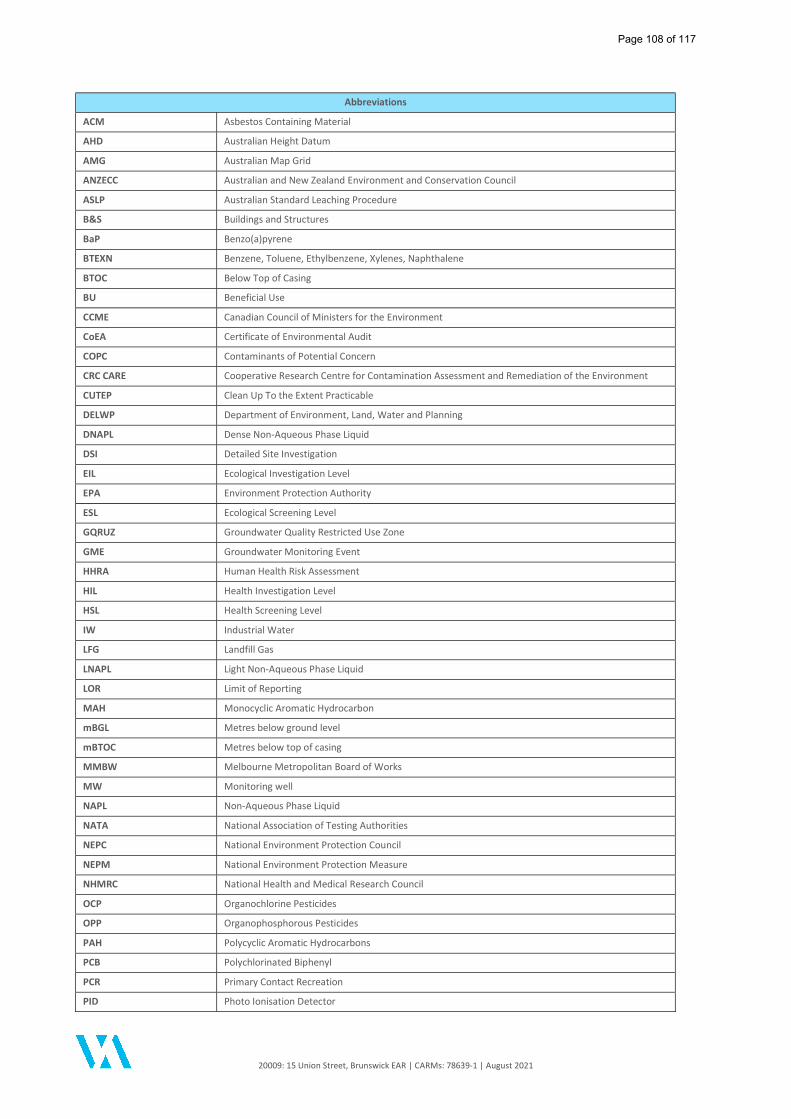
20009: 15 Union Street, Brunswick EAR | CARMs: 78639-1 | August 2021
Abbreviations
ACM Asbestos Containing Material
AHD Australian Height Datum
AMG Australian Map Grid
ANZECC Australian and New Zealand Environment and Conservation Council
ASLP Australian Standard Leaching Procedure
B&S Buildings and Structures
BaP Benzo(a)pyrene
BTEXN Benzene, Toluene, Ethylbenzene, Xylenes, Naphthalene
BTOC Below Top of Casing
BU Beneficial Use
CCME Canadian Council of Ministers for the Environment
CoEA Certificate of Environmental Audit
COPC Contaminants of Potential Concern
CRC CARE Cooperative Research Centre for Contamination Assessment and Remediation of the Environment
CUTEP Clean Up To the Extent Practicable
DELWP Department of Environment, Land, Water and Planning
DNAPL Dense Non-Aqueous Phase Liquid
DSI Detailed Site Investigation
EIL Ecological Investigation Level
EPA Environment Protection Authority
ESL Ecological Screening Level
GQRUZ Groundwater Quality Restricted Use Zone
GME Groundwater Monitoring Event
HHRA Human Health Risk Assessment
HIL Health Investigation Level
HSL Health Screening Level
IW Industrial Water
LFG Landfill Gas
LNAPL Light Non-Aqueous Phase Liquid
LOR Limit of Reporting
MAH Monocyclic Aromatic Hydrocarbon
mBGL Metres below ground level
mBTOC Metres below top of casing
MMBW Melbourne Metropolitan Board of Works
MW Monitoring well
NAPL Non-Aqueous Phase Liquid
NATA National Association of Testing Authorities
NEPC National Environment Protection Council
NEPM National Environment Protection Measure
NHMRC National Health and Medical Research Council
OCP Organochlorine Pesticides
OPP Organophosphorous Pesticides
PAH Polycyclic Aromatic Hydrocarbons
PCB Polychlorinated Biphenyl
PCR Primary Contact Recreation
PID Photo Ionisation Detector
Page 108 of 117
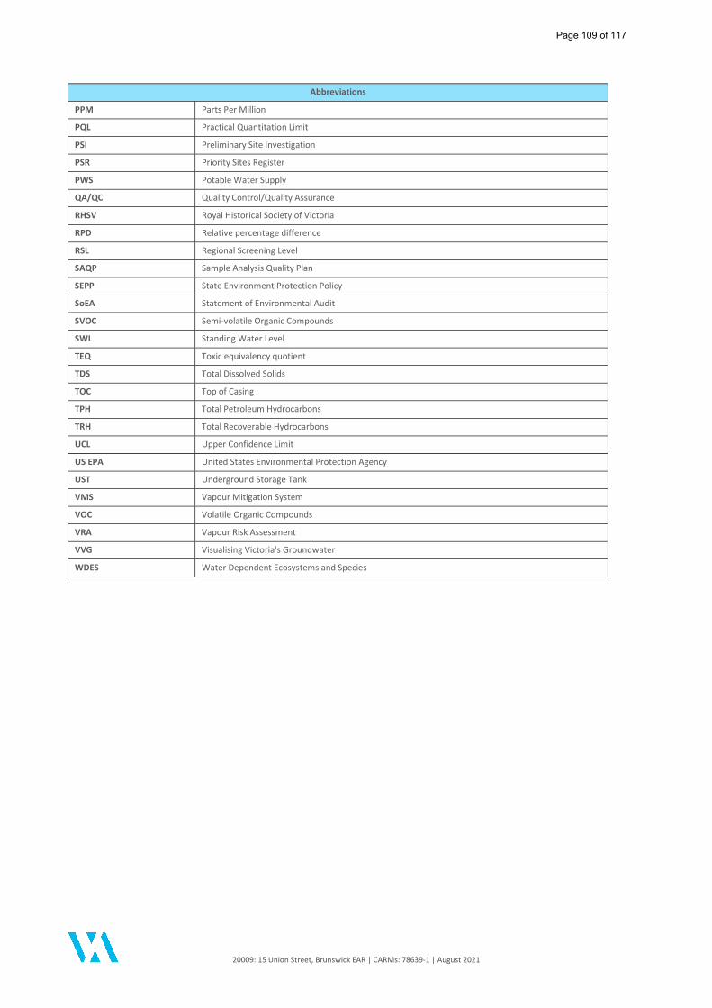
20009: 15 Union Street, Brunswick EAR | CARMs: 78639-1 | August 2021
Abbreviations
PPM Parts Per Million
PQL Practical Quantitation Limit
PSI Preliminary Site Investigation
PSR Priority Sites Register
PWS Potable Water Supply
QA/QC Quality Control/Quality Assurance
RHSV Royal Historical Society of Victoria
RPD Relative percentage difference
RSL Regional Screening Level
SAQP Sample Analysis Quality Plan
SEPP State Environment Protection Policy
SoEA Statement of Environmental Audit
SVOC Semi-volatile Organic Compounds
SWL Standing Water Level
TEQ Toxic equivalency quotient
TDS Total Dissolved Solids
TOC Top of Casing
TPH Total Petroleum Hydrocarbons
TRH Total Recoverable Hydrocarbons
UCL Upper Confidence Limit
US EPA United States Environmental Protection Agency
UST Underground Storage Tank
VMS Vapour Mitigation System
VOC Volatile Organic Compounds
VRA Vapour Risk Assessment
VVG Visualising Victoria's Groundwater
WDES Water Dependent Ecosystems and Species
Page 109 of 117

20009: 15 Union Street, Brunswick EAR | CARMs: 78639-1 | August 2021
References
Page 110 of 117
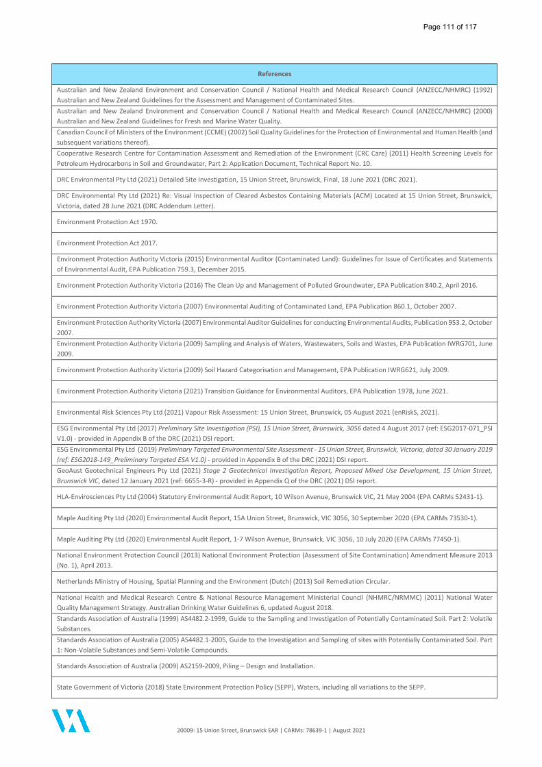
20009: 15 Union Street, Brunswick EAR | CARMs: 78639-1 | August 2021
References
Australian and New Zealand Environment and Conservation Council / National Health and Medical Research Council (ANZECC/NHMRC) (1992) Australian and New Zealand Guidelines for the Assessment and Management of Contaminated Sites. Australian and New Zealand Environment and Conservation Council / National Health and Medical Research Council (ANZECC/NHMRC) (2000) Australian and New Zealand Guidelines for Fresh and Marine Water Quality. Canadian Council of Ministers of the Environment (CCME) (2002) Soil Quality Guidelines for the Protection of Environmental and Human Health (and subsequent variations thereof). Cooperative Research Centre for Contamination Assessment and Remediation of the Environment (CRC Care) (2011) Health Screening Levels for Petroleum Hydrocarbons in Soil and Groundwater, Part 2: Application Document, Technical Report No. 10.
DRC Environmental Pty Ltd (2021) Detailed Site Investigation, 15 Union Street, Brunswick, Final, 18 June 2021 (DRC 2021).
DRC Environmental Pty Ltd (2021) Re: Visual Inspection of Cleared Asbestos Containing Materials (ACM) Located at 15 Union Street, Brunswick, Victoria, dated 28 June 2021 (DRC Addendum Letter).
Environment Protection Act 1970.
Environment Protection Act 2017.
Environment Protection Authority Victoria (2015) Environmental Auditor (Contaminated Land): Guidelines for Issue of Certificates and Statements of Environmental Audit, EPA Publication 759.3, December 2015.
Environment Protection Authority Victoria (2016) The Clean Up and Management of Polluted Groundwater, EPA Publication 840.2, April 2016.
Environment Protection Authority Victoria (2007) Environmental Auditing of Contaminated Land, EPA Publication 860.1, October 2007.
Environment Protection Authority Victoria (2007) Environmental Auditor Guidelines for conducting Environmental Audits, Publication 953.2, October 2007. Environment Protection Authority Victoria (2009) Sampling and Analysis of Waters, Wastewaters, Soils and Wastes, EPA Publication IWRG701, June 2009.
Environment Protection Authority Victoria (2009) Soil Hazard Categorisation and Management, EPA Publication IWRG621, July 2009.
Environment Protection Authority Victoria (2021) Transition Guidance for Environmental Auditors, EPA Publication 1978, June 2021.
Environmental Risk Sciences Pty Ltd (2021) Vapour Risk Assessment: 15 Union Street, Brunswick, 05 August 2021 (enRiskS, 2021).
ESG Environmental Pty Ltd (2017) Preliminary Site Investigation (PSI), 15 Union Street, Brunswick, 3056 dated 4 August 2017 (ref: ESG2017-071_PSI V1.0) - provided in Appendix B of the DRC (2021) DSI report. ESG Environmental Pty Ltd (2019) Preliminary Targeted Environmental Site Assessment - 15 Union Street, Brunswick, Victoria, dated 30 January 2019 (ref: ESG2018-149_Preliminary Targeted ESA V1.0) - provided in Appendix B of the DRC (2021) DSI report. GeoAust Geotechnical Engineers Pty Ltd (2021) Stage 2 Geotechnical Investigation Report, Proposed Mixed Use Development, 15 Union Street, Brunswick VIC, dated 12 January 2021 (ref: 6655-3-R) - provided in Appendix Q of the DRC (2021) DSI report.
HLA-Envirosciences Pty Ltd (2004) Statutory Environmental Audit Report, 10 Wilson Avenue, Brunswick VIC, 21 May 2004 (EPA CARMs 52431-1).
Maple Auditing Pty Ltd (2020) Environmental Audit Report, 15A Union Street, Brunswick, VIC 3056, 30 September 2020 (EPA CARMs 73530-1).
Maple Auditing Pty Ltd (2020) Environmental Audit Report, 1-7 Wilson Avenue, Brunswick, VIC 3056, 10 July 2020 (EPA CARMs 77450-1).
National Environment Protection Council (2013) National Environment Protection (Assessment of Site Contamination) Amendment Measure 2013 (No. 1), April 2013.
Netherlands Ministry of Housing, Spatial Planning and the Environment (Dutch) (2013) Soil Remediation Circular.
National Health and Medical Research Centre & National Resource Management Ministerial Council (NHMRC/NRMMC) (2011) National Water Quality Management Strategy. Australian Drinking Water Guidelines 6, updated August 2018. Standards Association of Australia (1999) AS4482.2-1999, Guide to the Sampling and Investigation of Potentially Contaminated Soil. Part 2: Volatile Substances. Standards Association of Australia (2005) AS4482.1-2005, Guide to the Investigation and Sampling of sites with Potentially Contaminated Soil. Part 1: Non-Volatile Substances and Semi-Volatile Compounds.
Standards Association of Australia (2009) AS2159-2009, Piling – Design and Installation.
State Government of Victoria (2018) State Environment Protection Policy (SEPP), Waters, including all variations to the SEPP.
Page 111 of 117
20009: 15 Union Street, Brunswick EAR | CARMs: 78639-1 | August 2021
References
State Government of Victoria (1997) State Environment Protection Policy (SEPP), Groundwaters of Victoria, including all variations to the SEPP.
State Government of Victoria (2003) State Environment Protection Policy (SEPP), Waters of Victoria, including all variations to the SEPP.
State Government of Victoria (2002) State Environment Protection Policy (SEPP), Prevention and Management of Contamination of Land.
United States Environmental Protection Agency (US EPA) (May 2021) Regional Screening Levels.
Page 112 of 117

20009: 15 Union Street, Brunswick EAR | CARMs: 78639-1 | August 2021
Figures
Page 113 of 117
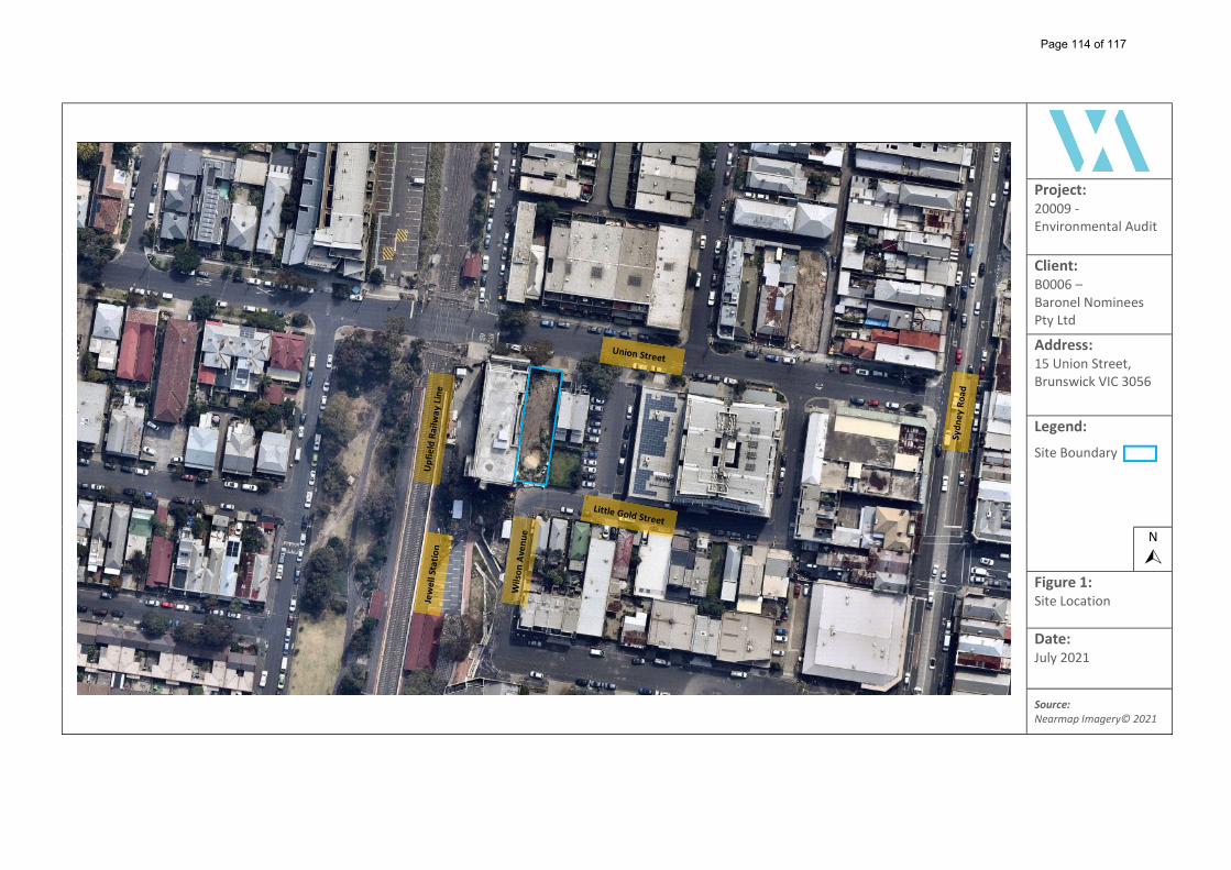
Project: 20009 - Environmental Audit
Client: B0006 – Baronel Nominees Pty Ltd
Address: 15 Union Street, Brunswick VIC 3056
Legend:
Site Boundary
N
Figure 1: Site Location
Date: July 2021
Source: Nearmap Imagery© 2021
Page 114 of 117
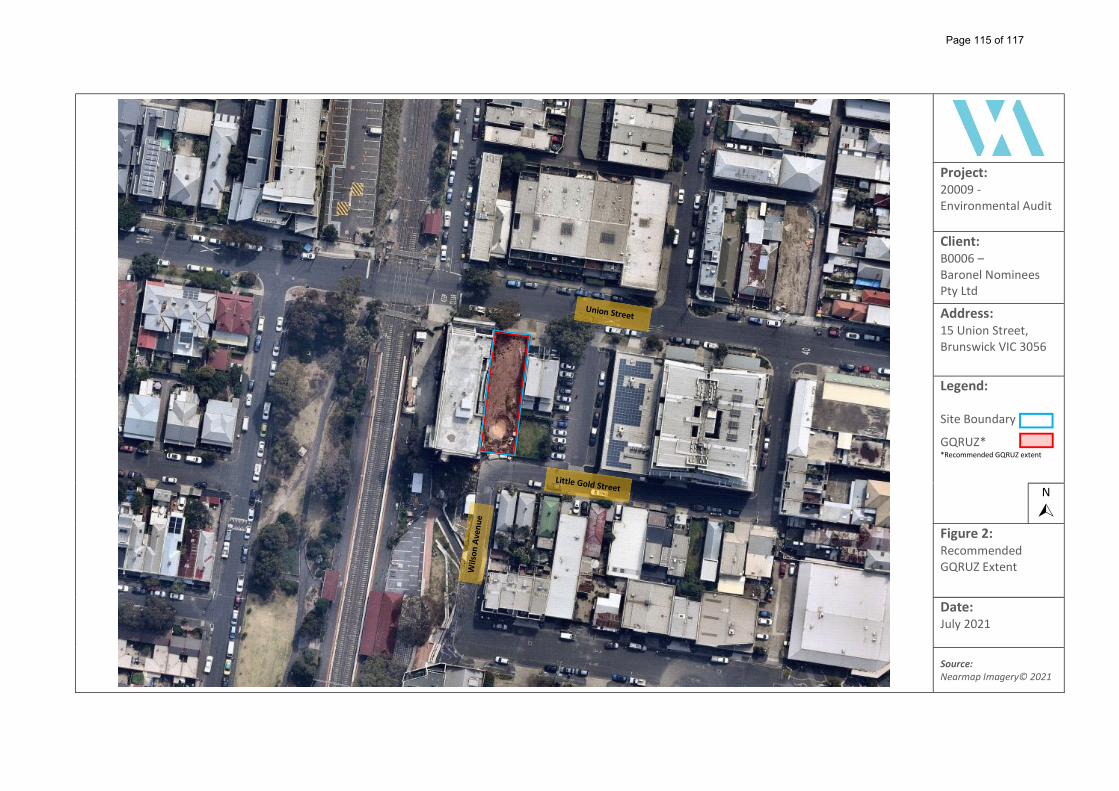
Project: 20009 - Environmental Audit
Client: B0006 – Baronel Nominees Pty Ltd
Address: 15 Union Street, Brunswick VIC 3056
Legend: Site Boundary
GQRUZ* *Recommended GQRUZ extent
N
Figure 2: Recommended GQRUZ Extent
Date: July 2021
Source: Nearmap Imagery© 2021
Page 115 of 117
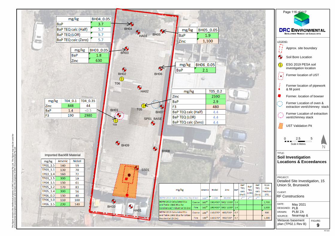
A4 size
TITLE:
N
0
Scale in Metres
XX
DATE:
DESIGNED:
DRAWN:
SOURCE:
PROJECT:
CLIENT:
FIGURE:
LEGEND:
Th
is fig
ure
rem
ain
s th
e in
telle
ctual p
ropert
y of D
RC
Envi
ronm
enta
l Pty
Ltd
. e
nvi
ronm
enta
l desc
riptio
n p
urp
ose
s T
his
fig
ure
may
only
be u
sed for
and r
em
ain
s th
e p
ropert
y of D
RC
Envi
ronm
enta
l Pty
Ltd
.
44.10
44.30
44.17
06
4
1.25 97˚ 37' 10"
10.67 277˚ 37' 10"
38.10 186˚ 23' 10"
38.12 5˚ 30' 20"
NO
.13TH
REE STO
REY
APARTM
ENT
BUILD
ING
"VACAN
T" GR
ASS
CONCRETEDRIVEWAY
NO
.17PR
OPO
SEDN
INE STO
REY
APARTM
ENT
BUILD
ING
ELCO
MPIT
EXISTING
PALING
FENC
E
EXISTING
STEELPAN
EL FENC
E
SIGN
P.O.S
BBTP4.01
BBTP4.01
CCTP04.2
CCTP04.2
CAR
STACKER
SQ
UAD
RU
PLE20 C
AR SPAC
ES
10000L IN G
RO
UN
DR
AINW
ATER TAN
K
CAR
PARK
A: 117 m2
Approx. site boundary
Soil InvestigationLocations & Exceedances
Detailed Site Investigation, 15Union St, Brunswick
RF Constructions
May 2021PLBPLB/ ZANearmap &
9
T04
T05
T06
Soil Bore Location
ESG 2019 PESA soilinvestigation location
N
Former location of UST
Former location of pipework& fill point
Former. location of bowser
Former Location of oven &extraction vent/chimney stack
Former Location of extractionvent/chimney stack
Metaxas basementplan (TP02.1 Rev B)
BH04
BH05
BH06
BH03
BH01
BH02
0
Scale in Metres
XX 52.50
BH07
BH08
BH09
BH10
UST Validation Pit
SP01_BASE
mg/kg
Imported Backfill Material
SS01
HA02
HA03
HA01
Page 116 of 117
KiriMcDonnell
Text Box
FIGURE 3: SOIL EXCEEDANCE PLAN
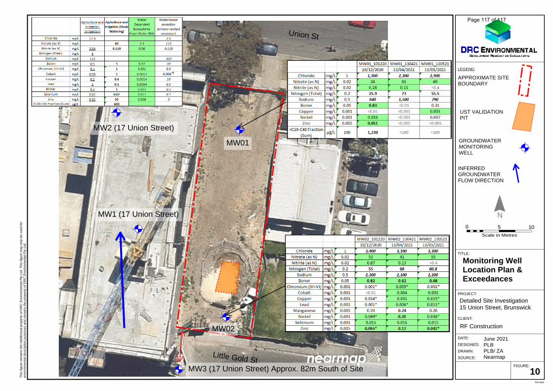
A4 size
TITLE:
N
0
Scale in Metres
XX
DATE:
DESIGNED:
DRAWN:
SOURCE:
PROJECT:
CLIENT:
FIGURE:
LEGEND:
Th
is fig
ure
rem
ain
s th
e in
telle
ctual p
ropert
y of D
RC
Envi
ronm
enta
l Pty
Ltd
. e
nvi
ronm
enta
l desc
riptio
n p
urp
ose
s T
his
fig
ure
may
only
be u
sed for
and r
em
ain
s th
e p
ropert
y of D
RC
Envi
ronm
enta
l Pty
Ltd
.
APPROXIMATE SITEBOUNDARY
Little Gold St
MW01
MW02
UST VALIDATIONPIT
Union St
GROUNDWATERMONITORINGWELL
Monitoring WellLocation Plan &Exceedances
Detailed Site Investigation15 Union Street, Brunswick
RF Construction
June 2021PLBPLB/ ZANearmap
0
Scale in Metres
XX 1050
10
MW2 (17 Union Street)
MW1 (17 Union Street)
MW3 (17 Union Street) Approx. 82m South of Site
INFERREDGROUNDWATERFLOW DIRECTION
Page 117 of 117
KiriMcDonnell
Text Box
FIGURE 4: GROUNDWATER EXCEEDANCE PLAN
Related Documents