Marine Geology, 34 (1980) 61--78. 61 © Elsevier Scientific Publishing Company, Amsterdam -- Printed in The Netherlands INFLUENCE OF SAN GABRIEL SUBMARINE CANYON ON NARROW- SHELF SEDIMENT DYNAMICS, SOUTHERN CALIFORNIA HERMAN A. KARL U.S. Geological Survey, Menlo Park, Calif. 94025 (U.S.A.) (Received January 25, 1979; revised and accepted March 28, 1979) ABSTRACT Karl, H.A., 1980. Influence of San Gabriel Submarine Canyon on narrow-shelf sediment dynamics, southern California. Mar. Geol., 34: 61--78. Variations in the concentration of total suspended particulate matter (TSM) collected 1 m above bottom, changes in vertical profiles of light transmission, and substrate textural patterns reveal a corridor for preferential sediment transport on San Pedro continental shelf, California. During the winter, this corridor, designated the preferential transport corridor (PTC), is defined by higher concentrations of TSM relative to the rest of the shelf and extends for 10--15 km from the inner shelf to the head of San Gabriel Submarine Canyon. Vertical profiles of light transmission within the PTC suggest density strati- fication throughout the water column and apparent mixing in the upper 15--20 m of water column on either side of the PTC. The PTC is not as fully developed during the summer. Excursions in isopleths of substrate textural variables perpendicular to isobaths in the PTC suggest that although the PTC is seasonally episodic, it recurs regularly over a longer period. A conceptual model attributes the PTC to modification of shelf circulation patterns by San Gabriel Canyon. Surface waves diverge over the canyon head resulting in differential wave set up at the shore face. This forces back turbid nearshore water for a distance of a few kilometers toward the canyon. At some point on the shelf, seaward nearshore flow overlaps offshore currents generated or modified by internal waves focused onto the shelf by the canyon and/or turbulent eddies produced by flow separation in currents moving across the canyon axis. At times, these subtle processes overprint tidal and wind-driven currents and thereby create the PTC. The model suggests that canyons heading several kilometers from shore can have a regulatory effect on narrow-shelf sediment dynamics. INTRODUCTION Numerous investigators have studied the physiography of submarine canyons and the dynamic processes operating within these impressive features (see, e.g., Shepard, 1963; Shepard and Dill, 1966; Shepard and Marshall, 1969, 1973; Drake and Gorsline, 1973; Stanley and Kelling, 1978). Most studies have focused on canyons as conduits for detritus from the continental shelf to deep ocean basins. Almost parenthetically, a few previous studies discussed the interaction between currents in the canyons and water circulation on the continental shelf. Beer and Gorsline (1971) noted that downweUing currents

Welcome message from author
This document is posted to help you gain knowledge. Please leave a comment to let me know what you think about it! Share it to your friends and learn new things together.
Transcript
Marine Geology, 34 (1980) 61--78. 61 © Elsevier Scientific Publishing Company, Amsterdam -- Printed in The Netherlands
I N F L U E N C E O F S A N G A B R I E L S U B M A R I N E C A N Y O N O N N A R R O W - S H E L F S E D I M E N T D Y N A M I C S , S O U T H E R N C A L I F O R N I A
HERMAN A. KARL
U.S. Geological Survey, Menlo Park, Calif. 94025 (U.S.A.)
(Received January 25, 1979; revised and accepted March 28, 1979)
ABSTRACT
Karl, H.A., 1980. Influence of San Gabriel Submarine Canyon on narrow-shelf sediment dynamics, southern California. Mar. Geol., 34: 61--78.
Variations in the concentration of total suspended particulate matter (TSM) collected 1 m above bot tom, changes in vertical profiles of light transmission, and substrate textural patterns reveal a corridor for preferential sediment transport on San Pedro continental shelf, California. During the winter, this corridor, designated the preferential transport corridor (PTC), is defined by higher concentrations of TSM relative to the rest of the shelf and extends for 10--15 km from the inner shelf to the head of San Gabriel Submarine Canyon. Vertical profiles of light transmission within the PTC suggest density strati- fication throughout the water column and apparent mixing in the upper 15--20 m of water column on either side of the PTC. The PTC is not as fully developed during the summer. Excursions in isopleths of substrate textural variables perpendicular to isobaths in the PTC suggest that although the PTC is seasonally episodic, it recurs regularly over a longer period.
A conceptual model at tr ibutes the PTC to modification of shelf circulation pat terns by San Gabriel Canyon. Surface waves diverge over the canyon head resulting in differential wave set up at the shore face. This forces back turbid nearshore water for a distance of a few kilometers toward the canyon. At some point on the shelf, seaward nearshore flow overlaps offshore currents generated or modified by internal waves focused onto the shelf by the canyon and/or turbulent eddies produced by flow separation in currents moving across the canyon axis. At times, these subtle processes overprint tidal and wind-driven currents and thereby create the PTC. The model suggests that canyons heading several kilometers from shore can have a regulatory effect on narrow-shelf sediment dynamics.
INTRODUCTION
N u m e r o u s i n v e s t i g a t o r s have s t u d i e d t h e p h y s i o g r a p h y o f s u b m a r i n e c a n y o n s a n d t h e d y n a m i c p r o c e s s e s o p e r a t i n g w i t h i n t h e s e i m p r e s s i v e f e a t u r e s (see , e.g. , S h e p a r d , 1 9 6 3 ; S h e p a r d a n d Di l l , 1 9 6 6 ; S h e p a r d a n d M a r s h a l l , 1 9 6 9 , 1 9 7 3 ; D r a k e a n d G o r s l i n e , 1 9 7 3 ; S t a n l e y a n d K e l l i n g , 1 9 7 8 ) . M o s t s t u d i e s h a v e f o c u s e d o n c a n y o n s as c o n d u i t s f o r d e t r i t u s f r o m t h e c o n t i n e n t a l s h e l f t o d e e p o c e a n bas ins . A l m o s t p a r e n t h e t i c a l l y , a f e w p r e v i o u s s t u d i e s d i s c u s s e d t h e i n t e r a c t i o n b e t w e e n c u r r e n t s in t h e c a n y o n s a n d w a t e r c i r c u l a t i o n o n t h e c o n t i n e n t a l she l f . Bee r a n d G o r s l i n e ( 1 9 7 1 ) n o t e d t h a t d o w n w e U i n g c u r r e n t s

62
over the head of Redondo Submarine Canyon, California siphoned suspended sediment from the adjacent shelf. Lyall et al. (197]) reported a similar drainin;: of shelf water through Wilmington Canyon, Delaware. Knebel and Folger (1976) attributed sandwaves around the head of Wilmington Canyon to cur- rents modified or generated by the canyon. Felix and Gorsline ( 1971 ) discussed the interplay among coastal processes in relation to the formation of Newport Submarine Canyon, California. [nman et al. {1976) published a provocative analysis of the interaction of Scripps Submarine Canyon, California, with oceanographic and atmospheric processes.
These investigations have described canyons heading within 1 km of shore (the U.S. West Coast "sand canyon") and those on the U.S. East Coast heading more than 100 km from shore. This report describes the distribution of sus- pended particulates 1 m above bottom, the relative water turbidity, and the textural properties of surficial sediment on San Pedro continental shelf, California. Analysis of these data suggests that San Gabriel Submarine Canyon, heading about 10---15 km from shore, influences pathways of sediment trans- port from shoreface to shelf break over a proportionately larger area of shelf than canyons heading closer to or farther from shore. The purpose of this report is to develop a conceptual model to explain the canyon's influence on shelfwide sediment dynamics
STUDY AREA
The continental shelf off southern California is compartmentalized into a series of littoral transport cells bounded on their downdrift ends by submarine canyons (Emery, 1960; Inman and Frautschy, 1966). San Pedro Bay, the area of study, encompasses the cell that begins just east of Palos Verdes Peninsula and terminates where Newport Submarine Canyon incises the shelf at the east end (Fig.l).
San Pedro shelf varies in width from about 20 km at its widest point to about 3 km at its east and west boundaries. Two canyons, San Pedro Sea Valley and San Gabriel Submarine Canyon, indent the outer area of the flat, gently sloping, wide segments of shelf (Fig.l). These canyons do not head close enough to shore to intercept sand moving downcoast in the longshore transport system. Newport Canyon, the east terminus of the cell, does head within the longshore drift but may no longer be active (Felix and Gorsline, 1971 ; Drake and Gorsline, 1973}.
Three water circulation seasons, generated by seasonal atmospheric-pressure cells, occur along the coast of California (Pirie et al., 1975). The Oceanic Period, characterized by the south-flowing California Current, begins in July and lasts until November. From the middle of November to mid-February, the north- flowing Davidson Current dominates nearshore current patterns. The third season, Upwelling, starts around the middle of February and continues until the end of July but off southern California is best developed in May and June. Upwelling and the Davidson Current may not be well developed in any given year. Local winds, tides, waves and river discharge compound the effects of

63
I I
LONG BEACH
.... :.i':: ~ ;~.i ............ .. •
"i . ." 0 I Z 3 4 5 ~ - - L O ~ E A C H BREAKWATER ~ KM
FERMIN~ ~ ~o .3--~ ~ ~ f o - - ~ . . . . . ~ ~ - 5 0 - FATHOMS
,o~ ~ G A S R I E L ~ ~ ~ - " f ~'NEwPORT ..... " ~ ~ ' C A N Y O N ~ ~ ~ CANYON
SAN PEDRO CHANNEL
,m I zo ,,7155
Fig.1. General bathymetry and geography of San Pedro continental shelf, southern California.
major offshore current systems to create very complicated surface-circulation patterns over the continental shelf. In general, at distances greater than 4--8 km offshore, surface transport in the area of San Pedro Bay appears to be toward either the west or south. Areas closer to shore seem to be dominated by a series of small local gyres that cause mixed transport (Bunnell, 1969; Pirie et al., 1975). Less information exists on the details of subsurface current pat- terns over San Pedro shelf.
Virtually nothing is known about currents in the canyons incising San Pedro shelf. From studies of other West Coast canyons, F.P. Shepard and his colleagues at the Scripps Institution of Oceanography have found that currents flow alternately upcanyon and downcanyon and occasionally crosscanyon; net transport is downcanyon (Shepard and Marshall, 1969, 1973; Shepard et al., 1974a). Shepard et al. (1974a, b) at tr ibuted currents moving parallel with the canyon axis to internal tides and waves propagating shoreward, and attri- buted crosscanyon flow to surface winds. Internal waves travel faster in can- yons than on the continental shelf (Lee, 1961; Shepard et al., 1974b; Winant, 1974). Apel et al. (1975) interpreted features seen on computer-enhanced LANDSAT images as packets of high-frequency internal waves generated in long-period cycles by the morphology around the head of Hudson Canyon.
64
Internal waves propagating shoreward shoal and break when they impinge upon the sea floor (Southard and Cacchione, 1972; Cacchione and Wunsch, 1974). Internal surf generates a characteristic density microstructure and a seaward return flow within the water column (LaFond, 1961, 1962; Southard and Cacchione, 1972). Laboratory experiments and theoretical calculations show that breaking internal waves resuspend and transport fine sediment (Southard and Cacchione, 1972; Cacchione and Southard, 1974). Internal surf has been identified in areas of the southern California continental shelf (LaFond, 1961, 1962; Lee, 1961; Cains, 1967; Emery and Gunnersen, 1973; Winant, 1974; Karl, 1976). Because the canyons seem to funnel internal tides and generate high-frequency internal waves, breaking may be more frequent or intense in a zone on the shelf adjacent to the canyon head. Currents in the canyon and boundary currents along the shelf break flowing past the canyon can generate eddies and vortices over the canyon head (Gorsline, 1970; Inman et ai., 1976). The effects of tides and internal waves on canyon processes de- crease where canyons head close to shore in shallow water; here, surface waves, winds, and edge waves dominate canyon currents (Inman et al., 1976).
So, there is probably a spectrum of interactions from shore-heading canyons through shore-separated canyons, such that submarine canyons probably main- rain an umbilical link with shoreface processes until some critical distance from shore is reached at which point the umbilicus is broken and the canyons then effect shelf processes only in that small area of shelf around the canyon head. This paper will offer some evidence to support that view
METHODS
Turbidity of the water column was measured with a profiling light-beam transmissometer; increasing percent transmission indicates decreasing tur- bidity (less suspended sediment in the water column). Absolute concentration of suspended solids was determined by conventional methods. Water 1 m above bot tom was sampled using a 30-1 Niskin bottle modified to close when a weighted line contacted the seabed. At sea, 2--4 liter aliquots of water from the Niskin bottles were passed through preweighed Nuclepore filters (nominal pore size, 0.4/am) by vacuum pumps; the filters were rinsed with distilled water and placed in covered petri dishes. Onshore the filters were dried in an oven and weighed, and the concentration of total suspended particulate matter calculated as milligrams of suspensate per liter of seawater.
Grain-size distributions were determined by sampling from the upper 2 cm of a box core collected with an NEL box coring apparatus. These samples were analyzed by standard pipette techniques for the fine-sediment (<62 ~m) and by settling tube techniques for the coarse-sediment (> 62 pm) fractions {see Cook, 1969; Felix, 1969; Royse, 1970).
RESULTS
Three surveys, in December 1973, August 1974, and December 1974
65
sampled the distribution of total suspended particulate matter (TSM) 1 m above the bo t tom of San Pedro shelf (Figs.2--4). Transmissometer casts were made during August and December 1974. For each survey, stations were occupied consecutively over a 1--2<lay period. Textural properties of the sea floor were determined from more than 100 box cores collected over a 3-year period from 1973--1975; the majority were collected during the fall and winter of 1974.
Total suspended matter
Figs.2--4 clearly show temporal variability in the concentration of TSM. Lower overall concentrations during August 1974 than during December 1973 and 1974 demonstrate a seasonal variability in the amount of sediment sus- pended 1 m above bot tom. Spatial distribution of TSM for each survey shows a general seaward gradient of decreasing concentration interrupted by several small anomalies. Trends of isopleths tend to parallel isobaths, but notable ex- ceptions occur; winter patterns show greater complexity than summer patterns.
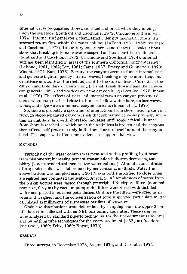
Distribution and concentrations of TSM during December 1973 and 1974 reveal similar patterns and values (Figs.2, 4). Four major areas of perturbation in isopleths, evident as tongues of high concentrations of TSM shooting across
< 2 2 3 4 > 4
Mn/O
Fig.2. Areal distribution o f absolute concentration (mg/l) o f total suspended matter in samples collected 1 m above bottom during December 1973. A, B, C, and D identify areas referred to in text and coincide with areas shown in Figs.3 and 4. Dots indicate station locations.

66
Mg/~.
........ B /
A
\
0
. . . . . : T ~ : - -: : ~ S A N Ki lometers
GABRIEL CA N YON
\ \
C \
Fig.3. Areal d i s t r i bu t i on o f abso lu te c o n c e n t r a t i o n (mg/ l ) o f to ta l suspended m a t t e r samples col lec ted 1 m above b o t t o m dur ing Augus t 1974. A, B, C, and D iden t i fy areas refer red to in t e x t and coinc ide wi th areas s h o w n on Figs.2 and 4. Do t s indicate s t a t ion locat ions . Smal l " C " 's a t some s t a t ions d e n o t e samples possibly c o n t a m i n a t e d owing to fai lure o f Niskin bo t t l e to close before impac t o n sea floor.
isobaths, were identified in both years (areas A, B, C, and D, Figs.2, 4). The east--west location and spacing of these tongues remained consistent, whereas the cross-shelf and long-shelf dimensions varied, in 1973 and 1974. For example, the 3-mg/1 isopleth in area B encompassed a much greater area in 1974 (Fig.4) than in 1973 (Fig.2). Of particular note is that in both years, area C delineated a corridor of high concentrations of TSM cutting perpendicularly across iso- baths for 10--15 km from the inner shelf to the head of San Gabriel Canyon. Although none of these major perturbations were clearly defined during August 1974 (Fig.3), high concentrations of TSM were observed over the head of San Gabriel Canyon in an area corresponding to the seaward extent of the corridor during the winter (Figs.2, 4).
Transmission records
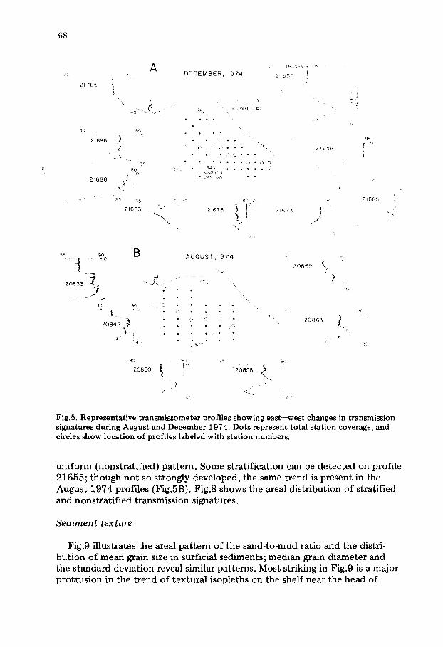
Three representative transects of transmissometer records from both the August and December 1974 surveys were chosen to illustrate vertical changes in the relative turbidity of the water column (Figs.5, 6). The east--west tran- sects connect stations at central-shelf depths of between approximately 35 and 45 m (Fig.5). The north--south transects set off stations on the broad

67
. \d i!ii! i:i i!iiii!ii?i,
. "
• :-:}:':'::o::::::Co:~.:/~'" .:!~i::: :::i~%~:i~i!:::~.~ • i": C
0 •
Fig.4. Areal distribution of absolute concentration (mg/1) o f total suspended matter samples collected 1 m above bottom during December 1974. A, B, C, and D identify areas referred Co in text and coincide with areas shown in Figs.2 and 3. Dots indicate station locations. Small "C" 's at some stations identify samples possibly contaminated owing to failure of Niskin bottle to close before impact on sea floor.
open shelf (profiles 20846--20852, 21703--21706) from those adjacent to San Gabriel Canyon (profiles 20867--20872, 21676--21680) (Fig.6). Dia- grammatic cross-sections derived from these records reflect the three~imen- sional spatial distribution of TSM (Fig.7).
Immediately apparent on both summer and winter records is the progressive increase in percent light transmission seaward, a trend indicating a decrease in relative turbidity. Also obvious is that suspended particulates concentrate in discrete layers of varying thickness at levels throughout the water column. Suspensates tend to accumulate on the surface along density interfaces within the water column, and over the bo t tom as a nepheloid layer (see Drake, 1971, 1972). Three other trends emerge from careful examination of Figs.5--7: (1) well-formed turbid plumes over the shelf disperse rapidly upon reaching the shelf break and upper slope; (2) the nepheloid layer and midwater plumes are particularly prevalent near San Gabriel and Newport Submarine Canyons; and (3) a change in transmission signature from east to west (west to east) seems to occur across the shelf (Fig.5).
In Fig.5A, note the upper 15--20 m of each transmission record. Whereas profile 21705 on the central shelf is reasonably straight and relatively uniform in this part of the record, the next profile to the west shows much greater variability. This nonuniform (stratified) signature, to varying degrees, remains characteristic of each successive profile until 21673, where it reverts to a
68
2 1 7 0 5
~0
2 1 6 9 6
2 1 6 8 8
A
{
8(
8O • . r
x
2 1 6 8 5 --...
"%.
D E C E M B E R 9 7 4
K ,©METP~
, . , ,
, . .
• • • •
• " " • • • • • ~ D
~,~,;~.~.._ ~ • . . . . . . .
2 1 6 7 8
2 1 6 5 =
2 6 7 3
2 6 5 £
I i
J
~5
I
2 6 6 5
I
,? % B
t
50
60 %.
2o8; ) ,)
A U G U S T , 1 9 7 4
: 0 ,0 , , • . • 0
9 d ~
4 ~ r
2 0 8 6 9
::b
2 0 8 6 5
{. ,f
?
z'
,;>
v
~J
45
2 0 8 5 0 2 0 8 5 8
e L . 4::J , 1
Fig.5. Representative transmissometer profiles showing east--west changes in transmission signatures during August and December 1974. Dots represent total station coverage, and circles show location of profiles labeled with station numbers.
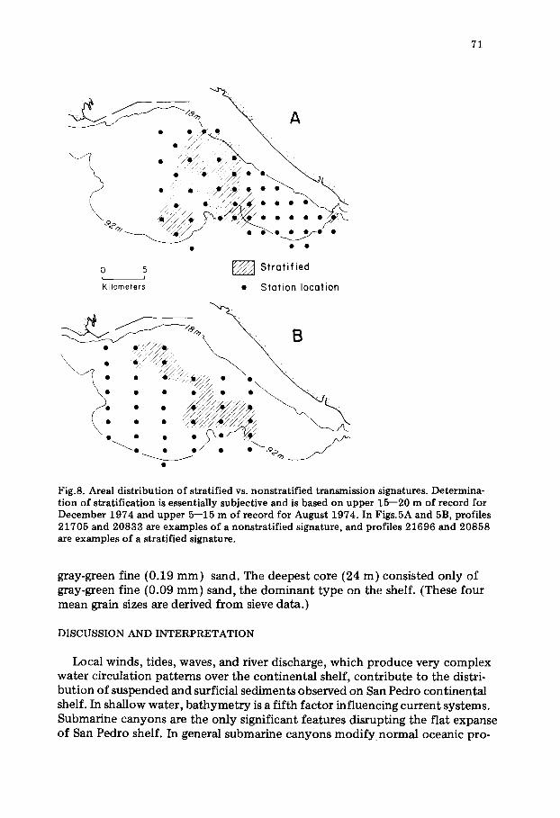
uniform (nonstratified) pattern. Some stratification can be detected on profile 21655; though not so strongly developed, the same trend is present in the August 1974 profiles (Fig.5B). Fig.8 shows the areal distribution of stratified and nonstratified transmission signatures.
Sed iment texture
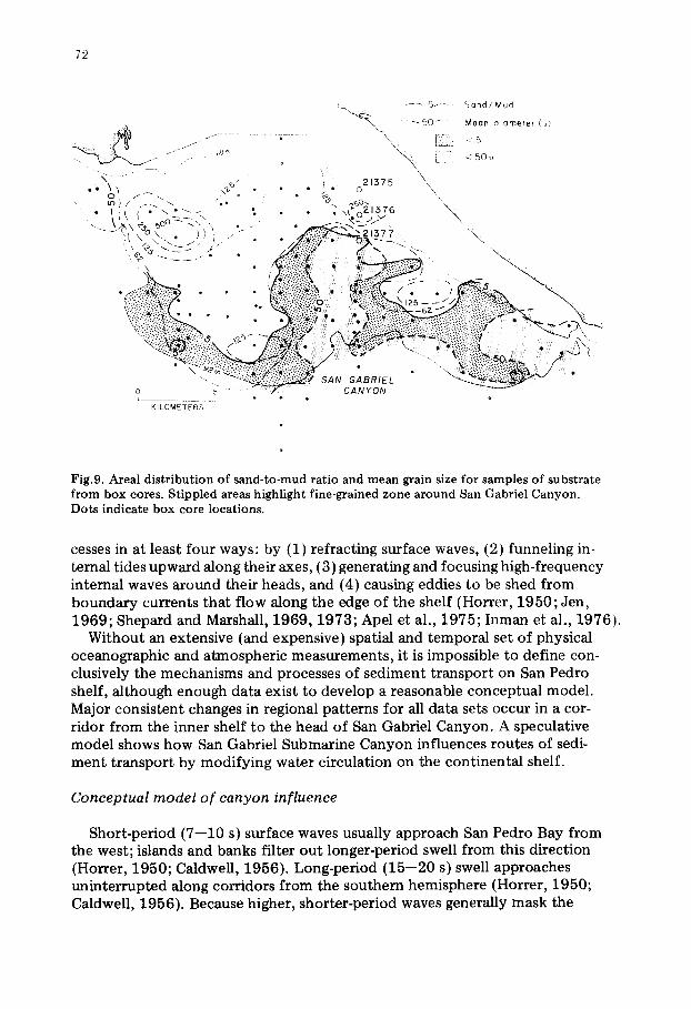
Fig.9 illustrates the areal pattern of the sand-to-mud ratio and the distri- bution of mean grain size in surficial sediments; median grain diameter and the standard deviation reveal similar patterns. Most striking in Fig.9 is a major protrusion in the trend of textural isopleths on the shelf near the head of

69
25 60 A 0 TRANSMISSION (%) 60 '21703 / I ° DECEMBER, 1974 / 21676 .l~ -° ~
,' uj~..
~ m 0 ~ ' 0 . ; \ . ~ / / / 21677 I J ~:1 f u,R, / J /
~ ' ~ / KI'LOMETERS/ 75 \ ~ 0 2 0 ~ Z ~ ~B-B50 L40 35 ~ ~ I L 4 0 /"850 ~21680 I~ 2'679 ~ I I~ I
B ---~ AUGUST 1974
/ - ~ ~ " - ~ / \ - - ~ FI25 20872 ~
: . ? ° 6o SO ~ . . . . (:~ \ ~ ~ ' - 20871
2 0 8 4 8 ~ J ,\ • ~-" , , , C ' - . ~ / ~ \ __ _ _
- - ~ - " --~ / . o/~ , /0 "~\,9 ~-.~'/ 35 85 ss "3O " "W-~-" ...... j ~,,,--\ - to
o . • .... 20870
i "85 \ 35 \ 20868 ,F ....... 30 5 85
L40 65. / '900 ~. 20869 55
- - 15o _~6o . . . . . 60
165m
Fig.6. Representative transmissometer profiles showing north--south changes in transmission signatures during August and December 1974. Dots represent total station coverage, and circles show location of profiles labeled with station number.
San Gabriel Canyon. In this area isopleths cut across isobaths, in contrast to the tendency to parallel isobaths in other areas of the shelf.
A sequence of three box cores, each penetrating about 15 cm, taken on the inner shelf inshore of this protrusion merits mention because of the striking vertical and lateral textural changes not typical of other cores collected during the study (see Fig.9 for locations). The shallowest core (water depth, 15 m) penetrated only iron-stained sand with a mean grain size of 0.24 mm. In the next core, 1.9 km seaward, reddish-brown medium (0.29 mm) sand overlay

17
05
2
16
96
2
16
88
17
05
7
04
T
O5
2 ~
5
'60
6
0
50
<
50
TR
AN
SM
ISS
ION
%
'0
85
5
16
83
2
16
78
2
16
75
[08
50
2
08
48
2
08
46
'
_ ,
....
..
.,,6
9~-"
~
-
F
5f
- "
21
67
6
17
06
,.
° ,
• •
* °
, _
.21
6.
_ •
oo
•
• ",
£'A
~
21
68
~
•
,,
3A
BR
fEI
tAN
'f O
N
;EC
FM
BE
R
!gv~
-
H6
65
2
16
58
2
16
55
68
0
21
67
9
21
67
8
21
67
7
21
67
6
' 6
0
/
20
84
2
20
85
0
20
85
8
20
86
5
20
86
9
Ld
60
Zb
D
""
20
84
~
0
08
35
'
20
87
2
• "
" -
. ,8
6,
7 2
08
68
2
08
69
2
08
7
~'.
;~
~>'~
" '
' _,
n5
20
86
" /
--
~~
'
~"
;AB
RIE
L
:AN
'f O
N
.~
E
/ A
UG
US
T
97
4
/
/
/ /
"ig.
7. C
ross
-sec
t;io
ns
for
rep
rese
nta
tiv
e p
rofi
le,,
:~
h()
~
in F
igs.
" an
d
# S
cale
dif
fer'
:. ~
ligh
[13
;m'~
on~
cro
.-.~
se(
!ti(
,,n~
.~n
d n~
,n c
he~
~,
t~>
roy
ecti
on
s ,4
an
d D
, B
an
d E
, an
d (
7 a
nd
F
~3
71
o 5 Stratified J
Ki lometers • Station location
I
Fig.8. Area l d i s t r i bu t ion o f s t ra t i f ied vs. nons t r a t i f i ed t r ansmiss ion s ignatures . De te rmina- t i on of s t r a t i f i ca t ion is essent ial ly subject ive and is based o n u p p e r 15- -20 m of r ecord for D e c e m b e r 1974 and uppe r 5 - -15 m of r ecord for Augus t 1974. In Figs .5A and 5B, prof i les 2 1 7 0 5 and 20833 are examples of a nons t r a t i f i ed s ignature , and prof i les 2 1 6 9 6 and 2 0 8 5 8 are examples o f a s t ra t i f ied s ignature .
gray-green fine (0.19 mm) sand. The deepest core (24 m) consisted only of gay-green fine (0.09 mm) sand, the dominant type on the shelf. (These four mean grain sizes are derived from sieve data.)
DISCUSSION AND I N T E R P R E T A T I O N
Local winds, tides, waves, and river discharge, which produce very complex water circulation patterns over the continental shelf, contr ibute to the distri- bution of suspended and surficial sediments observed on San Pedro continental shelf. In shallow water, ba thymetry is a fifth factor influencing current systems. Submarine canyons are the only significant features disrupting the flat expanse of San Pedro shelf. In general submarine canyons m o d i f y normal oceanic pro-
72
i ". . . . . . . - 5 ~ - ...... : : ~ g n d / M u d
" ' ~ " N -" 50 M e a n d i a m e t e l ( u )
, . . . / tP. m % - ~ "h " " \ X i j < 5 0 u
2 3 7 5 "x -,t~ - ~" • ~ - o
• "" ~k ) / ~ . - . . / . . • ",e~°~,376 " • 1 t ° " - ° ' - " "* * • kz,\ ÷~ ~o -,',., . . ~ - - ~ - 5 ~ - - > ~ " \ ,
..... >I \ 7 ~ \ " -)-)'~-"" . ~, . ' . :~. : :~a,3r7 \ ', ,, % ,--. --5" j" " z..~{~~)- " o : ) , ~ . . .
~. i , I i i i i ;
=========================== * -.:
~i~:~!,...~:~i!-...':-~:~ ":~ " . V~.::.~.:.: .:::.~ ~ ,, ~.:~.!:r.':'.."!:: > , " ~>:[::'.:Y:.~;i':'i.: . . ~ ' ~ - ~ - - - - , -~ ~.>~:--,-.:,~,:.>~-~:.,~i¥" . , ; : . < > : > : . , : ~ /
' - " ~ ~ SAN G A B R I E L " Q ~ o 5 ........ ~ CANYON L . . . . . . . . . . . ~ @
K I L O M E T E R S
Fig.9. Areal distribution of sand-to-mud ratio and mean grain size for samples of substrate from box cores. Stippled areas highlight fine-grained zone around San Gabriel Canyon. Dots indicate box core locations.
cesses in at least four ways: by (1) refracting surface waves, (2) funneling in- ternal tides upward along their axes, (3) generating and focusing high-frequency internal waves around their heads, and (4) causing eddies to be shed from boundary currents that flow along the edge of the shelf (Horrer, 1950; Jen, 1969; Shepard and Marshall, 1969, 1973; Apel et al., 1975; Inman et al., 1976).
Without an extensive (and expensive) spatial and temporal set of physical oceanographic and atmospheric measurements, it is impossible to define con- clusively the mechanisms and processes of sediment transport on San Pedro shelf, although enough data exist to develop a reasonable conceptual model. Major consistent changes in regional patterns for all data sets occur in a cor- ridor from the inner shelf to the head of San Gabriel Canyon. A speculative model shows how San Gabriel Submarine Canyon influences routes of sedi- ment transport by modifying water circulation on the continental shelf.
Conceptual model o f canyon influence
Short-period (7--10 s) surface waves usually approach San Pedro Bay from the west; islands and banks filter out longer-period swell from this direction (Horrer, 1950; Caldwell, 1956). Long-period (15--20 s) swell approaches uninterrupted along corridors from the southern hemisphere (Horrer, 1950; Caldwell, 1956). Because higher, shorter-period waves generally mask the
73
lower, longer-period swell, the short-period waves are more noticeable to an observer aboard ship. However, the longer-period swell, though less noticeable at the sea surface, has a greater effect on the seabed.
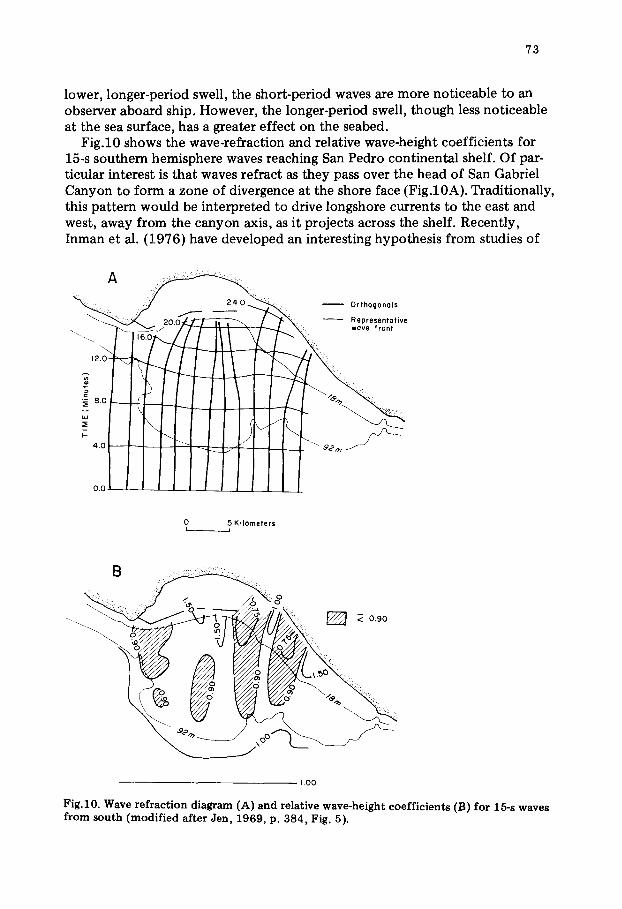
Fig.10 shows the wave-refraction and relative wave-height coefficients for 15-s southern hemisphere waves reaching San Pedro continental shelf. Of par- ticular interest is that waves refract as they pass over the head of San Gabriel Canyon to form a zone of divergence at the shore face (Fig.10A). Traditionally, this pattern would be interpreted to drive longshore currents to the east and west, away from the canyon axis, as it projects across the shelf. Recently, Inman et al. (1976) have developed an interesting hypothesis from studies of
A ~ ~:~:~:i::! 7~ :: ! : L : ; :
O r t h o g o n a l s
- - R e p r e s e n t a t i v e • w a v e f r o n t
0 5 K i l o m e t e r s L •
1,00
Fig.10. Wave refraction diagram ( l ) and relative wave-height coefficients (B) for 15-s waves from south (modified after Jen, 1969, p. 384, Fig. 5).
74
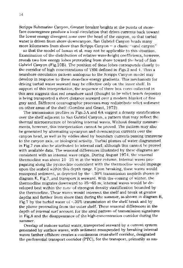
Scripps Submarine Canyon. Greater breaker heights at the points of shore- face convergence produce a local circulation that drives currents back toward the lower energy divergent zone over the head of the canyon, so that turbid water is driven from shore downcanyon. San Gabriel Canyon heads many more kilometers from shore than Scripps Canyon .... a classic '~sand canyon"
- so that the model of Inman et al. may not be applicable to this situation. Examination of the distribution of relative wave-height coefficients, however~ reveals two low energy lobes protruding from shore toward the head of San Gabriel Canyon (Fig.10B). The position of these lobes corresponds closely to the corridor of high concentrations of TSM defined in Figs.2 and 4. Thus a nearshore circulation pattern analogous to the Scripps Canyon model may develop in response to these shoreface energy gradients. This mectlanism for driving turbid water seaward may be effective only on the inner shelf. In support of this interpretat ion, the sequence of three box cores collected in this area suggests that red nearshore sand ( thought to be relict beach deposits} is being transported a short distance seaward over a modern blanket of fine gray sand. Different oceanographic processes may redistribute relict sediment on other areas of the shelf iGorsline and Grant, 1972)
The transmission profiles in Figs.5A and 6A suggest a density stratification over the shelf adjacent to San Gabriel Canyon, a pattern that may reflect the thermal microstructure of breaking internal waves. Without density measure- ments, however, this interpretat ion cannot be proved. The pattern may also be generated by alternating upcanyon and downcanyon currents over the canyon head, as well as by eddies shed by boundary currents passing transverse to the canyon axis, or biological activity. Turbid plumes of water diagrammed in Fig.7 can also be at tr ibuted to internal surf; although this cannot be proved with available data. The seasonal differences illustrated by these diagrams are consistent with an internal wave origin. During August 1974, tile seasonal thermocline was about 1 0 - 2 5 m in the water column. Internal waves pro- pagating along the pycnocline coincident with the thermocline would impinge upon the seabed within this depth range. Upon breaking, these waves would resuspend sediment, as depicted by the .~ 30% transmission isopleth shown in diagram E, Fig.7, and transport it seaward. With the coming of winter, the thermocline migrates downward to 35--65 m; internal waves would be de- veloped best within the zone of strongest density stratification bounded by the thermocline. These waves would intersect the shelf and break at greater depths and farther from shore than during the summer, as shown in diagram B, Fig.7 by the turbid water of < 30% transmission at the shelf break and by the plume protruding from the outer shelf. These seasonal differences in the depth of internal surf account for the areal pattern of transmission signatures in Fig.8 and the disappearance of the high-concentration corridor during the summer.
Overlap of inshore turbid water, t ransported seaward by a current system generated by surface waves, with sediment resuspended by breaking internal waves farther offshore creates a continuous cross-shelf corridor, designated the preferential t ransport corridor (PTC), for the transport , primarily as sus-

75
PREFERENTIAL TRANSPORT CORRIDOR (EPISODIC)
i!ii iilil i !ii~i! i i!i ilili I
Fig.11. Conceptual diagram of preferential transport corridor described in text. Stippled area at top of diagram indicates circulation cell generated from surface waves refracted by the canyon. Arrows show seaward flow. Hachured area over canyon head at bot tom of diagram indicates zone of gyres generated by alternating upcanyon and downcanyon cur- rents, including area influenced by eddies possibly shed from boundary currents (open arrows) flowing along shelf edge. Area where stipples and hachures overlap represent part of shelf where high-frequency internal waves shoal, steepen, and break. Arrows indicate net flow seaward toward canyon head.
pended load, of fine sediment (Fig . l l ) . Shoreward incursions of textural iso- pleths on the shelf adjacent to San Gabriel Submarine Canyon suggest that the position of the PTC remains fairly stable over time. Since physical oceano- graphic conditions necessary to generate the PTC do not always occur in the right combinations, the PTC is episodic in nature and subtle in intensity, not analogous to a river on land. The corridor is a zone in which sediment is advected, deposited, and resuspended more frequently than in other areas of the shelf. Because the nearshore part of the PTC receives more energy than the offshore part, mean and median grain sizes near shore are coarser, sorting is better, and the percentage of sand is higher. Finer grain sizes, poorer sorting, and higher percentages of mud indicate less bedload transport in the deeper part of the PTC. These textural characteristics of the surficial sediment also reflect the fact that suspended matter moves in greater concentrations and more frequently through the PTC than over other areas of the shelf.
CONCLUSIONS
Submarine canyons influence sediment dynamics on continental shelves to varying degrees. Southern California "sand canyons" incise very narrow shelves (410 km) and head well within 1 km of shore. These canyons interact with the shelf transport system in a complex way; but because they head so close to shore, their relative effect on the total system is limited to trapping of
76
sediment that moves in the longshore drift. Large canyons on the U.S. East Coast head more than 100 km from shore and form relatively small notches in very broad continental shelves; these canyons influence shelf circulation only in a small area around their heads. San Gabriel Submarine Canyon :incises a narrow shelf 10--15 km from shore. Data presented here show that at this dis- tance, the canyon modifies shelf current systems so as to create a corridor for the preferential transport of suspended particulate matter across the shelf. This preferential transport corridor (PTC) extends virtually from shore face to canyon head; and, during the seasons when the PTC is generated and main- tained, the canyon has proportionately greater influence over the total shelf sediment dynamical system than do larger canyons on broader shelves.
Sea level changes through time should cause a submarine canyon to evolve through the progressive stages from shore-heading canyon to shore-separated canyon. These changes may be recognizable in the depositional record of the canyon-fan systems which should respond to differences in shelf processes and sediments delivered to the canyon. Thus examination of ancient fan sediments in the light of the model presented in this paper may help unravel the depo- sitional history of ancient continental shelves.
ACKNOWLEDGEMENTS
Dennis K. Thurston, Marine Technician at the Sedimentology Research Laboratory of the University of Southern California, analyzed the grain-size data. Lee Ann Musgrove, laboratory assistant, aided in data reduction. I want to thank the officers and crew of the research vessel VELERO IV, the staff of the University of Southern California Marine Facility, and the many students who served in the scientific party on several cruises for their field support.
Concepts expressed in this paper are an outgrowth of a dissertation completed by the author under the supervision of Dr. D. S. Gorsline of the Department of Geological Sciences, University of Southern California.
The National Science Foundation funded this work through grants GA 40049, DES 75-01438, and DES 75-01438, Amendment No.A01.
The manuscript was completed during tenure as a National Research Council Associate with the U.S. Geological Survey in Menlo Park, California.
P.N. Barnes and D.E. Drake of the U.S. Geological Survey critically reviewed drafts of this paper.
REFERENCES
Apel, J.R., Byrne, H.M., Prone, J.R. and Charnell, R.L., 1975. Observations of oceanic internal and surface waves from the Earth Resources Technology satellite. J. Geophys. Res., 80: 865--881.
Beer, R.M. and Gorsline, D.S., 1971. Distribution, composition and transport of suspended sediment in Redondo Submarine Canyon and vicinity (California). Mar. Geol., 10: 153--176.
Bunnell, V.A., 1969. The Water Structure of the San Pedro Basin, California Borderland. Thesis, University of Southern California, Los Angeles, Calif. 127 pp. (unpublished).

77
Cacchione, D.A. and Southard, J.B., 1974. Incipient sediment movement by shoaling in- ternal gravity waves. J. Geophys. Res., 70: 2237--2242.
Cacchione, D.A. and Wunsch, C., 1974. Experimental s tudy of internal waves over a slope. J. Fluid Mech., 66: 223--239.
Cains, J.L., 1967. Asymmetry of internal tidal waves in shallow coastal water. J. Geophys. Res., 72: 3563--3565.
Caldwell, J.M., 1956. Wave action and sand movement near Anaheim Bay, California: U.S. Army Corps of Engineers, Beach Erosion Board, Rech. Mem. 68, 21 pp.
Cook, D.O., 1969. Calibration of the University of Southern California automatically recording settling tube. J. Sediment. Petrol., 39: 781--786.
Drake, D.E., 1971. Suspended sediment and thermal stratification in Santa Barbara Channel. Deep-Sea Res., 18: 763--769.
Drake, D.E., 1972. Distribution and Transport of Suspended Matter, Santa Barbara Channel, California. Thesis, University of Southern California, Los Angeles, Calif., 358 pp. (unpublished).
Drake, D.E. and Gorsline, D.S., 1973. Distribution and transport of suspended particulate matter in Hueneme, Redondo, Newport and La Jolla Submarine Canyons, California. Geol. Soc. Am. Bull., 84: 3949--3968.
Emery, K.O., 1960. The Sea off Southern California. Wiley, New York, N.Y., 366 pp. Emery, K.O. and Gunnerson, C.G., 1973. Internal swash and surf. Proc. Natl. Acad. Sci.,
U.S.A., 70: 2379--2380. Felix, D.W., 1969. An inexpensive recording settling tube for analysis of sands. J. Sediment.
Petrol., 39: 777--780. Felix, D.W. and Gorsline, D.S., 1971. Newport Submarine Canyon, California: an example
of the effects of shifting loci of sand supply upon canyon position. Mar. Geol., 10: 177--198.
Gorsline, D.S., 1970. Report of a reconnaissance survey of the hydrographic characteristics of the Hueneme-Mugu shelf to evaluate ground-water leakage from submarine exposures of coastal acquifers, June--July, 1970. Report Number USC Geol. 70-6, University of Southern California, Los Angeles, Calif., 21 pp.
Gorsline, D.S. and Grant, D.J., 1972. Sediment textural patterns on San Pedro shelf, California (1951--1971): Reworking and transport by waves and currents. In: D.J.P. Swift, D.B. Duane and O.H. Pilkey (Editors), Shelf Sediment Transport: Process and Pattern. Dowden, Hutchinson and Ross, Stroudsburg, Pa., pp.575--600.
Horrer, P.L., 1950. Southern hemisphere swell and waves from a tropical storm at Long Beach, California. U.S. Army Corps of Engineers, Beach Erosion Board Bull., 4(3): 1--18.
Inman, D.L. and Frautschy, J.D., 1966. Littoral processes and the development of shore- lines. Coastal Eng. Santa Barbara Specialty Conf., New York, Am. Soc. Civ. Eng., pp. 511--536.
Inman, D.L., Nordstrom, C.E. and Flick, R.E., 1976. Currents in submarine canyons: an air---sea--land interaction. Annu. Rev. Fluid Mech., 8" 275--310.
Jen, Y., 1969. Wave refraction near San Pedro Bay, California. J. Waterways Harbors Div., Proc. Am. Soc. Civ. Eng., 95(WW3): 379--393.
Karl, H.A., 1976. Processes Influencing Transportation and Deposition of Sediment on the Continental Shelf, Southern California. Thesis, University of Southern California, Los Angeles, Calif., 331 pp. (unpublished).
Knebel, H.J. and Folger, D.W., 1976. Large sand waves on the Atlantic outer continental shelf around Wilmington Canyon, off eastern United States. Mar. Geol., 22: M7--M15.
LaFond, E.C., 1961. Internal wave mot ion and its geological significance. In: Mahadevan Volume. Osmania University Press, pp.61--77.
LaFond, E.C., 1962. Internal waves. In: M.N. Hill (Editor), The Sea: Ideas and Obser- vations on Progress in the Study of the Sea, 1. Physical Oceanography. Interscience, New York, N.Y., pp.731--751.
Lee, O.S., 1961. Observations on internal waves in shallow water. Limnol. Oceanogr., 6: 312--321.

78
Lyall, A.K., Stanley, D.J., Giles, H.N. and Fischer Jr., A., 1971. Suspended sediment and transport at the shelf-break and on the slope, Wilmington canyon area, eastern U.S.A. Mar. Technol. Soc. J., 5: 15---27.
Pirie, D.M., Murphy, M.J. and Edmisten, J. R , 1975. California nearshore surface currents Shore Beach, 43(2): 23--34.
Royse Jr., C.F., 1970. An introduction to sediment analyses. Sediment Analyses, Tempe, Arizona, 180 pp.
Shepard, F.P., 1963. Submarine Geology. Harper and Row, New York, N.Y., 557 pp. Shepard, F.P. and Dill, R., 1966. Submarine canyons and other sea valleys. Rand-McNally,
Chicago, Ill. Shepard, F.P. and Marshall, N.F., 1969. Currents in La Jolla and Scripps Submarine
Canyon. Science, 165: 177--178. Shepard, F.P. and Marshall, N.F., 1973. Currents along floors of submarine canyons. Bull.
Am. Ass. Pet. Geol., 57: 244----264. Shepard, F.P., Marshall, N.F. and McLoughlin, P.A., 1974a. Currents in submarine canyons
Deep-Sea Res., 21: 691--706. Shepard, F.P., Marshall, N.F. and McLoughlin, P.A., 1974b. "Internal waves" advancing
along submarine canyons. Science, 183: 195--198. Southard, J.B. and Cacchione, D.A., 1972. Experiments on bot tom sediment movement
by breaking internal waves. In: D.J.P. Swift, D.B. Duane and O.H. Pilkey (Editors), Shelf Sediment Transport: Process and Pattern. Dowden, Hutchinson and Ross, Stroudsburg, Pa., pp.83--97.
Stanley, D.J. and Kelling, G., 1978. Sedimentation in Submarine Canyons, Fans, and Trenches. Dowden, Hutchinson and Ross, Stroudsburg, Pa., 395 pp.
Winant, C.D., 1974. Internal surges in coastal waters. J. Geophys. Res., 79: 4523--4526.
Related Documents