INDIAN NOTICES TO MARINERS EDITION NO. 08 DATED 16 APR 2018 (CONTAINS NOTICES 079 TO 085) REACH US 24 x 7 [email protected] [email protected] +91-135-2748373 National Hydrographic Office 107-A, Rajpur Road Dehradun – 248001 INDIA Joint Director of Hydrography Maritime Safety Information Services +91- 135 - 2746290-117 www.hydrobharat.gov.in CONTENTS Section No. Title I List of Charts Affected II Permanent Notices III Temporary and Preliminary Notices IV Marine Information V NAVAREA VIII Warnings inforce VI Corrections to Sailing Directions VII Corrections to List of Lights VIII Corrections to List of Radio Signals IX Reporting of Navigational Dangers (PUBLISHED ON NHO WEBSITE ON 1 ST & 16 TH OF EVERY MONTH) FEEDBACK : [email protected] INSIST ON INDIAN CHARTS AND PUBLICATIONS Original, Authentic and Up-to-Date © Govt. of India Copyright No permission is required to make copies of these Notices. However, such copies are not to be commercially sold.

Welcome message from author
This document is posted to help you gain knowledge. Please leave a comment to let me know what you think about it! Share it to your friends and learn new things together.
Transcript
INDIAN
NOTICES TO MARINERS
EDITION NO. 08 DATED 16 APR 2018 (CONTAINS NOTICES 079 TO 085)
REACH US 24 x 7
[email protected] [email protected]
+91-135-2748373
National Hydrographic Office 107-A, Rajpur Road Dehradun – 248001
INDIA
Joint Director of Hydrography Maritime Safety Information Services
+91- 135 - 2746290-117
www.hydrobharat.gov.in
CONTENTS Section No. Title
I List of Charts Affected II Permanent Notices III Temporary and Preliminary Notices IV Marine Information V NAVAREA VIII Warnings inforce VI Corrections to Sailing Directions VII Corrections to List of Lights VIII Corrections to List of Radio Signals IX Reporting of Navigational Dangers
(PUBLISHED ON NHO WEBSITE ON 1ST & 16TH OF EVERY MONTH)
FEEDBACK: [email protected]
INSIST ON INDIAN CHARTS AND PUBLICATIONS
Original, Authentic and Up-to-Date
© Govt. of India Copyright No permission is required to make copies of these Notices. However, such copies are not to be commercially sold.
II
MARINER’S OBLIGATION AND A CHART MAKER’S PLEA
Observing changes at sea proactively and reporting them promptly to the concerned charting agency, is an obligation that all mariners owe to the entire maritime community towards SOLAS. Mariners are requested to notify the Chief Hydrographer to the Government of India at the above mentioned address/fax number/ E mail address immediately on discovering new or suspected dangers to navigation, changes/defects pertaining to navigational aids, and shortcomings in Indian charts/publications. The Hydrographic Note [Form IH – 102] is a convenient form to notify such changes. Specimen form is attached at Section IX with this notice. Also visit our website for downloading and filling up instructions for Hydrographic Note.
Chief Hydrographer to the Government of India
WARNING AGAINST USE OF COUNTERFEIT PRODUCTS
All mariners are cautioned against the use of counterfeit copies of IN Charts and publications. Navigational Charts produced after 31 Oct 14 carry NHO crest as watermark on the reverse with backslip. Chart Agent’s stamp is mandatory on all Charts. Counterfeit products may have errors resulting in potential risks. The same are not approved by inspecting agencies and do not satisfy the carriage requirements of SOLAS chapter V. Mariners are strongly advised not to use or encourage the use of counterfeit charts and publications. Failure to comply with the warning may invite legal action.
III
EXPLANATORY NOTES
Corrections to Charts and Publications
(a) Geographical positions given are in the horizontal datum of the current edition of the chart, unless otherwise stated.
. Section I comprises List of Charts affected by the notices contained in this edition. Whereas sections II and III contain information for correcting the charts and publications. Mariners should insist on corrected charts from their chart distributors/agents.
(b) Bearings are true, reckoned clockwise from 000° to 359°. Bearings to lights are from seaward. (c) Symbols referred to, are those shown on the chart 5020 (INT 1). (d) Alterations to depth contours, deletion of depths to make way for new detail, etc; are not normally mentioned, unless they have some navigational significance. (e) Blocks and notes, if any, accompanying the Notices in Sections II and III are placed after Section IX. Temporary and Preliminary Notices. These are indicated by (T) and (P) respectively after the Notice number and are placed in Section III . Sl Nos. of those in force are published quarterly on 01
Jan, 01 Apr, 01 Jul and 01 Oct, and their
text is published in Annual Edition of Indian Notices to Mariners. They should be inserted in pencil, by the user, on receipt.
Source of Information. A star preceding the number of a Notice indicates that the notice is promulgated by INHO based on original information received.
Sailing Directions. Corrections for the Sailing Directions (Pilots) are given in Section VI.
Lights
(a) These corrections should be incorporated as per instructions given on page XI of the List of Lights.
. Corrections to Indian List of Lights are given in Section VII, where affected Light List number is quoted.
(b) Such correction notices to list of lights may be published in either an earlier or a later Edition of N to M than the Edition containing the Notice to the chart correction.
(c) The range of a light given is its nominal range. Its geographical range is given in parenthesis only if it is less than the nominal range. (d) A star indicates that the corresponding field is to be amended and all stars indicate that new light is to be inserted.
Radio Signals. The corrections in Section VIII should be cut and pasted in the appropriate volume of the List of Radio Signals.
Radio Navigational Warnings
(b) They contain important information affecting navigational safety, which cannot await the publication of the next edition of N to M.
.
(a) These are broadcast as serially numbered NAVAREA warnings by the concerned NAVAREA coordinator through GMDSS and Area Radio Broadcasts.
(c) It should be borne in mind that they may be based on reports which cannot always be verified before promulgation. (d) It is therefore necessary to be selective, and promulgate only the more important warnings to avoid over loading users; the less important information is included in the forthcoming edition of N to M or the Chart/publication concerned.
IV Laws and Regulations
(a) That no liability whatsoever can be accepted for failure to publish details of any particular law or regulation
. While in the interest of the safety of shipping, the Hydrographic Office makes every endeavor to include in its publications details of the laws and regulations of all countries pertaining to navigation, it must be clearly understood: -
and (b) That publication of details of a law or regulation is solely for the safety and convenience of shipping and implies no recognition of the International validity of the law or regulation.
Correction of Charts and Publications by the Users. Notices to Mariners contain important information concerning safety of navigation at sea, hence, they should be used to keep the specified charts and publications up-to-date.
Reliance on Charts and Associated Publications. While every effort is made by the Hydrographic Office to ensure the accuracy of the information on Charts and Publications before they are published, it should be appreciated that it may not always be complete and up-to-date. The mariner must be the final judge for the reliance he can place on the infor-mation available, bearing in mind his particular circumstances, local pilotage guidance and judicious use of available navigational aids.
Use of Global Positioning System (WGS 84) positions
(a) The positions of hydrographic objects shown on some of the Indian charts and publications are in Everest datum. However, the positions of vessels obtained from Global Positioning System (GPS) are on World Geodetic System 1984 datum. There will always exist a difference in the position values obtained by visual fixing (Everest Datum) and GPS position (WGS 84 datum).
.
(b) Wherever these differences have been ascertained, their average values are published as a Cautionary
Note on the chart concerned, as shifts in Latitude and Longitude. Whilst plotting GPS positions on charts, the shift values as given on the chart must be applied, before making any assessment of the navigational situation vis-à-vis the other charted information.
(c) These datum shift values are not uniform, particularly in areas off Andaman and Nicobar and Lakshadweep Islands, as these places are not linked to mainland network (Everest datum). Mariners are advised to use alternate source of position information such as Visual or Radar, particularly when closing the shore or navigating in the vicinity of dangers.
Source Data on Charts. All Indian charts contain specific information on their source of hydrographic data. In areas where the source data is very old, incomplete and less reliable, the mariner must use such charts with prudence. Mariner should always use the largest scale charts available for the area. Apart from being the most detailed, the larger scale charts are usually corrected first. Hydrographic information may be sparse on small scale charts. On such charts, a charted shoal may be in error as regards position, least depth and extent. Uncharted dangers may also exist, particularly in areas away from well-established routes. Mariners must exercise due caution.
Further Guidance. The Mariner’s Hand Book (NP 100) gives full explanation on the use of charts and the type of information contained on charts. In their own interest, all users of charts should refer to it.
V
ENC Cell Name
NEWLY PUBLISHED INDIAN CHARTS, ENCs AND PUBLICATION 1. The new edition Indian Electronic Navigational Charts that are available for mariners in the market are as follows:-
Chart No. Title Issue Date
IN62106P 2106 MUNDRA PORT 09-04-2018
2. The Indian Electronic Navigational Charts that are permanently withdrawn are as follows:-
ENC Cell Name Chart No. Title Issue Date
IN62106P 2106 MUNDRA PORT 10-02-2017
3. The forthcoming Indian Charts are as follows:-
Chart No Title Scale Remarks
21 MUSCAT TO MUMBAI 15,00,000 New Edition
22(INT 752) MUMBAI TO CAPE COMORIN 15,00,000 New Edition
210 UMARGAM TO SATPATI 1,50,000 New Edition
211 SATPATI TO DIGHI HARBOUR 1,50,000 New Edition
212 MURUD-JANJIRA HR TO RATNAGIRI 1,50,000 New Edition
220 TANUR NAGARAM TO MANAKKODAM 1,50,000 New Chart
221 ALLEPPEY TO QUILON 1,50,000 New Chart
253 (INT 7328) VERAVAL TO PIPAVAV 3,00,000 New Edition
254 (INT 7331) APPROACHES TO GULF OF KHAMBHAT 3,00,000 New Edition
255 (INT 7334) APPROACHES TO MUMBAI 3,00,000 New Edition
256 (INT 7340) MURUD-JANJIRA HR TO MALVAN 3,00,000 New Edition
292 (INT 7021) DWARKA TO MUMBAI 7,50,000 New Edition
293 (INT 7022) MUMBAI TO NEW MANGALORE 7,50,000 New Edition
351 (INT 7419) PARADIP TO PUSSUR RIVER 3,00,000 New Chart
2016 (INT 7336) INNER APPROACHES TO MUMBAI 60,000 New Edition
2043 APPROACHES TO VENGURLA AND REDI 60,000 New Chart
3006 (INT 7423)
HUGLI RIVER;
New Chart KUKRAHATI REACH TO ROYAPUR CROSSING 37,500
ROYAPUR CROSSING TO CALCUTTA DOCKS 37,500
CALCUTTA DOCKS 17,500
3009 (INT 7407) KAKINADA PORT 10,000
New Chart KAKINADA ANCHORAGE 25,000
4107 INTERVIEW ISLAND 25000 New Chart
VI
United Kingdom Hydrographic Office Admiralty Way, Taunton, Somerset TA1 2DN, UK Tel: +44 (0) 1823 337900 Fax: +44 (0) 1823 330561, 1823 284077
Availability of ENCs
The complete folios of Official Indian ENCs are distributed worldwide through JEPPESEN MARINE (formerly C-MAP), UKHO and Norwegian Hydrographic Service. UKHO distributes Indian ENCs through the world wide network of their agents and distributors. Updates are also made available as per the existing policy of the distributor. Mariners and other ENC users may contact the under mentioned for further details:
Web site: www.hydro.gov.uk
C-MAP Norway AS Nyaskaiveien 2, 4379 Egersund, Norway Ph: +47 51 464700, +91 2262233326 Mob: +91 9820238542 Fax: +47 51 464701, +91 2267939504 Email: [email protected], [email protected] Website: www.c-map.com
M/s Primar Norwegian Hydrographic Service, Postbox 60, 4001 Stavanger Norway
E-mail:
Telephone - +47 - 51 85 87 00 Fax - + 47 - 51 85 87 08
[email protected] Website: - www.primar.org
M/s IIC Technologies Limited B-2-350/5/B-22, Road No. 3 Banjara Hills Hyderabad - 500 034 Telangana Tel:+91 4039144444 Fax: +91 4039144455 Email: [email protected] Web: www.iictechnologies.com
1.1
SECTION – I
The list of charts affected by the Notices 079 to 085 contained in this edition is as follows:
CHART NUMBER FOLIO NO. NOTICE NO. 21 2 085(P)
22 (INT 752) 3 085(P) 31 (INT 756) 5 083(T) 32 (INT 754) 5 083(T) 41 (INT 757) 6 084(T)
211 3 085(P) 223 4 081
255 (INT 7334) 3 085(P) 260 (INT 7362) 4 081 292 (INT 7021) 2 085(P) 293 (INT 7022) 3 085(P)
313 5 082 354 (INT 7408) 5 083(T) 356 (INT 7400) 5 082
391 5 083(T) 2001 3 080, 085(P)
2015 (INT 7337) 3 080, 085(P) 2016 (INT 7336) 3 080, 085(P) 2076 (INT 7338) 3 085(P)
2106 2 079 3001 (INT 7402) 5 082
2. 1
SECTION – II
* 079(08/18)
PERMANENT NOTICES
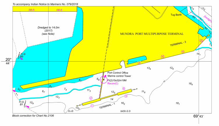
INDIA – WEST COAST – Gulf of Kachchh – Mundra Port – General Area.
Source: Adani Ports and SEZ Ltd. Chart 2106 (previous update 144/17)
Insert accompanying block showing amendments to general area; centered on: 22° 44´·01N., 69° 42´·42E.
*080(08/18) INDIA – WEST COAST –Mumbai Docks – Maintained depth.
Source: IH-102, HSU Mumbai.
Chart 2016 (INT 7336) [previous update 075/18]
Replace “13.5m” with “8,0m”, centered on: 18° 56´·50N., 72° 51´·32E.
legend “Maintained depth 13,5m” with “Maintained depth 8,0m”, centered on:
18° 55´·42N., 72° 51´·50E.
Chart 2015 (INT 7337) [previous update 100/17]
Replace legend “13.5m (see Note)” with “8,0m (see Note)”, centered on:
18° 56´·54N., 72° 51´·32E.
legend “16.0m (see Note)” with “11,0m (see Note)”, centered on:
18° 56´·50N., 72° 51´·23E.
legend “13.5m (see Note)” with “8,0m (see Note)”, centered on:
18° 55´·92N., 72° 51´·22E.
legend “Maintained depth 13,5m (see Note)” with “Maintained depth 8,0m (see Note)”, centered on:
18° 55´·42N., 72° 51´·53E.
Chart 2001 [previous update 088/17]
Replace legend “Maintained depth 16,0m (see Note)” with “Maintained depth 11,0m (see Note)”, centered on:
18° 56´·48N., 72° 51´·23E.
legend “Maintained depth 13,5m (see Note)” with “Maintained depth 8,0m (see Note)”, centered on:
18° 56´·45N., 72° 51´·32E.
legend “13.5m (see Note)” with “8,0m (see Note)”, centered on:
18° 55´·90N., 72° 51´·22E.
legend “Maintained depth 13,5m (see Note)” with “Maintained depth 8,0m (see Note)”, centered on:
18° 55´·41N., 72° 51´·56E.
*081(08/18) INDIA - SOUTH COAST – Kolachel to Manappad - Depth.
Source: NHO, Dehradun
Chart 260 (INT 7362) [previous update 163/16]
Insert depth 199 08° 12´·96N., 77° 08´·47E. enclosed by 20m contour
Chart 223 [previous update 034/18]
Insert depth 199 08° 12´·96N., 77° 08´·47E. enclosed by 20m contour
2. 2
*082(08/18) INDIA – EAST COAST – Kamarajar Port– Buoy.
Source: NHO Dehradun.
Chart 356 (INT 7400) [previous update 037/17]
Amend Characteristics to Fl. R.5s 13° 12´·10N., 80° 23´·60E.
Chart 313 [previous update 132/17]
Amend Characteristics to Fl. R.5s 13° 12´·10N., 80° 23´·60E.
Chart 3001 (INT 7402) [previous update 132/17]
Amend Characteristics to Fl. R.5s 13° 12´·10N., 80° 23´·60E.
3.1
SECTION – III
TEMPORARY AND PRELIMINARY NOTICES
*083(T) (08/18) INDIA – EAST COAST – Sacramento Shoal to Kalingapatnam – Unexploded Charges.
Source: Indian Navy.
1. Unexploded charges reported dumped by Indian Naval Ship in position 17° 00´·00N., 83° 40´·50E on 27 Feb 18 and 01 Mar 18.
2. Mariners to take note.
Charts Affected – 31 (INT 756) – 32 (INT 754) – 391 – 354 (INT 7408).
*084(T) (08/18) BAY OF BENGAL AND ANDAMAN SEA – Andaman Sea– Drilling Operation. Source: Myanmar Hydrographic Office. 1. Drilling operation will be carried out by Semi – Submersible Drilling Rig, Noble Cylde Boudreaux (call sign; A8BM6) in below mentioned coordinates till 31 Aug 19:-
(I) Restricted area boundry coordinates: Sl. No. Point Position
(i) Point(A) 14° 21´·14N., 95° 21´·75E. (ii) Point(B) 14° 21´·18N., 95° 52´·67E. (iii) Point(C) 14° 40´·08N., 95° 52´·66E. (iv) Point(D) 14° 40´·08N., 96° 10´·79E. (v) Point(E) 13° 54´·45N., 96° 10´·76E. (vi) Point(F) 13° 54´·41N., 95° 21´·82E. (II) Individual Surface Location of Well: Sl. No. Point Position (i) KKN-57 14° 16´·47N., 96° 05´·27E. (ii) KKN-66 14° 16´·19N., 95° 45´·24E. (iii) KKN-74 14° 15´·10N., 95° 33´·29E. (iv) KKN-82 14° 12´·65N., 95° 35´·26E. (v) KKN-25 14° 21´·72N., 95° 59´·89E. (vi) KKN-44 14° 24´·02N., 95° 58´·24E. (vii) GTK-19 14° 29´·22N., 95° 59´·18E. (viii) ZTK-23 13° 59´·88N., 95° 47´·89E. (ix) GTK-11 14° 34´·96N., 96° 02´·56E. (x) GTK21 14° 31´·14N., 96° 00´·35E. (xi) New Play I(Exploration Well) 14° 16´·13N., 95° 28´·00E.
2. During the operation period unauthorized navigation, anchoring, fishing and trawling are prohibited within 4 KM from above mentioned area. 3. Mariners are advised to navigate with caution. Chart affected– 41 (INT 757).
3.2
*085 (P) (08/18) INDIA – WEST COAST – Mumbai Docks – Construction Work.
Source: Mumbai Port Trust. 1. Construction work of Berth No. 5 at Jawahar Dweep Oil Tanker Terminal at Jawahar Dweep is under progress in area bounded by the following :
(a) Buoy with White Light 18° 56´·10N., 72° 53´·48E.
(b) Buoy with White Light 18° 56´·18N., 72° 53´·63E.
(c) Buoy with White Light 18° 56´·25N., 72° 53´·74E.
(d) Buoy with White Light 18° 56´·36N., 72° 53´·88E.
(e) Orange Buoy 18° 56´·37N., 72° 53´·86E.
(f) Orange Buoy 18° 56´·23N., 72° 53´·42E.
(g) Orange Buoy 18° 56´·34N., 72° 53´·59E.
(h) Orange Buoy 18° 56´·15N., 72° 53´·50E. 2. Mariners are advised to navigate with caution. Charts affected – 21 – 22 (INT 752) – 211 – 255 (INT 7334) – 292 (INT 7021) – 293 (INT 7022) – 2076 (INT 7338) – 2016 (INT 7336) – 2015 (INT 7337) – 2001.
4.1
SECTION – IV
MARINE INFORMATION 1.
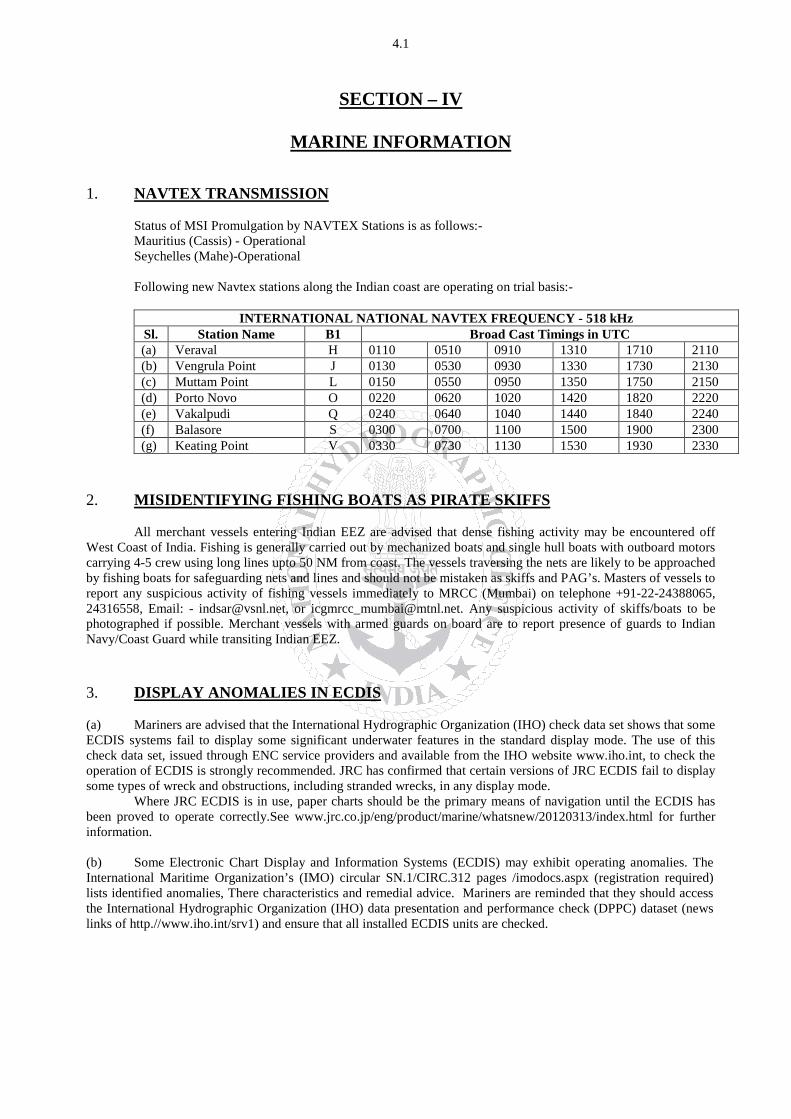
INTERNATIONAL NATIONAL NAVTEX FREQUENCY - 518 kHz
NAVTEX TRANSMISSION Status of MSI Promulgation by NAVTEX Stations is as follows:- Mauritius (Cassis) - Operational Seychelles (Mahe)-Operational
Following new Navtex stations along the Indian coast are operating on trial basis:-
Sl. Station Name B1 Broad Cast Timings in UTC (a) Veraval H 0110 0510 0910 1310 1710 2110 (b) Vengrula Point J 0130 0530 0930 1330 1730 2130 (c) Muttam Point L 0150 0550 0950 1350 1750 2150 (d) Porto Novo O 0220 0620 1020 1420 1820 2220 (e) Vakalpudi Q 0240 0640 1040 1440 1840 2240 (f) Balasore S 0300 0700 1100 1500 1900 2300 (g) Keating Point V 0330 0730 1130 1530 1930 2330
2.
All merchant vessels entering Indian EEZ are advised that dense fishing activity may be encountered off West Coast of India. Fishing is generally carried out by mechanized boats and single hull boats with outboard motors carrying 4-5 crew using long lines upto 50 NM from coast. The vessels traversing the nets are likely to be approached by fishing boats for safeguarding nets and lines and should not be mistaken as skiffs and PAG’s. Masters of vessels to report any suspicious activity of fishing vessels immediately to MRCC (Mumbai) on telephone +91-22-24388065, 24316558, Email: - [email protected], or
MISIDENTIFYING FISHING BOATS AS PIRATE SKIFFS
[email protected]. Any suspicious activity of skiffs/boats to be photographed if possible. Merchant vessels with armed guards on board are to report presence of guards to Indian Navy/Coast Guard while transiting Indian EEZ. 3. DISPLAY ANOMALIES IN ECDIS (a) Mariners are advised that the International Hydrographic Organization (IHO) check data set shows that some ECDIS systems fail to display some significant underwater features in the standard display mode. The use of this check data set, issued through ENC service providers and available from the IHO website www.iho.int, to check the operation of ECDIS is strongly recommended. JRC has confirmed that certain versions of JRC ECDIS fail to display some types of wreck and obstructions, including stranded wrecks, in any display mode. Where JRC ECDIS is in use, paper charts should be the primary means of navigation until the ECDIS has been proved to operate correctly.See www.jrc.co.jp/eng/product/marine/whatsnew/20120313/index.html for further information. (b) Some Electronic Chart Display and Information Systems (ECDIS) may exhibit operating anomalies. The International Maritime Organization’s (IMO) circular SN.1/CIRC.312 pages /imodocs.aspx (registration required) lists identified anomalies, There characteristics and remedial advice. Mariners are reminded that they should access the International Hydrographic Organization (IHO) data presentation and performance check (DPPC) dataset (news links of http.//www.iho.int/srv1) and ensure that all installed ECDIS units are checked.
4.2
4. SAFETY FAIRWAYS,RECOMMENDED ROUTES, TRAFFIC SEPARATIONSCHEME The Director General Shipping has established Safety fairways, recommended routes and traffic separation scheme (TSS) in restricted Indian waters including the offshore development area to enhance safety of navigation. The details of coordinates for the above have been published in the fortnightly Indian Notices to Mariners Edition No 07 of 2018(01st
(a) Safety Fairways: An area within which permits are not granted for the erection of oil or gas related structures. The use of a safety fairway is not usually mandatory, but is recommended. Safety fairwayshave been promulgated in and round offshore development area in Arabian Sea up to the Exclusive Economic Zone (EEZ) due to increased weather related marine accidents and dense traffic. These are mandatory for all Indian ships and vessels transiting through the ODA and recommendatory for all foreign flag ships and vessels irrespective of size.
April 2018).
(b) Traffic Separation Schemes (TSS). The TSS off Mumbai harbour is mandatory for all Indian and foreign flag ships and vessels entering and leaving Mumbai harbour and Jawaharlal Nehru Port Trust (JNPT)/ Nhava-Shevaharbour irrespective of size.
5. GAGAN SYSTEM COMMISSIONED FOR OPERATIONS The GAGAN System is now commissioned for safety of life, civil aviation, and en- route operations in addition to all other non-aviation applications. The GAGAN signal is being broadcasted through GSAT-8 and GSAT-10 with PRN127& 128 respectively. All the GPS users are requested to enable SBAS functionality in their receivers, configure it to receive PRN- 127& 128 and avail the benefits of GAGAN in terms of increased accuracy and reliability.There may be occasional signal outages due to system up-gradation activities.
6. USAGE OF THURAYA/ IRRIDUM AND SATELLITE PHONE The use of Thuraya, Irridum and other such satellite phone is banned in India under Sec 6 of Indian Wireless Act and Sec 20 of Indian Telegraph Act. It is intimated to all shipping companies/ shipping agents that use of Thuraya/ Irridum and other such satellite phones are banned in Indian waters and seafarers should not use the same. Satellite phones can be used only after no objections certificate issued by department of telecommunication (DOT) on a case to case basis.The shipping agents should mandatorily intimate the details of person carrying Thuraya and the particulars of Thuraya, Irridum and other such sets in pre arrival notification on security (PANS). The unauthorized holders of Thuraya/ Irridum and other such Satellite phones can be prosecuted under Sec 6 of Indian Wireless Act and Sec 20 of Indian Telegraph Act. 7.
CAUTIONARY NOTE There is a finite amount of lag between publication of large and small scale Indian Nautical Charts. To avoid uncertainty the mariners are advised to use large scale charts for coastal navigation wherever applicable and available. In addition, mariners are to refer large scale charts in conjunction with small scale charts in areas where both overlap during both planning and conduct of passage.

4.3
OSA Books and Periodicals R-246, Greater Kailash –I, New Delhi - 110 048 Tel/Fax: +91-11-26418643, 46557337, Mob: 9971093992
List of Indian Chart Agents
Email: [email protected]
M/s VDO Marine Insrtuments Shanghar Building, PO Bag No – 645, 45/271, Corner of Bristow & Naval Road, Willingdon Island, Kochi – 682 003 Tel: +91 484 2667157 Fax: +91 484 2667121 Email: [email protected]
M/s Global Charts & Nav. Aids Pvt. Limited 1A, Goa Mansion, Ground Floor, 58, Dr. SunderlalBahl Path (Goa Street), Fort, Mumbai - 400 001 Tel: 91-22-22626318, 22626380 Fax: 91-22-22621488 Email: [email protected] Web: www.globalcharts.com.sg
E.W.Liner Charts & Publication (India) 2/524, Sandeep Road, ChinnaNeelangarai, Chennai - 600041 Tele: +91-44-24490668 Fax: +91-44-24491668 Mob No : +91-9003245348 Email: [email protected] Web: www.ewliner.com
M/s C & C Marine Combine 25 Bank Street, 1st
Email:
Floor, Fort Mumbai - 400 023 Tel: 91-22- 22660017/0018/0525/1937 Ext: 32 Tel: 91-22-22672143 Fax: 91-22-22670896
M/s Engineering Logistics Executive Multi Services Elems Charts, Door No: 61-4-45-A/4, Prakash Nagar, Malkapuram Visakhapatnam – 530 011 Mob: +91 9133871827
[email protected], [email protected] Email: [email protected] Web: www.elemscharts.in
M/s SVR Chart Agencies Door No.50-81-48/4, Seetammapeta, Visakhapatnam – 530 016 Tel/ Fax: 0891-2799471, Cell: +91-9849120988, 9885797333 Email : [email protected] [email protected]
SMS Marine Private Ltd 505, Raheja Arcade, Sector 11, CBD Belapur, Navi Mumbai – 400 614 Tel: +91-22-62233326, Fax: 022-67939504 Mobile: +91 9820 238 542 Email: [email protected] , [email protected] Web: www.smsmaps.co.in
M/s JM Maritime Services 24/24C Kavarana Building, Ground Floor, WadiBunder, P.D. Mellow Road, Mumbai – 400 009 Tel: +91 22 23736956, Fax: 022 - 23725083 Cell: +91 9820788357 Email : [email protected] , [email protected]
M/s Global Marine Infratech Pvt. Ltd. SikshaSandan, Ground Floor, Plot No. ND7, VIP Area, IRC Village, Bhubaneswar – 751015 Tel: +91-674-2550599, Fax: +91-674-2551899 Cell:- +91-9337477799, 7077702499 Email: [email protected] Web: www.gmiindia.in
M/s Lift o Marine Allen’s Mansion, C6, Nungi Station Road, Bata Nagar, Kolkata – 700 140 Tel: +91 9836972027 Fax: 033 24924283 Email: Web:
[email protected],[email protected] www.liftomarine.org
L. R. Marine Services 301, 3rd Floor, Birya House, 265, PerinNariman Street, Fort, Mumbai - 400 001. Tel: +91-22-2269 1535, Fax: +91-22-66359148 Cell No: +91 8108926880/ +91 98214 60258 Email: [email protected], [email protected]
M/s Zenith Surveys (I) Pvt. Ltd. Lakhani’sPlam View, First Floor, Office No. 889, Sector 48, Nerul, Navi Mumbai – 400 706 Tel/ Fax: +91-22- 27708011 Email: [email protected]
Web: [email protected]
www.zenithsurvey.com
IIC Technologies Limited 8-2-350/5/B-22, Road No. 3, Banjara Hills, Hyderabad – 500 034, Telangana Tel: +91 40 39144444 Fax: +91 40 39144455 Email: [email protected] [email protected] Web: www.iictechnologies.com
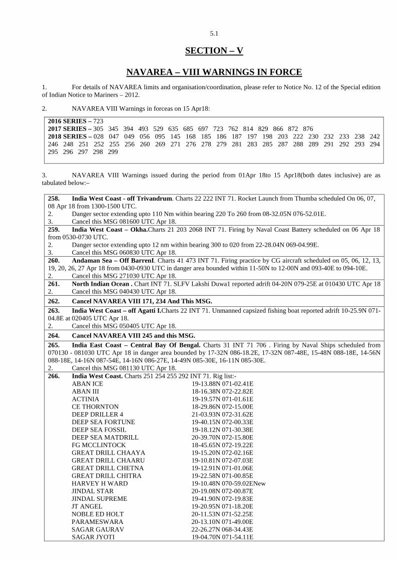
5.1
SECTION – V
2016 SERIES – 723 2017 SERIES – 305 345 394 493 529 635 685 697 723 762 814 829 866 872 876 2018 SERIES – 028 047 049 056 095 145 168 185 186 187 197 198 203 222 230 232 233 238 242 246 248 251 252 255 256 260 269 271 276 278 279 281 283 285 287 288 289 291 292 293 294 295 296 297 298 299
NAVAREA – VIII WARNINGS IN FORCE 1. For details of NAVAREA limits and organisation/coordination, please refer to Notice No. 12 of the Special edition of Indian Notice to Mariners – 2012. 2. NAVAREA VIII Warnings in forceas on 15 Apr18:
3. NAVAREA VIII Warnings issued during the period from 01Apr 18to 15 Apr18(both dates inclusive) are as tabulated below:–
258. India West Coast - off Trivandrum. Charts 22 222 INT 71. Rocket Launch from Thumba scheduled On 06, 07, 08 Apr 18 from 1300-1500 UTC. 2. Danger sector extending upto 110 Nm within bearing 220 To 260 from 08-32.05N 076-52.01E. 3. Cancel this MSG 081600 UTC Apr 18. 259. India West Coast – Okha.Charts 21 203 2068 INT 71. Firing by Naval Coast Battery scheduled on 06 Apr 18 from 0530-0730 UTC. 2. Danger sector extending upto 12 nm within bearing 300 to 020 from 22-28.04N 069-04.99E. 3. Cancel this MSG 060830 UTC Apr 18. 260. Andaman Sea – Off BarrenI. Charts 41 473 INT 71. Firing practice by CG aircraft scheduled on 05, 06, 12, 13, 19, 20, 26, 27 Apr 18 from 0430-0930 UTC in danger area bounded within 11-50N to 12-00N and 093-40E to 094-10E. 2. Cancel this MSG 271030 UTC Apr 18. 261. North Indian Ocean . Chart INT 71. SLFV Lakshi Duwa1 reported adrift 04-20N 079-25E at 010430 UTC Apr 18 2. Cancel this MSG 040430 UTC Apr 18. 262. Cancel NAVAREA VIII 171, 234 And This MSG. 263. India West Coast – off Agatti I.Charts 22 INT 71. Unmanned capsized fishing boat reported adrift 10-25.9N 071-04.8E at 020405 UTC Apr 18. 2. Cancel this MSG 050405 UTC Apr 18. 264. Cancel NAVAREA VIII 245 and this MSG. 265. India East Coast – Central Bay Of Bengal. Charts 31 INT 71 706 . Firing by Naval Ships scheduled from 070130 - 081030 UTC Apr 18 in danger area bounded by 17-32N 086-18.2E, 17-32N 087-48E, 15-48N 088-18E, 14-56N 088-18E, 14-16N 087-54E, 14-16N 086-27E, 14-49N 085-30E, 16-11N 085-30E. 2. Cancel this MSG 081130 UTC Apr 18. 266. India West Coast. Charts 251 254 255 292 INT 71. Rig list:- ABAN ICE 19-13.88N 071-02.41E ABAN III 18-16.38N 072-22.82E ACTINIA 19-19.57N 071-01.61E CE THORNTON 18-29.86N 072-15.00E DEEP DRILLER 4 21-03.93N 072-31.62E DEEP SEA FORTUNE 19-40.15N 072-00.33E DEEP SEA FOSSIL 19-18.12N 071-30.38E DEEP SEA MATDRILL 20-39.70N 072-15.80E FG MCCLINTOCK 18-45.65N 072-19.22E GREAT DRILL CHAAYA 19-15.20N 072-02.16E GREAT DRILL CHAARU 19-10.81N 072-07.03E GREAT DRILL CHETNA 19-12.91N 071-01.06E GREAT DRILL CHITRA 19-22.58N 071-00.85E HARVEY H WARD 19-10.48N 070-59.02ENew JINDAL STAR 20-19.08N 072-00.87E JINDAL SUPREME 19-41.90N 072-19.83E JT ANGEL 19-20.95N 071-18.20E NOBLE ED HOLT 20-11.53N 071-52.25E PARAMESWARA 20-13.10N 071-49.00E SAGAR GAURAV 22-26.27N 068-34.43E SAGAR JYOTI 19-04.70N 071-54.11E
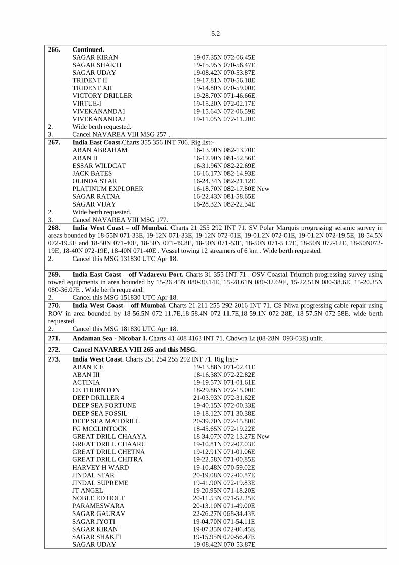
5.2 266. Continued. SAGAR KIRAN 19-07.35N 072-06.45E SAGAR SHAKTI 19-15.95N 070-56.47E SAGAR UDAY 19-08.42N 070-53.87E TRIDENT II 19-17.81N 070-56.18E TRIDENT XII 19-14.80N 070-59.00E VICTORY DRILLER 19-28.70N 071-46.66E VIRTUE-I 19-15.20N 072-02.17E VIVEKANANDA1 19-15.64N 072-06.59E VIVEKANANDA2 19-11.05N 072-11.20E 2. Wide berth requested. 3. Cancel NAVAREA VIII MSG 257 . 267. India East Coast.Charts 355 356 INT 706. Rig list:- ABAN ABRAHAM 16-13.90N 082-13.70E ABAN II 16-17.90N 081-52.56E ESSAR WILDCAT 16-31.96N 082-22.69E JACK BATES 16-16.17N 082-14.93E OLINDA STAR 16-24.34N 082-21.12E PLATINUM EXPLORER 16-18.70N 082-17.80E New SAGAR RATNA 16-22.43N 081-58.65E SAGAR VIJAY 16-28.32N 082-22.34E 2. Wide berth requested. 3. Cancel NAVAREA VIII MSG 177. 268. India West Coast – off Mumbai. Charts 21 255 292 INT 71. SV Polar Marquis progressing seismic survey in areas bounded by 18-55N 071-33E, 19-12N 071-33E, 19-12N 072-01E, 19-01.2N 072-01E, 19-01.2N 072-19.5E, 18-54.5N 072-19.5E and 18-50N 071-40E, 18-50N 071-49.8E, 18-50N 071-53E, 18-50N 071-53.7E, 18-50N 072-12E, 18-50N072-19E, 18-40N 072-19E, 18-40N 071-40E . Vessel towing 12 streamers of 6 km . Wide berth requested. 2. Cancel this MSG 131830 UTC Apr 18. 269. India East Coast – off Vadarevu Port. Charts 31 355 INT 71 . OSV Coastal Triumph progressing survey using towed equipments in area bounded by 15-26.45N 080-30.14E, 15-28.61N 080-32.69E, 15-22.51N 080-38.6E, 15-20.35N 080-36.07E . Wide berth requested. 2. Cancel this MSG 151830 UTC Apr 18. 270. India West Coast – off Mumbai. Charts 21 211 255 292 2016 INT 71. CS Niwa progressing cable repair using ROV in area bounded by 18-56.5N 072-11.7E,18-58.4N 072-11.7E,18-59.1N 072-28E, 18-57.5N 072-58E. wide berth requested. 2. Cancel this MSG 181830 UTC Apr 18. 271. Andaman Sea - Nicobar I. Charts 41 408 4163 INT 71. Chowra Lt (08-28N 093-03E) unlit.
272. Cancel NAVAREA VIII 265 and this MSG. 273. India West Coast. Charts 251 254 255 292 INT 71. Rig list:- ABAN ICE 19-13.88N 071-02.41E ABAN III 18-16.38N 072-22.82E ACTINIA 19-19.57N 071-01.61E CE THORNTON 18-29.86N 072-15.00E DEEP DRILLER 4 21-03.93N 072-31.62E DEEP SEA FORTUNE 19-40.15N 072-00.33E DEEP SEA FOSSIL 19-18.12N 071-30.38E DEEP SEA MATDRILL 20-39.70N 072-15.80E FG MCCLINTOCK 18-45.65N 072-19.22E GREAT DRILL CHAAYA 18-34.07N 072-13.27E New GREAT DRILL CHAARU 19-10.81N 072-07.03E GREAT DRILL CHETNA 19-12.91N 071-01.06E GREAT DRILL CHITRA 19-22.58N 071-00.85E HARVEY H WARD 19-10.48N 070-59.02E JINDAL STAR 20-19.08N 072-00.87E JINDAL SUPREME 19-41.90N 072-19.83E JT ANGEL 19-20.95N 071-18.20E NOBLE ED HOLT 20-11.53N 071-52.25E PARAMESWARA 20-13.10N 071-49.00E SAGAR GAURAV 22-26.27N 068-34.43E SAGAR JYOTI 19-04.70N 071-54.11E SAGAR KIRAN 19-07.35N 072-06.45E SAGAR SHAKTI 19-15.95N 070-56.47E SAGAR UDAY 19-08.42N 070-53.87E
5.3 273. Continued. TRIDENT II 20-09.54N 071-47.43ENew TRIDENT XII 19-14.80N 070-59.00E VICTORY DRILLER 19-28.70N 071-46.66E VIRTUE-I 19-15.20N 072-02.17E VIVEKANANDA1 19-15.64N 072-06.59E VIVEKANANDA2 19-11.05N 072-11.20E 2. Wide berth requested. 3. Cancel NAVAREA VIII MSG 266. 274. India East Coast.Charts 355 356 INT 706. Rig list:- ABAN ABRAHAM 16-13.90N 082-13.70E ABAN II 16-17.90N 081-52.56E ESSAR WILDCAT 16-31.96N 082-22.69E JACK BATES 16-25.70N 082-23.43E New OLINDA STAR 16-24.34N 082-21.12E PLATINUM EXPLORER 16-18.70N 082-17.80E SAGAR RATNA 16-22.43N 081-58.65E SAGAR VIJAY 16-28.32N 082-22.34E 2. Wide berth requested. 3. Cancel NAVAREA VIII MSG 267 . 275. Bay Of Bengal, Andaman Sea, Pacific Ocean.Charts 32, 41, 356 INT 71. PSLV Launch scheduled from 11 – 19 Apr 18 for 04 hrs from 2145 UTC. 2. Danger zone as follows:
Zone -1: Circle Of 10 nm from 13-43.9N 080-14.2E. Zone–2: 13-30N 080-30E, 13-50N 080-35E, 13-35N 081-30E, 13-15N 081-25E. Zone–3: 13-00N 082-10E, 13-30N 082-15E, 12-55N 084-05E, 12-25N 084-00E. Zone–4: 12-20N 084-05E, 13-00N 084-15E, 12-45N 085-10E, 12-05N 085-00E. Zone–5: 11-10N 088-25E, 11-45N 088-35E, 11-25N 089-40E, 10-50N 089-30E. Zone–6: 09-05N 094-50E, 09-55N 095-05E, 09-35N 096-00E, 08-45N 095-45E. Zone–7: 19-00S 134-00W, 17-00S 134-00W, 13-00S 112-00W, 07-30S 090-00W, 09-30S 090-00W, 15-00S 112-00W.
3. Cancel this MSG 200245 UTC Apr 18. 276. India West Coast – off Porbandar. Charts 21 204 205 252 INT 71. Firing from Kathiawar range scheduled on 07,11, 12, 13, 14 Apr 18 from 0230-1030 UTC in danger area bounded by 22-12N 068-36.33E, 21-15.5N 069-04E, 21-09N 069-40E, 21-15.5N 069-42.5E, 22-05.75N 068-49E. 2. Cancel this MSG 141130 UTC Apr 18. 277. India East Coast – off Kakinada. Charts 31 32 INT 71. Firing by Naval ships scheduled on 10 Apr 18 from 0030 – 0500 UTC in danger area bounded by15-30N 083-24E, 16-14N 084-00E, 15-34N 084-46E 15-08N 084-24E. 2. Cancel this MSG 100600 UTC Apr 18. 278. India West Coast – NeelamOda. Charts 21 211 255 292 293 2016 INT 71.MV Chandra Jupiter progressing survey in area bounded by 18-49.2N 072-09.49E, 18-48.81N 072-28.67E, 17-58.73N 072-27.66E, 17-59.05N 072-08.58E.Wide berth requested. 2. Cancelthis MSG 151830 UTC May 18. 279. India West Coast – Off NeelamOda. Charts 21 211 255 292 INT 71. SV Lts3000 progressing installation in vicinity of 18-56.90N 072-15.93E, 18-41.47N 072-21.22E. Wide berth requested. 2. Cancel this MSG 301830 UTC May 18. 280. NAVAREA VIII Warnings in force as on 06 Apr 18:- 2016 SERIES – 723 2017 SERIES – 305 345 394 493 529 635 685 697 723 762 814 829 836 866 872 876 2018 SERIES – 028 047 049 056 095 145 160 168 185 186 187 197 198 203 222 230 232 233 238 242 246 248 250 251 252 254 255 256 258 260 268 269 270 271 273 274 275 276 277 278 279 (A) NAVAREA VIII Warnings less than 42 days promulgated via safetynet. (B) Text of NAVAREA VIII warnings inforce including those which no longer broadcast available in www.hydrobharat.gov.in 2. Cancel this MSG 131830 UTC Apr 18. 281. India West Coast - off Mumbai To Jakhau. Charts 21 202 203 251 253 254 255 291 292 INT 71. SV Fugro Mapper progressing survey in vicinity of 20-14.85N 071-57.78E, 20-05.42N 071-53.13E, 18-30.06N 072-15.95E,18-38.79N 072-14.97E, 19-13.54N 070-48.33E, 19-34.27N 071-38.04E, 19-39.26N 071-33.14E, 19-26.15N 071-18.63E, 19-05.34N 072-06.88E, 21-37.97N 068-26.41E, 22-57.11N 068-32.30E and from 22-27.92N 068-48.86E to 22-23.81N 068-58.31E from 01 - 07 May 18. Wide berth requested. 2. Cancel NAVAREA VIII 254 and this MSG 071830 UTC May 18. 282. Cancel NAVAREA VIII 836/17 and this MSG. 283. Lakshadweep Sea - off Cape Comorin. Charts 23 261 INT 71. Upturned hull approximately 15 mtrs reported
5.4 283. Continued. adrift 06-48.3N 077-18.6E. 2. Cancel this MSG 141000 UTC Apr 18. 284. India West Coast – Safety Fairway and Deep Water Route off Okha.Charts 21 202 251 271 291 2068INT 71. MT Revti progressing survey using towed sonar in area bounded by 21-24.9N 068-57.23E, 22-24.3N 068-25.63E, 22-23.31N 068-58.14E, 22-23.92N 068-58.14E. Wide berth requested. 2. Cancel this MSG 301830 UTC Apr 18. 285. India East Coast – off Chennai. Charts 32 313 356 357 INT 71. Firing by CG aircraft scheduled daily from 16 - 30 Apr 18 from 0130 - 1130 UTC in danger area bounded within 12-49N to 12-59N and 080-46E to 081-26E. 2. Cancel this MSG 301230 UTC Apr 18. 286. Cancel NAVAREA VIII 160 and this MSG. 287. India West Coast – Safety Fairway and Deep Water Route off Okha. Charts 21 202 251 271 291 2068INT 71. MT Revti progressing survey using towed sonar in area bounded by 22-24.9N 068-57.23E, 22-24.3N 068-25.63E, 22-23.31N 068-58.14E, 22-23.92N 068-58.14E. Wide berth requested. 2. Cancel NAVAREA VIII 284 and this MSG 301830 UTC Apr 18. 288. India West Coast – off Mumbai.Charts 21 211 255 292 2016 INT 71. CS Niwa progressing cable repair using ROV in area bounded by 18-56.5N 072-11.7E, 18-58.4N 072-11.7E,18-59.1N 072-23E, 18-57.5N 072-23E. Wide berth requested. 2. Cancel NAVAREA VIII 270 and this MSG 181830 UTC Apr 18. 289. Andaman Sea – off Pigeon I. Charts 41 409 472 INT 71. INS Investigator progressing hydrographic survey in area bounded within 06-55.13N to 07-12.8N and 093-51.7E TO 094-00.4E .Wide berth from ship and survey boats requested. 2. Cancel this MSG 171830 UTC Apr 18. 290. Cancel NAVAREA VIII 275 and this MSG. 291. India West Coast - off Karwar. Charts 21 215 257 293 INT 71 705. Firing by Naval Ships scheduled on 17 Apr 18 from 0800-1430 UTC In danger area bounded within 14-08N to 14-40N and 072-42E to 073-15E. 2. Cancel this MSG 171530 UTC Apr 18. 292. India West Coast – off Netrani I. Charts 22 216 257 293 2072 INT 71.Firing by Naval Ships scheduled on 17 Apr 18 from 0001 - 0530 UTC in danger area bounded within 13-56.2N to 14-07.2N and 074-13.6E to 074-25.07E. 2. Cancel this MSG 170630 UTC Apr 18. 293. India West Coast - off Trivandrum. Charts 22 222 INT 71. Rocket launch from Thumba(08-31.98N 076-52.05E) scheduled on 18 Apr 18 from 0530-0730 UTC. 2. Danger sector:
(A) Radius of 05 nm from Thumba between azimuth 190 and 300. (B) Radii of 45 and 75 nm from Thumba between azimuth 220 and 260.
3. Cancel this MSG 180830 UTC Apr 18. 294. India East Coast- Vishakhapatnam. Charts 31 308 3002 INT 71. Firing by Naval Coast Battery scheduled on 18 Apr 18 from 0001 - 0130 UTC in danger sector extending upto17 nm between bearing 070 and 130 from 17-42N 083-18E. 2. Cancel this MSG 180230 UTC Apr 18. 295. India West Coast - off Jafarabad. Charts 21 210 254 292 INT 71. SV KNK Ayaana progressing survey using towed equipment in areas bounded by (A) 20-10.89N 071-22.73E, 20-04.33N 071-29.72E, 20-00.49N 071-28.82E, 20-00.39N 071-26.07E, 20-06.73N 071-25.01E, 20-06.53N 071-20.23E, 20-08.94N 071-18.87E (B) 20-09.54N 071-24.17E, 20-20.73N 072-01.41E, 20-19.69N 072-01.82E, 20-08.68N 071-25.09E. Wide berth requested. 2. Cancel this MSG 121830 UTC May 18. 296. India West Coast – off NeelamOda. Charts 21 211 255 292 INT 71. SV Polar Marquis progressing seismic surveyin area bounded by 18-50N 071-40E, 18-50N 071-49.8E, 18-50N 071-53E, 18-50N 071-53.7E, 18-50N 072-12E, 18-50N 072-19E, 18-40N 072-19E, 18-40N 071-40E. Vessel towing 12 streamers of 06 km. Wide berth requested. 2. Cancel this MSG 171830 UTC Apr 18. 297. India West Coast. Charts 251 254 255 292 INT 71. Rig list: ABAN ICE 19-13.88N 071-02.41E ACTINIA 19-19.57N 071-01.61E CE THORNTON 18-29.86N 072-15.00E DEEP DRILLER 4 21-03.93N 072-31.62E DEEP SEA FORTUNE 19-40.15N 072-00.33E DEEP SEA FOSSIL 19-18.12N 071-30.38E DEEP SEA MATDRILL 20-39.70N 072-15.80E FG MCCLINTOCK 18-45.65N 072-19.22E GREAT DRILL CHAAYA 18-34.07N 072-13.27E GREAT DRILL CHAARU 19-10.81N 072-07.03E GREAT DRILL CHETNA 19-12.91N 071-01.06E GREAT DRILL CHITRA 19-22.58N 071-00.85E HARVEY H WARD 19-10.48N 070-59.02E JINDAL STAR 20-19.08N 072-00.87E
5.5 297. Continued. JINDAL SUPREME 19-41.90N 072-19.83E JT ANGEL 19-20.95N 071-18.20E NOBLE ED HOLT 20-11.53N 071-52.25E PARAMESWARA 20-13.10N 071-49.00E SAGAR GAURAV 22-26.27N 068-34.43E SAGAR JYOTI 19-04.70N 071-54.11E SAGAR KIRAN 19-07.35N 072-06.45E SAGAR SHAKTI 19-15.95N 070-56.47E SAGAR UDAY 19-08.42N 070-53.87E TRIDENT II 20-09.54N 071-47.43E TRIDENT XII 19-26.06N 071-12.96ENew VICTORY DRILLER 19-28.70N 071-46.66E VIRTUE-I 19-15.20N 072-02.17E VIVEKANANDA1 19-15.64N 072-06.59E VIVEKANANDA2 19-11.05N 072-11.20E 2. Wide berth requested. 3. Cancel NAVAREA VIII MSG 273 . 298. India East Coast. Charts 355 356 INT 706.Rig list: ABAN ABRAHAM 16-13.90N 082-13.70E ABAN II 16-17.90N 081-52.56E ESSAR WILDCAT 15-19.58N 080-33.30E New JACK BATES 16-25.70N 082-23.43E OLINDA STAR 16-24.34N 082-21.12E PLATINUM EXPLORER 16-18.70N 082-17.80E SAGAR RATNA 16-22.43N 081-58.65E SAGAR VIJAY 16-28.32N 082-22.34E 2. Wide berth requested. 3. Cancel NAVAREA VIII MSG 274. 299. India West Coast – Neelam, Mukta And Tapti Oda. Charts 21 22 210 211 212 254 255 256 292 293 2016 INT 71. SV MV Flamboyan progressing surveyin area bounded by (A) 18-49.2N 072-09.49E, 18-48.81N 072-28.67E, 17-58.73N 072-27.66E, 17-59.05N 072-08.58E (B) 19-42.36N 070-56.18E, 19-41.28N 072-09.73E, 18-54.89N 072-20.56E, 18-55.08N071-46.56E, 18-55.74N 071-01.96E, 19-05.85N 070-55.71E (C) 20-37.99N 071-56.7E, 20-37.8N 072-07.22E, 20-03.33N 072-06.53E, 20-03.75N 071-40.63E. Wide berth requested. 2. Cancel this MSG 311830 UTC May 18. 300. NAVAREA VIII Warnings in force as on 13 Apr 18:- 2016 SERIES – 723 2017 SERIES – 305 345 394 493 529 635 685 697 723 762 814 829 866 872 876 2018 SERIES – 028 047 049 056 095 145 168 185 186 187 197 198 203 222 230 232 233 238 242 246 248 251 252 255 256 260 269 271 276 278 279 281 283 285 287 288 289 291 292 293 294 295 296 297 298 299 (A) NAVAREA VIII Warnings less than 42 days promulgated via safetynet. (B) Text of NAVAREA VIII warnings inforce including those which no longer broadcast available in www.hydrobharat.gov.in 2. Cancel this MSG 201830 UTC Apr 18.
6. 1
SECTION – VI
CORRECTIONS TO SAILING DIRECTIONS (PILOTS)
West coast of India Pilot (INP-1)
(Source: IH-102, HSU Mumbai) Chapter - 7 (Page 280)
Article 7.214, Para 1, line 3 Delete text “13.5 m” and replace by “8.0 m” Page 286, Article 7.251, Para 3, line 2 Delete text “13.5 m” and replace by “8.0 m” Page 286, Article 7.254, Para 2, line 4 & 5 Delete text “13.5 m” and replace by “8.0 m”
7. 1
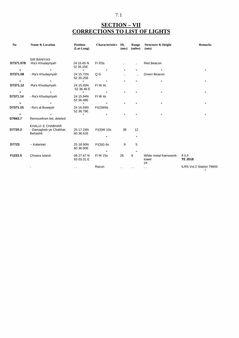
SECTION – VII
CORRECTIONS TO LIST OF LIGHTS
No Name & Location Position (Lat-Long)
Characteristics Ht. (mts)
Range (miles)
Structure & Height (mts)
Remarks
SIR BANIYAS
D7371.078 -Ra's Khudayriyah 24 15.65 N 52 35.25E
FI R3s . . .. Red Beacon
* * * * * * * * D7371.08 - Ra's Khudayriyah 24 15.72N
52 35.25E Q G .. .. Green Beacon
* * * * * * * * D7371.12 -Ra's Khudayriyah 24 15.93N
52 36.46 E FI W 4s
* * * * * * * * D7371.14 - Ra's Khudayriyah 24 15.94N
52 36.48E FI W 4s
* * * * * * * * D7371.15 - Ra's al Buwaytir 24 16.59N
52 36.79E FI(2)W6s
* * * * * * * * D7663.7 Removefrom list; deleted KHALIJ- E CHABHAR D7720.2 - Damagheh-ye Chabhar.
Behashti 25 17.19N 60 36.61E
FI(3)W 10s
38 12
* * D7723 -- Kalantari 25 18.90N
60 36.90E FI(3)G 6s 9 5
* * F1222.5 Chowra Island 08 27.67 N
93 03.31 E Fl W 15s 26 9 White metal framework
tower 24
fl 0.5 TE 2018
- . . Racon . . . . . . ILRS Vol.2 Station 79600 *
8.1
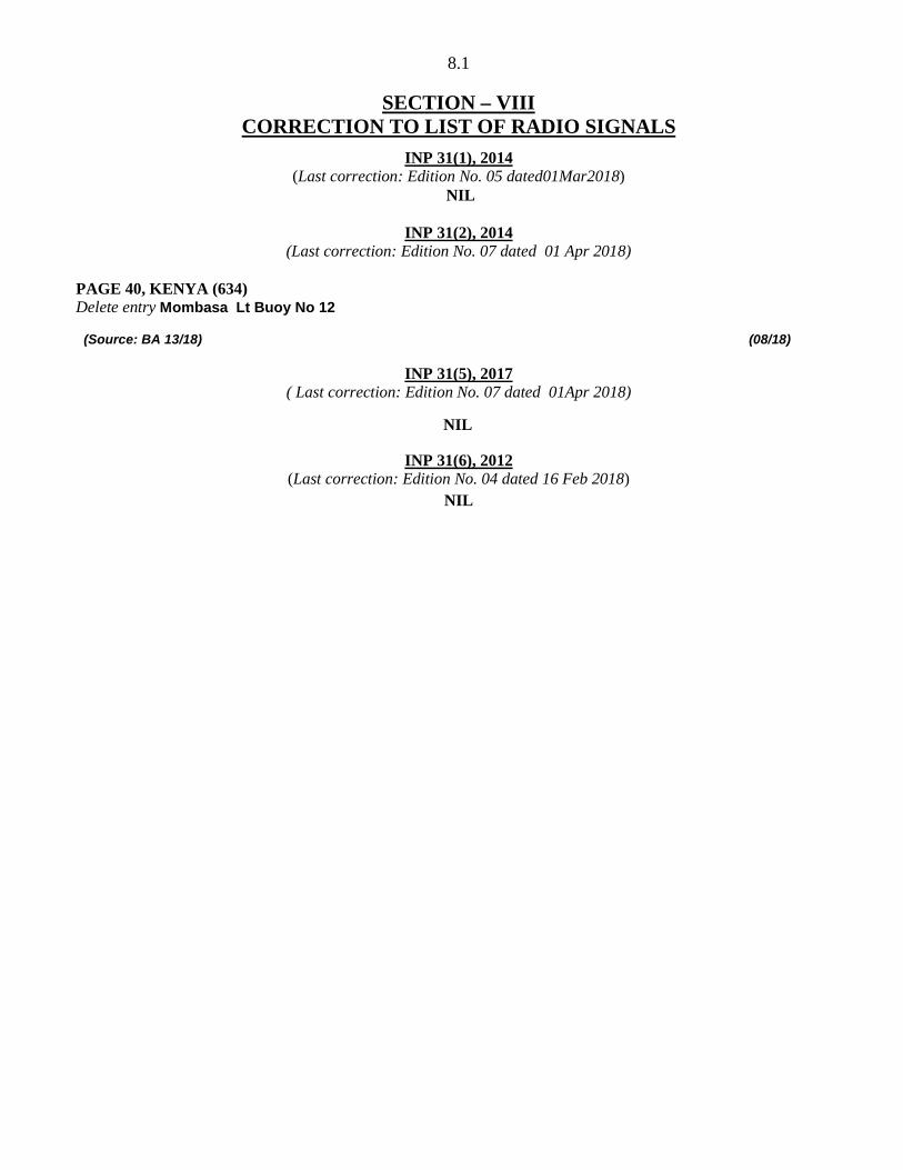
SECTION – VIII
CORRECTION TO LIST OF RADIO SIGNALS
(Last correction: Edition No. 05 dated01Mar2018) INP 31(1), 2014
NIL
Delete entry Mombasa Lt Buoy No 12
INP 31(2), 2014 (Last correction: Edition No. 07 dated 01 Apr 2018)
PAGE 40, KENYA (634)
(Source: BA 13/18) (08/18)
NIL
INP 31(5), 2017 ( Last correction: Edition No. 07 dated 01Apr 2018)
INP 31(6), 2012 (Last correction: Edition No. 04 dated 16 Feb 2018)
NIL
9.1
SECTION – IX
REPORTING OF NAVIGATIONAL DANGERS Appeal to all Mariners 1. Mariners at sea whilst on passage, or whilst entering / leaving ports / harbours and other waterways, are requested to look out for new or suspected dangers to navigation, changes in aids to navigation, or corrections to published charts and Sailing Directions. Whenever any such changes / dangers are observed, mariners are requested to notify the same to the Chief Hydrographer to the Government of India at the following address: -
National Hydrographic Office 107-A, Rajpur Road, Dehradun - 248001 (UTTARAKHAND), INDIA e-mail: - [email protected], [email protected] Fax No.: +91-135- 2748373 WEB: www.hydrobharat.gov.in
Instructions for filling up IH 102 2. Kindly follow the instructions below in order to help the Hydrographic Office (the recipient) to quickly issue NAVAREA warning / Notice to Mariners for the benefit of all other mariners at sea. Position Reporting 3. Accurate position or knowledge of position error is of great importance. Latitude and Longitude should only be used to specify position details when they have been fixed by GPS or Astronomical Observations. A full description of the method, equipment, time and datum (WGS 84/Everest/Other) used should be given. When position is defined by sextant angles or bearings (true or magnetic to be specified), more than two bearings should be used in order to provide a redundancy check. Distances observed by Radar should be corrected for index errors. Where position is derived after the event, from other observations and/or Dead Reckoning, the methodology of deriving the position should be included. 4. Paper Charts. A copy/tracing of largest scale chart is the best medium for forwarding details, the alterations and additions being shown thereon in red, but adequate details from the chart must be traced in black ink to enable the amendments to be fitted correctly. 5. ENCs. A Screen shot of largest scale usage band ENC with the alterations and additions being shown thereon in red. If it is to report an issue with the display of an ENC, a screen shot of the affected cell should be sent along with details of the ECDIS make and version in use at the time. Depth Reporting 6. When soundings are obtained using echo sounders, the echo sounding trace should be duly annotated with date, times, position, depths, etc., and forwarded with the IH102. It is important to state whether the echo sounder is set to register depths below the surface or below the keel; in the latter case the vessel’s draught should be given. Time and date should be given in order that corrections for the height of the tide may be made where necessary. The make, name and type of echo sounder should also be given. 7. For modern echo sounders that use electronic ‘range gating’, care should be taken that the correct range scale and appropriate gate width are in use. Older electro-mechanical echo sounders frequently record signals from echoes received back after one or more rotations of the stylus have been completed. Thus with a set whose maximum range is 500m, an echo recorded at 50m may be from depths of 50m, 550m or even 1050m. Soundings recorded beyond the set’s nominal range can usually be recognised by the following: (a) the trace being weaker than normal for the depth recorded; (b) the trace passing through the transmission line; (c) the feathery nature of the trace.
9.2
As a check that apparently shoal soundings are not due to echoes received beyond the set’s nominal range, soundings should be continued until reasonable agreement with charted soundings is reached. However, soundings received after one or more rotations of the stylus can still be useful and should be submitted if they show significant differences from the chatted depths. Efforts should be made to identify and negate false echoes if any. The Mariners Handbook (NP100) and Notice 15 Special Edition of Notice to Mariners may be consulted. 8. Reports which cannot be confirmed or are lacking in certain details should not be withheld. Shortcomings should be stressed and any firm expectation of being able to check the information on a succeeding voyage should be notified. 9. Reports of shoal soundings, uncharted dangers and aids to navigation out of order should, at the mariner’s discretion, also be made by radio to the nearest coast radio station. The draught of modern tankers in such that any uncharted depth under 30 meters or 15 fathoms may be of sufficient importance to justify a radio message. 10. Changes to Port information should be forwarded on Form IH.102A together with form IH.102. Form 102A contains the information required for Sailing Directions and should be used as an aide memoir. The Mariners Handbook, NP100, Chapter 8 gives general instructions. Where there is insufficient space on the forms an additional sheet should be used. Please Note: - An acknowledgement will be sent by National Hydrographic Office for Hydrographic Notes, on receipt. When a Notice to Mariners is issued, the sender’s ship or name is quoted as authority unless the information is also received from other authorities/ foreign Notices to Mariners. Further, communication from National Hydrographic Office to the sender of Hydrographic Notes will only be necessary to verify unusual features or abnormal values reported.
9.3
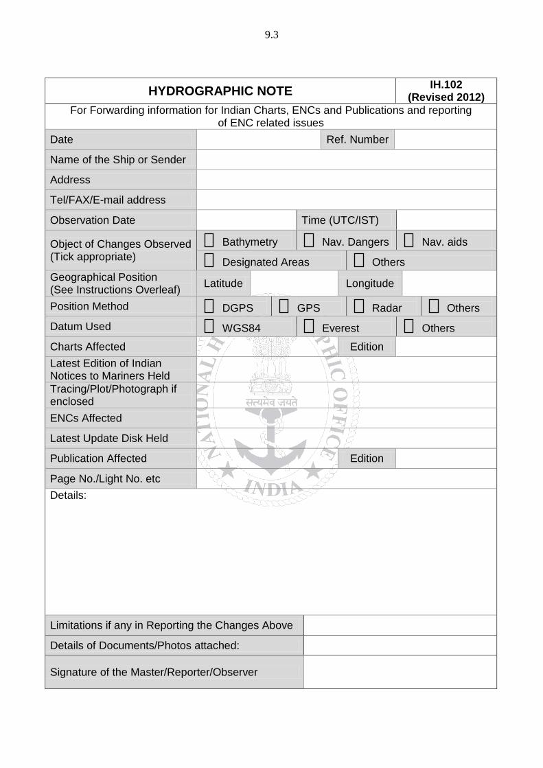
HYDROGRAPHIC NOTE IH.102 (Revised 2012)
For Forwarding information for Indian Charts, ENCs and Publications and reporting of ENC related issues
Date Ref. Number
Name of the Ship or Sender
Address
Tel/FAX/E-mail address
Observation Date Time (UTC/IST)
Object of Changes Observed (Tick appropriate)
Bathymetry
Nav. Dangers
Nav. aids
Designated Areas
Others Geographical Position (See Instructions Overleaf) Latitude Longitude
Position Method
DGPS
GPS
Radar
Others
Datum Used
WGS84
Everest
Others
Charts Affected Edition Latest Edition of Indian Notices to Mariners Held
Tracing/Plot/Photograph if enclosed
ENCs Affected
Latest Update Disk Held
Publication Affected Edition
Page No./Light No. etc Details: Limitations if any in Reporting the Changes Above
Details of Documents/Photos attached:
Signature of the Master/Reporter/Observer
9.4
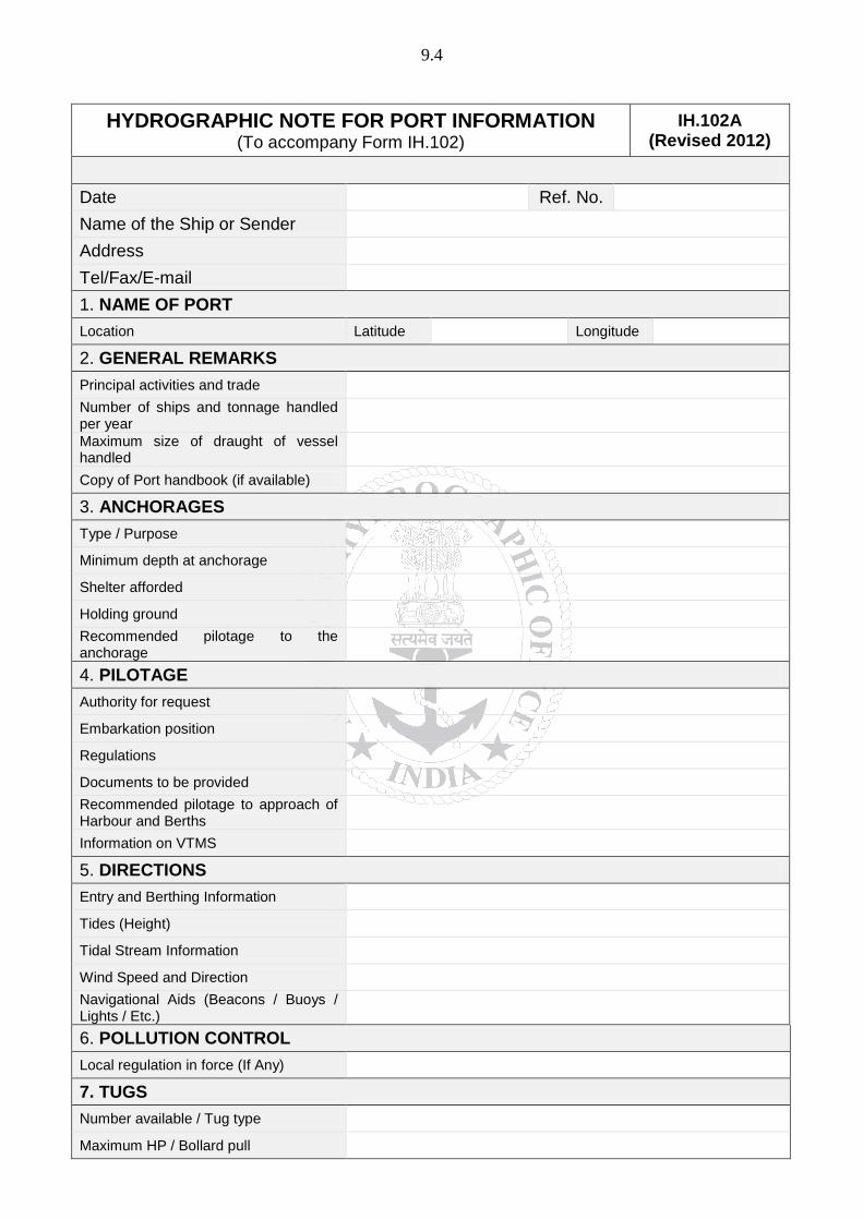
HYDROGRAPHIC NOTE FOR PORT INFORMATION (To accompany Form IH.102)
IH.102A (Revised 2012)
Date Ref. No. Name of the Ship or Sender Address Tel/Fax/E-mail 1. NAME OF PORT Location Latitude Longitude
2. GENERAL REMARKS Principal activities and trade Number of ships and tonnage handled per year
Maximum size of draught of vessel handled
Copy of Port handbook (if available)
3. ANCHORAGES Type / Purpose Minimum depth at anchorage Shelter afforded Holding ground Recommended pilotage to the anchorage
4. PILOTAGE Authority for request Embarkation position Regulations Documents to be provided Recommended pilotage to approach of Harbour and Berths Information on VTMS 5. DIRECTIONS Entry and Berthing Information Tides (Height) Tidal Stream Information Wind Speed and Direction Navigational Aids (Beacons / Buoys / Lights / Etc.)
6. POLLUTION CONTROL Local regulation in force (If Any) 7. TUGS Number available / Tug type Maximum HP / Bollard pull
9.5
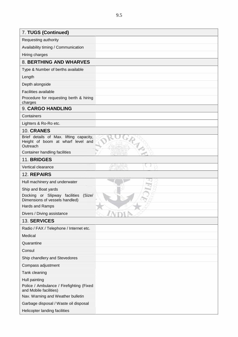
7. TUGS (Continued) Requesting authority Availability timing / Communication Hiring charges 8. BERTHING AND WHARVES Type & Number of berths available Length Depth alongside Facilities available Procedure for requesting berth & hiring charges
9. CARGO HANDLING Containers Lighters & Ro-Ro etc. 10. CRANES Brief details of Max. lifting capacity, Height of boom at wharf level and Outreach
Container handling facilities 11. BRIDGES Vertical clearance 12. REPAIRS Hull machinery and underwater Ship and Boat yards Docking or Slipway facilities (Size/ Dimensions of vessels handled) Hards and Ramps Divers / Diving assistance 13. SERVICES Radio / FAX / Telephone / Internet etc. Medical Quarantine Consul Ship chandlery and Stevedores Compass adjustment Tank cleaning Hull painting Police / Ambulance / Firefighting (Fixed and Mobile facilities) Nav. Warning and Weather bulletin Garbage disposal / Waste oil disposal Helicopter landing facilities

9.6
14. RESCUE & DISTRESS Salvage, Lifeboat, Life guards, etc 15. SUPPLIES Fuel (Type, Quantities & Method of delivery) Fresh water (Method of delivery and Rate of supply) Provisions Chart agents 16. COMMUNICATIONS Road, Rail and Air services available Nearest airport or airfield Port Radio and Information Service (Frequencies and Operating Hours)
17. PORT AUTHORITY Designation, Address, Telephone, E-mail Address and Website
18. SECURITY Security of ports / International Ship and Port Facility Security (ISPS) compliance
Custom and Immigration Regulations in force
19. SMALL CRAFT FACILITIES Information and facilities for small craft, yachts visiting the port Yacht clubs, berths etc 20. SHORT LEAVE 21. CLUBS RECREATION Information Kiosk (Location) Foreign Exchange firms / Banks (Within / Near Port Area) Places of interest near port 22. VIEWS Photographs(Duly annotated) of the approaches, leading marks, the entrance to the harbour etc.
23. ADDITIONAL DETAILS
Any other information considered to be useful for the mariners
SIGNATURE OF THE OBSERVER / REPORTER /
MASTER
FOR 24 X 7 SAR ASSISTANCE IN INDIAN SRR
NATION WIDE SAR TELE
: 1554 (LAND LINE)
INMARSAT C (IOR) 441907210 CODE
: 43 (TOLL FREE)
AFTN: VABBYXYC
Related Documents