Implementation of GIS technology to support Population Census operations in Albania Nexhmije Leçini Meeting on the Management of Statistical Information Systems (MSIS 2014) (Dublin, Ireland, 14-16 April 2014)

Implementation of GIS technology to support Population Census operations in Albania Nexhmije Leçini Meeting on the Management of Statistical Information.
Jan 02, 2016
Welcome message from author
This document is posted to help you gain knowledge. Please leave a comment to let me know what you think about it! Share it to your friends and learn new things together.
Transcript

Implementation of GIS technology to support Population Census operations in Albania
Nexhmije Leçini
Meeting on the Management of Statistical Information Systems (MSIS 2014)
(Dublin, Ireland, 14-16 April 2014)

Presentation outline
• Introduction
• Existing spatial data and census information
a) Census mapping
b) The new GIS system
• Post Census activities
• Next challenges
2National Institute of Statistics Albania

Introduction
GIS technology in the Census process
Optical Mark Recognition (OMR)
Intelligent Character Recognition (ICR)
3National Institute of Statistics Albania
Some new technological innovation implemented at Population Census Albania
Census Information System
I. Census Mapping
II. The new GIS systema) Field update
b) Digitizing
c) Delineation of the EAs
4National Institute of Statistics Albania

Digitizing
5National Institute of Statistics Albania
a.Urban Modeb.Rural Mode

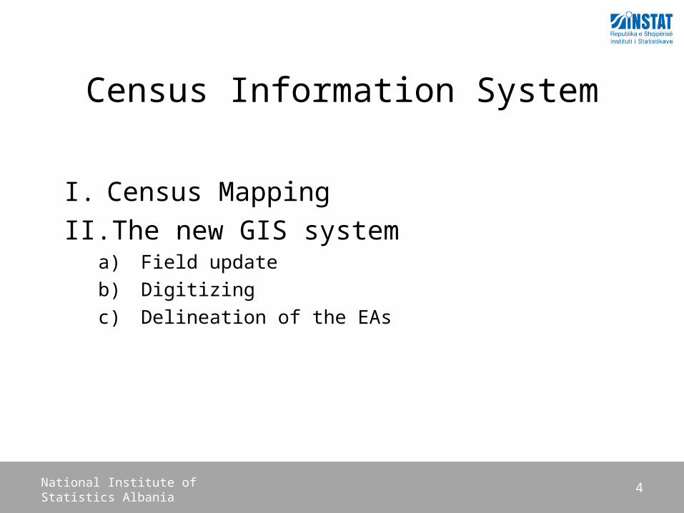
Digitizing / Quality Control
6National Institute of Statistics Albania
User Action for Quality Control
Digitizing / Quality Control
7National Institute of Statistics Albania
Geodatabase Administration
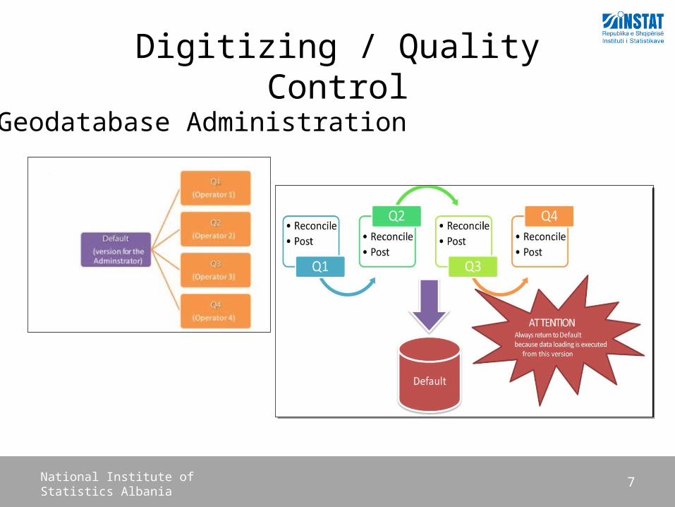
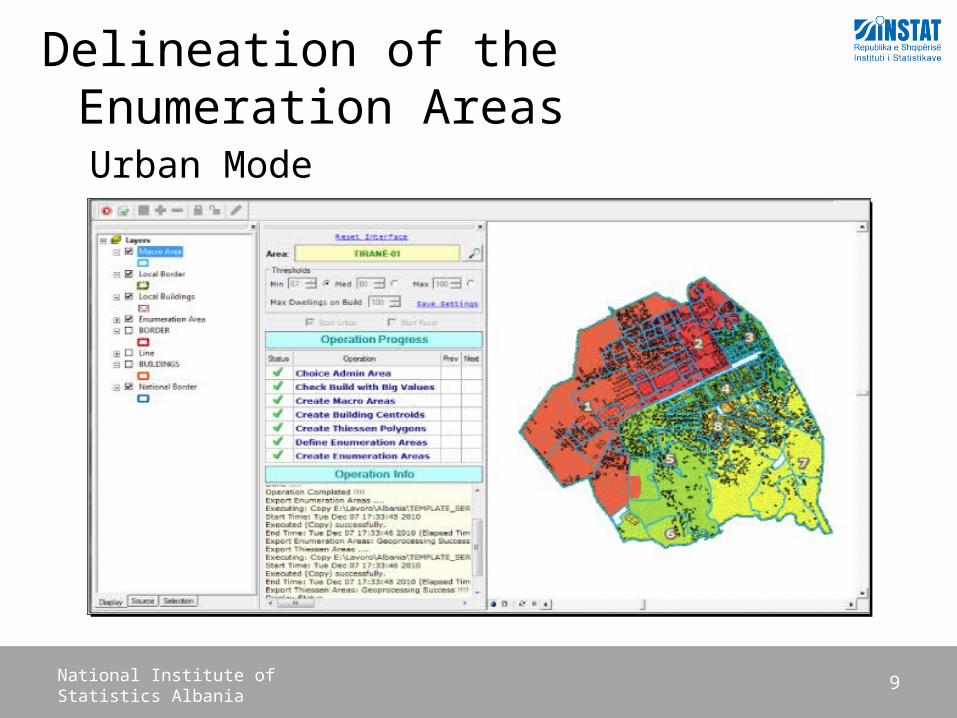
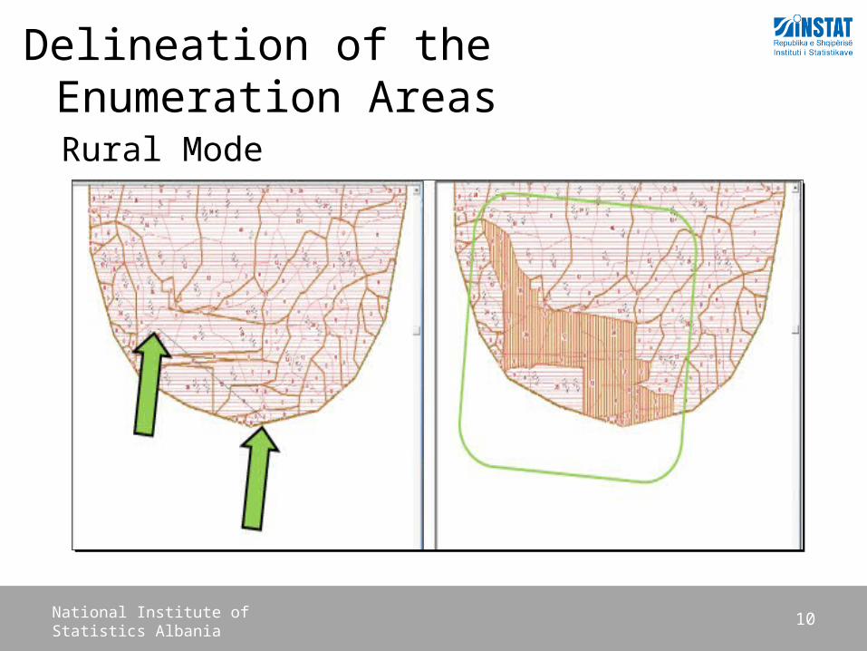
Delineation of the Enumeration Areas
8National Institute of Statistics Albania
• In Urban Areas each EA have approximately 80 to 100 dwellings• In Rural Areas the size of EAs was slightly smaller, 60 to 80
1. Urban mode - boundaries, street lines and buildings for housing purpose
2. Rural mode- boundaries, street lines, buildings, watersheds and sides
Two way process:
Delineation of the Enumeration Areas
9National Institute of Statistics Albania
Urban Mode
Delineation of the Enumeration Areas
10National Institute of Statistics Albania
Rural Mode

Enumeration Area Map
11National Institute of Statistics Albania
Post Census activities
12National Institute of Statistics Albania
• Data entry• Checking• Editing • Analysis • Publications
Future Challenges
13National Institute of Statistics Albania
The objective is to create a spatial database• enables queries over the whole territory• data is suitable for a small-scale thematic mapping and large-scale analysis• the database contains information of census maps and census data• the database avoids data duplication• uses open data structure, permits use of as many GIS software applications • the database structure enables export of data for Web services in the future• enables relation with Census database• enforces the technical quality and logical consistency of the data• implementation of data specifications in the framework of the INSPIRE EU Directive

14National Institute of Statistics Albania
Question Please?
Thank You
Related Documents