ORIGINAL ARTICLE Hydrologic and geochemical survey of the lake ‘‘Specchio di Venere’’ (Pantelleria island, Southern Italy) A. Aiuppa W. D’Alessandro S. Gurrieri P. Madonia F. Parello Received: 24 January 2007 / Accepted: 23 February 2007 / Published online: 16 March 2007 Ó Springer-Verlag 2007 Abstract Hydrological and geochemical studies per- formed on Lake Specchio di Venere on Pantelleria island (Italy) indicate that this endorheic basin has been formed through upwelling of the water table, and that it is con- tinuously fed by the thermal springs situated on its shores. The lake is periodically stratified both thermally and in salinity, albeit this stratification is rather unstable over time, since meteorological events such as strong rain or wind can determine the mixing of its waters. Periodical analyses of the lake water chemistry show large variations of the salt content due to the yearly evaporation-rain dilution cycle. These processes are also responsible for the saline stratification during steady meteorological condi- tions. The mineralogical characterisation of the bottom sediments shows the almost exclusive presence of neofor- mation minerals, mainly carbonates, formed in response to the pH gradient between spring- (pH 6) and lake-waters (pH 9). Finally, the CO 2 partial pressures in the lake water slightly exceeding the atmospheric one, are due to the large amounts of CO 2 brought to the lake through the bubbling free gas phase of the thermal springs. Neverthe- less the high pH value of the lake water, its small volume and its periodical mixing prevent dangerous built up of this gas. Keywords Pantelleria island Volcanic lake Gas hazard Introduction Volcanic lakes are a common feature of many active vol- canoes (Varekamp et al. 2000). They range in composition from very dilute, meteoric-water dominated to hyper-acid brines, reflecting variations in the composition and flux of volcanic or hydrothermal fluids into the lake, with super- imposed dilution and evaporation effects (Varekamp et al. 2000; Marini et al. 2003). These lakes are known to be potentially dangerous, since accumulation of CO 2 and CH 4 in the deep waters, followed by overturning after an external cause (e.g., earthquakes, landslides, cold rains, strong winds), may give rise to catastrophic gas exsolution. Events of this kind occurred in the 1980s from the Cameroonian Lakes Nyos and Monoun, causing about 1,800 casualties (Sigurdsson et al. 1987; Le Guern and Sigvaldason 1990). In Italy, gas accumulation takes place in the deep waters of Lake Piccolo of Monticchio, Vulture volcano (Chiodini et al. 2000) and of Lake Albano (Cioni et al. 2003). Lake ‘‘Specchio di Venere’’ (also known as ‘‘Bagno dell’Acqua’’) is an endorheic saline lake within a calderic depression on Pantelleria (Fig. 1), a quiescent volcanic island in the Sicily Channel, between Tunisia and Sicily. The island is for its entirety covered by volcanic products (Mahood and Hildreth 1986) of both effusive (mainly basalts) and explosive activity (trachytes to peralkaline rhyolites). The volcanic system of Pantelleria is still active, with a probable resumption of eruptive activity within the next 2000 years (Civetta et al. 1988). At present, volcanic activity is limited to low temperature fumarolic emissions and thermal springs characterized by temperatures up to A. Aiuppa F. Parello Dipartimento CFTA, Universita ` di Palermo, via Archirafi 36, 90123 Palermo, Italy A. Aiuppa W. D’Alessandro (&) S. Gurrieri P. Madonia Istituto Nazionale di Geofisica e Vulcanologia, Sezione di Palermo, via U. La Malfa 153, 90146 Palermo, Italy e-mail: [email protected] 123 Environ Geol (2007) 53:903–913 DOI 10.1007/s00254-007-0702-1

Welcome message from author
This document is posted to help you gain knowledge. Please leave a comment to let me know what you think about it! Share it to your friends and learn new things together.
Transcript
ORIGINAL ARTICLE
Hydrologic and geochemical survey of the lake‘‘Specchio di Venere’’ (Pantelleria island, Southern Italy)
A. Aiuppa Æ W. D’Alessandro Æ S. Gurrieri ÆP. Madonia Æ F. Parello
Received: 24 January 2007 / Accepted: 23 February 2007 / Published online: 16 March 2007
� Springer-Verlag 2007
Abstract Hydrological and geochemical studies per-
formed on Lake Specchio di Venere on Pantelleria island
(Italy) indicate that this endorheic basin has been formed
through upwelling of the water table, and that it is con-
tinuously fed by the thermal springs situated on its shores.
The lake is periodically stratified both thermally and in
salinity, albeit this stratification is rather unstable over
time, since meteorological events such as strong rain or
wind can determine the mixing of its waters. Periodical
analyses of the lake water chemistry show large variations
of the salt content due to the yearly evaporation-rain
dilution cycle. These processes are also responsible for the
saline stratification during steady meteorological condi-
tions. The mineralogical characterisation of the bottom
sediments shows the almost exclusive presence of neofor-
mation minerals, mainly carbonates, formed in response to
the pH gradient between spring- (pH � 6) and lake-waters
(pH � 9). Finally, the CO2 partial pressures in the lake
water slightly exceeding the atmospheric one, are due to
the large amounts of CO2 brought to the lake through the
bubbling free gas phase of the thermal springs. Neverthe-
less the high pH value of the lake water, its small volume
and its periodical mixing prevent dangerous built up of this
gas.
Keywords Pantelleria island � Volcanic lake � Gas hazard
Introduction
Volcanic lakes are a common feature of many active vol-
canoes (Varekamp et al. 2000). They range in composition
from very dilute, meteoric-water dominated to hyper-acid
brines, reflecting variations in the composition and flux of
volcanic or hydrothermal fluids into the lake, with super-
imposed dilution and evaporation effects (Varekamp et al.
2000; Marini et al. 2003). These lakes are known to be
potentially dangerous, since accumulation of CO2 and CH4
in the deep waters, followed by overturning after an
external cause (e.g., earthquakes, landslides, cold rains,
strong winds), may give rise to catastrophic gas exsolution.
Events of this kind occurred in the 1980s from the
Cameroonian Lakes Nyos and Monoun, causing about
1,800 casualties (Sigurdsson et al. 1987; Le Guern and
Sigvaldason 1990). In Italy, gas accumulation takes place
in the deep waters of Lake Piccolo of Monticchio, Vulture
volcano (Chiodini et al. 2000) and of Lake Albano (Cioni
et al. 2003).
Lake ‘‘Specchio di Venere’’ (also known as ‘‘Bagno
dell’Acqua’’) is an endorheic saline lake within a calderic
depression on Pantelleria (Fig. 1), a quiescent volcanic
island in the Sicily Channel, between Tunisia and Sicily.
The island is for its entirety covered by volcanic products
(Mahood and Hildreth 1986) of both effusive (mainly
basalts) and explosive activity (trachytes to peralkaline
rhyolites). The volcanic system of Pantelleria is still active,
with a probable resumption of eruptive activity within the
next 2000 years (Civetta et al. 1988). At present, volcanic
activity is limited to low temperature fumarolic emissions
and thermal springs characterized by temperatures up to
A. Aiuppa � F. Parello
Dipartimento CFTA, Universita di Palermo, via Archirafi 36,
90123 Palermo, Italy
A. Aiuppa � W. D’Alessandro (&) � S. Gurrieri �P. Madonia
Istituto Nazionale di Geofisica e Vulcanologia,
Sezione di Palermo, via U. La Malfa 153,
90146 Palermo, Italy
e-mail: [email protected]
123
Environ Geol (2007) 53:903–913
DOI 10.1007/s00254-007-0702-1
90�C (Parello et al. 2000). In 1992, four exploratory wells
ascertained the presence of an exploitable 1,500–2,000 m
deep geothermal field at temperatures higher than 250�C
(Squarci et al. 1994). Furthermore, a recent study evaluated
the huge output of magmatic CO2 at Pantelleria, with one
of the most degassing areas of the island being the sur-
roundings of the Lake (Favara et al. 2000).
The aim of this work is to review hydrological, geo-
chemical and mineralogical aspects of the lake ‘‘Specchio
di Venere’’. An hydrological balance of the lake is pre-
sented, and the results of two extended surveys of the lake
waters are shown in the attempt to investigate the three-
dimensional distribution of major dissolved ions and
chemico-physical parameters. The relationships between
the lake and feeding thermal springs, and between the
dissolved species and the mineralogy of its sediments, were
also studied. The temporal evolution of the chemical and
chemical–physical parameters of the lake waters has been
studied through both monthly samplings during a period of
12 months and through continuous temperature registration
at four different depths during a period of 3 months. The
whole acquired dataset is used to evaluate the potential gas
hazard in the lake’s area.
Study area and methods
Lake description
Lake ‘‘Specchio di Venere’’ (also known as ‘‘Bagno
dell’Acqua’’) is an endorheic saline lake located inside a
calderic depression of Pantelleria Island (Fig. 1). The
calderic depression was named ‘‘Caldera Cinque Denti’’
by Mahood and Hildreth (1986) and was formed during the
‘‘Green Tuff’’ ignimbrite eruption. The products erupted
during this explosive event covered the island completely
and have been dated at about 50,000 years BP. (Civetta
et al. 1984). Sodarhyolitic and sodatrachytic lavas and
domes 16,000 years old also crop out on the shores of the
lake (Civetta et al. 1984).
The SW part of the lake is characterized by a quite
intense exhaling hydrothermal activity, long recognized
and documented in the literature (Foerstner 1881; Wash-
ington 1913; Rittmann 1967). Exhaling gases mainly
consist of CO2 (98%) and low percentages of N2, O2, Ar,
CH4, H2 and He (D’Alessandro et al. 1994; Parello et al.
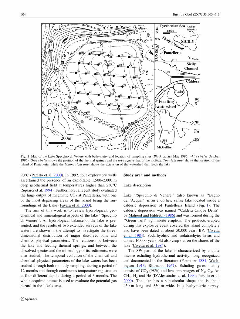
2000). The lake has a sub-circular shape and is about
450 m long and 350 m wide. In a bathymetric survey,
X8
X7
X6
X5
X4
X3
X2
X1
X0
Z13Z12
Z11Z10
Z9Z8
Z7Z6
Z5Z4
Z3Z2
Z1
200m
SicilyChannel
Lake
Caldera
Feedingwatershed
Mt.Gelfiser
400
300
394
200
200
100
100
1000m
Sicily Channel
SICILY
N
Pantelleria
Malta
200km
12°E
38°N
Aeolianislands
Tyrrhenian Sea
TU
NIS
IAFig. 1 Map of the Lake Specchio di Venere with bathymetry and location of sampling sites (Black circles May 1996; white circles October
1996). Grey circles shows the position of the thermal springs and the grey square that of the mofette. Top right inset shows the location of the
island of Pantelleria, while the bottom right inset shows the extension of the watershed that feeds the lake
904 Environ Geol (2007) 53:903–913
123
Bocchi et al. (1988) measured a maximum depth of
12.5 m. The SW area is characterized by shallow depths
with gently sloping bottom covered by whitish sediments,
while in the NE one the slopes are much steeper (Fig. 1).
Sub aqueous inspection highlighted the presence of a dark
coloured layer of decaying organic matter covering the
bottom of the lake in its deeper part. Its thickness is vari-
able, probably due to organic productivity within the lake’s
water (in May 1996, it exceeded 50 cm of thickness, while
in October of the same year it has been estimated in about
10 cm). This layer is followed by about 2 m of dark grey
uncompacted sediments with water contents higher than
50% by weight. Beneath this level, sediments become
progressively more compacted.
The lake’s surface and the altitude above sea-level are
variable with time. On the map of the ‘‘Istituto Geografico
Militare’’ (scale 1:25,000) the lake has a surface of about
194,000 m2 and an altitude of 2 m above sea-level, while
on the map of the ‘‘Regione Siciliana’’ (scale 1:10,000), a
surface of about 136,000 m2 and an elevation of 0.3 m
above sea-level is reported. Note that the latter map was
made on the basis of aerial photos taken in September 1992
at the end of the dry season. During our study large vari-
ations of the lake’s geometry also occurred. In May 1996,
the surface occupied by the lake and the water volume have
been estimated in about 200,000 m2 and 925,000 m3,
respectively. During the wet season, from October 1995 to
May 1996, rainfall was very close to long time average,
except in March (123 mm against a 30 mm average) and in
May (59 mm against a 10 mm average) when very high
values were recorded. During May intense rainfall
(43 mm) preceded of 1 week our survey. This unusually
rainy period caused the raising of the water level up to the
surrounding road, whose N and NE tracts have been totally
flooded. In October 1996, after a summer with average
climatic conditions, water level dropped about 30 cm,
causing a decrease of the estimated surface and total vol-
ume of about 15 and 7%, respectively. These fluctuations
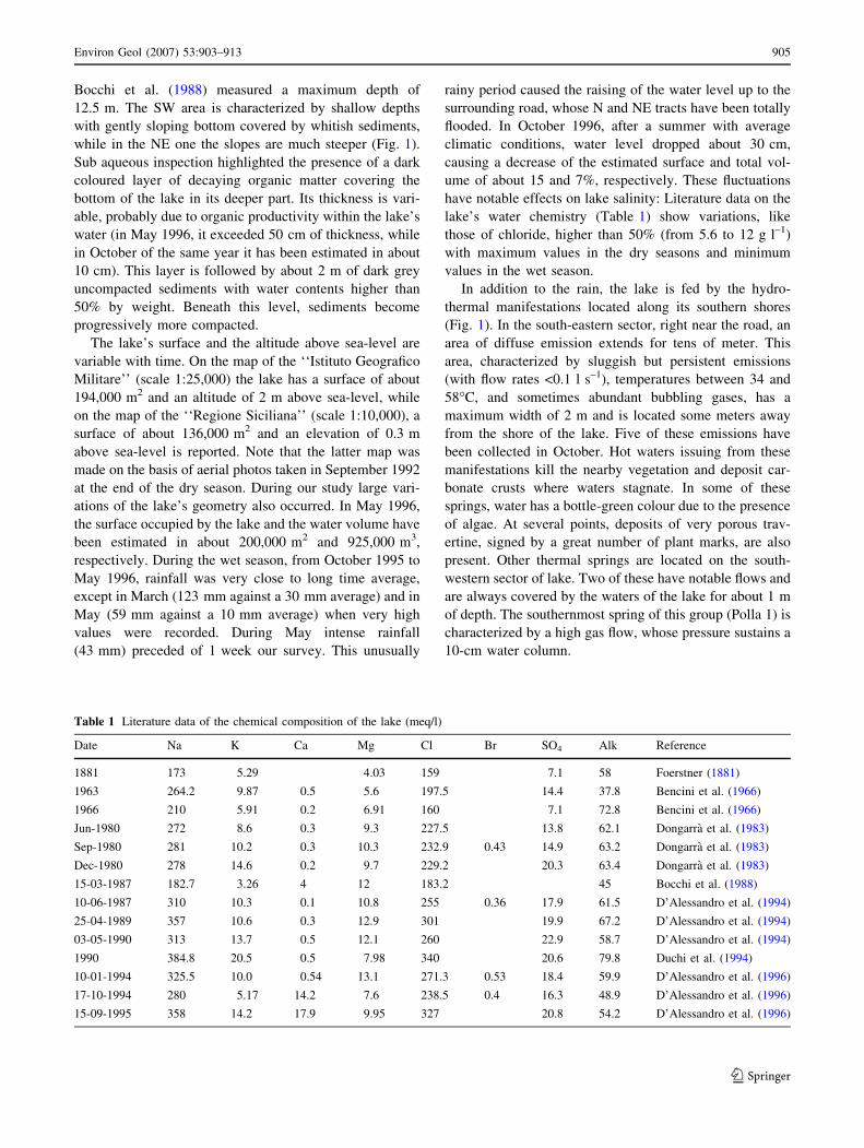
have notable effects on lake salinity: Literature data on the
lake’s water chemistry (Table 1) show variations, like
those of chloride, higher than 50% (from 5.6 to 12 g l–1)
with maximum values in the dry seasons and minimum
values in the wet season.
In addition to the rain, the lake is fed by the hydro-
thermal manifestations located along its southern shores
(Fig. 1). In the south-eastern sector, right near the road, an
area of diffuse emission extends for tens of meter. This
area, characterized by sluggish but persistent emissions
(with flow rates <0.1 l s–1), temperatures between 34 and
58�C, and sometimes abundant bubbling gases, has a
maximum width of 2 m and is located some meters away
from the shore of the lake. Five of these emissions have
been collected in October. Hot waters issuing from these
manifestations kill the nearby vegetation and deposit car-
bonate crusts where waters stagnate. In some of these
springs, water has a bottle-green colour due to the presence
of algae. At several points, deposits of very porous trav-
ertine, signed by a great number of plant marks, are also
present. Other thermal springs are located on the south-
western sector of lake. Two of these have notable flows and
are always covered by the waters of the lake for about 1 m
of depth. The southernmost spring of this group (Polla 1) is
characterized by a high gas flow, whose pressure sustains a
10-cm water column.
Table 1 Literature data of the chemical composition of the lake (meq/l)
Date Na K Ca Mg Cl Br SO4 Alk Reference
1881 173 5.29 4.03 159 7.1 58 Foerstner (1881)
1963 264.2 9.87 0.5 5.6 197.5 14.4 37.8 Bencini et al. (1966)
1966 210 5.91 0.2 6.91 160 7.1 72.8 Bencini et al. (1966)
Jun-1980 272 8.6 0.3 9.3 227.5 13.8 62.1 Dongarra et al. (1983)
Sep-1980 281 10.2 0.3 10.3 232.9 0.43 14.9 63.2 Dongarra et al. (1983)
Dec-1980 278 14.6 0.2 9.7 229.2 20.3 63.4 Dongarra et al. (1983)
15-03-1987 182.7 3.26 4 12 183.2 45 Bocchi et al. (1988)
10-06-1987 310 10.3 0.1 10.8 255 0.36 17.9 61.5 D’Alessandro et al. (1994)
25-04-1989 357 10.6 0.3 12.9 301 19.9 67.2 D’Alessandro et al. (1994)
03-05-1990 313 13.7 0.5 12.1 260 22.9 58.7 D’Alessandro et al. (1994)
1990 384.8 20.5 0.5 7.98 340 20.6 79.8 Duchi et al. (1994)
10-01-1994 325.5 10.0 0.54 13.1 271.3 0.53 18.4 59.9 D’Alessandro et al. (1996)
17-10-1994 280 5.17 14.2 7.6 238.5 0.4 16.3 48.9 D’Alessandro et al. (1996)
15-09-1995 358 14.2 17.9 9.95 327 20.8 54.2 D’Alessandro et al. (1996)
Environ Geol (2007) 53:903–913 905
123
Sampling methods and analysis
Surveys have been carried out during May and October
1996. The first survey attempted to investigate the spatial
variability of the chemical and physico-chemical parame-
ters within the lake through a three-dimensional net. In
October, measurements were limited only along two sec-
tions of the lake (Fig. 1).
The selection of sampling points on the lake’s surface
has been made using a topographic map on the scale
1:3,000 on which several sections have been traced
(Fig. 1). Tightening some ropes across the lake material-
ized these sections.
Sampling has been carried out from a small boat with a
multiparametric probe (Aquamaster 345) and a water
sampler. The multiparametric probe, fitted with depth,
temperature, pH, electric conductivity and Eh sensors, was
used to collect data every meter along 41 depth profiles,
totalling 258 measurement points in May. In October only
68 sampling points were covered. Forty-six lake water
samples for chemical analysis have been collected, every
2 m of depth, along selected vertical profiles in May and 13
in October. Five samples of the thermal springs were col-
lected in both surveys. Furthermore, one thermal water
sample and one lake sample far from the thermal mani-
festations were collected each month for 1 year. Water
samples were filtered in the field trough 0.45 lm Millipore
filters and then kept into polyethylene bottles. The aliquot
for cations analysis was acidified with HNO3.
Chemical and isotopic analyses have been carried out in
the laboratory. Alkalinity has been determined by means of
titration. Sodium, K, Mg, Ca, Cl, NO3 and SO4 have been
determined by ionic chromatography, Li, Sr, Rb and Cs by
emission flame spectrophotometry, and Si and B trough
specific colorimetric methods using a spectrophotometer.
Water samples for oxygen isotope determination have
been prepared according to Epstein and Mayeda (1953) and
d18O(H2O) values, expressed as & with respect to the V-
SMOW standard, have been determined by mass spec-
trometry.
With the objective of following the temporal evolution
of the temperature of the lake, a series of miniaturized data
loggers with internal temperature sensors (Gemini Tiny-
talk) have been installed above the deepest zone of the
lake, at depths of 2, 6, 9.5, and 11 m. They have been
located along a vertical alignment, obtained using a rope
provided with a float and anchored to a weight at the
bottom of the lake; temperature data have been acquired
each 48 min (30 data each day) in the period May to Au-
gust 1997. The sensor installed at 11 m acquired data until
June 18.
Three cores of lake sediments have been collected
during the month of October at about 0.3, 1 and 12 m of
depth and to a relative distance from the southern coast of
10 (S2), 40 (S3) and 240 (S5) m, respectively (S2 and S3
were close to water sampling points X0 and X5; Fig. 1).
Cores have been collected with PVC tubes, 6 cm in
diameter, forced in the bottom of the lake. The sampling of
sediments confirmed that the bottom of the lake, in the
deeper zone (12.5 m), is not coherent and that the portion
of not consolidated sediments reaches a thickness of more
than 2 m. The choice of the sampling points has been
carried out considering the hot-springs (close to the shore
of the lake) and the centre of the lake (the deepest zone) as
end-members.
Cores S2 and S3 have been cut in fractions of 10–15 cm
length and oven dried at 60�C. Core S5, being unconsoli-
dated, could not be subdivided in sub-fractions, and only
two samples were collected from the top and from the
bottom of the core, respectively. Dried samples have been
pulverized in an agate mortar and their mineralogical
composition has been investigated by XRD, using a CuKaradiation Ni filtered, scanning rate 2� 2h min–1 in the range
2–60�. Semi-quantitative estimation of the abundance of
the identified mineralogical phases was performed using
the method of Schultz (1964).
Results
Hydrological balance
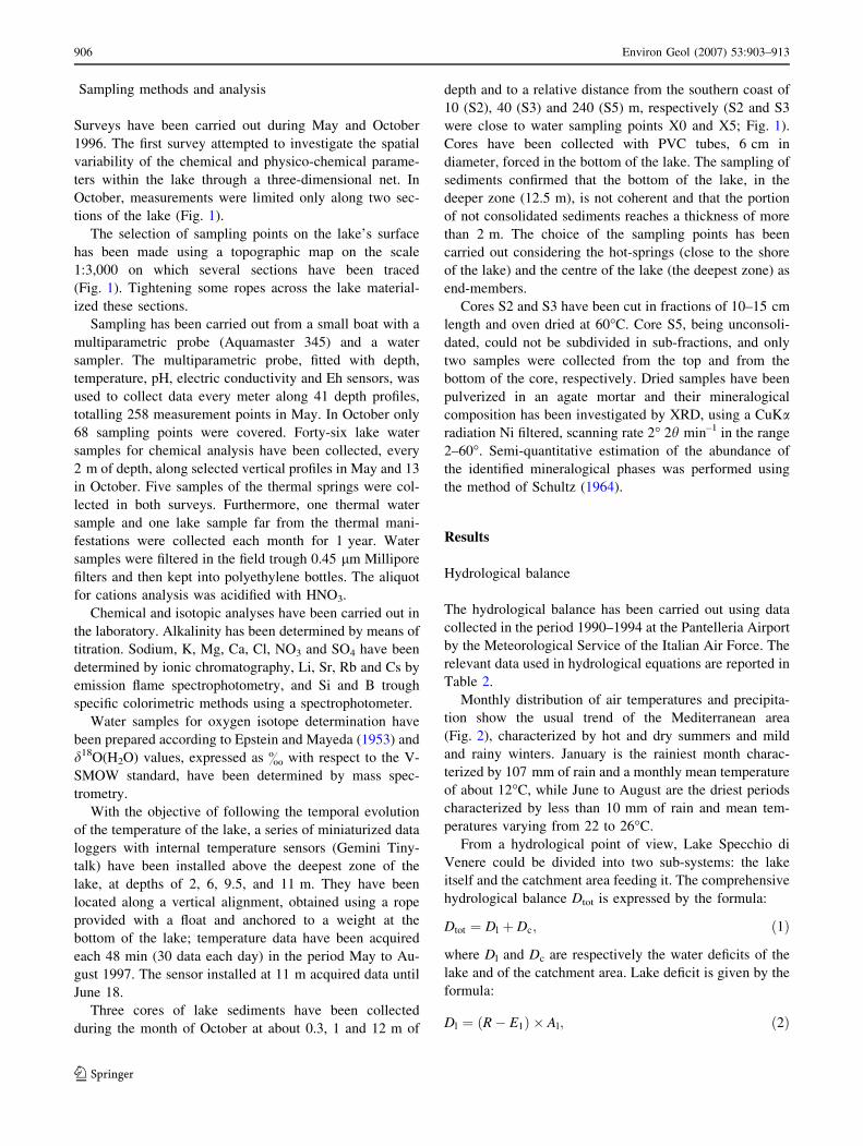
The hydrological balance has been carried out using data
collected in the period 1990–1994 at the Pantelleria Airport
by the Meteorological Service of the Italian Air Force. The
relevant data used in hydrological equations are reported in
Table 2.
Monthly distribution of air temperatures and precipita-
tion show the usual trend of the Mediterranean area
(Fig. 2), characterized by hot and dry summers and mild
and rainy winters. January is the rainiest month charac-
terized by 107 mm of rain and a monthly mean temperature
of about 12�C, while June to August are the driest periods
characterized by less than 10 mm of rain and mean tem-
peratures varying from 22 to 26�C.
From a hydrological point of view, Lake Specchio di
Venere could be divided into two sub-systems: the lake
itself and the catchment area feeding it. The comprehensive
hydrological balance Dtot is expressed by the formula:
Dtot ¼ Dl þ Dc; ð1Þ
where Dl and Dc are respectively the water deficits of the
lake and of the catchment area. Lake deficit is given by the
formula:
Dl ¼ ðR� E1Þ � Al; ð2Þ
906 Environ Geol (2007) 53:903–913
123
where R is the yearly rainfall, El the yearly evaporation,
calculated by the Meyer formula (Natale 1981) and Al the
lake surface.
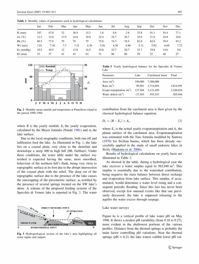
Due to the local orographic conditions, both run-off and
infiltration feed the lake. As illustrated in Fig. 1, the lake
lies on a coastal plain, very close to the shoreline and
downslope a steep 400 m high hill (Mt. Gelfiser). Under
these conditions, the water table under the surface wa-
tershed is expected having the same, more smoothed,
behaviour of the northern hill’s flank, being very close to
topographic surface at its foot due to the abrupt intersection
of the coastal plain with the relief. The deep cut of the
topographic surface due to the presence of the lake causes
the outcropping of the piezometric surface, as testified by
the presence of several springs located on the SW lake’s
shore. A scheme of the proposed feeding systems of the
Specchio di Venere lake is reported in Fig. 3. The water
contribution from the catchment area is then given by the
classical hydrological balance equation:
Dc ¼ ðR� EcÞ � Ac; ð3Þ
where Ec is the actual yearly evapotranspiration and Ac the
planar surface of the catchment area. Evapotranspiration
was estimated with the Turc formula modified by Santoro
(1970) for Sicilian basins, which has been already suc-
cessfully applied in the study of small endoreic lakes in
Sicily (Madonia et al. 2006),
Results of hydrological calculations on yearly basis are
illustrated in Table 3.
As showed in the table, during a hydrological year the
lake receives a water surplus equal to 565,940 m3. This
surplus is essentially due to the watershed contribution,
being negative the mass balance between direct recharge
and evaporation from lake surface. This surplus, if accu-
mulated, would determine a water level rising and a con-
sequent periodic flooding. Since this fact has never been
observed, except few unusual events like that one previ-
ously discussed, the lake is supposed releasing to the
aquifer the water excess through seepage.
Lake water surveys
Figure 4a is a vertical profile of lake water pH on May
1996. It shows a modest pH variability (from 9.18 to 9.27),
more evident in the shallowest portions of the various
profiles. Distance from the thermal springs is probably the
main factor controlling pH variations. Near the thermal
springs (pH � 6.2), the lake waters exhibit lower pH val-
120
80
40 10
20
30
0
mm
J F M A S O N DJJ
°C
Temp.Rainfall
M A
Fig. 2 Monthly mean rainfall and temperature at Pantelleria island in
the period 1990–1994
WATER TABLE
FRESH WATERBRACKISH WATER
SEEPAGE
DIRECT METEORIC INPUTRUN OFF EVAPORATION
HYDROTHERMAL INPUT
SEA
S N
Fig. 3 Hydrogeological section of the lake’s area highlighting all
water inputs and outputs
Table 3 Yearly hydrological balance for the Specchio di Venere
Lake
Parameter Lake Catchment basin Total
Area (m2) 196,000 7,288,000
Rain (m3) 99,901 3,714,694 3,814,595
Evapo-transpiration (m3) 127,204 3,121,450 3,248,654
Water deficit (m3) –27,303 593,243 565,940
Table 2 Monthly values of parameters used in hydrological calculations
Jan Feb Mar Apr May Jun Jul Aug Sep Oct Nov Dec
R (mm) 107 47.8 32 38.4 15.3 1.8 8.8 2.8 33.8 91.1 54.4 77.1
tA (�C) 12.3 12.0 13.9 14.8 18.8 22.4 24.7 26.7 25.0 21.6 16.8 10.6
Rh (%) 80.5 77.9 79 79 75 75.8 74.3 76.9 82.8 82.6 78.9 83.2
Ws (m/s) 7.81 7.36 7.7 7.31 6.36 5.56 4.58 4.86 5.11 5.92 6.69 7.72
Es (mmHg) 10.5 10.5 12 12.8 16.5 19.8 23.7 26.7 23.7 19.8 14.6 9.8
El (mm) 33 37 41 43 63 71 86 88 59 52 48 27
Environ Geol (2007) 53:903–913 907
123
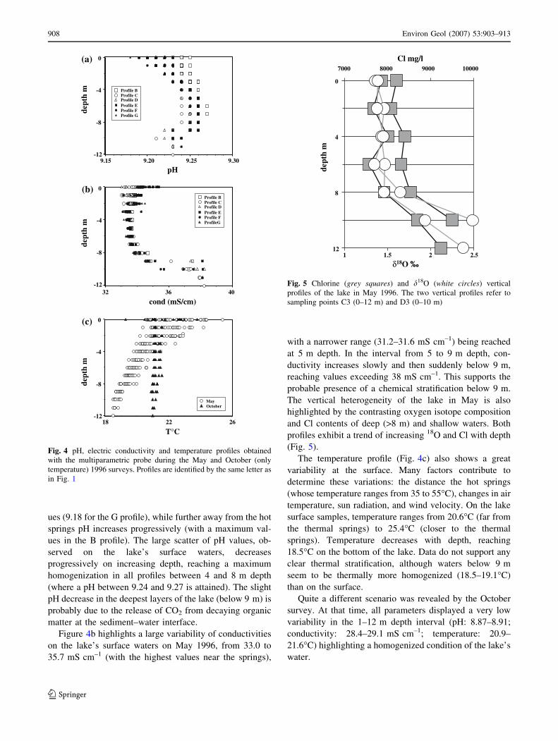
ues (9.18 for the G profile), while further away from the hot
springs pH increases progressively (with a maximum val-
ues in the B profile). The large scatter of pH values, ob-
served on the lake’s surface waters, decreases
progressively on increasing depth, reaching a maximum
homogenization in all profiles between 4 and 8 m depth
(where a pH between 9.24 and 9.27 is attained). The slight
pH decrease in the deepest layers of the lake (below 9 m) is
probably due to the release of CO2 from decaying organic
matter at the sediment–water interface.
Figure 4b highlights a large variability of conductivities
on the lake’s surface waters on May 1996, from 33.0 to
35.7 mS cm–1 (with the highest values near the springs),
with a narrower range (31.2–31.6 mS cm–1) being reached
at 5 m depth. In the interval from 5 to 9 m depth, con-
ductivity increases slowly and then suddenly below 9 m,
reaching values exceeding 38 mS cm–1. This supports the
probable presence of a chemical stratification below 9 m.
The vertical heterogeneity of the lake in May is also
highlighted by the contrasting oxygen isotope composition
and Cl contents of deep (>8 m) and shallow waters. Both
profiles exhibit a trend of increasing 18O and Cl with depth
(Fig. 5).
The temperature profile (Fig. 4c) also shows a great
variability at the surface. Many factors contribute to
determine these variations: the distance the hot springs
(whose temperature ranges from 35 to 55�C), changes in air
temperature, sun radiation, and wind velocity. On the lake
surface samples, temperature ranges from 20.6�C (far from
the thermal springs) to 25.4�C (closer to the thermal
springs). Temperature decreases with depth, reaching
18.5�C on the bottom of the lake. Data do not support any
clear thermal stratification, although waters below 9 m
seem to be thermally more homogenized (18.5–19.1�C)
than on the surface.
Quite a different scenario was revealed by the October
survey. At that time, all parameters displayed a very low
variability in the 1–12 m depth interval (pH: 8.87–8.91;
conductivity: 28.4–29.1 mS cm–1; temperature: 20.9–
21.6�C) highlighting a homogenized condition of the lake’s
water.
9.309.259.209.15
Profile BProfile CProfile DProfile EProfile FProfile G
Profile BProfile CProfile DProfile EProfile FProfileG
pH
403632
cond (mS/cm)
262218-12
-8
-4
0
dept
h m
dept
h m
dept
h m
-12
-8
-4
0
-12
-8
-4
0
MayOctober
T°C
(a)
(c)
(b)
Fig. 4 pH, electric conductivity and temperature profiles obtained
with the multiparametric probe during the May and October (only
temperature) 1996 surveys. Profiles are identified by the same letter as
in Fig. 1
80007000 9000 10000
Cl mg/l
δ18O ‰
0
4
8
12
dept
h m
1 1.5 2 2.5
Fig. 5 Chlorine (grey squares) and d18O (white circles) vertical
profiles of the lake in May 1996. The two vertical profiles refer to
sampling points C3 (0–12 m) and D3 (0–10 m)
908 Environ Geol (2007) 53:903–913
123
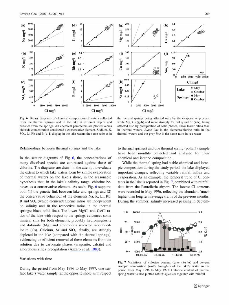
Relationships between thermal springs and the lake
In the scatter diagrams of Fig. 6, the concentrations of
many dissolved species are contrasted against those of
chlorine. The diagrams are drawn in the attempt to evaluate
the extent to which lake waters form by simple evaporation
of thermal waters on the lake’s shore, in the reasonable
hypothesis that, in the lake’s salinity range, chlorine be-
haves as a conservative element. As such, Fig. 6 supports
both (1) the genetic link between lake and springs and (2)
the conservative behaviour of the elements Na, K, Li, Rb,
B and SO4 (which element/chlorine ratios are independent
on salinity and fit the respective ratios in the thermal
springs; black solid line). The lower Mg/Cl and Cs/Cl ra-
tios of the lake with respect to the springs evidences some
mineral sink for both elements, probably hydromagnesite
and dolomite (Mg) and amorphous silica or montmoril-
lonite (Cs). Calcium, Sr and SiO2, finally, are strongly
depleted in the lake (compared with the thermal springs),
evidencing an efficient removal of these elements from the
solution due to carbonate phases (aragonite, calcite) and
amorphous silica precipitation (Azzaro et al. 1983).
Variations with time
During the period from May 1996 to May 1997, one sur-
face lake’s water sample (at the opposite shore with respect
to thermal springs) and one thermal spring (polla 3) sample
have been monthly collected and analysed for their
chemical and isotope composition.
While the thermal spring had stable chemical and isoto-
pic composition during the study period, the lake displayed
important changes, reflecting variable rainfall influx and
evaporation. As an example, the temporal trend of Cl con-
tents in the lake is reported in Fig. 7, combined with rainfall
data from the Pantelleria airport. The lowest Cl contents
were recorded in May 1996, reflecting the abundant (much
higher than long term average) rains of the previous months.
During the summer, salinity increased peaking in Septem-
0
2000
4000
6000
8000N
a m
g/l
Li m
g/l
Mg
mg/
lC
a m
g/l
Sr m
g/l
Cs
mg/
lSi
o 2 mg/
l
(a)
MayLake
Springs MayOctober
October
0
125
250
375
500
K m
g/l
Rb
mg/
lB
mg/
l
0
250
500
750
1000
0 2500 5000 7500 10000
Cl mg/l Cl mg/l Cl mg/l
0 2500 5000 7500 10000
SO4
mg/
l
0
4
8
12
16
0
0.5
1.0
1.5
2.0
0
2
4
6
8
(b)
(c)
(d)
(f)
(e)
00 2500 5000 7500 10000
0 2500 5000 7500 10000
Cl mg/l
0
0
50
100
150
200
0
50
100
150
200
0
0.1
0.2
0.3
0.4
0
30
60
90
120
0.15
0.30
0.45
0.60
(g) (h)
(i) (j)
(k)
Fig. 6 Binary diagrams of chemical composition of waters collected
from the thermal springs and in the lake at different depths and
distance from the springs. All chemical parameters are plotted versus
chloride concentration considered a conservative element. Sodium, K,
SO4, Li, Rb and B (a–f) display in the lake waters the same ratio as in
the thermal springs being affected only by the evaporative process,
while Mg, Cs (g–h) and more strongly Ca, SiO2 and Sr (i–k), being
affected also by precipitation of solid phases, show lower ratios than
in thermal waters. Black line is the element/chlorine ratio in the
thermal waters and the grey line is the same ratio in sea water
4000
5000
8000
100
50
0
25
75
mm
Cl m
g/l
9000
10000
01-05-96 31-08-96 31-12-96 02-05-971.3
1.8
2.3
2.8
3.3
δ18O
‰
Fig. 7 Variations of chlorine content (grey circles) and oxygen
isotopic composition (white triangles) of the lake’s water in the
period from May 1996 to May 1997. Chlorine content of thermal
spring water is also plotted (black squares) together with rainfall
Environ Geol (2007) 53:903–913 909
123
ber. In October, after abundant rains, the lake’s waters be-
came progressively more diluted reaching a relative salinity
minimum in February 1997. The d18O isotope composition
of the lake (Fig. 7) was in good agreement with the above
evaporation-meteoric dilution process.
Temperature values measured from the 13th of May
1997 to the 7th of August 1997 at different depths (Fig. 8)
followed closely the mean daily air temperature variation.
During this period (from late spring to early summer),
characterized by increasing air temperatures, temperature
in shallowest lake’s level were the highest and in the
deeper level the lowest. A daily temperature cycle char-
acterised the shallow lake’s water level, with up to 2�C
temperature excursion. In the deepest lake’s layers, daily
variations were below instrumental sensitivity (about
0.3�C). Temperature differences between the shallowest
and the deepest measuring point varied between 0 and 4�C,
pointing to limited temporarily thermal stratifications of the
lake. Stratifications lasted for maximum 17 days and were
interrupted by mixing episodes, which occurred always in
days with maximum wind intensities exceeding about
15 m s–1 (Fig. 8). No effective rainfall events occurred in
this period.
Sediment mineralogy
A previous mineralogical characterisation (Azzaro et al.
1983) of two sediment cores collected near the western
springs detected the presence of clay minerals probably
belonging to the smectite group. Others crystalline phases
identified were: dolomite, calcite, carbonato-apatite, hyd-
romagnesite, pyrite. Minor amounts of quartz, feldspar and
pyroxene (egirina—NaFeSi2O6), probably deriving from
mechanical weathering of the surrounding rocks, were also
been identified by the authors.
In this work, 13 samples obtained from three cores of
lake sediments have been analysed by XRD on the tout-
venant. Results revealed the presence of carbonate phases
in all cores. Aragonite was detected in all samples, while
calcite, dolomite and hydromagnesite only occasionally.
Clay minerals were always present with minor quantities of
quartz. Other identified phases include pyroxene (egirina),
feldspars, carbonato-apatite and pyrite.
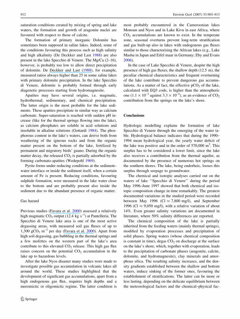
A semi-quantitative analysis (Table 4) showed that
aragonite and clay minerals were the most abundant pha-
ses, representing more than 90% of the total. Carbonato-
apatite and pyrite were accessory minerals and increased in
abundance in the deepest parts of the cores. Feldspar and
Pyroxenes, of probable detrital origin, were identified in
small quantities in the shallower parts of core S2 (the
closest to the shores of the lake) and in the whole column
of core S5 (in the deeper part of the lake). Finally quartz,
which was identified in small quantities in all samples, and
did not show any significant variations with depth.
Discussion
Compositional and thermal stratification
Contrasting compositional profiles in the lake were ob-
served in the two surveys: in May, a striking salinity and
chemical stratification was observed, while major ion
chemistry, pH, conductivity, and temperature of the lake
were almost invariable in October, suggesting that
homogenization of the lake waters had occurred. During
the May survey, clear weather and weak wind prevailed
with an average air temperature of 25�C (during the day),
while strong south-east winds and showers characterised
the October survey (air temperature was about 22�C). The
wind intensity was so notable in October to produce a
strong wave motion on the lake surface: this probably gave
rise to the turnover of the lake waters, and totally obscured
the chemical stratification previously observed in May.
Temperature data acquired in the period May–August 1997
supports further the idea that Specchio di Venere lake can
occasionally undergo stratification events: they also high-
light however, that these events are short lasting and not
seasonal as observed in several other lakes. The two sur-
veys of May and October 1996 are probably too far away to
conclude that the lake has seasonal stratification episodes.
30
26
22
18
30
35
25
20
10
0 0
15
5 1
2
3
4
5
6
7
2 m
6 m9.5 m
11 m
Air temp.(°C)
°C°C
Rain (mm)
mm
Wind (m/s)m/s
10-05-97 10-06-97 11-07-97 11-08-97
Fig. 8 Water temperature acquired each 48 min (30 data each day) in
the period 14/05/97–7/8/97 at 2, 6, 9.5, and 11 m depths (uppergraph), together with mean daily air temperature, rainfall and wind
intensity data measured at the Pantelleria airport (lower graph)
910 Environ Geol (2007) 53:903–913
123
At least two factors causing density variations and thus
vertical instability of water column have to be considered:
(1) temperature variations of the waters due to the input of
the colder winter rains and/or to the decreasing air tem-
perature; (2) the salinity variations resulting from changing
input/output from meteoric waters, hydrothermal waters,
run-off waters, all having contrasting chemical composi-
tions and salinities.
The higher Cl contents of lake’s bottom waters in May
(Fig. 5), combined with the parallel d18O increase, would
paradoxically indicate a greater evaporation taking place at
depth. In the reality, it is the final result of ‘‘sinking’’ of the
dense shallow water masses, after intense evaporation at
the lake’s surface: during the summer months, the lake is
subjected to an intense evaporation, and the lake’s surface
waters becomes enriched in both heavy isotopes and con-
servative dissolved ions (Cl). When the density of the
evaporated surface waters, increased further by the pres-
ence of microcrystals of precipitating solid phases, exceeds
the isotopically lighter and more dilute deeper ones, the
former will sink to the bottom. Accumulation of these
evaporated waters will slowly build up a compositional
stratification of the waters such as that found in the May
1996 survey. Such a stratification will last until some
external cause, such as changing weather conditions in
autumn/winter, will trigger remixing of the waters with a
subsequent homogenization.
Chemical evolution
Compared with other volcanic lakes, ‘‘Specchio di Ve-
nere’’ has a peculiar composition. Based on its high Cl and
SO4 contents, the lake would fall into the field of the
‘‘active crater lakes’’ as defined by Varekamp et al. (2000).
The latter, however, display very low pH values (<3), while
‘‘Specchio di Venere’’ is typically basic, falling at the
upper pH range of volcanic lakes quoted by Marini et al.
(2003).
The composition of volcanic lakes is principally con-
trolled by the flux and composition of incoming volcanic or
geothermal fluids. ‘‘Specchio di Venere’’ lake makes no
exception: its chemical features are inherited from the
thermal springs feeding it (Fig. 6). In turn, the main pro-
cesses governing the composition of the latter are: (a)
mixing between infiltrated meteoric and sea waters; (b)
heating to 230–280�C and water–rock interaction, resulting
in the formation of a brine with typical enrichment in
alkaline elements and depletion in Mg; (c) dissolution of
magma-derived volatiles (mainly CO2) (Dongarra et al.
1983; D’Alessandro et al. 1994; Squarci et al. 1994; Parello
et al. 2000). On spring discharge, evaporation contributes
to increase further lake’s salinity, while precipitation of
carbonates and clay minerals act as sinks for Mg, Sr, Cs
and silica.
Precipitation of solid phases
Speciation calculations, performed with EQ3 code (Wolery
1992), suggest that the lake waters are super-satured with
respect to aragonite and calcite, as long as with respect to
dolomite, hydromagnesite, huntite and magnesite. These
minerals, except the last two, were detected in the sedi-
ments with the abundances shown in paragraph 5.4.
The higher amount of aragonite in the sediments, with
respect to other carbonate phases (calcite, hydromagnesite
and dolomite), is consistent with the high Mg and Sr
contents of the springs waters (Pentecost 2005). This latter
phase is also kinetically favoured, due to the strong super-
Table 4 Semiquantitative mineralogic analysis of the sediment samples collected on the bottom of lake Specchio di Venere
Sample Arag. Calc. Dol. Hydrm. Ca-Ap. Clay Min. Qz Fels. Pyr. Pirox.
S2 0–15 **** * * ** **** * * *
S2 15–25 **** ** * * **** ** * *
S2 25–35 **** * * **** * *
S2 35–45 **** * *** *** * *
S2 45–55 **** * * * **** *
S2 45–55 **** * * ** **** *
S3 0–15 **** * ** *** * *** *
S3 15–25 **** * ** **** *
S3 25–35 **** * * * *** * * *
S3 35–45 **** * * * *** * *
S3 45–55 **** * * * *** *
S5 Top **** * * ** *** * * *
S5 Bottom *** * ** *** * ** **
****Very abundant, ***Abundant, **Less abundant, *Scarce
Environ Geol (2007) 53:903–913 911
123
saturation conditions created by mixing of spring and lake
waters, the formation and growth of aragonite nuclei are
favoured with respect to those of calcite.
The formation of primary inorganic Dolomite has
sometimes been supposed in saline lakes. Indeed, some of
the conditions favouring this process such as high salinity
and high alkalinity (De Deckker and Last 1988) are also
present in the lake Specchio di Venere. The Mg/Ca (2–16),
however, is probably too low to allow direct precipitation
of dolomite. De Deckker and Last (1988), for example,
measured ratios always higher than 25 in some saline lakes
with primary dolomite precipitation. In the lake Specchio
di Venere, dolomite is probably formed through early
diagenetic processes starting from hydromagnesite.
Apatites may have several origins, i.e. magmatic,
hydrothermal, sedimentary, and chemical precipitation.
The latter origin is the most probable for the lake sedi-
ments. These apatites precipitate in similar way as calcium
carbonate. Super-saturation is reached with sudden pH in-
crease (like for the thermal springs flowing into the lake),
as calcium phosphates are soluble in acid solutions and
insoluble in alkaline solutions (Gottardi 1984). The phos-
phorous content in the lake’s waters, can derive both from
weathering of the igneous rocks and from the organic
matter present on the bottom of the lake, fertilized by
permanent and migratory birds’ guano. During the organic
matter decay, the released CO2 is partially adsorbed by the
forming carbonato-apatites (Wedepohl 1969).
Pyrite forms under reducing conditions at the sediment–
water interface or inside the sediment itself, when a certain
amount of Fe is present. Reducing conditions, favouring
sulphide formation, were measured in the lake water close
to the bottom and are probably present also inside the
sediment due to the abundant presence of organic matter.
Gas hazard
Previous studies (Favara et al. 2000) assessed a relatively
high magmatic CO2 output (12.4 kg s–1) at Pantelleria. The
Specchio di Venere lake area is one of the most active
degassing areas, with measured soil gas fluxes of up to
1,300 gCO2 m–2 per day (Favara et al. 2000). Apart from
high soil degassing, gas bubbling in the thermal springs and
a few mofettes on the western part of the lake’s area
contribute to this elevated CO2 release. This high gas flux
raises concern on the potential CO2 accumulation in the
lake up to hazardous levels.
After the lake Nyos disaster many studies were made to
investigate possible gas accumulation in volcanic lakes all
around the world. These studies highlighted that the
development of significant gas accumulations, apart from a
high endogenous gas flux, requires high depths and a
meromictic or oligomictic regime. The latter condition is
most probably encountered in the Cameroonian lakes
Monoun and Nyos and in Lake Kivu in east Africa, where
CO2 accumulations are known to exist. In the temperate
zone, seasonal overturns prevent long-term stratification
and gas built-up also in lakes with endogenous gas fluxes
similar to those characterising the African lakes (e.g., Lake
Mashu in Japan and Eifel maar in Germany; Eby and Evans
2006).
In the case of Lake Specchio di Venere, despite the high
presence of high gas fluxes, the shallow depth (12.5 m), the
peculiar chemical characteristics and frequent overturning
of the lake contribute to prevent dangerous gas accumu-
lations. As a matter of fact, the effective pCO2 of the lake,
calculated with EQ3 code, is higher than the atmospheric
one (1.1 · 10–3 against 3.3 · 10–4), as an evidence of CO2
contribution from the springs on the lake’s shore.
Conclusions
Hydrologic modelling explains the formation of lake
Specchio di Venere through the emerging of the water ta-
ble. Hydrological balance indicates that during the 1990–
1994 mean hydrological year, the yearly water deficit of
the lake was positive and in the order of 570,000 m3. This
surplus has to be considered a lower limit, since the lake
also receives a contribution from the thermal aquifer, as
documented by the presence of numerous hot springs on
the southern shores. The lake, being endorheic, looses this
surplus through seepage to groundwater.
The chemical and isotopic analyses carried out on the
waters of lake ‘‘Specchio di Venere’’ during the period
May 1996–June 1997 showed that both chemical and iso-
topic composition change in time remarkably. The greatest
documented variations in the studied period were recorded
between May 1996 (Cl � 7,800 mg/l), and September
1996 (Cl � 9,050 mg/l), with a relative variation of about
14%. Even greater salinity variations are documented in
literature, where 50% salinity differences are reported.
The chemical composition of the lake is partially
inherited from the feeding waters (mainly thermal springs),
modified by evaporation processes and precipitation of
solid phases. Spring waters (whose chemical composition
is constant in time), degas CO2 on discharge at the surface
on the lake’s shore, which, together with evaporation, leads
to the precipitation of carbonate phases (aragonite, calcite,
dolomite, and hydromagnesite), clay minerals and amor-
phous silica. The resulting salinity increases, and the den-
sity gradients established between the shallow and bottom
waters, induce sinking of the former ones, favouring the
establishment of stratifications. The latter can be more or
less lasting, depending on the delicate equilibrium between
the meteorological factors and the chemical–physical fac-
912 Environ Geol (2007) 53:903–913
123
tors affecting water density at different depths. The fre-
quent overturning of the water, together with morpholog-
ical (small volume and shallow depth) and chemical (high
pH) factors, precludes the build-up of dangerous gas levels
within the lake.
References
Azzaro E, Badalamenti F, Dongarra G, Hauser S (1983) Geochemical
and mineralogical studies of lake Specchio di Venere, Pantelleria
island, Italy. Chem Geol 40:149–165
Bencini A, Duchi V, Tonani F (1966) Rapporto idrogeochimico sulle
acque termali di Pantelleria. Internal Report of the CNR-IIRG,
Pisa
Bocchi G, Gabbianelli G, Lanzafame G, Lucchini F, Rabbi E, Rossi
PL (1988) Relazione sui rilievi eseguiti sul ‘‘Lago di Venere’’,
Pantelleria. Bull Italian Natl Group Volcanol 4:63–73
Chiodini G, Cioni R, Guidi M, Magro G, Marini L, Raco B (2000)
Gas chemistry of the Lake Piccolo of Monticchio Mt. Vulture, in
December 1996. Acta Vulcanol 12:139–142
Cioni R, Guidi M, Raco B, Marini L, Gambardella B (2003) Water
chemistry of Lake Albano (Italy). J Volcanol Geotherm Res
120:179–195
Civetta L, Cornette Y, Crisci G, Gillot PY, Orsi G, Requeiros CS
(1984) Geology, geochronology and chemical evolution of the
island of Pantelleria. Geol Magaz 121:541–562
Civetta L, Cornette Y, Gillot PY, Orsi G (1988) The eruptive history
of Pantelleria (Sicily Channel) in the last 50 ka. Bull Volcanol
50:47–57
D’Alessandro W, Dongarra G, Gurrieri S, Parello F, Valenza M
(1994) Geochemical characterization of naturally occurring
fluids on the Island of Pantelleria (Italy). Mineral Petrogr Acta
37:91–102
D’Alessandro W, Inguaggiato S, Parello F, Pecoraino G, Romeo L,
Sortino F (1996) Pantelleria island: geochemical survey of hot
waters and gases in the period 1993–1995. Acta Vulcanol
8(2):238–240
De Deckker P, Last WM (1988) Modern dolomite deposition in
continental, saline lakes, western Victoria, Australia. Geology
16:29–32
Dongarra G, Hauser S, Alaimo R, Carapezza M, Tonani F (1983) Hot
waters on Pantelleria island. Geochemical features and pre-
liminary geothermal investigation Geothermics 12:49–63
Duchi V, Campana ME, Minissale A, Thompson M (1994)
Geochemistry of thermal fluids on the volcanic island of
Pantelleria, southern Italy. Appl Geochem 9:147–160
Eby GN, Evans WC (2006) Taming the killer lakes of Cameroon.
Geol Today 22:18–22
Epstein S, Mayeda T (1953) Variation of O18 content of waters from
natural sources. Geochim Cosmochim Acta 4:213–224
Favara R, Giammanco S, Inguaggiato S, Pecoraino G (2000)
Preliminary estimate of CO2 output from Pantelleria island
volcano (Sicily, Italy): evidence of active mantle degassing.
Appl Geochem 16:883–894
Foerstner H (1881) Nota preliminare sulla geologia dell’isola di
Pantelleria secondo gli studi fatti negli anni 1974 e 1881. Boll R
Comit Geol It 12:532–556
Gottardi G (1984) I minerali, 3rd edn. Boringhieri, Torino
Le Guern F, Sigvaldason GE (eds) (1990) The Lake Nyos event and
natural CO2 degassing, II. J Volcanol Geotherm Res 42:307–402
Madonia P, Naselli-Flores L, Parello F, Parlato B, Viola A (2006)
Geological development of a gypsum lake formed at the
beginning of the 20th century in central Sicily, Italy: integration
of historical data with modern survey techniques. Chem Ecol
22:S333–S347. DOI:10.1080/02757540600557728
Mahood GA, Hildreth W (1986) Geology of the peralkaline volcano
at Pantelleria, Strait of Sicily. Bull Volcanol 48:143–172
Marini L, Vetuschi Zuccolini M, Saldi G (2003) The bimodal pH
distribution of volcanic lake waters. J Volcanol Geotherm Res
121:83–98
Natale L (1981) Idrologia tecnica. Manuale di ingegneria civile, vol1.
Zanichelli, Bologna, p 339
Parello F, Allard P, D’Alessandro W, Federico C, Jean-Baptiste P,
Catani O (2000) Isotope geochemistry of Pantelleria volcanic
fluids, Sicily Channel rift: a mantle volatile end-member for
volcanism in southern Europe. Earth Planet Sci Lett 180:325–
339
Pentecost A (2005) Mineralogy and elemental composition. In:
Travertine. Springer, Berlin, pp 101–128
Rittmann A (1967) Studio geovulcanologico e magmatologico
dell’isola di Pantelleria. Riv Min Sicil 106–108:147–182
Santoro M (1970) Sulla applicabilita della formula di Turc per il
calcolo della evapotraspitrazione effettiva in Sicilia. In: Pro-
ceedings of the 1st international symposium on groundwaters,
Palermo
Schultz LG (1964) Quantitative interpretation of mineralogical
composition from X-ray and chemical data for the Pierre Shale.
USGS Prof Paper 391-C:C1–C31
Sigurdsson H, Devine JD, Tchoua FM, Presser TS, Pringle MKW,
Evans WC (1987) Origin of the lethal gas burst from Lake
Monoun, Cameroun. J Volcanol Geotherm Res 31:1–16
Squarci P, Giannelli G, Grassi S, Mussi M, D’Amore F (1994)
Preliminary results of geothermal prospecting on the Island of
Pantelleria. Acta Vulcanol 5:117–123
Varekamp JC, Pasternack GB, Rowe GL (2000) Volcanic lake
systematics II. Chemical constraints. In: Varekamp GJ, Rowe
GL (eds) Crater Lakes. J Volcanol Geotherm Res 97:161–179
Washington HS (1913) The volcanoes and rocks of Pantelleria I. J
Geol 21:653–670
Wedepohl KH (1969) Handbook of geochemistry. Springer, Heidel-
berg
Wolery T (1992) EQ3NR, a computer program for geochemical
aqueous speciation-solubility calculations: theoretical manual,
user’s guide and related documentation. Lawrence Livermore
National Laboratory, Livermore
Environ Geol (2007) 53:903–913 913
123
Related Documents