GEOFÍSICA INTERNACIONAL (2014) 53-2: 135-151 Resumen Hay alrededor de 175 minas abandonadas en Portugal, de las cuales unos 60 son antiguas explotaciones de uranio. La mina de uranio Castelejo está ubicada a unos 2 km al W de Vila Cortês da Serra, en el distrito de Guarda, en la cuenca del río Mondego. En términos geológicos, la mina se localiza en un granito de grano medio e dos micas con tendencia SRU¿URLGDO /D H[SORWDFLyQ FRPHQ]y FRQ GRV minas a cielo abierto entre 1979 y 1990, que produjeron alrededor de 132 toneladas de U 3 O 8 . Desde 1992, la producción comenzó a llevarse a cabo a través de la lixiviación in situ con H 2 SO 4 de materiales de bajo contenido en XUDQLR /D FLUFXODFLyQ GH ODV DJXDV VXSHU¿FLDO y subterránea está estructuralmente condi- cionada por la fracturacion intensa en la zona. Dos campañas geofísicas de exploración se OOHYDURQ D FDER D ¿Q GH FDUDFWHUL]DU HO VLVWHPD de fracturas. La primera fue una investigación FRQ HO PpWRGR 9/) TXH QRV SHUPLWLy LGHQWL¿FDU los principales sistemas de fallas que pueden SURSRUFLRQDU UXWDV SDUD HO ÀXMR GH ODV DJXDV subterráneas. A partir de la segunda campaña, que fue un estudo llevado a cabo con el método RMT en una caja de falla que reproduz o gradiente natural de la mina, se obtuvieron las resistividades y espesores del material de JUDQLWR LQWHPSHUL]DGR /RV SHU¿OHV REWHQLGRV muestran que la resistividad disminuye con el aumento de profundidad. Este aspecto puede deberse a causas naturales - el material que llena la caja de falla es más intemperizado en profundidad que en la VXSHU¿FLH R SXHGH LQGLFDU FRQWDPLQDFLyQ HQ profundidad, debido al drenaje ácido de las minas. Palabras clave: prospección geofísica, acuífero ¿VXUDGR DJXD GH PLQD 9/) 5075 Abstract There are about 175 abandoned mining sites in Portugal, of which about 60 are old uranium workings. The Castelejo mine is an old uranium located about 2 km W of Vila Cortês da Serra, in Guarda district, on the River Mondego basin. In geologic terms, the mine is located in medium-grained two-mica monzonitic granite, with porphyroidal tendency. Exploitation started with two open cast mines between 1979 and 1990 which produced about 132 tonnes U 3 O 8 . From 1992, production started to be carried out through the in situ H 2 SO 4 leaching of the mine’s low-grade materials. The superficial and groundwater circulation are structurally conditioned by the intense fracturing in the area. 7ZR H[SORUDWRU\ JHRSK\VLFDO ¿HOG FDPSDLJQV were conducted in order to characterize the IUDFWXULQJ 7KH ¿UVW ZDV D 9/) VXUYH\ WKDW allowed us to identify major fault systems that PD\ SURYLGH SDWKV IRU JURXQGZDWHU ÀRZ )URP the second campaign, which was an RMT survey conducted at a fault gauge which records the PLQH QDWXUDO JUDGLHQW ÀRZ ZH REWDLQHG WKH resistivities and thicknesses of the weathered JUDQLWH PDWHULDO 7KH SUR¿OHV REWDLQHG VKRZ that resistivity declines with increasing depth. This fact may arise from natural causes – the PDWHULDO ZKLFK ¿OOV WKH IDXOW JDXJH LV PRUH weathered at depth than on the surface – or it may indicate contamination at depth, due to acid mine drainage. Key words: geophysical surveying, fissured aquifer, mine water, VLF, RMT-R. 135 Hydrogeologic characterization of the abandoned mining site of Castelejo, Portugal by VLF-EM & RMT-R geophysical surveying Vitor Manuel Gomes de Oliveira * , Luís Filipe Tavares Ribeiro and María Catarina Rosalino da Silva Received: November 27, 2012; accepted: August 28, 2013; published on line: April 01, 2014 V.M.G. Oliveira L.F.T. Ribeiro CVRM Instituto Superior Técnico Universidade de Lisboa Av. Rovisco Pais, Lisboa Portugal * Corresponding author: [email protected] M.C.R. Silva Centro de Geología FCUL, Edifício C6 Campo Grande Lisboa, Portugal ORIGINAL PAPER

Welcome message from author
This document is posted to help you gain knowledge. Please leave a comment to let me know what you think about it! Share it to your friends and learn new things together.
Transcript

GEOFÍSICA INTERNACIONAL (2014) 53-2: 135-151
Resumen
Hay alrededor de 175 minas abandonadas en Portugal, de las cuales unos 60 son antiguas explotaciones de uranio. La mina de uranio Castelejo está ubicada a unos 2 km al W de Vila Cortês da Serra, en el distrito de Guarda, en la cuenca del río Mondego. En términos geológicos, la mina se localiza en un granito de grano medio e dos micas con tendencia
minas a cielo abierto entre 1979 y 1990, que produjeron alrededor de 132 toneladas de U3O8. Desde 1992, la producción comenzó a llevarse a cabo a través de la lixiviación in situ con H2SO4 de materiales de bajo contenido en
y subterránea está estructuralmente condi-cionada por la fracturacion intensa en la zona. Dos campañas geofísicas de exploración se
de fracturas. La primera fue una investigación
los principales sistemas de fallas que pueden
subterráneas. A partir de la segunda campaña, que fue un estudo llevado a cabo con el método RMT en una caja de falla que reproduz o gradiente natural de la mina, se obtuvieron las resistividades y espesores del material de
muestran que la resistividad disminuye con el aumento de profundidad.Este aspecto puede deberse a causas naturales - el material que llena la caja de falla es más intemperizado en profundidad que en la
profundidad, debido al drenaje ácido de las minas.
Palabras clave: prospección geofísica, acuífero
Abstract
There are about 175 abandoned mining sites in Portugal, of which about 60 are old uranium workings. The Castelejo mine is an old uranium located about 2 km W of Vila Cortês da Serra, in Guarda district, on the River Mondego basin. In geologic terms, the mine is located in medium-grained two-mica monzonitic granite, with porphyroidal tendency. Exploitation started with two open cast mines between 1979 and 1990 which produced about 132 tonnes U3O8. From 1992, production started to be carried out through the in situ H2SO4 leaching of the mine’s low-grade materials. The superficial and groundwater circulation are structurally conditioned by the intense fracturing in the area.
were conducted in order to characterize the
allowed us to identify major fault systems that
the second campaign, which was an RMT survey conducted at a fault gauge which records the
resistivities and thicknesses of the weathered
that resistivity declines with increasing depth. This fact may arise from natural causes – the
weathered at depth than on the surface – or it may indicate contamination at depth, due to acid mine drainage.
Key words: geophysical surveying, fissured aquifer, mine water, VLF, RMT-R.
135
Hydrogeologic characterization of the abandoned mining site of Castelejo, Portugal by VLF-EM & RMT-R geophysical surveying
Vitor Manuel Gomes de Oliveira*, Luís Filipe Tavares Ribeiro and María Catarina Rosalino da Silva
Received: November 27, 2012; accepted: August 28, 2013; published on line: April 01, 2014
V.M.G. OliveiraL.F.T. RibeiroCVRM Instituto Superior TécnicoUniversidade de LisboaAv. Rovisco Pais, Lisboa Portugal*Corresponding author: [email protected]
M.C.R. SilvaCentro de GeologíaFCUL, Edifício C6Campo GrandeLisboa, Portugal
ORIGINAL PAPER

V. M. G. Oliveira, L. F. T. Ribeiro and M. C. R. Silva
136 VOLUME 53 NUMBER 2
Introduction
The activities developed by mining are, from the very start of operations, capable of degrading the surrounding environment and
unless they are properly monitored and then controlled in accordance with the data gathered from the monitoring.
balance generally result from digging a part of the land surface, as well as from the production of deposits of varying kinds of waste and / or sterile minerals (tailings) and from the chemical products used in ore separation /
et al., eds, 2002). All
ground water), geochemical impacts (on sediment, ground and alluvium) and biochemical impacts (on living beings) (Lottermoser, 2003).
The characteristics and consequences of these impacts diverge according to when they are produced, and they can cause sporadic and /or diffuse pollution.
Sporadic pollution occurs when the mine is being worked; if there is a control system in operation (monitoring) the pollution can be prevented from spreading.
Diffuse pollution tends to occur once a mine has been abandoned. As a rule (Rapantova et al., eds, 2008) when a reasonably long time is spent on closing down a mine there is no longer any concern with monitoring, which is only undertaken when it is active.
This attitude disregards possible subsequent risks to the closed down mine without taking any type of prevention to forestall them, and therefore it contributes to the propagation of the contamination.
The environmental liabilities of mining are expressed, as a rule, by the incidence of abnormal (very high) concentrations of heavy metals in the sediments, ground and alluvia, as
of this activity (Rapantova et al., eds, 2008). The presence of these elements is essentially due to the leaching of the materials inside the mine and to erosion and leaching processes acting on the tailing materials extracted from
et al., eds, 2002). In fact, in open cast mining these elements are vulnerable to the action of the wind and the rain, which are their main vehicles of dissemination.
In many cases of mine exploration, the action of the water over the tailings and other mine wastes causes a phenomenon known as acid mine drainage (AMD). This phenomenon particularly occurs in metal ore workings in which sulphide is exposed to oxidating environments, or when acid leaching from poor ore with a view to its concentration and subsequent recuperation occurs (Lottermoser,
and if the evolution of the characteristics and the processes of environmental alteration are not controlled the ominous consequences will get worse as years go by. One of the best-known is the contamination of the surface water and groundwater, which occurs both during the phase of functioning and after the mine’s closure.
The hydrogeological impact is a serious problem in almost all underground mines and in open cast mines, too. A series of measures can help to avoid or reduce this contamination. Thus, when the mine is abandoned it is essential to have the most accurate knowledge possible of the hydrogeology, the geology, the mineralogical composition of the materials, and the method of extracting and processing the ore to enable the prevention, correction and mitigation of environmental degradation caused by the operation.
The method used to decommission a mine
conditions. In conjunction with the operation there are often problems of mining subsidence, which occurs because methods of dismantling are used that do not consider the full extent of the galleries.
When in operation we can see, in brief, the following effects:
- Differential settlements- Fractures on the ground- Lowering of groundwater levels
exhaustion- Contamination of water.
It can be said that during the course of its history Portugal several times gained importance for major mining, and it is even one of those countries in which mining carried out by Romans is well documented (Ferreira, 1971; Carvalho et al., 1971).
From north to south Portugal 55 Roman mining operations were recorded, and we think there were others that have not been

GEOFÍSICA INTERNACIONAL
APRIL - JUNE 2014 137
surveyed. They were mostly for gold and several remained in operation until very recent times (Nunes, 1983).
Geophysical surveying has long been used to characterize fracturing in various geological formations. Particularly in mining areas, where fractures are often related to mineralized veins, the joint use of geophysical and other methods enables one to characterize the ore potential of an area of interest (Kearey et al., 2002).
Geophysical surveying today has a very broad range of applications: from mining to civil engineering, through archaeological, environmental, geological and hydrological investigations to aquifer characterization.
In addition to obtaining different kinds of information of geological interest and detecting geological structures that may contain water (e.g. faults and fractures), geophysical surveying is also used to map and monitor the presence and behavior of contaminants in groundwater, ranging from saltwater intrusion in coastal aquifers to the presence of contaminants from mining, industrial or agricultural operations (Kearey et al., 2002; Oliveira, V., 2010).
Several geophysical methods can be applied to characterize soil and groundwater
contamination, particularly those using ground-penetrating radar (GPR) devices, magnetometers or conductivimeters (Daniels et al., 1995; Milson, 2003).
Using more than one surveying method improves the accuracy of interpretations, so as in the work described here, it is possible to geologically characterize the suspected area of contamination using one method and to adopt another to detail its intensity and spread. In this study we use two electromagnetic methods,
Neuchâtel, where they are starting to be used in the characterization of karst discontinuities (Thierrin et al., 1988; Turberg et al., 1992).
sites
Some of the risks associated with abandoned
through an ecological and human risk-assessment process. In general terms, once the ore has been milled it becomes yellowcake, a U3O8 concentrate, through a series of processes that include crushing, leaching,
The composition of the tailings produced over all these processes is represented in Table 1.
Tailings pose several risks and threats, some of which are (see Figure 4):
Table 1. Properties of uranium mill tailings (adapted from USEPA 2007).
Sand 75 - 500 SiO2 Ni, Mo, V silicates and metal oxides;
3O8; with H2SO4 leaching process: 26-100 pCi 226Ra/g and 70-600 pCi 230Th/g;
Slime 45 - 75 SiO2 and Na, Ca, Mn, Mg, Al, Fe silicates and metal oxides; Concentration of U3O8 and 226
concentration in sands; with H2SO4 leaching process: 150-400 pCi 226Ra/g and 70-600 pCi 230Th/g;
Liquid - with H2SO4 leaching process: pH 1.2-2.0; Na+,NH4+, SO4
2-, Cl-, PO43-;
3O8; 20-7500 pCi 226Ra/l and 2000-22000 pCi 230Th/l;

V. M. G. Oliveira, L. F. T. Ribeiro and M. C. R. Silva
138 VOLUME 53 NUMBER 2
a) Radon exhalationRadon (222Rn) is a dangerous radioactive
gas which migrates to the surface of a tailings pile through a process of diffusion and is then released into the atmosphere.
One of the most feared characteristics of Rn is the danger that it poses to the lungs if inhaled. According to USEPA (2007), Rn can affect the health of people living many kilometers from a tailings pile.
b) Gamma radiationThe radioactivity present in the tailings,
mainly due to the uranium decay products of radium (226Ra) and thorium (230Th) can be harmful to those directly exposed to the emitted radiation.
c) Dust blowingThe action of the wind over the tailings
causes dust blowing. Dust blowing can spread many kinds of contaminants in the air. This risk worsens after the closure of the mine, as the tailings materials dry out.
d) Dam failureDam failure, although rare, might be caused
by anthropogenic or natural factors. Among the former, bad conception or design of the dam can be blamed while natural disasters –
examples of natural causes.
e) SeepageGroundwater contamination may be a major
problem when considering the risks associated with uranium mill tailings.
In fact, there is a strong relationship between the geological environment of the mine and its surroundings and the migration of contaminants to the aquifer, as we can also see in this study.
The hydrology of the site is also crucial, along with the chemistry and type of the tailings (sand, slime or liquid and their composition, see Table 1 for details). The soil composition and the characteristics of the mining processes (e.g. underground or surface mining, use of acid leaching) are likewise important. The acid leaching poses an additional problem related to the increased solubility caused in some products, thereby facilitating their migration to groundwater.
f) Other risksAmong the risks not illustrated in Figure 4,
the improper use of tailings must be mentioned.
Actually the use of sandy tailings as building materials raises the danger of radiation exposure for the inhabitants of such buildings.
Study Area
Current situation in Portugal
In Portugal there are about 175 abandoned mine workings, dozens of which are currently undergoing environmental restoration. About 60 are former uranium mines, which are for the most part located in very intense fractured zones.
1907 is the year of the discovery of the Urgeiriça uranium-radium deposit. Only radium was exploited until 1944, when the exploitation and production of uranium began, which had place in Urgeiriça until the operation was closed in 2001 with the ending of processing of ore.
The uranium workings were abandoned with the decline of its economic and strategic interest, and the last mines of this radioactive metal were closed in the early 1990s.
The present work concerns an old mine site at Castelejo, an ancient uranium exploitation, located about 2 km W of Vila Cortês da Serra in Gouveia municipality, Guarda district, and connected to the Mondego River basin through the Paço Stream (Figure 8-B).
At present, the area is being environmentally rehabilitated by the Portuguese state-owned enterprise charged with the environmental rehabilitation of old abandoned mining areas. Exploitation started with two open cast pits
which produced about 132 tonnes of U3O8. From 1992 up to 1997 production started to be done through in situ H2SO4 leaching of the poor material taken from the mine itself, as well as that from other workings located nearby. This latter process was responsible for the production of (more or less) a further 22.5 tonnes U3O8.
The coordinates of the central point of the mine, located between both open skies,
System (ED50) are: latitude 40º 33’ 20’’N and longitude 7º 33’ 5’’W (Figure 8-B).
Geology
Mainland Portugal is formed by an ancient and hardened core, usually called the
, part of the so-called Hesperian Massif, and by land coverage (Figure 1-A and B).

GEOFÍSICA INTERNACIONAL
APRIL - JUNE 2014 139
The comprises ante-Mesozoic lands, and consists of sedimentary, eruptive and metamorphic rocks (Ribeiro et al., 1979).
The land coverage includes sedimentary and some Meso-Cenozoic eruptive rocks which form the western and southern edges of the country, as well as modern deposits, consisting
levels, which result from various basins of et
al., 1979; Figures 1-A and B).
The Hesperian Massif is crossed by the Central Cordillera, a ENE-WSW lying mountain range, which divides it into two: the north
expression has an essential geomorphological meaning) with an average altitude of 800 meters, and the south Meseta, with an average altitude of about 400 m.
The formations that form the Hesperian Massif, mainly schists, granites and graywackes, suffered the action of Caledonian, Hercynian and Alpine orogenies, although the Hercynian orogeny is the one whose effects are better documented here.
In the Iberian Peninsula, the Hercynian orogeny began in the Middle Devonian and continued until the Late Carboniferous period (Ribeiro et al., 1979).
Although it has developed over several stages, two main phases can be distinguished (dated by the presence of unconformities in the outer zones or by radiometric dating of certain granites (Araújo, M.A. (2002); Abranches, M.C.B. et al. (1982)):
- First one, which ran from Middle Devonian to Visean
- Second, a phase dating from Westphalian.The orogenic actions caused folding
in a general NW-SE orientation, as well as synorogenic magmatism and regional metamorphism.
Between the Late Westphalian and Late Permian periods the Hercynian chain suffered uplifts, the results of erosion and post-tectonics intrusive actions, mainly consisting of alkaline and calc-alkaline granitoid rocks, which gave
The last stages of Hercynian orogeny induced intense fracturation in the Massif, causing various movements of uplifting and sinking.
During the Cenozoic era the Hesperian Massif suffered fracturation again, now predominantly in the NE-SW direction, as a result of the Alpine orogeny actions that occurred (Ribeiro et al., 1979).
Figure 1. a) Paleogeographic and tectonic zones of the Hesperian Massif. Adapted from Ribeiro et al. 1979.b) Major hydrogeological units of portuguese metropolitan territory. Adapted from SNIRH, Instituto da Água, 2009
V. M. G. Oliveira, L. F. T. Ribeiro and M. C. R. Silva
140 VOLUME 53 NUMBER 2
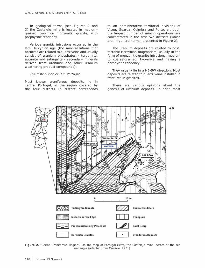
In geological terms (see Figures 2 and 3) the Castelejo mine is located in medium-grained two-mica monzonitic granite, with porphyritic tendency.
Various granitic intrusions occurred in the late Hercynian age (the mineralizations that occurred are related to quartz veins and usually consist of uranium phosphates - torbernite, autunite and sabugalite - secondary minerals derived from uraninite and other uranium weathering product compounds).
Most known uraniferous deposits lie in central Portugal, in the region covered by the four districts (a district corresponds
to an administrative territorial division) of Viseu, Guarda, Coimbra and Porto, although the largest number of mining operations are
are, in general terms, presented in Figure 2).
The uranium deposits are related to post-tectonic Hercynian magmatism, usually in the form of monzonitic granite intrusions, medium to coarse-grained, two-mica and having a porphyritic tendency.
They usually lie in a NE-SW direction. Most deposits are related to quartz veins installed in fractures in granites.
There are various opinions about the genesis of uranium deposits. In brief, most
Figure 2. “Beiras Uraniferous Region”. On the map of Portugal (left), the Castelejo mine locates at the red rectangle (adapted from Ferreira, 1971).

GEOFÍSICA INTERNACIONAL
APRIL - JUNE 2014 141
authors (Cerveira, A., 1951; Neiva, J.M.C., 1995) albeit with slight variations, considered primary deposits as coming from hydrothermal deposits, while the secondary deposits - impregnation deposits - are considered
and subsequent precipitation in favourable structures.
is structurally conditioned by the intense fracturing in the area (Teixeira, C. et al., 1967).
frequency (VLF) survey that enabled the
constitute prime pathways for groundwater
magnetotelluric (RMT) survey conducted at
material. This fault gauge collects the mine’s
have obtained the resistivities and thicknesses of the weathered material.
EDM, the Portuguese state-owned enterprise, in charge of the environmental rehabilitation of the old abandoned mining areas, has been monitoring several water points (wells and piezometers) located in the vicinity of the old Castelejo mine on a more or less regular basis since 1991. However,
since neither the piezometer geometrical characteristics nor its depths of abstraction are known. Besides, data collected over time vary both quantitatively as qualitatively, which
Figure 3. Castelejo mine geological setting

V. M. G. Oliveira, L. F. T. Ribeiro and M. C. R. Silva
142 VOLUME 53 NUMBER 2
Furthermore, the collected data relate to two different realities – dug wells and drilled wells - and it is reasonable to apply them a conceptual model based on the supposition that they concern two equally different aquifers: a porous aquifer located near the
one in a deeper fractured rock zone, taken
Carvalho, J.M., 2006).
Therefore, in view of the hydrogeological characterization of the former mining area and
supplementary data was needed to enable us
unpublished reports. For this, two geophysical surveys were undertaken, using two different geophysical methods. This was intended to supplement the information obtained in each campaign.
performed, which was based on photogeological analysis of the studied area.
Materials and Methods
Bases and methods
It is common to be faced with problems of several orders when approaching the hydrogeological study of fractured rocks with a view to their hydraulic characterization.
In the case of granitic rocks, in particular, which, when fresh, are practically impermeable to water, it is well known that its secondary porosity, namely due to several physical processes, can very often play a determinant role in water circulation.
The circulation of the water in this type of rock prompts a fundamental question, which
from where the drainage can proceed: these fractures are not always easy to identify, bearing in mind the thickness of the covering layer that sometimes overlies the rock (Afonso, M.J.C. 2003).
So, we need to resort to indirect survey methods that enable us to identify any abnormalities of hydrogeological interest.
The methods used in the current work are very low frequency – electromagnetics (VLF-EM) and radio magnetotelluric – resistivity (RMT-R). Both methods are based on radio waves from low frequency to very low frequency – from 12 kHz to 300 kHz in both methods – which are emitted by antennas located all over the world (Thierrin, J. et al., 1988; Turberg, P. et al., 1992; Turberg, P., 1993).
These waves also propagate in the basement, with the depth of penetration of
PFa= 503ρ
(1)
Figure 4. Some ecological and human risks associated with uranium mill tailings (adapted from http://www.wise-uranium.org/uwai.html).

GEOFÍSICA INTERNACIONAL
APRIL - JUNE 2014 143
where :
P generated by the radio waves (m)
a - apparent resistivity (ohm.m)F - wave frequency (Hz).
But these waves also give rise to a secondary
nature of the material crossed and can be detected at the surface (Thierrin, J. et al., 1988; Turberg, P. et al., 1992). Consequently
which are distinguished by intensity, phase and direction.
VLF-EM Method
With the VLF-EM method, special, well-adjusted devices make use of one horizontal axis coil to measure the intensity of the primary
one vertical axis coil.
developed for hydrogeological purposes by Prof. Imre Müller, of the Centre of Hydrogeology of the University of Neuchâtel (Müller, I., 1983).
It differs from commercial appliances since it continuously registers the variation of the
signal. The joint use of a data logger and a GPS secures the right location of registered anomalies (Müller, I., 1983; Thierrin, J. et al., 1988; Turberg, P. et al., 1992).
The vertical components are either in phase
The expression of the results is given by the
The method permits detection of the presence of electricity-conducting bodies such
equally great sensitivity to other important hydrogeologic characteristics, such as lateral facies variations (Dill, A. et al., 1998).
The method has the additional advantage of not requiring contact with the ground –once the antenna is automatically oriented, it can be used manually or installed in vehicles.
RMT-R Method
The RMT-R method measures the electric Ex , in the direction of propagating radio
waves (e.g. in the emitter antenna direction).
electrodes inserted in the ground at a certain distance from each other (in our work this distance is 5 meters).
Figure 5. Basis of VLF-EM method, adapted from Turberg and Müller (1992) Reproduced from Dill et al. (1998).

V. M. G. Oliveira, L. F. T. Ribeiro and M. C. R. Silva
144 VOLUME 53 NUMBER 2
The RMT-R method also measures the H
y , which is measured through
a coil whose horizontal axis is normal to the emitter antenna direction.
The apparent resistivity, a, results from the application of equation (2):
ρπa
x
y
E
H F=
2
0
1
2 (2)
where:
Ex
(Volt/m)
Hy - magnetic component of the resultant
0 - permeability of free space (Henry/m).
F - wave frequency (Hz).
This method also measures the phase-shift, , between the electric and magnetic components. The phase-shift enables inference of the stratigraphic characteristics of the place under study: there will be a conductive layer over a resistive one if < 45º , there will be a resistive layer over a conductive one if > 45º, and the medium is considered homogeneous if = 45º .
Given the fact that emitter antennas being located far apart from the receiver device, we could consider all directions of propagation as essentially parallel, which in practice reduces to only one direction. Once the device allows the simultaneous measurement of 4 frequencies, we can interpret it as supplying information from 4 depths (see Figure 6). An inversion program (FITVLF2) for the personal computer was used to obtain the real resistivities and the thicknesses of the layers traversed. Although its description is beyond the scope of this article, detailed information about the method of inversion and its implementation can be found at Fischer, G. et al. (1981), Fischer, G. (1985) and Thierrin, J. (1992).
Since it is a quick method that enables measurements (soundings) to be taken at 5 m intervals it allows the detection of heterogeneities, and it is possible to infer the permeability of the formations from their resistivity values, although this has not been done in the present study.
Multidirectional soundings can also be carried out to get information about the anisotropy of the studied medium.
Results and Discussion
VLF-EM
In Figure 8 we present a photographic map of the places surveyed by VLF-EM method.
The marked points show the paths walked along and color gradation indicates that the
relationship.
frequency and some important conclusions can be drawn from their interpretation (see Figure 8).
Very negative or very positive values (Hs/
high tension power lines and so they must
are usually related to major resistivity layers,
major electricity conductivity layers (for instance, the presence of clay materials).
fracture zones, the more important the greater the registered amplitude.
In Figure 9 we present a summarized interpretation of the obtained results, in order to illustrate the stated above. The joint interpretation of the VLF-EM results with information gathered on EDM internal reports
to draw a map summarizing the fractures in the studied area, from which main drainage trends can be established (see Figure 10, wherein places where the presence of water was noted are marked in blue).
RMT-R
Apparent resistivity and phase difference
with circles, and they were quite enlightening (see Figures 10 and 11).

GEOFÍSICA INTERNACIONAL
APRIL - JUNE 2014 145
Figure 6. Basis of RMT-R method, adapted from Thierrin and Müller (1988).
Reproduced from Dill et al. (1998).
Figure 7. VLF-EM method: equipment adapted to a vehicle (Castelejo mining site).

V. M. G. Oliveira, L. F. T. Ribeiro and M. C. R. Silva
146 VOLUME 53 NUMBER 2
Figure 8. a) Start point and
carried out in the VLF-EM survey
b) Photographic map of Castelejo former mine site surroundings, with profile location where VLF-EM survey was conducted (color variation explained in the text; P –

GEOFÍSICA INTERNACIONAL
APRIL - JUNE 2014 147
mining site, in the Castelejo Valley (see Figure 12), have revealed very interesting features.
After processing the obtained results using an inversion program (Fischer, G., 1985), the real resistivities and thicknesses of the different layers were computed (Figure 13). Mid sector values were calculated next.
the Castelejo Valley exhibit a decrease in resistivity with depth. Once we are away from the mineralized vein, this may suggest either more alteration of granites with depth, or a situation of deep-contamination.
(referring to deep pink points in Figures 10 and 11) is located near the old mining site: resistivity values correspond to those obtained for almost unweathered granite blocks (with
resistivity values > 1000 .m) immersed in
700 .m).
reproduced separately in Figure 13 (here referring to light green points in Figures 10 and 11) is located along the main fault valley
resistivity values corresponding to a situation of very weathered rock material, decreasing with depth.
spreads out WNW from washing pools, indicate
show a decrease of resistivity not only with depth but also as we go away from the mine towards the main fault valley (e.g. from P1 to
Figure 9.

V. M. G. Oliveira, L. F. T. Ribeiro and M. C. R. Silva
148 VOLUME 53 NUMBER 2
Figure 10. Fracture map of the studied area.
Figure 11 – Location of all RMT-R profiles per fo rmed in the s u r r o u n d i n g s o f Castelejo mining site

GEOFÍSICA INTERNACIONAL
APRIL - JUNE 2014 149
Figure 13. near the old mining site, with resistivity
values.
Figure 12 – Location of RMT-R prof i les per fo rmed in the
Castelejo Valley.

V. M. G. Oliveira, L. F. T. Ribeiro and M. C. R. Silva
150 VOLUME 53 NUMBER 2
Conclusions
At the beginning of the study it was known the situation in terms of regional tectonics, which was known complex for being associated with a number of episodes of tardi-Hercynian fracturing, as well with the Alpine tectonics.
In order to better characterize the underlying geology of the old Castelejo mine, two geophysical surveying campaigns were conducted at the site. Both the results
the references consulted, particularly in EDM internal reports, pointed to the presence of faults and fractures which might constitute the
drainage.
In the second campaign, measurements of RMT-R were performed to the WNW and ESE of the centre of exploration. Apparent resistivity and phase difference between the electric and
obtained values were projected graphically and processed, after which real resistivities and thicknesses were determined through the use of an inversion program.
After matching the literature data with the
that the direction of maximum compressive stress, s1, located NNW-SSE to NW-SE, where extension fractures are developed, should
easily, since the larger openings of the fractures
However, it was not possible to establish a direct correspondence between real resistivity values and permeability values, which, although outside the scope of this article, may be relevant for v.g. hydrogeological purposes.
– their resistivity values decrease with depth.
This can be due to natural causes (more weathered layers) or it can indicate a situation of deep contamination with acid drainage (increased mineralization).
In fact, we are in the presence of a former uranium exploration, in which ore acid
with a number of negative implications in the surroundings, particularly over groundwater. Treatment operations of the mine water still occur. However, any risks to populations seem weak, given the isolation of the area in terms of population.
Also the use of water seems to be aimed to agricultural purposes rather than for human consumption.
This point will be addressed in the future through the implementation of a hydrochemical monitoring plan.
Acnowledgements
The assistance of Amélia Dill was deeply appreciated
References
Abranches M.C.B., Canilho M.H., 1982. Determinação de idade pelo método do Rb-Sr de granitos antigos portugueses. In Memórias da Academia das Ciências de Lisboa. - Tomo XXIV (1981/82), p. 17-32
Afonso M.J.C., 2003, Hidrogeologia de rochas graníticas da região do Porto (NW de Portugal). Laxe. A Coruña. 28, pp. 173-192.
Araújo M.A., 2002, Tópicos da Matéria da .
.
Carvalho D., Goinhas J., Schermerhorn L., 1971, Principais jazigos minerais do Sul de Portugal. I Congresso Hispano-Luso-Americano de Geologia Económica, Livro-Guia da Excursão nº 4, Direcção-Geral de Minas e Serviços Geológicos, Lisboa, 94 pp.
Carvalho J.M., 2006, Prospecção e pesquisa de recursos hídricos subterrâneos no Maciço Antigo Português : linhas metodológicas. Tese de Doutoramento, Universidade de Aveiro, 312 pp.
Cerveira A., 1951, Sobre a metalogenia do urânio em Portugal.
, 8, 3, pp.141-182
Daniels J., Roberts R., Vendl M., 1995, Ground penetrating radar for the detection of liquid contaminants.
33, Elsevier, 13 pp.
Dill A., Müller I., Costa A.M., Monteiro J.P., 1998, Importância do uso de métodos geofísicos electromagnéticos Very Low Frequency Electromagnetics (VLF-EM) e Radio Magnetotelluric-Resistivity (RMT-R) no estudo de aquíferos cársicos do Alentejo e do Algarve. 4º Congresso da Água, A.P.R.H., Lisboa, 10 pp.

GEOFÍSICA INTERNACIONAL
APRIL - JUNE 2014 151
Ferreira M.P., 1971, Jazigos uraníferos portugueses, jazigos de Au-Ag-sulfuretos do Norte de Portugal. I Congresso Hispano-Luso-Americano de Geologia Económica, Livro-Guia da Excursão nº 5, Direcção-Geral de Minas e Serviços Geológicos, Lisboa, 81 pp.
Fischer G., Schnegg P.-A., Peguiron M., Le Quang B., 1981, An analytic one-dimensional magnetotelluric inversion scheme.
67 2, John Wiley & Sons Ltd, pp. 257-278.
Fischer G., 1985, Some Remarks on the Behaviour of the Magnetotelluric Phase.
, 33 (5), John Wiley & Sons Ltd , pp. 716-722.
Kearey P., Brooks M., Hill I., 2002, An Introduction to Geophysical Exploration. Blackwell Science Ltd., 281 pp.
Lottermoser B., 2003, Mine wastes, characterization, treatment and environmental impacts. Springer-Verlag Berlin Heidelberg, 277 pp.
Milsom J., 2003, Field geophysics. John Wiley & Sons Ltd, West Sussex, England, 249 pp.
Müller I., 1983, Anisotropic properties of rocks detected with electro-magnetic VLF (Very Low Frequency). International Symposium on Field measurements in Geomechanics. Zurich, Switzerland, special publ., pp. 273-282.
Neiva J.M.C., 1995, Jazigos portugueses de minérios de urânio. 4, IV Congresso Nacional de Geologia, Museu e Laboratório Mineralógico e Geológico, Faculdade de Ciências, Universidade do Porto, pp. 575-579
Nunes A., 1983, A geologia económica e a indústria mineira através dos tempos. Geonovas 5, pp. 67-114.
Oliveira V., 2010, Modelação hidrogeológica da área mineira abandonada de Castelejo (Guarda). Tese de Doutoramento. Faculdade de Ciências Universidade de Lisboa, 211 pp.
Rapantova N., Hrkal Z., (editors), 2008, Mine water and the environment. Proceedings of 10th Internacional Mine Water Association Congress. VSB-Technical University of Ostrava, Faculty of Mining and Geology. Olomouc, Czech Republic, 628 pp.
Ribeiro A., Antunes M.T., Ferreira M.P., Rocha R.B., Soares A.F., Zbyszewski G., Moitinho de Almeida F., Carvalho D. e Monteiro, J.H., 1979, Introduction à la géologie générale du Portugal. Serviços Geológicos de Portugal, Lisboa, 114 pp.
Teixeira C., 1966, A evolução do território português no decurso dos tempos geológicos. Palestra Rev. Ped. Cult., 28, Lisboa, pp. 111-157.
Teixeira C., Carvalho B., Santos P., Peres M., Barros R., 1967, Carta geológica de Portugal à escala 1:50.000, Folha 17-D (Gouveia) e notícia explicativa. Serviços Geológicos de Portugal, Lisboa, 28 pp.
Thierrin J., Müller I., 1988, La méthode VLF-Résistivité multifréquence, un example d’exploration hydrogéologique dans un synclinal crétacé à la Brévine (Jura neuchâtelois).
, Mémoire Hors de Série, nº 6, Quatrième Colloque d´Hydrogéologie en Pays Calcaire, Besançon, France, 17-25.
Turberg P., 1993, Apport de la cartographie radiomagnetotellurique a l´hydrogeologie des milieux fracturés. Thèse de Doctorat. Faculté des Sciences de l’Université de Neuchâtel, Suisse, 233 pp.
Turberg P., Müller I., 1992, La méthode inductive VLF-EM pour la prospection hydrogéologique
, Mémoire Hors de Série, nº 11, Cinquième Colloque d´Hydrogéologie en Pays Calcaire et en Milieu Fissuré, Neuchâtel, Suisse, 207-214.
United States Environmental Protection Agency, 2007, Technical report on technologically enhanced naturally occurring radioactive materials from uranium mining – Volume 2: investigation of potential health, geographic and environmental issues of abandoned uranium mines. U.S. Environmental
Indoor Air, Radiation Protection Division, Washington, DC, USA.
water hydrogeology and geochemistry. , 198,
London, 396 pp.
Related Documents