Huzzas Phase 2 Multi Client 3D Marine Seismic Survey, Environment Plan Summary HUZZAS PHASE 2 MULTI CLIENT 3D MARINE SEISMIC SURVEY ENVIRONMENT PLAN SUMMARY TGS March 2014

Welcome message from author
This document is posted to help you gain knowledge. Please leave a comment to let me know what you think about it! Share it to your friends and learn new things together.
Transcript
Huzzas Phase 2 Multi Client 3D Marine Seismic Survey, Environment Plan Summary
HUZZAS PHASE 2 MULTI CLIENT 3D MARINE SEISMIC SURVEY
ENVIRONMENT PLAN SUMMARY
TGS
March 2014
Huzzas Phase 2 Multi Client 3D MSS, Environment Plan Summary
Page i
HUZZAS PHASE 2 MULTI CLIENT 3D MARINE SEISMIC SURVEY, ENVIRONMENT PLAN
TABLE OF CONTENTS
1 INTRODUCTION .......................................................................................................... 1
2 LOCATION OF THE ACTIVITY ...................................................................................... 1
3 DESCRIPTION OF THE ACTIVITY ................................................................................ 3
3.1 SURVEY PARAMETERS ................................................................................................. 3
3.2 SURVEY VESSELS ........................................................................................................ 3
4 DESCRIPTION OF THE ENVIRONMENT ....................................................................... 4
4.1 REGIONAL SETTING .................................................................................................... 4
4.2 PHYSICAL ENVIRONMENT ........................................................................................... 4
4.3 BIOLOGICAL ENVIRONMENT ....................................................................................... 5
4.3.1 Biological Productivity ............................................................................................. 5
4.3.2 Biological Communities ........................................................................................... 5
4.3.4 Protected Marine Fauna .......................................................................................... 5
4.4 SOCIO-ECONOMIC ENVIRONMENT ............................................................................... 9
4.4.1 Commercial Fisheries .............................................................................................. 9
4.4.2 Petroleum Exploration and Production...................................................................... 9
4.4.3 Shipping .............................................................................................................. 10
4.4.4 Tourism ............................................................................................................... 10
4.4.5 Heritage ............................................................................................................... 10
4.4.7 Marine Parks and Reserves.................................................................................... 10
4.4.8 Other Protected Areas ........................................................................................... 11
4.4.9 Western Australian Mainland Coast ........................................................................ 11
4.4.10 Defence Activities ................................................................................................. 11
5 IDENTIFICATION AND ASSESSMENT OF ENVIRONMENTAL RISKS AND IMPACTS . 12
TABLE 3 SUMMARY OF THE ENVIRONMENTAL RISK ASSESSMENT FOR THE SURVEY .......... 14
6 MANAGEMENT APPROACH ........................................................................................ 21
7 CONSULTATION ........................................................................................................ 22
7.1 Pre-survey consultation ......................................................................................... 22
8 CONTACT DETAILS .................................................................................................... 23
9 REFERENCES ............................................................................................................. 24
Huzzas Phase 2 Multi Client 3D MSS, Environment Plan Summary
Page ii
FIGURES
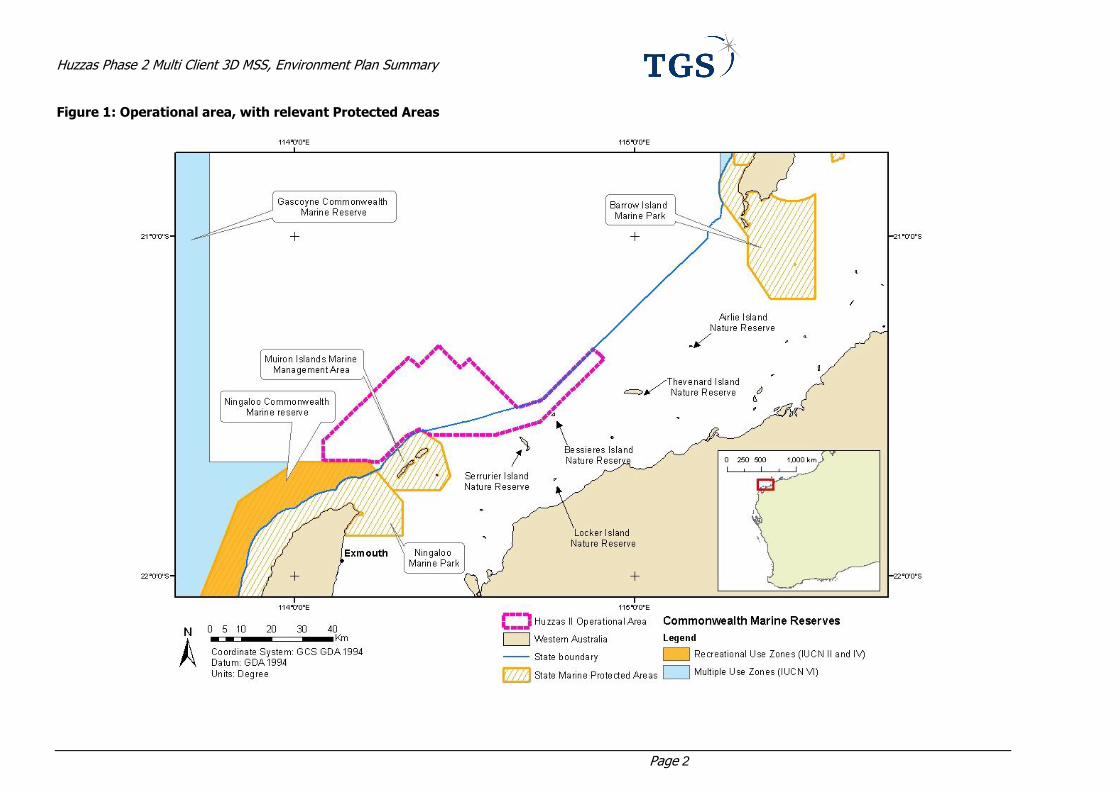
Figure 1: Operational area, with relevant Protected Areas ................................................................. 2
TABLES
Table 1: Co-ordinates for the operational area ................................................................................. 1
Table 2: EPBC Act Protected Species that may occur in, or relate to, the operational area and surrounding waters ................................................................................................................. 6
Table 3 Summary of the environmental risk assessment for the survey ........................................... 14
Huzzas Phase 2 Multi Client 3D MSS, Environment Plan Summary
Page 1
1 INTRODUCTION
The geophysical company TGS proposes to undertake a multi-client three-dimensional (MC3D) marine
seismic survey (MSS) known as Huzzas Phase 2 (‘the survey’), south of the Exmouth Plateau within the northern Carnarvon Basin offshore from Western Australia (WA) (Figure 1).
The operational area comprises 1,356 km2 and lies within Commonwealth and State waters (Figure 1). The
area defined as the ‘operational area’ is the physical area used for full power data acquisition within the operational area plus additional area for sail line run outs (required to obtain full fold coverage), soft-start
procedures and vessel manoeuvring.
The survey is scheduled to occur between late March and May 2014, with a total duration of approximately
26 days. The water depths within the operational area range from approximately 20 m to 200 m.
The survey will follow the same technical methods and procedures as other seismic surveys conducted in Australian marine waters. No unique or unusual equipment or operations are proposed.
This document provides a summary of the Environment Plan (EP) that was accepted by the National Offshore petroleum Safety and Environmental Management Authority (NOPSEMA) as part of the
requirements under the Offshore Petroleum and Greenhouse Gas Storage (Environment) Regulations 2009 (Environment Regulations). This EP summary has been prepared as per the requirements of Regulation 11
(7) and (8) of the Environment Regulations.

Huzzas Phase 2 Multi Client 3D MSS, Environment Plan Summary
Page 1
2 LOCATION OF THE ACTIVITY
The proposed survey is located in Commonwealth and State (WA) waters in the Carnarvon Basin, northwest
of WA. The area defined as the ‘operational area’ is the physical area used for full power data acquisition within the survey area, plus additional area for sail line run outs (required to obtain full fold coverage), soft-
start procedures and vessel manoeuvring.
The operational area will cover 1,356 km2 and intersects petroleum permit blocks WA-42-L, WA-399-P, WA-155-P (1), WA-41-R, WA-486-P, WA-483-P, TR-3 R2, TP/25 and EP 483.The boundaries of the operational
area are shown in Figure 1 and boundary coordinates for the operational area are provided in Table 1.
Table 1: Co-ordinates for the operational area
Longitude Latitude
114.42 -21.32
114.49 -21.39
114.51 -21.36
114.65 -21.50
114.73 -21.48
114.88 -21.33
114.91 -21.36
114.72 -21.55
114.59 -21.58
114.40 -21.59
114.37 -21.57
114.33 -21.59
114.25 -21.66
114.22 -21.66
114.08 -21.66
114.08 -21.60
114.30 -21.39
114.34 -21.36
114.36 -21.38
Datum: GDA94
Huzzas Phase 2 Multi Client 3D MSS, Environment Plan Summary
Page 2
Figure 1: Operational area, with relevant Protected Areas
Huzzas Phase 2 Multi Client 3D MSS, Environment Plan Summary
Page 3
3 DESCRIPTION OF THE ACTIVITY
3.1 Survey Parameters
The marine seismic survey proposed is a typical 3D survey similar to most others conducted in Australian marine waters (in terms of technical methods and procedures). No unique or unusual equipment or
operations are proposed. The survey will be conducted using a purpose-built seismic survey vessel.
During the proposed activities, the survey vessel will traverse a series of pre-determined sail lines within the operational area at a speed of approximately 8-9 km/hr. As the vessel travels along the sail lines a series of
noise pulses (every 8 – 10 seconds) will be directed down through the water column and seabed. The released sound is attenuated and reflected at geological boundaries and the reflected signals are detected
using sensitive microphones arranged along a number of hydrophone cables (streamers) towed behind the
survey vessel. The reflected sound is then processed to provide information about the structure and composition of geological formations below the seabed in an attempt to identify hydrocarbon reservoirs.
The seismic array will comprise a maximum of fourteen seismic cables, with a maximum length of 7050 m. The seismic cables are towed side by side and the spacing will be 75 m between each seismic cable. The
seismic energy source tow depth will be 6 m (+/- 1 m) and the cable tow depth will be between 9m to 15 m (+/- 1 m). The operating pressure for the seismic energy source will be approximately 2,000 psi and will
consist of two arrays, each with a maximum volume of approximately 3500 cui.
These sub-arrays will be fired alternately, with a shotpoint interval of 18.75 m horizontal distance. The source produces sound pulses (within a few metres in the order of ~262 dB re 1μPa sound pressure level –
SPL) at frequencies extending up to approximately 210 Hz. The sound sources will be directed downwards towards the seafloor rather than horizontally. These sound pulses decrease to levels in the order of 201 dB
re 1μPa (SPL) within 1 km of the source. It is important to note that this estimate of SPL is calculated
assuming perfect conditions with sea surface reflectivity of -1 (which assuming all energy is reflected) and no absorption of energy in the water, or sediments, which is not true in reality. As such, the SPL reported
here is much higher than that that would be observed in the environment.
3.2 Survey Vessels
TGS proposes to conduct the survey using a purpose built seismic survey vessel. At least one support vessel
will escort the survey vessel at all times to maintain a safe distance between the survey array and other
vessels, and also to manage interactions with shipping and fishing activities, if required. The support vessels will also re-supply the survey vessel with logistical supplies, including refuelling as necessary.

Huzzas Phase 2 Multi Client 3D MSS, Environment Plan Summary
Page 4
4 DESCRIPTION OF THE ENVIRONMENT
4.1 Regional Setting
The proposed operational area lies within Commonwealth and State marine waters of the North West Shelf (NWS) in the North-west Marine Region (NWMR). While the operational area covers water depths between
20 and 200 m only, the NWS includes shallower water (up to shorelines) and is scattered with islands, the
largest of which is Barrow Island.
The NWS gradually slopes from the coast to the shelf break, but displays a number of seafloor features such
as banks/shoals, holes/valleys and several terraces and steps which reflect ancient coastlines from when the sea level was lower than it is today. The most prominent of these occurs at a water depth of approximately
125 m and is believed to be an important migratory pathway for cetaceans and other pelagic species such as
the whale shark (DSEWPaC 2012).).
Inshore areas of the NWMR have predominantly sandy sediments, with mostly muddy sediments occurring
offshore from the 200 m isobath.
4.2 Physical Environment
The NWS is subject to an arid, subtropical climate with tropical cyclone activity from November to April. The
summer and winter seasons fall into the periods September-March and May-July respectively. In summer,
mean daily temperatures range between 20°C and 34°C and in winter, between 17°C and 26°C (Chevron Australia, 2008). Relative humidity at Barrow Island ranges from 61% in the winter months (September) to
70% in the summer (February) (BoM, 2012).
Rainfall on Barrow Island varies significantly each year and is dependent on rain-bearing low-pressure
systems, thunderstorm activity, and the passage of tropical cyclones (which generally occur from November
to April). Average annual rainfall at Barrow Island is 306 mm with most rain (85%) occurring between January and July (BoM, 2012). The cyclone season is November to April with the majority of cyclones
moving down the north-west coast between 40-400 km offshore and at an average speed of 16 km per hour. During tropical cyclones, mean wind speeds of 56 ms-1 have been recorded with gusts up to 69 ms-1.
An average of five tropical cyclones per year occur in the Pilbara Region (BoM, 2011), with an average of two per year passing through the Barrow Island area (Chevron Australia, 2005).
Winds are predominantly WSW from October to April and ESE from May to September. Average 10 minute
wind speed in non-cyclonic conditions is 6 ms-1 with a 5% exceedence value of 12 ms-1. In general, wind speeds are <10 m/s for more than 90% of the time, but rarely fall below 1 m/s (2.2% of the time).
Surface water temperatures offshore range between approximately 20°C in winter and 31°C in summer (Chevron Australia, 2005). The Leeuwin Current flows south along the shelf break and is shallow (less than
300 m deep) and narrow (50–100 km wide). The Leeuwin Undercurrent is also a feature of this bioregion
and flows northward beneath the Leeuwin Current, between 250–450 m water depth on the continental slope. The Leeuwin Current is strongest during autumn and winter. During summer, strengthening south-
westerly winds counter the alongshore pressure gradient and weaken the southward flow of the Leeuwin Current, allowing the generation of the northward flowing Ningaloo Current. The Ningaloo Current intrudes
into this bioregion inshore of the 50 m depth contour along Cape Range Peninsula.
Water clarity in the region varies according to water movement and sediment type (Chevron Australia, 2011). The shallow, nearshore coastal waters off the west coast of Barrow Island generally have low levels
of turbidity and concentrations of suspended sediments (<5 mg/L), which is indicative of clear water environments. Low-level sediment deposition is temporary and is rapidly resuspended by waves and tidal
flow (Chevron Australia, 2011). Wave activity is important in contributing to local re-suspension of sediments, resulting in elevated turbidity and suspended sediment concentrations.).
Huzzas Phase 2 Multi Client 3D MSS, Environment Plan Summary
Page 5
4.3 Biological Environment
4.3.1 Biological Productivity
Primary productivity in the Northwest Shelf Province is thought to occur predominantly in pelagic environments, where phytoplankton plays an important primary producer role.
Broadly, the inner shelf experiences oligotrophic conditions, with episodic injections of nutrients during storm
events when run-off from terrestrial sources occurs and when sediments are resuspended as a result of cyclonic or tidal activity. The mid-shelf is also generally oligotrophic with sporadic availability of higher levels
of nutrients associated with vertical mixing and internal wave activity occurring around the shelf break and extending onto the shelf. While not as pronounced as for the inner shelf, cyclones and strong tides mix
water layers and nutrients and induce pulses of increased biological productivity over the mid shelf.
Enhanced pelagic production occurs on the outer shelf as a result of the interaction of surface and deeper water masses on the adjacent shelf break, via vertical mixing and internal wave action. The mixed water
masses travel towards shore and can stimulate biological productivity when the deeper nutrient-rich waters move into the photic zone where light allows phytoplankton to take up the influx of nutrients.
4.3.2 Biological Communities
The NWMR represents the beginning of a transition between tropical and temperate biological communities.
The predominantly southward flowing surface currents continue to bring tropical Indo–Pacific organisms into this bioregion, but the presence of the northward flowing Leeuwin Undercurrent also transports temperate
species from more southern areas (Brewer et al., 2007).
Coral reefs are an important feature of the Region supporting high species diversty. These reefs and their
surrounding waters are also important habitats for cetaceans and seabirds. Multispecific, synchronous
spawning (mass spawning) of scleractinian corals has been recorded in the Dampier Archipelago and at Ningaloo Reef, and may occur at other reefs in the Region. Mass spawning occurs March and April each
year, coinciding with the annual intensification of the Leeuwin Current and Indonesian Throughflow.
On the NWS, the sandy substrates are thought to support low density benthic communities of bryozoans,
molluscs and echinoids. Sponge communities are also sparsely distributed on the shelf, but are found only in areas of hard substrate. Other benthic and demersal species in this bioregion include sea cucumbers,
urchins, prawns and squid. The benthic and pelagic fish communities of the NWS are strongly depth-related,
indicative of a close association between fish communities and benthic habitats (Brewer et al. 2007).
The upper and middle parts of the NWS have important demersal fish communities, which display a high
degree of endemism compared with other areas of slope. The high numbers of species found here is believed to be associated with areas of enhanced biological productivity as a result of the interaction
between seasonal currents and seabed topography.
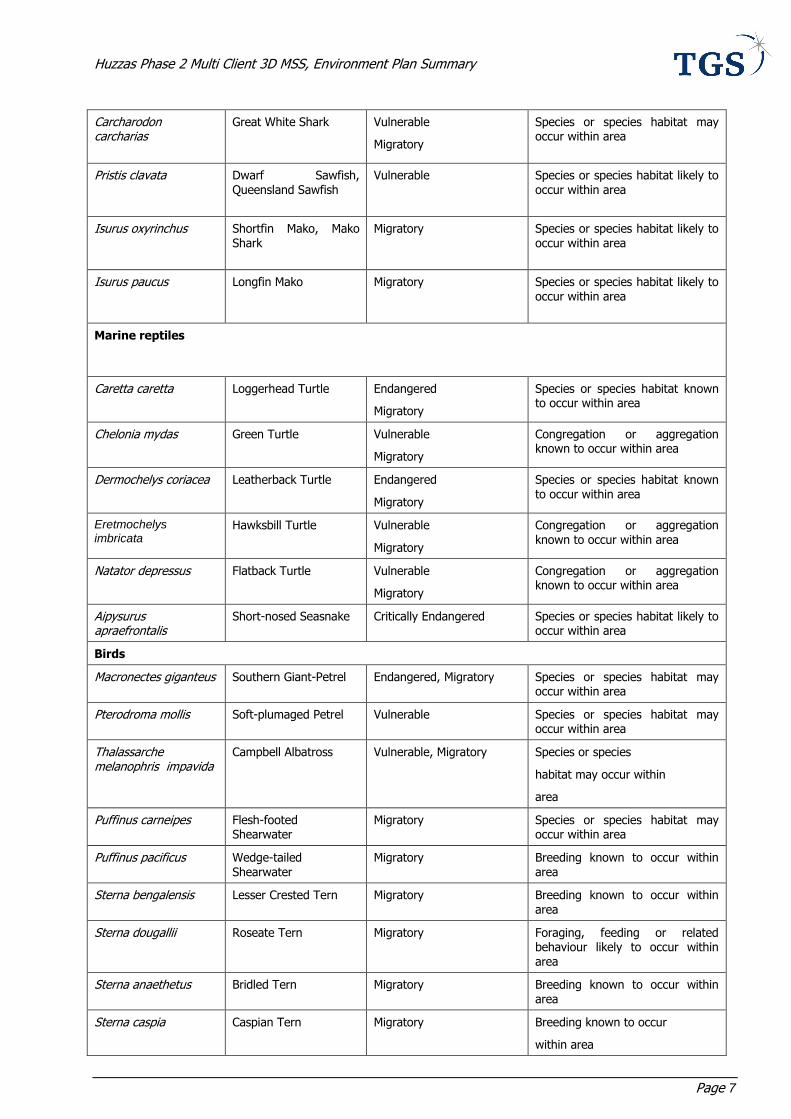
4.3.4 Protected Marine Fauna
A review of the EPBC Act database (Protected Matters search tool) held by DoE (DoE, 2013) was conducted
to identify protected marine fauna species which are likely to occur within, or adjacent to, the operational area. Table 2 provides an indication of species that may be found in the operational area including a 10 km
buffer.
Cetaceans
Nine migratory cetaceans, of which three are threatened, may occur in the operational area. The survey was
intentionally scheduled to avoid the humpback whale migration occurring between June and September. The migratory period of the blue whale may overlap in timing with the survey. However, given the distances
between known migratory pathways and the operational area, encounter rates are expected to be low. Given the likely distribution of southern right whales (the third of the threatened species), encounters of this
species are not expected.
Marine reptiles
Six species of threatened marine reptiles, including five turtles, all of which are migratory, and one sea snake, may occur within the operational area. The survey timing is intentionally scheduled to avoid peak
internesting periods of the loggerhead, green and flatback turtle, known to nest in the vicinity of the
Huzzas Phase 2 Multi Client 3D MSS, Environment Plan Summary
Page 6
operational area. Significant aggregations of marine reptile within the operational area are considered unlikely and any individuals encountered will be transitory only. The short nosed seasnake is not expected to
occur in the operational area in large numbers.
Sharks
Six species of threatened and/or migratory shark may occur in the operational area. The survey timing overlaps with peak aggregation periods of the threatened whale shark at Ningaloo reef. While whale sharks
may traverse or migrate through the operational area, they are not known to aggregate within this area. The remaining species may transit through the operational area, although encounter probability is expected to be
low.
Seabirds
Eleven species of threatened and/or migratory seabirds may occur within the operational area, however, individuals are likely to be transitory only.
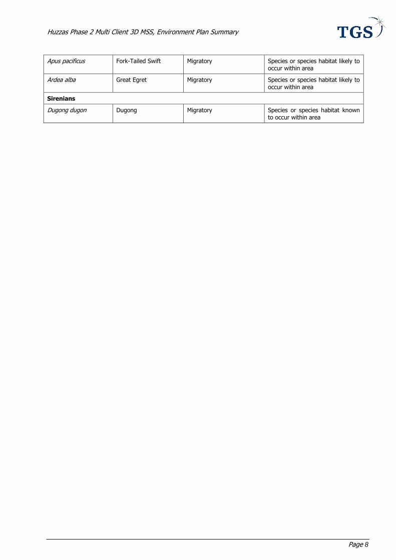
Sirenians
One migratory species of sirenian, the dugong, may be found in the operational area. While individuals may
traverse the area, due to the lack of preferred foraging/feeding habitat in the operational area, aggregations are not expected.
Table 2: EPBC Act Protected Species that may occur in, or relate to, the operational area and
surrounding waters
Scientific Name Common Name Status Type of Presence
Cetaceans
Balaenoptera musculus Blue Whale Endangered, Migratory Species or species habitat may occur within area
Eubalaena australis Southern Right Whale Endangered, Migratory Species or species habitat likely to occur within area
Megaptera novaeangliae
Humpback Whale Vulnerable, Migratory Congregation or aggregation known to occur within area
Balaenoptera bonaerensis
Antarctic Minke Whale Migratory Species or species habitat may occur within area
Balaenoptera edeni Bryde’s Whale Migratory Species or species habitat may occur within area
Orcinus orca Killer Whale Migratory Species or species habitat may occur within area
Physeter macrocephalus
Sperm Whale Migratory Species or species habitat may occur within area
Sousa chinensis Indo-Pacific Humpback Dolphin
Migratory Species or species habitat may occur within area
Tursiops aduncus Spotted Bottlenose Dolphin (Arafura/Timor Sea populations)
Migratory Species or species habitat likely to occur within area
Sharks
Rhincodon typus Whale Shark Vulnerable
Migratory
Foraging, feeding or related behaviour known to occur within area
Carcharias taurus Grey Nurse Shark (west coast population)
Vulnerable Species or species habitat may occur within area
Huzzas Phase 2 Multi Client 3D MSS, Environment Plan Summary
Page 7
Carcharodon carcharias
Great White Shark Vulnerable
Migratory
Species or species habitat may occur within area
Pristis clavata Dwarf Sawfish, Queensland Sawfish
Vulnerable Species or species habitat likely to occur within area
Isurus oxyrinchus Shortfin Mako, Mako Shark
Migratory Species or species habitat likely to occur within area
Isurus paucus Longfin Mako Migratory Species or species habitat likely to occur within area
Marine reptiles
Caretta caretta Loggerhead Turtle Endangered
Migratory
Species or species habitat known to occur within area
Chelonia mydas Green Turtle Vulnerable
Migratory
Congregation or aggregation known to occur within area
Dermochelys coriacea Leatherback Turtle Endangered
Migratory
Species or species habitat known to occur within area
Eretmochelys imbricata
Hawksbill Turtle Vulnerable
Migratory
Congregation or aggregation
known to occur within area
Natator depressus Flatback Turtle Vulnerable
Migratory
Congregation or aggregation known to occur within area
Aipysurus apraefrontalis
Short-nosed Seasnake Critically Endangered Species or species habitat likely to occur within area
Birds
Macronectes giganteus Southern Giant-Petrel Endangered, Migratory Species or species habitat may occur within area
Pterodroma mollis Soft-plumaged Petrel Vulnerable Species or species habitat may occur within area
Thalassarche melanophris impavida
Campbell Albatross Vulnerable, Migratory Species or species
habitat may occur within
area
Puffinus carneipes Flesh-footed Shearwater
Migratory Species or species habitat may occur within area
Puffinus pacificus Wedge-tailed Shearwater
Migratory Breeding known to occur within area
Sterna bengalensis Lesser Crested Tern Migratory Breeding known to occur within area
Sterna dougallii Roseate Tern Migratory Foraging, feeding or related behaviour likely to occur within area
Sterna anaethetus Bridled Tern Migratory Breeding known to occur within area
Sterna caspia Caspian Tern Migratory Breeding known to occur
within area
Huzzas Phase 2 Multi Client 3D MSS, Environment Plan Summary
Page 8
Apus pacificus Fork-Tailed Swift Migratory Species or species habitat likely to occur within area
Ardea alba Great Egret Migratory Species or species habitat likely to occur within area
Sirenians
Dugong dugon Dugong Migratory Species or species habitat known to occur within area
Huzzas Phase 2 Multi Client 3D MSS, Environment Plan Summary
Page 9
4.4 Socio-economic Environment
4.4.1 Commercial Fisheries
Both the offshore and coastal waters in the Pilbara support a valuable and diverse commercial fishing industry. Several commercial fisheries operate out of Exmouth, Onslow, Port Samson and Dampier and
overlap or are adjacent with the operational area. The fisheries are managed by either the WA Department
of Fisheries (State) or the Australian Fisheries Management Authority (Commonwealth).
State Fisheries
North Coast Prawn Managed Fisheries;
Mackerel Managed Fishery;
Northern Shark Fishery
Exmouth Gulf Prawn Managed Fishery;
Gascoyne Demersal Scalefish Fishery;
Pilbara Demersal Scalefish Fisheries;
Pearl Oyster Managed Fishery;
Beche-de-mer Fishery;
Marine Aquarium Fish Managed Fishery; and
Specimen Shell Managed Fishery.
Commonwealth Fisheries
North West Slope Trawl Fishery (north of permit area);
Western Skipjack Fishery;
Western Tuna and Billfish Fishery;
Southern Bluefin Tuna Fishery; and
Western Deepwater Trawl Fishery.
Of these fisheries, only the North West Slope Trawl Fishery and Western Deepwater Trawl Fishery (Commonwealth), and North Coast Prawn Managed Fisheries and Mackerel Managed Fishery (State), are
likely to be active in the operational area.
Whilst the operational area is located within the area of the Western Deepwater Trawl Fishery, it is apparent that most of the effort and catch within the fishery occurs in waters well to the south of the operational
area; especially to the west and north-west of Shark Bay. No fishing activity in the Western Deepwater Trawl Fishery occurred in the operational area during 2009-2010.
Likewise, the operational area is located within the area of the North West Slope Trawl Fishery, the majority
of effort and catch occurs to the north-west of the operational area, particularly north of Barrow Island, and around Mermaid reef and Rowley shoals.
4.4.2 Petroleum Exploration and Production
Various petroleum exploration and development activities have occurred within and surrounding the operational area.
The operational area is situated ~16 km southeast of Ngujima Yin FPSO and Coniston Drill Centre, Novara
Drill Centre and the Van Gogh FPSO, and overlaps with the Pyrenees / Macedon field within which a number of wells have been drilled over the past three decades. Within WA-42-L, which is operated by BHPB, the
Pyrenees FPSO and the Macedon pipeline are located.
Extensive consultation has been carried out with operators of developments within or in proximity to the
operational area.
Huzzas Phase 2 Multi Client 3D MSS, Environment Plan Summary
Page 10
4.4.3 Shipping
Under the Commonwealth Navigation Act 1912, all vessels operating in Australian waters are required to report their location on a daily basis to the Rescue Coordination Centre in Canberra. This Australian Ship
Reporting System (AUSREP) is an integral part of the Australian Maritime Search and Rescue system and is
operated by Australian Maritime Safety Authority (AMSA) through the Rescue Coordination Centre.
The operational area is not within a commercial shipping route although some slow moving vessel traffic
could be expected around Thevenard Island, Muiron Islands, Onslow and those using Mary Anne Passage in and around Barrow Island. Local vessel movement is likely to be associated with the petroleum industry
(Pyrenees and Macedon field) and to a lesser degree, commercial fishing.
4.4.4 Tourism
Tourism is regarded highly in the Ningaloo Exmouth region and is one of the main incomes into the area. Activities include scuba diving, fishing and sightseeing. These activities are mainly confined within the more
sheltered waters of the islands where survey activities will not occur.
Recreational fishing is a very popular activity in the region. Although recreational fishing is likely to be low in
intensity (given the distance offshore), stakeholder consultation highlighted the potential overlap of the
survey with GAMEX, the premier fishing event in WA and also the Australian International Billfish Tournament (AIBT). GAMEX, in particular, is significant for local tourism, bringing millions of dollars to the
regional economy. Since the survey is scheduled to avoid the GAMEX competition, negative impacts to tourism and recreational fishing are not expected as a result of the proposed survey.
4.4.5 Heritage
There are no listed National Heritage places in the proposed operational area. There are no known
indigenous cultural heritage values or issues for the waters and seabed within and immediately adjacent to the operational area. Similarly, there are no current or pending Native Title Determinations for the waters
and seabed within and immediately adjacent to the operational area. There are no known historic shipwreck sites within or immediately adjacent to the operational area.
4.4.7 Marine Parks and Reserves
The operational area is located 14 km east of the Gascoyne Commonwealth Marine Reserve (CMR), 0.5 km
north east of the Ningaloo CMR, 3 km north east of the Ningaloo State Marine Park, 0.5 km north of the Muiron Island Marine Management Area (MMA), and 54 km to Montebello/Barrow Island Marine Reserve
Complex, 70 km to Montebello CMR in a easterly direction.
The Gascoyne CMR is 14 km west of the operational area and comprises of three different zones; Marine National Park (IUCN II), Habitat Protection Zone (IUCN IV) and Multiple Use Zone (IUCN VI). Mining
operations, including oil and gas activities, are allowable in Multiple Use Zones.
The Ningaloo CMR is an important foraging area for whale sharks and marine turtles, and includes part of
the migratory pathway for humpback whales. The reserve includes shallow shelf environments providing
protection for shelf and slope habitats, as well as pinnacle and terrace seafloor features. The Ningaloo State Marine Park is an important whale shark aggregation area with peak numbers appearing from late March to
early May following the mass spawning of coral.
The Muiron Islands Marine Management Area (MMA), which is situated to the north-east and immediately
adjacent to Ningaloo Marine Park, is located approximately 0.5 km south of the operational area. The park supports important coral reef habitat and associated diverse fish fauna, and is an important breeding site for
the loggerhead turtle.
The State-managed Montebello/Barrow Islands Marine Conservation Reserves Complex (MCR) comprises three separately vested reserves, namely the Montebello Islands Marine Park, Barrow Island Marine Park and
Barrow Island MMA, which were gazetted in 2004.
Adjacent to the Montebello State Marine Park described above, the Montebello CMR covers an area of 3,413

Huzzas Phase 2 Multi Client 3D MSS, Environment Plan Summary
Page 11
km2 in Commonwealth waters. The area is an important area for foraging migratory seabirds, whale sharks and marine turtles, and includes part of the migratory pathway of the protected humpback whale. A number
of sandy beaches are important turtle nesting sites. Wading shorebirds and foraging and nesting seabirds are also common on the islands.
4.4.8 Other Protected Areas
In addition to the marine protected areas discussed above, a number of State managed terrestrial protected areas are situated on islands south of the proposed operational area. This consists of a suite of Nature
Reserves (NRs) distributed between Exmouth to Dampier archipelago forming part of the Exmouth Gulf and Rowley Shelf Islands Registered National Estate. The National Estate encompasses an area of approximately
23,000 hectares and comprises islands and associated rocks, mangroves and reefs in the Exmouth Gulf and
between, and including, the Muiron Islands in the west and Weld Island in the east. The NRs, ranging from 1.6 – 25 km from the operational area, are C-Class Nature Reserves which is vested by the Conservation
Commission of Western Australia for the conservation of flora and fauna, and managed by the Department of Parks and Wildlife.
4.4.9 Western Australian Mainland Coast
At the closest point, the Western Australian mainland coast is located 40 km from the operational area.
Environmental sensitivities along the coastline include mangroves, seagrasses, sandy beaches, intertidal and
submerged coral reefs, and the diverse flora and fauna these habitats support. In turn, this brings tourism to the Pilbara region. The townships of Onslow and Exmouth are located ~35 km and ~ 33 km from the
operational area respectively. The key industry in both these towns is tourism, in particular snorkelling, diving and recreational fishing. Consultation was carried out with local shires and recreational fishing
stakeholders which revealed no potentially conflicting activities during the time of the proposed survey.
4.4.10 Defence Activities
The operational area overlaps with a Military Exercise Area (MEO) (the West Australia Exercise Area). These
areas are used by the RAAF and the RAN for all military operations including live weapons and missile firings. Restricted airspace is approved for navy and air weapons firing into Lancelin Training Area. Undertaking
seismic survey could impact upon naval and air force weapons practices.
TGS has included defence stakeholders in their stakeholder engagement program to minimise impact and/or
interaction between defence and seismic survey activities. The consultation has revealed no potentially
conflicting activities during the time of the proposed survey.
Huzzas Phase 2 Multi Client 3D MSS, Environment Plan Summary
Page 12
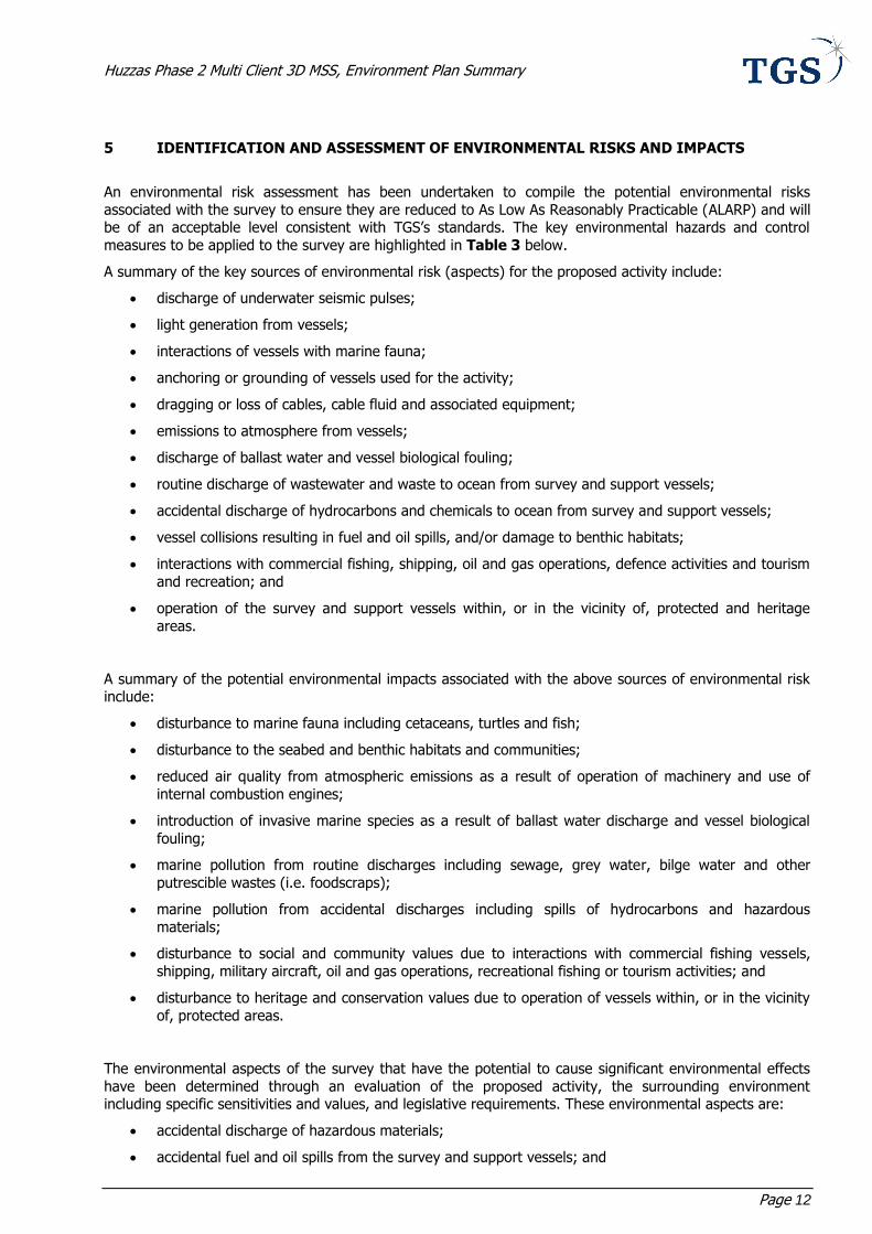
5 IDENTIFICATION AND ASSESSMENT OF ENVIRONMENTAL RISKS AND IMPACTS
An environmental risk assessment has been undertaken to compile the potential environmental risks
associated with the survey to ensure they are reduced to As Low As Reasonably Practicable (ALARP) and will be of an acceptable level consistent with TGS’s standards. The key environmental hazards and control
measures to be applied to the survey are highlighted in Table 3 below.
A summary of the key sources of environmental risk (aspects) for the proposed activity include:
discharge of underwater seismic pulses;
light generation from vessels;
interactions of vessels with marine fauna;
anchoring or grounding of vessels used for the activity;
dragging or loss of cables, cable fluid and associated equipment;
emissions to atmosphere from vessels;
discharge of ballast water and vessel biological fouling;
routine discharge of wastewater and waste to ocean from survey and support vessels;
accidental discharge of hydrocarbons and chemicals to ocean from survey and support vessels;
vessel collisions resulting in fuel and oil spills, and/or damage to benthic habitats;
interactions with commercial fishing, shipping, oil and gas operations, defence activities and tourism
and recreation; and
operation of the survey and support vessels within, or in the vicinity of, protected and heritage
areas.
A summary of the potential environmental impacts associated with the above sources of environmental risk include:
disturbance to marine fauna including cetaceans, turtles and fish;
disturbance to the seabed and benthic habitats and communities;
reduced air quality from atmospheric emissions as a result of operation of machinery and use of
internal combustion engines;
introduction of invasive marine species as a result of ballast water discharge and vessel biological
fouling;
marine pollution from routine discharges including sewage, grey water, bilge water and other
putrescible wastes (i.e. foodscraps);
marine pollution from accidental discharges including spills of hydrocarbons and hazardous
materials;
disturbance to social and community values due to interactions with commercial fishing vessels,
shipping, military aircraft, oil and gas operations, recreational fishing or tourism activities; and
disturbance to heritage and conservation values due to operation of vessels within, or in the vicinity
of, protected areas.
The environmental aspects of the survey that have the potential to cause significant environmental effects
have been determined through an evaluation of the proposed activity, the surrounding environment including specific sensitivities and values, and legislative requirements. These environmental aspects are:
accidental discharge of hazardous materials;
accidental fuel and oil spills from the survey and support vessels; and

Huzzas Phase 2 Multi Client 3D MSS, Environment Plan Summary
Page 13
vessel collisions, resulting in fuel and oil spills.
Implemented control measures documented in Table 3 ensure that the environmental risks associated with
these impacts are reduced and maintained at ALARP levels, while maintaining economic viability for the proposed activity. These control measures are taken into consideration in calculating the residual risk
associated with the potential environmental impacts.
Huzzas Phase 2 Multi Client 3D MSS, Environment Plan Summary
Page 14
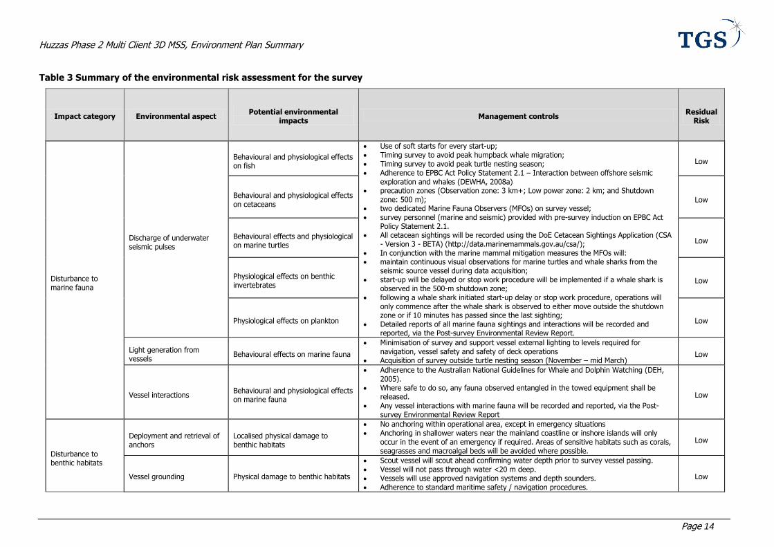
Table 3 Summary of the environmental risk assessment for the survey
Impact category Environmental aspect Potential environmental
impacts Management controls
Residual Risk
Disturbance to marine fauna
Discharge of underwater seismic pulses
Behavioural and physiological effects on fish
Use of soft starts for every start-up; Timing survey to avoid peak humpback whale migration; Timing survey to avoid peak turtle nesting season; Adherence to EPBC Act Policy Statement 2.1 – Interaction between offshore seismic
exploration and whales (DEWHA, 2008a) precaution zones (Observation zone: 3 km+; Low power zone: 2 km; and Shutdown
zone: 500 m); two dedicated Marine Fauna Observers (MFOs) on survey vessel; survey personnel (marine and seismic) provided with pre-survey induction on EPBC Act
Policy Statement 2.1. All cetacean sightings will be recorded using the DoE Cetacean Sightings Application (CSA
- Version 3 - BETA) (http://data.marinemammals.gov.au/csa/); In conjunction with the marine mammal mitigation measures the MFOs will: maintain continuous visual observations for marine turtles and whale sharks from the
seismic source vessel during data acquisition; start-up will be delayed or stop work procedure will be implemented if a whale shark is
observed in the 500-m shutdown zone; following a whale shark initiated start-up delay or stop work procedure, operations will
only commence after the whale shark is observed to either move outside the shutdown zone or if 10 minutes has passed since the last sighting;
Detailed reports of all marine fauna sightings and interactions will be recorded and reported, via the Post-survey Environmental Review Report.
Low
Behavioural and physiological effects on cetaceans
Low
Behavioural effects and physiological on marine turtles
Low
Physiological effects on benthic invertebrates
Low
Physiological effects on plankton Low
Light generation from vessels
Behavioural effects on marine fauna
Minimisation of survey and support vessel external lighting to levels required for navigation, vessel safety and safety of deck operations
Acquisition of survey outside turtle nesting season (November – mid March) Low
Vessel interactions Behavioural and physiological effects on marine fauna
Adherence to the Australian National Guidelines for Whale and Dolphin Watching (DEH, 2005).
Where safe to do so, any fauna observed entangled in the towed equipment shall be released.
Any vessel interactions with marine fauna will be recorded and reported, via the Post-survey Environmental Review Report
Low
Disturbance to benthic habitats
Deployment and retrieval of anchors
Localised physical damage to benthic habitats
No anchoring within operational area, except in emergency situations Anchoring in shallower waters near the mainland coastline or inshore islands will only
occur in the event of an emergency if required. Areas of sensitive habitats such as corals, seagrasses and macroalgal beds will be avoided where possible.
Low
Vessel grounding Physical damage to benthic habitats
Scout vessel will scout ahead confirming water depth prior to survey vessel passing. Vessel will not pass through water <20 m deep. Vessels will use approved navigation systems and depth sounders. Adherence to standard maritime safety / navigation procedures.
Low
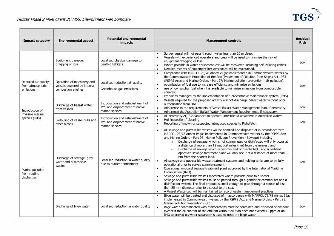
Huzzas Phase 2 Multi Client 3D MSS, Environment Plan Summary
Page 15
Impact category Environmental aspect Potential environmental
impacts Management controls
Residual Risk
Equipment damage, dragging or loss
Localised physical damage to benthic habitats
Survey vessel will not pass through water less than 20 m deep. Vessels with experienced operators and crew will be used to minimise the risk of
equipment dragging or loss. Where possible in-water equipment lost will be recovered including self-inflating cables. Detailed records of equipment lost overboard will be maintained.
Low
Reduced air quality from atmospheric emissions
Operation of machinery and vessels powered by internal combustion engines
Localised reduction air quality
Greenhouse gas emissions
Compliance with MARPOL 73/78 Annex VI (as implemented in Commonwealth waters by the Commonwealth Protection of the Sea (Prevention of Pollution from Ships) Act 1983 (PSPPS Act); and Marine Orders - Part 97: Marine pollution prevention - air pollution).
optimisation of fuel use to increase efficiency and minimise emissions; use of low sulphur fuel when it is available to minimise emissions from combustible
sources; emissions managed by the implementation of a preventative maintenance system (PMS).
Low
Introduction of invasive marine species (IMS)
Discharge of ballast water from vessels
Introduction and establishment of IMS and displacement of native marine species
Vessels required for the proposed activity will not discharge ballast water without prior authorisation from DAFF.
Adherence to the requirements of Vessel Ballast Water Management Plan, if necessary. Adherence the Australian Ballast Water Management Requirements, if necessary.
Low
Biofouling of vessel hulls and other niches
Introduction and establishment of IMS and displacement of native marine species
All necessary AQIS clearances to operate unrestricted anywhere in Australian waters Hull inspection / cleaning Reporting of known or suspected introduced species to FishWatch Low
Marine pollution from routine discharges
Discharge of sewage, grey water and putrescible wastes
Localised reduction in water quality due to nutrient enrichment
All sewage and putrescible wastes will be handled and disposed of in accordance with MARPOL 73/78 Annex IV (as implemented in Commonwealth waters by the PSPPS Act; and Marine Orders - Part 96: Marine Pollution Prevention - Sewage) including:
o Discharge of sewage which is not comminuted or disinfected will only occur at a distance of more than 12 nautical miles (nm) from the nearest land.
o Discharge of sewage which is comminuted or disinfected using a certified approved sewage treatment plant will only occur at a distance of more than 3 nm from the nearest land.
All sewage and putrescible waste treatment systems and holding tanks are to be fully operational prior to survey commencement;
Operational onboard sewage treatment plant approved by the International Maritime Organisation (IMO).
Sewage and putrescible wastes macerated where possible prior to disposal. Sewage and putrescible wastes must be passed through a grinder or comminuter and a
disinfection system. The final product is small enough to pass through a screen of less than 25 mm diameter prior to disposal to the sea.
A Vessel Waste Log will be maintained to record waste management practices.
Low
Discharge of bilge water Localised reduction in water quality
Bilge water will be treated and disposed of in accordance with MARPOL 73/78 Annex I (as implemented in Commonwealth waters by the PSPPS Act; and Marine Orders - Part 91: Marine Pollution Prevention - Oil).
Bilge water contaminated with hydrocarbons must be contained and disposed of onshore, except if the oil content of the effluent without dilution does not exceed 15 ppm or an IMO approved oil/water separator is used to treat the bilge water
Low

Huzzas Phase 2 Multi Client 3D MSS, Environment Plan Summary
Page 16
Impact category Environmental aspect Potential environmental
impacts Management controls
Residual Risk
Bilge water contaminated with chemicals must be contained and disposed of onshore, except if the chemical is demonstrated to have a low toxicity (as determined by the relevant Material Safety Data Sheet [MSDS]).
Discharge only to be made at distance of more than 12 nm from nearest boundary of any marine protected areas (and if less than 15ppm).
Discharge of other wastes i.e. domestic or hazardous wastes
Toxic effects on marine fauna and flora
Reduction in water quality
Physical impacts on marine fauna i.e. from plastics
Garbage will be disposed of in accordance with MARPOL 73/78 Annex V (as implemented in Commonwealth waters by the PSPPS Act; and Marine Orders - Part 95: Marine Pollution Prevention - Garbage).
Survey vessel Garbage Management Plan in place detailing wastes generated and disposal requirements.
No discharge of plastics or plastic products of any kind from vessels in accordance with MARPOL requirements.
No discharge of domestic wastes (i.e. cans, glass, paper or other wastes from living areas) and no maintenance wastes (i.e. paint sweepings, rags, deck sweepings, oil soaks, machinery deposits, will be disposed of overboard) from vessels.
All waste receptacles aboard the survey and support vessels will be covered with tightly fitting, secure lids to prevent any solid wastes from blowing overboard. This is a standard operating procedure (SOP) for both vessels.
All solid, liquid and hazardous wastes (other than sewage, grey water and putrescible wastes) will be incinerated or compacted (if possible) and stored in designated areas and sent ashore for recycling, disposal or treatment.
Incinerators used are compliant with MARPOL and IMO requirements. Incinerators will be operated in accordance with established operating procedures that
align with manufacturers specifications by trained personnel. All storage facilities and handling equipment will be in good working order and designed
in such a way as to prevent and contain any spillage as far as practicable; A Vessel Waste Log Form will be created and maintained to record quantities of wastes
transported to shore; Detailed records of waste accidentally discharged will be maintained.
Low
Marine pollution from accidental discharges
Hazardous materials
Toxic effects on marine fauna and flora
Localised reduction in water quality
Harmful Packaged Substances will be handled and disposed of in accordance with MARPOL 73/78 Annex III (as implemented in Commonwealth waters by the PSPPS Act; and Marine Orders - Part 94: Marine Pollution Prevention - Packaged Harmful Substances)
Adherence to the requirements of Vessel Garbage Management Plan. All chemical and hazardous wastes will be segregated into clearly marked containers prior
to onshore disposal All storage facilities and handling equipment will be in good working order and designed
in such a way as to prevent and contain any spillage as far as practicable. All hazardous substances (as defined in NOHSC:1008(2004) – Approved Criteria for
Classifying Hazardous Substances) will have an Material Safety Data Sheet (MSDS) in place that is readily available on board.
Spill response bins/kits will be located in close proximity to hydrocarbon storage areas for prompt response in the event of a spill or leak. The kits will be checked for their adequacy and replenished as necessary prior to the commencement of activities and on a
Medium
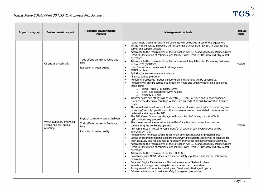
Huzzas Phase 2 Multi Client 3D MSS, Environment Plan Summary
Page 17
Impact category Environmental aspect Potential environmental
impacts Management controls
Residual Risk
regular basis thereafter. Identified personnel will be trained in use of this equipment. Tested / implemented Shipboard Oil Pollution Emergency Plan (SOPEP) in place for both
survey and support vessels.
Oil and chemical spills
Toxic effects on marine fauna and flora
Reduction in water quality
Adherence to the requirements of the Navigation Act 1912, and specifically Marine Orders - Part 30: Prevention of collisions; and Marine Order - Part 59: Off-shore industry vessel operations.
Adherence to the requirements of the International Regulations for Preventing Collisions at Sea 1972 (COLREGS).
Use of secondary containment in storage areas. SOPEP in place. Spill kits / absorbent material available.
Medium
Vessel collisions, grounding, sinking and spill during refuelling
Physical damage to benthic habitats
Toxic effects on marine fauna and flora
Reduction in water quality
All cargo will be pre-slung Refuelling procedures (including supervision and shut off) will be adhered to. Refuelling will only be carried out in daylight hours and within weather limit guidelines,
these being: o Wind<Force 6 (30 knots/15m/s) o Seas <3m (significant wave height) o Visibility > 1 mile
Transfer hoses and fittings will be recently (< 1 year) certified and in good condition. Quick release dry break couplings will be used on ends of all bulk hydrocarbon transfer hoses.
The Vessel Master will conduct and document a risk assessment prior to conducting any bunkering/resupply operation and this risk assessment and associated controls must be reviewed and accepted by TGS.
The TGS Vessel Operations Manager will be notified before any transfer of bulk hydrocarbons may proceed.
The survey Vessel Master will notify AMSA of any bunkering operations prior to commencing the bunkering operation.
Any vessel used in vessel to vessel transfer of cargo or bulk hydrocarbons will be approved by TGS.
Refuelling will not occur within 25 km of an emergent features or protected area. Stocks of absorbent materials aboard the survey and support vessels will be checked for
their adequacy and replenished as necessary prior to the commencement of activities. Adherence to the requirements of the Navigation Act 1912, and specifically Marine Orders
- Part 30: Prevention of collisions; and Marine Order - Part 59: Off-shore industry vessel operations.
Adherence to the requirements of the COLREGS. Compliance with AMSA administered marine safety regulations and marine notification
requirements. Deck and Engine Maintenance - Planned Maintenance System in place. Vessels will use approved navigation systems and depth sounders. Survey vessel will not enter the Ningaloo Coast World Heritage Property. Adherence to standard maritime safety / navigation procedures.
Medium
Huzzas Phase 2 Multi Client 3D MSS, Environment Plan Summary
Page 18
Impact category Environmental aspect Potential environmental
impacts Management controls
Residual Risk
The survey vessel has an implemented and tested SOPEP. Hydrocarbons located above deck will be stored with some form of secondary
containment to contain leaks or spills e.g. bund, containment pallet, transport packs etc. in accordance with MARPOL requirements.
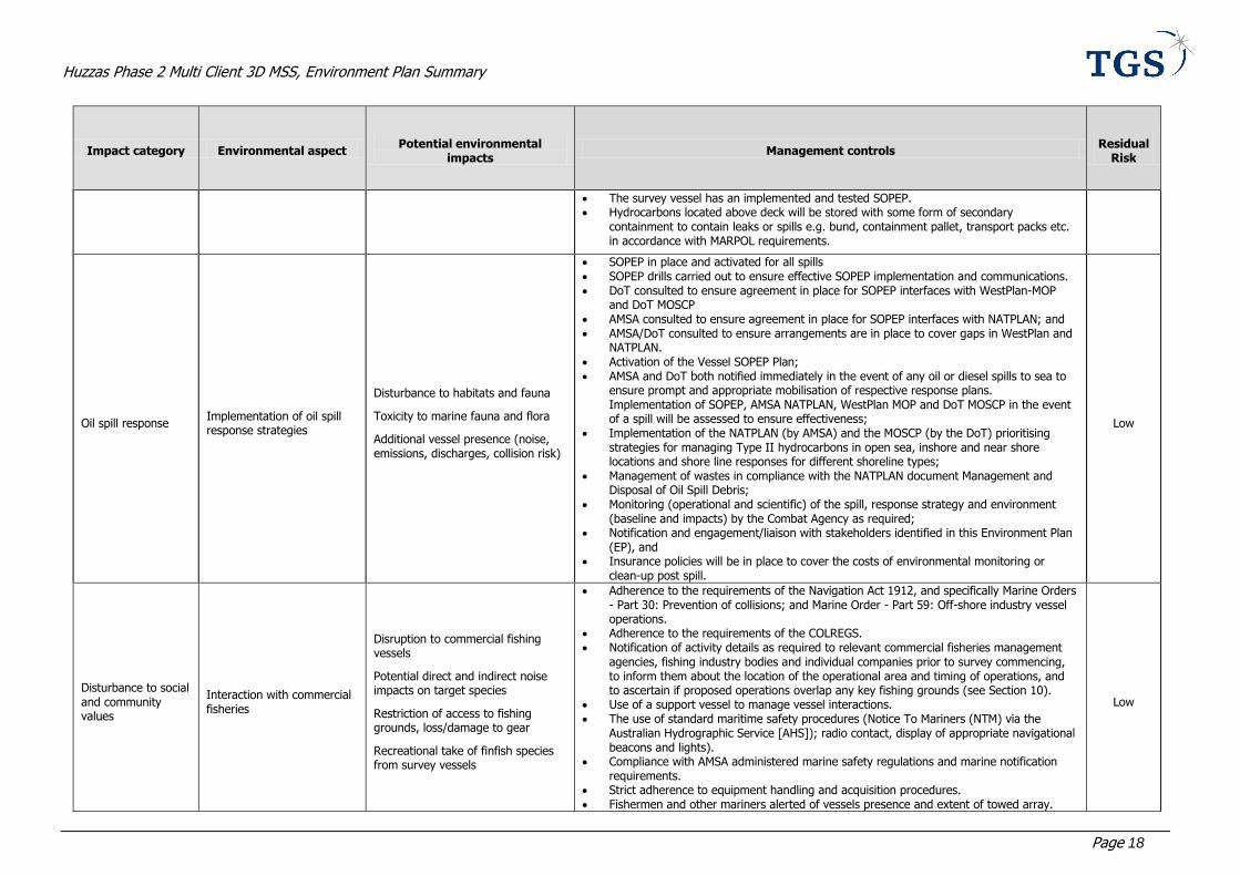
Oil spill response Implementation of oil spill response strategies
Disturbance to habitats and fauna
Toxicity to marine fauna and flora
Additional vessel presence (noise, emissions, discharges, collision risk)
SOPEP in place and activated for all spills SOPEP drills carried out to ensure effective SOPEP implementation and communications. DoT consulted to ensure agreement in place for SOPEP interfaces with WestPlan-MOP
and DoT MOSCP AMSA consulted to ensure agreement in place for SOPEP interfaces with NATPLAN; and AMSA/DoT consulted to ensure arrangements are in place to cover gaps in WestPlan and
NATPLAN. Activation of the Vessel SOPEP Plan; AMSA and DoT both notified immediately in the event of any oil or diesel spills to sea to
ensure prompt and appropriate mobilisation of respective response plans. Implementation of SOPEP, AMSA NATPLAN, WestPlan MOP and DoT MOSCP in the event of a spill will be assessed to ensure effectiveness;
Implementation of the NATPLAN (by AMSA) and the MOSCP (by the DoT) prioritising strategies for managing Type II hydrocarbons in open sea, inshore and near shore locations and shore line responses for different shoreline types;
Management of wastes in compliance with the NATPLAN document Management and Disposal of Oil Spill Debris;
Monitoring (operational and scientific) of the spill, response strategy and environment (baseline and impacts) by the Combat Agency as required;
Notification and engagement/liaison with stakeholders identified in this Environment Plan (EP), and
Insurance policies will be in place to cover the costs of environmental monitoring or clean-up post spill.
Low
Disturbance to social and community values
Interaction with commercial fisheries
Disruption to commercial fishing vessels
Potential direct and indirect noise impacts on target species
Restriction of access to fishing grounds, loss/damage to gear
Recreational take of finfish species from survey vessels
Adherence to the requirements of the Navigation Act 1912, and specifically Marine Orders - Part 30: Prevention of collisions; and Marine Order - Part 59: Off-shore industry vessel operations.
Adherence to the requirements of the COLREGS. Notification of activity details as required to relevant commercial fisheries management
agencies, fishing industry bodies and individual companies prior to survey commencing, to inform them about the location of the operational area and timing of operations, and to ascertain if proposed operations overlap any key fishing grounds (see Section 10).
Use of a support vessel to manage vessel interactions. The use of standard maritime safety procedures (Notice To Mariners (NTM) via the
Australian Hydrographic Service [AHS]); radio contact, display of appropriate navigational beacons and lights).
Compliance with AMSA administered marine safety regulations and marine notification requirements.
Strict adherence to equipment handling and acquisition procedures. Fishermen and other mariners alerted of vessels presence and extent of towed array.
Low

Huzzas Phase 2 Multi Client 3D MSS, Environment Plan Summary
Page 19
Impact category Environmental aspect Potential environmental
impacts Management controls
Residual Risk
Establishment of a vessel exclusion zone around the survey vessel. Display of appropriate navigational beacons and lights, radar watch, radio contact. Where possible in-water equipment lost will be recovered. Detailed records of equipment lost overboard will be maintained. Recreational fishing from the survey and support vessels will be prohibited.
Interaction with shipping Disruption to shipping activities
Adherence to the requirements of the Navigation Act 1912, and specifically Marine Orders - Part 30: Prevention of collisions; and Marine Order - Part 59: Offshore industry vessel operations.
Adherence to the requirements of the COLREGS. Consultation with AMSA prior to the survey commencing to determine the level of
commercial shipping in the vicinity of the operational area, providing AMSA with name of survey and support vessels once confirmed and advising the Rescue Coordination Centre (RCC) of AMSA of vessel movements
Use of a support vessel to manage vessel interactions. The use of standard maritime safety procedures (Notice To Mariners (NTM) via the AHO;
radio contact, display of appropriate navigational beacons and lights). Compliance with AMSA administered marine safety regulations and marine notification
requirements. Strict adherence to equipment handling and acquisition procedures. Shipping alerted of vessels presence and extent of towed array. Establishment of an SNA around the survey vessel. Display of appropriate navigational beacons and lights, radar watch, radio contact. Where possible in-water equipment lost will be recovered. Detailed records of equipment lost overboard will be maintained.
Low
Interaction with defence activities
Disruption to aircraft participating in defence activities within the Learmonth Airspace
Consultation with Department of Defence (Directorate of Property Acquisition, Mining and Native Title; Royal Australian Air Force Aeronautical Information Service [RAAF AIS]) prior to the survey commencing to determine if there are any planned activities within the Learmonth Airspace that will coincide with the survey and proposed helicopter movements from Learmonth airport.
Department of Defence will be advised of any aviation activities 2 -3 weeks prior to their commencement
Adherence to the requirements of Helicopter Operations Procedures.
Low
Interaction with existing oil and gas activity
Disruption to activities of existing oil and gas activities
Potential collision risk of vessels
Equipment damage (seismic cables)
Adherence to the requirements of the Navigation Act 1912, and specifically Marine Orders - Part 30: Prevention of collisions; and Marine Order - Part 59: Off-shore industry vessel operations.
Adherence to the requirements of the COLREGS. Use of a support vessel to manage vessel interactions. The use of standard maritime safety procedures (Notice To Mariners (NTM) via the
Australian Hydrographic Service [AHS]); radio contact, display of appropriate navigational beacons and lights).
Compliance with AMSA administered marine safety regulations and marine notification requirements.
Strict adherence to equipment handling and acquisition procedures.
Medium
Huzzas Phase 2 Multi Client 3D MSS, Environment Plan Summary
Page 20
Impact category Environmental aspect Potential environmental
impacts Management controls
Residual Risk
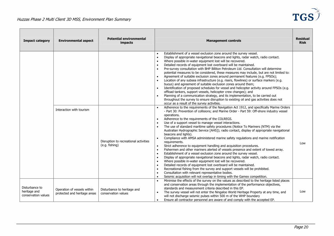
Establishment of a vessel exclusion zone around the survey vessel. Display of appropriate navigational beacons and lights, radar watch, radio contact. Where possible in-water equipment lost will be recovered. Detailed records of equipment lost overboard will be maintained. Pre-survey consultation with BHP Billiton Petroleum Ltd. Consultation will determine
potential measures to be considered, these measures may include, but are not limited to: Agreement of suitable exclusion zones around permanent features (e.g. FPSOs); Location of any subsea infrastructure (e.g. risers, flowlines) or surface markers (e.g.
buoys) and agreement of suitable exclusion zones around them; Identification of proposed schedules for vessel and helicopter activity around FPSOs (e.g.
offload tankers, support vessels, helicopter crew changes); and Planning of a communication strategy, and its implementation, to be carried out
throughout the survey to ensure disruption to existing oil and gas activities does not occur as a result of the survey activities.
Interaction with tourism
Disruption to recreational activities (e.g. fishing)
Adherence to the requirements of the Navigation Act 1912, and specifically Marine Orders - Part 30: Prevention of collisions; and Marine Order - Part 59: Off-shore industry vessel operations.
Adherence to the requirements of the COLREGS. Use of a support vessel to manage vessel interactions. The use of standard maritime safety procedures (Notice To Mariners (NTM) via the
Australian Hydrographic Service [AHS]); radio contact, display of appropriate navigational beacons and lights).
Compliance with AMSA administered marine safety regulations and marine notification requirements.
Strict adherence to equipment handling and acquisition procedures. Fishermen and other mariners alerted of vessels presence and extent of towed array. Establishment of a vessel exclusion zone around the survey vessel. Display of appropriate navigational beacons and lights, radar watch, radio contact. Where possible in-water equipment lost will be recovered. Detailed records of equipment lost overboard will be maintained. Recreational fishing from the survey and support vessels will be prohibited. Consultation with relevant representative bodies. Seismic acquisition will not overlap in timing with the Gamex competition.
Low
Disturbance to heritage and conservation values
Operation of vessels within protected and heritage areas
Disturbance to heritage and conservation values
Minimise the effects of the survey on the values as described to the heritage listed places and conservation areas through the implementation of the performance objectives, standards and measurement criteria described in this EP.
The survey vessel will not enter the Ningaloo World Heritage Property at any time, and will not discharge seismic pulses within 500 m of the WHP boundary
Ensure all contractor personnel are aware of and comply with the accepted EP.
Low
Huzzas Phase 2 Multi Client 3D MSS, Environment Plan Summary
Page 21
6 MANAGEMENT APPROACH
The survey will be managed in compliance with the EP as accepted by NOPSEMA under the Environment
Regulations, other relevant environmental legislation and TGS’s corporate policies. The objective of the EP is to ensure that potential adverse impacts on the environment associated with the survey, during both routine and
non-routine operations, are identified, and will be reduced to ALARP and will be of an acceptable level.
The design and execution of the survey will be conducted under the framework of the TGS Environmental Policy,
TGS Health, Safety and Environmental (HSE) Management System, and the survey vessel operator HSE&Q
Management System. The seismic programme will be supported by a project-specific HSE Plan (that includes Emergency Response (ER) procedures), the survey vessel operator’s Emergency Response Procedures, and a TGS
Emergency Preparedness Bridging Document (incorporated within the HSE Plan). To ensure TGS’s environmental objectives and management standards are achieved, the survey vessel operator will be required to comply with all
relevant requirements of TGS’s HSE systems/policies and standards.
The EP includes specific performance objectives and standards, and identifies the key controls and mitigation
measures (Table 3) to be implemented to achieve the performance objectives. These various commitments are
communicated to all personnel involved in the survey. The implementation strategy detailed in the EP identifies the roles/responsibilities and competency/training requirements for all personnel (TGS and contractors) in relation to
implementing controls, managing non-conformance, emergency response and meeting reporting requirements during the survey. The EP also details the types of auditing that will be undertaken and the reporting requirements
for environmental incidents, and reporting for overall compliance of the survey.
The vessel master(s) will be responsible for the day to day operation of the survey vessel, including any potential emergency situation. In the event of a fuel or oil spill to sea, the vessel Shipboard Oil Pollution Emergency Plan
(SOPEP) will be activated, supported as required by applicable established, statutory (WA State and Commonwealth) Oil Spill Contingency Plans.

Huzzas Phase 2 Multi Client 3D MSS, Environment Plan Summary
Page 22
7 CONSULTATION
Consultation with stakeholder groups, primarily within the commercial fishing industry, concerning TGS’s proposed
survey began on the 4th October 2013. In total 37 stakeholders were contacted, in addition to all licence holders of identified state fisheries. Following an update of the operational area, letters were reissued on the 22nd November
2013.
TGS received feedback on the proposed activity from a range of stakeholders, including government agencies and
commercial fisheries. During the consultation process, where stakeholders have raised queries, TGS provided
additional information in response to the stakeholder queries. The consultation process has allowed for the development of a communication and engagement strategy for each relevant stakeholder through which TGS will
maintain communication with identified stakeholders to ensure they are informed of relevant aspects of the survey or changes that may affect them.
7.1 Pre-survey consultation
Prior to commencement of the survey, TGS will consult a number of additional stakeholders, primarily within the
offshore exploration and production industry. These consultations will include, as far as possible, other geophysical companies operating in Australian waters, plus titleholders of petroleum titles adjacent to the operational area. The
primary objective of this consultation will be to ascertain if there are any other seismic surveys proposed for areas adjacent to the operational area, over the same time period. In addition, Notices to Mariners covering survey
activities will be issued via the Australian Hydrographic Service (notified 14 days prior to activity commencing).
Huzzas Phase 2 Multi Client 3D MSS, Environment Plan Summary
Page 23
8 CONTACT DETAILS
For further information about the proposed Huzzas Phase 2 MC3D MSS on the North West Shelf offshore from
Western Australia, please contact:
Tanya Johnstone
Project Development Manager
Australasia
TGS
Level 5, 1100 Hay Street
West Perth, WA 6005
Tel: +61 (8) 9480 0022
email: [email protected]
Huzzas Phase 2 Multi Client 3D MSS, Environment Plan Summary
Page 24
9 REFERENCES
BoM (2011). Tropical Cyclones in Western Australia – Climatology. Bureau of Meteorology Available from: http://www.bom.gov.au/wa/cyclone/about/climatology.shtml [Accessed 9 May 2011].
BoM (2012). Climate statistics for Australian locations. Summary Statistics Barrow Island. Bureau of Meteorology Available from: http://www.bom.gov.au/climate/averages/tables/cw_005058.shtml [Accessed
24 January 2012].
DoE (2013) EPBC Act Protected Matters Reports, Commonwealth Department of Environment, online
database. Accessed 29th November 2013.
DSEWPaC (2012). Marine bioregional plan for the North-west Marine Region. Commonwealth Department of Sustainability, Environment, Water, Population and Communities
http://www.environment.gov.au/coasts/marineplans/north-west/pubs/north-west-marine-plan.pdf
Brewer, DT, Lyne, V, Skewes, TD, and Rothlisberg, P (2007). Trophic Systems of the North West Marine
Region. Report to The Department of the Environment and Water Resources. CSIRO Cleveland. 156
pp.
http://www.environment.gov.au/coasts/mbp/publications/north-west/pubs/nw-trophicsystems.pdf
Chevron Australia (2005). Draft Environmental Impact Statement/Environmental Review and Management Programme for the Proposed Gorgon Gas Development. Chevron Australia, Perth, Western Australia.
Chevron Australia (2008). Gorgon Gas Development Revised and Expanded Proposal Public Environmental Review. Chevron Australia, Perth, Western Australia.
Chevron Australia (2011). Gorgon Gas Development and Jansz Feed Gas Pipeline: Coastal and Marine
Baseline State and Environmental Impact Report: Offshore Feed Gas Pipeline System and Marine Component of the Shore Crossing (Revision 4). Chevron Australia, Perth, Western Australia.
Related Documents


