Adv. Geosci., 19, 23–32, 2008 www.adv-geosci.net/19/23/2008/ © Author(s) 2008. This work is distributed under the Creative Commons Attribution 3.0 License. Advances in Geosciences Historical damage pattern and causes of differential damage: an approach based on combining geophysical prospecting, geological and historical-technical data F. T. Gizzi 1 , V. Lapenna 2 , N. Masini 1 , and E. Rizzo 2 1 Istituto per i Beni Archeologici e Monumentali (IBAM) CNR-Area della Ricerca-Tito Scalo (PZ)-C.da S. Loja 85050, Italy 2 Istituto per le Metodologie Avanzate di Analisi Ambientali (IMAA)- CNR-Area della Ricerca-Tito Scalo (PZ)-C.da S. Loja 85050, Italy Received: 5 July 2008 – Revised: 11 October 2008 – Accepted: 14 October 2008 – Published: 14 November 2008 Abstract. We describe a multidisciplinary and interdisci- plinary method to analyse the causes of differential macro- seismic effects caused by an earthquake in a historical town. We illustrate the method with a case study based on analysing the damage caused by the 1930 Irpinia earthquake (Me=6.7) in Melfi, a town in southern Italy. A damage pattern map was already available for this site. To understand the anomalies of Melfi damage, we used an integrated approach that combines geological surveys, geo- physical prospecting and analysis of unpublished technical- historical data. Geo-electrical prospecting was adopted to infer the geo- logical set-up and to estimate the thickness of shallow de- posits. The results of the geophysical surveys were compared with detailed geological information derived from both in situ surveys and boreholes. Finally, cross-correlation among these data and technical reports coeval to the earthquake al- lowed us to create a complete picture of the possible causes of uneven damage. 1 Introduction Detailed knowledge of the effects of past earthquakes can lead to a meaningful improvement in the “seismic features” of a town (e.g., Guidoboni et al., 2003; Gizzi, 2006). It is possible to infer from a damage map the areas where highest damage occurred and where in-depth multidisci- plinary and interdisciplinary analyses and surveys should be Correspondence to: F. T. Gizzi ([email protected]) done. In this way, the causes of the differential damage, such as seismic amplification, landslides, geo-technical failure of the soils and/or building vulnerability, can be inferred. This paper introduces a methodology for determining the causes of an uneven damage pattern in a town hit by a past earthquake. To illustrate the methodology, we provide a case study of the 1930 Irpinia earthquake (Me=6.7) in Melfi, a medieval town located in southern Italy, for which a detailed damage pattern map was already available (Gizzi and Masini, 2004). The multidisciplinary and interdisciplinary approach is based on combining geological data, geophysical prospecting and technical-historical information. The multidisciplinary approach has already proved be use- ful for analysing some aspects of natural events both related to seismic effects in urban areas and other natural phenom- ena. As regards historical damage, works similar to what we are proposing here are few. Among these, we cite the Palermo case study. To identify the causes of the uneven damage in Palermo some studies, examined as a whole, show an integrated use of geological, geotechnical, geophysical, and historical data (Guidoboni et al., 2003; Giammarinaro et al., 2005; Cara et al., 2008). “Multi-level” approach involving historical, geological, and geophysical information is also adopted for analysing some aspects of other natural events, such as landslides. We refer, for example, to the approach to analyse both the causes of the landslide trigger and geomorphological risk of histori- cal centres (Agnesi et al., 2005; Naudet et al., 2006). Published by Copernicus Publications on behalf of the European Geosciences Union.

Welcome message from author
This document is posted to help you gain knowledge. Please leave a comment to let me know what you think about it! Share it to your friends and learn new things together.
Transcript
Adv. Geosci., 19, 23–32, 2008www.adv-geosci.net/19/23/2008/© Author(s) 2008. This work is distributed underthe Creative Commons Attribution 3.0 License.
Advances inGeosciences
Historical damage pattern and causes of differential damage: anapproach based on combining geophysical prospecting, geologicaland historical-technical data
F. T. Gizzi1, V. Lapenna2, N. Masini1, and E. Rizzo2
1Istituto per i Beni Archeologici e Monumentali (IBAM) CNR-Area della Ricerca-Tito Scalo (PZ)-C.da S. Loja 85050, Italy2Istituto per le Metodologie Avanzate di Analisi Ambientali (IMAA)- CNR-Area della Ricerca-Tito Scalo (PZ)-C.da S. Loja85050, Italy
Received: 5 July 2008 – Revised: 11 October 2008 – Accepted: 14 October 2008 – Published: 14 November 2008
Abstract. We describe a multidisciplinary and interdisci-plinary method to analyse the causes of differential macro-seismic effects caused by an earthquake in a historical town.We illustrate the method with a case study based on analysingthe damage caused by the 1930 Irpinia earthquake (Me=6.7)in Melfi, a town in southern Italy. A damage pattern map wasalready available for this site.
To understand the anomalies of Melfi damage, we used anintegrated approach that combines geological surveys, geo-physical prospecting and analysis of unpublished technical-historical data.
Geo-electrical prospecting was adopted to infer the geo-logical set-up and to estimate the thickness of shallow de-posits. The results of the geophysical surveys were comparedwith detailed geological information derived from both insitu surveys and boreholes. Finally, cross-correlation amongthese data and technical reports coeval to the earthquake al-lowed us to create a complete picture of the possible causesof uneven damage.
1 Introduction
Detailed knowledge of the effects of past earthquakes canlead to a meaningful improvement in the “seismic features”of a town (e.g., Guidoboni et al., 2003; Gizzi, 2006).
It is possible to infer from a damage map the areas wherehighest damage occurred and where in-depth multidisci-plinary and interdisciplinary analyses and surveys should be
Correspondence to:F. T. Gizzi([email protected])
done. In this way, the causes of the differential damage, suchas seismic amplification, landslides, geo-technical failure ofthe soils and/or building vulnerability, can be inferred.
This paper introduces a methodology for determining thecauses of an uneven damage pattern in a town hit by a pastearthquake.
To illustrate the methodology, we provide a case study ofthe 1930 Irpinia earthquake (Me=6.7) in Melfi, a medievaltown located in southern Italy, for which a detailed damagepattern map was already available (Gizzi and Masini, 2004).The multidisciplinary and interdisciplinary approach is basedon combining geological data, geophysical prospecting andtechnical-historical information.
The multidisciplinary approach has already proved be use-ful for analysing some aspects of natural events both relatedto seismic effects in urban areas and other natural phenom-ena.
As regards historical damage, works similar to what weare proposing here are few.
Among these, we cite the Palermo case study. To identifythe causes of the uneven damage in Palermo some studies,examined as a whole, show an integrated use of geological,geotechnical, geophysical, and historical data (Guidoboni etal., 2003; Giammarinaro et al., 2005; Cara et al., 2008).
“Multi-level” approach involving historical, geological,and geophysical information is also adopted for analysingsome aspects of other natural events, such as landslides. Werefer, for example, to the approach to analyse both the causesof the landslide trigger and geomorphological risk of histori-cal centres (Agnesi et al., 2005; Naudet et al., 2006).
Published by Copernicus Publications on behalf of the European Geosciences Union.
24 F. T. Gizzi et al.: Historical damage pattern and causes of differential damage
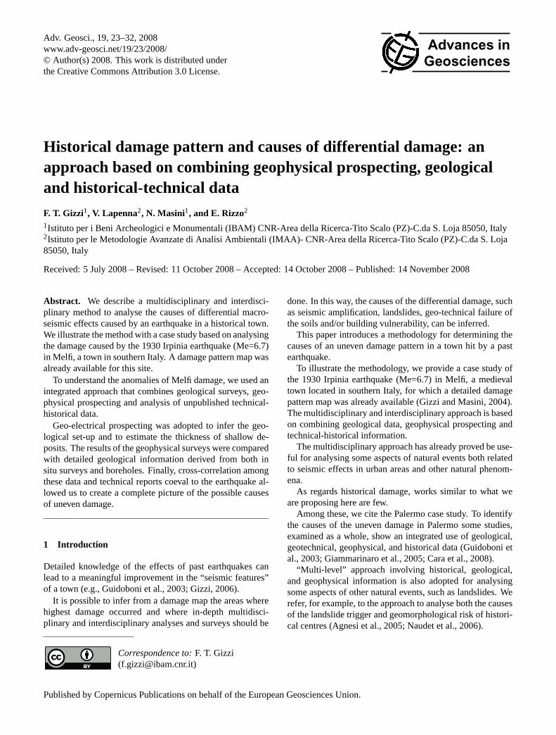
Fig. 1. Tectonic outline of the Southern Apennines. 1=Bradanic foredeep and intrapenninic sediments. Volcanoclastic rocks (plio-quaternary); 2=Sinorogenic sediments (Miocene); 3=Liguride complex (Cretaceous-Oligocene); 4=Apennine platform carbonate (Mesozoic-Cenozoic); 5=Lagonegro basin sediments (Trias-Miocene); 6=Apulian platform sediments (Trias-Pliocene); 7=Volcanoes; 8=Buried al-lochthonous front. Vulture area is shown from the rectangle (from Pescatore et al., 1999, modified).
2 Regional and site geological settings
Melfi, a town with about 17 000 inhabitants, lies on a hill-top at the foot of the extinct Vulture volcano in the southernApennines.
The Apenninic chain is a Neogene fold and thrust beltmade up of complex imbricated tectonic units with duplexstructures, dissected by normal faults (e.g., Patacca and Scan-done, 1989). The chain is made up of Mesozoic-Paleogenesediments deposited in platform and basin paleogeographicdomains that were involved in contractional episodes fromlate Oligocene-early Miocene times (e.g., Pescatore et al.,1999) (Fig. 1). Progressive eastward migration of compres-sional fronts was driven by gravity-sinking of the forelandlithosphere and related subduction roll-back (Malinverno andRyan, 1986). Since the Pliocene, shortening has been re-placed by extensional tectonics (e.g., Patacca et al., 1990).Present day stress field analysis suggests that the southernApennines are affected by extension that occurs across nor-mal faults mostly strike parallel to the chain (Frepoli andAmato, 1997; Montone et al., 1997).
During the Middle Pleistocene, the most recent chain de-formation occurred in the southern and easternmost part ofthe Apennines (e.g., Scandone et al., 1992), and the historyof the strato-volcano Vulture began.
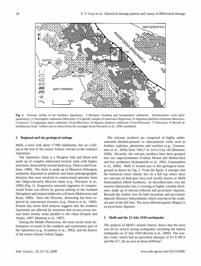
The volcanic products are composed of highly under-saturated alkaline-potassic to ultra-potassic rocks such asfoidites, tephrites, phonolites and trachites (e.g., Giannan-drea et al., 2004) from 740±7 to 141±11 ky old (Buettner,2006). Recently, the volcanic products have been groupedinto two supersynthemes (Vulture Mount and Monticchio)and five synthemes (Schiattarella et al., 2005; Giannandreaet al., 2006). Melfi is located just in this geological back-ground as shown by Fig. 2. From the figure, it emerges thatthe historical centre mainly lies on a hill top where thereare outcrops of dark-grey lava rock locally known as MelfiHauynophyre (Melfi Synthem). As described later, over themassive Hauynofiro lies a covering of highly variable thick-ness, made up of eluvial-colluvial and pyroclastic deposits.Beneath the foiditic lava lie both lacustrine and pyroclasticdeposits (Rionero Subsynthem), which outcrop in the south-ern part of the hill foot. The most affected quarter (Bagni) ison pyroclastic deposits.
3 Melfi and the 23 July 1930 earthquake
The analysis of Melfi’s seismic history shows that the townwas hit by several strong earthquakes including the Irpiniaearthquake on 23 July 1930 (Boschi et al., 2000). The seis-mic event, which had an epicentral intensity of Io=X MCSand Me=6.7, hit an area of about 6500 km2.
Adv. Geosci., 19, 23–32, 2008 www.adv-geosci.net/19/23/2008/
F. T. Gizzi et al.: Historical damage pattern and causes of differential damage 25
Fig. 2. Geological map of Melfi downtown.
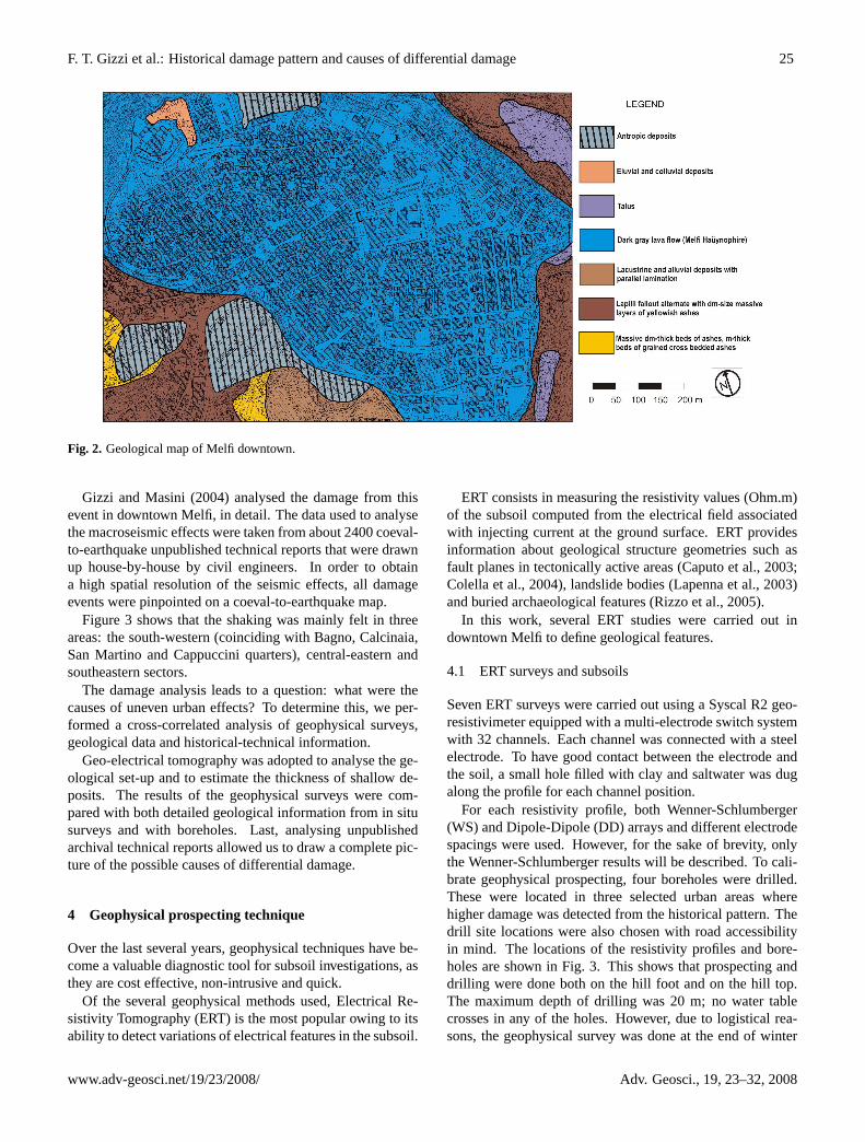
Gizzi and Masini (2004) analysed the damage from thisevent in downtown Melfi, in detail. The data used to analysethe macroseismic effects were taken from about 2400 coeval-to-earthquake unpublished technical reports that were drawnup house-by-house by civil engineers. In order to obtaina high spatial resolution of the seismic effects, all damageevents were pinpointed on a coeval-to-earthquake map.
Figure 3 shows that the shaking was mainly felt in threeareas: the south-western (coinciding with Bagno, Calcinaia,San Martino and Cappuccini quarters), central-eastern andsoutheastern sectors.
The damage analysis leads to a question: what were thecauses of uneven urban effects? To determine this, we per-formed a cross-correlated analysis of geophysical surveys,geological data and historical-technical information.
Geo-electrical tomography was adopted to analyse the ge-ological set-up and to estimate the thickness of shallow de-posits. The results of the geophysical surveys were com-pared with both detailed geological information from in situsurveys and with boreholes. Last, analysing unpublishedarchival technical reports allowed us to draw a complete pic-ture of the possible causes of differential damage.
4 Geophysical prospecting technique
Over the last several years, geophysical techniques have be-come a valuable diagnostic tool for subsoil investigations, asthey are cost effective, non-intrusive and quick.
Of the several geophysical methods used, Electrical Re-sistivity Tomography (ERT) is the most popular owing to itsability to detect variations of electrical features in the subsoil.
ERT consists in measuring the resistivity values (Ohm.m)of the subsoil computed from the electrical field associatedwith injecting current at the ground surface. ERT providesinformation about geological structure geometries such asfault planes in tectonically active areas (Caputo et al., 2003;Colella et al., 2004), landslide bodies (Lapenna et al., 2003)and buried archaeological features (Rizzo et al., 2005).
In this work, several ERT studies were carried out indowntown Melfi to define geological features.
4.1 ERT surveys and subsoils
Seven ERT surveys were carried out using a Syscal R2 geo-resistivimeter equipped with a multi-electrode switch systemwith 32 channels. Each channel was connected with a steelelectrode. To have good contact between the electrode andthe soil, a small hole filled with clay and saltwater was dugalong the profile for each channel position.
For each resistivity profile, both Wenner-Schlumberger(WS) and Dipole-Dipole (DD) arrays and different electrodespacings were used. However, for the sake of brevity, onlythe Wenner-Schlumberger results will be described. To cali-brate geophysical prospecting, four boreholes were drilled.These were located in three selected urban areas wherehigher damage was detected from the historical pattern. Thedrill site locations were also chosen with road accessibilityin mind. The locations of the resistivity profiles and bore-holes are shown in Fig. 3. This shows that prospecting anddrilling were done both on the hill foot and on the hill top.The maximum depth of drilling was 20 m; no water tablecrosses in any of the holes. However, due to logistical rea-sons, the geophysical survey was done at the end of winter
www.adv-geosci.net/19/23/2008/ Adv. Geosci., 19, 23–32, 2008
26 F. T. Gizzi et al.: Historical damage pattern and causes of differential damage
Fig. 3. Damage effects in Melfi downtown. The figure shows both the location of the tomographies and boreholes.
(March), while boreholes were drilled in the summer (Au-gust). This preamble is essential to realize geophysical datathat will be discussed in the following paragraphs.
The ERT data were elaborated using RES2DINV inversionsoftware (Loke, 2003). The 2-D inversion routine appliesa Gauss-Newton least squares method (Loke and Barker,1996), based on a finite difference model of the subsurface,automatically adjusted in an iterative process. The latest re-
sult is obtained by comparing the measured apparent resis-tivity with the calculated apparent resistivity obtained fromthe inverted model. To better define the boundaries of thewaste landfill, we applied a robust inversion approach. Thismethod attempts to minimise the absolute changes in resis-tivity values, producing models with sharp interfaces, such asburied boundaries in an urban area. Moreover, a topographiccorrection with a least-squares straight line trend removal has
Adv. Geosci., 19, 23–32, 2008 www.adv-geosci.net/19/23/2008/
F. T. Gizzi et al.: Historical damage pattern and causes of differential damage 27
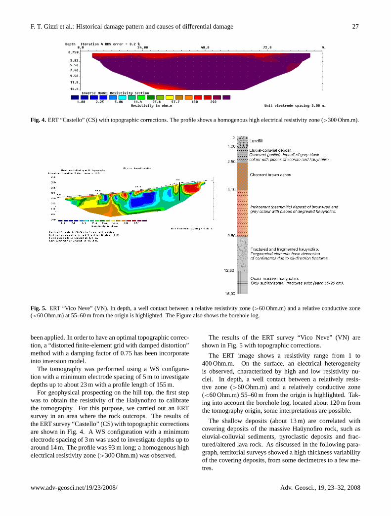
Fig. 4. ERT “Castello” (CS) with topographic corrections. The profile shows a homogenous high electrical resistivity zone (>300 Ohm.m).
Fig. 5. ERT “Vico Neve” (VN). In depth, a well contact between a relative resistivity zone (>60 Ohm.m) and a relative conductive zone(<60 Ohm.m) at 55–60 m from the origin is highlighted. The Figure also shows the borehole log.
been applied. In order to have an optimal topographic correc-tion, a “distorted finite-element grid with damped distortion”method with a damping factor of 0.75 has been incorporateinto inversion model.
The tomography was performed using a WS configura-tion with a minimum electrode spacing of 5 m to investigatedepths up to about 23 m with a profile length of 155 m.
For geophysical prospecting on the hill top, the first stepwas to obtain the resistivity of the Hauynofiro to calibratethe tomography. For this purpose, we carried out an ERTsurvey in an area where the rock outcrops. The results ofthe ERT survey “Castello” (CS) with topographic correctionsare shown in Fig. 4. A WS configuration with a minimumelectrode spacing of 3 m was used to investigate depths up toaround 14 m. The profile was 93 m long; a homogenous highelectrical resistivity zone (>300 Ohm.m) was observed.
The results of the ERT survey “Vico Neve” (VN) areshown in Fig. 5 with topographic corrections.
The ERT image shows a resistivity range from 1 to400 Ohm.m. On the surface, an electrical heterogeneityis observed, characterized by high and low resistivity nu-clei. In depth, a well contact between a relatively resis-tive zone (>60 Ohm.m) and a relatively conductive zone(<60 Ohm.m) 55–60 m from the origin is highlighted. Tak-ing into account the borehole log, located about 120 m fromthe tomography origin, some interpretations are possible.
The shallow deposits (about 13 m) are correlated withcovering deposits of the massive Hauynofiro rock, such aseluvial-colluvial sediments, pyroclastic deposits and frac-tured/altered lava rock. As discussed in the following para-graph, territorial surveys showed a high thickness variabilityof the covering deposits, from some decimetres to a few me-tres.
www.adv-geosci.net/19/23/2008/ Adv. Geosci., 19, 23–32, 2008
28 F. T. Gizzi et al.: Historical damage pattern and causes of differential damage
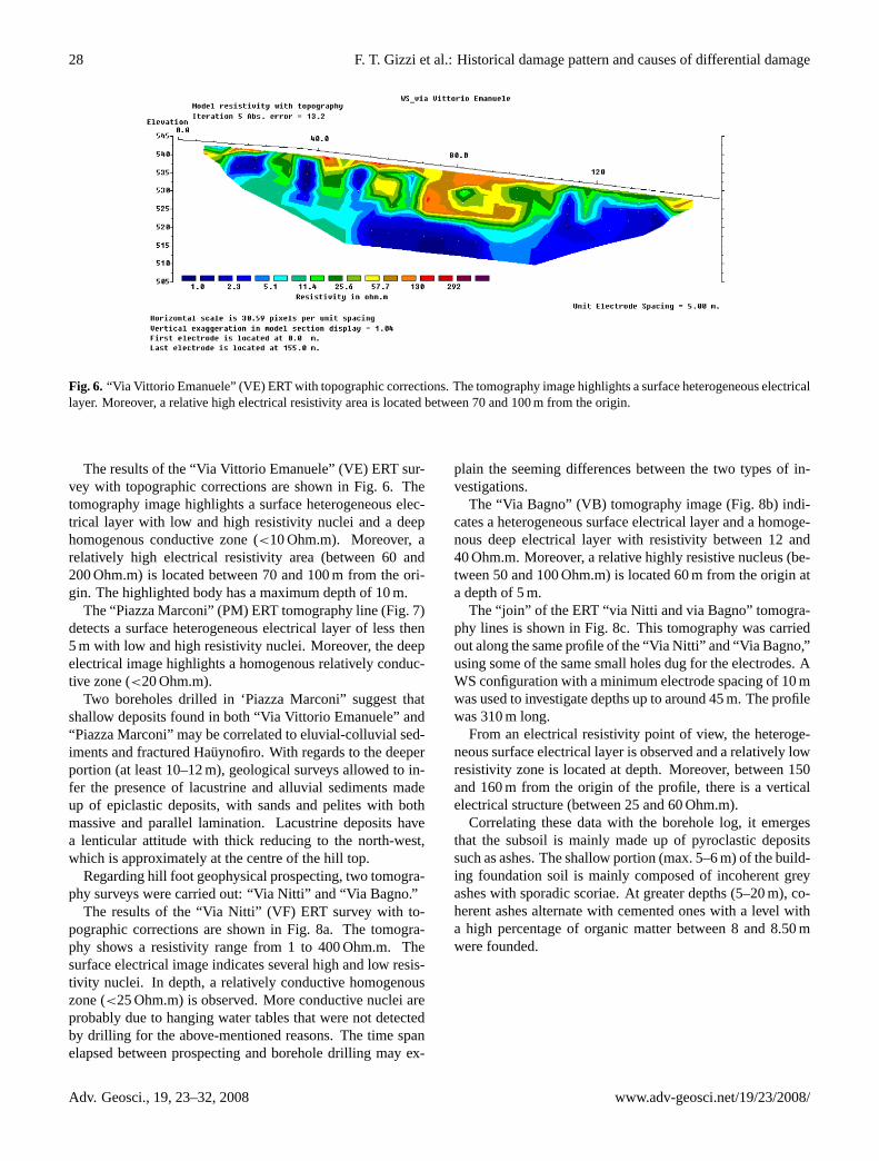
Fig. 6. “Via Vittorio Emanuele” (VE) ERT with topographic corrections. The tomography image highlights a surface heterogeneous electricallayer. Moreover, a relative high electrical resistivity area is located between 70 and 100 m from the origin.
The results of the “Via Vittorio Emanuele” (VE) ERT sur-vey with topographic corrections are shown in Fig. 6. Thetomography image highlights a surface heterogeneous elec-trical layer with low and high resistivity nuclei and a deephomogenous conductive zone (<10 Ohm.m). Moreover, arelatively high electrical resistivity area (between 60 and200 Ohm.m) is located between 70 and 100 m from the ori-gin. The highlighted body has a maximum depth of 10 m.
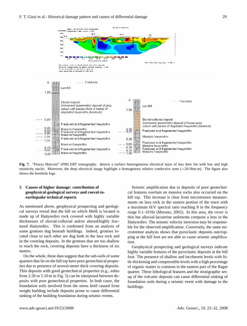
The “Piazza Marconi” (PM) ERT tomography line (Fig. 7)detects a surface heterogeneous electrical layer of less then5 m with low and high resistivity nuclei. Moreover, the deepelectrical image highlights a homogenous relatively conduc-tive zone (<20 Ohm.m).
Two boreholes drilled in ‘Piazza Marconi” suggest thatshallow deposits found in both “Via Vittorio Emanuele” and“Piazza Marconi” may be correlated to eluvial-colluvial sed-iments and fractured Hauynofiro. With regards to the deeperportion (at least 10–12 m), geological surveys allowed to in-fer the presence of lacustrine and alluvial sediments madeup of epiclastic deposits, with sands and pelites with bothmassive and parallel lamination. Lacustrine deposits havea lenticular attitude with thick reducing to the north-west,which is approximately at the centre of the hill top.
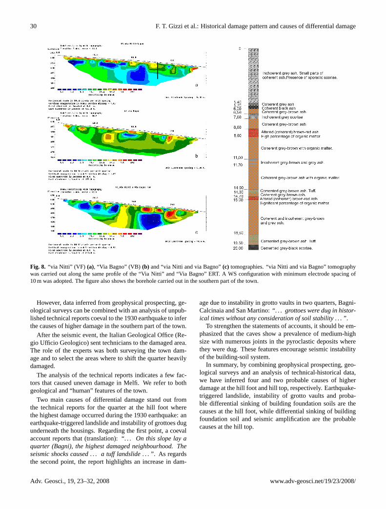
Regarding hill foot geophysical prospecting, two tomogra-phy surveys were carried out: “Via Nitti” and “Via Bagno.”
The results of the “Via Nitti” (VF) ERT survey with to-pographic corrections are shown in Fig. 8a. The tomogra-phy shows a resistivity range from 1 to 400 Ohm.m. Thesurface electrical image indicates several high and low resis-tivity nuclei. In depth, a relatively conductive homogenouszone (<25 Ohm.m) is observed. More conductive nuclei areprobably due to hanging water tables that were not detectedby drilling for the above-mentioned reasons. The time spanelapsed between prospecting and borehole drilling may ex-
plain the seeming differences between the two types of in-vestigations.
The “Via Bagno” (VB) tomography image (Fig. 8b) indi-cates a heterogeneous surface electrical layer and a homoge-nous deep electrical layer with resistivity between 12 and40 Ohm.m. Moreover, a relative highly resistive nucleus (be-tween 50 and 100 Ohm.m) is located 60 m from the origin ata depth of 5 m.
The “join” of the ERT “via Nitti and via Bagno” tomogra-phy lines is shown in Fig. 8c. This tomography was carriedout along the same profile of the “Via Nitti” and “Via Bagno,”using some of the same small holes dug for the electrodes. AWS configuration with a minimum electrode spacing of 10 mwas used to investigate depths up to around 45 m. The profilewas 310 m long.
From an electrical resistivity point of view, the heteroge-neous surface electrical layer is observed and a relatively lowresistivity zone is located at depth. Moreover, between 150and 160 m from the origin of the profile, there is a verticalelectrical structure (between 25 and 60 Ohm.m).
Correlating these data with the borehole log, it emergesthat the subsoil is mainly made up of pyroclastic depositssuch as ashes. The shallow portion (max. 5–6 m) of the build-ing foundation soil is mainly composed of incoherent greyashes with sporadic scoriae. At greater depths (5–20 m), co-herent ashes alternate with cemented ones with a level witha high percentage of organic matter between 8 and 8.50 mwere founded.
Adv. Geosci., 19, 23–32, 2008 www.adv-geosci.net/19/23/2008/
F. T. Gizzi et al.: Historical damage pattern and causes of differential damage 29
Fig. 7. “Piazza Marconi” (PM) ERT tomography. detects a surface heterogeneous electrical layer of less then 5m with low and highresistivity nuclei. Moreover, the deep electrical image highlight a homogenous relative conductive zone (<20 Ohm.m). The figure alsoshows the borehole logs.
5 Causes of higher damage: contribution ofgeophysical-geological surveys and coeval-to-earthquake technical reports
As mentioned above, geophysical prospecting and geologi-cal surveys reveal that the hill on which Melfi is located ismade up of Hauynofiro rock covered with highly variablethicknesses of eluvial-colluvial and/or altered/highly frac-tured Hauynofiro. This is confirmed from an analysis ofsome grottoes dug beneath buildings. Indeed, grottoes lo-cated close to each other are dug both in the lava rock andin the covering deposits. In the grottoes that are too shallowto reach the rock, covering deposits have a thickness of sixmeters.
On the whole, these data suggest that the sub-soils of somequarters that lie on the hill top have poor geotechnical proper-ties due to presence of several-meter thick covering deposits.Thin deposits with good geotechnical properties (e.g., ashesfrom 2.50 to 5.10 m in Fig. 5) can be interposed between de-posits with poor geotechnical properties. In both cases, thefoundation soils involved from the stress field caused fromweight building include deposits prone to cause differentialsinking of the building foundation during seismic events.
Seismic amplification due to deposits of poor geotechni-cal features overlain on massive rocks also occurred on thehill top. This increase is clear from microtremor measure-ments on lava rock in the eastern portion of the town witha maximum H/V spectral ratio reaching 8 in the frequencyrange 0.1–10 Hz (Morano, 2002). In this area, the cover isthin but alluvial-lacustrine sediments compose a lens in theHauynofiro. The seismic velocity inversion may be responsi-ble for the observed amplification. Conversely, the same mi-crotremor analysis shows that pyroclastic deposits outcrop-ping at the hill foot are not able to cause seismic amplifica-tion.
Geophysical prospecting and geological surveys indicatehighly variable features of the pyroclastic deposits at the hillfoot. The presence of shallow and incoherent levels with lit-tle thickening and compressible levels with a high percentageof organic matter is common in the eastern part of the Bagniquarter. These lithological features and the stratigraphic set-up of the volcanic deposits can cause differential sinking offoundation soils during a seismic event with damage to thebuildings.
www.adv-geosci.net/19/23/2008/ Adv. Geosci., 19, 23–32, 2008
30 F. T. Gizzi et al.: Historical damage pattern and causes of differential damage
Fig. 8. “via Nitti” (VF) (a), “Via Bagno” (VB) (b) and “via Nitti and via Bagno”(c) tomographies. “via Nitti and via Bagno” tomographywas carried out along the same profile of the “Via Nitti” and “Via Bagno” ERT. A WS configuration with minimum electrode spacing of10 m was adopted. The figure also shows the borehole carried out in the southern part of the town.
However, data inferred from geophysical prospecting, ge-ological surveys can be combined with an analysis of unpub-lished technical reports coeval to the 1930 earthquake to inferthe causes of higher damage in the southern part of the town.
After the seismic event, the Italian Geological Office (Re-gio Ufficio Geologico) sent technicians to the damaged area.The role of the experts was both surveying the town dam-age and to select the areas where to shift the quarter heavilydamaged.
The analysis of the technical reports indicates a few fac-tors that caused uneven damage in Melfi. We refer to bothgeological and “human” features of the town.
Two main causes of differential damage stand out fromthe technical reports for the quarter at the hill foot wherethe highest damage occurred during the 1930 earthquake: anearthquake-triggered landslide and instability of grottoes dugunderneath the housings. Regarding the first point, a coevalaccount reports that (translation):“. . . On this slope lay aquarter (Bagni), the highest damaged neighbourhood. Theseismic shocks caused . . . a tuff landslide . . . ”. As regardsthe second point, the report highlights an increase in dam-
age due to instability in grotto vaults in two quarters, Bagni-Calcinaia and San Martino:“. . . grottoes were dug in histor-ical times without any consideration of soil stability . . . ”.
To strengthen the statements of accounts, it should be em-phasized that the caves show a prevalence of medium-highsize with numerous joints in the pyroclastic deposits wherethey were dug. These features encourage seismic instabilityof the building-soil system.
In summary, by combining geophysical prospecting, geo-logical surveys and an analysis of technical-historical data,we have inferred four and two probable causes of higherdamage at the hill foot and hill top, respectively. Earthquake-triggered landslide, instability of grotto vaults and proba-ble differential sinking of building foundation soils are thecauses at the hill foot, while differential sinking of buildingfoundation soil and seismic amplification are the probablecauses at the hill top.
Adv. Geosci., 19, 23–32, 2008 www.adv-geosci.net/19/23/2008/
F. T. Gizzi et al.: Historical damage pattern and causes of differential damage 31
6 Conclusions
This paper sheds light on an integrated method adopted toanalyse the causes of uneven damage in a town due to a well-documented historical earthquake. To illustrate the approach,we provide a case study pertaining to a town in southern Italy.
The results emphasize the role played by the multidisci-plinary and interdisciplinary approach, based on combininggeophysical prospecting, geological surveys and unpublishedtechnical-historical written sources.
In detail, we used geo-electrical prospecting techniques toanalyse the geological set-up and to estimate the thicknessof shallow deposits. The results of the geophysical surveyswere compared with detailed geological information derivedfrom in situ surveys and boreholes. Finally, cross-correlationamong these data and technical reports coeval to the seis-mic event allowed us to gather a complete picture of possiblecauses of uneven damage.
Acknowledgements.This work was funded by Melfi town Council(Resolution n. 90 of 1 June 2006). The authors would like tothank L. V. Eppelbaum and two anonymous referees for the helpfulcomments on this paper.
Edited by: L. V. EppelbaumReviewed by: two anonymous referees
References
Agnesi, V., Camarda, M., Conoscenti, C., Di Maggio, C., Lib-erto, I.S., Madonia, P., and Rotigliano, E.: A multidisciplinaryapproach to the evaluation of the mechanism that triggered theCerda landslide (Sicily, Italy), Geomorphology, 65(1–2), 101–116, 2005.
Boschi, E., Guidoboni E., Ferrari G., Mariotti D., Valensise G., andGasperini P.: Catalogue of Strong Italian Earthquakes from 461B.C. to 1997, Ann. Geof., 43(4), with CD-ROM, 2000.
Buettner, A., Principe, C., Villa, I. M., and Bocchini, D.:Geocronologia 39Ar – 40Ar del Monte Vulture La geologia delMonte Vulture Ed Principe C (Lavello: Regione Basilicata), 73–86, 2006.
Caputo, R., Piscitelli, S., Oliveto, A., Rizzo, E., and Lapenna, V.:High-resolution resistivity tomographies in Active Tectonic stud-ies. Examples from the Tyrnavos Basin, Greece, J. Geod. 36, 19–35, 2003.
Cara, F., Cultrera G., Azzara, R. M., De Rubeis, V., Di Giulio, G.,Giammarinaro, M.S., Tosi, P., Vallone, P., and Rovelli, A.: Mi-crotremor Measurements in the City of Palermo, Italy: Analysisof the Correlation between Local Geology and Damage, Bull.Seism. Soc. Am., 98(3), 1354–1372, 2008.
Colella, A., Lapenna, V., and Rizzo, E.: High-resolution imagingof the High Agri Valley basin (Southern Italy) with ElectricalResistivity Tomography, Tectonophysics, 386, 29–40, 2004.
Frepoli, A. and Amato, A.: Contemporaneous extension and com-pression in the Northern Apennines from earthquake fault planesolutions, Geoph. J. Int., 129, 368–388, 1997.
Giammarinaro, M. S, Tertulliani, A., Galli, G., and Leta, M.: In-vestigation on surface geology and intensity variability in the
Palermo (Italy) urban area after the 6 September 2002, earth-quake, Bull. Seism. Soc. Am., 95(6), 2318–2327, 2005.
Giannandrea, P., La Volpe, L., Principe, C., and Schiattarella,M.: Geological Map of Monte Vulture (scale 1:25000), Firenze,2004.
Giannandrea, P., La Volpe, P., Principe, C., and Schiattarella, M.:Unita stratigrafiche a limiti inconformi e storia evolutiva del vul-cano medio-pleistocenico di Monte Vulture (Appennino merid-ionale, Italia), Boll. Soc. Geol. It., 125, 67–92, 2006.
Gizzi, F. T.: To what degree can historical seismicity records assistin seismic microzonation?, Eng. Geol., 87, 1–12, 2006.
Gizzi, F. T. and Masini, N.: Damage scenario of the earthquake on23 July 1930 in Melfi: the contribution of technical documenta-tion, Ann. Geophys., 47(5), 1641–1664, 2004.
Guidoboni, E., Mariotti, D., Giammarinaro, M. S., and Rovelli,A.: Identification of amplified damage zones in Palermo, Sicily(Italy), during the earthquakes of the last three centuries, Bull.Seism. Soc. Am., 93(4), 1649–1669, 2003.
Lapenna, V., Lorenzo, P., Perrone, A., Piscitelli, S., Sdao, F., andRizzo, E.: High-resolution geoelectrical tomographies in thestudy of the Giarrossa landslide (Potenza, Basilicata), Bull. Eng.Geol. Environ., 62, 259–268, 2003.
Loke, M. H.: Res2dinv-2D Resistivity and IP Inversion. GeotomoSoftware Malasya, 2003.
Loke, M. H. and Barker, R. D.: Rapid least-square inversion of ap-parent resistivity pseudosections using a quasi-Newton method,Geoph. Prosp., 44, 131–152, 1996.
Malinverno, A. and Ryan, W. B. F.: Extension in the Tyrrhenian Seaand shortening in the Apennines as a results of a migration drivenby sinking of the lithosphere, Tectonics, 5, 227–245, 1986.
Montone, P., Amato, A., Frepoli, A., Mariucci, M. T., and Cesaro,M.: Crustal stress regime in Italy, Ann. Geof., 40(3), 741–757,1997.
Morano, V.: La microzonazione sismica dell’abitato di Melfi. De-gree thesis. Universita degli Studi della Basilicata, Potenza,2002.
Naudet, V., Lazzari, M., Perrone, A., Loperte, A., Piscitelli, S., andLapenna, V.: Integrated geophysical and geomorphological ap-proach to investigate the snowmelt-triggered landslide of BoscoPiccolo village (Basilicata, southern Italy), Eng. Geol., 98(3–4),156–167, 2008.
Patacca, E., Sartori, R., and Scandone, P.: Tyrrhenian Basin andApenninic Arcs: Kinematic relations since late Tortonian times,Mem. Soc. Geol. It., 45, 425–451, 1990.
Patacca, E. and Scandone, P.: Post-Tortonian mountain building inthe Apennines. The role of the passive sinking of a relic litho-spheric slab The lithosphere in Italy, Advances in Earth ScienceResearch. Proc. It. Nat. Comm. Int. Lith. Progr. Mid-term Conf.(Rome, 5–6 May 1987), Accademia Nazionale dei Lincei, 80,157–176, 1989.
Pescatore, T., Renda, P., Schiattarella, M., and Tramutoli, M.:Stratigraphic and structural relationship between Meso-CenozoicLagonegro basin and coeval carbonate platforms in southernApennines, Italy, Tectonophysics, 315, 269–286, 1999.
Rizzo, E., Chianese, D., and Lapenna, V.: Integration of magneto-metric, gpr and geoelectric measurements applied to the archaeo-logical site of Viggiano (Southern Italy, Agri Valley-Basilicata),Near Surf. Geoph., 3, 13–19, 2005.
Scandone, P., Patacca, E., Meletti, C., Bellatalla,. M., Perilli, N.,
www.adv-geosci.net/19/23/2008/ Adv. Geosci., 19, 23–32, 2008

32 F. T. Gizzi et al.: Historical damage pattern and causes of differential damage
and Santini, U.: Struttura geologica, evoluzione cinematica eschema sismotettonico della penisola italiana Atti del ConvegnoAnnuale del Gruppo Nazionale per la Difesa dai Terremoti (Pisa,25–27 giugno 1990), 119–135, 1992.
Schiattarella, M., Beneduce, P., Di Leo, P., Giano, S. I., Giannan-drea, P. and Principe, C.: Assetto strutturale ed evoluzione mor-fotettonica quaternaria del volcano del Monte Vulture (Appen-nino lucano), Boll. Soc. Geol. It., 124, 543–562, 2005.
Adv. Geosci., 19, 23–32, 2008 www.adv-geosci.net/19/23/2008/
Related Documents