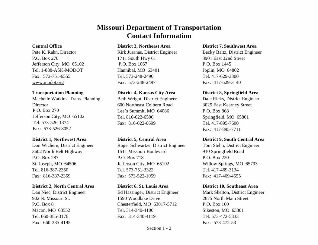
Highway and Bridge Construction Schedule RSMo 21.795.3(3) Introduction The information in this section is in accordance with the highlighted portion in the following section of the reporting statute. "(3) The proposed allocation and expenditure of moneys and the proposed work plan for the current fiscal year, at least the next four years, and for any period of time expressed in any public transportation plan approved by either the general assembly or by the voters of Missouri. This proposed allocation and expenditure of moneys shall include the amounts of proposed allocation and expenditure of moneys in each of the categories listed in subdivision (1) of this subsection; ..." Section 21.795.3(3), RSMo Supp. 2002 (L. 2003 TAFP HB 668) (emphasis added). MoDOT has proposed a specific plan for highway construction covering the next five years. The plan relies only on currently anticipated revenues, and it specifies projects assumed to be placed under contract or authorized for right-of-way acquisition in the state fiscal years 2007 through 2011. As each year of the plan is completed, a new year is added. This plan also includes other modes of transportation. On August 10, 2005, President George W. Bush signed the Safe, Accountable, Flexible, Efficient Transportation Equity Act: A Legacy for Users (SAFETEA-LU). SAFETEA-LU authorizes the Federal surface transportation programs for highways, highway safety, and transit for the five- year period of 2005 through 2009. The 2007-2011 Statewide Transportation Improvement Program (STIP) was developed in accordance with SAFETEA-LU and it represents the increased funding associated with SAFETEA-LU. The increased funding from SAFETEA-LU and the increased amount of earmarked projects required MoDOT to reconsider our funding distribution. The current funding distribution was approved in January of 2003 and amended in June of 2004. During the months after the ratification of SAFETEA-LU, MoDOT staff met with its planning partners twice to develop a new funding distribution aimed at managing the increased funds and earmarked projects. This new funding distribution increased taking care of the system and flexible funds and was approved by the Missouri Highways and Transportation Commission in February 2006. The 2007–2011 STIP incorporates new projects in 2011. This happens each year – as one year of projects is completed, another year is added. The program includes references to transportation improvements on the state system and also improvements identified by metropolitan planning organizations in St. Louis, Kansas City, Springfield, Columbia, Jefferson City, Joplin and St. Joseph.

Welcome message from author
This document is posted to help you gain knowledge. Please leave a comment to let me know what you think about it! Share it to your friends and learn new things together.
Transcript
Highway and Bridge Construction Schedule RSMo 21.795.3(3)
Introduction
The information in this section is in accordance with the highlighted portion in the following section of the reporting statute. "(3) The proposed allocation and expenditure of moneys and the proposed work plan for the current fiscal year, at least the next four years, and for any period of time expressed in any public transportation plan approved by either the general assembly or by the voters of Missouri. This proposed allocation and expenditure of moneys shall include the amounts of proposed allocation and expenditure of moneys in each of the categories listed in subdivision (1) of this subsection; ..." Section 21.795.3(3), RSMo Supp. 2002 (L. 2003 TAFP HB 668) (emphasis added).
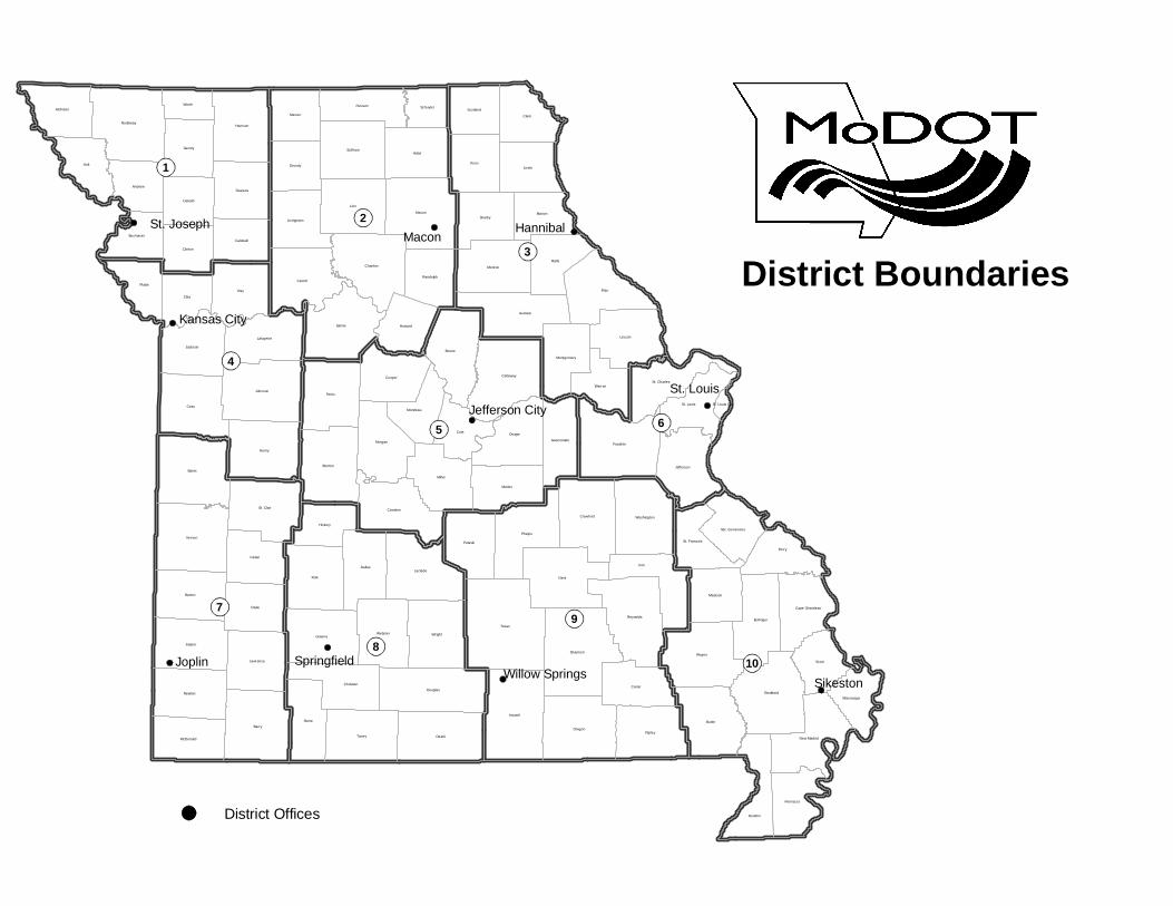
MoDOT has proposed a specific plan for highway construction covering the next five years. The plan relies only on currently anticipated revenues, and it specifies projects assumed to be placed under contract or authorized for right-of-way acquisition in the state fiscal years 2007 through 2011. As each year of the plan is completed, a new year is added. This plan also includes other modes of transportation. On August 10, 2005, President George W. Bush signed the Safe, Accountable, Flexible, Efficient Transportation Equity Act: A Legacy for Users (SAFETEA-LU). SAFETEA-LU authorizes the Federal surface transportation programs for highways, highway safety, and transit for the five-year period of 2005 through 2009. The 2007-2011 Statewide Transportation Improvement Program (STIP) was developed in accordance with SAFETEA-LU and it represents the increased funding associated with SAFETEA-LU. The increased funding from SAFETEA-LU and the increased amount of earmarked projects required MoDOT to reconsider our funding distribution. The current funding distribution was approved in January of 2003 and amended in June of 2004. During the months after the ratification of SAFETEA-LU, MoDOT staff met with its planning partners twice to develop a new funding distribution aimed at managing the increased funds and earmarked projects. This new funding distribution increased taking care of the system and flexible funds and was approved by the Missouri Highways and Transportation Commission in February 2006. The 2007–2011 STIP incorporates new projects in 2011. This happens each year – as one year of projects is completed, another year is added. The program includes references to transportation improvements on the state system and also improvements identified by metropolitan planning organizations in St. Louis, Kansas City, Springfield, Columbia, Jefferson City, Joplin and St. Joseph.
Texas
Dent
Pike
Bates
Barry
Polk
Linn
Ray
Iron
Howell
Cass
Ozark
Saline
Henry
Pettis
Macon
Butler
Holt
Franklin
Vernon
Miller
WayneShannon
Adair
Boone
Carroll
Oregon
Benton
Wright
TaneyRipley
Knox
Douglas
Phelps
Johnson
Clark
Laclede
Ralls
Jasper
Dade
Nodaway
Callaway
Osage
Stoddard
Clay
Greene
Perry
Chariton
Barton
Lincoln
Audrain
Lewis
Reynolds
Monroe
St. Clair
Cole
Dallas
Stone
Harrison
Camden
Scott
Sullivan
Newton
Carter
Crawford
Cedar
Morgan
Maries
Cooper
Pulaski
Jackson
Platte
Shelby
Gentry
Dunklin
Jefferson
Daviess
Bollinger
Webster
Lafayette
Putnam
Mercer
Atchison
Marion
Washington
Christian
Lawrence
Howard
Dekalb
Clinton
St. Louis
Warren
Grundy
Madison
New Madrid
Andrew
Pemiscot
Hickory
St. Charles
McDonald
Liv ingston
Randolph
Caldwell
Scotland
Gasconade
Moniteau
Worth
Montgomery
Buchanan
Mississippi
St. Francois
Cape Girardeau
Schuyler
Ste. Genevieve
St. Louis City
Sikeston
SpringfieldJoplin
Kansas City
St. Joseph
St. Louis
Jefferson City
HannibalMacon
Willow Springs
9
2
10
5
8
7
3
1
4
6
District Boundaries
District Offices
Section 1 - 2
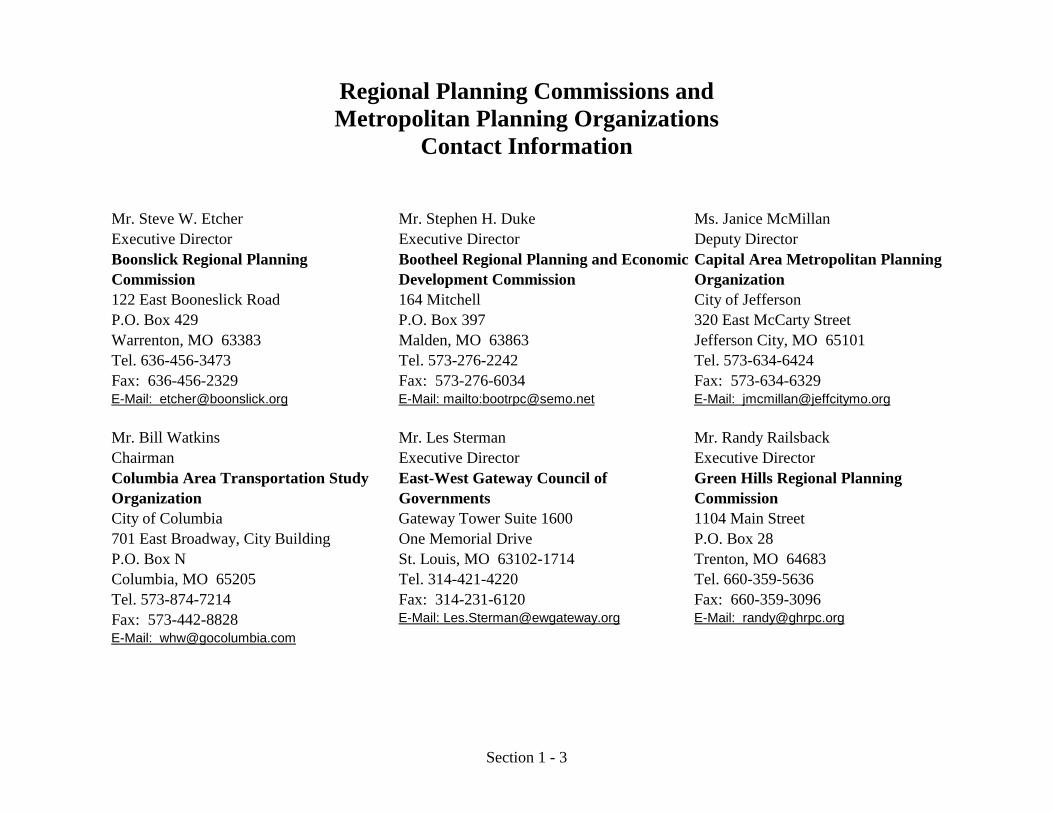
Missouri Department of Transportation Contact Information
Central Office District 3, Northeast Area District 7, Southwest Area Pete K. Rahn, Director Kirk Juranas, District Engineer Becky Baltz, District EngineerP.O. Box 270 1711 South Hwy 61 3901 East 32nd Street Jefferson City, MO 65102 P.O. Box 1067 P.O. Box 1445 Tel. 1-888-ASK-MODOT Hannibal, MO 63401 Joplin, MO 64802 Fax: 573-751-6555 Tel. 573-248-2490 Tel. 417-629-3300 www.modot.org Fax: 573-248-2497 Fax: 417-629-3140
Transportation Planning District 4, Kansas City Area District 8, Springfield Area Machelle Watkins, Trans. Planning Director
Beth Wright, District Engineer Dale Ricks, District Engineer
P.O. Box 270 600 Northeast Colbern Road 3025 East Kearney Street
Jefferson City, MO 65102 Lee’s Summit, MO 64086 P.O. Box 868
Tel. 573-526-1374 Tel. 816-622-6500 Springfield, MO 65801
Fax: 573-526-8052 Fax: 816-622-0699 Tel. 417-895-7600
Fax: 417-895-7711
District 1, Northwest Area District 5, Central Area District 9, South Central Area Don Wichern, District Engineer Roger Schwartze, District Engineer Tom Stehn, District Engineer 3602 North Belt Highway 1511 Missouri Boulevard 910 Springfield Road P.O. Box 287 P.O. Box 718 P.O. Box 220 St. Joseph, MO 64506 Jefferson City, MO 65102 Willow Springs, MO 65793 Tel. 816-387-2350 Tel. 573-751-3322 Tel. 417-469-3134 Fax: 816-387-2359 Fax: 573-522-1059 Fax: 417-469-4555
District 2, North Central Area District 6, St. Louis Area District 10, Southeast Area Dan Niec, District Engineer Ed Hassinger, District Engineer Mark Shelton, District Engineer902 N. Missouri St. 1590 Woodlake Drive 2675 North Main Street P.O. Box 8 Chesterfield, MO 63017-5712 P.O. Box 160 Macon, MO 63552 Tel. 314-340-4100 Sikeston, MO 63801 Tel. 660-385-3176 Fax: 314-340-4119 Tel. 573-472-5333 Fax: 660-385-4195 Fax: 573-472-53
Section 1 - 3
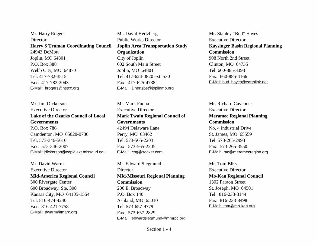
Regional Planning Commissions and Metropolitan Planning Organizations
Contact Information
Mr. Steve W. Etcher Mr. Stephen H. Duke Ms. Janice McMillanExecutive Director Executive Director Deputy DirectorBoonslick Regional Planning Commission
Bootheel Regional Planning and Economic Development Commission
Capital Area Metropolitan Planning Organization
122 East Booneslick Road 164 Mitchell City of JeffersonP.O. Box 429 P.O. Box 397 320 East McCarty StreetWarrenton, MO 63383 Malden, MO 63863 Jefferson City, MO 65101Tel. 636-456-3473 Tel. 573-276-2242 Tel. 573-634-6424Fax: 636-456-2329 Fax: 573-276-6034 Fax: 573-634-6329E-Mail: [email protected] E-Mail: mailto:[email protected] E-Mail: [email protected]
Mr. Bill Watkins Mr. Les Sterman Mr. Randy RailsbackChairman Executive Director Executive DirectorColumbia Area Transportation Study Organization
East-West Gateway Council of Governments
Green Hills Regional Planning Commission
City of Columbia Gateway Tower Suite 1600 1104 Main Street701 East Broadway, City Building One Memorial Drive P.O. Box 28P.O. Box N St. Louis, MO 63102-1714 Trenton, MO 64683Columbia, MO 65205 Tel. 314-421-4220 Tel. 660-359-5636Tel. 573-874-7214 Fax: 314-231-6120 Fax: 660-359-3096Fax: 573-442-8828 E-Mail: [email protected] E-Mail: [email protected]: [email protected]
Section 1 - 4
Mr. Harry Rogers Mr. David Hertzberg Mr. Stanley “Bud” HayesDirector Public Works Director Executive DirectorHarry S Truman Coordinating Council24943 DeMott
Joplin Area Transportation Study Organization
Kaysinger Basin Regional Planning Commission
Joplin, MO 64801 City of Joplin 908 North 2nd StreetP.O. Box 388 602 South Main Street Clinton, MO 64735Webb City, MO 64870 Joplin, MO 64801 Tel. 660-885-3393Tel. 417-782-3515 Tel. 417-624-0820 ext. 530 Fax: 660-885-4166Fax: 417-782-2043 Fax: 417-625-4738 E-Mail: [email protected]: [email protected] E-Mail: [email protected]
Mr. Jim Dickerson Mr. Mark Fuqua Mr. Richard CavenderExecutive Director Executive Director Executive DirectorLake of the Ozarks Council of Local Governments
Mark Twain Regional Council of Governments
Meramec Regional Planning Commission
P.O. Box 786 42494 Delaware Lane No. 4 Industrial DriveCamdenton, MO 65020-0786 Perry, MO 63462 St. James, MO 65559Tel. 573-346-5616 Tel. 573-565-2203 Tel. 573-265-2993Fax: 573-346-2007 Fax: 573-565-2205 Fax: 573-265-3550E-Mail: [email protected] E-Mail: [email protected] E-Mail: [email protected]
Mr. David Warm Mr. Edward Siegmund Mr. Tom BlissExecutive Director Director Executive DirectorMid-America Regional Council300 Rivergate Center
Mid-Missouri Regional Planning Commission
Mo-Kan Regional Council1302 Faraon Street
600 Broadway, Ste. 300 206 E. Broadway St. Joseph, MO 64501Kansas City, MO 64105-1554 P.O. Box 140 Tel. 816-233-3144Tel. 816-474-4240 Ashland, MO 65010 Fax: 816-233-8498Fax: 816-421-7758 Tel. 573-657-9779 E-Mail: [email protected]: [email protected] Fax: 573-657-2829
E-Mail: [email protected]
Section 1 - 5
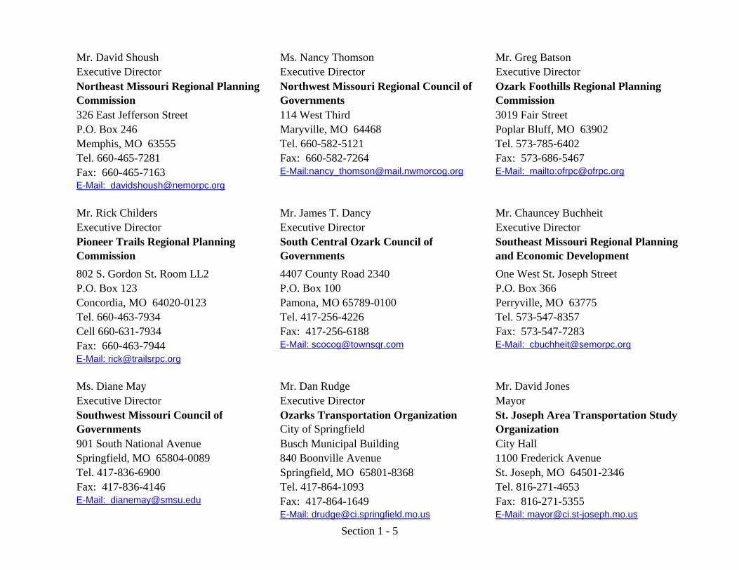
Mr. David Shoush Ms. Nancy Thomson Mr. Greg BatsonExecutive Director Executive Director Executive DirectorNortheast Missouri Regional Planning Commission
Northwest Missouri Regional Council of Governments
Ozark Foothills Regional Planning Commission
326 East Jefferson Street 114 West Third 3019 Fair StreetP.O. Box 246 Maryville, MO 64468 Poplar Bluff, MO 63902Memphis, MO 63555 Tel. 660-582-5121 Tel. 573-785-6402Tel. 660-465-7281 Fax: 660-582-7264 Fax: 573-686-5467Fax: 660-465-7163 E-Mail:[email protected] E-Mail: mailto:[email protected]: [email protected]
Mr. Rick Childers Mr. James T. Dancy Mr. Chauncey BuchheitExecutive Director Executive Director Executive DirectorPioneer Trails Regional Planning Commission
South Central Ozark Council of Governments
Southeast Missouri Regional Planning and Economic Development C i i802 S. Gordon St. Room LL2 4407 County Road 2340 One West St. Joseph Street
P.O. Box 123 P.O. Box 100 P.O. Box 366Concordia, MO 64020-0123 Pamona, MO 65789-0100 Perryville, MO 63775Tel. 660-463-7934 Tel. 417-256-4226 Tel. 573-547-8357Cell 660-631-7934 Fax: 417-256-6188 Fax: 573-547-7283Fax: 660-463-7944 E-Mail: [email protected] E-Mail: [email protected]: [email protected]
Ms. Diane May Mr. Dan Rudge Mr. David JonesExecutive Director Executive Director MayorSouthwest Missouri Council of Governments
Ozarks Transportation OrganizationCity of Springfield
St. Joseph Area Transportation Study Organization
901 South National Avenue Busch Municipal Building City HallSpringfield, MO 65804-0089 840 Boonville Avenue 1100 Frederick AvenueTel. 417-836-6900 Springfield, MO 65801-8368 St. Joseph, MO 64501-2346Fax: 417-836-4146 Tel. 417-864-1093 Tel. 816-271-4653E-Mail: [email protected] Fax: 417-864-1649 Fax: 816-271-5355
E-Mail: [email protected] E-Mail: [email protected]
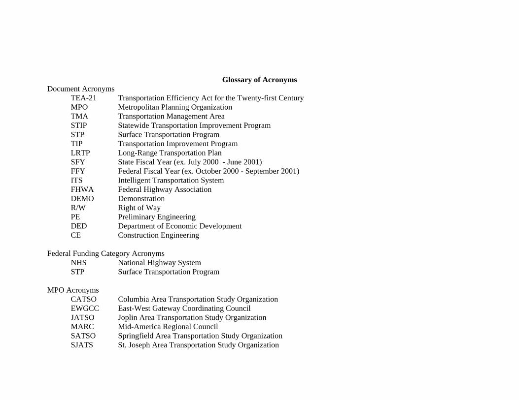
Glossary of Acronyms Document Acronyms TEA-21 Transportation Efficiency Act for the Twenty-first Century MPO Metropolitan Planning Organization TMA Transportation Management Area STIP Statewide Transportation Improvement Program STP Surface Transportation Program TIP Transportation Improvement Program LRTP Long-Range Transportation Plan SFY State Fiscal Year (ex. July 2000 - June 2001) FFY Federal Fiscal Year (ex. October 2000 - September 2001) ITS Intelligent Transportation System FHWA Federal Highway Association DEMO Demonstration R/W Right of Way PE Preliminary Engineering DED Department of Economic Development CE Construction Engineering Federal Funding Category Acronyms NHS National Highway System STP Surface Transportation Program MPO Acronyms CATSO Columbia Area Transportation Study Organization EWGCC East-West Gateway Coordinating Council JATSO Joplin Area Transportation Study Organization MARC Mid-America Regional Council SATSO Springfield Area Transportation Study Organization SJATS St. Joseph Area Transportation Study Organization
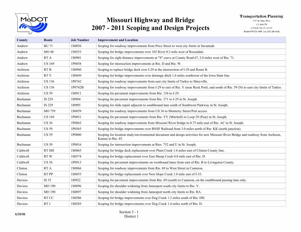
Missouri Highway and Bridge2007 - 2011 Scoping and Design Projects
County Route Job Number Improvement and Location
Andrew BU 71 1S0856 Scoping for roadway improvements from Price Street to west city limits in Savannah.
Andrew MO 48 1S0553 Scoping for bridge improvements over 102 River 0.3 mile west of Rosendale.
Andrew RT A 1S0901 Scoping for sight distance improvements at "S" curve at County Road 67, 2.0 miles west of Rte. 71.
Andrew US 169 1P0858 Scoping for intersection improvements at Rte. D and Rte. W.
Atchison RT B 1S0960 Scoping to replace bridge deck over I-29 at the intersection of I-29 and Route B.
Atchison RT V 1S0849 Scoping for bridge improvements over drainage ditch 1.6 miles southwest of the Iowa State line.
Atchison US 136 1P0742 Scoping for roadway improvements from east city limits of Tarkio to Maryville.
Atchison US 136 1P0742B Scoping for roadway improvements from I-29 to east of Rte. Y (near Rock Port), and south of Rte. 59 (N) to east city limits of Tarkio.
Atchison US 59 1S0911 Scoping for pavement improvements from Rte. 136 to I-29.
Buchanan IS 229 1I0904 Scoping for pavement improvements from Rte. 371 to I-29 in St. Joseph.
Buchanan IS 229 1I0905 Scoping for slide repair adjacent to southbound lane south of Southwest Parkway in St. Joseph.
Buchanan MO 759 1S0859 Scoping for roadway improvements from US 36 to Monterey Street/Port access.
Buchanan US 169 1P0851 Scoping for pavement improvements from Rte. YY (Mitchell) to Loop 29 (Pear) in St. Joseph.
Buchanan US 36 1P0862 Scoping for roadway improvements from Missouri River bridge to 0.75 mile east of Rte. AC in St. Joseph.
Buchanan US 59 1P0565 Scoping for bridge improvements over BNSF Railroad from 3.0 miles north of Rte. KK (north junction).
Buchanan US 59 1P0800 Scoping for location study/environmental document and design activities for new Missouri River Bridge and roadway from Atchison, Kansas to Rte. 45.
Buchanan US 59 1P0816 Scoping for intersection improvements at Rtes. 752 and U in St. Joseph.
Caldwell RT HH 1S0865 Scoping for bridge deck replacement over Plum Creek 1.6 miles east of Clinton County line.
Caldwell RT W 1S0574 Scoping for bridge replacement over East Sheep Creek 0.8 mile east of Rte. D.
Caldwell US 36 1P0913 Scoping for pavement improvements on westbound lanes from east of Rte. B to Livingston County.
Clinton RT A 1S0866 Scoping for roadway improvements from Rte. 69 to West Street in Cameron.
Clinton RT PP 1S0855 Scoping for bridge replacement over New Hope Creek 1.0 mile east of I-35.
Daviess IS 35 1I0922 Scoping for pavement improvements from Rte. 69 (south) to Cameron, on the southbound passing lane only.
Daviess MO 190 1S0896 Scoping for shoulder widening from Jamesport south city limits to Rte. V.
Daviess MO 190 1S0897 Scoping for shoulder widening from Jamesport north city limits to Rte. RA.
Daviess RT CC 1S0586 Scoping for bridge improvements over Dog Creek 1.2 miles south of Rte. HH.
Daviess RT J 1S0585 Scoping for bridge improvements over Dog Creek 1.4 miles north of Rte. D.
6/29/06Section 3 - 1
District 1
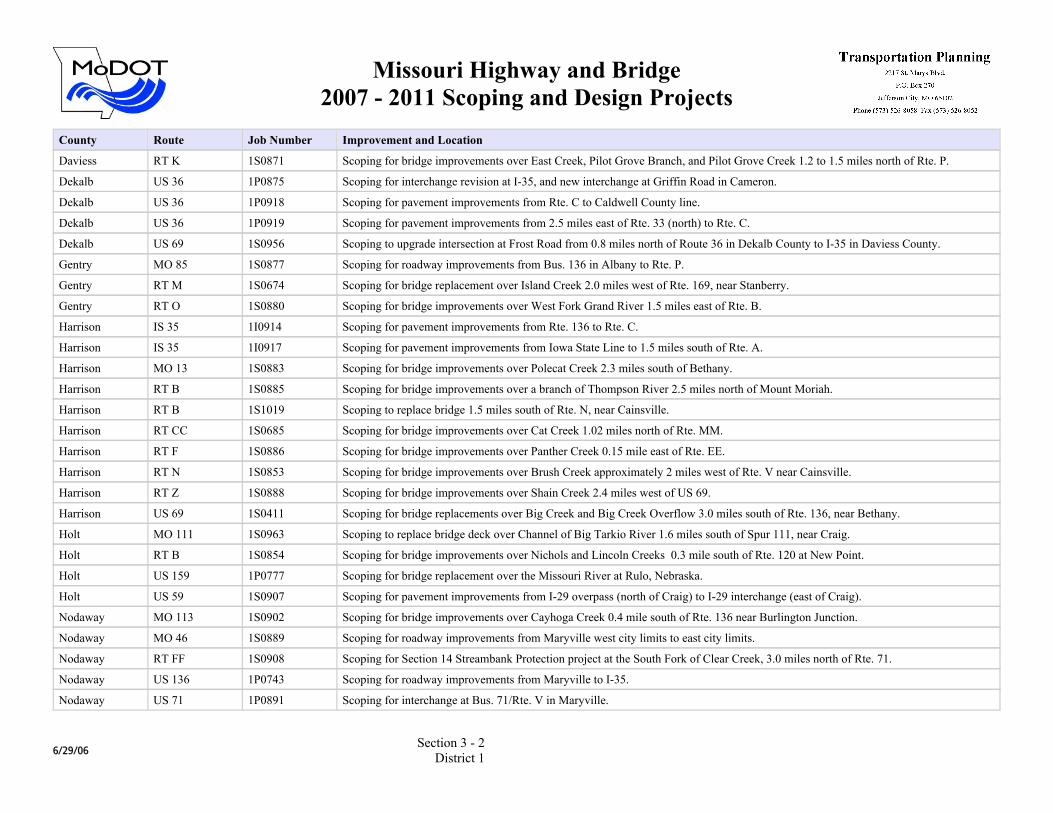
Missouri Highway and Bridge2007 - 2011 Scoping and Design Projects
County Route Job Number Improvement and Location
Daviess RT K 1S0871 Scoping for bridge improvements over East Creek, Pilot Grove Branch, and Pilot Grove Creek 1.2 to 1.5 miles north of Rte. P.
Dekalb US 36 1P0875 Scoping for interchange revision at I-35, and new interchange at Griffin Road in Cameron.
Dekalb US 36 1P0918 Scoping for pavement improvements from Rte. C to Caldwell County line.
Dekalb US 36 1P0919 Scoping for pavement improvements from 2.5 miles east of Rte. 33 (north) to Rte. C.
Dekalb US 69 1S0956 Scoping to upgrade intersection at Frost Road from 0.8 miles north of Route 36 in Dekalb County to I-35 in Daviess County.
Gentry MO 85 1S0877 Scoping for roadway improvements from Bus. 136 in Albany to Rte. P.
Gentry RT M 1S0674 Scoping for bridge replacement over Island Creek 2.0 miles west of Rte. 169, near Stanberry.
Gentry RT O 1S0880 Scoping for bridge improvements over West Fork Grand River 1.5 miles east of Rte. B.
Harrison IS 35 1I0914 Scoping for pavement improvements from Rte. 136 to Rte. C.
Harrison IS 35 1I0917 Scoping for pavement improvements from Iowa State Line to 1.5 miles south of Rte. A.
Harrison MO 13 1S0883 Scoping for bridge improvements over Polecat Creek 2.3 miles south of Bethany.
Harrison RT B 1S0885 Scoping for bridge improvements over a branch of Thompson River 2.5 miles north of Mount Moriah.
Harrison RT B 1S1019 Scoping to replace bridge 1.5 miles south of Rte. N, near Cainsville.
Harrison RT CC 1S0685 Scoping for bridge improvements over Cat Creek 1.02 miles north of Rte. MM.
Harrison RT F 1S0886 Scoping for bridge improvements over Panther Creek 0.15 mile east of Rte. EE.
Harrison RT N 1S0853 Scoping for bridge improvements over Brush Creek approximately 2 miles west of Rte. V near Cainsville.
Harrison RT Z 1S0888 Scoping for bridge improvements over Shain Creek 2.4 miles west of US 69.
Harrison US 69 1S0411 Scoping for bridge replacements over Big Creek and Big Creek Overflow 3.0 miles south of Rte. 136, near Bethany.
Holt MO 111 1S0963 Scoping to replace bridge deck over Channel of Big Tarkio River 1.6 miles south of Spur 111, near Craig.
Holt RT B 1S0854 Scoping for bridge improvements over Nichols and Lincoln Creeks 0.3 mile south of Rte. 120 at New Point.
Holt US 159 1P0777 Scoping for bridge replacement over the Missouri River at Rulo, Nebraska.
Holt US 59 1S0907 Scoping for pavement improvements from I-29 overpass (north of Craig) to I-29 interchange (east of Craig).
Nodaway MO 113 1S0902 Scoping for bridge improvements over Cayhoga Creek 0.4 mile south of Rte. 136 near Burlington Junction.
Nodaway MO 46 1S0889 Scoping for roadway improvements from Maryville west city limits to east city limits.
Nodaway RT FF 1S0908 Scoping for Section 14 Streambank Protection project at the South Fork of Clear Creek, 3.0 miles north of Rte. 71.
Nodaway US 136 1P0743 Scoping for roadway improvements from Maryville to I-35.
Nodaway US 71 1P0891 Scoping for interchange at Bus. 71/Rte. V in Maryville.
6/29/06Section 3 - 2
District 1
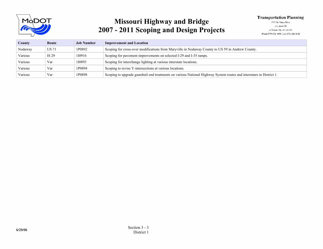
Missouri Highway and Bridge2007 - 2011 Scoping and Design Projects
County Route Job Number Improvement and Location
Nodaway US 71 1P0892 Scoping for cross-over modifications from Maryville in Nodaway County to US 59 in Andrew County.
Various IS 29 1I0916 Scoping for pavement improvements on selected I-29 and I-35 ramps.
Various Var 1I0893 Scoping for interchange lighting at various interstate locations.
Various Var 1P0894 Scoping to revise Y-intersections at various locations.
Various Var 1P0898 Scoping to upgrade guardrail end treatments on various National Highway System routes and interstates in District 1.
6/29/06Section 3 - 3
District 1
Missouri Highway and Bridge2007 - 2011 Scoping and Design Projects
County Route Job Number Improvement and Location
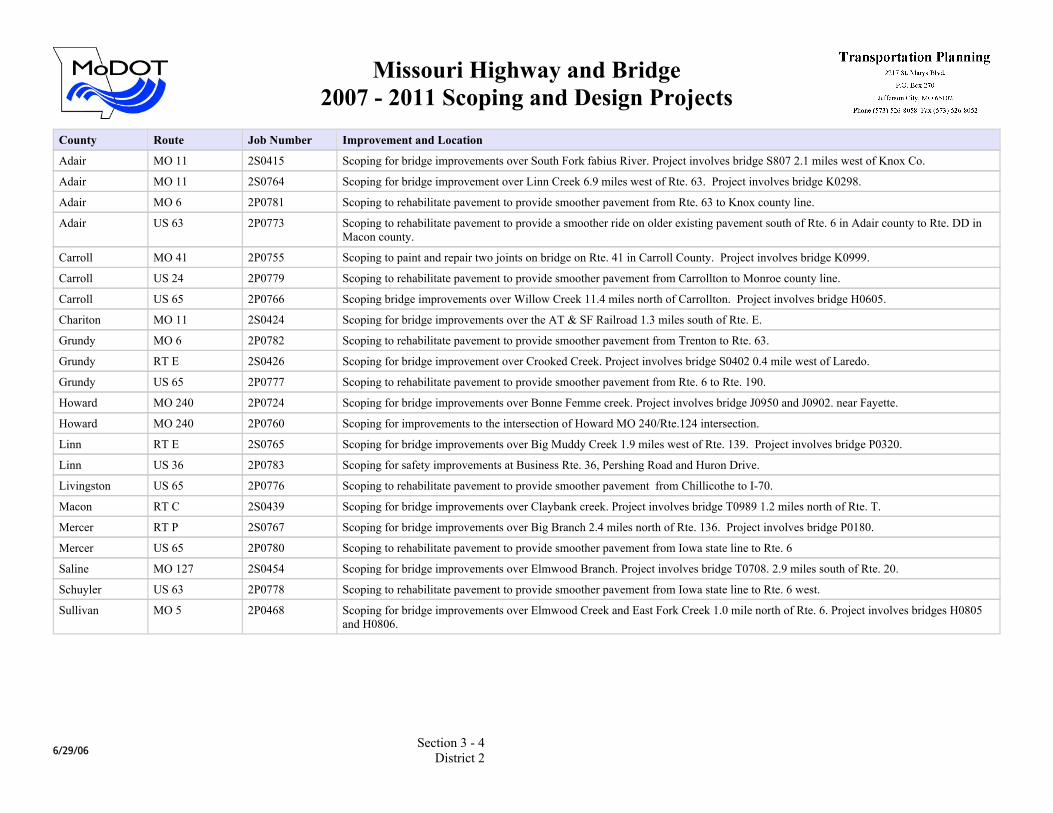
Adair MO 11 2S0415 Scoping for bridge improvements over South Fork fabius River. Project involves bridge S807 2.1 miles west of Knox Co.
Adair MO 11 2S0764 Scoping for bridge improvement over Linn Creek 6.9 miles west of Rte. 63. Project involves bridge K0298.
Adair MO 6 2P0781 Scoping to rehabilitate pavement to provide smoother pavement from Rte. 63 to Knox county line.
Adair US 63 2P0773 Scoping to rehabilitate pavement to provide a smoother ride on older existing pavement south of Rte. 6 in Adair county to Rte. DD in Macon county.
Carroll MO 41 2P0755 Scoping to paint and repair two joints on bridge on Rte. 41 in Carroll County. Project involves bridge K0999.
Carroll US 24 2P0779 Scoping to rehabilitate pavement to provide smoother pavement from Carrollton to Monroe county line.
Carroll US 65 2P0766 Scoping bridge improvements over Willow Creek 11.4 miles north of Carrollton. Project involves bridge H0605.
Chariton MO 11 2S0424 Scoping for bridge improvements over the AT & SF Railroad 1.3 miles south of Rte. E.
Grundy MO 6 2P0782 Scoping to rehabilitate pavement to provide smoother pavement from Trenton to Rte. 63.
Grundy RT E 2S0426 Scoping for bridge improvement over Crooked Creek. Project involves bridge S0402 0.4 mile west of Laredo.
Grundy US 65 2P0777 Scoping to rehabilitate pavement to provide smoother pavement from Rte. 6 to Rte. 190.
Howard MO 240 2P0724 Scoping for bridge improvements over Bonne Femme creek. Project involves bridge J0950 and J0902. near Fayette.
Howard MO 240 2P0760 Scoping for improvements to the intersection of Howard MO 240/Rte.124 intersection.
Linn RT E 2S0765 Scoping for bridge improvements over Big Muddy Creek 1.9 miles west of Rte. 139. Project involves bridge P0320.
Linn US 36 2P0783 Scoping for safety improvements at Business Rte. 36, Pershing Road and Huron Drive.
Livingston US 65 2P0776 Scoping to rehabilitate pavement to provide smoother pavement from Chillicothe to I-70.
Macon RT C 2S0439 Scoping for bridge improvements over Claybank creek. Project involves bridge T0989 1.2 miles north of Rte. T.
Mercer RT P 2S0767 Scoping for bridge improvements over Big Branch 2.4 miles north of Rte. 136. Project involves bridge P0180.
Mercer US 65 2P0780 Scoping to rehabilitate pavement to provide smoother pavement from Iowa state line to Rte. 6
Saline MO 127 2S0454 Scoping for bridge improvements over Elmwood Branch. Project involves bridge T0708. 2.9 miles south of Rte. 20.
Schuyler US 63 2P0778 Scoping to rehabilitate pavement to provide smoother pavement from Iowa state line to Rte. 6 west.
Sullivan MO 5 2P0468 Scoping for bridge improvements over Elmwood Creek and East Fork Creek 1.0 mile north of Rte. 6. Project involves bridges H0805 and H0806.
6/29/06Section 3 - 4
District 2
Missouri Highway and Bridge2007 - 2011 Scoping and Design Projects
County Route Job Number Improvement and Location
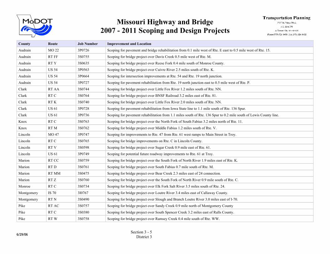
Audrain MO 22 3P0726 Scoping for pavement and bridge rehabilitation from 0.1 mile west of Rte. E east to 0.5 mile west of Rte. 15.
Audrain RT FF 3S0755 Scoping for bridge project over Davis Creek 0.5 mile west of Rte. M.
Audrain RT Y 3S0635 Scoping for bridge project over Reese Fork 0.4 mile south of Monroe County.
Audrain US 54 3P0563 Scoping for bridge project over Cuivre River 2.5 miles south of Rte. K.
Audrain US 54 3P0664 Scoping for intersection improvements at Rte. 54 and Rte. 19 north junction.
Audrain US 54 3P0727 Scoping for pavement rehabilitation from Rte. 19 north junction east to 0.5 mile west of Rte. P.
Clark RT AA 3S0744 Scoping for bridge project over Little Fox River 1.2 miles south of Rte. NN.
Clark RT C 3S0764 Scoping for bridge project over BNSF Railroad 3.2 miles east of Rte. 81.
Clark RT K 3S0740 Scoping for bridge project over Little Fox River 2.0 miles south of Rte. NN.
Clark US 61 3P0728 Scoping for pavement rehabilitation from Iowa State line to 1.1 mile south of Rte. 136 Spur.
Clark US 61 3P0736 Scoping for pavement rehabilitation from 1.1 miles south of Rte. 136 Spur to 0.2 mile south of Lewis County line.
Knox RT C 3S0763 Scoping for bridge project over the North Fork of South Fabius 3.2 miles north of Rte. 11.
Knox RT M 3S0762 Scoping for bridge project over Middle Fabius 1.2 miles south of Rte. V.
Lincoln MO 47 3P0747 Scoping for improvements to Rte. 47 from Rte. 61 west ramps to Main Street in Troy.
Lincoln RT C 3S0765 Scoping for bridge improvements on Rte. C in Lincoln County.
Lincoln RT V 3S0598 Scoping for bridge project over Sugar Creek 0.9 mile east of Rte. 61.
Lincoln US 61 3P0749 Scoping for potential future roadway improvements to Rte. 61 at Troy.
Marion RT CC 3S0759 Scoping for bridge project over the South Fork of North River 1.9 miles east of Rte. K.
Marion RT D 3S0761 Scoping for bridge project over South Fabius 0.7 mile south of Rte. M.
Marion RT MM 3S0475 Scoping for bridge project over Bear Creek 2.3 miles east of 24 connection.
Marion RT Z 3S0760 Scoping for bridge project over the South Fork of North River 0.9 mile south of Rte. C.
Monroe RT C 3S0734 Scoping for bridge project over Elk Fork Salt River 3.5 miles south of Rte. 24.
Montgomery IS 70 3I0767 Scoping for bridge project over Loutre River 3.4 miles east of Callaway County.
Montgomery RT N 3S0490 Scoping for bridge project over Slough and Branch Loutre River 3.0 miles east of I-70.
Pike RT AC 3S0757 Scoping for bridge project over Sandy Creek 0.9 mile north of Montgomery County
Pike RT C 3S0380 Scoping for bridge project over South Spencer Creek 3.2 miles east of Ralls County.
Pike RT W 3S0758 Scoping for bridge project over Ramsey Creek 0.4 mile south of Rte. WW.
6/29/06Section 3 - 5
District 3
Missouri Highway and Bridge2007 - 2011 Scoping and Design Projects
County Route Job Number Improvement and Location
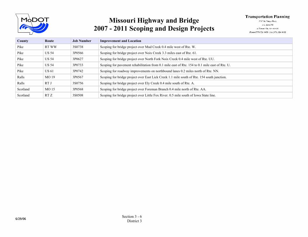
Pike RT WW 3S0738 Scoping for bridge project over Mud Creek 0.4 mile west of Rte. W.
Pike US 54 3P0566 Scoping for bridge project over Noix Creek 3.3 miles east of Rte. 61.
Pike US 54 3P0627 Scoping for bridge project over North Fork Noix Creek 0.4 mile west of Rte. UU.
Pike US 54 3P0733 Scoping for pavement rehabilitation from 0.1 mile east of Rte. 154 to 0.1 mile east of Rte. U.
Pike US 61 3P0742 Scoping for roadway improvements on northbound lanes 0.2 miles north of Rte. NN.
Ralls MO 19 3P0567 Scoping for bridge project over East Lick Creek 1.1 mile south of Rte. 154 south junction.
Ralls RT J 3S0756 Scoping for bridge project over Ely Creek 0.4 mile south of Rte. A.
Scotland MO 15 3P0568 Scoping for bridge project over Foreman Branch 0.4 mile north of Rte. AA.
Scotland RT Z 3S0508 Scoping for bridge project over Little Fox River. 0.5 mile south of Iowa State line.
6/29/06Section 3 - 6
District 3
Missouri Highway and Bridge2007 - 2011 Scoping and Design Projects
County Route Job Number Improvement and Location
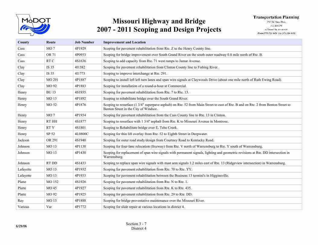
Cass MO 7 4P1929 Scoping for pavement rehabilitation from Rte. Z to the Henry County line.
Cass OR 71 4P0953 Scoping for bridge improvement over South Grand River on the south outer roadway 0.8 mile north of Rte. B.
Cass RT C 4S1636 Scoping to add capacity from Rte. 71 west ramps to Jamar Avenue.
Clay IS 35 4I1382 Scoping for pavement rehabilitation from Clinton County line to Fishing River.
Clay IS 35 4I1773 Scoping to improve interchange at Rte. 291.
Clay MO 291 4P1887 Scoping to install left left turn lanes and span wire signals at Claywoods Drive (about one mile north of Ruth Ewing Road).
Clay MO 92 4P1883 Scoping for installation of a round-a-bout at Commercial.
Henry BU 13 4S1935 Scoping for pavement rehabilitation from Rte. 7 to Rte. 13.
Henry MO 13 4P1892 Scoping to rehabilitate bridge over the South Grand River.
Henry MO 52 4P1876 Scoping to resurface (1 3/4" superpave asphalt) on Rte. 52 from Main Street to east of Rte. B and on Rte. 2 from Benton Street to Benton Street in the City of Windsor.
Henry MO 7 4P1934 Scoping for pavement rehabilitation from the Cass County line to Rte. 13 in Clinton.
Henry RT HH 4S1877 Scoping to resurface with 1 3/4" asphalt from Rte. K to Missouri Avenue in Montrose.
Henry RT Y 4S1801 Scoping to Rehabilitate bridge over E. Tebo Creek.
Henry SP 52 4L0800C Scoping for thin lift overlay from Rte. 52 to Eighth Street in Deepwater.
Jackson OR 291 4S1940 Scoping for outer road study/design from Courtney Road to Kentucky Road.
Johnson MO 13 4P1138 Scoping for four-lane relocation (freeway) from Rte. V north of Warrensburg to Rte. Y south of Warrensburg.
Johnson MO 13 4P1430 Scoping for replacement of span wire signals with permanent signals, lighting and geometric revisions at Rte. DD intersection in Warrensburg.
Johnson RT DD 4S1433 Scoping to replace span wire signals with mast arm signals 1.2 miles east of Rte. 13 (Ridgeview intersection) in Warrensburg.
Lafayette MO 13 4P1932 Scoping for pavement rehabilitation from Rte. 70 to Rte. YY.
Lafayette MO 13 4P1933 Scoping for pavement rehabilitation between the Business 13 termini's in Higginsville.
Platte MO 152 4S1926 Scoping for pavement rehabilitation from Rte. N to Rte. 1.
Platte MO 45 4P1927 Scoping for pavement rehabilitation from Rte. K to Rte. 435.
Platte MO 92 4P1925 Scoping for pavement rehabilitation from Rte. 29 to Rte. DD.
Ray MO 13 4P1888 Scoping for bridge preventative maintenance over the Missouri River.
Various Var 4P1772 Scoping for slide repair at various locations in district 4.
6/29/06Section 3 - 7
District 4
Missouri Highway and Bridge2007 - 2011 Scoping and Design Projects
County Route Job Number Improvement and Location
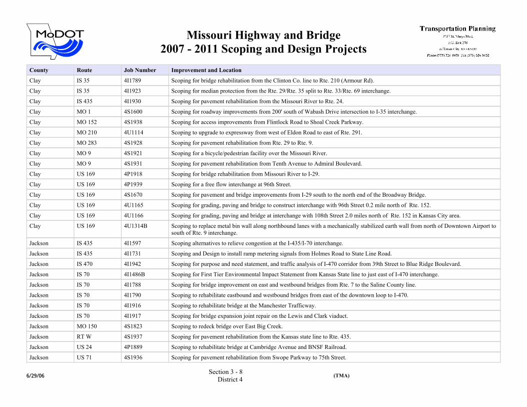
Clay IS 35 4I1789 Scoping for bridge rehabilitation from the Clinton Co. line to Rte. 210 (Armour Rd).
Clay IS 35 4I1923 Scoping for median protection from the Rte. 29/Rte. 35 split to Rte. 33/Rte. 69 interchange.
Clay IS 435 4I1930 Scoping for pavement rehabilitation from the Missouri River to Rte. 24.
Clay MO 1 4S1600 Scoping for roadway improvements from 200' south of Wabash Drive intersection to I-35 interchange.
Clay MO 152 4S1938 Scoping for access improvements from Flintlock Road to Shoal Creek Parkway.
Clay MO 210 4U1114 Scoping to upgrade to expressway from west of Eldon Road to east of Rte. 291.
Clay MO 283 4S1928 Scoping for pavement rehabilitation from Rte. 29 to Rte. 9.
Clay MO 9 4S1921 Scoping for a bicycle/pedestrian facility over the Missouri River.
Clay MO 9 4S1931 Scoping for pavement rehabilitation from Tenth Avenue to Admiral Boulevard.
Clay US 169 4P1918 Scoping for bridge rehabilitation from Missouri River to I-29.
Clay US 169 4P1939 Scoping for a free flow interchange at 96th Street.
Clay US 169 4S1670 Scoping for pavement and bridge improvements from I-29 south to the north end of the Broadway Bridge.
Clay US 169 4U1165 Scoping for grading, paving and bridge to construct interchange with 96th Street 0.2 mile north of Rte. 152.
Clay US 169 4U1166 Scoping for grading, paving and bridge at interchange with 108th Street 2.0 miles north of Rte. 152 in Kansas City area.
Clay US 169 4U1314B Scoping to replace metal bin wall along northbound lanes with a mechanically stabilized earth wall from north of Downtown Airport to south of Rte. 9 interchange.
Jackson IS 435 4I1597 Scoping alternatives to relieve congestion at the I-435/I-70 interchange.
Jackson IS 435 4I1731 Scoping and Design to install ramp metering signals from Holmes Road to State Line Road.
Jackson IS 470 4I1942 Scoping for purpose and need statement, and traffic analysis of I-470 corridor from 39th Street to Blue Ridge Boulevard.
Jackson IS 70 4I1486B Scoping for First Tier Environmental Impact Statement from Kansas State line to just east of I-470 interchange.
Jackson IS 70 4I1788 Scoping for bridge improvement on east and westbound bridges from Rte. 7 to the Saline County line.
Jackson IS 70 4I1790 Scoping to rehabilitate eastbound and westbound bridges from east of the downtown loop to I-470.
Jackson IS 70 4I1916 Scoping to rehabilitate bridge at the Manchester Trafficway.
Jackson IS 70 4I1917 Scoping for bridge expansion joint repair on the Lewis and Clark viaduct.
Jackson MO 150 4S1823 Scoping to redeck bridge over East Big Creek.
Jackson RT W 4S1937 Scoping for pavement rehabilitation from the Kansas state line to Rte. 435.
Jackson US 24 4P1889 Scoping to rehabilitate bridge at Cambridge Avenue and BNSF Railroad.
Jackson US 71 4S1936 Scoping for pavement rehabilitation from Swope Parkway to 75th Street.
6/29/06Section 3 - 8
District 4 (TMA)
Missouri Highway and Bridge2007 - 2011 Scoping and Design Projects
County Route Job Number Improvement and Location
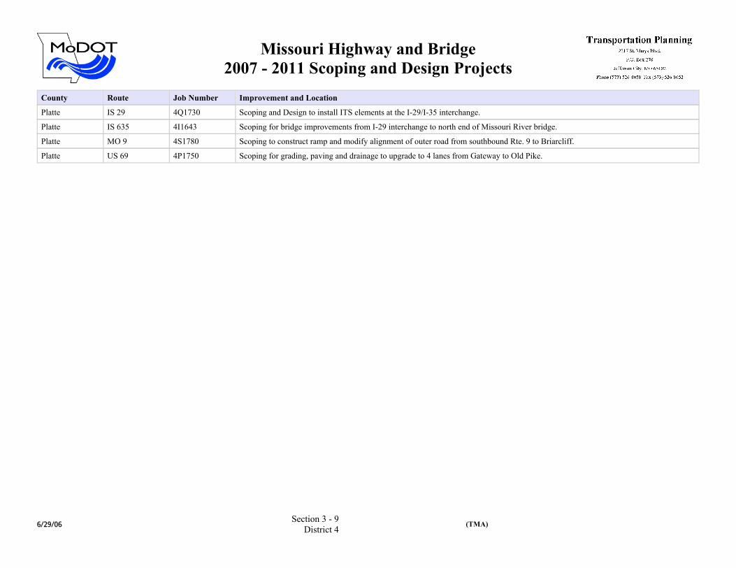
Platte IS 29 4Q1730 Scoping and Design to install ITS elements at the I-29/I-35 interchange.
Platte IS 635 4I1643 Scoping for bridge improvements from I-29 interchange to north end of Missouri River bridge.
Platte MO 9 4S1780 Scoping to construct ramp and modify alignment of outer road from southbound Rte. 9 to Briarcliff.
Platte US 69 4P1750 Scoping for grading, paving and drainage to upgrade to 4 lanes from Gateway to Old Pike.
6/29/06Section 3 - 9
District 4 (TMA)
Missouri Highway and Bridge2007 - 2011 Scoping and Design Projects
County Route Job Number Improvement and Location
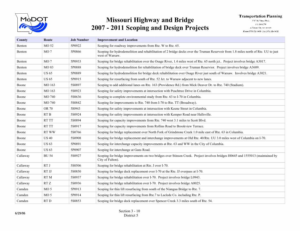
Benton MO 52 5P0922 Scoping for roadway improvements from Rte. W to Rte. 65.
Benton MO 7 5P0866 Scoping for hydrodemolition and rehabilitation of 2 bridge decks over the Truman Reservoir from 1.8 miles north of Rte. UU to just west of Warsaw.
Benton MO 7 5P0933 Scoping for bridge rehabilitation over the Osage River, 1.4 miles west of Rte. 65 north jct.. Project involves bridge A3017.
Benton MO 83 5P0888 Scoping for hydrodemolition for rehabilitation of bridge deck over Truman Reservior. Project involves bridge A3689.
Benton US 65 5P0889 Scoping for hydrodemolition for bridge deck rehabilitation over Osage River just south of Warsaw. Involves bridge A3021.
Benton US 65 5P0915 Scoping for resurfacing from south of Rte. 52 Jct. to Warsaw adjacent to new lanes.
Boone MO 163 5S0897 Scoping to add additional lanes on Rte. 163 (Providence Rd.) from Mick Deaver Dr. to Rte. 740 (Stadium).
Boone MO 163 5S0923 Scoping for safety improvements at intersection with Peachtree Drive in Columbia.
Boone MO 740 5S0636 Scoping to complete environmental study from Rte. 63 to I-70 in Columbia.
Boone MO 740 5S0842 Scoping for improvements to Rte. 740 from I-70 to Rte. TT (Broadway).
Boone OR 70 5I0943 Scoping for safety improvements at intersection with Keene Street in Columbia.
Boone RT B 5S0924 Scoping for safety improvements at intersection with Kemper Road near Hallsville.
Boone RT TT 5S0894 Scoping for capacity improvements from Rte. 740 west 3.1 miles to Scott Blvd.
Boone RT TT 5S0917 Scoping for capacity improvements from Rollins Road to Brookview Terrace.
Boone RT WW 5S0766 Scoping for bridge replacement over North Fork of Grindstone Creek 1.0 mile east of Rte. 63 in Columbia.
Boone US 40 5S0908 Scoping for bridge replacement and interchange improvements at Old Rte. 40/Rte. UU 3.0 miles west of Columbia on I-70.
Boone US 63 5P0891 Scoping for interchange capacity improvements at Rte. 63 and WW in the City of Columbia.
Boone US 63 5P0907 Scoping for interchange at Gans Road.
Callaway BU 54 5S0927 Scoping for bridge improvements on two bridges over Stinson Creek. Project involves bridges H0645 and 1555013 (maintained by City of Fulton).
Callaway RT J 5S0506 Scoping for bridge rehabilitation at Rte. J over I-70.
Callaway RT JJ 5S0850 Scoping for bridge deck replacement over I-70 at the Rte. JJ overpass at I-70.
Callaway RT M 5S0937 Scoping for bridge rehabilitation over I-70. Project involves bridge L0943.
Callaway RT Z 5S0936 Scoping for bridge rehabilitation over I-70. Project involves bridge A0025.
Camden MO 5 5P0913 Scoping for thin lift resurfacing from south of the Niangua Bridge to Rte. 7.
Camden MO 5 5P0914 Scoping for thin lift resurfacing from Rte.7 to Laclede Co. including Rte. P.
Camden RT D 5S0853 Scoping for bridge deck replacement over Spencer Creek 3.3 miles south of Rte. 54.
6/29/06Section 3 - 10
District 5
Missouri Highway and Bridge2007 - 2011 Scoping and Design Projects
County Route Job Number Improvement and Location
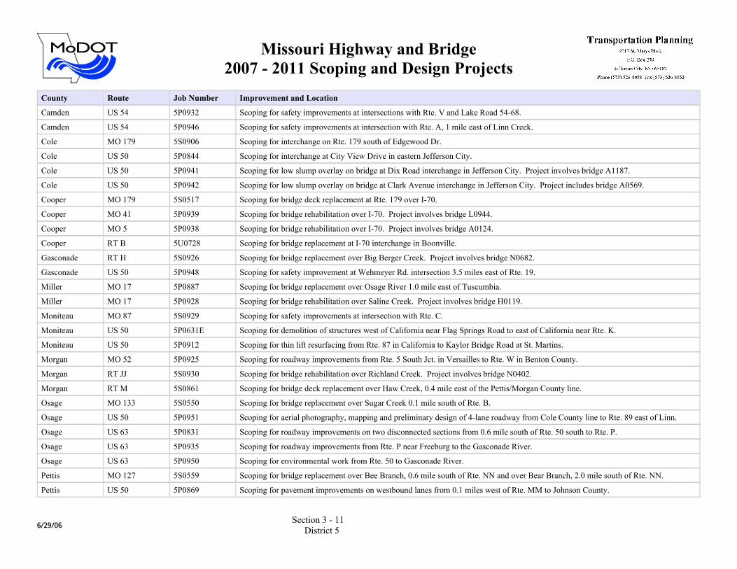
Camden US 54 5P0932 Scoping for safety improvements at intersections with Rte. V and Lake Road 54-68.
Camden US 54 5P0946 Scoping for safety improvements at intersection with Rte. A, 1 mile east of Linn Creek.
Cole MO 179 5S0906 Scoping for interchange on Rte. 179 south of Edgewood Dr.
Cole US 50 5P0844 Scoping for interchange at City View Drive in eastern Jefferson City.
Cole US 50 5P0941 Scoping for low slump overlay on bridge at Dix Road interchange in Jefferson City. Project involves bridge A1187.
Cole US 50 5P0942 Scoping for low slump overlay on bridge at Clark Avenue interchange in Jefferson City. Project includes bridge A0569.
Cooper MO 179 5S0517 Scoping for bridge deck replacement at Rte. 179 over I-70.
Cooper MO 41 5P0939 Scoping for bridge rehabilitation over I-70. Project involves bridge L0944.
Cooper MO 5 5P0938 Scoping for bridge rehabilitation over I-70. Project involves bridge A0124.
Cooper RT B 5U0728 Scoping for bridge replacement at I-70 interchange in Boonville.
Gasconade RT H 5S0926 Scoping for bridge replacement over Big Berger Creek. Project involves bridge N0682.
Gasconade US 50 5P0948 Scoping for safety improvement at Wehmeyer Rd. intersection 3.5 miles east of Rte. 19.
Miller MO 17 5P0887 Scoping for bridge replacement over Osage River 1.0 mile east of Tuscumbia.
Miller MO 17 5P0928 Scoping for bridge rehabilitation over Saline Creek. Project involves bridge H0119.
Moniteau MO 87 5S0929 Scoping for safety improvements at intersection with Rte. C.
Moniteau US 50 5P0631E Scoping for demolition of structures west of California near Flag Springs Road to east of California near Rte. K.
Moniteau US 50 5P0912 Scoping for thin lift resurfacing from Rte. 87 in California to Kaylor Bridge Road at St. Martins.
Morgan MO 52 5P0925 Scoping for roadway improvements from Rte. 5 South Jct. in Versailles to Rte. W in Benton County.
Morgan RT JJ 5S0930 Scoping for bridge rehabilitation over Richland Creek. Project involves bridge N0402.
Morgan RT M 5S0861 Scoping for bridge deck replacement over Haw Creek, 0.4 mile east of the Pettis/Morgan County line.
Osage MO 133 5S0550 Scoping for bridge replacement over Sugar Creek 0.1 mile south of Rte. B.
Osage US 50 5P0951 Scoping for aerial photography, mapping and preliminary design of 4-lane roadway from Cole County line to Rte. 89 east of Linn.
Osage US 63 5P0831 Scoping for roadway improvements on two disconnected sections from 0.6 mile south of Rte. 50 south to Rte. P.
Osage US 63 5P0935 Scoping for roadway improvements from Rte. P near Freeburg to the Gasconade River.
Osage US 63 5P0950 Scoping for environmental work from Rte. 50 to Gasconade River.
Pettis MO 127 5S0559 Scoping for bridge replacement over Bee Branch, 0.6 mile south of Rte. NN and over Bear Branch, 2.0 mile south of Rte. NN.
Pettis US 50 5P0869 Scoping for pavement improvements on westbound lanes from 0.1 miles west of Rte. MM to Johnson County.
6/29/06Section 3 - 11
District 5
Missouri Highway and Bridge2007 - 2011 Scoping and Design Projects
County Route Job Number Improvement and Location
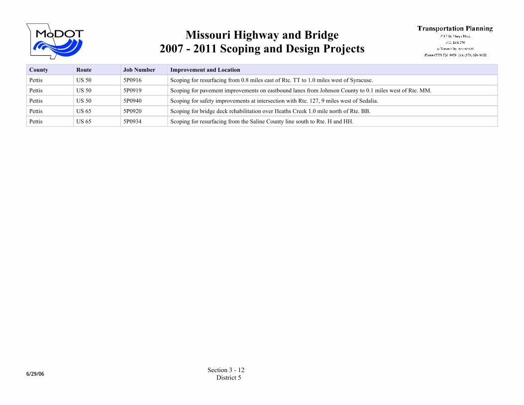
Pettis US 50 5P0916 Scoping for resurfacing from 0.8 miles east of Rte. TT to 1.0 miles west of Syracuse.
Pettis US 50 5P0919 Scoping for pavement improvements on eastbound lanes from Johnson County to 0.1 miles west of Rte. MM.
Pettis US 50 5P0940 Scoping for safety improvements at intersection with Rte. 127, 9 miles west of Sedalia.
Pettis US 65 5P0920 Scoping for bridge deck rehabilitation over Heaths Creek 1.0 mile north of Rte. BB.
Pettis US 65 5P0934 Scoping for resurfacing from the Saline County line south to Rte. H and HH.
6/29/06Section 3 - 12
District 5
Missouri Highway and Bridge2007 - 2011 Scoping and Design Projects
County Route Job Number Improvement and Location
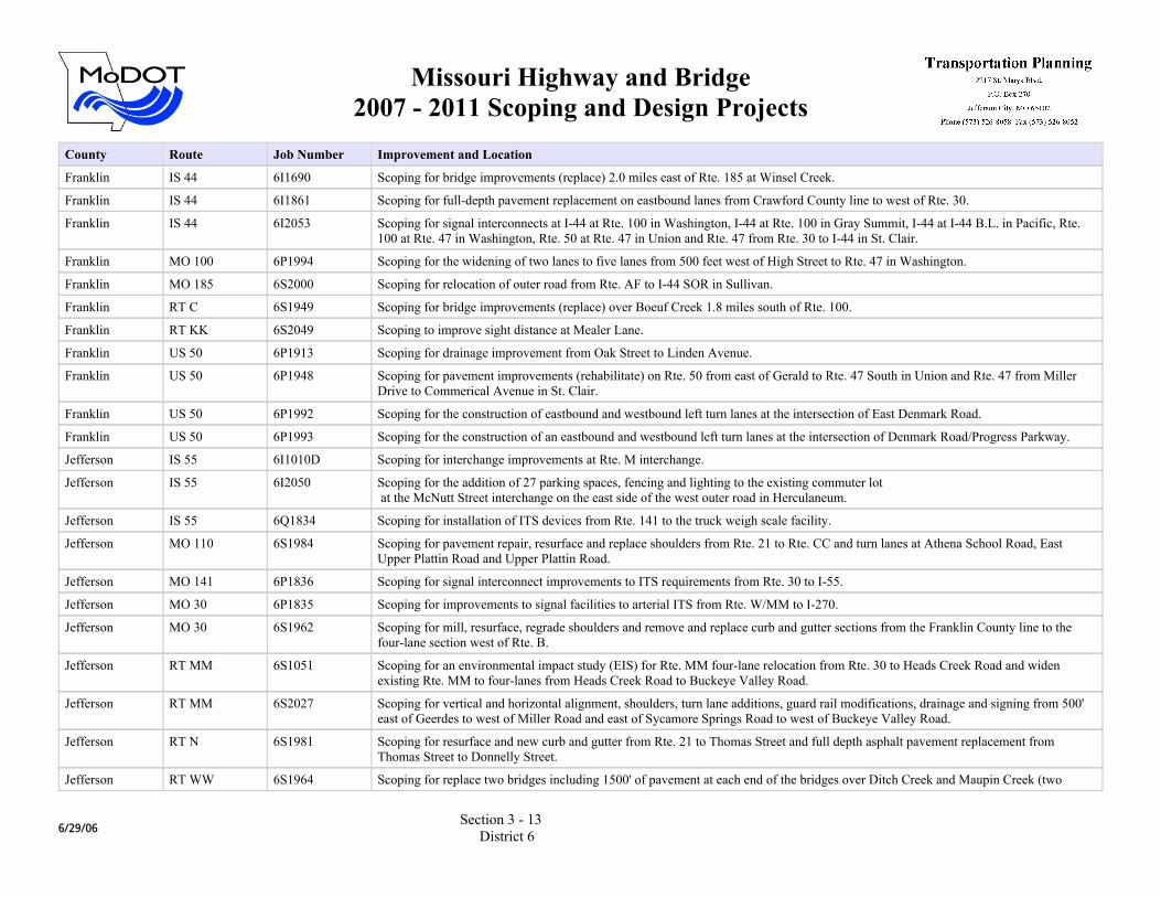
Franklin IS 44 6I1690 Scoping for bridge improvements (replace) 2.0 miles east of Rte. 185 at Winsel Creek.
Franklin IS 44 6I1861 Scoping for full-depth pavement replacement on eastbound lanes from Crawford County line to west of Rte. 30.
Franklin IS 44 6I2053 Scoping for signal interconnects at I-44 at Rte. 100 in Washington, I-44 at Rte. 100 in Gray Summit, I-44 at I-44 B.L. in Pacific, Rte. 100 at Rte. 47 in Washington, Rte. 50 at Rte. 47 in Union and Rte. 47 from Rte. 30 to I-44 in St. Clair.
Franklin MO 100 6P1994 Scoping for the widening of two lanes to five lanes from 500 feet west of High Street to Rte. 47 in Washington.
Franklin MO 185 6S2000 Scoping for relocation of outer road from Rte. AF to I-44 SOR in Sullivan.
Franklin RT C 6S1949 Scoping for bridge improvements (replace) over Boeuf Creek 1.8 miles south of Rte. 100.
Franklin RT KK 6S2049 Scoping to improve sight distance at Mealer Lane.
Franklin US 50 6P1913 Scoping for drainage improvement from Oak Street to Linden Avenue.
Franklin US 50 6P1948 Scoping for pavement improvements (rehabilitate) on Rte. 50 from east of Gerald to Rte. 47 South in Union and Rte. 47 from Miller Drive to Commerical Avenue in St. Clair.
Franklin US 50 6P1992 Scoping for the construction of eastbound and westbound left turn lanes at the intersection of East Denmark Road.
Franklin US 50 6P1993 Scoping for the construction of an eastbound and westbound left turn lanes at the intersection of Denmark Road/Progress Parkway.
Jefferson IS 55 6I1010D Scoping for interchange improvements at Rte. M interchange.
Jefferson IS 55 6I2050 Scoping for the addition of 27 parking spaces, fencing and lighting to the existing commuter lot at the McNutt Street interchange on the east side of the west outer road in Herculaneum.
Jefferson IS 55 6Q1834 Scoping for installation of ITS devices from Rte. 141 to the truck weigh scale facility.
Jefferson MO 110 6S1984 Scoping for pavement repair, resurface and replace shoulders from Rte. 21 to Rte. CC and turn lanes at Athena School Road, East Upper Plattin Road and Upper Plattin Road.
Jefferson MO 141 6P1836 Scoping for signal interconnect improvements to ITS requirements from Rte. 30 to I-55.
Jefferson MO 30 6P1835 Scoping for improvements to signal facilities to arterial ITS from Rte. W/MM to I-270.
Jefferson MO 30 6S1962 Scoping for mill, resurface, regrade shoulders and remove and replace curb and gutter sections from the Franklin County line to the four-lane section west of Rte. B.
Jefferson RT MM 6S1051 Scoping for an environmental impact study (EIS) for Rte. MM four-lane relocation from Rte. 30 to Heads Creek Road and widen existing Rte. MM to four-lanes from Heads Creek Road to Buckeye Valley Road.
Jefferson RT MM 6S2027 Scoping for vertical and horizontal alignment, shoulders, turn lane additions, guard rail modifications, drainage and signing from 500' east of Geerdes to west of Miller Road and east of Sycamore Springs Road to west of Buckeye Valley Road.
Jefferson RT N 6S1981 Scoping for resurface and new curb and gutter from Rte. 21 to Thomas Street and full depth asphalt pavement replacement from Thomas Street to Donnelly Street.
Jefferson RT WW 6S1964 Scoping for replace two bridges including 1500' of pavement at each end of the bridges over Ditch Creek and Maupin Creek (two
6/29/06Section 3 - 13
District 6

Missouri Highway and Bridge2007 - 2011 Scoping and Design Projects
County Route Job Number Improvement and Location
disconnected sections).
Jefferson US 61 6S1961 Scoping for resurface, regrade shoulders and guardrail replacement at two bridges from I-55 @ Airport Road to the St. Genevieve County line.
Jefferson US 61 6S1963 Scoping for sandblast, paint and sealcoat substructure over Joachim Creek.
Jefferson US 61 6S2064 Scoping for signal interconnects at Rte. 61/67 from north of Meramec River to Rte. 231, I-55 at Richardson Road interchange, I-55 at Imperial Main interchange, and I-55 from Rte. 61/67 to Windsor Harbor.
St. Charles IS 70 6I1751 Scoping for fence replacement along I-70 South Outer Road from Dardenne Creek to west of Rte. C.
St. Charles IS 70 6I1945 Scoping for bridge improvements (rehabilitate) at the Rte. 370 interchange.
St. Charles IS 70 6I1999 Scoping for an the addition of a southbound right turn lane to the I-70 westbound on-ramp and add a dual left turn lane to the eastbound I-70 on-ramp at Wentzville Parkway.
St. Charles IS 70 6I2002 Scoping for an addition of a westbound lane from TR Hughes Boulevard interchange to Rte. K.
St. Charles IS 70 6I2051 Scoping for the addition of an auxiliary lane on I-70 eastbound from T.R. Hughes to Rte. 79.
St. Charles IS 70 6I2052 Scoping for the addition of an auxiliary lane on I-70 eastbound from Rte. K/M to T.R. Hughes.
St. Charles IS 70 6I2059 Scoping for interchange interconnects from Rte.40/61 to 5th Street.
St. Charles MO 364 6U1028D Scoping for grading, drainage, bridges and interchange for Page Avenue extension from Hanley Road to McCluer Road.
St. Charles MO 364 6U1028Y Scoping for grading, paving, one way outer road, signing, signals and lighting from w/o Central School Road to east of Jungerman Road (Page Extension).
St. Charles MO 370 6P1943 Scoping for bridge improvements (rehabilitate) 0.3 mile east of I-70 over the Norfolk and Western Railroad.
St. Charles MO 370 6P1944 Scoping for eastbound and westbound bridge improvements (rehabilitate) over the Missouri River.
St. Charles MO 94 6S1529 Scoping for pavement repair, resurfacing and widening for a left turn lane from Rte. B to Clark Street.
St. Charles MO 94 6S1837 Scoping for signal facility improvements to arterial ITS requirements from I-70 to Rte. 40.
St. Charles MO 94 6S1946 Scoping for bridge improvements (rehabilitate) over Femme Osage Creek.
St. Charles MO 94 6S1955 Scoping for pavement improvements (resurface) from Rte. H/J intersection to Rte. 67.
St. Charles OR 70 6I1982 Scoping for resuface the north and south outer roads from Rte. K to Rte. 79.
St. Charles RT A 6S1942 Scoping for pavement and bridge improvements (rehabilitate) from Rte. 40/61 to I-70.
St. Charles RT B 6S1947 Scoping for bridge improvements (rehabilitate) over Dardenne Creek.
St. Charles RT N 6S1988 Scoping to widen for a left turn lane and shoulders and realign Rte. N from Meadowlake Drive to Dardenne Farms Drive.
St. Charles US 61 6P1527 Scoping for resurfacing the outer roads, pave and light the pool parking lot, light the intersection, and add turn lanes at Rte. P.
St. Charles US 67 6P2031 Scoping for structural steel painting on the Lewis Bridge over the Missouri River.
6/29/06Section 3 - 14
District 6
Missouri Highway and Bridge2007 - 2011 Scoping and Design Projects
County Route Job Number Improvement and Location
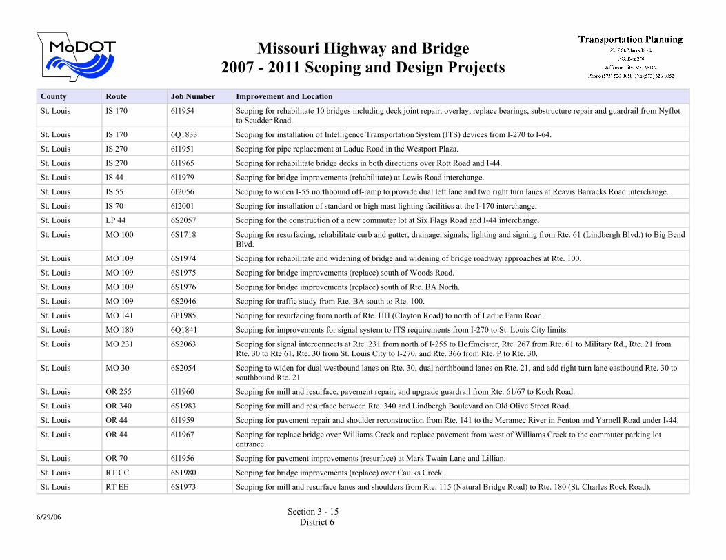
St. Louis IS 170 6I1954 Scoping for rehabilitate 10 bridges including deck joint repair, overlay, replace bearings, substructure repair and guardrail from Nyflot to Scudder Road.
St. Louis IS 170 6Q1833 Scoping for installation of Intelligence Transportation System (ITS) devices from I-270 to I-64.
St. Louis IS 270 6I1951 Scoping for pipe replacement at Ladue Road in the Westport Plaza.
St. Louis IS 270 6I1965 Scoping for rehabilitate bridge decks in both directions over Rott Road and I-44.
St. Louis IS 44 6I1979 Scoping for bridge improvements (rehabilitate) at Lewis Road interchange.
St. Louis IS 55 6I2056 Scoping to widen I-55 northbound off-ramp to provide dual left lane and two right turn lanes at Reavis Barracks Road interchange.
St. Louis IS 70 6I2001 Scoping for installation of standard or high mast lighting facilities at the I-170 interchange.
St. Louis LP 44 6S2057 Scoping for the construction of a new commuter lot at Six Flags Road and I-44 interchange.
St. Louis MO 100 6S1718 Scoping for resurfacing, rehabilitate curb and gutter, drainage, signals, lighting and signing from Rte. 61 (Lindbergh Blvd.) to Big Bend Blvd.
St. Louis MO 109 6S1974 Scoping for rehabilitate and widening of bridge and widening of bridge roadway approaches at Rte. 100.
St. Louis MO 109 6S1975 Scoping for bridge improvements (replace) south of Woods Road.
St. Louis MO 109 6S1976 Scoping for bridge improvements (replace) south of Rte. BA North.
St. Louis MO 109 6S2046 Scoping for traffic study from Rte. BA south to Rte. 100.
St. Louis MO 141 6P1985 Scoping for resurfacing from north of Rte. HH (Clayton Road) to north of Ladue Farm Road.
St. Louis MO 180 6Q1841 Scoping for improvements for signal system to ITS requirements from I-270 to St. Louis City limits.
St. Louis MO 231 6S2063 Scoping for signal interconnects at Rte. 231 from north of I-255 to Hoffmeister, Rte. 267 from Rte. 61 to Military Rd., Rte. 21 from Rte. 30 to Rte 61, Rte. 30 from St. Louis City to I-270, and Rte. 366 from Rte. P to Rte. 30.
St. Louis MO 30 6S2054 Scoping to widen for dual westbound lanes on Rte. 30, dual northbound lanes on Rte. 21, and add right turn lane eastbound Rte. 30 to southbound Rte. 21
St. Louis OR 255 6I1960 Scoping for mill and resurface, pavement repair, and upgrade guardrail from Rte. 61/67 to Koch Road.
St. Louis OR 340 6S1983 Scoping for mill and resurface between Rte. 340 and Lindbergh Boulevard on Old Olive Street Road.
St. Louis OR 44 6I1959 Scoping for pavement repair and shoulder reconstruction from Rte. 141 to the Meramec River in Fenton and Yarnell Road under I-44.
St. Louis OR 44 6I1967 Scoping for replace bridge over Williams Creek and replace pavement from west of Williams Creek to the commuter parking lot entrance.
St. Louis OR 70 6I1956 Scoping for pavement improvements (resurface) at Mark Twain Lane and Lillian.
St. Louis RT CC 6S1980 Scoping for bridge improvements (replace) over Caulks Creek.
St. Louis RT EE 6S1973 Scoping for mill and resurface lanes and shoulders from Rte. 115 (Natural Bridge Road) to Rte. 180 (St. Charles Rock Road).
6/29/06Section 3 - 15
District 6
Missouri Highway and Bridge2007 - 2011 Scoping and Design Projects
County Route Job Number Improvement and Location
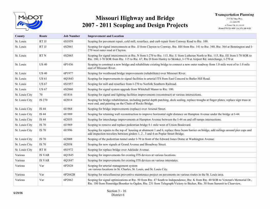
St. Louis RT JJ 6S1859 Scoping for pavement repair, cold mill, resurface, and curb repair from Conway Road to Rte. 100.
St. Louis RT JJ 6S2061 Scoping for signal interconnects at Rte. JJ from Clayton to Conway, Rte. HH from Rte. 141 to Rte. 340, Rte. 364 at Bennington and I-270 west outer road at Clayton.
St. Louis RT N 6S2065 Scoping for signal interconnects at Rte. N from I-270 to Rte. 115, Rte. U from Lutheran North to Rte. 115, Rte. EE from I-70 SOR to Rte. 180, I-70 SOR from Rte. 115 to Rte. 67, Rte D from Hanley to Skinker, I-170 at Airport Rd. interchange, I-270 at
St. Louis US 40 6P1436 Scoping to construct a new bridge and rehabilitate existing bridge to connect a new outer roadway from 1.0 mile west of to 1.0 mile east of Missouri River.
St. Louis US 40 6P1977 Scoping for westbound bridge improvements (rehabilitate) over Missouri River.
St. Louis US 61 6Q1843 Scoping for improvements to signal facilities to arterial ITS from East Concord to Butler Hill Road.
St. Louis US 67 6S1957 Scoping for mill and resurface from I-270 to Norfolk Southern Railroad.
St. Louis US 67 6S2060 Scoping for signal system upgrade from Whitehall Manor to Rte. 100.
St. Louis City 70 6I1816 Scoping for signal and lighting facilities improvements (reconstruct) at various intersections.
St. Louis City IS 270 6I2014 Scoping for bridge rehabilitation, including partial depth patching, deck sealing, replace troughs at finger plates, replace sign truss at west end, and painting on the Chain of Rocks Bridge.
St. Louis City IS 44 6I1968 Scoping for bridge improvements (replace) over Arsenal Street.
St. Louis City IS 44 6I1989 Scoping for retaining wall reconstruction to improve horizontal sight distance on Hampton Avenue under the bridge at I-44.
St. Louis City IS 44 6I2055 Scoping for interchange improvements at Hampton Avenue between the I-44 on and off-ramps intersections.
St. Louis City IS 70 6I1969 Scoping to remove and replace pedestrian bridge 0.1 mile west of Union Boulevard.
St. Louis City IS 70 6I1996 Scoping for repairs to the top of housing at abutment 1 and 6, replace three beam barrier on bridge, add railings around pier caps and add inspection travelers between girders 1, 2 , 3 and 4 on Poplar Street Bridge.
St. Louis City IS 70 6I2008 Scoping of the pedestrian tunnel under I-70 in front of the Edward Jones Dome at Washington Avenue.
St. Louis City IS 70 6I2058 Scoping for new signals at Grand Avenue and Broadway Street.
St. Louis City RT H 6S1972 Scoping for replace bridge over Adelaide Avenue.
Various IS VAR 6Q1845 Scoping for improvements for existing ITS devices at various locations.
Various IS VAR 6Q1847 Scoping for improvements for existing ITS devices on various interstates.
Various Var 6P2028 Scoping for arterial management system on various locations in St. Charles, St. Louis, and St. Louis City.
Various Var 6P2042B Scoping for miscellaneous preventive maintenace project on pavements on various routes in the St. Louis area.
Various Var 6P2062 Scoping for signal optimizations at Rte. 50 from Rte. 47 South to Independence, Rte. K from Rte. 40 SOR to Veteran's Memorial Dr., Rte. 180 from Pennridge/Boenker to Ogden, Rte. 231 from Telegraph/Victory to Becker, Rte. 30 from Summit to Clearview,
6/29/06Section 3 - 16
District 6
Missouri Highway and Bridge2007 - 2011 Scoping and Design Projects
County Route Job Number Improvement and Location
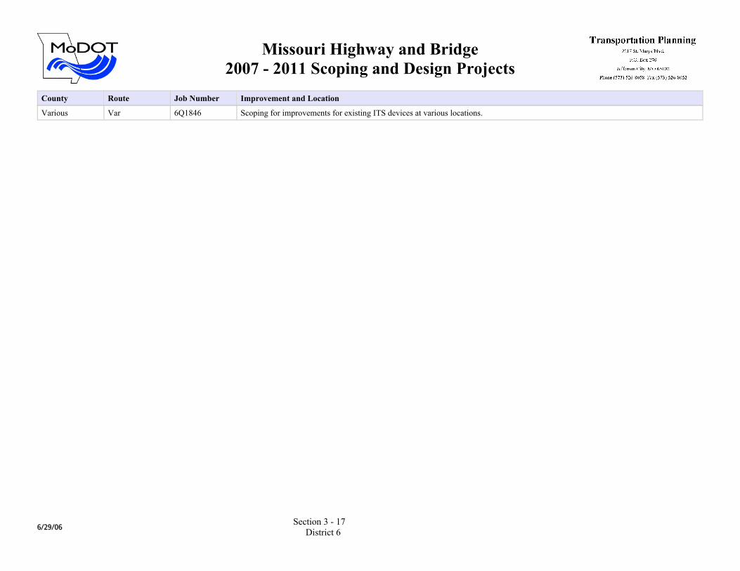
Various Var 6Q1846 Scoping for improvements for existing ITS devices at various locations.
6/29/06Section 3 - 17
District 6
Missouri Highway and Bridge2007 - 2011 Scoping and Design Projects
County Route Job Number Improvement and Location
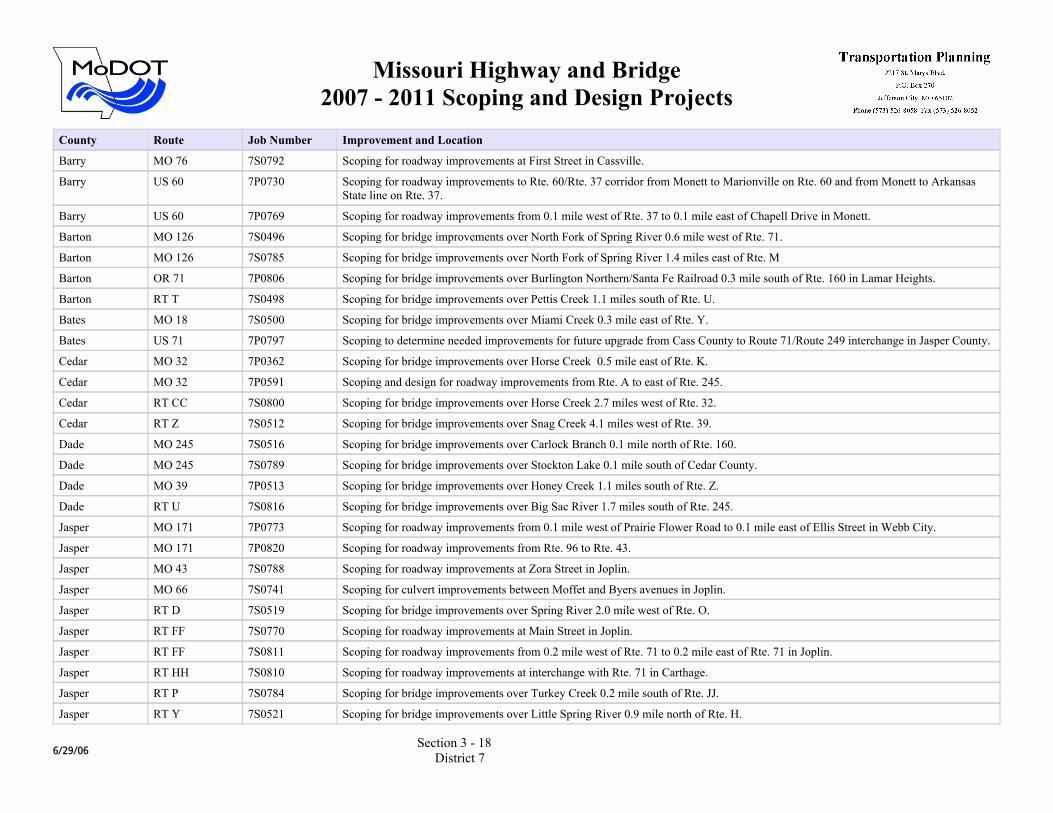
Barry MO 76 7S0792 Scoping for roadway improvements at First Street in Cassville.
Barry US 60 7P0730 Scoping for roadway improvements to Rte. 60/Rte. 37 corridor from Monett to Marionville on Rte. 60 and from Monett to Arkansas State line on Rte. 37.
Barry US 60 7P0769 Scoping for roadway improvements from 0.1 mile west of Rte. 37 to 0.1 mile east of Chapell Drive in Monett.
Barton MO 126 7S0496 Scoping for bridge improvements over North Fork of Spring River 0.6 mile west of Rte. 71.
Barton MO 126 7S0785 Scoping for bridge improvements over North Fork of Spring River 1.4 miles east of Rte. M
Barton OR 71 7P0806 Scoping for bridge improvements over Burlington Northern/Santa Fe Railroad 0.3 mile south of Rte. 160 in Lamar Heights.
Barton RT T 7S0498 Scoping for bridge improvements over Pettis Creek 1.1 miles south of Rte. U.
Bates MO 18 7S0500 Scoping for bridge improvements over Miami Creek 0.3 mile east of Rte. Y.
Bates US 71 7P0797 Scoping to determine needed improvements for future upgrade from Cass County to Route 71/Route 249 interchange in Jasper County.
Cedar MO 32 7P0362 Scoping for bridge improvements over Horse Creek 0.5 mile east of Rte. K.
Cedar MO 32 7P0591 Scoping and design for roadway improvements from Rte. A to east of Rte. 245.
Cedar RT CC 7S0800 Scoping for bridge improvements over Horse Creek 2.7 miles west of Rte. 32.
Cedar RT Z 7S0512 Scoping for bridge improvements over Snag Creek 4.1 miles west of Rte. 39.
Dade MO 245 7S0516 Scoping for bridge improvements over Carlock Branch 0.1 mile north of Rte. 160.
Dade MO 245 7S0789 Scoping for bridge improvements over Stockton Lake 0.1 mile south of Cedar County.
Dade MO 39 7P0513 Scoping for bridge improvements over Honey Creek 1.1 miles south of Rte. Z.
Dade RT U 7S0816 Scoping for bridge improvements over Big Sac River 1.7 miles south of Rte. 245.
Jasper MO 171 7P0773 Scoping for roadway improvements from 0.1 mile west of Prairie Flower Road to 0.1 mile east of Ellis Street in Webb City.
Jasper MO 171 7P0820 Scoping for roadway improvements from Rte. 96 to Rte. 43.
Jasper MO 43 7S0788 Scoping for roadway improvements at Zora Street in Joplin.
Jasper MO 66 7S0741 Scoping for culvert improvements between Moffet and Byers avenues in Joplin.
Jasper RT D 7S0519 Scoping for bridge improvements over Spring River 2.0 mile west of Rte. O.
Jasper RT FF 7S0770 Scoping for roadway improvements at Main Street in Joplin.
Jasper RT FF 7S0811 Scoping for roadway improvements from 0.2 mile west of Rte. 71 to 0.2 mile east of Rte. 71 in Joplin.
Jasper RT HH 7S0810 Scoping for roadway improvements at interchange with Rte. 71 in Carthage.
Jasper RT P 7S0784 Scoping for bridge improvements over Turkey Creek 0.2 mile south of Rte. JJ.
Jasper RT Y 7S0521 Scoping for bridge improvements over Little Spring River 0.9 mile north of Rte. H.
6/29/06Section 3 - 18
District 7
Missouri Highway and Bridge2007 - 2011 Scoping and Design Projects
County Route Job Number Improvement and Location
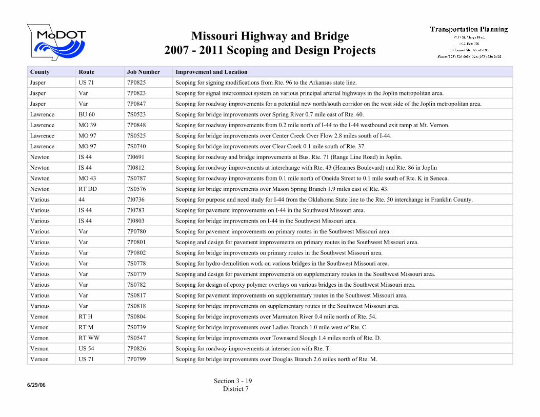
Jasper US 71 7P0825 Scoping for signing modifications from Rte. 96 to the Arkansas state line.
Jasper Var 7P0823 Scoping for signal interconnect system on various principal arterial highways in the Joplin metropolitan area.
Jasper Var 7P0847 Scoping for roadway improvements for a potential new north/south corridor on the west side of the Joplin metropolitan area.
Lawrence BU 60 7S0523 Scoping for bridge improvements over Spring River 0.7 mile east of Rte. 60.
Lawrence MO 39 7P0848 Scoping for roadway improvements from 0.2 mile north of I-44 to the I-44 westbound exit ramp at Mt. Vernon.
Lawrence MO 97 7S0525 Scoping for bridge improvements over Center Creek Over Flow 2.8 miles south of I-44.
Lawrence MO 97 7S0740 Scoping for bridge improvements over Clear Creek 0.1 mile south of Rte. 37.
Newton IS 44 7I0691 Scoping for roadway and bridge improvements at Bus. Rte. 71 (Range Line Road) in Joplin.
Newton IS 44 7I0812 Scoping for roadway improvements at interchange with Rte. 43 (Hearnes Boulevard) and Rte. 86 in Joplin
Newton MO 43 7S0787 Scoping for roadway improvements from 0.1 mile north of Oneida Street to 0.1 mile south of Rte. K in Seneca.
Newton RT DD 7S0576 Scoping for bridge improvements over Mason Spring Branch 1.9 miles east of Rte. 43.
Various 44 7I0736 Scoping for purpose and need study for I-44 from the Oklahoma State line to the Rte. 50 interchange in Franklin County.
Various IS 44 7I0783 Scoping for pavement improvements on I-44 in the Southwest Missouri area.
Various IS 44 7I0803 Scoping for bridge improvements on I-44 in the Southwest Missouri area.
Various Var 7P0780 Scoping for pavement improvements on primary routes in the Southwest Missouri area.
Various Var 7P0801 Scoping and design for pavement improvements on primary routes in the Southwest Missouri area.
Various Var 7P0802 Scoping for bridge improvements on primary routes in the Southwest Missouri area.
Various Var 7S0778 Scoping for hydro-demolition work on various bridges in the Southwest Missouri area.
Various Var 7S0779 Scoping and design for pavement improvements on supplementary routes in the Southwest Missouri area.
Various Var 7S0782 Scoping for design of epoxy polymer overlays on various bridges in the Southwest Missouri area.
Various Var 7S0817 Scoping for pavement improvements on supplementary routes in the Southwest Missouri area.
Various Var 7S0818 Scoping for bridge improvements on supplementary routes in the Southwest Missouri area.
Vernon RT H 7S0804 Scoping for bridge improvements over Marmaton River 0.4 mile north of Rte. 54.
Vernon RT M 7S0739 Scoping for bridge improvements over Ladies Branch 1.0 mile west of Rte. C.
Vernon RT WW 7S0547 Scoping for bridge improvements over Townsend Slough 1.4 miles north of Rte. D.
Vernon US 54 7P0826 Scoping for roadway improvements at intersection with Rte. T.
Vernon US 71 7P0799 Scoping for bridge improvements over Douglas Branch 2.6 miles north of Rte. M.
6/29/06Section 3 - 19
District 7
Missouri Highway and Bridge2007 - 2011 Scoping and Design Projects
County Route Job Number Improvement and Location
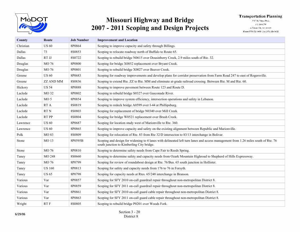
Christian US 60 8P0864 Scoping to improve capacity and safety through Billings.
Dallas 73 8S0853 Scoping to relocate roadway north of Buffalo to Route 65.
Dallas RT JJ 8S0722 Scoping to rebuild bridge N0615 over Dousinberry Creek, 2.9 miles south of Rte. 32.
Douglas MO 76 8P0800 Scoping for bridge X0852 replacement over Bryant Creek.
Douglas MO 76 8P0801 Scoping to rebuild bridge X0027 over Beaver Creek.
Greene US 60 8P0683 Scoping for roadway improvements and develop plans for corridor preservation from Farm Road 247 to east of Rogersville.
Greene ZZ AND MM 8S0836 Scoping to extend Rte. ZZ to Rte. MM and eliminate at-grade railroad crossing. Between Rte. M and Rte. 60.
Hickory US 54 8P0888 Scoping to improve pavement between Route 123 and Route D.
Laclede MO 32 8P0802 Scoping to rebuild bridge S0327 over Gasconade River.
Laclede MO 5 8P0854 Scoping to improve system efficiency, intersection operations and safety in Lebanon.
Laclede RT A 8S0819 Scoping to redeck bridge A0599 over I-44 at Phillipsburg.
Laclede RT N 8S0803 Scoping for replacement of bridge N0340 over Mill Creek.
Laclede RT PP 8S0804 Scoping for bridge W0521 replacement over Brush Creek.
Lawrence US 60 8P0687 Scoping for location study west of Marionville to Rte. 360.
Lawrence US 60 8P0865 Scoping to improve capacity and safety on the existing alignment between Republic and Marionville.
Polk MO 83 8S0809 Scoping for relocation of Rte. 83 from Rte 32/D intersecton to 83/13 interchange in Bolivar.
Stone MO 13 8P0595B Scoping and design for widening to 4 lanes with delineated left turn lanes and access management from 1.26 miles south of Rte. 76 south junction to Kimberling City bridge.
Stone MO 76 8P0810 Scoping to determine safety needs from Cape Fair to Reeds Spring.
Taney MO 248 8S0660 Scoping to determine safety and capacity needs from Ozark Mountain Highroad to Shepherd of Hills Expressway.
Taney MO 76 8P0799 Scoping for review of roundabout design at Rte. 76/Bus. 65 south junction in Hollister.
Taney US 160 8P0813 Scoping for safety and capacity needs from 176 to 76 in Forsyth.
Taney US 65 8P0798 Scoping for capacity needs at Rtes. 65/248 interchange in Branson.
Various Var 8P0857 Scoping for SFY 2010 on-call guardrail repair throughout non-metropolitan District 8.
Various Var 8P0859 Scoping for SFY 2011 on-call guardrail repair throughout non-metropolitan District 8.
Various Var 8P0861 Scoping for SFY 2010 on-call guard cable repair throughout non-metropolitan District 8.
Various Var 8P0863 Scoping for SFY 2011 on-call guard cable repair throughout non-metropolitan District 8.
Wright RT F 8S0805 Scoping to rebuild bridge P0201 over Woods Fork.
6/29/06Section 3 - 20
District 8

Missouri Highway and Bridge2007 - 2011 Scoping and Design Projects
County Route Job Number Improvement and Location
Christian MO 14 8P0588 Scoping for roadway improvements from west of Rte. 160 in Nixa to east of Rte. 65 in Ozark.
Christian MO 14 8P0786 Scoping for roadway safety improvements at Tiffany/Majestic Oak Drive in Nixa.
Christian RT CC 8S0736 Scoping for capacity improvements from Rte. 160 to Rte. 65.
Christian US 65 8P0605 Scoping to improve system efficiency and capacity from Valley Water Mill Road in Springfield to Rte. F in Ozark.
Greene 44 8I0860 Scoping for SFY 2010 on-call guard cable repair in the Ozarks Transportation Organization area.
Greene 44 8I0862 Scoping for SFY 2011 on-call guard cable repair in the Ozarks Transportation Organization area.
Greene BU 65 8P0789 Scoping for intersection improvements at Glenstone and Primrose in Springfield.
Greene MO 13 8P0841 Scoping to improve interchange capacity at I-44.
Greene MO 266 8S0851 Scoping to improve capacity on Chestnut Expressway at the I-44 interchange and between I-44 and Route AB.
Greene MO 744 8S0790 Scoping for intersection improvements at Kearney and National in Springfield.
Greene MO 744 8S0852 Scoping to determine pavement rehabilitation needs from Route 65 to Route OO.
Greene NEW 8S0795 Scoping to determine a roadway connection to serve new Midfield Terminal at Springfield/Branson National Airport.
Greene RT H 8S0724 Scoping to determine needs at interchange and intersections on Rte. H from north of FR 102 (Valley Water Mill) to south of I-44.
Greene RT M 8S0835 Scoping for adding turn lanes, signal at Republic High School.
Greene US 160 8P0896 Scoping to improve intersection capacity at Hughes Road in Willard.
Greene US 60 8P0683B Scoping for interchange and ramp improvements at Rte. 60/65 interchange in southeast Springfield.
Greene US 60 8P0683D Scoping for corridor preservation for Rtes. 60/J/NN interchange with corresponding outer roads from west of Highland Springs Road to east of Farm Road 213.
Greene US 60 8P0683E Scoping for corridor preservation for interchange at Route 125 and outer roads from west of FR 213 to FR 247.
Greene US 60 8P0791 Scoping to improve interchange safety and capacity at James River Freeway and National Avenue in Springfield.
Greene US 60 8P0792 Scoping to improve interchange safety and capacity at James River Freeway and Route 160 (Campbell Avenue) in Springfield.
Greene US 65 8P0850 Scoping to improve interchange capacity at Rte. Business 65 (Chestnut Expressway).
Greene Var 8P0760 Scoping for Transportation Management System software for congestion and incident management various routes in the Springfield area.
Greene Var 8P0830C Scoping for Field Device Development Deployment of Intelligent Transportation System in the Ozarks Transportation Organization Area on various routes in the Ozarks Transportation Organization area.
Various Var 8P0856 Scoping for SFY 2010 on-call guardrail repair in the Ozarks Transportation Organization area.
Various Var 8P0858 Scoping for SFY 2011 on-call guardrail repair in the Ozarks Transportation Organization area.
6/29/06Section 3 - 21
District 8 (TMA)
Missouri Highway and Bridge2007 - 2011 Scoping and Design Projects
County Route Job Number Improvement and Location
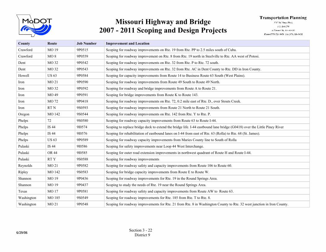
Crawford MO 19 9P0515 Scoping for roadway improvements on Rte. 19 from Rte. PP to 2.5 miles south of Cuba.
Crawford MO 8 9P0559 Scoping for roadway improvement on Rte. 8 from Rte. 19 north in Steelville to Rte. AA west of Potosi.
Dent MO 32 9P0542 Scoping for roadway improvements on Rte. 32 from Rte. P to Rte. 72 south.
Dent MO 32 9P0543 Scoping for roadway improvements on Rte. 32 from Rte. AC in Dent County to Rte. DD in Iron County.
Howell US 63 9P0584 Scoping for capacity improvements from Route 14 to Business Route 63 South (West Plains).
Iron MO 21 9P0590 Scoping for roadway improvements from Route 49 South to Route 49 North.
Iron MO 32 9P0592 Scoping for roadway and bridge improvements from Route A to Route 21.
Iron MO 49 9P0591 Scoping for bridge improvements from Route K to Route 143.
Iron MO 72 9P0418 Scoping for roadway improvements on Rte. 72, 0.2 mile east of Rte. D., over Stouts Creek.
Iron RT N 9S0593 Scoping for roadway improvements from Route 21 North to Route 21 South.
Oregon MO 142 9S0544 Scoping for roadway improvements on Rte. 142 from Rte. Y to Rte. P.
Phelps 72 9S0580 Scoping for roadway capacity improvements from Route 63 to Route I-44.
Phelps IS 44 9I0574 Scoping to replace bridge deck to extend the bridge life. I-44 eastbound lane bridge (G0418) over the Little Piney River
Phelps IS 44 9I0576 Scoping for rehabilitation of eastbound lanes on I-44 from east of Rte. 63 (Rolla) to Rte. 68 (St. James).
Phelps US 63 9P0589 Scoping for roadway capacity improvements from Maries County line to South of Rolla
Pulaski IS 44 9I0586 Scoping for safety improvements near Loop 44 West Interchange.
Pulaski OR 44 9I0585 Scoping for outer road extension improvements in northwest quadrant of Route H and Route I-44.
Pulaski RT Y 9S0588 Scoping for roadway improvements
Reynolds MO 21 9P0582 Scoping for roadway safety and capacity improvements from Route 106 to Route 60.
Ripley MO 142 9S0583 Scoping for bridge capacity improvements from Route E to Route W.
Shannon MO 19 9P0436 Scoping for roadway improvements for Rte. 19 in the Round Springs Area.
Shannon MO 19 9P0437 Scoping to study the needs of Rte. 19 near the Round Springs Area.
Texas MO 17 9P0581 Scoping for roadway safety and capacity improvements from Route AW to Route 63.
Washington MO 185 9S0549 Scoping for roadway improvements for Rte. 185 from Rte. T to Rte. 8.
Washington MO 21 9P0548 Scoping for roadway improvements for Rte. 21 from Rte. 8 in Washington County to Rte. 32 west junction in Iron County.
6/29/06Section 3 - 22
District 9
Missouri Highway and Bridge2007 - 2011 Scoping and Design Projects
County Route Job Number Improvement and Location
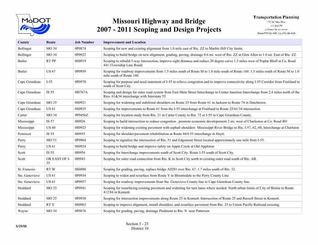
Bollinger MO 34 0P0874 Scoping for new and existing alignment from 1.0 mile east of Rte. ZZ to Marble Hill City limits.
Bollinger MO 34 0P0922 Scoping to build bridge on new alignment, grading, paving, drainage 0.6 mi. west of Rte. ZZ at Glen Allen to 1.0 mi. East of Rte. ZZ
Butler RT PP 0S0919 Scoping to rebuild 5-way intersection, improve sight distance and reduce 20 degree curve 1.5 miles west of Poplar Bluff at Co. Road 441 (Township Line Road)
Butler US 67 0P0959 Scoping for roadway improvements from 1.5 miles south of Route M to 1.0 mile south of Route 160. 1.5 miles south of Route M to 1.0 mile south of Route 160.
Cape Girardeau I-55 0P0970 Scoping for purpose and need statement of I-55 to relieve congestion and to improve connectivity along I-55 Corridor from Fruitland to south of Scott City.
Cape Girardeau IS 55 0I0767A Scoping and design for outer road system from East Main Street Interchange to Center Junction Interchange from 2.4 miles north of the Rtes. 61&34 interchange with Interstate 55.
Cape Girardeau MO 25 0S0921 Scoping for widening and stabilized shoulders on Route 25 from Route 61 in Jackson to Route 74 in Dutchtown.
Cape Girardeau US 61 0S0935 Scoping for improvements to Route 61 from the I-55 interchange at Fruitland to Route 25/61/34 intersection
Carter MO 34 9P0456Z Scoping for location study from Rte. 21 in Carter County to Rte. 72 or I-55 in Cape Girardeau County.
Mississippi IS 57 0I0926 Scoping to build intersection to reduce congestion , promote economic developement 2 mi. west of Charleston at Co. Road 401
Mississippi US 60 0S0923 Scoping for widening existing pavement with asphalt shoulders Mississippi River Bridge to Rte. I-57, 62, 60, Interchange at Charlston
Pemiscot IS 55 0I0955 Scoping for shoulder/pavement rehabilitation at Route 84/I-55 interchange in Hayti.
Perry MO 51 0P0964 Scoping to signalize the intersection of Rte. 51 and Edgemont Street located approximately one mile from I-55.
Perry US 61 0S0924 Scoping to build bridge and improve safety on Apple Creek at Old Appleton
Scott IS 55 0I0956 Scoping for interchange improvements south of Scott City. Route I-55 south of Scott City.
Scott OR EAST OF I-55
0I0943 Scoping for outer road connection from Rte. K in Scott City north to existing outer road south of Rte. AB.
St. Francois RT W 0S0880 Scoping for grading, paving, replace bridge A0281 over Rte. 67, 1.7 miles south of Rte. 32.
Ste. Genevieve US 61 0P0934 Scoping to widen and resurface from Route Y in Bloomsdale to the Perry County Line
Ste. Genevieve US 61 0P0957 Scoping for roadway improvements from Ste. Genevieve County line to Cape Girardeau County line.
Stoddard MO 25 0P0941 Scoping for resurfacing existing pavement and widening for turn lanes where needed. North urban limits of City of Bernie to Route 412/84 in Kennett.
Stoddard MO 25 0P0958 Scoping for intersection improvements along Route 25 in Kennett. Intersection of Route 25 and Russell Street in Kennett.
Stoddard RT Y 0S0963 Scoping to improve alignment, install shoulders, and resurface pavement from Rte. 25 to Union Pacific Railroad crossing.
Wayne MO 34 0P0876 Scoping for grading, paving, drainage Piedmont to Rte. N near Patterson
6/29/06Section 3 - 23
District 10
Related Documents