PROCEEDINGS, 42nd Workshop on Geothermal Reservoir Engineering Stanford University, Stanford, California, February 13-15, 2017 SGP-TR-212 1 Hg air Survey at Makaroyen Village in Kotamobagu Geothermal Field, North Sulawesi, Indonesia Hendra Riogilang Sam Ratulangi University, Dept. of Civil Engineering, Indonesia Campus Unsrat Street Bahu Manado North Sulawesi, 95115 Indonesia Kyushu University, Earth Resources Engineering Department, Kyushu Japan E-mail: [email protected] Keywords: Kotamobagu, Survey, Potency, Geothermal Field, Hg air ABSTRACT Kotamobagu geothermal field is one of the prospects of geothermal development in North Sulawesi, Indonesia. We conducted soil air gas (Hg air) survey in Kotamobagu, mainly within Makaroyen village, on the foot of Ambang Mountain. Concentrations of Hg air, were measured for 20 sampling points in the area of 1.0 km EW and 1.0 km NW with elevation around 1000 m above sea level. High concentrations of Hg air, 2.40 to 2.72 ng/day, were mainly measured in the center and northeast of the study area whereas lower concentrations to the south and to the west. High concentration of Hg air above 2.40 ng/day was detected in the center and northeast of the area Makaroyen village. The presence of flow path of high temperature fluid and heat source is expected below the areas with high concentrations of Hg air. 1. INTRODUCTION Kotamobagu geothermal field lies on the southern slope of Ambang Volcano in North Sulawesi Province, Indonesia, 200 km to the southwest of Manado city, capital of the province. The field has been proved to be one of the geothermal prospects in Indonesia (Hochstein and Sudarman, 2008). PT. Pertamina Geothermal Energy (PT.PGE) has conducted reconnaissance and feasibility studies in Kotamobagu and concluded that the field has high potential for power generation. PT. PGE also conducted a research on environmental impact upon development and issued a document related to the environmental impact, which is one of the requirements by Indonesian government for starting geothermal development project in Kotamobagu. In geothermal exploration, geochemical methods such as soil air gas surveys have been recognized as an excellent tool to find the locations of subsurface heat source and of faults or fractures that act as pathway for geothermal fluid (Koga, 1984). The mercury is one of the volatile materials found in fumarole gas. It is transferred directly upward from a heat source by advection of geothermal fluid and by diffusion as well (Koga and Noda, 1975; Varekamp and Buseck, 1983). The volatility of Hg is useful for geothermal exploration. The high vapor pressure of Hg makes it extremely mobile, and the high temperatures near a geothermal reservoir tend to increase this mobility. Hg migrates upwards and is released from the geothermal reservoir. In the soil, overburden layer of geothermal areas, should be enriched in Hg. Mercury deposits typically occur in the regions containing evidence of geothermal activity such as hot springs. For instance in the Geysers California; Wairakei, New Zealand; Geyser, Iceland; Larderello, Italy; and Kamchatka, Russia (Matlick and Buseck, 1975). In this study, we have carried out soil air gas surveys including Mercury air (Hg air). The area for soil air gas survey mainly lies within Makaroyen village and the area is covered by mainly house of local people and paddy field and wild grassing with elevation around 1000 m above sea level. The area survey is choosing at Makaroyen village because in this area had crossed of fault by direction northeast to southwest. In this area of 1.0 km EW and 1.0 km NW, we measured gas Hg concentrations of soil air. 2. GEOLOGY 2.1 Geological Section Survey area locates in the Eastern Kotamobagu city mainly lies at Makaroyen village on the slope of Ambang Mountain (Fig. 1). The lithology consist of the Tertiary and the Quaternary rocks. Tertiary sedimentary rocks consist of shale and sandstone with intercalation of limestone and chert, and are overlain by Tertiary and Quaternary volcanic rocks. The Tertiary volcanic rocks are products of Old volcano consisting of breccia, tuff and andesitic lava, dacite and rhyolite. Ambang Volcano and Lake Deposits of Quaternary overlain the Tertiary volcanic rocks in Liberia village. Ambang volcanic unit consists of tuff, agglomerate, lahar, lava, and sulfur deposit within a crater of Ambang volcano. Southern side of Ambang Volcano, Lake Deposits unit consist of grey clay stone, plant remnants and lignite. The survey area partly locates within tuff pumice. Geological map is shown in Fig.2 with cross section and lithologies. 2.2 Geological Structure Fault in Kotamobagu had directions northwest to southwest, northeast to southwest and west to east. Fracture with direction west to east which is crossing the sedimentary rocks controls the appearance of Pusian and Bakan hot springs (PT.PGE, 2005). Fracture with

Welcome message from author
This document is posted to help you gain knowledge. Please leave a comment to let me know what you think about it! Share it to your friends and learn new things together.
Transcript
PROCEEDINGS, 42nd Workshop on Geothermal Reservoir Engineering
Stanford University, Stanford, California, February 13-15, 2017
SGP-TR-212
1
Hg air Survey at Makaroyen Village in Kotamobagu Geothermal Field, North Sulawesi,
Indonesia
Hendra Riogilang
Sam Ratulangi University, Dept. of Civil Engineering, Indonesia
Campus Unsrat Street Bahu Manado North Sulawesi, 95115 Indonesia
Kyushu University, Earth Resources Engineering Department, Kyushu Japan
E-mail: [email protected]
Keywords: Kotamobagu, Survey, Potency, Geothermal Field, Hgair
ABSTRACT
Kotamobagu geothermal field is one of the prospects of geothermal development in North Sulawesi, Indonesia. We conducted soil air
gas (Hg air) survey in Kotamobagu, mainly within Makaroyen village, on the foot of Ambang Mountain. Concentrations of Hg air, were
measured for 20 sampling points in the area of 1.0 km EW and 1.0 km NW with elevation around 1000 m above sea level. High
concentrations of Hg air, 2.40 to 2.72 ng/day, were mainly measured in the center and northeast of the study area whereas lower
concentrations to the south and to the west. High concentration of Hg air above 2.40 ng/day was detected in the center and northeast of
the area Makaroyen village. The presence of flow path of high temperature fluid and heat source is expected below the areas with high
concentrations of Hg air.
1. INTRODUCTION
Kotamobagu geothermal field lies on the southern slope of Ambang Volcano in North Sulawesi Province, Indonesia, 200 km to the
southwest of Manado city, capital of the province. The field has been proved to be one of the geothermal prospects in Indonesia
(Hochstein and Sudarman, 2008). PT. Pertamina Geothermal Energy (PT.PGE) has conducted reconnaissance and feasibility studies in
Kotamobagu and concluded that the field has high potential for power generation. PT. PGE also conducted a research on environmental
impact upon development and issued a document related to the environmental impact, which is one of the requirements by Indonesian
government for starting geothermal development project in Kotamobagu.
In geothermal exploration, geochemical methods such as soil air gas surveys have been recognized as an excellent tool to find the
locations of subsurface heat source and of faults or fractures that act as pathway for geothermal fluid (Koga, 1984). The mercury is one
of the volatile materials found in fumarole gas. It is transferred directly upward from a heat source by advection of geothermal fluid and
by diffusion as well (Koga and Noda, 1975; Varekamp and Buseck, 1983). The volatility of Hg is useful for geothermal exploration.
The high vapor pressure of Hg makes it extremely mobile, and the high temperatures near a geothermal reservoir tend to increase this
mobility. Hg migrates upwards and is released from the geothermal reservoir. In the soil, overburden layer of geothermal areas, should
be enriched in Hg. Mercury deposits typically occur in the regions containing evidence of geothermal activity such as hot springs. For
instance in the Geysers California; Wairakei, New Zealand; Geyser, Iceland; Larderello, Italy; and Kamchatka, Russia (Matlick and
Buseck, 1975).
In this study, we have carried out soil air gas surveys including Mercury air (Hg air). The area for soil air gas survey mainly lies within
Makaroyen village and the area is covered by mainly house of local people and paddy field and wild grassing with elevation around
1000 m above sea level. The area survey is choosing at Makaroyen village because in this area had crossed of fault by direction
northeast to southwest. In this area of 1.0 km EW and 1.0 km NW, we measured gas Hg concentrations of soil air.
2. GEOLOGY
2.1 Geological Section
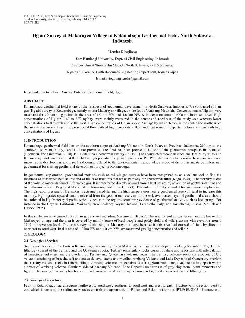
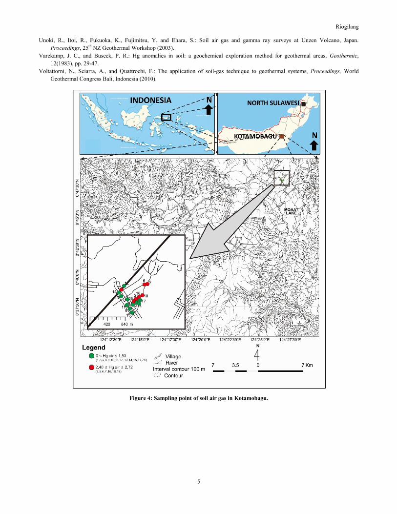
Survey area locates in the Eastern Kotamobagu city mainly lies at Makaroyen village on the slope of Ambang Mountain (Fig. 1). The
lithology consist of the Tertiary and the Quaternary rocks. Tertiary sedimentary rocks consist of shale and sandstone with intercalation
of limestone and chert, and are overlain by Tertiary and Quaternary volcanic rocks. The Tertiary volcanic rocks are products of Old
volcano consisting of breccia, tuff and andesitic lava, dacite and rhyolite. Ambang Volcano and Lake Deposits of Quaternary overlain
the Tertiary volcanic rocks in Liberia village. Ambang volcanic unit consists of tuff, agglomerate, lahar, lava, and sulfur deposit within
a crater of Ambang volcano. Southern side of Ambang Volcano, Lake Deposits unit consist of grey clay stone, plant remnants and
lignite. The survey area partly locates within tuff pumice. Geological map is shown in Fig.2 with cross section and lithologies.
2.2 Geological Structure
Fault in Kotamobagu had directions northwest to southwest, northeast to southwest and west to east. Fracture with direction west to
east which is crossing the sedimentary rocks controls the appearance of Pusian and Bakan hot springs (PT.PGE, 2005). Fracture with
Riogilang
2
direction northwest to southeast controls the appearance of Lobong hot spring. Fumaroles appearances are controlled by fracture, with
direction northeast to southwest (PT.PGE, 2005).
Figure 1: Located of survey
Riogilang
3
Figure 2: Geological map
3. MEASUREMENT METHODS
Survey area locates in the Eastern Kotamobagu city mainly lies at Makaroyen village on the slope of Ambang Mountain (Fig. 1). Soil
air gas was measured at 20 points, mainly in Makaroyen village (Fig.1). The measurements were made at intervals from 50 to 200 m.
Concentration of Hg air was measured at each point where the hole of 60 cm depth and 5 cm diameter was made by hammering steel
pipe into the ground. The temperature inside and outside of hole was measured using thermometer. The gold wire (1.5g, 10cm) was
hung in the hole whose inlet was capped with a plastic plate and covered with soil for preventing air communication between the hole
and atmosphere. The wire was left for a week for soil air Hg, then it was collected and stored in a glass tube that was tightly sealed. The
gold wire was analyzed for mercury with Atomic Absorption Spectrometer (Mercury SP3 Nippon Instruments Co.) in the laboratory.
4. RESULTS AND DISCUSSION
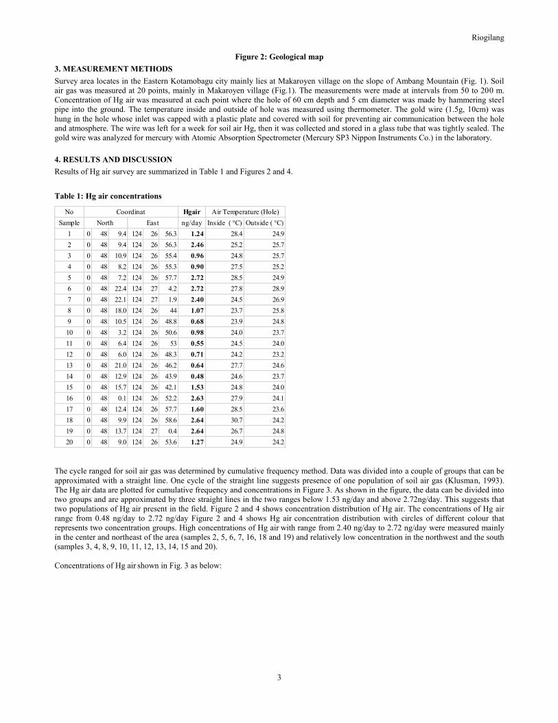
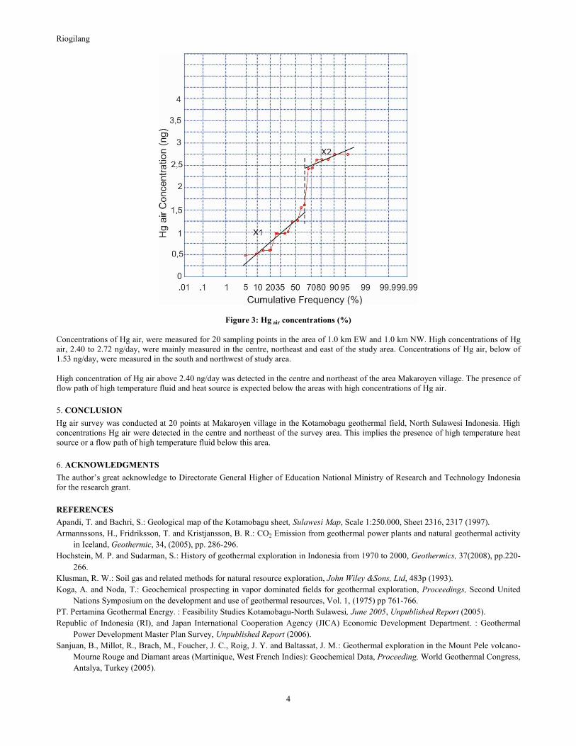
Results of Hg air survey are summarized in Table 1 and Figures 2 and 4.
Table 1: Hg air concentrations
The cycle ranged for soil air gas was determined by cumulative frequency method. Data was divided into a couple of groups that can be
approximated with a straight line. One cycle of the straight line suggests presence of one population of soil air gas (Klusman, 1993).
The Hg air data are plotted for cumulative frequency and concentrations in Figure 3. As shown in the figure, the data can be divided into
two groups and are approximated by three straight lines in the two ranges below 1.53 ng/day and above 2.72ng/day. This suggests that
two populations of Hg air present in the field. Figure 2 and 4 shows concentration distribution of Hg air. The concentrations of Hg air
range from 0.48 ng/day to 2.72 ng/day Figure 2 and 4 shows Hg air concentration distribution with circles of different colour that
represents two concentration groups. High concentrations of Hg air with range from 2.40 ng/day to 2.72 ng/day were measured mainly
in the center and northeast of the area (samples 2, 5, 6, 7, 16, 18 and 19) and relatively low concentration in the northwest and the south
(samples 3, 4, 8, 9, 10, 11, 12, 13, 14, 15 and 20).
Concentrations of Hg air shown in Fig. 3 as below:
No Hgair
Sample ng/day Inside ( °C) Outside ( °C)
1 0 48 9.4 124 26 56.3 1.24 28.4 24.9
2 0 48 9.4 124 26 56.3 2.46 25.2 25.7
3 0 48 10.9 124 26 55.4 0.96 24.8 25.7
4 0 48 8.2 124 26 55.3 0.90 27.5 25.2
5 0 48 7.2 124 26 57.7 2.72 28.5 24.9
6 0 48 22.4 124 27 4.2 2.72 27.8 28.9
7 0 48 22.1 124 27 1.9 2.40 24.5 26.9
8 0 48 18.0 124 26 44 1.07 23.7 25.8
9 0 48 10.5 124 26 48.8 0.68 23.9 24.8
10 0 48 3.2 124 26 50.6 0.98 24.0 23.7
11 0 48 6.4 124 26 53 0.55 24.5 24.0
12 0 48 6.0 124 26 48.3 0.71 24.2 23.2
13 0 48 21.0 124 26 46.2 0.64 27.7 24.6
14 0 48 12.9 124 26 43.9 0.48 24.6 23.7
15 0 48 15.7 124 26 42.1 1.53 24.8 24.0
16 0 48 0.1 124 26 52.2 2.63 27.9 24.1
17 0 48 12.4 124 26 57.7 1.60 28.5 23.6
18 0 48 9.9 124 26 58.6 2.64 30.7 24.2
19 0 48 13.7 124 27 0.4 2.64 26.7 24.8
20 0 48 9.0 124 26 53.6 1.27 24.9 24.2
Air Temperature (Hole)
North East
Coordinat
Riogilang
4
Figure 3: Hg air concentrations (%)
Concentrations of Hg air, were measured for 20 sampling points in the area of 1.0 km EW and 1.0 km NW. High concentrations of Hg
air, 2.40 to 2.72 ng/day, were mainly measured in the centre, northeast and east of the study area. Concentrations of Hg air, below of
1.53 ng/day, were measured in the south and northwest of study area.
High concentration of Hg air above 2.40 ng/day was detected in the centre and northeast of the area Makaroyen village. The presence of
flow path of high temperature fluid and heat source is expected below the areas with high concentrations of Hg air.
5. CONCLUSION
Hg air survey was conducted at 20 points at Makaroyen village in the Kotamobagu geothermal field, North Sulawesi Indonesia. High
concentrations Hg air were detected in the centre and northeast of the survey area. This implies the presence of high temperature heat
source or a flow path of high temperature fluid below this area.
6. ACKNOWLEDGMENTS
The author’s great acknowledge to Directorate General Higher of Education National Ministry of Research and Technology Indonesia
for the research grant.
REFERENCES
Apandi, T. and Bachri, S.: Geological map of the Kotamobagu sheet, Sulawesi Map, Scale 1:250.000, Sheet 2316, 2317 (1997).
Armannssons, H., Fridriksson, T. and Kristjansson, B. R.: CO2 Emission from geothermal power plants and natural geothermal activity
in Iceland, Geothermic, 34, (2005), pp. 286-296.
Hochstein, M. P. and Sudarman, S.: History of geothermal exploration in Indonesia from 1970 to 2000, Geothermics, 37(2008), pp.220-
266.
Klusman, R. W.: Soil gas and related methods for natural resource exploration, John Wiley &Sons, Ltd, 483p (1993).
Koga, A. and Noda, T.: Geochemical prospecting in vapor dominated fields for geothermal exploration, Proceedings, Second United
Nations Symposium on the development and use of geothermal resources, Vol. 1, (1975) pp 761-766.
PT. Pertamina Geothermal Energy. : Feasibility Studies Kotamobagu-North Sulawesi, June 2005, Unpublished Report (2005).
Republic of Indonesia (RI), and Japan International Cooperation Agency (JICA) Economic Development Department. : Geothermal
Power Development Master Plan Survey, Unpublished Report (2006).
Sanjuan, B., Millot, R., Brach, M., Foucher, J. C., Roig, J. Y. and Baltassat, J. M.: Geothermal exploration in the Mount Pele volcano-
Mourne Rouge and Diamant areas (Martinique, West French Indies): Geochemical Data, Proceeding, World Geothermal Congress,
Antalya, Turkey (2005).
Riogilang
5
Unoki, R., Itoi, R., Fukuoka, K., Fujimitsu, Y. and Ehara, S.: Soil air gas and gamma ray surveys at Unzen Volcano, Japan.
Proceedings, 25th NZ Geothermal Workshop (2003).
Varekamp, J. C., and Buseck, P. R.: Hg anomalies in soil: a geochemical exploration method for geothermal areas, Geothermic,
12(1983), pp. 29-47.
Voltattorni, N., Sciarra, A., and Quattrochi, F.: The application of soil-gas technique to geothermal systems, Proceedings, World
Geothermal Congress Bali, Indonesia (2010).
Figure 4: Sampling point of soil air gas in Kotamobagu.
Related Documents