Hartwell Neighborhood Business District Plan Approved by Cincinnati City Council April 25, 2012

Welcome message from author
This document is posted to help you gain knowledge. Please leave a comment to let me know what you think about it! Share it to your friends and learn new things together.
Transcript
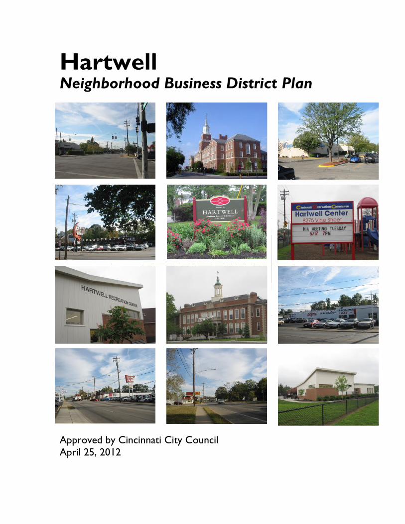
Hartwell Neighborhood Business District Plan
Approved by Cincinnati City Council
April 25, 2012


Table of Contents
Acknowledgements 3
Executive Summary 5
Introduction 9
Background 9
The Study Area 10
Prior Studies 10
History of Hartwell 17
Existing Conditions 21
Vision and Goal 23
Assets and Challenges 25
Issue Areas 27
Goals 28
Objectives and Strategies 29
Action Plan 33

Hartwell Neighborhood Business District Plan
2
Hartwell Neighborhood Business District Plan
3
Acknowledgements
The City Planning Department prepared this plan
with assistance from the Department of
Community Development.
The planning process was lead by the Hartwell
NBD Planning Committee - a group of Hartwell
Improvement Association (HIA) members,
Hartwell residents, property owners, and business
owners.
Hartwell NBD Planning Committee
Pastor Jim Fryer, HIA President
Pam Jackson, HIA Corresponding Secretary
Lois Smith, HIA Treasurer
Peggy Nestor HIA Recording Secretary
Jane Messingschlager, HIA Membership Director
Dawn Longworth, HIA Past President
Paul Colborn, HIA Past Vice President
Phil Kupper, HIA Past Recording Secretary
Bart Alford, Alford Motors
Dee Atkinson
Mike Blevins
Rose Burlingame
Melissa Davis, National City Bank / PNC Bank
Andrea Evans
Lynn Kupper
Pastor Jim Fryer
Teresa Keith
Loretta Lewis
Rob Monteserin
Jim Smith
Angie Strunc
Bob Strunc
Dan Torbeck, Torbeck Auto
Cynthia Walker, Drake Center
City of Cincinnati City Council
Mayor Mark Mallory
Vice Mayor Roxanne Qualls
President Pro-Tem Cecil Thomas
Councilmember Laure Quinlivan
Councilmember Chris Seelbach
Councilmember Yvette Simpson
Councilmember PG Sittenfeld
Councilmember Christopher Smitherman
Councilmember Charlie Winburn
Councilmember Wendell Young
City of Cincinnati City Planning Commission
Caleb Faux, Chair
Christie Bryant
City Manager Milton Dohoney
Michaele Pride
Vice Mayor Roxanne Qualls
John Schneider
Rainer vom Hofe
Staff from the City of Cincinnati
Milton Dohoney, City Manager
Charles C. Graves, III, Director, Department of City
Planning and Buildings
Michael Cervay, Director, Department of Community
Development
Margaret Wuerstle, Chief Planner, Department of
City Planning and Buildings
Bill Fischer, Business Development Division
Manager, Department of Community Development
Rick Hardy, Senior Community Development
Analyst, Department of Community Development
Greg Koehler, Community Development Analyst,
Department of Community Development
Deepika Andavarapu, Intern, Department of City
Planning and Buildings
Katherine Keough-Jurs, Senior City Planner,
Department of City Planning and Buildings

Hartwell Neighborhood Business District Plan
4

Hartwell Neighborhood Business District Plan
5
Executive Summary
The Hartwell neighborhood has a unique location:
as the northernmost neighborhood in our City it is
immediately surrounded not only by the Cincinnati
neighborhoods of Carthage, Roselawn and Bond
Hill, but also by the cities of Wyoming and
Arlington Heights, the Village of Lockland, and
Springfield Township.
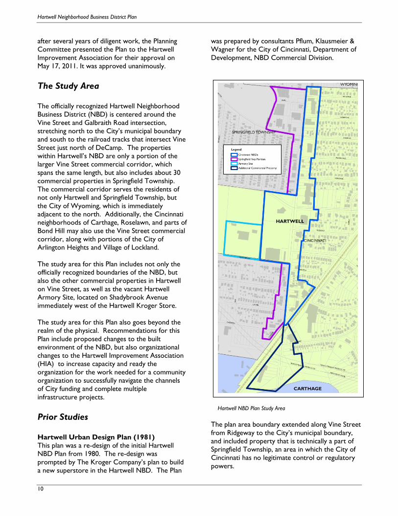
The Study Area The officially recognized Hartwell Neighborhood
Business District (NBD) is centered around the
Vine Street and Galbraith Road intersection,
stretching north to the City’s municipal boundary
and south to the railroad tracks that intersect Vine
Street just north of DeCamp. The properties
within Hartwell’s NBD are only a portion of the
larger Vine Street commercial corridor, which
spans the same length, but also includes about 30
commercial properties in Springfield Township.
The commercial corridor serves the residents of
not only Hartwell and Springfield Township, but
the other surrounding neighborhoods and
municipalities.
The study area for this Plan includes not only the
officially recognized boundaries of the NBD, but
also the other commercial properties in Hartwell
on Vine Street, as well as the vacant Hartwell
Armory Site, located on Shadybrook Avenue
immediately west of the Hartwell Kroger Store.
The study area for this Plan also goes beyond the
realm of the physical. Recommendations for this
Plan include proposed changes to the built
environment of the NBD, but also organizational
changes to the Hartwell Improvement Association
(HIA) to increase capacity and ready the
organization for the work needed for a community
organization to successfully navigate the channels
of City funding and complete multiple
infrastructure projects.
The Neighborhood Business District The Hartwell Neighborhood Business District
(NBD) is the center of the Hartwell community.
The Hartwell Elementary School and the Hartwell
Recreation Center are located at the primary
intersection of Vine Street and Galbraith Road.
One of the greatest assets of the Hartwell NBD is
its location, with easy access and high visibility.
Located within just 5 miles of the NBD are 13 of
Cincinnati’s neighborhoods, 15 other
Neighborhood Business Districts, and 17 other
municipalities and townships in Hamilton County.
Hartwell NBD Plan Study Area

Hartwell Neighborhood Business District Plan
6
Within one mile, there are more than 15,000
residents living in over 7,700 housing units. Also
within that mile, there are over 2,300 housing units
with no access to a vehicle within the City of
Cincinnati alone, making the .accessibility of the
local services provided within the NBD essential to
the daily lives of local residents.
There is convenient access to both Interstate 75
and Ronald Reagan Cross County Highway, and an
estimated 15,000 cars that travel through the Vine
and Galbraith intersection each day.
Another important asset is the strength of the
NBD’s existing businesses. While there is the
potential for infill development, consolidation of
property, elimination of curb cuts, and improved
maintenance and landscaping, these improvements
would be building on a strong core.
Although the primary intersection of Vine Street
and Galbraith Road appears to be somewhat
fractured due to the unusual island in the center of
the intersection, it is anchored by three very
strong uses: a recently built Walgreens store at the
southeast corner, a newly renovated Hartwell
Recreation Center at the southwest corner, and
the newly renovated Hartwell Elementary School
at the northeast corner.
Additionally, the NBD boasts another pharmacy (a
CVS), a bank, a Kroger grocery store, which has
become more regionally important since the
recent closing of the Roselawn Kroger store, as
well as several restaurants. Other unique uses
include the Friends of the Public Library building as
well as the Country Fresh Market, an independent
produce market (located in Springfield Township).
Hartwell’s location in the Cincinnati Region.

Hartwell Neighborhood Business District Plan
7
At the southern end of the NBD, there are several
automobile dealerships and repair shops. Alford
Motors and Torbeck’s Auto (which is located in
Springfield Township) are reminiscent of the
history of Vine Street as a destination for auto
sales and repairs for many decades. These two
community staples have worked to maintain the
appearance of their own properties, and in doing
so have inspired other property owners at the
south end of the NBD to make improvements.
Due west of the NBD, the Drake Center is home
to a medical facility offering long-term acute
rehabilitation, transitional nursing and therapy care,
and assisted living for seniors. Additionally, Drake
provides outpatient services, wellness services for
the community, and on-site research studies.
While not technically located within the NBD, it is
one of the area’s largest employers and
undoubtedly has the potential to have a positive
impact on the businesses in the Hartwell NBD.
These assets are building blocks for future
improvements in the Hartwell NBD. While many
NBDs in Cincinnati struggle with retaining stable
businesses and basic property maintenance,
Hartwell is fortunate to be home to numerous
strong businesses and other community uses. With
this strong base, basic infrastructure improvements
and regulatory and design considerations can have
a significant impact.
The Vision and Goals
The overall Vision for the Neighborhood Business
District follows:
The Vision
The Hartwell NBD on the Vine Street Commercial
Corridor is a unique, vibrant, regional-serving
business district. It features clean, attractive, safe
and walkable streets; strong, vital and active local
and national businesses; historic and renowned
local and regional institutions; and is a hub of
neighborhood activity for residents of Hartwell,
and also serves Wyoming and Springfield
Township, Arlington Heights, Carthage, and
Roselawn.
The Overall Goal
The Hartwell NBD on the Vine Street Commercial
Corridor will achieve its Vision by:
Leveraging the recent major improvements to
the Hartwell Elementary School and Hartwell
Recreation Center;
Taking advantage of its prime location, solid
residential base, and strong existing businesses
and institutions; and,
Strengthening its community and business
organizations to systematically make
improvements to public spaces, encourage
redevelopment of key properties, and further
stabilize the district.
The Five Goals
The Goals for the Hartwell Neighborhood
Business District Plan are as follows:
1. Reinforce the role of the community
organizations in implementing changes in
Hartwell
2. Improve the Visual Appearance of the NBD
and encourage better Property Maintenance
3. Encourage future development and ensure that
it is sensitive to the character of the Hartwell
NBD and enhances the walkability of the Vine
Street Corridor.
4. Make the Vine/Galbraith Intersection more
attractive, as well as safer for both vehicular
and pedestrian traffic.
5. Redevelop the Armory Site.

Hartwell Neighborhood Business District Plan
8

Hartwell Neighborhood Business District Plan
9
Introduction
Background
The Hartwell neighborhood began actively planning
the future of its Neighborhood Business District
(NBD) in 2004. Working with GroundWork
Design Collaborative LLC, Hartwell residents and
business owners met during the fall of 2004 to
participate in a visioning and design process that
lead them to a request to the City of Cincinnati for
design and construction work for an enhanced
neighborhood gateway at the intersection of Vine
and Galbraith. The request did not receive
funding, but the process began to make Hartwell
residents and business owners want to learn more
about the funding process and think more seriously
about how to make improvements to their NBD.
In January 2008, Hamilton County Development
Company (HCDC) released the Vine Street
Commercial Corridor Study. Requested by the
City of Wyoming and Springfield Township, the
Study focuses on the northern portion of the Vine
Street Commercial Corridor, from the intersection
of Vine and Galbraith north to the City of
Wyoming border. The City of Cincinnati and the
Hartwell neighborhood did not participate in this
study. This caused concern for the leaders of the
Hartwell Improvement Association (HIA) who
approached City of Cincinnati Director of City
Planning Charles C. Graves, III with a request for a
plan for the entirety of the Hartwell NBD.
Work on a Plan for the Hartwell NBD began in the
fall of 2008 and continued into early 2009 with a
series of public meetings to resume the work that
had begun in 2004. At the public Kick-off Meeting,
Hartwell residents, property owners and business
owners participated in a candid discussion about
the neighborhood’s strengths, weaknesses,
opportunities, and threats. In subsequent
meetings, as a core group of Planning Committee
members began to regularly attend meetings, the
primary ideas discussed at that first meeting were
refined into a series of Issue Areas, and then into
Goals and Objectives. With assistance from City
Staff, the committee carefully considered a number
of strategies to meet their goals.
During the remainder of 2009, work on the
Hartwell NBD Plan took a hiatus in order to work
through the Request for Proposal (RFP) and
Preferred Development Agreement processes for
the vacant, City-owned Hartwell Armory site,
which is located immediately to the west of the
Kroger store, just outside the official boundary of
the NBD. The Planning Committee understood
that the future use of the Hartwell Armory site
would undoubtedly have an impact on the NBD,
and therefore the formal planning process was
placed on hold. During the City’s RFP process,
two proposals were received: one for a senior
housing development and another for a medical
office building that would potentially be associated
with Drake Hospital next door. The medical office
building was selected as the development and the
remainder of 2009 and into 2010 the proposed
developer of the medical office building worked
with the City of Cincinnati Department of
Community Development toward a preferred
developer agreement.
NBD Planning Meetings resumed in early 2010 and
the Planning Committee started by reassessing the
work they had completed in 2008 and 2009. At a
series of open-house-style meetings, Hartwell
residents, property owners and business owners,
reviewed the proposed goals, objectives and
strategies and participated in a prioritization
exercise. The Planning Committee then devised a
series of short, medium, and long term Action
Steps and discussed the specific activities and
timeline that would be required. The Hartwell
NBD Plan was presented to the Hartwell
Improvement Association at a special meeting on
October 19, 2010.
In late 2010, it was determined that the proposed
medical office development would not be feasible
on the Armory Site. The alternative option for the
site, to redevelop it as a senior living facility, was
vetted with the Hartwell community and the
Department of Community Development. Finally,
Hartwell Neighborhood Business District Plan
10
after several years of diligent work, the Planning
Committee presented the Plan to the Hartwell
Improvement Association for their approval on
May 17, 2011. It was approved unanimously.
The Study Area
The officially recognized Hartwell Neighborhood
Business District (NBD) is centered around the
Vine Street and Galbraith Road intersection,
stretching north to the City’s municipal boundary
and south to the railroad tracks that intersect Vine
Street just north of DeCamp. The properties
within Hartwell’s NBD are only a portion of the
larger Vine Street commercial corridor, which
spans the same length, but also includes about 30
commercial properties in Springfield Township.
The commercial corridor serves the residents of
not only Hartwell and Springfield Township, but
the City of Wyoming, which is immediately
adjacent to the north. Additionally, the Cincinnati
neighborhoods of Carthage, Roselawn, and parts of
Bond Hill may also use the Vine Street commercial
corridor, along with portions of the City of
Arlington Heights and Village of Lockland.
The study area for this Plan includes not only the
officially recognized boundaries of the NBD, but
also the other commercial properties in Hartwell
on Vine Street, as well as the vacant Hartwell
Armory Site, located on Shadybrook Avenue
immediately west of the Hartwell Kroger Store.
The study area for this Plan also goes beyond the
realm of the physical. Recommendations for this
Plan include proposed changes to the built
environment of the NBD, but also organizational
changes to the Hartwell Improvement Association
(HIA) to increase capacity and ready the
organization for the work needed for a community
organization to successfully navigate the channels
of City funding and complete multiple
infrastructure projects.
Prior Studies
Hartwell Urban Design Plan (1981)
This plan was a re-design of the initial Hartwell
NBD Plan from 1980. The re-design was
prompted by The Kroger Company’s plan to build
a new superstore in the Hartwell NBD. The Plan
was prepared by consultants Pflum, Klausmeier &
Wagner for the City of Cincinnati, Department of
Development, NBD Commercial Division.
The plan area boundary extended along Vine Street
from Ridgeway to the City’s municipal boundary,
and included property that is technically a part of
Springfield Township, an area in which the City of
Cincinnati has no legitimate control or regulatory
powers.
Hartwell NBD Plan Study Area
Hartwell Neighborhood Business District Plan
11
The NBD was divided into three areas: the
Northern Core Area, central Core Area, and
Southern Core Area. For each Area, the Plan
made recommendations about the types of uses
and proposed zoning designations.
The primary Objectives of the Plan are listed
below:
1. The visual impact in the revitalization of the
NBD should consider the major traffic arterial
function of Vine Street and the influence that it
exerts on the maintenance of an automobile-
oriented shopping district. Improvements to
the appearance and environmental quality of
the NBD should strive towards counter-acting
the traffic-related influence through
appropriately bold and physical change.
2. Building improvements and streetscape
changes should strive toward reinforcing the
visual appearance of continuity of building form
along Vine Street, so that a more cohesive
NBD image can emerge, creating a new
identity for the area.
3. A unified visual theme should be established
for each subarea, and applied throughout the
building improvements, streetscape elements,
luminaires, signage, etc.
4. Within the visual retail environment, unified
efforts should be made in maintaining a
harmonious contract in building texture, color
and form, individually for each subarea in order
to maximize the linear impact of Vine Street.
The dominant elements of the Urban Design Plan
for all three areas include:
The establishment of two major
commercial retail centers, located opposite
each other at either end of the business
district.
A division of specialization relative to each
commercial center.
The redevelopment and revitalization of
the Vine Street commercial corridor from
Ridgeway north to the City of Wyoming.
A unified streetscape design program
throughout the NBD.
Improved vehicular circulation via
proposed roadway widening for turning
movements and storage lanes for Vine
Street and improved parking and driveway
access.
Improved pedestrian circulation via
upgraded sidewalks and crosswalks and
expanded internal pedestrian circulation
systems.
Elimination of marginal and blighting
features of the physical environment.
There were thirteen (13) specific changes
recommended to meet the objectives of the Plan.
Many of the recommendations were for areas
within Springfield Township, and are noted as such.
1. Closing Mary Street and using the right-of-way
for additional new retail development.
(Springfield Township)
2. Redevelopment of the property at the corner
of Locust Street and Compton Avenue for a
parking facility to serve the Northern Core
Area. (Springfield Township)
3. Redevelopment of the property that occupies
the northeast quadrant of Sheehan and Vine
Street for realigning the Sheehan/Compton
Road intersection and for new commercial
expansion.
4. Reorganization of existing parking areas to
serve specific subareas within each core area.
5. Redevelopment of the northern core area
between Burger Chef and existing Mary Street
for new commercial/entertainment
development. (Springfield Township)
6. Demolition of the property at 8401-8419 Vine
Street for redevelopment as a parking facility.
(Springfield Township)
7. Elimination of all storefront parking that
requires backing onto Vine Street.
8. Roadway widening and improvements made to
Locust and Compton Roads. (Springfield
Township)
9. Roadway widening of Vine Street for left turn
lanes.
10. Designation of Glenway Avenue as one-way
heading east and the designation of Parkway
Avenue as one-way heading west. An
alternative option was proposed to cul-de-sac
Hartwell Neighborhood Business District Plan
12
both streets so that they only intersect with
Vine Street.
11. Extending Burns Street (May Street?)
northward to connect Ridgeway with
Shadybrook. (Springfield Township)
12. Redevelopment of the Hartwell Recreation
Center
13. Widening and upgrading of Shadybrook to
accommodate increased traffic volumes.
(Springfield Township)
Most of the recommendations from the Plan were
not implemented. One exception is the renovation
of the Hartwell Recreation Center, which was
recently renovated and reopened in 2009.
The Plan also includes guidelines for improving the
visual appearance of the NBD. Guidelines are
specifically related to Storefront and Building
Façade Improvements, Sign, and Outdoor Lighting.
These guidelines are the criteria necessary for the
establishment of what was formerly known as an
Environmental Quality (EQ) District. Today, the
EQ Districts have transitioned to Urban Design
Overlay Districts (UDODs), and the presence of
an Urban Design Plan with specific design
guidelines is a basic criteria for establishment of a
UDOD.
The Hartwell NBD is listed as UD #3, but there
are no guidelines specified. The designation of
these guidelines is one of the recommendations
found later in this Plan.
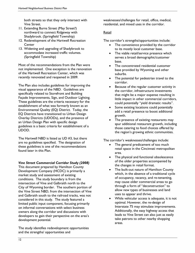
Vine Street Commercial Corridor Study (2008)
This document prepared by Hamilton County
Development Company (HCDC) is primarily a
market study and assessment of existing
conditions. The study boundary is from the
intersection of Vine and Galbraith north to the
City of Wyoming border. The southern portion of
the Vine Street NBD, from the intersection of Vine
and Galbraith south to the railroad tracks, was not
considered in this study. The study featured a
limited public input component, focusing primarily
on informal conversations with select business
owners along the corridor and discussions with
developers to gain their perspective on the area’s
development potential.
The study identifies redevelopment opportunities
and the strengths/ opportunities and
weaknesses/challenges for retail, office, medical,
residential, and mixed uses in the corridor.
Retail
The corridor’s strengths/opportunities include:
The convenience provided by the corridor
to its mostly local customer base.
The viable retail/service presence which
serves a broad demographic/customer
base.
The concentrated residential customer
base provided by Wyoming and other
suburbs.
The potential for pedestrian travel to the
corridor.
Because of the regular customer activity in
the corridor, infrastructure investments
that might be a major expense resulting in
little impact in other commercial corridors,
could potentially “yield dramatic results”.
Some existing locations could potentially
add a retail presence to boost additional
growth.
The presence of existing restaurants may
spur additional restaurant growth, including
those catering to food choices offered by
the region’s growing ethnic communities.
The corridor’s weaknesses/challenges include:
The general predicament of too much
retail space in the Cincinnati metropolitan
area.
The physical and functional obsolescence
of the older properties accompanied by
the changes in retail format.
The built-out nature of Hamilton County
which, in the absence of a traditional cycle
of occupancy, vacancy, and re-tenanting,
may cause older commercial areas to go
through a form of “deconstruction” to
allow new types of businesses and land
uses to appear and thrive.
While vehicular access is adequate, it is not
optimal. However, the re-design of
Interstate 75 may stimulate improvements.
Additionally, the easy highway access that
leads to Vine Street can also just as easily
take patrons to other nearby shopping
areas.

Hartwell Neighborhood Business District Plan
13
It is a challenge to identify the new,
emerging demographic that can serve as a
future customer base.
Small specialty retailers cannot afford to
overlap.
Site assembly costs can be too high to
justify only retail uses.
Office
The corridor’s strengths/opportunities include:
The opportunity for office development as
a component of a mixed-use project allows
spreading of risk among differing products.
The connectivity of both the I-275 beltway
and the Ronald Reagan Cross County
Highway has created interconnecting
corridors making office development more
viable than in past decades.
The exits for Cross County Highway are
within one mile of the corridor.
The corridor is close to Wyoming and
similar affluent areas along Compton Rd in
Springfield Twp.
The redesign of I-75 may make the area
appropriate for office development
Small office facilities, accommodating:
attorneys, insurance, medical, architecture,
and other smaller users are possible.
The corridor’s weaknesses/challenges include:
The most popular development areas for
Class A office development are in Blue
Ash, , the developing suburban corridors in
Mason (I- 71 corridor), West Chester (I-75
corridor), and Clermont County.
Smaller office projects tend to gravitate
toward Class B rate structures and are
more modest in terms of amenities and
site placement. A site of approximately 5
acres might yield a 50,000 sq ft structure
with adequate parking.
Suburban vacancy and net absorption rates
are not encouraging, but there is little large
office space in close proximity to the
corridor.
Medical
The corridor’s strengths/opportunities include:
Proximity to a patient base
Drake Hospital has evolved from a long-
term care facility devoted to trauma
rehabilitation to an institution oriented
toward gerontology services.
Drake has developed facilities for
independent living which adjoin the hospital
grounds.
Evergreen, one of the area’s larger senior
living centers, is located less than half a
mile west on Galbraith.
Professional offices devoted to senior-
oriented medical specialties may be in
demand as baby boomers age.
The corridor’s weaknesses/challenges include:
Geographic spacing is necessary to avoid
overlap.
The only medical office facility within the
study area is mostly vacant and is not
attractive. Pursuit of medical uses is highly dependent
upon a resident base. If a mixed-use
development is proposed, the target resident
market and related medical specialties should
correlate.
Residential
The corridor’s strengths/opportunities include:
A development based on principles of new
urbanism could be a successful option.
The corridor is surrounded by a wide
variety of housing styles and income
ranges.
The residential areas surrounding the
corridor are mostly built-out but have not
yet experienced the phenomenon of “tear-
down/infill” activity that is more likely to
occur in Blue Ash and Montgomery.
The corridor’s weaknesses/challenges include:
Traditional detached, single-family
homeownership is still a popular choice,

Hartwell Neighborhood Business District Plan
14
and most local government programs are
focused on this option.
In today’s “First Suburbs”, most single
family homes are located in a built-out
environment.
There is skepticism in some neighborhoods
regarding higher density housing.
Increased access to homeownership,
condominium development, and the
expansion of traditional suburban settings
has caused some apartments have become
obsolete, by either location or amenities.
Mixed-Use
The corridor’s strengths/opportunities include:
Many developers, planners, and community
residents have become advocates of new
urbanism, which promotes mixed uses.
Mixed use projects are a viable economic
response to decline in older suburban
communities.
Mixed-use development spreads risk and
creates customers among the different
pieces
Mixed-use development can be flexible,
including projects ranging from urban
retrofits to suburban in-fill.
New urbanism projects combine a diverse
range of housing with commercial
activities. It also seeks to recapture
development centered on design, emphasis
on pedestrian access and transit-oriented
elements.
It is more pedestrian-scaled and the
automobile‘s dominance is scaled back.
An attractive, properly developed mixed-
use project that replaces obsolete or
poorly-maintained structures may fill up
faster and could have significantly higher
rents than nearby projects.
The corridor’s weaknesses/challenges include:
Proposals containing mixed-use and higher
density development raise a good deal of
skepticism in Cincinnati.
There is a traditional demarcation between
retail, office, and residential spaces.
Mixed-uses require a new dimension in
property management.
Local building and zoning codes often lack
the flexibility to allow for mixed uses.
Developers, lenders and investors are
anxious about the viability of retail in
mixed use settings.
Study Recommendations
It was noted that the Vine Street commercial area,
though affected by demographic and business
change common to older commercial districts,
remains relatively active. Shoppers may patronize
other venues, but still value the area for
convenience.
General Recommendations include:
Site-assembly of multiple parcels would
provide for a cleaner development
environment instead of working piecemeal
or with many property owners.
Site assembly of a sufficient size may allow
a multi-use redevelopment concept, which
provides the opportunity to attract a
specific demographic group.
A long-term development concept implies
site assembly of large underutilized
properties as well as smaller sites that can
maximize the assemblage. The Study noted
a site from Compton Road to the
Wyoming line, running west to square off a
site by including commercial buildings
fronting on Compton.
Short-term Recommendations involve tasks,
initiatives, and structures ready for implementation
within 1 to 3 years:
Fund and implement a design-oriented,
infrastructure investment program aimed
at upgrading the commercial area and
offsetting the perception of early or
advanced decline. This would be an
interim improvement.
Put incentives programs in place, such as a
Community Reinvestment Area (CRA), to
motivate private business investment.
Springfield Township and the City of
Wyoming should advocate strongly for
capital funding in the City of Cincinnati’s
Hartwell neighborhood.
The City of Cincinnati must document any
demographic data showing that new,
younger families are moving into Hartwell.

Hartwell Neighborhood Business District Plan
15
Encourage private property upgrades at
the strip mall north of Compton, on the
east side of Vine Street, specifically to the
signage.
Encourage façade improvements at the
Laundromat, the Dragon City restaurant,
and the strip center.
Continue involvement with the First
Suburbs Consortium.
Establish a database of property owners,
tenants, leases, dates for renewal, etc., en
route to building a business recruitment
effort in the commercial district.
Long-term Recommendations involve tasks,
initiatives, and structures ready for implementation
in excess of 5 years:
A Mixed-Use Development in highly
landscaped, pedestrian-oriented setting
with resident/tenant parking plus
visitor/shopper parking is proposed on the
site bounded by Springfield/Pike/Vine St.,
Compton Road and Locust Street as it
contains the most significant grouping of
obsolete, underutilized, and minimally
maintained structures in the study area.
The proposed site is in Springfield
Township and includes 14 parcels:
Discount Furniture, Family Dollar Store,
Vogue Café, HUG Jewelers, Country
Fresh, Service garage, Lodge Hall, Medical
offices, Blacksmith Shop, several vacant
properties. The total market value is
$4,430,300 and totals 5.7 acres.
Possible configurations include:
Retail/service and office
Retail/service and residential above and
on out lots
Senior residential supported by
retail/medical services
Non-senior condominiums
above/retail/service/professional office
on ground floors
Family residential condominiums
(young families),
retail/convenience/childcare/gathering
Medical/retail medical/adult
condominiums and out lot modular
residential/office
Other sites that may be amenable to
mixed-use development include:
Friends of the Cincinnati Public Library
Building, which may be able to
accommodate an additional associated
tenant such as a coffee shop.
The Geraci property, which is the
former Walgreens and attached retail
spaces, could serve as a relocation site
for the Country Fresh store across
Vine Street.
The Study also listed a series of
Development Tools that could be used,
including several HCDC- based programs
such as: CRA, Community Improvement
Corp. of Greater Cincinnati (CIC), Special
Improvement District (SID), Tax Increment
Financing (TIF), SBA 504 Loans, and Ohio
Treasurer of State Linked Deposit
Programs.

Hartwell Neighborhood Business District Plan
16

Hartwell Neighborhood Business District Plan
17
History of Hartwell
Compiled by Peggy Jones; From the Hartwell
Improvement Association website:
www.hartwellohio.com
Early History: The Indians, Anthony Wayne,
and Jacob White
From history, we know that the Shawnee and the
Miami tribes lived here along the banks of the Mill
Creek. The Indians referred to the winding creek
as the Maketewah. The land here was good to
them: deer, rabbit, fox and squirrel were plentiful.
Berries, nuts and medicinal plants abounded.
Native peoples fought each other on this very land
we now call home, probably for the right to use
the land for sustenance.
In a book called The Past and Present of the Mill
Creek Valley (1882), from which most of this
history is derived, author Henry Teetor tells us
that when Jacob White came to build his
settlement, he found, just north of his land,
"...Indian bones were thickly scattered over the
ground, intermingled with battle axes, arrows and
other implements of savage warfare. About four
thousand were believed to have been engaged."
The place where Captain White settled was known
as the third crossing of the Mill Creek. White's
"Station," as all local first settlements were called,
was just off an old Miami Indian Trail that was
traveled by General Anthony Wayne on his way
from Fort Washington (now downtown Cincinnati)
to Greenville, Ohio, where he eventually fought
the Battle of Fallen Timbers in 1795.
Captain Jacob White and his family were originally
from Redstone, Pennsylvania. They came up this
"Wayne's Road," as it was called, and built a
blockhouse in the year 1790. David Flinn and
Andrew Goebel also built cabins here. Two years
later, Andrew Pryor, Lewis Winans and John
Wallace built their cabins on the opposite bank of
the creek. Moses Pryor and John Reily settled on a
tract of land just south of White's Station.
In October of 1793, the pioneers at White's
Station were warned by a messenger of General
Wayne's that Indians had attacked a wagon train
near Fort St. Clair. At this time the male
population at White's Station consisted of seven
men and one boy. The settlers' dogs began barking
at about 5 PM. Captain White forbade anyone to
leave the confine of the station's fenced-in area.
Andrew Goebel thought the dogs may have treed a
coon, so he left to check it out. The Indians
emerged from their cover and fired upon Goebel,
killing him. There were about thirty red men in the
war party, and they were determined to defend the
land they had lived on and loved. When it was all
over, the widow of Moses Pryor and two of her
children were killed as well. Captain White killed
one red man, who seemed to him to be the chief
of the group. In the skirmish, the Indians had also
entered the cabins, ripped open feather beds and
filled the mattresses with clothing, blankets and
other household goods, and ran off, never to be
caught.
Nearly a century later, the author Henry Teetor
searched for the graves of Andrew Goebel and
Mrs. Pryor's children because he had heard they
were buried near where they died. Mr. Teetor says
this location "...no doubt formed the burial place
for the dead of that neighborhood for many years
afterwards. A number of tombstones may yet be
seen there on the elevated piece of ground east of
the canal..."
Captain White went on to build, in 1795, a
successful saw and grist mill on the Mill Creek, in
use until about 1827, then overtaken by the
building of the canal. He was also the first
Overseer of Highways in Springfield Township. The
United States Bank eventually took away Captain
White's properties when a neighbor had defaulted
on a loan that White had endorsed. He then
moved to Gallatin County, Kentucky in 1838. He
lived until the age of 93, dying on July 20, 1849.
Captain White's son, whose name was Providence,
was 10 years old at the time of the attack on
White's Station. Providence eventually built a
double log cabin near where Ridgeway Avenue is
now located. His daughter, Nancy White
Culbertson, told Mr. Teetor that the first apple
orchard between the two Miami Rivers was
planted around that cabin. The foundations of the
cabin were destroyed when Ridgeway was built.

Hartwell Neighborhood Business District Plan
18
It should be noted there was another group of
people who settled about a half mile directly west
of White's Station in 1793. Called "Griffin's Station,
it was home to Lieutenant Daniel Griffin, Robert
Griffin, Daniel and Jacob Voorhees, Daniel Seward,
James McCashen and Robert Caldwell and his two
sons. No Indians attacked Griffin's Station. Here's
another interesting tidbit of history: Jacob White's
brother, Edward, platted the village of Carthage in
the year 1815.
The Canal, the Farms, the Railroads
As the population grew, so did the need for a safe
and speedy way to deliver goods from Cincinnati
to outlying areas. The Miami Canal in the Mill
Creek Valley was excavated and opened in 1827.
The Miami Canal was linked to the Erie Canal in
1849. Here in what was once known as Section
One of Springfield Township, where Captain Jacob
White had purchased land and settled, the canal
ran up through the middle of the township,
sandwiched between Wayne's Road and the Mill
Creek.
Large farms and fruit orchards were maintained in
this area during that time. The Greenham family
owned about 200 acres in the center of Section
One. Built around 1828, their original brick home
(with additions), still stands today on Parkway
Avenue. Judge Jonathan Cilley owned quite a bit of
land next to the Greenhams; his land extended to
include the land that Drake Center now sits upon.
(We got the name "Cilley Creek" for the stream
that runs by the ball fields below Drake from Judge
Cilley.) The 100-acre Sturgis farm was located in
the northern part of Section One of the township.
The James Zerbe family built their house on the
old Sturgis farm in the 1840s. No longer standing,
it was located on what we know today to be the
southwest corner of Anthony Wayne and Sheehan.
It was a 33-room red brick structure "...with gabled
roofs and numerous balconies and verandas. The
wooden carriage porch served many years as a
protection for celebrated guests in gala attire. The
house was famed for its hospitality...", says The
WPA Guide To Cincinnati (1943).
The Cincinnati, Hamilton and Dayton (C H & D)
Railroad lay down its tracks through here in 1851.
By the year 1888, sixty passenger and freight trains
ran daily over these tracks. The area was further
opened up for businessmen who wanted to
commute to Cincinnati, yet live in a country-like
atmosphere. The C C C and St. L Railroad was
squeezed between the canal and Anthony Wayne
Ave. (then called Eastern Ave.) in 1872. Sixteen
passenger trains ran daily on these tracks in 1888.
There were depots at either end of what is
Parkway Avenue today.
John W. Hartwell, Daniel DeCamp,
Subdivisions and Original Street Names
Daniel DeCamp, the president of the Hamilton
County House Building Association, enthusiastically
promoted living in this area. The original
Greenham farm was now known as "Hartwell," and
it was platted in 1869. Named after John Wesley
Hartwell, the popular vice president of the C H &
D Railroad, Mr. Hartwell liked DeCamp's
enterprise so well that he offered a year's free
commuter ticket to anyone who bought land and
built their home in the village that bore his name.
Daniel DeCamp himself built his own dwelling in
1877 on a piece of pie-shaped property between
what are now Woodbine and Avalon, where it still
proudly stands today.
Mr. DeCamp's wife Joanna, suggested that a
circular section of Hartwell, affectionately called
"the bowl," be set aside for at least 2 places of
worship. It was decided that this circle would be a
center-point, with streets that would arc from it,
styling it much like the village of Glendale to the
north.
Charles M. Steele was the first mayor. (The house
he lived in is still there at the southwest corner of
present-day Hillsdale and Burns.) The large farms
to the north of Hartwell were divided into
subdivisions, with "Maplewood," once the Sturgis
farm, being platted in 1871. When Colonel T. E.
McNamara built the first home in this new
subdivision, he found remnants of a wigwam and
other Indian artifacts. (McNamara's house is still
there today at the southwest corner of Wiswell
and Sheehan.) In Maplewood there used to be an
Opera House on what we know today as Wiswell
Ave., and a jail on Burns, where "Halls of
Montezuma" is today. The Town Hall was a one-
room wooden structure on present day Ferndale
and Burns. (This structure was later turned into a
community meeting place for teens in the 1960s,
and then torn down in the 1970s. There is a "tot
lot" there today.) The "Bell and Steele" subdivision

Hartwell Neighborhood Business District Plan
19
was located just west of Maplewood, and the
"Oxley" lay to the east.
When the streets were laid out and named, most
were not known by the names we know them
today. From north to south, here are the old
names, with the current ones in parentheses. (See
if you can find the old name of your street!) Mills
(Millsdale), Highland (Hillsdale), Bellevue
(Hereford), Maplewood (Hereford Ct.), Sheehan
(Sheehan from Vine to Burns), Central (Sheehan
from Burns to Wayne), North Ln. (Sheehan from
Wayne to Dixie), Oxley (Oxley), Dixie (Dixie),
Williams (Wiswell), Sturgis (Curzon), Wayne
(Wayne from Mills to Hartwell Ave.), Woodbine
(Woodbine from Millsdale to Hunsford), Mace
(Mace), Woodlawn (Woodsdale), Fairview
(Ferndale), Lawn (Hunsford), Burns (Burns from
Millsdale, across Galbraith to Glendale), Section
(Galbraith from Vine to Burns and then including
all of Hartwell Ave.), Cilley (Parkway from Vine to
Monon), Ohio (Monon), N. Crescent (Kearney),
Mystic (Mystic), Park (Parkway from Monon to
Wayne), Willow (Wildwood), Oak (Oakmont), S.
Crescent (Avalon), Central (DeCamp), Rural
(Woodbine from the circle to Wayne), Eastern
(Wayne from Hartwell Ave. to lower Woodbine),
and Hamilton-Carthage Turnpike (Vine Street). If
your street is not included in this list, it may not
have existed in 1880! The reason the names were
different back then was because Hartwell had not
yet been annexed to the city of Cincinnati. When it
was, in 1912, the city already had these street
names elsewhere in other parts of town, so ours
had to be changed.
Schools, past and present
"The first settlers in Hartwell were included in the
Lockland School District," so says the editor of an
early Hartwell newspaper called "The Olio" (1888).
The editor continues: "In 1870 when the town had
grown to about one dozen families measures were
taken to secure better school facilities." The first
school in Hartwell was built on a shady lot on
North Crescent Avenue, now known as Kearney.
The Hamilton County House Building Association
donated the lot. The Springfield Township School
Board gave half of the money necessary to build
the new school; the citizens of Hartwell gave the
other half. A Mrs. Curran was the first teacher; she
started with 25 pupils in a two-room facility. Two
more teachers were hired in 1876, and in 1879, a
third room was added to the building. Enrollment
eventually increased to 114. In 1882, Professor J.
Harry Lowe was the Principal. Yet another building
was erected and occupied that same year.
The Hartwell Village School District was organized
in 1885. The teaching staff was now five in number,
and Professor Trisler was the Principal. Pupils were
graded by the same scale as those who were
enrolled in Cincinnati schools. In just three short
years, the number of students increased from 120
to 300, so that a new, three-storied brick school
was built on the corner of what is now Hartwell
and Woodbine Avenues in the Spring of 1888. It
boasted eight large school rooms, a hall that could
seat 500, a double room basement for play rooms
in bad weather, and a tower. The exterior was
made of Zanesville brick and trimmed with white
stone. Considered outdated less than 40 years
later, yet another school was built on the corner of
Galbraith and Vine in 1925. The "old school
Building" at Woodbine and Hartwell was bought by
a private owner and turned into apartments. In the
summer of 1969, a tornado tore through the
Valley, and the old school's tower collapsed inside
the stairwell killing a young mother and her 2 sons.
The Hartwell School that stands today at Galbraith
and Vine is still in great shape. It is considered to
be an excellent example of the Georgian Colonial
style. Until the late 1940s, it took care of grades K-
12. Now, grades K-8 attend there. Many of the
graduates from the 1940s are still involved in the
upkeep of the school and still have great school
spirit. Their organization is known as the Hartwell
Alumni Association.
This and That...Other Interesting Tidbits about
Hartwell's History
The Hamilton County Fairground, although it has
been claimed by Carthage on the south and called
the "Carthage Fair" for many years, should be
noted in a history of Hartwell. The present
grounds between Vine and Wayne were acquired
by the Ohio Agricultural Society in 1847. The Fair
actually originated the year before and was held on
nearby farm owned by Ezekiel Hutchinson.
Hartwellians have been fortunate to be able to
walk to the Fair, which is held for 5 straight days
every August. It's an old-fashioned event with blue-

Hartwell Neighborhood Business District Plan
20
ribbon contests of all kinds, a demolition derby,
animal demonstrations and funnel cakes. There are
a few older buildings still standing on this 68-acre
site, which also includes a race track and bleachers.
Horses are boarded there year-round. Up until the
1980s there was an old farm house near the
Wayne entrance gate, but in its place now are a
few mobile homes. Since the Fairground is owned
by the county, and not the city, the horses and the
mobile homes are permitted there. At the Vine
Street entrance, there is a special "sculpture" on
display; it is made entirely of twisted beams that
were found in the wreckage of the tornado that
came through the Valley in 1969. The beams were
supports from a highway billboard sign and are
exactly as the artist found them.
When Hartwell was annexed into the city of
Cincinnati in the year 1912, the boundaries of
Springfield Township were changed. Since Hartwell
was originally part of the township, and after 1912
was not, that meant that Edgemont Terrace, which
is located on the other side of the expressway and
still part of the township, was cut off from the
larger portion of Springfield Township, which is
west of Vine.
Electric trolley tracks were extended into Hartwell
in 1898. Charles Kilgour financed the building of a
new bridge over the Mill Creek at Wayne, and
"Route 78" was born, going through Hartwell to
Lockland. A powerhouse with a carbarn was
erected on what is now DeCamp Avenue in 1901.
That square brick building still stands today behind
Metropolitan Harvest Church of God. In 1932, the
tracks that ran from the powerhouse into
Wyoming were paved over. Tracks for Route 78
to Lockland via Wayne lasted until 1951. "Route
78" is still alive today thanks to the Metro bus
service.
In 1959, Interstate 75 was laid down just to the
east of Hartwell. Known for many years around
here as the "Millcreek Expressway," it overtook
cornfields and basically cut Hartwell off from
Arlington Heights and the hills of Edgemont
Terrace. In the 1990s the Ronald Reagan Cross
County Highway worked its way into our
landscape and in the process, Woodbine Avenue
no longer runs all the way through the
neighborhood to Wayne; there is now a well-kept
little cul-de-sac that is left to itself in the shadow of
an overpass.
There is no doubt more of Hartwell's history that
could be shared! These are the highlights. Every
effort has been made to link the past with the
present.

Hartwell Neighborhood Business District Plan
21
Existing Conditions Analysis
Hartwell is Cincinnati’s northern-most
neighborhood, and is surrounded by the Cincinnati
neighborhoods of Carthage and Roselawn, as well
as Springfield Township, the cities of Wyoming, and
Arlington Heights and the Village of Lockland.
The Hartwell neighborhood is approximately 746
acres in size, and the officially recognized
Neighborhood Business District (NBD) is about 30
acres in size, or about 4% of the total
neighborhood area.
The full Vine Street commercial corridor is 52
acres in size, and is divided as such:
Community Acres
Hartwell 35 acres
Springfield Twp 17 acres
Percentage of Property in Commercial Corridor by Community
Population According to preliminary 2010 U.S. Census data,
the population of Hartwell is 5,228 persons.
Approximately 54% of the population is female and
46% is male.
Over the thirty-year period from 1980 to 2010,
Hartwell held a relatively stable population.
Between 1980 and 1990, Hartwell decreased in
population by approximately 500 people, only to
regain that population between 1990 and 2000.
Between 2000 and 2010 the population decreased
by about 300 people, or approximately 5% of the
population. By comparison, the City of Cincinnati
as a whole decreased in population by about 23%
over that same time period.
However, the Hartwell NBD does not serve only
the Hartwell Neighborhood. Living within just a
one mile distance of the NBD there are more than
15,000 people.
Distance Population
1 mile 15,585
3 miles 92,771
5 miles 256,414
Age Hartwell’s population is spread nearly equally
among age groups. The primary exception to this
is the 18 – 24 age group, which only accounts for
9% of Hartwell’s population. The neighborhood’s
median age is 38.1.
Under 18
21%
18 to 24
9%
25 to 34
17%
50 to 64
18%
35 to 49
18%
65 and up
17%
Age Distribution in Hartwell
Source: U.S. Census Bureau, 2010 Census
Race 96.7% of Hartwell residents identify themselves as
being of one race. Of that 96.7%, the Hartwell
neighborhood is 56% white, with approximately
37% of the population identifying themselves as
black or African American. 2.1 % identify

Hartwell Neighborhood Business District Plan
22
themselves as Asian, .2% identify as American
Indian/Alaska Native and 1.7% identifying
themselves as being another race.
4.8% of the population identifies themselves as
being Hispanic or Latino.
Race Distribution in Hartwell
Source: U.S. Census Bureau, 2010 Census
Household Types There are 2,486 total households in Hartwell. 46%
are Family Households, and 54% are Non-Family
Households. Of the Non-Family Households, 84%
are Single-person Households. The average
household size is 2 persons, and the average family
size is 2.94 persons.
Housing Occupancy and Ownership There are a total of 3,097 Housing Units in
Hartwell. According to the 2000 census, 2,486
units (or 80%) were occupied. Approximately 611
(20%) were vacant.
Like the City of Cincinnati as a whole, Hartwell is a
neighborhood with a larger number of renters than
homeowners. Of the occupied housing units, 806
(32%) were owner-occupied, while 1,680 (68%)
were renter-occupied. This is very similar to the
City’s year 2010 homeownership rate of 38.9%
Household Income and Poverty According to the 2005-2009 American Community
Survey, the median household income in Hartwell
was $38,963, which was higher than Cincinnati’s
median household income of $33,855.
During this time period, 14.6% of the families in
Hartwell were living below the poverty line; 19.3%
of all persons were living below the poverty line.
Although this is higher than the number of families
and persons living below the poverty line in 2000,
it is a lower percentage than the City of Cincinnati
as a whole, which was estimated to have 20.5% of
all families and 25.3% of all persons living below the
poverty line.
Income in Hartwell
Range Number Percent
Less than $10,000 170 7%
$10,000 to $24,999 846 32%
$25,000 to $49,999 454 17%
$50,000 to $74,999 711 27%
$75,000 to $99,999 233 9%
$100,000 + 194 7%
Source: U.S. Census Bureau, 2005-2009 American Community
Survey
Traffic Counts
The traffic volume moving through the Vine Street
Corridor brings close to 85,000 cars close to this
area daily. It is estimated that about 15,000 move
through the Vine and Galbraith intersection,
showing that most shoppers who would patronize
the Vine Street Corridor are local shoppers who
will do so out of convenience.
Traffic Counts
Intersection Direction Total Daily
Count
Galbraith/Vine North/South 15,580
Reagan Cross
County/Winton
East/West 45,542
Glendale-
Milford/Springfield Pike
North/South 23,570
Source: Vine Street Commercial Corridor Study, Hamilton County
Development Company, 2008

Hartwell Neighborhood Business District Plan
23
Vision and Goals
At one of the earliest meetings, the Hartwell NBD
Planning Committee discussed what they wanted
to see for the future of their neighborhood and
their Neighborhood Business District. The overall
Vision for the Neighborhood Business District
follows:
The Vision
The Hartwell NBD on the Vine Street Commercial
Corridor is a unique, vibrant, regional-serving
business district. It features clean, attractive, safe
and walkable streets; strong, vital and active local
and national businesses; historic and renowned
local and regional institutions; and is a hub of
neighborhood activity for residents of Hartwell,
and also serves Wyoming and Springfield
Township, Arlington Heights, Carthage, and
Roselawn.
The Overall Goal:
The Hartwell NBD on the Vine Street Commercial
Corridor will achieve its Vision by:
Leveraging the recent major improvements to
the Hartwell Elementary School and Hartwell
Recreation Center;
Taking advantage of its prime location, solid
residential base, and strong existing businesses
and institutions; and,
Strengthening its community and business
organizations to systematically make
improvements to public spaces, encourage
redevelopment of key properties, and further
stabilize the district.

Hartwell Neighborhood Business District Plan
24
The newly renovated Hartwell Elementary School The view on Vine Street looking north
The Recreation Center under renovation The completed Recreation Center
Non-commercial structures on the corridor The intersection of Vine and Galbraith looking south

Hartwell Neighborhood Business District Plan
25
Assets and Challenges
At the beginning of the planning process, the
Planning Committee identified the assets that can
be built upon and the challenges that must be
overcome in order for the Hartwell neighborhood
to meet its Vision and Overall Goal. When
discussing the assets and challenges, the most
compelling issues fell into both categories. For
example, one of the greatest assets of the Hartwell
NBD is its location, with easy access and high
visibility, but it was also considered to be one its
greatest challenges to overcome due to the
fractured nature of the intersection and perceived
lack of identity. The diverse businesses in the
Neighborhood Business District were seen as an
asset, but the auto-oriented nature of some of the
businesses as well as the lack of maintenance of
some properties was seen as a negative. Other
assets and challenges are listed below.
Location Assets Challenges
Location near I-75 - easy access, regional location
NBD has high visibility – located at a major
intersection
Accessibility of housing to the business district
Vine Street is a state route
NBD has access to public transportation
Proximity to Wyoming, Springfield Township
1-75 improvements/diversion could have a negative
impact
Fractured corner: Vine/Galbraith/Pfau
Unsafe for both pedestrian and vehicular
traffic
No continuity at the four corners; Lack of a
focal point
Noise, traffic, pollution at Vine/Galbraith
intersection
Burns/Galbraith intersection is also dangerous
Lack of identity – often lumped with Carthage; NBD
needs own identity
No clear boundaries of NBD
Connectivity to Wyoming and Springfield Township
means that fates are tied together
Neighborhood Business District/Businesses Assets Challenges
Diversity of amenities and types of businesses
“Neighborhood feel” in NBD
Good Entrance Signs
Restaurants (about 10 in Hartwell area)
Walgreen’s and CVS
Kroger
Banks
Auto dealerships
Poor visual appearance of some properties in the NBD
Vacancies
Lack of maintenance of both private and
public property
Litter
Vandalism – graffiti
Loitering at CRC lot, Armory, Wendy’s,
Speedway
Overhead utility lines
Lack of curbs/storm sewer throughout neighborhood
Front yard parking decreases safety and visual
appearance
Auto-oriented zoning encourages uses that do not
mesh with community desires for pedestrian NBD
Auto dealerships - some take test drives through the
neighborhood
Absentee landlords
Vacant Armory Site

Hartwell Neighborhood Business District Plan
26
Housing Assets Challenges
Affordable housing
Historic homes
Nearby senior housing
People with school-aged kids are leaving Hartwell
Institutions Assets Challenges
Newly Renovated Historic Hartwell Elementary School
located at Hartwell’s core
Newly Renovated Rec Center/parking located at
Hartwell’s core
New playground
Churches
Drake Hospital
Nearby Wyoming Golf Course
Overflow parking for CRC requires people to cross
busy street
Kids traveling between Hartwell School and Rec
Center must cross busy intersection
Organizations Assets Challenges
Active Hartwell Improvement Association (HIA)
Citizens On Patrol
Hartwell School LSDMC
Strong Senior Group
Community Apathy
HIA is active but small
There is no active Business Association
Of the assets discussed, one of the most
important, yet one that is often overlooked, is the
strength of the existing businesses in the NBD.
While there is the potential for infill development,
consolidation of property, elimination of curb cuts,
and improved maintenance and landscaping, these
improvements would be building on a strong core.
Although the primary intersection of Vine Street
and Galbraith Road appears to be somewhat
fractured due to the unusual island in the center of
the intersection, it is anchored by three very
strong uses: a recently built Walgreens store at the
southeast corner, a newly renovated Hartwell
Recreation Center at the southwest corner, and
the newly renovated Hartwell Elementary School
at the northeast corner.
Additionally, the NBD boasts another pharmacy (a
CVS), a bank, a Kroger grocery store, which has
become more regionally important since the
recent closing of the Roselawn Kroger store, as
well as several restaurants. Other unique uses
include the Friends of the Public Library building as
well as the Country Fresh Market, an independent
produce market (located in Springfield Township).
At the southern end of the NBD, there are several
automobile dealerships and repair shops. Alford
Motors and Torbeck’s Auto (which is located in
Springfield Township) were represented on the
Planning Committee and reminded Committee
members of the history of Vine Street as a
destination for auto sales and repairs for many
decades. These two community staples have
worked to maintain the appearance of their own
properties, and in doing so have inspired other
property owners at the south end of the NBD to
make improvements.
Due west of the NBD, the Drake Center is home
to a medical facility offering long-term acute
rehabilitation, transitional nursing and therapy care,
and assisted living for seniors. Additionally, Drake
provides outpatient services, wellness services for
the community, and on-site research studies.
While not technically located within the NBD, it is
one of the area’s largest employers and
undoubtedly has the potential to have a positive
impact on the businesses in the Hartwell NBD.
While these assets are often overlooked, they
should be considered as building blocks for future
improvements. While many NBDs in Cincinnati
struggle with retaining stable businesses and basic
property maintenance, it bears a reminder that
Hartwell’s NBD is home to numerous strong
businesses and other community uses, and that in
this situation, basic infrastructure improvements
can have a significant impact.

Hartwell Neighborhood Business District Plan
27
Issue Areas
A review of the assets and challenges lead the
Planning Committee to concentrate on five specific
issues:
1. Community Organization
Until very recently, Hartwell did not have a
Business Association or a Business District
Committee within the Hartwell Improvement
Association (HIA). The Planning Committee
realized that without an active Business Association
it is unlikely that the NBD will receive significant
funding from the City for streetscape
improvements, intersection re-design, and other
improvements to the NBD. An active Business
Association can also help business owners
coordinate their efforts on issues and
opportunities important to the businesses
themselves.
Strengthening the HIA is another important step in
meeting the Vision and Goals set by the Planning
Committee. Increasing membership is a common
desire of Community Councils, and any community
facing implementation of a Plan is in a stronger
position with a full slate of volunteers.
Because the Vine Street Commercial Corridor
spans two communities, directly serves at least
three, and indirectly serves several others, it is
imperative for the HIA and fledgling Business
Association to solidify relationships with
surrounding communities including Springfield
Township, the cities of Wyoming, and Arlington
Heights, the Village of Lockland, and the Cincinnati
neighborhoods of Carthage, Bond Hill, and
Roselawn.
2. Land Use and Zoning / Future
Development
The primary zoning designation in the Hartwell
NBD is an auto-oriented commercial zone. With
the community’s goals of a more pedestrian-
oriented NBD, an auto-oriented zone may not be
appropriate for the entire length of the NBD.
Additionally, Hartwell’s NBD has an Urban Design
Overly District (UDOD) in place, which would
help protect the district from incompatible
development. However, the UDOD is lacking the
guidelines that regulate the NBD. A relatively
simple solution, the HIA can take almost immediate
action to ensure that these standards are put in
place.
The buildings along the corridor do not address
the street consistently, as some buildings are
located directly on the front lot line while others
have a significant setback with parking in the front
yard. This gives the NBD an incoherent
appearance, and creates gaps for pedestrians
navigating the length of Vine Street.
Additionally, while there are many places along
Vine Street to walk to, it is not always comfortable
to be a pedestrian. The speed limit is 30 miles per
hour, and with narrow sidewalks, pedestrians do
not have significant protection from traffic as there
are no parking lanes along Vine Street and no tree
lawn or planting strip. Pedestrian safety is of
primary concern along this corridor, especially with
children and seniors needing to access the Hartwell
Elementary School, the Recreation Center, and the
grocery stores, pharmacies, and restaurants.
With appropriate zoning regulations in place,
properties that become vacant in the future or are
proposed for a new use can be properly developed
or redeveloped. The application of a Form Based
Code and implementation of future Complete
Streets regulations may make the pedestrian
environment safer and more appealing.
3. Redevelopment of the Armory Site
The first site proposed for redevelopment is the
City-owned Hartwell Armory site, located
immediately to the west of the Kroger store.
With an RFP process complete and a developer
selected for a Preferred Developer Agreement, the
Hartwell community is concerned that the Armory
be developed in a manner that makes the site an
asset to the community.
The proposed development is for a senior housing
development, including both independent and
assisted living. The Armory site itself is 7.5 acres in
size and is accessed from Shadybrook Drive, a

Hartwell Neighborhood Business District Plan
28
residential street in Springfield Township. It is
zoned RM-1.2, Residential Multi-Family. It is
imperative that the Hartwell community be
involved in the development of this or any other
project proposed for this site, as the future use and
its details will undoubtedly have a long-term impact
on the entire community. With the
neighborhood’s involvement, Hartwell leaders can
ensure that the development is indeed a
tremendous asset to the neighborhood and the
region.
4. Visual Appearance of the NBD /
Property Maintenance
The future goals of the Hartwell community are
dependent not only on potential new development,
but also on the maintenance and revitalization of
existing properties.
The HIA and the newly created Business
Association have the opportunity to work with
existing property owners to relay the
neighborhoods concerns about ongoing
maintenance. With an active and engaged Business
Association in place, Hartwell may be in the
position to request City funds to assist property
owners in making needed improvements.
5. Vine/Galbraith Intersection
The intersection of Vine Street and Galbraith Road
is the heart of the Hartwell NBD. The intersection
is flanked by two important community uses: the
Hartwell Elementary School and the Hartwell
Recreation Center. It also moves about 15,000
cars per day through the intersection, making it
potentially dangerous for both pedestrians and
cars.
This is made more complicated by the island at the
northwest portion of the intersection. The island
currently has several purposes: it is a parking lot, it
is a landscaping bed, it is a traffic island for vehicles
turning south on Vine Street from west-bound
Galbraith Road, and it is a neighborhood gateway.
The Hartwell neighborhood feels that the island
does not do any of these things effectively, and
would like to reconsider its purpose and
functionality. If it is a true gateway, it should be a
focal point. If it is a traffic island or parking area it
should be more efficient. In either case, it should
be more attractive.
With the existing community uses and additional
residents and jobs potentially moving to the
Armory site, it is imperative that the intersection
of Vine Street and Galbraith Road be redesigned
for safety, efficiency, and aesthetics.
With these issues in mind, the Planning Committee
developed five goals, and a series of objectives and
strategies to meet those goals:
Goals
1. Reinforce the role of the community
organizations in implementing changes in
Hartwell
2. Improve the Visual Appearance of the
NBD and encourage better Property
Maintenance
3. Encourage future development and ensure
that it is sensitive to the character of the
Hartwell NBD and enhances the
walkability of the Vine Street Corridor.
4. Make the Vine/Galbraith Intersection
more attractive, as well as safer for both
vehicular and pedestrian traffic.
5. Redevelop the Armory Site.
An aerial view of the Vine Street / Galbraith Road intersection.

Hartwell Neighborhood Business District Plan
29
Objectives and Strategies
Goal 1: Reinforce the role of the community organizations in implementing changes in
Hartwell
Objective 1: Strengthen the Hartwell
Improvement Association (HIA) and increase its
capacity to respond to resident and property
owner needs
Strategies
1. Utilize Neighborhood Institutions (Churches,
Schools, Seniors, HIA, etc.) to increase pool of
volunteers, expand opportunities for public
events
2. Increase attendance at HIA meetings
3. Increase membership in the HIA
4. Create Plan Implementation Committee (in
conjunction with Business Association) to
work to annually implement NBD Plan and
apply for funds
5. Create Succession Plan to help new members
grow within the organization
6. Build relationships with other Community
Councils to compare notes, build coalitions
(especially important with Carthage, Roselawn,
Bond Hill)
Objective 2: Form a Business Association to
work with the HIA to stabilize the Neighborhood
Business District
Strategies
1. Identify leadership in new Business Association
2. Build membership by approaching local
businesses and institutions (including Drake)
3. Work in conjunction with HIA to annually
implement NBD Plan, make recommendations,
and apply for funds
4. Create Succession Plan to help new members
grow within the organization
5. Continue attending Cincinnati Neighborhood
Business Districts United (CNBDU) meetings
to meet other NBD representatives, build
relationships, and get involved in the funding
process
Objective 3: Solidify Relationships with
Wyoming and Springfield Township to benefit the
entire Vine Street Corridor
Strategies
1. Approach Wyoming and Springfield Township
representatives to participate in
implementation committee
2. Ask businesses outside Cincinnati boundary to
join Business Association
3. Invite Wyoming and Springfield Township
representatives to participate in Hartwell
Community/Institution events
4. Convene meeting (at least annually) with
Wyoming and Springfield Township
representatives to discuss common goals
5. Attend Wyoming and Springfield Township
meetings when possible
6. Advocate for Wyoming and Springfield
Township at County or State levels when
reasonable

Hartwell Neighborhood Business District Plan
30
Goal 2: Improve the Visual Appearance of the NBD and encourage better Property
Maintenance
Objective 1: Enhance the appearance of the
NBD by making capital/physical improvements
Strategies
1. Seek funding through CNBDU for appropriate
streetscape improvements throughout the
Hartwell NBD
2. Seek funding through CNBDU for a Façade
Program for properties in the Hartwell NBD
3. Work with local organizations and institutions
(Churches, schools, seniors, scouts, etc.) on
beautification efforts (in coordination with
Wyoming and Springfield Twp)
4. Secure permanent hardware for and install
Hartwell banners
5. Redefine the boundaries of the NBD to include
all commercially-zoned properties north of the
Mill Creek on Vine Street in Hartwell
Objective 2: Ensure ongoing property
maintenance by regularly reassessing the conditions
of the NBD and working with property owners to
make improvements
Strategies
1. Establish a Property Maintenance or Quality of
Life Committee of the HIA (in conjunction
with the Business Association) to take
proactive steps regarding property
maintenance and respond to complaints
2. Seek assistance from other neighborhoods
with successful Quality of Life or Property
Management Committees (such as College Hill)
3. Schedule a formal assessment by the
Committee on at least an annual basis
4. Identify vacant or dilapidated properties
5. Contact property owners and encourage
improvements
6. Take corrective action when necessary: call in
a report to the City regarding code violations
and follow up
Goal 3: Encourage future development and ensure that it is sensitive to the character of
the Hartwell NBD and enhances the walkability of the Vine Street Corridor.
Objective 1: Retain existing businesses and
develop additional retail, office, restaurant, and
service uses in the Hartwell NBD.
Strategies
1. Identify vacant or underutilized properties that
could be potential future development sites
2. Work with the City to market sites to
businesses and developers
Objective 2: Verify that the NBD is
appropriately regulated for existing and desired
future uses
Strategies
1. Enact regulations for existing Urban Design
Overlay District
2. Request a zoning study of the Vine Street
Corridor to consider mixed zoning in some
areas (maintain current auto uses)
3. Maintain and improve the character of the
NBD through additional design guidelines,
including the consideration of Form Based
Codes

Hartwell Neighborhood Business District Plan
31
Goal 4: Make the Vine/Galbraith Intersection more attractive, as well as safer for both
vehicular and pedestrian traffic.
Objective 1: Redesign and rebuild the island,
sidewalks, crosswalks and signals (if necessary) at
Vine and Galbraith
Strategies
1. Work with the City’s Department of
Transportation and Engineering to redesign the
intersection, including the island
2. Investigate current traffic patterns, reviewing
signal timing, traffic counts and accident data to
determine safety issues
3. Define the purpose of the island
4. Apply to the NBD Improvement Fund (through
CNBDU) to fund design improvements
Goal 5: Redevelop the Armory Site.
Objective 1: Work with the City of Cincinnati
to create a development that is an asset to both
the City as a whole and Hartwell specifically.
Strategies
1. Organize a Hartwell Steering Committee to
work with the City and a developer or
development team to navigate the details of
any proposed development.
2. Seek developers willing to work with the
community to redevelop the site into the
following uses:
Office or Medical Office;
Greenspace/Park or Recreation;
Senior Housing;
A commercial Banquet Facility, or
Single-family Market Rate Housing
3. Involve the Hartwell community as a whole in
any decision to relocate or rearrange the
recreation uses near the Armory Site.
4. Consider the impact of the redeveloped
Armory Site in any capital/physical
improvements to the NBD; plans to redesign
the Vine and Galbraith intersection; and
encourage the new users involvement in the
NBD Association.

Hartwell Neighborhood Business District Plan
32
ype a quote from the document or the summary of an interesting
point. You can position the text box anywhere in the document. Use
the Text Box Tools tab to change the formatting of the pull quote
text box.]
Zoning in the Hartwell NBD.
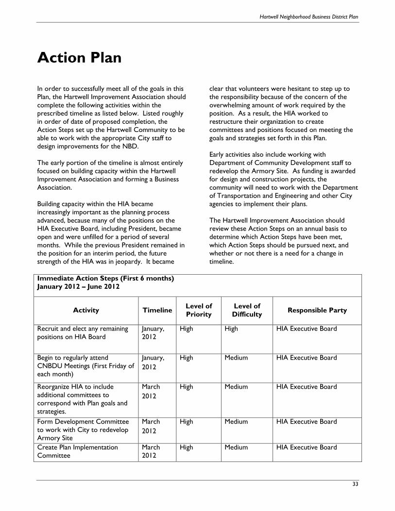
Hartwell Neighborhood Business District Plan
33
Action Plan
In order to successfully meet all of the goals in this
Plan, the Hartwell Improvement Association should
complete the following activities within the
prescribed timeline as listed below. Listed roughly
in order of date of proposed completion, the
Action Steps set up the Hartwell Community to be
able to work with the appropriate City staff to
design improvements for the NBD.
The early portion of the timeline is almost entirely
focused on building capacity within the Hartwell
Improvement Association and forming a Business
Association.
Building capacity within the HIA became
increasingly important as the planning process
advanced, because many of the positions on the
HIA Executive Board, including President, became
open and were unfilled for a period of several
months. While the previous President remained in
the position for an interim period, the future
strength of the HIA was in jeopardy. It became
clear that volunteers were hesitant to step up to
the responsibility because of the concern of the
overwhelming amount of work required by the
position. As a result, the HIA worked to
restructure their organization to create
committees and positions focused on meeting the
goals and strategies set forth in this Plan.
Early activities also include working with
Department of Community Development staff to
redevelop the Armory Site. As funding is awarded
for design and construction projects, the
community will need to work with the Department
of Transportation and Engineering and other City
agencies to implement their plans.
The Hartwell Improvement Association should
review these Action Steps on an annual basis to
determine which Action Steps have been met,
which Action Steps should be pursued next, and
whether or not there is a need for a change in
timeline.
Immediate Action Steps (First 6 months)
January 2012 – June 2012
Activity Timeline Level of
Priority
Level of
Difficulty Responsible Party
Recruit and elect any remaining
positions on HIA Board
January,
2012
High High HIA Executive Board
Begin to regularly attend
CNBDU Meetings (First Friday of
each month)
January,
2012
High Medium HIA Executive Board
Reorganize HIA to include
additional committees to
correspond with Plan goals and
strategies.
March
2012
High Medium HIA Executive Board
Form Development Committee
to work with City to redevelop
Armory Site
March
2012
High Medium HIA Executive Board
Create Plan Implementation
Committee
March
2012
High Medium HIA Executive Board
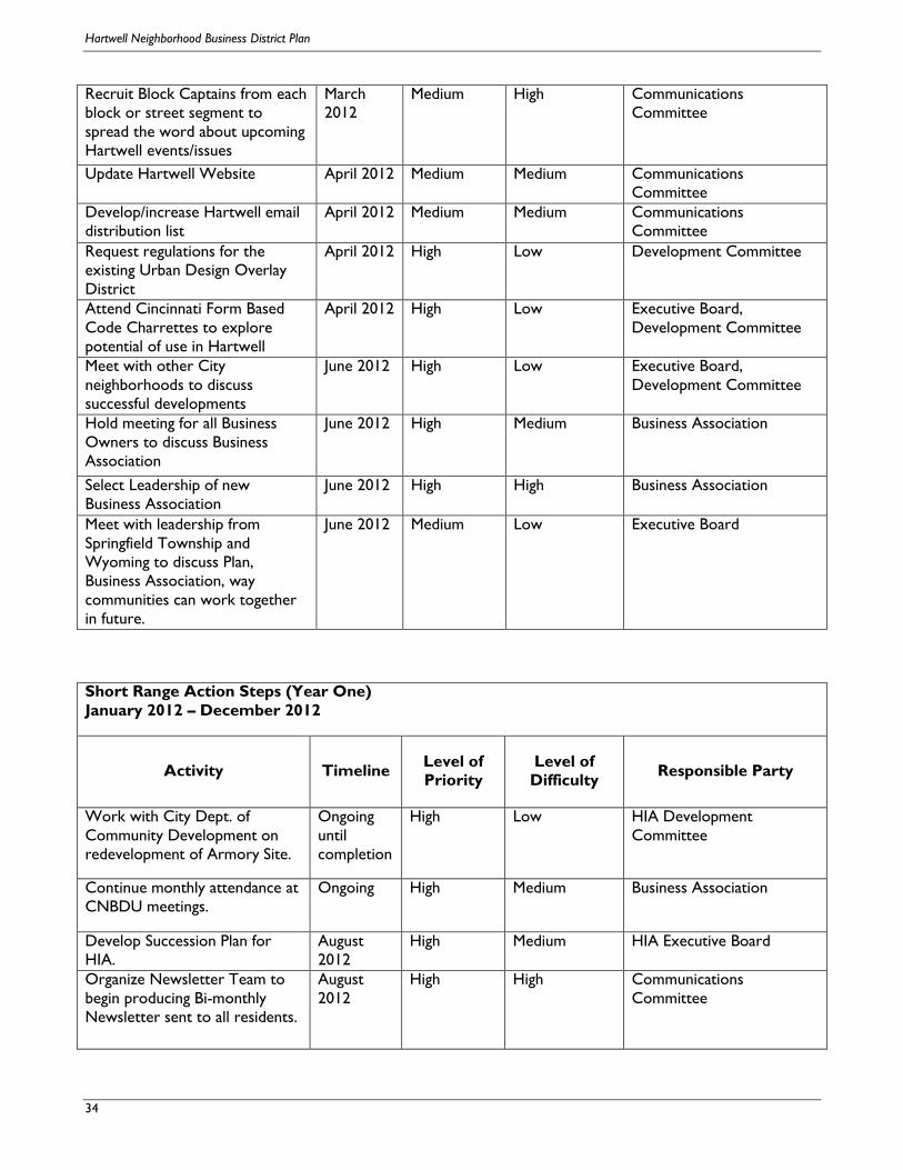
Hartwell Neighborhood Business District Plan
34
Recruit Block Captains from each
block or street segment to
spread the word about upcoming
Hartwell events/issues
March
2012
Medium High Communications
Committee
Update Hartwell Website April 2012 Medium Medium Communications
Committee
Develop/increase Hartwell email
distribution list
April 2012 Medium Medium Communications
Committee
Request regulations for the
existing Urban Design Overlay
District
April 2012 High Low Development Committee
Attend Cincinnati Form Based
Code Charrettes to explore
potential of use in Hartwell
April 2012 High Low Executive Board,
Development Committee
Meet with other City
neighborhoods to discuss
successful developments
June 2012 High Low Executive Board,
Development Committee
Hold meeting for all Business
Owners to discuss Business
Association
June 2012 High Medium Business Association
Select Leadership of new
Business Association
June 2012 High High Business Association
Meet with leadership from
Springfield Township and
Wyoming to discuss Plan,
Business Association, way
communities can work together
in future.
June 2012 Medium Low Executive Board
Short Range Action Steps (Year One)
January 2012 – December 2012
Activity Timeline Level of
Priority
Level of
Difficulty Responsible Party
Work with City Dept. of
Community Development on
redevelopment of Armory Site.
Ongoing
until
completion
High Low HIA Development
Committee
Continue monthly attendance at
CNBDU meetings.
Ongoing High Medium Business Association
Develop Succession Plan for
HIA.
August
2012
High Medium HIA Executive Board
Organize Newsletter Team to
begin producing Bi-monthly
Newsletter sent to all residents.
August
2012
High High Communications
Committee

Hartwell Neighborhood Business District Plan
35
Begin attending Carthage and
Roselawn Community Council
meetings.
September
2012
High Low HIA Executive Committee
Hold special Business
Association meeting to increase
membership in Business
Association
October
2012
High Medium Business Association
Apply to CNBDU for funding
for a façade improvement
program
July 2012 Medium High Business Association / HIA
Executive Board
Hold two special HIA meetings
in first year with guest speakers
to focus on increasing
membership.
October
2012
Medium Medium HIA Executive Board /
Membership Committee
Secure and install hardware for
Hartwell banners in NBD.
October
2012
Medium Medium Business Association / HIA
Executive Board
Medium Range Action Steps (Years Two -Five)
January 2013 – December 2016
Activity Timeline Level of
Priority
Level of
Difficulty Responsible Party
Continue working with Dept. of
Community Development on
redevelopment of Armory Site
Until
Completion
of Project
High High Development Committee
Work with Business owners
who want to participate in
façade program
Jan. 2013 High High Business Association / HIA
Executive Board
Initiate zoning study of NBD June 2013 High Low Development Committee
Explore use of Form-Based
Code in NBD
June 2013 High Medium Development Committee
Request funding from CNBDU
for DOTE to perform design
work for intersection redesign
and streetscape improvements
July 2014 High High Business Association / HIA
Executive Board
Begin working with City’s
DOTE to develop plan for
intersection redesign and
streetscape improvements
Jan. 2015 High Medium Business Association / HIA
Executive Board
Apply for funding to CNBDU
for construction work for
intersection redesign and
streetscape improvements
June 2015 High High Business Association / HIA
Executive Board

Hartwell Neighborhood Business District Plan
36
Work with City’s DOTE
through intersection and
streetscape construction
Jan. 2016 High High Business Association / HIA
Executive Board
Long Range Action Steps (Years Six – Ten)
January 2017 – December 2021
Activity Timeline Level of
Priority
Level of
Difficulty Responsible Party
Continue working with City’s
DOTE through intersection and
streetscape construction if not
yet complete
Jan. 2017 High High Business Association /
HIA Executive Board
Join existing CDC or create
new CDC, preferably with
surrounding areas, to guide
future development, market the
NBD, purchase property, etc.
Jan. 2018 Medium High Executive Board,
Business Association

Related Documents