CLN Network Geography Program Year 7 2017 Great Lakes College Forster Year 7 Geography Program 2017

Welcome message from author
This document is posted to help you gain knowledge. Please leave a comment to let me know what you think about it! Share it to your friends and learn new things together.
Transcript

CLN Network Geography Program Year 7 2017
Great Lakes College Forster
Year 7 Geography Program
2017
CLN Network Geography Program Year 7 2017
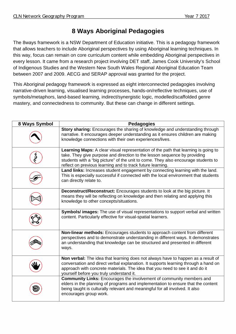
8 Ways Aboriginal Pedagogies
The 8ways framework is a NSW Department of Education initiative. This is a pedagogy framework that allows teachers to include Aboriginal perspectives by using Aboriginal learning techniques. In this way, focus can remain on core curriculum content while embedding Aboriginal perspectives in every lesson. It came from a research project involving DET staff, James Cook University’s School of Indigenous Studies and the Western New South Wales Regional Aboriginal Education Team between 2007 and 2009. AECG and SERAP approval was granted for the project.
This Aboriginal pedagogy framework is expressed as eight interconnected pedagogies involving narrative-driven learning, visualised learning processes, hands-on/reflective techniques, use of symbols/metaphors, land-based learning, indirect/synergistic logic, modelled/scaffolded genre mastery, and connectedness to community. But these can change in different settings.
8 Ways Symbol Pedagogies
Story sharing: Encourages the sharing of knowledge and understanding through narrative. It encourages deeper understanding as it ensures children are making knowledge connections with their own experiences/lives.
Learning Maps: A clear visual representation of the path that learning is going to take. They give purpose and direction to the lesson sequence by providing students with a “big picture” of the unit to come. They also encourage students to reflect on previous learning and to track future learning.
Land links: Increases student engagement by connecting learning with the land. This is especially successful if connected with the local environment that students can directly relate to.
Deconstruct/Reconstruct: Encourages students to look at the big picture. It means they will be reflecting on knowledge and then relating and applying this knowledge to other concepts/situations.
Symbols/ images: The use of visual representations to support verbal and written content. Particularly effective for visual-spatial learners.
Non-linear methods: Encourages students to approach content from different perspectives and to demonstrate understanding in different ways. It demonstrates an understanding that knowledge can be structured and presented in different ways.
Non verbal: The idea that learning does not always have to happen as a result of conversation and direct verbal explanation. It supports learning through a hand on approach with concrete materials. The idea that you need to see it and do it yourself before you truly understand it.
Community Links: Encourages the involvement of community members and elders in the planning of programs and implementation to ensure that the content being taught is culturally relevant and meaningful for all involved. It also encourages group work.

CLN Network Geography Program Year 7 2017
Numeracy Continuum K-10 The Numeracy continuum describes how students progress from using simple to increasingly sophisticated strategies in order to solve number and measurement problems. It supports teachers’ understanding of how students develop numeracy concepts by providing an explicit framework of students’ strategies and understandings across critical aspects of numeracy.
The continuum represents the synthesis of extensive national and international research over the past 20 years and underpins State developed numeracy programs including, Best Start, Targeted Early Numeracy (TEN), Count Me In Too (CMIT) and Taking Off With Numeracy (TOWN).
It can assist teachers to support the specific numeracy demands across Key Learning Areas leading to knowledge, skills and understandings in:
• mental computation • numerical reasoning • patterning and algebraic reasoning and • applying measurement strategies.
The continuum is a tool which can be used flexibly for a variety of purposes which include:
• gathering assessment information when observing students working on mathematics problems • tracking and monitoring student progress and setting progress targets • guiding future learning for students • assisting in the development of differentiated programs • communicating with students and parents to set learning goals • providing a central focus for both professional discussion and action related to classroom practice.
Teachers can make decisions on the level of development of students’ understanding in numeracy against focus aspects of the continuum. Determining where students are currently placed on aspects of the continuum will assist in designing future teaching. Planning can be based on moving the student to the next level along each aspect. This will also support teachers to provide feedback to students that is focused on improvement. The continuum assists teachers to make necessary adjustments to their programs to meet the needs of their students when developing differentiated programs, units of work or lesson plans as well as support the development of Individual learning plans. Throughout this program, activities that are present on the Numeracy continuum will be represented with this symbol .State of New South Wales, Department of Education and Communities, 2013
CLN Network Geography Program Year 7 2017
Literacy Continuum K-10 The NSW Literacy continuum K-10 describes how students progress in literacy across the curriculum. It identifies the behaviours that demonstrate how a student’s skills and understandings develop in eight aspects of literacy that are regarded as critical to individual success.
The Literacy continuum K–10 describes the key markers of student achievement in each aspect.
The literacy continuum helps teachers to address the NSW Literacy K-12 policy as they implement all BOSTES syllabuses K-10. The continuum is informed by an extensive range of Australian and international research.
The Literacy continuum K–10 is for all teachers K-10. It strengthens each teacher’s knowledge of literacy to support their students to access all syllabus content. Teachers use the continuum to provide students with the necessary literacy skills for progress in each subject. It contributes to effective teaching, assessment and reporting practice.
This continuum can be used with other support materials such as the EAL/D Learning Progression and the ESL scales, to help meet the needs of all students.
Teachers can use the continuum to:
• track and monitor student progress in literacy, both through the aspects and across the years of schooling • strengthen literacy in all subjects by providing a shared understanding of literacy across KLAs • communicate clear learning goals with students (and the wider community) to make literacy learning more visible • guide teachers to plan for teaching for whole classes, groups of learners and individual students.
A cohesive, whole school approach to literacy is developed as this information is shared across grades and stages.
Teachers can determine where students are on the literacy continuum by using a range of evidence, including observations, work samples and interactions with students themselves. This assessment for learning guides teachers to plan ‘where to next’ for teaching.
Teachers can refer to literacy continuum markers to track and monitor student progress throughout the year. Continuum markers can be used to identify ‘literacy learning goals’ that may be transferred across subjects.
The Literacy continuum supports teachers to provide feedback to students, parents and caregivers about literacy progress.
Students can be informed of the skills and strategies they need to develop further in order to move along the learning sequence.
The literacy continuum can be used by teachers to differentiate programs to meet the specific needs of students. The continuum helps with developing individual learning programs and personalised learning plans.

CLN Network Geography Program Year 7 2017 The critical aspects
• Phonics – making the connection between sounds and letters when reading and spelling. • Phonemic awareness – hearing and manipulating sounds in spoken language. • Concepts about print – understanding and using conventions and concepts about print. • Reading texts – recognising words automatically, reading in a phrased and fluent way and navigating texts to create meaning. • Comprehension – responding to, interpreting, analysing and evaluating texts. • Vocabulary knowledge – understanding the meaning of spoken and written words and using words to create and understand texts. • Aspects of writing – creating texts for specific purposes using spelling, grammar, design features, handwriting and digital tools. • Aspects of speaking – using oral language to communicate with others in a range of contexts, and listening actively and attentively when interacting with others. Other important elements of literacy such as grammar, spelling, punctuation and listening are developed within these aspects of the Literacy continuum K-10.
Clusters and markers
Each critical aspect of the Literacy continuum K–10 is organised into ‘clusters’ of literacy behaviours that demonstrate the progression of literacy learning across the years of schooling.
Students demonstrate literacy progress as they ‘move’ from one cluster to the next.
The Literacy continuum K-6 contains clusters 1 to 12. These describe expected student achievement from prior to school, through Kindergarten and to the end of Year 6. The Literacy continuum 7–10 begins with Cluster 13 for Year 7 and ends at Cluster 16, end Year 10.
Each cluster is composed of a number of ‘markers’. These describe literacy behaviours typical in each aspect at that point of development. Markers within a cluster have equal significance and don’t need to be addressed in any particular order.
Markers enable teachers to establish clear learning goals, and to plan for explicit literacy teaching. South Wales, Department of Education and Communities, 2013
CLN Network Geography Program Year 7 2017
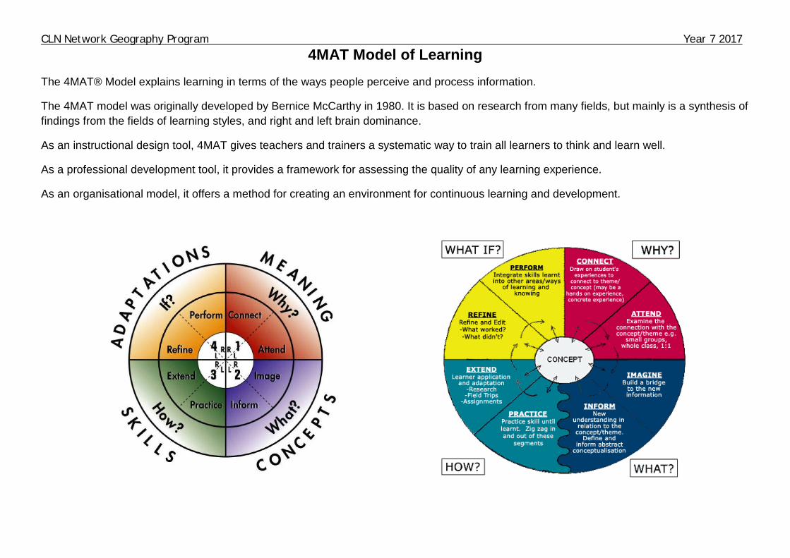
4MAT Model of Learning The 4MAT® Model explains learning in terms of the ways people perceive and process information.
The 4MAT model was originally developed by Bernice McCarthy in 1980. It is based on research from many fields, but mainly is a synthesis of findings from the fields of learning styles, and right and left brain dominance.
As an instructional design tool, 4MAT gives teachers and trainers a systematic way to train all learners to think and learn well.
As a professional development tool, it provides a framework for assessing the quality of any learning experience.
As an organisational model, it offers a method for creating an environment for continuous learning and development.
CLN Network Geography Program Year 7 2017
The Stage 4 course for Geography in the BOSTES NSW Syllabus for the Australian Curriculum (2015) is comprised of four main teaching and learning concepts. These are Place and Liveability, Landscapes and Landforms, Interconnections and Water in the World. The Mid North Coast CLN has decided that the Year 7 course will be Place and Liveability and Landscapes and Landforms. As part of the CLN direction to increase student connection and engagement the syllabus content was used to develop 3 units of work which create holistic learning opportunities. The three topics are:
• Skills • Our Place - Local Area Case Study • Country Name - South East Asian Case Study

CLN Network Geography Program Year 7 2017
Class Learning Profile ATSI students Literacy/Numeracy students IM / Support Unit students Behavioural students Students with identified disabilities NESB Disability Provisions for Assessment/Exams
Accommodations and Adjustments made for the class
CLN Network Geography Program Year 7 2017
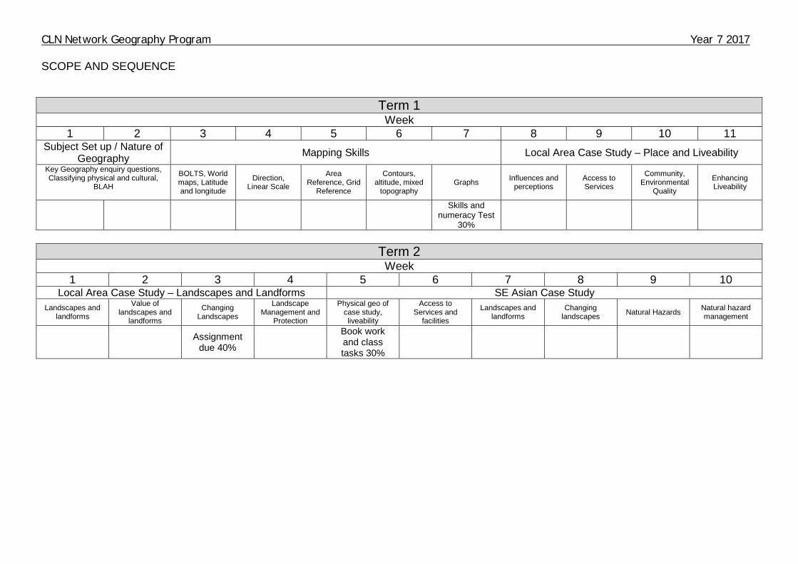
SCOPE AND SEQUENCE
Term 1
Week 1 2 3 4 5 6 7 8 9 10 11
Subject Set up / Nature of Geography Mapping Skills Local Area Case Study – Place and Liveability
Key Geography enquiry questions, Classifying physical and cultural,
BLAH
BOLTS, World maps, Latitude and longitude
Direction, Linear Scale
Area Reference, Grid
Reference
Contours, altitude, mixed
topography Graphs Influences and
perceptions Access to Services
Community, Environmental
Quality
Enhancing Liveability
Skills and
numeracy Test 30%
Term 2
Week 1 2 3 4 5 6 7 8 9 10
Local Area Case Study – Landscapes and Landforms SE Asian Case Study Landscapes and
landforms
Value of landscapes and
landforms
Changing Landscapes
Landscape Management and
Protection
Physical geo of case study, liveability
Access to Services and
facilities
Landscapes and landforms
Changing landscapes Natural Hazards Natural hazard
management
Assignment due 40%
Book work and class tasks 30%

CLN Network Geography Program Year 7 2017
Term 3 Week
1 2 3 4 5 6 7 8 9 10 Subject Set up / Nature of
Geography Mapping Skills Local Area Case Study – Place and Liveability
Key Geography enquiry questions, Classifying physical and cultural, BLAH
BOLTS, World maps, Latitude and longitude
Direction, Linear Scale
Area Reference, Grid Reference
Contours, altitude, mixed topography Graphs Influences and
perceptions Access to Services
Community, Environmental
Quality
Skills and
numeracy Test 30%
Term 4
Week 1 2 3 4 5 6 7 8 9 10 11
Local Area Case Study – Landscapes and Landforms SE Asia Case Study Enhancing Liveability
Landscapes and landforms
Value of landscapes and
landforms
Changing Landscapes
Landscape Management
and Protection
Physical geo of case study, liveability
Access to Services and
facilities
Landscapes and landforms
Changing landscapes Natural Hazards Natural hazard
management
Assignment due 40%
Book work and class tasks 30%
CLN Network Geography Program Year 7 2017
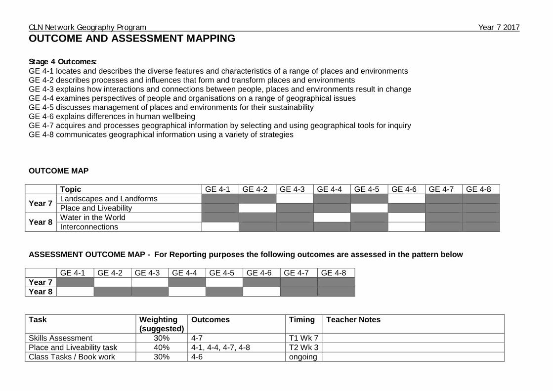
OUTCOME AND ASSESSMENT MAPPING Stage 4 Outcomes: GE 4-1 locates and describes the diverse features and characteristics of a range of places and environments GE 4-2 describes processes and influences that form and transform places and environments GE 4-3 explains how interactions and connections between people, places and environments result in change GE 4-4 examines perspectives of people and organisations on a range of geographical issues GE 4-5 discusses management of places and environments for their sustainability GE 4-6 explains differences in human wellbeing GE 4-7 acquires and processes geographical information by selecting and using geographical tools for inquiry GE 4-8 communicates geographical information using a variety of strategies OUTCOME MAP Topic GE 4-1 GE 4-2 GE 4-3 GE 4-4 GE 4-5 GE 4-6 GE 4-7 GE 4-8
Year 7 Landscapes and Landforms Place and Liveability
Year 8 Water in the World Interconnections
ASSESSMENT OUTCOME MAP - For Reporting purposes the following outcomes are assessed in the pattern below GE 4-1 GE 4-2 GE 4-3 GE 4-4 GE 4-5 GE 4-6 GE 4-7 GE 4-8 Year 7 Year 8 Task Weighting
(suggested) Outcomes Timing Teacher Notes
Skills Assessment 30% 4-7 T1 Wk 7 Place and Liveability task 40% 4-1, 4-4, 4-7, 4-8 T2 Wk 3 Class Tasks / Book work 30% 4-6 ongoing

CLN Network Geography Program Year 7 2017 Bookwork Guide for Teachers Individual class teachers are to monitor student books to teacher specified class standards for class bookwork and / or homework booklets. In Geography class books are to be structured as followed:
• Books are to be covered with student name, class and teacher on the front.
• Theory is to be written in a blue or black pen.
• A Geography title page.
• Each topic should have a title page. • Metalanguage is to be underlined – learn to spell these correctly.
• Notes should include dates and all headings underlined.
• All diagrams are to be clearly drawn with adequate space – using
pencils not pen.
• The back of the book is to be used only for activities such as spelling tests
Encourage students to take pride in their bookwork by checking it regularly and giving students feedback.

CLN Network Geography Program Year 7 2017 Geography Skills – Numeracy Teaching Guide
TOOL Year 7 Year 8 Year 9 Year 10 Maps Sketch maps, relief maps, political maps,
topographic maps, Flowline maps, Choropleth maps, isoline maps, précis maps, cartograms
Maps to identify direction, scale (linear) and distance, area and grid references, latitude and longitude, altitude, contour lines
Synoptic charts Local relief Scale (Ratio) Area
Cadastral maps, thematic maps, special purpose maps, Degrees and minutes of latitude and longitude, bearings, density
Aspect Gradient
Fieldwork Observing, measuring, collecting and recording data, developing and conducting surveys and interviews – assessment tasks - Place
Fieldwork instruments such as vegetation identification charts and compasses
Fieldwork instruments such as weather instruments, GPS, GIS
Remote sensing
Graphs and Statistics
Data tables Pie graphs Column graphs Line graphs Climate graphs Multiple graphs on a geographical theme
Population profiles Statistics to find patterns and trends
Scatter graphs Statistics to find patterns and trends; and to account for change
Spatial Technologies
Virtual maps Satellite images
Global Positioning Systems (GPS) Geographic Information Systems (GIS)
Remote sensing data Augmented reality
Visual Representations
Photographs Aerial photographs Multimedia Field sketches
Illustrations Flow charts Annotated diagrams Cartoons Web tools
Field and photo sketches
Mind maps
CLN Network Geography Program Year 7 2017
VOCABULARY LIST
Week 1 Week 6 Week 2 Week 7 Week 3 Week 8 Week 4 Week 9 Week 5 Week 10

CLN Network Geography Program Year 7 2017
VOCABULARY LIST
Week 1 Week 6 Week 2 Week 7 Week 3 Week 8 Week 4 Week 9 Week 5 Week 10
CLN Network Geography Program Year 7 2017
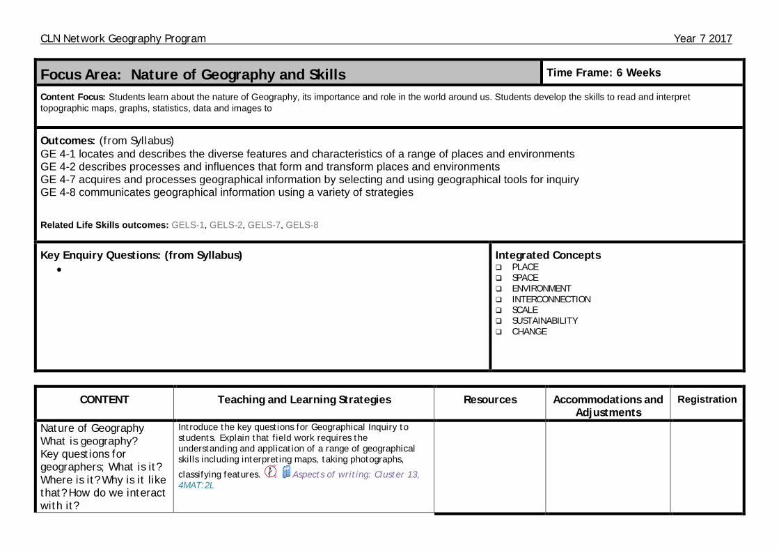
Focus Area: Nature of Geography and Skills Time Frame: 6 Weeks
Content Focus: Students learn about the nature of Geography, its importance and role in the world around us. Students develop the skills to read and interpret topographic maps, graphs, statistics, data and images to
Outcomes: (from Syllabus) GE 4-1 locates and describes the diverse features and characteristics of a range of places and environments GE 4-2 describes processes and influences that form and transform places and environments GE 4-7 acquires and processes geographical information by selecting and using geographical tools for inquiry GE 4-8 communicates geographical information using a variety of strategies
Related Life Skills outcomes: GELS-1, GELS-2, GELS-7, GELS-8
Key Enquiry Questions: (from Syllabus) •
Integrated Concepts PLACE SPACE ENVIRONMENT INTERCONNECTION SCALE SUSTAINABILITY CHANGE
CONTENT Teaching and Learning Strategies Resources Accommodations and Adjustments
Registration
Nature of Geography What is geography? Key questions for geographers; What is it? Where is it? Why is it like that? How do we interact with it?
Introduce the key questions for Geographical Inquiry to students. Explain that field work requires the understanding and application of a range of geographical skills including interpreting maps, taking photographs,
classifying features. Aspects of writing: Cluster 13, 4MAT:2L

CLN Network Geography Program Year 7 2017
CONTENT Teaching and Learning Strategies Resources Accommodations and Adjustments
Registration
Geographical Skills
Identify Physical and Cultural features on a map Describe global patterns of physical and human features. 4MAT:L2 Identify and describe the global patterns of physical and human features. Students to identify areas on a map of the local area and describe reasons for the distribution of features.
Aspects of writing: Cluster 13, 4MAT:1R,3L
Elements of BOLTS Draw a map of the classroom that contains the 5 key elements of
a map. 4MAT:3L
Use various types of maps including physical, political, topographic and thematic Recognise continents using different map projections Use an atlas to label the 7 continents, five oceans, arctic circle, tropics, equator, prime meridian and international date line.
Vocabulary knowledge: Cluster 13, 4MAT:3L2LR,3L
World map master World map continent jigsaw
Define latitude and longitude. Draw a representation of the earth. Draw in the lines of latitude and longitude and label important lines. Explain solar insolation and seasonal change Illustrate and explain the locations of biome zones. Brainstorm the reasoning for the growth of major populations along coastal areas.
Vocabulary knowledge: Cluster 13, 4MAT:1LR,2LR
CLN Network Geography Program Year 7 2017
CONTENT Teaching and Learning Strategies Resources Accommodations and Adjustments
Registration
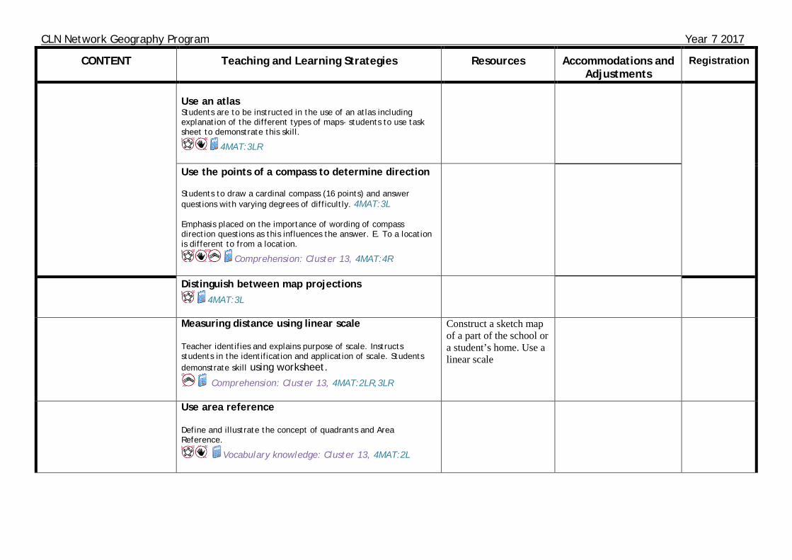
Use an atlas Students are to be instructed in the use of an atlas including explanation of the different types of maps- students to use task sheet to demonstrate this skill.
4MAT:3LR
Use the points of a compass to determine direction Students to draw a cardinal compass (16 points) and answer questions with varying degrees of difficultly. 4MAT:3L Emphasis placed on the importance of wording of compass direction questions as this influences the answer. E. To a location is different to from a location.
Comprehension: Cluster 13, 4MAT:4R
Distinguish between map projections 4MAT:3L
Measuring distance using linear scale Teacher identifies and explains purpose of scale. Instructs students in the identification and application of scale. Students demonstrate skill using worksheet.
Comprehension: Cluster 13, 4MAT:2LR,3LR
Construct a sketch map of a part of the school or a student’s home. Use a linear scale
Use area reference Define and illustrate the concept of quadrants and Area Reference.
Vocabulary knowledge: Cluster 13, 4MAT:2L

CLN Network Geography Program Year 7 2017
CONTENT Teaching and Learning Strategies Resources Accommodations and Adjustments
Registration
Use grid reference Define and demonstrate the use of Grid References. Carefully explain the use of tenths. Eg GR 245832 to GR 24.5 83.2
Vocabulary knowledge: Cluster 13, 4MAT:2L
Altitude using spot heights, colour and contour lines Teacher explanation of the features of a topographic map- spot heights, contour lines etc. Students to demonstrate skill with altitude by determining altitude of various locations using a topographic map.
4MAT:2LR,3LR
Construct a sketch map Students to construct a sketch map of both a physical and cultural environment
4MAT:3LR
CLN Network Geography Program Year 7 2017
CONTENT Teaching and Learning Strategies Resources Accommodations and Adjustments
Registration
Graphs and statistics Identify and calculate maximum, minimum, total, range, rank and average Teacher to use student ages to illustrate range by having students get into chronological order. From this teacher can demonstrate
maximum and minimum. 4MAT:1R Teacher to further illustrate the application of total, range and
average. Students to demonstrate these skills by completing numeracy
activities. 4MAT:3LR Construct and interpret bar, line, column and climatic graphs. 4MAT:3L Students are to construct various types of graphs, some with ICT, to develop their ability to apply further geographical skills such as max, min, range, rank etc. Students are to construct and interpret
climatic graphs and calculate average temperature etc
4MAT:4R Relationship to be drawn to previous study of the impact that latitude has on global seasons and therefore the impact that these
will have when inferring information from climatic graphs. 4MAT:3L,4R
Measuring and collecting data = traffic count Do a traffic count and create column graph of findings/ similar to fieldwork activity at end of program students can come up with improvements
Time Spent: six – seven weeks (includes swimming carnival)

CLN Network Geography Program Year 7 2017
Focus Area: Landscapes and Landforms Focus Area: Place and Liveability Content Focus: Students explore landscapes and landforms using examples from Australia and throughout the world. They explain processes that create landscapes and shape individual landforms and they describe the value of landscapes and landforms to different people. Students examine issues of landscape degradation and ways to manage and protect landscapes and landforms. Students also investigate a natural hazard associated with landscapes and people’s responses to that hazard.
Content Focus: Students discuss factors that influence people’s perceptions of the liveability of places. They investigate features and characteristics of places across a range of scales that support and enhance people’s wellbeing such as community identity, environmental quality and access to services and facilities. Students assess the liveability of places and propose strategies to enhance the liveability of a place in Australia.
Shared Unit Outcomes: (from Syllabus) GE 4-1 locates and describes the diverse features and characteristics of a range of places and environments GE 4-4 examines perspectives of people and organisations on a range of geographical issues GE 4-7 acquires and processes geographical information by selecting and using geographical tools for inquiry GE 4-8 communicates geographical information using a variety of strategies
Outcomes: (from Syllabus – Landscapes and Landforms) GE 4-2 describes processes and influences that form and transform places and environments GE 4- 5 discusses management of places and environments for their sustainability Related Life Skills outcomes: GELS-1, GELS-2, GELS-4, GELS-5, GELS-7, GELS-8
Outcomes: (from Syllabus – Place and Livability) GE 4-3 explains how interactions and connections between people, places and environments result in change GE 4-6 explains differences in human wellbeing
Related Life Skills outcomes: GELS-1, GELS-3, GELS-4, GELS-6, GELS-7, GELS-8
Key Enquiry Questions: (from Syllabus) Why is there a diversity of landscapes and landforms on Earth? What environmental and human processes form and transform landscapes and landforms? Why do people value landscapes and landforms? To what extent are landscapes and landforms sustainably managed and protected?
Key Enquiry Questions: (from Syllabus) Why do people’s perceptions of the liveability of places vary? What effect does environmental quality and access to services have on people’s wellbeing? How can strong community identity and social connectedness enhance the liveability of places? What approaches can be used to improve the liveability of places?
Time Frame: 13 Weeks Integrated Concepts
PLACE SPACE ENVIRONMENT INTERCONNECTION SCALE SUSTAINABILITY CHANGE
CLN Network Geography Program Year 7 2017
OUR PLACE - Local Area Case Study
CONTENT Teaching and Learning Strategies Resources Accommodations and Adjustments
Registration
PLACE AND LIVEABILITY
Influences and perceptions
Students investigate factors influencing perceptions of the liveability of places, for example: (ACHGK043, ACHGK046, ACHGK065)
- examination of environmental factors that influence perceptions of liveability eg climate, landforms, natural resources
- discussion of human factors that influence perceptions of liveability eg culture, income, employment, crime and safety
- explanation of ways used to measure, assess or rank the liveability of places eg surveys, liveability index
- development of personal liveability criteria and application to a local place
Where do most Australians live? 85% of Australians live within 50km of the coast. Brainstorm why Australians live in this space. Give each student 5 post it notes to write down their ideas. Group them on class wall/window/desk. Students group post it notes into human characteristics and natural characteristics. Reading texts, Comprehension, Vocabulary knowledge and Aspects of writing: Cluster 13, 4MAT:1LR,4R Use images to examine the liveability of other places, both safe and dangerous. Reading texts and Comprehension: Cluster 13, 4MAT:1LR, 3R Ask students where else they would like to live and why? Students to write a paragraph which describes the place they would like to live – the ideal world. Draw a sketch map of the perfect town and its features. Aspects of Writing and Vocabulary knowledge: Cluster 13, 4MAT:3L,4R Use www.theeconomist.com. Has the current global liveability ranking. Includes maps and graphs. Examines stability, healthcare, culture and environment, education, infrastructure. Investigate the MERCER scale to compare differences in ways to measure liveability. Students examine the different characteristics used in the liveability indexes and compare
ABC splash – where’s the best place to live? (digibook) Primaryedutech.com Geoguessr – uses google maps for students to determine where they are
CLN Network Geography Program Year 7 2017
OUR PLACE - Local Area Case Study
CONTENT Teaching and Learning Strategies Resources Accommodations and Adjustments
Registration
Access to services and facilities
Students investigate the influence of accessibility to services and facilities on the liveability of places, for example: (ACHGK044)
- identification of services and facilities considered important to people’s wellbeing
- examination of variations in access to services and facilities between urban, rural and remote places
- explanation of how limited access to services and facilities affects the liveability of ONE place for different groups of people eg young people, people with disabilities, the aged, rural and remote communities
results/ Questions based on statistics available. Reading texts and Comprehension: Cluster 13,
4MAT:3R Newspaper analysis on the most liveable city index. Reading texts and Comprehension: Cluster 13, 4MAT:4R,3R Students determine the facilities required for different groups such as: 0-5 5-11 12-18 19-25 26-40 40-60 60-80 80+ Unemployed Disabled Identified subculture groups (surfers, skaters).
Comprehension and Vocabulary knowledge: Cluster 13 Use a local area map to indicate some of the facility locations. Reading texts, Comprehension and Vocabulary knowledge: Cluster 13. 4MAT:3L Students write an explanation of which groups are catered for in their local community and how well they are catered for. Aspects of Writing: Cluster 13, 4MAT:3R

CLN Network Geography Program Year 7 2017
OUR PLACE - Local Area Case Study
CONTENT Teaching and Learning Strategies Resources Accommodations and Adjustments
Registration
Community
Students investigate the influence of social connectedness and community identity on the liveability of places, for example: (ACHGK046)
- identification of the characteristics of places that influence community identity eg culture, environment, public events, religious beliefs
- discussion of factors that enhance social connectedness eg transport, technology, open spaces, meeting places, employment
Environmental quality
Students investigate the impact of environmental quality on the liveability of places, for example: (ACHGK045)
For the groups identified in the above activity students develop a list of social activities/interest groups which occur in their community including sporting, cultural, social events which increase liveability for groups. This may include carols in the park, sporting competitions, markets, festivals, Rotary, SES. Comprehension: Cluster 13, 4MAT:3R Students create a brochure, poster, radio script which promotes the local area or a local event.
Aspects of Writing and Speaking: Cluster 13, 4MAT:4R Guest speaker from tourist information centre to speak to the students about the importance of community resources and events. Comprehension: Cluster 13, 4MAT:2LR Students complete a Y Chart for looks like, sounds like, smells like a healthy environment to live in. Vocabulary knowledge: Cluster 13, 4MAT:1R,2R Students list the parts of the local environment which are positive influences including water
Documentary on the Aral Sea
CLN Network Geography Program Year 7 2017
OUR PLACE - Local Area Case Study
CONTENT Teaching and Learning Strategies Resources Accommodations and Adjustments
Registration
- discussion of factors that reduce environmental quality eg natural hazard, conflict, population pressures, land degradation
- comparison of the impact of environmental quality on the liveability of places across a range of scales eg local neighbourhoods, large cities, countries
Enhancing liveability
Students investigate strategies used to enhance the liveability of places using examples from different countries, for example: (ACHGK047)
- identification of the characteristics of places considered highly liveable
- examination of a range of strategies used to enhance liveability
quality, forests, waterways, beaches, national parkland, low population density, air quality, noise. Aspects of Writing: Cluster 13, 4MAT:1R Students list the negative environmental forces in their local community. Aspects of Writing: Cluster 13, 4MAT:1R,3L Visual literacy activity where students collect images of healthy environments versus unhealthy environments. Teacher may introduce the students to a range of images from places around to show environmental challenges for populations. Students rank photos in order of liveability. Comprehension: Cluster 13, 4MAT:1LR,2LR,3L Use council growth plans to show students how local councils plan to improve space liveability. Students identify the resources which are planned. Reading texts: Cluster 13, 4MAT:2LR Propose strategies to the class and examine the impacts on liveability including pros and cons Eg Greater police presence A new hospital Fast train from Melbourne to Brisbane An airport in your local area A music festival targeting 18-25 yr olds
4MAT:2LR

CLN Network Geography Program Year 7 2017
OUR PLACE - Local Area Case Study
CONTENT Teaching and Learning Strategies Resources Accommodations and Adjustments
Registration
- assessment of the role of governments, non-government organisations, communities and individuals in enhancing liveability
- proposal of strategies to improve the liveability of a place in Australia
LANDSCAPES AND LANDFORMS
Landscapes and landforms
Students investigate different landscape and the geomorphic processes that create distinctive landforms , for example: (ACHGK048, ACHGK050)
- identification of a variety of landscapes and landforms
- explanation of geomorphic processes that create landforms eg weathering, erosion, deposition, tectonic activity
- examination of ONE landscape and its distinctive landforms
Students design a space eg a park to increase liveability.
Comprehension: Cluster 13, 4MAT:3L.4R Investigate what it is like where you live. 4MAT:3R What makes up your local landscape? 4MAT:1R Investigate the processes which have formed the local landscapes. 4MAT:3R Distribute images of local landforms. Students annotate images to identify landform, distinguishing features and clues to the factors that have changed, or are currently changing the landform. Aspects of Writing, Comprehension and reading texts: Cluster 13, 4MAT:3L Class task: Assessment for learning task GE4-2 Describes processes and influences that form and transform places and environments 4MAT:3R What has formed the local landscapes? Introduce the main processes which create
Books by Steve Breveton

CLN Network Geography Program Year 7 2017
OUR PLACE - Local Area Case Study
CONTENT Teaching and Learning Strategies Resources Accommodations and Adjustments
Registration
Value of landscapes and landforms
Students investigate the aesthetic, cultural, spiritual and economic value of landscapes and landforms for people, including Aboriginal and Torres Strait Islander Peoples, for example: (ACHGK049)
- explanation of the aesthetic value of landscapes and landforms to culture and identity
- description of the cultural and spiritual value of landscapes or landforms in different places
landforms in the local area. Students investigate the processes in action in the local area. Students describe the processes. Aspects of writing and Comprehension: Cluster 13, 4MAT:1R,2L.3L Use local dreaming stories on local landscape. 4MAT:1LR Examine one local landform and the geomorphic processes relevant to the landscape. Reading texts: Cluster 13, 4MAT:3R Students investigate how the local area is promoted and collect relevant images. Possible activities: 1. Choose a local landform. Investigate its aesthetic, cultural, spiritual and economic value eg. Wallis Lake, North Brother Aspects of writing and Reading texts: Cluster 13, 4MAT:1R,3R 2. Scaffold a web quest which investigates which the aesthetic, cultural, spiritual and economic value of the area Reading texts, Comprehension, Vocabulary knowledge and Aspects of writing: Cluster 13, 4MAT:1R,3R 3. Devise 4 class groups. Each group researches one key value (aesthetic, cultural, spiritual and

CLN Network Geography Program Year 7 2017
OUR PLACE - Local Area Case Study
CONTENT Teaching and Learning Strategies Resources Accommodations and Adjustments
Registration
- identification of how a landscape can have economic value for different people
Changing landscapes
Students investigate the human causes and effects of land degradation, for example: (ACHGK051)
- identification of the ways people utilise and change landscapes
- description of the impact of a range of human activities on landscapes
- examination of ONE type of landscape degradation including its spatial distribution, causes and impact
economic). Each group presents their research to the class. Reading texts, Comprehension, Vocabulary knowledge and Aspects of speaking: Cluster 13, 4MAT:1R,3R
4. Design a brochure to attract people to your local area. The four values (aesthetic, cultural, spiritual and economic) must be covered.
Reading texts, Comprehension and Aspects of writing: Cluster 13, 4MAT:1R,3R Photo representations of then and now. Look at a local built landscape and examine the impact of human uses on the natural environment. Reading texts and Comprehension: Cluster 13, 4MAT:1LR Examine one form of land degradation which has occurred to build the local environment. eg land clearing, draining wetlands, building break walls, beach erosion / lake openings. Students describe the impact. Reading texts, Comprehension and Aspects of writing: Cluster 13, 4MAT:1LR Students examine the positives and negatives of the landscape change. Reading texts: Cluster 13, 4MAT:3R
CLN Network Geography Program Year 7 2017
OUR PLACE - Local Area Case Study
CONTENT Teaching and Learning Strategies Resources Accommodations and Adjustments
Registration
Landscape management and protection
Students investigate ways people, including Aboriginal and Torres Strait Islander Peoples, manage and protect landscapes, for example: (ACHGK052)
- description of the nature and extent of landscape protection across a range of scales eg locally protected places, national parks, world heritage listing
- examination of management and protection strategies for ONE landscape
- assessment of the contribution of Aboriginal and Torres Strait Islander Peoples’ knowledge to the use and management of an Australian landscape or landform
Students investigate the traditional and contemporary land management practices for the landscape identified above. Reading texts: Cluster 13, 4MAT:3R Students learn about the traditional management practices and how this informs current management
practices. 4MAT:3R

CLN Network Geography Program Year 7 2017
South East Asian Case Study eg India, China, Borneo, Indonesia
CONTENT Teaching and Learning Strategies Resources Accommodations and Adjustments
Registration
Influences and perceptions
Students investigate factors influencing perceptions of the liveability of places, for example: (ACHGK043, ACHGK046, ACHGK065)
- examination of environmental factors that influence perceptions of liveability eg climate, landforms, natural resources
- discussion of human factors that influence perceptions of liveability eg culture, income, employment, crime and safety
- explanation of ways used to measure, assess or rank the liveability of places eg surveys, liveability index
- development of personal liveability criteria and application to a local place
What is it like in other places? 4MAT:3LR Students examine a case study from SE Asia to compare life in that country to their home town.
Reading texts and Comprehension: Cluster 13, 4MAT:2LR,3LR Students map the country location and its main features (landforms and cities). 4MAT:3L Students map the main biomes of the case study country. Vocabulary knowledge: Cluster 13, 4MAT:3L Students complete climate graph for the capital city of their state and the capital city of the Case Study country. 4MAT:3L Find and present to students You tube clips / photographs which show life in the case study country. Students write a list of similarities and differences for their home country V the case study. Reading texts, Comprehension and Aspects of writing: Cluster 13, 4MAT:1LR,2LR,3L Students complete a scaffolded worksheet on the statistics of the country being investigated compared to Australia using CIA world fact book.
Numbeo.com – compares countries based on a cost of living Slumming it – Kevin McCloud documentary on Dharavi CIA World factbook – global statistics for country comparisons Worldvision.ocom.au 40hourfamine.com.au oxfam.org.au “I am a girl” SBS documentary
CLN Network Geography Program Year 7 2017
South East Asian Case Study eg India, China, Borneo, Indonesia
CONTENT Teaching and Learning Strategies Resources Accommodations and Adjustments
Registration
Access to services and facilities
Students investigate the influence of accessibility to services and facilities on the liveability of places, for example: (ACHGK044)
- identification of services and facilities considered important to people’s wellbeing
- examination of variations in access to services and facilities between urban, rural and remote places
- explanation of how limited access to services and facilities affects the liveability of ONE place for different groups of people eg young people, people with disabilities, the aged, rural and remote communities
Environmental quality
Students investigate the impact of environmental quality on the liveability of places, for example:
Key comparison terms scaffolded on the worksheet. Reading texts: Cluster 13, 4MAT:3L Students apply their liveability criteria to the case study. Comprehension: Cluster 13, 4MAT:4R Students explain how access to clean water, medical attention, education etc effects liveability outcomes such as life expectancy, employment, infectious diseases. Aspects of writing and speaking: Cluster 13, 4MAT:3R Class task: Assessment for learning task GE4-6 explains differences in Human Wellbeing 4MAT:3R Students investigate crime statistics for the country case study in comparison to Australia.
Reading texts: Cluster 13, 4MAT:1R Students write a diary entry for a person in the case study country which develops empathy for individual based on the challenges faced. Students should focus on the challenges of women or children in the area. Vocabulary knowledge and Aspects of writing: Cluster 13, 4MAT:3R Teacher directed- overview of activities threatening environmental quality Borneo- Palm oil
CLN Network Geography Program Year 7 2017
South East Asian Case Study eg India, China, Borneo, Indonesia
CONTENT Teaching and Learning Strategies Resources Accommodations and Adjustments
Registration
(ACHGK045)
- discussion of factors that reduce environmental quality eg natural hazard, conflict, population pressures, land degradation
- comparison of the impact of environmental quality on the liveability of places across a range of scales eg local neighbourhoods, large cities, countries
Enhancing liveability
Students investigate strategies used to enhance the liveability of places using examples from different countries, for example: (ACHGK047)
- identification of the characteristics of places considered highly liveable
- examination of a range of strategies used to enhance liveability
- assessment of the role of governments, non-government
Indonesia- Palm oil, fire clearing Vocabulary knowledge: Cluster 13, 4MAT:2L Palm oil case study Comparison of the representation of selected country to local area- collection of images.
4MAT:3R How does palm oil impact BLAH? Using Venn diagram to identify the impacts of palm oil. Comprehension, Vocabulary knowledge and Aspects of writing: Cluster 13, 4MAT:3R Local populations making money from tourism rather than land degradation Potential to examine the sustainable
benefits of tourism rather than clearing for palm oil 4MAT:3R
Students research the role of governments, non-government organisations, communities and individuals in enhancing liveability

CLN Network Geography Program Year 7 2017
South East Asian Case Study eg India, China, Borneo, Indonesia
CONTENT Teaching and Learning Strategies Resources Accommodations and Adjustments
Registration
organisations, communities and individuals in enhancing liveability
- proposal of strategies to improve the liveability of a place in Australia
LANDSCAPES AND LANDFORMS
Landscapes and landforms
Students investigate different landscape and the geomorphic processes that create distinctive landforms , for example: (ACHGK048, ACHGK050)
- identification of a variety of landscapes and landforms
- explanation of geomorphic processes that create landforms eg weathering, erosion, deposition, tectonic activity
- examination of ONE landscape and its distinctive
Link to civics and citizenship, Orang-utan sanctuaries, sponsor Orang-utans.
Reading texts: Cluster 13, 4MAT:3R Create brochure/ PowerPoint/ poster about the activities undertaken by NGO’s to protect the Orang-utans. Aspects of writing: Cluster 13, 4MAT:4R Extension: What else can be done/ what further strategies would you suggest. 4MAT:4LR Students need to have an understanding of the different forms of landscapes/ environments- deserts, rainforests, mountains of the selected case study country. When selecting the landform study consider studying a different landform from the local area case study. Also consider the natural hazards which may impact the landform (next part of syllabus).

CLN Network Geography Program Year 7 2017
South East Asian Case Study eg India, China, Borneo, Indonesia
CONTENT Teaching and Learning Strategies Resources Accommodations and Adjustments
Registration
landforms
Changing landscapes
Students investigate the human causes and effects of land degradation, for example: (ACHGK051)
- identification of the ways people utilise and change landscapes
- description of the impact of a range of human activities on landscapes
- examination of ONE type of landscape degradation including its spatial distribution, causes and impact
Geomorphic hazard
Students investigate ONE contemporary geomorphic hazard including causes, impacts and responses, for example: (ACHGK053)
- description of the spatial
Changing landscapes- covered under Environmental Quality (see above) Geomorphic hazard will inform the landscape/ landform studied role of governments, NGO’s can be covered in response to Geomorphic hazard. Vocabulary knowledge: Cluster 13 Potential to develop 4 examples of geomorphic hazards that occur in the South East Asian region
www.stopdisastersgame. org/en/playgame.html
CLN Network Geography Program Year 7 2017
South East Asian Case Study eg India, China, Borneo, Indonesia
CONTENT Teaching and Learning Strategies Resources Accommodations and Adjustments
Registration
distribution of the disaster
- explanation of geomorphic processes causing the disaster and its impacts
- examination of the responses of individuals, groups and government to the impact of the disaster
- discussion of management strategies to reduce the future impact of similar natural hazard events including the role of technology in monitoring and predicting geomorphic hazards
Volcanoes Tsunami Landslides Earthquake Use group work and ICT to research and report on a hazard. In the research student should report on the causes of the natural hazard, responses made by government and NGO’s, survival plans, and management strategies used to reduce the impact of future natural hazards.
Reading texts, Comprehension, Vocabulary knowledge, Aspects of writing and speaking: Cluster 13, 4MAT:1L,3R For lower ability classes: creation of a literacy based activity sequence to support the understanding and comprehension based on resources on geomorphic hazards. Reading texts, Comprehension, Vocabulary knowledge, Aspects of writing and speaking: Cluster 13, 4MAT:1L,4R Last week comparison: look at comparisons between local area and chosen case study
Reading texts: Cluster 13, 4MAT:1R,3R

CLN Network Geography Program Year 7 2017
Focus Area: Extension work - Fieldwork Time Frame: 3 Weeks
Content Focus: To develop student’s abilities to conduct fieldwork in relation to the topics studied in Year 7
Outcomes: (from Syllabus) To be determined by programming team based on nature of task GE 4-1 locates and describes the diverse features and characteristics of a range of places and environments GE 4-2 describes processes and influences that form and transform places and environments GE 4-3 explains how interactions and connections between people, places and environments result in change GE 4-4 examines perspectives of people and organisations on a range of geographical issues GE 4-5 discusses management of places and environments for their sustainability GE 4-6 explains differences in human wellbeing GE 4-7 acquires and processes geographical information by selecting and using geographical tools for inquiry GE 4-8 communicates geographical information using a variety of strategies
Related Life Skills outcomes: GELS-1, GELS-3, GELS-4, GELS-6, GELS-7, GELS-8
Key Enquiry Questions: (from Syllabus) From place and liveability
• Why do people’s perceptions of the liveability of places vary? • What effect does environmental quality and access to services have on people’s wellbeing? • How can strong community identity and social connectedness enhance the liveability of places? • What approaches can be used to improve the liveability of places?
From landscapes and landforms
• Why is there a diversity of landscapes and landforms on Earth? • What environmental and human processes form and transform landscapes and landforms? • Why do people value landscapes and landforms? • To what extent are landscapes and landforms sustainably managed and protected?
Integrated Concepts PLACE SPACE ENVIRONMENT INTERCONNECTION SCALE SUSTAINABILITY CHANGE

CLN Network Geography Program Year 7 2017
Geographical Fieldwork Content Teaching and Learning Strategies Resources Accommodations and
Adjustments Registration
Key geographical questions Identify the key geographical questions: What? Where? Why? How is it managed? Explain the concepts of aim, hypothesis Go through the various methods that can be used to collect primary and secondary data Design a field study within the local environment. Show students how to collect data, analysis and present findings using a variety of forms.
Apply key geographical questions to a local environment. Comprehension: Cluster 13, 4MAT:3L Use geographical tools to measure and record elements of the local environment. Comprehension: Cluster 13, 4MAT:3L Present geographical information about the local environment using a range of written, oral and graphic forms. Aspects of writing and speaking: Cluster 13, 4MAT:3LR,4LR
CLN Network Geography Program Year 7 2017
GATS EXTENSION NOTES Geography Research Students that have finished the designated course content in the allocated time or require additional material should only complete this section. As a class students can complete an in-depth field study over several weeks. Choose a specific biome. Divide students in groups. Each group is to research the specific biome selected. Reading texts, Comprehension, Vocabulary knowledge, Aspects of writing and speaking: Cluster 13, 4MAT:1LR,2LR,3LR Students should: Identify where the biome can be found Describe the features and characteristics of the biome Explain the adaptations of plants and animals in the biome Identify the threats to the biome Explain the impact of these threats on the biome functioning
REGO
Related Documents