State and tribal Brownfields sites BROWNFIELDS: Considered Brownfieds Sites Listing A listing of sites the SWRCB considers to be Brownfields since these are sites have come to them through the MOA Process. Date of Government Version: 02/29/2016 Date Data Arrived at EDR: 03/07/2016 Date Made Active in Reports: 05/04/2016 Number of Days to Update: 58 Source: State Water Resources Control Board Telephone: 916-323-7905 Last EDR Contact: 09/26/2016 Next Scheduled EDR Contact: 01/09/2017 Data Release Frequency: Varies ADDITIONAL ENVIRONMENTAL RECORDS Local Brownfield lists US BROWNFIELDS: A Listing of Brownfields Sites Brownfields are real property, the expansion, redevelopment, or reuse of which may be complicated by the presence or potential presence of a hazardous substance, pollutant, or contaminant. Cleaning up and reinvesting in these properties takes development pressures off of undeveloped, open land, and both improves and protects the environment. Assessment, Cleanup and Redevelopment Exchange System (ACRES) stores information reported by EPA Brownfields grant recipients on brownfields properties assessed or cleaned up with grant funding as well as information on Targeted Brownfields Assessments performed by EPA Regions. A listing of ACRES Brownfield sites is obtained from Cleanups in My Community. Cleanups in My Community provides information on Brownfields properties for which information is reported back to EPA, as well as areas served by Brownfields grant programs. Date of Government Version: 09/20/2016 Date Data Arrived at EDR: 09/21/2016 Date Made Active in Reports: 11/11/2016 Number of Days to Update: 51 Source: Environmental Protection Agency Telephone: 202-566-2777 Last EDR Contact: 09/21/2016 Next Scheduled EDR Contact: 01/02/2017 Data Release Frequency: Semi-Annually Local Lists of Landfill / Solid Waste Disposal Sites WMUDS/SWAT: Waste Management Unit Database Waste Management Unit Database System. WMUDS is used by the State Water Resources Control Board staff and the Regional Water Quality Control Boards for program tracking and inventory of waste management units. WMUDS is composed of the following databases: Facility Information, Scheduled Inspections Information, Waste Management Unit Information, SWAT Program Information, SWAT Report Summary Information, SWAT Report Summary Data, Chapter 15 (formerly Subchapter 15) Information, Chapter 15 Monitoring Parameters, TPCA Program Information, RCRA Program Information, Closure Information, and Interested Parties Information. Date of Government Version: 04/01/2000 Date Data Arrived at EDR: 04/10/2000 Date Made Active in Reports: 05/10/2000 Number of Days to Update: 30 Source: State Water Resources Control Board Telephone: 916-227-4448 Last EDR Contact: 11/07/2016 Next Scheduled EDR Contact: 02/20/2017 Data Release Frequency: No Update Planned SWRCY: Recycler Database A listing of recycling facilities in California. Date of Government Version: 09/12/2016 Date Data Arrived at EDR: 09/14/2016 Date Made Active in Reports: 10/14/2016 Number of Days to Update: 30 Source: Department of Conservation Telephone: 916-323-3836 Last EDR Contact: 09/14/2016 Next Scheduled EDR Contact: 12/26/2016 Data Release Frequency: Quarterly HAULERS: Registered Waste Tire Haulers Listing A listing of registered waste tire haulers. TC4787451.2s Page GR-13 GOVERNMENT RECORDS SEARCHED / DATA CURRENCY TRACKING

Welcome message from author
This document is posted to help you gain knowledge. Please leave a comment to let me know what you think about it! Share it to your friends and learn new things together.
Transcript

State and tribal Brownfields sites
BROWNFIELDS: Considered Brownfieds Sites ListingA listing of sites the SWRCB considers to be Brownfields since these are sites have come to them through the MOAProcess.
Date of Government Version: 02/29/2016Date Data Arrived at EDR: 03/07/2016Date Made Active in Reports: 05/04/2016Number of Days to Update: 58
Source: State Water Resources Control BoardTelephone: 916-323-7905Last EDR Contact: 09/26/2016Next Scheduled EDR Contact: 01/09/2017Data Release Frequency: Varies
ADDITIONAL ENVIRONMENTAL RECORDS
Local Brownfield lists
US BROWNFIELDS: A Listing of Brownfields SitesBrownfields are real property, the expansion, redevelopment, or reuse of which may be complicated by the presenceor potential presence of a hazardous substance, pollutant, or contaminant. Cleaning up and reinvesting in theseproperties takes development pressures off of undeveloped, open land, and both improves and protects the environment.Assessment, Cleanup and Redevelopment Exchange System (ACRES) stores information reported by EPA Brownfieldsgrant recipients on brownfields properties assessed or cleaned up with grant funding as well as information onTargeted Brownfields Assessments performed by EPA Regions. A listing of ACRES Brownfield sites is obtained fromCleanups in My Community. Cleanups in My Community provides information on Brownfields properties for which informationis reported back to EPA, as well as areas served by Brownfields grant programs.
Date of Government Version: 09/20/2016Date Data Arrived at EDR: 09/21/2016Date Made Active in Reports: 11/11/2016Number of Days to Update: 51
Source: Environmental Protection AgencyTelephone: 202-566-2777Last EDR Contact: 09/21/2016Next Scheduled EDR Contact: 01/02/2017Data Release Frequency: Semi-Annually
Local Lists of Landfill / Solid Waste Disposal Sites
WMUDS/SWAT: Waste Management Unit DatabaseWaste Management Unit Database System. WMUDS is used by the State Water Resources Control Board staff and theRegional Water Quality Control Boards for program tracking and inventory of waste management units. WMUDS is composedof the following databases: Facility Information, Scheduled Inspections Information, Waste Management Unit Information,SWAT Program Information, SWAT Report Summary Information, SWAT Report Summary Data, Chapter 15 (formerly Subchapter15) Information, Chapter 15 Monitoring Parameters, TPCA Program Information, RCRA Program Information, ClosureInformation, and Interested Parties Information.
Date of Government Version: 04/01/2000Date Data Arrived at EDR: 04/10/2000Date Made Active in Reports: 05/10/2000Number of Days to Update: 30
Source: State Water Resources Control BoardTelephone: 916-227-4448Last EDR Contact: 11/07/2016Next Scheduled EDR Contact: 02/20/2017Data Release Frequency: No Update Planned
SWRCY: Recycler DatabaseA listing of recycling facilities in California.
Date of Government Version: 09/12/2016Date Data Arrived at EDR: 09/14/2016Date Made Active in Reports: 10/14/2016Number of Days to Update: 30
Source: Department of ConservationTelephone: 916-323-3836Last EDR Contact: 09/14/2016Next Scheduled EDR Contact: 12/26/2016Data Release Frequency: Quarterly
HAULERS: Registered Waste Tire Haulers ListingA listing of registered waste tire haulers.
TC4787451.2s Page GR-13
GOVERNMENT RECORDS SEARCHED / DATA CURRENCY TRACKING

Date of Government Version: 08/25/2016Date Data Arrived at EDR: 08/26/2016Date Made Active in Reports: 10/14/2016Number of Days to Update: 49
Source: Integrated Waste Management BoardTelephone: 916-341-6422Last EDR Contact: 11/11/2016Next Scheduled EDR Contact: 02/27/2017Data Release Frequency: Varies
INDIAN ODI: Report on the Status of Open Dumps on Indian LandsLocation of open dumps on Indian land.
Date of Government Version: 12/31/1998Date Data Arrived at EDR: 12/03/2007Date Made Active in Reports: 01/24/2008Number of Days to Update: 52
Source: Environmental Protection AgencyTelephone: 703-308-8245Last EDR Contact: 10/31/2016Next Scheduled EDR Contact: 02/13/2017Data Release Frequency: Varies
ODI: Open Dump InventoryAn open dump is defined as a disposal facility that does not comply with one or more of the Part 257 or Part 258Subtitle D Criteria.
Date of Government Version: 06/30/1985Date Data Arrived at EDR: 08/09/2004Date Made Active in Reports: 09/17/2004Number of Days to Update: 39
Source: Environmental Protection AgencyTelephone: 800-424-9346Last EDR Contact: 06/09/2004Next Scheduled EDR Contact: N/AData Release Frequency: No Update Planned
DEBRIS REGION 9: Torres Martinez Reservation Illegal Dump Site LocationsA listing of illegal dump sites location on the Torres Martinez Indian Reservation located in eastern RiversideCounty and northern Imperial County, California.
Date of Government Version: 01/12/2009Date Data Arrived at EDR: 05/07/2009Date Made Active in Reports: 09/21/2009Number of Days to Update: 137
Source: EPA, Region 9Telephone: 415-947-4219Last EDR Contact: 10/24/2016Next Scheduled EDR Contact: 02/06/2017Data Release Frequency: No Update Planned
IHS OPEN DUMPS: Open Dumps on Indian LandA listing of all open dumps located on Indian Land in the United States.
Date of Government Version: 04/01/2014Date Data Arrived at EDR: 08/06/2014Date Made Active in Reports: 01/29/2015Number of Days to Update: 176
Source: Department of Health & Human Serivces, Indian Health ServiceTelephone: 301-443-1452Last EDR Contact: 11/04/2016Next Scheduled EDR Contact: 02/13/2017Data Release Frequency: Varies
Local Lists of Hazardous waste / Contaminated Sites
US HIST CDL: National Clandestine Laboratory RegisterA listing of clandestine drug lab locations that have been removed from the DEAs National Clandestine LaboratoryRegister.
Date of Government Version: 08/31/2016Date Data Arrived at EDR: 09/06/2016Date Made Active in Reports: 09/23/2016Number of Days to Update: 17
Source: Drug Enforcement AdministrationTelephone: 202-307-1000Last EDR Contact: 08/31/2016Next Scheduled EDR Contact: 10/10/2016Data Release Frequency: No Update Planned
HIST CAL-SITES: Calsites DatabaseThe Calsites database contains potential or confirmed hazardous substance release properties. In 1996, CaliforniaEPA reevaluated and significantly reduced the number of sites in the Calsites database. No longer updated by thestate agency. It has been replaced by ENVIROSTOR.
TC4787451.2s Page GR-14
GOVERNMENT RECORDS SEARCHED / DATA CURRENCY TRACKING

Date of Government Version: 08/08/2005Date Data Arrived at EDR: 08/03/2006Date Made Active in Reports: 08/24/2006Number of Days to Update: 21
Source: Department of Toxic Substance ControlTelephone: 916-323-3400Last EDR Contact: 02/23/2009Next Scheduled EDR Contact: 05/25/2009Data Release Frequency: No Update Planned
SCH: School Property Evaluation ProgramThis category contains proposed and existing school sites that are being evaluated by DTSC for possible hazardousmaterials contamination. In some cases, these properties may be listed in the CalSites category depending on thelevel of threat to public health and safety or the environment they pose.
Date of Government Version: 08/01/2016Date Data Arrived at EDR: 08/02/2016Date Made Active in Reports: 10/05/2016Number of Days to Update: 64
Source: Department of Toxic Substances ControlTelephone: 916-323-3400Last EDR Contact: 11/01/2016Next Scheduled EDR Contact: 02/13/2017Data Release Frequency: Quarterly
CDL: Clandestine Drug LabsA listing of drug lab locations. Listing of a location in this database does not indicate that any illegal druglab materials were or were not present there, and does not constitute a determination that the location eitherrequires or does not require additional cleanup work.
Date of Government Version: 12/31/2015Date Data Arrived at EDR: 05/10/2016Date Made Active in Reports: 06/17/2016Number of Days to Update: 38
Source: Department of Toxic Substances ControlTelephone: 916-255-6504Last EDR Contact: 11/07/2016Next Scheduled EDR Contact: 01/23/2017Data Release Frequency: Varies
TOXIC PITS: Toxic Pits Cleanup Act SitesToxic PITS Cleanup Act Sites. TOXIC PITS identifies sites suspected of containing hazardous substances where cleanuphas not yet been completed.
Date of Government Version: 07/01/1995Date Data Arrived at EDR: 08/30/1995Date Made Active in Reports: 09/26/1995Number of Days to Update: 27
Source: State Water Resources Control BoardTelephone: 916-227-4364Last EDR Contact: 01/26/2009Next Scheduled EDR Contact: 04/27/2009Data Release Frequency: No Update Planned
US CDL: Clandestine Drug LabsA listing of clandestine drug lab locations. The U.S. Department of Justice ("the Department") provides thisweb site as a public service. It contains addresses of some locations where law enforcement agencies reportedthey found chemicals or other items that indicated the presence of either clandestine drug laboratories or dumpsites.In most cases, the source of the entries is not the Department, and the Department has not verified the entryand does not guarantee its accuracy. Members of the public must verify the accuracy of all entries by, for example,contacting local law enforcement and local health departments.
Date of Government Version: 08/30/2016Date Data Arrived at EDR: 09/06/2016Date Made Active in Reports: 09/23/2016Number of Days to Update: 17
Source: Drug Enforcement AdministrationTelephone: 202-307-1000Last EDR Contact: 08/31/2016Next Scheduled EDR Contact: 12/12/2016Data Release Frequency: Quarterly
Local Lists of Registered Storage Tanks
SWEEPS UST: SWEEPS UST ListingStatewide Environmental Evaluation and Planning System. This underground storage tank listing was updated andmaintained by a company contacted by the SWRCB in the early 1990’s. The listing is no longer updated or maintained.The local agency is the contact for more information on a site on the SWEEPS list.
TC4787451.2s Page GR-15
GOVERNMENT RECORDS SEARCHED / DATA CURRENCY TRACKING

Date of Government Version: 06/01/1994Date Data Arrived at EDR: 07/07/2005Date Made Active in Reports: 08/11/2005Number of Days to Update: 35
Source: State Water Resources Control BoardTelephone: N/ALast EDR Contact: 06/03/2005Next Scheduled EDR Contact: N/AData Release Frequency: No Update Planned
UST MENDOCINO: Mendocino County UST DatabaseA listing of underground storage tank locations in Mendocino County.
Date of Government Version: 09/22/2016Date Data Arrived at EDR: 09/27/2016Date Made Active in Reports: 10/20/2016Number of Days to Update: 23
Source: Department of Public HealthTelephone: 707-463-4466Last EDR Contact: 09/12/2016Next Scheduled EDR Contact: 12/12/2016Data Release Frequency: Annually
HIST UST: Hazardous Substance Storage Container DatabaseThe Hazardous Substance Storage Container Database is a historical listing of UST sites. Refer to local/countysource for current data.
Date of Government Version: 10/15/1990Date Data Arrived at EDR: 01/25/1991Date Made Active in Reports: 02/12/1991Number of Days to Update: 18
Source: State Water Resources Control BoardTelephone: 916-341-5851Last EDR Contact: 07/26/2001Next Scheduled EDR Contact: N/AData Release Frequency: No Update Planned
CA FID UST: Facility Inventory DatabaseThe Facility Inventory Database (FID) contains a historical listing of active and inactive underground storagetank locations from the State Water Resource Control Board. Refer to local/county source for current data.
Date of Government Version: 10/31/1994Date Data Arrived at EDR: 09/05/1995Date Made Active in Reports: 09/29/1995Number of Days to Update: 24
Source: California Environmental Protection AgencyTelephone: 916-341-5851Last EDR Contact: 12/28/1998Next Scheduled EDR Contact: N/AData Release Frequency: No Update Planned
Local Land Records
LIENS: Environmental Liens ListingA listing of property locations with environmental liens for California where DTSC is a lien holder.
Date of Government Version: 08/25/2016Date Data Arrived at EDR: 09/06/2016Date Made Active in Reports: 10/14/2016Number of Days to Update: 38
Source: Department of Toxic Substances ControlTelephone: 916-323-3400Last EDR Contact: 09/02/2016Next Scheduled EDR Contact: 12/19/2016Data Release Frequency: Varies
LIENS 2: CERCLA Lien InformationA Federal CERCLA (’Superfund’) lien can exist by operation of law at any site or property at which EPA has spentSuperfund monies. These monies are spent to investigate and address releases and threatened releases of contamination.CERCLIS provides information as to the identity of these sites and properties.
Date of Government Version: 02/18/2014Date Data Arrived at EDR: 03/18/2014Date Made Active in Reports: 04/24/2014Number of Days to Update: 37
Source: Environmental Protection AgencyTelephone: 202-564-6023Last EDR Contact: 10/28/2016Next Scheduled EDR Contact: 02/06/2017Data Release Frequency: Varies
DEED: Deed Restriction Listing
TC4787451.2s Page GR-16
GOVERNMENT RECORDS SEARCHED / DATA CURRENCY TRACKING

Site Mitigation and Brownfields Reuse Program Facility Sites with Deed Restrictions & Hazardous Waste ManagementProgram Facility Sites with Deed / Land Use Restriction. The DTSC Site Mitigation and Brownfields Reuse Program(SMBRP) list includes sites cleaned up under the program’s oversight and generally does not include currentor former hazardous waste facilities that required a hazardous waste facility permit. The list represents deedrestrictions that are active. Some sites have multiple deed restrictions. The DTSC Hazardous Waste ManagementProgram (HWMP) has developed a list of current or former hazardous waste facilities that have a recorded landuse restriction at the local county recorder’s office. The land use restrictions on this list were required bythe DTSC HWMP as a result of the presence of hazardous substances that remain on site after the facility (orpart of the facility) has been closed or cleaned up. The types of land use restriction include deed notice, deedrestriction, or a land use restriction that binds current and future owners.
Date of Government Version: 09/06/2016Date Data Arrived at EDR: 09/07/2016Date Made Active in Reports: 10/14/2016Number of Days to Update: 37
Source: DTSC and SWRCBTelephone: 916-323-3400Last EDR Contact: 09/07/2016Next Scheduled EDR Contact: 12/19/2016Data Release Frequency: Semi-Annually
Records of Emergency Release Reports
HMIRS: Hazardous Materials Information Reporting SystemHazardous Materials Incident Report System. HMIRS contains hazardous material spill incidents reported to DOT.
Date of Government Version: 06/27/2016Date Data Arrived at EDR: 06/28/2016Date Made Active in Reports: 09/23/2016Number of Days to Update: 87
Source: U.S. Department of TransportationTelephone: 202-366-4555Last EDR Contact: 09/27/2016Next Scheduled EDR Contact: 01/09/2017Data Release Frequency: Annually
CHMIRS: California Hazardous Material Incident Report SystemCalifornia Hazardous Material Incident Reporting System. CHMIRS contains information on reported hazardous materialincidents (accidental releases or spills).
Date of Government Version: 06/03/2016Date Data Arrived at EDR: 07/26/2016Date Made Active in Reports: 09/23/2016Number of Days to Update: 59
Source: Office of Emergency ServicesTelephone: 916-845-8400Last EDR Contact: 10/26/2016Next Scheduled EDR Contact: 02/06/2017Data Release Frequency: Varies
LDS: Land Disposal Sites ListingLand Disposal sites (Landfills) included in GeoTracker. GeoTracker is the Water Boards data management systemfor sites that impact, or have the potential to impact, water quality in California, with emphasis on groundwater.
Date of Government Version: 09/12/2016Date Data Arrived at EDR: 09/13/2016Date Made Active in Reports: 10/14/2016Number of Days to Update: 31
Source: State Water Qualilty Control BoardTelephone: 866-480-1028Last EDR Contact: 11/01/2016Next Scheduled EDR Contact: 12/26/2016Data Release Frequency: Quarterly
MCS: Military Cleanup Sites ListingMilitary sites (consisting of: Military UST sites; Military Privatized sites; and Military Cleanup sites [formerlyknown as DoD non UST]) included in GeoTracker. GeoTracker is the Water Boards data management system for sitesthat impact, or have the potential to impact, water quality in California, with emphasis on groundwater.
Date of Government Version: 09/12/2016Date Data Arrived at EDR: 09/13/2016Date Made Active in Reports: 10/14/2016Number of Days to Update: 31
Source: State Water Resources Control BoardTelephone: 866-480-1028Last EDR Contact: 11/01/2016Next Scheduled EDR Contact: 12/26/2016Data Release Frequency: Quarterly
TC4787451.2s Page GR-17
GOVERNMENT RECORDS SEARCHED / DATA CURRENCY TRACKING

SPILLS 90: SPILLS90 data from FirstSearchSpills 90 includes those spill and release records available exclusively from FirstSearch databases. Typically,they may include chemical, oil and/or hazardous substance spills recorded after 1990. Duplicate records that arealready included in EDR incident and release records are not included in Spills 90.
Date of Government Version: 06/06/2012Date Data Arrived at EDR: 01/03/2013Date Made Active in Reports: 02/22/2013Number of Days to Update: 50
Source: FirstSearchTelephone: N/ALast EDR Contact: 01/03/2013Next Scheduled EDR Contact: N/AData Release Frequency: No Update Planned
Other Ascertainable Records
RCRA NonGen / NLR: RCRA - Non Generators / No Longer RegulatedRCRAInfo is EPA’s comprehensive information system, providing access to data supporting the Resource Conservationand Recovery Act (RCRA) of 1976 and the Hazardous and Solid Waste Amendments (HSWA) of 1984. The databaseincludes selective information on sites which generate, transport, store, treat and/or dispose of hazardous wasteas defined by the Resource Conservation and Recovery Act (RCRA). Non-Generators do not presently generate hazardouswaste.
Date of Government Version: 06/21/2016Date Data Arrived at EDR: 06/30/2016Date Made Active in Reports: 09/02/2016Number of Days to Update: 64
Source: Environmental Protection AgencyTelephone: (415) 495-8895Last EDR Contact: 09/28/2016Next Scheduled EDR Contact: 01/09/2017Data Release Frequency: Varies
FUDS: Formerly Used Defense SitesThe listing includes locations of Formerly Used Defense Sites properties where the US Army Corps of Engineersis actively working or will take necessary cleanup actions.
Date of Government Version: 01/31/2015Date Data Arrived at EDR: 07/08/2015Date Made Active in Reports: 10/13/2015Number of Days to Update: 97
Source: U.S. Army Corps of EngineersTelephone: 202-528-4285Last EDR Contact: 09/09/2016Next Scheduled EDR Contact: 12/19/2016Data Release Frequency: Varies
DOD: Department of Defense SitesThis data set consists of federally owned or administered lands, administered by the Department of Defense, thathave any area equal to or greater than 640 acres of the United States, Puerto Rico, and the U.S. Virgin Islands.
Date of Government Version: 12/31/2005Date Data Arrived at EDR: 11/10/2006Date Made Active in Reports: 01/11/2007Number of Days to Update: 62
Source: USGSTelephone: 888-275-8747Last EDR Contact: 10/14/2016Next Scheduled EDR Contact: 01/23/2017Data Release Frequency: Semi-Annually
FEDLAND: Federal and Indian LandsFederally and Indian administrated lands of the United States. Lands included are administrated by: Army Corpsof Engineers, Bureau of Reclamation, National Wild and Scenic River, National Wildlife Refuge, Public Domain Land,Wilderness, Wilderness Study Area, Wildlife Management Area, Bureau of Indian Affairs, Bureau of Land Management,Department of Justice, Forest Service, Fish and Wildlife Service, National Park Service.
Date of Government Version: 12/31/2005Date Data Arrived at EDR: 02/06/2006Date Made Active in Reports: 01/11/2007Number of Days to Update: 339
Source: U.S. Geological SurveyTelephone: 888-275-8747Last EDR Contact: 10/14/2016Next Scheduled EDR Contact: 01/23/2017Data Release Frequency: N/A
SCRD DRYCLEANERS: State Coalition for Remediation of Drycleaners ListingThe State Coalition for Remediation of Drycleaners was established in 1998, with support from the U.S. EPA Officeof Superfund Remediation and Technology Innovation. It is comprised of representatives of states with establisheddrycleaner remediation programs. Currently the member states are Alabama, Connecticut, Florida, Illinois, Kansas,Minnesota, Missouri, North Carolina, Oregon, South Carolina, Tennessee, Texas, and Wisconsin.
TC4787451.2s Page GR-18
GOVERNMENT RECORDS SEARCHED / DATA CURRENCY TRACKING

Date of Government Version: 03/07/2011Date Data Arrived at EDR: 03/09/2011Date Made Active in Reports: 05/02/2011Number of Days to Update: 54
Source: Environmental Protection AgencyTelephone: 615-532-8599Last EDR Contact: 11/17/2016Next Scheduled EDR Contact: 11/28/2016Data Release Frequency: Varies
US FIN ASSUR: Financial Assurance InformationAll owners and operators of facilities that treat, store, or dispose of hazardous waste are required to provideproof that they will have sufficient funds to pay for the clean up, closure, and post-closure care of their facilities.
Date of Government Version: 07/12/2016Date Data Arrived at EDR: 08/17/2016Date Made Active in Reports: 10/21/2016Number of Days to Update: 65
Source: Environmental Protection AgencyTelephone: 202-566-1917Last EDR Contact: 11/16/2016Next Scheduled EDR Contact: 02/27/2017Data Release Frequency: Quarterly
EPA WATCH LIST: EPA WATCH LISTEPA maintains a "Watch List" to facilitate dialogue between EPA, state and local environmental agencies on enforcementmatters relating to facilities with alleged violations identified as either significant or high priority. Beingon the Watch List does not mean that the facility has actually violated the law only that an investigation byEPA or a state or local environmental agency has led those organizations to allege that an unproven violationhas in fact occurred. Being on the Watch List does not represent a higher level of concern regarding the allegedviolations that were detected, but instead indicates cases requiring additional dialogue between EPA, state andlocal agencies - primarily because of the length of time the alleged violation has gone unaddressed or unresolved.
Date of Government Version: 08/30/2013Date Data Arrived at EDR: 03/21/2014Date Made Active in Reports: 06/17/2014Number of Days to Update: 88
Source: Environmental Protection AgencyTelephone: 617-520-3000Last EDR Contact: 11/08/2016Next Scheduled EDR Contact: 02/20/2017Data Release Frequency: Quarterly
2020 COR ACTION: 2020 Corrective Action Program ListThe EPA has set ambitious goals for the RCRA Corrective Action program by creating the 2020 Corrective ActionUniverse. This RCRA cleanup baseline includes facilities expected to need corrective action. The 2020 universecontains a wide variety of sites. Some properties are heavily contaminated while others were contaminated buthave since been cleaned up. Still others have not been fully investigated yet, and may require little or no remediation.Inclusion in the 2020 Universe does not necessarily imply failure on the part of a facility to meet its RCRA obligations.
Date of Government Version: 04/22/2013Date Data Arrived at EDR: 03/03/2015Date Made Active in Reports: 03/09/2015Number of Days to Update: 6
Source: Environmental Protection AgencyTelephone: 703-308-4044Last EDR Contact: 11/11/2016Next Scheduled EDR Contact: 02/20/2017Data Release Frequency: Varies
TSCA: Toxic Substances Control ActToxic Substances Control Act. TSCA identifies manufacturers and importers of chemical substances included on theTSCA Chemical Substance Inventory list. It includes data on the production volume of these substances by plantsite.
Date of Government Version: 12/31/2012Date Data Arrived at EDR: 01/15/2015Date Made Active in Reports: 01/29/2015Number of Days to Update: 14
Source: EPATelephone: 202-260-5521Last EDR Contact: 09/23/2016Next Scheduled EDR Contact: 01/02/2017Data Release Frequency: Every 4 Years
TRIS: Toxic Chemical Release Inventory SystemToxic Release Inventory System. TRIS identifies facilities which release toxic chemicals to the air, water andland in reportable quantities under SARA Title III Section 313.
TC4787451.2s Page GR-19
GOVERNMENT RECORDS SEARCHED / DATA CURRENCY TRACKING

Date of Government Version: 12/31/2014Date Data Arrived at EDR: 11/24/2015Date Made Active in Reports: 04/05/2016Number of Days to Update: 133
Source: EPATelephone: 202-566-0250Last EDR Contact: 08/26/2016Next Scheduled EDR Contact: 12/05/2016Data Release Frequency: Annually
SSTS: Section 7 Tracking SystemsSection 7 of the Federal Insecticide, Fungicide and Rodenticide Act, as amended (92 Stat. 829) requires allregistered pesticide-producing establishments to submit a report to the Environmental Protection Agency by March1st each year. Each establishment must report the types and amounts of pesticides, active ingredients and devicesbeing produced, and those having been produced and sold or distributed in the past year.
Date of Government Version: 12/31/2009Date Data Arrived at EDR: 12/10/2010Date Made Active in Reports: 02/25/2011Number of Days to Update: 77
Source: EPATelephone: 202-564-4203Last EDR Contact: 10/24/2016Next Scheduled EDR Contact: 02/06/2017Data Release Frequency: Annually
ROD: Records Of DecisionRecord of Decision. ROD documents mandate a permanent remedy at an NPL (Superfund) site containing technicaland health information to aid in the cleanup.
Date of Government Version: 11/25/2013Date Data Arrived at EDR: 12/12/2013Date Made Active in Reports: 02/24/2014Number of Days to Update: 74
Source: EPATelephone: 703-416-0223Last EDR Contact: 09/09/2016Next Scheduled EDR Contact: 12/19/2016Data Release Frequency: Annually
RMP: Risk Management PlansWhen Congress passed the Clean Air Act Amendments of 1990, it required EPA to publish regulations and guidancefor chemical accident prevention at facilities using extremely hazardous substances. The Risk Management ProgramRule (RMP Rule) was written to implement Section 112(r) of these amendments. The rule, which built upon existingindustry codes and standards, requires companies of all sizes that use certain flammable and toxic substancesto develop a Risk Management Program, which includes a(n): Hazard assessment that details the potential effectsof an accidental release, an accident history of the last five years, and an evaluation of worst-case and alternativeaccidental releases; Prevention program that includes safety precautions and maintenance, monitoring, and employeetraining measures; and Emergency response program that spells out emergency health care, employee training measuresand procedures for informing the public and response agencies (e.g the fire department) should an accident occur.
Date of Government Version: 08/01/2016Date Data Arrived at EDR: 08/22/2016Date Made Active in Reports: 11/11/2016Number of Days to Update: 81
Source: Environmental Protection AgencyTelephone: 202-564-8600Last EDR Contact: 11/18/2016Next Scheduled EDR Contact: 02/06/2017Data Release Frequency: Varies
RAATS: RCRA Administrative Action Tracking SystemRCRA Administration Action Tracking System. RAATS contains records based on enforcement actions issued under RCRApertaining to major violators and includes administrative and civil actions brought by the EPA. For administrationactions after September 30, 1995, data entry in the RAATS database was discontinued. EPA will retain a copy ofthe database for historical records. It was necessary to terminate RAATS because a decrease in agency resourcesmade it impossible to continue to update the information contained in the database.
Date of Government Version: 04/17/1995Date Data Arrived at EDR: 07/03/1995Date Made Active in Reports: 08/07/1995Number of Days to Update: 35
Source: EPATelephone: 202-564-4104Last EDR Contact: 06/02/2008Next Scheduled EDR Contact: 09/01/2008Data Release Frequency: No Update Planned
TC4787451.2s Page GR-20
GOVERNMENT RECORDS SEARCHED / DATA CURRENCY TRACKING
PRP: Potentially Responsible PartiesA listing of verified Potentially Responsible Parties
Date of Government Version: 10/25/2013Date Data Arrived at EDR: 10/17/2014Date Made Active in Reports: 10/20/2014Number of Days to Update: 3
Source: EPATelephone: 202-564-6023Last EDR Contact: 11/07/2016Next Scheduled EDR Contact: 02/20/2017Data Release Frequency: Quarterly
PADS: PCB Activity Database SystemPCB Activity Database. PADS Identifies generators, transporters, commercial storers and/or brokers and disposersof PCB’s who are required to notify the EPA of such activities.
Date of Government Version: 01/20/2016Date Data Arrived at EDR: 04/28/2016Date Made Active in Reports: 09/02/2016Number of Days to Update: 127
Source: EPATelephone: 202-566-0500Last EDR Contact: 10/14/2016Next Scheduled EDR Contact: 01/23/2017Data Release Frequency: Annually
ICIS: Integrated Compliance Information SystemThe Integrated Compliance Information System (ICIS) supports the information needs of the national enforcementand compliance program as well as the unique needs of the National Pollutant Discharge Elimination System (NPDES)program.
Date of Government Version: 07/27/2016Date Data Arrived at EDR: 08/05/2016Date Made Active in Reports: 10/21/2016Number of Days to Update: 77
Source: Environmental Protection AgencyTelephone: 202-564-5088Last EDR Contact: 10/11/2016Next Scheduled EDR Contact: 01/23/2017Data Release Frequency: Quarterly
FTTS: FIFRA/ TSCA Tracking System - FIFRA (Federal Insecticide, Fungicide, & Rodenticide Act)/TSCA (Toxic Substances Control Act)FTTS tracks administrative cases and pesticide enforcement actions and compliance activities related to FIFRA,TSCA and EPCRA (Emergency Planning and Community Right-to-Know Act). To maintain currency, EDR contacts theAgency on a quarterly basis.
Date of Government Version: 04/09/2009Date Data Arrived at EDR: 04/16/2009Date Made Active in Reports: 05/11/2009Number of Days to Update: 25
Source: EPA/Office of Prevention, Pesticides and Toxic SubstancesTelephone: 202-566-1667Last EDR Contact: 11/17/2016Next Scheduled EDR Contact: 03/06/2017Data Release Frequency: Quarterly
FTTS INSP: FIFRA/ TSCA Tracking System - FIFRA (Federal Insecticide, Fungicide, & Rodenticide Act)/TSCA (Toxic Substances Control Act)A listing of FIFRA/TSCA Tracking System (FTTS) inspections and enforcements.
Date of Government Version: 04/09/2009Date Data Arrived at EDR: 04/16/2009Date Made Active in Reports: 05/11/2009Number of Days to Update: 25
Source: EPATelephone: 202-566-1667Last EDR Contact: 11/17/2016Next Scheduled EDR Contact: 03/06/2017Data Release Frequency: Quarterly
MLTS: Material Licensing Tracking SystemMLTS is maintained by the Nuclear Regulatory Commission and contains a list of approximately 8,100 sites whichpossess or use radioactive materials and which are subject to NRC licensing requirements. To maintain currency,EDR contacts the Agency on a quarterly basis.
Date of Government Version: 08/30/2016Date Data Arrived at EDR: 09/08/2016Date Made Active in Reports: 10/21/2016Number of Days to Update: 43
Source: Nuclear Regulatory CommissionTelephone: 301-415-7169Last EDR Contact: 11/07/2016Next Scheduled EDR Contact: 02/20/2017Data Release Frequency: Quarterly
TC4787451.2s Page GR-21
GOVERNMENT RECORDS SEARCHED / DATA CURRENCY TRACKING

COAL ASH DOE: Steam-Electric Plant Operation DataA listing of power plants that store ash in surface ponds.
Date of Government Version: 12/31/2005Date Data Arrived at EDR: 08/07/2009Date Made Active in Reports: 10/22/2009Number of Days to Update: 76
Source: Department of EnergyTelephone: 202-586-8719Last EDR Contact: 09/09/2016Next Scheduled EDR Contact: 12/19/2016Data Release Frequency: Varies
COAL ASH EPA: Coal Combustion Residues Surface Impoundments ListA listing of coal combustion residues surface impoundments with high hazard potential ratings.
Date of Government Version: 07/01/2014Date Data Arrived at EDR: 09/10/2014Date Made Active in Reports: 10/20/2014Number of Days to Update: 40
Source: Environmental Protection AgencyTelephone: N/ALast EDR Contact: 09/06/2016Next Scheduled EDR Contact: 12/19/2016Data Release Frequency: Varies
PCB TRANSFORMER: PCB Transformer Registration DatabaseThe database of PCB transformer registrations that includes all PCB registration submittals.
Date of Government Version: 02/01/2011Date Data Arrived at EDR: 10/19/2011Date Made Active in Reports: 01/10/2012Number of Days to Update: 83
Source: Environmental Protection AgencyTelephone: 202-566-0517Last EDR Contact: 10/28/2016Next Scheduled EDR Contact: 02/06/2017Data Release Frequency: Varies
RADINFO: Radiation Information DatabaseThe Radiation Information Database (RADINFO) contains information about facilities that are regulated by U.S.Environmental Protection Agency (EPA) regulations for radiation and radioactivity.
Date of Government Version: 10/03/2016Date Data Arrived at EDR: 10/05/2016Date Made Active in Reports: 10/21/2016Number of Days to Update: 16
Source: Environmental Protection AgencyTelephone: 202-343-9775Last EDR Contact: 10/05/2016Next Scheduled EDR Contact: 01/16/2017Data Release Frequency: Quarterly
HIST FTTS: FIFRA/TSCA Tracking System Administrative Case ListingA complete administrative case listing from the FIFRA/TSCA Tracking System (FTTS) for all ten EPA regions. Theinformation was obtained from the National Compliance Database (NCDB). NCDB supports the implementation of FIFRA(Federal Insecticide, Fungicide, and Rodenticide Act) and TSCA (Toxic Substances Control Act). Some EPA regionsare now closing out records. Because of that, and the fact that some EPA regions are not providing EPA Headquarterswith updated records, it was decided to create a HIST FTTS database. It included records that may not be includedin the newer FTTS database updates. This database is no longer updated.
Date of Government Version: 10/19/2006Date Data Arrived at EDR: 03/01/2007Date Made Active in Reports: 04/10/2007Number of Days to Update: 40
Source: Environmental Protection AgencyTelephone: 202-564-2501Last EDR Contact: 12/17/2007Next Scheduled EDR Contact: 03/17/2008Data Release Frequency: No Update Planned
HIST FTTS INSP: FIFRA/TSCA Tracking System Inspection & Enforcement Case ListingA complete inspection and enforcement case listing from the FIFRA/TSCA Tracking System (FTTS) for all ten EPAregions. The information was obtained from the National Compliance Database (NCDB). NCDB supports the implementationof FIFRA (Federal Insecticide, Fungicide, and Rodenticide Act) and TSCA (Toxic Substances Control Act). SomeEPA regions are now closing out records. Because of that, and the fact that some EPA regions are not providingEPA Headquarters with updated records, it was decided to create a HIST FTTS database. It included records thatmay not be included in the newer FTTS database updates. This database is no longer updated.
TC4787451.2s Page GR-22
GOVERNMENT RECORDS SEARCHED / DATA CURRENCY TRACKING

Date of Government Version: 10/19/2006Date Data Arrived at EDR: 03/01/2007Date Made Active in Reports: 04/10/2007Number of Days to Update: 40
Source: Environmental Protection AgencyTelephone: 202-564-2501Last EDR Contact: 12/17/2008Next Scheduled EDR Contact: 03/17/2008Data Release Frequency: No Update Planned
DOT OPS: Incident and Accident DataDepartment of Transporation, Office of Pipeline Safety Incident and Accident data.
Date of Government Version: 07/31/2012Date Data Arrived at EDR: 08/07/2012Date Made Active in Reports: 09/18/2012Number of Days to Update: 42
Source: Department of Transporation, Office of Pipeline SafetyTelephone: 202-366-4595Last EDR Contact: 11/02/2016Next Scheduled EDR Contact: 02/13/2017Data Release Frequency: Varies
CONSENT: Superfund (CERCLA) Consent DecreesMajor legal settlements that establish responsibility and standards for cleanup at NPL (Superfund) sites. Releasedperiodically by United States District Courts after settlement by parties to litigation matters.
Date of Government Version: 03/31/2016Date Data Arrived at EDR: 08/01/2016Date Made Active in Reports: 09/23/2016Number of Days to Update: 53
Source: Department of Justice, Consent Decree LibraryTelephone: VariesLast EDR Contact: 09/26/2016Next Scheduled EDR Contact: 01/09/2017Data Release Frequency: Varies
BRS: Biennial Reporting SystemThe Biennial Reporting System is a national system administered by the EPA that collects data on the generationand management of hazardous waste. BRS captures detailed data from two groups: Large Quantity Generators (LQG)and Treatment, Storage, and Disposal Facilities.
Date of Government Version: 12/31/2013Date Data Arrived at EDR: 02/24/2015Date Made Active in Reports: 09/30/2015Number of Days to Update: 218
Source: EPA/NTISTelephone: 800-424-9346Last EDR Contact: 08/26/2016Next Scheduled EDR Contact: 12/05/2016Data Release Frequency: Biennially
INDIAN RESERV: Indian ReservationsThis map layer portrays Indian administered lands of the United States that have any area equal to or greaterthan 640 acres.
Date of Government Version: 12/31/2005Date Data Arrived at EDR: 12/08/2006Date Made Active in Reports: 01/11/2007Number of Days to Update: 34
Source: USGSTelephone: 202-208-3710Last EDR Contact: 10/14/2016Next Scheduled EDR Contact: 01/23/2017Data Release Frequency: Semi-Annually
FUSRAP: Formerly Utilized Sites Remedial Action ProgramDOE established the Formerly Utilized Sites Remedial Action Program (FUSRAP) in 1974 to remediate sites whereradioactive contamination remained from Manhattan Project and early U.S. Atomic Energy Commission (AEC) operations.
Date of Government Version: 07/21/2016Date Data Arrived at EDR: 07/26/2016Date Made Active in Reports: 09/23/2016Number of Days to Update: 59
Source: Department of EnergyTelephone: 202-586-3559Last EDR Contact: 11/08/2016Next Scheduled EDR Contact: 02/20/2017Data Release Frequency: Varies
UMTRA: Uranium Mill Tailings SitesUranium ore was mined by private companies for federal government use in national defense programs. When the millsshut down, large piles of the sand-like material (mill tailings) remain after uranium has been extracted fromthe ore. Levels of human exposure to radioactive materials from the piles are low; however, in some cases tailingswere used as construction materials before the potential health hazards of the tailings were recognized.
TC4787451.2s Page GR-23
GOVERNMENT RECORDS SEARCHED / DATA CURRENCY TRACKING

Date of Government Version: 09/14/2010Date Data Arrived at EDR: 10/07/2011Date Made Active in Reports: 03/01/2012Number of Days to Update: 146
Source: Department of EnergyTelephone: 505-845-0011Last EDR Contact: 09/09/2016Next Scheduled EDR Contact: 12/05/2016Data Release Frequency: Varies
LEAD SMELTER 1: Lead Smelter SitesA listing of former lead smelter site locations.
Date of Government Version: 03/07/2016Date Data Arrived at EDR: 04/07/2016Date Made Active in Reports: 09/02/2016Number of Days to Update: 148
Source: Environmental Protection AgencyTelephone: 703-603-8787Last EDR Contact: 10/20/2016Next Scheduled EDR Contact: 01/16/2017Data Release Frequency: Varies
LEAD SMELTER 2: Lead Smelter SitesA list of several hundred sites in the U.S. where secondary lead smelting was done from 1931and 1964. These sitesmay pose a threat to public health through ingestion or inhalation of contaminated soil or dust
Date of Government Version: 04/05/2001Date Data Arrived at EDR: 10/27/2010Date Made Active in Reports: 12/02/2010Number of Days to Update: 36
Source: American Journal of Public HealthTelephone: 703-305-6451Last EDR Contact: 12/02/2009Next Scheduled EDR Contact: N/AData Release Frequency: No Update Planned
US AIRS (AFS): Aerometric Information Retrieval System Facility Subsystem (AFS)The database is a sub-system of Aerometric Information Retrieval System (AIRS). AFS contains compliance dataon air pollution point sources regulated by the U.S. EPA and/or state and local air regulatory agencies. Thisinformation comes from source reports by various stationary sources of air pollution, such as electric power plants,steel mills, factories, and universities, and provides information about the air pollutants they produce. Action,air program, air program pollutant, and general level plant data. It is used to track emissions and compliancedata from industrial plants.
Date of Government Version: 06/30/2016Date Data Arrived at EDR: 07/25/2016Date Made Active in Reports: 10/21/2016Number of Days to Update: 88
Source: EPATelephone: 202-564-2496Last EDR Contact: 09/26/2016Next Scheduled EDR Contact: 01/09/2017Data Release Frequency: Annually
US AIRS MINOR: Air Facility System DataA listing of minor source facilities.
Date of Government Version: 06/30/2016Date Data Arrived at EDR: 07/25/2016Date Made Active in Reports: 10/21/2016Number of Days to Update: 88
Source: EPATelephone: 202-564-2496Last EDR Contact: 09/26/2016Next Scheduled EDR Contact: 01/09/2017Data Release Frequency: Annually
US MINES: Mines Master Index FileContains all mine identification numbers issued for mines active or opened since 1971. The data also includesviolation information.
Date of Government Version: 08/05/2016Date Data Arrived at EDR: 09/01/2016Date Made Active in Reports: 09/23/2016Number of Days to Update: 22
Source: Department of Labor, Mine Safety and Health AdministrationTelephone: 303-231-5959Last EDR Contact: 09/01/2016Next Scheduled EDR Contact: 12/12/2016Data Release Frequency: Semi-Annually
US MINES 2: Ferrous and Nonferrous Metal Mines Database ListingThis map layer includes ferrous (ferrous metal mines are facilities that extract ferrous metals, such as ironore or molybdenum) and nonferrous (Nonferrous metal mines are facilities that extract nonferrous metals, suchas gold, silver, copper, zinc, and lead) metal mines in the United States.
TC4787451.2s Page GR-24
GOVERNMENT RECORDS SEARCHED / DATA CURRENCY TRACKING

Date of Government Version: 12/05/2005Date Data Arrived at EDR: 02/29/2008Date Made Active in Reports: 04/18/2008Number of Days to Update: 49
Source: USGSTelephone: 703-648-7709Last EDR Contact: 09/02/2016Next Scheduled EDR Contact: 12/12/2016Data Release Frequency: Varies
US MINES 3: Active Mines & Mineral Plants Database ListingActive Mines and Mineral Processing Plant operations for commodities monitored by the Minerals Information Teamof the USGS.
Date of Government Version: 04/14/2011Date Data Arrived at EDR: 06/08/2011Date Made Active in Reports: 09/13/2011Number of Days to Update: 97
Source: USGSTelephone: 703-648-7709Last EDR Contact: 09/02/2016Next Scheduled EDR Contact: 12/12/2016Data Release Frequency: Varies
FINDS: Facility Index System/Facility Registry SystemFacility Index System. FINDS contains both facility information and ’pointers’ to other sources that contain moredetail. EDR includes the following FINDS databases in this report: PCS (Permit Compliance System), AIRS (AerometricInformation Retrieval System), DOCKET (Enforcement Docket used to manage and track information on civil judicialenforcement cases for all environmental statutes), FURS (Federal Underground Injection Control), C-DOCKET (CriminalDocket System used to track criminal enforcement actions for all environmental statutes), FFIS (Federal FacilitiesInformation System), STATE (State Environmental Laws and Statutes), and PADS (PCB Activity Data System).
Date of Government Version: 07/15/2016Date Data Arrived at EDR: 09/07/2016Date Made Active in Reports: 11/11/2016Number of Days to Update: 65
Source: EPATelephone: (415) 947-8000Last EDR Contact: 09/07/2016Next Scheduled EDR Contact: 12/19/2016Data Release Frequency: Quarterly
UXO: Unexploded Ordnance SitesA listing of unexploded ordnance site locations
Date of Government Version: 10/25/2015Date Data Arrived at EDR: 01/29/2016Date Made Active in Reports: 04/05/2016Number of Days to Update: 67
Source: Department of DefenseTelephone: 571-373-0407Last EDR Contact: 10/17/2016Next Scheduled EDR Contact: 01/30/2017Data Release Frequency: Varies
DOCKET HWC: Hazardous Waste Compliance Docket ListingA complete list of the Federal Agency Hazardous Waste Compliance Docket Facilities.
Date of Government Version: 06/02/2016Date Data Arrived at EDR: 06/03/2016Date Made Active in Reports: 09/02/2016Number of Days to Update: 91
Source: Environmental Protection AgencyTelephone: 202-564-0527Last EDR Contact: 08/24/2016Next Scheduled EDR Contact: 12/12/2016Data Release Frequency: Varies
CA BOND EXP. PLAN: Bond Expenditure PlanDepartment of Health Services developed a site-specific expenditure plan as the basis for an appropriation ofHazardous Substance Cleanup Bond Act funds. It is not updated.
Date of Government Version: 01/01/1989Date Data Arrived at EDR: 07/27/1994Date Made Active in Reports: 08/02/1994Number of Days to Update: 6
Source: Department of Health ServicesTelephone: 916-255-2118Last EDR Contact: 05/31/1994Next Scheduled EDR Contact: N/AData Release Frequency: No Update Planned
CORTESE: "Cortese" Hazardous Waste & Substances Sites ListThe sites for the list are designated by the State Water Resource Control Board (LUST), the Integrated WasteBoard (SWF/LS), and the Department of Toxic Substances Control (Cal-Sites).
TC4787451.2s Page GR-25
GOVERNMENT RECORDS SEARCHED / DATA CURRENCY TRACKING

Date of Government Version: 09/26/2016Date Data Arrived at EDR: 09/27/2016Date Made Active in Reports: 11/18/2016Number of Days to Update: 52
Source: CAL EPA/Office of Emergency InformationTelephone: 916-323-3400Last EDR Contact: 09/27/2016Next Scheduled EDR Contact: 01/09/2017Data Release Frequency: Quarterly
DRYCLEANERS: Cleaner FacilitiesA list of drycleaner related facilities that have EPA ID numbers. These are facilities with certain SIC codes:power laundries, family and commercial; garment pressing and cleaner’s agents; linen supply; coin-operated laundriesand cleaning; drycleaning plants, except rugs; carpet and upholster cleaning; industrial launderers; laundry andgarment services.
Date of Government Version: 06/02/2016Date Data Arrived at EDR: 07/12/2016Date Made Active in Reports: 08/18/2016Number of Days to Update: 37
Source: Department of Toxic Substance ControlTelephone: 916-327-4498Last EDR Contact: 09/02/2016Next Scheduled EDR Contact: 12/19/2016Data Release Frequency: Annually
EMI: Emissions Inventory DataToxics and criteria pollutant emissions data collected by the ARB and local air pollution agencies.
Date of Government Version: 12/31/2014Date Data Arrived at EDR: 09/23/2016Date Made Active in Reports: 10/24/2016Number of Days to Update: 31
Source: California Air Resources BoardTelephone: 916-322-2990Last EDR Contact: 09/23/2016Next Scheduled EDR Contact: 01/02/2017Data Release Frequency: Varies
ENF: Enforcement Action ListingA listing of Water Board Enforcement Actions. Formal is everything except Oral/Verbal Communication, Notice ofViolation, Expedited Payment Letter, and Staff Enforcement Letter.
Date of Government Version: 08/22/2016Date Data Arrived at EDR: 08/24/2016Date Made Active in Reports: 10/05/2016Number of Days to Update: 42
Source: State Water Resoruces Control BoardTelephone: 916-445-9379Last EDR Contact: 11/16/2016Next Scheduled EDR Contact: 02/06/2017Data Release Frequency: Varies
Financial Assurance 1: Financial Assurance Information ListingFinancial Assurance information
Date of Government Version: 04/25/2016Date Data Arrived at EDR: 04/29/2016Date Made Active in Reports: 06/21/2016Number of Days to Update: 53
Source: Department of Toxic Substances ControlTelephone: 916-255-3628Last EDR Contact: 11/24/2016Next Scheduled EDR Contact: 02/06/2017Data Release Frequency: Varies
Financial Assurance 2: Financial Assurance Information ListingA listing of financial assurance information for solid waste facilities. Financial assurance is intended to ensurethat resources are available to pay for the cost of closure, post-closure care, and corrective measures if theowner or operator of a regulated facility is unable or unwilling to pay.
Date of Government Version: 08/10/2016Date Data Arrived at EDR: 08/15/2016Date Made Active in Reports: 10/05/2016Number of Days to Update: 51
Source: California Integrated Waste Management BoardTelephone: 916-341-6066Last EDR Contact: 11/11/2016Next Scheduled EDR Contact: 02/27/2017Data Release Frequency: Varies
HAZNET: Facility and Manifest DataFacility and Manifest Data. The data is extracted from the copies of hazardous waste manifests received each yearby the DTSC. The annual volume of manifests is typically 700,000 - 1,000,000 annually, representing approximately350,000 - 500,000 shipments. Data are from the manifests submitted without correction, and therefore many containsome invalid values for data elements such as generator ID, TSD ID, waste category, and disposal method. Thisdatabase begins with calendar year 1993.
TC4787451.2s Page GR-26
GOVERNMENT RECORDS SEARCHED / DATA CURRENCY TRACKING

Date of Government Version: 12/31/2014Date Data Arrived at EDR: 10/14/2015Date Made Active in Reports: 12/11/2015Number of Days to Update: 58
Source: California Environmental Protection AgencyTelephone: 916-255-1136Last EDR Contact: 10/12/2016Next Scheduled EDR Contact: 01/23/2017Data Release Frequency: Annually
HIST CORTESE: Hazardous Waste & Substance Site ListThe sites for the list are designated by the State Water Resource Control Board [LUST], the Integrated Waste Board[SWF/LS], and the Department of Toxic Substances Control [CALSITES]. This listing is no longer updated by thestate agency.
Date of Government Version: 04/01/2001Date Data Arrived at EDR: 01/22/2009Date Made Active in Reports: 04/08/2009Number of Days to Update: 76
Source: Department of Toxic Substances ControlTelephone: 916-323-3400Last EDR Contact: 01/22/2009Next Scheduled EDR Contact: N/AData Release Frequency: No Update Planned
HWP: EnviroStor Permitted Facilities ListingDetailed information on permitted hazardous waste facilities and corrective action ("cleanups") tracked in EnviroStor.
Date of Government Version: 08/22/2016Date Data Arrived at EDR: 08/23/2016Date Made Active in Reports: 10/05/2016Number of Days to Update: 43
Source: Department of Toxic Substances ControlTelephone: 916-323-3400Last EDR Contact: 08/23/2016Next Scheduled EDR Contact: 12/05/2016Data Release Frequency: Quarterly
HWT: Registered Hazardous Waste Transporter DatabaseA listing of hazardous waste transporters. In California, unless specifically exempted, it is unlawful for anyperson to transport hazardous wastes unless the person holds a valid registration issued by DTSC. A hazardouswaste transporter registration is valid for one year and is assigned a unique registration number.
Date of Government Version: 07/11/2016Date Data Arrived at EDR: 07/13/2016Date Made Active in Reports: 08/18/2016Number of Days to Update: 36
Source: Department of Toxic Substances ControlTelephone: 916-440-7145Last EDR Contact: 10/12/2016Next Scheduled EDR Contact: 01/23/2017Data Release Frequency: Quarterly
MINES: Mines Site Location ListingA listing of mine site locations from the Office of Mine Reclamation.
Date of Government Version: 09/12/2016Date Data Arrived at EDR: 09/14/2016Date Made Active in Reports: 10/14/2016Number of Days to Update: 30
Source: Department of ConservationTelephone: 916-322-1080Last EDR Contact: 09/14/2016Next Scheduled EDR Contact: 12/26/2016Data Release Frequency: Varies
MWMP: Medical Waste Management Program ListingThe Medical Waste Management Program (MWMP) ensures the proper handling and disposal of medical waste by permittingand inspecting medical waste Offsite Treatment Facilities (PDF) and Transfer Stations (PDF) throughout thestate. MWMP also oversees all Medical Waste Transporters.
Date of Government Version: 09/06/2016Date Data Arrived at EDR: 09/07/2016Date Made Active in Reports: 10/14/2016Number of Days to Update: 37
Source: Department of Public HealthTelephone: 916-558-1784Last EDR Contact: 09/07/2016Next Scheduled EDR Contact: 12/19/2016Data Release Frequency: Varies
NPDES: NPDES Permits ListingA listing of NPDES permits, including stormwater.
TC4787451.2s Page GR-27
GOVERNMENT RECORDS SEARCHED / DATA CURRENCY TRACKING

Date of Government Version: 05/16/2016Date Data Arrived at EDR: 05/18/2016Date Made Active in Reports: 06/23/2016Number of Days to Update: 36
Source: State Water Resources Control BoardTelephone: 916-445-9379Last EDR Contact: 11/15/2016Next Scheduled EDR Contact: 02/27/2017Data Release Frequency: Quarterly
PEST LIC: Pesticide Regulation Licenses ListingA listing of licenses and certificates issued by the Department of Pesticide Regulation. The DPR issues licensesand/or certificates to: Persons and businesses that apply or sell pesticides; Pest control dealers and brokers;Persons who advise on agricultural pesticide applications.
Date of Government Version: 09/06/2016Date Data Arrived at EDR: 09/07/2016Date Made Active in Reports: 10/14/2016Number of Days to Update: 37
Source: Department of Pesticide RegulationTelephone: 916-445-4038Last EDR Contact: 09/07/2016Next Scheduled EDR Contact: 12/19/2016Data Release Frequency: Quarterly
PROC: Certified Processors DatabaseA listing of certified processors.
Date of Government Version: 09/12/2016Date Data Arrived at EDR: 09/14/2016Date Made Active in Reports: 10/14/2016Number of Days to Update: 30
Source: Department of ConservationTelephone: 916-323-3836Last EDR Contact: 09/14/2016Next Scheduled EDR Contact: 12/26/2016Data Release Frequency: Quarterly
NOTIFY 65: Proposition 65 RecordsListings of all Proposition 65 incidents reported to counties by the State Water Resources Control Board and theRegional Water Quality Control Board. This database is no longer updated by the reporting agency.
Date of Government Version: 09/10/2015Date Data Arrived at EDR: 01/05/2016Date Made Active in Reports: 02/12/2016Number of Days to Update: 38
Source: State Water Resources Control BoardTelephone: 916-445-3846Last EDR Contact: 09/19/2016Next Scheduled EDR Contact: 01/02/2017Data Release Frequency: No Update Planned
UIC: UIC ListingA listing of wells identified as underground injection wells, in the California Oil and Gas Wells database.
Date of Government Version: 07/06/2016Date Data Arrived at EDR: 09/14/2016Date Made Active in Reports: 10/14/2016Number of Days to Update: 30
Source: Deaprtment of ConservationTelephone: 916-445-2408Last EDR Contact: 09/14/2016Next Scheduled EDR Contact: 12/26/2016Data Release Frequency: Varies
WASTEWATER PITS: Oil Wastewater Pits ListingWater officials discovered that oil producers have been dumping chemical-laden wastewater into hundreds of unlinedpits that are operating without proper permits. Inspections completed by the Central Valley Regional Water QualityControl Board revealed the existence of previously unidentified waste sites. The water board?s review found thatmore than one-third of the region?s active disposal pits are operating without permission.
Date of Government Version: 04/15/2015Date Data Arrived at EDR: 04/17/2015Date Made Active in Reports: 06/23/2015Number of Days to Update: 67
Source: RWQCB, Central Valley RegionTelephone: 559-445-5577Last EDR Contact: 10/14/2016Next Scheduled EDR Contact: 01/23/2017Data Release Frequency: Varies
WDS: Waste Discharge SystemSites which have been issued waste discharge requirements.
TC4787451.2s Page GR-28
GOVERNMENT RECORDS SEARCHED / DATA CURRENCY TRACKING

Date of Government Version: 06/19/2007Date Data Arrived at EDR: 06/20/2007Date Made Active in Reports: 06/29/2007Number of Days to Update: 9
Source: State Water Resources Control BoardTelephone: 916-341-5227Last EDR Contact: 11/16/2016Next Scheduled EDR Contact: 03/06/2017Data Release Frequency: Quarterly
WIP: Well Investigation Program Case ListWell Investigation Program case in the San Gabriel and San Fernando Valley area.
Date of Government Version: 07/03/2009Date Data Arrived at EDR: 07/21/2009Date Made Active in Reports: 08/03/2009Number of Days to Update: 13
Source: Los Angeles Water Quality Control BoardTelephone: 213-576-6726Last EDR Contact: 09/23/2016Next Scheduled EDR Contact: 01/09/2017Data Release Frequency: Varies
FUELS PROGRAM: EPA Fuels Program Registered ListingThis listing includes facilities that are registered under the Part 80 (Code of Federal Regulations) EPA FuelsPrograms. All companies now are required to submit new and updated registrations.
Date of Government Version: 08/22/2016Date Data Arrived at EDR: 08/23/2016Date Made Active in Reports: 10/21/2016Number of Days to Update: 59
Source: EPATelephone: 800-385-6164Last EDR Contact: 08/23/2016Next Scheduled EDR Contact: 12/05/2016Data Release Frequency: Quarterly
ICE: ICEContains data pertaining to the Permitted Facilities with Inspections / Enforcements sites tracked in Envirostor.
Date of Government Version: 08/22/2016Date Data Arrived at EDR: 08/23/2016Date Made Active in Reports: 10/05/2016Number of Days to Update: 43
Source: Department of Toxic Subsances ControlTelephone: 877-786-9427Last EDR Contact: 08/23/2016Next Scheduled EDR Contact: 12/05/2016Data Release Frequency: Quarterly
ECHO: Enforcement & Compliance History InformationECHO provides integrated compliance and enforcement information for about 800,000 regulated facilities nationwide.
Date of Government Version: 09/18/2016Date Data Arrived at EDR: 09/20/2016Date Made Active in Reports: 10/21/2016Number of Days to Update: 31
Source: Environmental Protection AgencyTelephone: 202-564-2280Last EDR Contact: 09/20/2016Next Scheduled EDR Contact: 01/02/2017Data Release Frequency: Quarterly
ABANDONED MINES: Abandoned MinesAn inventory of land and water impacted by past mining (primarily coal mining) is maintained by OSMRE to provideinformation needed to implement the Surface Mining Control and Reclamation Act of 1977 (SMCRA). The inventorycontains information on the location, type, and extent of AML impacts, as well as, information on the cost associatedwith the reclamation of those problems. The inventory is based upon field surveys by State, Tribal, and OSMREprogram officials. It is dynamic to the extent that it is modified as new problems are identified and existingproblems are reclaimed.
Date of Government Version: 06/09/2016Date Data Arrived at EDR: 06/13/2016Date Made Active in Reports: 09/02/2016Number of Days to Update: 81
Source: Department of InteriorTelephone: 202-208-2609Last EDR Contact: 09/12/2016Next Scheduled EDR Contact: 12/26/2016Data Release Frequency: Quarterly
EDR HIGH RISK HISTORICAL RECORDS
EDR Exclusive Records
TC4787451.2s Page GR-29
GOVERNMENT RECORDS SEARCHED / DATA CURRENCY TRACKING

EDR MGP: EDR Proprietary Manufactured Gas PlantsThe EDR Proprietary Manufactured Gas Plant Database includes records of coal gas plants (manufactured gas plants)compiled by EDR’s researchers. Manufactured gas sites were used in the United States from the 1800’s to 1950’sto produce a gas that could be distributed and used as fuel. These plants used whale oil, rosin, coal, or a mixtureof coal, oil, and water that also produced a significant amount of waste. Many of the byproducts of the gas production,such as coal tar (oily waste containing volatile and non-volatile chemicals), sludges, oils and other compoundsare potentially hazardous to human health and the environment. The byproduct from this process was frequentlydisposed of directly at the plant site and can remain or spread slowly, serving as a continuous source of soiland groundwater contamination.
Date of Government Version: N/ADate Data Arrived at EDR: N/ADate Made Active in Reports: N/ANumber of Days to Update: N/A
Source: EDR, Inc.Telephone: N/ALast EDR Contact: N/ANext Scheduled EDR Contact: N/AData Release Frequency: No Update Planned
EDR Hist Auto: EDR Exclusive Historic Gas StationsEDR has searched selected national collections of business directories and has collected listings of potentialgas station/filling station/service station sites that were available to EDR researchers. EDR’s review was limitedto those categories of sources that might, in EDR’s opinion, include gas station/filling station/service stationestablishments. The categories reviewed included, but were not limited to gas, gas station, gasoline station,filling station, auto, automobile repair, auto service station, service station, etc. This database falls withina category of information EDR classifies as "High Risk Historical Records", or HRHR. EDR’s HRHR effort presentsunique and sometimes proprietary data about past sites and operations that typically create environmental concerns,but may not show up in current government records searches.
Date of Government Version: N/ADate Data Arrived at EDR: N/ADate Made Active in Reports: N/ANumber of Days to Update: N/A
Source: EDR, Inc.Telephone: N/ALast EDR Contact: N/ANext Scheduled EDR Contact: N/AData Release Frequency: Varies
EDR Hist Cleaner: EDR Exclusive Historic Dry CleanersEDR has searched selected national collections of business directories and has collected listings of potentialdry cleaner sites that were available to EDR researchers. EDR’s review was limited to those categories of sourcesthat might, in EDR’s opinion, include dry cleaning establishments. The categories reviewed included, but werenot limited to dry cleaners, cleaners, laundry, laundromat, cleaning/laundry, wash & dry etc. This database fallswithin a category of information EDR classifies as "High Risk Historical Records", or HRHR. EDR’s HRHR effortpresents unique and sometimes proprietary data about past sites and operations that typically create environmentalconcerns, but may not show up in current government records searches.
Date of Government Version: N/ADate Data Arrived at EDR: N/ADate Made Active in Reports: N/ANumber of Days to Update: N/A
Source: EDR, Inc.Telephone: N/ALast EDR Contact: N/ANext Scheduled EDR Contact: N/AData Release Frequency: Varies
EDR RECOVERED GOVERNMENT ARCHIVES
Exclusive Recovered Govt. Archives
RGA LF: Recovered Government Archive Solid Waste Facilities ListThe EDR Recovered Government Archive Landfill database provides a list of landfills derived from historical databasesand includes many records that no longer appear in current government lists. Compiled from Records formerly availablefrom the Department of Resources Recycling and Recovery in California.
Date of Government Version: N/ADate Data Arrived at EDR: 07/01/2013Date Made Active in Reports: 01/13/2014Number of Days to Update: 196
Source: Department of Resources Recycling and RecoveryTelephone: N/ALast EDR Contact: 06/01/2012Next Scheduled EDR Contact: N/AData Release Frequency: Varies
TC4787451.2s Page GR-30
GOVERNMENT RECORDS SEARCHED / DATA CURRENCY TRACKING
RGA LUST: Recovered Government Archive Leaking Underground Storage TankThe EDR Recovered Government Archive Leaking Underground Storage Tank database provides a list of LUST incidentsderived from historical databases and includes many records that no longer appear in current government lists.Compiled from Records formerly available from the State Water Resources Control Board in California.
Date of Government Version: N/ADate Data Arrived at EDR: 07/01/2013Date Made Active in Reports: 12/30/2013Number of Days to Update: 182
Source: State Water Resources Control BoardTelephone: N/ALast EDR Contact: 06/01/2012Next Scheduled EDR Contact: N/AData Release Frequency: Varies
COUNTY RECORDS
ALAMEDA COUNTY:
Contaminated SitesA listing of contaminated sites overseen by the Toxic Release Program (oil and groundwater contamination fromchemical releases and spills) and the Leaking Underground Storage Tank Program (soil and ground water contaminationfrom leaking petroleum USTs).
Date of Government Version: 10/12/2016Date Data Arrived at EDR: 10/14/2016Date Made Active in Reports: 11/18/2016Number of Days to Update: 35
Source: Alameda County Environmental Health ServicesTelephone: 510-567-6700Last EDR Contact: 10/07/2016Next Scheduled EDR Contact: 01/23/2017Data Release Frequency: Semi-Annually
Underground TanksUnderground storage tank sites located in Alameda county.
Date of Government Version: 07/07/2016Date Data Arrived at EDR: 07/12/2016Date Made Active in Reports: 08/08/2016Number of Days to Update: 27
Source: Alameda County Environmental Health ServicesTelephone: 510-567-6700Last EDR Contact: 10/07/2016Next Scheduled EDR Contact: 01/23/2017Data Release Frequency: Semi-Annually
AMADOR COUNTY:
CUPA Facility ListCupa Facility List
Date of Government Version: 08/22/2016Date Data Arrived at EDR: 09/06/2016Date Made Active in Reports: 10/14/2016Number of Days to Update: 38
Source: Amador County Environmental HealthTelephone: 209-223-6439Last EDR Contact: 09/02/2016Next Scheduled EDR Contact: 12/19/2016Data Release Frequency: Varies
BUTTE COUNTY:
CUPA Facility ListingCupa facility list.
Date of Government Version: 10/21/2016Date Data Arrived at EDR: 10/26/2016Date Made Active in Reports: 11/18/2016Number of Days to Update: 23
Source: Public Health DepartmentTelephone: 530-538-7149Last EDR Contact: 10/24/2016Next Scheduled EDR Contact: 01/23/2017Data Release Frequency: No Update Planned
CALVERAS COUNTY:
TC4787451.2s Page GR-31
GOVERNMENT RECORDS SEARCHED / DATA CURRENCY TRACKING

CUPA Facility ListingCupa Facility Listing
Date of Government Version: 10/25/2016Date Data Arrived at EDR: 10/27/2016Date Made Active in Reports: 11/18/2016Number of Days to Update: 22
Source: Calveras County Environmental HealthTelephone: 209-754-6399Last EDR Contact: 09/26/2016Next Scheduled EDR Contact: 01/09/2017Data Release Frequency: Quarterly
COLUSA COUNTY:
CUPA Facility ListCupa facility list.
Date of Government Version: 09/02/2016Date Data Arrived at EDR: 09/06/2016Date Made Active in Reports: 10/14/2016Number of Days to Update: 38
Source: Health & Human ServicesTelephone: 530-458-0396Last EDR Contact: 11/07/2016Next Scheduled EDR Contact: 02/20/2017Data Release Frequency: Varies
CONTRA COSTA COUNTY:
Site ListList includes sites from the underground tank, hazardous waste generator and business plan/2185 programs.
Date of Government Version: 08/22/2016Date Data Arrived at EDR: 08/24/2016Date Made Active in Reports: 10/10/2016Number of Days to Update: 47
Source: Contra Costa Health Services DepartmentTelephone: 925-646-2286Last EDR Contact: 10/31/2016Next Scheduled EDR Contact: 02/13/2017Data Release Frequency: Semi-Annually
DEL NORTE COUNTY:
CUPA Facility ListCupa Facility list
Date of Government Version: 07/29/2016Date Data Arrived at EDR: 08/01/2016Date Made Active in Reports: 11/18/2016Number of Days to Update: 109
Source: Del Norte County Environmental Health DivisionTelephone: 707-465-0426Last EDR Contact: 10/31/2016Next Scheduled EDR Contact: 02/13/2017Data Release Frequency: Varies
EL DORADO COUNTY:
CUPA Facility ListCUPA facility list.
Date of Government Version: 05/24/2016Date Data Arrived at EDR: 05/26/2016Date Made Active in Reports: 08/09/2016Number of Days to Update: 75
Source: El Dorado County Environmental Management DepartmentTelephone: 530-621-6623Last EDR Contact: 10/31/2016Next Scheduled EDR Contact: 02/13/2017Data Release Frequency: Varies
FRESNO COUNTY:
TC4787451.2s Page GR-32
GOVERNMENT RECORDS SEARCHED / DATA CURRENCY TRACKING
CUPA Resources ListCertified Unified Program Agency. CUPA’s are responsible for implementing a unified hazardous materials and hazardouswaste management regulatory program. The agency provides oversight of businesses that deal with hazardous materials,operate underground storage tanks or aboveground storage tanks.
Date of Government Version: 10/11/2016Date Data Arrived at EDR: 10/14/2016Date Made Active in Reports: 11/18/2016Number of Days to Update: 35
Source: Dept. of Community HealthTelephone: 559-445-3271Last EDR Contact: 09/29/2016Next Scheduled EDR Contact: 01/16/2017Data Release Frequency: Semi-Annually
HUMBOLDT COUNTY:
CUPA Facility ListCUPA facility list.
Date of Government Version: 10/25/2016Date Data Arrived at EDR: 10/27/2016Date Made Active in Reports: 11/18/2016Number of Days to Update: 22
Source: Humboldt County Environmental HealthTelephone: N/ALast EDR Contact: 10/13/2016Next Scheduled EDR Contact: 12/05/2016Data Release Frequency: Varies
IMPERIAL COUNTY:
CUPA Facility ListCupa facility list.
Date of Government Version: 10/24/2016Date Data Arrived at EDR: 10/27/2016Date Made Active in Reports: 11/18/2016Number of Days to Update: 22
Source: San Diego Border Field OfficeTelephone: 760-339-2777Last EDR Contact: 10/24/2016Next Scheduled EDR Contact: 02/06/2017Data Release Frequency: Varies
INYO COUNTY:
CUPA Facility ListCupa facility list.
Date of Government Version: 09/10/2013Date Data Arrived at EDR: 09/11/2013Date Made Active in Reports: 10/14/2013Number of Days to Update: 33
Source: Inyo County Environmental Health ServicesTelephone: 760-878-0238Last EDR Contact: 11/16/2016Next Scheduled EDR Contact: 03/06/2017Data Release Frequency: Varies
KERN COUNTY:
Underground Storage Tank Sites & Tank ListingKern County Sites and Tanks Listing.
Date of Government Version: 08/04/2016Date Data Arrived at EDR: 08/08/2016Date Made Active in Reports: 10/18/2016Number of Days to Update: 71
Source: Kern County Environment Health Services DepartmentTelephone: 661-862-8700Last EDR Contact: 11/07/2016Next Scheduled EDR Contact: 02/20/2017Data Release Frequency: Quarterly
KINGS COUNTY:
TC4787451.2s Page GR-33
GOVERNMENT RECORDS SEARCHED / DATA CURRENCY TRACKING

CUPA Facility ListA listing of sites included in the county’s Certified Unified Program Agency database. California’s Secretaryfor Environmental Protection established the unified hazardous materials and hazardous waste regulatory programas required by chapter 6.11 of the California Health and Safety Code. The Unified Program consolidates the administration,permits, inspections, and enforcement activities.
Date of Government Version: 05/25/2016Date Data Arrived at EDR: 05/27/2016Date Made Active in Reports: 06/22/2016Number of Days to Update: 26
Source: Kings County Department of Public HealthTelephone: 559-584-1411Last EDR Contact: 11/16/2016Next Scheduled EDR Contact: 03/06/2017Data Release Frequency: Varies
LAKE COUNTY:
CUPA Facility ListCupa facility list
Date of Government Version: 09/08/2016Date Data Arrived at EDR: 09/09/2016Date Made Active in Reports: 10/14/2016Number of Days to Update: 35
Source: Lake County Environmental HealthTelephone: 707-263-1164Last EDR Contact: 10/17/2016Next Scheduled EDR Contact: 01/30/2017Data Release Frequency: Varies
LOS ANGELES COUNTY:
San Gabriel Valley Areas of ConcernSan Gabriel Valley areas where VOC contamination is at or above the MCL as designated by region 9 EPA office.
Date of Government Version: 03/30/2009Date Data Arrived at EDR: 03/31/2009Date Made Active in Reports: 10/23/2009Number of Days to Update: 206
Source: EPA Region 9Telephone: 415-972-3178Last EDR Contact: 09/19/2016Next Scheduled EDR Contact: 01/02/2017Data Release Frequency: No Update Planned
HMS: Street Number ListIndustrial Waste and Underground Storage Tank Sites.
Date of Government Version: 07/05/2016Date Data Arrived at EDR: 07/12/2016Date Made Active in Reports: 08/18/2016Number of Days to Update: 37
Source: Department of Public WorksTelephone: 626-458-3517Last EDR Contact: 11/07/2016Next Scheduled EDR Contact: 01/23/2017Data Release Frequency: Semi-Annually
List of Solid Waste FacilitiesSolid Waste Facilities in Los Angeles County.
Date of Government Version: 07/15/2016Date Data Arrived at EDR: 07/19/2016Date Made Active in Reports: 10/05/2016Number of Days to Update: 78
Source: La County Department of Public WorksTelephone: 818-458-5185Last EDR Contact: 10/18/2016Next Scheduled EDR Contact: 01/30/2017Data Release Frequency: Varies
City of Los Angeles LandfillsLandfills owned and maintained by the City of Los Angeles.
Date of Government Version: 01/01/2016Date Data Arrived at EDR: 01/26/2016Date Made Active in Reports: 03/22/2016Number of Days to Update: 56
Source: Engineering & Construction DivisionTelephone: 213-473-7869Last EDR Contact: 10/17/2016Next Scheduled EDR Contact: 01/30/2017Data Release Frequency: Varies
TC4787451.2s Page GR-34
GOVERNMENT RECORDS SEARCHED / DATA CURRENCY TRACKING

Site Mitigation ListIndustrial sites that have had some sort of spill or complaint.
Date of Government Version: 03/29/2016Date Data Arrived at EDR: 04/06/2016Date Made Active in Reports: 06/13/2016Number of Days to Update: 68
Source: Community Health ServicesTelephone: 323-890-7806Last EDR Contact: 10/17/2016Next Scheduled EDR Contact: 01/30/2017Data Release Frequency: Annually
City of El Segundo Underground Storage TankUnderground storage tank sites located in El Segundo city.
Date of Government Version: 03/30/2015Date Data Arrived at EDR: 04/02/2015Date Made Active in Reports: 04/13/2015Number of Days to Update: 11
Source: City of El Segundo Fire DepartmentTelephone: 310-524-2236Last EDR Contact: 10/17/2016Next Scheduled EDR Contact: 01/30/2017Data Release Frequency: Semi-Annually
City of Long Beach Underground Storage TankUnderground storage tank sites located in the city of Long Beach.
Date of Government Version: 11/04/2015Date Data Arrived at EDR: 11/13/2015Date Made Active in Reports: 12/17/2015Number of Days to Update: 34
Source: City of Long Beach Fire DepartmentTelephone: 562-570-2563Last EDR Contact: 10/24/2016Next Scheduled EDR Contact: 02/06/2017Data Release Frequency: Annually
City of Torrance Underground Storage TankUnderground storage tank sites located in the city of Torrance.
Date of Government Version: 06/23/2016Date Data Arrived at EDR: 07/12/2016Date Made Active in Reports: 08/09/2016Number of Days to Update: 28
Source: City of Torrance Fire DepartmentTelephone: 310-618-2973Last EDR Contact: 10/07/2016Next Scheduled EDR Contact: 01/23/2017Data Release Frequency: Semi-Annually
MADERA COUNTY:
CUPA Facility ListA listing of sites included in the county’s Certified Unified Program Agency database. California’s Secretaryfor Environmental Protection established the unified hazardous materials and hazardous waste regulatory programas required by chapter 6.11 of the California Health and Safety Code. The Unified Program consolidates the administration,permits, inspections, and enforcement activities.
Date of Government Version: 08/18/2016Date Data Arrived at EDR: 08/22/2016Date Made Active in Reports: 09/23/2016Number of Days to Update: 32
Source: Madera County Environmental HealthTelephone: 559-675-7823Last EDR Contact: 11/16/2016Next Scheduled EDR Contact: 03/06/2017Data Release Frequency: Varies
MARIN COUNTY:
Underground Storage Tank SitesCurrently permitted USTs in Marin County.
Date of Government Version: 04/07/2016Date Data Arrived at EDR: 04/26/2016Date Made Active in Reports: 06/01/2016Number of Days to Update: 36
Source: Public Works Department Waste ManagementTelephone: 415-499-6647Last EDR Contact: 09/29/2016Next Scheduled EDR Contact: 01/16/2017Data Release Frequency: Semi-Annually
MERCED COUNTY:
TC4787451.2s Page GR-35
GOVERNMENT RECORDS SEARCHED / DATA CURRENCY TRACKING

CUPA Facility ListCUPA facility list.
Date of Government Version: 08/17/2016Date Data Arrived at EDR: 08/22/2016Date Made Active in Reports: 09/23/2016Number of Days to Update: 32
Source: Merced County Environmental HealthTelephone: 209-381-1094Last EDR Contact: 11/16/2016Next Scheduled EDR Contact: 03/06/2017Data Release Frequency: Varies
MONO COUNTY:
CUPA Facility ListCUPA Facility List
Date of Government Version: 08/29/2016Date Data Arrived at EDR: 08/31/2016Date Made Active in Reports: 10/14/2016Number of Days to Update: 44
Source: Mono County Health DepartmentTelephone: 760-932-5580Last EDR Contact: 08/24/2016Next Scheduled EDR Contact: 12/12/2016Data Release Frequency: Varies
MONTEREY COUNTY:
CUPA Facility ListingCUPA Program listing from the Environmental Health Division.
Date of Government Version: 06/24/2016Date Data Arrived at EDR: 06/27/2016Date Made Active in Reports: 08/09/2016Number of Days to Update: 43
Source: Monterey County Health DepartmentTelephone: 831-796-1297Last EDR Contact: 08/22/2016Next Scheduled EDR Contact: 12/05/2016Data Release Frequency: Varies
NAPA COUNTY:
Sites With Reported ContaminationA listing of leaking underground storage tank sites located in Napa county.
Date of Government Version: 12/05/2011Date Data Arrived at EDR: 12/06/2011Date Made Active in Reports: 02/07/2012Number of Days to Update: 63
Source: Napa County Department of Environmental ManagementTelephone: 707-253-4269Last EDR Contact: 08/24/2016Next Scheduled EDR Contact: 12/12/2016Data Release Frequency: No Update Planned
Closed and Operating Underground Storage Tank SitesUnderground storage tank sites located in Napa county.
Date of Government Version: 01/15/2008Date Data Arrived at EDR: 01/16/2008Date Made Active in Reports: 02/08/2008Number of Days to Update: 23
Source: Napa County Department of Environmental ManagementTelephone: 707-253-4269Last EDR Contact: 08/24/2016Next Scheduled EDR Contact: 12/12/2016Data Release Frequency: No Update Planned
NEVADA COUNTY:
CUPA Facility ListCUPA facility list.
TC4787451.2s Page GR-36
GOVERNMENT RECORDS SEARCHED / DATA CURRENCY TRACKING
Date of Government Version: 07/25/2016Date Data Arrived at EDR: 08/01/2016Date Made Active in Reports: 09/23/2016Number of Days to Update: 53
Source: Community Development AgencyTelephone: 530-265-1467Last EDR Contact: 10/31/2016Next Scheduled EDR Contact: 02/13/2017Data Release Frequency: Varies
ORANGE COUNTY:
List of Industrial Site CleanupsPetroleum and non-petroleum spills.
Date of Government Version: 08/01/2016Date Data Arrived at EDR: 08/15/2016Date Made Active in Reports: 10/05/2016Number of Days to Update: 51
Source: Health Care AgencyTelephone: 714-834-3446Last EDR Contact: 11/07/2016Next Scheduled EDR Contact: 02/20/2017Data Release Frequency: Annually
List of Underground Storage Tank CleanupsOrange County Underground Storage Tank Cleanups (LUST).
Date of Government Version: 08/03/2016Date Data Arrived at EDR: 08/15/2016Date Made Active in Reports: 10/07/2016Number of Days to Update: 53
Source: Health Care AgencyTelephone: 714-834-3446Last EDR Contact: 11/07/2016Next Scheduled EDR Contact: 02/20/2017Data Release Frequency: Quarterly
List of Underground Storage Tank FacilitiesOrange County Underground Storage Tank Facilities (UST).
Date of Government Version: 08/01/2016Date Data Arrived at EDR: 08/09/2016Date Made Active in Reports: 10/11/2016Number of Days to Update: 63
Source: Health Care AgencyTelephone: 714-834-3446Last EDR Contact: 11/08/2016Next Scheduled EDR Contact: 02/20/2017Data Release Frequency: Quarterly
PLACER COUNTY:
Master List of FacilitiesList includes aboveground tanks, underground tanks and cleanup sites.
Date of Government Version: 09/02/2016Date Data Arrived at EDR: 09/06/2016Date Made Active in Reports: 10/14/2016Number of Days to Update: 38
Source: Placer County Health and Human ServicesTelephone: 530-745-2363Last EDR Contact: 09/02/2016Next Scheduled EDR Contact: 12/19/2016Data Release Frequency: Semi-Annually
RIVERSIDE COUNTY:
Listing of Underground Tank Cleanup SitesRiverside County Underground Storage Tank Cleanup Sites (LUST).
Date of Government Version: 06/13/2016Date Data Arrived at EDR: 07/18/2016Date Made Active in Reports: 10/07/2016Number of Days to Update: 81
Source: Department of Environmental HealthTelephone: 951-358-5055Last EDR Contact: 09/19/2016Next Scheduled EDR Contact: 01/02/2017Data Release Frequency: Quarterly
TC4787451.2s Page GR-37
GOVERNMENT RECORDS SEARCHED / DATA CURRENCY TRACKING

Underground Storage Tank Tank ListUnderground storage tank sites located in Riverside county.
Date of Government Version: 07/13/2016Date Data Arrived at EDR: 07/18/2016Date Made Active in Reports: 08/08/2016Number of Days to Update: 21
Source: Department of Environmental HealthTelephone: 951-358-5055Last EDR Contact: 09/19/2016Next Scheduled EDR Contact: 01/02/2017Data Release Frequency: Quarterly
SACRAMENTO COUNTY:
Toxic Site Clean-Up ListList of sites where unauthorized releases of potentially hazardous materials have occurred.
Date of Government Version: 08/22/2016Date Data Arrived at EDR: 10/04/2016Date Made Active in Reports: 11/18/2016Number of Days to Update: 45
Source: Sacramento County Environmental ManagementTelephone: 916-875-8406Last EDR Contact: 10/04/2016Next Scheduled EDR Contact: 01/16/2017Data Release Frequency: Quarterly
Master Hazardous Materials Facility ListAny business that has hazardous materials on site - hazardous material storage sites, underground storage tanks,waste generators.
Date of Government Version: 05/02/2016Date Data Arrived at EDR: 07/06/2016Date Made Active in Reports: 08/18/2016Number of Days to Update: 43
Source: Sacramento County Environmental ManagementTelephone: 916-875-8406Last EDR Contact: 10/04/2016Next Scheduled EDR Contact: 01/16/2017Data Release Frequency: Quarterly
SAN BERNARDINO COUNTY:
Hazardous Material PermitsThis listing includes underground storage tanks, medical waste handlers/generators, hazardous materials handlers,hazardous waste generators, and waste oil generators/handlers.
Date of Government Version: 09/06/2016Date Data Arrived at EDR: 09/07/2016Date Made Active in Reports: 10/19/2016Number of Days to Update: 42
Source: San Bernardino County Fire Department Hazardous Materials DivisionTelephone: 909-387-3041Last EDR Contact: 11/07/2016Next Scheduled EDR Contact: 02/20/2017Data Release Frequency: Quarterly
SAN DIEGO COUNTY:
Hazardous Materials Management Division DatabaseThe database includes: HE58 - This report contains the business name, site address, business phone number, establishment’H’ permit number, type of permit, and the business status. HE17 - In addition to providing the same informationprovided in the HE58 listing, HE17 provides inspection dates, violations received by the establishment, hazardouswaste generated, the quantity, method of storage, treatment/disposal of waste and the hauler, and informationon underground storage tanks. Unauthorized Release List - Includes a summary of environmental contamination casesin San Diego County (underground tank cases, non-tank cases, groundwater contamination, and soil contaminationare included.)
Date of Government Version: 09/23/2013Date Data Arrived at EDR: 09/24/2013Date Made Active in Reports: 10/17/2013Number of Days to Update: 23
Source: Hazardous Materials Management DivisionTelephone: 619-338-2268Last EDR Contact: 06/02/2016Next Scheduled EDR Contact: 09/19/2016Data Release Frequency: Quarterly
TC4787451.2s Page GR-38
GOVERNMENT RECORDS SEARCHED / DATA CURRENCY TRACKING

Solid Waste FacilitiesSan Diego County Solid Waste Facilities.
Date of Government Version: 10/31/2015Date Data Arrived at EDR: 11/07/2015Date Made Active in Reports: 01/04/2016Number of Days to Update: 58
Source: Department of Health ServicesTelephone: 619-338-2209Last EDR Contact: 11/16/2016Next Scheduled EDR Contact: 02/06/2017Data Release Frequency: Varies
Environmental Case ListingThe listing contains all underground tank release cases and projects pertaining to properties contaminated withhazardous substances that are actively under review by the Site Assessment and Mitigation Program.
Date of Government Version: 03/23/2010Date Data Arrived at EDR: 06/15/2010Date Made Active in Reports: 07/09/2010Number of Days to Update: 24
Source: San Diego County Department of Environmental HealthTelephone: 619-338-2371Last EDR Contact: 09/02/2016Next Scheduled EDR Contact: 12/19/2016Data Release Frequency: No Update Planned
SAN FRANCISCO COUNTY:
Local Oversite FacilitiesA listing of leaking underground storage tank sites located in San Francisco county.
Date of Government Version: 09/19/2008Date Data Arrived at EDR: 09/19/2008Date Made Active in Reports: 09/29/2008Number of Days to Update: 10
Source: Department Of Public Health San Francisco CountyTelephone: 415-252-3920Last EDR Contact: 11/07/2016Next Scheduled EDR Contact: 02/20/2017Data Release Frequency: Quarterly
Underground Storage Tank InformationUnderground storage tank sites located in San Francisco county.
Date of Government Version: 11/29/2010Date Data Arrived at EDR: 03/10/2011Date Made Active in Reports: 03/15/2011Number of Days to Update: 5
Source: Department of Public HealthTelephone: 415-252-3920Last EDR Contact: 11/16/2016Next Scheduled EDR Contact: 02/20/2017Data Release Frequency: Quarterly
SAN JOAQUIN COUNTY:
San Joaquin Co. USTA listing of underground storage tank locations in San Joaquin county.
Date of Government Version: 09/21/2016Date Data Arrived at EDR: 09/22/2016Date Made Active in Reports: 10/18/2016Number of Days to Update: 26
Source: Environmental Health DepartmentTelephone: N/ALast EDR Contact: 09/19/2016Next Scheduled EDR Contact: 01/02/2017Data Release Frequency: Semi-Annually
SAN LUIS OBISPO COUNTY:
CUPA Facility ListCupa Facility List.
Date of Government Version: 08/18/2016Date Data Arrived at EDR: 08/22/2016Date Made Active in Reports: 10/04/2016Number of Days to Update: 43
Source: San Luis Obispo County Public Health DepartmentTelephone: 805-781-5596Last EDR Contact: 11/16/2016Next Scheduled EDR Contact: 03/06/2017Data Release Frequency: Varies
SAN MATEO COUNTY:
TC4787451.2s Page GR-39
GOVERNMENT RECORDS SEARCHED / DATA CURRENCY TRACKING

Business InventoryList includes Hazardous Materials Business Plan, hazardous waste generators, and underground storage tanks.
Date of Government Version: 06/02/2016Date Data Arrived at EDR: 06/07/2016Date Made Active in Reports: 06/22/2016Number of Days to Update: 15
Source: San Mateo County Environmental Health Services DivisionTelephone: 650-363-1921Last EDR Contact: 09/12/2016Next Scheduled EDR Contact: 12/26/2016Data Release Frequency: Annually
Fuel Leak ListA listing of leaking underground storage tank sites located in San Mateo county.
Date of Government Version: 06/09/2016Date Data Arrived at EDR: 06/13/2016Date Made Active in Reports: 08/09/2016Number of Days to Update: 57
Source: San Mateo County Environmental Health Services DivisionTelephone: 650-363-1921Last EDR Contact: 09/12/2016Next Scheduled EDR Contact: 12/26/2016Data Release Frequency: Semi-Annually
SANTA BARBARA COUNTY:
CUPA Facility ListingCUPA Program Listing from the Environmental Health Services division.
Date of Government Version: 09/08/2011Date Data Arrived at EDR: 09/09/2011Date Made Active in Reports: 10/07/2011Number of Days to Update: 28
Source: Santa Barbara County Public Health DepartmentTelephone: 805-686-8167Last EDR Contact: 11/16/2016Next Scheduled EDR Contact: 03/06/2017Data Release Frequency: Varies
SANTA CLARA COUNTY:
Cupa Facility ListCupa facility list
Date of Government Version: 08/17/2016Date Data Arrived at EDR: 08/22/2016Date Made Active in Reports: 10/04/2016Number of Days to Update: 43
Source: Department of Environmental HealthTelephone: 408-918-1973Last EDR Contact: 11/16/2016Next Scheduled EDR Contact: 03/06/2017Data Release Frequency: Varies
HIST LUST - Fuel Leak Site Activity ReportA listing of open and closed leaking underground storage tanks. This listing is no longer updated by the county.Leaking underground storage tanks are now handled by the Department of Environmental Health.
Date of Government Version: 03/29/2005Date Data Arrived at EDR: 03/30/2005Date Made Active in Reports: 04/21/2005Number of Days to Update: 22
Source: Santa Clara Valley Water DistrictTelephone: 408-265-2600Last EDR Contact: 03/23/2009Next Scheduled EDR Contact: 06/22/2009Data Release Frequency: No Update Planned
LOP ListingA listing of leaking underground storage tanks located in Santa Clara county.
Date of Government Version: 03/03/2014Date Data Arrived at EDR: 03/05/2014Date Made Active in Reports: 03/18/2014Number of Days to Update: 13
Source: Department of Environmental HealthTelephone: 408-918-3417Last EDR Contact: 08/24/2016Next Scheduled EDR Contact: 12/12/2016Data Release Frequency: Annually
TC4787451.2s Page GR-40
GOVERNMENT RECORDS SEARCHED / DATA CURRENCY TRACKING

Hazardous Material FacilitiesHazardous material facilities, including underground storage tank sites.
Date of Government Version: 08/03/2016Date Data Arrived at EDR: 08/08/2016Date Made Active in Reports: 10/07/2016Number of Days to Update: 60
Source: City of San Jose Fire DepartmentTelephone: 408-535-7694Last EDR Contact: 11/07/2016Next Scheduled EDR Contact: 02/20/2017Data Release Frequency: Annually
SANTA CRUZ COUNTY:
CUPA Facility ListCUPA facility listing.
Date of Government Version: 08/17/2016Date Data Arrived at EDR: 08/22/2016Date Made Active in Reports: 10/04/2016Number of Days to Update: 43
Source: Santa Cruz County Environmental HealthTelephone: 831-464-2761Last EDR Contact: 11/16/2016Next Scheduled EDR Contact: 03/06/2017Data Release Frequency: Varies
SHASTA COUNTY:
CUPA Facility ListCupa Facility List.
Date of Government Version: 09/12/2016Date Data Arrived at EDR: 09/15/2016Date Made Active in Reports: 10/14/2016Number of Days to Update: 29
Source: Shasta County Department of Resource ManagementTelephone: 530-225-5789Last EDR Contact: 08/22/2016Next Scheduled EDR Contact: 12/05/2016Data Release Frequency: Varies
SOLANO COUNTY:
Leaking Underground Storage TanksA listing of leaking underground storage tank sites located in Solano county.
Date of Government Version: 06/09/2016Date Data Arrived at EDR: 06/13/2016Date Made Active in Reports: 08/09/2016Number of Days to Update: 57
Source: Solano County Department of Environmental ManagementTelephone: 707-784-6770Last EDR Contact: 09/26/2016Next Scheduled EDR Contact: 12/26/2016Data Release Frequency: Quarterly
Underground Storage TanksUnderground storage tank sites located in Solano county.
Date of Government Version: 09/26/2016Date Data Arrived at EDR: 09/29/2016Date Made Active in Reports: 10/18/2016Number of Days to Update: 19
Source: Solano County Department of Environmental ManagementTelephone: 707-784-6770Last EDR Contact: 09/26/2016Next Scheduled EDR Contact: 12/26/2016Data Release Frequency: Quarterly
SONOMA COUNTY:
Cupa Facility ListCupa Facility list
TC4787451.2s Page GR-41
GOVERNMENT RECORDS SEARCHED / DATA CURRENCY TRACKING

Date of Government Version: 07/10/2016Date Data Arrived at EDR: 07/12/2016Date Made Active in Reports: 08/09/2016Number of Days to Update: 28
Source: County of Sonoma Fire & Emergency Services DepartmentTelephone: 707-565-1174Last EDR Contact: 09/26/2016Next Scheduled EDR Contact: 01/09/2017Data Release Frequency: Varies
Leaking Underground Storage Tank SitesA listing of leaking underground storage tank sites located in Sonoma county.
Date of Government Version: 07/01/2016Date Data Arrived at EDR: 07/05/2016Date Made Active in Reports: 08/18/2016Number of Days to Update: 44
Source: Department of Health ServicesTelephone: 707-565-6565Last EDR Contact: 09/26/2016Next Scheduled EDR Contact: 01/09/2017Data Release Frequency: Quarterly
SUTTER COUNTY:
Underground Storage TanksUnderground storage tank sites located in Sutter county.
Date of Government Version: 06/02/2016Date Data Arrived at EDR: 06/07/2016Date Made Active in Reports: 06/23/2016Number of Days to Update: 16
Source: Sutter County Department of AgricultureTelephone: 530-822-7500Last EDR Contact: 09/02/2016Next Scheduled EDR Contact: 12/19/2016Data Release Frequency: Semi-Annually
TUOLUMNE COUNTY:
CUPA Facility ListCupa facility list
Date of Government Version: 08/12/2016Date Data Arrived at EDR: 08/16/2016Date Made Active in Reports: 10/04/2016Number of Days to Update: 49
Source: Divison of Environmental HealthTelephone: 209-533-5633Last EDR Contact: 10/24/2016Next Scheduled EDR Contact: 02/06/2017Data Release Frequency: Varies
VENTURA COUNTY:
Business Plan, Hazardous Waste Producers, and Operating Underground TanksThe BWT list indicates by site address whether the Environmental Health Division has Business Plan (B), WasteProducer (W), and/or Underground Tank (T) information.
Date of Government Version: 06/28/2016Date Data Arrived at EDR: 08/01/2016Date Made Active in Reports: 09/23/2016Number of Days to Update: 53
Source: Ventura County Environmental Health DivisionTelephone: 805-654-2813Last EDR Contact: 10/24/2016Next Scheduled EDR Contact: 02/06/2017Data Release Frequency: Quarterly
Inventory of Illegal Abandoned and Inactive SitesVentura County Inventory of Closed, Illegal Abandoned, and Inactive Sites.
Date of Government Version: 12/01/2011Date Data Arrived at EDR: 12/01/2011Date Made Active in Reports: 01/19/2012Number of Days to Update: 49
Source: Environmental Health DivisionTelephone: 805-654-2813Last EDR Contact: 09/29/2016Next Scheduled EDR Contact: 01/16/2017Data Release Frequency: Annually
TC4787451.2s Page GR-42
GOVERNMENT RECORDS SEARCHED / DATA CURRENCY TRACKING

Listing of Underground Tank Cleanup SitesVentura County Underground Storage Tank Cleanup Sites (LUST).
Date of Government Version: 05/29/2008Date Data Arrived at EDR: 06/24/2008Date Made Active in Reports: 07/31/2008Number of Days to Update: 37
Source: Environmental Health DivisionTelephone: 805-654-2813Last EDR Contact: 11/14/2016Next Scheduled EDR Contact: 02/27/2017Data Release Frequency: Quarterly
Medical Waste Program ListTo protect public health and safety and the environment from potential exposure to disease causing agents, theEnvironmental Health Division Medical Waste Program regulates the generation, handling, storage, treatment anddisposal of medical waste throughout the County.
Date of Government Version: 06/28/2016Date Data Arrived at EDR: 08/01/2016Date Made Active in Reports: 10/07/2016Number of Days to Update: 67
Source: Ventura County Resource Management AgencyTelephone: 805-654-2813Last EDR Contact: 10/24/2016Next Scheduled EDR Contact: 02/06/2017Data Release Frequency: Quarterly
Underground Tank Closed Sites ListVentura County Operating Underground Storage Tank Sites (UST)/Underground Tank Closed Sites List.
Date of Government Version: 08/29/2016Date Data Arrived at EDR: 09/14/2016Date Made Active in Reports: 10/11/2016Number of Days to Update: 27
Source: Environmental Health DivisionTelephone: 805-654-2813Last EDR Contact: 09/14/2016Next Scheduled EDR Contact: 12/26/2016Data Release Frequency: Quarterly
YOLO COUNTY:
Underground Storage Tank Comprehensive Facility ReportUnderground storage tank sites located in Yolo county.
Date of Government Version: 06/30/2016Date Data Arrived at EDR: 08/24/2016Date Made Active in Reports: 10/11/2016Number of Days to Update: 48
Source: Yolo County Department of HealthTelephone: 530-666-8646Last EDR Contact: 11/14/2016Next Scheduled EDR Contact: 01/16/2017Data Release Frequency: Annually
YUBA COUNTY:
CUPA Facility ListCUPA facility listing for Yuba County.
Date of Government Version: 08/03/2016Date Data Arrived at EDR: 08/05/2016Date Made Active in Reports: 10/05/2016Number of Days to Update: 61
Source: Yuba County Environmental Health DepartmentTelephone: 530-749-7523Last EDR Contact: 10/31/2016Next Scheduled EDR Contact: 02/13/2017Data Release Frequency: Varies
OTHER DATABASE(S)
Depending on the geographic area covered by this report, the data provided in these specialty databases may or may not becomplete. For example, the existence of wetlands information data in a specific report does not mean that all wetlands in thearea covered by the report are included. Moreover, the absence of any reported wetlands information does not necessarilymean that wetlands do not exist in the area covered by the report.
TC4787451.2s Page GR-43
GOVERNMENT RECORDS SEARCHED / DATA CURRENCY TRACKING
CT MANIFEST: Hazardous Waste Manifest DataFacility and manifest data. Manifest is a document that lists and tracks hazardous waste from the generator throughtransporters to a tsd facility.
Date of Government Version: 07/30/2013Date Data Arrived at EDR: 08/19/2013Date Made Active in Reports: 10/03/2013Number of Days to Update: 45
Source: Department of Energy & Environmental ProtectionTelephone: 860-424-3375Last EDR Contact: 11/11/2016Next Scheduled EDR Contact: 02/27/2017Data Release Frequency: No Update Planned
NJ MANIFEST: Manifest InformationHazardous waste manifest information.
Date of Government Version: 12/31/2013Date Data Arrived at EDR: 07/17/2015Date Made Active in Reports: 08/12/2015Number of Days to Update: 26
Source: Department of Environmental ProtectionTelephone: N/ALast EDR Contact: 10/12/2016Next Scheduled EDR Contact: 01/23/2017Data Release Frequency: Annually
NY MANIFEST: Facility and Manifest DataManifest is a document that lists and tracks hazardous waste from the generator through transporters to a TSDfacility.
Date of Government Version: 08/01/2016Date Data Arrived at EDR: 08/03/2016Date Made Active in Reports: 09/09/2016Number of Days to Update: 37
Source: Department of Environmental ConservationTelephone: 518-402-8651Last EDR Contact: 11/02/2016Next Scheduled EDR Contact: 02/13/2017Data Release Frequency: Annually
PA MANIFEST: Manifest InformationHazardous waste manifest information.
Date of Government Version: 12/31/2014Date Data Arrived at EDR: 07/24/2015Date Made Active in Reports: 08/18/2015Number of Days to Update: 25
Source: Department of Environmental ProtectionTelephone: 717-783-8990Last EDR Contact: 10/14/2016Next Scheduled EDR Contact: 01/30/2017Data Release Frequency: Annually
RI MANIFEST: Manifest informationHazardous waste manifest information
Date of Government Version: 12/31/2013Date Data Arrived at EDR: 06/19/2015Date Made Active in Reports: 07/15/2015Number of Days to Update: 26
Source: Department of Environmental ManagementTelephone: 401-222-2797Last EDR Contact: 09/20/2016Next Scheduled EDR Contact: 12/05/2016Data Release Frequency: Annually
WI MANIFEST: Manifest InformationHazardous waste manifest information.
Date of Government Version: 12/31/2015Date Data Arrived at EDR: 04/14/2016Date Made Active in Reports: 06/03/2016Number of Days to Update: 50
Source: Department of Natural ResourcesTelephone: N/ALast EDR Contact: 09/12/2016Next Scheduled EDR Contact: 12/26/2016Data Release Frequency: Annually
Oil/Gas PipelinesSource: PennWell CorporationPetroleum Bundle (Crude Oil, Refined Products, Petrochemicals, Gas Liquids (LPG/NGL), and SpecialtyGases (Miscellaneous)) N = Natural Gas Bundle (Natural Gas, Gas Liquids (LPG/NGL), and Specialty Gases(Miscellaneous)). This map includes information copyrighted by PennWell Corporation. This informationis provided on a best effort basis and PennWell Corporation does not guarantee its accuracy nor warrantits fitness for any particular purpose. Such information has been reprinted with the permission of PennWell.
Electric Power Transmission Line DataSource: PennWell CorporationThis map includes information copyrighted by PennWell Corporation. This information is provided on a besteffort basis and PennWell Corporation does not guarantee its accuracy nor warrant its fitness for anyparticular purpose. Such information has been reprinted with the permission of PennWell.
TC4787451.2s Page GR-44
GOVERNMENT RECORDS SEARCHED / DATA CURRENCY TRACKING

Sensitive Receptors: There are individuals deemed sensitive receptors due to their fragile immune systems and special sensitivityto environmental discharges. These sensitive receptors typically include the elderly, the sick, and children. While the location of allsensitive receptors cannot be determined, EDR indicates those buildings and facilities - schools, daycares, hospitals, medical centers,and nursing homes - where individuals who are sensitive receptors are likely to be located.
AHA Hospitals:Source: American Hospital Association, Inc.Telephone: 312-280-5991The database includes a listing of hospitals based on the American Hospital Association’s annual survey of hospitals.
Medical Centers: Provider of Services ListingSource: Centers for Medicare & Medicaid ServicesTelephone: 410-786-3000A listing of hospitals with Medicare provider number, produced by Centers of Medicare & Medicaid Services,a federal agency within the U.S. Department of Health and Human Services.
Nursing HomesSource: National Institutes of HealthTelephone: 301-594-6248Information on Medicare and Medicaid certified nursing homes in the United States.
Public SchoolsSource: National Center for Education StatisticsTelephone: 202-502-7300The National Center for Education Statistics’ primary database on elementaryand secondary public education in the United States. It is a comprehensive, annual, national statisticaldatabase of all public elementary and secondary schools and school districts, which contains data that arecomparable across all states.
Private SchoolsSource: National Center for Education StatisticsTelephone: 202-502-7300The National Center for Education Statistics’ primary database on private school locations in the United States.
Daycare Centers: Licensed FacilitiesSource: Department of Social ServicesTelephone: 916-657-4041
Flood Zone Data: This data was obtained from the Federal Emergency Management Agency (FEMA). It depicts 100-year and500-year flood zones as defined by FEMA. It includes the National Flood Hazard Layer (NFHL) which incorporates FloodInsurance Rate Map (FIRM) data and Q3 data from FEMA in areas not covered by NFHL.
Source: FEMATelephone: 877-336-2627Date of Government Version: 2003, 2015
NWI: National Wetlands Inventory. This data, available in select counties across the country, was obtained by EDRin 2002, 2005 and 2010 from the U.S. Fish and Wildlife Service.
State Wetlands Data: Wetland InventorySource: Department of Fish & GameTelephone: 916-445-0411
Current USGS 7.5 Minute Topographic MapSource: U.S. Geological Survey
TC4787451.2s Page GR-45
GOVERNMENT RECORDS SEARCHED / DATA CURRENCY TRACKING

STREET AND ADDRESS INFORMATION
© 2015 TomTom North America, Inc. All rights reserved. This material is proprietary and the subject of copyright protectionand other intellectual property rights owned by or licensed to Tele Atlas North America, Inc. The use of this material is subjectto the terms of a license agreement. You will be held liable for any unauthorized copying or disclosure of this material.
TC4787451.2s Page GR-46
GOVERNMENT RECORDS SEARCHED / DATA CURRENCY TRACKING

TC4787451.2s Page A-1
geologic strata.of the soil, and nearby wells. Groundwater flow velocity is generally impacted by the nature of theGroundwater flow direction may be impacted by surface topography, hydrology, hydrogeology, characteristics
2. Groundwater flow velocity. 1. Groundwater flow direction, and
Assessment of the impact of contaminant migration generally has two principal investigative components:
forming an opinion about the impact of potential contaminant migration.EDR’s GeoCheck Physical Setting Source Addendum is provided to assist the environmental professional in
2012Version Date:5619056 BALDWIN PARK, CAWest Map:
2012Version Date:5619080 SAN DIMAS, CATarget Property Map:
USGS TOPOGRAPHIC MAP
597 ft. above sea levelElevation:3770130.0UTM Y (Meters): 420523.3UTM X (Meters): Zone 11Universal Tranverse Mercator: 117.861305 - 117˚ 51’ 40.70’’Longitude (West): 34.070653 - 34˚ 4’ 14.35’’Latitude (North):
TARGET PROPERTY COORDINATES
COVINA, CA 917241034 PARK VIEW DRIVEVACANT LAND
TARGET PROPERTY ADDRESS
®GEOCHECK - PHYSICAL SETTING SOURCE ADDENDUM®

TC4787451.2s Page A-2
should be field verified.on a relative (not an absolute) basis. Relative elevation information between sites of close proximitySource: Topography has been determined from the USGS 7.5’ Digital Elevation Model and should be evaluated
SURROUNDING TOPOGRAPHY: ELEVATION PROFILES
Ele
vatio
n (f
t)E
leva
tion
(ft)
TP
TP0 1/2 1 Miles
✩Target Property Elevation: 597 ft.
North South
West East
800
849
838803
724
760708645
643597
615
630
556
559
556
585
617
645
648483
486
551
558
567
561
569
586
590
597
648
691
768
768
888
879
883 852
999
General WNWGeneral Topographic Gradient:TARGET PROPERTY TOPOGRAPHY
should contamination exist on the target property, what downgradient sites might be impacted.assist the environmental professional in forming an opinion about the impact of nearby contaminated properties or,Surface topography may be indicative of the direction of surficial groundwater flow. This information can be used toTOPOGRAPHIC INFORMATION
collected on nearby properties, and regional groundwater flow information (from deep aquifers).sources of information, such as surface topographic information, hydrologic information, hydrogeologic datausing site-specific well data. If such data is not reasonably ascertainable, it may be necessary to rely on otherGroundwater flow direction for a particular site is best determined by a qualified environmental professionalGROUNDWATER FLOW DIRECTION INFORMATION
®GEOCHECK - PHYSICAL SETTING SOURCE SUMMARY®

TC4787451.2s Page A-3
Not Reported
GENERAL DIRECTIONLOCATIONGROUNDWATER FLOWFROM TPMAP ID
hydrogeologically, and the depth to water table.authorities at select sites and has extracted the date of the report, groundwater flow direction as determinedflow at specific points. EDR has reviewed reports submitted by environmental professionals to regulatoryEDR has developed the AQUIFLOW Information System to provide data on the general direction of groundwater
AQUIFLOW®
Search Radius: 1.000 Mile.
Not found Status:1.25 miles Search Radius:
Site-Specific Hydrogeological Data*:
* ©1996 Site−specific hydrogeological data gathered by CERCLIS Alerts, Inc., Bainbridge Island, WA. All rights reserved. All of the information and opinions presented are those of the cited EPA report(s), which were completed undera Comprehensive Environmental Response Compensation and Liability Information System (CERCLIS) investigation.
contamination exist on the target property, what downgradient sites might be impacted.environmental professional in forming an opinion about the impact of nearby contaminated properties or, shouldof groundwater flow direction in the immediate area. Such hydrogeologic information can be used to assist theHydrogeologic information obtained by installation of wells on a specific site can often be an indicatorHYDROGEOLOGIC INFORMATION
YES - refer to the Overview Map and Detail MapSAN DIMAS
NATIONAL WETLAND INVENTORYNWI ElectronicData CoverageNWI Quad at Target Property
FEMA FIRM Flood data06037C1695F FEMA FIRM Flood data06037C1700F
Additional Panels in search area: FEMA Source Type
FEMA FIRM Flood data06037C1725F
Flood Plain Panel at Target Property FEMA Source Type
FEMA FLOOD ZONE
and bodies of water).Refer to the Physical Setting Source Map following this summary for hydrologic information (major waterways
contamination exist on the target property, what downgradient sites might be impacted.the environmental professional in forming an opinion about the impact of nearby contaminated properties or, shouldSurface water can act as a hydrologic barrier to groundwater flow. Such hydrologic information can be used to assistHYDROLOGIC INFORMATION
®GEOCHECK - PHYSICAL SETTING SOURCE SUMMARY®

TC4787451.2s Page A-4
> 20 inchesDepth to Bedrock Max:
> 8 inchesDepth to Bedrock Min:
HIGH Corrosion Potential - Uncoated Steel:
Hydric Status: Soil does not meet the requirements for a hydric soil.
water table is more than 6 feet.Well drained. Soils have intermediate water holding capacity. Depth toSoil Drainage Class:
water table, or are shallow to an impervious layer.Class D - Very slow infiltration rates. Soils are clayey, have a highHydrologic Group:
clay loamSoil Surface Texture:
CALLEGUAS Soil Component Name:
The following information is based on Soil Conservation Service STATSGO data.in a landscape. Soil maps for STATSGO are compiled by generalizing more detailed (SSURGO) soil survey maps.for privately owned lands in the United States. A soil map in a soil survey is a representation of soil patternsSurvey (NCSS) and is responsible for collecting, storing, maintaining and distributing soil survey informationThe U.S. Department of Agriculture’s (USDA) Soil Conservation Service (SCS) leads the National Cooperative Soil
DOMINANT SOIL COMPOSITION IN GENERAL AREA OF TARGET PROPERTY
Map, USGS Digital Data Series DDS - 11 (1994).of the Conterminous U.S. at 1:2,500,000 Scale - a digital representation of the 1974 P.B. King and H.M. BeikmanGeologic Age and Rock Stratigraphic Unit Source: P.G. Schruben, R.E. Arndt and W.J. Bawiec, Geology
ROCK STRATIGRAPHIC UNIT GEOLOGIC AGE IDENTIFICATION
Volcanic RocksCategory:CenozoicEra:TertiarySystem:Miocene volcanic rocksSeries:TmvCode: (decoded above as Era, System & Series)
at which contaminant migration may be occurring.Geologic information can be used by the environmental professional in forming an opinion about the relative speedGEOLOGIC INFORMATION IN GENERAL AREA OF TARGET PROPERTY
move more quickly through sandy-gravelly types of soils than silty-clayey types of soils.characteristics data collected on nearby properties and regional soil information. In general, contaminant plumesto rely on other sources of information, including geologic age identification, rock stratigraphic unit and soilusing site specific geologic and soil strata data. If such data are not reasonably ascertainable, it may be necessaryGroundwater flow velocity information for a particular site is best determined by a qualified environmental professionalGROUNDWATER FLOW VELOCITY INFORMATION
®GEOCHECK - PHYSICAL SETTING SOURCE SUMMARY®

TC4787451.2s Page A-5
opinion about the impact of contaminant migration on nearby drinking water wells.professional in assessing sources that may impact ground water flow direction, and in forming anEDR Local/Regional Water Agency records provide water well information to assist the environmental
LOCAL / REGIONAL WATER AGENCY RECORDS
gravelly - sandy loamstratifiedunweathered bedrockloamDeeper Soil Types:
gravelly - loamfine sandy loamsilty clay loamclay loamShallow Soil Types:
unweathered bedrockcobbly - loamloamsandy loamclaygravelly - loamSurficial Soil Types:
unweathered bedrockcobbly - loamloamsandy loamclaygravelly - loamSoil Surface Textures:
appear within the general area of target property.Based on Soil Conservation Service STATSGO data, the following additional subordinant soil types may
OTHER SOIL TYPES IN AREA
Min: 0.00Max: 0.00
Min: 0.00Max: 0.00Not reportedNot reported
bedrockweathered20 inches16 inches 2
Min: 7.90Max: 8.40
Min: 0.60Max: 2.00
50%), Lean Claylimit less thanClays (liquidSOILS, Silts andFINE-GRAINED
Soils.200), Clayeypassing No.than 35 pct.Materials (moreSilt-Clayclay loam16 inches 0 inches 1
Soil Layer Information
Boundary Classification
PermeabilityRate (in/hr)
Layer Upper Lower Soil Texture Class AASHTO Group Unified Soil Soil Reaction(pH)
®GEOCHECK - PHYSICAL SETTING SOURCE SUMMARY®

TC4787451.2s Page A-6
1/2 - 1 Mile NNW1256 1
STATE DATABASE WELL INFORMATION
LOCATIONFROM TPWELL IDMAP ID
Note: PWS System location is not always the same as well location.
No PWS System Found
FEDERAL FRDS PUBLIC WATER SUPPLY SYSTEM INFORMATION
LOCATIONFROM TPWELL IDMAP ID
No Wells Found
FEDERAL USGS WELL INFORMATION
LOCATIONFROM TPWELL IDMAP ID
1.000State DatabaseNearest PWS within 0.001 milesFederal FRDS PWS1.000Federal USGS
WELL SEARCH DISTANCE INFORMATION
SEARCH DISTANCE (miles)DATABASE
®GEOCHECK - PHYSICAL SETTING SOURCE SUMMARY®

EDR Inc.EDR Inc.EDR Inc.EDR Inc.EDR Inc.EDR Inc.EDR Inc.EDR Inc.EDR Inc.EDR Inc.EDR Inc.EDR Inc.EDR Inc.EDR Inc.EDR Inc.EDR Inc.EDR Inc.EDR Inc.EDR Inc.EDR Inc.EDR Inc.EDR Inc.EDR Inc.EDR Inc.EDR Inc.EDR Inc.EDR Inc.EDR Inc.EDR Inc.EDR Inc.EDR Inc.EDR Inc.EDR Inc.EDR Inc.EDR Inc.EDR Inc.EDR Inc.EDR Inc.EDR Inc.EDR Inc.
60
0
5 6 0
56
0
5 2 0
5
20
640
7 6 07 2 06 8 0
9 2 08 8 0
8 40
80 0
8 0 0
76
0
6 0
7 20
7 2 020
6 8 0
6 8 0
64
0
6 4 0
6 0 0
6 0 0
5 6 0
5 6 0
5
2 0
7 6 0
8 00
88
0
8 4 0
1
0 00
9
6 0
96 0
9 6 09
92 0
9
2 0
9
2 05 2 0
52
0
5 6 0
9 6 0 9 6 09
6 0
5
2 0
56 0
5 6 0
5 6 0
56
0
5 6 0
5 6 0
124 0
12
1 240
6 0 0
6 0 0
6 0 0
6 0 0
6 0 0
6 0 0
60
0
60
0
60
06 0 0
1 320
1 2 00
1 2 0 0
1280
1 1 60
1 1 60
12
80
1 2 8 01 280
64
0
6 40
6 4 0
64
06
4 0
6 4 0
6 4 0
6 4 0
6 4 0
64
0
6 4 0
6 4 0
640
1
3 20
1 280
1
3
20
1240
12
80
6 8 0
6
8 0 6
6 8 0
6 8 0
6 8 0
6 8 0
6 8 0
6 8 0
6 8 0
6 8 0
6
8 0
68
01
240
12
40
12
401 2 4 0
1
200
1
2 0 0
12
00
12
00
1 2 00
1
2 0 0
11
60
11
60
1 1 6 0
11
60
11
60
1
1 60
11
6 0
11
20
11
20
11
20
1 1 2 0
11
20
1 1 20
1 1 20
11
2 0
1 0 80
10
80
1 08 0
1
1 0 8 0
10
80
10
8 0
1 080
7 2 0
7 2 0
7 2 0
7 2 0
7 2 0
7 2 072
0
72
0
72
0
7 2 0
72 0
72
0
72
0
72
0
1 0 4 0
9
20 1 0 40
10
40
1 040
1 0 4 0
1
0 4 0
1
0
40
1 0 4 0
1 040 960
76
0
7 60
7 6 0
76 0
7 6 0
7
6 0
760
760
76
0
76
0
1 0 0 0
10
0 0
1 0 0 0
10
00
1 0 0 0
10
00
1 0 0 0
1 0 0 0
1 00 0
80
0
8 0 08 0 0
8 0 0
8 00
80
0
80 0
8 0 0
8 0 0
80
0
80
0
80
0
84
0
8 4 0
8 4 0
8 4 0
8 4 0
8 4 0
8 4 0
8
4 0
8 4 0
8 4 0
8 4 0
8
4 0
84
0
84
0
8 8 0
88
088
0
88
0
8 8 0
8 8 0
8 8 0
8 8 0
8 80
8
8 0
88 0
8 8 0
88 0
88
0
88
0
9 2 0
9 2 0
9 2 09 2 0
9 2 0
9 2 0
9 2 0
9 2 0
9 2 0
92
0
20
9609 6 0
96
0
9 6 0
96
09 6
0
9 6 010
80
10
40
10
00
9 6 0
9 6 0
9
2 0
9
2 0
8 8 0
8 4 08 0 0
CA
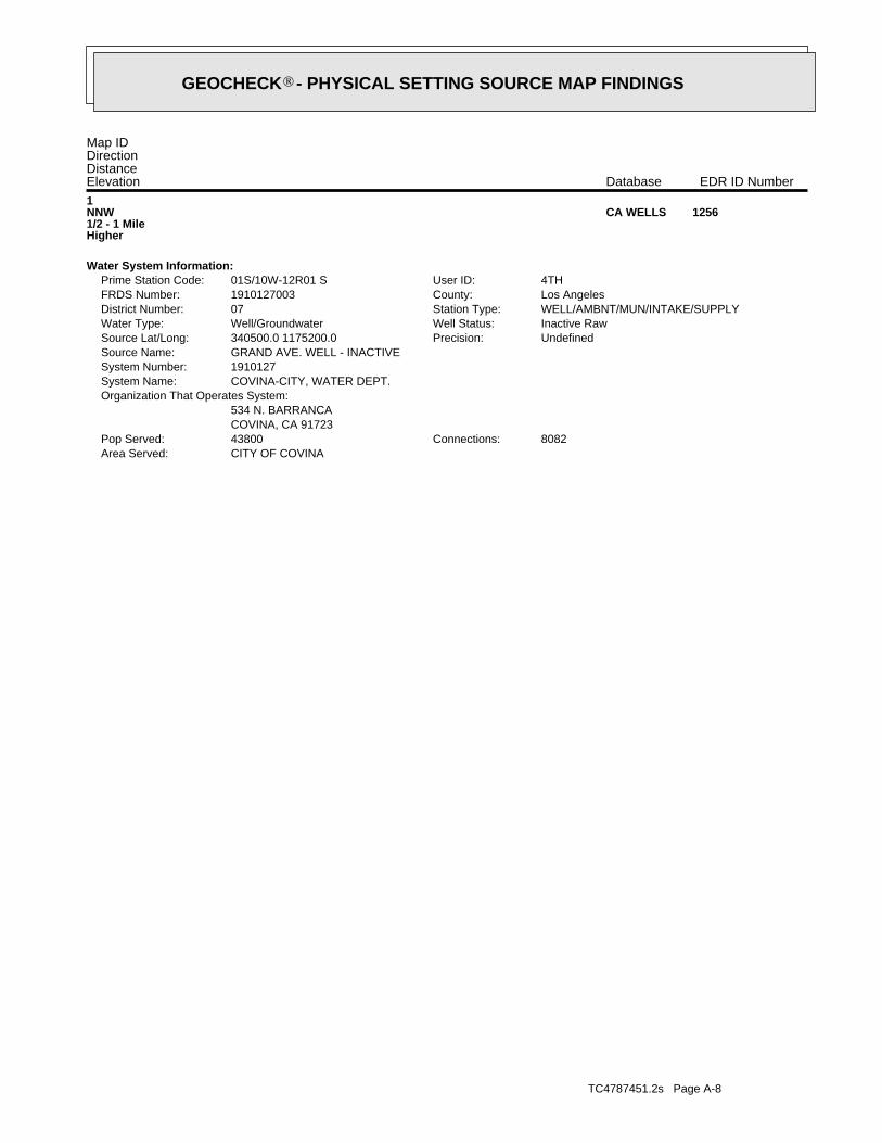
TC4787451.2s Page A-8
CITY OF COVINAArea Served:8082Connections:43800Pop Served:
COVINA, CA 91723534 N. BARRANCA
Organization That Operates System:COVINA-CITY, WATER DEPT.System Name:1910127System Number:GRAND AVE. WELL - INACTIVESource Name:
UndefinedPrecision:340500.0 1175200.0Source Lat/Long:Inactive RawWell Status:Well/GroundwaterWater Type:WELL/AMBNT/MUN/INTAKE/SUPPLYStation Type:07District Number:Los AngelesCounty:1910127003FRDS Number:4THUser ID:01S/10W-12R01 SPrime Station Code:
Water System Information:
1NNW1/2 - 1 MileHigher
1256CA WELLS
Map IDDirectionDistanceElevation EDR ID NumberDatabase
®GEOCHECK - PHYSICAL SETTING SOURCE MAP FINDINGS®
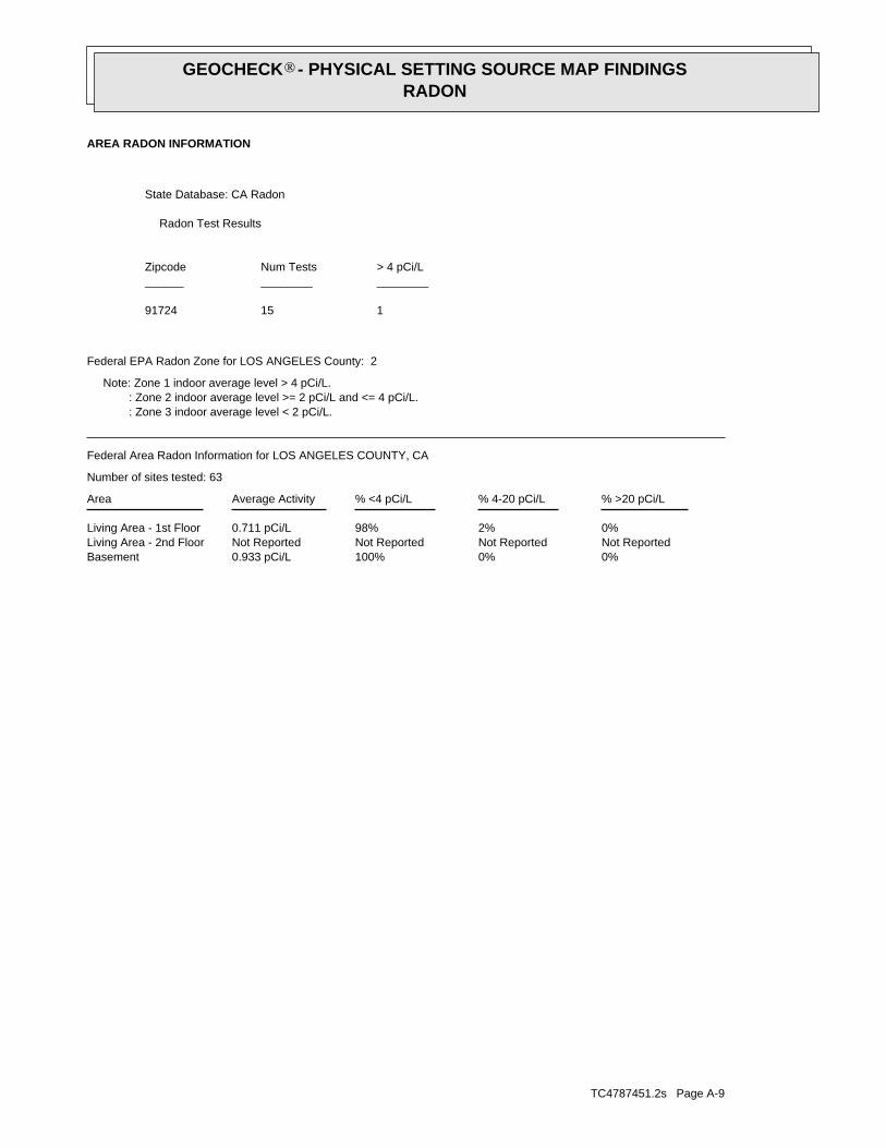
TC4787451.2s Page A-9
0%0%100%0.933 pCi/LBasementNot ReportedNot ReportedNot ReportedNot ReportedLiving Area - 2nd Floor0%2%98%0.711 pCi/LLiving Area - 1st Floor
% >20 pCi/L% 4-20 pCi/L% <4 pCi/LAverage ActivityArea
Number of sites tested: 63
Federal Area Radon Information for LOS ANGELES COUNTY, CA
: Zone 3 indoor average level < 2 pCi/L. : Zone 2 indoor average level >= 2 pCi/L and <= 4 pCi/L. Note: Zone 1 indoor average level > 4 pCi/L.
Federal EPA Radon Zone for LOS ANGELES County: 2
11591724
______________________> 4 pCi/LNum TestsZipcode
Radon Test Results
State Database: CA Radon
AREA RADON INFORMATION
®GEOCHECK - PHYSICAL SETTING SOURCE MAP FINDINGSRADON
®

TOPOGRAPHIC INFORMATION
USGS 7.5’ Digital Elevation Model (DEM)Source: United States Geologic SurveyEDR acquired the USGS 7.5’ Digital Elevation Model in 2002 and updated it in 2006. The 7.5 minute DEM correspondsto the USGS 1:24,000- and 1:25,000-scale topographic quadrangle maps. The DEM provides elevation datawith consistent elevation units and projection.
Current USGS 7.5 Minute Topographic MapSource: U.S. Geological Survey
HYDROLOGIC INFORMATION
Flood Zone Data: This data was obtained from the Federal Emergency Management Agency (FEMA). It depicts 100-year and500-year flood zones as defined by FEMA. It includes the National Flood Hazard Layer (NFHL) which incorporates FloodInsurance Rate Map (FIRM) data and Q3 data from FEMA in areas not covered by NFHL.
Source: FEMATelephone: 877-336-2627Date of Government Version: 2003, 2015
NWI: National Wetlands Inventory. This data, available in select counties across the country, was obtained by EDRin 2002, 2005 and 2010 from the U.S. Fish and Wildlife Service.
State Wetlands Data: Wetland InventorySource: Department of Fish & GameTelephone: 916-445-0411
HYDROGEOLOGIC INFORMATION
AQUIFLOW Information SystemR
Source: EDR proprietary database of groundwater flow informationEDR has developed the AQUIFLOW Information System (AIS) to provide data on the general direction of groundwater
flow at specific points. EDR has reviewed reports submitted to regulatory authorities at select sites and hasextracted the date of the report, hydrogeologically determined groundwater flow direction and depth to water tableinformation.
GEOLOGIC INFORMATION
Geologic Age and Rock Stratigraphic UnitSource: P.G. Schruben, R.E. Arndt and W.J. Bawiec, Geology of the Conterminous U.S. at 1:2,500,000 Scale - A digitalrepresentation of the 1974 P.B. King and H.M. Beikman Map, USGS Digital Data Series DDS - 11 (1994).
STATSGO: State Soil Geographic DatabaseSource: Department of Agriculture, Natural Resources Conservation Service (NRCS)The U.S. Department of Agriculture’s (USDA) Natural Resources Conservation Service (NRCS) leads the nationalConservation Soil Survey (NCSS) and is responsible for collecting, storing, maintaining and distributing soilsurvey information for privately owned lands in the United States. A soil map in a soil survey is a representationof soil patterns in a landscape. Soil maps for STATSGO are compiled by generalizing more detailed (SSURGO)soil survey maps.
SSURGO: Soil Survey Geographic DatabaseSource: Department of Agriculture, Natural Resources Conservation Service (NRCS)Telephone: 800-672-5559SSURGO is the most detailed level of mapping done by the Natural Resources Conservation Service, mappingscales generally range from 1:12,000 to 1:63,360. Field mapping methods using national standards are used toconstruct the soil maps in the Soil Survey Geographic (SSURGO) database. SSURGO digitizing duplicates theoriginal soil survey maps. This level of mapping is designed for use by landowners, townships and countynatural resource planning and management.
TC4787451.2s Page PSGR-1
PHYSICAL SETTING SOURCE RECORDS SEARCHED

LOCAL / REGIONAL WATER AGENCY RECORDS
FEDERAL WATER WELLS
PWS: Public Water SystemsSource: EPA/Office of Drinking WaterTelephone: 202-564-3750Public Water System data from the Federal Reporting Data System. A PWS is any water system which provides water to at
least 25 people for at least 60 days annually. PWSs provide water from wells, rivers and other sources.
PWS ENF: Public Water Systems Violation and Enforcement DataSource: EPA/Office of Drinking WaterTelephone: 202-564-3750Violation and Enforcement data for Public Water Systems from the Safe Drinking Water Information System (SDWIS) after
August 1995. Prior to August 1995, the data came from the Federal Reporting Data System (FRDS).
USGS Water Wells: USGS National Water Inventory System (NWIS)This database contains descriptive information on sites where the USGS collects or has collected data on surfacewater and/or groundwater. The groundwater data includes information on wells, springs, and other sources of groundwater.
STATE RECORDS
Water Well DatabaseSource: Department of Water ResourcesTelephone: 916-651-9648
California Drinking Water Quality DatabaseSource: Department of Public HealthTelephone: 916-324-2319The database includes all drinking water compliance and special studies monitoring for the state of California
since 1984. It consists of over 3,200,000 individual analyses along with well and water system information.
OTHER STATE DATABASE INFORMATION
California Oil and Gas Well LocationsSource: Department of ConservationTelephone: 916-323-1779Oil and Gas well locations in the state.
RADON
State Database: CA RadonSource: Department of Health ServicesTelephone: 916-324-2208Radon Database for California
Area Radon InformationSource: USGSTelephone: 703-356-4020The National Radon Database has been developed by the U.S. Environmental Protection Agency(USEPA) and is a compilation of the EPA/State Residential Radon Survey and the National Residential Radon Survey.The study covers the years 1986 - 1992. Where necessary data has been supplemented by information collected atprivate sources such as universities and research institutions.
EPA Radon ZonesSource: EPATelephone: 703-356-4020Sections 307 & 309 of IRAA directed EPA to list and identify areas of U.S. with the potential for elevated indoorradon levels.
TC4787451.2s Page PSGR-2
PHYSICAL SETTING SOURCE RECORDS SEARCHED

OTHER
Airport Landing Facilities: Private and public use landing facilitiesSource: Federal Aviation Administration, 800-457-6656
Epicenters: World earthquake epicenters, Richter 5 or greaterSource: Department of Commerce, National Oceanic and Atmospheric Administration
California Earthquake Fault Lines: The fault lines displayed on EDR’s Topographic map are digitized quaternary fault lines,prepared in 1975 by the United State Geological Survey. Additional information (also from 1975) regarding activity at specific faultlines comes from California’s Preliminary Fault Activity Map prepared by the California Division of Mines and Geology.
STREET AND ADDRESS INFORMATION
© 2015 TomTom North America, Inc. All rights reserved. This material is proprietary and the subject of copyright protectionand other intellectual property rights owned by or licensed to Tele Atlas North America, Inc. The use of this material is subjectto the terms of a license agreement. You will be held liable for any unauthorized copying or disclosure of this material.
TC4787451.2s Page PSGR-3
PHYSICAL SETTING SOURCE RECORDS SEARCHED
Appendix D
Regulatory Agency Records
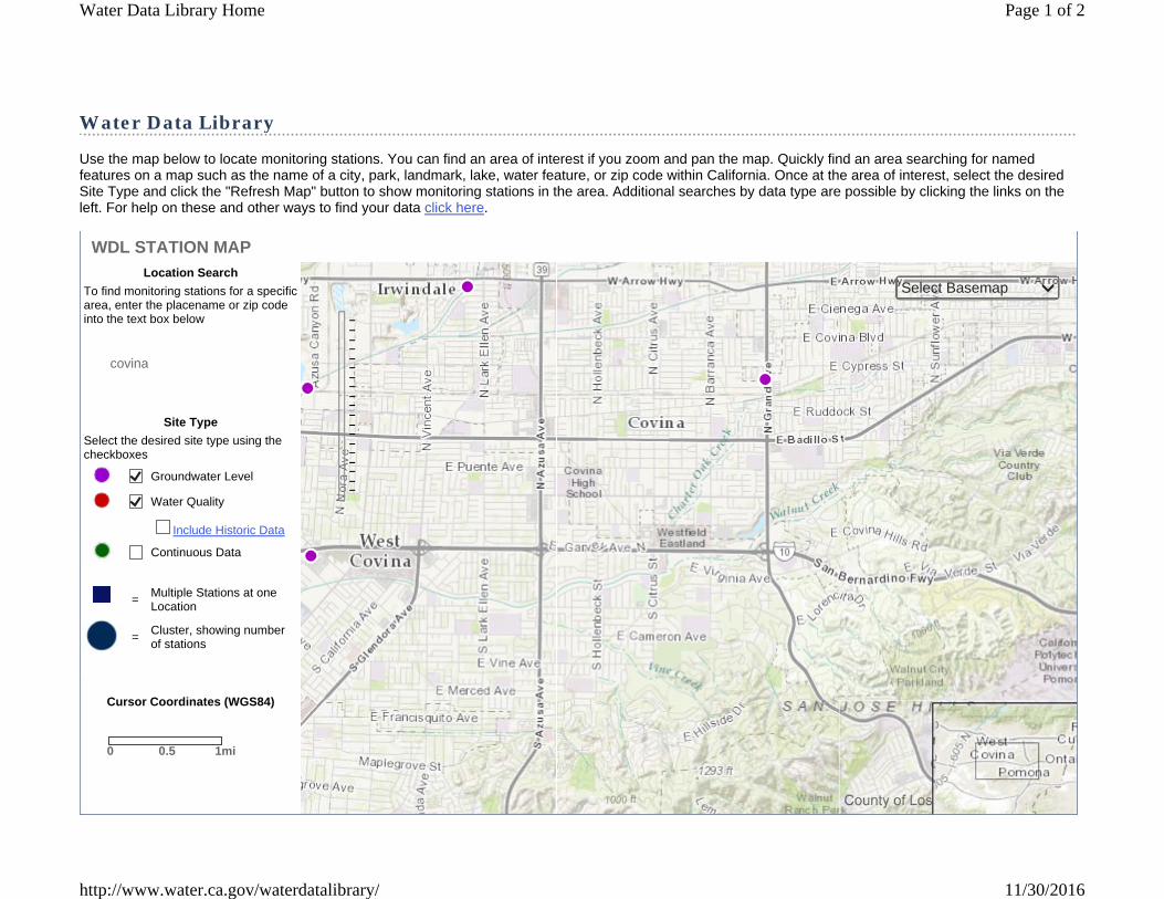
Water Data Library
Use the map below to locate monitoring stations. You can find an area of interest if you zoom and pan the map. Quickly find an area searching for named features on a map such as the name of a city, park, landmark, lake, water feature, or zip code within California. Once at the area of interest, select the desired Site Type and click the "Refresh Map" button to show monitoring stations in the area. Additional searches by data type are possible by clicking the links on the left. For help on these and other ways to find your data click here.
covina
Location Search
To find monitoring stations for a specific area, enter the placename or zip code into the text box below
Site Type
Select the desired site type using the checkboxes
Groundwater Level
Water Quality
Include Historic Data
Continuous Data
= Multiple Stations at one Location
= Cluster, showing number of stations
Cursor Coordinates (WGS84)
WDL STATION MAP
0 0.5 1mi
Select Basemap
Page 1 of 2Water Data Library Home
11/30/2016http://www.water.ca.gov/waterdatalibrary/
eric.fraske
Callout
Subject Property
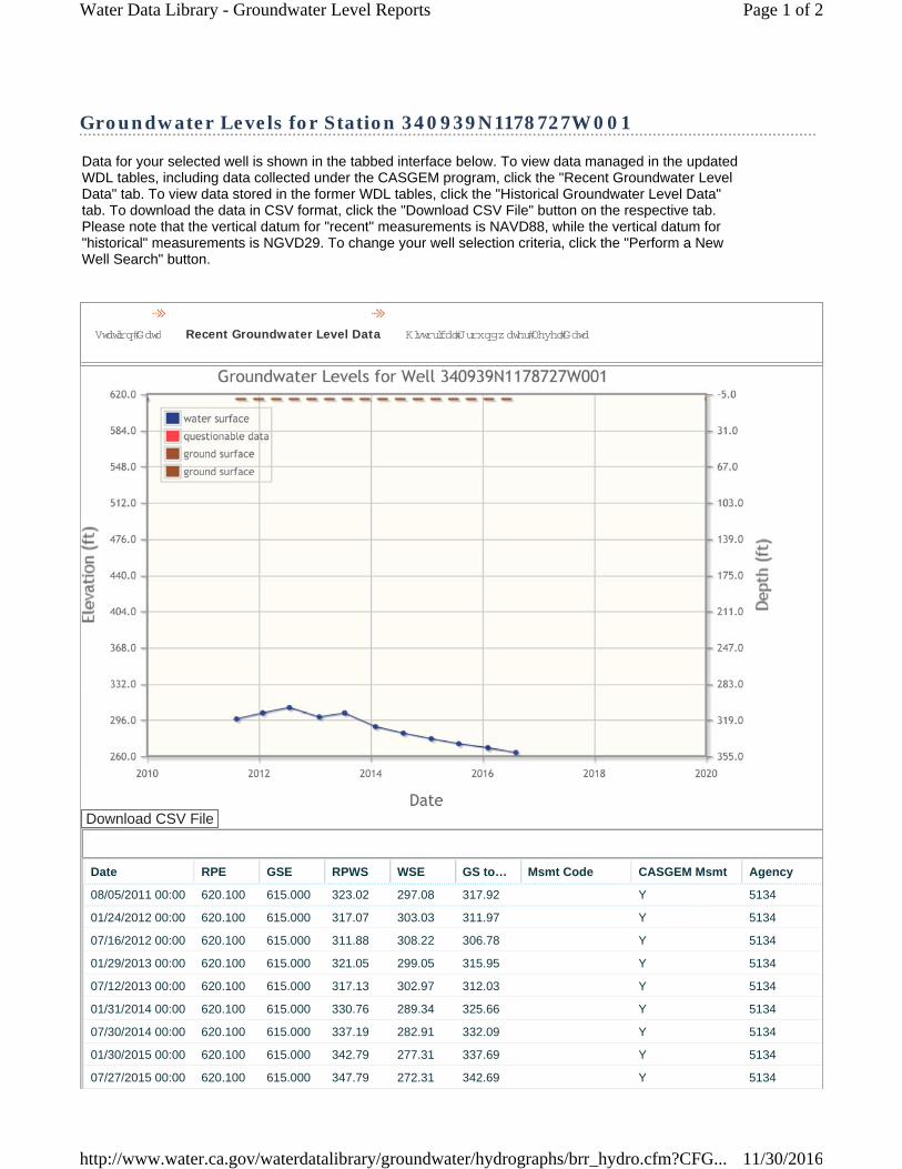
Groundwater Levels for Station 340939N1178727W001
Data for your selected well is shown in the tabbed interface below. To view data managed in the updated WDL tables, including data collected under the CASGEM program, click the "Recent Groundwater Level Data" tab. To view data stored in the former WDL tables, click the "Historical Groundwater Level Data" tab. To download the data in CSV format, click the "Download CSV File" button on the respective tab. Please note that the vertical datum for "recent" measurements is NAVD88, while the vertical datum for "historical" measurements is NGVD29. To change your well selection criteria, click the "Perform a New Well Search" button.
Station Data Recent Groundwater Level Data Historical Groundwater Level Data
Download CSV File
Date RPE GSE RPWS WSE GS to… Msmt Code CASGEM Msmt Agency
08/05/2011 00:00 620.100 615.000 323.02 297.08 317.92 Y 5134
01/24/2012 00:00 620.100 615.000 317.07 303.03 311.97 Y 5134
07/16/2012 00:00 620.100 615.000 311.88 308.22 306.78 Y 5134
01/29/2013 00:00 620.100 615.000 321.05 299.05 315.95 Y 5134
07/12/2013 00:00 620.100 615.000 317.13 302.97 312.03 Y 5134
01/31/2014 00:00 620.100 615.000 330.76 289.34 325.66 Y 5134
07/30/2014 00:00 620.100 615.000 337.19 282.91 332.09 Y 5134
01/30/2015 00:00 620.100 615.000 342.79 277.31 337.69 Y 5134
07/27/2015 00:00 620.100 615.000 347.79 272.31 342.69 Y 5134
Page 1 of 2Water Data Library - Groundwater Level Reports
11/30/2016http://www.water.ca.gov/waterdatalibrary/groundwater/hydrographs/brr_hydro.cfm?CFG...

Wetlands Map
Esri, HERE, DeLorme, MapmyIndia, © OpenStreetMap contributors, and theGIS user community
Estuarine and Marine DeepwaterEstuarine and Marine WetlandFreshwater Emergent Wetland
Freshwater Forested/Shrub WetlandFreshwater PondLake
OtherRiverine
November 30, 2016
0 0.15 0.30.075 mi
0 0.25 0.50.125 km
1:10,448
This page was produced by the NWI mapperNational Wetlands Inventory (NWI)
This map is for general reference only. The US Fish and Wildlife Service is not responsible for the accuracy or currentness of the base data shown on this map. All wetlands related data should be used in accordance with the layer metadata found on the Wetlands Mapper web site.
eric.fraske
Callout
Subject Property

11/30/2016 Division of Oil, Gas & Geothermal Resources Well Finder
http://maps.conservation.ca.gov/doggr/#close 1/1
1074 S PARK VIEW DR, Covina, CA, 917241074 S PARK VIEW DR, Covina, CA, 917241074 S PARK VIEW DR, Covina, CA, 917241074 S PARK VIEW DR, Covina, CA, 917241074 S PARK VIEW DR, Covina, CA, 917241074 S PARK VIEW DR, Covina, CA, 917241074 S PARK VIEW DR, Covina, CA, 91724+
–9
1km
0.6mi
Find My Current Location
or
Street: 1074 park view drive
City: covina
Zip: Find
Display a 1 mile buffer
Buffer radius is limited to 10 mi (52800ft).
Find By Location
Find By API
Find By Lat, Long
Find By PLSS
Find By Oil ⁄ Gas Field
Data (Layers):
Notices & Permits
DOGGR Wells
Copyright © 2014 State of California Conditions of Use | Privacy Policy
Division of Oil, Gas & Geothermal Resources Well Finder

Perform a New Well Search
All elevation and depth measurements are in feet. The vertical datum for recent measurements is NAVD88.
02/05/2016 00:00 620.100 615.000 351.79 268.31 346.69 Y 5134
08/05/2016 00:00 620.100 615.000 356.38 263.72 351.28 Y 5134
Page 2 of 2Water Data Library - Groundwater Level Reports
11/30/2016http://www.water.ca.gov/waterdatalibrary/groundwater/hydrographs/brr_hydro.cfm?CFG...

3777 Long Beach Blvd, Annex Building
Long Beach, CA 90807 FAX
DATE: November 30, 2016 NUMBER OF PAGES (including cover sheet): 1
TO: County of L. A. Sanitation District
Industrial Waste Department
1955 Workman Mill Road, Whittier, CA
ATTN:
RE: File Review Request
PHONE: (562) 699-7411
FAX: (562) 908-4224
CC:
FROM: Eric Fraske
Project Manager
PHONE: (562) 495-5777
FAX: (562) 495-5877
CC:
Urgent For your review Reply ASAP Please comment
I would like to set up an appointment for a file review for the following address: 1034, 1054, 1118, 1154, and 1164 Park View Drive, Covina, California 91724 This addresses are for five vacant parcels of land in Covina, CA. I would like to review all open and closed files. Please give me a call when these records are available for review.
Thank you
This facsimile is personal and confidential and intended for the entity named above. If you have received this fax in error please contact our office as soon as possible so we can make arrangements for the return of this information.

I rom :
ALTA ENVIRONMENTAL
3777 Long Beach Blvd, Annex Building Long Beach , CA 90807
11 I 3 0 I 2 0 1 6 1 2 : 02 # 1 3 2 P . 0 01 I 0 01
FAX DATE: November 30, 2016 NUMBER OF PAGES (including cov er s h e et): 1
TO:
ATTN:
County of L. A . Sanitation District
Industrial Waste Department
1955 Workman Mill Road , Whittier, CA
RE: File Review Request
PHONE: (562) 699-7411
FAX: (562) 908-4224
CC:
FROM: Eric Fraske
Project Manager
Eric. fraske@ altaenviron . com
PHONE: (562) 495-5777
FAX: (562) 495-5877
CC:
0 Urgent 0 For your review C81 Reply ASAP D Please comment
I would like to set up an appointment for a file review for the following address:
1034, 1054, 1118, 1154, and 1164 Park View Drive, Covina, California 91724
This addresses are for five vacant parcels of land in Covina , CA. I would like to review all open and closed files. Please give me a call when these records are available for review.
Thank you
~ v )3 0 \ ((f?
0o r~~ o rd ~ -~ou_ n.d , ' d p I e a se u.s e 'f-~e. a t+ O.C1h_c -Fo r nn-
i-o ~ e q___ues-f l n f-a r VY1Q+( 0 (/\.___
This facs imile is p e rsonal and confiden tial and intended fo r the entity name d a bove. 1f you have rece ived this fax in erro r p lease contact o ur office as soon as p oss ib le so w e can make a rran gem e nts for the re tu rn o f this information.
RECEIVED NOV-30-2016 12:08PM FROM- TO-I .W. SECTI ON PAGE DO 1
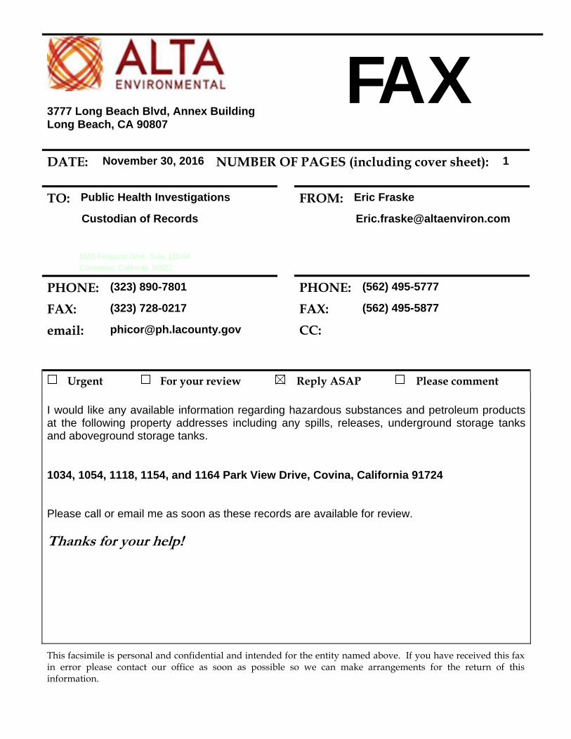
3777 Long Beach Blvd, Annex Building
Long Beach, CA 90807 FAX
DATE: November 30, 2016 NUMBER OF PAGES (including cover sheet): 1
TO: Public Health Investigations
Custodian of Records
5555 Ferguson Drive, Suite 120-04
Commerce, California 90022
PHONE: (323) 890-7801
FAX: (323) 728-0217
email: [email protected]
FROM: Eric Fraske
PHONE: (562) 495-5777
FAX: (562) 495-5877
CC:
Urgent For your review Reply ASAP Please comment I would like any available information regarding hazardous substances and petroleum products at the following property addresses including any spills, releases, underground storage tanks and aboveground storage tanks.
1034, 1054, 1118, 1154, and 1164 Park View Drive, Covina, California 91724 Please call or email me as soon as these records are available for review.
Thanks for your help!
This facsimile is personal and confidential and intended for the entity named above. If you have received this fax in error please contact our office as soon as possible so we can make arrangements for the return of this information.


1
Eric Fraske
From: Nicole Alvarez <[email protected]>Sent: Wednesday, November 30, 2016 2:29 PMTo: Eric FraskeCc: Sharon ClarkSubject: Public Records Request PRR 16-182
RE: PRR 16-182 Dear Mr. Fraske, There are no documents responsive to your records request for hazardous waste material records, spills, leaks, clean-ups, investigation, petroleum UST, AST, or environmental records for the properties located at: 1034, 1054, 1118, 1154, and 1164 Park View Drive, Covina, CA. Additionally, if you would like to follow up with the Fire department you can contact Adrianna West at the Los Angeles County Fire Department at 323‐881‐2379, fax 323‐266‐6033, or email [email protected].
Nicole Alvarez
Nicole Alvarez | Administrative Technician City Clerk’s Office | 125 E. College Street | Covina, CA 91723 Tel. (626) 384-5430 | Email: [email protected] Covina City Hall hours: Monday – Thursday 7:00 a.m. to 6:00 p.m., closed Fridays Go Green ! Please consider the environment before printing this email
Appendix E EDR Lien and AUL Report

VACANT LAND 1034 PARK VIEW DRIVE COVINA, CA
INQUIRY NUMBER: 4787451.7 NOVEMBER 23, 2016
6 Armstrong Road, 4th floor Shelton, CT 06484 Toll Free: 800.352.0050 www.edrnet.com

The EDR Environmental LienSearch Report provides results from a search of available current land title records for environmental cleanup liens and other activity and use limitations, such as engineering controls and institutional controls.
A network of professional, trained researchers, following established procedures, uses client supplied address information to: � search for parcel information and/or legal description; � search for ownership information; � research official land title documents recorded at jurisdictional agencies such as recorders' offices,
registries of deeds, county clerks' offices, etc.; � access a copy of the deed; � search for environmental encumbering instrument(s) associated with the deed; � provide a copy of any environmental encumbrance(s) based upon a review of key words in the
instrument(s) (title, parties involved, and description); and � provide a copy of the deed or cite documents reviewed.
Thank you for your business. Please contact EDR at 1-800-352-0050
with any questions or comments.
Disclaimer - Copyright and Trademark Notice
This report was prepared for the use of Environmental Data Resources, Inc., and AFX Research, LLC. (AFX) exclusively. This report is neither a guarantee of title, a commitment to insure, or a policy of title insurance. NO WARRANTY, EXPRESSED OR IMPLIED, IS MADE WHATSOEVER IN CONNECTION WTH THIS REPORT. Environmental Data Resources, Inc. (EDR) and AFX exclusively specifically disclaim the making of any such warranties, including without limitation, merchantability or fitness for a particular use or purpose. The information contained in this report is retrieved as it is recorded from the various agencies that make it available. The total liability is limited to the fee paid for this report.
Copyright 2016 by Environmental Data Resources, Inc. All rights reserved. Reproduction in any media or format, in whole or in part, of any report or map of Environmental Data Resources, Inc., or its affiliates, is prohibited without prior written permission.
EDR and its logos are trademarks of Environmental Data Resources, Inc. or its affiliates. All other trademarks used herein are the property of their respective owners.

TARGET PROPERTY INFORMATION
ADDRESS
LOT 8 COVINA, CA
RESEARCH SOURCE Source 1: RECORDER LOS ANGELES COUNTY, CA Source 2: CALIFORNIA ENVIRONMENTAL PROTECTION AGENCY Source 3: UNITED STATES ENVIRONMENTAL PROTECTION AGENCY PROPERTY INFORMATION
Deed 1
Type of Deed: GRANT DEED
Title is vested in: STATE OF CALIFORNIA
Title received from: CENTURY NATIONAL PROPERTIES, INC
Date Executed: 05/29/2015
Date Recorded: 12/29/2015
Book: NA
Page: NA
Volume: NA
Instrument#: 20151635201
Docket: NA
Land Record Comments: NA
Miscellaneous Comments: NA
Legal Description: AS RECORDED IN THE DEED BELOW Current Owner: STATE OF CALIFORNIA Property Identifiers: 8448-019-040 Comments: NA

ENVIRONMENTAL LIEN Environmental Lien: Found Not Found If Found:
1st Party: NA
2nd Party: NA
Dated: NA
Recorded: NA
Book: NA
Page: NA
Docket: NA
Volume: NA
Instrument #: NA
Comments: NA
Miscellaneous:
OTHER ACTIVITY AND USE LIMITATIONS (AULS)
Other AUL's: Found Not Found
If Found:
1st Party: NA
2nd Party: NA
Dated: NA
Recorded: NA
Book: NA
Page: NA
Docket: NA
Volume: NA
Instrument #: NA
Comments:
Miscellaneous:
X
X

DEED EXHIBIT


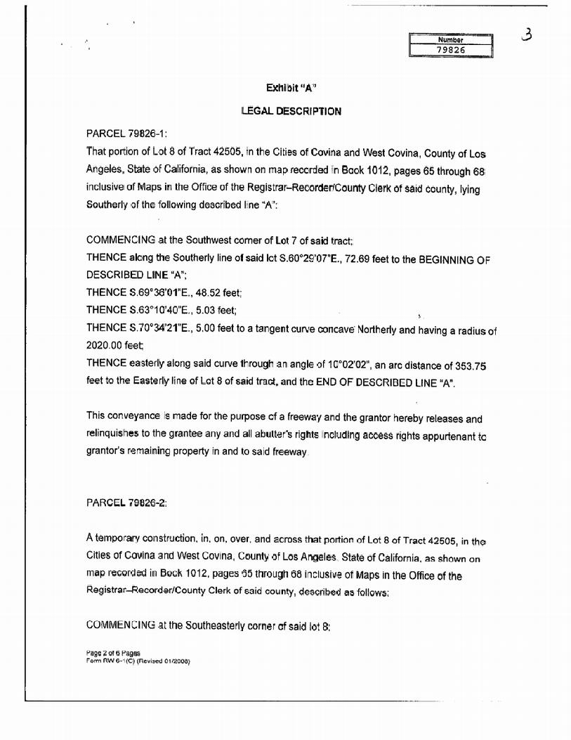
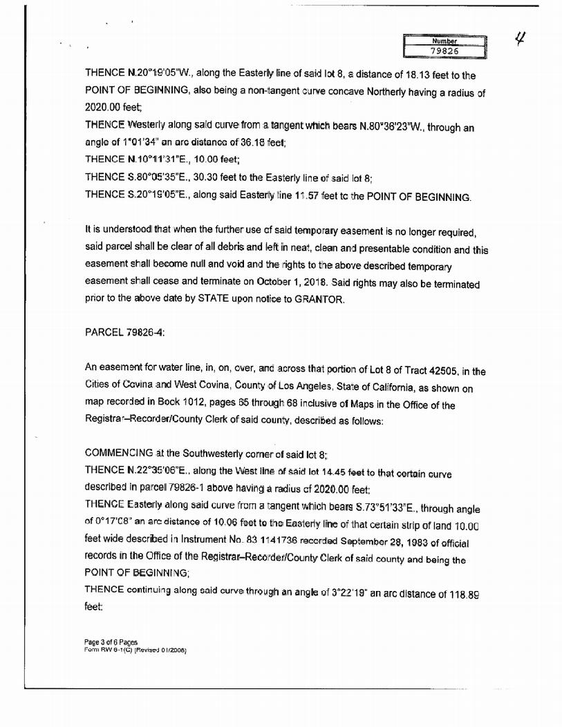


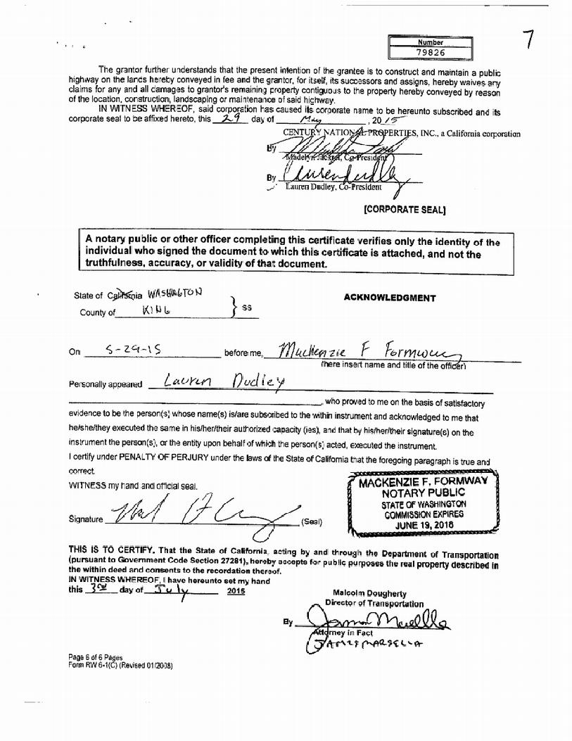
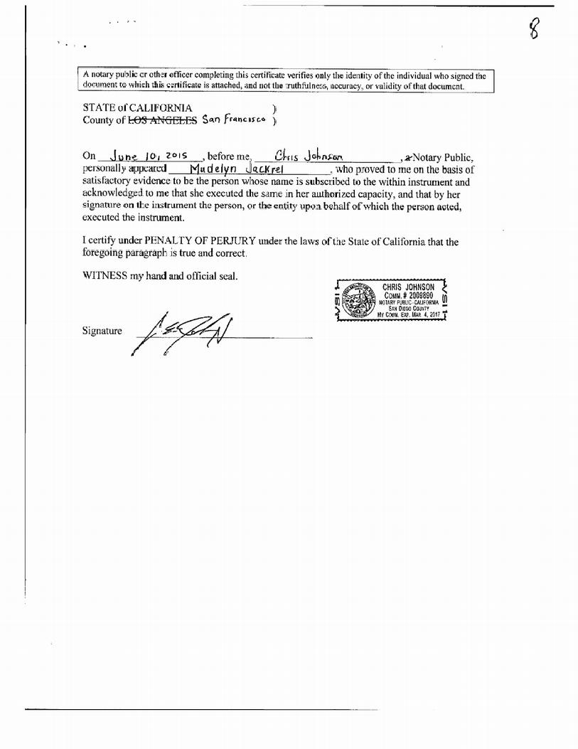

VACANT LAND 1034 PARK VIEW DRIVE COVINA, CA
INQUIRY NUMBER: 4787451.7 NOVEMBER 23, 2016
6 Armstrong Road, 4th floor Shelton, CT 06484 Toll Free: 800.352.0050 www.edrnet.com

The EDR Environmental LienSearch Report provides results from a search of available current land title records for environmental cleanup liens and other activity and use limitations, such as engineering controls and institutional controls.
A network of professional, trained researchers, following established procedures, uses client supplied address information to: � search for parcel information and/or legal description; � search for ownership information; � research official land title documents recorded at jurisdictional agencies such as recorders' offices,
registries of deeds, county clerks' offices, etc.; � access a copy of the deed; � search for environmental encumbering instrument(s) associated with the deed; � provide a copy of any environmental encumbrance(s) based upon a review of key words in the
instrument(s) (title, parties involved, and description); and � provide a copy of the deed or cite documents reviewed.
Thank you for your business. Please contact EDR at 1-800-352-0050
with any questions or comments.
Disclaimer - Copyright and Trademark Notice
This report was prepared for the use of Environmental Data Resources, Inc., and AFX Research, LLC. (AFX) exclusively. This report is neither a guarantee of title, a commitment to insure, or a policy of title insurance. NO WARRANTY, EXPRESSED OR IMPLIED, IS MADE WHATSOEVER IN CONNECTION WTH THIS REPORT. Environmental Data Resources, Inc. (EDR) and AFX exclusively specifically disclaim the making of any such warranties, including without limitation, merchantability or fitness for a particular use or purpose. The information contained in this report is retrieved as it is recorded from the various agencies that make it available. The total liability is limited to the fee paid for this report.
Copyright 2016 by Environmental Data Resources, Inc. All rights reserved. Reproduction in any media or format, in whole or in part, of any report or map of Environmental Data Resources, Inc., or its affiliates, is prohibited without prior written permission.
EDR and its logos are trademarks of Environmental Data Resources, Inc. or its affiliates. All other trademarks used herein are the property of their respective owners.

TARGET PROPERTY INFORMATION
ADDRESS
LOT 9 COVINA, CA
RESEARCH SOURCE Source 1: RECORDER LOS ANGELES COUNTY, CA Source 2: CALIFORNIA ENVIRONMENTAL PROTECTION AGENCY Source 3: UNITED STATES ENVIRONMENTAL PROTECTION AGENCY PROPERTY INFORMATION
Deed 1
Type of Deed: CORPORATION GRANT DEED
Title is vested in: CENTURY NATIONAL PROPERTIES, INC
Title received from: REPUBLIC DEVELOPMENT COMPANY
Date Executed: 11/26/1986
Date Recorded: 12/12/1986
Book: NA
Page: NA
Volume: NA
Instrument#: 86-1729216
Docket: NA
Land Record Comments: NA
Miscellaneous Comments: NA
Legal Description: AS RECORDED IN THE DEED BELOW Current Owner: CENTURY NATIONAL PROPERTIES, INC Property Identifiers: 8448-019-041 Comments: NA

ENVIRONMENTAL LIEN Environmental Lien: Found Not Found If Found:
1st Party: NA
2nd Party: NA
Dated: NA
Recorded: NA
Book: NA
Page: NA
Docket: NA
Volume: NA
Instrument #: NA
Comments: NA
Miscellaneous:
OTHER ACTIVITY AND USE LIMITATIONS (AULS)
Other AUL's: Found Not Found
If Found:
1st Party: NA
2nd Party: NA
Dated: NA
Recorded: NA
Book: NA
Page: NA
Docket: NA
Volume: NA
Instrument #: NA
Comments: NA
Miscellaneous:
X
X

DEED EXHIBIT
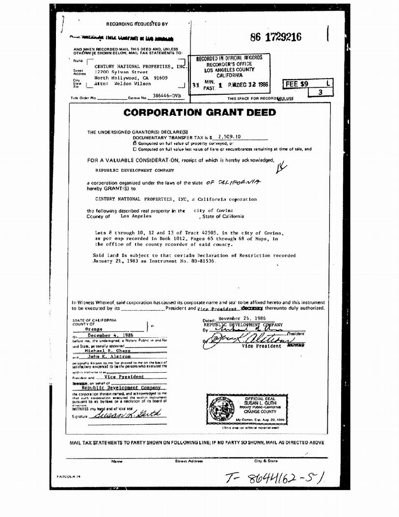


VACANT LAND 1034 PARK VIEW DRIVE COVINA, CA
INQUIRY NUMBER: 4787451.7 NOVEMBER 23, 2016
6 Armstrong Road, 4th floor Shelton, CT 06484 Toll Free: 800.352.0050 www.edrnet.com

The EDR Environmental LienSearch Report provides results from a search of available current land title records for environmental cleanup liens and other activity and use limitations, such as engineering controls and institutional controls.
A network of professional, trained researchers, following established procedures, uses client supplied address information to: � search for parcel information and/or legal description; � search for ownership information; � research official land title documents recorded at jurisdictional agencies such as recorders' offices,
registries of deeds, county clerks' offices, etc.; � access a copy of the deed; � search for environmental encumbering instrument(s) associated with the deed; � provide a copy of any environmental encumbrance(s) based upon a review of key words in the
instrument(s) (title, parties involved, and description); and � provide a copy of the deed or cite documents reviewed.
Thank you for your business. Please contact EDR at 1-800-352-0050
with any questions or comments.
Disclaimer - Copyright and Trademark Notice
This report was prepared for the use of Environmental Data Resources, Inc., and AFX Research, LLC. (AFX) exclusively. This report is neither a guarantee of title, a commitment to insure, or a policy of title insurance. NO WARRANTY, EXPRESSED OR IMPLIED, IS MADE WHATSOEVER IN CONNECTION WTH THIS REPORT. Environmental Data Resources, Inc. (EDR) and AFX exclusively specifically disclaim the making of any such warranties, including without limitation, merchantability or fitness for a particular use or purpose. The information contained in this report is retrieved as it is recorded from the various agencies that make it available. The total liability is limited to the fee paid for this report.
Copyright 2016 by Environmental Data Resources, Inc. All rights reserved. Reproduction in any media or format, in whole or in part, of any report or map of Environmental Data Resources, Inc., or its affiliates, is prohibited without prior written permission.
EDR and its logos are trademarks of Environmental Data Resources, Inc. or its affiliates. All other trademarks used herein are the property of their respective owners.

TARGET PROPERTY INFORMATION
ADDRESS
LOT 10 COVINA, CA
RESEARCH SOURCE Source 1: RECORDER LOS ANGELES COUNTY, CA Source 2: CALIFORNIA ENVIRONMENTAL PROTECTION AGENCY Source 3: UNITED STATES ENVIRONMENTAL PROTECTION AGENCY PROPERTY INFORMATION
Deed 1
Type of Deed: CORPORATION GRANT DEED
Title is vested in: CENTURY NATIONAL PROPERTIES, INC
Title received from: REPUBLIC DEVELOPMENT COMPANY
Date Executed: 11/26/1986
Date Recorded: 12/12/1986
Book: NA
Page: NA
Volume: NA
Instrument#: 86-1729216
Docket: NA
Land Record Comments: NA
Miscellaneous Comments: NA
Legal Description: AS RECORDED IN THE DEED BELOW Current Owner: CENTURY NATIONAL PROPERTIES, INC Property Identifiers: 8448-019-042 Comments: NA

ENVIRONMENTAL LIEN Environmental Lien: Found Not Found If Found:
1st Party: NA
2nd Party: NA
Dated: NA
Recorded: NA
Book: NA
Page: NA
Docket: NA
Volume: NA
Instrument #: NA
Comments: NA
Miscellaneous:
OTHER ACTIVITY AND USE LIMITATIONS (AULS)
Other AUL's: Found Not Found
If Found:
1st Party: NA
2nd Party: NA
Dated: NA
Recorded: NA
Book: NA
Page: NA
Docket: NA
Volume: NA
Instrument #: NA
Comments: NA
Miscellaneous:
X
X

DEED EXHIBIT

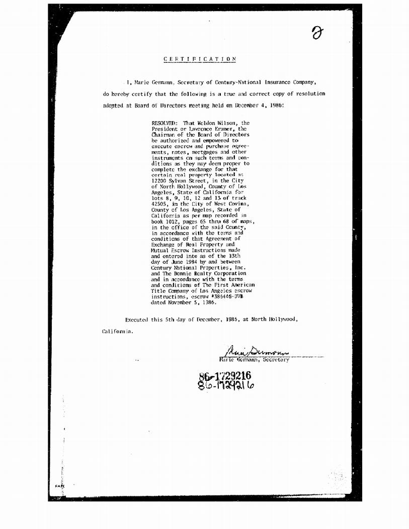


VACANT LAND 1034 PARK VIEW DRIVE COVINA, CA
INQUIRY NUMBER: 4787451.7 NOVEMBER 23, 2016
6 Armstrong Road, 4th floor Shelton, CT 06484 Toll Free: 800.352.0050 www.edrnet.com

The EDR Environmental LienSearch Report provides results from a search of available current land title records for environmental cleanup liens and other activity and use limitations, such as engineering controls and institutional controls.
A network of professional, trained researchers, following established procedures, uses client supplied address information to: � search for parcel information and/or legal description; � search for ownership information; � research official land title documents recorded at jurisdictional agencies such as recorders' offices,
registries of deeds, county clerks' offices, etc.; � access a copy of the deed; � search for environmental encumbering instrument(s) associated with the deed; � provide a copy of any environmental encumbrance(s) based upon a review of key words in the
instrument(s) (title, parties involved, and description); and � provide a copy of the deed or cite documents reviewed.
Thank you for your business. Please contact EDR at 1-800-352-0050
with any questions or comments.
Disclaimer - Copyright and Trademark Notice
This report was prepared for the use of Environmental Data Resources, Inc., and AFX Research, LLC. (AFX) exclusively. This report is neither a guarantee of title, a commitment to insure, or a policy of title insurance. NO WARRANTY, EXPRESSED OR IMPLIED, IS MADE WHATSOEVER IN CONNECTION WTH THIS REPORT. Environmental Data Resources, Inc. (EDR) and AFX exclusively specifically disclaim the making of any such warranties, including without limitation, merchantability or fitness for a particular use or purpose. The information contained in this report is retrieved as it is recorded from the various agencies that make it available. The total liability is limited to the fee paid for this report.
Copyright 2016 by Environmental Data Resources, Inc. All rights reserved. Reproduction in any media or format, in whole or in part, of any report or map of Environmental Data Resources, Inc., or its affiliates, is prohibited without prior written permission.
EDR and its logos are trademarks of Environmental Data Resources, Inc. or its affiliates. All other trademarks used herein are the property of their respective owners.

TARGET PROPERTY INFORMATION
ADDRESS
LOT 12 COVINA, CA
RESEARCH SOURCE Source 1: RECORDER LOS ANGELES COUNTY, CA Source 2: CALIFORNIA ENVIRONMENTAL PROTECTION AGENCY Source 3: UNITED STATES ENVIRONMENTAL PROTECTION AGENCY PROPERTY INFORMATION
Deed 1
Type of Deed: CORPORATION GRANT DEED
Title is vested in: CENTURY NATIONAL PROPERTIES, INC
Title received from: REPUBLIC DEVELOPMENT COMPANY
Date Executed: 11/26/1986
Date Recorded: 12/12/1986
Book: NA
Page: NA
Volume: NA
Instrument#: 86-1729216
Docket: NA
Land Record Comments: NA
Miscellaneous Comments: NA
Legal Description: AS RECORDED IN THE DEED BELOW Current Owner: CENTURY NATIONAL PROPERTIES, INC Property Identifiers: 8448-019-044 Comments: NA

ENVIRONMENTAL LIEN Environmental Lien: Found Not Found If Found:
1st Party: NA
2nd Party: NA
Dated: NA
Recorded: NA
Book: NA
Page: NA
Docket: NA
Volume: NA
Instrument #: NA
Comments: NA
Miscellaneous:
OTHER ACTIVITY AND USE LIMITATIONS (AULS)
Other AUL's: Found Not Found
If Found:
1st Party: NA
2nd Party: NA
Dated: NA
Recorded: NA
Book: NA
Page: NA
Docket: NA
Volume: NA
Instrument #: NA
Comments: NA
Miscellaneous:
X
X

DEED EXHIBIT


VACANT LAND 1034 PARK VIEW DRIVE COVINA, CA
INQUIRY NUMBER: 4787451.7 NOVEMBER 23, 2016
6 Armstrong Road, 4th floor Shelton, CT 06484 Toll Free: 800.352.0050 www.edrnet.com
The EDR Environmental LienSearch Report provides results from a search of available current land title records for environmental cleanup liens and other activity and use limitations, such as engineering controls and institutional controls.
A network of professional, trained researchers, following established procedures, uses client supplied address information to: � search for parcel information and/or legal description; � search for ownership information; � research official land title documents recorded at jurisdictional agencies such as recorders' offices,
registries of deeds, county clerks' offices, etc.; � access a copy of the deed; � search for environmental encumbering instrument(s) associated with the deed; � provide a copy of any environmental encumbrance(s) based upon a review of key words in the
instrument(s) (title, parties involved, and description); and � provide a copy of the deed or cite documents reviewed.
Thank you for your business. Please contact EDR at 1-800-352-0050
with any questions or comments.
Disclaimer - Copyright and Trademark Notice
This report was prepared for the use of Environmental Data Resources, Inc., and AFX Research, LLC. (AFX) exclusively. This report is neither a guarantee of title, a commitment to insure, or a policy of title insurance. NO WARRANTY, EXPRESSED OR IMPLIED, IS MADE WHATSOEVER IN CONNECTION WTH THIS REPORT. Environmental Data Resources, Inc. (EDR) and AFX exclusively specifically disclaim the making of any such warranties, including without limitation, merchantability or fitness for a particular use or purpose. The information contained in this report is retrieved as it is recorded from the various agencies that make it available. The total liability is limited to the fee paid for this report.
Copyright 2016 by Environmental Data Resources, Inc. All rights reserved. Reproduction in any media or format, in whole or in part, of any report or map of Environmental Data Resources, Inc., or its affiliates, is prohibited without prior written permission.
EDR and its logos are trademarks of Environmental Data Resources, Inc. or its affiliates. All other trademarks used herein are the property of their respective owners.

TARGET PROPERTY INFORMATION
ADDRESS
LOT 13 COVINA, CA
RESEARCH SOURCE Source 1: RECORDER LOS ANGELES COUNTY, CA Source 2: CALIFORNIA ENVIRONMENTAL PROTECTION AGENCY Source 3: UNITED STATES ENVIRONMENTAL PROTECTION AGENCY PROPERTY INFORMATION
Deed 1
Type of Deed: CORPORATION GRANT DEED
Title is vested in: CENTURY NATIONAL PROPERTIES, INC
Title received from: REPUBLIC DEVELOPMENT COMPANY
Date Executed: 11/26/1986
Date Recorded: 12/12/1986
Book: NA
Page: NA
Volume: NA
Instrument#: 86-1729216
Docket: NA
Land Record Comments: NA
Miscellaneous Comments: NA
Legal Description: AS RECORDED IN THE DEED BELOW Current Owner: CENTURY NATIONAL PROPERTIES, INC Property Identifiers: 8448-019-045 Comments: NA

ENVIRONMENTAL LIEN Environmental Lien: Found Not Found If Found:
1st Party: NA
2nd Party: NA
Dated: NA
Recorded: NA
Book: NA
Page: NA
Docket: NA
Volume: NA
Instrument #: NA
Comments: NA
Miscellaneous:
OTHER ACTIVITY AND USE LIMITATIONS (AULS)
Other AUL's: Found Not Found
If Found:
1st Party: NA
2nd Party: NA
Dated: NA
Recorded: NA
Book: NA
Page: NA
Docket: NA
Volume: NA
Instrument #: NA
Comments: NA
Miscellaneous:
X
X

DEED EXHIBIT


Appendix F User-Provided Information


Appendix G Interview Documentation

TETRA TECH, INC.
Page 1 of 4 2901 Wilcrest Drive, Houston, TX 77042 Tel (832) 251‐5160 Fax (832) 251‐5170
www.tetratech.com
PHASE I ENVIRONMENTAL SITE ASSESSMENT ASTM 1527-13 USER QUESTIONNAIRE
Please fax the completed questionnaire to (832) 251-5164 or email a scanned copy to [email protected]. Thank you.
Property Name: Parkview Property Property Address: APN 8448-019-040, -041, -042, -044, and -045 In order to qualify for one of the Landowner Liability Protections (LLPs)* offered by the Small Business Liability Relief and Brownfields Revitalization Act of 2001 (the “Brownfields Amendments”)**, the user of the Phase I Environmental Site Assessment report must provide the following information (if available) to the environmental professional. Failure to provide this information could result in a determination that “all appropriate inquiry” is not complete. *Landowner Liability Protections, or LLPs, is the term used to describe the three types of potential defenses to Superfund liability in EPA’s Interim Guidance Regarding Criteria Landowners Must Meet in Order to Quality for Bona Fide Prospective Purchaser, Contiguous Property Owner, or Innocent Landowner Limitations on CERCLA Liability (“Common Elements” Guide) issued on March 6, 2003. ** P.L. 107-118.
ALL STATEMENTS ARE MADE TO THE BEST CURRENT ACTUAL KNOWLEDGE OF MADELYN JACKREL, PRESIDENT OF CENTURY NATIONAL PROPERTIES, INC., WITHOUT PERSONAL LIABILITY. STATEMENTS ARE MADE ONLY IN THE CAPACITY AS A CORPORATE OFFICER OF CENTURY NATIONAL PROPERTIES, INC. AND WITHOUT ANY INVESTIGATION OR INQUIRY WHATSOEVER. (1.) Environmental liens that are filed or recorded against the property (40 CFR 312.25). Are you aware of any environmental liens filed or recorded against the property under federal, tribal, state or local law?
No If yes, please provide details: NOT APPLICABLE ____________________________________________________________ _______________________________________________________________________________________________________________________________________________________________________________________________________________________________________________________________ (2.) Activity and use limitations that are in place on the property or that have been filed or
recorded against the property (40 CFR 312.26(a)(1)(v) and (vi)).

TETRA TECH, INC.
Page 2 of 4 2901 Wilcrest Drive, Houston, TX 77042 Tel (832) 251‐5160 Fax (832) 251‐5170
www.tetratech.com
Are you aware of any activity and use limitations (AULs), such as engineering controls, land use restrictions or institutional controls that are in place at the property and/or have been filed or recorded against the property under federal, tribal, state or local law?
No If yes, please provide details: NOT APPLICABLE _____________________________________________________________ _______________________________________________________________________________________________________________________________________________________________________________________________________________________________________________________________ (3.) Specialized knowledge or experience of the person seeking to qualify for the LLP (40 CFR
312.28). As the user of this ESA, do you have any specialized knowledge or experience related to the property or nearby properties? For example, are you involved in the same line of business as the current or former occupants of the property or an adjoining property so that you would have specialized knowledge of the chemicals and processes used by this type of business?
Not applicable, CNP is not the user of this ESA If yes, please provide the details: __________________________________________________________ _______________________________________________________________________________________________________________________________________________________________________________________________________________________________________________________________ (4.) Relationship of the purchase price to the fair market value of the property if it were not
contaminated (40 CFR 312.29). Does the purchase price being paid for this property reasonably reflect the fair market value of the property?
Unknown If no, please provide details: NOT APPLICABLE _____________________________________________________________ _______________________________________________________________________________________________________________________________________________________________________________________________________________________________________________________________ If there is a difference between the purchase price and fair market value, have you considered whether the lower purchase price is because contamination is known or believed to be present at the property?
No

TETRA TECH, INC.
Page 3 of 4 2901 Wilcrest Drive, Houston, TX 77042 Tel (832) 251‐5160 Fax (832) 251‐5170
www.tetratech.com
If yes, please provide details: NOT APPLICABLE _____________________________________________________________ _______________________________________________________________________________________________________________________________________________________________________________________________________________________________________________________________ (5.) Commonly known or reasonably ascertainable information about the property (40 CFR
312.30). Are you aware of commonly known or reasonably ascertainable information about the property that would help the environmental professional to identify conditions indicative of releases or threatened releases? For example,
(a) Do you know the past uses of the property? No (b) Do you know of specific chemicals that are present or once were present at the property?
No
(c) Do you know of spills or other chemical releases that have taken place at the property?
No
(d) Do you know of any environmental cleanups that have taken place at the property?
No
If yes to any of the above, please provide details: NOT APPLICABLE _____________________________________________ _______________________________________________________________________________________________________________________________________________________________________________________________________________________________________________________________ _____________________________________________________________________________________ (6.) The degree of obviousness of the presence or likely presence of contamination at the property,
and the ability to detect the contamination by appropriate investigation (40 CFR 312.31). Based on your knowledge and experience related to the property, are there any obvious indicators that point to the presence or likely presence of contamination at the property?
No If yes, please provide the details: NOT APPLICABLE __________________________________________________________ _______________________________________________________________________________________________________________________________________________________________________________________________________________________________________________________________

TETRA TECH, INC.
Page 4 of 4 2901 Wilcrest Drive, Houston, TX 77042 Tel (832) 251‐5160 Fax (832) 251‐5170
www.tetratech.com
PERSON COMPLETING QUESTIONNAIRE
Name: Madelyn Jackrel Title: PRESIDENT
Company Century National Properties, Inc.
Years familiar with Property: during ownership - without investigation or inquiry
Century National Properties, Inc., a California corporation By: _________________________ Madelyn Jackrel, President

Appendix H References

REFERENCES
American Society for Testing and Materials, Standard Practice for Environmental Site Assessments:
Phase I Environmental Site Assessment Process, ASTM Designation: E 1527-13.
American Society for Testing and Materials, Standard Guide for Vapor Encroachment Screening on
Property Involved in Real Estate Transactions, ASTM Designation: E 2600-15
Environmental Data Resources, Inc., Milford, Connecticut, The EDR Aerial Photo Decade Package,
Inquiry No. 4787451.12, November 2016.
Environmental Data Resources, Inc., Milford, Connecticut, Certified Sanborn Map Report, Inquiry No.
4787451.3, November 2016.
Environmental Data Resources, Inc., Milford, Connecticut, The EDR Historical Topographic Map Report,
Inquiry No. 4787451.4, November 2016.
Environmental Data Resources, Inc., Milford, Connecticut, The EDR Radius Map with Geocheck Report,
Inquiry No. 4787451.2S, November 2016.
Environmental Data Resources, Inc., Milford, Connecticut, The EDR Environmental Lien and AUL Search,
Inquiry No. 4787451.7, November 2016.
Environmental Data Resources, Inc., Milford, Connecticut, The EDR City Directory Image Report, Inquiry
No. 4787451.5, November 2016.

Phase I Environmental Site Assessment Proposed Assisted Living
SEC of East Holt Avenue and Park View Drive
Covina, Los Angeles County, California
May 15, 2017
Terracon Project No. 60177161
Prepared for:
Oakmont Senior Living
Corona, California
Prepared by:
Terracon Consultants, Inc.
Tustin, California


TABLE OF CONTENTS
Page No.
EXECUTIVE SUMMARY ............................................................................................................. i Findings and Opinions .......................................................................................................i Significant Data Gaps....................................................................................................... ii Conclusions .................................................................................................................... ii
1.0 INTRODUCTION .............................................................................................................1 1.1 Site Description....................................................................................................1 1.2 Scope of Services ................................................................................................1 1.3 Standard of Care ..................................................................................................1 1.4 Additional Scope Limitations, ASTM Deviations and Data Gaps...................................2 1.5 Reliance .............................................................................................................3 1.6 Client Provided Information ....................................................................................3
2.0 PHYSICAL SETTING.......................................................................................................4 3.0 HISTORICAL USE INFORMATION....................................................................................5
3.1 Historical Topographic Maps, Aerial Photographs, Sanborn Maps................................5 3.2 Historical City Directories.......................................................................................6 3.3 Site Ownership ....................................................................................................7 3.4 Title Search .........................................................................................................7 3.5 Environmental Liens and Activity and Use Limitations ................................................7 3.6 Interviews Regarding Current and Historical Site Uses ...............................................8 3.7 Prior Report Review..............................................................................................8
4.0 RECORDS REVIEW ........................................................................................................8 4.1 Federal and State/Tribal Databases ........................................................................9 4.2 Local Agency Inquiries ........................................................................................ 10
5.0 SITE RECONNAISSANCE ............................................................................................. 11 5.1 General Site Information ...................................................................................... 11 5.2 Overview of Current Site Occupants and Operations................................................ 11 5.3 Site Observations ............................................................................................... 11
6.0 ADJOINING PROPERTY RECONNAISSANCE ................................................................. 13 7.0 DDITIONAL SERVICES ................................................................................................. 14 8.0 DECLARATION ............................................................................................................ 15

TABLE OF CONTENTS (continued)
APPENDICES
APPENDIX A Exhibit 1 - Topographic Map, Exhibit 2 - Site Diagram
APPENDIX B Site Photographs
APPENDIX C Historical Documentation and User Questionnaire
APPENDIX D Environmental Database Information
APPENDIX E Credentials
APPENDIX F Description of Terms and Acronyms

Phase I Environmental Site Assessment Proposed Assisted Living ■ Covina, California May 15, 2017 ■ Terracon Project No. 60177161
Responsive ■ Resourceful ■ Reliable i
EXECUTIVE SUMMARY
This Phase I Environmental Site Assessment (ESA) was performed in accordance with Terracon
Proposal No. P60177161 dated April 24, 2017, and was conducted consistent with the procedures
included in ASTM E1527-13, Standard Practice for Environmental Site Assessments: Phase I
Environmental Site Assessment Process. The ESA was conducted under the supervision or
responsible charge of Islam (Sami) R. Noaman, Environmental Professional. Chandel L. Davis
performed the site reconnaissance on May 4, 2017.
Findings and Opinions
A summary of findings is provided below. It should be recognized that details were not included
or fully developed in this section, and the report must be read in its entirety for a comprehensive
understanding of the items contained herein.
Site Description and Use
The site is located at the southeast corner of East Holt Avenue and Park View Drive in Covina,
Los Angeles County, California and is comprised of two parcels (APNs: 8448-019-044 and -045)
totaling approximately 1.64-acres of vacant land with vegetation. At the time of the site
reconnaissance, the site was unoccupied.
Historical Information
Based on a review of historical information, the site consisted of undeveloped land from as early
as 1894 through 1928. The site was developed as agricultural land from the late-1930s through
the mid-1960s. Agriculture operations ceased by the early-1970s and the site remained
undeveloped vacant land with vegetation until at least 1981. Apparent grading activities occurred
by 1989, which are visible in Appendix B. The site has remained relatively unchanged through
the present. No RECs were identified associated with the historical review.
Historically the site was used for agricultural activities which possibly included the use of
pesticides and herbicides. Terracon believes the potential historical use of pesticides and
herbicides is a de minimis condition that generally does not present a threat to human health or
the environment, and that generally would not be the subject of an enforcement action if brought
to the attention of the appropriate governmental agency. Although the client should be aware of
these historic agricultural practices, no indications of pesticide and/or herbicide misuse were
observed on the site. Based on the historical agricultural use of the site, Terracon recommends
if suspected soil impacts are encountered, proper procedures should be followed with respect to
worker health and safety, and any affected soil encountered should be properly managed and
disposed in accordance with local and state regulations.
The properties to the adjoining northeast, southeast, and southwest of the site have consisted of
undeveloped and/or agricultural land from as early as 1894 to 1989, when the existing two-story
multi-tenant office buildings were developed. The northwest adjoining property was undeveloped

Phase I Environmental Site Assessment Proposed Assisted Living ■ Covina, California May 15, 2017 ■ Terracon Project No. 60177161
Responsive ■ Resourceful ■ Reliable ii
from at least 1894 to 1927. The existing Parque Xalapa was developed to the adjoin ing northwest
of the site by 1928.
Records Review
Selected federal and state environmental regulatory databases as well as responses from state
and local regulatory agencies were reviewed. The site was not identified in the current regulatory
databases. The facilities listed in the database report do not appear to represent RECs to the site
at this time based on regulatory status, apparent topographic gradient, and/or distance from the
site.
Site Reconnaissance
At the time of the site reconnaissance, one pad-mounted transformer was observed on the west
portion of the site. Evidence of RECs associated with the site originating from current on-site
operations were not observed. No RECs were identified associated with the site reconnaissance.
Adjoining Properties
The property to the adjoining northeast of the site consists of a two-story office building occupied
by Scanfiles, Inc. and associated asphalt-paved parking lots (1430 East Holt Avenue). The
property to the adjoining southeast of the site consists of a two-story multi-tenant office building
(1079 Park View Drive) and a single family residence. Park View Drive abuts the site to the
southwest followed by two- and three-story multi-tenant office buildings and associated asphalt-
paved parking lots (1037-1067 Park View Drive). East Holt Avenue abuts the site to the northwest
followed by Parque Xalapa. RECs were not observed in connection with the adjoining properties.
Significant Data Gaps
Significant data gaps were not identified.
Conclusions
We have performed a Phase I ESA consistent with the procedures included in ASTM Practice
E1527-13 at SEC of East Holt Avenue and Park View Drive, Covina, Los Angeles County,
California (APNs 8448-019-045 and -044), the site. Recognized Environmental Conditions
(RECs) or Controlled RECs (CREC) were not identified in connection with the site.
Recommendations
Based on the scope of services, limitations, and conclusions of this assessment, Terracon did not
identify RECs or CRECs. As such, no additional investigation is warranted at this time. Based on
the historical agricultural use of the site, Terracon recommends if suspected soil impacts are
encountered, proper procedures should be followed with respect to worker health and safety, and
any affected soil encountered should be properly managed and disposed in accordance with local
and state regulations.

Phase I Environmental Site Assessment Proposed Assisted Living ■ Covina, California May 15, 2017 ■ Terracon Project No. 60177161
Responsive ■ Resourceful ■ Reliable 1
1.0 INTRODUCTION
1.1 Site Description
Site Name Proposed Assisted Living
Site Location/Address SEC of East Holt Avenue and Park View Drive, Covina, Los Angeles
County, California (APNs 8448-019-045 and -044)
Land Area Approximately 1.64-acres
Site Improvements Vacant land with vegetation
The site location is depicted on Exhibit 1 of Appendix A, which was reproduced from a portion of
the USGS 7.5-minute series topographic map. A Site Diagram of the site and adjoining properties
is included as Exhibit 2 of Appendix A. Acronyms and terms used in this report are described in
Appendix F.
1.2 Scope of Services
This Phase I ESA was performed in accordance with Terracon Proposal No. P60177161 dated
April 24, 2017, and was conducted consistent with the procedures included in ASTM E1527-13,
Standard Practice for Environmental Site Assessments: Phase I Environmental Site Assessment
Process. The purpose of this ESA was to assist the client in developing information to identify
RECs in connection with the site as reflected by the scope of this report. This purpose was
undertaken through user-provided information, a regulatory database review, historical and
physical records review, interviews, including local government inquiries, as applicable, and a
visual noninvasive reconnaissance of the site and adjoining properties. Limitations, ASTM
deviations, and significant data gaps (if identified) are noted in the applicable sections of the
report. ASTM E1527-13 contains a new definition of "migrate/migration," which refers to “the
movement of hazardous substances or petroleum products in any form, including, for example,
solid and liquid at the surface or subsurface, and vapor in the subsurface.” By including this
explicit reference to migration in ASTM E1527-13, the standard clarifies that the potential for vapor
migration should be addressed as part of a Phase I ESA and was considered by Terracon in
evaluation of RECs associated with the site.
1.3 Standard of Care
This ESA was performed in accordance with generally accepted practices of this profession,
undertaken in similar studies at the same time and in the same geographical area. We have
endeavored to meet this standard of care, but may be limited by conditions encountered during
performance, a client-driven scope of work, or inability to review information not received by the
report date. Where appropriate, these limitations are discussed in the text of the report, and an
evaluation of their significance with respect to our findings has been conducted.

Phase I Environmental Site Assessment Proposed Assisted Living ■ Covina, California May 15, 2017 ■ Terracon Project No. 60177161
Responsive ■ Resourceful ■ Reliable 2
Phase I ESAs, such as the one performed at this site, are of limited scope, are noninvasive, and
cannot eliminate the potential that hazardous, toxic, or petroleum substances are present or have
been released at the site beyond what is identified by the limited scope of this ESA. In conducting
the limited scope of services described herein, certain sources of information and public records
were not reviewed. It should be recognized that environmental concerns may be documented in
public records that were not reviewed. No ESA can wholly eliminate uncertainty regarding the
potential for RECs in connection with a property. Performance of this practice is intended to
reduce, but not eliminate, uncertainty regarding the potential for RECs. No warranties, express or
implied, are intended or made. The limitations herein must be considered when the user of this
report formulates opinions as to risks associated with the site or otherwise uses the report for any
other purpose. These risks may be further evaluated – but not eliminated – through additional
research or assessment. We will, upon request, advise you of additional research or assessment
options that may be available and associated costs.
1.4 Additional Scope Limitations, ASTM Deviations and Data Gaps
Based upon the agreed-on scope of services, this ESA did not include subsurface or other
invasive assessments, vapor intrusion assessments or indoor air quality assessments (i.e.
evaluation of the presence of vapors within a building structure), business environmental risk
evaluations, or other services not particularly identified and discussed herein. Credentials of the
company (Statement of Qualifications) have not been included in this report but are available
upon request. Pertinent documents are referred to in the text of this report, and a separate
reference section has not been included. Reasonable attempts were made to obtain information
within the scope and time constraints set forth by the client; however, in some instances,
information requested is not, or was not, received by the issuance date of the report. Information
obtained for this ESA was received from several sources that we believe to be reliable;
nonetheless, the authenticity or reliability of these sources cannot and is not warranted hereunder.
This ESA was further limited by the following:
Terracon attempted to contact the local regulatory agencies in regards to records for
the site. At the issuance of this report, a response from the City of Covina and the
California Regional Water Quality Control Boards have not been received. Based on
the available information, the absence of these responses do not constitute a
significant data gap.
An evaluation of the significance of limitations and missing information with respect to our findings
has been conducted, and where appropriate, significant data gaps are identified and discussed
in the text of the report. However, it should be recognized that an evaluation of significant data
gaps is based on the information available at the time of report issuance, and an evaluation of
information received after the report issuance date may result in an alteration of our conclusions,
recommendations, or opinions. We have no obligation to provide information obtained or
discovered by us after the issuance date of the report, or to perform any additional services,
regardless of whether the information would affect any conclusions, recommendations, or
Phase I Environmental Site Assessment Proposed Assisted Living ■ Covina, California May 15, 2017 ■ Terracon Project No. 60177161
Responsive ■ Resourceful ■ Reliable 3
opinions in the report. This disclaimer specifically applies to any information that has not been
provided by the client.
This report represents our service to you as of the report date and constitutes our final document;
its text may not be altered after final issuance. Findings in this report are based upon the site’s
current utilization, information derived from the most recent reconnaissance and from other
activities described herein; such information is subject to change. Certain indicators of the
presence of hazardous substances or petroleum products may have been latent, inaccessible,
unobservable, or not present during the most recent reconnaissance and may subsequently
become observable (such as after site renovation or development). Further, these services are
not to be construed as legal interpretation or advice.
1.5 Reliance
This ESA report is prepared for the exclusive use and reliance of Oakmont Senior Living. Use or
reliance by any other party is prohibited without the written authorization of Oakmont Senior Living
and Terracon Consultants, Inc. (Terracon).
Reliance on the ESA by the client and all authorized parties will be subject to the terms, conditions
and limitations stated in the proposal, ESA report, and Terracon’s Agreement. The limitation of
liability defined in the Agreement is the aggregate limit of Terracon’s liability to the client and all
relying parties.
Continued viability of this report is subject to ASTM E1527-13 Sections 4.6 and 4.8. If the ESA
will be used by a different user (third party) than the user for whom the ESA was originally
prepared, the third party must also satisfy the user’s responsibilities in Section 6 of ASTM E1527-
13.
1.6 Client Provided Information
Prior to the site visit, Mr. Wayne Sant, client’s representative, was asked to provide the following
user questionnaire information as described in ASTM E1527-13 Section 6.
Client Questionnaire Responses
Client Questionnaire Item Client Did Not
Respond
Client’s
Response
Yes No
Specialized Knowledge or Experience that is material to a REC in
connection with the site.
X
Actual Knowledge of Environmental Liens or Activity Use
Limitations (AULs) that may encumber the site.
X
Phase I Environmental Site Assessment Proposed Assisted Living ■ Covina, California May 15, 2017 ■ Terracon Project No. 60177161
Responsive ■ Resourceful ■ Reliable 4
Client Questionnaire Item Client Did Not
Respond
Client’s
Response
Yes No
Actual Knowledge of a Lower Purchase Price because
contamination is known or believed to be present at the site.
X
Commonly Known or Reasonably Ascertainable Information that
is material to a REC in connection with the site.
X
Obvious Indicators of Contamination at the site. X
Terracon’s consideration of the client provided information did not identify RECs. A copy of the
questionnaire is included in Appendix C.
2.0 PHYSICAL SETTING
Physical Setting
Physical Setting Information Source
Topography (Refer to Appendix A for an excerpt of the Topographic Map)
Site Elevation Approximately 600 feet (NGVD)
USGS Topographic Map, San
Dimas and Baldwin Park
Quadrangle, 2012
Topographic Gradient Gently sloping towards the west / towards
the southwest
Closest Surface
Water
Walnut Creek, approximately 2,600 feet
northwest of the site.
Soil Characteristics
Soil Type Urban land-Biscailuz-Pico complex
Los Angeles County, California
USDA-NRCS web soil survey
issued January 26, 2017. Description
These soils are somewhat poorly drained
with a high available water storage in
profile. These soils are formed from
discontinuous human-transporter material
over mixed alluvium derived from granite
and/or sedimentary rock. Typical profiles
are 0 to 27 inches loam, 27 to 49 inches
sandy clay loam, 49 to 57 inches sandy
loam, and 57 to 79 inches sand.
Geology/Hydrogeology
Formation Quaternary Deposits (Qoa)
Geological Map of California,
dated 2010. Description
Pleistocene marine and nonmarine
(continental) sedimentary rocks. Older
alluvium, lake, playa, and terrace deposits

Phase I Environmental Site Assessment Proposed Assisted Living ■ Covina, California May 15, 2017 ■ Terracon Project No. 60177161
Responsive ■ Resourceful ■ Reliable 5
Physical Setting Information Source
Estimated Depth to
Groundwater
Depth to groundwater in the immediate site
vicinity is not known. No data available
*Hydrogeologic
Gradient
Not known - may be inferred to be parallel to topographic gradient (primarily to
the southwest). * The groundwater flow direction and the depth to shallow, unconfined groundwater, if presen t, would likely vary depending upon
seasonal variations in rainfall and other hydrogeological features. Without the benefit of on-site groundwater monitoring wells surveyed to a datum, groundwater depth and flow direction beneath the site cannot be directly ascertained.
3.0 HISTORICAL USE INFORMATION
Terracon reviewed the following historical sources to develop a history of the previous uses of the
site and surrounding area, in order to help identify RECs associated with past uses. Copies of
selected historical documents are included in Appendix C.
3.1 Historical Topographic Maps, Aerial Photographs, Sanborn Maps
Readily available historical USGS topographic maps, selected historical aerial photographs (at
approximately 10 to 15 year intervals) and historical fire insurance maps produced by the Sanborn
Map Company were reviewed to evaluate land development and obtain information concerning
the history of development on and near the site. Reviewed historical topographic maps, aerial
photographs and Sanborn Maps are summarized below.
Historical fire insurance maps produced by the Sanborn Map Company were requested from
Environmental Data Resources (EDR) to evaluate past uses and relevant characteristics of the
site and surrounding properties. Based upon inquiries to the above-listed Sanborn provider,
Sanborn maps were not available for the site.
Topographic map:
o Pomona, California, published in 1894, 1897, 1898, 1904, (1:62,500)
o Covina, California, published in 1927, (1:24,000)
o San Dimas, California, published in 1954, 1966, 1972, 1981, 2012,
(1:24,000)
o Baldwin Park, California, published in 1966, 1972, 1981, 2012, (1:24,000)
Aerial photograph:
o USGS, 1928, 1948, 1964, 1”=500’
o USDA, 1938, 1953, 1989, 1990, 2002, 1”=500’
o EDR Proprietary Brewster Pacific, 1972, 1977, 1981, 1”=500’
o USGS/DOQQ, 1995, 1”=500’
o USDA/NAIP, 2005, 2009, 2010, 2012, 1”=500’

Phase I Environmental Site Assessment Proposed Assisted Living ■ Covina, California May 15, 2017 ■ Terracon Project No. 60177161
Responsive ■ Resourceful ■ Reliable 6
Historical Topographic Maps and Aerial Photographs
Direction Description
Site Undeveloped land (1894-1928); agricultural land (1938-1964). vacant land (1972-1981);
apparent grading activities occurred (1989-2012);
Northeast
Undeveloped and/or agricultural land (1894-1966); cleared land (1972-1977); apparent
construction trailers are visible (1981); developed with existing two-story, multi-tenant
office building and an asphalt-paved parking lot (1989-1990); asphalt-paved parking lot
redeveloped with a parking garage (1995-2012).
Southeast
Undeveloped and/or agricultural land (1894-1981); developed with existing two-story,
multi-tenant office building and asphalt-paved parking lot (1989); developed with existing
single-family residence (1995-2012).
Southwest
Undeveloped and/or agricultural land (1894-1981); developed with Park View Drive
followed by the three existing two-story, multi-tenant office buildings and asphalt-paved
parking lots (1989-2012).
Northwest Depicted with an unnamed stream (1894-1927); developed with East Holt Avenue
followed by Parque Xalapa (1928-2012).
Historically the site has been for agricultural activities which could include the use of pesticides
and herbicides. Most currently used agricultural chemicals do not persist for extended periods of
time in the environment if applied appropriately; however, some agricultural chemicals persist in
the environment, especially if misapplied. In Terracon’s experience, the application of herbicides
and pesticides to agricultural fields can leave trace amounts of the compounds in the soil and/or
groundwater; however, these residual amounts are generally below risk-based screening levels.
As such, Terracon believes the potential historical use of pesticides and herbicides is a de minimis
condition that generally does not present a threat to human health or the environment, and that
generally would not be the subject of an enforcement action if brought to the att ention of the
appropriate governmental agency. Although the client should be aware of these historic
agricultural practices, indications of pesticide and/or herbicide misuse or vegetative stress were
not observed on the site. If in the future the site use should change to a school, day care,
residential use, or other use with sensitive populations with direct contact with soils, additional
assessment may be warranted to further evaluate the potential presence of pesticides or
herbicides at the site. Furthermore. based on the historical agricultural use of the site, Terracon
recommends if suspected soil impacts are encountered, proper procedures should be followed
with respect to worker health and safety, and any affected soil encountered should be properly
managed and disposed in accordance with local and state regulations.
3.2 Historical City Directories
The Pacific Telephone, Los Angeles Directory Co., Pacific Bell, Haines & Co., and EDR Digital
Archive city directories used in this study were made available through EDR (selected years
reviewed: 1920-2014) and were reviewed at approximate five-year intervals, if readily available.
Street listings not available prior to 1950. The current street address for the site was not identified.

Phase I Environmental Site Assessment Proposed Assisted Living ■ Covina, California May 15, 2017 ■ Terracon Project No. 60177161
Responsive ■ Resourceful ■ Reliable 7
Historical City Directories
Direction Description
Site No assigned address; vacant land with vegetation.
Northeast 1430 East Holt Avenue: No listed (1920-2001); Schneider Warren (2003); not listed
(2004-2006) Med-Legal Inc (2010-2014).
Southeast
1440 East Holt Avenue: Not listed (1920-2006); Rio Ongs MD Corp (2010); not listed
(2014).
1074 Park View Drive: Not listed (1920-1981); law, medical, insurance, and dental
listings (1985-2014).
Southwest
1037 Park View Drive: Not listed (1920-1986); law, medical, insurance, and dental
listings (1990-2014).
1055 Park View Drive: Not listed (1920-2014).
1067 Park View Drive: Not listed (1920-2006); retail, insurance, and medical listings
(2010-2014).
Northwest No assigned address; Parque Xalapa
3.3 Site Ownership
Based on a review of information obtained through EDR the site is currently owned by Century
National Properties, Inc.
3.4 Title Search
At the direction of the client, a title search was not included as part of the scope of services.
Unless notified otherwise, we assume that the client is evaluating this information outside the
scope of this report.
3.5 Environmental Liens and Activity and Use Limitations
Environmental lien and activity and use limitation records recorded against the site were not
provided by the client. At the direction of the client, performance of a review of these records was
not included as part of the scope of services and unless notified otherwise, we assume that the
client is evaluating this information outside the scope of this report .
While not requested by the client, the EDR regulatory database report included a review of both
Federal and State Engineering Control (EC) and Institutional Control (IC) databases. Based on
a review of the database report, the site was not listed on the EC or IC databases. In addition to
these federal and state listings, AULs can be recorded at the county and municipal level that may
not be listed in the regulatory database report. Based on its limited nature, this review does not
constitute a review of AULs per ASTM E1527-13.

Phase I Environmental Site Assessment Proposed Assisted Living ■ Covina, California May 15, 2017 ■ Terracon Project No. 60177161
Responsive ■ Resourceful ■ Reliable 8
3.6 Interviews Regarding Current and Historical Site Uses
The following individual was interviewed regarding the current and historical use of the site.
Interviews
Interviewer Interviewee/Phone # Title Date/Time
Mr. Jeremy
Rosenthal
Mr. Matt Hamilton
949-335-3300 ext. 2
Member of Owner Entity /
Covina Park View, LLC
April 5, 2017
12:00 PM
Terracon received a completed property owner questionnaire form from Mr. Matt Hamilton,
member of owner entity with Covina Park View, LLC, following site reconnaissance. Mr. Hamilton
indicated he has owned the property for approximately five months and has been associated with
the property for approximately seven months. His understanding is that the property has always
been vacant land. He indicated a prior Phase I ESA has been conducted on the site; however,
Mr. Hamilton did not provide a copy of the report for Terracon’s review. Mr. Hamilton indicated
that he is not aware of underground features on the property such as underground storage tanks,
oil/water separators, petroleum pipelines, etc. Mr. Hamilton was not aware of any pending,
threatened or past environmental litigation, proceedings or notices of possible violations of
environmental laws or liability, or potential environmental concerns in connection with the site .
3.7 Prior Report Review
Terracon requested the client provide any previous environmental reports they are aware of for
the site. Previous reports were not provided by the client to Terracon for review.
4.0 RECORDS REVIEW
Regulatory database information was provided by EDR, a contract information services company.
The purpose of the records review was to identify RECs in connection with the site. Information
in this section is subject to the accuracy of the data provided by the information services company
and the date at which the information is updated, and the scope herein did not include confirmation
of facilities listed as "unmappable" by regulatory databases.
In some of the following subsections, the words up-gradient, cross-gradient and down-gradient
refer to the topographic gradient in relation to the site. As stated previously, the groundwater flow
direction and the depth to shallow groundwater, if present, would likely vary depending upon
seasonal variations in rainfall and the depth to the soil/bedrock interface. Without the benefit of
on-site groundwater monitoring wells surveyed to a datum, groundwater depth and flow direction
beneath the site cannot be directly ascertained.
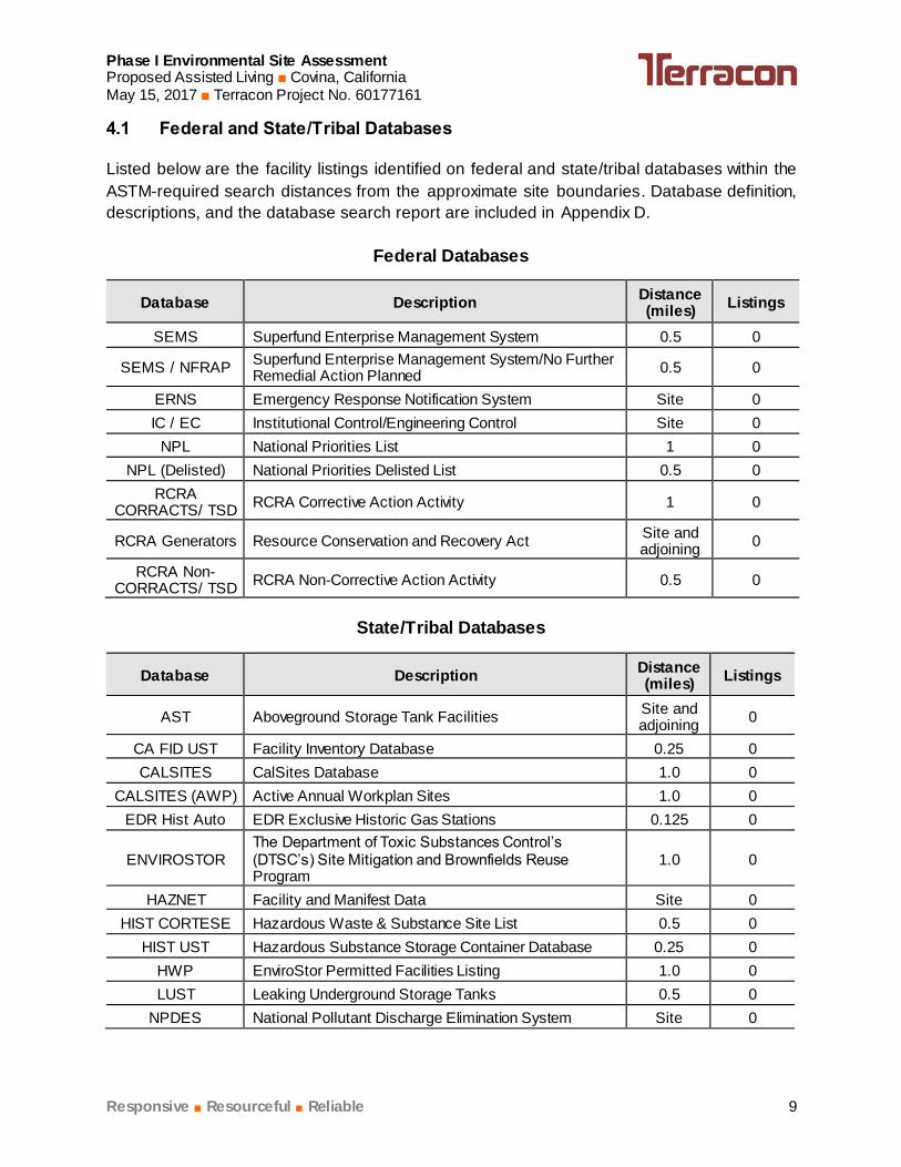
Phase I Environmental Site Assessment Proposed Assisted Living ■ Covina, California May 15, 2017 ■ Terracon Project No. 60177161
Responsive ■ Resourceful ■ Reliable 9
4.1 Federal and State/Tribal Databases
Listed below are the facility listings identified on federal and state/tribal databases within the
ASTM-required search distances from the approximate site boundaries. Database definition,
descriptions, and the database search report are included in Appendix D.
Federal Databases
Database Description Distance (miles)
Listings
SEMS Superfund Enterprise Management System 0.5 0
SEMS / NFRAP Superfund Enterprise Management System/No Further Remedial Action Planned
0.5 0
ERNS Emergency Response Notification System Site 0
IC / EC Institutional Control/Engineering Control Site 0
NPL National Priorities List 1 0
NPL (Delisted) National Priorities Delisted List 0.5 0
RCRA CORRACTS/ TSD
RCRA Corrective Action Activity 1 0
RCRA Generators Resource Conservation and Recovery Act Site and adjoining
0
RCRA Non-CORRACTS/ TSD
RCRA Non-Corrective Action Activity 0.5 0
State/Tribal Databases
Database Description Distance (miles)
Listings
AST Aboveground Storage Tank Facilities Site and adjoining
0
CA FID UST Facility Inventory Database 0.25 0
CALSITES CalSites Database 1.0 0
CALSITES (AWP) Active Annual Workplan Sites 1.0 0
EDR Hist Auto EDR Exclusive Historic Gas Stations 0.125 0
ENVIROSTOR The Department of Toxic Substances Control’s (DTSC’s) Site Mitigation and Brownfields Reuse Program
1.0 0
HAZNET Facility and Manifest Data Site 0
HIST CORTESE Hazardous Waste & Substance Site List 0.5 0
HIST UST Hazardous Substance Storage Container Database 0.25 0
HWP EnviroStor Permitted Facilities Listing 1.0 0
LUST Leaking Underground Storage Tanks 0.5 0
NPDES National Pollutant Discharge Elimination System Site 0

Phase I Environmental Site Assessment Proposed Assisted Living ■ Covina, California May 15, 2017 ■ Terracon Project No. 60177161
Responsive ■ Resourceful ■ Reliable 10
Database Description Distance (miles) Listings
RCRA NonGen/NLR
NLR: RCRA - Non Generators / No Longer Regulated 0.25 0
RESPONSE State Response Sites 1.0 0
SLIC Spills, Leaks, Investigation and Cleanup 0.5 0
SWEEPS UST Statewide Environmental Evaluation and Planning System
0.25 1
SWF/LF Solid Waste Facilities/Landfills 0.5 0
UST Underground Storage Tank Facilities Site and adjoining
1
VCP Voluntary Cleanup Program 0.5 0
In addition to the above ASTM-required listings, Terracon reviewed other federal, state, local, and
proprietary databases provided by the database firm. A list of the additional reviewed databases
is included in the regulatory database report included in Appendix D.
Terracon verified distance and direction of listed facilities in relation to the site. None of the
facilities listed in the current regulatory database were found to be located within a 500-foot radius
to the site. Based upon regulatory status, apparent topographic gradient, hydrogeologic gradient,
and/or distance from the site, the facilities listed in the database report do not appear to represent
RECs to the site.
Unmapped facilities are those that do not contain sufficient address or location information to
evaluate the facility listing locations relative to the site. The report did not list facilities in the
unmapped section.
4.2 Local Agency Inquiries
Agency Contacted/
Contact Method Response
City of Covina City Clerk and Fire
Department / Fax (626) 332-5427
At the issuance of this report, a response had not been received
from the City of Covina.
Los Angeles County Public Health
Investigation / Fax (323) 728-0217
At the issuance of this report, a response had not been received
from the Los Angeles County Public Health Investigation.
Los Angeles County Department of
Public Works / Online (lapw.org)
Terracon reviewed the Los Angeles County Department of
Public Works online file review database. No records were found
for the site
South Coast Air Quality
Management District (SCAQMD) /
online (www.aqmd.gov)
Terracon reviewed the SCAQMD’s online Facility Information
Detail (FIND) database. No records were found for the site.

Phase I Environmental Site Assessment Proposed Assisted Living ■ Covina, California May 15, 2017 ■ Terracon Project No. 60177161
Responsive ■ Resourceful ■ Reliable 11
Agency Contacted/
Contact Method Response
California Department of Toxic
Substances Control (DTSC) / e-
mail ([email protected])
According to Jan Papararo of the DTSC, no records exist for the
site.
California Regional Water Quality
Control Boards (RWQCB) / e-mail
online / (GeoTracker)
At the issuance of this report, a response had not been received
from the RWQCB.
Terracon reviewed the RWQCB GeoTracker website for records
associated with the site. No records were found.
5.0 SITE RECONNAISSANCE
Information contained in this section is based on a visual reconnaissance conducted while walking
through the site and the accessible interior areas of structures, if any, located on the site. Exhibit
2 in Appendix A is a Site Diagram of the site. Photo documentation of the site at the time of the
visual reconnaissance is provided in Appendix B. Credentials of the individuals planning and
conducting the site visit are included in Appendix E.
5.1 General Site Information
General Site Information
Site Reconnaissance
Field Personnel Chandel L. Davis
Reconnaissance Date May 4, 2017
Weather Conditions Sunny, ~75F
Site Contact/Title NA
5.2 Overview of Current Site Occupants and Operations
The site is located at the southeast corner of East Holt Avenue and Park View Drive, Covina, Los
Angeles County, California and is comprised of two parcels (APNs 8448-019-045 and -044)
totaling approximately 1.64-acres of vacant land with vegetation.
5.3 Site Observations
The following table summarizes site observations and interviews. Affirmative responses
(designated by an “X”) are discussed in more detail following the table.

Phase I Environmental Site Assessment Proposed Assisted Living ■ Covina, California May 15, 2017 ■ Terracon Project No. 60177161
Responsive ■ Resourceful ■ Reliable 12
Site Characteristics
Category Item or Feature Observed or
Identified
Site Operations, Processes, and
Equipment
Emergency generators
Elevators
Air compressors
Hydraulic lifts
Dry cleaning
Photo processing
Ventilation hoods and/or incinerators
Waste treatment systems and/or water treatment systems
Heating and/or cooling systems
Paint booths
Sub-grade mechanic pits
Wash-down areas or carwashes
Pesticide/herbicide production or storage
Printing operations
Metal finishing (e.g., electroplating, chrome plating, galvanizing, etc.)
Salvage operations
Oil, gas or mineral production
Other processes or equipment
Aboveground Chemical or Waste
Storage
Aboveground storage tanks
Drums, barrels and/or containers 5 gallons
MSDS or SDS
Underground Chemical or Waste Storage, Drainage
or Collection Systems
Underground storage tanks or ancillary UST equipment
Sumps, cisterns, French drains, catch basins and/or dry wells
Grease traps
Septic tanks and/or leach fields
Oil/water separators, clarifiers, sand traps, triple traps, interceptors
Pipeline markers
Interior floor drains
Electrical Transformers/
PCBs
Transformers and/or capacitors X
Other equipment
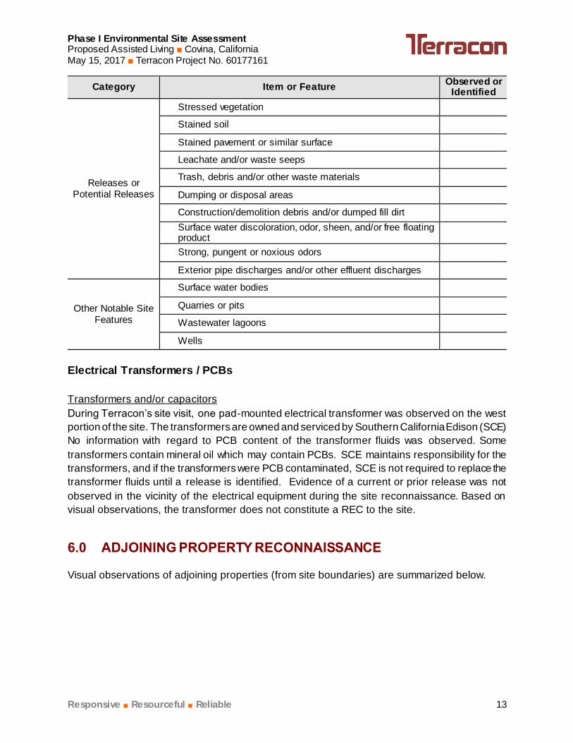
Phase I Environmental Site Assessment Proposed Assisted Living ■ Covina, California May 15, 2017 ■ Terracon Project No. 60177161
Responsive ■ Resourceful ■ Reliable 13
Category Item or Feature Observed or
Identified
Releases or Potential Releases
Stressed vegetation
Stained soil
Stained pavement or similar surface
Leachate and/or waste seeps
Trash, debris and/or other waste materials
Dumping or disposal areas
Construction/demolition debris and/or dumped fill dirt
Surface water discoloration, odor, sheen, and/or free floating product
Strong, pungent or noxious odors
Exterior pipe discharges and/or other effluent discharges
Other Notable Site Features
Surface water bodies
Quarries or pits
Wastewater lagoons
Wells
Electrical Transformers / PCBs
Transformers and/or capacitors
During Terracon’s site visit, one pad-mounted electrical transformer was observed on the west
portion of the site. The transformers are owned and serviced by Southern California Edison (SCE)
No information with regard to PCB content of the transformer fluids was observed. Some
transformers contain mineral oil which may contain PCBs. SCE maintains responsibility for the
transformers, and if the transformers were PCB contaminated, SCE is not required to replace the
transformer fluids until a release is identified. Evidence of a current or prior release was not
observed in the vicinity of the electrical equipment during the site reconnaissance. Based on
visual observations, the transformer does not constitute a REC to the site.
6.0 ADJOINING PROPERTY RECONNAISSANCE
Visual observations of adjoining properties (from site boundaries) are summarized below.

Phase I Environmental Site Assessment Proposed Assisted Living ■ Covina, California May 15, 2017 ■ Terracon Project No. 60177161
Responsive ■ Resourceful ■ Reliable 14
Adjoining Properties
Direction Description
Northeast The property to the adjoining northeast of the site consists of a two-story office
building occupied by Scanfiles, Inc. and associated asphalt-paved parking lots
(1430 East Holt Avenue).
Southeast The property to the adjoining southeast of the site consists of a two-story multi-
tenant office building (1079 Park View Drive) and a single family residence
Southwest Park View Drive abuts the site to the southwest followed by three, two-story, multi-
tenant office buildings and associated asphalt-paved parking lots (1037-1067 Park
View Drive).
Northwest East Holt Avenue abuts the site to the northwest followed by Parque Xalapa.
RECs were not observed with the adjoining properties.
7.0 ADDITIONAL SERVICES
Per the agreed scope of services specified in the proposal, additional services (e.g. asbestos
sampling, lead-based paint sampling, wetlands evaluation, lead in drinking water testing, radon
testing, vapor encroachment screening, etc.) were not conducted.

Phase I Environmental Site AssessmentProposed Assisted Living Covina, CaliforniaMay 15, 2017 Terracon Project No. 60177161
Responsive Resourceful Reliable 15
Islam (Sami) R. Noaman
Islam (Sami) R. Noaman
Environmental Department Manager I
APPENDIX A
EXHIBIT 1 – TOPOGRAPHIC MAP
EXHIBIT 2 – SITE DIAGRAM
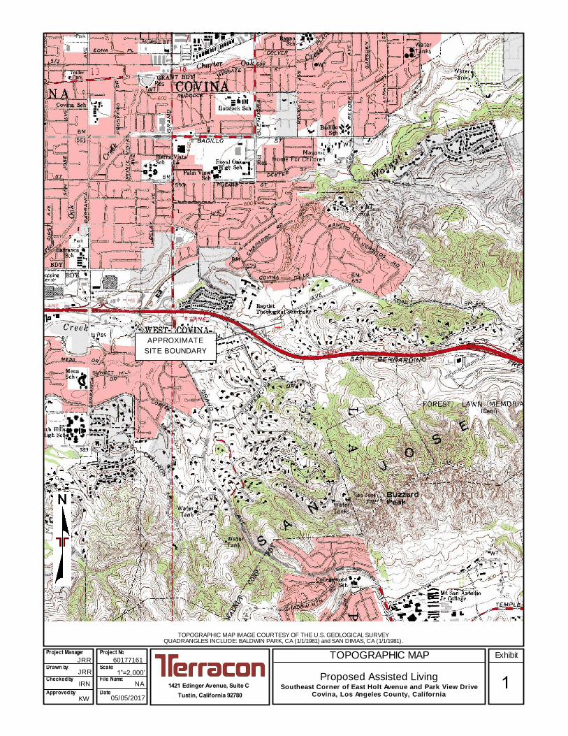
TOPOGRAPHIC MAP
Proposed Assisted Living Southeast Corner of East Holt Avenue and Park View Drive
Covina, Los Angeles County, California
TOPOGRAPHIC MAP IMAGE COURTESY OF THE U.S. GEOLOGICAL SURVEY QUADRANGLES INCLUDE: BALDWIN PARK, CA (1/1/1981) and SAN DIMAS, CA (1/1/1981) .
1421 Edinger Avenue, Suite C
Tustin, California 92780
60177161
Project Manager:
Drawn by: Checked by:
Approved by:
JRR
IRN
KW
1”=2,000’ NA
05/05/2017
Project No.
Scale: File Name:
Date: 1
Exhibit JRR
APPROXIMATE
SITE BOUNDARY
jrrosenthal
Rectangle

Project Mngr:
Approved By:
Checked By:
Drawn By:
Project No.
Scale:
Date: Consulting Engineers and Scientists
1421 EDINGER AVE. STE. C. TUSTIN, CALIFORNIA 92780FAX. (949) 261-6110PH. (949) 261-0051
JRR
DLC
JRR
KW
60177161
AS SHOWNSITE DIAGRAM
2PROPOSED ASSISTED LIVINGSEC OF EAST HOLT AVENUE AND PARK VIEW DRIVE
COVINA, LOS ANGELES COUNTY, CALIFORNIA
EXHIBIT
05/01/2017
LEGEND:
APPROXIMATE SITE
BOUNDARY
SINGLE-FAMILY
RESIDENCE
PARQUE XALAPA
(
1
4
3
0
)
SCANFILES, INC.
TWO-STORY MULTI-
TENANT OFFICE
BUILDING
TWO-STORY MULTI-
TENANT OFFICE
BUILDING
TWO-STORY MULTI-
TENANT OFFICE
BUILDING
(
1
0
6
7
)
(
1
0
3
7
)
TWO-STORY
MULTI-TENANT
OFFICE BUILDING
ASPHALT-PAVED
PARKING LOT
(
1
0
7
9
)
T
TRANSFORMER
(PAD MOUNTED)
T
TWO-STORY
PARKING GARAGE
VACANT LAND WITH
VEGETATION
VACANT LAND
WITH VEGETATION
ASPHALT-PAVED
PARKING LOT
jrrosenthal
Rectangle
jrrosenthal
Line
jrrosenthal
Line
jrrosenthal
Rectangle

APPENDIX B
SITE PHOTOGRAPHS

Proposed Assisted Living
Project No. 60177161
Photo Date: May 4, 2017
Photo #1 View of the northeast portion of the site
looking w est.
Photo #2 View of the southeast portion of the
site looking northw est
Photo #3 View of the southw est portion of the
site looking northeast.
Photo #4 View of the northw est portion of the
site looking east.
Photo #5 View of the pad-mounted transformer
near the w est site boundary.
Photo #6 View of East Hole Avenue follow ed by
Parque Xalapa to the adjoining
northw est of the site.
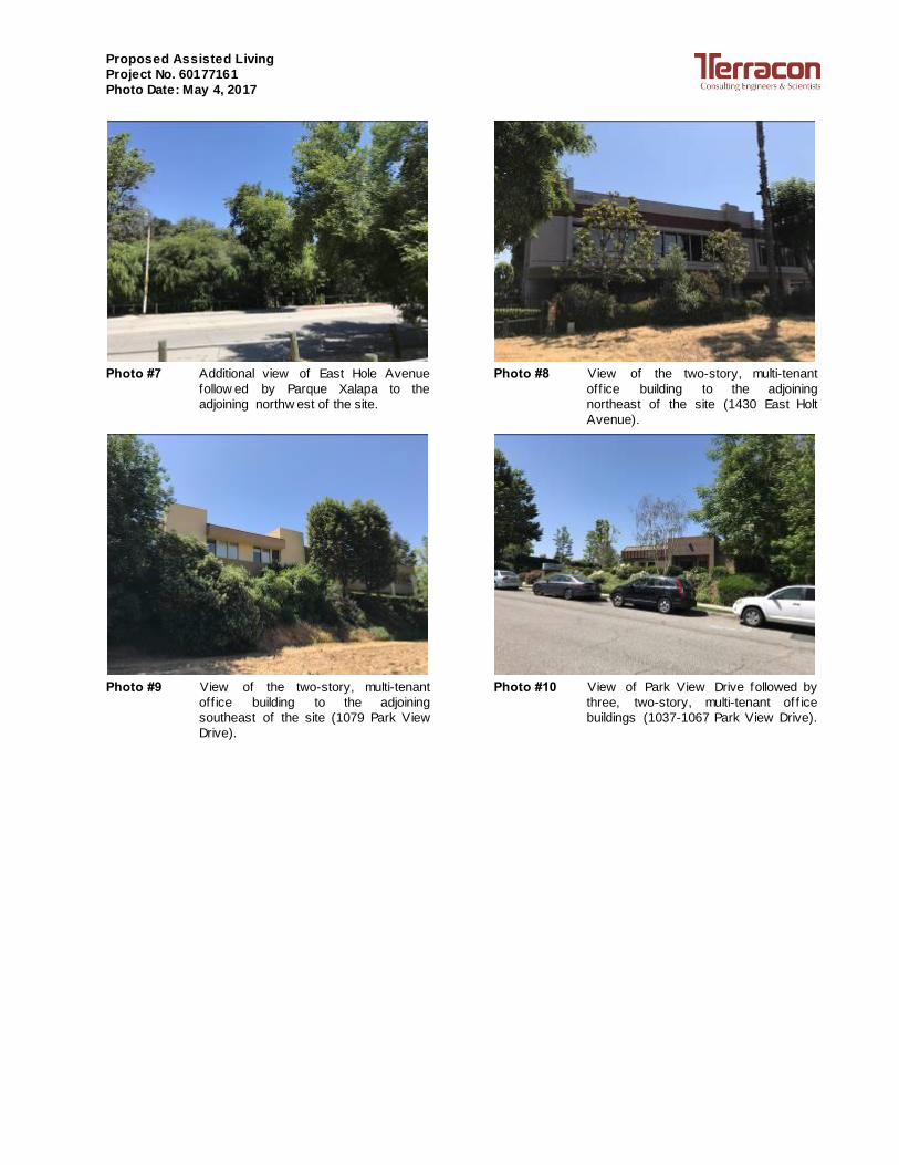
Proposed Assisted Living
Project No. 60177161
Photo Date: May 4, 2017
Photo #7 Additional view of East Hole Avenue
follow ed by Parque Xalapa to the
adjoining northw est of the site.
Photo #8 View of the two-story, multi-tenant
off ice building to the adjoining
northeast of the site (1430 East Holt
Avenue).
Photo #9 View of the two-story, multi-tenant
off ice building to the adjoining
southeast of the site (1079 Park View
Drive).
Photo #10 View of Park View Drive followed by
three, two-story, multi-tenant of f ice
buildings (1037-1067 Park View Drive).

APPENDIX C
HISTORICAL DOCUMENTATION AND USER QUESTIONNAIRE
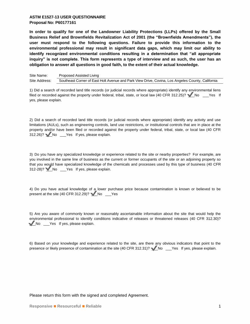
ASTM E1527-13 USER QUESTIONNAIRE
Proposal No: P60177161
Please return this form with the signed and completed Agreement.
Responsive Resourceful Reliable 1
In order to qualify for one of the Landowner Liability Protections (LLPs) offered by the Small
Business Relief and Brownfields Revitalization Act of 2001 (the “Brownfields Amendments”), the
user must respond to the following questions. Failure to provide this information to the
environmental professional may result in significant data gaps, which may limit our ability to
identify recognized environmental conditions resulting in a determination that “all appropriate
inquiry” is not complete. This form represents a type of interview and as such, the user has an
obligation to answer all questions in good faith, to the extent of their actual knowledge.
Site Name: Proposed Assisted Living
Site Address: Southeast Corner of East Holt Avenue and Park View Drive, Covina, Los Angeles County, California
1) Did a search of recorded land title records (or judicial records where appropriate) identify any environmental liens
filed or recorded against the property under federal, tribal, state, or local law (40 CFR 312.25)? ___No ___Yes If
yes, please explain.
2) Did a search of recorded land title records (or judicial records where appropriate) identify any activity and use
limitations (AULs), such as engineering controls, land use restrictions, or institutional controls that are in place at the
property and/or have been filed or recorded against the property under federal, tribal, state, or local law (40 CFR
312.26)? ___No ___Yes If yes, please explain.
3) Do you have any specialized knowledge or experience related to the site or nearby properties? For example, are
you involved in the same line of business as the current or former occupants of the site or an adjoining property so
that you would have specialized knowledge of the chemicals and processes used by this type of business (40 CFR
312-28)? ___No ___Yes If yes, please explain.
4) Do you have actual knowledge of a lower purchase price because contamination is known or believed to be
present at the site (40 CFR 312.29)? ___No ___Yes
5) Are you aware of commonly known or reasonably ascertainable information about the site that would help the
environmental professional to identify conditions indicative of releases or threatened releases (40 CFR 312.30)?
___No ___Yes If yes, please explain.
6) Based on your knowledge and experience related to the site, are there any obvious indicators that point to the
presence or likely presence of contamination at the site (40 CFR 312.31)? ___No ___Yes If yes, please explain.
jlawson
Stamp
jlawson
Stamp
jlawson
Stamp
jlawson
Stamp
jlawson
Stamp
jlawson
Stamp
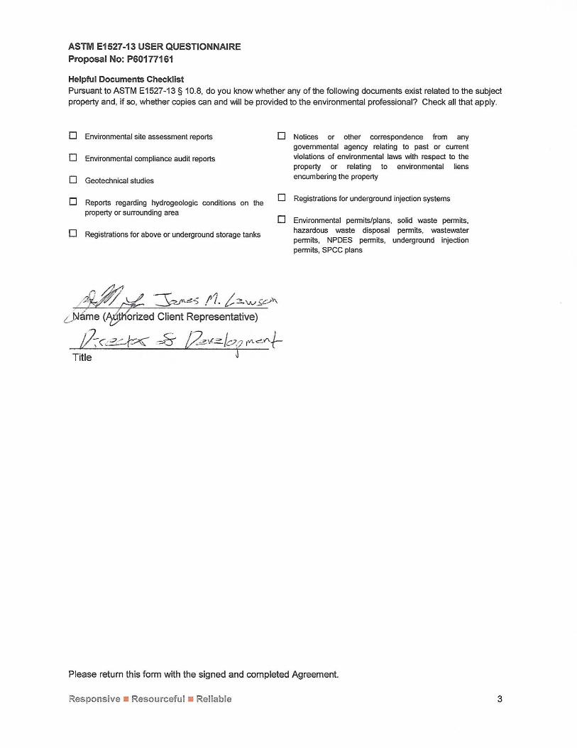

Inquiry Number:
Proposed Assisted Living
East Holt Avenue and Park View Drive
Covina, CA 91724
April 26, 2017
4918524.4

Search Results:
Disclaimer - Copyright and Trademark otice
EDR and its logos (including Sanborn and Sanborn Map) are trademarks of Environmental Data Resources, Inc. or its affiliates. All other trademarks used hereinare the property of their respective owners.
page
:
2012
1981
1972
1966
1954
1927
1904
1898
1897
1894

page
Topo SheetThis EDR Topo Map Report is based upon the following USGS topographic map sheets.
2012 Source Sheets
2012
San Dimas
7.5-minute, 24000
2012
Baldwin Park
7.5-minute, 24000
1981 Source Sheets
1981
Baldwin Park
7.5-minute, 24000
Aerial Photo Revised 1978
1981
San Dimas
7.5-minute, 24000
Aerial Photo Revised 1978
1972 Source Sheets
1972
San Dimas
7.5-minute, 24000
Aerial Photo Revised 1972
1972
Baldwin Park
7.5-minute, 24000
Aerial Photo Revised 1972
1966 Source Sheets
1966
Baldwin Park
7.5-minute, 24000
Aerial Photo Revised 1964
1966
San Dimas
7.5-minute, 24000
Aerial Photo Revised 1964
4918524 4 3

page
Topo SheetThis EDR Topo Map Report is based upon the following USGS topographic map sheets.
1954 Source Sheets
1954
San Dimas
7.5-minute, 24000
Aerial Photo Revised 1952
1927 Source Sheets
1927
Covina
7.5-minute, 24000
1904 Source Sheets
1904
Pomona
15-minute, 62500
1898 Source Sheets
1898
Pomona
15-minute, 62500
4918524 4 4

page
Topo SheetThis EDR Topo Map Report is based upon the following USGS topographic map sheets.
1897 Source Sheets
1897
Pomona
15-minute, 62500
1894 Source Sheets
1894
Pomona
15-minute, 62500
4918524 4 5
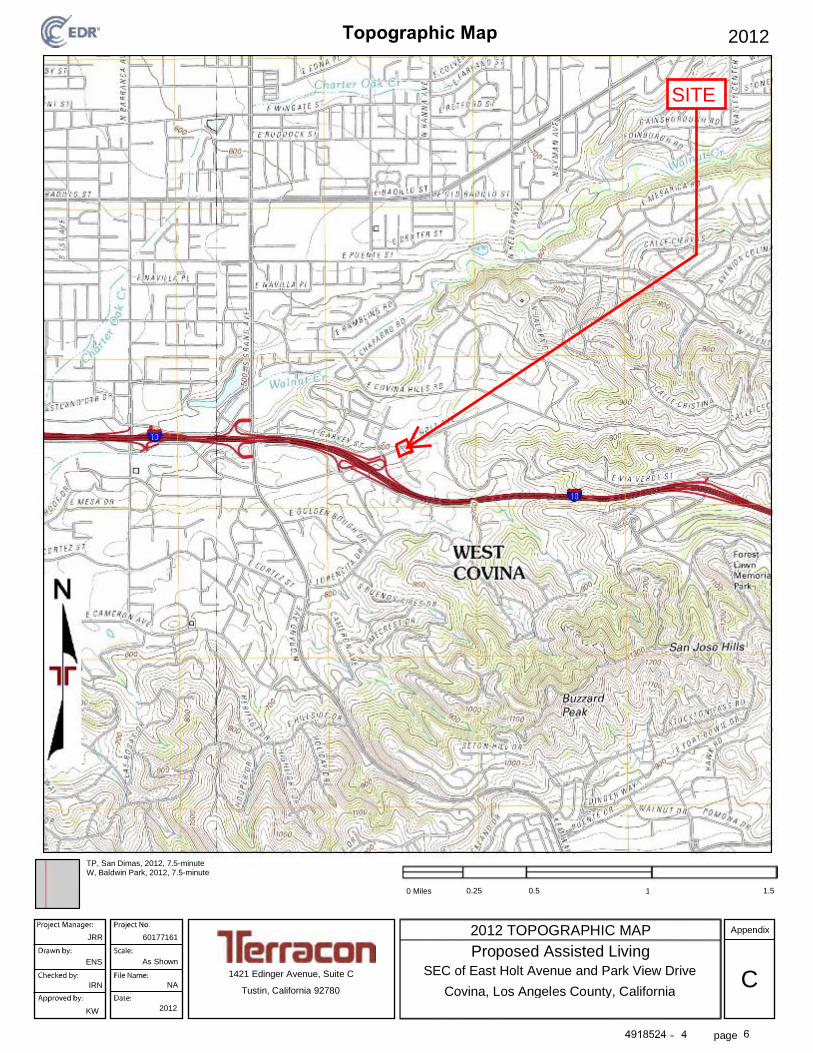
page
TP, San Dimas, 2012, 7.5-minuteW, Baldwin Park, 2012, 7.5-minute
0 Miles 0.25 0.5 1 1.5
2012 TOPOGRAPHIC MAP
2012
2012
JRR 60177161Appendix
ENS As Shown
IRN NA
1421 Edinger Avenue, Suite C SEC of East Holt Avenue and Park View Drive
Proposed Assisted Living
Tustin, California 92780 Covina, Los Angeles County, CaliforniaC
KW
SITE
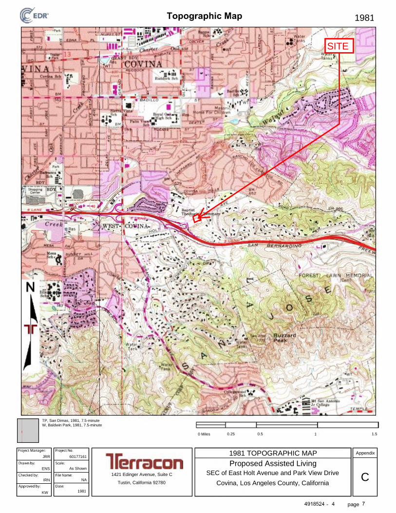
page
TP, San Dimas, 1981, 7.5-minuteW, Baldwin Park, 1981, 7.5-minute
0 Miles 0.25 0.5 1 1.5
1981 TOPOGRAPHIC MAP
1981
1981
JRR 60177161Appendix
ENS As Shown
IRN NA
1421 Edinger Avenue, Suite C SEC of East Holt Avenue and Park View Drive
Proposed Assisted Living
Tustin, California 92780 Covina, Los Angeles County, CaliforniaC
KW
SITE
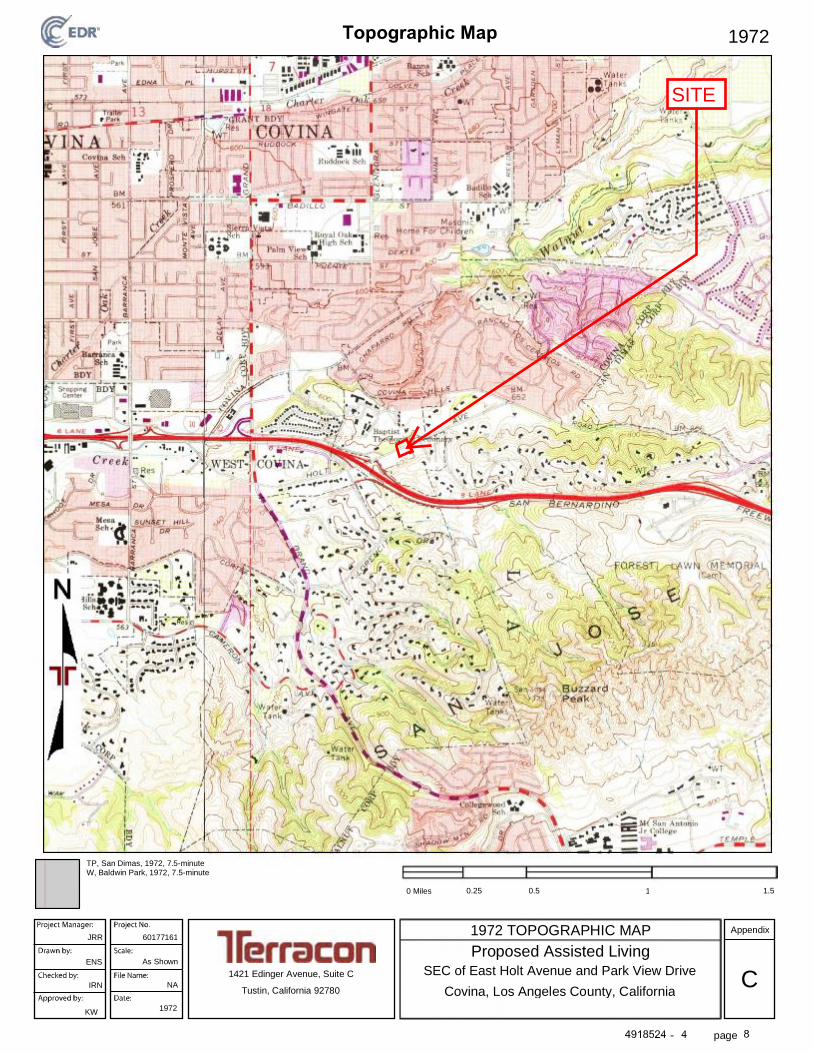
page
TP, San Dimas, 1972, 7.5-minuteW, Baldwin Park, 1972, 7.5-minute
0 Miles 0.25 0.5 1 1.5
1972 TOPOGRAPHIC MAP
1972
1972
JRR 60177161Appendix
ENS As Shown
IRN NA
1421 Edinger Avenue, Suite C SEC of East Holt Avenue and Park View Drive
Proposed Assisted Living
Tustin, California 92780 Covina, Los Angeles County, CaliforniaC
KW
SITE

page
TP, San Dimas, 1966, 7.5-minuteW, Baldwin Park, 1966, 7.5-minute
0 Miles 0.25 0.5 1 1.5
1966 TOPOGRAPHIC MAP
1966
1966
JRR 60177161Appendix
ENS As Shown
IRN NA
1421 Edinger Avenue, Suite C SEC of East Holt Avenue and Park View Drive
Proposed Assisted Living
Tustin, California 92780 Covina, Los Angeles County, CaliforniaC
KW
SITE

page
TP, San Dimas, 1954, 7.5-minute
0 Miles 0.25 0.5 1 1.5
1954 TOPOGRAPHIC MAP
1954
1954
JRR 60177161Appendix
ENS As Shown
IRN NA
1421 Edinger Avenue, Suite C SEC of East Holt Avenue and Park View Drive
Proposed Assisted Living
Tustin, California 92780 Covina, Los Angeles County, CaliforniaC
KW
SITE

page
TP, Covina, 1927, 7.5-minute
0 Miles 0.25 0.5 1 1.5
1927 TOPOGRAPHIC MAP
1927
1927
JRR 60177161Appendix
ENS As Shown
IRN NA
1421 Edinger Avenue, Suite C SEC of East Holt Avenue and Park View Drive
Proposed Assisted Living
Tustin, California 92780 Covina, Los Angeles County, CaliforniaC
KW
SITE

page
TP, Pomona, 1904, 15-minute
0 Miles 0.25 0.5 1 1.5
1904 TOPOGRAPHIC MAP
1904
1904
JRR 60177161Appendix
ESN As Shown
IRN NA
1421 Edinger Avenue, Suite C SEC of East Holt Avenue and Park View Drive
Proposed Assisted Living
Tustin, California 92780 Covina, Los Angeles County, CaliforniaC
KW
SITE

page
TP, Pomona, 1898, 15-minute
0 Miles 0.25 0.5 1 1.5
1898 TOPOGRAPHIC MAP
1898
1898
JRR 60177161Appendix
ESN As Shown
IRN NA
1421 Edinger Avenue, Suite C SEC of East Holt Avenue and Park View Drive
Proposed Assisted Living
Tustin, California 92780 Covina, Los Angeles County, CaliforniaC
KW
SITE

page
TP, Pomona, 1897, 15-minute
0 Miles 0.25 0.5 1 1.5
1897 TOPOGRAPHIC MAP
1897
1897
JRR 60177161Appendix
ESN As Shown
IRN NA
1421 Edinger Avenue, Suite C SEC of East Holt Avenue and Park View Drive
Proposed Assisted Living
Tustin, California 92780 Covina, Los Angeles County, CaliforniaC
KW
SITE

page
TP, Pomona, 1894, 15-minute
0 Miles 0.25 0.5 1 1.5
1894 TOPOGRAPHIC MAP
1894
1894
JRR 60177161Appendix
ESN As Shown
IRN NA
1421 Edinger Avenue, Suite C SEC of East Holt Avenue and Park View Drive
Proposed Assisted Living
Tustin, California 92780 Covina, Los Angeles County, CaliforniaC
KW
SITE
Inquiry Number:
April 27, 2017
4918524.9
Proposed Assisted Living
SEC of East Holt Avenue and Park View Drive
Covina, California 91724
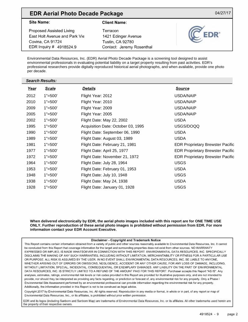
Search Results:
Disclaimer - Copyright and Trademark otice
EDR and its logos (including Sanborn and Sanborn Map) are trademarks of Environmental Data Resources, Inc. or its affiliates. All other trademarks used herein arethe property of their respective owners.
page
Environmental Data Resources, Inc. (EDR) Aerial Photo Decade Package is a screening tool designed to assistenvironmental professionals in evaluating potential liability on a target property resulting from past activities. EDR’sprofessional researchers provide digitally reproduced historical aerial photographs, and when available, provide one photoper decade.
When delivered electronically by EDR, the aerial photo images included with this report are for ONE TIME USEONLY. Further reproduction of these aerial photo images is prohibited without permission from EDR. For moreinformation contact your EDR Account Executive.
2012 1"=500' Flight Year: 2012 USDA/NAIP
2010 1"=500' Flight Year: 2010 USDA/NAIP
2009 1"=500' Flight Year: 2009 USDA/NAIP
2005 1"=500' Flight Year: 2005 USDA/NAIP
2002 1"=500' Flight Date: May 22, 2002 USDA
1995 1"=500' Acquisition Date: October 03, 1995 USGS/DOQQ
1990 1"=500' Flight Date: September 06, 1990 USDA
1989 1"=500' Flight Date: August 03, 1989 USDA
1981 1"=500' Flight Date: February 21, 1981 EDR Proprietary Brewster Pacific
1977 1"=500' Flight Date: April 25, 1977 EDR Proprietary Brewster Pacific
1972 1"=500' Flight Date: November 21, 1972 EDR Proprietary Brewster Pacific
1964 1"=500' Flight Date: July 28, 1964 USGS
1953 1"=500' Flight Date: February 01, 1953 USDA
1948 1"=500' Flight Date: July 10, 1948 USGS
1938 1"=500' Flight Date: May 24, 1938 USDA
1928 1"=500' Flight Date: January 01, 1928 USGS
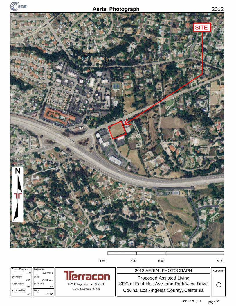
page
0 Feet 500 1000 2000
2012 AERIAL PHOTOGRAPH
2012
2012
JRR 60177161
ESN As Shown
Appendix
Proposed Assisted Living
IRN NA C1421 Edinger Avenue, Suite C
Covina, Los Angeles County, CaliforniaTustin, California 92780
SEC of East Holt Ave. and Park View Drive
KW
SITE

page
0 Feet 500 1000 2000
2010 AERIAL PHOTOGRAPH
2010
2010
JRR 60177161
ENS As Shown
Appendix
Proposed Assisted Living
IRN NA C1421 Edinger Avenue, Suite C
Covina, Los Angeles County, CaliforniaTustin, California 92780
SEC of East Holt Ave. and Park View Drive
KW
SITE
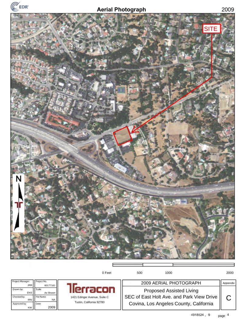
page
0 Feet 500 1000 2000
2009 AERIAL PHOTOGRAPH
2009
2009
JRR 60177161
ENS As Shown
Appendix
Proposed Assisted Living
IRN NA C1421 Edinger Avenue, Suite C
Covina, Los Angeles County, CaliforniaTustin, California 92780
SEC of East Holt Ave. and Park View Drive
KW
SITE

page
0 Feet 500 1000 2000
2005 AERIAL PHOTOGRAPH
2005
2005
JRR 60177161
ENS As Shown
Appendix
Proposed Assisted Living
IRN NA C1421 Edinger Avenue, Suite C
Covina, Los Angeles County, CaliforniaTustin, California 92780
SEC of East Holt Ave. and Park View Drive
KW
SITE
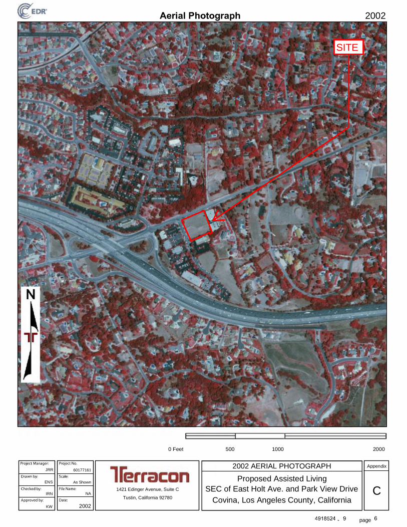
page
0 Feet 500 1000 2000
2002 AERIAL PHOTOGRAPH
2002
2002
JRR 60177161
ENS As Shown
Appendix
Proposed Assisted Living
IRN NA C1421 Edinger Avenue, Suite C
Covina, Los Angeles County, CaliforniaTustin, California 92780
SEC of East Holt Ave. and Park View Drive
KW
SITE

page
0 Feet 500 1000 2000
1995 AERIAL PHOTOGRAPH
1995
1995
JRR 60177161
ENS As Shown
Appendix
Proposed Assisted Living
IRN NA C1421 Edinger Avenue, Suite C
Covina, Los Angeles County, CaliforniaTustin, California 92780
SEC of East Holt Ave. and Park View Drive
KW
SITE

page
0 Feet 500 1000 2000
1990 AERIAL PHOTOGRAPH
1990
1990
JRR 60177161
ENS As Shown
Appendix
Proposed Assisted Living
IRN NA C1421 Edinger Avenue, Suite C
Covina, Los Angeles County, CaliforniaTustin, California 92780
SEC of East Holt Ave. and Park View Drive
KW
SITE

page
0 Feet 500 1000 2000
1989 AERIAL PHOTOGRAPH
1989
1989
JRR 60177161
ENS As Shown
Appendix
Proposed Assisted Living
IRN NA C1421 Edinger Avenue, Suite C
Covina, Los Angeles County, CaliforniaTustin, California 92780
SEC of East Holt Ave. and Park View Drive
KW
SITE

page
0 Feet 500 1000 2000
1981 AERIAL PHOTOGRAPH
1981
1981
JRR 60177161
ENS As Shown
Appendix
Proposed Assisted Living
IRN NA C1421 Edinger Avenue, Suite C
Covina, Los Angeles County, CaliforniaTustin, California 92780
SEC of East Holt Ave. and Park View Drive
KW
SITE
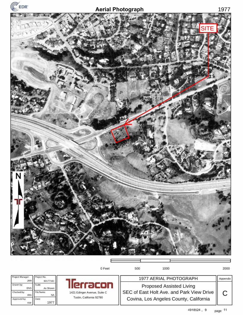
page
0 Feet 500 1000 2000
1977 AERIAL PHOTOGRAPH
1977
1977
JRR 60177161
ENS As Shown
Appendix
Proposed Assisted Living
IRN NA C1421 Edinger Avenue, Suite C
Covina, Los Angeles County, CaliforniaTustin, California 92780
SEC of East Holt Ave. and Park View Drive
KW
SITE
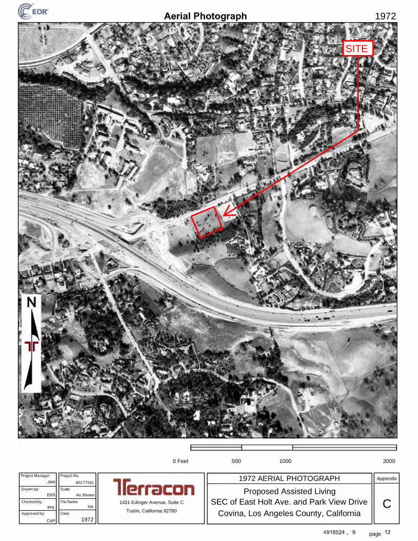
page
0 Feet 500 1000 2000
1972 AERIAL PHOTOGRAPH
1972
1972
Appendix
Proposed Assisted Living
NA C1421 Edinger Avenue, Suite C
Covina, Los Angeles County, CaliforniaTustin, California 92780
SEC of East Holt Ave. and Park View Drive
JRR 60177161
ENS As Shown
IRN
SITE
jrrosenthal
Text Box
KW

page
0 Feet 500 1000 2000
1964 AERIAL PHOTOGRAPH
1964
1964
Appendix
Proposed Assisted Living
NA C1421 Edinger Avenue, Suite C
Covina, Los Angeles County, CaliforniaTustin, California 92780
SEC of East Holt Ave. and Park View Drive
JRR 60177161
ENS As Shown
IRN
SITE
jrrosenthal
Text Box
KW

page
0 Feet 500 1000 2000
1953 AERIAL PHOTOGRAPH
1953
1953
Appendix
Proposed Assisted Living
NA C1421 Edinger Avenue, Suite C
Covina, Los Angeles County, CaliforniaTustin, California 92780
SEC of East Holt Ave. and Park View Drive
JRR 60177161
ENS As Shown
IRN
SITE
jrrosenthal
Text Box
KW

page
0 Feet 500 1000 2000
1948 AERIAL PHOTOGRAPH
1948
1948
Appendix
Proposed Assisted Living
NA C1421 Edinger Avenue, Suite C
Covina, Los Angeles County, CaliforniaTustin, California 92780
SEC of East Holt Ave. and Park View Drive
JRR 60177161
ENS As Shown
IRN
SITE
jrrosenthal
Text Box
KW

page
0 Feet 500 1000 2000
1938 AERIAL PHOTOGRAPH
1938
1938
Appendix
Proposed Assisted Living
NA C1421 Edinger Avenue, Suite C
Covina, Los Angeles County, CaliforniaTustin, California 92780
SEC of East Holt Ave. and Park View Drive
JRR 60177161
ENS As Shown
IRN
SITE
jrrosenthal
Text Box
KW

page
0 Feet 500 1000 2000
1928 AERIAL PHOTOGRAPH
1928
1928
Appendix
Proposed Assisted Living
NA C1421 Edinger Avenue, Suite C
Covina, Los Angeles County, CaliforniaTustin, California 92780
SEC of East Holt Ave. and Park View Drive
JRR 60177161
ENS As Shown
IRN
SITE
jrrosenthal
Text Box
KW

Certified Sanborn® Map Report
Inquiry Number:
6 Armstrong Road, 4th floor Shelton, CT 06484Toll Free: 800.352.0050 www.edrnet.com
April 26, 2017
4918524.3
Proposed Assisted Living
SEC of East Holt Avenue and Park View Drive
Covina, CA 91724
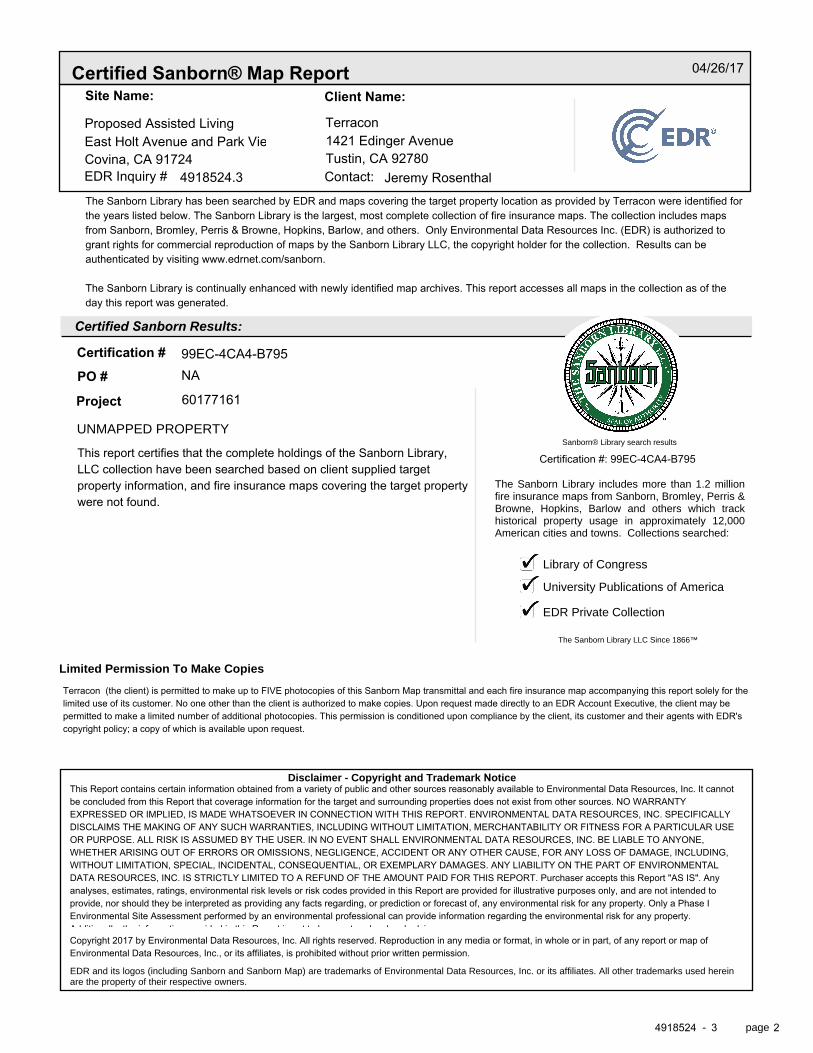
Certified Sanborn® Map Report
Certified Sanborn Results:
Disclaimer - Copyright and Trademark Notice
EDR and its logos (including Sanborn and Sanborn Map) are trademarks of Environmental Data Resources, Inc. or its affiliates. All other trademarks used herein are the property of their respective owners.
page-
The Sanborn Library includes more than 1.2 millionfire insurance maps from Sanborn, Bromley, Perris &Browne, Hopkins, Barlow and others which trackhistorical property usage in approximately 12,000American cities and towns. Collections searched:
Library of Congress
University Publications of America
EDR Private Collection
The Sanborn Library LLC Since 1866™
Limited Permission To Make Copies
Sanborn® Library search results
Certification #
Contact:EDR Inquiry #
Site Name: Client Name:
PO #
Project
04/26/17
Proposed Assisted Living TerraconEast Holt Avenue and Park View Drive 1421 Edinger AvenueCovina, CA 91724 Tustin, CA 92780
4918524.3 Jeremy RosenthalThe Sanborn Library has been searched by EDR and maps covering the target property location as provided by Terracon were identified forthe years listed below. The Sanborn Library is the largest, most complete collection of fire insurance maps. The collection includes mapsfrom Sanborn, Bromley, Perris & Browne, Hopkins, Barlow, and others. Only Environmental Data Resources Inc. (EDR) is authorized togrant rights for commercial reproduction of maps by the Sanborn Library LLC, the copyright holder for the collection. Results can beauthenticated by visiting www.edrnet.com/sanborn.
The Sanborn Library is continually enhanced with newly identified map archives. This report accesses all maps in the collection as of theday this report was generated.
99EC-4CA4-B795NA
UNMAPPED PROPERTY
60177161
This report certifies that the complete holdings of the Sanborn Library,LLC collection have been searched based on client supplied targetproperty information, and fire insurance maps covering the target propertywere not found.
Certification #: 99EC-4CA4-B795
Terracon (the client) is permitted to make up to FIVE photocopies of this Sanborn Map transmittal and each fire insurance map accompanying this report solely for thelimited use of its customer. No one other than the client is authorized to make copies. Upon request made directly to an EDR Account Executive, the client may bepermitted to make a limited number of additional photocopies. This permission is conditioned upon compliance by the client, its customer and their agents with EDR'scopyright policy; a copy of which is available upon request.
This Report contains certain information obtained from a variety of public and other sources reasonably available to Environmental Data Resources, Inc. It cannotbe concluded from this Report that coverage information for the target and surrounding properties does not exist from other sources. NO WARRANTYEXPRESSED OR IMPLIED, IS MADE WHATSOEVER IN CONNECTION WITH THIS REPORT. ENVIRONMENTAL DATA RESOURCES, INC. SPECIFICALLYDISCLAIMS THE MAKING OF ANY SUCH WARRANTIES, INCLUDING WITHOUT LIMITATION, MERCHANTABILITY OR FITNESS FOR A PARTICULAR USEOR PURPOSE. ALL RISK IS ASSUMED BY THE USER. IN NO EVENT SHALL ENVIRONMENTAL DATA RESOURCES, INC. BE LIABLE TO ANYONE,WHETHER ARISING OUT OF ERRORS OR OMISSIONS, NEGLIGENCE, ACCIDENT OR ANY OTHER CAUSE, FOR ANY LOSS OF DAMAGE, INCLUDING,WITHOUT LIMITATION, SPECIAL, INCIDENTAL, CONSEQUENTIAL, OR EXEMPLARY DAMAGES. ANY LIABILITY ON THE PART OF ENVIRONMENTALDATA RESOURCES, INC. IS STRICTLY LIMITED TO A REFUND OF THE AMOUNT PAID FOR THIS REPORT. Purchaser accepts this Report "AS IS". Anyanalyses, estimates, ratings, environmental risk levels or risk codes provided in this Report are provided for illustrative purposes only, and are not intended toprovide, nor should they be interpreted as providing any facts regarding, or prediction or forecast of, any environmental risk for any property. Only a Phase IEnvironmental Site Assessment performed by an environmental professional can provide information regarding the environmental risk for any property.Additionally, the information provided in this Report is not to be construed as legal advice.Copyright 2017 by Environmental Data Resources, Inc. All rights reserved. Reproduction in any media or format, in whole or in part, of any report or map ofEnvironmental Data Resources, Inc., or its affiliates, is prohibited without prior written permission.
4918524 3 2
Proposed Assisted Living
SEC of East Holt Avenue and Park View DriveCovina, CA 91724
Inquiry Number: 4918524.5April 26, 2017
The EDR-City Directory Abstract
6 Armstrong RoadShelton, CT 06484800.352.0050www.edrnet.comEnvironmental Data Resources IncEnvironmental Data Resources IncEnvironmental Data Resources IncEnvironmental Data Resources Inc

TABLE OF CONTENTS
SECTION
Executive Summary
Findings
City Directory Images
Thank you for your business. Please contact EDR at 1-800-352-0050
with any questions or comments.
Disclaimer - Copyright and Trademark Notice
This Report contains certain information obtained from a variety of public and other sources reasonably available to Environmental Data Resources, Inc. It cannot be concluded from this Report that coverage information for the target and surrounding properties does not exist from other sources. NO WARRANTY EXPRESSED OR IMPLIED, IS MADE WHATSOEVER IN CONNECTION WITH THIS REPORT. ENVIRONMENTAL DATA RESOURCES, INC. SPECIFICALLY DISCLAIMS THE MAKING OF ANY SUCH WARRANTIES, INCLUDING WITHOUT LIMITATION, MERCHANTABILITY OR FITNESS FOR A PARTICULAR USE OR PURPOSE. ALL RISK IS ASSUMED BY THE USER. IN NO EVENT SHALL ENVIRONMENTAL DATA RESOURCES, INC. BE LIABLE TO ANYONE, WHETHER ARISING OUT OF ERRORS OR OMISSIONS, NEGLIGENCE, ACCIDENT OR ANY OTHER CAUSE, FOR ANY LOSS OR DAMAGE, INCLUDING, WITHOUT LIMITATION, SPECIAL, INCIDENTAL, CONSEQUENTIAL, OR EXEMPLARY DAMAGES. ANY LIABILITY ON THE PART OF ENVIRONMENTAL DATA RESOURCES, INC. IS STRICTLY LIMITED TO A REFUND OF THE AMOUNT PAID FOR THIS REPORT. Purchaser accepts this Report "AS IS". Any analyses, estimates, ratings, environmental risk levels or risk codes provided in this Report are provided for illustrative purposes only, and are not intended to provide, nor should they be interpreted as providing any facts regarding, or prediction orforecast of, any environmental risk for any property. Only a Phase I Environmental Site Assessment performed by an environmental professional can provide information regarding the environmental risk for any property. Additionally, the information provided in this Report is not to be construed as legal advice.
Copyright 2017 by Environmental Data Resources, Inc. All rights reserved. Reproduction in any media or format, in whole or in part, of any report or map of Environmental Data Resources, Inc. or its affiliates is prohibited without prior written permission.
EDR and its logos (including Sanborn and Sanborn Map) are trademarks of Environmental Data Resources, Inc. or its affiliates. All other trademarks used herein are the property of their respective owners.

EXECUTIVE SUMMARY
DESCRIPTION
Environmental Data Resources, Inc.’s (EDR) City Directory Abstract is a screening tool designed to assist environmental professionals in evaluating potential liability on a target property resulting from past activities. EDR’s City Directory Abstract includes a search and abstract of available city directory data. For each address, the directory lists the name of the corresponding occupant at five year intervals.
Business directories including city, cross reference and telephone directories were reviewed, if available, at approximately five year intervals for the years spanning 1920 through 2014. This report compiles information gathered in this review by geocoding the latitude and longitude of properties identified and gathering information about properties within 660 feet of the target property.
A summary of the information obtained is provided in the text of this report.
RECORD SOURCES
EDR's Digital Archive combines historical directory listings from sources such as Cole Information and Dun & Bradstreet. These standard sources of property information complement and enhance each other to provide a more comprehensive report.
EDR is licensed to reproduce certain City Directory works by the copyright holders of those works. The purchaser of this EDR City Directory Report may include it in report(s) delivered to a customer. Reproduction of City Directories without permission of the publisher or licensed vendor may be a violation of copyright.
RESEARCH SUMMARY
The following research sources were consulted in the preparation of this report. An "X" indicates where information was identified in the source and provided in this report.
Source TPYear Adjoining Text Abstract Source Image
2014 EDR Digital Archive - X X -
2010 EDR Digital Archive - X X -
2006 Haines Company - - - -
2004 Haines Company - - - -
2003 Haines & Company - X X -
2001 Haines Company, Inc. - - - -
2000 Haines - - - -
1999 Haines Company - - - -
1996 GTE - - - -
1995 Pacific Bell - X X -
1992 PACIFIC BELL WHITE PAGES - - - -
1991 Pacific Bell - X X -
4918524- 5 Page 1

EXECUTIVE SUMMARY
Source TPYear Adjoining Text Abstract Source Image
1990 Pacific Bell - X X -
1986 Pacific Bell - - - -
1985 Pacific Bell - X X -
1981 Pacific Telephone - - - -
1980 Pacific Telephone - X X -
1976 R.L. Polk & Co Publishers - - - -
1975 Pacific Telephone - X X -
1972 R. L. Polk & Co. - - - -
1971 R. L. Polk & Co. - - - -
1970 Pacific Telephone - - - -
1969 Pacific Telephone - - - -
1967 R. L. Polk & Co. - - - -
1966 Pacific Telephone - X X -
1965 GTE - - - -
1964 Pacific Telephone - - - -
1963 Pacific Telephone - - - -
1962 Pacific Telephone - - - -
1961 R. L. Polk & Co. - - - -
1960 Pacific Telephone - X X -
1958 Pacific Telephone - - - -
1957 Pacific Telephone - X X -
1956 Pacific Telephone - - - -
1955 R. L. Polk & Co. - - - -
1954 R. L. Polk & Co. - - - -
1952 Los Angeles Directory Co. - - - -
1951 Los Angeles Directory Co Publishers - X X -
1950 Pacific Telephone - X X -
1949 Los Angeles Directory Co. - - - -
1948 Associated Telephone Company, Ltd. - - - -
1947 Pacific Directory Co. - - - -
1946 Southern California Telephone Co - - - -
1945 R. L. Polk & Co. - - - -
1944 R. L. Polk & Co. - - - -
1942 Los Angeles Directory Co. - - - -
1940 Los Angeles Directory Co. - - - -
1939 Los Angeles Directory Co. - - - -
1938 Los Angeles Directory Company Publishers
- - - -
1937 Los Angeles Directory Co. - - - -
1936 Los Angeles Directory Co. - - - -
1935 Los Angeles Directory Co. - - - -
1934 Los Angeles Directory Co. - - - -
1933 Los Angeles Directory Co. - - - -
4918524- 5 Page 2

EXECUTIVE SUMMARY
Source TPYear Adjoining Text Abstract Source Image
1932 Los Angeles Directory Co. - - - -
1931 TRIBUNE-NEWS PUBLISHING CO. - - - -
1930 Los Angeles Directory Co. - - - -
1929 Los Angeles Directory Co. - - - -
1928 Los Angeles Directory Co. - - - -
1927 Los Angeles Directory Co. - - - -
1926 Los Angeles Directory Co. - - - -
1925 Los Angeles Directory Co. - - - -
1924 Los Angeles Directory Co. - - - -
1923 Los Angeles Directory Co. - - - -
1921 Los Angeles Directory Co. - - - -
1920 Los Angeles Directory Co. - - - -
4918524- 5 Page 3

EXECUTIVE SUMMARY
SELECTED ADDRESSES
The following addresses were selected by the client, for EDR to research. An "X" indicates where information was identified.
Address Type Findings
1405 east holt avenue Client Entered X
1430 east holt avenue Client Entered X
1440 east holt avenue Client Entered X
1074 park view drive Client Entered X
1067 park view drive Client Entered
1051 park view drive Client Entered
1037 park view drive Client Entered X
4918524- 5 Page 4

FINDINGS
TARGET PROPERTY INFORMATION
ADDRESS
East Holt Avenue and Park View DriveCovina, CA 91724
FINDINGS DETAIL
Target Property research detail.
4918524- 5 Page 5

FINDINGS
ADJOINING PROPERTY DETAIL
The following Adjoining Property addresses were researched for this report. Detailed findings are provided for each address.
E HOLT AVE
1405 E HOLT AVE
Year Uses Source
2003 VANVALKENBURGH JR Haines & Company
VANVALKENBURGH J R Haines & Company
1995 Van Valkenburgh J R Pacific Bell
1985 SCHULTZ CHAD A Pacific Bell
1975 SCHULTZ CHAS A Pacific Telephone
1411 E HOLT AVE
Year Uses Source
1950 ROBERTS HARRY R Pacific Telephone
ROBERTS HARRY R Pacific Telephone
E Holt Ave
1430 E Holt Ave
Year Uses Source
2014 MED LEGAL INC EDR Digital Archive
ML PRIOR INC EDR Digital Archive
MED LEGAL INC EDR Digital Archive
ML PRIOR INC EDR Digital Archive
2010 MED-LEGAL INC EDR Digital Archive
MED-LEGAL INC EDR Digital Archive
E HOLT AVE
1430 E HOLT AVE
Year Uses Source
2003 SCHNEIDERWarren Haines & Company
1995 i Pacific Bell
1438 E HOLT AVE
Year Uses Source
2003 SONG Rio Haines & Company
4918524- 5 Page 6

Year Uses Source
FINDINGS
E Holt Ave
1440 E Holt Ave
Year Uses Source
2010 RIO ONGS MD CORP EDR Digital Archive
RIO ONGS MD CORP EDR Digital Archive
E HOLT AVE
1445 E HOLT AVE
Year Uses Source
2003 XXXX Haines & Company
1995 Cordova Henry Pacific Bell
2005 E HOLT AVE
Year Uses Source
1951 Bewley J Los Angeles Directory Co Publishers
20065 E HOLT AVE
Year Uses Source
1966 SCHOCK HAROLD REV Pacific Telephone
1960 JOBE CHAS R Pacific Telephone
1957 JOBE CHAS R Pacific Telephone
20095 E HOLT AVE
Year Uses Source
1960 SCHULTZ CHAD A Pacific Telephone
1957 SCHULTZ CHAD A Pacific Telephone
20212 E HOLT AVE
Year Uses Source
1960 DAVIS R W Pacific Telephone
1957 DAVIS R W Pacific Telephone
20235 E HOLT AVE
Year Uses Source
2003 SEALEY Frank E Haines & Company
1995 Sealey L Pacific Bell
Sealey Kathleen Pacific Bell
Sealey Frank E Pacific Bell
1985 SEALEY FRANK E Pacific Bell
4918524- 5 Page 7

Year Uses Source
FINDINGS
Year Uses Source
1980 FALKENBERG DON E HOLT AVE COVINA
Pacific Telephone
SEALEY FRANK E E HOLT AVE COVINA
Pacific Telephone
1966 HAMILTON J M Pacific Telephone
1960 ROBERTS HARRY R Pacific Telephone
1957 ROBERTS HARRY R Pacific Telephone
east holt avenue
1405 east holt avenue
Year Uses Source
2003 VANVALKENBURGH JR Haines & Company
VANVALKENBURGH J R Haines & Company
1995 Van Valkenburgh J R Pacific Bell
1985 SCHULTZ CHAD A Pacific Bell
1975 SCHULTZ CHAS A Pacific Telephone
1430 east holt avenue
Year Uses Source
2003 SCHNEIDERWarren Haines & Company
1995 i Pacific Bell
1440 east holt avenue
Year Uses Source
1980 BROMBERGER HAROLD E HOLT AVE COVINA
Pacific Telephone
Park View Dr
1037 Park View Dr
Year Uses Source
2014 BRADBURY ESTATES ASSOCIATION EDR Digital Archive
MONIE PROPERTIES LLC EDR Digital Archive
ALPHA ACTUAL LLC EDR Digital Archive
MONTGOMERY NIEMEYER & CO LLP EDR Digital Archive
MONTGOMERY NIEMEYER CO EDR Digital Archive
MNC TECHNOLOGY SOLUTIONS INC EDR Digital Archive
ALPHA ACTUAL LLC EDR Digital Archive
BRADBURY ESTATES ASSOCIATION EDR Digital Archive
MONIE PROPERTIES LLC EDR Digital Archive
4918524- 5 Page 8

Year Uses Source
FINDINGS
Year Uses Source
2014 MONTGOMERY NIEMEYER & CO LLP EDR Digital Archive
MONTGOMERY NIEMEYER CO EDR Digital Archive
MNC TECHNOLOGY SOLUTIONS INC EDR Digital Archive
2010 MONTGOMERY NIEMEYER CO EDR Digital Archive
MONTGOMERY NIEMEYER & CO LLP EDR Digital Archive
SCHMIDT-CANNON PROPERTIES EDR Digital Archive
BRADBURY ESTATES ASSOCIATION EDR Digital Archive
MONIE PROPERTIES LLC EDR Digital Archive
MNC TECHNOLOGY SOLUTIONS INC EDR Digital Archive
INTERNATIONAL REAL ESTATE SERV EDR Digital Archive
MONTGOMERY NIEMEYER CO EDR Digital Archive
MONTGOMERY NIEMEYER & CO LLP EDR Digital Archive
SCHMIDT-CANNON PROPERTIES EDR Digital Archive
BRADBURY ESTATES ASSOCIATION EDR Digital Archive
MONIE PROPERTIES LLC EDR Digital Archive
MNC TECHNOLOGY SOLUTIONS INC EDR Digital Archive
INTERNATIONAL REAL ESTATE SERV EDR Digital Archive
CROWELL WEEDON & CO INC EDR Digital Archive
CROWELL WEEDON & CO INC EDR Digital Archive
PARK VIEW DR
1037 PARK VIEW DR
Year Uses Source
1991 TRW Real Estate Information Services Pacific Bell
1990 TRW INC TRW INFORMATION SYSTEMS GROUP
Pacific Bell
Park View Dr
1051 Park View Dr
Year Uses Source
2014 CENTRAL HEALTH PLAN CAL INC EDR Digital Archive
EMNET MANAGEMENT SYSTEMS EDR Digital Archive
ECOM ASSET SECURITIZATION INC EDR Digital Archive
HOME LOAN MORTGAGE CO EDR Digital Archive
CENTRAL HEALTH PLAN CAL INC EDR Digital Archive
ECOM ASSET SECURITIZATION INC EDR Digital Archive
HOME LOAN MORTGAGE CO EDR Digital Archive
EMNET MANAGEMENT SYSTEMS EDR Digital Archive
4918524- 5 Page 9
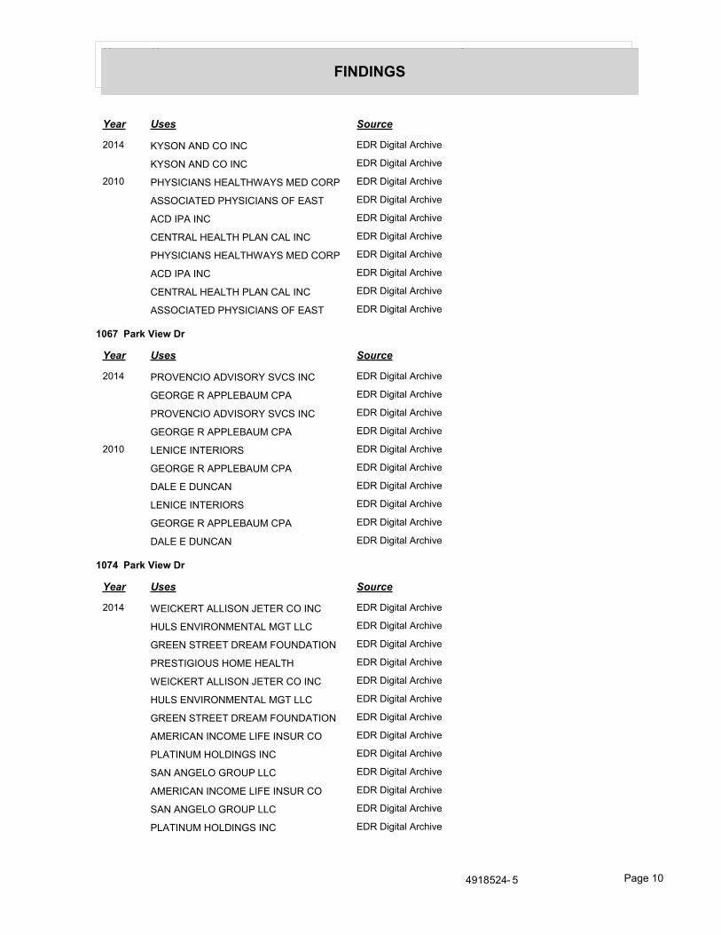
Year Uses Source
FINDINGS
Year Uses Source
2014 KYSON AND CO INC EDR Digital Archive
KYSON AND CO INC EDR Digital Archive
2010 PHYSICIANS HEALTHWAYS MED CORP EDR Digital Archive
ASSOCIATED PHYSICIANS OF EAST EDR Digital Archive
ACD IPA INC EDR Digital Archive
CENTRAL HEALTH PLAN CAL INC EDR Digital Archive
PHYSICIANS HEALTHWAYS MED CORP EDR Digital Archive
ACD IPA INC EDR Digital Archive
CENTRAL HEALTH PLAN CAL INC EDR Digital Archive
ASSOCIATED PHYSICIANS OF EAST EDR Digital Archive
1067 Park View Dr
Year Uses Source
2014 PROVENCIO ADVISORY SVCS INC EDR Digital Archive
GEORGE R APPLEBAUM CPA EDR Digital Archive
PROVENCIO ADVISORY SVCS INC EDR Digital Archive
GEORGE R APPLEBAUM CPA EDR Digital Archive
2010 LENICE INTERIORS EDR Digital Archive
GEORGE R APPLEBAUM CPA EDR Digital Archive
DALE E DUNCAN EDR Digital Archive
LENICE INTERIORS EDR Digital Archive
GEORGE R APPLEBAUM CPA EDR Digital Archive
DALE E DUNCAN EDR Digital Archive
1074 Park View Dr
Year Uses Source
2014 WEICKERT ALLISON JETER CO INC EDR Digital Archive
HULS ENVIRONMENTAL MGT LLC EDR Digital Archive
GREEN STREET DREAM FOUNDATION EDR Digital Archive
PRESTIGIOUS HOME HEALTH EDR Digital Archive
WEICKERT ALLISON JETER CO INC EDR Digital Archive
HULS ENVIRONMENTAL MGT LLC EDR Digital Archive
GREEN STREET DREAM FOUNDATION EDR Digital Archive
AMERICAN INCOME LIFE INSUR CO EDR Digital Archive
PLATINUM HOLDINGS INC EDR Digital Archive
SAN ANGELO GROUP LLC EDR Digital Archive
AMERICAN INCOME LIFE INSUR CO EDR Digital Archive
SAN ANGELO GROUP LLC EDR Digital Archive
PLATINUM HOLDINGS INC EDR Digital Archive
4918524- 5 Page 10

Year Uses Source
FINDINGS
Year Uses Source
2014 PRESTIGIOUS HOME HEALTH EDR Digital Archive
2010 SUPERIOR LENDING CORPORATION EDR Digital Archive
SAN ANGELO GROUP LLC EDR Digital Archive
PLATINUM HOLDINGS INC EDR Digital Archive
FLAGSHIP REALTY EDR Digital Archive
EQUINAIRE INC EDR Digital Archive
LEGIANCE LLC EDR Digital Archive
GRANDERSON HOLDINGS INC EDR Digital Archive
CALIFORNIA RES MGT TRNG INST EDR Digital Archive
LEGIANCE LLC EDR Digital Archive
PLATINUM HOLDINGS INC EDR Digital Archive
FLAGSHIP REALTY EDR Digital Archive
EQUINAIRE INC EDR Digital Archive
SAN ANGELO GROUP LLC EDR Digital Archive
GRANDERSON HOLDINGS INC EDR Digital Archive
CALIFORNIA RES MGT TRNG INST EDR Digital Archive
GREEN STREET DREAM FOUNDATION EDR Digital Archive
WEICKERT ALLISON JETER CO INC EDR Digital Archive
ERIC T WONG DDS A PROF CORP EDR Digital Archive
ENVISION DIRECT DIRECT MARKTG EDR Digital Archive
SUPERIOR LENDING CORPORATION EDR Digital Archive
GREEN STREET DREAM FOUNDATION EDR Digital Archive
ERIC T WONG DDS A PROF CORP EDR Digital Archive
ENVISION DIRECT DIRECT MARKTG EDR Digital Archive
WEICKERT ALLISON JETER CO INC EDR Digital Archive
PARK VIEW DR
1074 PARK VIEW DR
Year Uses Source
1985 SKRIFVARS J CRAIG CPA Pacific Bell
ANDEN GROUP THE Pacific Bell
Park View Dr
1123 Park View Dr
Year Uses Source
2014 NATIONWIDE TOTALFLOOD SERVICES EDR Digital Archive
LPS PROPERTY TAX SOLUTIONS EDR Digital Archive
4918524- 5 Page 11
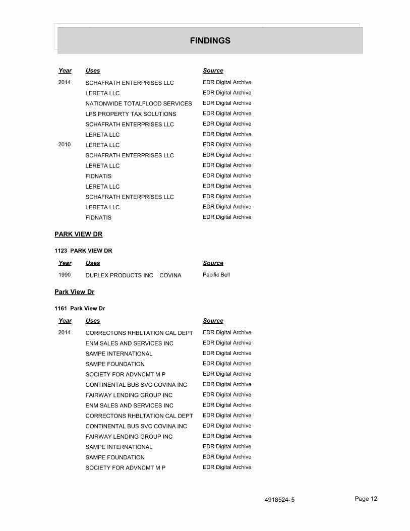
Year Uses Source
FINDINGS
Year Uses Source
2014 SCHAFRATH ENTERPRISES LLC EDR Digital Archive
LERETA LLC EDR Digital Archive
NATIONWIDE TOTALFLOOD SERVICES EDR Digital Archive
LPS PROPERTY TAX SOLUTIONS EDR Digital Archive
SCHAFRATH ENTERPRISES LLC EDR Digital Archive
LERETA LLC EDR Digital Archive
2010 LERETA LLC EDR Digital Archive
SCHAFRATH ENTERPRISES LLC EDR Digital Archive
LERETA LLC EDR Digital Archive
FIDNATIS EDR Digital Archive
LERETA LLC EDR Digital Archive
SCHAFRATH ENTERPRISES LLC EDR Digital Archive
LERETA LLC EDR Digital Archive
FIDNATIS EDR Digital Archive
PARK VIEW DR
1123 PARK VIEW DR
Year Uses Source
1990 DUPLEX PRODUCTS INC COVINA Pacific Bell
Park View Dr
1161 Park View Dr
Year Uses Source
2014 CORRECTONS RHBLTATION CAL DEPT EDR Digital Archive
ENM SALES AND SERVICES INC EDR Digital Archive
SAMPE INTERNATIONAL EDR Digital Archive
SAMPE FOUNDATION EDR Digital Archive
SOCIETY FOR ADVNCMT M P EDR Digital Archive
CONTINENTAL BUS SVC COVINA INC EDR Digital Archive
FAIRWAY LENDING GROUP INC EDR Digital Archive
ENM SALES AND SERVICES INC EDR Digital Archive
CORRECTONS RHBLTATION CAL DEPT EDR Digital Archive
CONTINENTAL BUS SVC COVINA INC EDR Digital Archive
FAIRWAY LENDING GROUP INC EDR Digital Archive
SAMPE INTERNATIONAL EDR Digital Archive
SAMPE FOUNDATION EDR Digital Archive
SOCIETY FOR ADVNCMT M P EDR Digital Archive
4918524- 5 Page 12

Year Uses Source
FINDINGS
Year Uses Source
2010 SOCIETY FOR ADVNCMT M P EDR Digital Archive
FAIRWAY LENDING GROUP INC EDR Digital Archive
SAN GABRIEL PAROLE OFFICE EDR Digital Archive
CORRECTONS RHBLTATION CAL DEPT EDR Digital Archive
CDCR/DAPO EDR Digital Archive
FAIRWAY LENDING GROUP INC EDR Digital Archive
SOCIETY FOR ADVNCMT M P EDR Digital Archive
CORRECTONS RHBLTATION CAL DEPT EDR Digital Archive
CDCR/DAPO EDR Digital Archive
SAN GABRIEL PAROLE OFFICE EDR Digital Archive
park view drive
1037 park view drive
Year Uses Source
1991 TRW Real Estate Information Services Pacific Bell
1990 TRW INC TRW INFORMATION SYSTEMS GROUP
Pacific Bell
1074 park view drive
Year Uses Source
1985 ANDEN GROUP THE Pacific Bell
SKRIFVARS J CRAIG CPA Pacific Bell
4918524- 5 Page 13

FINDINGS
TARGET PROPERTY: ADDRESS NOT IDENTIFIED IN RESEARCH SOURCE
The following Target Property addresses were researched for this report, and the addresses were not identified in the research source.
Address Researched Address Not Identified in Research Source
East Holt Avenue and Park View Drive
2014, 2010, 2006, 2004, 2003, 2001, 2000, 1999, 1996, 1995, 1992, 1991, 1990, 1986, 1985, 1981, 1980, 1976, 1975, 1972, 1971, 1970, 1969, 1967, 1966, 1965, 1964, 1963, 1962, 1961, 1960, 1958, 1957, 1956, 1955, 1954, 1952, 1951, 1950, 1949, 1948, 1947, 1946, 1945, 1944, 1942, 1940, 1939, 1938, 1937, 1936, 1935, 1934, 1933, 1932, 1931, 1930, 1929, 1928, 1927, 1926, 1925, 1924, 1923, 1921, 1920
ADJOINING PROPERTY: ADDRESSES NOT IDENTIFIED IN RESEARCH SOURCE
The following Adjoining Property addresses were researched for this report, and the addresses were not identified in research source.
Address Researched Address Not Identified in Research Source
1037 Park View Dr 2006, 2004, 2003, 2001, 2000, 1999, 1996, 1995, 1992, 1991, 1990, 1986, 1985, 1981, 1980, 1976, 1975, 1972, 1971, 1970, 1969, 1967, 1966, 1965, 1964, 1963, 1962, 1961, 1960, 1958, 1957, 1956, 1955, 1954, 1952, 1951, 1950, 1949, 1948, 1947, 1946, 1945, 1944, 1942, 1940, 1939, 1938, 1937, 1936, 1935, 1934, 1933, 1932, 1931, 1930, 1929, 1928, 1927, 1926, 1925, 1924, 1923, 1921, 1920
1037 PARK VIEW DR 2014, 2010, 2006, 2004, 2003, 2001, 2000, 1999, 1996, 1995, 1992, 1986, 1985, 1981, 1980, 1976, 1975, 1972, 1971, 1970, 1969, 1967, 1966, 1965, 1964, 1963, 1962, 1961, 1960, 1958, 1957, 1956, 1955, 1954, 1952, 1951, 1950, 1949, 1948, 1947, 1946, 1945, 1944, 1942, 1940, 1939, 1938, 1937, 1936, 1935, 1934, 1933, 1932, 1931, 1930, 1929, 1928, 1927, 1926, 1925, 1924, 1923, 1921, 1920
1037 Park View Dr 2006, 2004, 2003, 2001, 2000, 1999, 1996, 1995, 1992, 1991, 1990, 1986, 1985, 1981, 1980, 1976, 1975, 1972, 1971, 1970, 1969, 1967, 1966, 1965, 1964, 1963, 1962, 1961, 1960, 1958, 1957, 1956, 1955, 1954, 1952, 1951, 1950, 1949, 1948, 1947, 1946, 1945, 1944, 1942, 1940, 1939, 1938, 1937, 1936, 1935, 1934, 1933, 1932, 1931, 1930, 1929, 1928, 1927, 1926, 1925, 1924, 1923, 1921, 1920
1037 park view drive 2014, 2010, 2006, 2004, 2003, 2001, 2000, 1999, 1996, 1995, 1992, 1986, 1985, 1981, 1980, 1976, 1975, 1972, 1971, 1970, 1969, 1967, 1966, 1965, 1964, 1963, 1962, 1961, 1960, 1958, 1957, 1956, 1955, 1954, 1952, 1951, 1950, 1949, 1948, 1947, 1946, 1945, 1944, 1942, 1940, 1939, 1938, 1937, 1936, 1935, 1934, 1933, 1932, 1931, 1930, 1929, 1928, 1927, 1926, 1925, 1924, 1923, 1921, 1920
1051 Park View Dr 2006, 2004, 2003, 2001, 2000, 1999, 1996, 1995, 1992, 1991, 1990, 1986, 1985, 1981, 1980, 1976, 1975, 1972, 1971, 1970, 1969, 1967, 1966, 1965, 1964, 1963, 1962, 1961, 1960, 1958, 1957, 1956, 1955, 1954, 1952, 1951, 1950, 1949, 1948, 1947, 1946, 1945, 1944, 1942, 1940, 1939, 1938, 1937, 1936, 1935, 1934, 1933, 1932, 1931, 1930, 1929, 1928, 1927, 1926, 1925, 1924, 1923, 1921, 1920
1051 Park View Dr 2006, 2004, 2003, 2001, 2000, 1999, 1996, 1995, 1992, 1991, 1990, 1986, 1985, 1981, 1980, 1976, 1975, 1972, 1971, 1970, 1969, 1967, 1966, 1965, 1964, 1963, 1962, 1961, 1960, 1958, 1957, 1956, 1955, 1954, 1952, 1951, 1950, 1949, 1948, 1947, 1946, 1945, 1944, 1942, 1940, 1939, 1938, 1937, 1936, 1935, 1934, 1933, 1932, 1931, 1930, 1929, 1928, 1927, 1926, 1925, 1924, 1923, 1921, 1920

FINDINGS
Address Researched Address Not Identified in Research Source
1051 park view drive 2014, 2010, 2006, 2004, 2003, 2001, 2000, 1999, 1996, 1995, 1992, 1991, 1990, 1986, 1985, 1981, 1980, 1976, 1975, 1972, 1971, 1970, 1969, 1967, 1966, 1965, 1964, 1963, 1962, 1961, 1960, 1958, 1957, 1956, 1955, 1954, 1952, 1951, 1950, 1949, 1948, 1947, 1946, 1945, 1944, 1942, 1940, 1939, 1938, 1937, 1936, 1935, 1934, 1933, 1932, 1931, 1930, 1929, 1928, 1927, 1926, 1925, 1924, 1923, 1921, 1920
1067 Park View Dr 2006, 2004, 2003, 2001, 2000, 1999, 1996, 1995, 1992, 1991, 1990, 1986, 1985, 1981, 1980, 1976, 1975, 1972, 1971, 1970, 1969, 1967, 1966, 1965, 1964, 1963, 1962, 1961, 1960, 1958, 1957, 1956, 1955, 1954, 1952, 1951, 1950, 1949, 1948, 1947, 1946, 1945, 1944, 1942, 1940, 1939, 1938, 1937, 1936, 1935, 1934, 1933, 1932, 1931, 1930, 1929, 1928, 1927, 1926, 1925, 1924, 1923, 1921, 1920
1067 Park View Dr 2006, 2004, 2003, 2001, 2000, 1999, 1996, 1995, 1992, 1991, 1990, 1986, 1985, 1981, 1980, 1976, 1975, 1972, 1971, 1970, 1969, 1967, 1966, 1965, 1964, 1963, 1962, 1961, 1960, 1958, 1957, 1956, 1955, 1954, 1952, 1951, 1950, 1949, 1948, 1947, 1946, 1945, 1944, 1942, 1940, 1939, 1938, 1937, 1936, 1935, 1934, 1933, 1932, 1931, 1930, 1929, 1928, 1927, 1926, 1925, 1924, 1923, 1921, 1920
1067 park view drive 2014, 2010, 2006, 2004, 2003, 2001, 2000, 1999, 1996, 1995, 1992, 1991, 1990, 1986, 1985, 1981, 1980, 1976, 1975, 1972, 1971, 1970, 1969, 1967, 1966, 1965, 1964, 1963, 1962, 1961, 1960, 1958, 1957, 1956, 1955, 1954, 1952, 1951, 1950, 1949, 1948, 1947, 1946, 1945, 1944, 1942, 1940, 1939, 1938, 1937, 1936, 1935, 1934, 1933, 1932, 1931, 1930, 1929, 1928, 1927, 1926, 1925, 1924, 1923, 1921, 1920
1074 PARK VIEW DR 2014, 2010, 2006, 2004, 2003, 2001, 2000, 1999, 1996, 1995, 1992, 1991, 1990, 1986, 1981, 1980, 1976, 1975, 1972, 1971, 1970, 1969, 1967, 1966, 1965, 1964, 1963, 1962, 1961, 1960, 1958, 1957, 1956, 1955, 1954, 1952, 1951, 1950, 1949, 1948, 1947, 1946, 1945, 1944, 1942, 1940, 1939, 1938, 1937, 1936, 1935, 1934, 1933, 1932, 1931, 1930, 1929, 1928, 1927, 1926, 1925, 1924, 1923, 1921, 1920
1074 Park View Dr 2006, 2004, 2003, 2001, 2000, 1999, 1996, 1995, 1992, 1991, 1990, 1986, 1985, 1981, 1980, 1976, 1975, 1972, 1971, 1970, 1969, 1967, 1966, 1965, 1964, 1963, 1962, 1961, 1960, 1958, 1957, 1956, 1955, 1954, 1952, 1951, 1950, 1949, 1948, 1947, 1946, 1945, 1944, 1942, 1940, 1939, 1938, 1937, 1936, 1935, 1934, 1933, 1932, 1931, 1930, 1929, 1928, 1927, 1926, 1925, 1924, 1923, 1921, 1920
1074 Park View Dr 2006, 2004, 2003, 2001, 2000, 1999, 1996, 1995, 1992, 1991, 1990, 1986, 1985, 1981, 1980, 1976, 1975, 1972, 1971, 1970, 1969, 1967, 1966, 1965, 1964, 1963, 1962, 1961, 1960, 1958, 1957, 1956, 1955, 1954, 1952, 1951, 1950, 1949, 1948, 1947, 1946, 1945, 1944, 1942, 1940, 1939, 1938, 1937, 1936, 1935, 1934, 1933, 1932, 1931, 1930, 1929, 1928, 1927, 1926, 1925, 1924, 1923, 1921, 1920
1074 park view drive 2014, 2010, 2006, 2004, 2003, 2001, 2000, 1999, 1996, 1995, 1992, 1991, 1990, 1986, 1981, 1980, 1976, 1975, 1972, 1971, 1970, 1969, 1967, 1966, 1965, 1964, 1963, 1962, 1961, 1960, 1958, 1957, 1956, 1955, 1954, 1952, 1951, 1950, 1949, 1948, 1947, 1946, 1945, 1944, 1942, 1940, 1939, 1938, 1937, 1936, 1935, 1934, 1933, 1932, 1931, 1930, 1929, 1928, 1927, 1926, 1925, 1924, 1923, 1921, 1920
1123 PARK VIEW DR 2014, 2010, 2006, 2004, 2003, 2001, 2000, 1999, 1996, 1995, 1992, 1991, 1986, 1985, 1981, 1980, 1976, 1975, 1972, 1971, 1970, 1969, 1967, 1966, 1965, 1964, 1963, 1962, 1961, 1960, 1958, 1957, 1956, 1955, 1954, 1952, 1951, 1950, 1949, 1948, 1947, 1946, 1945, 1944, 1942, 1940, 1939, 1938, 1937, 1936, 1935, 1934, 1933, 1932, 1931, 1930, 1929, 1928, 1927, 1926, 1925, 1924, 1923, 1921, 1920
1123 Park View Dr 2006, 2004, 2003, 2001, 2000, 1999, 1996, 1995, 1992, 1991, 1990, 1986, 1985, 1981, 1980, 1976, 1975, 1972, 1971, 1970, 1969, 1967, 1966, 1965, 1964, 1963, 1962, 1961, 1960, 1958, 1957, 1956, 1955, 1954, 1952, 1951, 1950, 1949, 1948, 1947, 1946, 1945, 1944, 1942, 1940, 1939, 1938, 1937, 1936, 1935, 1934, 1933, 1932, 1931, 1930, 1929, 1928, 1927, 1926, 1925, 1924, 1923, 1921, 1920
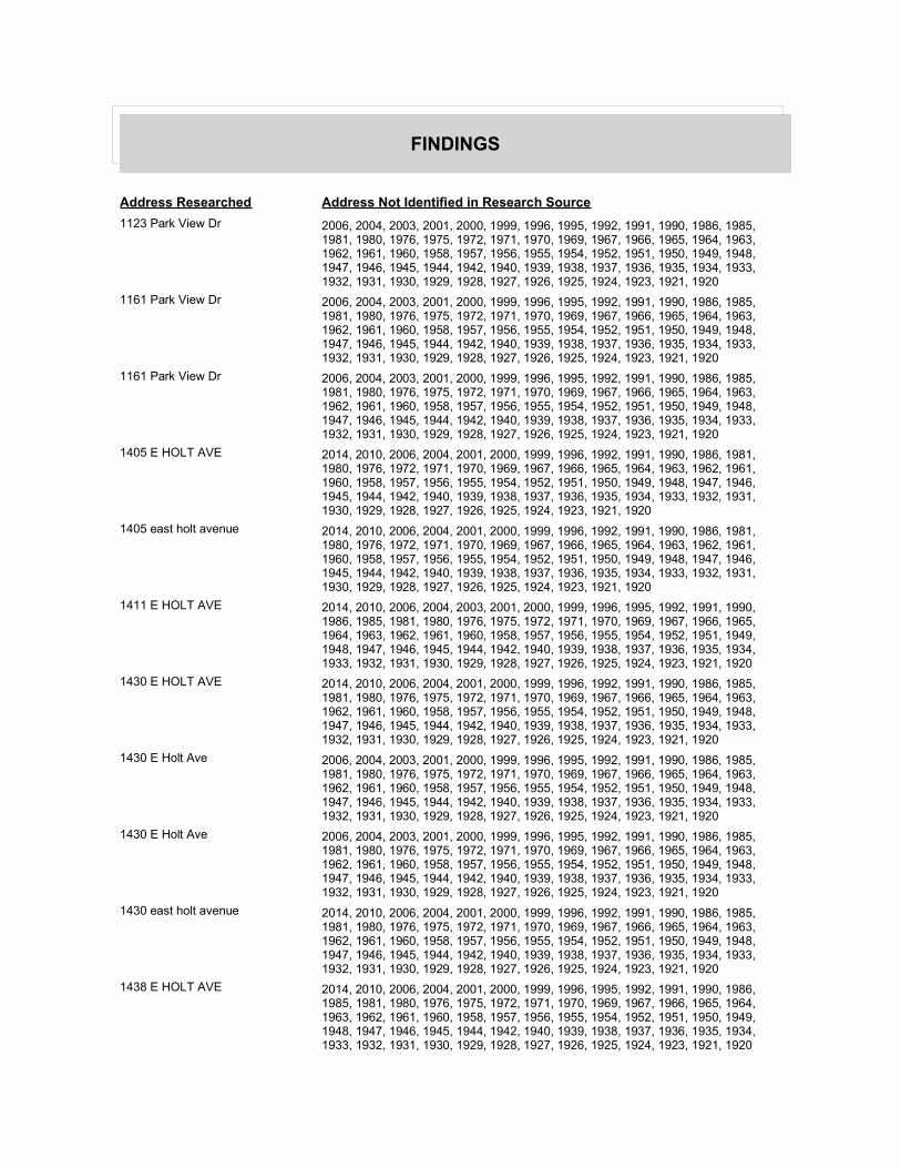
FINDINGS
Address Researched Address Not Identified in Research Source
1123 Park View Dr 2006, 2004, 2003, 2001, 2000, 1999, 1996, 1995, 1992, 1991, 1990, 1986, 1985, 1981, 1980, 1976, 1975, 1972, 1971, 1970, 1969, 1967, 1966, 1965, 1964, 1963, 1962, 1961, 1960, 1958, 1957, 1956, 1955, 1954, 1952, 1951, 1950, 1949, 1948, 1947, 1946, 1945, 1944, 1942, 1940, 1939, 1938, 1937, 1936, 1935, 1934, 1933, 1932, 1931, 1930, 1929, 1928, 1927, 1926, 1925, 1924, 1923, 1921, 1920
1161 Park View Dr 2006, 2004, 2003, 2001, 2000, 1999, 1996, 1995, 1992, 1991, 1990, 1986, 1985, 1981, 1980, 1976, 1975, 1972, 1971, 1970, 1969, 1967, 1966, 1965, 1964, 1963, 1962, 1961, 1960, 1958, 1957, 1956, 1955, 1954, 1952, 1951, 1950, 1949, 1948, 1947, 1946, 1945, 1944, 1942, 1940, 1939, 1938, 1937, 1936, 1935, 1934, 1933, 1932, 1931, 1930, 1929, 1928, 1927, 1926, 1925, 1924, 1923, 1921, 1920
1161 Park View Dr 2006, 2004, 2003, 2001, 2000, 1999, 1996, 1995, 1992, 1991, 1990, 1986, 1985, 1981, 1980, 1976, 1975, 1972, 1971, 1970, 1969, 1967, 1966, 1965, 1964, 1963, 1962, 1961, 1960, 1958, 1957, 1956, 1955, 1954, 1952, 1951, 1950, 1949, 1948, 1947, 1946, 1945, 1944, 1942, 1940, 1939, 1938, 1937, 1936, 1935, 1934, 1933, 1932, 1931, 1930, 1929, 1928, 1927, 1926, 1925, 1924, 1923, 1921, 1920
1405 E HOLT AVE 2014, 2010, 2006, 2004, 2001, 2000, 1999, 1996, 1992, 1991, 1990, 1986, 1981, 1980, 1976, 1972, 1971, 1970, 1969, 1967, 1966, 1965, 1964, 1963, 1962, 1961, 1960, 1958, 1957, 1956, 1955, 1954, 1952, 1951, 1950, 1949, 1948, 1947, 1946, 1945, 1944, 1942, 1940, 1939, 1938, 1937, 1936, 1935, 1934, 1933, 1932, 1931, 1930, 1929, 1928, 1927, 1926, 1925, 1924, 1923, 1921, 1920
1405 east holt avenue 2014, 2010, 2006, 2004, 2001, 2000, 1999, 1996, 1992, 1991, 1990, 1986, 1981, 1980, 1976, 1972, 1971, 1970, 1969, 1967, 1966, 1965, 1964, 1963, 1962, 1961, 1960, 1958, 1957, 1956, 1955, 1954, 1952, 1951, 1950, 1949, 1948, 1947, 1946, 1945, 1944, 1942, 1940, 1939, 1938, 1937, 1936, 1935, 1934, 1933, 1932, 1931, 1930, 1929, 1928, 1927, 1926, 1925, 1924, 1923, 1921, 1920
1411 E HOLT AVE 2014, 2010, 2006, 2004, 2003, 2001, 2000, 1999, 1996, 1995, 1992, 1991, 1990, 1986, 1985, 1981, 1980, 1976, 1975, 1972, 1971, 1970, 1969, 1967, 1966, 1965, 1964, 1963, 1962, 1961, 1960, 1958, 1957, 1956, 1955, 1954, 1952, 1951, 1949, 1948, 1947, 1946, 1945, 1944, 1942, 1940, 1939, 1938, 1937, 1936, 1935, 1934, 1933, 1932, 1931, 1930, 1929, 1928, 1927, 1926, 1925, 1924, 1923, 1921, 1920
1430 E HOLT AVE 2014, 2010, 2006, 2004, 2001, 2000, 1999, 1996, 1992, 1991, 1990, 1986, 1985, 1981, 1980, 1976, 1975, 1972, 1971, 1970, 1969, 1967, 1966, 1965, 1964, 1963, 1962, 1961, 1960, 1958, 1957, 1956, 1955, 1954, 1952, 1951, 1950, 1949, 1948, 1947, 1946, 1945, 1944, 1942, 1940, 1939, 1938, 1937, 1936, 1935, 1934, 1933, 1932, 1931, 1930, 1929, 1928, 1927, 1926, 1925, 1924, 1923, 1921, 1920
1430 E Holt Ave 2006, 2004, 2003, 2001, 2000, 1999, 1996, 1995, 1992, 1991, 1990, 1986, 1985, 1981, 1980, 1976, 1975, 1972, 1971, 1970, 1969, 1967, 1966, 1965, 1964, 1963, 1962, 1961, 1960, 1958, 1957, 1956, 1955, 1954, 1952, 1951, 1950, 1949, 1948, 1947, 1946, 1945, 1944, 1942, 1940, 1939, 1938, 1937, 1936, 1935, 1934, 1933, 1932, 1931, 1930, 1929, 1928, 1927, 1926, 1925, 1924, 1923, 1921, 1920
1430 E Holt Ave 2006, 2004, 2003, 2001, 2000, 1999, 1996, 1995, 1992, 1991, 1990, 1986, 1985, 1981, 1980, 1976, 1975, 1972, 1971, 1970, 1969, 1967, 1966, 1965, 1964, 1963, 1962, 1961, 1960, 1958, 1957, 1956, 1955, 1954, 1952, 1951, 1950, 1949, 1948, 1947, 1946, 1945, 1944, 1942, 1940, 1939, 1938, 1937, 1936, 1935, 1934, 1933, 1932, 1931, 1930, 1929, 1928, 1927, 1926, 1925, 1924, 1923, 1921, 1920
1430 east holt avenue 2014, 2010, 2006, 2004, 2001, 2000, 1999, 1996, 1992, 1991, 1990, 1986, 1985, 1981, 1980, 1976, 1975, 1972, 1971, 1970, 1969, 1967, 1966, 1965, 1964, 1963, 1962, 1961, 1960, 1958, 1957, 1956, 1955, 1954, 1952, 1951, 1950, 1949, 1948, 1947, 1946, 1945, 1944, 1942, 1940, 1939, 1938, 1937, 1936, 1935, 1934, 1933, 1932, 1931, 1930, 1929, 1928, 1927, 1926, 1925, 1924, 1923, 1921, 1920
1438 E HOLT AVE 2014, 2010, 2006, 2004, 2001, 2000, 1999, 1996, 1995, 1992, 1991, 1990, 1986, 1985, 1981, 1980, 1976, 1975, 1972, 1971, 1970, 1969, 1967, 1966, 1965, 1964, 1963, 1962, 1961, 1960, 1958, 1957, 1956, 1955, 1954, 1952, 1951, 1950, 1949, 1948, 1947, 1946, 1945, 1944, 1942, 1940, 1939, 1938, 1937, 1936, 1935, 1934, 1933, 1932, 1931, 1930, 1929, 1928, 1927, 1926, 1925, 1924, 1923, 1921, 1920

FINDINGS
Address Researched Address Not Identified in Research Source
1440 E Holt Ave 2014, 2006, 2004, 2003, 2001, 2000, 1999, 1996, 1995, 1992, 1991, 1990, 1986, 1985, 1981, 1980, 1976, 1975, 1972, 1971, 1970, 1969, 1967, 1966, 1965, 1964, 1963, 1962, 1961, 1960, 1958, 1957, 1956, 1955, 1954, 1952, 1951, 1950, 1949, 1948, 1947, 1946, 1945, 1944, 1942, 1940, 1939, 1938, 1937, 1936, 1935, 1934, 1933, 1932, 1931, 1930, 1929, 1928, 1927, 1926, 1925, 1924, 1923, 1921, 1920
1440 E Holt Ave 2014, 2006, 2004, 2003, 2001, 2000, 1999, 1996, 1995, 1992, 1991, 1990, 1986, 1985, 1981, 1980, 1976, 1975, 1972, 1971, 1970, 1969, 1967, 1966, 1965, 1964, 1963, 1962, 1961, 1960, 1958, 1957, 1956, 1955, 1954, 1952, 1951, 1950, 1949, 1948, 1947, 1946, 1945, 1944, 1942, 1940, 1939, 1938, 1937, 1936, 1935, 1934, 1933, 1932, 1931, 1930, 1929, 1928, 1927, 1926, 1925, 1924, 1923, 1921, 1920
1440 east holt avenue 2014, 2010, 2006, 2004, 2003, 2001, 2000, 1999, 1996, 1995, 1992, 1991, 1990, 1986, 1985, 1981, 1976, 1975, 1972, 1971, 1970, 1969, 1967, 1966, 1965, 1964, 1963, 1962, 1961, 1960, 1958, 1957, 1956, 1955, 1954, 1952, 1951, 1950, 1949, 1948, 1947, 1946, 1945, 1944, 1942, 1940, 1939, 1938, 1937, 1936, 1935, 1934, 1933, 1932, 1931, 1930, 1929, 1928, 1927, 1926, 1925, 1924, 1923, 1921, 1920
1445 E HOLT AVE 2014, 2010, 2006, 2004, 2001, 2000, 1999, 1996, 1992, 1991, 1990, 1986, 1985, 1981, 1980, 1976, 1975, 1972, 1971, 1970, 1969, 1967, 1966, 1965, 1964, 1963, 1962, 1961, 1960, 1958, 1957, 1956, 1955, 1954, 1952, 1951, 1950, 1949, 1948, 1947, 1946, 1945, 1944, 1942, 1940, 1939, 1938, 1937, 1936, 1935, 1934, 1933, 1932, 1931, 1930, 1929, 1928, 1927, 1926, 1925, 1924, 1923, 1921, 1920
2005 E HOLT AVE 2014, 2010, 2006, 2004, 2003, 2001, 2000, 1999, 1996, 1995, 1992, 1991, 1990, 1986, 1985, 1981, 1980, 1976, 1975, 1972, 1971, 1970, 1969, 1967, 1966, 1965, 1964, 1963, 1962, 1961, 1960, 1958, 1957, 1956, 1955, 1954, 1952, 1950, 1949, 1948, 1947, 1946, 1945, 1944, 1942, 1940, 1939, 1938, 1937, 1936, 1935, 1934, 1933, 1932, 1931, 1930, 1929, 1928, 1927, 1926, 1925, 1924, 1923, 1921, 1920
20065 E HOLT AVE 2014, 2010, 2006, 2004, 2003, 2001, 2000, 1999, 1996, 1995, 1992, 1991, 1990, 1986, 1985, 1981, 1980, 1976, 1975, 1972, 1971, 1970, 1969, 1967, 1965, 1964, 1963, 1962, 1961, 1958, 1956, 1955, 1954, 1952, 1951, 1950, 1949, 1948, 1947, 1946, 1945, 1944, 1942, 1940, 1939, 1938, 1937, 1936, 1935, 1934, 1933, 1932, 1931, 1930, 1929, 1928, 1927, 1926, 1925, 1924, 1923, 1921, 1920
20095 E HOLT AVE 2014, 2010, 2006, 2004, 2003, 2001, 2000, 1999, 1996, 1995, 1992, 1991, 1990, 1986, 1985, 1981, 1980, 1976, 1975, 1972, 1971, 1970, 1969, 1967, 1966, 1965, 1964, 1963, 1962, 1961, 1958, 1956, 1955, 1954, 1952, 1951, 1950, 1949, 1948, 1947, 1946, 1945, 1944, 1942, 1940, 1939, 1938, 1937, 1936, 1935, 1934, 1933, 1932, 1931, 1930, 1929, 1928, 1927, 1926, 1925, 1924, 1923, 1921, 1920
20212 E HOLT AVE 2014, 2010, 2006, 2004, 2003, 2001, 2000, 1999, 1996, 1995, 1992, 1991, 1990, 1986, 1985, 1981, 1980, 1976, 1975, 1972, 1971, 1970, 1969, 1967, 1966, 1965, 1964, 1963, 1962, 1961, 1958, 1956, 1955, 1954, 1952, 1951, 1950, 1949, 1948, 1947, 1946, 1945, 1944, 1942, 1940, 1939, 1938, 1937, 1936, 1935, 1934, 1933, 1932, 1931, 1930, 1929, 1928, 1927, 1926, 1925, 1924, 1923, 1921, 1920
20235 E HOLT AVE 2014, 2010, 2006, 2004, 2001, 2000, 1999, 1996, 1992, 1991, 1990, 1986, 1981, 1976, 1975, 1972, 1971, 1970, 1969, 1967, 1965, 1964, 1963, 1962, 1961, 1958, 1956, 1955, 1954, 1952, 1951, 1950, 1949, 1948, 1947, 1946, 1945, 1944, 1942, 1940, 1939, 1938, 1937, 1936, 1935, 1934, 1933, 1932, 1931, 1930, 1929, 1928, 1927, 1926, 1925, 1924, 1923, 1921, 1920

APPENDIX D
ENVIRONMENTAL DATABASE INFORMATION

FORM-LBC-KXG
®kcehCoeGhtiwtropeR™paMsuidaRRDEehT
6 Armstrong Road, 4th floorShelton, CT 06484Toll Free: 800.352.0050www.edrnet.com
Proposed Assisted Living
SEC of East Holt Avenue and Park View Drive
Covina, CA 91724
Inquiry Number: 4918524.2s
April 26, 2017

SECTION PAGE
Executive Summary ES1
Overview Map 2
Detail Map 3
Map Findings Summary 4
Map Findings 8
Orphan Summary 10
Government Records Searched/Data Currency Tracking GR-1
GEOCHECK ADDENDUM
Physical Setting Source Addendum A-1
Physical Setting Source Summary A-2
Physical Setting Source Map A-7
Physical Setting Source Map Findings A-8
Physical Setting Source Records Searched PSGR-1
TC4918524.2s Page 1
Thank you for your business.Please contact EDR at 1-800-352-0050
with any questions or comments.
Disclaimer - Copyright and Trademark Notice
This Report contains certain information obtained from a variety of public and other sources reasonably available to Environmental DataResources, Inc. It cannot be concluded from this Report that coverage information for the target and surrounding properties does not exist fromother sources. NO WARRANTY EXPRESSED OR IMPLIED, IS MADE WHATSOEVER IN CONNECTION WITH THIS REPORT. ENVIRONMENTALDATA RESOURCES, INC. SPECIFICALLY DISCLAIMS THE MAKING OF ANY SUCH WARRANTIES, INCLUDING WITHOUT LIMITATION,MERCHANTABILITY OR FITNESS FOR A PARTICULAR USE OR PURPOSE. ALL RISK IS ASSUMED BY THE USER. IN NO EVENT SHALLENVIRONMENTAL DATA RESOURCES, INC. BE LIABLE TO ANYONE, WHETHER ARISING OUT OF ERRORS OR OMISSIONS, NEGLIGENCE,ACCIDENT OR ANY OTHER CAUSE, FOR ANY LOSS OF DAMAGE, INCLUDING, WITHOUT LIMITATION, SPECIAL, INCIDENTAL,CONSEQUENTIAL, OR EXEMPLARY DAMAGES. ANY LIABILITY ON THE PART OF ENVIRONMENTAL DATA RESOURCES, INC. IS STRICTLYLIMITED TO A REFUND OF THE AMOUNT PAID FOR THIS REPORT. Purchaser accepts this Report "AS IS". Any analyses, estimates, ratings,environmental risk levels or risk codes provided in this Report are provided for illustrative purposes only, and are not intended to provide, norshould they be interpreted as providing any facts regarding, or prediction or forecast of, any environmental risk for any property. Only a Phase IEnvironmental Site Assessment performed by an environmental professional can provide information regarding the environmental risk for anyproperty. Additionally, the information provided in this Report is not to be construed as legal advice.
Copyright 2017 by Environmental Data Resources, Inc. All rights reserved. Reproduction in any media or format, in wholeor in part, of any report or map of Environmental Data Resources, Inc., or its affiliates, is prohibited without prior written permission.
EDR and its logos (including Sanborn and Sanborn Map) are trademarks of Environmental Data Resources, Inc. or its affiliates. All othertrademarks used herein are the property of their respective owners.
TABLE OF CONTENTS

ED
R Inc.
ED
R Inc.
ED
R Inc.
ED
R Inc.
ED
R Inc.
ED
R Inc.
ED
R Inc.
ED
R Inc.
ED
R Inc.
ED
R Inc.
ED
R Inc.
ED
R Inc.
ED
R Inc.
ED
R Inc.
ED
R Inc.
ED
R Inc.
ED
R Inc.
ED
R Inc.
ED
R Inc.
ED
R Inc.
ED
R Inc.
ED
R Inc.
ED
R Inc.
ED
R Inc.
ED
R Inc.
ED
R Inc.
ED
R Inc.
ED
R Inc.
ED
R Inc.
ED
R Inc.
ED
R Inc.
ED
R Inc.
ED
R Inc.
ED
R Inc.
ED
R Inc.
ED
R Inc.
ED
R Inc.
ED
R Inc.
ED
R Inc.
ED
R Inc.
TC4918524.2s Executive Summary 1
X DATA LINE SERVICE CO885 S VILLAGE OAKS DRCOVINA, CA 91724S102057041
A3NNW1/8-1/4930 ft.
621 ft.Higher
X FI SERV FRESNO, INC885 S VILLAGE OAKS DRCOVINA, CA 91724U003777461
A2NNW1/8-1/4930 ft.
621 ft.Higher
969 S VILLAGE OAKS DRCOVINA, CA 917241015109037
1WNW< 1/8642 ft.
618 ft.Higher
SURROUNDING SITES
SEARCH RESULTS
The target property was not listed in any of the databases searched by EDR.
HA
ZN
ET
Fin
anci
al A
ssur
ance
EN
FE
MI
DR
YC
LEA
NE
RS
CU
PA
Lis
tings
Cor
tese
CA
BO
ND
EX
P. P
LAN
FU
ELS
PR
OG
RA
ME
CH
OD
OC
KE
T H
WC
UX
OF
IND
SA
BA
ND
ON
ED
MIN
ES
US
MIN
ES
US
AIR
SLE
AD
SM
ELT
ER
SU
MT
RA
FU
SR
AP
IND
IAN
RE
SE
RV
CO
NS
EN
TD
OT
OP
SH
IST
FT
TS
RA
DIN
FO
PC
B T
RA
NS
FO
RM
ER
CO
AL
AS
H E
PA
CO
AL
AS
H D
OE
MLT
SF
TT
SIC
ISP
AD
SP
RP
RA
AT
SR
MP
RO
DS
ST
ST
RIS
TS
CA
2020
CO
R A
CT
ION
EP
A W
AT
CH
LIS
TU
S F
IN A
SS
UR
SC
RD
DR
YC
LEA
NE
RS
DO
DF
UD
SR
CR
A N
onG
en /
NLR
SP
ILLS
90
MC
SLD
SC
HM
IRS
HM
IRS
DE
ED
LIE
NS
2LI
EN
SC
A F
ID U
ST
HIS
T U
ST
SW
EE
PS
US
TU
S C
DL
Tox
ic P
itsC
DL
SC
HH
IST
Cal
-Site
sU
S H
IST
CD
LA
OC
ON
CE
RN
IHS
OP
EN
DU
MP
SO
DI
DE
BR
IS R
EG
ION
9IN
DIA
N O
DI
HA
ULE
RS
SW
RC
YW
MU
DS
/SW
AT
US
BR
OW
NF
IELD
SB
RO
WN
FIE
LDS
VC
PIN
DIA
N V
CP
IND
IAN
US
TA
ST
US
TF
EM
A U
ST
SLI
CIN
DIA
N L
US
TLU
ST
SW
F/L
FE
NV
IRO
ST
OR
RE
SP
ON
SE
ER
NS
US
INS
T C
ON
TR
OL
US
EN
G C
ON
TR
OLS
LUC
ISR
CR
A-C
ES
QG
RC
RA
-SQ
GR
CR
A-L
QG
RC
RA
-TS
DF
CO
RR
AC
TS
SE
MS
-AR
CH
IVE
SE
MS
FE
DE
RA
L F
AC
ILIT
YD
elis
ted
NP
LN
PL
LIE
NS
Pro
pose
d N
PL
NP
L
ADDITIONAL ENVIRONMENTAL RECORDSSTANDARD ENVIRONMENTAL RECORDS
Map IDDirectionDistanceDistance ft.Elevation ft.
TARGET PROPERTY ADDRESS
PROPOSED ASSISTED LIVINGEAST HOLT AVENUE AND PARK VIEW DRIVECOVINA, CA 91724Elevation: 602 ft.EDR Inquiry Number: 4918524.2s
TARGET PROPERTY
SEARCH RESULTS
Site
The results of this search follow:A search of available environmental records was conducted by Environmental Data Resources, Inc. (EDR).
EXECUTIVE SUMMARY

EDR Inc.EDR Inc.EDR Inc.EDR Inc.EDR Inc.EDR Inc.EDR Inc.EDR Inc.EDR Inc.EDR Inc.EDR Inc.EDR Inc.EDR Inc.EDR Inc.EDR Inc.EDR Inc.EDR Inc.EDR Inc.EDR Inc.EDR Inc.EDR Inc.EDR Inc.EDR Inc.EDR Inc.EDR Inc.EDR Inc.EDR Inc.EDR Inc.EDR Inc.EDR Inc.EDR Inc.EDR Inc.EDR Inc.EDR Inc.EDR Inc.EDR Inc.EDR Inc.EDR Inc.EDR Inc.EDR Inc.
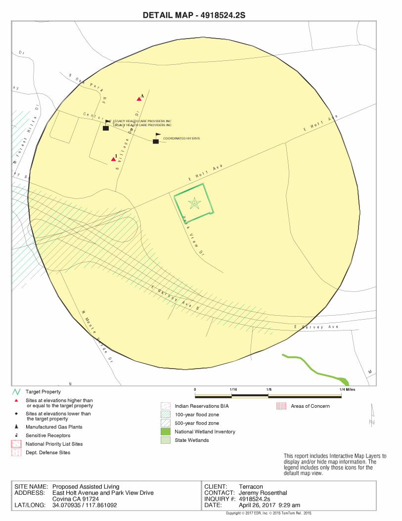
EDR Inc.EDR Inc.EDR Inc.EDR Inc.EDR Inc.EDR Inc.EDR Inc.EDR Inc.EDR Inc.EDR Inc.EDR Inc.EDR Inc.EDR Inc.EDR Inc.EDR Inc.EDR Inc.EDR Inc.EDR Inc.EDR Inc.EDR Inc.EDR Inc.EDR Inc.EDR Inc.EDR Inc.EDR Inc.EDR Inc.EDR Inc.EDR Inc.EDR Inc.EDR Inc.EDR Inc.EDR Inc.EDR Inc.EDR Inc.EDR Inc.EDR Inc.EDR Inc.EDR Inc.EDR Inc.EDR Inc.

MAP FINDINGS SUMMARY
SearchTargetDistance Total
Database Property(Miles) < 1/8 1/8 - 1/4 1/4 - 1/2 1/2 - 1 > 1 Plotted
STANDARD ENVIRONMENTAL RECORDS
Federal NPL site list 0 NR 0 0 0 0 1.000NPL 0 NR 0 0 0 0 1.000Proposed NPL 0 NR NR NR NR NR TPNPL LIENS
Federal Delisted NPL site list 0 NR 0 0 0 0 1.000Delisted NPL
Federal CERCLIS list 0 NR NR 0 0 0 0.500FEDERAL FACILITY 0 NR NR 0 0 0 0.500SEMS
Federal CERCLIS NFRAP site list 0 NR NR 0 0 0 0.500SEMS-ARCHIVE
Federal RCRA CORRACTS facilities list 0 NR 0 0 0 0 1.000CORRACTS
Federal RCRA non-CORRACTS TSD facilities list 0 NR NR 0 0 0 0.500RCRA-TSDF
Federal RCRA generators list 0 NR NR NR 0 0 0.250RCRA-LQG 0 NR NR NR 0 0 0.250RCRA-SQG 0 NR NR NR 0 0 0.250RCRA-CESQG
Federal institutional controls /engineering controls registries
0 NR NR 0 0 0 0.500LUCIS 0 NR NR 0 0 0 0.500US ENG CONTROLS 0 NR NR 0 0 0 0.500US INST CONTROL
Federal ERNS list 0 NR NR NR NR NR TPERNS
State- and tribal - equivalent NPL 0 NR 0 0 0 0 1.000RESPONSE
State- and tribal - equivalent CERCLIS 0 NR 0 0 0 0 1.000ENVIROSTOR
State and tribal landfill and/orsolid waste disposal site lists
0 NR NR 0 0 0 0.500SWF/LF
State and tribal leaking storage tank lists 0 NR NR 0 0 0 0.500LUST
TC4918524.2s Page 4
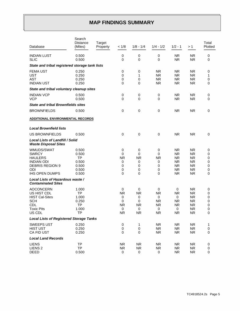
MAP FINDINGS SUMMARY
SearchTargetDistance Total
Database Property(Miles) < 1/8 1/8 - 1/4 1/4 - 1/2 1/2 - 1 > 1 Plotted
0 NR NR 0 0 0 0.500INDIAN LUST 0 NR NR 0 0 0 0.500SLIC
State and tribal registered storage tank lists 0 NR NR NR 0 0 0.250FEMA UST 1 NR NR NR 1 0 0.250UST 0 NR NR NR 0 0 0.250AST 0 NR NR NR 0 0 0.250INDIAN UST
State and tribal voluntary cleanup sites 0 NR NR 0 0 0 0.500INDIAN VCP 0 NR NR 0 0 0 0.500VCP
State and tribal Brownfields sites 0 NR NR 0 0 0 0.500BROWNFIELDS
ADDITIONAL ENVIRONMENTAL RECORDS
Local Brownfield lists 0 NR NR 0 0 0 0.500US BROWNFIELDS
Local Lists of Landfill / SolidWaste Disposal Sites
0 NR NR 0 0 0 0.500WMUDS/SWAT 0 NR NR 0 0 0 0.500SWRCY 0 NR NR NR NR NR TPHAULERS 0 NR NR 0 0 0 0.500INDIAN ODI 0 NR NR 0 0 0 0.500DEBRIS REGION 9 0 NR NR 0 0 0 0.500ODI 0 NR NR 0 0 0 0.500IHS OPEN DUMPS
Local Lists of Hazardous waste /Contaminated Sites
0 NR 0 0 0 0 1.000AOCONCERN 0 NR NR NR NR NR TPUS HIST CDL 0 NR 0 0 0 0 1.000HIST Cal-Sites 0 NR NR NR 0 0 0.250SCH 0 NR NR NR NR NR TPCDL 0 NR 0 0 0 0 1.000Toxic Pits 0 NR NR NR NR NR TPUS CDL
Local Lists of Registered Storage Tanks 1 NR NR NR 1 0 0.250SWEEPS UST 0 NR NR NR 0 0 0.250HIST UST 0 NR NR NR 0 0 0.250CA FID UST
Local Land Records 0 NR NR NR NR NR TPLIENS 0 NR NR NR NR NR TPLIENS 2 0 NR NR 0 0 0 0.500DEED
TC4918524.2s Page 5

MAP FINDINGS SUMMARY
SearchTargetDistance Total
Database Property(Miles) < 1/8 1/8 - 1/4 1/4 - 1/2 1/2 - 1 > 1 Plotted
Records of Emergency Release Reports 0 NR NR NR NR NR TPHMIRS 0 NR NR NR NR NR TPCHMIRS 0 NR NR NR NR NR TPLDS 0 NR NR NR NR NR TPMCS 0 NR NR NR NR NR TPSPILLS 90
Other Ascertainable Records 0 NR NR NR 0 0 0.250RCRA NonGen / NLR 0 NR 0 0 0 0 1.000FUDS 0 NR 0 0 0 0 1.000DOD 0 NR NR 0 0 0 0.500SCRD DRYCLEANERS 0 NR NR NR NR NR TPUS FIN ASSUR 0 NR NR NR NR NR TPEPA WATCH LIST 0 NR NR NR 0 0 0.2502020 COR ACTION 0 NR NR NR NR NR TPTSCA 0 NR NR NR NR NR TPTRIS 0 NR NR NR NR NR TPSSTS 0 NR 0 0 0 0 1.000ROD 0 NR NR NR NR NR TPRMP 0 NR NR NR NR NR TPRAATS 0 NR NR NR NR NR TPPRP 0 NR NR NR NR NR TPPADS 0 NR NR NR NR NR TPICIS 0 NR NR NR NR NR TPFTTS 0 NR NR NR NR NR TPMLTS 0 NR NR NR NR NR TPCOAL ASH DOE 0 NR NR 0 0 0 0.500COAL ASH EPA 0 NR NR NR NR NR TPPCB TRANSFORMER 0 NR NR NR NR NR TPRADINFO 0 NR NR NR NR NR TPHIST FTTS 0 NR NR NR NR NR TPDOT OPS 0 NR 0 0 0 0 1.000CONSENT 0 NR 0 0 0 0 1.000INDIAN RESERV 0 NR 0 0 0 0 1.000FUSRAP 0 NR NR 0 0 0 0.500UMTRA 0 NR NR NR NR NR TPLEAD SMELTERS 0 NR NR NR NR NR TPUS AIRS 0 NR NR NR 0 0 0.250US MINES 0 NR NR 0 0 0 0.500ABANDONED MINES 0 NR NR NR NR NR TPFINDS 0 NR 0 0 0 0 1.000UXO 0 NR NR NR NR NR TPDOCKET HWC 0 NR NR NR NR NR TPECHO 0 NR NR NR 0 0 0.250FUELS PROGRAM 0 NR 0 0 0 0 1.000CA BOND EXP. PLAN 0 NR NR 0 0 0 0.500Cortese 0 NR NR NR 0 0 0.250CUPA Listings 0 NR NR NR 0 0 0.250DRYCLEANERS 0 NR NR NR NR NR TPEMI
TC4918524.2s Page 6

MAP FINDINGS SUMMARY
SearchTargetDistance Total
Database Property(Miles) < 1/8 1/8 - 1/4 1/4 - 1/2 1/2 - 1 > 1 Plotted
0 NR NR NR NR NR TPENF 0 NR NR NR NR NR TPFinancial Assurance 0 NR NR NR NR NR TPHAZNET 0 NR NR NR NR NR TPICE 0 NR NR 0 0 0 0.500HIST CORTESE 0 NR NR NR NR NR TPLOS ANGELES CO. HMS 0 NR 0 0 0 0 1.000HWP 0 NR NR NR 0 0 0.250HWT 0 NR NR NR NR NR TPMINES 0 NR NR NR 0 0 0.250MWMP 0 NR NR NR NR NR TPNPDES 0 NR NR NR NR NR TPPEST LIC 0 NR NR 0 0 0 0.500PROC 0 NR 0 0 0 0 1.000Notify 65 0 NR NR NR NR NR TPLA Co. Site Mitigation 0 NR NR NR NR NR TPUIC 0 NR NR 0 0 0 0.500WASTEWATER PITS 0 NR NR NR NR NR TPWDS 0 NR NR NR 0 0 0.250WIP
EDR HIGH RISK HISTORICAL RECORDS
EDR Exclusive Records 0 NR 0 0 0 0 1.000EDR MGP 0 NR NR NR NR 0 0.125EDR Hist Auto 1 NR NR NR NR 1 0.125EDR Hist Cleaner
EDR RECOVERED GOVERNMENT ARCHIVES
Exclusive Recovered Govt. Archives 0 NR NR NR NR NR TPRGA LF 0 NR NR NR NR NR TPRGA LUST
3 0 0 0 2 1 0- Totals --
NOTES:
TP = Target Property
NR = Not Requested at this Search Distance
Sites may be listed in more than one database
TC4918524.2s Page 7

MAP FINDINGSMap ID
Direction
EDR ID NumberDistance
EPA ID NumberDatabase(s)SiteElevation
969 S VILLAGE OAKS DRAddress:
2002Year:
INSIDE TRACK CLEANINGName:
EDR Historical Cleaners:
642 ft.
0.122 mi.
Relative:Higher
Actual:618 ft.
< 1/8 COVINA, CA 91724
WNW 969 S VILLAGE OAKS DR N/A
1 EDR Hist Cleaner 1015109037
RemovedPermit Status:
000544600Permit Number:
6BArea:
RemovedFacility Status:
0Facility Type:
013953-043725Facility Id:
TPermit Category:
LARegion:
ClosedPermit Status:
000124011Permit Number:
6BArea:
ClosedFacility Status:
0Facility Type:
013953-022364Facility Id:
TPermit Category:
LARegion:
LOS ANGELES CO. HMS:
-117.8614567Longitude:
34.0748725Latitude:
LOS ANGELES COUNTYPermitting Agency:
22364Facility ID:
UST:
930 ft. Site 1 of 2 in cluster A
0.176 mi.
Relative:Higher
Actual:621 ft.
1/8-1/4 COVINA, CA 91724
NNW LOS ANGELES CO. HMS885 S VILLAGE OAKS DR N/A
A2 USTFI SERV FRESNO, INC U003777461
19-000-014425-000001SWRCB Tank Id:
Not reportedOwner Tank Id:
06-30-89Created Date:
Not reportedAction Date:
06-30-89Referral Date:
44-010420Board Of Equalization:
9Number:
14425Comp Number:
ActiveStatus:
SWEEPS UST:
930 ft. Site 2 of 2 in cluster A
0.176 mi.
Relative:Higher
Actual:621 ft.
1/8-1/4 COVINA, CA 91724
NNW LOS ANGELES CO. HMS885 S VILLAGE OAKS DR N/A
A3 SWEEPS USTDATA LINE SERVICE CO S102057041
TC4918524.2s Page 8

MAP FINDINGSMap ID
Direction
EDR ID NumberDistance
EPA ID NumberDatabase(s)SiteElevation
ClosedPermit Status:
00005712TPermit Number:
6BArea:
ClosedFacility Status:
0Facility Type:
013953-014425Facility Id:
TPermit Category:
LARegion:
LOS ANGELES CO. HMS:
1Number Of Tanks:
Not reportedContent:
WSTG:
UNKNOWNTank Use:
06-30-89Active Date:
Not reportedCapacity:
ATank Status:
DATA LINE SERVICE CO (Continued) S102057041
TC4918524.2s Page 9

ORPHAN SUMMARY
City EDR ID Site Name Site Address Zip Database(s)
Count: 0 records.
NO SITES FOUND
TC4918524.2s Page 10

To maintain currency of the following federal and state databases, EDR contacts the appropriate governmental agency
on a monthly or quarterly basis, as required.
Number of Days to Update: Provides confirmation that EDR is reporting records that have been updated within 90 days
from the date the government agency made the information available to the public.
STANDARD ENVIRONMENTAL RECORDS
Federal NPL site list
NPL: National Priority List
National Priorities List (Superfund). The NPL is a subset of CERCLIS and identifies over 1,200 sites for priority
cleanup under the Superfund Program. NPL sites may encompass relatively large areas. As such, EDR provides polygon
coverage for over 1,000 NPL site boundaries produced by EPA’s Environmental Photographic Interpretation Center
(EPIC) and regional EPA offices.
Date of Government Version: 12/05/2016
Date Data Arrived at EDR: 01/05/2017
Date Made Active in Reports: 02/03/2017
Number of Days to Update: 29
Source: EPA
Telephone: N/A
Last EDR Contact: 04/21/2017
Next Scheduled EDR Contact: 07/17/2017
Data Release Frequency: Quarterly
NPL Site Boundaries
Sources:
EPA’s Environmental Photographic Interpretation Center (EPIC)
Telephone: 202-564-7333
EPA Region 1 EPA Region 6
Telephone 617-918-1143 Telephone: 214-655-6659
EPA Region 3 EPA Region 7
Telephone 215-814-5418 Telephone: 913-551-7247
EPA Region 4 EPA Region 8
Telephone 404-562-8033 Telephone: 303-312-6774
EPA Region 5 EPA Region 9
Telephone 312-886-6686 Telephone: 415-947-4246
EPA Region 10
Telephone 206-553-8665
Proposed NPL: Proposed National Priority List Sites
A site that has been proposed for listing on the National Priorities List through the issuance of a proposed rule
in the Federal Register. EPA then accepts public comments on the site, responds to the comments, and places on
the NPL those sites that continue to meet the requirements for listing.
Date of Government Version: 12/05/2016
Date Data Arrived at EDR: 01/05/2017
Date Made Active in Reports: 02/03/2017
Number of Days to Update: 29
Source: EPA
Telephone: N/A
Last EDR Contact: 04/21/2017
Next Scheduled EDR Contact: 07/17/2017
Data Release Frequency: Quarterly
NPL LIENS: Federal Superfund Liens
Federal Superfund Liens. Under the authority granted the USEPA by CERCLA of 1980, the USEPA has the authority
to file liens against real property in order to recover remedial action expenditures or when the property owner
received notification of potential liability. USEPA compiles a listing of filed notices of Superfund Liens.
Date of Government Version: 10/15/1991
Date Data Arrived at EDR: 02/02/1994
Date Made Active in Reports: 03/30/1994
Number of Days to Update: 56
Source: EPA
Telephone: 202-564-4267
Last EDR Contact: 08/15/2011
Next Scheduled EDR Contact: 11/28/2011
Data Release Frequency: No Update Planned
TC4918524.2s Page GR-1
GOVERNMENT RECORDS SEARCHED / DATA CURRENCY TRACKING
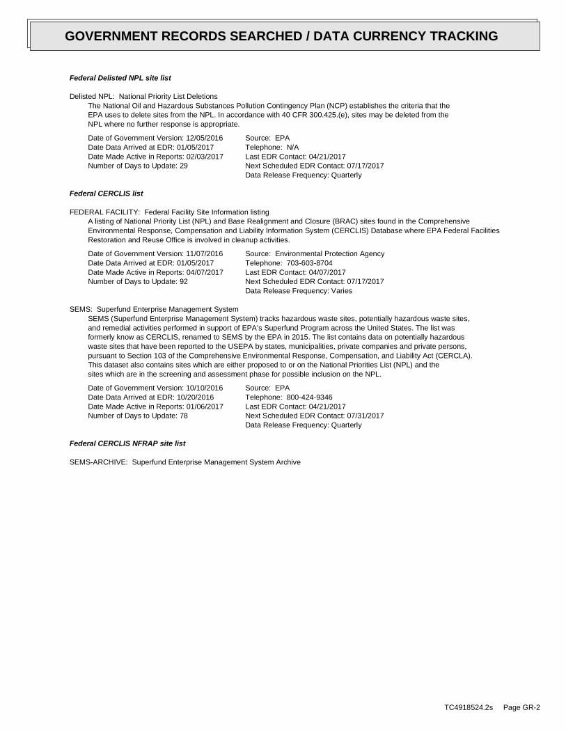
Federal Delisted NPL site list
Delisted NPL: National Priority List Deletions
The National Oil and Hazardous Substances Pollution Contingency Plan (NCP) establishes the criteria that the
EPA uses to delete sites from the NPL. In accordance with 40 CFR 300.425.(e), sites may be deleted from the
NPL where no further response is appropriate.
Date of Government Version: 12/05/2016
Date Data Arrived at EDR: 01/05/2017
Date Made Active in Reports: 02/03/2017
Number of Days to Update: 29
Source: EPA
Telephone: N/A
Last EDR Contact: 04/21/2017
Next Scheduled EDR Contact: 07/17/2017
Data Release Frequency: Quarterly
Federal CERCLIS list
FEDERAL FACILITY: Federal Facility Site Information listing
A listing of National Priority List (NPL) and Base Realignment and Closure (BRAC) sites found in the Comprehensive
Environmental Response, Compensation and Liability Information System (CERCLIS) Database where EPA Federal Facilities
Restoration and Reuse Office is involved in cleanup activities.
Date of Government Version: 11/07/2016
Date Data Arrived at EDR: 01/05/2017
Date Made Active in Reports: 04/07/2017
Number of Days to Update: 92
Source: Environmental Protection Agency
Telephone: 703-603-8704
Last EDR Contact: 04/07/2017
Next Scheduled EDR Contact: 07/17/2017
Data Release Frequency: Varies
SEMS: Superfund Enterprise Management System
SEMS (Superfund Enterprise Management System) tracks hazardous waste sites, potentially hazardous waste sites,
and remedial activities performed in support of EPA’s Superfund Program across the United States. The list was
formerly know as CERCLIS, renamed to SEMS by the EPA in 2015. The list contains data on potentially hazardous
waste sites that have been reported to the USEPA by states, municipalities, private companies and private persons,
pursuant to Section 103 of the Comprehensive Environmental Response, Compensation, and Liability Act (CERCLA).
This dataset also contains sites which are either proposed to or on the National Priorities List (NPL) and the
sites which are in the screening and assessment phase for possible inclusion on the NPL.
Date of Government Version: 10/10/2016
Date Data Arrived at EDR: 10/20/2016
Date Made Active in Reports: 01/06/2017
Number of Days to Update: 78
Source: EPA
Telephone: 800-424-9346
Last EDR Contact: 04/21/2017
Next Scheduled EDR Contact: 07/31/2017
Data Release Frequency: Quarterly
Federal CERCLIS NFRAP site list
SEMS-ARCHIVE: Superfund Enterprise Management System Archive
TC4918524.2s Page GR-2
GOVERNMENT RECORDS SEARCHED / DATA CURRENCY TRACKING

SEMS-ARCHIVE (Superfund Enterprise Management System Archive) tracks sites that have no further interest under
the Federal Superfund Program based on available information. The list was formerly known as the CERCLIS-NFRAP,
renamed to SEMS ARCHIVE by the EPA in 2015. EPA may perform a minimal level of assessment work at a site while
it is archived if site conditions change and/or new information becomes available. Archived sites have been removed
and archived from the inventory of SEMS sites. Archived status indicates that, to the best of EPA’s knowledge,
assessment at a site has been completed and that EPA has determined no further steps will be taken to list the
site on the National Priorities List (NPL), unless information indicates this decision was not appropriate or
other considerations require a recommendation for listing at a later time. The decision does not necessarily mean
that there is no hazard associated with a given site; it only means that. based upon available information, the
location is not judged to be potential NPL site.
Date of Government Version: 10/10/2016
Date Data Arrived at EDR: 10/20/2016
Date Made Active in Reports: 01/06/2017
Number of Days to Update: 78
Source: EPA
Telephone: 800-424-9346
Last EDR Contact: 04/25/2017
Next Scheduled EDR Contact: 07/31/2017
Data Release Frequency: Quarterly
Federal RCRA CORRACTS facilities list
CORRACTS: Corrective Action Report
CORRACTS identifies hazardous waste handlers with RCRA corrective action activity.
Date of Government Version: 12/12/2016
Date Data Arrived at EDR: 12/28/2016
Date Made Active in Reports: 02/10/2017
Number of Days to Update: 44
Source: EPA
Telephone: 800-424-9346
Last EDR Contact: 03/02/2017
Next Scheduled EDR Contact: 04/10/2017
Data Release Frequency: Quarterly
Federal RCRA non-CORRACTS TSD facilities list
RCRA-TSDF: RCRA - Treatment, Storage and Disposal
RCRAInfo is EPA’s comprehensive information system, providing access to data supporting the Resource Conservation
and Recovery Act (RCRA) of 1976 and the Hazardous and Solid Waste Amendments (HSWA) of 1984. The database
includes selective information on sites which generate, transport, store, treat and/or dispose of hazardous waste
as defined by the Resource Conservation and Recovery Act (RCRA). Transporters are individuals or entities that
move hazardous waste from the generator offsite to a facility that can recycle, treat, store, or dispose of the
waste. TSDFs treat, store, or dispose of the waste.
Date of Government Version: 12/12/2016
Date Data Arrived at EDR: 12/28/2016
Date Made Active in Reports: 02/10/2017
Number of Days to Update: 44
Source: Environmental Protection Agency
Telephone: (415) 495-8895
Last EDR Contact: 03/02/2017
Next Scheduled EDR Contact: 04/10/2017
Data Release Frequency: Quarterly
Federal RCRA generators list
RCRA-LQG: RCRA - Large Quantity Generators
RCRAInfo is EPA’s comprehensive information system, providing access to data supporting the Resource Conservation
and Recovery Act (RCRA) of 1976 and the Hazardous and Solid Waste Amendments (HSWA) of 1984. The database
includes selective information on sites which generate, transport, store, treat and/or dispose of hazardous waste
as defined by the Resource Conservation and Recovery Act (RCRA). Large quantity generators (LQGs) generate
over 1,000 kilograms (kg) of hazardous waste, or over 1 kg of acutely hazardous waste per month.
Date of Government Version: 12/12/2016
Date Data Arrived at EDR: 12/28/2016
Date Made Active in Reports: 02/10/2017
Number of Days to Update: 44
Source: Environmental Protection Agency
Telephone: (415) 495-8895
Last EDR Contact: 03/02/2017
Next Scheduled EDR Contact: 04/10/2017
Data Release Frequency: Quarterly
TC4918524.2s Page GR-3
GOVERNMENT RECORDS SEARCHED / DATA CURRENCY TRACKING
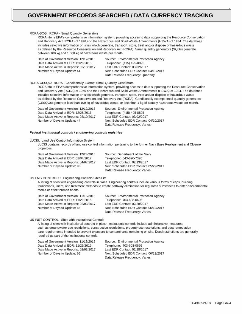
RCRA-SQG: RCRA - Small Quantity Generators
RCRAInfo is EPA’s comprehensive information system, providing access to data supporting the Resource Conservation
and Recovery Act (RCRA) of 1976 and the Hazardous and Solid Waste Amendments (HSWA) of 1984. The database
includes selective information on sites which generate, transport, store, treat and/or dispose of hazardous waste
as defined by the Resource Conservation and Recovery Act (RCRA). Small quantity generators (SQGs) generate
between 100 kg and 1,000 kg of hazardous waste per month.
Date of Government Version: 12/12/2016
Date Data Arrived at EDR: 12/28/2016
Date Made Active in Reports: 02/10/2017
Number of Days to Update: 44
Source: Environmental Protection Agency
Telephone: (415) 495-8895
Last EDR Contact: 03/02/2017
Next Scheduled EDR Contact: 04/10/2017
Data Release Frequency: Quarterly
RCRA-CESQG: RCRA - Conditionally Exempt Small Quantity Generators
RCRAInfo is EPA’s comprehensive information system, providing access to data supporting the Resource Conservation
and Recovery Act (RCRA) of 1976 and the Hazardous and Solid Waste Amendments (HSWA) of 1984. The database
includes selective information on sites which generate, transport, store, treat and/or dispose of hazardous waste
as defined by the Resource Conservation and Recovery Act (RCRA). Conditionally exempt small quantity generators
(CESQGs) generate less than 100 kg of hazardous waste, or less than 1 kg of acutely hazardous waste per month.
Date of Government Version: 12/12/2016
Date Data Arrived at EDR: 12/28/2016
Date Made Active in Reports: 02/10/2017
Number of Days to Update: 44
Source: Environmental Protection Agency
Telephone: (415) 495-8895
Last EDR Contact: 03/02/2017
Next Scheduled EDR Contact: 04/10/2017
Data Release Frequency: Varies
Federal institutional controls / engineering controls registries
LUCIS: Land Use Control Information System
LUCIS contains records of land use control information pertaining to the former Navy Base Realignment and Closure
properties.
Date of Government Version: 12/28/2016
Date Data Arrived at EDR: 01/04/2017
Date Made Active in Reports: 04/07/2017
Number of Days to Update: 93
Source: Department of the Navy
Telephone: 843-820-7326
Last EDR Contact: 02/13/2017
Next Scheduled EDR Contact: 05/29/2017
Data Release Frequency: Varies
US ENG CONTROLS: Engineering Controls Sites List
A listing of sites with engineering controls in place. Engineering controls include various forms of caps, building
foundations, liners, and treatment methods to create pathway elimination for regulated substances to enter environmental
media or effect human health.
Date of Government Version: 11/15/2016
Date Data Arrived at EDR: 11/29/2016
Date Made Active in Reports: 02/03/2017
Number of Days to Update: 66
Source: Environmental Protection Agency
Telephone: 703-603-0695
Last EDR Contact: 02/28/2017
Next Scheduled EDR Contact: 06/12/2017
Data Release Frequency: Varies
US INST CONTROL: Sites with Institutional Controls
A listing of sites with institutional controls in place. Institutional controls include administrative measures,
such as groundwater use restrictions, construction restrictions, property use restrictions, and post remediation
care requirements intended to prevent exposure to contaminants remaining on site. Deed restrictions are generally
required as part of the institutional controls.
Date of Government Version: 11/15/2016
Date Data Arrived at EDR: 11/29/2016
Date Made Active in Reports: 02/03/2017
Number of Days to Update: 66
Source: Environmental Protection Agency
Telephone: 703-603-0695
Last EDR Contact: 02/28/2017
Next Scheduled EDR Contact: 06/12/2017
Data Release Frequency: Varies
TC4918524.2s Page GR-4
GOVERNMENT RECORDS SEARCHED / DATA CURRENCY TRACKING

Federal ERNS list
ERNS: Emergency Response Notification System
Emergency Response Notification System. ERNS records and stores information on reported releases of oil and hazardous
substances.
Date of Government Version: 09/26/2016
Date Data Arrived at EDR: 09/29/2016
Date Made Active in Reports: 11/11/2016
Number of Days to Update: 43
Source: National Response Center, United States Coast Guard
Telephone: 202-267-2180
Last EDR Contact: 03/29/2017
Next Scheduled EDR Contact: 07/10/2017
Data Release Frequency: Annually
State- and tribal - equivalent NPL
RESPONSE: State Response Sites
Identifies confirmed release sites where DTSC is involved in remediation, either in a lead or oversight capacity.
These confirmed release sites are generally high-priority and high potential risk.
Date of Government Version: 10/31/2016
Date Data Arrived at EDR: 11/01/2016
Date Made Active in Reports: 01/18/2017
Number of Days to Update: 78
Source: Department of Toxic Substances Control
Telephone: 916-323-3400
Last EDR Contact: 01/31/2017
Next Scheduled EDR Contact: 05/08/2017
Data Release Frequency: Quarterly
State- and tribal - equivalent CERCLIS
ENVIROSTOR: EnviroStor Database
The Department of Toxic Substances Control’s (DTSC’s) Site Mitigation and Brownfields Reuse Program’s (SMBRP’s)
EnviroStor database identifes sites that have known contamination or sites for which there may be reasons to investigate
further. The database includes the following site types: Federal Superfund sites (National Priorities List (NPL));
State Response, including Military Facilities and State Superfund; Voluntary Cleanup; and School sites. EnviroStor
provides similar information to the information that was available in CalSites, and provides additional site information,
including, but not limited to, identification of formerly-contaminated properties that have been released for
reuse, properties where environmental deed restrictions have been recorded to prevent inappropriate land uses,
and risk characterization information that is used to assess potential impacts to public health and the environment
at contaminated sites.
Date of Government Version: 10/31/2016
Date Data Arrived at EDR: 11/01/2016
Date Made Active in Reports: 01/18/2017
Number of Days to Update: 78
Source: Department of Toxic Substances Control
Telephone: 916-323-3400
Last EDR Contact: 01/31/2017
Next Scheduled EDR Contact: 05/08/2017
Data Release Frequency: Quarterly
State and tribal landfill and/or solid waste disposal site lists
SWF/LF (SWIS): Solid Waste Information System
Active, Closed and Inactive Landfills. SWF/LF records typically contain an inve ntory of solid waste disposal
facilities or landfills. These may be active or i nactive facilities or open dumps that failed to meet RCRA Section
4004 criteria for solid waste landfills or disposal sites.
Date of Government Version: 11/14/2016
Date Data Arrived at EDR: 11/15/2016
Date Made Active in Reports: 01/20/2017
Number of Days to Update: 66
Source: Department of Resources Recycling and Recovery
Telephone: 916-341-6320
Last EDR Contact: 02/15/2017
Next Scheduled EDR Contact: 05/29/2017
Data Release Frequency: Quarterly
State and tribal leaking storage tank lists
TC4918524.2s Page GR-5
GOVERNMENT RECORDS SEARCHED / DATA CURRENCY TRACKING

LUST REG 5: Leaking Underground Storage Tank Database
Leaking Underground Storage Tank locations. Alameda, Alpine, Amador, Butte, Colusa, Contra Costa, Calveras, El
Dorado, Fresno, Glenn, Kern, Kings, Lake, Lassen, Madera, Mariposa, Merced, Modoc, Napa, Nevada, Placer, Plumas,
Sacramento, San Joaquin, Shasta, Solano, Stanislaus, Sutter, Tehama, Tulare, Tuolumne, Yolo, Yuba counties.
Date of Government Version: 07/01/2008
Date Data Arrived at EDR: 07/22/2008
Date Made Active in Reports: 07/31/2008
Number of Days to Update: 9
Source: California Regional Water Quality Control Board Central Valley Region (5)
Telephone: 916-464-4834
Last EDR Contact: 07/01/2011
Next Scheduled EDR Contact: 10/17/2011
Data Release Frequency: No Update Planned
LUST: Geotracker’s Leaking Underground Fuel Tank Report
Leaking Underground Storage Tank (LUST) Sites included in GeoTracker. GeoTracker is the Water Boards data management
system for sites that impact, or have the potential to impact, water quality in California, with emphasis on groundwater.
Date of Government Version: 12/12/2016
Date Data Arrived at EDR: 12/14/2016
Date Made Active in Reports: 01/20/2017
Number of Days to Update: 37
Source: State Water Resources Control Board
Telephone: see region list
Last EDR Contact: 03/14/2017
Next Scheduled EDR Contact: 06/26/2017
Data Release Frequency: Quarterly
LUST REG 9: Leaking Underground Storage Tank Report
Orange, Riverside, San Diego counties. For more current information, please refer to the State Water Resources
Control Board’s LUST database.
Date of Government Version: 03/01/2001
Date Data Arrived at EDR: 04/23/2001
Date Made Active in Reports: 05/21/2001
Number of Days to Update: 28
Source: California Regional Water Quality Control Board San Diego Region (9)
Telephone: 858-637-5595
Last EDR Contact: 09/26/2011
Next Scheduled EDR Contact: 01/09/2012
Data Release Frequency: No Update Planned
LUST REG 8: Leaking Underground Storage Tanks
California Regional Water Quality Control Board Santa Ana Region (8). For more current information, please refer
to the State Water Resources Control Board’s LUST database.
Date of Government Version: 02/14/2005
Date Data Arrived at EDR: 02/15/2005
Date Made Active in Reports: 03/28/2005
Number of Days to Update: 41
Source: California Regional Water Quality Control Board Santa Ana Region (8)
Telephone: 909-782-4496
Last EDR Contact: 08/15/2011
Next Scheduled EDR Contact: 11/28/2011
Data Release Frequency: Varies
LUST REG 7: Leaking Underground Storage Tank Case Listing
Leaking Underground Storage Tank locations. Imperial, Riverside, San Diego, Santa Barbara counties.
Date of Government Version: 02/26/2004
Date Data Arrived at EDR: 02/26/2004
Date Made Active in Reports: 03/24/2004
Number of Days to Update: 27
Source: California Regional Water Quality Control Board Colorado River Basin Region (7)
Telephone: 760-776-8943
Last EDR Contact: 08/01/2011
Next Scheduled EDR Contact: 11/14/2011
Data Release Frequency: No Update Planned
LUST REG 6V: Leaking Underground Storage Tank Case Listing
Leaking Underground Storage Tank locations. Inyo, Kern, Los Angeles, Mono, San Bernardino counties.
Date of Government Version: 06/07/2005
Date Data Arrived at EDR: 06/07/2005
Date Made Active in Reports: 06/29/2005
Number of Days to Update: 22
Source: California Regional Water Quality Control Board Victorville Branch Office (6)
Telephone: 760-241-7365
Last EDR Contact: 09/12/2011
Next Scheduled EDR Contact: 12/26/2011
Data Release Frequency: No Update Planned
TC4918524.2s Page GR-6
GOVERNMENT RECORDS SEARCHED / DATA CURRENCY TRACKING
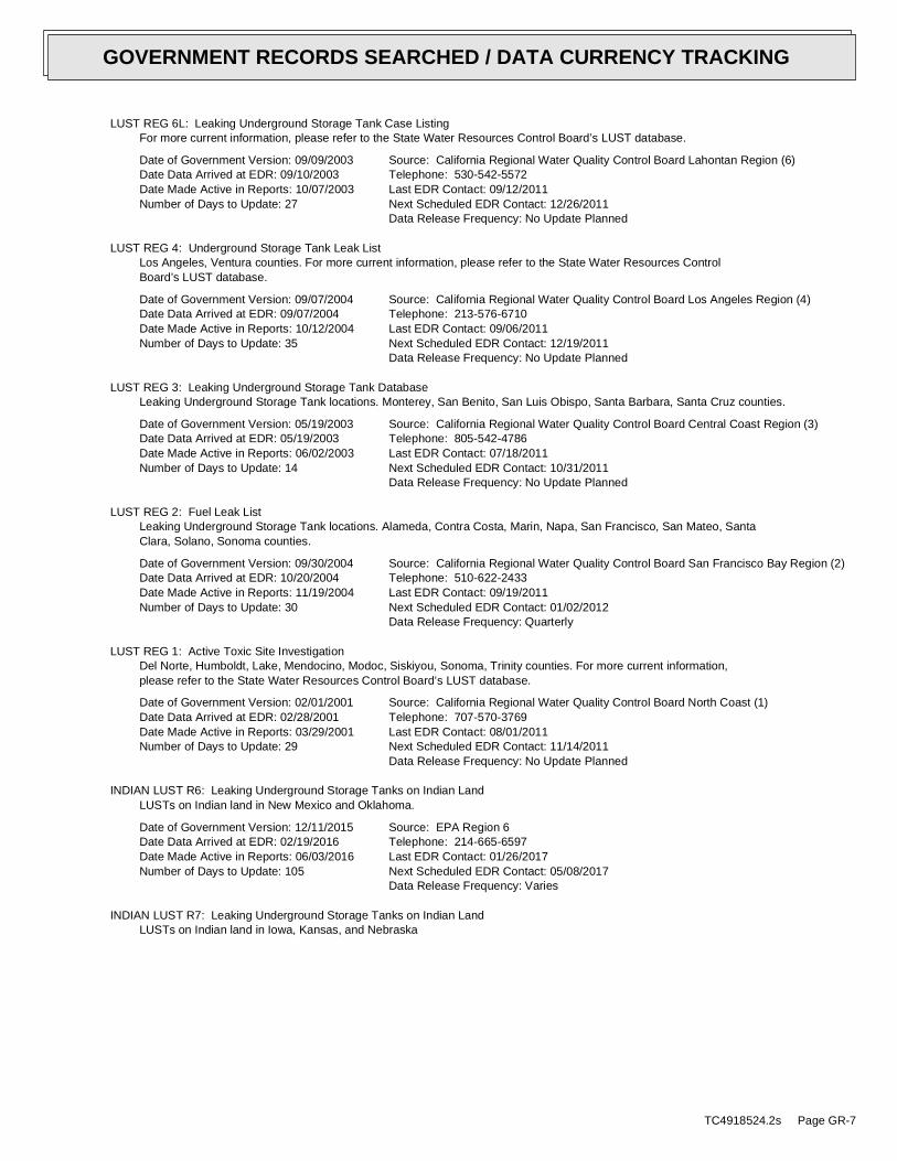
LUST REG 6L: Leaking Underground Storage Tank Case Listing
For more current information, please refer to the State Water Resources Control Board’s LUST database.
Date of Government Version: 09/09/2003
Date Data Arrived at EDR: 09/10/2003
Date Made Active in Reports: 10/07/2003
Number of Days to Update: 27
Source: California Regional Water Quality Control Board Lahontan Region (6)
Telephone: 530-542-5572
Last EDR Contact: 09/12/2011
Next Scheduled EDR Contact: 12/26/2011
Data Release Frequency: No Update Planned
LUST REG 4: Underground Storage Tank Leak List
Los Angeles, Ventura counties. For more current information, please refer to the State Water Resources Control
Board’s LUST database.
Date of Government Version: 09/07/2004
Date Data Arrived at EDR: 09/07/2004
Date Made Active in Reports: 10/12/2004
Number of Days to Update: 35
Source: California Regional Water Quality Control Board Los Angeles Region (4)
Telephone: 213-576-6710
Last EDR Contact: 09/06/2011
Next Scheduled EDR Contact: 12/19/2011
Data Release Frequency: No Update Planned
LUST REG 3: Leaking Underground Storage Tank Database
Leaking Underground Storage Tank locations. Monterey, San Benito, San Luis Obispo, Santa Barbara, Santa Cruz counties.
Date of Government Version: 05/19/2003
Date Data Arrived at EDR: 05/19/2003
Date Made Active in Reports: 06/02/2003
Number of Days to Update: 14
Source: California Regional Water Quality Control Board Central Coast Region (3)
Telephone: 805-542-4786
Last EDR Contact: 07/18/2011
Next Scheduled EDR Contact: 10/31/2011
Data Release Frequency: No Update Planned
LUST REG 2: Fuel Leak List
Leaking Underground Storage Tank locations. Alameda, Contra Costa, Marin, Napa, San Francisco, San Mateo, Santa
Clara, Solano, Sonoma counties.
Date of Government Version: 09/30/2004
Date Data Arrived at EDR: 10/20/2004
Date Made Active in Reports: 11/19/2004
Number of Days to Update: 30
Source: California Regional Water Quality Control Board San Francisco Bay Region (2)
Telephone: 510-622-2433
Last EDR Contact: 09/19/2011
Next Scheduled EDR Contact: 01/02/2012
Data Release Frequency: Quarterly
LUST REG 1: Active Toxic Site Investigation
Del Norte, Humboldt, Lake, Mendocino, Modoc, Siskiyou, Sonoma, Trinity counties. For more current information,
please refer to the State Water Resources Control Board’s LUST database.
Date of Government Version: 02/01/2001
Date Data Arrived at EDR: 02/28/2001
Date Made Active in Reports: 03/29/2001
Number of Days to Update: 29
Source: California Regional Water Quality Control Board North Coast (1)
Telephone: 707-570-3769
Last EDR Contact: 08/01/2011
Next Scheduled EDR Contact: 11/14/2011
Data Release Frequency: No Update Planned
INDIAN LUST R6: Leaking Underground Storage Tanks on Indian Land
LUSTs on Indian land in New Mexico and Oklahoma.
Date of Government Version: 12/11/2015
Date Data Arrived at EDR: 02/19/2016
Date Made Active in Reports: 06/03/2016
Number of Days to Update: 105
Source: EPA Region 6
Telephone: 214-665-6597
Last EDR Contact: 01/26/2017
Next Scheduled EDR Contact: 05/08/2017
Data Release Frequency: Varies
INDIAN LUST R7: Leaking Underground Storage Tanks on Indian Land
LUSTs on Indian land in Iowa, Kansas, and Nebraska
TC4918524.2s Page GR-7
GOVERNMENT RECORDS SEARCHED / DATA CURRENCY TRACKING
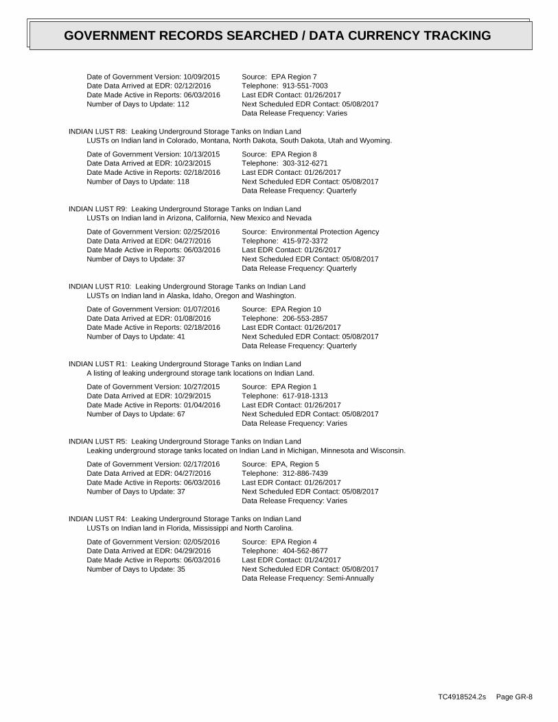
Date of Government Version: 10/09/2015
Date Data Arrived at EDR: 02/12/2016
Date Made Active in Reports: 06/03/2016
Number of Days to Update: 112
Source: EPA Region 7
Telephone: 913-551-7003
Last EDR Contact: 01/26/2017
Next Scheduled EDR Contact: 05/08/2017
Data Release Frequency: Varies
INDIAN LUST R8: Leaking Underground Storage Tanks on Indian Land
LUSTs on Indian land in Colorado, Montana, North Dakota, South Dakota, Utah and Wyoming.
Date of Government Version: 10/13/2015
Date Data Arrived at EDR: 10/23/2015
Date Made Active in Reports: 02/18/2016
Number of Days to Update: 118
Source: EPA Region 8
Telephone: 303-312-6271
Last EDR Contact: 01/26/2017
Next Scheduled EDR Contact: 05/08/2017
Data Release Frequency: Quarterly
INDIAN LUST R9: Leaking Underground Storage Tanks on Indian Land
LUSTs on Indian land in Arizona, California, New Mexico and Nevada
Date of Government Version: 02/25/2016
Date Data Arrived at EDR: 04/27/2016
Date Made Active in Reports: 06/03/2016
Number of Days to Update: 37
Source: Environmental Protection Agency
Telephone: 415-972-3372
Last EDR Contact: 01/26/2017
Next Scheduled EDR Contact: 05/08/2017
Data Release Frequency: Quarterly
INDIAN LUST R10: Leaking Underground Storage Tanks on Indian Land
LUSTs on Indian land in Alaska, Idaho, Oregon and Washington.
Date of Government Version: 01/07/2016
Date Data Arrived at EDR: 01/08/2016
Date Made Active in Reports: 02/18/2016
Number of Days to Update: 41
Source: EPA Region 10
Telephone: 206-553-2857
Last EDR Contact: 01/26/2017
Next Scheduled EDR Contact: 05/08/2017
Data Release Frequency: Quarterly
INDIAN LUST R1: Leaking Underground Storage Tanks on Indian Land
A listing of leaking underground storage tank locations on Indian Land.
Date of Government Version: 10/27/2015
Date Data Arrived at EDR: 10/29/2015
Date Made Active in Reports: 01/04/2016
Number of Days to Update: 67
Source: EPA Region 1
Telephone: 617-918-1313
Last EDR Contact: 01/26/2017
Next Scheduled EDR Contact: 05/08/2017
Data Release Frequency: Varies
INDIAN LUST R5: Leaking Underground Storage Tanks on Indian Land
Leaking underground storage tanks located on Indian Land in Michigan, Minnesota and Wisconsin.
Date of Government Version: 02/17/2016
Date Data Arrived at EDR: 04/27/2016
Date Made Active in Reports: 06/03/2016
Number of Days to Update: 37
Source: EPA, Region 5
Telephone: 312-886-7439
Last EDR Contact: 01/26/2017
Next Scheduled EDR Contact: 05/08/2017
Data Release Frequency: Varies
INDIAN LUST R4: Leaking Underground Storage Tanks on Indian Land
LUSTs on Indian land in Florida, Mississippi and North Carolina.
Date of Government Version: 02/05/2016
Date Data Arrived at EDR: 04/29/2016
Date Made Active in Reports: 06/03/2016
Number of Days to Update: 35
Source: EPA Region 4
Telephone: 404-562-8677
Last EDR Contact: 01/24/2017
Next Scheduled EDR Contact: 05/08/2017
Data Release Frequency: Semi-Annually
TC4918524.2s Page GR-8
GOVERNMENT RECORDS SEARCHED / DATA CURRENCY TRACKING

SLIC: Statewide SLIC Cases
Cleanup Program Sites (CPS; also known as Site Cleanups [SC] and formerly known as Spills, Leaks, Investigations,
and Cleanups [SLIC] sites) included in GeoTracker. GeoTracker is the Water Boards data management system for
sites that impact, or have the potential to impact, water quality in California, with emphasis on groundwater.
Date of Government Version: 12/12/2016
Date Data Arrived at EDR: 12/14/2016
Date Made Active in Reports: 01/23/2017
Number of Days to Update: 40
Source: State Water Resources Control Board
Telephone: 866-480-1028
Last EDR Contact: 03/14/2017
Next Scheduled EDR Contact: 06/26/2017
Data Release Frequency: Varies
SLIC REG 1: Active Toxic Site Investigations
The SLIC (Spills, Leaks, Investigations and Cleanup) program is designed to protect and restore water quality
from spills, leaks, and similar discharges.
Date of Government Version: 04/03/2003
Date Data Arrived at EDR: 04/07/2003
Date Made Active in Reports: 04/25/2003
Number of Days to Update: 18
Source: California Regional Water Quality Control Board, North Coast Region (1)
Telephone: 707-576-2220
Last EDR Contact: 08/01/2011
Next Scheduled EDR Contact: 11/14/2011
Data Release Frequency: No Update Planned
SLIC REG 2: Spills, Leaks, Investigation & Cleanup Cost Recovery Listing
The SLIC (Spills, Leaks, Investigations and Cleanup) program is designed to protect and restore water quality
from spills, leaks, and similar discharges.
Date of Government Version: 09/30/2004
Date Data Arrived at EDR: 10/20/2004
Date Made Active in Reports: 11/19/2004
Number of Days to Update: 30
Source: Regional Water Quality Control Board San Francisco Bay Region (2)
Telephone: 510-286-0457
Last EDR Contact: 09/19/2011
Next Scheduled EDR Contact: 01/02/2012
Data Release Frequency: Quarterly
SLIC REG 3: Spills, Leaks, Investigation & Cleanup Cost Recovery Listing
The SLIC (Spills, Leaks, Investigations and Cleanup) program is designed to protect and restore water quality
from spills, leaks, and similar discharges.
Date of Government Version: 05/18/2006
Date Data Arrived at EDR: 05/18/2006
Date Made Active in Reports: 06/15/2006
Number of Days to Update: 28
Source: California Regional Water Quality Control Board Central Coast Region (3)
Telephone: 805-549-3147
Last EDR Contact: 07/18/2011
Next Scheduled EDR Contact: 10/31/2011
Data Release Frequency: Semi-Annually
SLIC REG 4: Spills, Leaks, Investigation & Cleanup Cost Recovery Listing
The SLIC (Spills, Leaks, Investigations and Cleanup) program is designed to protect and restore water quality
from spills, leaks, and similar discharges.
Date of Government Version: 11/17/2004
Date Data Arrived at EDR: 11/18/2004
Date Made Active in Reports: 01/04/2005
Number of Days to Update: 47
Source: Region Water Quality Control Board Los Angeles Region (4)
Telephone: 213-576-6600
Last EDR Contact: 07/01/2011
Next Scheduled EDR Contact: 10/17/2011
Data Release Frequency: Varies
SLIC REG 5: Spills, Leaks, Investigation & Cleanup Cost Recovery Listing
The SLIC (Spills, Leaks, Investigations and Cleanup) program is designed to protect and restore water quality
from spills, leaks, and similar discharges.
Date of Government Version: 04/01/2005
Date Data Arrived at EDR: 04/05/2005
Date Made Active in Reports: 04/21/2005
Number of Days to Update: 16
Source: Regional Water Quality Control Board Central Valley Region (5)
Telephone: 916-464-3291
Last EDR Contact: 09/12/2011
Next Scheduled EDR Contact: 12/26/2011
Data Release Frequency: Semi-Annually
TC4918524.2s Page GR-9
GOVERNMENT RECORDS SEARCHED / DATA CURRENCY TRACKING
SLIC REG 6V: Spills, Leaks, Investigation & Cleanup Cost Recovery Listing
The SLIC (Spills, Leaks, Investigations and Cleanup) program is designed to protect and restore water quality
from spills, leaks, and similar discharges.
Date of Government Version: 05/24/2005
Date Data Arrived at EDR: 05/25/2005
Date Made Active in Reports: 06/16/2005
Number of Days to Update: 22
Source: Regional Water Quality Control Board, Victorville Branch
Telephone: 619-241-6583
Last EDR Contact: 08/15/2011
Next Scheduled EDR Contact: 11/28/2011
Data Release Frequency: Semi-Annually
SLIC REG 6L: SLIC Sites
The SLIC (Spills, Leaks, Investigations and Cleanup) program is designed to protect and restore water quality
from spills, leaks, and similar discharges.
Date of Government Version: 09/07/2004
Date Data Arrived at EDR: 09/07/2004
Date Made Active in Reports: 10/12/2004
Number of Days to Update: 35
Source: California Regional Water Quality Control Board, Lahontan Region
Telephone: 530-542-5574
Last EDR Contact: 08/15/2011
Next Scheduled EDR Contact: 11/28/2011
Data Release Frequency: No Update Planned
SLIC REG 7: SLIC List
The SLIC (Spills, Leaks, Investigations and Cleanup) program is designed to protect and restore water quality
from spills, leaks, and similar discharges.
Date of Government Version: 11/24/2004
Date Data Arrived at EDR: 11/29/2004
Date Made Active in Reports: 01/04/2005
Number of Days to Update: 36
Source: California Regional Quality Control Board, Colorado River Basin Region
Telephone: 760-346-7491
Last EDR Contact: 08/01/2011
Next Scheduled EDR Contact: 11/14/2011
Data Release Frequency: No Update Planned
SLIC REG 8: Spills, Leaks, Investigation & Cleanup Cost Recovery Listing
The SLIC (Spills, Leaks, Investigations and Cleanup) program is designed to protect and restore water quality
from spills, leaks, and similar discharges.
Date of Government Version: 04/03/2008
Date Data Arrived at EDR: 04/03/2008
Date Made Active in Reports: 04/14/2008
Number of Days to Update: 11
Source: California Region Water Quality Control Board Santa Ana Region (8)
Telephone: 951-782-3298
Last EDR Contact: 09/12/2011
Next Scheduled EDR Contact: 12/26/2011
Data Release Frequency: Semi-Annually
SLIC REG 9: Spills, Leaks, Investigation & Cleanup Cost Recovery Listing
The SLIC (Spills, Leaks, Investigations and Cleanup) program is designed to protect and restore water quality
from spills, leaks, and similar discharges.
Date of Government Version: 09/10/2007
Date Data Arrived at EDR: 09/11/2007
Date Made Active in Reports: 09/28/2007
Number of Days to Update: 17
Source: California Regional Water Quality Control Board San Diego Region (9)
Telephone: 858-467-2980
Last EDR Contact: 08/08/2011
Next Scheduled EDR Contact: 11/21/2011
Data Release Frequency: Annually
State and tribal registered storage tank lists
FEMA UST: Underground Storage Tank Listing
A listing of all FEMA owned underground storage tanks.
Date of Government Version: 01/01/2010
Date Data Arrived at EDR: 02/16/2010
Date Made Active in Reports: 04/12/2010
Number of Days to Update: 55
Source: FEMA
Telephone: 202-646-5797
Last EDR Contact: 04/11/2017
Next Scheduled EDR Contact: 07/24/2017
Data Release Frequency: Varies
TC4918524.2s Page GR-10
GOVERNMENT RECORDS SEARCHED / DATA CURRENCY TRACKING

UST: Active UST Facilities
Active UST facilities gathered from the local regulatory agencies
Date of Government Version: 09/12/2016
Date Data Arrived at EDR: 09/14/2016
Date Made Active in Reports: 10/14/2016
Number of Days to Update: 30
Source: SWRCB
Telephone: 916-341-5851
Last EDR Contact: 03/16/2017
Next Scheduled EDR Contact: 06/26/2017
Data Release Frequency: Semi-Annually
AST: Aboveground Petroleum Storage Tank Facilities
A listing of aboveground storage tank petroleum storage tank locations.
Date of Government Version: 07/06/2016
Date Data Arrived at EDR: 07/12/2016
Date Made Active in Reports: 09/19/2016
Number of Days to Update: 69
Source: California Environmental Protection Agency
Telephone: 916-327-5092
Last EDR Contact: 03/24/2017
Next Scheduled EDR Contact: 07/10/2017
Data Release Frequency: Quarterly
INDIAN UST R6: Underground Storage Tanks on Indian Land
The Indian Underground Storage Tank (UST) database provides information about underground storage tanks on Indian
land in EPA Region 6 (Louisiana, Arkansas, Oklahoma, New Mexico, Texas and 65 Tribes).
Date of Government Version: 12/03/2015
Date Data Arrived at EDR: 02/04/2016
Date Made Active in Reports: 06/03/2016
Number of Days to Update: 120
Source: EPA Region 6
Telephone: 214-665-7591
Last EDR Contact: 01/26/2017
Next Scheduled EDR Contact: 05/08/2017
Data Release Frequency: Semi-Annually
INDIAN UST R5: Underground Storage Tanks on Indian Land
The Indian Underground Storage Tank (UST) database provides information about underground storage tanks on Indian
land in EPA Region 5 (Michigan, Minnesota and Wisconsin and Tribal Nations).
Date of Government Version: 11/05/2015
Date Data Arrived at EDR: 11/13/2015
Date Made Active in Reports: 01/04/2016
Number of Days to Update: 52
Source: EPA Region 5
Telephone: 312-886-6136
Last EDR Contact: 01/26/2017
Next Scheduled EDR Contact: 05/08/2017
Data Release Frequency: Varies
INDIAN UST R4: Underground Storage Tanks on Indian Land
The Indian Underground Storage Tank (UST) database provides information about underground storage tanks on Indian
land in EPA Region 4 (Alabama, Florida, Georgia, Kentucky, Mississippi, North Carolina, South Carolina, Tennessee
and Tribal Nations)
Date of Government Version: 02/05/2016
Date Data Arrived at EDR: 04/29/2016
Date Made Active in Reports: 06/03/2016
Number of Days to Update: 35
Source: EPA Region 4
Telephone: 404-562-9424
Last EDR Contact: 01/24/2017
Next Scheduled EDR Contact: 05/08/2017
Data Release Frequency: Semi-Annually
INDIAN UST R1: Underground Storage Tanks on Indian Land
The Indian Underground Storage Tank (UST) database provides information about underground storage tanks on Indian
land in EPA Region 1 (Connecticut, Maine, Massachusetts, New Hampshire, Rhode Island, Vermont and ten Tribal
Nations).
Date of Government Version: 10/20/2015
Date Data Arrived at EDR: 10/29/2015
Date Made Active in Reports: 01/04/2016
Number of Days to Update: 67
Source: EPA, Region 1
Telephone: 617-918-1313
Last EDR Contact: 01/26/2017
Next Scheduled EDR Contact: 05/08/2017
Data Release Frequency: Varies
TC4918524.2s Page GR-11
GOVERNMENT RECORDS SEARCHED / DATA CURRENCY TRACKING

INDIAN UST R10: Underground Storage Tanks on Indian Land
The Indian Underground Storage Tank (UST) database provides information about underground storage tanks on Indian
land in EPA Region 10 (Alaska, Idaho, Oregon, Washington, and Tribal Nations).
Date of Government Version: 01/07/2016
Date Data Arrived at EDR: 01/08/2016
Date Made Active in Reports: 02/18/2016
Number of Days to Update: 41
Source: EPA Region 10
Telephone: 206-553-2857
Last EDR Contact: 01/26/2017
Next Scheduled EDR Contact: 05/08/2017
Data Release Frequency: Quarterly
INDIAN UST R7: Underground Storage Tanks on Indian Land
The Indian Underground Storage Tank (UST) database provides information about underground storage tanks on Indian
land in EPA Region 7 (Iowa, Kansas, Missouri, Nebraska, and 9 Tribal Nations).
Date of Government Version: 09/23/2014
Date Data Arrived at EDR: 11/25/2014
Date Made Active in Reports: 01/29/2015
Number of Days to Update: 65
Source: EPA Region 7
Telephone: 913-551-7003
Last EDR Contact: 01/26/2017
Next Scheduled EDR Contact: 05/08/2017
Data Release Frequency: Varies
INDIAN UST R9: Underground Storage Tanks on Indian Land
The Indian Underground Storage Tank (UST) database provides information about underground storage tanks on Indian
land in EPA Region 9 (Arizona, California, Hawaii, Nevada, the Pacific Islands, and Tribal Nations).
Date of Government Version: 02/25/2016
Date Data Arrived at EDR: 04/27/2016
Date Made Active in Reports: 06/03/2016
Number of Days to Update: 37
Source: EPA Region 9
Telephone: 415-972-3368
Last EDR Contact: 01/26/2017
Next Scheduled EDR Contact: 05/08/2017
Data Release Frequency: Quarterly
INDIAN UST R8: Underground Storage Tanks on Indian Land
The Indian Underground Storage Tank (UST) database provides information about underground storage tanks on Indian
land in EPA Region 8 (Colorado, Montana, North Dakota, South Dakota, Utah, Wyoming and 27 Tribal Nations).
Date of Government Version: 01/26/2016
Date Data Arrived at EDR: 02/05/2016
Date Made Active in Reports: 06/03/2016
Number of Days to Update: 119
Source: EPA Region 8
Telephone: 303-312-6137
Last EDR Contact: 01/26/2017
Next Scheduled EDR Contact: 05/08/2017
Data Release Frequency: Quarterly
State and tribal voluntary cleanup sites
VCP: Voluntary Cleanup Program Properties
Contains low threat level properties with either confirmed or unconfirmed releases and the project proponents
have request that DTSC oversee investigation and/or cleanup activities and have agreed to provide coverage for
DTSC’s costs.
Date of Government Version: 10/31/2016
Date Data Arrived at EDR: 11/01/2016
Date Made Active in Reports: 01/18/2017
Number of Days to Update: 78
Source: Department of Toxic Substances Control
Telephone: 916-323-3400
Last EDR Contact: 01/31/2017
Next Scheduled EDR Contact: 05/08/2017
Data Release Frequency: Quarterly
INDIAN VCP R7: Voluntary Cleanup Priority Lisitng
A listing of voluntary cleanup priority sites located on Indian Land located in Region 7.
Date of Government Version: 03/20/2008
Date Data Arrived at EDR: 04/22/2008
Date Made Active in Reports: 05/19/2008
Number of Days to Update: 27
Source: EPA, Region 7
Telephone: 913-551-7365
Last EDR Contact: 04/20/2009
Next Scheduled EDR Contact: 07/20/2009
Data Release Frequency: Varies
TC4918524.2s Page GR-12
GOVERNMENT RECORDS SEARCHED / DATA CURRENCY TRACKING

INDIAN VCP R1: Voluntary Cleanup Priority Listing
A listing of voluntary cleanup priority sites located on Indian Land located in Region 1.
Date of Government Version: 07/27/2015
Date Data Arrived at EDR: 09/29/2015
Date Made Active in Reports: 02/18/2016
Number of Days to Update: 142
Source: EPA, Region 1
Telephone: 617-918-1102
Last EDR Contact: 03/27/2017
Next Scheduled EDR Contact: 07/10/2017
Data Release Frequency: Varies
State and tribal Brownfields sites
BROWNFIELDS: Considered Brownfieds Sites Listing
A listing of sites the SWRCB considers to be Brownfields since these are sites have come to them through the MOA
Process.
Date of Government Version: 01/03/2017
Date Data Arrived at EDR: 01/04/2017
Date Made Active in Reports: 03/02/2017
Number of Days to Update: 57
Source: State Water Resources Control Board
Telephone: 916-323-7905
Last EDR Contact: 03/29/2017
Next Scheduled EDR Contact: 07/10/2017
Data Release Frequency: Varies
ADDITIONAL ENVIRONMENTAL RECORDS
Local Brownfield lists
US BROWNFIELDS: A Listing of Brownfields Sites
Brownfields are real property, the expansion, redevelopment, or reuse of which may be complicated by the presence
or potential presence of a hazardous substance, pollutant, or contaminant. Cleaning up and reinvesting in these
properties takes development pressures off of undeveloped, open land, and both improves and protects the environment.
Assessment, Cleanup and Redevelopment Exchange System (ACRES) stores information reported by EPA Brownfields
grant recipients on brownfields properties assessed or cleaned up with grant funding as well as information on
Targeted Brownfields Assessments performed by EPA Regions. A listing of ACRES Brownfield sites is obtained from
Cleanups in My Community. Cleanups in My Community provides information on Brownfields properties for which information
is reported back to EPA, as well as areas served by Brownfields grant programs.
Date of Government Version: 03/02/2017
Date Data Arrived at EDR: 03/02/2017
Date Made Active in Reports: 04/07/2017
Number of Days to Update: 36
Source: Environmental Protection Agency
Telephone: 202-566-2777
Last EDR Contact: 03/02/2017
Next Scheduled EDR Contact: 07/03/2017
Data Release Frequency: Semi-Annually
Local Lists of Landfill / Solid Waste Disposal Sites
WMUDS/SWAT: Waste Management Unit Database
Waste Management Unit Database System. WMUDS is used by the State Water Resources Control Board staff and the
Regional Water Quality Control Boards for program tracking and inventory of waste management units. WMUDS is composed
of the following databases: Facility Information, Scheduled Inspections Information, Waste Management Unit Information,
SWAT Program Information, SWAT Report Summary Information, SWAT Report Summary Data, Chapter 15 (formerly Subchapter
15) Information, Chapter 15 Monitoring Parameters, TPCA Program Information, RCRA Program Information, Closure
Information, and Interested Parties Information.
Date of Government Version: 04/01/2000
Date Data Arrived at EDR: 04/10/2000
Date Made Active in Reports: 05/10/2000
Number of Days to Update: 30
Source: State Water Resources Control Board
Telephone: 916-227-4448
Last EDR Contact: 02/03/2017
Next Scheduled EDR Contact: 05/22/2017
Data Release Frequency: No Update Planned
SWRCY: Recycler Database
A listing of recycling facilities in California.
TC4918524.2s Page GR-13
GOVERNMENT RECORDS SEARCHED / DATA CURRENCY TRACKING

Date of Government Version: 12/12/2016
Date Data Arrived at EDR: 12/14/2016
Date Made Active in Reports: 03/02/2017
Number of Days to Update: 78
Source: Department of Conservation
Telephone: 916-323-3836
Last EDR Contact: 03/14/2017
Next Scheduled EDR Contact: 06/26/2017
Data Release Frequency: Quarterly
HAULERS: Registered Waste Tire Haulers Listing
A listing of registered waste tire haulers.
Date of Government Version: 08/25/2016
Date Data Arrived at EDR: 08/26/2016
Date Made Active in Reports: 10/14/2016
Number of Days to Update: 49
Source: Integrated Waste Management Board
Telephone: 916-341-6422
Last EDR Contact: 02/13/2017
Next Scheduled EDR Contact: 05/29/2017
Data Release Frequency: Varies
INDIAN ODI: Report on the Status of Open Dumps on Indian Lands
Location of open dumps on Indian land.
Date of Government Version: 12/31/1998
Date Data Arrived at EDR: 12/03/2007
Date Made Active in Reports: 01/24/2008
Number of Days to Update: 52
Source: Environmental Protection Agency
Telephone: 703-308-8245
Last EDR Contact: 10/31/2016
Next Scheduled EDR Contact: 02/13/2017
Data Release Frequency: Varies
ODI: Open Dump Inventory
An open dump is defined as a disposal facility that does not comply with one or more of the Part 257 or Part 258
Subtitle D Criteria.
Date of Government Version: 06/30/1985
Date Data Arrived at EDR: 08/09/2004
Date Made Active in Reports: 09/17/2004
Number of Days to Update: 39
Source: Environmental Protection Agency
Telephone: 800-424-9346
Last EDR Contact: 06/09/2004
Next Scheduled EDR Contact: N/A
Data Release Frequency: No Update Planned
DEBRIS REGION 9: Torres Martinez Reservation Illegal Dump Site Locations
A listing of illegal dump sites location on the Torres Martinez Indian Reservation located in eastern Riverside
County and northern Imperial County, California.
Date of Government Version: 01/12/2009
Date Data Arrived at EDR: 05/07/2009
Date Made Active in Reports: 09/21/2009
Number of Days to Update: 137
Source: EPA, Region 9
Telephone: 415-947-4219
Last EDR Contact: 04/24/2017
Next Scheduled EDR Contact: 08/07/2017
Data Release Frequency: No Update Planned
IHS OPEN DUMPS: Open Dumps on Indian Land
A listing of all open dumps located on Indian Land in the United States.
Date of Government Version: 04/01/2014
Date Data Arrived at EDR: 08/06/2014
Date Made Active in Reports: 01/29/2015
Number of Days to Update: 176
Source: Department of Health & Human Serivces, Indian Health Service
Telephone: 301-443-1452
Last EDR Contact: 01/30/2017
Next Scheduled EDR Contact: 05/08/2017
Data Release Frequency: Varies
Local Lists of Hazardous waste / Contaminated Sites
US HIST CDL: National Clandestine Laboratory Register
A listing of clandestine drug lab locations that have been removed from the DEAs National Clandestine Laboratory
Register.
TC4918524.2s Page GR-14
GOVERNMENT RECORDS SEARCHED / DATA CURRENCY TRACKING

Date of Government Version: 09/30/2016
Date Data Arrived at EDR: 01/05/2017
Date Made Active in Reports: 02/10/2017
Number of Days to Update: 36
Source: Drug Enforcement Administration
Telephone: 202-307-1000
Last EDR Contact: 02/28/2017
Next Scheduled EDR Contact: 06/12/2017
Data Release Frequency: No Update Planned
HIST CAL-SITES: Calsites Database
The Calsites database contains potential or confirmed hazardous substance release properties. In 1996, California
EPA reevaluated and significantly reduced the number of sites in the Calsites database. No longer updated by the
state agency. It has been replaced by ENVIROSTOR.
Date of Government Version: 08/08/2005
Date Data Arrived at EDR: 08/03/2006
Date Made Active in Reports: 08/24/2006
Number of Days to Update: 21
Source: Department of Toxic Substance Control
Telephone: 916-323-3400
Last EDR Contact: 02/23/2009
Next Scheduled EDR Contact: 05/25/2009
Data Release Frequency: No Update Planned
SCH: School Property Evaluation Program
This category contains proposed and existing school sites that are being evaluated by DTSC for possible hazardous
materials contamination. In some cases, these properties may be listed in the CalSites category depending on the
level of threat to public health and safety or the environment they pose.
Date of Government Version: 10/31/2016
Date Data Arrived at EDR: 11/01/2016
Date Made Active in Reports: 01/18/2017
Number of Days to Update: 78
Source: Department of Toxic Substances Control
Telephone: 916-323-3400
Last EDR Contact: 01/31/2017
Next Scheduled EDR Contact: 05/08/2017
Data Release Frequency: Quarterly
CDL: Clandestine Drug Labs
A listing of drug lab locations. Listing of a location in this database does not indicate that any illegal drug
lab materials were or were not present there, and does not constitute a determination that the location either
requires or does not require additional cleanup work.
Date of Government Version: 08/31/2016
Date Data Arrived at EDR: 11/18/2016
Date Made Active in Reports: 12/22/2016
Number of Days to Update: 34
Source: Department of Toxic Substances Control
Telephone: 916-255-6504
Last EDR Contact: 04/10/2017
Next Scheduled EDR Contact: 07/24/2017
Data Release Frequency: Varies
TOXIC PITS: Toxic Pits Cleanup Act Sites
Toxic PITS Cleanup Act Sites. TOXIC PITS identifies sites suspected of containing hazardous substances where cleanup
has not yet been completed.
Date of Government Version: 07/01/1995
Date Data Arrived at EDR: 08/30/1995
Date Made Active in Reports: 09/26/1995
Number of Days to Update: 27
Source: State Water Resources Control Board
Telephone: 916-227-4364
Last EDR Contact: 01/26/2009
Next Scheduled EDR Contact: 04/27/2009
Data Release Frequency: No Update Planned
US CDL: Clandestine Drug Labs
A listing of clandestine drug lab locations. The U.S. Department of Justice ("the Department") provides this
web site as a public service. It contains addresses of some locations where law enforcement agencies reported
they found chemicals or other items that indicated the presence of either clandestine drug laboratories or dumpsites.
In most cases, the source of the entries is not the Department, and the Department has not verified the entry
and does not guarantee its accuracy. Members of the public must verify the accuracy of all entries by, for example,
contacting local law enforcement and local health departments.
Date of Government Version: 09/30/2016
Date Data Arrived at EDR: 12/05/2016
Date Made Active in Reports: 02/10/2017
Number of Days to Update: 67
Source: Drug Enforcement Administration
Telephone: 202-307-1000
Last EDR Contact: 02/28/2017
Next Scheduled EDR Contact: 06/12/2017
Data Release Frequency: Quarterly
TC4918524.2s Page GR-15
GOVERNMENT RECORDS SEARCHED / DATA CURRENCY TRACKING
Local Lists of Registered Storage Tanks
SWEEPS UST: SWEEPS UST Listing
Statewide Environmental Evaluation and Planning System. This underground storage tank listing was updated and
maintained by a company contacted by the SWRCB in the early 1990’s. The listing is no longer updated or maintained.
The local agency is the contact for more information on a site on the SWEEPS list.
Date of Government Version: 06/01/1994
Date Data Arrived at EDR: 07/07/2005
Date Made Active in Reports: 08/11/2005
Number of Days to Update: 35
Source: State Water Resources Control Board
Telephone: N/A
Last EDR Contact: 06/03/2005
Next Scheduled EDR Contact: N/A
Data Release Frequency: No Update Planned
UST MENDOCINO: Mendocino County UST Database
A listing of underground storage tank locations in Mendocino County.
Date of Government Version: 12/01/2016
Date Data Arrived at EDR: 12/06/2016
Date Made Active in Reports: 01/10/2017
Number of Days to Update: 35
Source: Department of Public Health
Telephone: 707-463-4466
Last EDR Contact: 02/27/2017
Next Scheduled EDR Contact: 06/12/2017
Data Release Frequency: Annually
HIST UST: Hazardous Substance Storage Container Database
The Hazardous Substance Storage Container Database is a historical listing of UST sites. Refer to local/county
source for current data.
Date of Government Version: 10/15/1990
Date Data Arrived at EDR: 01/25/1991
Date Made Active in Reports: 02/12/1991
Number of Days to Update: 18
Source: State Water Resources Control Board
Telephone: 916-341-5851
Last EDR Contact: 07/26/2001
Next Scheduled EDR Contact: N/A
Data Release Frequency: No Update Planned
CA FID UST: Facility Inventory Database
The Facility Inventory Database (FID) contains a historical listing of active and inactive underground storage
tank locations from the State Water Resource Control Board. Refer to local/county source for current data.
Date of Government Version: 10/31/1994
Date Data Arrived at EDR: 09/05/1995
Date Made Active in Reports: 09/29/1995
Number of Days to Update: 24
Source: California Environmental Protection Agency
Telephone: 916-341-5851
Last EDR Contact: 12/28/1998
Next Scheduled EDR Contact: N/A
Data Release Frequency: No Update Planned
Local Land Records
LIENS: Environmental Liens Listing
A listing of property locations with environmental liens for California where DTSC is a lien holder.
Date of Government Version: 03/06/2017
Date Data Arrived at EDR: 03/07/2017
Date Made Active in Reports: 04/21/2017
Number of Days to Update: 45
Source: Department of Toxic Substances Control
Telephone: 916-323-3400
Last EDR Contact: 03/06/2017
Next Scheduled EDR Contact: 06/19/2017
Data Release Frequency: Varies
LIENS 2: CERCLA Lien Information
A Federal CERCLA (’Superfund’) lien can exist by operation of law at any site or property at which EPA has spent
Superfund monies. These monies are spent to investigate and address releases and threatened releases of contamination.
CERCLIS provides information as to the identity of these sites and properties.
Date of Government Version: 02/18/2014
Date Data Arrived at EDR: 03/18/2014
Date Made Active in Reports: 04/24/2014
Number of Days to Update: 37
Source: Environmental Protection Agency
Telephone: 202-564-6023
Last EDR Contact: 04/21/2017
Next Scheduled EDR Contact: 08/07/2017
Data Release Frequency: Varies
TC4918524.2s Page GR-16
GOVERNMENT RECORDS SEARCHED / DATA CURRENCY TRACKING

DEED: Deed Restriction Listing
Site Mitigation and Brownfields Reuse Program Facility Sites with Deed Restrictions & Hazardous Waste Management
Program Facility Sites with Deed / Land Use Restriction. The DTSC Site Mitigation and Brownfields Reuse Program
(SMBRP) list includes sites cleaned up under the program’s oversight and generally does not include current
or former hazardous waste facilities that required a hazardous waste facility permit. The list represents deed
restrictions that are active. Some sites have multiple deed restrictions. The DTSC Hazardous Waste Management
Program (HWMP) has developed a list of current or former hazardous waste facilities that have a recorded land
use restriction at the local county recorder’s office. The land use restrictions on this list were required by
the DTSC HWMP as a result of the presence of hazardous substances that remain on site after the facility (or
part of the facility) has been closed or cleaned up. The types of land use restriction include deed notice, deed
restriction, or a land use restriction that binds current and future owners.
Date of Government Version: 12/06/2016
Date Data Arrived at EDR: 12/06/2016
Date Made Active in Reports: 01/20/2017
Number of Days to Update: 45
Source: DTSC and SWRCB
Telephone: 916-323-3400
Last EDR Contact: 03/07/2017
Next Scheduled EDR Contact: 06/19/2017
Data Release Frequency: Semi-Annually
Records of Emergency Release Reports
HMIRS: Hazardous Materials Information Reporting System
Hazardous Materials Incident Report System. HMIRS contains hazardous material spill incidents reported to DOT.
Date of Government Version: 12/28/2016
Date Data Arrived at EDR: 12/28/2016
Date Made Active in Reports: 02/03/2017
Number of Days to Update: 37
Source: U.S. Department of Transportation
Telephone: 202-366-4555
Last EDR Contact: 03/29/2017
Next Scheduled EDR Contact: 07/10/2017
Data Release Frequency: Annually
CHMIRS: California Hazardous Material Incident Report System
California Hazardous Material Incident Reporting System. CHMIRS contains information on reported hazardous material
incidents (accidental releases or spills).
Date of Government Version: 09/26/2016
Date Data Arrived at EDR: 10/26/2016
Date Made Active in Reports: 01/17/2017
Number of Days to Update: 83
Source: Office of Emergency Services
Telephone: 916-845-8400
Last EDR Contact: 01/25/2017
Next Scheduled EDR Contact: 05/08/2017
Data Release Frequency: Varies
LDS: Land Disposal Sites Listing
Land Disposal sites (Landfills) included in GeoTracker. GeoTracker is the Water Boards data management system
for sites that impact, or have the potential to impact, water quality in California, with emphasis on groundwater.
Date of Government Version: 12/12/2016
Date Data Arrived at EDR: 12/14/2016
Date Made Active in Reports: 01/20/2017
Number of Days to Update: 37
Source: State Water Qualilty Control Board
Telephone: 866-480-1028
Last EDR Contact: 03/14/2017
Next Scheduled EDR Contact: 06/26/2017
Data Release Frequency: Quarterly
MCS: Military Cleanup Sites Listing
Military sites (consisting of: Military UST sites; Military Privatized sites; and Military Cleanup sites [formerly
known as DoD non UST]) included in GeoTracker. GeoTracker is the Water Boards data management system for sites
that impact, or have the potential to impact, water quality in California, with emphasis on groundwater.
Date of Government Version: 12/12/2016
Date Data Arrived at EDR: 12/14/2016
Date Made Active in Reports: 01/20/2017
Number of Days to Update: 37
Source: State Water Resources Control Board
Telephone: 866-480-1028
Last EDR Contact: 03/14/2017
Next Scheduled EDR Contact: 06/26/2017
Data Release Frequency: Quarterly
TC4918524.2s Page GR-17
GOVERNMENT RECORDS SEARCHED / DATA CURRENCY TRACKING

SPILLS 90: SPILLS90 data from FirstSearch
Spills 90 includes those spill and release records available exclusively from FirstSearch databases. Typically,
they may include chemical, oil and/or hazardous substance spills recorded after 1990. Duplicate records that are
already included in EDR incident and release records are not included in Spills 90.
Date of Government Version: 06/06/2012
Date Data Arrived at EDR: 01/03/2013
Date Made Active in Reports: 02/22/2013
Number of Days to Update: 50
Source: FirstSearch
Telephone: N/A
Last EDR Contact: 01/03/2013
Next Scheduled EDR Contact: N/A
Data Release Frequency: No Update Planned
Other Ascertainable Records
RCRA NonGen / NLR: RCRA - Non Generators / No Longer Regulated
RCRAInfo is EPA’s comprehensive information system, providing access to data supporting the Resource Conservation
and Recovery Act (RCRA) of 1976 and the Hazardous and Solid Waste Amendments (HSWA) of 1984. The database
includes selective information on sites which generate, transport, store, treat and/or dispose of hazardous waste
as defined by the Resource Conservation and Recovery Act (RCRA). Non-Generators do not presently generate hazardous
waste.
Date of Government Version: 12/12/2016
Date Data Arrived at EDR: 12/28/2016
Date Made Active in Reports: 02/10/2017
Number of Days to Update: 44
Source: Environmental Protection Agency
Telephone: (415) 495-8895
Last EDR Contact: 03/02/2017
Next Scheduled EDR Contact: 04/10/2017
Data Release Frequency: Varies
FUDS: Formerly Used Defense Sites
The listing includes locations of Formerly Used Defense Sites properties where the US Army Corps of Engineers
is actively working or will take necessary cleanup actions.
Date of Government Version: 01/31/2015
Date Data Arrived at EDR: 07/08/2015
Date Made Active in Reports: 10/13/2015
Number of Days to Update: 97
Source: U.S. Army Corps of Engineers
Telephone: 202-528-4285
Last EDR Contact: 02/24/2017
Next Scheduled EDR Contact: 06/05/2017
Data Release Frequency: Varies
DOD: Department of Defense Sites
This data set consists of federally owned or administered lands, administered by the Department of Defense, that
have any area equal to or greater than 640 acres of the United States, Puerto Rico, and the U.S. Virgin Islands.
Date of Government Version: 12/31/2005
Date Data Arrived at EDR: 11/10/2006
Date Made Active in Reports: 01/11/2007
Number of Days to Update: 62
Source: USGS
Telephone: 888-275-8747
Last EDR Contact: 04/14/2017
Next Scheduled EDR Contact: 07/24/2017
Data Release Frequency: Semi-Annually
FEDLAND: Federal and Indian Lands
Federally and Indian administrated lands of the United States. Lands included are administrated by: Army Corps
of Engineers, Bureau of Reclamation, National Wild and Scenic River, National Wildlife Refuge, Public Domain Land,
Wilderness, Wilderness Study Area, Wildlife Management Area, Bureau of Indian Affairs, Bureau of Land Management,
Department of Justice, Forest Service, Fish and Wildlife Service, National Park Service.
Date of Government Version: 12/31/2005
Date Data Arrived at EDR: 02/06/2006
Date Made Active in Reports: 01/11/2007
Number of Days to Update: 339
Source: U.S. Geological Survey
Telephone: 888-275-8747
Last EDR Contact: 04/14/2017
Next Scheduled EDR Contact: 07/24/2017
Data Release Frequency: N/A
SCRD DRYCLEANERS: State Coalition for Remediation of Drycleaners Listing
The State Coalition for Remediation of Drycleaners was established in 1998, with support from the U.S. EPA Office
of Superfund Remediation and Technology Innovation. It is comprised of representatives of states with established
drycleaner remediation programs. Currently the member states are Alabama, Connecticut, Florida, Illinois, Kansas,
Minnesota, Missouri, North Carolina, Oregon, South Carolina, Tennessee, Texas, and Wisconsin.
TC4918524.2s Page GR-18
GOVERNMENT RECORDS SEARCHED / DATA CURRENCY TRACKING

Date of Government Version: 01/01/2017
Date Data Arrived at EDR: 02/03/2017
Date Made Active in Reports: 04/07/2017
Number of Days to Update: 63
Source: Environmental Protection Agency
Telephone: 615-532-8599
Last EDR Contact: 02/03/2017
Next Scheduled EDR Contact: 05/29/2017
Data Release Frequency: Varies
US FIN ASSUR: Financial Assurance Information
All owners and operators of facilities that treat, store, or dispose of hazardous waste are required to provide
proof that they will have sufficient funds to pay for the clean up, closure, and post-closure care of their facilities.
Date of Government Version: 10/11/2016
Date Data Arrived at EDR: 11/16/2016
Date Made Active in Reports: 02/03/2017
Number of Days to Update: 79
Source: Environmental Protection Agency
Telephone: 202-566-1917
Last EDR Contact: 02/15/2017
Next Scheduled EDR Contact: 05/29/2017
Data Release Frequency: Quarterly
EPA WATCH LIST: EPA WATCH LIST
EPA maintains a "Watch List" to facilitate dialogue between EPA, state and local environmental agencies on enforcement
matters relating to facilities with alleged violations identified as either significant or high priority. Being
on the Watch List does not mean that the facility has actually violated the law only that an investigation by
EPA or a state or local environmental agency has led those organizations to allege that an unproven violation
has in fact occurred. Being on the Watch List does not represent a higher level of concern regarding the alleged
violations that were detected, but instead indicates cases requiring additional dialogue between EPA, state and
local agencies - primarily because of the length of time the alleged violation has gone unaddressed or unresolved.
Date of Government Version: 08/30/2013
Date Data Arrived at EDR: 03/21/2014
Date Made Active in Reports: 06/17/2014
Number of Days to Update: 88
Source: Environmental Protection Agency
Telephone: 617-520-3000
Last EDR Contact: 02/03/2017
Next Scheduled EDR Contact: 05/22/2017
Data Release Frequency: Quarterly
2020 COR ACTION: 2020 Corrective Action Program List
The EPA has set ambitious goals for the RCRA Corrective Action program by creating the 2020 Corrective Action
Universe. This RCRA cleanup baseline includes facilities expected to need corrective action. The 2020 universe
contains a wide variety of sites. Some properties are heavily contaminated while others were contaminated but
have since been cleaned up. Still others have not been fully investigated yet, and may require little or no remediation.
Inclusion in the 2020 Universe does not necessarily imply failure on the part of a facility to meet its RCRA obligations.
Date of Government Version: 04/22/2013
Date Data Arrived at EDR: 03/03/2015
Date Made Active in Reports: 03/09/2015
Number of Days to Update: 6
Source: Environmental Protection Agency
Telephone: 703-308-4044
Last EDR Contact: 02/10/2017
Next Scheduled EDR Contact: 05/22/2017
Data Release Frequency: Varies
TSCA: Toxic Substances Control Act
Toxic Substances Control Act. TSCA identifies manufacturers and importers of chemical substances included on the
TSCA Chemical Substance Inventory list. It includes data on the production volume of these substances by plant
site.
Date of Government Version: 12/31/2012
Date Data Arrived at EDR: 01/15/2015
Date Made Active in Reports: 01/29/2015
Number of Days to Update: 14
Source: EPA
Telephone: 202-260-5521
Last EDR Contact: 03/24/2017
Next Scheduled EDR Contact: 07/03/2017
Data Release Frequency: Every 4 Years
TRIS: Toxic Chemical Release Inventory System
Toxic Release Inventory System. TRIS identifies facilities which release toxic chemicals to the air, water and
land in reportable quantities under SARA Title III Section 313.
TC4918524.2s Page GR-19
GOVERNMENT RECORDS SEARCHED / DATA CURRENCY TRACKING

Date of Government Version: 12/31/2014
Date Data Arrived at EDR: 11/24/2015
Date Made Active in Reports: 04/05/2016
Number of Days to Update: 133
Source: EPA
Telephone: 202-566-0250
Last EDR Contact: 02/24/2017
Next Scheduled EDR Contact: 06/05/2017
Data Release Frequency: Annually
SSTS: Section 7 Tracking Systems
Section 7 of the Federal Insecticide, Fungicide and Rodenticide Act, as amended (92 Stat. 829) requires all
registered pesticide-producing establishments to submit a report to the Environmental Protection Agency by March
1st each year. Each establishment must report the types and amounts of pesticides, active ingredients and devices
being produced, and those having been produced and sold or distributed in the past year.
Date of Government Version: 12/31/2009
Date Data Arrived at EDR: 12/10/2010
Date Made Active in Reports: 02/25/2011
Number of Days to Update: 77
Source: EPA
Telephone: 202-564-4203
Last EDR Contact: 04/25/2017
Next Scheduled EDR Contact: 08/07/2017
Data Release Frequency: Annually
ROD: Records Of Decision
Record of Decision. ROD documents mandate a permanent remedy at an NPL (Superfund) site containing technical
and health information to aid in the cleanup.
Date of Government Version: 11/25/2013
Date Data Arrived at EDR: 12/12/2013
Date Made Active in Reports: 02/24/2014
Number of Days to Update: 74
Source: EPA
Telephone: 703-416-0223
Last EDR Contact: 03/06/2017
Next Scheduled EDR Contact: 06/19/2017
Data Release Frequency: Annually
RMP: Risk Management Plans
When Congress passed the Clean Air Act Amendments of 1990, it required EPA to publish regulations and guidance
for chemical accident prevention at facilities using extremely hazardous substances. The Risk Management Program
Rule (RMP Rule) was written to implement Section 112(r) of these amendments. The rule, which built upon existing
industry codes and standards, requires companies of all sizes that use certain flammable and toxic substances
to develop a Risk Management Program, which includes a(n): Hazard assessment that details the potential effects
of an accidental release, an accident history of the last five years, and an evaluation of worst-case and alternative
accidental releases; Prevention program that includes safety precautions and maintenance, monitoring, and employee
training measures; and Emergency response program that spells out emergency health care, employee training measures
and procedures for informing the public and response agencies (e.g the fire department) should an accident occur.
Date of Government Version: 02/01/2017
Date Data Arrived at EDR: 02/09/2017
Date Made Active in Reports: 04/07/2017
Number of Days to Update: 57
Source: Environmental Protection Agency
Telephone: 202-564-8600
Last EDR Contact: 04/21/2017
Next Scheduled EDR Contact: 08/07/2017
Data Release Frequency: Varies
RAATS: RCRA Administrative Action Tracking System
RCRA Administration Action Tracking System. RAATS contains records based on enforcement actions issued under RCRA
pertaining to major violators and includes administrative and civil actions brought by the EPA. For administration
actions after September 30, 1995, data entry in the RAATS database was discontinued. EPA will retain a copy of
the database for historical records. It was necessary to terminate RAATS because a decrease in agency resources
made it impossible to continue to update the information contained in the database.
Date of Government Version: 04/17/1995
Date Data Arrived at EDR: 07/03/1995
Date Made Active in Reports: 08/07/1995
Number of Days to Update: 35
Source: EPA
Telephone: 202-564-4104
Last EDR Contact: 06/02/2008
Next Scheduled EDR Contact: 09/01/2008
Data Release Frequency: No Update Planned
TC4918524.2s Page GR-20
GOVERNMENT RECORDS SEARCHED / DATA CURRENCY TRACKING

PRP: Potentially Responsible Parties
A listing of verified Potentially Responsible Parties
Date of Government Version: 10/25/2013
Date Data Arrived at EDR: 10/17/2014
Date Made Active in Reports: 10/20/2014
Number of Days to Update: 3
Source: EPA
Telephone: 202-564-6023
Last EDR Contact: 04/25/2017
Next Scheduled EDR Contact: 05/22/2017
Data Release Frequency: Quarterly
PADS: PCB Activity Database System
PCB Activity Database. PADS Identifies generators, transporters, commercial storers and/or brokers and disposers
of PCB’s who are required to notify the EPA of such activities.
Date of Government Version: 01/20/2016
Date Data Arrived at EDR: 04/28/2016
Date Made Active in Reports: 09/02/2016
Number of Days to Update: 127
Source: EPA
Telephone: 202-566-0500
Last EDR Contact: 04/10/2017
Next Scheduled EDR Contact: 07/24/2017
Data Release Frequency: Annually
ICIS: Integrated Compliance Information System
The Integrated Compliance Information System (ICIS) supports the information needs of the national enforcement
and compliance program as well as the unique needs of the National Pollutant Discharge Elimination System (NPDES)
program.
Date of Government Version: 11/18/2016
Date Data Arrived at EDR: 11/23/2016
Date Made Active in Reports: 02/10/2017
Number of Days to Update: 79
Source: Environmental Protection Agency
Telephone: 202-564-2501
Last EDR Contact: 04/10/2017
Next Scheduled EDR Contact: 07/24/2017
Data Release Frequency: Quarterly
FTTS: FIFRA/ TSCA Tracking System - FIFRA (Federal Insecticide, Fungicide, & Rodenticide Act)/TSCA (Toxic Substances Control Act)
FTTS tracks administrative cases and pesticide enforcement actions and compliance activities related to FIFRA,
TSCA and EPCRA (Emergency Planning and Community Right-to-Know Act). To maintain currency, EDR contacts the
Agency on a quarterly basis.
Date of Government Version: 04/09/2009
Date Data Arrived at EDR: 04/16/2009
Date Made Active in Reports: 05/11/2009
Number of Days to Update: 25
Source: EPA/Office of Prevention, Pesticides and Toxic Substances
Telephone: 202-566-1667
Last EDR Contact: 02/17/2017
Next Scheduled EDR Contact: 06/05/2017
Data Release Frequency: Quarterly
FTTS INSP: FIFRA/ TSCA Tracking System - FIFRA (Federal Insecticide, Fungicide, & Rodenticide Act)/TSCA (Toxic Substances Control Act)
A listing of FIFRA/TSCA Tracking System (FTTS) inspections and enforcements.
Date of Government Version: 04/09/2009
Date Data Arrived at EDR: 04/16/2009
Date Made Active in Reports: 05/11/2009
Number of Days to Update: 25
Source: EPA
Telephone: 202-566-1667
Last EDR Contact: 02/17/2017
Next Scheduled EDR Contact: 06/05/2017
Data Release Frequency: Quarterly
MLTS: Material Licensing Tracking System
MLTS is maintained by the Nuclear Regulatory Commission and contains a list of approximately 8,100 sites which
possess or use radioactive materials and which are subject to NRC licensing requirements. To maintain currency,
EDR contacts the Agency on a quarterly basis.
Date of Government Version: 08/30/2016
Date Data Arrived at EDR: 09/08/2016
Date Made Active in Reports: 10/21/2016
Number of Days to Update: 43
Source: Nuclear Regulatory Commission
Telephone: 301-415-7169
Last EDR Contact: 02/03/2017
Next Scheduled EDR Contact: 05/22/2017
Data Release Frequency: Quarterly
TC4918524.2s Page GR-21
GOVERNMENT RECORDS SEARCHED / DATA CURRENCY TRACKING
COAL ASH DOE: Steam-Electric Plant Operation Data
A listing of power plants that store ash in surface ponds.
Date of Government Version: 12/31/2005
Date Data Arrived at EDR: 08/07/2009
Date Made Active in Reports: 10/22/2009
Number of Days to Update: 76
Source: Department of Energy
Telephone: 202-586-8719
Last EDR Contact: 03/06/2017
Next Scheduled EDR Contact: 06/19/2017
Data Release Frequency: Varies
COAL ASH EPA: Coal Combustion Residues Surface Impoundments List
A listing of coal combustion residues surface impoundments with high hazard potential ratings.
Date of Government Version: 07/01/2014
Date Data Arrived at EDR: 09/10/2014
Date Made Active in Reports: 10/20/2014
Number of Days to Update: 40
Source: Environmental Protection Agency
Telephone: N/A
Last EDR Contact: 03/06/2017
Next Scheduled EDR Contact: 06/19/2017
Data Release Frequency: Varies
PCB TRANSFORMER: PCB Transformer Registration Database
The database of PCB transformer registrations that includes all PCB registration submittals.
Date of Government Version: 02/01/2011
Date Data Arrived at EDR: 10/19/2011
Date Made Active in Reports: 01/10/2012
Number of Days to Update: 83
Source: Environmental Protection Agency
Telephone: 202-566-0517
Last EDR Contact: 01/29/2016
Next Scheduled EDR Contact: 05/08/2017
Data Release Frequency: Varies
RADINFO: Radiation Information Database
The Radiation Information Database (RADINFO) contains information about facilities that are regulated by U.S.
Environmental Protection Agency (EPA) regulations for radiation and radioactivity.
Date of Government Version: 01/04/2017
Date Data Arrived at EDR: 01/06/2017
Date Made Active in Reports: 02/10/2017
Number of Days to Update: 35
Source: Environmental Protection Agency
Telephone: 202-343-9775
Last EDR Contact: 04/06/2017
Next Scheduled EDR Contact: 07/17/2017
Data Release Frequency: Quarterly
HIST FTTS: FIFRA/TSCA Tracking System Administrative Case Listing
A complete administrative case listing from the FIFRA/TSCA Tracking System (FTTS) for all ten EPA regions. The
information was obtained from the National Compliance Database (NCDB). NCDB supports the implementation of FIFRA
(Federal Insecticide, Fungicide, and Rodenticide Act) and TSCA (Toxic Substances Control Act). Some EPA regions
are now closing out records. Because of that, and the fact that some EPA regions are not providing EPA Headquarters
with updated records, it was decided to create a HIST FTTS database. It included records that may not be included
in the newer FTTS database updates. This database is no longer updated.
Date of Government Version: 10/19/2006
Date Data Arrived at EDR: 03/01/2007
Date Made Active in Reports: 04/10/2007
Number of Days to Update: 40
Source: Environmental Protection Agency
Telephone: 202-564-2501
Last EDR Contact: 12/17/2007
Next Scheduled EDR Contact: 03/17/2008
Data Release Frequency: No Update Planned
HIST FTTS INSP: FIFRA/TSCA Tracking System Inspection & Enforcement Case Listing
A complete inspection and enforcement case listing from the FIFRA/TSCA Tracking System (FTTS) for all ten EPA
regions. The information was obtained from the National Compliance Database (NCDB). NCDB supports the implementation
of FIFRA (Federal Insecticide, Fungicide, and Rodenticide Act) and TSCA (Toxic Substances Control Act). Some
EPA regions are now closing out records. Because of that, and the fact that some EPA regions are not providing
EPA Headquarters with updated records, it was decided to create a HIST FTTS database. It included records that
may not be included in the newer FTTS database updates. This database is no longer updated.
TC4918524.2s Page GR-22
GOVERNMENT RECORDS SEARCHED / DATA CURRENCY TRACKING

Date of Government Version: 10/19/2006
Date Data Arrived at EDR: 03/01/2007
Date Made Active in Reports: 04/10/2007
Number of Days to Update: 40
Source: Environmental Protection Agency
Telephone: 202-564-2501
Last EDR Contact: 12/17/2008
Next Scheduled EDR Contact: 03/17/2008
Data Release Frequency: No Update Planned
DOT OPS: Incident and Accident Data
Department of Transporation, Office of Pipeline Safety Incident and Accident data.
Date of Government Version: 07/31/2012
Date Data Arrived at EDR: 08/07/2012
Date Made Active in Reports: 09/18/2012
Number of Days to Update: 42
Source: Department of Transporation, Office of Pipeline Safety
Telephone: 202-366-4595
Last EDR Contact: 02/01/2017
Next Scheduled EDR Contact: 05/08/2017
Data Release Frequency: Varies
CONSENT: Superfund (CERCLA) Consent Decrees
Major legal settlements that establish responsibility and standards for cleanup at NPL (Superfund) sites. Released
periodically by United States District Courts after settlement by parties to litigation matters.
Date of Government Version: 09/30/2016
Date Data Arrived at EDR: 11/18/2016
Date Made Active in Reports: 02/03/2017
Number of Days to Update: 77
Source: Department of Justice, Consent Decree Library
Telephone: Varies
Last EDR Contact: 03/27/2017
Next Scheduled EDR Contact: 07/10/2017
Data Release Frequency: Varies
BRS: Biennial Reporting System
The Biennial Reporting System is a national system administered by the EPA that collects data on the generation
and management of hazardous waste. BRS captures detailed data from two groups: Large Quantity Generators (LQG)
and Treatment, Storage, and Disposal Facilities.
Date of Government Version: 12/31/2013
Date Data Arrived at EDR: 02/24/2015
Date Made Active in Reports: 09/30/2015
Number of Days to Update: 218
Source: EPA/NTIS
Telephone: 800-424-9346
Last EDR Contact: 02/22/2017
Next Scheduled EDR Contact: 06/05/2017
Data Release Frequency: Biennially
INDIAN RESERV: Indian Reservations
This map layer portrays Indian administered lands of the United States that have any area equal to or greater
than 640 acres.
Date of Government Version: 12/31/2014
Date Data Arrived at EDR: 07/14/2015
Date Made Active in Reports: 01/10/2017
Number of Days to Update: 546
Source: USGS
Telephone: 202-208-3710
Last EDR Contact: 04/14/2017
Next Scheduled EDR Contact: 07/24/2017
Data Release Frequency: Semi-Annually
FUSRAP: Formerly Utilized Sites Remedial Action Program
DOE established the Formerly Utilized Sites Remedial Action Program (FUSRAP) in 1974 to remediate sites where
radioactive contamination remained from Manhattan Project and early U.S. Atomic Energy Commission (AEC) operations.
Date of Government Version: 12/23/2016
Date Data Arrived at EDR: 12/27/2016
Date Made Active in Reports: 02/17/2017
Number of Days to Update: 52
Source: Department of Energy
Telephone: 202-586-3559
Last EDR Contact: 02/03/2017
Next Scheduled EDR Contact: 05/22/2017
Data Release Frequency: Varies
UMTRA: Uranium Mill Tailings Sites
Uranium ore was mined by private companies for federal government use in national defense programs. When the mills
shut down, large piles of the sand-like material (mill tailings) remain after uranium has been extracted from
the ore. Levels of human exposure to radioactive materials from the piles are low; however, in some cases tailings
were used as construction materials before the potential health hazards of the tailings were recognized.
TC4918524.2s Page GR-23
GOVERNMENT RECORDS SEARCHED / DATA CURRENCY TRACKING

Date of Government Version: 09/14/2010
Date Data Arrived at EDR: 10/07/2011
Date Made Active in Reports: 03/01/2012
Number of Days to Update: 146
Source: Department of Energy
Telephone: 505-845-0011
Last EDR Contact: 02/21/2017
Next Scheduled EDR Contact: 06/05/2017
Data Release Frequency: Varies
LEAD SMELTER 1: Lead Smelter Sites
A listing of former lead smelter site locations.
Date of Government Version: 12/05/2016
Date Data Arrived at EDR: 01/05/2017
Date Made Active in Reports: 02/10/2017
Number of Days to Update: 36
Source: Environmental Protection Agency
Telephone: 703-603-8787
Last EDR Contact: 04/21/2017
Next Scheduled EDR Contact: 07/17/2017
Data Release Frequency: Varies
LEAD SMELTER 2: Lead Smelter Sites
A list of several hundred sites in the U.S. where secondary lead smelting was done from 1931and 1964. These sites
may pose a threat to public health through ingestion or inhalation of contaminated soil or dust
Date of Government Version: 04/05/2001
Date Data Arrived at EDR: 10/27/2010
Date Made Active in Reports: 12/02/2010
Number of Days to Update: 36
Source: American Journal of Public Health
Telephone: 703-305-6451
Last EDR Contact: 12/02/2009
Next Scheduled EDR Contact: N/A
Data Release Frequency: No Update Planned
US AIRS (AFS): Aerometric Information Retrieval System Facility Subsystem (AFS)
The database is a sub-system of Aerometric Information Retrieval System (AIRS). AFS contains compliance data
on air pollution point sources regulated by the U.S. EPA and/or state and local air regulatory agencies. This
information comes from source reports by various stationary sources of air pollution, such as electric power plants,
steel mills, factories, and universities, and provides information about the air pollutants they produce. Action,
air program, air program pollutant, and general level plant data. It is used to track emissions and compliance
data from industrial plants.
Date of Government Version: 10/12/2016
Date Data Arrived at EDR: 10/26/2016
Date Made Active in Reports: 02/03/2017
Number of Days to Update: 100
Source: EPA
Telephone: 202-564-2496
Last EDR Contact: 03/07/2017
Next Scheduled EDR Contact: 07/10/2017
Data Release Frequency: Annually
US AIRS MINOR: Air Facility System Data
A listing of minor source facilities.
Date of Government Version: 10/12/2016
Date Data Arrived at EDR: 10/26/2016
Date Made Active in Reports: 02/03/2017
Number of Days to Update: 100
Source: EPA
Telephone: 202-564-2496
Last EDR Contact: 03/07/2017
Next Scheduled EDR Contact: 04/10/2017
Data Release Frequency: Annually
US MINES: Mines Master Index File
Contains all mine identification numbers issued for mines active or opened since 1971. The data also includes
violation information.
Date of Government Version: 02/08/2017
Date Data Arrived at EDR: 02/28/2017
Date Made Active in Reports: 04/07/2017
Number of Days to Update: 38
Source: Department of Labor, Mine Safety and Health Administration
Telephone: 303-231-5959
Last EDR Contact: 02/28/2017
Next Scheduled EDR Contact: 06/12/2017
Data Release Frequency: Semi-Annually
US MINES 2: Ferrous and Nonferrous Metal Mines Database Listing
This map layer includes ferrous (ferrous metal mines are facilities that extract ferrous metals, such as iron
ore or molybdenum) and nonferrous (Nonferrous metal mines are facilities that extract nonferrous metals, such
as gold, silver, copper, zinc, and lead) metal mines in the United States.
TC4918524.2s Page GR-24
GOVERNMENT RECORDS SEARCHED / DATA CURRENCY TRACKING

Date of Government Version: 12/05/2005
Date Data Arrived at EDR: 02/29/2008
Date Made Active in Reports: 04/18/2008
Number of Days to Update: 49
Source: USGS
Telephone: 703-648-7709
Last EDR Contact: 03/03/2017
Next Scheduled EDR Contact: 06/12/2017
Data Release Frequency: Varies
US MINES 3: Active Mines & Mineral Plants Database Listing
Active Mines and Mineral Processing Plant operations for commodities monitored by the Minerals Information Team
of the USGS.
Date of Government Version: 04/14/2011
Date Data Arrived at EDR: 06/08/2011
Date Made Active in Reports: 09/13/2011
Number of Days to Update: 97
Source: USGS
Telephone: 703-648-7709
Last EDR Contact: 03/03/2017
Next Scheduled EDR Contact: 06/12/2017
Data Release Frequency: Varies
ABANDONED MINES: Abandoned Mines
An inventory of land and water impacted by past mining (primarily coal mining) is maintained by OSMRE to provide
information needed to implement the Surface Mining Control and Reclamation Act of 1977 (SMCRA). The inventory
contains information on the location, type, and extent of AML impacts, as well as, information on the cost associated
with the reclamation of those problems. The inventory is based upon field surveys by State, Tribal, and OSMRE
program officials. It is dynamic to the extent that it is modified as new problems are identified and existing
problems are reclaimed.
Date of Government Version: 03/14/2017
Date Data Arrived at EDR: 03/17/2017
Date Made Active in Reports: 04/07/2017
Number of Days to Update: 21
Source: Department of Interior
Telephone: 202-208-2609
Last EDR Contact: 03/13/2017
Next Scheduled EDR Contact: 06/26/2017
Data Release Frequency: Quarterly
FINDS: Facility Index System/Facility Registry System
Facility Index System. FINDS contains both facility information and ’pointers’ to other sources that contain more
detail. EDR includes the following FINDS databases in this report: PCS (Permit Compliance System), AIRS (Aerometric
Information Retrieval System), DOCKET (Enforcement Docket used to manage and track information on civil judicial
enforcement cases for all environmental statutes), FURS (Federal Underground Injection Control), C-DOCKET (Criminal
Docket System used to track criminal enforcement actions for all environmental statutes), FFIS (Federal Facilities
Information System), STATE (State Environmental Laws and Statutes), and PADS (PCB Activity Data System).
Date of Government Version: 07/15/2016
Date Data Arrived at EDR: 09/07/2016
Date Made Active in Reports: 11/11/2016
Number of Days to Update: 65
Source: EPA
Telephone: (415) 947-8000
Last EDR Contact: 04/07/2017
Next Scheduled EDR Contact: 06/19/2017
Data Release Frequency: Quarterly
DOCKET HWC: Hazardous Waste Compliance Docket Listing
A complete list of the Federal Agency Hazardous Waste Compliance Docket Facilities.
Date of Government Version: 06/02/2016
Date Data Arrived at EDR: 06/03/2016
Date Made Active in Reports: 09/02/2016
Number of Days to Update: 91
Source: Environmental Protection Agency
Telephone: 202-564-0527
Last EDR Contact: 02/24/2017
Next Scheduled EDR Contact: 06/12/2017
Data Release Frequency: Varies
ECHO: Enforcement & Compliance History Information
ECHO provides integrated compliance and enforcement information for about 800,000 regulated facilities nationwide.
Date of Government Version: 12/11/2016
Date Data Arrived at EDR: 12/20/2016
Date Made Active in Reports: 02/17/2017
Number of Days to Update: 59
Source: Environmental Protection Agency
Telephone: 202-564-2280
Last EDR Contact: 03/21/2017
Next Scheduled EDR Contact: 07/03/2017
Data Release Frequency: Quarterly
TC4918524.2s Page GR-25
GOVERNMENT RECORDS SEARCHED / DATA CURRENCY TRACKING

UXO: Unexploded Ordnance Sites
A listing of unexploded ordnance site locations
Date of Government Version: 10/25/2015
Date Data Arrived at EDR: 01/29/2016
Date Made Active in Reports: 04/05/2016
Number of Days to Update: 67
Source: Department of Defense
Telephone: 571-373-0407
Last EDR Contact: 04/17/2017
Next Scheduled EDR Contact: 07/31/2017
Data Release Frequency: Varies
FUELS PROGRAM: EPA Fuels Program Registered Listing
This listing includes facilities that are registered under the Part 80 (Code of Federal Regulations) EPA Fuels
Programs. All companies now are required to submit new and updated registrations.
Date of Government Version: 11/21/2016
Date Data Arrived at EDR: 11/22/2016
Date Made Active in Reports: 02/03/2017
Number of Days to Update: 73
Source: EPA
Telephone: 800-385-6164
Last EDR Contact: 02/22/2017
Next Scheduled EDR Contact: 06/05/2017
Data Release Frequency: Quarterly
CA BOND EXP. PLAN: Bond Expenditure Plan
Department of Health Services developed a site-specific expenditure plan as the basis for an appropriation of
Hazardous Substance Cleanup Bond Act funds. It is not updated.
Date of Government Version: 01/01/1989
Date Data Arrived at EDR: 07/27/1994
Date Made Active in Reports: 08/02/1994
Number of Days to Update: 6
Source: Department of Health Services
Telephone: 916-255-2118
Last EDR Contact: 05/31/1994
Next Scheduled EDR Contact: N/A
Data Release Frequency: No Update Planned
CORTESE: "Cortese" Hazardous Waste & Substances Sites List
The sites for the list are designated by the State Water Resource Control Board (LUST), the Integrated Waste
Board (SWF/LS), and the Department of Toxic Substances Control (Cal-Sites).
Date of Government Version: 12/28/2016
Date Data Arrived at EDR: 12/28/2016
Date Made Active in Reports: 03/02/2017
Number of Days to Update: 64
Source: CAL EPA/Office of Emergency Information
Telephone: 916-323-3400
Last EDR Contact: 03/29/2017
Next Scheduled EDR Contact: 07/10/2017
Data Release Frequency: Quarterly
DRYCLEANERS: Cleaner Facilities
A list of drycleaner related facilities that have EPA ID numbers. These are facilities with certain SIC codes:
power laundries, family and commercial; garment pressing and cleaner’s agents; linen supply; coin-operated laundries
and cleaning; drycleaning plants, except rugs; carpet and upholster cleaning; industrial launderers; laundry and
garment services.
Date of Government Version: 09/02/2016
Date Data Arrived at EDR: 09/27/2016
Date Made Active in Reports: 12/15/2016
Number of Days to Update: 79
Source: Department of Toxic Substance Control
Telephone: 916-327-4498
Last EDR Contact: 03/27/2017
Next Scheduled EDR Contact: 06/19/2017
Data Release Frequency: Annually
EMI: Emissions Inventory Data
Toxics and criteria pollutant emissions data collected by the ARB and local air pollution agencies.
Date of Government Version: 12/31/2014
Date Data Arrived at EDR: 09/23/2016
Date Made Active in Reports: 10/24/2016
Number of Days to Update: 31
Source: California Air Resources Board
Telephone: 916-322-2990
Last EDR Contact: 03/21/2017
Next Scheduled EDR Contact: 07/03/2017
Data Release Frequency: Varies
TC4918524.2s Page GR-26
GOVERNMENT RECORDS SEARCHED / DATA CURRENCY TRACKING

ENF: Enforcement Action Listing
A listing of Water Board Enforcement Actions. Formal is everything except Oral/Verbal Communication, Notice of
Violation, Expedited Payment Letter, and Staff Enforcement Letter.
Date of Government Version: 12/06/2016
Date Data Arrived at EDR: 12/09/2016
Date Made Active in Reports: 01/18/2017
Number of Days to Update: 40
Source: State Water Resoruces Control Board
Telephone: 916-445-9379
Last EDR Contact: 04/24/2017
Next Scheduled EDR Contact: 08/07/2017
Data Release Frequency: Varies
Financial Assurance 1: Financial Assurance Information Listing
Financial Assurance information
Date of Government Version: 04/25/2016
Date Data Arrived at EDR: 04/29/2016
Date Made Active in Reports: 06/21/2016
Number of Days to Update: 53
Source: Department of Toxic Substances Control
Telephone: 916-255-3628
Last EDR Contact: 04/24/2017
Next Scheduled EDR Contact: 08/07/2017
Data Release Frequency: Varies
Financial Assurance 2: Financial Assurance Information Listing
A listing of financial assurance information for solid waste facilities. Financial assurance is intended to ensure
that resources are available to pay for the cost of closure, post-closure care, and corrective measures if the
owner or operator of a regulated facility is unable or unwilling to pay.
Date of Government Version: 11/16/2016
Date Data Arrived at EDR: 11/18/2016
Date Made Active in Reports: 01/20/2017
Number of Days to Update: 63
Source: California Integrated Waste Management Board
Telephone: 916-341-6066
Last EDR Contact: 02/13/2017
Next Scheduled EDR Contact: 05/29/2017
Data Release Frequency: Varies
HAZNET: Facility and Manifest Data
Facility and Manifest Data. The data is extracted from the copies of hazardous waste manifests received each year
by the DTSC. The annual volume of manifests is typically 700,000 - 1,000,000 annually, representing approximately
350,000 - 500,000 shipments. Data are from the manifests submitted without correction, and therefore many contain
some invalid values for data elements such as generator ID, TSD ID, waste category, and disposal method. This
database begins with calendar year 1993.
Date of Government Version: 12/31/2015
Date Data Arrived at EDR: 10/12/2016
Date Made Active in Reports: 12/15/2016
Number of Days to Update: 64
Source: California Environmental Protection Agency
Telephone: 916-255-1136
Last EDR Contact: 04/14/2017
Next Scheduled EDR Contact: 07/24/2017
Data Release Frequency: Annually
ICE: ICE
Contains data pertaining to the Permitted Facilities with Inspections / Enforcements sites tracked in Envirostor.
Date of Government Version: 11/21/2016
Date Data Arrived at EDR: 11/22/2016
Date Made Active in Reports: 01/23/2017
Number of Days to Update: 62
Source: Department of Toxic Subsances Control
Telephone: 877-786-9427
Last EDR Contact: 02/22/2017
Next Scheduled EDR Contact: 06/05/2017
Data Release Frequency: Quarterly
HIST CORTESE: Hazardous Waste & Substance Site List
The sites for the list are designated by the State Water Resource Control Board [LUST], the Integrated Waste Board
[SWF/LS], and the Department of Toxic Substances Control [CALSITES]. This listing is no longer updated by the
state agency.
Date of Government Version: 04/01/2001
Date Data Arrived at EDR: 01/22/2009
Date Made Active in Reports: 04/08/2009
Number of Days to Update: 76
Source: Department of Toxic Substances Control
Telephone: 916-323-3400
Last EDR Contact: 01/22/2009
Next Scheduled EDR Contact: N/A
Data Release Frequency: No Update Planned
TC4918524.2s Page GR-27
GOVERNMENT RECORDS SEARCHED / DATA CURRENCY TRACKING

HWP: EnviroStor Permitted Facilities Listing
Detailed information on permitted hazardous waste facilities and corrective action ("cleanups") tracked in EnviroStor.
Date of Government Version: 11/21/2016
Date Data Arrived at EDR: 11/22/2016
Date Made Active in Reports: 01/23/2017
Number of Days to Update: 62
Source: Department of Toxic Substances Control
Telephone: 916-323-3400
Last EDR Contact: 02/22/2017
Next Scheduled EDR Contact: 06/05/2017
Data Release Frequency: Quarterly
HWT: Registered Hazardous Waste Transporter Database
A listing of hazardous waste transporters. In California, unless specifically exempted, it is unlawful for any
person to transport hazardous wastes unless the person holds a valid registration issued by DTSC. A hazardous
waste transporter registration is valid for one year and is assigned a unique registration number.
Date of Government Version: 10/12/2016
Date Data Arrived at EDR: 10/12/2016
Date Made Active in Reports: 12/15/2016
Number of Days to Update: 64
Source: Department of Toxic Substances Control
Telephone: 916-440-7145
Last EDR Contact: 04/13/2017
Next Scheduled EDR Contact: 07/24/2017
Data Release Frequency: Quarterly
MINES: Mines Site Location Listing
A listing of mine site locations from the Office of Mine Reclamation.
Date of Government Version: 09/12/2016
Date Data Arrived at EDR: 09/14/2016
Date Made Active in Reports: 10/14/2016
Number of Days to Update: 30
Source: Department of Conservation
Telephone: 916-322-1080
Last EDR Contact: 03/13/2017
Next Scheduled EDR Contact: 06/26/2017
Data Release Frequency: Varies
MWMP: Medical Waste Management Program Listing
The Medical Waste Management Program (MWMP) ensures the proper handling and disposal of medical waste by permitting
and inspecting medical waste Offsite Treatment Facilities (PDF) and Transfer Stations (PDF) throughout the
state. MWMP also oversees all Medical Waste Transporters.
Date of Government Version: 12/02/2016
Date Data Arrived at EDR: 12/06/2016
Date Made Active in Reports: 03/02/2017
Number of Days to Update: 86
Source: Department of Public Health
Telephone: 916-558-1784
Last EDR Contact: 03/07/2017
Next Scheduled EDR Contact: 06/19/2017
Data Release Frequency: Varies
NPDES: NPDES Permits Listing
A listing of NPDES permits, including stormwater.
Date of Government Version: 11/14/2016
Date Data Arrived at EDR: 11/15/2016
Date Made Active in Reports: 03/02/2017
Number of Days to Update: 107
Source: State Water Resources Control Board
Telephone: 916-445-9379
Last EDR Contact: 02/15/2017
Next Scheduled EDR Contact: 05/29/2017
Data Release Frequency: Quarterly
PEST LIC: Pesticide Regulation Licenses Listing
A listing of licenses and certificates issued by the Department of Pesticide Regulation. The DPR issues licenses
and/or certificates to: Persons and businesses that apply or sell pesticides; Pest control dealers and brokers;
Persons who advise on agricultural pesticide applications.
Date of Government Version: 12/06/2016
Date Data Arrived at EDR: 12/06/2016
Date Made Active in Reports: 03/03/2017
Number of Days to Update: 87
Source: Department of Pesticide Regulation
Telephone: 916-445-4038
Last EDR Contact: 03/07/2017
Next Scheduled EDR Contact: 06/19/2017
Data Release Frequency: Quarterly
TC4918524.2s Page GR-28
GOVERNMENT RECORDS SEARCHED / DATA CURRENCY TRACKING

PROC: Certified Processors Database
A listing of certified processors.
Date of Government Version: 12/12/2016
Date Data Arrived at EDR: 12/14/2016
Date Made Active in Reports: 03/02/2017
Number of Days to Update: 78
Source: Department of Conservation
Telephone: 916-323-3836
Last EDR Contact: 03/14/2017
Next Scheduled EDR Contact: 06/26/2017
Data Release Frequency: Quarterly
NOTIFY 65: Proposition 65 Records
Listings of all Proposition 65 incidents reported to counties by the State Water Resources Control Board and the
Regional Water Quality Control Board. This database is no longer updated by the reporting agency.
Date of Government Version: 12/16/2016
Date Data Arrived at EDR: 12/22/2016
Date Made Active in Reports: 03/02/2017
Number of Days to Update: 70
Source: State Water Resources Control Board
Telephone: 916-445-3846
Last EDR Contact: 04/03/2017
Next Scheduled EDR Contact: 07/03/2017
Data Release Frequency: No Update Planned
UIC: UIC Listing
A listing of wells identified as underground injection wells, in the California Oil and Gas Wells database.
Date of Government Version: 10/06/2016
Date Data Arrived at EDR: 12/14/2016
Date Made Active in Reports: 04/14/2017
Number of Days to Update: 121
Source: Deaprtment of Conservation
Telephone: 916-445-2408
Last EDR Contact: 03/14/2017
Next Scheduled EDR Contact: 06/26/2017
Data Release Frequency: Varies
WASTEWATER PITS: Oil Wastewater Pits Listing
Water officials discovered that oil producers have been dumping chemical-laden wastewater into hundreds of unlined
pits that are operating without proper permits. Inspections completed by the Central Valley Regional Water Quality
Control Board revealed the existence of previously unidentified waste sites. The water board?s review found that
more than one-third of the region?s active disposal pits are operating without permission.
Date of Government Version: 04/15/2015
Date Data Arrived at EDR: 04/17/2015
Date Made Active in Reports: 06/23/2015
Number of Days to Update: 67
Source: RWQCB, Central Valley Region
Telephone: 559-445-5577
Last EDR Contact: 04/14/2017
Next Scheduled EDR Contact: 07/24/2017
Data Release Frequency: Varies
WDS: Waste Discharge System
Sites which have been issued waste discharge requirements.
Date of Government Version: 06/19/2007
Date Data Arrived at EDR: 06/20/2007
Date Made Active in Reports: 06/29/2007
Number of Days to Update: 9
Source: State Water Resources Control Board
Telephone: 916-341-5227
Last EDR Contact: 02/17/2017
Next Scheduled EDR Contact: 06/05/2017
Data Release Frequency: Quarterly
WIP: Well Investigation Program Case List
Well Investigation Program case in the San Gabriel and San Fernando Valley area.
Date of Government Version: 07/03/2009
Date Data Arrived at EDR: 07/21/2009
Date Made Active in Reports: 08/03/2009
Number of Days to Update: 13
Source: Los Angeles Water Quality Control Board
Telephone: 213-576-6726
Last EDR Contact: 03/24/2017
Next Scheduled EDR Contact: 07/10/2017
Data Release Frequency: Varies
TC4918524.2s Page GR-29
GOVERNMENT RECORDS SEARCHED / DATA CURRENCY TRACKING

EDR HIGH RISK HISTORICAL RECORDS
EDR Exclusive Records
EDR MGP: EDR Proprietary Manufactured Gas Plants
The EDR Proprietary Manufactured Gas Plant Database includes records of coal gas plants (manufactured gas plants)
compiled by EDR’s researchers. Manufactured gas sites were used in the United States from the 1800’s to 1950’s
to produce a gas that could be distributed and used as fuel. These plants used whale oil, rosin, coal, or a mixture
of coal, oil, and water that also produced a significant amount of waste. Many of the byproducts of the gas production,
such as coal tar (oily waste containing volatile and non-volatile chemicals), sludges, oils and other compounds
are potentially hazardous to human health and the environment. The byproduct from this process was frequently
disposed of directly at the plant site and can remain or spread slowly, serving as a continuous source of soil
and groundwater contamination.
Date of Government Version: N/A
Date Data Arrived at EDR: N/A
Date Made Active in Reports: N/A
Number of Days to Update: N/A
Source: EDR, Inc.
Telephone: N/A
Last EDR Contact: N/A
Next Scheduled EDR Contact: N/A
Data Release Frequency: No Update Planned
EDR Hist Auto: EDR Exclusive Historic Gas Stations
EDR has searched selected national collections of business directories and has collected listings of potential
gas station/filling station/service station sites that were available to EDR researchers. EDR’s review was limited
to those categories of sources that might, in EDR’s opinion, include gas station/filling station/service station
establishments. The categories reviewed included, but were not limited to gas, gas station, gasoline station,
filling station, auto, automobile repair, auto service station, service station, etc. This database falls within
a category of information EDR classifies as "High Risk Historical Records", or HRHR. EDR’s HRHR effort presents
unique and sometimes proprietary data about past sites and operations that typically create environmental concerns,
but may not show up in current government records searches.
Date of Government Version: N/A
Date Data Arrived at EDR: N/A
Date Made Active in Reports: N/A
Number of Days to Update: N/A
Source: EDR, Inc.
Telephone: N/A
Last EDR Contact: N/A
Next Scheduled EDR Contact: N/A
Data Release Frequency: Varies
EDR Hist Cleaner: EDR Exclusive Historic Dry Cleaners
EDR has searched selected national collections of business directories and has collected listings of potential
dry cleaner sites that were available to EDR researchers. EDR’s review was limited to those categories of sources
that might, in EDR’s opinion, include dry cleaning establishments. The categories reviewed included, but were
not limited to dry cleaners, cleaners, laundry, laundromat, cleaning/laundry, wash & dry etc. This database falls
within a category of information EDR classifies as "High Risk Historical Records", or HRHR. EDR’s HRHR effort
presents unique and sometimes proprietary data about past sites and operations that typically create environmental
concerns, but may not show up in current government records searches.
Date of Government Version: N/A
Date Data Arrived at EDR: N/A
Date Made Active in Reports: N/A
Number of Days to Update: N/A
Source: EDR, Inc.
Telephone: N/A
Last EDR Contact: N/A
Next Scheduled EDR Contact: N/A
Data Release Frequency: Varies
EDR RECOVERED GOVERNMENT ARCHIVES
Exclusive Recovered Govt. Archives
RGA LF: Recovered Government Archive Solid Waste Facilities List
The EDR Recovered Government Archive Landfill database provides a list of landfills derived from historical databases
and includes many records that no longer appear in current government lists. Compiled from Records formerly available
from the Department of Resources Recycling and Recovery in California.
TC4918524.2s Page GR-30
GOVERNMENT RECORDS SEARCHED / DATA CURRENCY TRACKING
Date of Government Version: N/A
Date Data Arrived at EDR: 07/01/2013
Date Made Active in Reports: 01/13/2014
Number of Days to Update: 196
Source: Department of Resources Recycling and Recovery
Telephone: N/A
Last EDR Contact: 06/01/2012
Next Scheduled EDR Contact: N/A
Data Release Frequency: Varies
RGA LUST: Recovered Government Archive Leaking Underground Storage Tank
The EDR Recovered Government Archive Leaking Underground Storage Tank database provides a list of LUST incidents
derived from historical databases and includes many records that no longer appear in current government lists.
Compiled from Records formerly available from the State Water Resources Control Board in California.
Date of Government Version: N/A
Date Data Arrived at EDR: 07/01/2013
Date Made Active in Reports: 12/30/2013
Number of Days to Update: 182
Source: State Water Resources Control Board
Telephone: N/A
Last EDR Contact: 06/01/2012
Next Scheduled EDR Contact: N/A
Data Release Frequency: Varies
COUNTY RECORDS
ALAMEDA COUNTY:
Contaminated Sites
A listing of contaminated sites overseen by the Toxic Release Program (oil and groundwater contamination from
chemical releases and spills) and the Leaking Underground Storage Tank Program (soil and ground water contamination
from leaking petroleum USTs).
Date of Government Version: 10/12/2016
Date Data Arrived at EDR: 10/14/2016
Date Made Active in Reports: 11/18/2016
Number of Days to Update: 35
Source: Alameda County Environmental Health Services
Telephone: 510-567-6700
Last EDR Contact: 04/10/2017
Next Scheduled EDR Contact: 07/24/2017
Data Release Frequency: Semi-Annually
Underground Tanks
Underground storage tank sites located in Alameda county.
Date of Government Version: 10/10/2016
Date Data Arrived at EDR: 10/12/2016
Date Made Active in Reports: 01/10/2017
Number of Days to Update: 90
Source: Alameda County Environmental Health Services
Telephone: 510-567-6700
Last EDR Contact: 04/10/2017
Next Scheduled EDR Contact: 04/24/2047
Data Release Frequency: Semi-Annually
AMADOR COUNTY:
CUPA Facility List
Cupa Facility List
Date of Government Version: 03/06/2017
Date Data Arrived at EDR: 03/08/2017
Date Made Active in Reports: 04/14/2017
Number of Days to Update: 37
Source: Amador County Environmental Health
Telephone: 209-223-6439
Last EDR Contact: 03/06/2017
Next Scheduled EDR Contact: 06/19/2017
Data Release Frequency: Varies
BUTTE COUNTY:
CUPA Facility Listing
Cupa facility list.
TC4918524.2s Page GR-31
GOVERNMENT RECORDS SEARCHED / DATA CURRENCY TRACKING
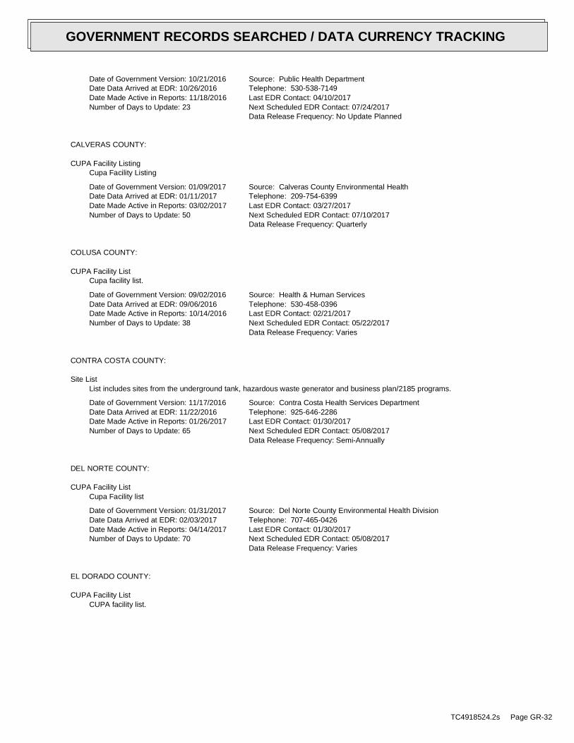
Date of Government Version: 10/21/2016
Date Data Arrived at EDR: 10/26/2016
Date Made Active in Reports: 11/18/2016
Number of Days to Update: 23
Source: Public Health Department
Telephone: 530-538-7149
Last EDR Contact: 04/10/2017
Next Scheduled EDR Contact: 07/24/2017
Data Release Frequency: No Update Planned
CALVERAS COUNTY:
CUPA Facility Listing
Cupa Facility Listing
Date of Government Version: 01/09/2017
Date Data Arrived at EDR: 01/11/2017
Date Made Active in Reports: 03/02/2017
Number of Days to Update: 50
Source: Calveras County Environmental Health
Telephone: 209-754-6399
Last EDR Contact: 03/27/2017
Next Scheduled EDR Contact: 07/10/2017
Data Release Frequency: Quarterly
COLUSA COUNTY:
CUPA Facility List
Cupa facility list.
Date of Government Version: 09/02/2016
Date Data Arrived at EDR: 09/06/2016
Date Made Active in Reports: 10/14/2016
Number of Days to Update: 38
Source: Health & Human Services
Telephone: 530-458-0396
Last EDR Contact: 02/21/2017
Next Scheduled EDR Contact: 05/22/2017
Data Release Frequency: Varies
CONTRA COSTA COUNTY:
Site List
List includes sites from the underground tank, hazardous waste generator and business plan/2185 programs.
Date of Government Version: 11/17/2016
Date Data Arrived at EDR: 11/22/2016
Date Made Active in Reports: 01/26/2017
Number of Days to Update: 65
Source: Contra Costa Health Services Department
Telephone: 925-646-2286
Last EDR Contact: 01/30/2017
Next Scheduled EDR Contact: 05/08/2017
Data Release Frequency: Semi-Annually
DEL NORTE COUNTY:
CUPA Facility List
Cupa Facility list
Date of Government Version: 01/31/2017
Date Data Arrived at EDR: 02/03/2017
Date Made Active in Reports: 04/14/2017
Number of Days to Update: 70
Source: Del Norte County Environmental Health Division
Telephone: 707-465-0426
Last EDR Contact: 01/30/2017
Next Scheduled EDR Contact: 05/08/2017
Data Release Frequency: Varies
EL DORADO COUNTY:
CUPA Facility List
CUPA facility list.
TC4918524.2s Page GR-32
GOVERNMENT RECORDS SEARCHED / DATA CURRENCY TRACKING

Date of Government Version: 11/22/2016
Date Data Arrived at EDR: 11/23/2016
Date Made Active in Reports: 01/17/2017
Number of Days to Update: 55
Source: El Dorado County Environmental Management Department
Telephone: 530-621-6623
Last EDR Contact: 01/30/2017
Next Scheduled EDR Contact: 05/08/2017
Data Release Frequency: Varies
FRESNO COUNTY:
CUPA Resources List
Certified Unified Program Agency. CUPA’s are responsible for implementing a unified hazardous materials and hazardous
waste management regulatory program. The agency provides oversight of businesses that deal with hazardous materials,
operate underground storage tanks or aboveground storage tanks.
Date of Government Version: 01/09/2017
Date Data Arrived at EDR: 01/11/2017
Date Made Active in Reports: 03/02/2017
Number of Days to Update: 50
Source: Dept. of Community Health
Telephone: 559-445-3271
Last EDR Contact: 03/31/2017
Next Scheduled EDR Contact: 07/17/2017
Data Release Frequency: Semi-Annually
HUMBOLDT COUNTY:
CUPA Facility List
CUPA facility list.
Date of Government Version: 01/04/2017
Date Data Arrived at EDR: 01/10/2017
Date Made Active in Reports: 03/02/2017
Number of Days to Update: 51
Source: Humboldt County Environmental Health
Telephone: N/A
Last EDR Contact: 02/21/2017
Next Scheduled EDR Contact: 06/05/2017
Data Release Frequency: Varies
IMPERIAL COUNTY:
CUPA Facility List
Cupa facility list.
Date of Government Version: 01/23/2017
Date Data Arrived at EDR: 01/25/2017
Date Made Active in Reports: 03/02/2017
Number of Days to Update: 36
Source: San Diego Border Field Office
Telephone: 760-339-2777
Last EDR Contact: 04/24/2017
Next Scheduled EDR Contact: 08/07/2017
Data Release Frequency: Varies
INYO COUNTY:
CUPA Facility List
Cupa facility list.
Date of Government Version: 09/10/2013
Date Data Arrived at EDR: 09/11/2013
Date Made Active in Reports: 10/14/2013
Number of Days to Update: 33
Source: Inyo County Environmental Health Services
Telephone: 760-878-0238
Last EDR Contact: 03/06/2017
Next Scheduled EDR Contact: 06/05/2017
Data Release Frequency: Varies
KERN COUNTY:
TC4918524.2s Page GR-33
GOVERNMENT RECORDS SEARCHED / DATA CURRENCY TRACKING

Underground Storage Tank Sites & Tank Listing
Kern County Sites and Tanks Listing.
Date of Government Version: 11/07/2016
Date Data Arrived at EDR: 11/08/2016
Date Made Active in Reports: 01/10/2017
Number of Days to Update: 63
Source: Kern County Environment Health Services Department
Telephone: 661-862-8700
Last EDR Contact: 02/06/2017
Next Scheduled EDR Contact: 05/22/2017
Data Release Frequency: Quarterly
KINGS COUNTY:
CUPA Facility List
A listing of sites included in the county’s Certified Unified Program Agency database. California’s Secretary
for Environmental Protection established the unified hazardous materials and hazardous waste regulatory program
as required by chapter 6.11 of the California Health and Safety Code. The Unified Program consolidates the administration,
permits, inspections, and enforcement activities.
Date of Government Version: 12/14/2016
Date Data Arrived at EDR: 12/16/2016
Date Made Active in Reports: 12/22/2016
Number of Days to Update: 6
Source: Kings County Department of Public Health
Telephone: 559-584-1411
Last EDR Contact: 03/06/2017
Next Scheduled EDR Contact: 06/05/2017
Data Release Frequency: Varies
LAKE COUNTY:
CUPA Facility List
Cupa facility list
Date of Government Version: 01/18/2017
Date Data Arrived at EDR: 01/20/2017
Date Made Active in Reports: 03/02/2017
Number of Days to Update: 41
Source: Lake County Environmental Health
Telephone: 707-263-1164
Last EDR Contact: 04/17/2017
Next Scheduled EDR Contact: 07/31/2017
Data Release Frequency: Varies
LOS ANGELES COUNTY:
San Gabriel Valley Areas of Concern
San Gabriel Valley areas where VOC contamination is at or above the MCL as designated by region 9 EPA office.
Date of Government Version: 03/30/2009
Date Data Arrived at EDR: 03/31/2009
Date Made Active in Reports: 10/23/2009
Number of Days to Update: 206
Source: EPA Region 9
Telephone: 415-972-3178
Last EDR Contact: 03/20/2017
Next Scheduled EDR Contact: 07/03/2017
Data Release Frequency: No Update Planned
HMS: Street Number List
Industrial Waste and Underground Storage Tank Sites.
Date of Government Version: 11/14/2016
Date Data Arrived at EDR: 11/18/2016
Date Made Active in Reports: 01/23/2017
Number of Days to Update: 66
Source: Department of Public Works
Telephone: 626-458-3517
Last EDR Contact: 04/10/2017
Next Scheduled EDR Contact: 07/24/2017
Data Release Frequency: Semi-Annually
List of Solid Waste Facilities
Solid Waste Facilities in Los Angeles County.
TC4918524.2s Page GR-34
GOVERNMENT RECORDS SEARCHED / DATA CURRENCY TRACKING

Date of Government Version: 10/17/2016
Date Data Arrived at EDR: 10/18/2016
Date Made Active in Reports: 12/15/2016
Number of Days to Update: 58
Source: La County Department of Public Works
Telephone: 818-458-5185
Last EDR Contact: 04/18/2017
Next Scheduled EDR Contact: 07/31/2017
Data Release Frequency: Varies
City of Los Angeles Landfills
Landfills owned and maintained by the City of Los Angeles.
Date of Government Version: 01/01/2016
Date Data Arrived at EDR: 01/26/2016
Date Made Active in Reports: 03/22/2016
Number of Days to Update: 56
Source: Engineering & Construction Division
Telephone: 213-473-7869
Last EDR Contact: 04/17/2017
Next Scheduled EDR Contact: 07/31/2017
Data Release Frequency: Varies
Site Mitigation List
Industrial sites that have had some sort of spill or complaint.
Date of Government Version: 03/29/2016
Date Data Arrived at EDR: 04/06/2016
Date Made Active in Reports: 06/13/2016
Number of Days to Update: 68
Source: Community Health Services
Telephone: 323-890-7806
Last EDR Contact: 04/17/2017
Next Scheduled EDR Contact: 07/31/2017
Data Release Frequency: Annually
City of El Segundo Underground Storage Tank
Underground storage tank sites located in El Segundo city.
Date of Government Version: 03/30/2015
Date Data Arrived at EDR: 04/02/2015
Date Made Active in Reports: 04/13/2015
Number of Days to Update: 11
Source: City of El Segundo Fire Department
Telephone: 310-524-2236
Last EDR Contact: 04/17/2017
Next Scheduled EDR Contact: 07/31/2017
Data Release Frequency: Semi-Annually
City of Long Beach Underground Storage Tank
Underground storage tank sites located in the city of Long Beach.
Date of Government Version: 11/04/2015
Date Data Arrived at EDR: 11/13/2015
Date Made Active in Reports: 12/17/2015
Number of Days to Update: 34
Source: City of Long Beach Fire Department
Telephone: 562-570-2563
Last EDR Contact: 04/24/2017
Next Scheduled EDR Contact: 08/07/2017
Data Release Frequency: Annually
City of Torrance Underground Storage Tank
Underground storage tank sites located in the city of Torrance.
Date of Government Version: 10/04/2016
Date Data Arrived at EDR: 10/11/2016
Date Made Active in Reports: 01/12/2017
Number of Days to Update: 93
Source: City of Torrance Fire Department
Telephone: 310-618-2973
Last EDR Contact: 04/10/2017
Next Scheduled EDR Contact: 07/24/2017
Data Release Frequency: Semi-Annually
MADERA COUNTY:
CUPA Facility List
A listing of sites included in the county’s Certified Unified Program Agency database. California’s Secretary
for Environmental Protection established the unified hazardous materials and hazardous waste regulatory program
as required by chapter 6.11 of the California Health and Safety Code. The Unified Program consolidates the administration,
permits, inspections, and enforcement activities.
TC4918524.2s Page GR-35
GOVERNMENT RECORDS SEARCHED / DATA CURRENCY TRACKING

Date of Government Version: 12/05/2016
Date Data Arrived at EDR: 12/09/2016
Date Made Active in Reports: 01/19/2017
Number of Days to Update: 41
Source: Madera County Environmental Health
Telephone: 559-675-7823
Last EDR Contact: 02/21/2017
Next Scheduled EDR Contact: 06/05/2017
Data Release Frequency: Varies
MARIN COUNTY:
Underground Storage Tank Sites
Currently permitted USTs in Marin County.
Date of Government Version: 10/19/2016
Date Data Arrived at EDR: 10/25/2016
Date Made Active in Reports: 01/12/2017
Number of Days to Update: 79
Source: Public Works Department Waste Management
Telephone: 415-499-6647
Last EDR Contact: 03/31/2017
Next Scheduled EDR Contact: 07/17/2017
Data Release Frequency: Semi-Annually
MERCED COUNTY:
CUPA Facility List
CUPA facility list.
Date of Government Version: 12/02/2016
Date Data Arrived at EDR: 12/06/2016
Date Made Active in Reports: 01/17/2017
Number of Days to Update: 42
Source: Merced County Environmental Health
Telephone: 209-381-1094
Last EDR Contact: 02/21/2017
Next Scheduled EDR Contact: 06/05/2017
Data Release Frequency: Varies
MONO COUNTY:
CUPA Facility List
CUPA Facility List
Date of Government Version: 11/29/2016
Date Data Arrived at EDR: 12/05/2016
Date Made Active in Reports: 12/22/2016
Number of Days to Update: 17
Source: Mono County Health Department
Telephone: 760-932-5580
Last EDR Contact: 02/24/2017
Next Scheduled EDR Contact: 06/12/2017
Data Release Frequency: Varies
MONTEREY COUNTY:
CUPA Facility Listing
CUPA Program listing from the Environmental Health Division.
Date of Government Version: 06/24/2016
Date Data Arrived at EDR: 06/27/2016
Date Made Active in Reports: 08/09/2016
Number of Days to Update: 43
Source: Monterey County Health Department
Telephone: 831-796-1297
Last EDR Contact: 02/21/2017
Next Scheduled EDR Contact: 06/05/2017
Data Release Frequency: Varies
NAPA COUNTY:
Sites With Reported Contamination
A listing of leaking underground storage tank sites located in Napa county.
TC4918524.2s Page GR-36
GOVERNMENT RECORDS SEARCHED / DATA CURRENCY TRACKING

Date of Government Version: 01/09/2017
Date Data Arrived at EDR: 01/11/2017
Date Made Active in Reports: 03/02/2017
Number of Days to Update: 50
Source: Napa County Department of Environmental Management
Telephone: 707-253-4269
Last EDR Contact: 03/09/2017
Next Scheduled EDR Contact: 06/12/2017
Data Release Frequency: No Update Planned
Closed and Operating Underground Storage Tank Sites
Underground storage tank sites located in Napa county.
Date of Government Version: 01/15/2008
Date Data Arrived at EDR: 01/16/2008
Date Made Active in Reports: 02/08/2008
Number of Days to Update: 23
Source: Napa County Department of Environmental Management
Telephone: 707-253-4269
Last EDR Contact: 03/09/2017
Next Scheduled EDR Contact: 06/12/2017
Data Release Frequency: No Update Planned
NEVADA COUNTY:
CUPA Facility List
CUPA facility list.
Date of Government Version: 11/07/2016
Date Data Arrived at EDR: 11/08/2016
Date Made Active in Reports: 12/22/2016
Number of Days to Update: 44
Source: Community Development Agency
Telephone: 530-265-1467
Last EDR Contact: 01/30/2017
Next Scheduled EDR Contact: 05/08/2017
Data Release Frequency: Varies
ORANGE COUNTY:
List of Industrial Site Cleanups
Petroleum and non-petroleum spills.
Date of Government Version: 02/06/2017
Date Data Arrived at EDR: 02/10/2017
Date Made Active in Reports: 04/21/2017
Number of Days to Update: 70
Source: Health Care Agency
Telephone: 714-834-3446
Last EDR Contact: 02/06/2017
Next Scheduled EDR Contact: 05/22/2017
Data Release Frequency: Annually
List of Underground Storage Tank Cleanups
Orange County Underground Storage Tank Cleanups (LUST).
Date of Government Version: 11/04/2016
Date Data Arrived at EDR: 11/11/2016
Date Made Active in Reports: 01/23/2017
Number of Days to Update: 73
Source: Health Care Agency
Telephone: 714-834-3446
Last EDR Contact: 02/06/2017
Next Scheduled EDR Contact: 05/22/2017
Data Release Frequency: Quarterly
List of Underground Storage Tank Facilities
Orange County Underground Storage Tank Facilities (UST).
Date of Government Version: 11/03/2016
Date Data Arrived at EDR: 11/08/2016
Date Made Active in Reports: 01/12/2017
Number of Days to Update: 65
Source: Health Care Agency
Telephone: 714-834-3446
Last EDR Contact: 02/07/2017
Next Scheduled EDR Contact: 05/22/2017
Data Release Frequency: Quarterly
PLACER COUNTY:
TC4918524.2s Page GR-37
GOVERNMENT RECORDS SEARCHED / DATA CURRENCY TRACKING
Master List of Facilities
List includes aboveground tanks, underground tanks and cleanup sites.
Date of Government Version: 09/02/2016
Date Data Arrived at EDR: 09/06/2016
Date Made Active in Reports: 10/14/2016
Number of Days to Update: 38
Source: Placer County Health and Human Services
Telephone: 530-745-2363
Last EDR Contact: 03/06/2017
Next Scheduled EDR Contact: 06/19/2017
Data Release Frequency: Semi-Annually
RIVERSIDE COUNTY:
Listing of Underground Tank Cleanup Sites
Riverside County Underground Storage Tank Cleanup Sites (LUST).
Date of Government Version: 04/18/2017
Date Data Arrived at EDR: 04/20/2017
Date Made Active in Reports: 04/21/2017
Number of Days to Update: 1
Source: Department of Environmental Health
Telephone: 951-358-5055
Last EDR Contact: 03/20/2017
Next Scheduled EDR Contact: 07/03/2017
Data Release Frequency: Quarterly
Underground Storage Tank Tank List
Underground storage tank sites located in Riverside county.
Date of Government Version: 10/20/2016
Date Data Arrived at EDR: 10/25/2016
Date Made Active in Reports: 01/10/2017
Number of Days to Update: 77
Source: Department of Environmental Health
Telephone: 951-358-5055
Last EDR Contact: 03/20/2017
Next Scheduled EDR Contact: 07/03/2017
Data Release Frequency: Quarterly
SACRAMENTO COUNTY:
Toxic Site Clean-Up List
List of sites where unauthorized releases of potentially hazardous materials have occurred.
Date of Government Version: 11/07/2016
Date Data Arrived at EDR: 01/05/2017
Date Made Active in Reports: 03/02/2017
Number of Days to Update: 56
Source: Sacramento County Environmental Management
Telephone: 916-875-8406
Last EDR Contact: 04/04/2017
Next Scheduled EDR Contact: 07/17/2017
Data Release Frequency: Quarterly
Master Hazardous Materials Facility List
Any business that has hazardous materials on site - hazardous material storage sites, underground storage tanks,
waste generators.
Date of Government Version: 11/08/2016
Date Data Arrived at EDR: 01/05/2017
Date Made Active in Reports: 03/02/2017
Number of Days to Update: 56
Source: Sacramento County Environmental Management
Telephone: 916-875-8406
Last EDR Contact: 04/04/2017
Next Scheduled EDR Contact: 07/17/2017
Data Release Frequency: Quarterly
SAN BERNARDINO COUNTY:
Hazardous Material Permits
This listing includes underground storage tanks, medical waste handlers/generators, hazardous materials handlers,
hazardous waste generators, and waste oil generators/handlers.
TC4918524.2s Page GR-38
GOVERNMENT RECORDS SEARCHED / DATA CURRENCY TRACKING

Date of Government Version: 12/09/2016
Date Data Arrived at EDR: 12/13/2016
Date Made Active in Reports: 03/03/2017
Number of Days to Update: 80
Source: San Bernardino County Fire Department Hazardous Materials Division
Telephone: 909-387-3041
Last EDR Contact: 02/06/2017
Next Scheduled EDR Contact: 05/22/2017
Data Release Frequency: Quarterly
SAN DIEGO COUNTY:
Hazardous Materials Management Division Database
The database includes: HE58 - This report contains the business name, site address, business phone number, establishment
’H’ permit number, type of permit, and the business status. HE17 - In addition to providing the same information
provided in the HE58 listing, HE17 provides inspection dates, violations received by the establishment, hazardous
waste generated, the quantity, method of storage, treatment/disposal of waste and the hauler, and information
on underground storage tanks. Unauthorized Release List - Includes a summary of environmental contamination cases
in San Diego County (underground tank cases, non-tank cases, groundwater contamination, and soil contamination
are included.)
Date of Government Version: 10/05/2016
Date Data Arrived at EDR: 12/06/2016
Date Made Active in Reports: 03/02/2017
Number of Days to Update: 86
Source: Hazardous Materials Management Division
Telephone: 619-338-2268
Last EDR Contact: 03/10/2017
Next Scheduled EDR Contact: 06/19/2017
Data Release Frequency: Quarterly
Solid Waste Facilities
San Diego County Solid Waste Facilities.
Date of Government Version: 10/31/2015
Date Data Arrived at EDR: 11/07/2015
Date Made Active in Reports: 01/04/2016
Number of Days to Update: 58
Source: Department of Health Services
Telephone: 619-338-2209
Last EDR Contact: 04/24/2017
Next Scheduled EDR Contact: 08/07/2017
Data Release Frequency: Varies
Environmental Case Listing
The listing contains all underground tank release cases and projects pertaining to properties contaminated with
hazardous substances that are actively under review by the Site Assessment and Mitigation Program.
Date of Government Version: 03/23/2010
Date Data Arrived at EDR: 06/15/2010
Date Made Active in Reports: 07/09/2010
Number of Days to Update: 24
Source: San Diego County Department of Environmental Health
Telephone: 619-338-2371
Last EDR Contact: 03/06/2017
Next Scheduled EDR Contact: 06/19/2017
Data Release Frequency: No Update Planned
SAN FRANCISCO COUNTY:
Local Oversite Facilities
A listing of leaking underground storage tank sites located in San Francisco county.
Date of Government Version: 09/19/2008
Date Data Arrived at EDR: 09/19/2008
Date Made Active in Reports: 09/29/2008
Number of Days to Update: 10
Source: Department Of Public Health San Francisco County
Telephone: 415-252-3920
Last EDR Contact: 02/03/2017
Next Scheduled EDR Contact: 05/22/2017
Data Release Frequency: Quarterly
Underground Storage Tank Information
Underground storage tank sites located in San Francisco county.
Date of Government Version: 11/16/2016
Date Data Arrived at EDR: 11/21/2016
Date Made Active in Reports: 01/12/2017
Number of Days to Update: 52
Source: Department of Public Health
Telephone: 415-252-3920
Last EDR Contact: 02/21/2017
Next Scheduled EDR Contact: 05/22/2017
Data Release Frequency: Quarterly
SAN JOAQUIN COUNTY:
TC4918524.2s Page GR-39
GOVERNMENT RECORDS SEARCHED / DATA CURRENCY TRACKING
San Joaquin Co. UST
A listing of underground storage tank locations in San Joaquin county.
Date of Government Version: 12/21/2016
Date Data Arrived at EDR: 12/27/2016
Date Made Active in Reports: 02/14/2017
Number of Days to Update: 49
Source: Environmental Health Department
Telephone: N/A
Last EDR Contact: 03/20/2017
Next Scheduled EDR Contact: 07/03/2017
Data Release Frequency: Semi-Annually
SAN LUIS OBISPO COUNTY:
CUPA Facility List
Cupa Facility List.
Date of Government Version: 11/17/2016
Date Data Arrived at EDR: 11/21/2016
Date Made Active in Reports: 01/19/2017
Number of Days to Update: 59
Source: San Luis Obispo County Public Health Department
Telephone: 805-781-5596
Last EDR Contact: 02/21/2017
Next Scheduled EDR Contact: 06/05/2017
Data Release Frequency: Varies
SAN MATEO COUNTY:
Business Inventory
List includes Hazardous Materials Business Plan, hazardous waste generators, and underground storage tanks.
Date of Government Version: 06/02/2016
Date Data Arrived at EDR: 06/07/2016
Date Made Active in Reports: 06/22/2016
Number of Days to Update: 15
Source: San Mateo County Environmental Health Services Division
Telephone: 650-363-1921
Last EDR Contact: 03/09/2017
Next Scheduled EDR Contact: 06/26/2017
Data Release Frequency: Annually
Fuel Leak List
A listing of leaking underground storage tank sites located in San Mateo county.
Date of Government Version: 03/15/2017
Date Data Arrived at EDR: 04/07/2017
Date Made Active in Reports: 04/21/2017
Number of Days to Update: 14
Source: San Mateo County Environmental Health Services Division
Telephone: 650-363-1921
Last EDR Contact: 03/27/2017
Next Scheduled EDR Contact: 06/26/2017
Data Release Frequency: Semi-Annually
SANTA BARBARA COUNTY:
CUPA Facility Listing
CUPA Program Listing from the Environmental Health Services division.
Date of Government Version: 09/08/2011
Date Data Arrived at EDR: 09/09/2011
Date Made Active in Reports: 10/07/2011
Number of Days to Update: 28
Source: Santa Barbara County Public Health Department
Telephone: 805-686-8167
Last EDR Contact: 02/21/2017
Next Scheduled EDR Contact: 06/05/2017
Data Release Frequency: Varies
SANTA CLARA COUNTY:
Cupa Facility List
Cupa facility list
TC4918524.2s Page GR-40
GOVERNMENT RECORDS SEARCHED / DATA CURRENCY TRACKING

Date of Government Version: 11/16/2016
Date Data Arrived at EDR: 11/21/2016
Date Made Active in Reports: 01/19/2017
Number of Days to Update: 59
Source: Department of Environmental Health
Telephone: 408-918-1973
Last EDR Contact: 02/21/2017
Next Scheduled EDR Contact: 06/05/2017
Data Release Frequency: Varies
HIST LUST - Fuel Leak Site Activity Report
A listing of open and closed leaking underground storage tanks. This listing is no longer updated by the county.
Leaking underground storage tanks are now handled by the Department of Environmental Health.
Date of Government Version: 03/29/2005
Date Data Arrived at EDR: 03/30/2005
Date Made Active in Reports: 04/21/2005
Number of Days to Update: 22
Source: Santa Clara Valley Water District
Telephone: 408-265-2600
Last EDR Contact: 03/23/2009
Next Scheduled EDR Contact: 06/22/2009
Data Release Frequency: No Update Planned
LOP Listing
A listing of leaking underground storage tanks located in Santa Clara county.
Date of Government Version: 03/03/2014
Date Data Arrived at EDR: 03/05/2014
Date Made Active in Reports: 03/18/2014
Number of Days to Update: 13
Source: Department of Environmental Health
Telephone: 408-918-3417
Last EDR Contact: 02/24/2017
Next Scheduled EDR Contact: 06/12/2017
Data Release Frequency: Annually
Hazardous Material Facilities
Hazardous material facilities, including underground storage tank sites.
Date of Government Version: 11/07/2016
Date Data Arrived at EDR: 11/10/2016
Date Made Active in Reports: 01/24/2017
Number of Days to Update: 75
Source: City of San Jose Fire Department
Telephone: 408-535-7694
Last EDR Contact: 02/06/2017
Next Scheduled EDR Contact: 05/22/2017
Data Release Frequency: Annually
SANTA CRUZ COUNTY:
CUPA Facility List
CUPA facility listing.
Date of Government Version: 11/16/2016
Date Data Arrived at EDR: 11/21/2016
Date Made Active in Reports: 01/19/2017
Number of Days to Update: 59
Source: Santa Cruz County Environmental Health
Telephone: 831-464-2761
Last EDR Contact: 02/21/2017
Next Scheduled EDR Contact: 06/05/2017
Data Release Frequency: Varies
SHASTA COUNTY:
CUPA Facility List
Cupa Facility List.
Date of Government Version: 12/13/2016
Date Data Arrived at EDR: 12/16/2016
Date Made Active in Reports: 03/02/2017
Number of Days to Update: 76
Source: Shasta County Department of Resource Management
Telephone: 530-225-5789
Last EDR Contact: 02/21/2017
Next Scheduled EDR Contact: 06/05/2017
Data Release Frequency: Varies
SOLANO COUNTY:
TC4918524.2s Page GR-41
GOVERNMENT RECORDS SEARCHED / DATA CURRENCY TRACKING

Leaking Underground Storage Tanks
A listing of leaking underground storage tank sites located in Solano county.
Date of Government Version: 11/29/2016
Date Data Arrived at EDR: 12/21/2016
Date Made Active in Reports: 12/22/2016
Number of Days to Update: 1
Source: Solano County Department of Environmental Management
Telephone: 707-784-6770
Last EDR Contact: 03/09/2017
Next Scheduled EDR Contact: 06/26/2017
Data Release Frequency: Quarterly
Underground Storage Tanks
Underground storage tank sites located in Solano county.
Date of Government Version: 11/29/2016
Date Data Arrived at EDR: 12/22/2016
Date Made Active in Reports: 01/10/2017
Number of Days to Update: 19
Source: Solano County Department of Environmental Management
Telephone: 707-784-6770
Last EDR Contact: 03/09/2017
Next Scheduled EDR Contact: 06/26/2017
Data Release Frequency: Quarterly
SONOMA COUNTY:
Cupa Facility List
Cupa Facility list
Date of Government Version: 12/22/2016
Date Data Arrived at EDR: 12/27/2016
Date Made Active in Reports: 03/02/2017
Number of Days to Update: 65
Source: County of Sonoma Fire & Emergency Services Department
Telephone: 707-565-1174
Last EDR Contact: 03/27/2017
Next Scheduled EDR Contact: 07/10/2017
Data Release Frequency: Varies
Leaking Underground Storage Tank Sites
A listing of leaking underground storage tank sites located in Sonoma county.
Date of Government Version: 01/04/2017
Date Data Arrived at EDR: 01/06/2017
Date Made Active in Reports: 03/02/2017
Number of Days to Update: 55
Source: Department of Health Services
Telephone: 707-565-6565
Last EDR Contact: 03/27/2017
Next Scheduled EDR Contact: 07/10/2017
Data Release Frequency: Quarterly
SUTTER COUNTY:
Underground Storage Tanks
Underground storage tank sites located in Sutter county.
Date of Government Version: 12/02/2016
Date Data Arrived at EDR: 12/06/2016
Date Made Active in Reports: 01/10/2017
Number of Days to Update: 35
Source: Sutter County Department of Agriculture
Telephone: 530-822-7500
Last EDR Contact: 03/06/2017
Next Scheduled EDR Contact: 06/19/2017
Data Release Frequency: Semi-Annually
TUOLUMNE COUNTY:
CUPA Facility List
Cupa facility list
Date of Government Version: 01/25/2017
Date Data Arrived at EDR: 01/27/2017
Date Made Active in Reports: 03/02/2017
Number of Days to Update: 34
Source: Divison of Environmental Health
Telephone: 209-533-5633
Last EDR Contact: 04/24/2017
Next Scheduled EDR Contact: 08/07/2017
Data Release Frequency: Varies
VENTURA COUNTY:
TC4918524.2s Page GR-42
GOVERNMENT RECORDS SEARCHED / DATA CURRENCY TRACKING

Business Plan, Hazardous Waste Producers, and Operating Underground Tanks
The BWT list indicates by site address whether the Environmental Health Division has Business Plan (B), Waste
Producer (W), and/or Underground Tank (T) information.
Date of Government Version: 09/26/2016
Date Data Arrived at EDR: 10/27/2016
Date Made Active in Reports: 01/17/2017
Number of Days to Update: 82
Source: Ventura County Environmental Health Division
Telephone: 805-654-2813
Last EDR Contact: 04/24/2017
Next Scheduled EDR Contact: 08/07/2017
Data Release Frequency: Quarterly
Inventory of Illegal Abandoned and Inactive Sites
Ventura County Inventory of Closed, Illegal Abandoned, and Inactive Sites.
Date of Government Version: 12/01/2011
Date Data Arrived at EDR: 12/01/2011
Date Made Active in Reports: 01/19/2012
Number of Days to Update: 49
Source: Environmental Health Division
Telephone: 805-654-2813
Last EDR Contact: 03/31/2017
Next Scheduled EDR Contact: 07/17/2017
Data Release Frequency: Annually
Listing of Underground Tank Cleanup Sites
Ventura County Underground Storage Tank Cleanup Sites (LUST).
Date of Government Version: 05/29/2008
Date Data Arrived at EDR: 06/24/2008
Date Made Active in Reports: 07/31/2008
Number of Days to Update: 37
Source: Environmental Health Division
Telephone: 805-654-2813
Last EDR Contact: 02/13/2017
Next Scheduled EDR Contact: 05/29/2017
Data Release Frequency: Quarterly
Medical Waste Program List
To protect public health and safety and the environment from potential exposure to disease causing agents, the
Environmental Health Division Medical Waste Program regulates the generation, handling, storage, treatment and
disposal of medical waste throughout the County.
Date of Government Version: 09/26/2016
Date Data Arrived at EDR: 10/27/2016
Date Made Active in Reports: 01/24/2017
Number of Days to Update: 89
Source: Ventura County Resource Management Agency
Telephone: 805-654-2813
Last EDR Contact: 04/24/2017
Next Scheduled EDR Contact: 08/07/2017
Data Release Frequency: Quarterly
Underground Tank Closed Sites List
Ventura County Operating Underground Storage Tank Sites (UST)/Underground Tank Closed Sites List.
Date of Government Version: 11/28/2016
Date Data Arrived at EDR: 12/14/2016
Date Made Active in Reports: 01/12/2017
Number of Days to Update: 29
Source: Environmental Health Division
Telephone: 805-654-2813
Last EDR Contact: 03/15/2017
Next Scheduled EDR Contact: 06/26/2017
Data Release Frequency: Quarterly
YOLO COUNTY:
Underground Storage Tank Comprehensive Facility Report
Underground storage tank sites located in Yolo county.
Date of Government Version: 11/14/2016
Date Data Arrived at EDR: 11/18/2016
Date Made Active in Reports: 01/12/2017
Number of Days to Update: 55
Source: Yolo County Department of Health
Telephone: 530-666-8646
Last EDR Contact: 03/31/2017
Next Scheduled EDR Contact: 07/17/2017
Data Release Frequency: Annually
YUBA COUNTY:
TC4918524.2s Page GR-43
GOVERNMENT RECORDS SEARCHED / DATA CURRENCY TRACKING

CUPA Facility List
CUPA facility listing for Yuba County.
Date of Government Version: 10/28/2016
Date Data Arrived at EDR: 11/03/2016
Date Made Active in Reports: 12/15/2016
Number of Days to Update: 42
Source: Yuba County Environmental Health Department
Telephone: 530-749-7523
Last EDR Contact: 01/30/2017
Next Scheduled EDR Contact: 05/08/2017
Data Release Frequency: Varies
OTHER DATABASE(S)
Depending on the geographic area covered by this report, the data provided in these specialty databases may or may not be
complete. For example, the existence of wetlands information data in a specific report does not mean that all wetlands in the
area covered by the report are included. Moreover, the absence of any reported wetlands information does not necessarily
mean that wetlands do not exist in the area covered by the report.
CT MANIFEST: Hazardous Waste Manifest Data
Facility and manifest data. Manifest is a document that lists and tracks hazardous waste from the generator through
transporters to a tsd facility.
Date of Government Version: 07/30/2013
Date Data Arrived at EDR: 08/19/2013
Date Made Active in Reports: 10/03/2013
Number of Days to Update: 45
Source: Department of Energy & Environmental Protection
Telephone: 860-424-3375
Last EDR Contact: 11/11/2016
Next Scheduled EDR Contact: 02/27/2017
Data Release Frequency: No Update Planned
NJ MANIFEST: Manifest Information
Hazardous waste manifest information.
Date of Government Version: 12/31/2015
Date Data Arrived at EDR: 09/29/2016
Date Made Active in Reports: 01/03/2017
Number of Days to Update: 96
Source: Department of Environmental Protection
Telephone: N/A
Last EDR Contact: 04/11/2017
Next Scheduled EDR Contact: 07/24/2017
Data Release Frequency: Annually
NY MANIFEST: Facility and Manifest Data
Manifest is a document that lists and tracks hazardous waste from the generator through transporters to a TSD
facility.
Date of Government Version: 01/30/2017
Date Data Arrived at EDR: 02/01/2017
Date Made Active in Reports: 02/13/2017
Number of Days to Update: 12
Source: Department of Environmental Conservation
Telephone: 518-402-8651
Last EDR Contact: 02/01/2017
Next Scheduled EDR Contact: 05/08/2017
Data Release Frequency: Annually
PA MANIFEST: Manifest Information
Hazardous waste manifest information.
Date of Government Version: 12/31/2015
Date Data Arrived at EDR: 07/22/2016
Date Made Active in Reports: 11/22/2016
Number of Days to Update: 123
Source: Department of Environmental Protection
Telephone: 717-783-8990
Last EDR Contact: 04/18/2017
Next Scheduled EDR Contact: 07/31/2017
Data Release Frequency: Annually
RI MANIFEST: Manifest information
Hazardous waste manifest information
Date of Government Version: 12/31/2013
Date Data Arrived at EDR: 06/19/2015
Date Made Active in Reports: 07/15/2015
Number of Days to Update: 26
Source: Department of Environmental Management
Telephone: 401-222-2797
Last EDR Contact: 02/21/2017
Next Scheduled EDR Contact: 06/05/2017
Data Release Frequency: Annually
TC4918524.2s Page GR-44
GOVERNMENT RECORDS SEARCHED / DATA CURRENCY TRACKING

WI MANIFEST: Manifest Information
Hazardous waste manifest information.
Date of Government Version: 12/31/2015
Date Data Arrived at EDR: 04/14/2016
Date Made Active in Reports: 06/03/2016
Number of Days to Update: 50
Source: Department of Natural Resources
Telephone: N/A
Last EDR Contact: 03/13/2017
Next Scheduled EDR Contact: 06/26/2017
Data Release Frequency: Annually
Oil/Gas Pipelines
Source: PennWell Corporation
Petroleum Bundle (Crude Oil, Refined Products, Petrochemicals, Gas Liquids (LPG/NGL), and Specialty
Gases (Miscellaneous)) N = Natural Gas Bundle (Natural Gas, Gas Liquids (LPG/NGL), and Specialty Gases
(Miscellaneous)). This map includes information copyrighted by PennWell Corporation. This information
is provided on a best effort basis and PennWell Corporation does not guarantee its accuracy nor warrant
its fitness for any particular purpose. Such information has been reprinted with the permission of PennWell.
Electric Power Transmission Line Data
Source: PennWell Corporation
This map includes information copyrighted by PennWell Corporation. This information is provided on a best
effort basis and PennWell Corporation does not guarantee its accuracy nor warrant its fitness for any
particular purpose. Such information has been reprinted with the permission of PennWell.
Sensitive Receptors: There are individuals deemed sensitive receptors due to their fragile immune systems and special sensitivity
to environmental discharges. These sensitive receptors typically include the elderly, the sick, and children. While the location of all
sensitive receptors cannot be determined, EDR indicates those buildings and facilities - schools, daycares, hospitals, medical centers,
and nursing homes - where individuals who are sensitive receptors are likely to be located.
AHA Hospitals:
Source: American Hospital Association, Inc.
Telephone: 312-280-5991
The database includes a listing of hospitals based on the American Hospital Association’s annual survey of hospitals.
Medical Centers: Provider of Services Listing
Source: Centers for Medicare & Medicaid Services
Telephone: 410-786-3000
A listing of hospitals with Medicare provider number, produced by Centers of Medicare & Medicaid Services,
a federal agency within the U.S. Department of Health and Human Services.
Nursing Homes
Source: National Institutes of Health
Telephone: 301-594-6248
Information on Medicare and Medicaid certified nursing homes in the United States.
Public Schools
Source: National Center for Education Statistics
Telephone: 202-502-7300
The National Center for Education Statistics’ primary database on elementary
and secondary public education in the United States. It is a comprehensive, annual, national statistical
database of all public elementary and secondary schools and school districts, which contains data that are
comparable across all states.
Private Schools
Source: National Center for Education Statistics
Telephone: 202-502-7300
The National Center for Education Statistics’ primary database on private school locations in the United States.
Daycare Centers: Licensed Facilities
Source: Department of Social Services
Telephone: 916-657-4041
Flood Zone Data: This data was obtained from the Federal Emergency Management Agency (FEMA). It depicts 100-year and
500-year flood zones as defined by FEMA. It includes the National Flood Hazard Layer (NFHL) which incorporates Flood
Insurance Rate Map (FIRM) data and Q3 data from FEMA in areas not covered by NFHL.
Source: FEMA
Telephone: 877-336-2627
Date of Government Version: 2003, 2015
TC4918524.2s Page GR-45
GOVERNMENT RECORDS SEARCHED / DATA CURRENCY TRACKING

NWI: National Wetlands Inventory. This data, available in select counties across the country, was obtained by EDR
in 2002, 2005 and 2010 from the U.S. Fish and Wildlife Service.
State Wetlands Data: Wetland Inventory
Source: Department of Fish & Game
Telephone: 916-445-0411
Current USGS 7.5 Minute Topographic Map
Source: U.S. Geological Survey
STREET AND ADDRESS INFORMATION
© 2015 TomTom North America, Inc. All rights reserved. This material is proprietary and the subject of copyright protection
and other intellectual property rights owned by or licensed to Tele Atlas North America, Inc. The use of this material is subject
to the terms of a license agreement. You will be held liable for any unauthorized copying or disclosure of this material.
TC4918524.2s Page GR-46
GOVERNMENT RECORDS SEARCHED / DATA CURRENCY TRACKING

TC4918524.2s Page A-1
geologic strata.of the soil, and nearby wells. Groundwater flow velocity is generally impacted by the nature of theGroundwater flow direction may be impacted by surface topography, hydrology, hydrogeology, characteristics
2. Groundwater flow velocity. 1. Groundwater flow direction, and
Assessment of the impact of contaminant migration generally has two principal investigative components:
forming an opinion about the impact of potential contaminant migration.EDR’s GeoCheck Physical Setting Source Addendum is provided to assist the environmental professional in
2012Version Date:5619056 BALDWIN PARK, CAWest Map:
2012Version Date:5619080 SAN DIMAS, CATarget Property Map:
USGS TOPOGRAPHIC MAP
602 ft. above sea levelElevation:3770161.0UTM Y (Meters):420543.2UTM X (Meters):Zone 11Universal Tranverse Mercator:117.861092 - 117˚ 51’ 39.93’’Longitude (West):34.070935 - 34˚ 4’ 15.37’’Latitude (North):
TARGET PROPERTY COORDINATES
COVINA, CA 91724EAST HOLT AVENUE AND PARK VIEW DRIVEPROPOSED ASSISTED LIVING
TARGET PROPERTY ADDRESS
GEOCHECK - PHYSICAL SETTING SOURCE ADDENDUM

TC4918524.2s Page A-2
should be field verified.on a relative (not an absolute) basis. Relative elevation information between sites of close proximitySource: Topography has been determined from the USGS 7.5’ Digital Elevation Model and should be evaluated
SURROUNDING TOPOGRAPHY: ELEVATION PROFILES
Ele
vation
(ft)
Ele
va
tio
n(f
t)
TP
TP0 1/2 1 Miles
Target Property Elevation: 602 ft.
North South
West East
83
2
87
8
85
574
6
748
77
766
5
64
3
63
4
60
2
61
7
62
156
0
563
55
4
59
2
62
4
64
7
64
94
83
49
1
53
9
56
9
56
8
57
0
57
9
591
59
3
60
2
64
6
71
9
77
2
806
86
6
83
2
88
0
905
97
9
General WestGeneral Topographic Gradient:TARGET PROPERTY TOPOGRAPHY
should contamination exist on the target property, what downgradient sites might be impacted.assist the environmental professional in forming an opinion about the impact of nearby contaminated properties or,Surface topography may be indicative of the direction of surficial groundwater flow. This information can be used to
TOPOGRAPHIC INFORMATION
collected on nearby properties, and regional groundwater flow information (from deep aquifers).sources of information, such as surface topographic information, hydrologic information, hydrogeologic datausing site-specific well data. If such data is not reasonably ascertainable, it may be necessary to rely on otherGroundwater flow direction for a particular site is best determined by a qualified environmental professional
GROUNDWATER FLOW DIRECTION INFORMATION
GEOCHECK - PHYSICAL SETTING SOURCE SUMMARY

TC4918524.2s Page A-3
Not Reported
GENERAL DIRECTIONLOCATION
GROUNDWATER FLOWFROM TPMAP ID
hydrogeologically, and the depth to water table.authorities at select sites and has extracted the date of the report, groundwater flow direction as determinedflow at specific points. EDR has reviewed reports submitted by environmental professionals to regulatoryEDR has developed the AQUIFLOW Information System to provide data on the general direction of groundwater
AQUIFLOW
Search Radius: 1.000 Mile.
Not found Status:1.25 miles Search Radius:
Site-Specific Hydrogeological Data*:
* ©1996 Site−specific hydrogeological data gathered by CERCLIS Alerts, Inc., Bainbridge Island, WA. All rights reserved. All of the information and opinions presented are those of the cited EPA report(s), which were completed undera Comprehensive Environmental Response Compensation and Liability Information System (CERCLIS) investigation.
contamination exist on the target property, what downgradient sites might be impacted.environmental professional in forming an opinion about the impact of nearby contaminated properties or, shouldof groundwater flow direction in the immediate area. Such hydrogeologic information can be used to assist theHydrogeologic information obtained by installation of wells on a specific site can often be an indicator
HYDROGEOLOGIC INFORMATION
YES - refer to the Overview Map and Detail MapSAN DIMAS
NATIONAL WETLAND INVENTORY
NWI ElectronicData CoverageNWI Quad at Target Property
FEMA FIRM Flood data06037C1695F FEMA FIRM Flood data06037C1700F
Additional Panels in search area: FEMA Source Type
FEMA FIRM Flood data06037C1725F
Flood Plain Panel at Target Property FEMA Source Type
FEMA FLOOD ZONE
and bodies of water).Refer to the Physical Setting Source Map following this summary for hydrologic information (major waterways
contamination exist on the target property, what downgradient sites might be impacted.the environmental professional in forming an opinion about the impact of nearby contaminated properties or, shouldSurface water can act as a hydrologic barrier to groundwater flow. Such hydrologic information can be used to assist
HYDROLOGIC INFORMATION
GEOCHECK - PHYSICAL SETTING SOURCE SUMMARY

TC4918524.2s Page A-4
> 20 inchesDepth to Bedrock Max:
> 8 inchesDepth to Bedrock Min:
HIGHCorrosion Potential - Uncoated Steel:
Hydric Status: Soil does not meet the requirements for a hydric soil.
water table is more than 6 feet.Well drained. Soils have intermediate water holding capacity. Depth toSoil Drainage Class:
water table, or are shallow to an impervious layer.Class D - Very slow infiltration rates. Soils are clayey, have a highHydrologic Group:
clay loamSoil Surface Texture:
CALLEGUASSoil Component Name:
The following information is based on Soil Conservation Service STATSGO data.in a landscape. Soil maps for STATSGO are compiled by generalizing more detailed (SSURGO) soil survey maps.for privately owned lands in the United States. A soil map in a soil survey is a representation of soil patternsSurvey (NCSS) and is responsible for collecting, storing, maintaining and distributing soil survey informationThe U.S. Department of Agriculture’s (USDA) Soil Conservation Service (SCS) leads the National Cooperative Soil
DOMINANT SOIL COMPOSITION IN GENERAL AREA OF TARGET PROPERTY
Map, USGS Digital Data Series DDS - 11 (1994).of the Conterminous U.S. at 1:2,500,000 Scale - a digital representation of the 1974 P.B. King and H.M. BeikmanGeologic Age and Rock Stratigraphic Unit Source: P.G. Schruben, R.E. Arndt and W.J. Bawiec, Geology
ROCK STRATIGRAPHIC UNIT GEOLOGIC AGE IDENTIFICATION
Volcanic RocksCategory:CenozoicEra:TertiarySystem:Miocene volcanic rocksSeries:TmvCode: (decoded above as Era, System & Series)
at which contaminant migration may be occurring.Geologic information can be used by the environmental professional in forming an opinion about the relative speed
GEOLOGIC INFORMATION IN GENERAL AREA OF TARGET PROPERTY
move more quickly through sandy-gravelly types of soils than silty-clayey types of soils.characteristics data collected on nearby properties and regional soil information. In general, contaminant plumesto rely on other sources of information, including geologic age identification, rock stratigraphic unit and soilusing site specific geologic and soil strata data. If such data are not reasonably ascertainable, it may be necessaryGroundwater flow velocity information for a particular site is best determined by a qualified environmental professional
GROUNDWATER FLOW VELOCITY INFORMATION
GEOCHECK - PHYSICAL SETTING SOURCE SUMMARY
TC4918524.2s Page A-5
opinion about the impact of contaminant migration on nearby drinking water wells.professional in assessing sources that may impact ground water flow direction, and in forming anEDR Local/Regional Water Agency records provide water well information to assist the environmental
LOCAL / REGIONAL WATER AGENCY RECORDS
gravelly - sandy loamstratifiedunweathered bedrockloamDeeper Soil Types:
gravelly - loamfine sandy loamsilty clay loamclay loamShallow Soil Types:
unweathered bedrockcobbly - loamloamsandy loamclaygravelly - loamSurficial Soil Types:
unweathered bedrockcobbly - loamloamsandy loamclaygravelly - loamSoil Surface Textures:
appear within the general area of target property.Based on Soil Conservation Service STATSGO data, the following additional subordinant soil types may
OTHER SOIL TYPES IN AREA
Min: 0.00
Max: 0.00
Min: 0.00
Max: 0.00Not reportedNot reported
bedrock
weathered20 inches16 inches 2
Min: 7.90
Max: 8.40
Min: 0.60
Max: 2.00
50%), Lean Clay
limit less than
Clays (liquid
SOILS, Silts and
FINE-GRAINED
Soils.
200), Clayey
passing No.
than 35 pct.
Materials (more
Silt-Clayclay loam16 inches 0 inches 1
Soil Layer Information
Boundary Classification
PermeabilityRate (in/hr)
Layer Upper Lower Soil Texture Class AASHTO Group Unified Soil Soil Reaction(pH)
GEOCHECK - PHYSICAL SETTING SOURCE SUMMARY

TC4918524.2s Page A-6
1/2 - 1 Mile NNW1256 1
STATE DATABASE WELL INFORMATION
LOCATION
FROM TPWELL IDMAP ID
Note: PWS System location is not always the same as well location.
No PWS System Found
FEDERAL FRDS PUBLIC WATER SUPPLY SYSTEM INFORMATION
LOCATION
FROM TPWELL IDMAP ID
No Wells Found
FEDERAL USGS WELL INFORMATION
LOCATION
FROM TPWELL IDMAP ID
1.000State Database
Nearest PWS within 1 mileFederal FRDS PWS
1.000Federal USGS
WELL SEARCH DISTANCE INFORMATION
SEARCH DISTANCE (miles)DATABASE
GEOCHECK - PHYSICAL SETTING SOURCE SUMMARY

EDR Inc.EDR Inc.EDR Inc.EDR Inc.EDR Inc.EDR Inc.EDR Inc.EDR Inc.EDR Inc.EDR Inc.EDR Inc.EDR Inc.EDR Inc.EDR Inc.EDR Inc.EDR Inc.EDR Inc.EDR Inc.EDR Inc.EDR Inc.EDR Inc.EDR Inc.EDR Inc.EDR Inc.EDR Inc.EDR Inc.EDR Inc.EDR Inc.EDR Inc.EDR Inc.EDR Inc.EDR Inc.EDR Inc.EDR Inc.EDR Inc.EDR Inc.EDR Inc.EDR Inc.EDR Inc.EDR Inc.
60
0
5 6 0
56
0
5 2 0
5
20
640
7 6 07 2
06 8 0
9 2 08 8 0
8 40
80 0
0 0
76
0
6 0
72
0
7 2 00
68
0
6 8 0
64
0
6 4 0
6 0 0
6 0 0
5 6 0
5 6 0
5
2 0
7 6 0
8 00
88
0
8 4 0
1
0 00
9
60
96
0
9 60
9
92
0
9
20
9
20
52
0
52
0
56 0
9 6 09 6 09
6 0
5
20
56
0
5 6 0
5 6 0
56
0
5 6 0
56
0
124
0
12
40
1 240
6 0 0
6 0 0
6 0 0
60 0
6 0 0
6 00
60
0
60
0
60
06 0
0
1 320
1 2 00
12
00
1280
11
60
11
60
12
80
1 2 8 0
12
80
64
0
6
40
6 4 0
64
06
4 0
64
0
6 4 0
6 4 0
6 4 0
64
0
6 4 0
6 4 0
640
1
320
1
280
1
3
20
1240
12
80
68 0
6
8 06
6 8 0
6 8 0
6 8 0
6 8 0
6 8 0
6 8 0
6 8 0
6 8 0
6
8 0
68
0
12
40
12
40
12
401 2 4 0
1
200
1
2 0 0
12
00
12
00
1 2 00
1
2 0 0
11
60
11
60
11 6 0
11
60
11
60
1
1 60
11
6 0
11
20
11
20
11
20
1 1 20
11
20
1 120
1 1 20
11
20
10
80
10
80
1
08
0
1
1 0 8 0
10
80
10
80
10
80
7 2 0
72
0
7 2 0
7 2 0
7 2 0
7 2 072
0
72
0
72
0
72 0
72
0
72
0
72
0
72
0
1
04
0
9
20
10 40
10
40
1
040
1 0 4 0
1
04 0
1
0
40
1 0 4 0
1 040 960
76
0
7 60
7 6 0
76
0
7 6 0
7
6 0
760
760
76
0
76
0
1 0 0 0
10
0 0
1 0 0 0
10
00
10 0 0
10
00
1 0 0 0
1 00 0
10
00
80
0
8 0 08
00
8 0 0
8 00
80
0
80 0
8 0 0
8 0 0
80
0
80
0
80
0
84
0
8 4 0
84
0
8 4 0
8 4 0
8 4 0
8 4 0
8
4 0
8 4 0
8 4 0
8 4 0
8
40
84
0
84
0
8 8 0
88
088
0
88
0
8 8 0
8 8 0
8 8 0
8 8 0
8 80
8
8 0
88
0
88 0
88
0
88
0
88
0
9 2 0
9 2 0
9 2 0
9 2 0
9 2 0
9
20
9
20
9 2 0
9 2 0
92
0
0
9609 6 0
96
0
9 6 0
96
0
96
0
9 6 010
81
04
10
00
9 6 0
9 6 0
9
2 0
9
20
8 8 0
8 4 00
CA

TC4918524.2s Page A-8
CITY OF COVINAArea Served:
8082Connections:43800Pop Served:
COVINA, CA 91723
534 N. BARRANCA
Organization That Operates System:
COVINA-CITY, WATER DEPT.System Name:
1910127System Number:
GRAND AVE. WELL - INACTIVESource Name:
UndefinedPrecision:340500.0 1175200.0Source Lat/Long:
Inactive RawWell Status:Well/GroundwaterWater Type:
WELL/AMBNT/MUN/INTAKE/SUPPLYStation Type:07District Number:
Los AngelesCounty:1910127003FRDS Number:
4THUser ID:01S/10W-12R01 SPrime Station Code:
Water System Information:
1NNW1/2 - 1 MileHigher
1256CA WELLS
Map IDDirectionDistanceElevation EDR ID NumberDatabase
GEOCHECK - PHYSICAL SETTING SOURCE MAP FINDINGS

TC4918524.2s Page A-9
0%0%100%0.933 pCi/LBasement
Not ReportedNot ReportedNot ReportedNot ReportedLiving Area - 2nd Floor
0%2%98%0.711 pCi/LLiving Area - 1st Floor
% >20 pCi/L% 4-20 pCi/L% <4 pCi/LAverage ActivityArea
Number of sites tested: 63
Federal Area Radon Information for LOS ANGELES COUNTY, CA
: Zone 3 indoor average level < 2 pCi/L.
: Zone 2 indoor average level >= 2 pCi/L and <= 4 pCi/L.
Note: Zone 1 indoor average level > 4 pCi/L.
Federal EPA Radon Zone for LOS ANGELES County: 2
11591724
______________________
> 4 pCi/LNum TestsZipcode
Radon Test Results
State Database: CA Radon
AREA RADON INFORMATION
GEOCHECK - PHYSICAL SETTING SOURCE MAP FINDINGS
RADON

TOPOGRAPHIC INFORMATION
USGS 7.5’ Digital Elevation Model (DEM)
Source: United States Geologic Survey
EDR acquired the USGS 7.5’ Digital Elevation Model in 2002 and updated it in 2006. The 7.5 minute DEM corresponds
to the USGS 1:24,000- and 1:25,000-scale topographic quadrangle maps. The DEM provides elevation data
with consistent elevation units and projection.
Current USGS 7.5 Minute Topographic Map
Source: U.S. Geological Survey
HYDROLOGIC INFORMATION
Flood Zone Data: This data was obtained from the Federal Emergency Management Agency (FEMA). It depicts 100-year and
500-year flood zones as defined by FEMA. It includes the National Flood Hazard Layer (NFHL) which incorporates Flood
Insurance Rate Map (FIRM) data and Q3 data from FEMA in areas not covered by NFHL.
Source: FEMA
Telephone: 877-336-2627
Date of Government Version: 2003, 2015
NWI: National Wetlands Inventory. This data, available in select counties across the country, was obtained by EDR
in 2002, 2005 and 2010 from the U.S. Fish and Wildlife Service.
State Wetlands Data: Wetland Inventory
Source: Department of Fish & Game
Telephone: 916-445-0411
HYDROGEOLOGIC INFORMATION
AQUIFLOW Information SystemR
Source: EDR proprietary database of groundwater flow information
EDR has developed the AQUIFLOW Information System (AIS) to provide data on the general direction of groundwater
flow at specific points. EDR has reviewed reports submitted to regulatory authorities at select sites and has
extracted the date of the report, hydrogeologically determined groundwater flow direction and depth to water table
information.
GEOLOGIC INFORMATION
Geologic Age and Rock Stratigraphic Unit
Source: P.G. Schruben, R.E. Arndt and W.J. Bawiec, Geology of the Conterminous U.S. at 1:2,500,000 Scale - A digital
representation of the 1974 P.B. King and H.M. Beikman Map, USGS Digital Data Series DDS - 11 (1994).
STATSGO: State Soil Geographic Database
Source: Department of Agriculture, Natural Resources Conservation Service (NRCS)
The U.S. Department of Agriculture’s (USDA) Natural Resources Conservation Service (NRCS) leads the national
Conservation Soil Survey (NCSS) and is responsible for collecting, storing, maintaining and distributing soil
survey information for privately owned lands in the United States. A soil map in a soil survey is a representation
of soil patterns in a landscape. Soil maps for STATSGO are compiled by generalizing more detailed (SSURGO)
soil survey maps.
SSURGO: Soil Survey Geographic Database
Source: Department of Agriculture, Natural Resources Conservation Service (NRCS)
Telephone: 800-672-5559
SSURGO is the most detailed level of mapping done by the Natural Resources Conservation Service, mapping
scales generally range from 1:12,000 to 1:63,360. Field mapping methods using national standards are used to
construct the soil maps in the Soil Survey Geographic (SSURGO) database. SSURGO digitizing duplicates the
original soil survey maps. This level of mapping is designed for use by landowners, townships and county
natural resource planning and management.
TC4918524.2s Page PSGR-1
PHYSICAL SETTING SOURCE RECORDS SEARCHED

LOCAL / REGIONAL WATER AGENCY RECORDS
FEDERAL WATER WELLS
PWS: Public Water Systems
Source: EPA/Office of Drinking Water
Telephone: 202-564-3750
Public Water System data from the Federal Reporting Data System. A PWS is any water system which provides water to at
least 25 people for at least 60 days annually. PWSs provide water from wells, rivers and other sources.
PWS ENF: Public Water Systems Violation and Enforcement Data
Source: EPA/Office of Drinking Water
Telephone: 202-564-3750
Violation and Enforcement data for Public Water Systems from the Safe Drinking Water Information System (SDWIS) after
August 1995. Prior to August 1995, the data came from the Federal Reporting Data System (FRDS).
USGS Water Wells: USGS National Water Inventory System (NWIS)
This database contains descriptive information on sites where the USGS collects or has collected data on surface
water and/or groundwater. The groundwater data includes information on wells, springs, and other sources of groundwater.
STATE RECORDS
Water Well Database
Source: Department of Water Resources
Telephone: 916-651-9648
California Drinking Water Quality Database
Source: Department of Public Health
Telephone: 916-324-2319
The database includes all drinking water compliance and special studies monitoring for the state of California
since 1984. It consists of over 3,200,000 individual analyses along with well and water system information.
OTHER STATE DATABASE INFORMATION
California Oil and Gas Well Locations
Source: Department of Conservation
Telephone: 916-323-1779
Oil and Gas well locations in the state.
RADON
State Database: CA Radon
Source: Department of Health Services
Telephone: 916-324-2208
Radon Database for California
Area Radon Information
Source: USGS
Telephone: 703-356-4020
The National Radon Database has been developed by the U.S. Environmental Protection Agency
(USEPA) and is a compilation of the EPA/State Residential Radon Survey and the National Residential Radon Survey.
The study covers the years 1986 - 1992. Where necessary data has been supplemented by information collected at
private sources such as universities and research institutions.
EPA Radon Zones
Source: EPA
Telephone: 703-356-4020
Sections 307 & 309 of IRAA directed EPA to list and identify areas of U.S. with the potential for elevated indoor
radon levels.
TC4918524.2s Page PSGR-2
PHYSICAL SETTING SOURCE RECORDS SEARCHED
OTHER
Airport Landing Facilities: Private and public use landing facilities
Source: Federal Aviation Administration, 800-457-6656
Epicenters: World earthquake epicenters, Richter 5 or greater
Source: Department of Commerce, National Oceanic and Atmospheric Administration
California Earthquake Fault Lines: The fault lines displayed on EDR’s Topographic map are digitized quaternary fault lines,
prepared in 1975 by the United State Geological Survey. Additional information (also from 1975) regarding activity at specific fault
lines comes from California’s Preliminary Fault Activity Map prepared by the California Division of Mines and Geology.
STREET AND ADDRESS INFORMATION
© 2015 TomTom North America, Inc. All rights reserved. This material is proprietary and the subject of copyright protection
and other intellectual property rights owned by or licensed to Tele Atlas North America, Inc. The use of this material is subject
to the terms of a license agreement. You will be held liable for any unauthorized copying or disclosure of this material.
TC4918524.2s Page PSGR-3
PHYSICAL SETTING SOURCE RECORDS SEARCHED

APPENDIX E
CREDENTIALS

Geo tec hn i ca l ■ En v i r on m en t a l ■ Co ns t ruc t i on M at e r i a l s ■ F ac i l i t i es
CHANDEL DAVISSTAFF ENVIRONMENTAL SCIENTIST
PROFESSIONAL EXPERIENCEMs. Davis is a staff environmental scientist in Terracon’s Orange County,California office. Ms. Davis has a master’s degree in environmentalscience and is currently a project manager working on Phase IEnvironmental Site Assessments (ESAs) and environmental compliance projects. Ms. Davis prepares ESA reports by researching city directories, agency records, topographic maps, and aerial photographs as well as conducting site assessments on vacant land, office, retail, warehouse, industrial, automotive, and telecommunications sites. Ms. Davis also received her Qualified Industrial Stormwater Practitioner (QISP) certification and utilizes that qualification in her environmental compliance work.
PROJECT EXPERIENCE
Office Buildings – California Project manager for Environmental Site Assessments on multiple office properties.
Retail Buildings – California Project manager for Environmental Site Assessments on multiple retail properties.
Warehouse Buildings – California Project manager for Environmental Site Assessments on multiple warehouse properties.
Industrial Buildings – CaliforniaProject manager for Environmental Site Assessments on multipleindustrial properties.
Telecommunications Sites – California Project manager for Environmental Site Assessments on multiple properties proposed for telecommunications installations.
PRESENTATIONS “Relationships between Fennel (Foeniculum vulgare Mill.) Seed Mass, Germination Rate, and Soil Water Deficit in California” presented at the Ecological Society of America national convention, August 2014.
EducationMaster of Science,Environmental Engineering, California State University Fullerton, 2017
Master of Science,Environmental Studies- Scienceand Technology, CaliforniaState University Fullerton, 2014
Bachelors, Florida Institute ofTechnology, 2011
Work HistoryTerracon Consultants, Inc.,Environmental Staff Scientist,2014-Present
California State UniversityFullerton, Biology Department,Teaching Assistant, 2012-2014
Env i ro nm e nt a l ■ Fa c i l i t i es ■ Ge o t ech n i c a l ■ Ma te r i a l s
ISLAM (SAMI) R. NOAMAN, E.I.T. ENVIRONMENTAL DEPARTMENT MANAGER
PROFESSIONAL EXPERIENCE
Mr. Noaman is an environmental Department Manager with track record in client management, management of phases of environmental site assessments (ESAs), business environmental risk reviews, site characterizations, regulatory compliance services, and remediation projects. Possess excellent analytical, problem solving, advisory, and team management skills.
PROJECT EXPERIENCE
Environmental Site Assessments (ESA):
Performed and managed hundreds of ESAs in California for industrial, commercial,
residential, and agricultural properties. Managed long-term national accounts for financial
institutions (equity and loan portfolios), major retail chains, real estate investment trusts,
developers and other real property owners. Mr. Noaman understands facility operating
systems; state and federal regulations; and fate and transport of chemicals through air, soil,
soil vapor, surface water and groundwater. He is experienced in the performance of ESAs
under the All Appropriate Inquiry (AAI) rules (ASTM 1527-13), and meets the requirements
of an Environmental Professional as defined in Section 312.10 of 40 CFR 312.
Limited Subsurface Investigations (LSIs):
Performed and managed hundreds of LSIs in California, New Jersey, and New York.
Investigated environmental conditions in soils and groundwater as a result of releases from
a variety of sources, including service stations, dry cleaners, and a wide range of industrial
and manufacturing operations. Specialized in collection and interpretation of data to pursue
closure through state and federal programs including Los Angeles County Site Mitigation
Unit, the California Regional Water Quality Control Board, and the Department Of Toxic
Substances Control Voluntary Cleanup Programs (VCP).
Hazardous Materials Surveys:
Managed and/or provided quality assurance for numerous hazardous materials surveys in
the state of california including, but not limited to, acm, lead in paint, mold, pcbs, and
mercury-containing equipment. Acm surveys were performed in accordance with ahera and
neshap guidelines on commercial, multi-family residential, and educational properties slated
for renovation or demolition.
Stormwater Prevention and Pollution Control Plan (SWPPP):
Managed SWPPP for numerous industrial sites in Southern California. Scope of the work
typically included client and agency coordination, implementation of guidelines required by
the state of California Water Resources Board (SWRB), and preparation of documentations
for submittals to the SWRB. In addition, I have managed several limited regulatory
compliance projects (annual submittals and Level 1 ERA reporting) for industrial stormwater,
to achieve compliance in accordance with the NPDES general permit requirements.
Education Bachelor of Science, Chemistry/Environmental Chemistry, 2002, City University of New York, City College of New York
Pursuing Masters in Environmental Engineering (California State University Fullerton-expected graduation date Fall 2017)
Certifications Certified Engineer In Training (CA) Certification No. EIT 171371
40-Hour OSHA Hazardous Waste Operations & Emergency Response Training Course
Work History Terracon Consultants, Inc. (Irvine, CA), Environmental Group/Department Manager, June 2012 to Present Smith Emery GeoServices (SEG), (Los Angeles, CA), Project Engineer, August 2008 to June 2012 KLK Environmental Group LLC. (Kearny, NJ). Environmental Scientist -August 2003 to June 2008 UniChem Inc. (Kearny, NJ). Staff Environmental Chemist - August 2002 to June 2003

Env i ro nm e nt a l ■ Fa c i l i t i es ■ Ge o t ech n i c a l ■ Ma te r i a l s
Major Department Store Commercial Retail Portfolio: Environmental team lead for evaluating environmental site conditions and due
diligence review, including overseeing Phase I Environmental Site Assessments and Phase II Environmental Site Investigations for over
thirty retail facilities with automotive maintenance across California. Findings from subsurface investigations were used to support
regulatory closure of select facilities to facilitate a real estate transaction across the United States.
Industrial Facility – Land-use Change/Private School, Los Angeles, CA: Environmental consulting services including Phase I
Environmental Site Assessments (ESA) due diligence support, subsurface investigation activities to evaluate environmental media
including soil, soil gas and indoor / outdoor air. Services included a land-use change from an industrial facility to a private school.
Prepared environmental investigation reports, regulatory interaction, corrective action design for indoor air mitigation, and work plan for
management of environmental media.
Retail Shopping Center – Former Dry Cleaners Facility – DTSC, Fremont, CA: Conducted extensive site investigation activities to
evaluate the magnitude and extent of chlorinated solvents identified in the vicinity of a former dry cleaners facility, including an evaluation
of groundwater, soil, soil-gas and indoor vapors as a result of a chlorinated solvent plume. Project responsibilities consisted of direct
support and interaction with client, client legal team and DTSC representatives to manage the closure process, including the preparation
of work plans and environmental investigation reports, risk-based human health evaluation, and response actions.
Underground Storage Tank Assessment and Monitoring – West Los Angeles, CA: Assisted property owner with the regulatory
closure of former underground storage tank (UST) site located in West Los Angeles, California. The project scope included historical
research of past site use and site characterization, including soil, groundwater and soil gas assessments, followed by groundwater
monitoring until closure was achieved.
Automated Fuel Dispensing Facilities – Camp Pendleton, California: Project scope included environmental and geotechnical
investigations at six fueling existing/proposed facilities within Camp Pendleton, California. The project consisted of construction of new
buildings, canopies, pavements, retaining walls, slopes, and installation of underground storage tanks (USTs), and other site facilities.
Served as the environmental group leader.
Emerson College, Hollywood, California: Conducted comprehensive investigation and assisted the client through enrolling and
interacting with the LAFD regarding USTs found during construction activities. Provided construction management oversight to manage
impacted soils and assisted the client in waste disposition, permitting and regulatory compliance interaction. A total of 45,000 cubic
yards of soil was removed from the site and disposed at an off-site facility, prior to the construction of a mid-rise school complex. Support
services allowed for significant savings in construction, on an expedited timeline in concert with the construction schedule.
Los Angeles Unified School District (LAUSD Sites): Managed soil characterization for export/import soils for over nine Los Angeles
Unified School District (LAUSD) sites. Prepared Sample Strategy Plans (SSP) for stockpiled and in-place soils, oversaw the sampling,
and prepared soil certification reports under the supervision of a professional geologist for submittal to the LAUSD Office of Environmental
Health.
Newton Plastics, Newton, NJ: Managed the removal of two 12,000-gallon (solvents & gasoline containing) USTs from a plastic products
manufacturing facility as a part of transaction deal. Project tasks included, work plan preparation, regulatory officials interface, client
contact/coordination, oversight of removal activities, and report preparation. No further action letter from NJDEP was obtained for the
client. The property value was retained for the client with our consulting services.
Eagle Electric, Queens, NY: Responsibilities were to manage the cleanup of former Coal storage rooms in basement of a landmark
building in Queens, NY. The cleanup activities included, hauling of approximately 425 tons of Class N-1 Hazardous materials, managed
and ensured safety of eight to twelve crew, handling of waste manifests, and coordination for transportation / disposal and client interface.
AROL Chemicals, Newark, NJ: Managed Phase I and Phase II ESA of chemical manufacturing facility. Scope of Phase II ESA included,
the removal of three 12,000-gallon USTs, excavation and disposal of impacted soils.

Env i ro nm e nt a l ■ Fa c i l i t i es ■ Ge o t ech n i c a l ■ Ma te r i a l s
KeySpan Energy, NY: Responsibilities include inspection and maintenance of client boilers and tanks systems. Objectives were to
prevent scaling/rusting in the boiler systems resulting from the plant operations to maintain operations efficiency. Goals were achieved
for the client by developing environmentally friendly chemical reagents (pH controlled) to mitigate the concerns at the plant, boilers
maintenance issues were resolved and steady business was created for the company.
The HACH Company, OH: Implementing a unique techniques producing Ferrozine - Iron- reagent for determining trace levels of iron in
chemical reagents and glycols. Ferrozine can also be used to analyze samples containing magnetite (black iron oxide) or ferrites.
KIWA of The Netherlands: Research and development of new synthetic methods of alkali Ferrates including, Potassium, Sodium, and
Barium ferrates, an environmentally friendly oxidative reagents used in wastewater treatment for municipal and industrial facilities.
Geo tec hn i ca l ■ En v i r on m en t a l ■ Co ns t ruc t i on M at e r i a l s ■ F ac i l i t i es
KENT WHEELER, PG (UTAH) REGIONAL MANAGER / VICE PRESIDENT
PROFESSIONAL EXPERIENCE
Mr. Wheeler’s responsibilities include providing environmental-related consulting services encompassing a wide range of projects, from Superfund liability associated with property transactions and hazardous waste cleanups to groundwater and soil-contaminant investigations. His expertise lies in the compilation and evaluation of hydrogeologic data, including subsurface soil and groundwater information, synthesizing the data with potential release scenarios and developing integrated management strategies. The development of innovative risk-based remedial strategies have provided substantial savings to a diverse group of clients, including prospective sellers and purchasers of real estate, industrial, and commercial clients with CERCLA, RCRA, and LUST issues.
Mr. Wheeler has extensive experience interacting with regulatory agencies, including EPA, Utah Voluntary Cleanup Program (VCP), Utah DERR, Utah DSHW, UDOT, and Utah DAQ. He interacts closely with clients, lawyers, and regulatory personnel on a routine basis, acting as Senior Project Manager on many large environmental projects. He has managed CERCLA Investigations and Removal Actions, RCRA Facility Investigations and Remedial Actions, SMCRA Mine Reclamation projects, LUST Investigations and Corrective Actions, Air Quality Permitting actions and provided review and consultation to legal counsel on numerous large-scale property investigations. During his tenure, Mr. Wheeler has provided expert witness services on a variety of cases, including PCBs, mine reclamation, groundwater contamination, snow hydrology, and geology.
PROJECT EXPERIENCE
UTA Light Rail and Frontrunner Property Acquisition When Utah Transit Authority initially started developing the idea for a light rail system in Utah in the mid 1990’s, they recognized that there would be significant potential environmental liabilities associated with the property, They came to IHI (a Terracon Company) to help them with the environmental due diligence needed for the acquisition of right-of-ways and other properties associated with the more than 100 miles of rail line acquisition. Mr. Wheeler was an integral part of this team that developed plans and procedures in conjunction with UTA, Union Pacific Railroad, Utah DEQ, and EPA to ensure that UTAs efforts met all of the requirements to qualify as an innocent landowner and/or a bona fide prospective purchaser. Mr. Wheeler acted as the senior Project Manager and Principle in Charge for all UTA work from 1995 to 2010. This included the review or over 2,000 Phase I ESAs or property screens, hundreds of Phase II Site Investigations.
By outlining and limiting future land uses of the rail corridor through an agreement with EPA, the team was able to significantly reduce time, effort and costs associated with Site Investigations and remedial actions. The implementation of this program saved over $6 million on just a single project described below.
Education M.S., Watershed Sciences, Colorado State University, 1987
B.S., Geology, Western State College, 1983
Supplemental Education USGS Finite Difference Groundwater Modeling: OSMRE Advanced Hydrology & Cumulative Hydrologic Impacts; State of Utah ASTM LUST Risk-Based Corrective Action
Registrations Professional Geologist, Utah, #5274992-2250
Work History Terracon Consultants, Inc., Senior Principle & Regional Manager, September 1, 2012-Present
IHI Environmental, Inc., Chief Operations Officer, 2007-2012
IHI Environmental, Inc., Manager, Environmental Services & Senior Hydrogeologist, 1989-2007
EnviroSearch, Hydrogeologist, 1988-1989
State of Utah, Division of Oil, Gas & Mining, Reclamation Hydrologist,
1987-1988

Geo tec hn i ca l ■ En v i r on m en t a l ■ Co ns t ruc t i on M at e r i a l s ■ F ac i l i t i es
Mr. Wheeler managed the Pallas Yard CERCLA project from the initial identification of the site during a Phase II ESA through the final closure of the site, using a Non-time Critical Removal Action overseen by EPA. This site involved the identification, assessment, and remediation of a mile-long railroad yard that was impacted by high levels of arsenic and lead. Because this rail yard was a key component in the Utah Transit Authority’s light-rail project in Salt Lake City, it had to be completed within 18 months of the initial contact with EPA. By using a Brownfields approach of “starting with the end in mind,” this project was designed and managed in a manner that resulted in savings of over $6 million to the client. In addition the project was completed within 18 months, from the initial site investigation through the completion of the Removal Action. Mr. Wheeler worked closely with EPA and Utah DERR personnel throughout the project to ensure the timely closure of the property.
This expedited timeframe required almost weekly, if not, daily contacts with the client, legal counsel, EPA, UDEQ-DERR, and several PRPs, including Union Pacific Railroad and ASARCO, as well as property owners along the right-of-way. EPA cited this site as an example of how to expedite the investigation and restore CERCLA sites.
Interstate 15 Environmental Compliance When Interstate 15 was reconstructed in Salt Lake City, just prior to the 2002 Winter Olympics; Wasatch Constructors selected IHI to lead the environmental compliance effort. This linear project also used the defined land use restrictions in the road corridor, to significantly reduce Site Investigation and remedial action costs. Mr. Wheeler led the team during the reconstruction project. This included asbestos and lead paint surveys and abatements on hundreds of structures with in the proposed roadway corridor. Phase I ESAs on all properties taken as part of the reconstructions, Phase II Site Investigations for all properties with identified environmental issues, including over 25 former gasoline stations, and two CERCLIS listed site, and one CERCLA site. Significant issues dealt with in a short time frame included, LUST and UST Site, CERCLA issues, RCRA waste issues, lead based paint, stormwater, wastewater discharges.
VCP Cleanup Mr. Wheeler acted as the Senior Project Manager for the remediation and closure of the former Utah Barrel facility, through the Utah Voluntary Cleanup Program. This cleanup was negotiated and implemented on a fast track, allowing the client to get tax credits and LEEDS credits for the development. The innovative design of the remediation allowed the removal and disposal of PCB, lead- and arsenic-impacted soils, as well as the remediation of a petroleum-contaminated groundwater plume, in less than 8 months. The ability to complete this work from site investigation to remediation under the oversight of the VCP in this short time frame is what allowed the project to be financially viable.
Voluntary Closure of Oil Pipeline Pump Station Mr. Wheeler was the Senior Project Manager of a subsurface investigation and remediation effort of a former pumping station for an oil pipeline outside Salinas, California. The facility had been a pumping station along a crude oil pipeline in the early 1900s. The site investigation included defining soil impacts and groundwater impacts, and determining the extent of a free product plume. Over two acres of land were impacted from the surface to over 25 feet below ground surface (bgs). A Risk Assessment was used to establish Action Levels and a Corrective Action Plan (CAP) was prepared which eliminated the exposure pathways and protected groundwater. Approximately 12,000 yds3 of the most highly impacted soils were excavated and mixed with less impacted soils; this material was placed above groundwater and capped with low permeability soils to stop infiltration. This project was performed for the Church of Jesus Christ of Latter-day Saints. Costs for using traditional remediation technologies ranged from $850,000 to $1,500,000. Mr. Wheeler’s innovative approach cost the client less than $350,000.
Methane Extraction and Monitoring During the development of a large regional mall in Provo, Utah, methane-bearing soils were encountered underlying the footprint of the building. The site had to be investigated and the extent and source of the methane plume determined. A soil vapor extraction system was then designed and installed, while allowing construction activities to continue. Mr. Wheeler oversaw the engineering and construction plans and oversaw the installation and operation of the system. Through the active extraction process, methane concentrations were reduced to safe levels in all targeted areas of the development and a passive extraction system is now in place.

Geo tec hn i ca l ■ En v i r on m en t a l ■ Co ns t ruc t i on M at e r i a l s ■ F ac i l i t i es
Complex Property Transactions As the Senior Environmental Professional and senior reviewer for property transactions for the last 20 years, Mr. Wheeler has overseen the completion of thousands of Phase I ESAs and Limited Site Investigations (Phase II SI). The property issues have included CERCLIS and RCRA sites, leaking underground storage tanks, construction waste landfills, suspect lease operations, Brownfields, wetlands issues, vapor intrusion, and groundwater impacts from on- and off-site sources. The sites were impacted by a wide variety of contaminants, including PCE and TCE, PCBs and PNAs, lead, arsenic, mercury, and petroleum hydrocarbons. Mr. Wheeler works closely with many attorneys, corporate managers and regulatory personnel in evaluating risks associated with potential property acquisitions. Working in this environment, Mr. Wheeler recognizes the need to identify and quantify risks quickly, and identify workable solutions.
RCRA Hazardous Waste Identification and Disposal Mr. Wheeler was the Project Manager for the cleanup of an aerospace manufacturing facility that had declared bankruptcy. This cleanup involved characterizing and disposing of over 5,000 gallons of liquid hazardous wastes and caustic chemicals and chlorinated solvents, as well as the characterization and disposal of approximately 50 unmarked drums containing hazardous wastes. This project was performed for Wells Fargo Bank.
PCE Plume Investigation and Remedial Action Mr. Wheeler acted as the Senior Project Manager for the voluntary RCRA investigation of a large PCE plume in Salt Lake City. The plume extended approximately one half mile from the facility under adjoining properties. The investigation included designing a Sampling Plan that not only defined soil impacts in the source area to a depth of over 50 feet, but a network of monitoring wells that were sufficient to define a ¼ mile-long groundwater plume. Additionally, because of the high concentrations, vapor monitoring was required in residential houses to ensure de minimis exposures to homeowners.
This initial stage also included the design of a removal action of source material that extended over 30 feet below the ground surface. Mr. Wheeler worked with the State to allow the majority of the soil to be disposed of as non-hazardous wastes, resulting in significant savings.
Key Bank Tower Building Implosion During the redevelopment of the City Creek Center in downtown Salt Lake City, Mr. Wheeler oversaw the environmental permitting and compliance associated with imploding the Key Bank Building. At that time, the State Division of Air Quality had an “unofficial” hold on issuing permits for building implosions in the Salt Lake air shed. Mr. Wheeler was retained to write and obtain the permit, and oversee the air quality monitoring, before, during and after the event. He was selected as the Senior PM because of his strong relationships with the regulatory agencies and his knowledge and proven abilities to move projects through the regulatory system.
Publications Available on Request
APPENDIX F
DESCRIPTION OF TERMS AND ACRONYMS

Description of Selected General Terms and Acronyms
Term/Acronym Description
ACM
Asbestos Containing Material. Asbestos is a naturally occurring mineral, three varieties of which (chrysotile, amosite, crocidolite) have been commonly used as fireproofing or binding agents in construction materials. Exposure to asbestos, as well as ACM, has been documented to cause lung diseases including asbestosis (scarring of the lung), lung cancer and mesothelioma (a cancer of the lung lining). Regulatory agencies have generally defined ACM as a material containing greater that one (1) percent asbestos, however some states (e.g. California) define ACM as materials having 0.1% asbestos. In order to define a homogenous material as non-ACM, a minimum number of samples must be collected from the material dependent upon its type and quantity. Homogenous materials defined as non-ACM must either have 1) no asbestos identified in all of its samples or 2) an identified asbestos concentration below the appropriate regulatory threshold. Asbestos concentrations are generally determined using polarized light microscopy or transmission electron microscopy. Point counting is an analytical method to statistically quantify the percentage of asbestos in a sample. The asbestos component of ACM may either be friable or non-friable. Friable materials, when dry, can be crumbled, pulverized, or reduced to powder by hand pressure and have a higher potential for a fiber release than non-friable ACM. Non-friable ACM are materials that are firmly bound in a matrix by plastic, cement, etc. and, if handled carefully, will not become friable. Federal and state regulations require that either all suspect building materials be presumed ACM or that an asbestos survey be performed prior to renovation, dismantling, demolition, or other activities that may disturb potential ACM. Notifications are required prior to demolition and/or renovation activities that may impact the condition of ACM in a building. ACM removal may be required if the ACM is likely to be disturbed or damaged during the demolition or renovation. Abatement of friable or potentially friable ACM must be performed by a licensed abatement contractor in accordance with state rules and NESHAP. Additionally, OSHA regulations for work classification, worker training and worker protection will apply.
AHERA Asbestos Hazard Emergency Response Act
AST Aboveground Storage Tanks. ASTs are generally described as storage tanks less than 10% of which are below ground (i.e., buried). Tanks located in a basement, but not buried, are also considered ASTs. Whether, and the extent to which, an AST is regulated, is determined on a case-by-case basis and depends upon tank size, its contents and the jurisdiction of its location.
BGS Below Ground Surface Brownfields State and/or tribal listing of Brownfield properties addressed by Cooperative Agreement Recipients or Targeted Brownfields Assessments.
BTEX Benzene, Toluene, Ethylbenzene, and Xylenes. BTEX are VOC components found in gasoline and commonly used as analytical indicators of a petroleum hydrocarbon release.
CERCLA Comprehensive Environmental Response, Compensation and Liability Act (a.k.a. Superfund). CERCLA is the federal act that regulates abandoned or uncontrolled hazardous waste sites. Under this Act, joint and several liability may be imposed on potentially responsible parties for cleanup-related costs.
CERCLIS
Comprehensive Environmental Response, Compensation and Liability Information System. An EPA compilation of sites having suspected or actual releases of hazardous substances to the environment. CERCLIS also contains information on site inspections, preliminary assessments and remediation of hazardous waste sites. These sites are typically reported to EPA by states and municipalities or by third parties pursuant to CERCLA Section 103.
CESQG Conditionally exempt small quantity generators. CFR Code of Federal Regulations

Description of Selected General Terms and Acronyms (cont.)
Term/Acronym Description
CREC
Controlled Recognized Environmental Condition is defined in ASTM E1527-13 as “a recognized environmental condition resulting from a past release of hazardous substances or petroleum products that has been addressed to the satisfaction of the applicable regulatory authority (for example, as evidenced by the issuance of a no further action letter or equivalent, or meeting risk-based criteria established by regulatory authority) , with hazardous substances or petroleum products allowed to remain in place subject to the implementation of required controls (for example, property use restrictions, activity and use limitations, institutional controls, or engineering controls). A condition considered by the environmental professional to be a controlled recognized environmental condition shall be listed in the findings section of the Phase I Environmental Site Assessment report, and as a recognized environmental condition in the conclusions section of the Phase I Environmental Site Assessment report.”
DOT U.S. Department of Transportation EPA U.S. Environmental Protection Agency
ERNS Emergency Response Notification System. An EPA-maintained federal database which stores information on notifications of oil discharges and hazardous substance releases in quantities greater than the applicable reportable quantity under CERCLA. ERNS is a cooperative data-sharing effort between EPA, DOT, and the National Response Center.
ESA Environmental Site Assessment FRP Fiberglass Reinforced Plastic
Hazardous Substance
As defined under CERCLA, this is (A) any substance designated pursuant to section 1321(b)(2)(A) of Title 33, (B) any element, compound, mixture, solution, or substance designated pursuant to section 9602 of this title; (C) any hazardous waste having characteristics identified under or listed pursuant to section 3001 of the Solid Waste Disposal Act (with some exclusions); (D) any toxic pollutant listed under section 1317(a) of Title 33; (E) any hazardous air pollutant listed under section 112 of the Clean Air Act; and (F) any imminently hazardous chemical substance or mixture with respect to which the EPA Administrator has taken action under section 2606 of Title 15. This term does not include petroleum, including crude oil or any fraction thereof which is not otherwise listed as a hazardous substance under subparagraphs (A) through (F) above, and the term include natural gas, or synthetic gas usable for fuel (or mixtures of natural gas and such synthetic gas).
Hazardous Waste
This is defined as having characteristics identified or listed under section 3001 of the Solid Waste Disposal Act (with some exceptions). RCRA, as amended by the Solid Waste Disposal Act of 1980, defines this term as a “solid waste, or combination of solid wastes, which because of its quantity, concentration, or physical, chemical, or infectious characteristics may (A) cause, or significantly contribute to an increase in mortality or an increase in serious irreversible, or incapacitating reversible illness; or (B) pose a substantial present or potential hazard to human health or the environment when improperly treated, stored, transported, or disposed of, or otherwise managed.”
HREC
Historical Recognized Environmental Condition is defined in ASTM E1527-13 as “a past release of any hazardous substances or petroleum products that has occurred in connection with the property and has been addressed to the satisfaction of the applicable regulatory authority or meeting unrestricted residential use criteria established by a regulatory authority, without subjecting the property to any required controls (for example, property use restrictions, activity and use limitations, institutional controls, or engineering controls). Before calling the past release a historical recognized environmental condition, the environmental professional must determine whether the past release is a recognized environmental condition at the time of the Phase I Environmental Site Assessment is conducted (for example, if there has been a change in the regulatory criteria). If the EP considers the past release to be a recognized environmental condition at the time the Phase I ESA is conducted, the condition shall be included in the conclusions section of the report as a recognized environmental cond ition.”

IC/EC
A listing of sites with institutional and/or engineering controls in place. IC include administrative measures, such as groundwater use restrictions, construction restrictions, property use restrictions, and post remediation care requirements intended to prevent exposure to contaminants remaining on site. Deed restrictions are generally required as part of the institutional controls. EC include various forms of caps, building foundations, liners, and treatment methods to create pathway elimination for regulated substances to enter environmental media or effect human health.
ILP Innocent Landowner/Operator Program LQG Large quantity generators. LUST Leaking Underground Storage Tank. This is a federal term set forth under RCRA for leaking USTs. Some states also utilize this term.
MCL Maximum Contaminant Level. This Safe Drinking Water concept (and also used by many states as a ground water cleanup criteria) refers to the limit on drinking water contamination that determines whether a supplier can deliver water from a specific source without treatment.
MSDS Material Safety Data Sheets. Written/printed forms prepared by chemical manufacturers, importers and employers which identify the physical and chemical traits of hazardous chemicals under OSHA’s Hazard Communication Standard.
NESHAP National Emissions Standard for Hazardous Air Pollutants (Federal Clean Air Act). This part of the Clean Air Act regulates emissions of hazardous air pollutants.
NFRAP Facilities where there is “No Further Remedial Action Planned,” as more particularly described under the Records Review section of this report.
NOV Notice of Violation. A notice of violation or similar citation issued to an entity, company or individual by a state or federal regulatory body indicating a violation of applicable rule or regulations has been identified.
NPDES National Pollutant Discharge Elimination System (Clean Water Act). The federal permit system for discharges of polluted water.
NPL The NPL is the EPA’s database of uncontrolled or abandoned hazardous waste facilities that have been listed for priority remedial actions under the Superfund Program.
OSHA Occupational Safety and Health Administration or Occupational Safety and Health Act
PACM Presumed Asbestos-Containing Material. A material that is suspected of containing or presumed to contain asbestos but which has not been analyzed to confirm the presence or absence of asbestos.

Description of Selected General Terms and Acronyms (cont.)
Term/Acronym Description
PCB
Polychlorinated Biphenyl. A halogenated organic compound commonly in the form of a viscous liquid or resin, a flowing yellow oil, or a waxy solid. This compound was historically used as dielectric fluid in electrical equipment (such as electrical transformers and capacitors, electrical ballasts, hydraulic and heat transfer fluids), and for numerous heat and fire sensitive applications. PCB was preferred due to its durability, stability (even at high temperatures), good chemical resistance, low volatility, flammability, and conductivity. PCBs, however, do not break down in the environment and are classified by the EPA as a suspected carcinogen. 1978 regulations, under the Toxic Substances Control Act, prohibit manufacturing of PCB-containing equipment; however, some of this equipment may still be in use today.
pCi/L Pico Curies per Liter of Air. Unit of measurement for Radon and similar radioactive materials. PLM Polarized Light Microscopy (see ACM section of the report, if included in the scope of services) PST Petroleum Storage Tank. An AST or UST that contains a petroleum product.
Radon
A radioactive gas resulting from radioactive decay of naturally-occurring radioactive materials in rocks and soils containing uranium, granite, shale, phosphate, and pitchblende. Radon concentrations are measured in Pico Curies per Liter of Air. Exposure to elevated levels of radon creates a risk of lung cancer; this risk generally increases as the level of radon and the duration of exposure increases. Outdoors, radon is diluted to such low concentrations that it usually does not present a health concern. However, radon can accumulate in building basements or similar enclosed spaces to levels that can pose a risk to human health. Indoor radon concentrations depend primarily upon the building's construction, design and the concentration of radon in the underlying soil and ground water. The EPA recommended annual average indoor “action level” concentration for residential structures is 4.0 pCi/l.
RCRA Resource Conservation and Recovery Act. Federal act regulating solid and hazardous wastes from point of generation to time of disposal (‘cradle to grave”). 42 U.S.C. 6901 et seq.
RCRA Generators
The RCRA Generators database, maintained by the EPA, lists facilities that generate hazardous waste as part of their normal business practices. Generators are listed as either large (LQG), small (SQG), or conditionally exempt (CESQG). LQG produce at least 1000 kg/month of non-acutely hazardous waste or 1 kg/month of acutely hazardous waste. SQG produce 100-1000 kg/month of non-acutely hazardous waste. CESQG are those that generate less than 100 kg/month of non-acutely hazardous waste.
RCRA CORRACTS/TSDs
The USEPA maintains a database of RCRA facilities associated with treatment, storage, and disposal (TSD) of hazardous materials which are undergoing “corrective action”. A “corrective action” order is issued when there is a release of hazardous waste or constituents into the environment from a RCRA facility.
RCRA Non-CORRACTS/TSDs
The RCRA Non-CORRACTS/TSD Database is a compilation by the USEPA of facilities which report storage, transportation, treatment, or disposal of hazardous waste. Unlike the RCRA CORRACTS/TSD database, the RCRA Non-CORRACTS/TSD database does not include RCRA facilities where corrective action is required.
RCRA Violators List
RAATS. RCRA Administrative Actions Taken. RAATS information is now contained in the RCRIS database and includes records of administrative enforcement actions against facilities for noncompliance.
RCRIS Resource Conservation and Recovery Information System, as defined in the Records Review section of this report.
REC Recognized Environmental Conditions are defined by ASTM E1527-13 as “the presence or likely presence of any hazardous substances or petroleum products in, on, or at a property: 1)due to any release to the environment; 2) under conditions indicative of a release to the environment. De minimis conditions are not recognized environmental conditions.”
SCL State “CERCLIS” List (see SPL /State Priority List, below).

Description of Selected General Terms and Acronyms (cont.)
Term/Acronym Description
SPCC
Spill Prevention, Control and Countermeasures. SPCC plans are required under federal law (Clean Water Act and Oil Pollution Act) for any facility storing petroleum in tanks and/or containers of 55-gallons or more that when taken in aggregate exceed 1,320 gallons. SPCC plans are also required for facilities with underground petroleum storage tanks with capacities of over 42,000 gallons. Many states have similar spill prevention programs, which may have additional requirements.
SPL State Priority List. State list of confirmed sites having contamination in which the state is actively involved in clean up activities or is actively pursuing potentially responsible parties for clean up. Sometimes referred to as a State “CERCLIS” List.
SQG Small quantity generator.
SWF/LF State and/or Tribal database of solid waste/Landfill facilities. The database information may include the facility name, class, operation type, area, estimated operational life, and owner.
TPH Total Petroleum Hydrocarbons
TRI Toxic Release Inventory. Routine EPA report on releases of toxic chemicals to the environment based upon information submitted by entities subject to reporting under the Emergency Planning and Community Right to Know Act.
TSCA Toxic Substances Control Act. A federal law regulating manufacture, import, processing and distribution of chemical substances not specifically regulated by other federal laws (such as asbestos, PCBs, lead-based paint and radon). 15 U.S.C 2601 et seq.
USACE United States Army Corps of Engineers USC United States Code USGS United States Geological Survey USNRCS United States Department of Agriculture-Natural Resource Conservation Service
UST Underground Storage Tank. Most federal and state regulations, as well as ASTM E1527-13, define this as any tank, incl., underground piping connected to the tank, that is or has been used to contain hazardous substances or petroleum products and the volume of which is 10% or more beneath the surface of the ground (i.e., buried).
VCP State and/or Tribal facilities included as Voluntary Cleanup Program sites. VOC Volatile Organic Compound
Wetlands
Areas that are typically saturated with surface or ground water that creates an environment supportive of wetland vegetation (i.e., swamps, marshes, bogs). The Corps of Engineers Wetlands Delineation Manual (Technical Report Y-87-1) defines wetlands as areas inundated or saturated by surface or ground water at a frequency and duration sufficient to support, and that under normal circumstances do support, a prevalence of vegetation typically adapted for life in saturated soil conditions. For an area to be considered a jurisdictional wetland, it must meet the following criteria: more than 50 percent of the dominant plant species must be categorized as Obligate, Facultative Wetland, or Facultative on lists of plant species that occur in wetlands; the soil must be hydric; and, wetland hydrology must be present. The federal Clean Water Act which regulates “waters of the US,” also regulates wetlands, a program jointly administered by the USACE and the EPA. Waters of the U.S. are defined as: (1) waters used in interstate or foreign commerce, including all waters subject to the ebb and flow of tides; (2) all interstate waters including interstate wetlands; (3) all other waters such as intrastate lakes, rivers, streams (including intermittent streams), mudflats, sandflats, wetlands, sloughs, prairie potholes, wet meadows, playa lakes, or natural ponds, etc., which the use, degradation, or destruction could affect interstate/ foreign commerce; (4) all impoundments of waters otherwise defined as waters of the U. S., (5) tributaries of waters identified in 1 through 4 above; (6) the territorial seas; and (7) wetlands adjacent to waters identified in 1 through 6 above. Only the USACE has the authority to make a final wetlands jurisdictional determination.
APPENDIX E Low Impact Development Plans


Low Impact Development (LID) Plan Oakmont of Covina
Owner’s Certification
Project Owner’s Certification
I certify under penalty of law that this document and all attachments were prepared under my jurisdiction or supervision in accordance with a system designed to assure that qualified personnel properly gather and evaluate the information submitted. Based on my inquiry of the person or persons who manage the system or those persons directly responsible for gathered the information, to the best of my knowledge and belief, the information submitted is true, accurate, and complete. I am aware that there are significant penalties for submitting false information, including the possibility of fine and imprisonment for knowing violations.
Owner’s Name: Wayne Sant
Owner’s Title: Vice President, Development
Company: Oakmont Senior Living
Address: 220 Concourse Blvd., Santa Rosa, CA 95403
Email: [email protected]
Telephone No: 707‐535‐3200
Signature: Date:


Low Impact Development (LID) Plan Oakmont of Covina
Table of Contents
Table of Contents
1. Project Description ........................................................................................................ 1 1.1. Project Category ........................................................................................................................ 1 1.2. Project Description .................................................................................................................... 2 1.3. Hydromodification Analysis ....................................................................................................... 4 1.4. Property Ownership/Management ............................................................................................ 5
2. Best Management Practices (BMPs) ............................................................................... 6 2.1. Site Design ................................................................................................................................ 6 2.2. BMP Selection ........................................................................................................................... 7
2.2.1. Infiltration BMPs .......................................................................................................................... 7 2.2.2. Rainwater Harvest and Use BMPs ............................................................................................... 8 2.2.3. Hydromodification Control BMPs .............................................................................................. 12 2.2.4. Alternative Compliance BMPs ..................................................................................................... 9 2.2.5. Treatment Control BMPs ........................................................................................................... 11 2.2.6. Non‐structural Source Control BMPs ......................................................................................... 13 2.2.7. Structural Source Control BMPs ................................................................................................. 14
Attachments Attachment A ...... .................................................................................................................... Calculations
Attachment B ....... .............................................................................................. Geotechnical Investigation
Attachment C ....... ......................................................................... Master Covenant and Agreement (MCA)
Attachment D ...... ....................................................................... Operations and Maintenance (O&M) Plan
Attachment E ....... ....................................................................................................... Preliminary Site Plan

Low Impact Development Plan (LID Plan) Oakmont of Covina
Page 1
1. PROJECT DESCRIPTION 1.1. PROJECT CATEGORY Check which box best represents the proposed project category. Only check “Yes” for one box.
Category YES NO 1. Development a of a new project equal to 1 acre or greater of disturbed area and adding
more than 10,000 square feet of impervious area b
2. Development a of a new industrial park with 10,000 square feet or more of surface area c
3. Development a of a new commercial mall with 10,000 square feet or more surface area c
4. Development a of a new retail gasoline outlet with 5,000 square feet or more of surface area c
5. Development a of a new restaurant (SIC 5812) with 5,000 square feet or more of surface area c
6. Development a of a new parking lot with either 5,000 ft2 or more of impervious area b or with 25 or more parking spaces
7. Development a of a new automotive service facility (SIC 5013, 5014, 5511, 5541, 7532‐7534 and 7536‐7539) with 5,000 square feet or more of surface area c
8. Projects located in or directly adjacent to, or discharging directly to a Significant Ecological Area (SEA),d where the development will: a. Discharge stormwater runoff that is likely to impact a sensitive biological species or
habitat; and b. Create 2,500 square feet or more of impervious area b
9. Redevelopment e of 5,000 square feet or more in one of the categories listed above If yes, list redevelopment category here:
10. Redevelopment e of 10,000 square feet or more to a Single Family Home, without a change in landuse.
a Development includes any construction or demolition activity, clearing, grading, grubbing, or excavation or any other activity that results in land disturbance.
b Surfaces that do not allow stormwater runoff to percolate into the ground. Typical impervious surfaces include: concrete, asphalt, roofing materials, etc.
c The surface area is the total footprint of an area. Not to include the cumulative area above or below the ground surface. d An area in which plant or animal life or their habitats are either rare or especially valuable because of their special nature or
role in an ecosystem and would be disturbed or degraded by human activities and developments. Also, an area designated by the City as approved by the Regional Water Quality Control Board.
e Land‐disturbing activities that result in the creation, addition, or replacement of a certain amount of impervious surface area on an already developed site. Redevelopment does not include routine maintenance activities that are conducted to maintain the original line and grade, hydraulic capacity, or original purpose of facility, nor does it include modifications to existing single family structures, or emergency construction activities required to immediately protect public health and safety.
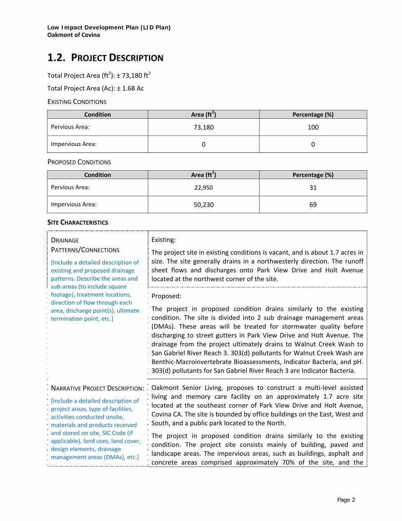
Low Impact Development Plan (LID Plan) Oakmont of Covina
Page 2
1.2. PROJECT DESCRIPTION Total Project Area (ft2): ± 73,180 ft2
Total Project Area (Ac): ± 1.68 Ac
EXISTING CONDITIONS
Condition Area (ft2) Percentage (%)
Pervious Area: 73,180 100
Impervious Area: 0 0
PROPOSED CONDITIONS
Condition Area (ft2) Percentage (%)
Pervious Area: 22,950 31
Impervious Area: 50,230 69
SITE CHARACTERISTICS
DRAINAGE PATTERNS/CONNECTIONS [Include a detailed description of existing and proposed drainage patterns. Describe the areas and sub‐areas (to include square footage), treatment locations, direction of flow through each area, discharge point(s), ultimate termination point, etc.]
Existing:
The project site in existing conditions is vacant, and is about 1.7 acres in size. The site generally drains in a northwesterly direction. The runoff sheet flows and discharges onto Park View Drive and Holt Avenue located at the northwest corner of the site.
Proposed:
The project in proposed condition drains similarly to the existing condition. The site is divided into 2 sub drainage management areas (DMAs). These areas will be treated for stormwater quality before discharging to street gutters in Park View Drive and Holt Avenue. The drainage from the project ultimately drains to Walnut Creek Wash to San Gabriel River Reach 3. 303(d) pollutants for Walnut Creek Wash are Benthic‐Macroinvertebrate Bioassessments, Indicator Bacteria, and pH. 303(d) pollutants for San Gabriel River Reach 3 are Indicator Bacteria.
NARRATIVE PROJECT DESCRIPTION:
[Include a detailed description of project areas, type of facilities, activities conducted onsite, materials and products received and stored on site, SIC Code (if applicable), land uses, land cover, design elements, drainage management areas (DMAs), etc.]
Oakmont Senior Living, proposes to construct a multi‐level assisted living and memory care facility on an approximately 1.7 acre site located at the southeast corner of Park View Drive and Holt Avenue, Covina CA. The site is bounded by office buildings on the East, West and South, and a public park located to the North.
The project in proposed condition drains similarly to the existing condition. The project site consists mainly of building, paved and landscape areas. The impervious areas, such as buildings, asphalt and concrete areas comprised approximately 70% of the site, and the
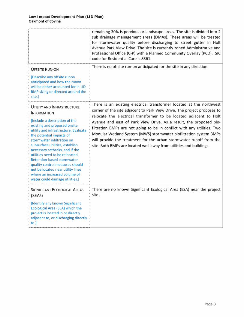
Low Impact Development Plan (LID Plan) Oakmont of Covina
Page 3
remaining 30% is pervious or landscape areas. The site is divided into 2 sub drainage management areas (DMAs). These areas will be treated for stormwater quality before discharging to street gutter in Holt Avenue Park View Drive. The site is currently zoned Administrative and Professional Office (C‐P) with a Planned Community Overlay (PCD). SIC code for Residential Care is 8361.
OFFSITE RUN‐ON
[Describe any offsite runon anticipated and how the runon will be either accounted for in LID BMP sizing or directed around the site.]
There is no offsite run‐on anticipated for the site in any direction.
UTILITY AND INFRASTRUCTURE INFORMATION [Include a description of the existing and proposed onsite utility and infrastructure. Evaluate the potential impacts of stormwater infiltration on subsurface utilities, establish necessary setbacks, and if the utilities need to be relocated. Retention‐based stormwater quality control measures should not be located near utility lines where an increased volume of water could damage utilities.]
There is an existing electrical transformer located at the northwest corner of the site adjacent to Park View Drive. The project proposes to relocate the electrical transformer to be located adjacent to Holt Avenue and east of Park View Drive. As a result, the proposed bio‐filtration BMPs are not going to be in conflict with any utilities. Two Modular Wetland System (MWS) stormwater biofiltration system BMPs will provide the treatment for the urban stormwater runoff from the site. Both BMPs are located well away from utilities and buildings.
SIGNIFICANT ECOLOGICAL AREAS (SEAS) [Identify any known Significant Ecological Area (SEA) which the project is located in or directly adjacent to, or discharging directly to.]
There are no known Significant Ecological Area (ESA) near the project site.

Low Impact Development Plan (LID Plan) Oakmont of Covina
Page 4
1.3. HYDROMODIFICATION ANALYSIS
DOES THE PROPOSED PROJECT FALL INTO ONE OF THE FOLLOWING CATEGORIES? CHECK YES/NO. YES NO
1. Project is a redevelopment that decreases the effective impervious area compared to the pre‐project conditions.
Describe:
2. Project is a redevelopment that increases the infiltration capacity of pervious areas compared to the pre‐project conditions.
Describe:
3. Project discharges directly or via a storm drain to a sump, lake, area under tidal influence, into a waterway that has a 100‐year peak flow (Q100) of 25,000 cfs or more.
Describe:
4. Project discharges directly or via a storm drain into concrete or otherwise engineered (not natural) channels (e.g., channelized or armored with rip rap, shotcrete, etc.), which, in turn, discharge into receiving water that is not susceptible to hydromodification impacts.
Describe:
Runoff from the site will be collected in several onsite catch basins and then discharged to the street gutters along Park View Drive and Holt Avenue using curb opening outlets. The flows will travel westerly along Holt Avenue where they are pick up in catch basins located on the south side of Holt Avenue at the I‐10 Freeway.
[Check “Yes” or “No,” as applicable.
If one or more of the above criteria are checked “Yes,” the project is exempt from Hydromodification Control Measures. State as such.
If none of the above criteria are checked “Yes,” the project will require Hydromodification control measures. Include detailed description of control measures to be implemented and a reference to calculations following the criteria outlined in MS4 Permit (Order R4‐2012‐0175) §VI.D.7.c.iv]
HYDROMODIFICATION ANALYSIS N/A

Low Impact Development Plan (LID Plan) Oakmont of Covina
Page 5
1.4. PROPERTY OWNERSHIP/MANAGEMENT
[Describe ownership of all portions of project and site. Include information on if any infrastructure transfer to public agencies (City, County, Caltrans, etc.). Describe any property management company/association that will be formed. Include leasee information, as applicable.]
Property ownership / management will be provided by the owner during
construction and after project completion. The entity will be responsible for
the long‐term maintenance of the project stormwater and LID facilities associated
with the proposed assisted living facility. This will be incorporated with
the assisted living facility and/or as outlined in CC&R’s
or such documents associated with the assisted living facility site.

Low Impact Development Plan (LID Plan) Oakmont of Covina
Page 6
2. BEST MANAGEMENT PRACTICES (BMPS) 2.1. SITE DESIGN
85TH PERCENTILE, 24‐HOUR STORM DEPTH [Determined from the Los Angeles County 85th percentile precipitation isohyetal map. If less than 0.75 inch, state as such and use 0.75 inch throughout.]
1.00 inch
SITE DESIGN [Describe site design and drainage plan including; site design practices utilized and how BMPs are incorporated using the appropriate hierarchy.]
The proposed site will utilize two Modular Wetland System (MWS) dual‐stage high flow rate media and biofiltration system for the treatment of urban runoff from the site. The units incorporate a pre‐treatment chamber for trash and larger debris, a separate chamber for larger TSS and a series of media filter cartridges for removal of fine TSS and other particulate pollutants. The pretreated runoff is then transferred to the biofiltration chamber. Treated runoff is discharged from the system through an orifice control riser to assure the proper amount of flow is treated and the outflow from the system will discharge onto Parkview Drive and Holt Avenue gutters using small diameter storm drains and curb opening outlets.
BMP LIST [Fill out the table below with information on the BMPs incorporated in each Drainage Management Area (DMA)]
DMA DESIGNATION
SQUARE FOOTAGE (SF)
ACREAGE (AC)
STORM WATER QUALITY DESIGN
VOLUME (SWQDV, CF)
STORM WATER QUALITY DESIGN
FLOWRATE (SWQDQ, CFS) [Delete if using volume‐based
BMPs]
BMP TYPE [Include make &
model if proprietary]
MINIMUM BMP SIZE [Include units]
BMP SIZE PROVIDED [Include units]
A 39096 0.90 0.20 cfs Modular
Wetland (MWS) MWS‐L‐8‐12‐C
0.20 cfs 0.346 cfs
B 33247 0.76 0.20 cfs Modular
Wetland (MWS) MWS‐L‐4‐21‐V
0.20 cfs 0.268 cfs

Low Impact Development Plan (LID Plan) Oakmont of Covina
Page 7
2.2. BMP SELECTION
2.2.1. INFILTRATION BMPS
NAME INCLUDED [Check all that apply.]
Bioretention without underdrains
Infiltration Trench
Infiltration Basin
Drywell
Proprietary Subsurface Infiltration Gallery
Permeable Pavement (concrete, asphalt, pavers)
Other:
Other:
DESCRIPTION [Describe Infiltration BMPs. Include descriptions on selection, sizing, and feasibility, as applicable. If infiltration is infeasible, provide brief explanation, including reference to the geotechnical report.]
CALCULATIONS
[Show calculations to demonstrate that the Storm Water Quality Design volume can be met with Infiltration BMPs.]

Low Impact Development Plan (LID Plan) Oakmont of Covina
Page 8
2.2.2. RAINWATER HARVEST AND USE BMPS
NAME INCLUDED [Check all that apply.]
Above‐ground cisterns and basins
Underground detention
Other:
Other:
Other:
DESCRIPTION [Describe Rainwater Harvest and Use BMPs. Include descriptions on selection, suitability, sizing, and infeasibility, as applicable.]
CALCULATIONS [Show calculations to demonstrate if the Storm Water Quality Design volume can be met with Rainwater Harvest and Use BMPs. If not, document how much can be met with Rainwater Harvest and Use and why it is not feasible to meet the full volume with Rainwater Harvest and Use BMPs.]

Low Impact Development Plan (LID Plan) Oakmont of Covina
Page 9
2.2.3. ALTERNATIVE COMPLIANCE BMPS
BIOFILTRATION BMPS (If Infiltration BMPs and Rainwater Harvest and Use BMPs are Infeasible)
NAME INCLUDED
[Check all that apply.] Bioretention with underdrains (i.e. planter box, rain garden, etc.) Constructed Wetland Vegetated Swale Vegetated Filter Strip Tree‐Well Filter Other: Biofiltration System (MWS Unit) Other:
DESCRIPTION [If the full Design Storm Capture Volume cannot be met with Infiltration BMPs, and/or Rainwater Harvest and Use BMPs, describe Biofiltration BMPs. Include descriptions on selection, suitability, sizing, and infeasibility, as applicable.]
The proposed site will utilize two Modular Wetland System (MWS) dual‐stage high flow rate media and biofiltration system for the treatment of urban runoff from the site. The units incorporate a pre‐treatment chamber for trash and larger debris, a separate chamber for larger TSS and a series of media filter cartridges for removal of fine TSS and other particulate pollutants. The pretreated runoff is then transferred to the biofiltration chamber. Treated runoff is discharged from the system through an orifice control riser to assure the proper amount of flow is treated and the outflow from the system will discharge onto Parkview Drive and Holt Avenue using small diameter storm drains and curb opening outlets.
Based on the Los Angeles County Hydrology Manual, the soil type of the project site is 002 (Altamont Clay Loam) which is not an ideal soil type for infiltration. In addition, site grading and limited open space makes infiltration BMPs infeasible. As a result, biofiltration BMPs (MWS Units) were selected as the most appropriate BMPs for this site. Soil infiltration tests will be provided for the next submittal to confirm that infiltration BMPs are infeasible.
CALCULATIONS
[Show calculations to demonstrate how 1.5 times the Storm Water Quality Design volume and/or flowrate can be met with Biotreatment BMPs.]
See Attachment 1 for supporting calculations.

Low Impact Development Plan (LID Plan) Oakmont of Covina
Page 10
OFFSITE BMPS (If Infiltration BMPs, Rainwater Harvest and Use BMPs, and Biofiltration BMPs are Infeasible)
NAME INCLUDED [Check all that apply.]
Offsite Infiltration
Ground Water Replenishment Projects
Offsite Project ‐ Retrofit Existing Development
Regional Storm Water Mitigation Program
Other:
Other:
DESCRIPTION [If the full Design Storm Capture Volume cannot be met with Infiltration BMPs, Rainwater Harvest and Use BMPs, or Biofiltration BMPs, describe proposed Alternative Compliance BMPs. Include descriptions on selection, suitability, sizing, and infeasibility, as applicable.]
CALCULATIONS [Show calculations to demonstrate how the conditions required by the MS4 Permit will be met with Alternative Compliance BMPs.]

Low Impact Development Plan (LID Plan) Oakmont of Covina
Page 11
2.2.4. TREATMENT CONTROL BMPS Treatment control BMPs can only be used as pre‐treatment to LID BMPs.
NAME INCLUDED [Check all that apply.]
Media Filter
Filter Insert
CDS Unit
Other:
Other:
DESCRIPTION [Include descriptions on selection, suitability, sizing, and infeasibility, as applicable.]
The MWS units incorporate a pre‐treatment chamber containing a screen device for trash and larger debris and a separate chamber for larger TSS and a series of media filter cartridges for removal of fine TSS and other particulate pollutants prior to entering the biofiltration chamber

Low Impact Development Plan (LID Plan) Oakmont of Covina
Page 12
2.2.5. HYDROMODIFICATION CONTROL BMPS
NAME INCLUDED [Check all that apply.]
Infiltration System
Above‐ground Cistern
Above‐ground Basin
Underground Detention
Other:
Other:
DESCRIPTION [If the site is susceptible to hydromodification, include descriptions on selection and sizing of Hydromodification Control Measures.]
CALCULATIONS [If the site is susceptible to hydromodification, show calculations to demonstrate how the volume, flowrate, and duration conditions can be met with Hydromodification Control Measures BMPs.]

Low Impact Development Plan (LID Plan) Oakmont of Covina
Page 13
2.2.6. NON‐STRUCTURAL SOURCE CONTROL BMPS
NAME CHECK ONE
Included Not Applicable Education for Property Owners, Tenants and Occupants
Activity Restrictions
Common Area Landscape Management
Common Area Litter Control
Housekeeping of Loading Docks
Common Area Catch Basin Inspection
Street Sweeping Private Streets and Parking Lots

Low Impact Development Plan (LID Plan) Oakmont of Covina
Page 14
2.2.7. STRUCTURAL SOURCE CONTROL BMPS
NAME CHECK ONE
Included Not Applicable
Provide storm drain system stenciling and signage Design and construct outdoor material storage areas to reduce pollution introduction
Design and construct trash and waste storage areas to reduce pollution introduction
Use efficient irrigation systems & landscape design, water conservation, smart controllers, and source control
Protect slopes and channels and provide energy dissipation
Loading docks
Maintenance bays
Vehicle wash areas
Outdoor processing areas
Equipment wash areas/racks
Fueling areas
Hillside landscaping

Attachment A Calculations
[Include calculations for each BMP following an approved published design standard (i.e. City Manuals, County Manuals, Caltrans, CASQA, etc.). Calculations must be followed step‐by‐step with no alterations. Also, include an excerpt from the design standard used.]

85th Percentile Storm Calculations

Peak Flow Hydrologic AnalysisFile location: R:/17/1686 - Covina/PRELIM/REPORTS/PRELIM LID/Oakmont Senior Living - DMA-A.pdfVersion: HydroCalc 1.0.2
Input ParametersProject Name Oakmont Senior LivingSubarea ID DMA-AArea (ac) 0.9Flow Path Length (ft) 407.0Flow Path Slope (vft/hft) 0.0285th Percentile Rainfall Depth (in) 1.0Percent Impervious 0.64Soil Type 2Design Storm Frequency 85th percentile stormFire Factor 0LID True
Output ResultsModeled (85th percentile storm) Rainfall Depth (in) 1.0Peak Intensity (in/hr) 0.3039Undeveloped Runoff Coefficient (Cu) 0.4347Developed Runoff Coefficient (Cd) 0.7325Time of Concentration (min) 21.0Clear Peak Flow Rate (cfs) 0.2004Burned Peak Flow Rate (cfs) 0.200424-Hr Clear Runoff Volume (ac-ft) 0.046524-Hr Clear Runoff Volume (cu-ft) 2023.8579

Peak Flow Hydrologic AnalysisFile location: R:/17/1686 - Covina/PRELIM/REPORTS/PRELIM LID/Oakmont Senior Living - DMA-B.pdfVersion: HydroCalc 1.0.2
Input ParametersProject Name Oakmont Senior LivingSubarea ID DMA-BArea (ac) 0.76Flow Path Length (ft) 330.0Flow Path Slope (vft/hft) 0.0285th Percentile Rainfall Depth (in) 1.0Percent Impervious 0.73Soil Type 2Design Storm Frequency 85th percentile stormFire Factor 0LID True
Output ResultsModeled (85th percentile storm) Rainfall Depth (in) 1.0Peak Intensity (in/hr) 0.3357Undeveloped Runoff Coefficient (Cu) 0.4641Developed Runoff Coefficient (Cd) 0.7823Time of Concentration (min) 17.0Clear Peak Flow Rate (cfs) 0.1996Burned Peak Flow Rate (cfs) 0.199624-Hr Clear Runoff Volume (ac-ft) 0.043624-Hr Clear Runoff Volume (cu-ft) 1898.086

0.60
0.70
0.80
1.00
0.90
0.50
0.40
0.30
1.101.20
1.30
0.20
1.4
0
1.5
0
1.00
1.40
0.8
0
0.30
0.900.90
0.800.80
0.700.70
1.00
0.50
0.70
1.10
1.00
1.10
0.7
0
1.50
1.10
1.201.10
1.10
0.80
1.3
0
0.60
0.9
0
0.90
1.2
0
0.90
0.70
0.6
0
0.90
1.00
0.60
0.40
1.10
0.800.70
0.90
1.00 1.0
0
0.40
1.000.90
0.8
0
0.30
1.10
0.9
0
85th Percentile 24-hr Rainfall Isohyetal Map
10 0 10 20 30 40 Miles
N
EW
S
85th Percentile 24-hr Rainfall Depth
YHu
Oval
YHu
Callout
SITE, P=1.00"

�
��
�
���
���
���
���
���
���
���
���
���� ���
���
��
��
��
��
����
���������
���
�������
� �
���
� �
��
��
���
���
��
���� �
��
��
��
�� ����������
�� ��
��� ���
��
��
���
� � ������������
���
����
������
���
��� ����
���
���
���
���
���
������
���
���
������
�������
��
���
���
��
���
������
����� �
��
��
�� ��
��
���
���
���
��
��
���������� ���
����
���
����
��
��
� �
����
�������
�������
���
����
��������
���
��
���
� �
������
��
��
��
�
���
� �
����
���
����
����
����
����
����
�� ������������� ������ �������������������������������� ������ �����������������������
�������� ����
����������� ����
���������� ����
�������� ����
� � � � �����
����!���������� ������ ���
��"��#��##
��"��#��##
����"��#��##
����"��#��##
���
������������������
����������������
���
����
��� ����������
PKasturi
Rectangle
PKasturi
Callout
SITE

1
4
+
0
0
1
5
+
0
0
1
6
+
0
0
1
+
0
0
2
+
0
0
INTERSTATE
C/L
4.13' OR VARIES
----
IE OUT
----
IE IN
PLANT
ESTABLISHMENT
MEDIA
VEGETATION
FLOW
CONTROL
RISER
----
RIM/FG
----
RIM/FG
C/L
22'-0"
21'-0" 6"6"
C/L
C/L
DRAIN DOWN LINEWETLANDMEDIA
BED
PATENTED
PERIMETER
VOID AREA
PRE-FILTER
CARTRIDGE
VERTICAL
UNDERDRAIN
MANIFOLD
INLET PIPE
SEE NOTES
OUTLET PIPE
SEE NOTES
AutoCAD SHX Text
600
AutoCAD SHX Text
605
AutoCAD SHX Text
610
AutoCAD SHX Text
595
AutoCAD SHX Text
590
AutoCAD SHX Text
590
AutoCAD SHX Text
595
AutoCAD SHX Text
595
AutoCAD SHX Text
590
AutoCAD SHX Text
590
AutoCAD SHX Text
600
AutoCAD SHX Text
605
AutoCAD SHX Text
610
AutoCAD SHX Text
605
AutoCAD SHX Text
600
AutoCAD SHX Text
595
AutoCAD SHX Text
E
AutoCAD SHX Text
DWY
AutoCAD SHX Text
DWY
AutoCAD SHX Text
DWY
AutoCAD SHX Text
DWY
AutoCAD SHX Text
X 594.3
AutoCAD SHX Text
X 594.2
AutoCAD SHX Text
X 598.7
AutoCAD SHX Text
X 599.6
AutoCAD SHX Text
X 593.2
AutoCAD SHX Text
X 593.7
AutoCAD SHX Text
X 598.4
AutoCAD SHX Text
X 599.2
AutoCAD SHX Text
X 592.6
AutoCAD SHX Text
X 593.1
AutoCAD SHX Text
X 597.7
AutoCAD SHX Text
X 598.3
AutoCAD SHX Text
X 598.7
AutoCAD SHX Text
X 596.5
AutoCAD SHX Text
X 591.2
AutoCAD SHX Text
X 593.2
AutoCAD SHX Text
X 588.2
AutoCAD SHX Text
X 588.5
AutoCAD SHX Text
X 589.5
AutoCAD SHX Text
X 589.7
AutoCAD SHX Text
X 590.6
AutoCAD SHX Text
X 591.6
AutoCAD SHX Text
X 591.4
AutoCAD SHX Text
X 592.5
AutoCAD SHX Text
X 598.6
AutoCAD SHX Text
X 596.5
AutoCAD SHX Text
X 594.4
AutoCAD SHX Text
X 592.3
AutoCAD SHX Text
X 590.6
AutoCAD SHX Text
X 589.3
AutoCAD SHX Text
X 588.4
AutoCAD SHX Text
X 588.1
AutoCAD SHX Text
X 595.1
AutoCAD SHX Text
X 595.2
AutoCAD SHX Text
X 595.8
AutoCAD SHX Text
ASPH.
AutoCAD SHX Text
ASPH.
AutoCAD SHX Text
ASPH.
AutoCAD SHX Text
ASPH.
AutoCAD SHX Text
ASPH.
AutoCAD SHX Text
ASPH.
AutoCAD SHX Text
615
AutoCAD SHX Text
615
AutoCAD SHX Text
TRANS.
AutoCAD SHX Text
DMA A
AutoCAD SHX Text
0.9
AutoCAD SHX Text
DMA B
AutoCAD SHX Text
0.76
AutoCAD SHX Text
T
AutoCAD SHX Text
J.N.
AutoCAD SHX Text
CIVIL ENGINEERS PLANNERS SURVEYORS
AutoCAD SHX Text
1880 COMPTON AVENUE, SUITE 100 CORONA, CA. 92881-3370 951-734-2130
AutoCAD SHX Text
R:\17\1686 - Covina\PRELIM\REPORTS\PRELIM LID\1686 PRELIM LID SITE PLAN.dwg
AutoCAD SHX Text
17.1693.1.8
AutoCAD SHX Text
SCALE IN FEET
AutoCAD SHX Text
0
AutoCAD SHX Text
20'
AutoCAD SHX Text
20'
AutoCAD SHX Text
40'
AutoCAD SHX Text
60'
AutoCAD SHX Text
CHECK:
AutoCAD SHX Text
DRAFT:
AutoCAD SHX Text
DESIGN:
AutoCAD SHX Text
YH
AutoCAD SHX Text
DG
AutoCAD SHX Text
YH
AutoCAD SHX Text
OF
AutoCAD SHX Text
SHEET
AutoCAD SHX Text
1
AutoCAD SHX Text
1
AutoCAD SHX Text
LEGEND
AutoCAD SHX Text
TRIBUTARY AREA BOUNDARY
AutoCAD SHX Text
DMA NUMBER
AutoCAD SHX Text
TRIBUTARY AREA (ACRES)
AutoCAD SHX Text
PROPOSED STORM DRAIN
AutoCAD SHX Text
PERVIOUS AREAS
AutoCAD SHX Text
DMA A
AutoCAD SHX Text
1.00
AutoCAD SHX Text
DRAINAGE FLOW PATH
AutoCAD SHX Text
FOR
AutoCAD SHX Text
COVINA CA
AutoCAD SHX Text
PRELIMINARY LID SITE PLAN
AutoCAD SHX Text
OAKMONT SENIOR LIVING
AutoCAD SHX Text
RET-1 BIO-RETENTION BASIN
AutoCAD SHX Text
TREATMENT CONTROL BMPs
AutoCAD SHX Text
ACREAGE:
AutoCAD SHX Text
GROSS ACREAGE: 2.45 ACRES
AutoCAD SHX Text
DRAINAGE AREA ACREAGE: 2.40 ACRES
AutoCAD SHX Text
PERVIOUS ACREAGE: 0.71 ACRES
AutoCAD SHX Text
IMPERVIOUS ACREAGE: 1.74 ACRES
AutoCAD SHX Text
-CONCRETE/ASPHALT AREA: 1.37 ACRES
AutoCAD SHX Text
-ROOF AREA AREA: 0.37 ACRES
AutoCAD SHX Text
CONC. SIDEWALK
AutoCAD SHX Text
A
AutoCAD SHX Text
LID TREATMENT SUMMARY TABLE
AutoCAD SHX Text
0.9
AutoCAD SHX Text
0.58
AutoCAD SHX Text
0.32
AutoCAD SHX Text
0.20
AutoCAD SHX Text
B
AutoCAD SHX Text
0.76
AutoCAD SHX Text
UNIT
AutoCAD SHX Text
DMA AREA (AC)
AutoCAD SHX Text
IMPERVIOUS (AC)
AutoCAD SHX Text
PERVIOUS (AC)
AutoCAD SHX Text
STORM WATER QUALITY DESIGN FLOWRATE (CFS)
AutoCAD SHX Text
BMP SIZE PROVIDED (CFS)
AutoCAD SHX Text
0.346
AutoCAD SHX Text
BMP TYPE
AutoCAD SHX Text
0.56
AutoCAD SHX Text
0.2
AutoCAD SHX Text
0.20
AutoCAD SHX Text
MODULAR WETLAND (MWS)
AutoCAD SHX Text
MWS-L-8-12-C
AutoCAD SHX Text
NOT TO SCALE
AutoCAD SHX Text
VICINITY MAP
AutoCAD SHX Text
1
AutoCAD SHX Text
10
AutoCAD SHX Text
EAST
AutoCAD SHX Text
SAN DIMAS
AutoCAD SHX Text
EAST
AutoCAD SHX Text
OWOOD
AutoCAD SHX Text
CENTER COURT DR.
AutoCAD SHX Text
FOREST
AutoCAD SHX Text
SOUTH
AutoCAD SHX Text
OAKS DR.
AutoCAD SHX Text
HOLT
AutoCAD SHX Text
AVE.
AutoCAD SHX Text
EAST
AutoCAD SHX Text
VIA
AutoCAD SHX Text
DE
AutoCAD SHX Text
MONTE
AutoCAD SHX Text
EAST
AutoCAD SHX Text
MENO
AutoCAD SHX Text
MESQ
AutoCAD SHX Text
PRIVATE
AutoCAD SHX Text
PARK VIEW
AutoCAD SHX Text
DR.
AutoCAD SHX Text
SITE
AutoCAD SHX Text
RD.
AutoCAD SHX Text
VILLAGE
AutoCAD SHX Text
ST.
AutoCAD SHX Text
COVINA
AutoCAD SHX Text
HILLS
AutoCAD SHX Text
GARY
AutoCAD SHX Text
AVE.
AutoCAD SHX Text
SOUTH
AutoCAD SHX Text
PALO
AutoCAD SHX Text
DR.
AutoCAD SHX Text
UITE
AutoCAD SHX Text
LN.
AutoCAD SHX Text
SOUTH
AutoCAD SHX Text
VERDE
AutoCAD SHX Text
DR.
AutoCAD SHX Text
EAST
AutoCAD SHX Text
TEMPLE
AutoCAD SHX Text
WAY
AutoCAD SHX Text
EAST
AutoCAD SHX Text
GARVEY
AutoCAD SHX Text
ST.
AutoCAD SHX Text
MEAD
AutoCAD SHX Text
DR.
AutoCAD SHX Text
PRIVATE
AutoCAD SHX Text
PRIVATE
AutoCAD SHX Text
SOUTH
AutoCAD SHX Text
HILLS
AutoCAD SHX Text
DR.
AutoCAD SHX Text
VER
AutoCAD SHX Text
MWS-L-4-21
AutoCAD SHX Text
0.268
AutoCAD SHX Text
MODULAR WETLAND (MWS)
AutoCAD SHX Text
MWS-L-4-21-V
AutoCAD SHX Text
DRAIN DOWN LINE
AutoCAD SHX Text
DRAIN DOWN FILTER
AutoCAD SHX Text
PRE-FILTER CARTRIDGE
AutoCAD SHX Text
C/L
AutoCAD SHX Text
C/L
AutoCAD SHX Text
PATENTED PERIMETER VOID AREA
AutoCAD SHX Text
VERTICAL UNDERDRAIN MANIFOLD
AutoCAD SHX Text
WETLAND MEDIA BED
AutoCAD SHX Text
%%UPLAN VIEW
AutoCAD SHX Text
%%UELEVATION VIEW
AutoCAD SHX Text
MWS-L-8-12
AutoCAD SHX Text
%%URIGHT END VIEW
AutoCAD SHX Text
%%UELEVATION VIEW
AutoCAD SHX Text
%%ULEFT END VIEW
BPrice
Sticky Note
ASDASD
Biofiltration Units
For
DMA‐A and DMA‐B


MWS Linear
Advanced Stormwater Biofiltration

Contents1 Introduction
2 Applications
3 Configurations
4 Advantages
5 Operation
6 Orientations | Bypass
7 Performance | Approvals
8 Sizing
9 Installation | Maintenance | Plants

www.ModularWetlands.com
The Urban ImpactFor hundreds of years natural wetlands surrounding our shores have played an integral role as nature’s stormwater treatment system. But as our cities grow and develop, these natural wet-lands have perished under countless roads, rooftops,
and parking lots.
Plant A WetlandWithout natural wetlands our cities are deprived of water purification, flood control, and land stability. Modular Wetlands and the MWS Linear re-establish nature’s presence and rejuvenate water ways in urban areas.
MWS LinearThe Modular Wetland System Linear represents a pioneering breakthrough in stormwater tech-nology as the only biofiltration system to utilize patented horizontal flow, allowing for a smaller footprint and higher treatment capacity. While most biofilters use little or no pre-treatment, the MWS Linear incorporates an advanced pre-treatment chamber that includes separation and pre-filter cartridges. In this chamber sediment and hydrocarbons are removed from runoff before it enters the biofiltration chamber, in turn reducing maintenance costs and improving performance.

Parking LotsParking lots are designed to maximize space and the MWS Linear’s 4 ft. standard planter width al-lows for easy integration into parking lot islands and other landscape medians.
Mixed UseThe MWS Linear can be installed as a raised plant-er to treat runoff from rooftops or patios, making it perfect for sustainable “live-work” spaces.
IndustrialMany states enforce strict regulations for dis-charges from industrial sites. The MWS Linear has helped various sites meet difficult EPA mandated effluent limits for dissolved metals and other pol-lutants.
ResidentialLow to high density developments can benefit from the versatile design of the MWS Linear. The system can be used in both decentralized LID de-sign and cost-effective end-of-the-line configura-tions.
StreetsStreet applications can be challenging due to limited space. The MWS Linear is very adaptable, and offers the smallest footprint to work around the constraints of existing utilities on retrofit pro-jects.
CommercialCompared to bioretention systems, the MWS Lin-ear can treat far more area in less space - meeting treatment and volume control requirements.
ApplicationsThe MWS Linear has been successfully used on numerous new construction and retrofit projects. The system’s superior versatility makes it beneficial for a wide range of stormwater and waste water applications - treating rooftops, streetscapes, parking lots, and industrial sites.
More applications are available on our website: www.ModularWetlands.com/Applications• Agriculture• Reuse
• Low Impact Development• Waste Water
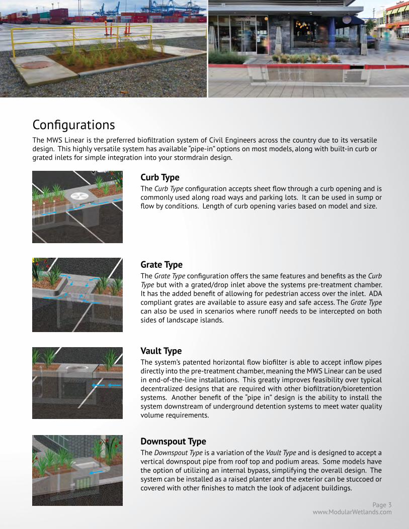
www.ModularWetlands.com
ConfigurationsThe MWS Linear is the preferred biofiltration system of Civil Engineers across the country due to its versatile design. This highly versatile system has available “pipe-in” options on most models, along with built-in curb or grated inlets for simple integration into your stormdrain design.
Curb TypeThe Curb Type configuration accepts sheet flow through a curb opening and is commonly used along road ways and parking lots. It can be used in sump or flow by conditions. Length of curb opening varies based on model and size.
Grate TypeThe Grate Type configuration offers the same features and benefits as the Curb Type but with a grated/drop inlet above the systems pre-treatment chamber. It has the added benefit of allowing for pedestrian access over the inlet. ADA compliant grates are available to assure easy and safe access. The Grate Type can also be used in scenarios where runoff needs to be intercepted on both sides of landscape islands.
Downspout TypeThe Downspout Type is a variation of the Vault Type and is designed to accept a vertical downspout pipe from roof top and podium areas. Some models have the option of utilizing an internal bypass, simplifying the overall design. The system can be installed as a raised planter and the exterior can be stuccoed or covered with other finishes to match the look of adjacent buildings.
Vault TypeThe system’s patented horizontal flow biofilter is able to accept inflow pipes directly into the pre-treatment chamber, meaning the MWS Linear can be used in end-of-the-line installations. This greatly improves feasibility over typical decentralized designs that are required with other biofiltration/bioretention systems. Another benefit of the “pipe in” design is the ability to install the system downstream of underground detention systems to meet water quality volume requirements.
Page 3

Cartridge Housing
Pre-filter Cartridge
Curb Inlet
Individual Media Filters
Advantages & OperationThe MWS Linear is the most efficient and versatile biofiltration system on the market, and the only system with horizontal flow which improves performance, reduces footprint, and minimizes maintenance. Figure-1 and Figure-2 illustrate the invaluable benefits of horizontal flow and the multiple treatment stages.
• Horizontal Flow Biofiltration• Greater Filter Surface Area• Pre-Treatment Chamber
• Patented Perimeter Void Area• Flow Control• No Depressed Planter Area
Separation• Trash, sediment, and debris are separated before entering the pre-filter cartridges• Designed for easy maintenance access
Pre-Filter Cartridges• Over 25 ft2 of surface area per cartridge• Utilizes BioMediaGREEN filter material• Removes over 80% of TSS & 90% of hydrocarbons• Prevents pollutants that cause clogging from migrating to the biofiltration chamber
Pre-Treatment11
2
Drain-Down Line
12Vertical Underdrain
Manifold
Featured Advantages

www.ModularWetlands.com
Fig. 1
Horizontal Flow • Less clogging than downward flow biofilters• Water flow is subsurface• Improves biological filtration
Patented Perimeter Void Area• Vertically extends void area between the walls and the WetlandMEDIA on all four sides.• Maximizes surface area of the media for higher treatment capacity
WetlandMEDIA • Contains no organics and removes phosphorus• Greater surface area and 48% void space• Maximum evapotranspiration• High ion exchange capacity and light weight
Flow Control• Orifice plate controls flow of water through WetlandMEDIA to a level lower than the media’s capacity.• Extends the life of the media and improves performance
Drain-Down Filter• The Drain-Down is an optional feature that completely drains the pre-treatment chamber• Water that drains from the pre-treatment chamber between storm events will be treated
2x to 3x More Surface Area Than Traditional Downward Flow Bioretention Systems.Fig. 2 - Top View
Biofiltration2
Discharge3
Perimeter Void Area
3
4
3Flow Control Riser
Drain-Down Line
Outlet PipePage 5

Orientations
Bypass
Internal Bypass Weir (Side-by-Side Only)The Side-By-Side orientation places the pre-treat-ment and discharge chambers adjacent to one an-other allowing for integration of internal bypass. The wall between these chambers can act as a by-pass weir when flows exceed the system’s treatment capacity, thus allowing bypass from the pre-treat-ment chamber directly to the discharge chamber.
External Diversion Weir StructureThis traditional offline diversion method can be used with the MWS Linear in scenarios where run-off is being piped to the system. These simple and effective structures are generally configured with two outflow pipes. The first is a smaller pipe on the upstream side of the diversion weir - to divert low flows over to the MWS Linear for treatment. The second is the main pipe that receives water once the system has exceeded treatment capacity and water flows over the weir.
Flow By DesignThis method is one in which the system is placed just upstream of a standard curb or grate inlet to intercept the first flush. Higher flows simply pass by the MWS Linear and into the standard inlet down-stream.
End-To-EndThe End-To-End orientation places the pre-treat-ment and discharge chambers on opposite ends of the biofiltration chamber therefore minimizing the width of the system to 5 ft (outside dimension). This orientation is perfect for linear projects and street retrofits where existing utilities and sidewalks limit the amount of space available for installation. One limitation of this orientation is bypass must be ex-ternal.
Side-By-SideThe Side-By-Side orientation places the pre-treat-ment and discharge chamber adjacent to one an-other with the biofiltration chamber running paral-lel on either side. This minimizes the system length, providing a highly compact footprint. It has been proven useful in situations such as streets with di-rectly adjacent sidewalks, as half of the system can be placed under that sidewalk. This orientation also offers internal bypass options as discussed below.
This simple yet innovative diversion trough can be installed in existing or new curb and grate inlets to divert the first flush to the MWS Linear via pipe. It works similar to a rain gutter and is installed just below the opening into the inlet. It captures the low flows and channels them over to a connecting pipe exiting out the wall of the inlet and leading to the MWS Linear. The DVERT is perfect for retrofit and green street applications that allows the MWS Lin-ear to be installed anywhere space is available.
DVERT Low Flow Diversion
DVERT Trough

www.ModularWetlands.com
Rhode Island DEM ApprovedApproved as an authorized BMP and noted to achieve the following minimum removal efficiencies: 85% TSS, 60% Pathogens, 30% Total Phosphorus for discharges to freshwater systems, and 30% Total Nitrogen for discharges to saltwater or tidal systems.
MASTEP EvaluationThe University of Massachusetts at Amherst – Water Resources Research Center, issued a technical evaluation report noting removal rates up to 84% TSS, 70% Total Phosphorus, 68.5% Total Zinc, and more.
Washington State TAPE ApprovedThe MWS Linear is approved for General Use Level Designation (GULD) for Basic, Enhanced, and Phosphorus treatment at 1 gpm/ft2 loading rate. The highest performing BMP on the market for all main pollutant categories.
ApprovalsThe MWS Linear has successfully met years of challenging technical reviews and testing from some of the most prestigious and demanding agencies in the nation, and perhaps the world.
DEQ Assignment The Virginia Department of Environmental Quality assigned the MWS Linear, the highest phosphorus removal rating for manufactured treatment devices to meet the new Virginia Stormwater Management Program (VSMP) Technical Criteria.
VA
TSSTotal
PhosphorusOrtho
PhosphorusNitrogen Dissolved Zinc
Dissolved Copper
Total ZincTotal
CopperMotor Oil
85% 64% 67% 45% 66% 38% 69% 50% 95%
PerformanceThe MWS Linear continues to outperform other treatment methods with superior pollutant removal for TSS, heavy metals, nutrients, hydrocarbons and bacteria. Since 2007 the MWS Linear has been field tested on nu-merous sites across the country. With it’s advanced pre-treatment chamber and innovative horizontal flow biofilter, the system is able to effectively remove pollutants through a combination of physical, chemical, and biological filtration processes. With the same biological processes found in natural wetlands, the MWS Linear harnesses natures ability to process, transform, and remove even the most harmful pollutants.
Page 7

Treatment Flow Sizing Table
Model # Dimensions WetlandMediaSurface Area
Treatment Flow Rate (cfs)
MWS-L-4-4 4’ x 4’ 23 ft2 0.052
MWS-L-4-6 4’ x 6’ 32 ft2 0.073
MWS-L-4-8 4’ x 8’ 50 ft2 0.115
MWS-L-4-13 4’ x 13’ 63 ft2 0.144
MWS-L-4-15 4’ x 15’ 76 ft2 0.175
MWS-L-4-17 4’ x 17’ 90 ft2 0.206
MWS-L-4-19 4’ x 19’ 103 ft2 0.237
MWS-L-4-21 4’ x 21’ 117 ft2 0.268
MWS-L-8-8 8’ x 8’ 100 ft2 0.230
MWS-L-8-12 8’ x 12’ 151 ft2 0.346
MWS-L-8-16 8’ x 16’ 201 ft2 0.462
Flow Based SizingThe MWS Linear can be used in stand alone applica-tions to meet treatment flow requirements. Since the MWS Linear is the only biofiltration system that can ac-cept inflow pipes several feet below the surface it can be used not only in decentralized design applications but also as a large central end-of-the-line application for maximum feasibility.
Volume Based SizingMany states require treatment of a water quality volume and do not offer the option of flow based design. The MWS Linear and its unique horizontal flow makes it the only biofilter that can be used in volume based design installed downstream of ponds, detention basins, and underground storage systems.
Treatment Volume Sizing Table
Model # Treatment Capacity (cu. ft.)@ 24-Hour Drain Down
Treatment Capacity (cu. ft.)@ 48-Hour Drain Down
MWS-L-4-4 1140 2280
MWS-L-4-6 1600 3200
MWS-L-4-8 2518 5036
MWS-L-4-13 3131 6261
MWS-L-4-15 3811 7623
MWS-L-4-17 4492 8984
MWS-L-4-19 5172 10345
MWS-L-4-21 5853 11706
MWS-L-8-8 5036 10072
MWS-L-8-12 7554 15109
MWS-L-8-16 10073 20145

www.ModularWetlands.com
InstallationThe MWS Linear is simple, easy to install, and has a space efficient design that offers lower excavation and in-stallation costs compared to traditional tree-box type systems. The structure of the system resembles pre-cast catch basin or utility vaults and is installed in a similar fashion.
The system is delivered fully assembled for quick in-stallation. Generally, the structure can be unloaded and set in place in 15 minutes. Our experienced team of field technicians are available to supervise installations and provide technical support.
Plant SelectionAbundant plants, trees, and grasses bring value and an aesthetic benefit to any urban setting, but those in the MWS Linear do even more - they increase pollutant removal. What’s not seen, but very important, is that below grade the stormwater runoff/flow is being subjected to nature’s secret weapon: a dynamic physical, chemi-cal, and biological process working to break down and remove non-point source pollutants. The flow rate is controlled in the MWS Linear, giving the plants more “contact time” so that pollutants are more successfully decomposed, volatilized and incorporated into the biomass of The MWS Linear’s micro/macro flora and fauna.
A wide range of plants are suitable for use in the MWS Linear, but selec-tions vary by location and climate. View suitable plants by selecting the list relative to your project location’s hardy zone.
Please visit www.ModularWetlands.com/Plants for more information and various plant lists.
MaintenanceReduce your maintenance costs, man hours, and materials with the MWS Linear. Unlike other biofiltration systems that provide no pre-treatment, the MWS Linear is a self-contained treatment train which incorporates simple and effective pre-treatment.
Maintenance requirements for the biofilter itself are almost completely eliminated, as the pre-treatment chamber removes and isolates trash, sediments, and hydrocarbons. What’s left is the simple maintenance of an easily accessible pre-treatment chamber that can be cleaned by hand or with a standard vac truck. Only periodic replacement of low-cost media in the pre-filter cartridges is required for long term opera-tion and there is absolutely no need to replace expensive biofiltration media.
Page 9

Attachment B Geotechnical Investigation
[Include all geotechnical documents relevant to infiltration feasibility (i.e. Geotechnical Report, Soils Report, Percolation Report, Soils Letter, etc.). The document(s) must detail the results of the soil investigation, the infiltration rate, groundwater depths, soil characterization, etc. Note that soil borings must be conducted in the area of the proposed BMPs. In addition to the complete soils report, a letter signed and stamped with wet ink application by a geotechnical engineer must be provided. The letter must state that the soil will or will not exhibit instability as a result of implementing the proposed BMPs, that the seasonal high groundwater depth is or is not at the required depth (5‐10 feet depending on BMP type) below the base of the infiltration BMP, and the infiltration rate is or is not at least 0.3 in/hr.]

Attachment C Master Covenant Agreement (MCA)
Include a Master Covenant Agreement (MCA) form along with an attached Operations and Maintenance (O&M) Plan, Site Plan, and Owner’s Certification. The MCA must list the type and dimensions of each BMP. Once the MCA is approved by the City, it will need to be notarized and recorded (along with attachments) with the County Recorder’s Office.

Attachment D Operations and Maintenance (O&M) Plan
[Include an Operations and Maintenance (O&M) Plan. This should include the components of the BMPs, the frequency of inspections and maintenance, the responsible entity, etc.

Oakmont Of Covina
Holt Avenue And Parkview Drive, Covina, California
Apn: 8448-019-044 And Apn: 8448-019-045

Operations and Maintenance Plan Page 1
REQUIRED PERMITS
This section must list any permits required for the implementation, operation, and maintenance of the BMPs. Possible examples are:
• Permits for connection to sanitary sewer
• Permits from California Department of Fish and Game
• Encroachment permits
If no permits are required, a statement to that effect should be made.
RECORDKEEPING
All records must be made available for review upon request.
RESPONSIBLE PARTY
The owner is aware of the maintenance responsibilities of the proposed BMPs. A funding mechanism is in place to maintain the BMPs at the frequency stated in the LID Plan. The contact information for the entity responsible is below:
Name:
Company:
Title:
Address 1:
Address 2:
Phone Number:
Email:

Operations and Maintenance Plan Page 2
BMP Name BMP Implementation, Maintenance, and Inspection Procedures
Implementation, Maintenance, and
Inspection Frequency and Schedule
Person or Entity with Operation & Maintenance
Responsibility Non-Structural Source Control BMPs
Education for Property Owners, Tenants and Occupants
PROPERTY MANAGEMENT COMPANY WILL PERIODICALLY PROVIDE ENVIRONMENTAL AWARENESS EDUCATIONAL MATERIALS, MADE AVAILABLE BY THE MUNICIPALITIES, TO ALL MEMBERS.
Quarterly Owner
Activity Restriction NO OUTDOOR CLEANING ACTIVITIES. None Owner
Common Area Landscape Management LANDSCAPE MAINTENANCE ACTIVITIES SHALL BE PERFORMED IN A MANNER CONSISTENT WITH THE BMP MATERIALS IN THE REPORT. LANDSCAPED AREAS TO BE A MIN. OF 1‐2 INCHES BELOW TOP OF CURB, SIDEWALK, OR PAVEMENT.
Monthly
Owner
Common Area Litter Control THE REPORT AND DRAINAGE PLAN COMPLIES WITH APPLICABLE LOCAL WATER QUALITY ORDINANCES
None Owner
Housekeeping of Loading Docks Not Applicable Not Applicable Not Applicable
Common Area Catch Basin Inspection CATCH BASINS SHALL BE INSPECTED AND CLEANED ON A MONTHLY BASIS. THE WATER QUALITY INSERT WILL BE INSPECTED AND CLEANED ANNUALLY
Quarterly Owner

Operations and Maintenance Plan Page 3
BMP Name BMP Implementation, Maintenance, and Inspection Procedures
Implementation, Maintenance, and
Inspection Frequency and Schedule
Person or Entity with Operation & Maintenance
Responsibility Street Sweeping Private Streets and Parking Lots
THE PARKING LOT AND DRIVE AISLES SHALL BE SWEPT AT A MINIMUM OF ONCE A MONTH AND ALSO IN PREPARATION FOR STORM EVENTS.
Monthly Owner
Structural Source Control BMPs Provide Storm Drain System Stenciling and Signage
ALL CATCH BASINS AND STORM DRAIN SYSTEMS WILL BE ACCOMPANIED BY THE APPROPRIATE SIGNAGE
None Owner
Design and Construct Outdoor Material Storage Areas to Reduce Pollutant Introduction
Not Applicable. Not Applicable Not Applicable
Design and Construct Trash and Waste Storage Areas to Reduce Pollutant Introduction
THE SITE WILL BE INSPECTED WEEKLY FOR TRASH AND LITTER BY THE TENANT. TRASH AREAS ARE TO BE COVERED.
Weekly Owner
Use Efficient Irrigation Systems & Landscape Design
OWNER SHALL INSTALL PROGRAMMABLE SPRINKLER TIMERS AND LOW‐FLOW IRRIGATION FIXTURES TO MAXIMIZE IRRIGATION EFFICIENCY. SPRINKLERS SHALL BE ADJUSTED AND MAINTAINED ON A MONTHLY BASIS BY THE LANDSCAPE CONTRACTOR
Monthly Owner
Protect Slopes and Channels and Provide Energy Dissipation
INSPECT SLOPES AND CHANNELS QUARTERLY AND INSTALL ENERGY DISSIPATION AS NEEDED.
Quarter Owner
Loading Docks Not Applicable. Not Applicable Not Applicable

Operations and Maintenance Plan Page 4
BMP Name BMP Implementation, Maintenance, and Inspection Procedures
Implementation, Maintenance, and
Inspection Frequency and Schedule
Person or Entity with Operation & Maintenance
Responsibility Maintenance Bays Not Applicable. Not Applicable Not Applicable
Vehicle Wash Areas/Racks Not Applicable. Not Applicable Not Applicable
Outdoor Processing Areas Not Applicable. Not Applicable Not Applicable
Equipment Wash Areas Not Applicable. Not Applicable Not Applicable
Fueling Areas Not Applicable. Not Applicable Not Applicable
Hillside Landscaping LANDSCAPE MAINTENANCE ACTIVITIES SHALL BE PERFORMED IN A MANNER COSNISTENT WITH THE BMP MATERIALS IN THE REPORT.
Quarterly Owner
Treatment Control BMPs Filter Inserts FILTER INSERTS SHALL BE INSPECTED AND CLEANED
ANNUALLY.
Annually Owner
LID BMPs Bioretention Basin Inspect Quarterly per LID design guideline. Quarterly Owner Stormtect Infiltration Chamber Inspect Annually per Manufacturer design guideline. Quarterly Owner
Hydromodification Control BMPs NONE

Attachment F Plans
[Include full sized copies (24” x 36” or larger) of all relevant plans (i.e. grading plans, plumbing plans, drainage plans, etc.) signed, stamped, and dated with wet ink application by a California licensed civil engineer with all water quality notes and details. This is to properly evaluate the site design and ensure all BMPs are located on plans which will be used by the contractor during construction. The plans must indicate the locations of all BMPs, cross‐sectional details of all BMPs, conveyance systems, drainage connections, overflow processes, elevations, inverts, etc. All conveyance systems (i.e. ribbon gutters, area drains, storm drains, swales, etc.) must be indicated with inverts and elevations. The cross‐sectional details of the BMPs must show the type and depth of all layers (i.e. amended soil layer, gravel layer, etc.) and must follow the criteria from the design standard used.]

INTERSTATE
CONCEPTUAL GRADING PLAN
HOLT AVE & PARKVIEW DRIVE, COVINA, CALIFORNIA
2%
CL
EXISTING GROUND
EX. 10'
TRAIL 584.00 GF
30' 8'
MIN
HOLT AVE.R/W
EXISTING GROUND
PARK VIEW DRIVE.
CL 20' 10'
R/W
4' SIDEWALK 4' SIDEWALK
20'DRIVE AISLE
2% MIN
PROP. GROUND
584.00 GF
4' SIDEWALK
584.00 GF
4' SIDEWALK6' MAX RET. WALL
PROPERTY
BOUNDARY
2% MIN
EXISTING GROUND
PROP. GROUND
EXISTING GROUND
584.00 GF
28' FIRE LANE
2% MIN2% MIN
PROPERTY
BOUNDARY
EX. 3' HIGH TRAIL FENCE
(2:1
)
CONCRETE DRAIN WITH WELDED WIRE MESH
16"4"4"
24"
RETAINING WALL
6"
EX. 6' TRAIL
EASEMENT
2% MIN
1% MIN
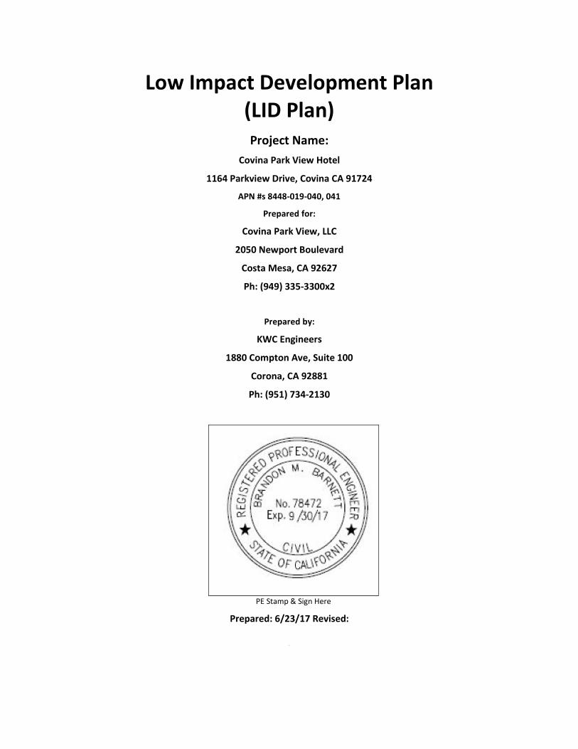
Low Impact Development Plan
(LID Plan)
Project Name:
Covina Park View Hotel
1164 Parkview Drive, Covina CA 91724
APN #s 8448-019-040, 041
Prepared for:
Covina Park View, LLC
2050 Newport Boulevard
Costa Mesa, CA 92627
Ph: (949) 335-3300x2
Prepared by:
KWC Engineers
1880 Compton Ave, Suite 100
Corona, CA 92881
Ph: (951) 734-2130
PE Stamp & Sign Here
Prepared: 6/23/17 Revised:
R

Low Impact Development (LID) Plan
Covina Parkview Hotel
Owner’s Certification
Project Owner’s Certification
I certify under penalty of law that this document and all attachments were prepared under my
jurisdiction or supervision in accordance with a system designed to assure that qualified personnel
properly gather and evaluate the information submitted. Based on my inquiry of the person or persons
who manage the system or those persons directly responsible for gathered the information, to the best
of my knowledge and belief, the information submitted is true, accurate, and complete. I am aware that
there are significant penalties for submitting false information, including the possibility of fine and
imprisonment for knowing violations.
Owner’s Name: Matt Hamilton
Owner’s Title:
Company: Covina Park View, LLC
Address: 2050 Newport Boulevard, Costa Mesa, CA 92627
Email: [email protected]
Telephone No: 949-335-3300
Signature: Date:

Low Impact Development (LID) Plan
Covina Parkview Hotel
Engineer’s Certification
Preparer (Engineer) CertificationEngineer’s Name: Brandon M. Barnett
Engineer’s Title: Executive Vice President
Company: KWC Engineers
Address: 1880 Compton Avenue, Suite 100, Corona CA 92881
Email: [email protected]
Telephone No: 951-734-2130 ex. 203
I hereby certify that this Low Impact Development Plan is in compliance with, and meets the
requirements set forth in, Order No. R4-2012-0175, of the Los Angeles Regional Water Quality Control
Board.
Engineer’s
Signature Date
Place
Stamp
Here
Low Impact Development (LID) Plan
Covina Parkview Hotel
Table of Contents
Table of Contents
1. Project Description ....................................................................................................... 1
1.1. Project Category ........................................................................................................................... 1
1.2. Project Description ....................................................................................................................... 2
1.3. Hydromodification Analysis ......................................................................................................... 4
1.4. Property Ownership/Management .............................................................................................. 5
2. Best Management Practices (BMPs) ............................................................................. 6
2.1. Site Design ................................................................................................................................... 6
2.2. BMP Selection .............................................................................................................................. 7
2.2.1. Infiltration BMPs .......................................................................................................................... 7
2.2.2. Rainwater Harvest and Use BMPs ............................................................................................... 8
2.2.3. Hydromodification Control BMPs .............................................................................................. 12
2.2.4. Alternative Compliance BMPs ..................................................................................................... 9
2.2.5. Treatment Control BMPs ........................................................................................................... 11
2.2.6. Non-structural Source Control BMPs ......................................................................................... 13
2.2.7. Structural Source Control BMPs ................................................................................................. 14
Attachments
Attachment A ......................................................................................................................... Calculations
Attachment B ................................................................................................... Geotechnical Investigation
Attachment C ............................................................................... Master Covenant and Agreement (MCA)
Attachment D ............................................................................ Operations and Maintenance (O&M) Plan
Attachment E ............................................................................................................. Preliminary Site Plan
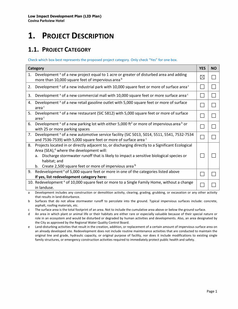
Low Impact Development Plan (LID Plan)
Covina Parkview Hotel
Page 1
1. PROJECT DESCRIPTION
1.1. PROJECT CATEGORY
Check which box best represents the proposed project category. Only check “Yes” for one box.
Category YES NO
1. Development a of a new project equal to 1 acre or greater of disturbed area and adding
more than 10,000 square feet of impervious area b
2. Development a of a new industrial park with 10,000 square feet or more of surface area c
3. Development a of a new commercial mall with 10,000 square feet or more surface area c
4. Development a of a new retail gasoline outlet with 5,000 square feet or more of surface
area c
5. Development a of a new restaurant (SIC 5812) with 5,000 square feet or more of surface
area c
6. Development a of a new parking lot with either 5,000 ft2 or more of impervious area b or
with 25 or more parking spaces
7. Development a of a new automotive service facility (SIC 5013, 5014, 5511, 5541, 7532-7534
and 7536-7539) with 5,000 square feet or more of surface area c
8. Projects located in or directly adjacent to, or discharging directly to a Significant Ecological
Area (SEA),d where the development will:
a. Discharge stormwater runoff that is likely to impact a sensitive biological species or
habitat; and
b. Create 2,500 square feet or more of impervious area b
9. Redevelopment e of 5,000 square feet or more in one of the categories listed above
If yes, list redevelopment category here:
10. Redevelopment e of 10,000 square feet or more to a Single Family Home, without a change
in landuse.
a Development includes any construction or demolition activity, clearing, grading, grubbing, or excavation or any other activity
that results in land disturbance.
b Surfaces that do not allow stormwater runoff to percolate into the ground. Typical impervious surfaces include: concrete,
asphalt, roofing materials, etc.
c The surface area is the total footprint of an area. Not to include the cumulative area above or below the ground surface.
d An area in which plant or animal life or their habitats are either rare or especially valuable because of their special nature or
role in an ecosystem and would be disturbed or degraded by human activities and developments. Also, an area designated by
the City as approved by the Regional Water Quality Control Board.
e Land-disturbing activities that result in the creation, addition, or replacement of a certain amount of impervious surface area on
an already developed site. Redevelopment does not include routine maintenance activities that are conducted to maintain the
original line and grade, hydraulic capacity, or original purpose of facility, nor does it include modifications to existing single
family structures, or emergency construction activities required to immediately protect public health and safety.
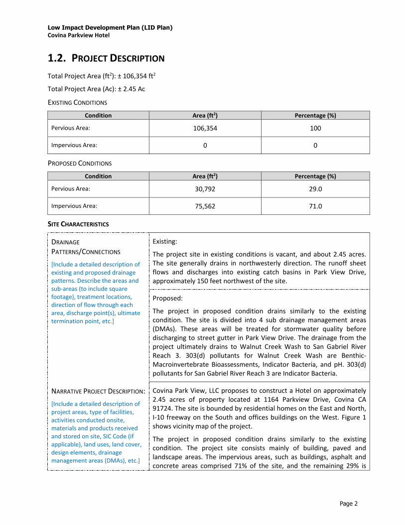
Low Impact Development Plan (LID Plan)
Covina Parkview Hotel
Page 2
1.2. PROJECT DESCRIPTION
Total Project Area (ft2): ± 106,354 ft2
Total Project Area (Ac): ± 2.45 Ac
EXISTING CONDITIONS
Condition Area (ft2) Percentage (%)
Pervious Area: 106,354 100
Impervious Area: 0 0
PROPOSED CONDITIONS
Condition Area (ft2) Percentage (%)
Pervious Area: 30,792 29.0
Impervious Area: 75,562 71.0
SITE CHARACTERISTICS
DRAINAGE
PATTERNS/CONNECTIONS
[Include a detailed description of
existing and proposed drainage
patterns. Describe the areas and
sub-areas (to include square
footage), treatment locations,
direction of flow through each
area, discharge point(s), ultimate
termination point, etc.]
Existing:
The project site in existing conditions is vacant, and about 2.45 acres.
The site generally drains in northwesterly direction. The runoff sheet
flows and discharges into existing catch basins in Park View Drive,
approximately 150 feet northwest of the site.
Proposed:
The project in proposed condition drains similarly to the existing
condition. The site is divided into 4 sub drainage management areas
(DMAs). These areas will be treated for stormwater quality before
discharging to street gutter in Park View Drive. The drainage from the
project ultimately drains to Walnut Creek Wash to San Gabriel River
Reach 3. 303(d) pollutants for Walnut Creek Wash are Benthic-
Macroinvertebrate Bioassessments, Indicator Bacteria, and pH. 303(d)
pollutants for San Gabriel River Reach 3 are Indicator Bacteria.
NARRATIVE PROJECT DESCRIPTION:
[Include a detailed description of
project areas, type of facilities,
activities conducted onsite,
materials and products received
and stored on site, SIC Code (if
applicable), land uses, land cover,
design elements, drainage
management areas (DMAs), etc.]
Covina Park View, LLC proposes to construct a Hotel on approximately
2.45 acres of property located at 1164 Parkview Drive, Covina CA
91724. The site is bounded by residential homes on the East and North,
I-10 freeway on the South and offices buildings on the West. Figure 1
shows vicinity map of the project.
The project in proposed condition drains similarly to the existing
condition. The project site consists mainly of building, paved and
landscape areas. The impervious areas, such as buildings, asphalt and
concrete areas comprised 71% of the site, and the remaining 29% is

Low Impact Development Plan (LID Plan)
Covina Parkview Hotel
Page 3
pervious or landscape areas. The site is divided into 4 sub drainage
management areas (DMAs). These areas will be treated for stormwater
quality before discharging to street gutter in Park View Drive.
The site zoning is C-P (Administrative and Professional Office) with an
overlay zone, PCD (Planned Community Development). SIC code for
Hotel is 7011.
OFFSITE RUN-ON
[Describe any offsite runon
anticipated and how the runon
will be either accounted for in LID
BMP sizing or directed around the
site.]
There is no offsite run-on anticipated for the site in any direction.
UTILITY AND INFRASTRUCTURE
INFORMATION
[Include a description of the
existing and proposed onsite
utility and infrastructure. Evaluate
the potential impacts of
stormwater infiltration on
subsurface utilities, establish
necessary setbacks, and if the
utilities need to be relocated.
Retention-based stormwater
quality control measures should
not be located near utility lines
where an increased volume of
water could damage utilities.]
The project has no conflicts with existing utilities on site. There is
existing 10 feet water easement provided for 6-inh waterline that runs
along the south and southwesterly boundary of the site. Proposed
infiltration BMPs are not going to be in conflict with the waterline and
no damage is anticipated from stormwater runoff infiltration.
SIGNIFICANT ECOLOGICAL AREAS
(SEAS)
[Identify any known Significant
Ecological Area (SEA) which the
project is located in or directly
adjacent to, or discharging directly
to.]
There are no known Significant Ecological Area (ESA) near the project
site.

Low Impact Development Plan (LID Plan)
Covina Parkview Hotel
Page 4
1.3. HYDROMODIFICATION ANALYSIS
DOES THE PROPOSED PROJECT FALL INTO ONE OF THE FOLLOWING CATEGORIES? CHECK YES/NO. YES NO
1. Project is a redevelopment that decreases the effective impervious area compared to the
pre-project conditions.
Describe:
2. Project is a redevelopment that increases the infiltration capacity of pervious areas
compared to the pre-project conditions.
Describe:
3. Project discharges directly or via a storm drain to a sump, lake, area under tidal
influence, into a waterway that has a 100-year peak flow (Q100) of 25,000 cfs or more.
Describe:
4. Project discharges directly or via a storm drain into concrete or otherwise engineered
(not natural) channels (e.g., channelized or armored with rip rap, shotcrete, etc.), which,
in turn, discharge into receiving water that is not susceptible to hydromodification
impacts.
Describe:
[Check “Yes” or “No,” as applicable.
If one or more of the above criteria are checked “Yes,” the project is exempt from Hydromodification Control
Measures. State as such.
If none of the above criteria are checked “Yes,” the project will require Hydromodification control measures.
Include detailed description of control measures to be implemented and a reference to calculations following the
criteria outlined in MS4 Permit (Order R4-2012-0175) §VI.D.7.c.iv]
HYDROMODIFICATION ANALYSIS
N/A

Low Impact Development Plan (LID Plan)
Covina Parkview Hotel
Page 5
1.4. PROPERTY OWNERSHIP/MANAGEMENT
[Describe ownership of all
portions of project and
site. Include information
on if any infrastructure
transfer to public agencies
(City, County, Caltrans,
etc.). Describe any
property management
company/association that
will be formed. Include
leasee information, as
applicable.]
Property ownership / management will be provided by the owner during
construction and after project completion. The entity will be responsible for
the long-term maintenance of the project stormwater and LID facilities
associated with the proposed hotel site. This will be incorporated with
the proposed hotel site. This will be incorporated and outlined CC&R’s
or such documents associated with the hotel site.

Low Impact Development Plan (LID Plan)
Covina Parkview Hotel
Page 6
2. BEST MANAGEMENT PRACTICES (BMPS)
2.1. SITE DESIGN
85TH PERCENTILE, 24-
HOUR STORM DEPTH
[Determined from the Los
Angeles County 85th
percentile precipitation
isohyetal map. If less than
0.75 inch, state as such
and use 0.75 inch
throughout.]
1.00 inch
SITE DESIGN
[Describe site design and
drainage plan including;
site design practices
utilized and how BMPs are
incorporated using the
appropriate hierarchy.]
The proposed site utilized landscape area as infiltration systems
bioretention without underdrain. The remaining area will be treated by
Stormtect Infiltration Chamber System. Pre-treatments to the underground
chameber system includes filter insert, isolation row, and eccentric header
pipe.
BMP LIST
[Fill out the table below with information on the BMPs incorporated in each Drainage Management Area (DMA)]
DMA
DESIGNATION
SQUARE
FOOTAGE
(SF)
ACREAG
E
(AC)
STORM WATER
QUALITY DESIGN
VOLUME
(SWQDV, CF)
STORM WATER
QUALITY DESIGN
FLOWRATE
(SWQDQ, CFS) [Delete if using
volume-based
BMPs]
BMP TYPE [Include make &
model if proprietary]
MINIMUM
BMP SIZE [Include
units]
BMP SIZE
PROVIDED [Include
units]
A 50094 1.15 2535 - Bioretention 507 SF 525 SF
B 15246 0.35 864
- Stormtect
Infiltration
Chamber System
864 CF 903 CF
C 5663 0.13 386 - Bioretention
Basin 331 SF 350 SF
D 33541 0.77 2071
- Stormtect
Infiltration
Chamber System
2071 2156

Low Impact Development Plan (LID Plan)
Covina Parkview Hotel
Page 7
2.2. BMP SELECTION
2.2.1. INFILTRATION BMPS
NAME INCLUDED
[Check all that apply.]
Bioretention without underdrains
Infiltration Trench
Infiltration Basin
Drywell
Proprietary Subsurface Infiltration Gallery
Permeable Pavement (concrete, asphalt, pavers)
Other: Underground Infiltration Basin
Other:
DESCRIPTION
[Describe Infiltration
BMPs. Include
descriptions on selection,
sizing, and feasibility, as
applicable. If infiltration
is infeasible, provide brief
explanation, including
reference to the
geotechnical report.]
The project are proposed to use (2) bioretention without underdrains and (2)
underground Stormtech – Infiltration Chamber System. For preliminary
design, a percolation rate of 1 inch/hour is used.
CALCULATIONS
[Show calculations to
demonstrate that the
Storm Water Quality
Design volume can be
met with Infiltration
BMPs.]
See Attachment 1 for supporting calculations.

Low Impact Development Plan (LID Plan)
Covina Parkview Hotel
Page 8
2.2.2. RAINWATER HARVEST AND USE BMPS
NAME INCLUDED
[Check all that apply.]
Above-ground cisterns and basins
Underground detention
Other:
Other:
Other:
DESCRIPTION
[Describe Rainwater
Harvest and Use BMPs.
Include descriptions on
selection, suitability,
sizing, and infeasibility, as
applicable.]
CALCULATIONS
[Show calculations to
demonstrate if the Storm
Water Quality Design
volume can be met with
Rainwater Harvest and
Use BMPs. If not,
document how much can
be met with Rainwater
Harvest and Use and why
it is not feasible to meet
the full volume with
Rainwater Harvest and
Use BMPs.]

Low Impact Development Plan (LID Plan)
Covina Parkview Hotel
Page 9
2.2.3. ALTERNATIVE COMPLIANCE BMPS
BIOFILTRATION BMPS (If Infiltration BMPs and Rainwater Harvest and Use BMPs are Infeasible)
NAME INCLUDED
[Check all that apply.]
Bioretention with underdrains (i.e. planter box, rain garden, etc.)
Constructed Wetland
Vegetated Swale
Vegetated Filter Strip
Tree-Well Filter
Other:
Other:
DESCRIPTION
[If the full Design Storm
Capture Volume cannot
be met with Infiltration
BMPs, and/or Rainwater
Harvest and Use BMPs,
describe Biofiltration
BMPs. Include
descriptions on selection,
suitability, sizing, and
infeasibility, as
applicable.]
CALCULATIONS
[Show calculations to
demonstrate how 1.5
times the Storm Water
Quality Design volume
and/or flowrate can be
met with Biotreatment
BMPs.]

Low Impact Development Plan (LID Plan)
Covina Parkview Hotel
Page 10
OFFSITE BMPS (If Infiltration BMPs, Rainwater Harvest and Use BMPs, and Biofiltration BMPs are Infeasible)
NAME INCLUDED
[Check all that apply.]
Offsite Infiltration
Ground Water Replenishment Projects
Offsite Project - Retrofit Existing Development
Regional Storm Water Mitigation Program
Other:
Other:
DESCRIPTION
[If the full Design Storm
Capture Volume cannot
be met with Infiltration
BMPs, Rainwater Harvest
and Use BMPs, or
Biofiltration BMPs,
describe proposed
Alternative Compliance
BMPs. Include
descriptions on selection,
suitability, sizing, and
infeasibility, as
applicable.]
CALCULATIONS
[Show calculations to
demonstrate how the
conditions required by
the MS4 Permit will be
met with Alternative
Compliance BMPs.]

Low Impact Development Plan (LID Plan)
Covina Parkview Hotel
Page 11
2.2.4. TREATMENT CONTROL BMPS
Treatment control BMPs can only be used as pre-treatment to LID BMPs.
NAME INCLUDED
[Check all that apply.]
Media Filter
Filter Insert
CDS Unit
Other:
Other:
DESCRIPTION
[Include descriptions on
selection, suitability,
sizing, and infeasibility, as
applicable.]
Filter Inserts will be used as pre-treatment before any runoff enter to the Stormtect
Infiltration Chamber System.

Low Impact Development Plan (LID Plan)
Covina Parkview Hotel
Page 12
2.2.5. HYDROMODIFICATION CONTROL BMPS
NAME INCLUDED
[Check all that apply.]
Infiltration System
Above-ground Cistern
Above-ground Basin
Underground Detention
Other:
Other:
DESCRIPTION
[If the site is susceptible
to hydromodification,
include descriptions on
selection and sizing of
Hydromodification
Control Measures.]
CALCULATIONS
[If the site is susceptible
to hydromodification,
show calculations to
demonstrate how the
volume, flowrate, and
duration conditions can
be met with
Hydromodification
Control Measures BMPs.]

Low Impact Development Plan (LID Plan)
Covina Parkview Hotel
Page 13
2.2.6. NON-STRUCTURAL SOURCE CONTROL BMPS
NAME CHECK ONE
Included Not Applicable
Education for Property Owners, Tenants and Occupants
Activity Restrictions
Common Area Landscape Management
Common Area Litter Control
Housekeeping of Loading Docks
Common Area Catch Basin Inspection
Street Sweeping Private Streets and Parking Lots
Related Documents