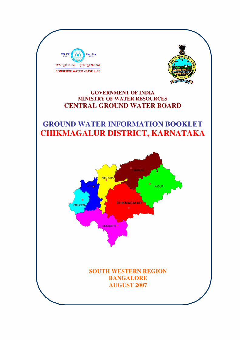
GOVERNMENT OF INDIA MINISTRY OF WATER RESOURCES CENTRAL GROUND WATER BOARD GROUND WATER INFORMATION BOOKLET CHIKMAGALUR DISTRICT, KARNATAKA SOUTH WESTERN REGION BANGALORE AUGUST 2007 CHIKMAGALUR N.R.PURA MUDIGERE SRINGERI KOPPA TARIKERE KADUR

Welcome message from author
This document is posted to help you gain knowledge. Please leave a comment to let me know what you think about it! Share it to your friends and learn new things together.
Transcript
GOVERNMENT OF INDIA
MINISTRY OF WATER RESOURCES
CENTRAL GROUND WATER BOARD
GROUND WATER INFORMATION BOOKLET
CHIKMAGALUR DISTRICT, KARNATAKA
SOUTH WESTERN REGION
BANGALORE
AUGUST 2007
CHIKMAGALUR
N.R.PURA
MUDIGERE
SRINGERI
KOPPA
TARIKERE
KADUR

FOREWORD
Ground water contributes to about eighty percent of the drinking
water requirements in the rural areas, fifty percent of the urban water
requirements and more than fifty percent of the irrigation requirements of the
nation. Central Ground Water Board has decided to bring out district level
ground water information booklets highlighting the ground water scenario, its
resource potential, quality aspects, recharge – discharge relationship, etc., for
all the districts of the country. As part of this, Central Ground Water Board,
South Western Region, Bangalore, is preparing such booklets for all the 27
districts of Karnataka state, of which six of the districts fall under farmers’
distress category.
The Chikmagalur district Ground Water Information Booklet has
been prepared based on the information available and data collected from
various state and central government organisations by several hydro-scientists
of Central Ground Water Board with utmost care and dedication. This booklet
has been prepared by Shri S.N.Ramaiah, Scientist-D, under the guidance of
Dr. K.Md. Najeeb, Superintending Hydrogeologist, Central Ground Water
Board, South Western Region, Bangalore. I take this opportunity to
congratulate them for the diligent and careful compilation and observation in
the form of this booklet, which will certainly serve as a guiding document for
further work and help the planners, administrators, hydrogeologists and
engineers to plan the water resources management in a better way in the
district.
Sd/-
(T.M.HUNSE) Regional Director
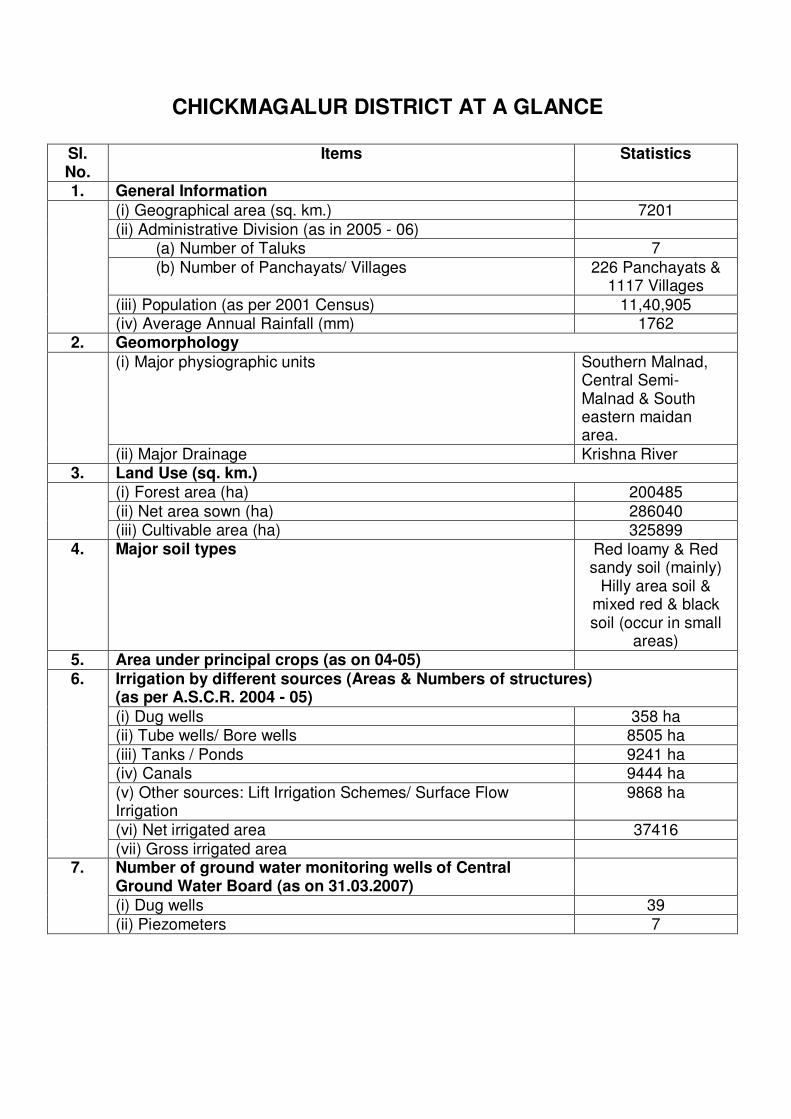
CHICKMAGALUR DISTRICT AT A GLANCE
Sl. No.
Items
Statistics
1. General Information
(i) Geographical area (sq. km.) 7201
(ii) Administrative Division (as in 2005 - 06) (a) Number of Taluks 7
(b) Number of Panchayats/ Villages 226 Panchayats & 1117 Villages
(iii) Population (as per 2001 Census) 11,40,905
(iv) Average Annual Rainfall (mm) 1762 2. Geomorphology
(i) Major physiographic units Southern Malnad, Central Semi- Malnad & South eastern maidan area.
(ii) Major Drainage Krishna River 3. Land Use (sq. km.)
(i) Forest area (ha) 200485 (ii) Net area sown (ha) 286040
(iii) Cultivable area (ha) 325899 4. Major soil types Red loamy & Red
sandy soil (mainly) Hilly area soil &
mixed red & black soil (occur in small
areas) 5. Area under principal crops (as on 04-05)
Irrigation by different sources (Areas & Numbers of structures) (as per A.S.C.R. 2004 - 05)
(i) Dug wells 358 ha (ii) Tube wells/ Bore wells 8505 ha
(iii) Tanks / Ponds 9241 ha (iv) Canals 9444 ha
(v) Other sources: Lift Irrigation Schemes/ Surface Flow Irrigation
9868 ha
(vi) Net irrigated area 37416
6.
(vii) Gross irrigated area Number of ground water monitoring wells of Central Ground Water Board (as on 31.03.2007)
(i) Dug wells 39
7.
(ii) Piezometers 7

8. Predominant Geological Formations Charnokite, gneisses & unclassified crystallines, slates, phyllites & schists.
Hydrogeology (i) Major water bearing formation Gneiss & Schist
(Fractured & weathered)
(ii) Pre - monsoon depth to water level during May 2006 (in mbgl)
1.92 – 12.40
9.
(iii) Post – monsoon depth to water level during Nov. 2006 (in mbgl)
0.55 – 10.32
(iv) Long term water level trend in 10 years (1997 – 2006) (a) Pre – monsoon; May 1997 – May 2006 (m/year) (b) Post – monsoon; Nov. 1997 – Nov. 2006 (m/year)
(a) In 17 NHS, water levels show rising trend in the range of 0.001 to 0.496m/year & in 13 NHS water levels show falling trend in the range of 0.023 to 0.814 m/year. (b) In 16 NHS, water levels show rising trend in the range of 0.007 to 0.120m/year. & in 17 NHS water levels show falling trend in the range of 0.004 to 0.93.2m/year
Ground water Exploration by Central Ground Water Board (as on 31.03.07)
(i) Number of wells drilled (EW, OW, PZ, SH, Total) 30 – EW; 9 - OW (ii) Depth Range (mbgl) 60 – 265.21 (iii) Discharge (litres per second) 0.45 – 11.16
(iv) Storativity (S)
10.
(v) Transmissivity (m2/day) 0.11 - 108 Ground water quality 11. (i) Presence of chemical constituents more than permissible limit
Nitrate (in very small area of Kadur taluk)
Dynamic Ground Water Resource (2004) ( mcm)
(i) Annual replenishable ground water resource 507
(ii) Net Annual Ground Water Draft 233
12.
(iii) Projected demand for domestic & industrial uses upto 2025 45

(iv) Stage of ground water development (%) 48 Awareness & Training activity (i) Mass awareness programmes organized
(a) Date 25.03.99 (b) Place Tangli village, Kadur
taluk (ii) Water management Training Programmes organized
(a) Date 29.11.2006
13.
(b) Place Zilla Panchayat Meeting Hall, Chikmagalur
Artificial recharge & rainwater harvesting
(i) Projects completed by CGWB (No. & amount spent) Nil
14.
(ii) Projects under technical guidance of CGWB Nil Ground water control & Regulation (i) Number of OE blocks Nil
(ii) Number of Critical blocks 1( Kadur taluk)
15.
(iii) Number of blocks notified Nil
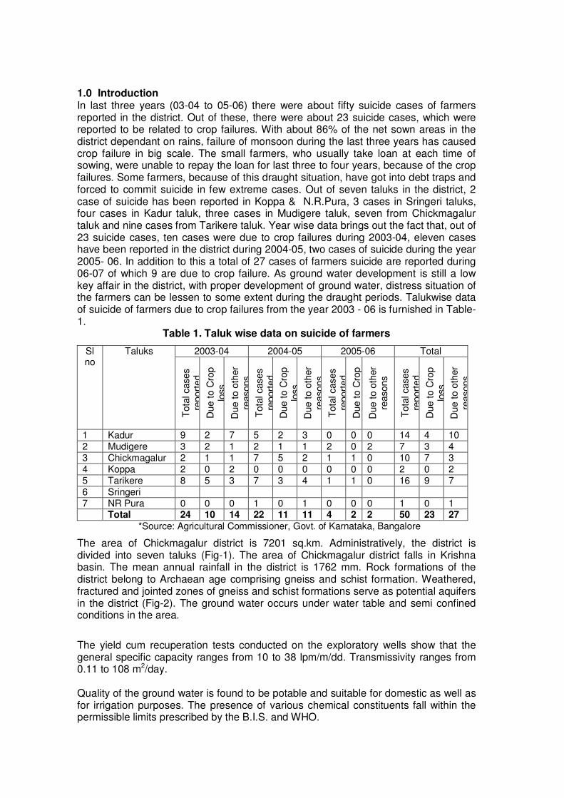
1.0 Introduction In last three years (03-04 to 05-06) there were about fifty suicide cases of farmers reported in the district. Out of these, there were about 23 suicide cases, which were reported to be related to crop failures. With about 86% of the net sown areas in the district dependant on rains, failure of monsoon during the last three years has caused crop failure in big scale. The small farmers, who usually take loan at each time of sowing, were unable to repay the loan for last three to four years, because of the crop failures. Some farmers, because of this draught situation, have got into debt traps and forced to commit suicide in few extreme cases. Out of seven taluks in the district, 2 case of suicide has been reported in Koppa & N.R.Pura, 3 cases in Sringeri taluks, four cases in Kadur taluk, three cases in Mudigere taluk, seven from Chickmagalur taluk and nine cases from Tarikere taluk. Year wise data brings out the fact that, out of 23 suicide cases, ten cases were due to crop failures during 2003-04, eleven cases have been reported in the district during 2004-05, two cases of suicide during the year 2005- 06. In addition to this a total of 27 cases of farmers suicide are reported during 06-07 of which 9 are due to crop failure. As ground water development is still a low key affair in the district, with proper development of ground water, distress situation of the farmers can be lessen to some extent during the draught periods. Talukwise data of suicide of farmers due to crop failures from the year 2003 - 06 is furnished in Table-1.
Table 1. Taluk wise data on suicide of farmers
2003-04 2004-05 2005-06 Total Sl no
Taluks
Tota
l cases
report
ed
Due t
o C
rop
loss
Due t
o o
ther
reasons
Tota
l cases
report
ed
Due t
o C
rop
loss
Due t
o o
ther
reasons
Tota
l cases
report
ed
Due t
o C
rop
Due t
o o
ther
reasons
Tota
l cases
report
ed
Due t
o C
rop
loss
Due t
o o
ther
reasons
1 Kadur 9 2 7 5 2 3 0 0 0 14 4 10 2 Mudigere 3 2 1 2 1 1 2 0 2 7 3 4 3 Chickmagalur 2 1 1 7 5 2 1 1 0 10 7 3 4 Koppa 2 0 2 0 0 0 0 0 0 2 0 2 5 Tarikere 8 5 3 7 3 4 1 1 0 16 9 7 6 Sringeri 7 NR Pura 0 0 0 1 0 1 0 0 0 1 0 1 Total 24 10 14 22 11 11 4 2 2 50 23 27
*Source: Agricultural Commissioner, Govt. of Karnataka, Bangalore
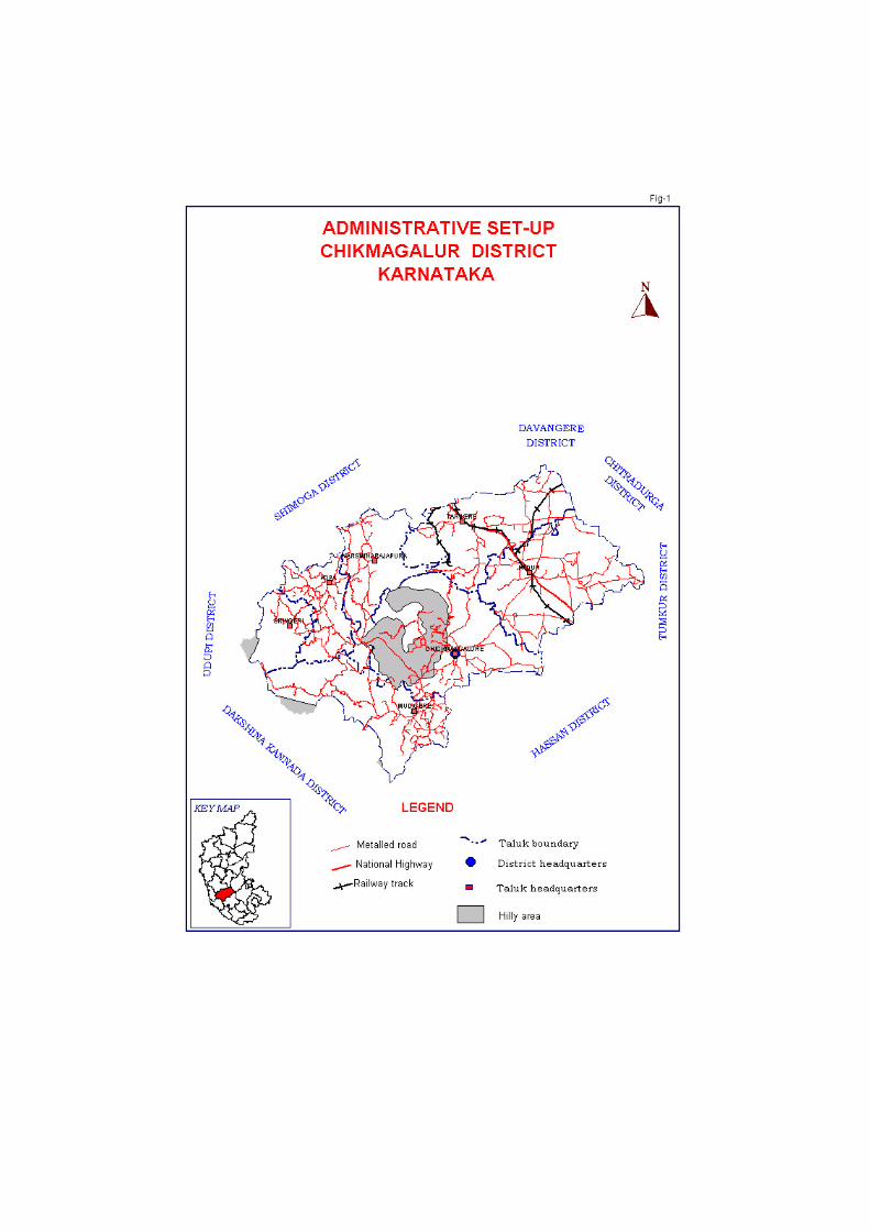
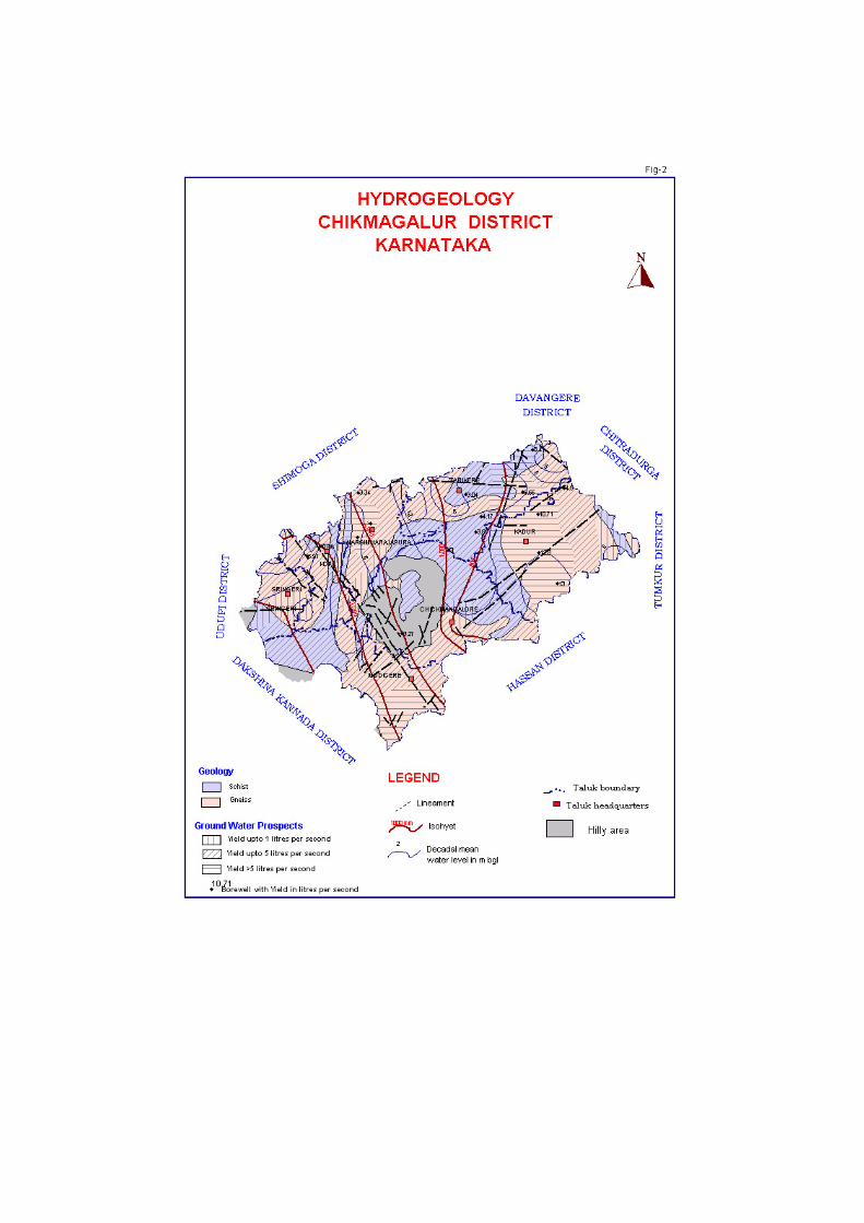
The area of Chickmagalur district is 7201 sq.km. Administratively, the district is divided into seven taluks (Fig-1). The area of Chickmagalur district falls in Krishna basin. The mean annual rainfall in the district is 1762 mm. Rock formations of the district belong to Archaean age comprising gneiss and schist formation. Weathered, fractured and jointed zones of gneiss and schist formations serve as potential aquifers in the district (Fig-2). The ground water occurs under water table and semi confined conditions in the area.
The yield cum recuperation tests conducted on the exploratory wells show that the general specific capacity ranges from 10 to 38 lpm/m/dd. Transmissivity ranges from 0.11 to 108 m2/day. Quality of the ground water is found to be potable and suitable for domestic as well as for irrigation purposes. The presence of various chemical constituents fall within the permissible limits prescribed by the B.I.S. and WHO.
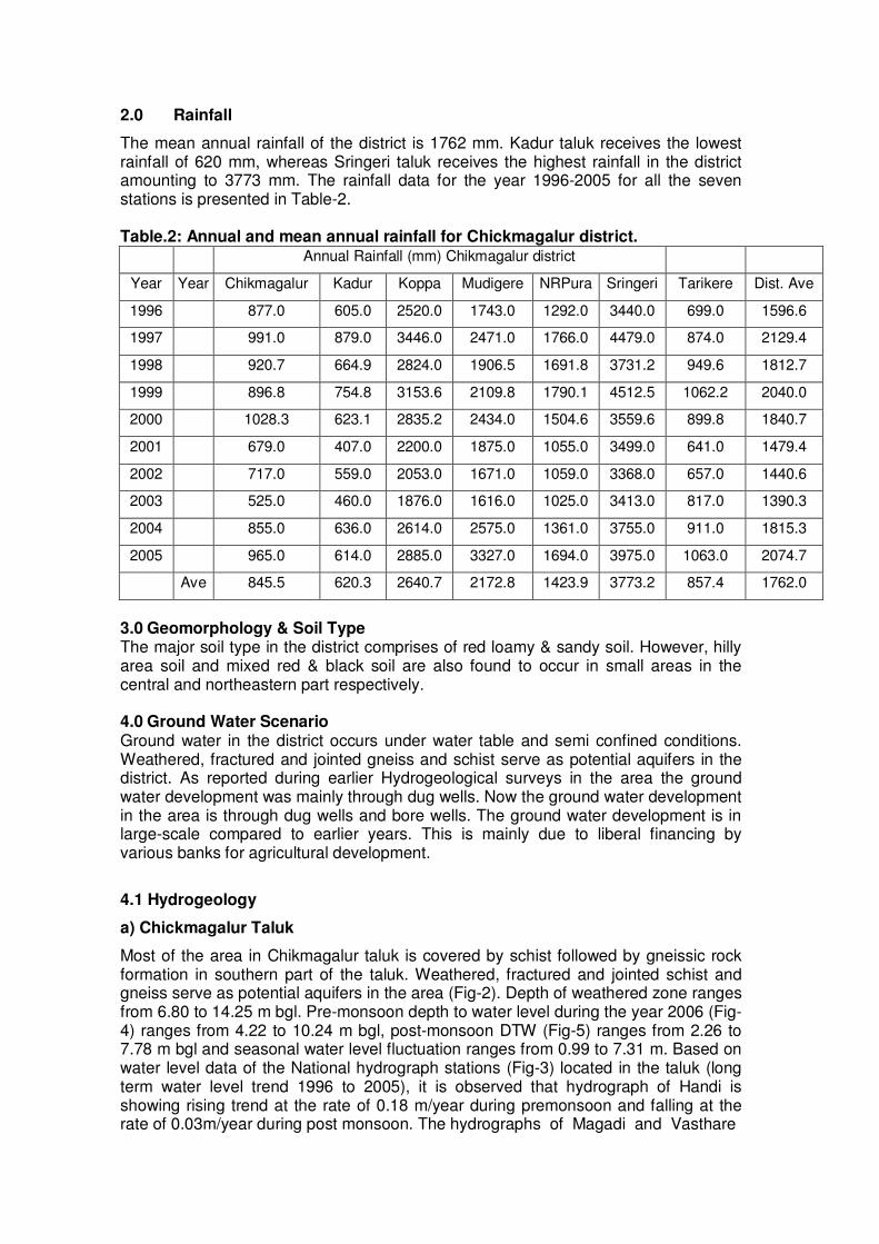
2.0 Rainfall
The mean annual rainfall of the district is 1762 mm. Kadur taluk receives the lowest rainfall of 620 mm, whereas Sringeri taluk receives the highest rainfall in the district amounting to 3773 mm. The rainfall data for the year 1996-2005 for all the seven stations is presented in Table-2. Table.2: Annual and mean annual rainfall for Chickmagalur district. Annual Rainfall (mm) Chikmagalur district
Year Year Chikmagalur Kadur Koppa Mudigere NRPura Sringeri Tarikere Dist. Ave
1996 877.0 605.0 2520.0 1743.0 1292.0 3440.0 699.0 1596.6
1997 991.0 879.0 3446.0 2471.0 1766.0 4479.0 874.0 2129.4
1998 920.7 664.9 2824.0 1906.5 1691.8 3731.2 949.6 1812.7
1999 896.8 754.8 3153.6 2109.8 1790.1 4512.5 1062.2 2040.0
2000 1028.3 623.1 2835.2 2434.0 1504.6 3559.6 899.8 1840.7
2001 679.0 407.0 2200.0 1875.0 1055.0 3499.0 641.0 1479.4
2002 717.0 559.0 2053.0 1671.0 1059.0 3368.0 657.0 1440.6
2003 525.0 460.0 1876.0 1616.0 1025.0 3413.0 817.0 1390.3
2004 855.0 636.0 2614.0 2575.0 1361.0 3755.0 911.0 1815.3
2005 965.0 614.0 2885.0 3327.0 1694.0 3975.0 1063.0 2074.7
Ave 845.5 620.3 2640.7 2172.8 1423.9 3773.2 857.4 1762.0
3.0 Geomorphology & Soil Type The major soil type in the district comprises of red loamy & sandy soil. However, hilly area soil and mixed red & black soil are also found to occur in small areas in the central and northeastern part respectively. 4.0 Ground Water Scenario Ground water in the district occurs under water table and semi confined conditions. Weathered, fractured and jointed gneiss and schist serve as potential aquifers in the district. As reported during earlier Hydrogeological surveys in the area the ground water development was mainly through dug wells. Now the ground water development in the area is through dug wells and bore wells. The ground water development is in large-scale compared to earlier years. This is mainly due to liberal financing by various banks for agricultural development.
4.1 Hydrogeology
a) Chickmagalur Taluk
Most of the area in Chikmagalur taluk is covered by schist followed by gneissic rock formation in southern part of the taluk. Weathered, fractured and jointed schist and gneiss serve as potential aquifers in the area (Fig-2). Depth of weathered zone ranges from 6.80 to 14.25 m bgl. Pre-monsoon depth to water level during the year 2006 (Fig-4) ranges from 4.22 to 10.24 m bgl, post-monsoon DTW (Fig-5) ranges from 2.26 to 7.78 m bgl and seasonal water level fluctuation ranges from 0.99 to 7.31 m. Based on water level data of the National hydrograph stations (Fig-3) located in the taluk (long term water level trend 1996 to 2005), it is observed that hydrograph of Handi is showing rising trend at the rate of 0.18 m/year during premonsoon and falling at the rate of 0.03m/year during post monsoon. The hydrographs of Magadi and Vasthare
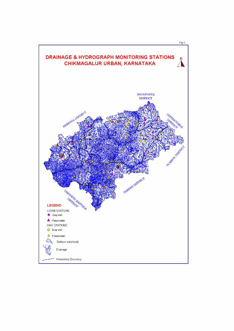
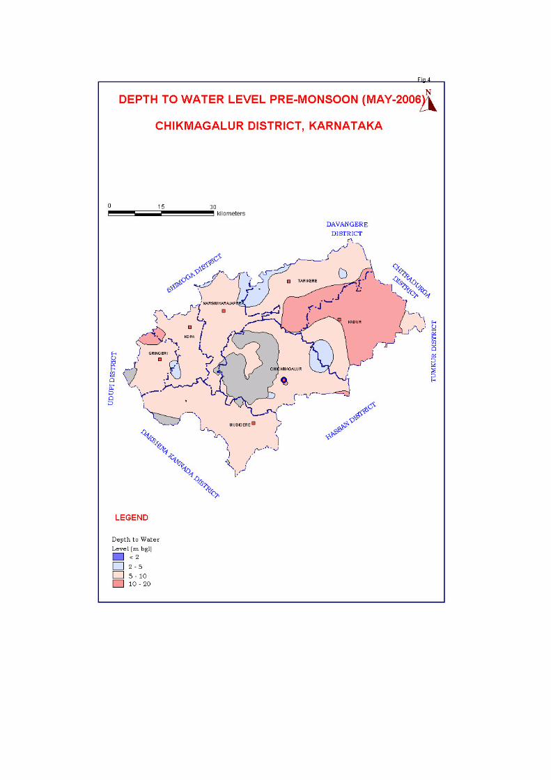

are showing the falling trend during both pre and post monsoon period at the rate of 0.06,0.16 and 0.35,0.30 m/year respectively. Pumping tests on shallow aquifers conducted in the area during hydrogeological surveys shows that specific capacity varies from 8.80 to 398 lpm/mdd. b) Kadur taluk Nearly 80% of the area in Kadur taluk is covered by gneissic rock formation and schist occupies rest of the area. Ground water occurs under water table as well as in semi-confined condition. Weathered, fractured and jointed gneiss and schist serves as potential aquifers in the area. Depth of weathering in the area ranges from 5.51 to16.10 m bgl. Pre - monsoon DTW (Fig-4) in the area ranges from 5.0 to 15.09 m bgl, Post monsoon DTW (Fig-5) ranges from 2.05 to 12.98 m bgl with a seasonal water level fluctuation ranging from 2.04 to 5.30m. Based on water level data of the National hydrograph stations (Fig-3) located in the taluk (long term water level trend 1996 to 2005), it is observed that hydrograph of Sakrepatna is showing falling trend during both pre and postmonsson period at the rate of 0.19 and 0.03 m/year. Pumping tests on shallow aquifers conducted in the area during hydrogeological surveys shows that specific capacity varies from 7.3 to 71 lpm/mdd.
c) Koppa Taluk Western part of the area in Koppa taluk is covered by gneiss and central and northern part of the taluk occupied by schist formation. Fractured and jointed gneiss and schist serves as potential aquifers in the area. Depth of weathered zone ranges from 7.15 to 11.05 m bgl. Pre-monsoon depth to water level during the year 2006 (Fig-4) ranges from 5.45 to 9.72 m bgl, post-monsoon DTW (Fig-5) ranges from 5.50 to 6.40 m bgl and seasonal water level fluctuation ranges from 0.05 to 3.68 m. Based on water level data of the National hydrograph stations located(Fig-3) in the taluk (long term water level trend 1996 to 2005), it is observed that both hydrographs of Hariharapura and Koppa are showing rising trend during premonsoon and Post monsoon period at the rate of 0.08,0.05 and 0.05,0.18 m/year respectively. Pumping tests on shallow aquifers conducted in the area during hydrogeological surveys shows that specific capacity varies from 9.10 to 65 lpm/mdd.
d) Mudigere Taluk Nearly 60% of the area in Mudigere talk is covered by gneiss and rest of the area is occupied by schist formation. Weathered fractured and jointed gneiss and schist serves as potential aquifers in the area. Depth of weathered zone ranges from 7.95 to 12.20 m bgl. Pre-monsoon depth to water level during the year 2006 (Fig-4) ranges from 4.99 to 9.63 m bgl, post-monsoon DTW (Fig-5) ranges from 2.18 to 6.43 m bgl and seasonal water level fluctuation ranges from 0.80 to 3.68 m. Based on water level data of the National hydrograph stations located (Fig-3) in the taluk (long term water level trend 1996 to 2005), it is observed that the two hydrographs of Kalasa and Mudigere are showing rising trend during premonsoon and Post monsoon period at the rate of 0.23,0.16 and 0.10,0.11m/year respectively. The hydrograph of Bhavikere shows falling trend during premonsoon at the rate of 0.17 m/year. Pumping tests on shallow aquifers conducted in the area during hydrogeological surveys shows that specific capacity varies from 8.5 to 398 lpm/mdd.
e) N.R.Pura Taluk Nearly 90% of the area in N.R.Pura taluk is covered by gneiss and rest of the area is occupied by schist formation. Weathered fractured and jointed gneiss and schist serves as potential aquifers in the area. Depth of weathered zone ranges from 10.68 to 13.41m bgl. Pre-monsoon depth to water level during the year 2006 (Fig-4) ranges
from 5.67 to 9.01 m bgl, post-monsoon DTW (Fig-5) ranges from 2.37 to 5.33 m bgl and seasonal water level fluctuation ranges from 2.02 to 3.30 m. Based on water level data of the National hydrograph stations (Fig-3) located in the taluk (long term water level trend 1996 to 2005), it is observed that the hydrograph of N.R.pura is showing rising rising trend during pre monsoon and Post monsoon period at the rate of 0.11and 0.12 m/year
f) Sringeri taluk Nearly 70% of the area in Sringeri taluk is covered by gneiss and rest of the area is occupied by schist formation. Weathered, fractured and jointed gneiss and schist serves as potential aquifers in the area. Depth of weathered zone ranges from 7.17 to 15.20 m bgl. Pre-monsoon depth to water level during the year 2006 (Fig-4) ranges from 4.37 to 12.40 m bgl, post-monsoon DTW (Fig-5) ranges from 1.88 top 9.30 m bgl and seasonal water level fluctuation ranges from 0.46 to 3.14 m. Based on water level data of the National hydrograph stations (Fig-3) located in the taluk (long term water level trend 1996 to 2005), it is observed that the hydrograph of Sringeri is showing falling trend during pre- monsoon period and more or less rising trend during post monsoon period (at the rate of 0.02 and 0.018 m/year).
g) Tarikere taluk Nearly 50% of the area in Tarikere taluk is covered by gneiss and rest of the area is occupied by schist formation. Weathered, fractured and jointed gneiss and schist serves as potential aquifers in the area. Depth of weathered zone ranges from 6.85 to 20.7 m bgl. Pre-monsoon depth to water level during the year 2006 (Fig-4) ranges from 1.92 to10.94 m bgl, post-monsoon DTW (Fig-5 ) ranges from 1.37 to 5.60 m bgl and seasonal water level fluctuation ranges from 0.55 to 1.67 m. Based on water level data of the National hydrograph stations located in the taluk (long term water level trend 1996 to 2005), it is observed that the hydrograph of Lakkavalli is showing falling trend during both pre and Post monsoon period at the rate of 0.06 and 0.0.01 m/year. The hydrographs of Shivane and Bukkambudi show rising trend during premonsoon period at the rate of 0.36 and 0.33 m/year and falling trend during post monsoon period at the rate of 0.55 and 0.18 m/year.
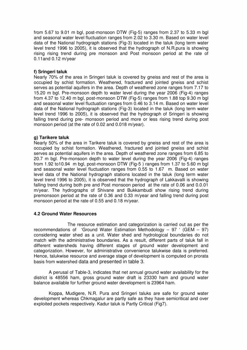
4.2 Ground Water Resources
The resource estimation and categorization is carried out as per the recommendations of ‘Ground Water Estimation Methodology – 97 ‘ (GEM – 97) considering water shed as a unit. Water shed and hydrological boundaries do not match with the administrative boundaries. As a result, different parts of taluk fall in different watersheds having different stages of ground water development and categorization. However, for administrative convenience talukwise data is preferred. Hence, talukwise resource and average stage of development is computed on prorata
basis from watershed data and presented in table 3.
A perusal of Table-3, indicates that net annual ground water availability for the district is 48556 ham, gross ground water draft is 23330 ham and ground water balance available for further ground water development is 23964 ham.
Koppa, Mudigere, N.R. Pura and Sringeri taluks are safe for ground water
development whereas Chkmagalur are partly safe as they have semicritical and over exploited pockets respectively. Kadur taluk is Partly Critical (Fig7).
15
Table 3: Groundwater Resource and Stage of Development of Chikmagalur District, Karnataka State as on March 2004
TALUK
Recharg
e f
rom
rain
fall
during
monsoon s
eason (
HA
M)
Recharg
e f
rom
oth
er
sourc
es
during m
onsoon s
eason (
HA
M)
Recharg
e f
rom
rain
fall
during
non-m
onsoon s
eason (
HA
M)
Recharg
e f
rom
oth
er
sourc
es
during n
on-m
onsoon s
eason
(HA
M)
Annual re
ple
nis
hable
GW
R
esourc
e(H
AM
)
Natu
ral dis
charg
e d
uring n
on-
monsoon s
eason(H
AM
)
Net
Gro
und w
ate
r A
vaila
bili
ty
(HA
M)
Irrigation d
raft
(H
AM
)
Dom
estic a
nd industr
ial dra
ft
(HA
M)
Tota
l annual gro
und w
ate
r dra
ft
(HA
M)
Pro
jecte
d d
om
estic a
nd
industr
ial dra
ft 2
025 (
HA
M)
Gro
und w
ate
r availa
bili
ty f
or
futu
re irr
igation**
(H
AM
)
Sta
ge o
f develo
pm
ent
(%)
Cata
gorisation
2 3 4 5 6 7 8 9 10 11 12 13 14 15
CHIKMAGALUR 3937 2301 2007 507 8752 435 8317 3317 480 3798 668 4329 46 SAFE(P)
KADUR 4983 1587 2314 1168 10059 495 9564 7983 476 8465 665 879 89 Semicritical(P)
KOPPA 1415 1239 451 99 3200 159 3041 289 153 441 201 2558 15 SAFE
MUDIGERE 3758 906 1118 187 5972 297 5675 1291 1018 2303 1397 2994 41 SAFE
N.R. PURA 2723 1849 580 302 5449 246 5204 519 198 717 273 4422 14 SAFE
SRINGERI 704 777 526 35 2041 101 1939 180 111 291 151 1612 15 SAFE
TARIKERE 5834 4392 1484 3584 15294 479 14816 6508 806 7315 1129 7169 49 SAFE(P)
TOTAL 23355 13051 8481 5882 50768 2212 48556 20087 3243 23330 4485 23964 48
Criteria for catagorisation of taluks- (I) Full- Entire taluka falling under a particular category, (II) Partial (P) - >50% of the area of the taluka falling under a categoty, (III) Partial (P-I) where non of the category is having more than 50% area (As per figure7)
16
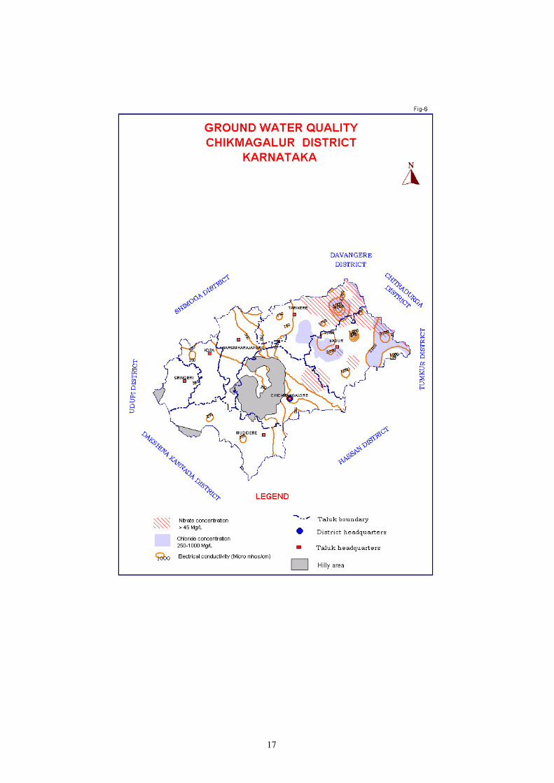
4.3 Ground Water Quality Ground water quality in the wells tapping weathered and fractured crystalline formations is generally good and suitable for drinking as well as for irrigation purposes. The electrical conductivity (EC) of ground water varies from 100 to 3000
micromhos/cm at 25ºC (Fig-6). EC of more than 2000 µs /cm occurs along Kadur-Tarikere boarder and in the southeastern parts of Kadur taluk.Fluoride concentration in ground water in the district is less than 1 mg/l. Nitrate concentration of more than permissible limit occurs along the boarder of Chikmagalur-Kadur taluks and in north eastern parts of Kadur and Tarikere taluks. 4.4 Status of Ground Water Development Owing to the hilly and undulating terrain condition, the uneven distribution of aquifers, the financial constraints of the marginal farmers and the non-availability of cultivable land, the ground water development is in low pace in the district. The farmers with small acreage of land depend mainly on the rainwater and water available in the shallow wells. The abstraction structures, dug-wells and bore wells constructed/existing are mainly tapping the aquifers within depth range 5.55 to 20.70 mbgl and 75 to 200mbgl respectively. The major ground water developmental activities are concentrated in the valley regions, along the banks of rivers/streams and a moderate development found in the undulating land/plateau. The sustained yield of wells recorded from negligible to maximum of 65m3/day. The ground water extraction for irrigation is practiced through shallow abstraction structures (dug well) and bore wells, found all over the area in the district. Owing to the steep and undulating terrain with large subsurface flow condition, the irrigation is practiced only in the valley region. Out of the net sown area of 286040 ha (2004-05) and irrigated area of 37416 ha, only 8863 ha (record-2004-05) of land comes under irrigation through ground water. Keeping in view of the available cultivable wasteland and unused annual utilizable ground water resource availability and marginal growth rate in agricultural sector, there is a need to develop the wastelands to bring under ground water irrigation specially in Koppa, Mudigere, N.R.Pura and Sringeri taluks. A marginal area taken up for ground water developments in the upstream areas would improve the agricultural production. 5.0 Ground Water Management Strategy A proper groundwater resource management strategy is essential to make most economical, efficient and judicious use of ground water and achieve a sustainable ground water resources development. Inculcating the water users on the ground water potentialities in different terrain conditions and its judicious use is essential. Conjunctive use of ground water and surface water can improve this unfavourable scenario. In view of the ever-growing population and subsequent demand for groundwater for various developmental activities, it is suggested to adopt unconventional means to artificially recharge the ground water in the water level depleting areas specially in eastern part of Chickmagalur, Kadur and Tarikere taluks where the areas fall in semi critical to critical category to facilitate the increased ground water availability to the down stream areas. Since, the water management is an integral part of environmental management and ecological stability it should be looked holistically. The development of water supply model should be resource based and the whole problem be tackled in its totality particularly from the point of view of total supply and ever growing demand for the precious natural resources.
17
18
5.1 Ground Water Development The ground water development is on large scale in eastern part of Chickmagalur, Kadur and Tarikere taluks through structures like dug wells and bore wells. This is mainly due to the liberal financing by various banks for agricultural development. In other four taluks namely Koppa, Mudigere, N.R.Pura and Sringeri taluks, there is vast scope for further ground water development as the entire area in these taluks is falling in safe category (Table-3, Fig-7). The ground water can be developed by sinking bore wells in hydrogelogically favorable areas. The sites for drilling bore wells should be selected on sound scientific principles (based on hydrogeological and geophysical surveys).
5.2 Water Conservation and Artificial Recharge Because of deforestation and bringing more and more grass covered areas for other activities during recent times, the natural way of recharging of dynamic reserves of ground water has reduced considerably. Most of the rains falling on the surface of the land flow out of the area immediately as surface run off, causing floods and soil erosion. By constructing suitable structures the contact time of this flowing water with the land is increased or the flow is arrested for some time. By studying the nature of geological formations, slope of the land, depth of weathering, depth to water level and availability of land and water source for the artificial recharge structures, different types of artificial structures are recommended and shown in the map. The plain lands on eastern parts of the district covering the areas in Chickmagalur , Kadur and Tarikere taluks, suitable artificial recharge structures (Fig-7) like Check dams, Nalabunds, Sub-surface dykes, Percolation tanks, and point recharge structures like recharging through existing borewells/ dugwells and recharge pits can be done. The areas in the other four taluks namely Koppa, Mudigere, N.R.Pura and Sringeri taluks the artificial recharge structures are not feasible because of this area receives high annual rainfall to the tune of 1500 to 3000mm,more over the area in all these four taluks falls in safe category. The base flow available in the streams and rivers during non-monsoon season (December to April) in these taluks may be arrested through construction of vented dams (Kholhapur type veirs) at suitable sites. This water can be used for either water supply to town and villages in the area or for lift irrigation.
6.0 Awareness & Training activity Mass awareness programme (under AAP 98-99) was conducted at Tangli village in Kadur taluk, Chikmagalur district on 25.03.99 in the premises of primary health unit, Tangli village, to educate the people on the utilization of ground water, conservation and prevention of pollution. The meeting was well attended by the local state Govt. authorities and local farmers. Pamphlets giving the details and objectives of ‘ Ground Water Authority’ in Kannada and English were distributed. In general, activities of CGWB, importance of ground water, its qualities, general measures of conserving it, role of farmers in achieving these objectives and activities of CGWB under exploration programme in Kadur taluk were discussed during the awareness programme. Shri. Mohammed Saifulla, Tehsildar, Kadur taluk, was the chief guest of the programme.

19
20
Training Programme on Ground Water Management was organized during
28.11.2006 to 29.11.2006 at Zilla Panchayat Meeting Hall, Chikmagalur. The training programme was organized as a nation wide programme for officers of different departments attached to Zilla Panchayat, NGOs’, representatives of farmers and Education Institutions etc., The curriculum of the training programme included water management, ground water conservation, artificial recharge techniques, water quality and its effects on human health, geophysical studies, role of women in water management etc. A Field visit was also planned under the programme covering the area where artificial recharge structures have been constructed. Sri Nilaya Mitash, IAS, Deputy Commissioner, Chikmagalur was the chief guest. Sri K.R. Druvakumar, President, Zilla Panchayat, Chikmagalur presided over the inaugural function and inaugurated the training programme on 28.11.2006. Various scientific aspects of ground water, detailed studies of rainfall pattern and documentaries were presented in the training programme. Certificates were distributed to the trainees after completion of the programme.
8.0 Recommendations Considering the prevailing scenario of the groundwater resources and development the following recommendations are made for the optimum drawl with sustainable development ground water resources in the district.
1. There is vast scope for further ground water development in Koppa, Mudigere, N.R.Pura and Sringeri taluks, as the area in all these taluks falls in safe category. Ground water can be developed through construction of additional ground water structures like bore wells.
2. Eastern part of Chikmagalur, central, South-western part of Kadur taluk falls under semi critical category and eastern part of Tarikere taluk falls under critical category. Here ground water withdrawal is to be minimised. Farmers should adopt micro irrigation system like sprinkler and drip irrigation system, so that more area can be brought under ground water irrigation with the same draft and crop yield will be more. Artificial recharge structures like Check dams, Nala bunds, Sub- surface dykes, percolation tanks, contour trenches and contour bunds are to be constructed at suitable sites for ground water recharge.
3. All most all areas in Koppa, Mudigere, N.R.Pura and Sringeri are hilly and the rain fall is also high (1500to 3000 mm). There is no scope for construction of artificial recharge structures because unsaturated aquifers get recharged during South-West monsoon rains.
4. Lot of base flow is available in the streams and rivers of these four taluks during non-monsoon period (December to April), this base flow can be harvested by construction of vented dams at suitable places.
5. The water retained in these vented dams can be utilised for domestic water supply to villages and towns located in the area as the villages and towns located in the area faces acute shortage of drinking water during April and May. The water retained in vented dams can also be utilised for lift irrigation.
Related Documents