Technical series:E For official use only Government of India Ministry of Water Resources CENTRAL GROUND WATER BOARD GROUND WATER INFORMATION BOOKLET KULLU DISTRICT, HIMACHAL PRADESH NORTHERN HIMALAYAN REGION DHARMSALA MARCH 2013

Welcome message from author
This document is posted to help you gain knowledge. Please leave a comment to let me know what you think about it! Share it to your friends and learn new things together.
Transcript
Technical series:E For official use only
Government of India Ministry of Water Resources
CENTRAL GROUND WATER BOARD
GROUND WATER INFORMATION BOOKLET
KULLU DISTRICT, HIMACHAL PRADESH
NORTHERN HIMALAYAN REGION
DHARMSALA MARCH 2013

Contributors
Anukaran Kujur
Assistant Hydrogeologist
Prepared under the supervision of
Shri J.S. Sharma
Head of Office
&
DALEL SINGH
Supdt.Hyd.
Our Vision
Water security through sound groundwater
management
Ground Water Information Booklet Kullu District, Himachal Pradesh
CONTENTS DISTRICT AT A GLANCE Page no. 1.0 INTRODUCTION
1-3
2.0 CLIMATE & RAINFALL
3
3.0 GEOMORPHOLOGY & SOILS
3-4
4.0
DRAINAGE 4-5
5.0 GROUND WATER SCENARIO
6-11
5.1 Hydrogeology 6-10
5.2 Ground Water Resources 10
5.3 Ground Water Quality 10
5.4 Status of Ground Water Development 11
6.0 GROUND WATER MANAGEMENT STRATEGY
11-13
6.1 Ground Water Development 11
6.2 Water Conservation & Artificial Recharge 12-13
7.0 GROUND WATER RELATED ISSUES & PROBLEMS
13
8.0 AWARENESS & TRAINING ACTIVITY 13 9.0 AREAS NOTIFIED BY CGWA / SGWA 13 10.0 RECOMMENDATIONS 13-14

KULU DISTRICT AT A GLANCE Sl. No
ITEMS
Statistics
1. GENERAL INFORMATION i) Geographical area (sq km) 5503 ii) Administrative Divisions (2001) • Number of Tehsil & sub-tehsils 4 & 2 • Number of CD Blocks 5 • Number of Panchayats 204 • Number of Villages 172
iii) Population (2011 Census) • Total population • Population Density (pers/sq km) • Rural & Urban Population • Sex Ratio (F/M)
4,37,903 80 3,96,512 & 41,391 942 /1000
iv) Average Annual Rainfall (mm) 1405.7 2. GEOMORPHOLOGY
• Mountainous area • (Elevation 4200–5000m amsl) • Valley/ alluvial plain
(elevation 914-2100m amsl)
Major Physiographic units
Major Drainages • Beas basin
Beas River and its Tributaries
3. LAND USE (2008-09) (Hectare) 900 • Forest area
• Total Cropped Area 64300 4. MAJOR SOIL TYPES • Alluvial soil
• Non-calcic soil 5. AREA UNDER PRINCIPAL CROPS
(2008-09) in hectare
• Rice 1,443 • Wheat 24,160 • Maize 16,683 • Barley 3,343 • Pulses 2,899
6. IRRIGATION BY DIFFERENT SOURCES( 2008-09) in hectare
2,553 • Net area irrigated through different
sources 7. NUMBER OF GROUND WATER
MONITORING WELLS OF CGWB (As on 31.3.2013)
3 • Number of Dug Wells
• Number of Piezometers Nil
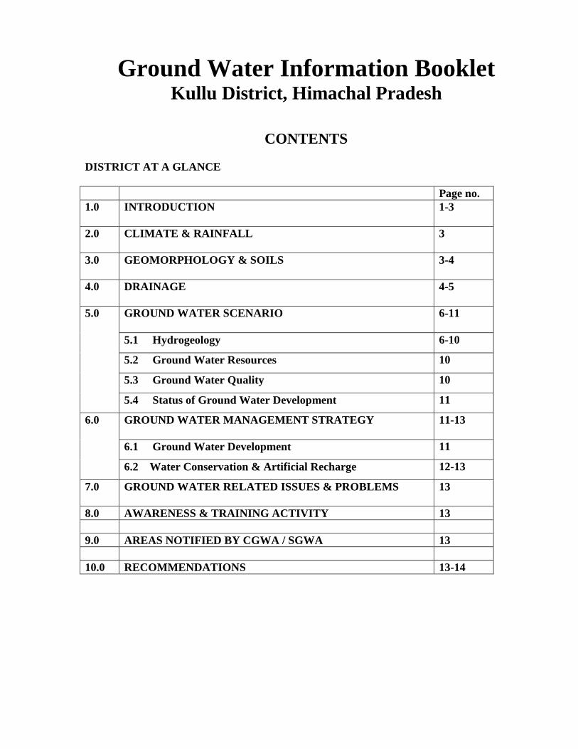
8. PREDOMINANT GEOLOGICAL FORMATIONS
• Alluvium/valley-fill (Quaternary)
• Proterozoic 9. HYDROGEOLOGY
Major Water Bearing Formations 1. Semi consolidated & Consolidated
sediments (Proterozoic)
Covers major part as hilly terrain
• Yield prospects Low to moderate (1-5 lps) • GW structures Springs, open wells 2. Unconsolidated porous sediments
(River & Glacial Deposits) In Kulu valley & other small valleys along major rivers
• Yield prospects High (10-25 lps) • GW structures feasible
Open wells & tube wells
10 GROUND WATER EXPLORATION BY CGWB (as on 31.3.2013)
• No of wells drilled 9 • Depth Range (m) 18 – 101 • Discharge (lpm) 299 – 1079 lpm • Static Water Level
1.62 to 31.45 m bgl
11. GROUND WATER QUALITY Nil Presence of Chemical constituents more
than permissible limits (e.g. EC, F, As, Fe) Quality of Ground Water (EC Range in µS/cm)
Good (32– 805)
12. AWARENESS AND TRAINING ACTIVITY
Nil
13. EFFORTS OF ARTIFICIAL RECHARGE & RAINWATER HARVESTING
Nil
14. GROUND WATER CONTROL AND REGULATION
Nil • Number of OE & Critical Blocks
• No of blocks notified Nil 15. MAJOR GROUND WATER PROBLEMS
AND ISSUES Nil • Depletion of water table
• Water scarcity & Deep water levels Nil • Water logging Nil

1
DISTRICT GROUND WATER BOOKLET
KULLU DISTRICT, HIMACHAL PRADESH 1.0 INTRODUCTION
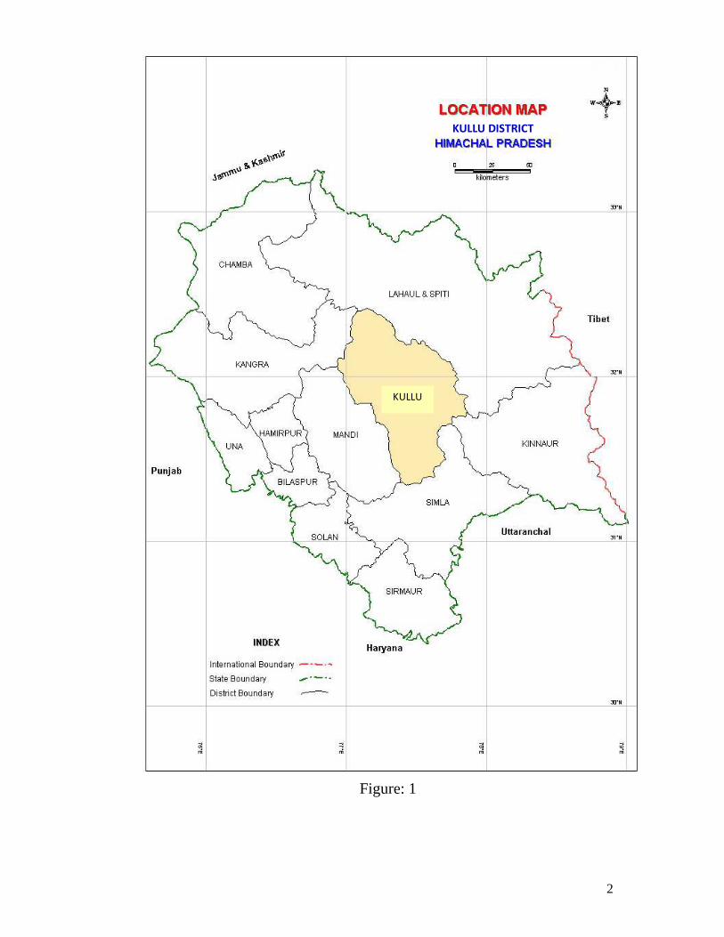
Kullu was made a separate district on 30th July 1963 when it was a part of composite Punjab. Prior to it, it was a tehsil of district Kangra. Kullu is a sparsely populated, centrally located hilly district of the State. The district lies between 31020’25” and 320 25’00” north latitude and 76°56’30” and 77052’20” east longitude. It is bounded on the north and east by Lahul and Spiti district, on the south-east by Kinnaur district, on the south by Shimla district, on the south- west and west by Mandi district and on the north-west by Kangra district. The district has a total area of 5,503 Sq. km. As per 2001 census the Kullu district comprises of 4 Sub-Divisions, 4 tehsils and 2 sub-tehsils. The four tehsils are Kullu, Manali, Banjar and Nirmand and two sub-tehsils namely Anni, and Sainj. There are five community development blocks in the district. They are Nagar, Kullu, Banjar, Anni and Nirmand.
The district is approachable by all-weather roads, such as, National Highway No. 21 and other State Highways. Small valleys located in various parts of the district are
1. Kullu valley : - located along the Beas river
2. Lug valley :- located along Sarvary khad
3. Garsa valley :- located in the eastern part of Kullu district
4. Manikaran valley :- located along the Parvati river
District is not having any large or medium scale industrial units. However, the district is known for Tourism and Hotel units as the district is known for its rich Art and Cultural Heritage, lush green deep meadows, dazzling rivers, white-capped snowy peaks and high mountains. Some of the important places are Bijli-Mahadev, Bajaura, Nagar, Manali, Hadimba, Rohtang-Pass, Malana, Vasisht, Manikaran etc.
2
Figure: 1
KULLU DISTRICT
KULLU

3
Hydroelectric power stations are under construction, namely Parvati project and Larji project. After the completion of these power projects the state will be in a position to earn revenue after selling electricity to the neighboring States.
In mineral wealth only slate mining is carried out for roofing materials and transported to near by districts, which earns a fair amount of money for the people of district.
As per 2011 census, total population of the district is 4,37,903 persons with a sex ratio of 942 females per 1000 males.
Central Ground Water Board under Exploratory Drilling Programme has drilled nine wells including observation wells up to March 2013 to know the sub-surface geology and aquifer parameters. State Government has also drilled shallow hand pumps in valley areas. For monitoring ground water levels and chemical quality in Kullu valley, the CGWB has established 3 observation wells. 2.0 CLIMATE & RAINFALL
Climate of the district is cool and dry and the year unfolds three broad seasons viz. cold season from October to February, hot season from March to June and rainy season from July to September. Snowfall generally occurs in December and January at higher elevations and most of the areas are cut off from the district headquarter since the mountain passes are closed. The district receives moderate rainfall and bulk of it is generally received during June to September and January-February. August is the wettest month through out the district. The average annual rainfall of the district is 1405.7 mm, out of which 57% occurs during June to September. 3.0 GEOMORPHOLOGY & SOILS
Geomorphology of the area plays an important role in deciphering the sub-surface and surface hydrogeological conditions. On the basis of hydro geomorphological and geological set up, the study area can be divided into the following geomorphic units.
I) Mountainous area- Dhauladhar and Pir-Panjal ranges trend NW-SE and peaks ranging in height between 4200-5000m above mean sea level.
II) Snow covered area- Northern and northeastern parts of Kullu district are covered with snow and snow line exists in this area.
III) Denuded hills- The presence of residual ridges along the intermontane valleys suggest that these ridges are the remnants of high relief mountains and formed active erosion.

4
IV) Valley area - Fluvial processes and structural disturbances in the area form intermontane valleys. Kullu valley is elongated and broadly v-shaped in cross-section and denuded hills along the sides.
V) Terrace area- Number of terraces are formed along the river valleys in Kullu district. Terraces are generally noticed on the western bank of the Beas River. Two levels of terraces are demarcated near Bhunter, which are covered with thick vegetation.
The elevation of Kullu district ranges from 914m to 4084m above mean sea level with varied agro-climatic conditions. The texture of soil ranges from sandy loam to clay loam and the colour of the soil also vary from brown to dark brown. Generally the soil is acidic in nature. Depth of the soil varies from 50 to 100 cms. But despite this, all the agro climatic conditions provide a range of potentialities for growing cash crops like, off season vegetables, seed potatoes, pulses and temperate fruits.
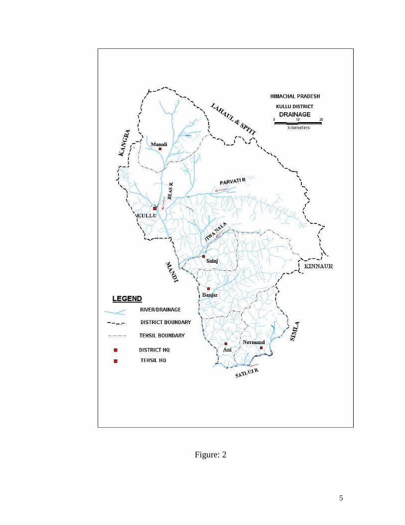
4.0 Drainage
The river Beas and its tributaries mainly drain more than 80% of the
district. This river originates in the Pir-Panjal range near Rohtang, at an elevation of about 4000m and is joined by number of tributaries viz. Parbati, Hurla, Sainj etc. All the tributaries are perennial in nature.
The Beas river flow towards south-southwest direction under steep gradient up to Larji and thereafter, it becomes gentler. Besides Beas, Sutlej river forms a boarder between Shimla and Kullu district and flows in south easterly direction. Both the rivers are flowing in their youth stages as indicated by ‘V’ shaped river profile and deeper river channels.
The Beas river maintains a longitudinal and consequent relationship in its upper course and after Larji it takes a knee-bend type turn towards west. The river is joined by subsequent rivers i.e. Parbati, Hurla, Sainj on its left and right banks. Several streams on their southern side in Kullu district join these subsequent rivers.
5
Figure: 2
KULLU DISTRICT
6
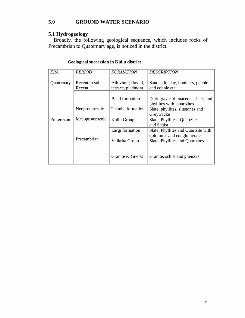
5.0 GROUND WATER SCENARIO 5.1 Hydrogeology
Broadly, the following geological sequence, which includes rocks of Precambrian to Quaternary age, is noticed in the district.
Geological succession in Kullu district
ERA PERIOD FORMATION DESCRIPTION
Quaternary Recent to sub-Recent
Alluvium; fluvial, terrace, piedmont
Sand, silt, clay, boulders, pebble and cobble etc.
Proterozoic
Neoproterozoic
Mesoproterozoic
Precambrian
Batal formation
Chamba formation
Dark gray carbonaceous slates and phyllites with quartzites Slate, phyllites, siltstones and Greywacke
Kullu Group Slate, Phyllites , Quartzites and Schist
Largi formation Vaikrita Group Granite & Gneiss
Slate, Phyllites and Quartzite with dolomites and conglomerates Slate, Phyllites and Quartzites Granite, schist and gneisses

7
Figure: 3
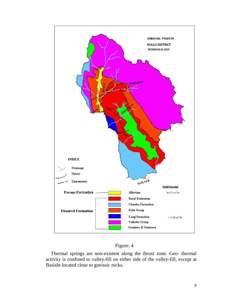
Hydro geologically the entire area of Kullu district can be divided into
porous and fissured formations. Porous formation includes the unconsolidated sediments. These sediments include fluvial channel
KULLU DISTRICT

8
deposits, valley fill deposits, terrace deposits and alluvial fans. These sediments form the potential aquifers. Unconsolidated sediments underlie Kullu valley, Garsa valley, Manikaran valley, Lag valley and longitudinal valley all along the major rivers and khads.
Fissured formation includes the semi-consolidated to consolidated sediments exposed in the district and are of sedimentary, metamorphic and igneous in origin. These form low to high hill ranges throughout the district.
In Kullu valley, ground water generally occurs under confined to semi-confined conditions. Phreatic aquifers are tapped mainly by open wells and form major source of domestic and irrigation water supply in the valley area. The aquifer zone mainly comprises of sand and silt in association with pebbles and boulders in low plains and predominantly boulders, cobbles, pebbles mixed with little clay in terraces. Static water level varies from 1.62m to 31.45m below ground level.
Central Ground Water Board has drilled 9 wells including observation wells in the district to know the aquifer parameters and sub-surface geology. The discharge of these wells varies from 299 lpm to 1079 lpm.
The source of major water supply schemes are based on springs in the district. The discharge of the springs varies from 0.5 lps to 25 lps. Majority of the springs are gravity springs. In gravity springs, the most common are the contact springs, which are formed by permeable water bearing formations overlying less permeable formations the contact of these formations intersects the ground surface.
There are lots of hot springs in Kullu and Parbati valleys. Along Beas river valley hot springs vary in temperature from 290C to 590C and in Parbati river valley the thermal springs vary in temperature from 350C to 960C. In Beas river valley, all the rocks belong to Pre-Cambrian age and are represented by gneisses, phylites, quartzite and limestones. A major fault extending in north- south direction from Bashist to Katrain for a distance of 25 kms, appears to control the emergence of thermal activity.
9
Figure: 4
Thermal springs are non-existent along the thrust zone. Geo- thermal activity is confined to valley-fill on either side of the valley-fill, except at Basisht located close to gneissic rocks.
KULLU DISTRICT
30-75 m3/hr
< 5-30 m3/hr
INDEX

10
In Parbati river valley, crystalline rocks of early to middle proterozoic age are thrust over younger middle proterozoic rocks. Thermal springs at Jan, Kasol and Manikaran emerge through quartzites at Balargarh through carbonaceous phillites/limestones, at Pulga through quartz-mica schists/gneisses and granite. Maximum temperature of 960 C is recorded at Manikaran.
5.2 Ground Water Resources
Ground water resources and irrigation potential for Kullu valley of the district has not been computed as per the GEC-97 methodology due to hilly terrain and localized aquifers. Snow fall in the higher reaches and rain fall in the lower areas, recharge the ground water. Springs are the other main sources for the irrigation and water supply schemes. 5.3 Ground Water Quality
Water samples collected from shallow as well as deep aquifers and
springs for chemical analysis indicate that the chemical parameters are within the permissible limit of safe drinking water set by Bureau of Indian Standard (BIS), except hot water springs. All the parameters of hot water springs are more than permissible limit and not fit for drinking purposes.
Chemical results of 2012
S. No. Parameter Range (spring/ dug wells)
Range (Hot spring )
Min Max Min Max 1. pH 7.69 8.65 8.05 8.21 2. EC µS/cm 34 1040 560 2400 3. HCO3 (mg/l) 21 350 171 720 4. Cl (mg/l) 3.5 202 96 561 5. F(mg/l) 0.10 0.79 .88 8.20 6. Ca(mg/l) 6 156 10 46 7. Mg(mg/l) 0.75 34 1.2 4.2 8. Na(mg/l) 0.4 134 70 600 9. K(mg/l) 0.1 48 13 41 10. TH as CaCO3(mg/l) 18 530 30 133
The overall quality of ground water is potable and safe for drinking
purpose except hot water springs.

11
5.4 Status of Ground Water Development
In Kullu valley, ground water occurs under water-table to semi-confined
conditions. Phreatic aquifers are tapped mainly by open wells and form the major source of domestic and irrigation water supply in the valley. The aquifer zone mainly comprises of sand in association with pebbles and boulders in low plains and predominantly boulders, cobbles, pebbles mixed with little clay in terraces. Depth to water level varies from 1.62m to 31.45 m below ground level.
State Ground Water Organization has constructed shallow hand pumps
down to a depth of 30 to 50m. bgl. Some of them have been energized for water supply schemes. Most of the hand pumps are along the Beas and other tributaries of the valley.
Under exploration work in Kullu valley, seven exploratory and two
observation wells have been drilled with a depth ranging from 18m to 101m. The discharge of these wells varies from 299 lpm to 1079 lpm depending upon the lithology encountered in the area. In Sangribag hot- water artesian spring (340C) with a discharge of more than 5 lps encountered. To identify the contact of fresh and hot water spring another bore hole was drilled down to a depth of 21.00m. The ground water is fresh and potable. 6.0 GROUND WATER MANAGEMENT STRATEGY
6.1 Ground Water Development
Kullu valley is partly explored and only shallow aquifers are tapped for water supply schemes. All these wells are drilled all along the Beas river and its tributaries in the district. There is a lot of scope for the future ground water development in the district.
In Kullu valley, ground water occurs under water-table to semi-confined conditions. The aquifer zone mainly comprises of sand and fine silt in association with pebbles and boulders in low plains and predominantly boulders, cobbles, pebbles mixed with little clay in terraces.
Fissured formation includes the semi-consolidated to consolidated sediments exposed in the district and are of sedimentary, metamorphic and igneous in origin.
Metamorphic and igneous rocks exposed in northeastern parts of the district include quartzites, gneisses, phyllites slates and dolomites.

12
Phyllites interlayer with thin quartzite bands and slates with dolomites form the exposed metamorphic rocks. Springs are reported to exist in the low topography areas along the lineaments and contact of various formations.
Most of the part of Kullu district having Metamorphic and Igneous rocks (consolidated and semi-consolidated) have not been explored due to mountainous terrain and difficulty in approachability as such, their yield potentials are unknown.
6.2 Water Conservation and Artificial Recharge
Average annual rainfall of the district is 1,405.7 mm, out of which 57% occurs during June to Sept. Due to hilly terrain most of the rainfall goes as runoff and a very small quantity enters as ground water. The ground water condition becomes particularly severe in hard rock formations, where scope for recharging the aquifer is low. Only the area, sufficiently traversed by faults/joints/weak zones/ weathered zones get recharged during the monsoon period. Due to high relief, most of the surface water goes as runoff, and hence, there exists a scope for recharging such aquifers.
Taking into consideration the physiography of the area, the following methods for artificial recharge are suggested.
Gabion Structure: - In hard rock areas, marked with fractures/weak zones; such less costly structures can be useful for recharging the surface water.
Contour Bunding: - This practice can be followed efficiently in hilly terrain, tapping the stream water. Here, the ditches are excavated following the ground surface contour of the area.
Subsurface dykes: - These types of structures are very useful in arresting the sub-surface flow in a stream and store the water below ground surface, to meet the demands during the period of needs.
Check dams: - Check dams can be constructed across small streams, having gentle slope and are feasible both i.e. hard rock areas as well as alluvial formations. The design of the structure is based on the characteristics of the stream course.
Recharge Shafts: -These are most efficient and cost effective structures to recharge the aquifer directly. In the areas, where source of water is intermittent or perennial e.g. base flow, springs etc., the recharge shaft can be constructed.

13
Roof top rain water harvesting: - During the monsoon period , the rain water from roof tops can be collected and put into recharge structure for recharging the shallow aquifer. This will help in raising the water level in the area, to some extent. The water can also be used for domestic purposes by collecting it into tanks. 7.0 GROUND WATER RELATED ISSUES & PROBLEMS
In Kullu district, major water supply schemes are based on springs and surface water. The excess of silt in major rivers, create problems for water supply schemes. Ground water in Kullu district has not been explored fully for its development. Kullu valley, located along the Beas river, Lag valley-located along Sarvary khad, Garsa valley-located in the eastern part of Kullu district, Manikaran valley- located along Parbati River and small valleys in Sainj, Banjar, Ani can be explored for the development of ground water for round the year and fresh water supplies to the public and for irrigation purpose.
8.0 AWARENESS AND TRAINING ACTIVITY Mass Awareness Programme (MAP) & Water Management Training Programme (WMTP) by CGWB
Central Ground Water Board has not conducted any Mass Awareness and Training Programme in the district on Water Management and Rainwater Harvesting. 9.0 AREAS NOTIFIED BY CGWA / SGWA
The stage of ground water development in Kullu district has not been calculated. Hence, no area or block in the district has been notified from the groundwater development point of view. 10.0 RECOMMENDATIONS
� Ground water development in the district, has not been fully explored and falls in safe category, Hence, there is a scope for developing the ground water resource in the district.
14
� Groundwater development by constructing shallow and deep boreholes can be carried out, in the valleys and the river terraces.
� Rooftop rainwater harvesting structures are mandatory in municipal areas, but there is a need to create awareness about these structures in rural areas also as well.
� Traditional resources like springs and bowries need to be revived, developed and protected for future use. Public participation in water resource management should be encouraged.
*****

For Technical Assistance Relating to Rainwater Harvesting
& Artificial Recharge to Ground Water
Contact:
CENTRAL GROUND WATER BOARD NORTHERN HIMALAYAN REGION
Dove Cottage, Near Ram Nagar Post Office, Dharamshala (H.P)
Phone: 01892- 227160 Telefax: 01892-223535 e-mail: [email protected]
SAVE WATER SERVE HUMANITY
Related Documents