“ जल संरण वष - 2013” Government of India Ministry of Water Resources CENTRAL GROUND WATER BOARD GROUND WATER INFORMATION BOOKLET LAHAUL & SPITI DISTRICT HIMACHAL PRADESH NORTHERN HIMALAYAN REGION DHARMSALA 2013

Welcome message from author
This document is posted to help you gain knowledge. Please leave a comment to let me know what you think about it! Share it to your friends and learn new things together.
Transcript

“ जल संर�ण वष - 2013”
Government of India Ministry of Water Resources
CENTRAL GROUND WATER BOARD
GROUND WATER INFORMATION BOOKLET LAHAUL & SPITI DISTRICT
HIMACHAL PRADESH
NORTHERN HIMALAYAN REGION
DHARMSALA 2013
“ जल संर�ण वष - 2013”
Contributors
Anukaran Kujur
Assistant Hydrogeologist
Prepared under the guidance of
Dalel Singh Head of Office
Our Vision
Water security through sound management

“ जल संर�ण वष - 2013”
GROUND WATER INFORMATION BOOKLET Lahaul & Spiti District, Himachal Pradesh
CONTENTS DISTRICT AT A GLANCE Page 1.0 INTRODUCTION
1-2
2.0 CLIMATE & RAINFALL
3
3.0 GEOMORPHOLOGY & SOIL TYPES
3-5
4.0 GROUND WATER SCENARIO
5-11
4.1 Hydrogeology 5-9
4.2 Ground Water Resources 9-10
4.3 Ground Water Quality 11
4.4 Status of Ground Water Development 11
5.0 GROUND WATER MANAGEMENT STRATEGY
12
5.1 Ground Water Development 12
5.2 Water Conservation & Artificial Recharge 12
6.0 GROUND WATER RELATED ISSUES & PROBLEMS
12
7.0 AWARENESS & TRAINING ACTIVITY
13
8.0 AREAS NOTIFIED BY CGWA / SGWA
13
9.0 RECOMMENDATIONS
13
“ जल संर�ण वष - 2013”
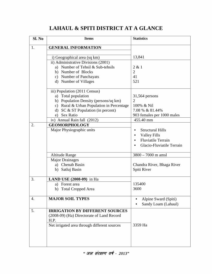
LAHAUL & SPITI DISTRICT AT A GLANCE Sl. No Items
Statistics
1. GENERAL INFORMATION 13,841
i) Geographical area (sq km) ii) Administrative Divisions (2001)
a) Number of Tehsil & Sub-tehsils b) Number of Blocks c) Number of Panchayats d) Number of Villages
2 & 1 2 41 521
iii) Population (2011 Census) a) Total population b) Population Density (persons/sq km) c) Rural & Urban Population in Percentage d) SC & ST Population (in percent) e) Sex Ratio
31,564 persons 2 100% & Nil 7.08 % & 81.44% 903 females per 1000 males
iv) Annual Rain fall (2012) 455.40 mm 2. GEOMORPHOLOGY
• Structural Hills • Valley Fills • Fluviatile Terrain • Glacio-Fluviatile Terrain
Major Physiographic units
Altitude Range 3800 – 7000 m amsl Major Drainages
a) Chenab Basin b) Satluj Basin
Chandra River, Bhaga River Spiti River
3. LAND USE (2008-09) in Ha 135400 3600
a) Forest area b) Total Cropped Area
4. MAJOR SOIL TYPES • Alpine Sward (Spiti) • Sandy Loam (Lahaul)
5. IRRIGATION BY DIFFERENT SOURCES (2008-09) (Ha) Directorate of Land Record H.P.
3359 Ha Net irrigated area through different sources

“ जल संर�ण वष - 2013”
6. NUMBERS OF GROUND WATER
MONITORING WELLS OF CGWB (As on 31.3.2013)
• No. of Dug Wells • No. of Piezometers
Nil Nil
7. PREDOMINANT GEOLOGICAL FORMATIONS
• Quaternary Alluvium • Older Crystalline /
Sedimentary / Metamorphic rocks
8. HYDROGEOLOGY
Major Water Bearing Formations a)Consolidated sediments / Hard Rocks (Older crystalline / Sedimentary /
Metamorphics) • Yield prospects • GW structures
Covering major part Low (<3 lps) Springs & Handpumps
b)Unconsolidated porous sediments (Alluvium)
• Yield prospects • GW structures
Valley area (3%) High (10-30 lps) Springs & Handpumps
9. GROUND WATER EXPLORATION BY CGWB (As on 31.3.2013)
• No of wells drilled Nil • Depth Range (m) - • Discharge (lps) - • Transmissivity (m2/day) -
10. GROUND WATER QUALITY Nil Presence of Chemical constituents more
than permissible limits (eg. EC, F, As, Fe)
11. DYNAMIC GROUND WATER RESOURCES (2011) in MCM
Not estimated due to localized aquifers
• Annual Replenishable Ground Water Resources
-
• Net Annual Ground Water Draft - • Projected Demand for Domestic and
industrial uses up to 2025 -
• Stage of Ground Water Development -

“ जल संर�ण वष - 2013”
12. AWARENESS AND TRAINING
ACTIVITY Nil Nil
• Mass Awareness Programmes • Water Management Training
Programmes 13. EFFORTS OF ARTIFICIAL RECHARGE
& RAINWATER HARVESTING Nil
14. GROUND WATER CONTROL AND REGULATION Number of OE Blocks No of Critical Blocks No of blocks notified
Nil Nil Nil
15. MAJOR GROUND WATER PROBLEMS AND ISSUES
Nil
P a g e | 1
“ जल संर�ण वष - 2013 ”
GROUND WATER INFORMATION BOOKLET LAHAUL & SPITI DISTRICT
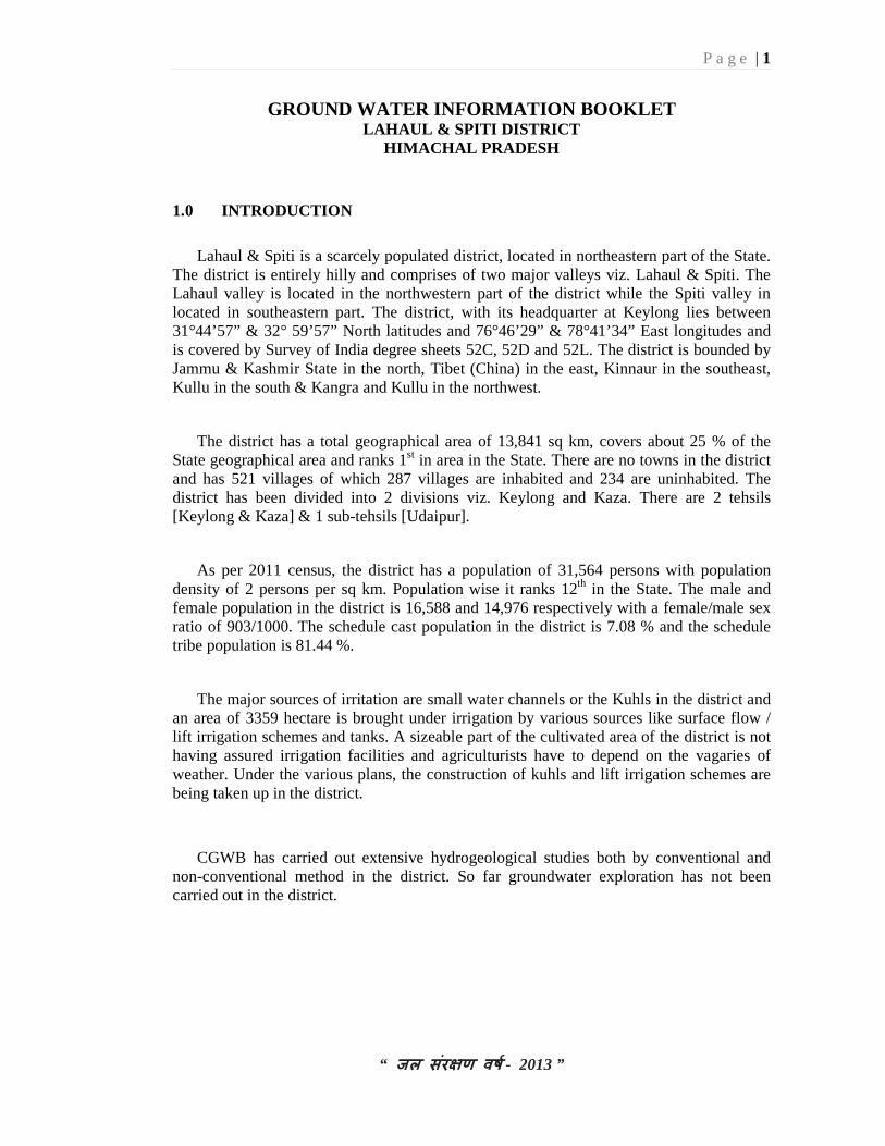
HIMACHAL PRADESH 1.0 INTRODUCTION
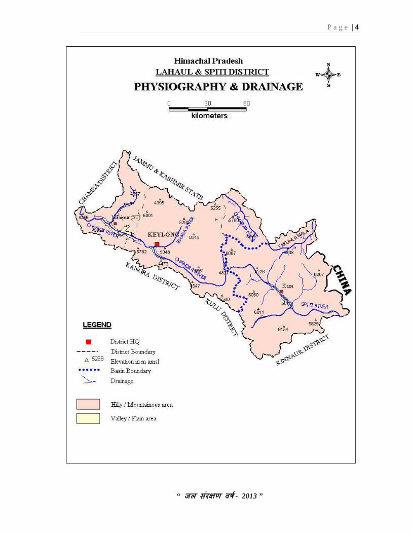
Lahaul & Spiti is a scarcely populated district, located in northeastern part of the State. The district is entirely hilly and comprises of two major valleys viz. Lahaul & Spiti. The Lahaul valley is located in the northwestern part of the district while the Spiti valley in located in southeastern part. The district, with its headquarter at Keylong lies between 31°44’57” & 32° 59’57” North latitudes and 76°46’29” & 78°41’34” East longitudes and is covered by Survey of India degree sheets 52C, 52D and 52L. The district is bounded by Jammu & Kashmir State in the north, Tibet (China) in the east, Kinnaur in the southeast, Kullu in the south & Kangra and Kullu in the northwest.
The district has a total geographical area of 13,841 sq km, covers about 25 % of the State geographical area and ranks 1st in area in the State. There are no towns in the district and has 521 villages of which 287 villages are inhabited and 234 are uninhabited. The district has been divided into 2 divisions viz. Keylong and Kaza. There are 2 tehsils [Keylong & Kaza] & 1 sub-tehsils [Udaipur].
As per 2011 census, the district has a population of 31,564 persons with population density of 2 persons per sq km. Population wise it ranks 12th in the State. The male and female population in the district is 16,588 and 14,976 respectively with a female/male sex ratio of 903/1000. The schedule cast population in the district is 7.08 % and the schedule tribe population is 81.44 %.
The major sources of irritation are small water channels or the Kuhls in the district and an area of 3359 hectare is brought under irrigation by various sources like surface flow / lift irrigation schemes and tanks. A sizeable part of the cultivated area of the district is not having assured irrigation facilities and agriculturists have to depend on the vagaries of weather. Under the various plans, the construction of kuhls and lift irrigation schemes are being taken up in the district.
CGWB has carried out extensive hydrogeological studies both by conventional and non-conventional method in the district. So far groundwater exploration has not been carried out in the district.

P a g e | 2
“ जल संर�ण वष - 2013 ”
P a g e | 3
“ जल संर�ण वष - 2013 ”
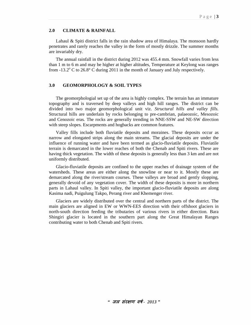
2.0 CLIMATE & RAINFALL
Lahaul & Spiti district falls in the rain shadow area of Himalaya. The monsoon hardly penetrates and rarely reaches the valley in the form of mostly drizzle. The summer months are invariably dry.
The annual rainfall in the district during 2012 was 455.4 mm. Snowfall varies from less than 1 m to 6 m and may be higher at higher altitudes, Temperature at Keylong was ranges from -13.2o C to 26.8° C during 2011 in the month of January and July respectively.
3.0 GEOMORPHOLOGY & SOIL TYPES
The geomorphologial set up of the area is highly complex. The terrain has an immature topography and is traversed by deep valleys and high hill ranges. The district can be divided into two major geomorphological unit viz. Structural hills and valley fills. Structural hills are underlain by rocks belonging to pre-cambrian, palaeozoic, Mesozoic and Cenozoic eras. The rocks are generally trending in NNE-SSW and NE-SW direction with steep slopes. Escarpments and hogbacks are common features.
Valley fills include both fluviatile deposits and moraines. These deposits occur as narrow and elongated strips along the main streams. The glacial deposits are under the influence of running water and have been termed as glacio-fluviatile deposits. Fluviatile terrain is demarcated in the lower reaches of both the Chenab and Spiti rivers. These are having thick vegetation. The width of these deposits is generally less than 3 km and are not uniformly distributed.
Glacio-fluviatile deposits are confined to the upper reaches of drainage system of the watersheds. These areas are either along the snowline or near to it. Mostly these are demarcated along the river/stream courses. These valleys are broad and gently slopping, generally devoid of any vegetation cover. The width of these deposits is more in northern parts in Lahaul valley. In Spiti valley, the important glacio-fluviatile deposits are along Kasima nadi, Puigulung Takpo, Perang river and Khemenger river.
Glaciers are widely distributed over the central and northern parts of the district. The main glaciers are aligned in EW or WWN-EES direction with their offshoot glaciers in north-south direction feeding the tributaries of various rivers in either direction. Bara Shingiri glacier is located in the southern part along the Great Himalayan Ranges contributing water to both Chenab and Spiti rivers.
P a g e | 4
“ जल संर�ण वष - 2013 ”
P a g e | 5
“ जल संर�ण वष - 2013 ”
Geng’s Tang and Kelas Buk glaciers occupy the eastern part in catchment of Chenab also occur in the Central part. The other minor glaciers in the southern parts are Talshah, Tapri-Lamini, Raighar and Sara Ugma glaciers.
Most of the soils in Spiti may be called alpine sward as the upper stratum of earth and vegetable mould is filled with incompletely decomposed roots of grass and other small plants. The depth of the fertile undisturbed horizon varies from 0.3 m to 0.6 m. Due to melting of the snow from the upper slopes; soil has been carried down to the lower slopes where the depth of the soil is deeper. The land in Spiti is fertile. The nature of soil varies from place to place. The nitrogenous and phosphatic content varies from medium to high. This is due to the scarcity of rainfall, high altitude, weathering of the mountain rocks from where water comes for irrigation in the fields.
In Lahaul valley, the quality of land and its produce is homogeneous throughout the tract. The nature of the soil varies little and it may be described as a light sandy loam.
4.0 GROUND WATER SCENARIO
4.1 Hydrogeology
The hydrogeological framework of the area is essentially controlled by geological setting, distribution of rainfall, snowfall and porosity of rocks constituting aquifers. Geologically, the area is underlain by the rocks of Proterozoic era to the quaternary period. Hydrogeologically, all these formations can be divided into units namely fissured and porous formations.
Fissured formations are constituted by hard rock formations ranging in age from Precambrian to Mesozoic and composed mainly of granites, gneisses, slates, phyllites, quarzites, schists and limestones. These rocks are generally massive and devoid of any primary porosity. However due to tectonic activities, secondary porosity has been developed along fractures, joints and faults zones. Weathered zones rarely form any aquifer because of their poor thickness. Sometimes contact zones of rocks unit forms poor to moderate aquifer. These are developed occasionally for localized and domestic water needs in low topographic areas. Ground water occurs generally under unconfined conditions and ooze out in the form of springs. Discharge of the springs varies from mere seepage to more than 20 lps with temperature varies from 10°C to 25°C in normal temperature of springs and 26°C to 60°C in hot water springs. This spring water is utilized for drinking and irrigation purposes.
Porous formations include both fluviatile and fluvio-glacial deposits. There is no development of the alluvial terrains in the valley as most of their river courses flow through narrow valley portions between well defined compact and hard rock valley walls. In broader valleys, like on the right banks of Bhaga and Chandra Bhaga rivers where older glacial terrain exists, large cultivations are being practiced. The width of these deposits varies from less than 500m to about 2.5km with increasing thickness of sediments towards the center of valley. These deposits are isolated and discontinuous and forms potential ground water aquifer.

P a g e | 6
“ जल संर�ण वष - 2013 ”
P a g e | 7
“ जल संर�ण वष - 2013 ”
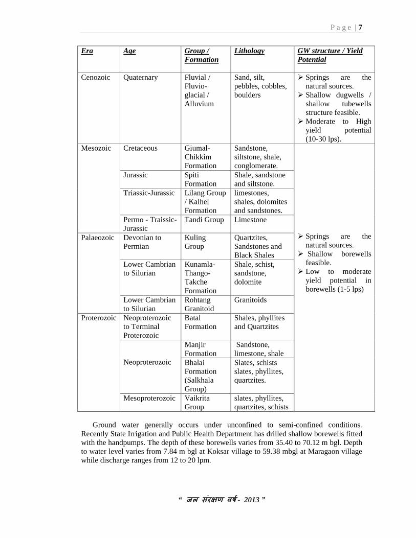
Era Age Group / Formation
Lithology GW structure / Yield Potential
Cenozoic Quaternary Fluvial / Fluvio-glacial / Alluvium
Sand, silt, pebbles, cobbles, boulders
� Springs are the natural sources.
� Shallow dugwells / shallow tubewells structure feasible.
� Moderate to High yield potential (10-30 lps).
Mesozoic Cretaceous Giumal-Chikkim Formation
Sandstone, siltstone, shale, conglomerate.
� Springs are the
natural sources. � Shallow borewells
feasible. � Low to moderate
yield potential in borewells (1-5 lps)
Jurassic Spiti Formation
Shale, sandstone and siltstone.
Triassic-Jurassic Lilang Group / Kalhel Formation
limestones, shales, dolomites and sandstones.
Permo - Traissic-Jurassic
Tandi Group Limestone
Palaeozoic Devonian to Permian
Kuling Group
Quartzites, Sandstones and Black Shales
Lower Cambrian to Silurian
Kunamla-Thango-Takche Formation
Shale, schist, sandstone, dolomite
Lower Cambrian to Silurian
Rohtang Granitoid
Granitoids
Proterozoic Neoproterozoic to Terminal Proterozoic
Batal Formation
Shales, phyllites and Quartzites
Neoproterozoic
Manjir Formation
Sandstone, limestone, shale
Bhalai Formation (Salkhala Group)
Slates, schists slates, phyllites, quartzites.
Mesoproterozoic Vaikrita Group
slates, phyllites, quartzites, schists
Ground water generally occurs under unconfined to semi-confined conditions.
Recently State Irrigation and Public Health Department has drilled shallow borewells fitted with the handpumps. The depth of these borewells varies from 35.40 to 70.12 m bgl. Depth to water level varies from 7.84 m bgl at Koksar village to 59.38 mbgl at Maragaon village while discharge ranges from 12 to 20 lpm.

P a g e | 8
“ जल संर�ण वष - 2013 ”
P a g e | 9
“ जल संर�ण वष - 2013 ”
Water table follows the topography and the formations encountered are valley fill deposits consisting of sand, gravels, pebbles & cobbles. There are two locations, which are worth mentions from the point of view of development of ground water viz. Jispa and Udaipur. Jispa lies on the right bank of Bhaga river with a gently sloping ground formed by the deposition of scree material brought down from hills in the north east due to melting of the snow. This unconsolidated accumulation of sediments may form a site for exploring the possibility of the construction of suitable ground water structure i.e. open dugwell or a tubewell depending upon the availability of adequate saturated thickness of the sediments.
Udaipur town and the Chandra Bhaga river exists a gently sloping alluvial plains merging with the river large amount of debris consisting of huge boulders and finer clastics is brought down by Miyar Nala and deposited in this valley called Patten valley. This alluvial flat plains is located with in few meters height from the river level and is suitable for development of ground water resources.
Springs are widely distributed all over the area in all types of formation at varying altitudes. These are the major sources of water supplies both for irrigation as well as for domestic purposes. Springs are of both fracture and seepage types. The fracture types of springs exist in the low topographic areas either along structurally weak zones or at the contact of geological formations where as seepage type of springs are formed on the slope of hills covered with loose material such as talus and scree. These springs are both perennial and seasonal with varying discharges and temperatures. Springs get recharged from rainfall and snowfall. Discharge of these springs generally increases during the summers. Irrigation and domestic water supply needs are met from these springs. The discharge generally varies from seepages to more than 20 lps with temperature varying from less than 100 C to 250C in normal temperature springs and 26°C to 60°C in hot water springs.
4.2 Ground Water Resources
Snowfall / rainfall is the major source of groundwater recharge apart from the influent seepage from the rivers, irrigated fields and inflow from upland areas whereas discharge from ground water mainly takes place from effluent seepages of ground water in the form of springs and base flow in streams etc. The district has a hilly terrain having very high slopes. The valley areas are deep, narrow and isolated. The areas therefore not considered for estimation of the ground water resources due to their discontinuous aquifer systems.

P a g e | 10
“ जल संर�ण वष - 2013 ”
Wells feasible
Rigs suitable
Depth of Well (m)
Discharge (lpm)
Suitable artificial Recharge structures
Soft rock aquifers
Tube well Dug well
Percussion & Percussion cum Rotary
Manual
100-120
10-20
1200-2500 300-500
Check dam, Check dam cum ground water dam, Recharge shaft
Hard rock aquifers
Dug well Spring development
Manual 10-20 300-500 30-2000
• Spring
Reservoir
Major drainage
Fault/lineament Tehsil boundary District boundary State boundary
P a g e | 11
“ जल संर�ण वष - 2013 ”
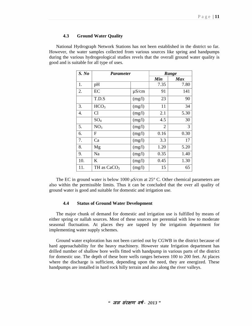
4.3 Ground Water Quality
National Hydrograph Network Stations has not been established in the district so far. However, the water samples collected from various sources like spring and handpumps during the various hydrogeological studies revels that the overall ground water quality is good and is suitable for all type of uses.
S. No Parameter Range Min Max
1. pH 7.35 7.80
2. EC µS/cm 91 141
T.D.S (mg/l) 23 90
3. HCO3 (mg/l) 11 34
4. Cl (mg/l) 2.1 5.30
SO4 (mg/l) 4.5 30
5. NO3 (mg/l) 2 3
6. F (mg/l) 0.16 0.30
7. Ca (mg/l) 3.3 17
8. Mg (mg/l) 1.20 5.20
9. Na (mg/l) 0.35 1.40
10. K (mg/l) 0.45 1.30
11. TH as CaCO3 (mg/l) 15 65
The EC in ground water is below 1000 µS/cm at 25° C. Other chemical parameters are
also within the permissible limits. Thus it can be concluded that the over all quality of ground water is good and suitable for domestic and irrigation use.
4.4 Status of Ground Water Development
The major chunk of demand for domestic and irrigation use is fulfilled by means of either spring or nallah sources. Most of these sources are perennial with low to moderate seasonal fluctuation. At places they are tapped by the irrigation department for implementing water supply schemes.
Ground water exploration has not been carried out by CGWB in the district because of hard approachability for the heavy machinery. However state Irrigation department has drilled number of shallow bore wells fitted with handpump in various parts of the district for domestic use. The depth of these bore wells ranges between 100 to 200 feet. At places where the discharge is sufficient, depending upon the need, they are energized. These handpumps are installed in hard rock hilly terrain and also along the river valleys.

P a g e | 12
“ जल संर�ण वष - 2013 ”
5 GROUND WATER MANAGEMENT STRATEGY
5.1 Ground Water Development
The district being hilly & mountainous, traditional sources of ground water mainly springs has played a major role since past in providing assured irrigation and water supply. These include the nallas, springs. In some of the areas, at present too these are the only sources for the water of the settlements. However modern means for tapping the ground water have been employed in recent years.
During the last 15-20 years, Irrigation and Public Health Department has constructed number of small depth bore wells fitted with handpumps in these areas. High hill ranges occupy more than 95 % of the area of the district. During the very past years, the traditional ground water source has served the settlements. Ground water development on small scale is seen in the valleys areas particularly in the Lahaul and Spiti valley. Handpumps have been installed in these areas and are energized for the water supply. There exists a scope to explore the potentialities of rest of the areas for ground water in low lying valley areas. The hilly area of the district is feasible for only drilling shallow to medium depth bore wells.
5.2 Water Conservation & Artificial Recharge
Ground water extraction through springs and hand pumps are the major sources of water supply, but the availability of water during summer is limited particularly in lean periods and requires immediate attention to augment the ground water resource. Based upon the climatic conditions, topography, hydrogeology of the area, suitable structure for rain water harvesting and artificial recharge to ground water are required. Proper scientific intervention for spring development and revival is required in water scarce areas. In the hilly areas, roof top rainwater harvesting structures like storage tanks are recommended while in low hill ranges, check dam and roof top rainwater / snow harvesting structures can be adopted.
6 GROUND WATER RELATED ISSUES & PROBLEMS
The entire district is hilly and mountainous and comes under the rain shadow area of Himalaya. In such hard rock terrain, since the aquifers are discontinuous and of different geological/hydrogeological setup, the ground water scenarios are different in various parts of the districts.
Most of the ground water issues and problems in the district are localized and need to be treated independently by taking micro level studies in a particular area.
P a g e | 13
“ जल संर�ण वष - 2013 ”
7 AWARENESS & TRAINING ACTIVITY Mass Awareness Programme (MAP) & Water Management Training Programme (WMTP) by CGWB No Mass Awareness & Training Programme has been taken up in the district. Participation in Exhibition, Mela, Fair etc CGWB has not participated in exhibition, Melas so far. Presentation & Lectures delivered in public forum / Radio/TV/Institution of repute/Grassroots association /NGO/Academic institutions etc
No presentation/lecture has been delivered in public forum so far. 8 AREAS NOTIFIED BY CGWA / SGWA As per Ground Water Resource Estimation of Himachal Pradesh as on March 2011, none of the areas of the district is notified. 9. RECOMMENDATIONS
� In valley areas, in addition to traditional ground water structures like springs, shallow to medium depth tube wells can be constructed for developing the ground water resource.
� In hilly terrain, springs and perennial nallas are the major sources of water. Shallow to medium depth bore wells fitted with hand pump are useful ground water structures for meeting the domestic needs and are feasible at favorable locations.
� Traditional source i.e. springs need to be revived, developed & protected on scientific lines for various use. The discharge of such springs can be sustained by construction of small check dams or subsurface dykes across the nallas/tributaries at favorable locations.
� Small ponds/tanks can be utilized for recharging ground water. These structures can be constructed for harvesting and utilizing domestic needs.
� Snow water harvesting practices can be adopted in hilly areas since the district receives ample snowfall.
� There is need to create awareness for water conservation, augmentation and proper waste disposal for protecting water sources.
SAVE WATER – SAVE LIFE
P a g e | 14
“ जल संर�ण वष - 2013 ”
For Technical Assistance Relating to Rainwater Harvesting
& Artificial Recharge to Ground Water
Contact:
CENTRAL GROUND WATER BOARD NORTHERN HIMALAYAN REGION
Dove Cottage, Ram Nagar, Dharamshala (H.P)
Phone: 01892- 224775; 227160 Telefax: 01892-223535 e-mail: [email protected]
SAVE WATER SERVE HUMANITY
Related Documents