Glaciers of North America— GLACIERS OF CANADA INTRODUCTION By RICHARD S. WILLIAMS, JR. and JANE G. FERRIGNO, Editors SATELLITE IMAGE ATLAS OF GLACIERS OF THE WORLD Edited by RICHARD S. WILLIAMS, Jr., and JANE G. FERRIGNO U.S. GEOLOGICAL SURVEY PROFESSIONAL PAPER 1386–J–1 Glaciers in Canada are situated in three principal locations: on several Arctic islands, in the Rocky Mountains and Interior Ranges , and along the Pacific Coast. Landsat MSS images are most useful in studying and monitoring changes in ice caps, ice fields, outlet glaciers, and valley glaciers

Welcome message from author
This document is posted to help you gain knowledge. Please leave a comment to let me know what you think about it! Share it to your friends and learn new things together.
Transcript

Glaciers of North America—
GLACIERS OF CANADA
INTRODUCTION
By
RICHARD S. WILLIAMS, JR.
and
JANE G. FERRIGNO,
Editors
SATELLITE IMAGE ATLAS OF GLACIERS OF THE WORLD
Edited by RICHARD S. WILLIAMS, Jr., and JANE G. FERRIGNO
U.S. GEOLOGICAL SURVEY PROFESSIONAL PAPER 1386–J–1
Glac i e r s in Canada are s i tuated in three pr inc ipa l locat ions: on s evera l Arc t i c i s lands , in the Rocky Mountains and
Inter ior Ranges
, and a long the Pac i f i c Coas t . Landsat MSS images are mos t use fu l in s tudying and moni tor ing changes in i c e caps , i c e f i e lds , out l e t g lac i e r s , and val l ey g lac i e r s
CONTENTS III
Introduction
-------------------------------------------------------------------------- J1
F
IGURE
1. Geographic locations of the currently glacierized regions of Canada
---------------------------------------------------------- 1
2. Glacierization of Canada (and Greenland and Iceland) during the Pleistocene Epoch
------------------------------------------ 2
T
ABLE
1. Estimated glacier area in Canada
--------------------------------- 1
Topical Sections
--------------------------------------------------------------- 3
Glaciers of the Arctic Islands
----------------------------------------------- 4
F
IGURE
3. Optimum Landsat 1, 2, and 3 MSS and RBV images of the glaciers of the Arctic Islands of Canada
--------------------------------- 5
T
ABLE
2. Optimum Landsat 1, 2, and 3 MSS and RBV images of the glaciers of the Arctic Islands of Canada
---------------------------------- 6
Glaciers of Western Canada
------------------------------------------------ 16
F
IGURE
4. Map of the major mountain ranges in the
Interior Ranges
of British Columbia
------------------------------------------------ 16
5. Optimum Landsat 1, 2, and 3 MSS images of the glaciers of the Canadian Rocky Mountains and
Interior Ranges
--------------- 17
6. Optimum Landsat 1, 2, and 3 MSS and RBV images of the glaciers of the Coast and St. Elias Mountains of Canada
-------- 20
7. Map of the major mountain ranges in the Yukon and Northwest Territories of Canada
------------------------------------------- 23
T
ABLE
3. Optimum Landsat 1, 2, and 3 MSS images of the glaciers of the Canadian Rocky Mountains and
Interior Ranges
--------------- 18
4. Optimum Landsat 1, 2, and 3 MSS and RBV images of glaciers of the Coast and St. Elias Mountains of Canada
----------------- 21
References Cited
-------------------------------------------------------------- 25
CONTENTS
Page

GLACIERS OF CANADA J1
HudsonBay
ARCTIC
OCEAN
Labrador
Sea
ATLAN
TIC
OCEA
N
0 1000 km
Coastal
Rockies
Arctic
SATELLITE IMAGE ATLAS OF GLACIERS OF THE WORLD
GLACIERS OF NORTH AMERICA—
GLACIERS OF CANADA
INTRODUCTION
By
RICHARD S. WILLIAMS, JR.
and
JANE G. FERRIGNO,
Editors
Glaciers in Canada are located principally in three geographic settings: onseveral Arctic islands in Nunavut and the Northwest Territories of northernCanada, in the Rocky Mountains and the
Interior Ranges
1
, and along thecoast of the Pacific Ocean, where they are sometimes contiguous with glaciersof Alaska (fig. 1, and figs. 1 and 2 in the “History of Glacier Investigations inCanada”). The area covered by glaciers is estimated to be 151,000 km
2
in theCanadian Arctic and 50,000 km
2
in the mountain ranges of Western Canada(table 1). During the Last Glacier Maximum (LGM) during the PleistoceneEpoch, the Laurentide Ice Sheet and the Cordilleran Ice Sheet covered
1
The names in this section conform to the usage authorized by the Secretariat of the Canadian Perma-nent Committee on Geographical Names (CPCGN) and found in the Canadian Geographical Names DataBase (CGNDB). Variant names and names not listed in the CPCGN/CGNDB are shown in italics.
Figure 1.
—Geographic locations ofthe currently glacierized regions ofCanada (and Greenland and Iceland),by S. Fick and A. Murray (see alsoShilts and others, 1998), from the1998 Canadian Geographic, v. 118,no. 7, Sources: Geomatics Canada,Glacier Atlas of Canada, NationalHydrology Research Centre. Usedwith permission.
T
ABLE
1.
—Estimated glacier area in Canada (from Ommanney, 1970)
[1, Approximation from previous estimates; 2, Ommanney (1969); 3, Koerner (1968); 4, Measured value from National Topographic System (NTS) 1:250,000-scale maps; 5, Henoch (1967)]
Location of Glaciers Estimated Glacier Area (square kilometers)
ARCTIC ISLANDS
Ellesmere........................................................................ 80,000
1
Ice Shelves (Ellesmere) ................................................ 500
1
Axel Heiberg................................................................... 11,735
2
Devon .............................................................................. 16,200
1
Coburg ............................................................................ 225
1
Meighen .......................................................................... 85
3
Melville............................................................................ 160
4
North Kent...................................................................... 152
4
Subtotal 109,057
Baffin............................................................................... 37,000
1
Bylot ................................................................................ 5,000
1
Subtotal Arctic 151,057
MAINLAND DRAINAGE BASINS
Pacific.............................................................................. 37,659
5
Nelson ............................................................................. 328
5
Great Slave ..................................................................... 626
5
Yukon .............................................................................. 10, 564
5
Arctic Ocean................................................................... 840
5
Labrador ......................................................................... 24
5
Subtotal Mainland 50,041
Total Canada 201,098
Manuscript approved for publication, 7 March 2002.
J2 SATELLITE IMAGE ATLAS OF GLACIERS OF THE WORLD
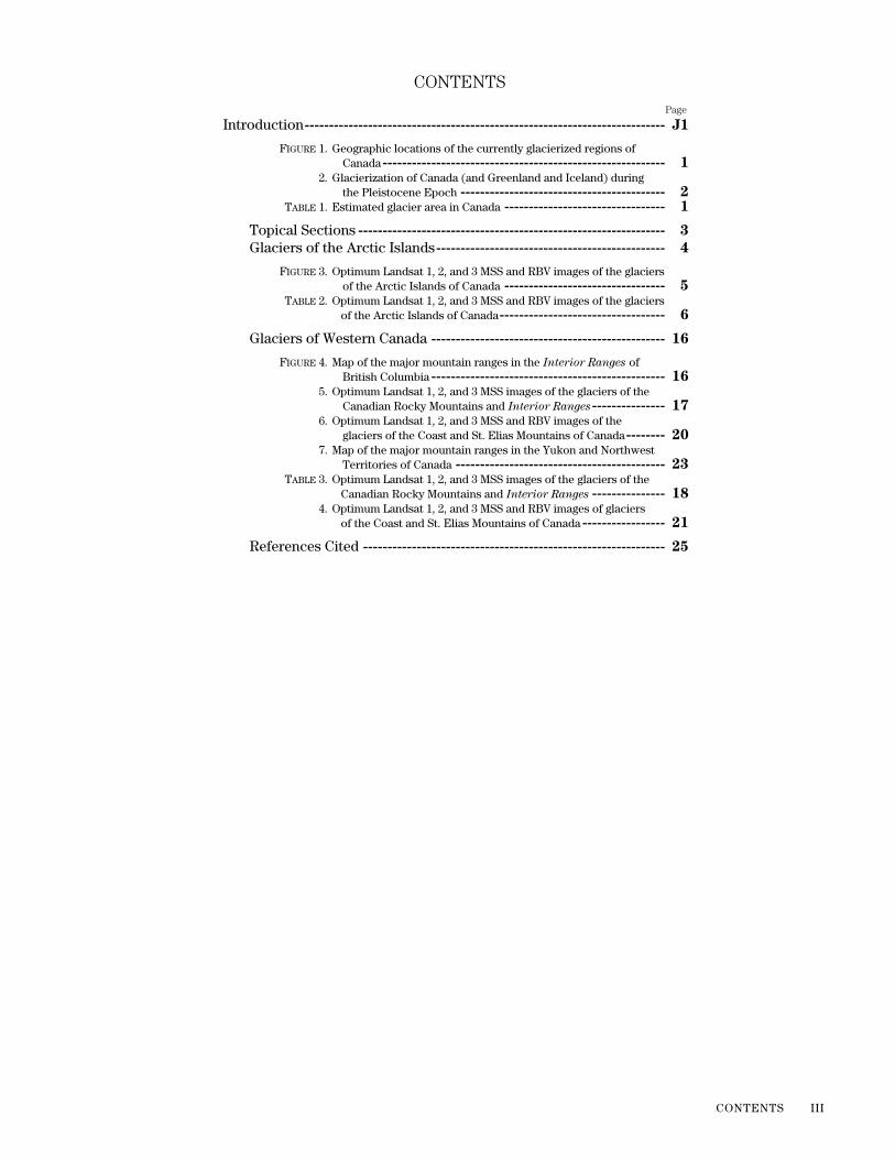
Figure 2
.—Glacierization of Canada(and Greenland and Iceland) duringthe Pleistocene Epoch, by S. Fick andA. Murray (see also Shilts and others,1998), from the 1998 Canadian Geo-graphic, v. 118, no. 7, Sources: Geo-matics Canada, Glacier Atlas ofCanada, National Hydrology ResearchCentre. Used with permission.
virtually all of Canada (fig. 2), so present-day glaciers in Canada are presentonly where the regional climates have temperature and (or) accumula-tion/melt regimes sufficient to maintain these ice masses. Some glaciers may,in fact, be relicts from the late Pleistocene Epoch, or from the late HoloceneEpoch “Little Ice Age,” and could not re-form under present, regional cli-matic conditions, if they were to completely melt. Because of the vastnessand often inaccessibility of the glacierized regions of Canada, only 176 indi-vidual glaciers of the many thousands of glaciers have been studied in thefield or with airborne and satellite remote sensing technology during the past140 years. Between the 1940’s and the present, 34 of these 176 glaciers orglacierized areas have been specially mapped one or more times, at scalesranging from 1:5,000 to 1:125,000.
Dunbar and Greenway (1956) published an important book whichincluded numerous trimetrogon aerial photographs of the glaciers of ArcticCanada; their pioneering work with available aerial photographs provided aregional overview of the most glacierized part of Canada and, in a sense,was a forerunner of the use of satellite images to document the areal extentof glacier ice in Canada. More than 120 years ago, the geologist NathanielShaler and the physical geographer William Morris Davis (Shaler and Davis,1881) pioneered in the use of ground photographs to provide a historicalrecord of glaciers. As soon as new technology becomes available, scientistsare quick to apply it to specific research needs. In the examples given, thesuccessive technologies adopted to study glaciers were ground photogra-phy, aerial photography, and satellite imagery.
The Glaciers of Canada section of this volume is divided into several sec-tions; two main topical sections and one subsection follow this introduction.Three main sections and two subsections cover the glaciers of the ArcticIslands; three main sections and one subsection cover the glaciers of theCanadian Rockies, Coast Mountains, and St. Elias Mountains. It is obviousthat the lack of scientific knowledge about most of the glaciers of Canadaprecludes a comprehensive discussion of all of the glacierized regions.However, the potential of satellite remote sensing, including the higher spa-tial and spectral resolution imagery of post-Landsat multispectral scanner(MSS) images to investigate areal changes in Canada’s glaciers, is well doc-umented in the following sections. The emphasis on 1970’s images in thisintroduction and the following sections is due to the goal of compiling a glo-bal baseline of glacier area (in the 1970’s time frame) in this Satellite ImageAtlas of Glaciers of the World series.
The first field observations of glaciers in Canada were made in 1861, nineyears before Clarence R. King, the first Director of the U.S. Geological Sur-vey (established in 1879), discovered Whitney Glacier on Mt. Shasta, Calif.,and three more glaciers on the north slope of the volcano in 1870 (Williamsand Ferrigno, 1997). Since that time, 176 glaciers in Canada—13 in the St.Elias Mountains, 63 in the Coast Mountains, 10 in the
Interior Ranges
, 27in the Rocky Mountains, 41 in the High Arctic, 10 in the Low Arctic, 5 in theTorngat Mountains of Labrador (Newfoundland), and 7 outside these gla-cierized areas—have been studied. These studies, in the post-World War IIto the 1980’s period, were driven by scientific, economic, security, and sov-ereignty concerns, including the impetus from major cooperative interna-tional scientific programs, such as the International Geophysical Year andthe International Hydrological Decade.
In 1999, the two Federal Departments having responsibilities in glaciol-ogy (Natural Resources Canada and Environment Canada) combined theirglaciological expertise and resources to form a “National Glaciology Pro-gramme” (NGP). The NGP is housed at the Geological Survey of Canada[http://sts.gsc.nrcan.gc.ca] and is responsible, in part, for meeting Canada’sglacier-observation commitment to the World Meteorological Organiza-tion’s (WMO) Global Climate Observing System and the United Nations
ARCTIC
OCEAN
Labrador
Sea
ATLAN
TIC
OCEA
N
GREENLAND
ICE SHEET
CORDILLE
RANICESHEET
LA U REN TID E IC E SH EET
PAC
IFIC
OC
EA
N
0 1000 km

GLACIERS OF CANADA J3
Educational, Scientific, and Cultural Organization’s (UNESCO) Interna-tional Hydrological Programme (IHP). This activity is complemented byparticipation in the “CRYSYS” program (to study variability and change ofthe Canadian CRYospheric SYStem) [http://www.crysys.uwaterloo.ca],whose academic and government partners conduct research on the Cana-dian cryosphere using conventional and remote sensing methods.
As part of the glacier investigations during the past 140 years, especiallybetween the middle 1940’s and 1990’s, one 1:4,000,000-scale map of theheight of the glaciation level in western Canada and southern Alaska (gla-ciers shown in green) (Anonymous, 1978), one 1:2,000,000-scale map ofglaciers and moraines in southern British Columbia and Alberta (glaciersshown in gray) (Østrem and others, 1966), seven 1:1,000,000-scale, 521:500,000 scale (Glacier Atlas of Canada), and 114 miscellaneous scale(1:2,500 to 1:125,000) maps of selected glaciers of Canada were publishedby governmental agencies and academic institutions. Satellite images, com-bined with digital-elevation models (DEMs) using geographic informationsystems (GIS) technology, are being used to produce new types of maps ofCanada’s glaciers. Roger D. Wheate, Robert W. Sidjak, and Garnet T. Whyteprovide examples of the application of these technologies to two glaciers inthe
Interior Ranges
and Rocky Mountains.Until the preparation of this volume on the glaciers of Canada, the last
effort to carry out a comprehensive review of the glacierized regions of Can-ada was done by William O. Field and his colleagues at the American Geo-graphical Society (AGS) in the two-volume “Mountain Glaciers of theNorthern Hemisphere,” which also included an atlas containing 49 plates(Field, 1975c). The two volumes and atlas were produced by the AGS undercontract with the Earth Sciences Division of the U.S. Army Engineer Topo-graphic Laboratories and published by the Technical Information AnalysisCenter, Cold Regions Research and Engineering Laboratory, U.S. Army Corpsof Engineers (Hanover, New Hampshire). (An earlier, similar atlas was pub-lished in 1958 (Field and Associates, 1958).) They include a comprehensivecollation of published reports and maps of the glaciers of Canada (and otherglacierized regions of the Northern Hemisphere) and are an excellent sourceof information from a variety of historical and modern sources. For all of theglacierized regions of Canada, including those regions not addressed in thisvolume, relevant chapters in the 1975 volumes will be cited.
In 1998, the Royal Canadian Geographical Society published, in theNovember/December 1998 issue of Canadian Geographic, an article on Can-ada’s glaciers (Anonymous, 1998) and an 8-page color map foldout (Shiltsand others, 1998). Several of the maps that appeared in the foldout map arereproduced, with permission and with some minor modifications, in the fol-lowing sections of the “Glaciers of Canada.” Another modern reference mapof Canada is the 1:6,000,000-scale “New Century Map of Canada” publishedby Canadian Geographic in 1999 [http://www.canadiangeographic.ca]. Seealso the National Atlas (of Canada) Web site at [http://atlas.gc.ca], whichwill, in the near future, carry maps from the previously noted plates of theGlacier Atlas of Canada and contain links to available glacier-related databases residing in government and university archives.
Topical Sections
Two topical sections follow this introduction. The two sections, writtenby C. Simon L. Ommanney, give a comprehensive review of “History of Gla-cier Investigations in Canada” and “Mapping Canada’s Glaciers.” The latterreview is followed by a subsection on “Mapping Glaciers in the
Interior
Ranges
and Rocky Mountains with Landsat Data,” by Roger D. Wheate,Robert W. Sidjak, and Garnet T. Whyte.

J4 SATELLITE IMAGE ATLAS OF GLACIERS OF THE WORLD
Glaciers of the Arctic Islands
The glaciers of the Canadian Arctic represent the largest area(151,057 km
2
) and volume of glacier ice in Canada and include about 5percent of the glacierized area of the Northern Hemisphere (fig. 1, andfig. 1 in “Glaciers of the High Arctic Islands”). Ice caps and ice fields andassociated outlet glaciers and smaller glaciers are present on several of theQueen Elizabeth Islands (Ellesmere, Axel Heiberg, Meighen, Coburg,Devon, and North Kent Islands, Nunavut, and in the western part ofMelville Island, Northwest Territories) (Mercer, 1975b). Roy M. Koerner, in“Glaciers of the High Arctic Islands,” describes both dynamic and stagnantice caps. These ice caps exhibit a very slow response to climate change.Even though the last 150 years have been the warmest in the past millen-nium, only very slight changes in area and volume of the ice caps can bediscerned.
Martin O. Jeffries describes historic and modern changes in the section“Ellesmere Island Ice Shelves and Ice Islands,” including the use of LandsatMSS, RADARSAT synthetic aperture radar (SAR) and SPOT haute resolu-tion visible (HRV) images to document changes in the ice shelves and iceplugs (multiyear landfast sea ice) that are located on the northwesterncoast of Ellesmere Island. Although the ice shelves have been present sincethe middle Holocene Epoch, they were much more extensive in the past.The 20th century warming interval has resulted in a significant reduction intheir areal extent.
The glaciers of the Canadian Low Arctic are located on Baffin and BylotIslands (Mercer, 1975a). About 45 percent of Bylot Island (4,859 km
2
) iscovered by glaciers (see the book’s cover). On Baffin Island, glaciers arefound on the northern and eastern coasts, from the northeastern part of theBrodeur and Borden Peninsulas to the eastern part of the Hall and MetaIncognita Peninsulas, Nunavut (fig. 1 in “Glaciers of Baffin Island”). John T.Andrews addresses the geographic distribution and types of glaciers (icecaps and ice fields and associated outlet glaciers and smaller glaciers) in“Glaciers of Baffin Island,” with specific reference to the two large ice caps,Barnes Ice Cap (5,935 km
2
) and Penny Ice Cap (5,960 km
2
); he concludesthese two ice masses contain ice that represents the last remnants of theLaurentide Ice Sheet (fig. 2). He also concludes that the Barnes Ice Cap isslowly shrinking, a recession that could accelerate if significant regional cli-mate warming were to occur. Gerald Holdsworth, in his discussion entitled“Barnes Ice Cap: Geomorphology and Thermodynamics,” confirms that awhitish marginal strip of ice at the ice-cap margin has a
δ
18
O isotope valuethat indicates a late Pleistocene Epoch (Wisconsinan) age of the ice. JohnD. Jacobs examines “Late 20th Century Change of the Barnes Ice Cap Mar-gin,” using both Landsat and RADARSAT SAR images to document reces-sion of Lewis Glacier and the calving ice-front in Gee Lake. Figure 3 andtable 2 show the optimum Landsat 1, 2, and 3 MSS and RBV images of theglaciers of the Arctic Islands.
The southernmost glaciers in eastern North America are located in theTorngat Mountains, Labrador, Newfoundland (fig. 1), but are not discussedin this chapter. Fahn (1975) states that most of the glaciers are cirque gla-ciers that form clusters on the slopes of the highest peaks. She furthernotes that the 1975 climatic conditions in the Torngat Mountains are mar-ginal and that the glaciers have been receding since the end of the “LittleIce Age” (LIA).
Unpublished work by Ommanney (written commun., 2001) summarizedthe body of knowledge on the distribution of a significant number of rockglaciers in Labrador. Ommanney (written commun., 2001) and his col-leagues also mapped one glacieret on the Québec side of the provincial bor-der with Labrador, so there is (or was?) at least one glacier(et) in Québec.

GLACIERS OF CANADA J5
GR
E E NL A
ND
Excellent image (0 to ≤5 percent cloud cover)
Good image (>5 to ≤10 percent cloud cover)
Nominal scene center for a Landsat image outside the area of glaciers
Usable Landsat 3 return beam vidicon (RBV) scenes.A, B, C, and D refer to usable RBV subscenes
EXPLANATION OF SYMBOLS
Evaluation of image usability for glaciologic, geologic, and cartographic applications. Symbols defined as follows:
B A F F I NI S L A N D
500 KILOMETERS0
ELLESMERE
ISLAND
DEVON ISLAND
B a f f i n
B a y
C A N AD
A
Fair to poor image (>10 to <100 percent cloud cover)
130°W 120° 110° 100° 90° 80° 70° 60° 50° 40° 30°
75°
70°
80°N
65°
A B
A
A B A B
A B
A B
A B
A
C
B
D
C
B
A BA
C
B
DC D
A
C
B
D
A
C
B
D
A
B
D
B
D
C DD
A BA B
A B
C DD
C D
B
D
B
D
D
B
B
DD
A
D
BB
D
C DC D
C D
D
C
B
B
C DC DD C D
C D
D
C
A
C
B
D
PATH 75
PATH 65
PATH
55
PATH
45
PATH
35
PATH
25
PATH15
ROW 15
ROW1
ROW
5
ROW 10
Figure 3.
—Optimum Landsat 1, 2, and 3 MSS and RBV images of the glaciersof the Arctic Islands of Canada.

J6 SATELLITE IMAGE ATLAS OF GLACIERS OF THE WORLD
Path-RowNominal
scene center (lat-long)
Landsat identification
numberDate
Solar elevation
angle (degrees)
CodeCloud cover
(percent)Remarks
16–13 66°40'N.60°28'W.
20202–14590 12 Aug 75 37 0 Baffin Island
16–14 65°20'N.61°57'W.
20202–14592 12 Aug 75 38 5
17–13 66°40'N.61°55'W.
20185–15051 26 Jul 75 42 0 Image used for Andrews’ figure 17
17–14 65°20'N.63°23'W.
20185–15053 26 Jul 75 43 0
17–15 63°59'N.64°44'W.
1747–15083 09 Aug 74 40 10 EDC
1
; image used for Andrews’ figure 18
17–16 62°38'N.65°58'W.
1747–15090 09 Aug 74 41 10 EDC
1
; Terra Nivea and Grinnell Glacier; image used for Andrews’ figure 19
18–13 66°40'N.63°21'W.
20186–15105 27 Jul 75 42 45
18–14 65°20'N.64°49'W.
20186–15112 27 Jul 75 43 15
18–15 63°59'N.66°10'W.
20204–15111 14 Aug 75 39 0
18–16 62°38'N.67°24'W.
1712–15160 05 Jul 74 47 0 EDC
19–12 67°59'N.63°08'W.
21663–15101 12 Aug 79 34 0
19–13 66°40'N.64°47'W.
21663–15103 12 Aug 79 35 10 Penny Ice Cap; image used for Andrews’ figure 16
19–13 66°40'N.64°47'W.
30156–15172A, B, C, D
08 Aug 78 38–39 5–30 Landsat 3 RBV
1
19–14 65°20'N.66°15'W.
21663–15110 12 Aug 79 36 0
19–14 65°20'N.66°15'W.
30156–15174A, B, C, D
08 Aug 78 39–40 0
19–16 62°38'N.68°50'W.
21303–14584 17 Aug 78 ~39 0
20–12 67°59'N.64°34'W.
11488–14431 19 Aug 76 32 0 Penny Ice Cap; extensive snow cover
20–13 66°40'N.66°13'W.
11488–14434 19 Aug 76 33 0 Extensive snow cover
21–12 67°59'N.66°00'W.
11453–14515 15 Jul 76 41 0 Penny Ice Cap
21–13 66°40'N.67°39'W.
11453–14521 15 Jul 76 42 0
22–11 69°17'N.65°37'W.
11829–14232 26 Jul 77 37 40
22–12 67°59'N.67°26'W.
11829–14234 26 Jul 77 37 30
23–11 69°17'N.67°03'W.
20911–15163 21 Jul 77 40 30
T
ABLE
2
.—Optimum Landsat 1, 2, and 3 MSS and RBV images of the glaciers of the Arctic Islands of Canada
[The images archived by the Canada Centre for Remote Sensing (CCRS) are not identified on the CCRS Website (http://www.ccrs.nrcan.gc.ca) by Landsat identification number but can be located by path (track), row (frame), and date. The images archived by the EROS Data Center (EDC) (http://earthexplorer.usgs.gov) are no longer located or ordered by the Landsat identification number on the
image but by a different entity number that incorporates satellite number, path, row, and date]

GLACIERS OF CANADA J7
23–12 67°59'N.68°52'W.
20911–15165 21 Jul 77 41 0
24–10 70°35'N.66°28'W.
20912–15214 22 Jul 77 39 0
24–11 69°17'N.68°29'W.
20912–15221 22 Jul 77 40 0
25–10 70°35'N.67°54'W.
11850–14380 16 Aug 77 30 0
25–11 69°17'N.69°55'W.
11850–14382 16 Aug 77 31 5 Southeastern end of Barnes Ice Cap
26–10 70°35'N.69°20'W.
21292–15355 06 Aug 78 ~36 0
26–11 69°17'N.71°21'W.
21328–15380 11 Sep 78 22 10 Southeastern end of Barnes Ice Cap
26–11 69°17'N.71°21'W.
30721–15514 A, B
24 Feb 80 10 30 Landsat 3 RBV; subscene B used for Andrews’ figure 15
27–10 70°35'N.70°46'W.
1379–16124 06 Aug 73 36 0 Barnes Ice Cap
27–11 69°17'N.72°48'W.
1379–16130 06 Aug 73 37 0 Barnes Ice Cap
27–11 69°17'N.72°48'W.
30722–15572B, C
25 Feb 80 ~11 0 Barnes Ice Cap; Landsat 3 RBV
28–09 71°50'N.69°54'W.
10380–16180 07 Aug 73 35 0
28–10 70°35'N.72°12'W.
10380–16182 07 Aug 73 36 0 Barnes Ice Cap; image used for Andrews’ figure 5
28–10 70°35'N.72°12'W.
30525–16065 12 Aug 79 32 0 Barnes Ice Cap; image used for Andrews’ figure 8A
28–11 69°17'N.74°14'W.
10380–16185 07 Aug 73 37 0 Barnes Ice Cap
28–11 69°17'N.74°14'W.
30525–16071 12 Aug 79 33 0 Barnes Ice Cap
29–09 71°50'N.71°20'W.
30526–16120 13 Aug 79 31 20
29–10 70°35'N.73°38'W.
11119–15585 16 Aug 75 33 0
29–10 70°35'N.73°38'W.
30526–16122B, D
13 Aug 79 30 0–20 Landsat 3 RBV
30–09 71°50'N.72°46'W.
11855–15054 21 Aug 77 28 0 Extensive snow cover
30–09 71°50'N.72°46'W.
30491–16174 D 09 Jul 79 41 0 Landsat 3 RBV
30–10 70°35'N.75°04'W.
11855–15060 21 Aug 77 29 5 Barnes Ice Cap
30–10 70°35'N.75°04'W.
30491–16181 B 09 Jul 79 41 0 Landsat 3 RBV
30–10 70°35'N.75°04'W.
30725–16141 D 28 Feb 80 11 20 Landsat 3 RBV
Path-RowNominal
scene center (lat-long)
Landsat identification
numberDate
Solar elevation
angle (degrees)
CodeCloud cover
(percent)Remarks
T
ABLE
2
.—Optimum Landsat 1, 2, and 3 MSS and RBV images of the glaciers of the Arctic Islands of Canada—
Continued

J8 SATELLITE IMAGE ATLAS OF GLACIERS OF THE WORLD
31–09 71°50'N.74°13'W.
11463–15471 25 Jul 76 37 15
31–09 71°50'N.74°13'W.
30546–16232 C, D
02 Sep 79 26 15–20 Landsat 3 RBV
31–10 70°35'N.76°30'W.
11463–15473 25 Jul 76 37 0
32–08 73°04'N.73°03'W.
11464–15522 26 Jul 76 36 0
32–09 71°50'N.75°39'W.
11857–15170 23 Aug 77 27 40
32–09 71°50'N.75°39'W.
30547–16290A, B, C, D
03 Sep 79 25–26 0–10 Landsat 3 RBV
33–08 73°04'N.74°29'W.
1403–16455 30 Aug 73 26 0
33–09 71°50'N.77°05'W.
1403–16461 30 Aug 73 27 0 Image used for Andrews’ figure 4
33–09 71°50'N.77°05'W.
30548–16345A, B, C, D
04 Sep 79 25–26 20–30 Landsat 3 RBV
34–08 73°04'N.75°55'W.
11841–15294 07 Aug 77 32 50
34–09 71°50'N.78°31'W.
1404–16515 31 Aug 73 27 0
34–09 71°50'N.78°31'W.
30549–16403A, B
05 Sep 79 25 20–50 Landsat 3 RBV
35–08 73°04'N.77°21'W.
11842–15352 08 Aug 77 31 15
35–08 73°04'N.77°21'W.
30586–16445C, D
12 Oct 79 10 10–20 Landsat 3 RBV
35–09 71°50'N.79°57'W.
11125–16323 22 Aug 75 30 20
35–09 71°50'N.79°57'W.
30586–16452A, B
12 Oct 79 10 20–40 Landsat 3 RBV
36–08 73°04'N.78°47'W.
20204–16513 14 Aug 75 31 0 Bylot Island
36–08 73°04'N.78°47'W.
30173–16525 D 25 Aug 78 28 20 Landsat 3 RBV
36–09 71°50'N.81°23'W.
11468–16152 30 Jul 76 35 0
37–07 74°16'N.77°14'W.
20943–16332 22 Aug 77 27 0
37–07 74°16'N.77°14'W.
30516–16572 D 03 Aug 79 33 50 Landsat 3 RBV
37–08 73°04'N.80°13'W.
20943–16335 22 Aug 77 28 0 Image used for Andrews’ figure 3
37–09 71°50'N.82°49'W.
20943–16341 22 Aug 77 29 0
38–06 75°25'N.75°14'W.
20944–16384 23 Aug 77 26 0
Path-RowNominal
scene center (lat-long)
Landsat identification
numberDate
Solar elevation
angle (degrees)
CodeCloud cover
(percent)Remarks
T
ABLE
2
.—Optimum Landsat 1, 2, and 3 MSS and RBV images of the glaciers of the Arctic Islands of Canada—
Continued

GLACIERS OF CANADA J9
38–07 74°16'N.78°40'W.
20926–16400 05 Aug 77 32 50 Eastern end of Devon Island
38–08 73°04'N.81°39'W.
11827–15540 24 Jul 77 35 10
38–08 73°04'N.81°39'W.
30589–17020 C, D
15 Oct 79 9 10–20 Landsat 3 RBV
38–09 71°50'N.84°15'W.
30589–17023 A, B
15 Oct 79 9 0 Landsat 3 RBV
39–06 75°25'N.76°40'W.
11147–16525 13 Sep 75 19 0
39–07 74°16'N.80°06'W.
20207–17081 17 Aug 75 29 15
39–08 73°04'N.83°05'W.
1733–17123 26 Jul 74 36 10
39–08 73°04'N.83°05'W.
30482–17091A, B, C, D
30 Jun 79 40 0 Landsat 3 RBV
40–05 76°31'N.74°08'W.
11130–16591 27 Aug 75 24 0
40–06 75°25'N.78°06'W.
11130–16593 27 Aug 75 25 10 Eastern end of Devon Island
40–07 74°16'N.81°32'W.
11130–17000 27 Aug 75 26 0 Eastern end of Devon Island
40–08 73°04'N.84°31'W.
11130–17002 27 Aug 75 27 15
41–05 76°31'N.75°34'W.
20209–17184 19 Aug 75 26 40 Southeastern corner of Ellesmere Island
41–06 75°25'N.79°33'W.
20551–17124 26 Jul 76 34 5 Devon Ice Cap
41–07 74°16'N.82°58'W.
20551–17130 26 Jul 76 35 0 Extensive snow cover
41–08 73°04'N.85°57'W.
21307–17015 21 Aug 78 ~28 5
42–05 76°31'N.77°00'W.
20948–17010 27 Aug 77 24 10 Southeastern corner of Ellesmere Island
42–06 75°25'N.80°59'W.
20948–17012 27 Aug 77 25 25 Devon Ice Cap
42–07 74°16'N.84°24'W.
1376–17372 03 Aug 73 33 10 EDC
43–04 77°33'N.73°49'W.
20553–17231 28 Jul 76 31 5
43–05 76°31'N.78°26'W.
20553–17234 28 Jul 76 32 10
43–06 75°25'N.82°25'W.
20553–17240 28 Jul 76 34 30 Devon Ice Cap
43–07 74°16'N.85°50'W.
20553–17243 28 Jul 76 35 0 Extensive snow cover
Path-RowNominal
scene center (lat-long)
Landsat identification
numberDate
Solar elevation
angle (degrees)
CodeCloud cover
(percent)Remarks
T
ABLE
2
.—Optimum Landsat 1, 2, and 3 MSS and RBV images of the glaciers of the Arctic Islands of Canada—
Continued

J10 SATELLITE IMAGE ATLAS OF GLACIERS OF THE WORLD
T
ABLE
2
.—Optimum Landsat 1, 2, and 3 MSS and RBV images of the glaciers of the Arctic Islands of Canada—
Continued
44–03 78°29'N.69°53'W.
20554–17283 29 Jul 76 30 5
44–04 77°33'N.75°15'W.
11458–17000 20 Jul 76 33 0 Extensive snow cover
44–05 76°31'N.79°53'W.
11458–17003 20 Jul 76 34 10 Extensive snow cover
44–06 75°25'N.83°51'W.
30523–17365 10 Aug 79 28 20 Image used for Koerner’s figure 2
44–07 74°16'N.87°17'W.
1378–17485 05 Aug 73 32 0 EDC
45–03 78°29'N.71°19'W.
20555–17341 30 Jul 76 30 25
45–04 77°33'N.76°41'W.
11459–17054 21 Jul 76 33 0 Extensive snow cover
45–05 76°31'N.81°19'W.
11459–17060 21 Jul 76 34 10 Extensive snow cover
45–06 75°25'N.85°17'W.
20951–17183 30 Aug 77 23 10 Extensive snow cover
45–07 74°16'N.88°43'W.
30524–17430 11 Aug 79 29 0
46–03 78°29'N.72°45'W.
11514–17063 14 Sep 76 15 0 Eastern side of Ellesmere Island
46–04 77°33'N.78°07'W.
1758–17500 20 Aug 74 25 0 Eastern side of Ellesmere Island; image used for Koerner’s figure 5
46–05 76°31'N.82°45'W.
1758–17503 20 Aug 74 26 0 Southeastern corner of Ellesmere Island
46–05 76°31'N.82°45'W.
30561–17473 A, B, D
17 Sep 79 15–16 10–20 Landsat 3 RBV
46–06 75°25'N.86°43'W.
1758–17505 20 Aug 74 27 0
46–07 74°16'N.90°09'W.
1758–17512 20 Aug 74 28 0
47–02 79°19'N.67°56'W.
2520–17403 25 Jun 76 33 20 EDC; Landsat 2 RBV
47–03 78°29'N.74°11'W.
11461–17163 23 Jul 76 32 0 Extensive snow cover
47–04 77°33'N.79°33'W.
11854–16411 20 Aug 77 25 10 Southeastern Ellesmere Island
47–05 76°31'N.84°11'W.
11497–17142 28 Aug 76 23 15
47–06 75°25'N.88°09'W.
30184–17552 05 Sep 78 ~20 40 Devon Island
47–07 74°16'N.91°35'W.
1399–18054 26 Aug 73 26 0 Extensive snow cover
48–02 79°19'N.69°22'W.
2558–17505 02 Aug 76 27 30 EDC; Landsat 2 RBV
Path-RowNominal
scene center (lat-long)
Landsat identification
numberDate
Solar elevation
angle (degrees)
CodeCloud cover
(percent)Remarks

GLACIERS OF CANADA J11
48–03 78°29'N.75°37'W.
1760–18010 22 Aug 74 23 0 Ellesmere Island; Prince of Wales Icefield; image used for Koerner’s figure 5
48–04 77°33'N.81°00'W.
1760–18013 22 Aug 74 24 0 Ellesmere Island; Prince of Wales Icefield
48–05 76°31'N.85°37'W.
1760–18015 22 Aug 74 25 10 Ellesmere Island; Sydkap Ice Cap; image used for Koerner’s figure 4
48–06 75°25'N.89°35'W.
1760–18022 22 Aug 74 26 40
49–02 79°19'N.70°48'W.
2559–17563 03 Aug 76 27 0 EDC
49–03 78°29'N.77°03'W.
20559–17570 03 Aug 76 29 10 Ellesmere Island; Prince of Wales Icefield
49–04 77°33'N.82°26'W.
20559–17573 03 Aug 76 30 40 Ellesmere Island; Prince of Wales Icefield
49–04 77°33'N.82°26'W.
30546–18043 D 02 Sep 79 21 30 Landsat 3 RBV
49–05 76°31'N.87°03'W.
11463–17284 25 Jul 76 33 0 Ellesmere Island; Sydkap Ice Cap
49–05 76°31'N.87°03'W.
30546–18050 B, D
02 Sep 79 21–22 10 Landsat 3 RBV
50–01 80°01'N.65°04'W.
2614–18002 27 Sep 76 6 50 EDC
50–02 79°19'N.72°14'W.
2597–18070 10 Sep 76 14 50 EDC
50–03 78°29'N.78°29'W.
30511–18100 29 Jul 79 28 10 Ellesmere Island; Prince of Wales Icefield
50–04 77°33'N.83°52'W.
11839–17000 05 Aug 77 29 10 Ellesmere Island; Sydkap Ice Cap
50–04 77°33'N.83°52'W.
30187–18114A, B
08 Sep 78 18 10–50 Landsat 3 RBV
50–05 76°31'N.88°29'W.
11839–17002 05 Aug 77 30 0
51–01 80°01'N.66°30'W.
2548–18361 23 Jul 76 27 10 EDC; northeastern Ellesmere Island; Landsat 2 RBV
51–02 79°19'N.73°40'W.
2543–18083 18 Jul 76 31 0 EDC; northeastern Ellesmere Island; Landsat 2 RBV
51–03 78°29'N.79°55'W.
11465–17391 27 Jul 76 31 5 Ellesmere Island; Prince of Wales Icefield
51–04 77°33'N.85°18'W.
11465–17394 27 Jul 76 32 5
51–04 77°33'N.85°18'W.
30206–18174 B, D
27 Sep 78 11 20 Landsat 3 RBV
51–05 76°31'N.89°55'W.
11465–17400 27 Jul 76 33 10
52–01 80°01'N.67°56'W.
2544–18135 19 Jul 76 29 0 EDC; northeastern Ellesmere Island; Landsat 2 RBV
Path-RowNominal
scene center (lat-long)
Landsat identification
numberDate
Solar elevation
angle (degrees)
CodeCloud cover
(percent)Remarks
T
ABLE
2
.—Optimum Landsat 1, 2, and 3 MSS and RBV images of the glaciers of the Arctic Islands of Canada—
Continued

J12 SATELLITE IMAGE ATLAS OF GLACIERS OF THE WORLD
52–02 79°19'N.75°06'W.
20544–18142 19 Jul 76 31 10
52–02 79°19'N.75°06'W.
30531–18211 D 18 Aug 79 24 70 Landsat 3 RBV
52–03 78°29'N.81°21'W.
20904–17595 14 Jul 77 33 0
52–03 78°29'N.81°21'W.
30521–18213 B 18 Aug 79 24 20 Landsat 3 RBV
52–04 77°33'N.86°44'W.
20904–18002 14 Jul 77 34 10
52–04 77°33'N.86°44'W.
30207–18232B, D
28 Sep 78 10 20–30 Landsat 3 RBV
52–05 76°31'N.91°21'W.
20904–18004 14 Jul 77 35 0
53–01 80°01'N.69°22'W.
2550–18474 25 Jul 76 27 5 EDC; Landsat 2 RBV
53–02 79°19'N.76°32'W.
11860–17141 26 Aug 77 21 5
53–03 78°29'N.82°47'W.
11860–17144 26 Aug 77 22 0
53–03 78°29'N.82°47'W.
21265–18063 10 Jul 78 ~34 0 Ablation area visible
53–03 78°29'N.82°47'W.
30208–18284C, D
29 Sep 78 9 10–40 Landsat 3 RBV
53–04 77°33'N.88°10'W.
30514–18274 01 Aug 79 28 30
53–04 77°33'N.88°10'W.
30208–18291 D 29 Sep 78 10 20 Landsat 3 RBV
53–05 76°31'N.92°47'W.
30514–18280 01 Aug 79 29 0
54–01 80°01'N.70°48'W.
2583–18295 27 Aug 76 18 0 EDC; Ellesmere Island; eastern Agassiz Ice Cap; Landsat 2 RBV
54–02 79°19'N.77°58'W.
11843–17214 09 Aug 77 26 5
54–02 79°19'N.77°58'W.
30191–18335C, D
12 Sep 78 14 10–20 Landsat 3 RBV
54–03 78°29'N.84°13'W.
21644–18270 24 Jul 79 29 20
54–03 78°29'N.84°13'W.
30191–18342B, D
12 Sep 78 15 10–30 Landsat 3 RBV
54–04 77°33'N.89°36'W.
20546–18263 21 Jul 76 33 0
54–05 76°31'N.94°13'W.
20924–18111 03 Aug 77 31 0
55–01 80°01'N.72°14'W.
2601–18292 14 Sep 76 11 0 EDC; Ellesmere Island; Agassiz Ice Cap; Landsat 2 RBV
Path-RowNominal
scene center (lat-long)
Landsat identification
numberDate
Solar elevation
angle (degrees)
CodeCloud cover
(percent)Remarks
T
ABLE
2
.—Optimum Landsat 1, 2, and 3 MSS and RBV images of the glaciers of the Arctic Islands of Canada—
Continued

GLACIERS OF CANADA J13
55–02 79°19'N.79°24'W.
11109–18251 06 Aug 75 27 0
55–02 79°19'N.79°24'W.
30192–18394 C, D
13 Sep 78 14 20–50 Landsat 3 RBV
55–03 78°29'N.85°39'W.
30516–18384 03 Aug 79 27 10 Southern Axel Heiberg Island
55–03 78°29'N.85°39'W.
30516–18384B, C, D
03 Aug 79 27 0–5 Southern Axel Heiberg Island; Landsat 3 RBV
55–04 77°33'N.91°02'W.
30516–18391 03 Aug 79 28 0
55–04 77°33'N.91°02'W.
30516–18391A, D
03 Aug 79 28 0 Landsat 3 RBV
55–05 76°31'N.95°39'W.
1371–18511 29 Jul 73 ~31 50 EDC
56–01 80°01'N.73°40'W.
2591–19151 04 Sep 76 14 10 EDC; Ellesmere Island; Agassiz Ice Cap; Landsat 2 RBV
56–02 79°19'N.80°50'W.
20548–18371 23 Jul 76 30 0
56–03 78°29'N.87°05'W.
20926–18214 05 Aug 77 28 20 Southern Axel Heiberg Island
56–03 78°29'N.87°05'W.
20548–18373 23 Jul 76 31 0 Southern Axel Heiberg Island
56–04 77°33'N.92°28'W.
30517–18445 04 Aug 79 27 0
57–01 80°01'N.75°06'W.
2548–18364 23 Jul 76 29 0 EDC; Ellesmere Island; Agassiz Ice Cap; Landsat 2 RBV
57–01 80°01'N.75°06'W.
2609–19144 22 Sep 76 7 10 EDC; Ellesmere Island; Agassiz Ice Cap; Landsat 2 RBV
57–02 79°19'N.82°16'W.
11864–17364 30 Aug 77 20 10
57–03 78°29'N.88°31'W.
20945–18262 24 Aug 77 22 0 Southern Axel Heiberg Island
58–01 80°01'N.76°32'W.
2550–18480 25 Jul 76 28 0 EDC; Ellesmere Island; Agassiz Ice Cap; Landsat 2 RBV; image used for Koerner’s figure 8
58–02 79°19'N.83°42'W.
20550–18483 25 Jul 76 30 0
58–02 79°19'N.83°42'W.
30123–18560B, C
06 Jul 78 33 10 Landsat 3 RBV
58–03 78°29'N.89°57'W.
20154–18563 25 Jun 75 35 0 Southern Axel Heiberg Island
58–03 78°29'N.89°57'W.
30123–18563 A 06 Jul 78 34 20 Landsat 3 RBV
59–01 80°01'N.77°58'W.
20551–18535 26 Jul 76 28 0 Ellesmere Island; Agassiz Ice Cap
59–02 79°19'N.85°08'W.
20551–18541 26 Jul 76 30 0
Path-RowNominal
scene center (lat-long)
Landsat identification
numberDate
Solar elevation
angle (degrees)
CodeCloud cover
(percent)Remarks
T
ABLE
2
.—Optimum Landsat 1, 2, and 3 MSS and RBV images of the glaciers of the Arctic Islands of Canada—
Continued

J14 SATELLITE IMAGE ATLAS OF GLACIERS OF THE WORLD
59–03 78°29'N.91°23'W.
20947–18374 26 Aug 77 22 0 Southern Axel Heiberg Island
60–01 80°01'N.79°24'W.
20552–18593 27 Jul 76 28 10 Ellesmere Island; Agassiz Ice Cap
60–02 79°19'N.86°34'W.
20948–18430 27 Aug 77 20 5 Axel Heiberg Island
60–03 78°29'N.92°49'W.
20948–18432 27 Aug 77 21 0
61–01 80°01'N.80°50'W.
2596–19434 09 Sep 76 12 20 EDC; Landsat 2 RBV
61–01 80°01'N.80°50'W.
30198–19134 C 19 Sep 78 10 20 Landsat 3 RBV
61–02 79°19'N.88°00'W.
20949–18484 28 Aug 77 20 0 Axel Heiberg Island
61–03 78°29'N.94°15'W.
20949–18490 28 Aug 77 21 0
62–01 80°01'N.82°16'W.
2559–19390 03 Aug 76 25 5 EDC; Landsat 2 RBV
62–02 79°19'N.89°27'W.
20950–18542 29 Aug 77 20 0 Axel Heiberg Island; image used for Koerner’s figure 7
62–03 78°29'N.95°42'W.
20950–18545 29 Aug 77 21 0
63–01 80°01'N.83°42'W.
2196–19292 06 Aug 75 25 0 EDC; Ellesmere Island
63–02 79°19'N.90°53'W.
2196–19295 06 Aug 75 26 10 EDC; Axel Heiberg Island
63–03 78°29'N.97°08'W.
30506–19243 24 Jul 79 29 0
64–01 80°01'N.85°08'W.
1758–19320 20 Aug 74 21 0
64–02 79°19'N.92°19'W.
20196–19295 06 Aug 75 27 10 Axel Heiberg Island
64–06 75°25'N.112°32'W.
21654–19254 03 Aug 79 30 0 Melville Island
65–01 80°01'N.86°35'W.
1759–19375 21 Aug 74 21 5
65–02 79°19'N.93°45'W.
30508–19354 26 Jul 79 27 20
65–02 79°19'N.93°45'W.
30202–19365A, B
23 Sep 78 ~9 40–69 Landsat 3 RBV
65–06 75°25'N.113°58'W.
1723–19411 16 Jul 74 36 20
66–01 80°01'N.88°01'W.
1760–19433 22 Aug 74 21 5 Axel Heiberg Island
66–01 80°01'N.88°01'W.
30563–19403C, D
19 Sep 79 10 0 Axel Heiberg Island; Landsat 3 RBV
Path-RowNominal
scene center (lat-long)
Landsat identification
numberDate
Solar elevation
angle (degrees)
CodeCloud cover
(percent)Remarks
T
ABLE
2
.—Optimum Landsat 1, 2, and 3 MSS and RBV images of the glaciers of the Arctic Islands of Canada—
Continued

GLACIERS OF CANADA J15
66–02 79°19'N.95°11'W.
11855–18292 21 Aug 77 23 10 Meighen and Axel Heiberg Islands
66–02 79°19'N.95°11'W.
30563–19405A, B, C, D
19 Sep 79 11–12 0–10 Axel Heiberg Island; Landsat 3 RBV
66–06 75°25'N.115°24'W.
11855–18310 21 Aug 77 26 0 Melville Island; image used for Koerner’s figure 16
66–06 75°25'N.115°24'W.
30527–19431A, B
14 Aug 79 29 0 Melville Island; Landsat 3 RBV
67–01 80°01'N.89°27'W.
30510–19464 28 Jul 79 28 40
67–01 80°01'N.89°27'W.
30204–19481C, D
25 Sep 78 8 10–20 Landsat 3 RBV
67–02 79°19'N.96°37'W.
30510–19471 28 Jul 79 27 30
67–06 75°25'N.116°50'W.
1725–19523 18 Jul 74 35 0 EDC; Melville Island
68–01 80°01'N.90°53'W.
11857–18401 23 Aug 77 21 0 Axel Heiberg Island
68–01 80°01'N.90°53'W.
30187–19534C, D
08 Sep 78 15 0 Axel Heiberg Island; Landsat 3 RBV
68–02 79°19'N.98°03'W.
1762–19551 24 Aug 74 20 0 EDC; Meighen Island
68–02 79°19'N.98°03'W.
30187–19534A, B
08 Sep 78 15 0–10 Axel Heiberg Island; Landsat 3 RBV
69–01 80°01'N.92°19'W.
11858–18455 24 Aug 77 21 0 Meighen and Axel Heiberg Islands; image used for Koerner’s figures 7 and 9
69–01 80°01'N.92°19'W.
30188–19593 D 09 Sep 78 14 10 Axel Heiberg Island; Landsat 3 RBV
69–02 79°19'N.99°29'W.
1763–20005 25 Aug 74 20 0 EDC; Meighen Island
70–01 80°01'N.93°45'W.
11859–18513 25 Aug 77 21 5 Meighen and Axel Heiberg Islands
71–01 80°01'N.95°11'W.
11860–18570 26 Aug 77 20 0 Meighen and Axel Heiberg Islands
72–01 80°01'N.96°37'W.
11861–19024 27 Aug 77 20 0 Meighen and Axel Heiberg Islands
72–01 80°01'N.96°37'W.
30191–20164A, B
12 Sep 78 12 0–40 Axel Heiberg Island; Landsat 3 RBV
73–01 80°01'N.98°03'W.
11862–19082 28 Aug 77 20 20 Meighen and Axel Heiberg Islands
74–01 80°01'N.99°29'W.
11863–19140 29 Aug 77 19 5
1
Most of the images in this table were acquired by the Canada Centre for Remote Sensing (CCRS). Those acquired by the U.S. GeologicalSurvey’s EROS Data Center (EDC) are indicated by the EDC acronym. Unfortunately, all of the Return Beam Vidicon (RBV) imagesacquired by both CCRS and EDC are no longer available from either of the two national Landsat image archives. However, all of theLandsat RBV images listed are archived by the U.S. Geological Survey’s Glacier Studies Project.
Path-RowNominal
scene center (lat-long)
Landsat identification
numberDate
Solar elevation
angle (degrees)
CodeCloud cover
(percent)Remarks
T
ABLE
2
.—Optimum Landsat 1, 2, and 3 MSS and RBV images of the glaciers of the Arctic Islands of Canada—
Continued

J16 SATELLITE IMAGE ATLAS OF GLACIERS OF THE WORLD
Whitehorse
NORTHWEST
TERRITORIES
ALBERTA
COLUMBIA
YUKON
TERRITORY
Stikin
eP
lateau
CO
AS
T
Mo
nashee
Mo
un
tains
Selkirk
Mo
un
tains
IN
TE
RI
OR
MO
UN
TA
IN
S
Ca
ss
i ar
Mt s
.
Finley
Rang
es
CO
AS
TM
OU
NT
AI
NS
CO
AS
TM
OU
NT
AI
NS
Selkirk
Mo
un
tains
Co
l um
bi a
Mo
un
t ai n
s
Co
l um
bi a
Mo
un
t ai n
s
Carib
oo
Mts.
50°
55°
60°N135°W 130° 125° 120°
Stikin
eP
lateau
Om
ineca
Mts.
Sw
ann
ell Ranges
Skeen
aM
ts.
Mo
nashee
Mo
un
tains
Ca
ss
i ar
Mt s
.
Stikin
eR
ang
esK
ech
ikaR
an
ges
Finlay
Rang
es
Ho
gem
Ran
ges
HazeltonMts.
Vancouver
0 200 KILOMETERS
CANADA
U.S.
Whitehorse
NORTHWEST
TERRITORIES
YUKON
TERRITORY
Whitehorse
NORTHWEST
TERRITORIES
ALBERTA
BRITISH
COLUMBIA
YUKON
TERRITORY
Stikin
eP
lateau
Mo
nashee
Mo
un
tains
Selkirk
Mo
un
tains
RO
CK
Y
MO
UN
TA
IN
S
IN
TE
RI
OR
RA
NG
ES
Whitehorse
CANADAUNITED STATES
Purcell M
ou
ntain
s
0 300 KILOMETERS
70°N
160°W
140°W 120°
60°
50°
ALASKA
CANADA
area of figure
Glaciers of Western Canada
The glaciers of the Rocky Mountains of Canada were discussed by Denton(1975a) in “Mountain Glaciers of the Northern Hemisphere.” In this volume,C. Simon L. Ommanney provides a comprehensive review entitled “Glaciersof the Canadian Rockies.” He subdivides the Canadian Rockies into fourmountain ranges, Border, Continental, Hart, and Muskwa Ranges, and dis-cusses the extent of glacierization within the many smaller ranges and moun-tain groups that comprise these ranges. The Continental Ranges are heavilyglacierized and include a number of major ice fields and outlet glaciers; theColumbia Icefield, with an area of 325 km
2
, is the largest glacier in the RockyMountains. In addition to the large ice fields and associated outlet glaciers,many smaller mountain glaciers are distributed throughout the ranges.
The
Interior Ranges
(fig. 4) of British Columbia, situated between theRocky Mountains on the east and the Coast Mountains on the west, are not
Figure 4.
—Map of the major mountainranges in the
Interior Ranges
of BritishColumbia. Glacierized ranges indicated ingreen, non-glacierized in black.

GLACIERS OF CANADA J17
NORTHWESTTERRITORIES
Excellent image (0 to ≤5 percent cloud cover)
Nominal scene center for a Landsat image outside the area of glaciers
EXPLANATION OF SYMBOLSEvaluation of image usability for glaciologic, geologic, and cartographic applications. Symbols defined as follows:
Fair to poor image (>10 to <100 percent cloud cover)
0 200 KILOMETERS
Vancouver
Victoria
Seattle
Calgary
50°
55°N
125°W
BRITISH
COLUMBIA
ALBERTA
125° 120°130°W
ROW 20
PATH
50
PATH
45
PATH 60
PATH55
ROW 25
CANADAUNITED STATES
Figure 5.
—Optimum Landsat 1, 2, and 3MSS images of the glaciers of the Cana-dian Rocky Mountains and
InteriorRanges
.
discussed in this volume, except with reference to glaciological researchand glacier mapping in the “History of Glacier Investigations in Canada”and in “Mapping Canada’s Glaciers,” by C. Simon L. Ommanney and for ananalysis of the Illecillewaet Glacier and Illecillewaet Névé in the SelkirkMountains within the Columbia Mountains in the section on “Mapping Gla-ciers in the
Interior Ranges
and Rocky Mountains with Landsat Data,” byRoger D. Wheate, Robert W. Sidjak, and Garnet T. Whyte. Figure 5 andtable 3 provide a list and assessment of the optimum Landsat 1, 2, and 3MSS images of the glaciers of the Canadian
Interior Ranges
and RockyMountains.
A brief review of the “Interior Ranges of British Columbia” by Denton(1975c) will provide some perspective, however. Denton (1975c) statedthat the Selkirk, Purcell, Cariboo, and Monashee Mountains within theColumbia Mountains are glacierized. Part of the Omineca and CassiarMountains, including the Swannell Ranges, the Skeena Mountains, and theStikine Plateau, also contain glaciers (fig. 4). Denton (1975c) concludedthat the Finlay, Hogem, Stikine, and Kechika Ranges of the Omineca andCassiar Mountains and the Hazelton Mountains did not have glaciers(fig. 4).

J18 SATELLITE IMAGE ATLAS OF GLACIERS OF THE WORLD
Path-RowNominal
scene center (lat-long)
Landsat identification
numberDate
Solar elevation
angle (degrees)
CodeCloud cover
(percent)Remarks
45–25 50°09'N.113°58'W.
** 14 Sep 81 ~38 0 Archived by CCRS
1
45–26 48°44'N.114°36'W.
22427–17465 14 Sep 81 39 0 Archived by EDC
46–24 51°34'N.114°43'W.
30561–17552 17 Sep 79 36 0 Archived by EDC
46–25 50°09'N.115°24'W.
** 17 Sep 79 37 0 Archived by CCRS
46–26 48°44'N.116°02'W.
30561–17561 17 Sep 79 38 0 Archived by EDC
47–24 51°34'N.116°09'W.
1741–18044 03 Aug 74 49 30 Columbia to Waputik Icefields; archived by EDC
47–24 51°34'N.116°09'W.
** 11 Aug 81 ~46 5 Columbia to Waputik Icefields; archived by CCRS
47–25 50°09'N.116°50'W.
1741–18050 03 Aug 74 50 40 Archived by EDC
47–25 50°09'N.116°50'W.
** 11 Aug 81 ~47 0 Archived by CCRS
47–26 48°44'N.117°28'W.
22393–17584 11 Aug 81 48 5 Archived by EDC
48–23 52°58'N.116°52'W.
** 13 Sep 75 ~36 0 Archived by CCRS
48–24 51°34'N.117°35'W.
** 13 Sep 75 ~37 0 Columbia to Waputik Icefields; archived by CCRS
48–24 51°34'N.117°35'W.
2252–18062 01 Oct 75 31 0 Columbia to Waputik Icefields; image used for figure 7; archived by EDC
48–25 50°09'N.118°16'W.
2234–18070 13 Sep 75 38 0 Archived by EDC
48–26 48°44'N.118°54'W.
2234–18073 13 Sep 75 39 0 Archived by EDC
49–23 52°58'N.118°18'W.
1419–18233 15 Sep 73 36 0 Mount Robson area to Clemenceau Icefield; archived by EDC
49–24 51°34'N.119°01'W.
1419–18235 15 Sep 73 37 0 Archived by EDC
49–25 50°09'N.119°42'W.
1419–18242 15 Sep 73 39 20 Archived by EDC
49–26 48°44'N.120°20'W.
1419–18244 15 Sep 73 40 20 Archived by EDC
50–22 54°22'N.118°59'W.
1420–18285 16 Sep 73 35 0 Mount Sir Alexander; archived by EDC
50–23 52°58'N.119°44'W.
1420–18291 16 Sep 73 36 0 Mount Robson area; image used for figure 29; archived by EDC
50–24 51°34'N.120°27'W.
1420–18294 16 Sep73 37 0 Archived by EDC
50–25 50°09'N.121°08'W.
1420–18300 16 Sep 73 38 0 Archived by EDC
51–22 54°22'N.120°26'W.
1385–18351 12 Aug 73 46 0 Mount Sir Alexander; archived by EDC
51–23 52°58'N.121°11'W.
1385–18353 12 Aug 73 47 0 Cariboo Range; archived by EDC
52–21 55°45'N.121°04'W.
21696–18241 14 Sep 79 34 0 Archived by EDC
T
ABLE
3.
—Optimum Landsat 1, 2, and 3 MSS images of the glaciers of the Canadian Rocky Mountains and
Interior Ranges
[**, The images archived by the Canada Centre for Remote Sensing (CCRS) are not identified on the CCRS Website (http://www.ccrs.nrcan.gc.ca) by Landsat identification number but can be located by path (track), row (frame), and date. The images archived by the EROS Data Center (EDC) (http://earthexplorer.usgs.gov) are no longer located or ordered by the Landsat identification number on
the image but by a different entity number that incorporates satellite number, path, row, and date]

GLACIERS OF CANADA J19
52–22 54°22'N.121°52'W.
** 14 Sep 79 ~35 0 Archived by CCRS
52–22 54°22'N.121°52'W.
2544–18223 19 Jul 76 50 0 Archived by EDC
53–20 57°08'N.121°39'W.
1783–18355 14 Sep 74 33 0 Archived by EDC
53–20 57°08'N.121°39'W.
** 17 Aug 81 ~43 0 Archived by CCRS
53–21 55°45'N.122°30'W.
1783–18361 14 Sep 74 34 40 Archived by EDC
53–21 55°45'N.122°30'W.
** 17 Aug 81 ~44 0 Archived by CCRS
53–22 54°22'N.123°18'W.
1783–18364 14 Sep 74 35 30 Archived by EDC
53–22 54°22'N.123°18'W.
** 17 Aug 81 ~45 0 Archived by CCRS
54–20 57°08'N.123°05'W.
1082–18515 13 Oct 72 23 0 Great Snow Mountain; extensive snow cover; archived by EDC
54–20 57°08'N.123°05'W.
** 14 Aug 75 ~44 5 Great Snow Mountain; archived by CCRS
54–21 55°45'N.123°56'W.
1082–18522 13 Oct 72 24 0 Extensive snow cover; archived by EDC
54–21 55°45'N.123°56'W.
** 14 Aug 75 ~45 5 Archived by CCRS
55–19 58°31'N.123°37'W.
1767–18473 29 Aug 74 37 30 Mount Roosevelt, Churchill Peak; archived by EDC
55–19 58°31'N.123°37'W.
** 11 Sep 75 ~32 5 Mount Roosevelt, Churchill Peak; archived by CCRS
55–20 57°08'N.124°31'W.
1767–18475 29 Aug 74 39 20 Mount Lloyd George, Great Snow Mountain; archived by EDC
55–20 57°08'N.124°31'W.
** 11 Sep 75 ~33 0 Mount Lloyd George, Great Snow Mountain; archived by CCRS
55–21 55°45'N.125°22'W.
1767–18482 29 Aug 74 39 0 Archived by EDC
55–21 55°45'N.125°22'W.
** 11 Sep 75 ~34 0 Archived by CCRS
56–19 58°31'N.125°03'W.
1750–18535 12 Aug 74 43 10 Mount Roosevelt, Mount Lloyd George; image used for figure 33; archived by EDC
56–19 58°31'N.125°03'W.
** 12 Sep 75 ~32 5 Mount Roosevelt, Mount Lloyd George; archived by CCRS
56–20 57°08'N.125°57'W.
1750–18542 12 Aug 74 44 10 Image used for figure 33; archived by EDC
56–20 57°08'N.125°57'W.
** 12 Sep 75 ~33 0 Archived by CCRS
57–19 58°31'N.126°29'W.
1769–18585 31 Aug 74 37 20 Mount Roosevelt; archived by EDC
57–19 58°31'N.126°29'W.
** 07 Aug 82 ~44 0 Archived by CCRS
58–19 58°31'N.127°55'W.
5865–17492 31 Aug 77 30 0 Archived by EDC
1
The cloud cover and evaluations of images archived by CCRS are based on the CCRS World Wide Web page listing(http://www.ccrs. nrcan.gc.ca). There is no browse image for these scenes, but the cloud cover evaluation has been reliablewhen compared with images that have been inspected directly.
Path-RowNominal
scene center (lat-long)
Landsat identification
numberDate
Solar elevation
angle (degrees)
CodeCloud cover
(percent)Remarks
T
ABLE
3.
—Optimum Landsat 1, 2, and 3 MSS images of the glaciers of the Canadian Rocky Mountains and
Interior Ranges
—
Continued

J20 SATELLITE IMAGE ATLAS OF GLACIERS OF THE WORLD
PATH 65
PATH 60
PATH55 PA
TH50
ROW 25
ROW 20
Prince Rupert
YUKON
NO
RT
HW
ES
T T
ER
RIT
OR
IES
BRITISH
COLUMBIA
Excellent image (0 to ≤5 percent cloud cover)
Good image (>5 to ≤10 percent cloud cover)
Nominal scene center for a Landsat image outside the area of glaciers
Usable Landsat 3 return beam vidicon (RBV) scenes.A, B, C, and D refer to usable RBV subscenes
EXPLANATION OF SYMBOLS
Evaluation of image usability for glaciologic, geologic, and cartographic applications. Symbols defined as follows:
Fair to poor image (>10 to <100 percent cloud cover)
A
C D
A B
C D
0 200 KILOMETERS
VANCOUVER
ISLAND
50°
55°
60°N
140°W 135° 130°
125°W 120°
Vancouver
Victoria
Juneau
Whitehorse
QUEEN
CHARLOTTE
ISLANDS
ADANAC
SETATSDETINU
ADANAC
SETATSDETI
NU
The “Glaciers of the Coast Mountains (Pacific Ranges and CascadeMountains) and Coast Ranges of British Columbia” were previously dis-cussed by Denton (1975b). Ommanney (1972) provided comprehensiveinformation about glaciers on Vancouver Island [Canada: Environment:Inland Waters Branch (1971a, b)], considered to be part of the CoastRanges (fig. 1). Field (1975a) also addressed the “Glaciers of the CoastMountains: Boundary Ranges (Alaska, British Columbia, and Yukon Terri-tory.)” In this volume, Garry K.C. Clarke and Gerald Holdsworth discusssome aspects of the “Glaciers of the Coast Mountains,” with special empha-sis on glaciological hazards, such as jökulhlaups, the use of small glaciers asrecreational resources, and the special problems associated with carryingout mining operations in glacierized regions.
The St. Elias Mountains are considered to be the most spectacular seriesof mountain ranges in North America. They are heavily glacierized andinclude three of the six highest mountain peaks on the continent. Mt.Logan, Yukon Territory, Canada, at 5,959 m [http://www.ice2001.com], issecond only to Mt. McKinley (6,194 m), Alaska, in elevation. The St. EliasMountains lie along the international border of the United States and Can-ada, between Alaska and Yukon Territory (fig. 1 in “History of Glacier Inves-tigations in Canada,” and fig. 1 in “Glaciers of the St. Elias Mountains”).Field (1975b) described the St. Elias Mountains in his compilation. GarryK.C. Clarke and Gerald Holdsworth, in the “Glaciers of the St. Elias Moun-tains” section of this volume, describe some of the valley glaciers, plateauglaciers, ice fields and associated outlet glaciers, and piedmont glaciers thatcharacterize the region. The glaciers are classified as temperate, subpolar,and cold; at least 136 of the subpolar glaciers are surge-type glaciers. In aspecial section, “Quantitative Measurements of Tweedsmuir Glacier andLowell Glacier Imagery,” Gerald Holdworth, Philip J. Howarth, and C. SimonL. Ommanney discuss the application of sequential Landsat images to twosurging glaciers. Figure 6 and table 4 provide a list and assessment of theoptimum Landsat 1, 2, and 3 MSS and RBV images of the Coast and St. EliasMountains of Canada.
Several mountain groups in the Yukon and Northwest Territories (fig. 7)have glaciers according to Horvath (1975), including the Hess and Wer-necke Mountains in the Selwyn Mountains, the Ogilvie Mountains, and theBackbone and Canyon Ranges of the Mackenzie Mountains. The LoganMountains, located in the Selwyn Mountains, have glaciers according toprovisional (as of 1985) NTS 1:50,000-scale map sheets (Demuth, writtencommun., 2001). Demuth (written commun., 2001) is evaluating the feasi-bility of establishing a glacier mass-balance-monitoring site near the Cirqueof the Unclimbables in the Logan Mountains. The Yukon Plateau and theKluane Ranges may also have glaciers (Ommanney, written commun.,2001). None of the these mountains are covered in this volume. Ommanney(1993) reported on an inventory of Yukon glaciers based on hydrologicbasins. Glaciers on the Alaska side of the hydrologic divide account forabout 7,250 km
2
of ice; those within the Yukon divide, feeding the YukonRiver, about 3,000 km
2
, and those within the Alsek River basin, drainingthrough the Panhandle into the Pacific Ocean, account for about 3,800 km
2
of ice. Landsat MSS images are most useful in the study of changes in large gla-
ciers, ice caps and ice fields, and associated outlet glaciers in Arctic Can-ada, and of ice fields and associated outlet glaciers, and valley glaciers inwestern Canada. The retreat of glaciers in western Canada can be delin-eated on Landsat images, time-lapse image coverage that now spans threedecades of data acquisition beginning in 1972 with Landsat 1, followed byLandsats 2, 3, 4, 5, and 7. The trend toward an increase in the number ofspectral bands and spatial resolution (15 m with the Landsat 7 enhancedthematic mapper (ETM+) and multispectral stereoscopic sensor on the
Figure 6.
—Optimum Landsat 1, 2, and 3MSS and RBV images of the glaciers of theCoast and St. Elias Mountains of Canada.

GLACIERS OF CANADA J21
Path-RowNominal
scene center (lat-long)
Landsat identification
numberDate
Solar elevation
angle (degrees)
CodeCloud cover
(percent)Remarks
50–25 50°09'N.121°08'W.
2596–18105 09 Sep 76 39 0
50–26 48°44'N.121°46'W.
2596–18111 09 Sep 76 40 0 Garibaldi Park area
51–24 51°34'N.121°53'W.
1385–18360 12 Aug 73 48 0
51–25 50°09'N.122°34'W.
1385–18362 12 Aug 73 49 0 Pemberton Icefield
52–24 51°34'N.123°19'W.
5877–17154 12 Sep 77 30 0
52–25 50°09'N.124°00'W.
5841–17195 07 Aug 77 40 0 Pemberton and Homathko Icefields
52–26 48°44'N.124°38'W.
1764–18332 26 Aug 74 45 0 Vancouver Island
53–23 52°58'N.124°03'W.
1027–18472 19 Aug 72 46 0
53–24 51°34'N.124°45'W.
1027–18475 19 Aug 72 43 0 Klinaklini Glacier, Mount Waddington, Homathko Icefield
53–25 50°09'N.125°26'W.
2203–18360 13 Aug 75 48 0
54–23 52°58'N.125°29'W.
1766–18433 28 Aug 74 42 0
54–24 51°34'N.126°11'W.
1766–18435 28 Aug 74 43 0 Monarch Icefield, Klinaklini Glacier, Mount Waddington
54–25 50°09'N.126°52'W.
1766–18442 28 Aug 74 44 0 Vancouver Island
55–22 54°22'N.126°10'W.
1767–18484 29 Aug 74 40 0
55–23 52°58'N.126°55'W.
1767–18491 29 Aug 74 41 0
55–24 51°34'N.127°37'W.
1767–18493 29 Aug 74 42 0
56–21 55°45'N.126°48'W.
1768–18540 30 Aug 74 39 0
56–22 54°22'N.127°36'W.
1768–18543 30 Aug 74 40 0
56–23 52°58'N.128°21'W.
1768–18545 30 Aug 74 41 0
57–20 57°08'N.127°23'W.
1769–18592 31 Aug 74 38 10
57–21 55°45'N.128°14'W.
1769–18594 31 Aug 74 39 0 Cambria Icefield
57–22 54°22'N.129°02'W.
1769–19001 31 Aug 74 40 0
57–23 52°58'N.129°47'W.
1049–19101 10 Sep 72 38 50
T
ABLE
4.
—Optimum Landsat 1, 2, and 3 MSS and RBV images of glaciers of the Coast and St. Elias Mountains of Canada
[The images archived by the Canada Centre for Remote Sensing (CCRS) are not identified on the CCRS Website (http://www.ccrs.nrcan.gc.ca) by Landsat identification number but can be located by path (track), row (frame), and date. The images archived by the EROS Data Center (EDC) (http://earthexplorer.usgs.gov) are no longer located or ordered by the Landsat identification number on the
image but by a different entity number that incorporates satellite number, path, row, and date]

J22 SATELLITE IMAGE ATLAS OF GLACIERS OF THE WORLD
58–20 57°08'N.128°49'W.
1770–19050 01 Sep 74 38 0
58–21 55°45'N.129°40'W.
21288–18435 02 Aug 78 45 0 Cambria Icefield; image used for Coast Mountains, figure 2
58–22 54°22'N.130°28'W.
1788–19050 19 Sep 74 33 10
59–20 57°08'N.130°15'W.
5848–17571 14 Aug 77 36 5
59–21 55°45'N.131°06'W.
5848–17574 14 Aug 77 36 0
60–19 58°31'N.130°47'W.
1772–19160 03 Sep 74 36 0
60–20 57°08'N.131°41'W.
1722–19162 03 Sep 74 37 0 Stikine Icefield; image used for Coast Mountains, figure 3
61–19 58°31'N.132°13'W.
5850–18080 16 Aug 77 35 25 Juneau Ice Field, Canadian glaciers cloudfree
61–20 57°08'N.133°07'W.
2931–18571 10 Aug 77 42 15 Stikine Icefield, Canadian glaciers cloudfree
62–18 59°54'N.132°41'W.
21670–19193 19 Aug 79 39 20 Archived by CCRS
1
62–19 58°31'N.133°39'W.
21670–19195 19 Aug 79 40 10
63–18 59°54'N.134°07'W.
1775–19324 06 Sep 74 34 10
63–19 58°31'N.135°05'W.
1775–19330 06 Sep 74 35 0 Juneau Ice Field
64–18 59°54'N.135°33'W.
30147–19373 30 Jul 78 45 0
64–18 59°54'N.135°33'W.
1416–19473 12 Sep 73 32 0 Band 6 evaluated, Band 7 missing
64–19 58°31'N.136°31'W.
30147–19375 30 Jul 78 46 0 Glacier Bay
64–19 58°31'N.136°31'W.
1416–19480 12 Sep 73 33 0 Glacier Bay
65–17 61°16'N.135°56'W.
1417–19525 13 Sep 73 30 0
65–18 59°54'N.136°59'W.
1417–19531 13 Sep 73 32 0 Image used for St. Elias Mountains, figures 9 and 12
65–19 58°31'N.137°57'W.
1417–19534 13 Sep 73 33 0
66–17 61°16'N.137°22'W.
21314–19293 28 Aug 78 35 0 Archived by CCRS
66–18 59°54'N.138°25'W.
21314–19295 28 Aug 78 36 0 Image used for St. Elias Mountains, figures 1, 9, and 12
66–18 59°54'N.138°25'W.
30167–19491 A, C, D
19 Aug 78 39 10 Landsat 3 RBV;
subscene A used for St. Elias Mountains, figure 6
;
archived by USGS Glacier Studies Project
67–17 61°16'N.138°48'W.
2955–19285 03 Sep 77 32 0 Image used for St. Elias Mountains, figures 2 and 4
Path-RowNominal
scene center (lat-long)
Landsat identification
numberDate
Solar elevation
angle (degrees)
CodeCloud cover
(percent)Remarks
T
ABLE
4.
—Optimum Landsat 1, 2, and 3 MSS and RBV images of glaciers of the Coast and St. Elias Mountains of Canada—
Continued

GLACIERS OF CANADA J23
Klu
an
eR
an
ge
s
ST.
EL
I AS
MT
S. .
CO
AS
TM
OU
NT
AIN
S
60°N
65°N
140°W 135°
130°W
125°
Y u k o n
P l a t e a u
ST.
EL
I AS
MT
S. .
CO
AS
TM
OU
NT
AIN
S
Ogilvie
Mountains
WerneckeMountains
SE
LWY
NM
OU
NTA
INS
Logan Mountains
YUKON
TERRITORY
NORTHWEST
TERRITORIES
BRITISH
MA
CK
EN
ZIE
MO
UN
TAIN
S
Backbo
neR
angesC
anyon
Ranges
CAN
AD
A
UN
ITED
STA
TES
COLUMBIA
Yukon
R.
HessMts.
Whitehorse
0 300 KILOMETERS
70°N
160°W
140°W 120°
60°
50°
ALASKA
CANADA
area of figure
0 200 KILOMETERS
Figure 7.
—Map of the major mountain ranges in the Yukon and NorthwestTerritories of Canada. Glacierized ranges indicated in green.
67–18 59°54'N.139°51'W.
2955–19292 03 Sep 77 33 0 Seward Glacier; image used for St. Elias Mountains,figure 2
68–17 61°16'N.140°14'W.
2956–19343 04 Sep 77 32 0 Image used for St. Elias Mountains, figure 1
68–18 59°54'N.141°17'W.
2956–19350 04 Sep 77 33 5 Seward Glacier; image used for St. Elias Mountains, figure 1
69–17 61°16'N.141°40'W.
21677–19593 26 Aug 79 36 5
1
The cloud cover and evaluations of images archived by CCRS are based on the CCRS World Wide Web page (http://www.ccrs.nrcan.gc.ca)listing. There is no browse image for these scenes, but the cloud cover evaluation has been reliable when compared with images that havebeen directly inspected.
Path-RowNominal
scene center (lat-long)
Landsat identification
numberDate
Solar elevation
angle (degrees)
CodeCloud cover
(percent)Remarks
T
ABLE
4.
—Optimum Landsat 1, 2, and 3 MSS and RBV images of glaciers of the Coast and St. Elias Mountains of Canada—
Continued

J24 SATELLITE IMAGE ATLAS OF GLACIERS OF THE WORLD
advanced thermal emission and reflectance radiometer (ASTER) on theTerra Spacecraft); the surface-elevation profile capability of the Ice, Cloud,and land Elevation Satellite (ICESat), estimated to be ±1 m; the all-weatherradar sensors, such as the Canadian RADARSAT; and high-resolution pan-chromatic IKONOS and QuickBird-2 images [1-m picture elements (pixels)and 61-cm pixels, respectively) will provide new opportunities for glaciolo-gists to use satellite remote sensing and GIS technologies to monitorchanges in the area and volume of glaciers in the future (Williams and oth-ers, 1997; Williams and Hall, 1998). The following sections are directed pri-marily at an analysis and evaluation of Landsat MSS (and RBV) images ofselected Canadian glaciers, in the context of the history of glacier investiga-tions and glacier mapping in Canada, as a contribution to the objective ofestablishing a global baseline of glacier area during the 1970’s. Although thepixel resolution of Landsat MSS images (79 m) generally precluded analysisof changes in small glaciers, the MSS images do provide an objective histor-ical, time-precise record of the areal extent of large glaciers (that comprisemost of the glacier area in Canada) during the 1970’s.

GLACIERS OF CANADA J25
Anonymous, 1978, Height of the glaciation level in western Can-ada and southern Alaska: Oslo, 1:4,000,000-scale map, in
Height of the glaciation level in northern British Columbia andsoutheastern Alaska: Geografiska Annaler, v. 54A, p. 76–84.
———1998, Rivers of ice: Canadian Geographic, v. 118, no. 7,p. 34–39.
Canada: Environment: Inland Waters Branch, 1971a, 8.8.1—South Vancouver Island, glacier inventory, area 4*8H: Ottawa,Ontario, produced by the Inland Waters Branch, Departmentof the Environment; printed by the Surveys and MappingBranch, Department of Energy, Mines and Resources, map.(Glacier Atlas of Canada IWB 1137, scale 1:500,000.)
Canada: Environment: Inland Waters Branch, 1971b, 8.8.2—Northern Vancouver Island, glacier inventory, area 4*8H:Ottawa, Ontario, produced by the Inland Waters Branch,Department of the Environment; printed by the Surveys andMapping Branch, Department of Energy, Mines andResources, map. (Glacier Atlas of Canada IWB 1139, scale1:500,000.)
Denton, G.H., 1975a, Glaciers of the Canadian Rocky Mountains,in Field, W.O., ed., Mountain glaciers of the Northern Hemi-sphere, v. 1: Hanover, N.H., U.S. Army Cold Regions Researchand Engineering Lab., p. 603–653.
———1975b, Glaciers of the Coast Mountains (Pacific Rangesand Cascade Mountains) and Coast Ranges of British Colum-bia, in Field, W.O., ed., Mountain glaciers of the NorthernHemisphere, v. 1: Hanover, N.H., U.S. Army Cold RegionsResearch and Engineering Lab., p. 671–687.
———1975c, Glaciers of the Interior Ranges of British Colum-bia, in Field, W.O., ed., Mountain glaciers of the NorthernHemisphere, v. 1: Hanover, N.H., U.S. Army Cold RegionsResearch and Engineering Lab., p. 655–670.
Dunbar, M., and Greenway, K.R., 1956, Arctic Canada from theair: Ottawa, Queen’s Printer, 541 p.
Fahn, C., 1975, Glaciers of northern Labrador, in Field, W.O., ed.,Mountain glaciers of the Northern Hemisphere, v. 2: Hanover,N.H., U.S. Army Cold Regions Research and EngineeringLab., p. 673–682.
Field, W.O., Jr., 1975a, Glaciers of the Coast Mountains—Bound-ary Ranges (Alaska, British Columbia, and Yukon Territory),in Field, W.O., ed., Mountain glaciers of the Northern Hemi-sphere, v. 2: Hanover, N.H., U.S. Army Cold Regions Researchand Engineering Lab., p. 11–141.
———1975b, Glaciers of the St. Elias Mountains, in Field, W.O.,ed., Mountain glaciers of the Northern Hemisphere, v. 2:Hanover, N.H., U.S. Army Cold Regions Research and Engi-neering Lab., p. 143–297.
———1975c, Mountain glaciers of the Northern Hemisphere:Hanover, N.H., U.S. Army Cold Regions Research and Engi-neering Lab., v. 1, 698 p., v. 2, 932 p., atlas, 49 plates.
Field, W.O, and Associates, 1958, Atlas of mountain glaciers inthe Northern Hemisphere: Natick, Mass., Headquarters Quar-termaster Research and Engineering Command, U.S. ArmyResearch and Engineering Center, Environmental ProtectionResearch Division, Technical Report EP–92, unpaginated,various plates.
Henoch, W.E.S., 1967, Surface measurements of glacierized areain Canada: Ottawa, Department of Energy, Mines andResources, Water Research Branch, Glaciology Section,unpublished manuscript, 4 p.
Horvath, Eva, 1975, Glaciers of the Yukon and Northwest Terri-tories (excluding the Queen Elizabeth Islands and St. EliasMountains), in Field, W.O., ed., Mountain glaciers of theNorthern Hemisphere, v. 1: Hanover, N.H., U.S. Army ColdRegions Research and Engineering Lab., p. 689–698.
Koerner, R.M., 1968, Fabric analysis of a core from the MeighenIce Cap, Northwest Territories, Canada: Journal of Glaciol-ogy, v. 7, no. 51, p. 421–430.
Mercer, J.H., 1975a, Glaciers of Baffin and Bylot Islands, in
Field, W.O., ed., Mountain glaciers of the Northern Hemi-sphere, v. 2: Hanover, N.H., U.S. Army Cold Regions Researchand Engineering Lab., p. 683–721.
———1975b, Glaciers of the Queen Elizabeth Islands, N.W.T.,Canada, in Field, W.O., ed., Mountain glaciers of the North-ern Hemisphere, v. 2: Hanover, N.H., U.S. Army Cold RegionsResearch and Engineering Lab., p. 723–752.
Ommanney, C.S.L., 1969, Glacier inventory of Canada-AxelHeiberg Island, Northwest Territories: Ottawa, Departmentof Energy, Mines and Resources, Inland Waters Branch Tech-nical Bulletin No. 37, 97 p.
Ommanney, Simon, 1970, The Canadian glacier inventory, in
Glaciers, Proceedings of Workshop Seminar, 1970; OttawaCanadian National Committee, the International Hydrologi-cal Decade, p. 23–30.
Ommanney, C.S.L., 1972, Application of the Canadian glacierinventory to studies of the static water balance. 1. The gla-ciers of Vancouver Island, in Adams, W.P., and Helleiner,F.M., eds., International Geography 1972, v. 2: Toronto, Uni-versity of Toronto Press, p. 1266–1268.
———1993, Yukon glaciers, in Prowse, T.D., Ommanney, C.S.L.,and Ulmer, K.E., eds., International Northern ResearchBasins Symposium/Workshop, 9th, Whitehorse, Dawson City,Eagle Plains, Yukon; Inuvik, Northwest Territories, 1992, Pro-ceedings: Saskatoon, Saskatchewan, National HydrologyResearch Institute, Environment Canada, v. 1, p. 373–382.(NHRI Symposium 10.)
Østrem, Gunnar, Arnold, K.C., and Simpson, K., compilers, 1966,Glaciers and moraines in southern British Columbia andAlberta, 1:2,000,000-scale map, in Østrem, G., and Arnold, K.,1970, Ice-cored moraines in southern British Columbia andAlberta, Canada: Geografiska Annaler, v. 52A, p. 120–128.
Shaler, N.S., and Davis, W.M., 1881, Illustrations of the Earth’ssurface: Glaciers: Boston, J.R. Osgood and Co., 198 p.
Shilts, Elizabeth, Fick, Steven, Murray, Andrew, and McLean,Janice, 1998, The glaciers of Canada: Canadian Geographic,v. 118, no. 7, p. 51–52 (8-page foldout, color map).
Williams, R.S., Jr., and Ferrigno, J.G., workshop coordinators,1997, Final Report of the Workshop on Long-Term Monitoringof Glaciers of North America and Northwestern Europe: U.S.Geological Survey Open-File Report 98–31, 144 p.
References Cited

J26 SATELLITE IMAGE ATLAS OF GLACIERS OF THE WORLD
Williams, R.S., Jr., Garvin, J.B., Sigurƒsson, O., Hall, D.K., and
Ferrigno, J.G., 1997, Measurement of changes in the area and
volume of the Earth’s large glaciers with satellite sensors, in
Williams, R.S., Jr., and Ferrigno, J.G., workshop coordinators,
Final Report of the Workshop on Long-Term Monitoring of
Glaciers of North America and Northwestern Europe: U.S.
Geological Survey Open-File Report 98–31, p. 74–76.
Williams, R.S., Jr., and Hall, D.K., 1998, Use of remote sensingtechniques, in Haeberli, W., Hoelzle, M., and Suter, S., eds.,Into the 2nd century of world glacier monitoring: Prospectsand strategies: A contribution to the International Hydrologi-cal Programme (IHP), and the Global Environmental Moni-toring System (GEMS), World Glacier Monitoring Service:Paris, UNESCO Publishing, Studies and Reports in Hydrol-ogy, Publication 56, p. 97–111.
Related Documents