Clark University Clark Digital Commons International Development, Community and Environment (IDCE) Master’s Papers 5-2017 GIS INTERNSHIP AT TIGHE AND BOND Yuanting Qu M.S. Clark University, [email protected] Follow this and additional works at: hps://commons.clarku.edu/idce_masters_papers Part of the Civil Engineering Commons , Environmental Engineering Commons , Environmental Studies Commons , International and Area Studies Commons , and the Urban Studies and Planning Commons is Dissertation is brought to you for free and open access by the Master’s Papers at Clark Digital Commons. It has been accepted for inclusion in International Development, Community and Environment (IDCE) by an authorized administrator of Clark Digital Commons. For more information, please contact [email protected], [email protected]. Recommended Citation Qu, Yuanting M.S., "GIS INTERNSHIP AT TIGHE AND BOND" (2017). International Development, Community and Environment (IDCE). 158. hps://commons.clarku.edu/idce_masters_papers/158

Welcome message from author
This document is posted to help you gain knowledge. Please leave a comment to let me know what you think about it! Share it to your friends and learn new things together.
Transcript
Clark UniversityClark Digital CommonsInternational Development, Community andEnvironment (IDCE) Master’s Papers
5-2017
GIS INTERNSHIP AT TIGHE AND BONDYuanting Qu M.S.Clark University, [email protected]
Follow this and additional works at: https://commons.clarku.edu/idce_masters_papers
Part of the Civil Engineering Commons, Environmental Engineering Commons, EnvironmentalStudies Commons, International and Area Studies Commons, and the Urban Studies and PlanningCommons
This Dissertation is brought to you for free and open access by the Master’s Papers at Clark Digital Commons. It has been accepted for inclusion inInternational Development, Community and Environment (IDCE) by an authorized administrator of Clark Digital Commons. For more information,please contact [email protected], [email protected].
Recommended CitationQu, Yuanting M.S., "GIS INTERNSHIP AT TIGHE AND BOND" (2017). International Development, Community and Environment(IDCE). 158.https://commons.clarku.edu/idce_masters_papers/158
GIS INTERNSHIP AT TIGHE AND BOND
YUANTING QU
DEGREE WILL BE CONFERRED MAY 2017
A GISDE final project paper
submitted to the faculty of Clark University, Worcester, Massachusetts,
in partial fulfillment of the requirements for the degree of
Masters of Science in Geographic Information Sciences for Development and Environment
in the Department of International Development, Community, and Environment
Accepted on the recommendation of
Dr. Yelena Ogneva-Himmelberger, Project Advisor
GIS INTERNSHIP AT TIGHE AND BOND
ii | P a g e
Abstract
GIS INTERNSHIP AT TIGHE AND BOND
Yuanting Qu
I started working as GIS Intern at Tighe and Bond Worcester Office on May 11, 2016. I was given
a multitude of civil engineering related projects to edit, verify, do analysis and process data. I was
able to apply my computer programming skills to help the GIS team develop a useful script tool
set that will improve efficiency work. This internship provided me insight into how GIS operate
as a part of engineering project on a day-to-day basis. Working background, my responsibilities
and what I have learned from this internship is discussed in this report.
Yelena Ogneva-Himmelberger, Project Advisor

GIS INTERNSHIP AT TIGHE AND BOND
iii | P a g e
Academic History
Name: Yuanting Qu Date: December, 2016
Place of Birth: Harbin, Heilongjiang Date: January 6th, 1993
Baccalaureate School: Northeast Forestry University Date: June 2015
Baccalaureate Subject: Bachelor of Science in Geography Information System
Occupation and Academic Connection since Baccalaureate Degree:
GIS Intern – Tighe & Bond, Worcester, MA

GIS INTERNSHIP AT TIGHE AND BOND
iv | P a g e
Dedication
To my parents, Qiming Shi and my friends.
GIS INTERNSHIP AT TIGHE AND BOND
v | P a g e
Acknowledgements
I would like to thank my professors Yelena Ogneva-Himmelberger and Jie Tian for
offering me support and being my mentors. Also, the spatial analysis and computer programming
knowledge that I obtained from their classes helped me obtained this internship opportunity.
I would also like to thank my GIS director Nat Norton, GIS analyst Sam Swartwout and
GIS technician Austin Canty in our GIS team, who guided me in many types of project and
taught me the GIS knowledge from the “Real World”.
At last, I appreciated the time that Sara Brown and Elizabeth Kubacki spent with me on
revising and improving this paper.
GIS INTERNSHIP AT TIGHE AND BOND
vi | P a g e
Contents CHAPTER 1: INTRODUCTION ................................................................................................... 1
CHAPTER 2: DESCRIPTION OF ORGANIZATION .................................................................. 3
2.1 Mission and Expertise: .......................................................................................................... 3
2.2 Organizational Structure and GIS Expertise: ........................................................................ 3
CHAPTER 3: INTERNSHIP RESPONSIBILITIES ...................................................................... 6
3.1 Utility Project Data Editing and Management ...................................................................... 6
3.2 Script Tool and Programming ............................................................................................. 11
CHAPTER 4: INTERNSHIP ASSESSMENT ............................................................................. 17
CHAPTER 5: CONCLUSION ..................................................................................................... 20
BIBLIOGRAPGHY ...................................................................................................................... 20
GIS INTERNSHIP AT TIGHE AND BOND
vii | P a g e
Figures
Figure 1: Chart of ground water and treatment plant water changing ............................................ 7
Figure 2: Stratford project’s GIS developing environment ............................................................ 9
Figure 3: User Trumbull project’s data view from ArcGIS Collector .......................................... 10
Figure 4: Screen shoot of self-developed small code library (script tool set) .............................. 12
Figure 5: The way to merge the PDFs for Watertown Project ..................................................... 13
Figure 6: Python GUI (user interface) for input configuration files ............................................. 14
Figure 7: User Interface of Lidar to Contour script tool ............................................................... 15
Figure 8: User Interface of URL to TXT script tool ..................................................................... 16
GIS INTERNSHIP AT TIGHE AND BOND
1 | P a g e
CHAPTER 1: INTRODUCTION
“The digital global will let people know everything in the world.” this is the sentence that
I have had in my mind from six years ago, which lead me to the greatness of GIS. Following
that, I majored in Geographic Information System at Northeast Forestry University in China. My
GIS journey started six years ago with a focus on forestry and remoting sensing but switched to
vector analysis and programming after choosing Clark University’s Geographic Information
Science for Development & Environment program. Clark’s program has offered me very
attractive courses regarding practical skills and good research environment that has a huge
impact of shaping my career goal.
To apply these skills I chose the internship track for the sake of better preparation for
future job. I got a valuable internship offer from Tighe and Bond, an engineering and
environmental consulting company that fits my interests about urban development, vector
analysis and coding. My internship started in early May toward to the end of August 2016 as the
summer stage. I was working at the Worcester office as a full time GIS intern, one member of
GIS team, during the summer. This internship continued as part time GIS intern throughout this
academic year.
I am lucky that I was embraced by this group of people from Tighe and Bond and I am
glad to have the responsibility of GIS member as well as a role of accomplishing GIS On-call
support task, incorporating engineer working on GIS request and interacting with other
professional team members to provide help or seek suggestions from each other. This internship
experience has brought me to a different level of acknowledgement of what is GIS, what kinds of
problem that GIS can solve, how can it helps people and how to do GIS work in most efficient

GIS INTERNSHIP AT TIGHE AND BOND
2 | P a g e
way. All of these benefit me from a different angle about GIS compared with what I have
obtained from the classes and final projects as it would generate a long term impact to my future.
This GIS internship are considered be the perfect first step of my career plan.
GIS INTERNSHIP AT TIGHE AND BOND
3 | P a g e
CHAPTER 2: DESCRIPTION OF ORGANIZATION
The company, Tighe and Bond, is a regional pioneer in the engineering and
environmental field as consulting company, which provide solutions for diverse projects that
related to permitting, planning and design. GIS is one of the tools they use to execute solutions
or develop contracture of projects.
2.1 Mission and Expertise:
“Tighe and Bond began as a broad-based civil engineering firm specializing in water
resources, bridges, and roadways, has continued to evolve in response to the changing needs of
clients in a changing environment. Our now also specialize in various aspects of environmental
engineering — such as water, wastewater, solid waste and storm water management. Our
experience ranges from consulting on limited projects for small businesses to designing two of
the largest wastewater residuals drying facilities in the world.” (Tighe & Bond, 2016).
“Our portfolio of expertise also includes environmental consulting for brownfields,
hazardous materials, wetland and ecological services, permitting, planning and more. In addition,
we provide an array of building, geographic information systems, and sustainability services for
a wide range of clients.” (Tighe & Bond, 2016).
2.2 Organizational Structure and GIS Expertise:
Tighe and Bond was started over 100 years ago and have more than 300 employees.
Headquartered in Westfield, Massachusetts, the company has seven other offices located at
Middletown, Connecticut; Shelton, Connecticut; Pocasset, Massachusetts; Worcester,
GIS INTERNSHIP AT TIGHE AND BOND
4 | P a g e
Massachusetts; Portsmouth, New Hampshire; Westwood, Massachusetts; and Red Hook, New
York.
The Worcester office is where I spent my summer interning. Tighe and Bond’s
departments including IT department, contract group, marketing department, finance department,
human resources department, technical resources and service department that made up by a
group of engineers and environmental scientists that running three business line including energy
and environmental, water and site civil & transportation. As an organization, the whole company
will have served and established contracts with numerous clients from different sectors such as
state & local Government, Water Utilities, Power Unities and so on.
GIS work and mapping were performed primarily in the GIS department as part of
technical resource. The GIS department is made up of ten GIS professionals including one GIS
Director, three GIS analysts, four GIS technicians, one web developer, and one GIS intern. This
group of GIS people are working in three locations (Westfield, Worcester, and Middletown CT),
which provides a full range of GIS services. Some GIS work and mapping were also performed
by non-GIS staff like engineers, environmental scientists, and technicians. Field data collection
is performed by environmental scientists using GIS software on iPads that will transfer and
modify the data to geodatabase.
Every person on the GIS team has experience working with diverse projects aiming at
different areas and related to different type of work such as project management, online data
management, fieldwork, data cleaning, data and attributes digitizing, modeling and analyzing,
map creation, customize scripting and programming, database building and managing, GIS
implementation planning, GIS software training and so on, contributing to the solution and
GIS INTERNSHIP AT TIGHE AND BOND
5 | P a g e
maintenance for cities underground pipe service system and many other sides of civil
engineering development as an effective team in Tighe and Bond company.
As one member of the GIS team, our team develop cutting-edge custom GIS applications for
both public and private clients based on their requirement and purpose. In addition, our team is
an ESRI business partner that provides a close working relationship with one of the most popular
GIS software vendors. Our staff includes an ESRI authorized training instructor as well as a
certified GIS professional (GISP). (ESRI, 2016)
With a full range of ESRI products, it helps us improve work performance and efficiency.
Besides the use traditional geodatabase distributed though out the different servers (share
folders) for storing and sharing the GIS data, we also embedded SDE server geodatabase for
multiple synchronously data editing and enterprise level data managing. ERSI collector and
ArcGIS Survey 123 are constantly used for fieldwork like data collection and data correction,
which will update the data to the online map and geodatabase. Comparing with ESRI collector,
Survey 123 perform smarter and more efficient during fieldwork. The existing template of
geodatabase and map layout will be used for populating data and map creation. Each features
inside different layers will be filled with detailed attributes according to “as built plan” and field
work, plan extent layer with attachments of plans will be created for using to verify the
parameters in the plan when people at the real location. For data analyzing and modeling, several
developed models and script tools will be used by engineers to obtain final results or solutions to
different projects. Some small assistant tools will be developed by using python and other
language. Many websites conveying our final map products will be built and published by using
HTML, CSS and JavaScript. Together, it formed a good partnership of other departments and
strengthened the whole organization.
GIS INTERNSHIP AT TIGHE AND BOND
6 | P a g e
CHAPTER 3: INTERNSHIP RESPONSIBILITIES
My GIS internship at Tighe & Bond started with the training and cooperating with three other
GIS team members including a GIS team director, a GIS analyst, and a GIS technician in the
Worcester office. Most projects were delivered by the GIS director through the group meetings
or emails. The majority of these projects are related to sewer, water or storm water, which focus
on data processing, feature and attribute editing, map creating, analyzing programming and
series of GIS related works.
3.1 Utility Project Data Editing and Management
As a GIS team member of Tighe & Bond, it is common working on multiple projects at the same
time. The project on sewer system capacity analysis of Stratford, CT is the most representative
long-term project that I have been involved in, as well as a good example of how GIS fits or
functions into an engineering project. Before the Tighe &Bond got the bid of this project, the
town of Stratford was concerned about the town’s sewer system capacity in term of the amount
of water running to the treatment plant. The treatment plant is a facility associated with each
town that will process the wastewater running out of the sewer system by filtering, using
chemical treatment to bring wastewater back to clean and eventually release clean water to
natural environment. However, the treatment can only deal with certain amount of water per day;
it has to discharge the wastewater to environment if the input water exceeds the treatment plant’s
limitation. To prevent the environment pollution, the city must monitor the capacity of the sewer
system to minimize the amount of water in it. As the age of the pipes get older, the change of the
circumstances, such as the tree’s roots grown in, will cause the pipes to have many cracks on the
surface, which will further induce extra water into the sewer system. There are two types of
GIS INTERNSHIP AT TIGHE AND BOND
7 | P a g e
water, which will cause sewage volumes to exceed the design capacity. One water type is called
Infiltration, which refer to the groundwater entering sanitary sewers system through the pipe
joints and cracks and the other one is called Inflow, which refer to the run off storm water
(rainwater) that was not caught by storm water system but entered into the sanitary sewers
system. Tighe & Bond’s main goal of this project is to figure out what kind of water is causing
the dilution in sewers and reassess the capacity of the whole sewer system. To monitor the
amount of water running in different part of sewer system, setting meters for certain manholes
were consider to be the first necessary step. By doing this, the engineering team could record the
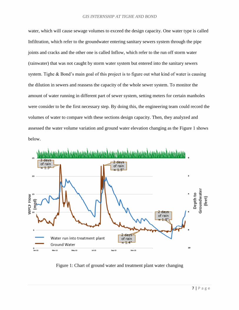
volumes of water to compare with these sections design capacity. Then, they analyzed and
assessed the water volume variation and ground water elevation changing as the Figure 1 shows
below.
Figure 1: Chart of ground water and treatment plant water changing
GIS INTERNSHIP AT TIGHE AND BOND
8 | P a g e
The blue line represents the changing of total water flow that went to treatment plants, the brown
line means the changing of the ground water elevation. The two lines in Figure 1 show peaks at
same time. And all the small increases and decreases for both water types shows the water
volume variation caused by precipitation. Based on these results the engineering team could
conclude that the groundwater is main source that will affect the volume of water in sewer
system and the Inflow water will only cause small variations in the sewer system.
In order to detect which section of the pipes will be affected by Infiltration, a comprehensive GIS
database of the whole towns’ sewer system needs to be developed. That is the part where GIS
will contribute as important role as preparation stage to further modeling. The whole GIS
database has been established through SDE which is an enterprise geodatabase that allows more
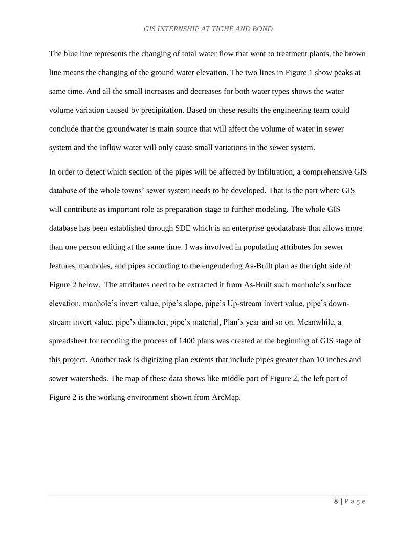
than one person editing at the same time. I was involved in populating attributes for sewer
features, manholes, and pipes according to the engendering As-Built plan as the right side of
Figure 2 below. The attributes need to be extracted it from As-Built such manhole’s surface
elevation, manhole’s invert value, pipe’s slope, pipe’s Up-stream invert value, pipe’s down-
stream invert value, pipe’s diameter, pipe’s material, Plan’s year and so on. Meanwhile, a
spreadsheet for recoding the process of 1400 plans was created at the beginning of GIS stage of
this project. Another task is digitizing plan extents that include pipes greater than 10 inches and
sewer watersheds. The map of these data shows like middle part of Figure 2, the left part of
Figure 2 is the working environment shown from ArcMap.
GIS INTERNSHIP AT TIGHE AND BOND
9 | P a g e
Figure 2: Stratford project’s GIS developing environment
As the data developing stage completed, this project was taken into analysis stage. The GIS team
incorporated with engineer team together to analyze and model this project as next stage which
we have been working on till recently. The main goal of this stage is to figure out which section
of pipes that distributed in the town are affected or always saturated in the ground water that
keep causing dilution in sanitary sewers system, as well as robot inspection, analyzes diurnal
flows, negatively sloped pipes, surcharged pipes, capacity of the pipe. Eventually, they will have
people to dig out and replace the problematic pipes to reduce the volume of water flow into
treatment plant in order to achieve the final goal of the project.
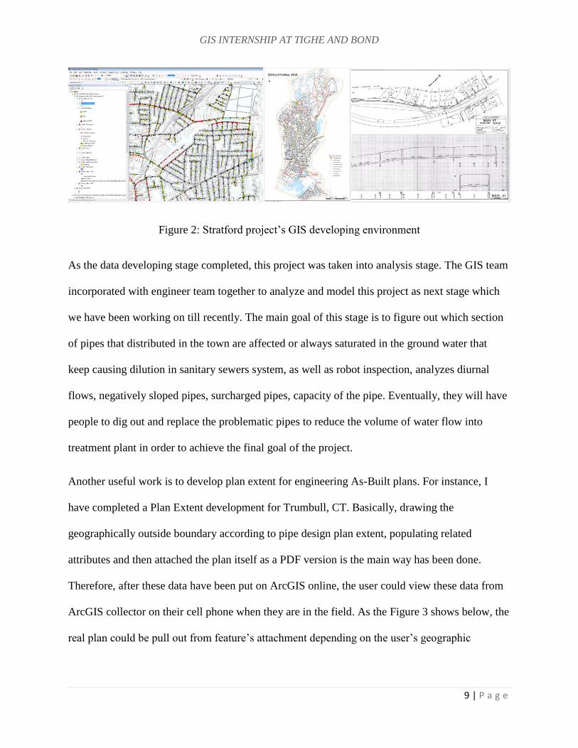
Another useful work is to develop plan extent for engineering As-Built plans. For instance, I
have completed a Plan Extent development for Trumbull, CT. Basically, drawing the
geographically outside boundary according to pipe design plan extent, populating related
attributes and then attached the plan itself as a PDF version is the main way has been done.
Therefore, after these data have been put on ArcGIS online, the user could view these data from
ArcGIS collector on their cell phone when they are in the field. As the Figure 3 shows below, the
real plan could be pull out from feature’s attachment depending on the user’s geographic
GIS INTERNSHIP AT TIGHE AND BOND
10 | P a g e
position. Which could be very helpful and useful, even for type of the client who want to
evaluate these data in the office.
Figure 3: User Trumbull project’s data view from ArcGIS Collector
Other projects were also conducted during the internship and are listed below:
Dalton MA, Shadly and Salisbury CT Sewer System GIS Support and Analysis:
Digitizing manhole points, issue points, sewer mains, attributing sewer mains and
recoding the data issues, drawing all plan extent.
Avon, CT-GIS On-Call Support and Engineering Services: Drawing plans' extent and
adding plan attachment for sewer system.
Mattapoisett, MA Pond Force Main GIS Support: Digitizing pavement, drive way and
side walk.
North Andover, MA Storm Water Program GIS Support: Digitizing and attributing
features from storm water plans. Recording plans' issues. Drawing plan extents.
GIS INTERNSHIP AT TIGHE AND BOND
11 | P a g e
Trinity CT Water, Sewer & SW Modeling: Building Feature Editing and catchment
editing for town.
Converting XYZ file Lidar file to feature class and building a terrain dataset.
LEGO campus, Enfield, CT GIS On-call: Geo-Referencing and Correcting soil boring
points.
Creating and cleaning attachments for Watertown water service area.
Creating maps and editing features responding to engineer requests.
Conducting X-ray Add-in tools of ARCGIS to get and compare information from Map
document.
3.2 Script Tool and Programming
For another kind of work, I use programming to create some script tools that are able to process
some data automatically, developing and running script to compare and check geodatabase,
creating script toolbox to automate the workflow.
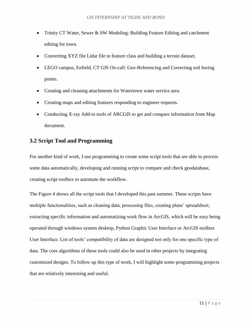
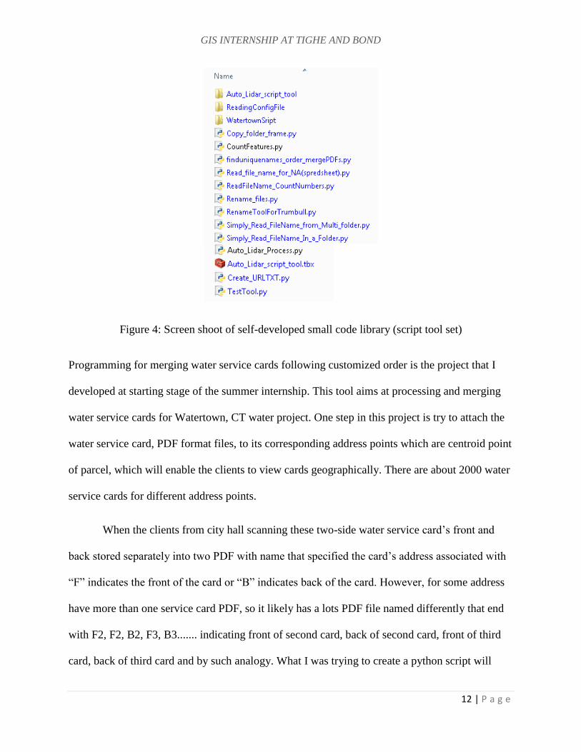
The Figure 4 shows all the script tools that I developed this past summer. These scripts have
multiple functionalities, such as cleaning data, processing files, creating plans’ spreadsheet,
extracting specific information and automatizing work flow in ArcGIS, which will be easy being
operated through windows system desktop, Python Graphic User Interface or ArcGIS toolbox
User Interface. List of tools’ compatibility of data are designed not only for one specific type of
data. The core algorithms of these tools could also be used in other projects by integrating
customized designs. To follow up this type of work, I will highlight some programming projects
that are relatively interesting and useful.
GIS INTERNSHIP AT TIGHE AND BOND
12 | P a g e
Figure 4: Screen shoot of self-developed small code library (script tool set)
Programming for merging water service cards following customized order is the project that I
developed at starting stage of the summer internship. This tool aims at processing and merging
water service cards for Watertown, CT water project. One step in this project is try to attach the
water service card, PDF format files, to its corresponding address points which are centroid point
of parcel, which will enable the clients to view cards geographically. There are about 2000 water
service cards for different address points.
When the clients from city hall scanning these two-side water service card’s front and
back stored separately into two PDF with name that specified the card’s address associated with
“F” indicates the front of the card or “B” indicates back of the card. However, for some address
have more than one service card PDF, so it likely has a lots PDF file named differently that end
with F2, F2, B2, F3, B3....... indicating front of second card, back of second card, front of third
card, back of third card and by such analogy. What I was trying to create a python script will
GIS INTERNSHIP AT TIGHE AND BOND
13 | P a g e
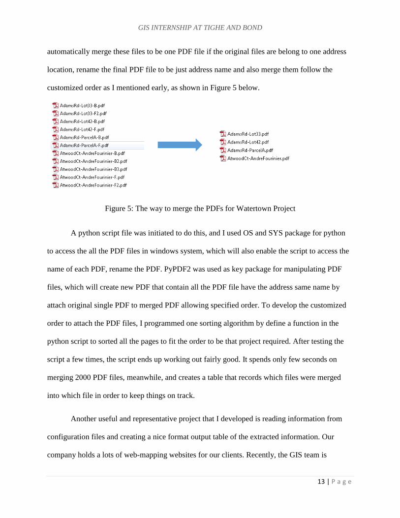
automatically merge these files to be one PDF file if the original files are belong to one address
location, rename the final PDF file to be just address name and also merge them follow the
customized order as I mentioned early, as shown in Figure 5 below.
Figure 5: The way to merge the PDFs for Watertown Project
A python script file was initiated to do this, and I used OS and SYS package for python
to access the all the PDF files in windows system, which will also enable the script to access the
name of each PDF, rename the PDF. PyPDF2 was used as key package for manipulating PDF
files, which will create new PDF that contain all the PDF file have the address same name by
attach original single PDF to merged PDF allowing specified order. To develop the customized
order to attach the PDF files, I programmed one sorting algorithm by define a function in the
python script to sorted all the pages to fit the order to be that project required. After testing the
script a few times, the script ends up working out fairly good. It spends only few seconds on
merging 2000 PDF files, meanwhile, and creates a table that records which files were merged
into which file in order to keep things on track.
Another useful and representative project that I developed is reading information from
configuration files and creating a nice format output table of the extracted information. Our
company holds a lots of web-mapping websites for our clients. Recently, the GIS team is
GIS INTERNSHIP AT TIGHE AND BOND
14 | P a g e
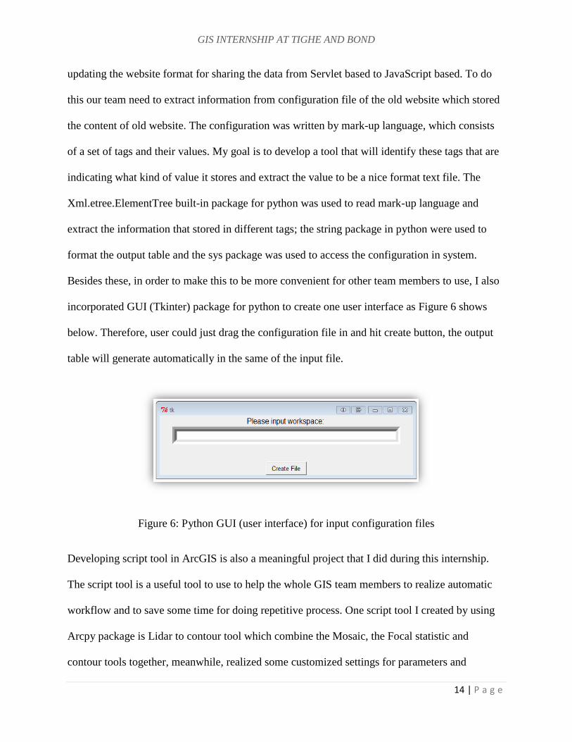
updating the website format for sharing the data from Servlet based to JavaScript based. To do
this our team need to extract information from configuration file of the old website which stored
the content of old website. The configuration was written by mark-up language, which consists
of a set of tags and their values. My goal is to develop a tool that will identify these tags that are
indicating what kind of value it stores and extract the value to be a nice format text file. The
Xml.etree.ElementTree built-in package for python was used to read mark-up language and
extract the information that stored in different tags; the string package in python were used to
format the output table and the sys package was used to access the configuration in system.
Besides these, in order to make this to be more convenient for other team members to use, I also
incorporated GUI (Tkinter) package for python to create one user interface as Figure 6 shows
below. Therefore, user could just drag the configuration file in and hit create button, the output
table will generate automatically in the same of the input file.
Figure 6: Python GUI (user interface) for input configuration files
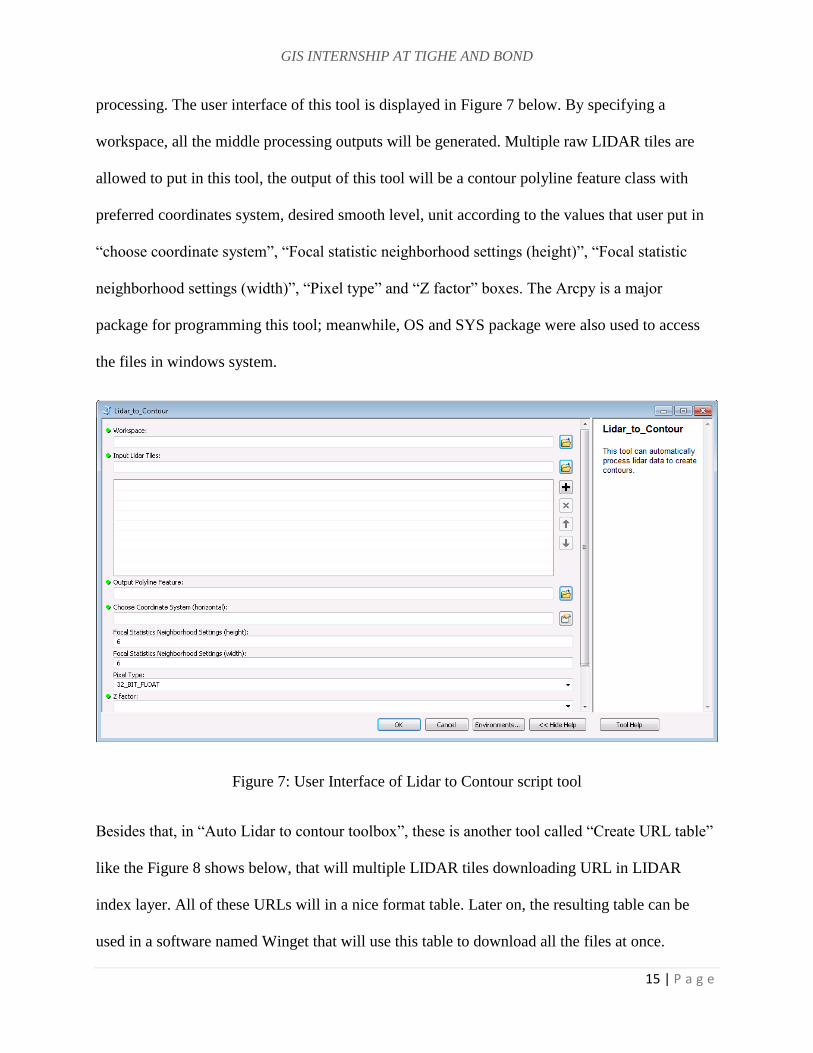
Developing script tool in ArcGIS is also a meaningful project that I did during this internship.
The script tool is a useful tool to use to help the whole GIS team members to realize automatic
workflow and to save some time for doing repetitive process. One script tool I created by using
Arcpy package is Lidar to contour tool which combine the Mosaic, the Focal statistic and
contour tools together, meanwhile, realized some customized settings for parameters and
GIS INTERNSHIP AT TIGHE AND BOND
15 | P a g e
processing. The user interface of this tool is displayed in Figure 7 below. By specifying a
workspace, all the middle processing outputs will be generated. Multiple raw LIDAR tiles are
allowed to put in this tool, the output of this tool will be a contour polyline feature class with
preferred coordinates system, desired smooth level, unit according to the values that user put in
“choose coordinate system”, “Focal statistic neighborhood settings (height)”, “Focal statistic
neighborhood settings (width)”, “Pixel type” and “Z factor” boxes. The Arcpy is a major
package for programming this tool; meanwhile, OS and SYS package were also used to access
the files in windows system.
Figure 7: User Interface of Lidar to Contour script tool
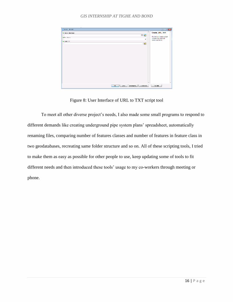
Besides that, in “Auto Lidar to contour toolbox”, these is another tool called “Create URL table”
like the Figure 8 shows below, that will multiple LIDAR tiles downloading URL in LIDAR
index layer. All of these URLs will in a nice format table. Later on, the resulting table can be
used in a software named Winget that will use this table to download all the files at once.
GIS INTERNSHIP AT TIGHE AND BOND
16 | P a g e
Figure 8: User Interface of URL to TXT script tool
To meet all other diverse project’s needs, I also made some small programs to respond to
different demands like creating underground pipe system plans’ spreadsheet, automatically
renaming files, comparing number of features classes and number of features in feature class in
two geodatabases, recreating same folder structure and so on. All of these scripting tools, I tried
to make them as easy as possible for other people to use, keep updating some of tools to fit
different needs and then introduced these tools’ usage to my co-workers through meeting or
phone.
GIS INTERNSHIP AT TIGHE AND BOND
17 | P a g e
CHAPTER 4: INTERNSHIP ASSESSMENT
In past one year, two academic semesters and summer internship became a precious and rich
experience in my life.
The pervious study at Clark has offered me a chance to become familiar with the American
culture and academic environment. Especially, I built up a good career goal through the
professional seminar that helped me to evaluate myself by introducing me to the entire GIS job
market and helping me find and establish my interests. What’s more important are professional
and skills GIS courses that I have learned before this internship which benefit me a lot and help
me grasp the chance of winning this internship opportunity. For instance, the Intro to GIS,
remote sensing, Advanced Raster GIS and GIS for International Development have given me
strong fundamental knowledge in analyzing vector data using ArcMap, manipulating GIS data,
finding diverse data, theories of remote sensing and advanced image processing & analyzing
skills. The skills and techniques that I gained from the python programming and Computer
Programming for GIS course were the most useful skills because I was able to create automatic
workflows which significantly increased efficiency. I was also able to build an online portfolio
after finishing the cartography class. The ability to accomplish a whole project, capacity of
solving problem and team working with other people also considered be to the most valuable
skills that I learned at school.
Overall from my summer internship, I have obtained hard and soft skills, which is a huge benefit
for my current academic study and future career development. I have gained sufficient training
from my co-workers at the beginning of this internship. As I stepped into real GIS world, it
assisted me to reinforce my GIS skills, meanwhile offered me a new GIS working circumstance
GIS INTERNSHIP AT TIGHE AND BOND
18 | P a g e
that filled with GIS demand from Client, GIS techniques responding the modern development
and the ways to using professional GIS knowledge to incorporate with people from professional
GIS team and different fields. I obtained many useful skills from this internship that I would like
to highlight some of them below.
First time dealing with utilities data (sewer, water, storm water system features), even
though we have already experienced some vector data. However, the utilities data
structure feels like more complicated such as pipe line features will have direction, many
unfamiliar water system feature associated with many attributes from engineering As-
built plan. It let me know better about what the data look like from the real project and
particular data will be needed for particular field.
Even though I made many maps for pervious projects while using personal color and
schema. However, for making engineering project maps I need to follow the template to
fit requirements of special elements and formats. Also, I have many new tricks for
making map like using data driven pages, using dynamic text, making annotations for
engineering figures and so on.
Doing works from this internship has significantly improved my familiarity and fluency
working with ArcMap, Arc Catalog and ArcGIS online. It got me exposed to
SDE(popular enterprise level geodatabase), ArcGIS collector and Survey 123(two
software for display data on mobile and collection field data).
Getting to know the interesting projects’ background, and knowing what problem GIS
could solve, what tool I should use in terms of better understanding the role of GIS in
each situation.
GIS INTERNSHIP AT TIGHE AND BOND
19 | P a g e
Get to know what kind of projects are needed in the market, how these projects operate
and earn profits, how to maintain a long-term project and what kind of final products
need to be made to fit the clients need.
The use of python programming to solve many problems as contribution of project and
improvement of working efficiency. To achieve the goals, I taught myself by using the
material from internet about how to install and use couple new python packages and then
developed a small code library that can be reused on many types of projects, which
helped team members’ and my daily work a lot.
If GIS students are interested in vector analysis and urban and utilities development, I would
strongly recommend this internship to them. Because this internship will offer real, diverse and
dynamic civil engineering related GIS working environment; chance to build up professional
network from the GIS team or client; help them redefine their interests as well as learn cutting
edge geographic information science resources and technologies and encourage them to take
related courses before they start seeking this kind of internship.
GIS INTERNSHIP AT TIGHE AND BOND
20 | P a g e
CHAPTER 5: CONCLUSION
The experience of Tighe and Bond GIS internship shaped me into more professional and skillful
person to the GIS discipline. I appreciated the training, helping, teaching and suggestions they
have offered to me. I am honored to have had the opportunity to expose myself to diverse GIS
projects under the real consulting company to grasp experience with new hard and soft skills and
to apply the extensive knowledge obtained from previous study on solving engineering
questions. I am proud of the products that I created because they could be used by many people
from different towns. The piece of code that I developed could be helpful to my co-workers and
the professional network that I have built during this period. This internship not only polished
my working ability and professional skills, but also helped me to be more confident to handle
engineering GIS cases and to pursue my future career goal.
BIBLIOGRAPGHY
Tighe & Bond, 2016, About Tighe & Bond. Accessible Link: http://www.tighebond.com/.
Last accessed on: December 15, 2016
ESRI, 2016, About ESRI. Accessible Link:
http://www.esri.com/about-esri/. Last accessed on: October 20, 2016
Related Documents


![Bovo tighe seminar 9-2010 v12b[1]](https://static.cupdf.com/doc/110x72/559125871a28ab85368b4745/bovo-tighe-seminar-9-2010-v12b1.jpg)