GIS & Health GIS & Health ESPM 9: W 5-8 ESPM 9: W 5-8 April 7, 2010 April 7, 2010 Instructors: Instructors: Maggi Kelly Maggi Kelly Kevin Koy Kevin Koy Mark O’Connor Mark O’Connor Geospatial Innovation Facility Geospatial Innovation Facility College of Natural Resources - UC College of Natural Resources - UC Berkeley Berkeley http://gif.berkeley.edu http://gif.berkeley.edu

GIS & Health ESPM 9: W 5-8 April 7, 2010 Instructors: Maggi Kelly Kevin Koy Mark O’Connor Geospatial Innovation Facility College of Natural Resources -
Dec 13, 2015
Welcome message from author
This document is posted to help you gain knowledge. Please leave a comment to let me know what you think about it! Share it to your friends and learn new things together.
Transcript

GIS & HealthGIS & Health
ESPM 9: W 5-8ESPM 9: W 5-8
April 7, 2010April 7, 2010
Instructors:Instructors:
Maggi KellyMaggi Kelly
Kevin KoyKevin Koy
Mark O’ConnorMark O’Connor
Geospatial Innovation FacilityGeospatial Innovation FacilityCollege of Natural Resources - UC College of Natural Resources - UC
BerkeleyBerkeleyhttp://gif.berkeley.eduhttp://gif.berkeley.edu

ESPM 9 – GIS and Health - Spring 2009
Today’s ScheduleToday’s Schedule
• LectureLecture– GIS IntroductionGIS Introduction– GIS Functions you will use todayGIS Functions you will use today
• Lab 1Lab 1– Getting to know GISGetting to know GIS
ESPM 9 – GIS and Health - Spring 2009
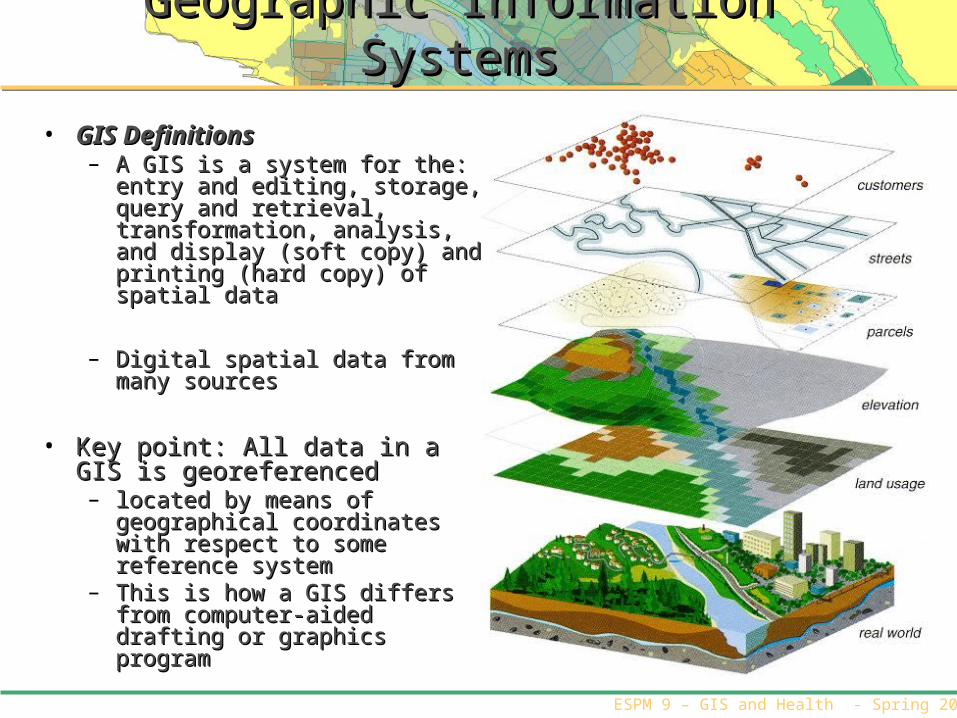
Geographic Information SystemsGeographic Information Systems
• GIS DefinitionsGIS Definitions– A GIS is a system for the: entry and A GIS is a system for the: entry and
editing, storage, query and editing, storage, query and retrieval, transformation, analysis, retrieval, transformation, analysis, and display (soft copy) and printing and display (soft copy) and printing (hard copy) of spatial data(hard copy) of spatial data
– Digital spatial data from many Digital spatial data from many sources sources
• Key point: All data in a GIS is Key point: All data in a GIS is georeferencedgeoreferenced
– located by means of geographical located by means of geographical coordinates with respect to some coordinates with respect to some reference systemreference system
– This is how a GIS differs from This is how a GIS differs from computer-aided drafting or computer-aided drafting or graphics programgraphics program

ESPM 9 – GIS and Health - Spring 2009
Data
Spatial Data FormatsSpatial Data Formats• VectorVector • Raster/GridRaster/Grid

ESPM 9 – GIS and Health - Spring 2009
Raster

ESPM 9 – GIS and Health - Spring 2009
Vector

ESPM 9 – GIS and Health - Spring 2009
Points, nodes
Lines, arcs
Polygons, objects
Raster, pixels,
grid cells
DataData
Measurement of point pattern
Distance from roads, length of
flow path
Patch size, Patch shape
Pattern, connectivity
Sample points, Disease cluster…
Animal behavior,
water quality…
Areas of protection or
invasion…
Animal movement,
invasive species
dispersal…
AnalysisAnalysis
GIS: Linking Spatial Data with Attribute DataGIS: Linking Spatial Data with Attribute DataAttributesAttributes Process / Process /
InterpretatiInterpretationonFast food
location, organic food
stand location…
Walking path to work…
Hospital service zone…
Access to fresh food…
ESPM 9 – GIS and Health - Spring 2009
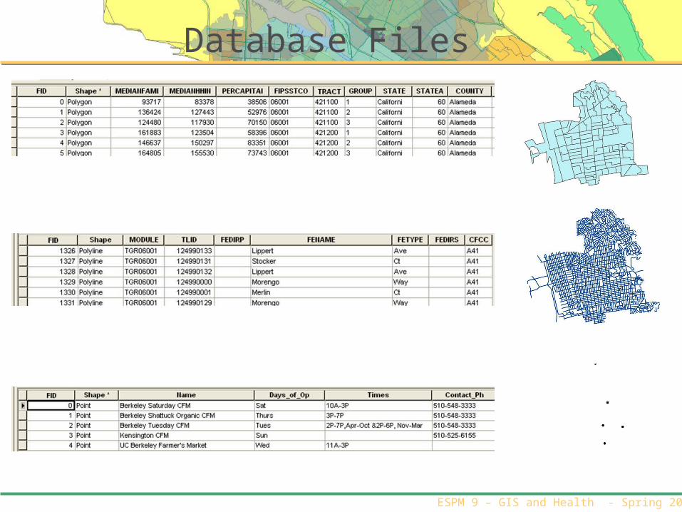
Database Files

ESPM 9 – GIS and Health - Spring 2009
Spatial Data AttributesSpatial Data Attributes

ESPM 9 – GIS and Health - Spring 2009
Vector Data

ESPM 9 – GIS and Health - Spring 2009
GIS Software you will useGIS Software you will use
• ESRI’s ArcGIS is the ESRI’s ArcGIS is the software that you will software that you will use for the labs. use for the labs.
ESPM 9 – GIS and Health - Spring 2009
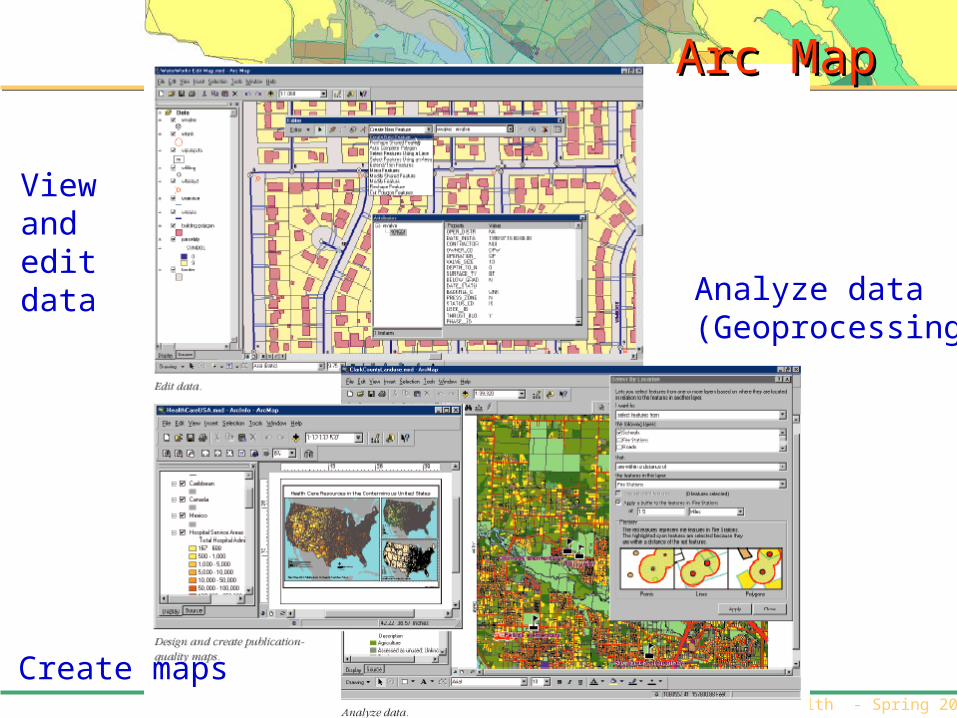
Arc MapArc Map
Create maps
Viewand edit data Analyze data
(Geoprocessing)

ESPM 9 – GIS and Health - Spring 2009
Arc CatalogArc Catalog
View data (like Windows Explorer)
Graphicalpreviews
Metadata
Tables
ESPM 9 – GIS and Health - Spring 2009
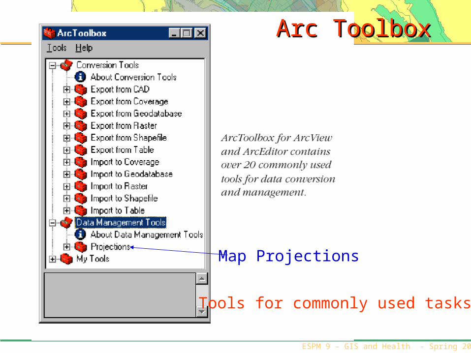
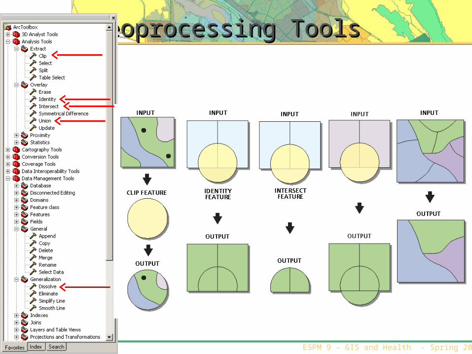
Arc ToolboxArc Toolbox
Map Projections
Tools for commonly used tasks

ESPM 9 – GIS and Health - Spring 2009
Functions that you will useFunctions that you will use
• There are a number of functions that you will use in the lab There are a number of functions that you will use in the lab today:today:– Navigation toolsNavigation tools– Query / Select by attributeQuery / Select by attribute– BufferBuffer– ClipClip– Merge & DissolveMerge & Dissolve– Making a MapMaking a Map– Symbology/DisplaySymbology/Display
ESPM 9 – GIS and Health - Spring 2009
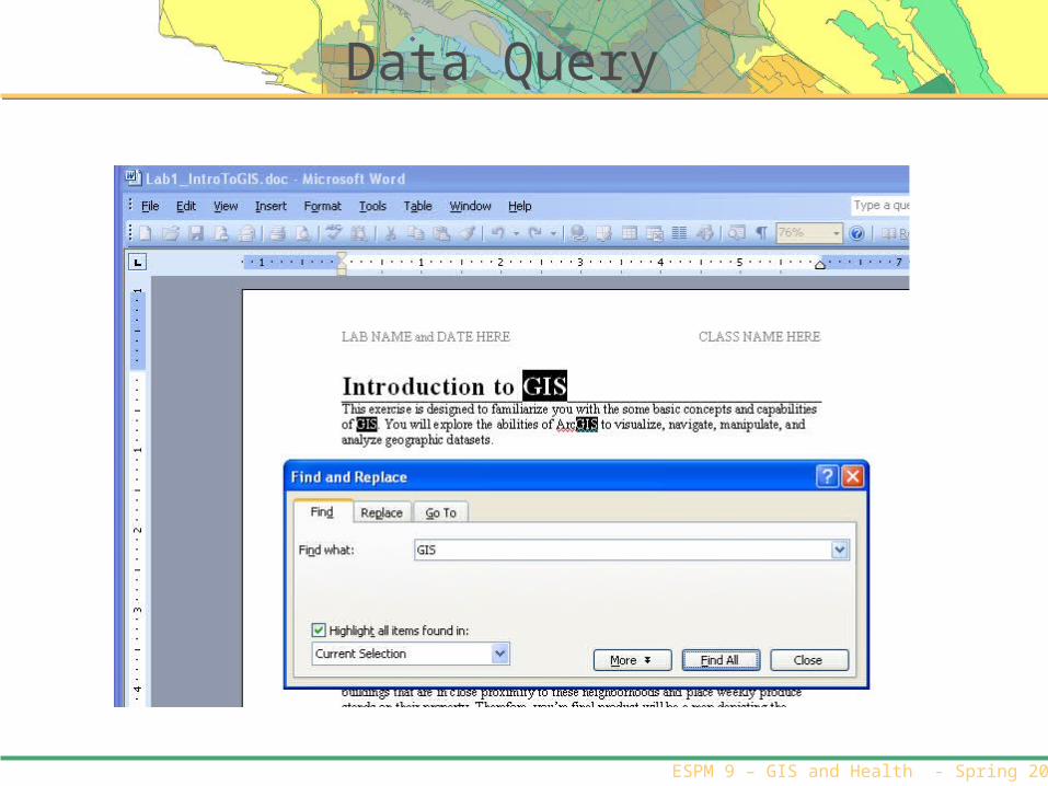
Data Query

ESPM 9 – GIS and Health - Spring 2009
Geospatial Query:Geospatial Query:POINTS near LINESPOINTS near LINES
Select by locationSelect by location: Toxic release sites within 1 mile of a river: Toxic release sites within 1 mile of a river
Image credit: K. Kurland, 2006Image credit: K. Kurland, 2006

ESPM 9 – GIS and Health - Spring 2009
Geospatial Query:Geospatial Query:POINTS near POINTSPOINTS near POINTS
Select by locationSelect by location: Schools within ½ mile of polluting : Schools within ½ mile of polluting companiescompanies
Image credit: K. Kurland, 2006Image credit: K. Kurland, 2006

ESPM 9 – GIS and Health - Spring 2009
Geospatial Query:Geospatial Query:POLYGONS intersecting LINESPOLYGONS intersecting LINES
Select by locationSelect by location: Municipalities that intersect : Municipalities that intersect InterstatesInterstates
Image credit: K. Kurland, 2006Image credit: K. Kurland, 2006
ESPM 9 – GIS and Health - Spring 2009
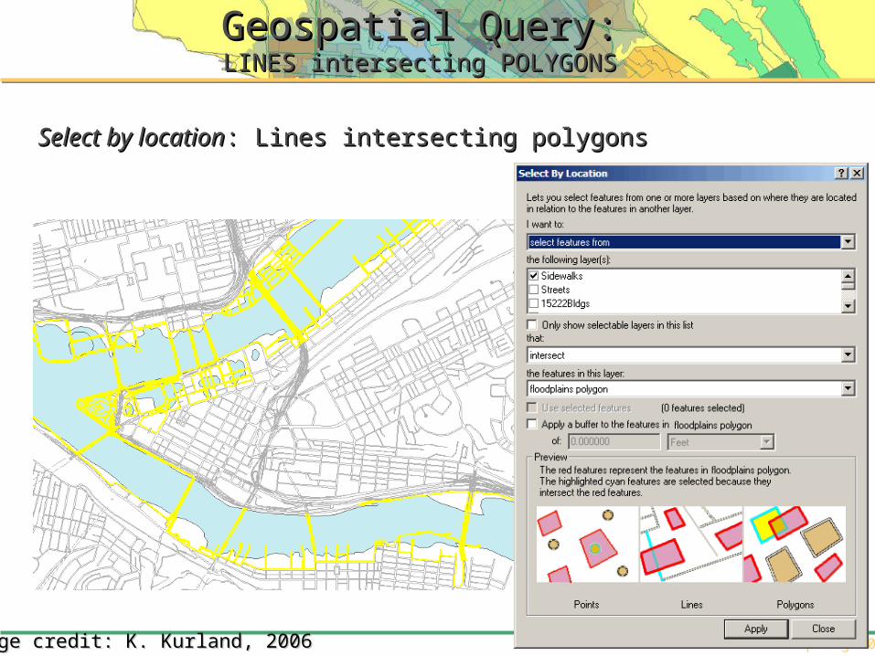
Geospatial Query:Geospatial Query:LINES intersecting POLYGONSLINES intersecting POLYGONS
Select by locationSelect by location: Lines: Lines intersectingintersecting polygonspolygons
Image credit: K. Kurland, 2006Image credit: K. Kurland, 2006

ESPM 9 – GIS and Health - Spring 2009
Function: Dissolve/MergeFunction: Dissolve/Merge
• When you want to When you want to dissolve boundaries dissolve boundaries between similar between similar objects, you can use objects, you can use the Dissolve function.the Dissolve function.
• To join features from To join features from multiple inputs into a multiple inputs into a single output use single output use Merge.Merge.

ESPM 9 – GIS and Health - Spring 2009
Function: BufferFunction: Buffer
• When you want to look at the distance away from an When you want to look at the distance away from an object, you can create spatial buffers.object, you can create spatial buffers.
ESPM 9 – GIS and Health - Spring 2009
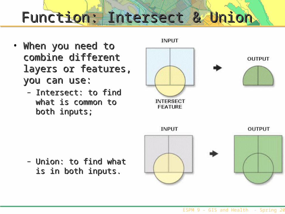
Function: Intersect & UnionFunction: Intersect & Union
• When you need to combine When you need to combine different layers or features, different layers or features, you can use:you can use:– Intersect: to find what is Intersect: to find what is
common to both inputs;common to both inputs;
– Union: to find what is in both Union: to find what is in both inputs.inputs.
ESPM 9 – GIS and Health - Spring 2009
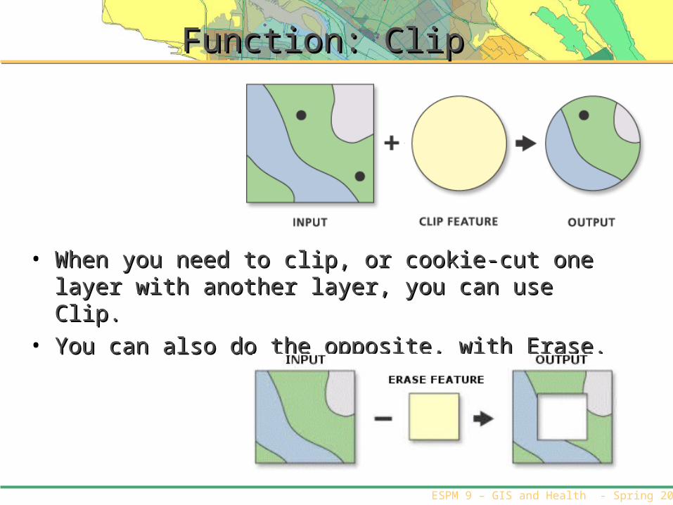
Function: ClipFunction: Clip
• When you need to clip, or cookie-cut one layer with When you need to clip, or cookie-cut one layer with another layer, you can use Clip. another layer, you can use Clip.
• You can also do the opposite, with Erase.You can also do the opposite, with Erase.
ESPM 9 – GIS and Health - Spring 2009
Geoprocessing ToolsGeoprocessing Tools

ESPM 9 – GIS and Health - Spring 2009
Power of MapsPower of Maps
• Maps gain their value in three Maps gain their value in three ways: ways:
– As a way of recording and As a way of recording and storing information storing information
– As a means of analyzing As a means of analyzing locational distributions and locational distributions and spatial patterns spatial patterns
– As a method of presenting As a method of presenting information and information and communicating findings communicating findings
http://quake.usgs.gov/prepare/alameda.htmlhttp://quake.usgs.gov/prepare/alameda.html
ESPM 9 – GIS and Health - Spring 2009
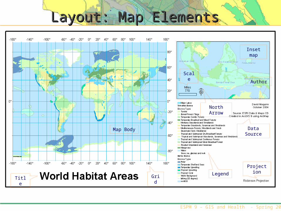
TitleLegen
d
Projection
Grid
Data Source
Inset map
Map Body
Author
North Arrow
Scale
Layout: Map ElementsLayout: Map Elements
ESPM 9 – GIS and Health - Spring 2009
Next WeeksNext Weeks
• Next week: Next week: – Creating spatial dataCreating spatial data– GPS and geocodingGPS and geocoding

ESPM 9 – GIS and Health - Spring 2009
Your Workspace
Logging on• User: !workshopuser• Password: WRKshop USR!
Working Folder:• Create a folder that all of your work will be stored in• C:\Workspace\YOURNAME• Copy the data into this folder
Data• Z:\ESPM9
Related Documents