Geospatial Tools for Geospatial Tools for Earthquake and Tsunami Earthquake and Tsunami Preparedness and Warning Preparedness and Warning Preparedness and Warning Preparedness and Warning - a casestudy on Istanbul a casestudy on Istanbul - Gerhard KEMPER, Orhan ALTAN, Sisi ZLATANOVA

Welcome message from author
This document is posted to help you gain knowledge. Please leave a comment to let me know what you think about it! Share it to your friends and learn new things together.
Transcript
Geospatial Tools for Geospatial Tools for Earthquake and Tsunami Earthquake and Tsunami Preparedness and WarningPreparedness and WarningPreparedness and WarningPreparedness and Warning-- a casestudy on Istanbul a casestudy on Istanbul --
Gerhard KEMPER, Orhan ALTAN, Sisi ZLATANOVA
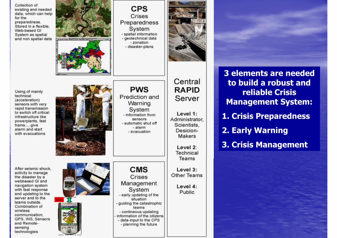
3 elements are needed to build a robust and to build a robust and
reliable Crisis Management System:
1. Crisis Preparedness
2. Early Warning
3. Crisis Management
AgendaAgenda
•• RisklevelRisklevel•• RisklevelRisklevel
•• Earthquakes and Tsunamis Earthquakes and Tsunamis close to Istanbulclose to Istanbul
•• Crisis PreparednessCrisis Preparedness
•• Early WarningEarly Warning•• Early WarningEarly Warning
•• Crisis Management SystemCrisis Management System
•• ConclusionConclusion
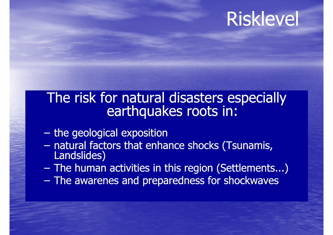
RisklevelRisklevel
The risk for natural disasters especially The risk for natural disasters especially earthquakes roots in:earthquakes roots in:
–– the geological expositionthe geological exposition–– natural factors that enhance shocks (Tsunamis, natural factors that enhance shocks (Tsunamis, Landslides)Landslides)Landslides)Landslides)
–– The human activities in this region (Settlements...)The human activities in this region (Settlements...)–– The awarenes and preparedness for shockwavesThe awarenes and preparedness for shockwaves

19451945
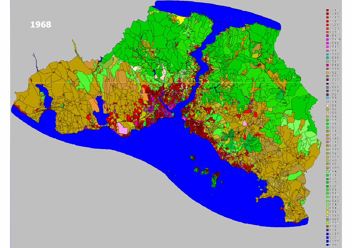
19681968

19881988
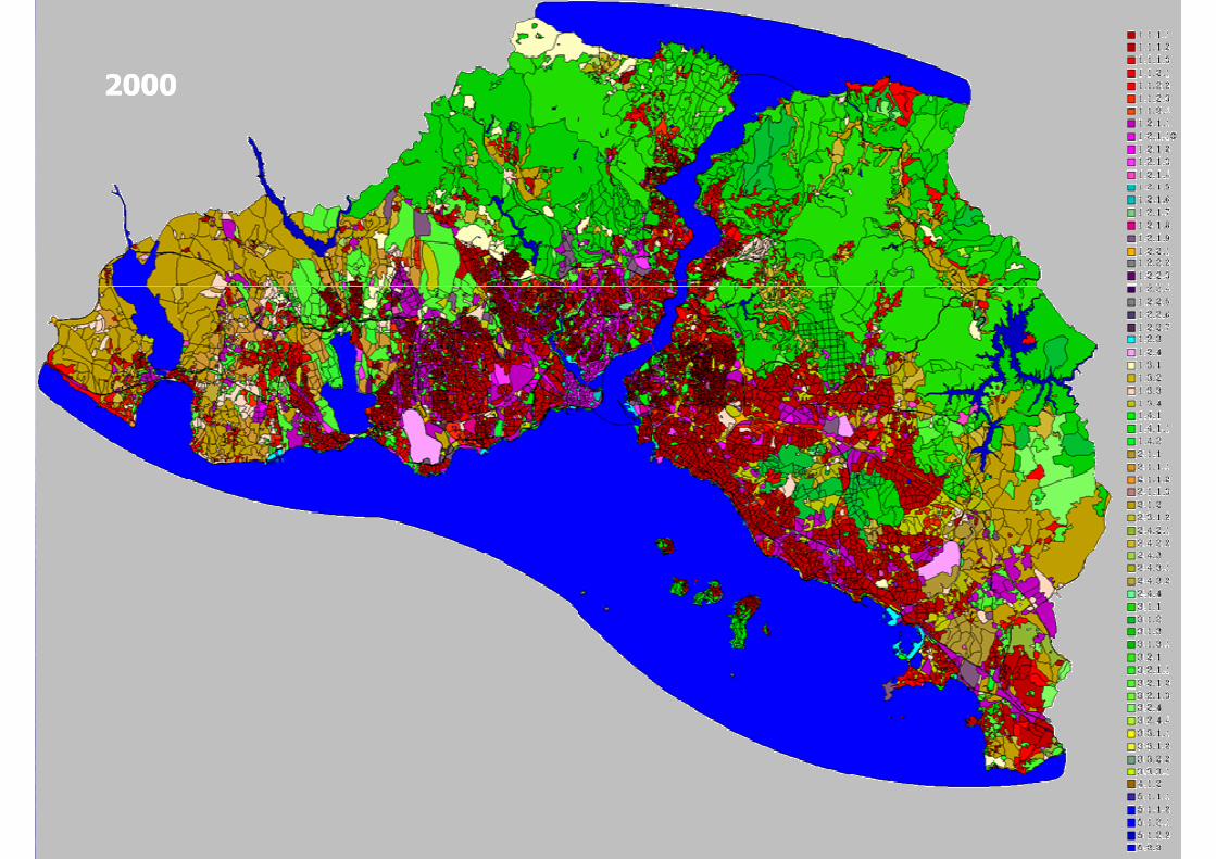
20002000
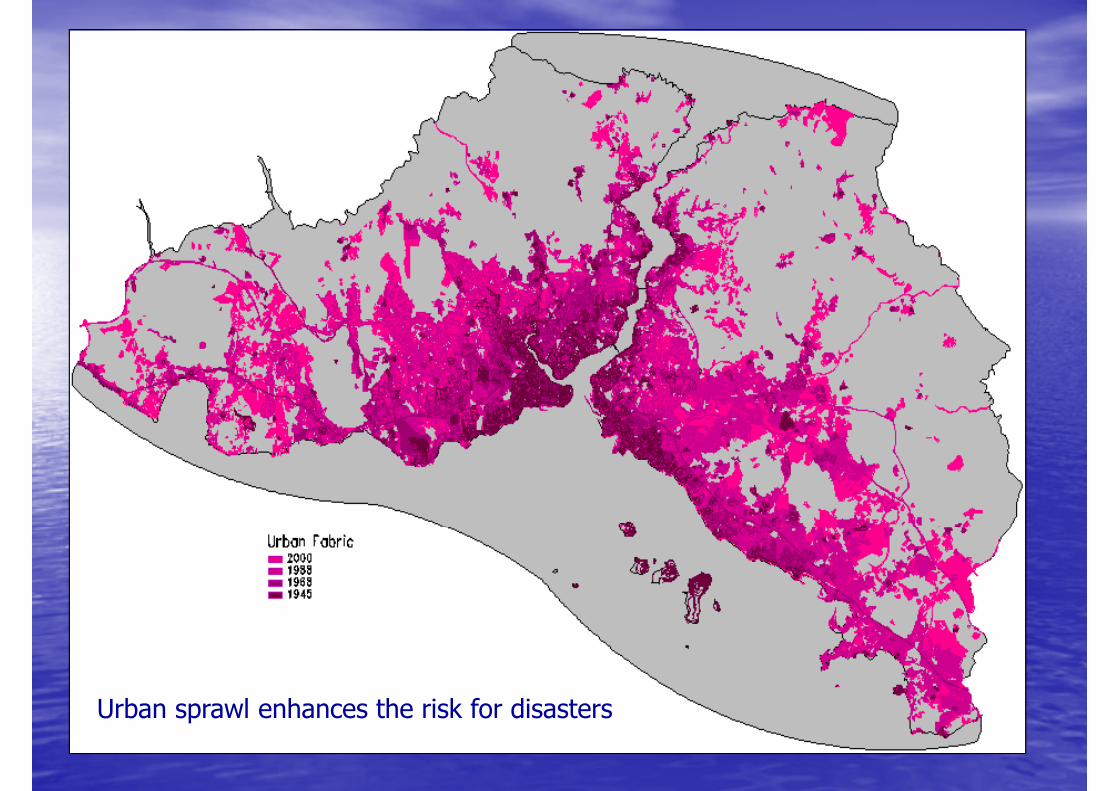
Urban sprawl enhances the risk for disasters
AgendaAgenda
•• RisklevelRisklevel•• RisklevelRisklevel
•• Earthquakes and Tsunamis Earthquakes and Tsunamis close to Istanbulclose to Istanbul
•• Crisis PreparednessCrisis Preparedness
•• Early WarningEarly Warning•• Early WarningEarly Warning
•• Crisis Management SystemCrisis Management System
•• ConclusionConclusion
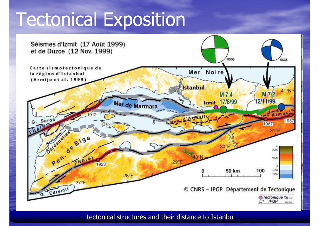
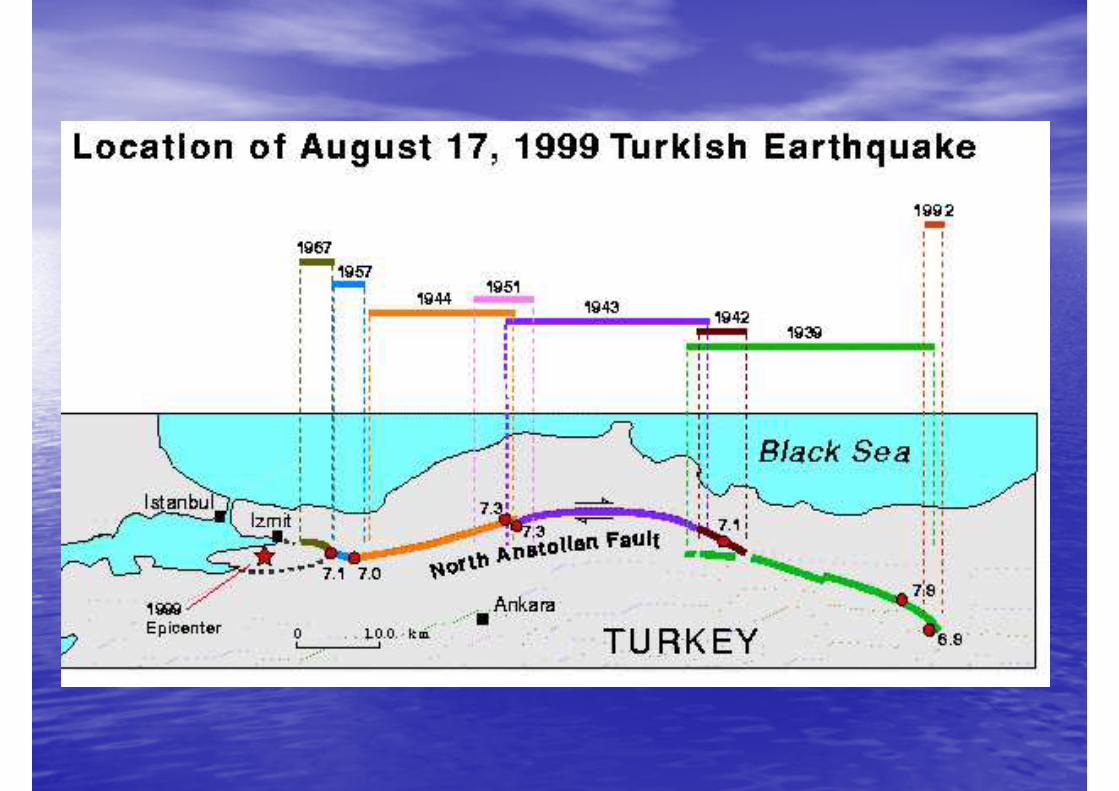
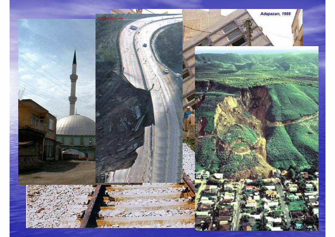
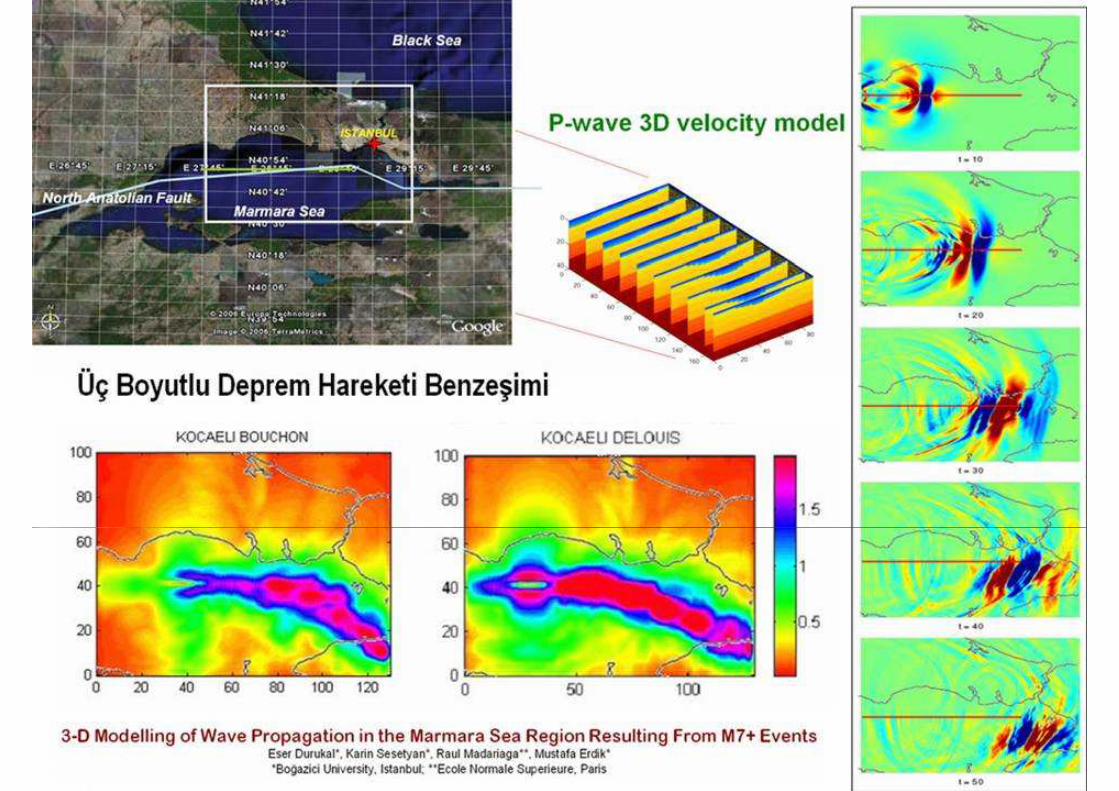
Tectonical ExpositionTectonical Exposition
The plates of Anatolia, Arabia and AfricaVectors of movements 1992-1998tectonical structures and their distance to Istanbul
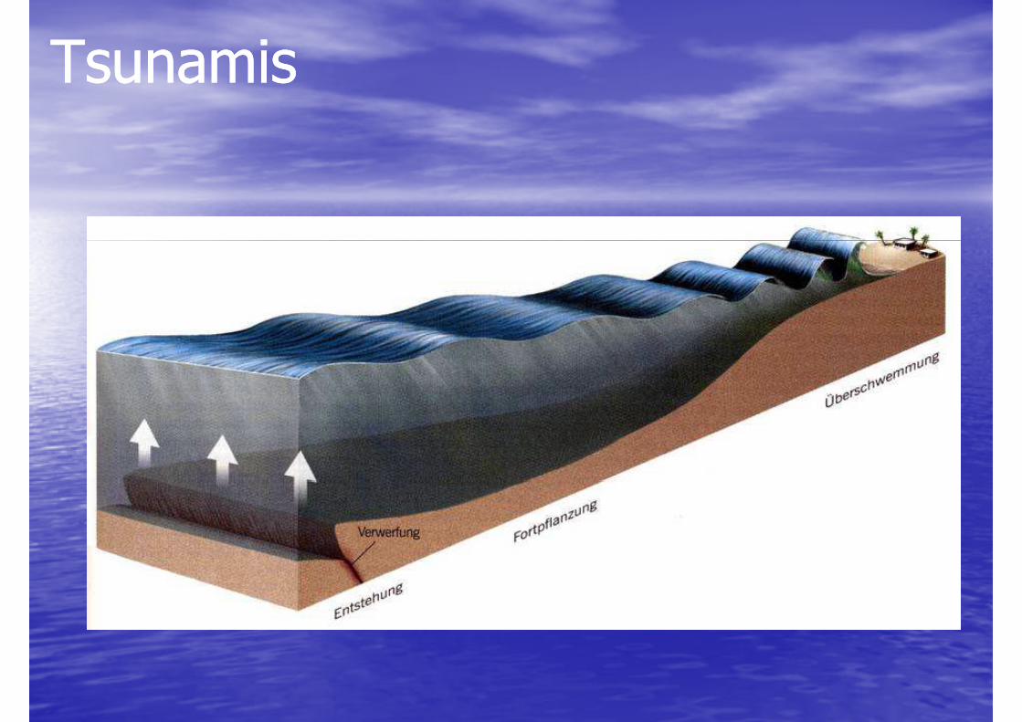
TsunamisTsunamis

The last picture! There are people who believe in God, there are others who don't believe, but we must understand that we are small when nature hits...
This picture was taken on the banks of Sumatra Island (the height of waves was of approx. 32 m = 105 ft). It was found saved in a digital camera, 1 1/2 years after the disaster. We cannot know for sure, but
very likely the one who took the picture is not alive any more (it was just a matter of seconds). Today we can see the last image he/ she saw before ending life on Earth!
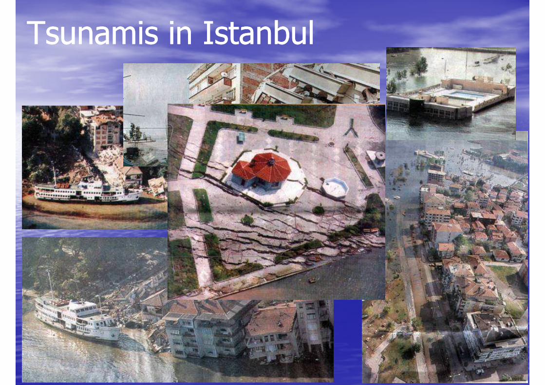
Tsunamis in IstanbulTsunamis in Istanbul
AgendaAgenda
•• RisklevelRisklevel•• RisklevelRisklevel
•• Earthquakes and Tsunamis Earthquakes and Tsunamis close to Istanbulclose to Istanbul
•• Crisis PreparednessCrisis Preparedness
•• Early WarningEarly Warning•• Early WarningEarly Warning
•• Crisis Management SystemCrisis Management System
•• ConclusionConclusion
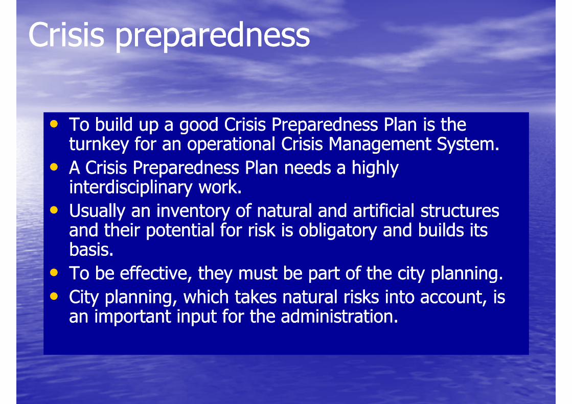
•• To build up a good Crisis Preparedness Plan is the To build up a good Crisis Preparedness Plan is the turnkey for an operational Crisis Management System. turnkey for an operational Crisis Management System.
Crisis preparednessCrisis preparedness
••turnkey for an operational Crisis Management System. turnkey for an operational Crisis Management System.
•• A Crisis Preparedness Plan needs a highly A Crisis Preparedness Plan needs a highly interdisciplinary work. interdisciplinary work.
•• Usually an inventory of natural and artificial structures Usually an inventory of natural and artificial structures and their potential for risk is obligatory and builds its and their potential for risk is obligatory and builds its basis. basis.
•• To be effective, they must be part of the city planning. To be effective, they must be part of the city planning. •• To be effective, they must be part of the city planning. To be effective, they must be part of the city planning.
•• City planning, which takes natural risks into account, is City planning, which takes natural risks into account, is an important input for the administration. an important input for the administration.
Crisis preparednessCrisis preparedness
What data is useful ?
• Masterplans
• Maps, Plans• Maps, Plans
• DTM and DSM
• 3D City models
• Orthophotos
• Land-use maps and databases
• Urban structure information• Urban structure information
• Information and maps of the infrastructure
• Emergency plans
• ... everything
• All data can be useful- even they are needed in a second stage
Crisis preparednessCrisis preparedness
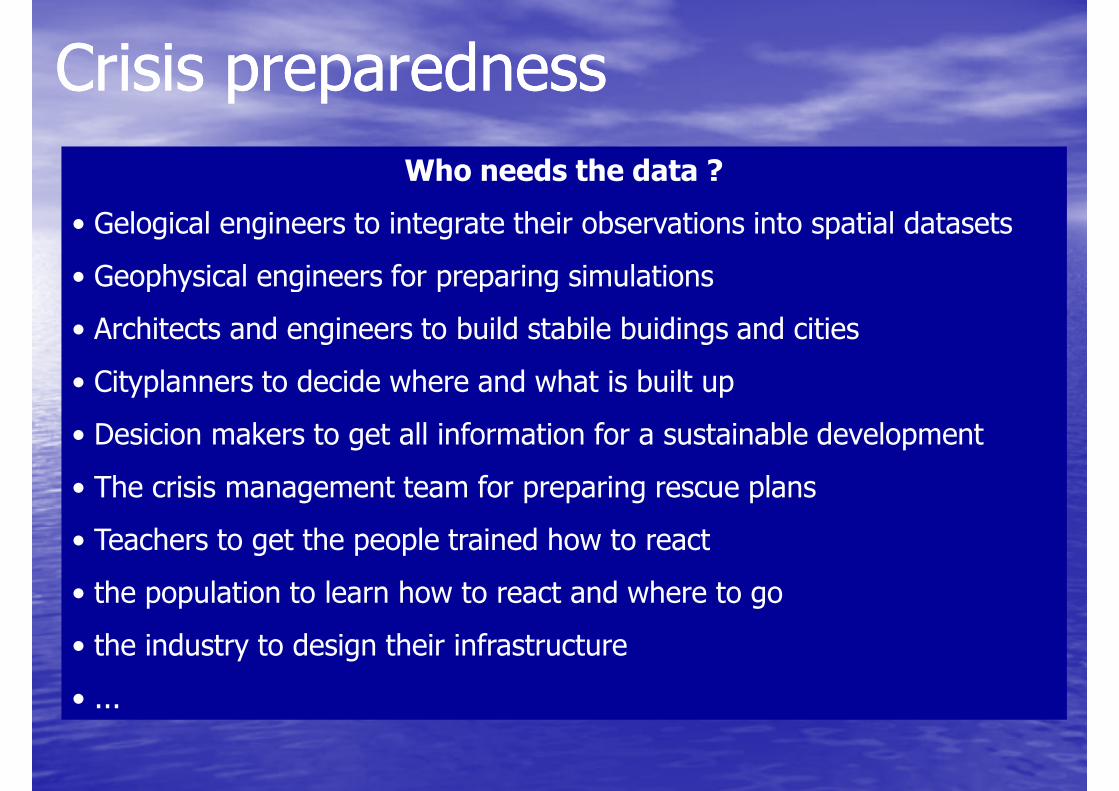
Who needs the data ?
• Gelogical engineers to integrate their observations into spatial datasets
• Geophysical engineers for preparing simulations • Geophysical engineers for preparing simulations
• Architects and engineers to build stabile buidings and cities
• Cityplanners to decide where and what is built up
• Desicion makers to get all information for a sustainable development
• The crisis management team for preparing rescue plans
• Teachers to get the people trained how to react• Teachers to get the people trained how to react
• the population to learn how to react and where to go
• the industry to design their infrastructure
• ...
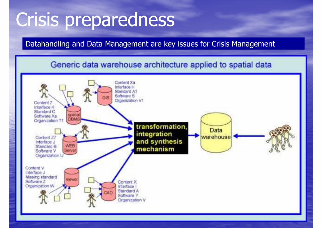
Crisis preparednessCrisis preparednessDatahandling and Data Management are key issues for Crisis Management
Crisis preparednessCrisis preparedness
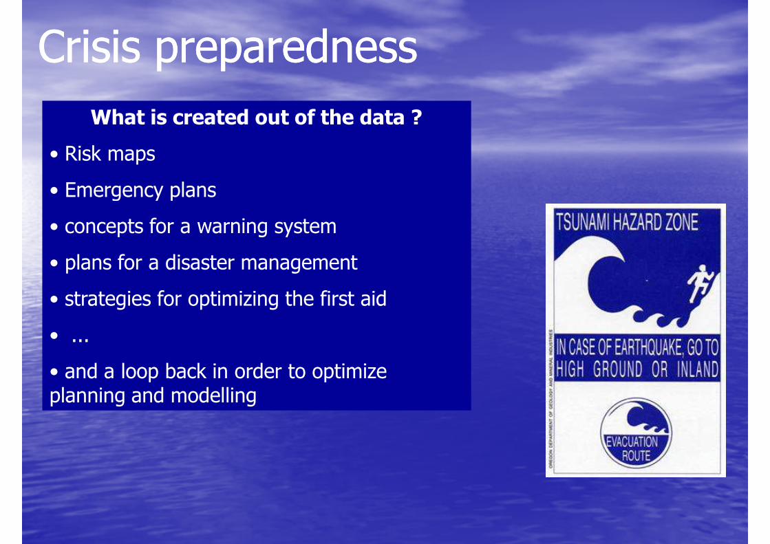
What is created out of the data ?
• Risk maps
• Emergency plans • Emergency plans
• concepts for a warning system
• plans for a disaster management
• strategies for optimizing the first aid
• ...
• and a loop back in order to optimize • and a loop back in order to optimize planning and modelling
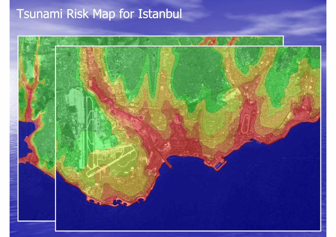
Tsunami Risk Map for IstanbulTsunami Risk Map for Istanbul
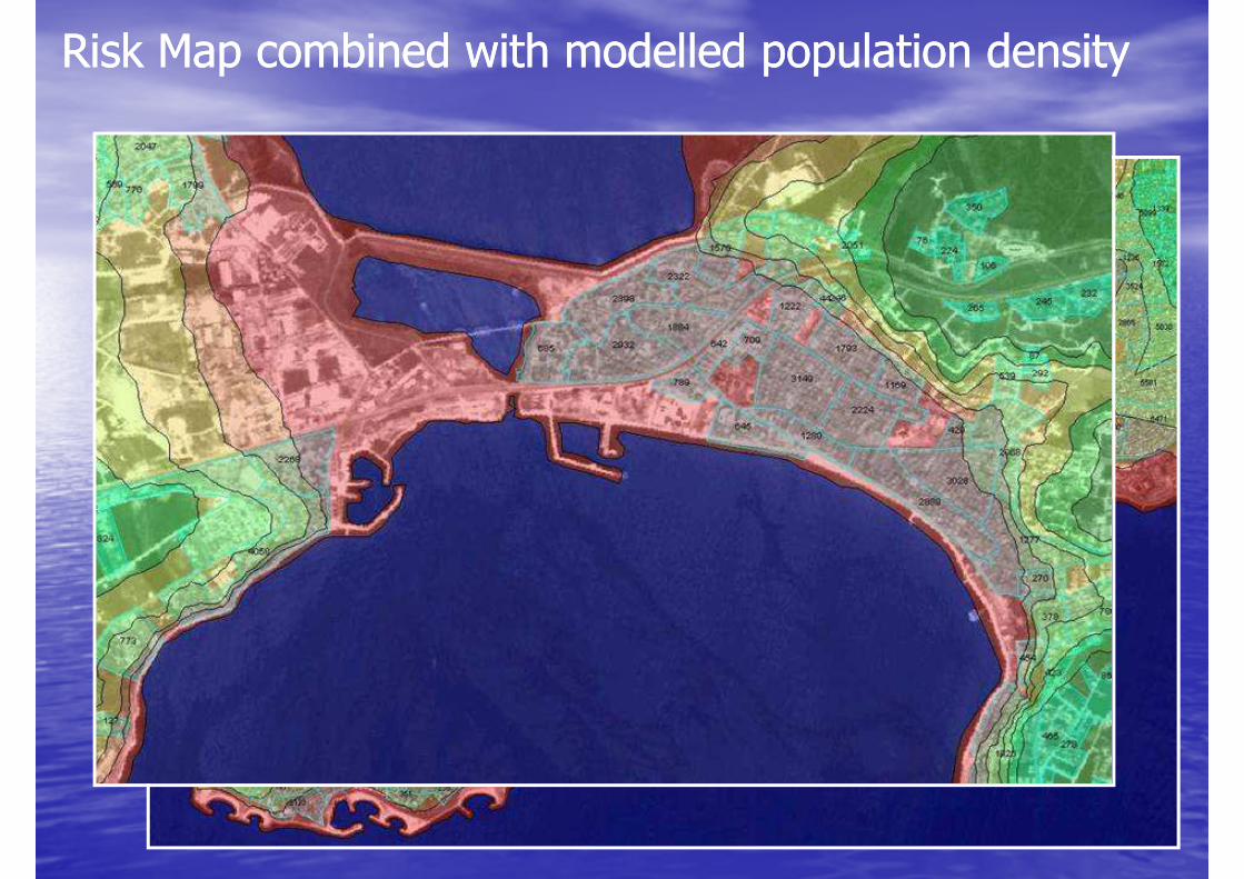
Risk Map combined with modelled population densityRisk Map combined with modelled population density
AgendaAgenda
•• RisklevelRisklevel•• RisklevelRisklevel
•• Earthquakes and Tsunamis Earthquakes and Tsunamis close to Istanbulclose to Istanbul
•• Crisis PreparednessCrisis Preparedness
•• Early WarningEarly Warning•• Early WarningEarly Warning
•• Crisis Management SystemCrisis Management System
•• ConclusionConclusion
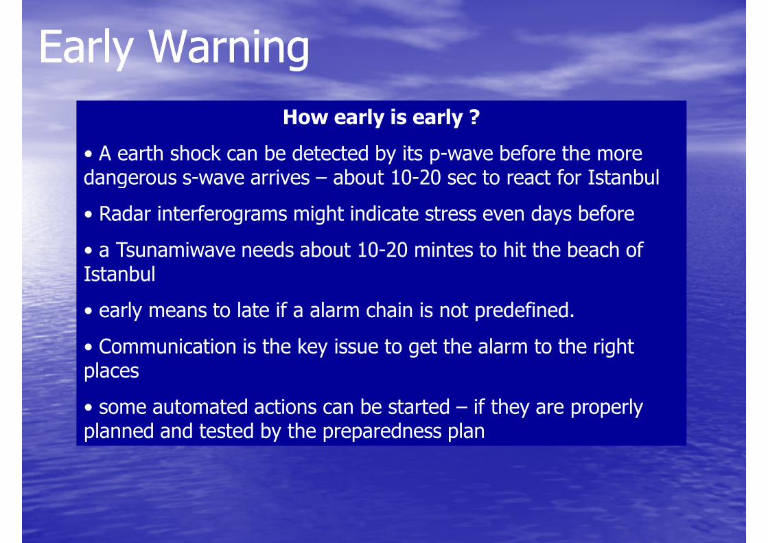
Early WarningEarly Warning
How early is early ?
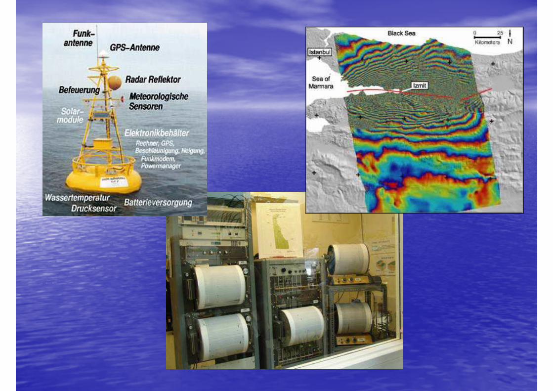
• A earth shock can be detected by its p-wave before the more dangerous s-wave arrives – about 10-20 sec to react for Istanbuldangerous s-wave arrives – about 10-20 sec to react for Istanbul
• Radar interferograms might indicate stress even days before
• a Tsunamiwave needs about 10-20 mintes to hit the beach of Istanbul
• early means to late if a alarm chain is not predefined.
• Communication is the key issue to get the alarm to the right placesplaces
• some automated actions can be started – if they are properly planned and tested by the preparedness plan

Early WarningEarly Warning
What can be done with the alarm ?
• get the rescue teams out
• stop rapid trains• stop rapid trains
• set traficlights red
• close pipelines e.g. Gas, Oil
• inform the population
• get the people away from the beach and the ships back to the seasea
• ......
AgendaAgenda
•• RisklevelRisklevel•• RisklevelRisklevel
•• Earthquakes and Tsunamis Earthquakes and Tsunamis close to Istanbulclose to Istanbul
•• Crisis PreparednessCrisis Preparedness
•• Early WarningEarly Warning•• Early WarningEarly Warning
•• Crisis Management SystemCrisis Management System
•• ConclusionConclusion
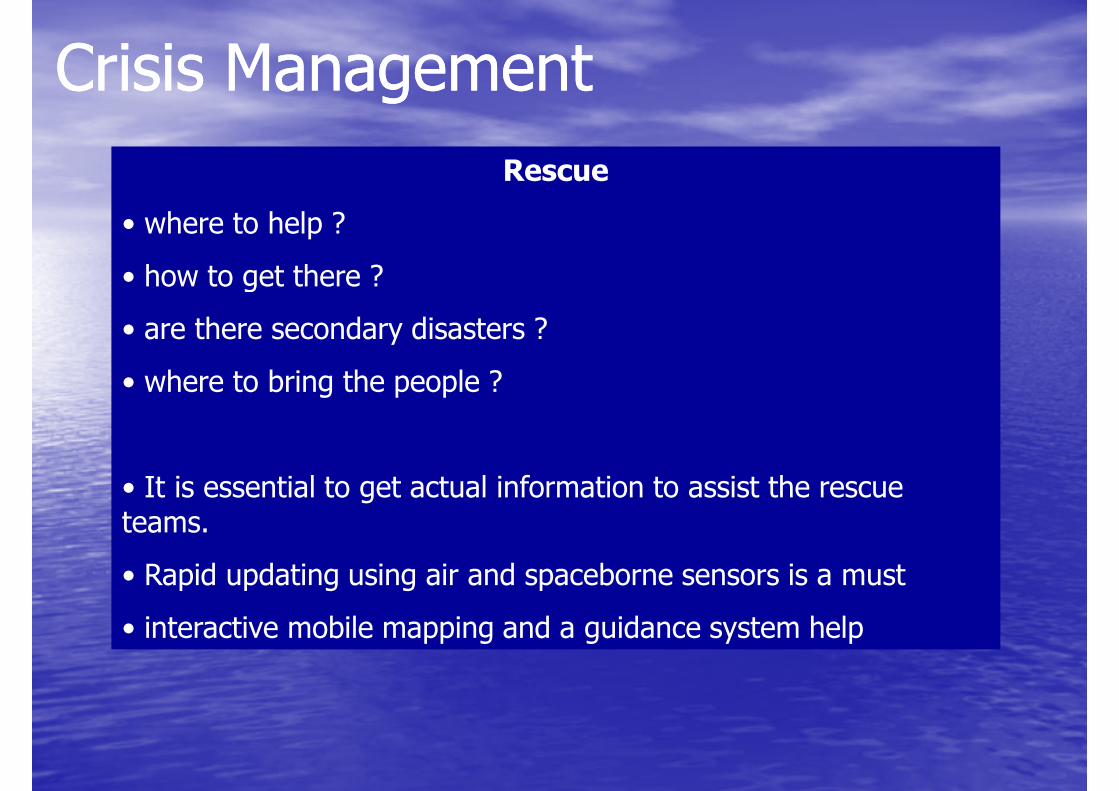
Crisis ManagementCrisis Management
Rescue
• where to help ?
• how to get there ?• how to get there ?
• are there secondary disasters ?
• where to bring the people ?
• It is essential to get actual information to assist the rescue teams. teams.
• Rapid updating using air and spaceborne sensors is a must
• interactive mobile mapping and a guidance system help
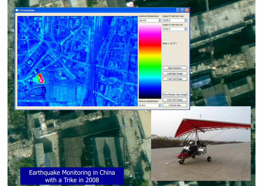
Earthquake Monitoring in China with a Trike in 2008
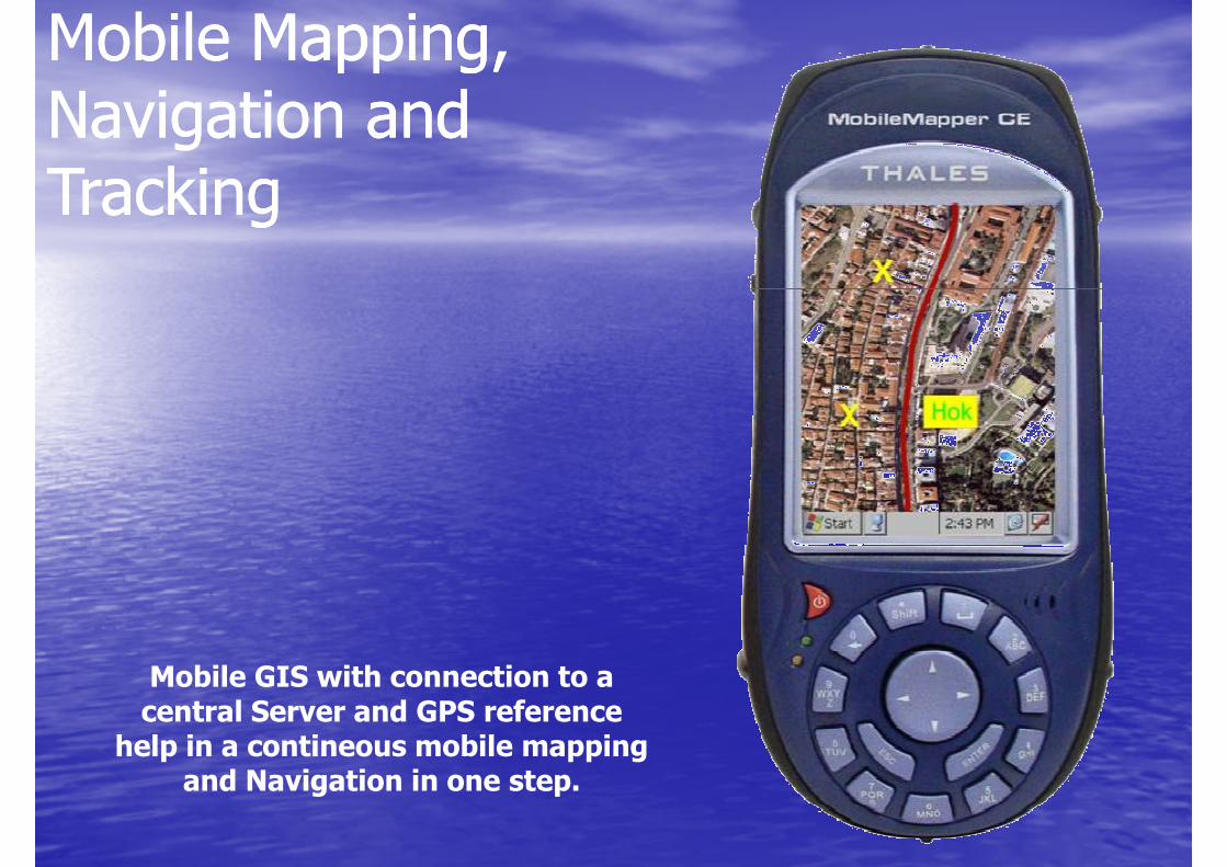
Mobile Mapping, Mobile Mapping, Navigation and Navigation and TrackingTracking
Mobile GIS with connection to a central Server and GPS reference
help in a contineous mobile mapping and Navigation in one step.
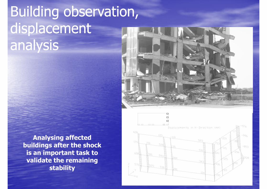
Building observation, Building observation, displacement displacement analysisanalysis
Analysing affected buildings after the shock is an important task to validate the remaining
stability
AgendaAgenda
•• RisklevelRisklevel•• RisklevelRisklevel
•• Earthquakes and Tsunamis Earthquakes and Tsunamis close to Istanbulclose to Istanbul
•• Crisis PreparednessCrisis Preparedness
•• Early WarningEarly Warning•• Early WarningEarly Warning
•• Crisis Management SystemCrisis Management System
•• ConclusionConclusion
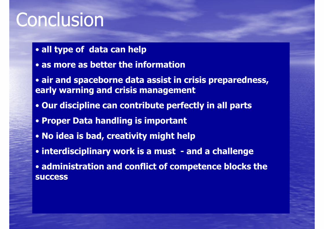
ConclusionConclusion
• all type of data can help
• as more as better the information
• air and spaceborne data assist in crisis preparedness, • air and spaceborne data assist in crisis preparedness, early warning and crisis management
• Our discipline can contribute perfectly in all parts
• Proper Data handling is important
• No idea is bad, creativity might help
• interdisciplinary work is a must - and a challenge• interdisciplinary work is a must - and a challenge
• administration and conflict of competence blocks the success
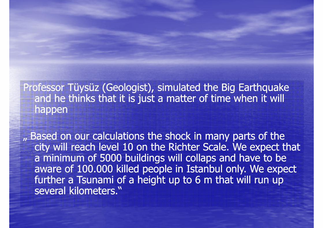
Professor Tüysüz (Geologist), simulated the Big Earthquake Professor Tüysüz (Geologist), simulated the Big Earthquake and he thinks that it is just a matter of time when it will and he thinks that it is just a matter of time when it will happenhappen
„ Based on our calculations the shock in many parts of the „ Based on our calculations the shock in many parts of the city will reach level 10 on the Richter Scale. We expect that city will reach level 10 on the Richter Scale. We expect that a minimum of 5000 buildings will collaps and have to be a minimum of 5000 buildings will collaps and have to be city will reach level 10 on the Richter Scale. We expect that city will reach level 10 on the Richter Scale. We expect that a minimum of 5000 buildings will collaps and have to be a minimum of 5000 buildings will collaps and have to be aware of 100.000 killed people in Istanbul only. We expect aware of 100.000 killed people in Istanbul only. We expect further a Tsunami of a height up to 6 m that will run up further a Tsunami of a height up to 6 m that will run up several kilometers.“several kilometers.“
Thank U 4 your attentionThank U 4 your attention
Gerhard KEMPER,[email protected]@ggs-speyer.de
Orhan ALTAN,[email protected]
Sisi [email protected]
Related Documents