Geomorphology study on the Bandar Lampung Capital City for recommendation of development area Rahmi Mulyasari 1* , Hari Wiki Utama 2 and Nandi Haerudin 1 1 Geophysics Engineering, Lampung University, Lampung, Indonesia 2 Geological Engineering, Jambi University, Jambi, Indonesia Email: [email protected], [email protected] Abstract. Bandar Lampung area is a capital of Lampung Province, that located on the south of Lampung Province. It has highly populated urban area consisting of land and waters with several highlands and mountains lied in Bandar Lampung. Population density supported by high infrastructure development makes Bandar Lampung City become a city with rapid growth. Consequently, spatial planning concept by considering all aspects needed to support sustainable development in a city, one of them is geomorphology aspect. Geomorphology has an important role to give the information and overview on the existing landscape in an area. The aim of this paper is to know geomorphology characteristics of this area that could provide an information to land use, disaster mitigation, and references for infrastructure development area. Analysis of geomorphology aspect was employed in this study, which are morphology aspect (morphography and morphometry), morphogenetics aspect (morphostructure active, passive and dynamic), morphochronology aspect and also consider the morphoconservation aspect. Remote sensing is a method which is carried out to know characteristic of geomorphology aspect become a map. The geomorphologic map is resulted based on analysis of geomorphology aspect. This area could be divided to four geomophologic units, there are fluviatil unit, structural unit, volcanic unit, and denudational unit. In addition, based on analysis of geology and geomorphology, the area composed of two degree of geohazard, which are secure zone and dangerous zone. In addition, geomorphology map could be used to designed and development for recommendation area in Bandar Lampung. Keywords: Bandar Lampung, geomorphology map, recommendation area. 1. Introduction Bandar Lampung area is a capital of Lampung Province, that located on the south of Lampung Province (Figure 1). It has highly populated urban area consisting of land and waters with several highlands and mountains lied in Bandar Lampung [1]. Population density supported by high infrastructure development makes Bandar Lampung City become a city with rapid growth. Consequently, spatial planning concept by considering all aspects needed to support sustainable development in a city, one of them is geomorphology aspect. Based on Geological Map of Tanjungkarang Sheet [2], geological conditions of Bandar Lampung City are influenced by faults. On the map, there are clearly some faults that crossed Bandar Lampung city. The existence of faults are reflected in morphological conditions hills with steep slope landforms. Dominated lithology in research area is former of coastal and river deposits that are scattered around Lampung Bay and around Tanjung Karang. It is dominated by terrain resulting from

Welcome message from author
This document is posted to help you gain knowledge. Please leave a comment to let me know what you think about it! Share it to your friends and learn new things together.
Transcript

Geomorphology study on the Bandar Lampung Capital City
for recommendation of development area
Rahmi Mulyasari1*
, Hari Wiki Utama2 and Nandi Haerudin
1
1 Geophysics Engineering, Lampung University, Lampung, Indonesia
2 Geological Engineering, Jambi University, Jambi, Indonesia
Email: [email protected], [email protected]
Abstract. Bandar Lampung area is a capital of Lampung Province, that located on the south of
Lampung Province. It has highly populated urban area consisting of land and waters with
several highlands and mountains lied in Bandar Lampung. Population density supported by
high infrastructure development makes Bandar Lampung City become a city with rapid
growth. Consequently, spatial planning concept by considering all aspects needed to support
sustainable development in a city, one of them is geomorphology aspect. Geomorphology has
an important role to give the information and overview on the existing landscape in an area.
The aim of this paper is to know geomorphology characteristics of this area that could provide
an information to land use, disaster mitigation, and references for infrastructure development
area. Analysis of geomorphology aspect was employed in this study, which are morphology
aspect (morphography and morphometry), morphogenetics aspect (morphostructure active,
passive and dynamic), morphochronology aspect and also consider the morphoconservation
aspect. Remote sensing is a method which is carried out to know characteristic of
geomorphology aspect become a map. The geomorphologic map is resulted based on analysis
of geomorphology aspect. This area could be divided to four geomophologic units, there are
fluviatil unit, structural unit, volcanic unit, and denudational unit. In addition, based on
analysis of geology and geomorphology, the area composed of two degree of geohazard, which
are secure zone and dangerous zone. In addition, geomorphology map could be used to
designed and development for recommendation area in Bandar Lampung.
Keywords: Bandar Lampung, geomorphology map, recommendation area.
1. Introduction
Bandar Lampung area is a capital of Lampung Province, that located on the south of Lampung
Province (Figure 1). It has highly populated urban area consisting of land and waters with several
highlands and mountains lied in Bandar Lampung [1]. Population density supported by high
infrastructure development makes Bandar Lampung City become a city with rapid growth.
Consequently, spatial planning concept by considering all aspects needed to support sustainable
development in a city, one of them is geomorphology aspect.
Based on Geological Map of Tanjungkarang Sheet [2], geological conditions of Bandar
Lampung City are influenced by faults. On the map, there are clearly some faults that crossed Bandar
Lampung city. The existence of faults are reflected in morphological conditions hills with steep slope
landforms. Dominated lithology in research area is former of coastal and river deposits that are
scattered around Lampung Bay and around Tanjung Karang. It is dominated by terrain resulting from

young volcanic activity from Lampung Formation which is generally consist of tuff rock. This
geological condition causes geological hazard in this area.
Geomorphology has an important role to give information and overview on the existing
landscape in an area. Geomorphological map can be considered as graphical inventories of a landscape
depicting landforms and surface as well as subsurface materials. This map can act as a preliminary
tool for land management, geomorphological and geological risk management, as well as providing
baseline data for other applied sectors of environmental research [3].
The aim of this paper is to know geomorphology characteristics of this area that could provide
information to land use, disaster mitigation, and references for infrastructure development area. The
geomorphologic aspects would be analyzed using remote sensing analysis.
Figure 1. Research Area.
2. Regional Geology
Sumatera Island was resulted from subduction of Indian Ocean plate boundary beneath the Eurasian
Continent plate in the Cenozoic Period which is thought to cause a clockwise rotation of Sumatera
Island [4, 5, 6]. This subduction made changing position of Sumatera Island, which initially directed
west – east to northwest – southeast [7]. Deformation changes in Sumatra Island occurred in Oligo –
Miocene Period [8]. This deformation caused movement of Sumatran fault which became active at
that time. According to [8] the geological structure formed on the island of Sumatra is generally in the
form of a horizontal fault which forms a fault segment.
2.1 Physiography
Physiography of Sumatra Island is divided into several physiographic zones: Bukit Barisan Zone,
Semangko Fault Zone (Sumatera Fault Zone), Highland and Hills Zone, Bukit Tiga Puluh Zone, Outer
Arc Zone, and Sunda Exposure Zone [9]. Bandar Lampung area is part of Bukit Barisan Zone. This
physiographic condition has similarities to Barisan Magmatic Arc in Physiography and Mandala
Geology [10] (Figure 2).
Bukit Barisan Zone is a hilly zone with a southeast-northwest orientation and has a longitudinal
pattern of about 1,650 km with a width of 100 km [9]. Based on morphology side, in general this area
can be divided into three morphological units: wavy plain in the east and northeast, rough mountains
in the middle and southwest, and a hilly to flat coastal area. The slopes are generally steep with
altitudes up to 500-1,680 m above sea level. Coastal areas are diverse in variety and often consist of
rough hills, reaching an altitude of 500 m above sea level.
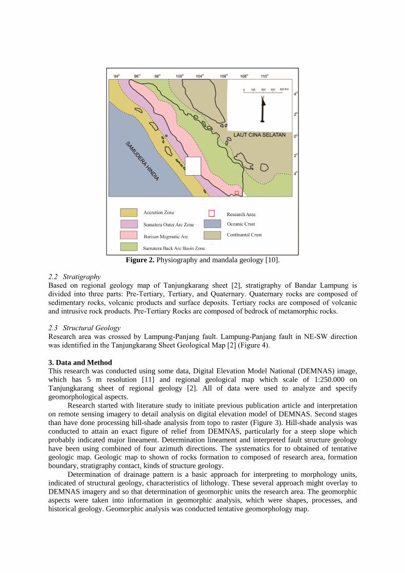
Figure 2. Physiography and mandala geology [10].
2.2 Stratigraphy
Based on regional geology map of Tanjungkarang sheet [2], stratigraphy of Bandar Lampung is
divided into three parts: Pre-Tertiary, Tertiary, and Quaternary. Quaternary rocks are composed of
sedimentary rocks, volcanic products and surface deposits. Tertiary rocks are composed of volcanic
and intrusive rock products. Pre-Tertiary Rocks are composed of bedrock of metamorphic rocks.
2.3 Structural Geology
Research area was crossed by Lampung-Panjang fault. Lampung-Panjang fault in NE-SW direction
was identified in the Tanjungkarang Sheet Geological Map [2] (Figure 4).
3. Data and Method
This research was conducted using some data, Digital Elevation Model National (DEMNAS) image,
which has 5 m resolution [11] and regional geological map which scale of 1:250.000 on
Tanjungkarang sheet of regional geology [2]. All of data were used to analyze and specify
geomorphological aspects.
Research started with literature study to initiate previous publication article and interpretation
on remote sensing imagery to detail analysis on digital elevation model of DEMNAS. Second stages
than have done processing hill-shade analysis from topo to raster (Figure 3). Hill-shade analysis was
conducted to attain an exact figure of relief from DEMNAS, particularly for a steep slope which
probably indicated major lineament. Determination lineament and interpreted fault structure geology
have been using combined of four azimuth directions. The systematics for to obtained of tentative
geologic map. Geologic map to shown of rocks formation to composed of research area, formation
boundary, stratigraphy contact, kinds of structure geology.
Determination of drainage pattern is a basic approach for interpreting to morphology units,
indicated of structural geology, characteristics of lithology. These several approach might overlay to
DEMNAS imagery and so that determination of geomorphic units the research area. The geomorphic
aspects were taken into information in geomorphic analysis, which were shapes, processes, and
historical geology. Geomorphic analysis was conducted tentative geomorphology map.

In the field were required of data collected, consist of characteristic lithology, confirmed of
structural geology, geomorphic shape such as degree of undulation-valley, volcanic controlled,
fluviatil processes, and degree of weathering. Specific data taken point to geohazard consist of mass
movement related to active structural geology tectonics and volcanic structures. Collecting data have
been give factual geologic map and geomorphology map.
Integration of geological map, geomorphology map, and point located of geohazard have done
identification related to structural geology active/approximately and understanding tectonic
development to control of fault segment in Sumatera, which Semangko fault (western of research area)
and Lampung-Panjang fault segment similarly orientation to Semangko fault. Therefore, this step is
divided in two group of geohazard zone, consists of secure zone and dangerous zone.
Figure 3. Four azimuth directions from the hill-shade analyze, a) N 315°E, b) N 0
°E, c) N 45
°E, and d)
N 90°E. Four azimuth direction have done combine for produce hill-shale exactly is representative real
geological condition surface.
4. Result and Discussion
4.1. Result
4.1.1. Stratigraphy
The research area is composed of Paleozoic metamorphic rocks, Mesozoic intrusive rock overlying to
alluvium surficial deposits, Quaternary volcanic product and tertiary sediment mixing to Miocene
intrusive rock (Figure 4). Lithology characteristics are divided rocks formation, however
distinguishing of formation boundary.

a. Paleozoic Group
This group is compiled of Schist Way Galih and Quartzite Sidodadi. These formation is depend on
orogenesis processes product and related to reverse fault. The existence of rocks formation is
basement rock of Bandar Lampung and Sumatra region. This group is distributed of eastern and
southeastern of Tanjung Karang (center of research area).
b. Mesozoic Group
Granodiorite is intrusive igneous rock as feature of magmatisme in Bandar Lampung and
distributed to eastern of research area. The existence of granodiorite intruded Paleozoic Sidodadi
Quartzite.
c. Tertiary Group
Tarahan Formation and Campang Formation are sedimentary rock formation composed of research
area. Campang Formation in the southeastern part of research area. This formation associated
straight of Lampung-Panjang fault, which segmentation fault similarly to Semangko fault (one of
big segment fault in Sumatra), whereas Tarahan Formation have width distribution, which is in the
southeastern-northeastern and western-southwestern part of research area.
Tertiary group is also composed of magmatic intrusive igneous rock, which is Miocene Granitoid.
This intrusive associated to secondary segment of Lampung-Panjang fault and the existence in the
western part of research area.
d. Quaternary Group
This group can be divide two cluster, which are Alluvium as product Recent geological processes
and Quaternary volcanic product. This group is focused to volcanic product. Lampung Formation
distributed in the part of northern and southern research area, meanwhile Young Volcanic Deposits
(Betung Volcano) distributed in the part of central to western research area. Young Volcanic
Deposits of Betung Volcano product is occupied more half than research area extensive.
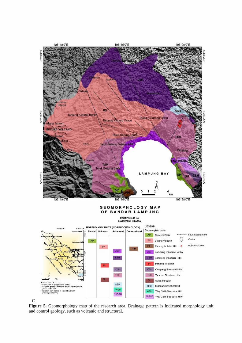
4.1.2. Geomorphology
In the research area is four geomorphic units that could be identified. Classified of geomorphic unit
divided become landscape. There is composed of fluviatil unit, structural unit, volcanic unit, and
denudational unit. The geomorphic unit is too the determination based on morphochronology of
landforms (Figure 5).
Drainage pattern in the research area compiled of radial, subdendritic, and dendritic. Radial is
occupy in Betung Volcano geomorphic unit, subdendritic is covered of structural and denudational
geomorphic units, whereas dendritic is only fluvial/alluvial plain unit.
a. Structural Geomorphic
This landscape have influenced by structural, which was active fault and approximately fault.
There were occupied in the central-north-east-southeastern-west-southwestern part of research area.
This landscape associated Lampung-Panjang fault with similarly Sumatra Fault System which
Semangko fault segmented. This landscape is composed by Way Galih Structural Hills (WGSH),
Way Galih Structural Hill (WSH), Sidodadi Structural Hill (SSH), Tarahan Structural Hills (TSH),
Campang Structural Hills (CSH), Lampung Structural Hills (LSH), and Lampung Structural Valley
(LSV).the existence of fault segment is primary element to formed of landscape.
b. Volcanic Geomorphic
This landscape controlled by Recent volcanic activity of Betung Volcano and magmatism in
Granodiorite Cretaceous and Granitoid Miocene. The existence of active volcano is counted of
Barisan Range, meanwhile presence of intrusion magmatism indicated tectonic-magmatism-
volcanism the associated with Sumatra Fault Zone. This units geomorphic are composed of Sulan
Intrusion (SI) Cretaceous, Panjang Intrusion (PI) Miocene, and active volcano product of Lampung
Formation Plio-Plistocene, and Betung Volcano unit (BV) Quaternary.
c. Denudational Geomorphic
This landscape is only occupied of little distribution geomorphic unit. This geomorphic unit is
controlled by eroded, which have characterized as lithology or rock formation on the hill
morphology different to lithology in surrounding. Padang Isolated Hill (PIH) is half of Lampung
Formation. This indicated that volcanic product such as pyroclastic, lava, and volcanic-sediment.
d. Fluvial Geomorphic
This landscape is product of Recent geological processes. This geomorphic have characteristics as
unlitification, sedimentary material and distributed in plain/flat relief, such as Alluvial Plain (AP).
Identified of fault segmented Lampung Panjang was dotted where concealed.
4.2. Discussion
4.2.1. Structural Geology and Geohazard
Structural geology is almost covered full in the research area. The existence of research area in
between Barisan Range-Magmatic Arc associated Sumatra Fault Zone. Fault segment Lampung-
Panjang fault is half Sumatra fault segmented. Lampung-Panjang fault is fault range, it have similarly
characteristic which Semangko fault, where fault segments interpreted to be active.
Structural geology development of the research area is resulted of interaction between those two
segment Lampung Panjang fault and Tanjung Karang fault (west beside part of Lampung Panjang
fault). There is orientation south-southeastern - north-northwestern direction and following orientation
the primary fault structure segments of Sumatra Fault System.
Along of segment fault system “tectonic fault” and volcanic fault is indicated to geohazard.
Point of mass movement have occurred in fault zone and surrounding (Figure 6). In addition to
tectonic compression of Sumatra regional, weight load exerted volcanic edifices. There is also plays
important role in creating structural geology controlled. A relatively north-northeastern - south-
southwestern compressional stress was generated by dextral fault movement of those fault, there are
producing of extensional faults that the distributed of research area.
4.2.2. Geomorphology Study for Recommendation Development area
Geomorphology study could be standard operation procedure for recommendation development area.
Integration data and considerately study have made geohazard potential zone which based on degree
of geohazard, so that the result could be standard operational procedure. Based on analyzed of
DEMNAS image, field datas, geomorphology map, geological map, and previous study, that divided
become to 2 zonations (Figure 6).
Base principle of degree geohazard zonation is counted of several aspect geology, between of
morphology (morphography), morphogenesis (characteristic lithology, structural geology, volcanism,
eroded, fluviatil, and weathering), morphochronology. Characteristic lithology and structural geology
is primary factor in determination of degree of geohazard. Active fault system in the research area
have conducted change of geomorphic condition. In the research area is also of residence or located
capital population, government building, and public transportation.
a. Secure Zone
This zone is category low potential geohazard. This zone occupied of Lampung Structural Hill
(LSH) with Lampung Formation is volcanic product, and volcanic-sediment product. This zone
secure relatively, meanwhile this zone across fault segment, but approximately segment.
Therefore, this zone is very recommendation for development area, such as residence, government
building, public transportation, and capital office complex.
b. Dangerous Zone
Dangerous zone is category high - very high risk when will become zone for development area.
There is occupied landscape of structural. Denudational, fluvial, and the half of volcanic, which is
Betung Volcanic zone. Structural geology is observed in this zone, between of Lampung-Panjang
fault (extension stress) dextral fault. Fault orientation in this zone compiled of north-northeastern
– south-southeastern direction, southeastern – northwestern direction are typically of dextral/strike
slip fault, northeastern – southwestern is typically strike slip fault sinistral with fault
observed/measured and approximately, and several normal fault of volcanic structure have east –
west direction. Fault volcanic structure to associated of Betung Volcanic. This zone is occupied
Paleozoic Group Formation, Mesozoic Group Formation, and Tertiary Group Formation, and
Quaternary Alluvium Group. The characterized is very high potential geohazard or mass
movement.

Figure 4. Geological map of the research area. This map to shown of distribution fault structure.
C
Figure 5. Geomorphology map of the research area. Drainage pattern is indicated morphology unit
and control geology, such as volcanic and structural.

Figure 6. Geohazard map of the research area.
5. Conclusions
Based on structural geology, stratigraphy and geomorphic analysis are control geological setting in
research area. Geomorphology map is resulted based on analysis morphology, morphogenesis, and
morphochronology aspects. This area could be divided into several geomorphologic units, there are
volcanic, structural, denudational, and fluvial morphology. The exist two degree of geohazard, which
are secure zone and dangerous zone. In addition, based on geomorphology map, it could be designed
and development for recommendation for area in Bandar Lampung.
6. References [1] Pemerintah Kota Bandar Lampung 2017 Sekilas Kota, https://bandarlampungkota.go.id/sekilas-
kota/ [accesed on 16 May 2018]
[2] Mangga S A, Amirudin T, Suwarti S, Gafoer and Sidarto 1993 Geological Map of Indonesia
Quadrangle: Tanjungkarang, Sumatra Scale 1: 250.000 (Bandung: Geological Research and
Development Centre)
[3] Otto J C andSmith M J 2013 Geomorphological mapping Geomorphological Techniques, Chap. 2,
Sec. 6
[4] Hall R 1997 Cenozoic Plate Tectonic Reconstruction of SE Asia, Geological Society of London,
Special Publication 126 pp 11-23
[5] Hall R 2002 Cenozoic Geological and Plate tectonic Evolution of SE Asia and the SW Pasific:
Computer Based Reconstruction, Model and Animation Journal of Asian Earth Sciences 20 pp
353-356
[6] Hall R 2014 Indonesia Tectonics: Subduction, Extention, Provenance, and More, Indonesian
Petroleum Association Proceedings 38th Annual Exhibition and Convention, Jakarta, Indonesia
IPA 14 G p 360
[7] Hamilton W B 1979 Tectonic of the Indonesian Region Professional Paper 1078 US Geological
Survey Washington DC p 345
[8] Barber A J Crow M J Milsom J S 2005 Geology, Resources and Tectonics Evolution (London:
Geological Society Memoir) p 290
[9] van Bemmelen R W 1949The Geology of Indonesia Volume 1A (The Hague, Netherlands:
Government Printing Office) p 732
[10] Kusnama Pardede R, Mangga S A and Sidarto 1992 Geological Map of Indonesia Quadrangle:
Sungai Penuh and Ketahun Scale 1: 250.000 (Bandung: Geological Research and Development
Centre)
[11] Geospatial Information Agency 2018 Digital Elevation Model National (DEMNAS) image
http://tides.big.go.id/DEMNAS/
Related Documents