WHY IT’S IMPORTANT— In the 1990s, several nations of Europe formed the European Union, an alliance that works for the region’s economic and political unity. Many European countries are replacing their national currencies with a common currency—the euro. As one of the world’s leading economic powers, Europe has long had close political, cultural, and trading ties with the United States. Because of this impor- tant relationship, European ideas and practices have shaped your life and will continue to do so in the years ahead. To learn more about Europe and its impact on your world, view the World Regions video “Europe.” Europe Europe World Regions Video UNIT 4 4 254 Unit 4

Welcome message from author
This document is posted to help you gain knowledge. Please leave a comment to let me know what you think about it! Share it to your friends and learn new things together.
Transcript

WHY IT’S IMPORTANT—
In the 1990s, several nations of Europe
formed the European Union, an
alliance that works for the region’s
economic and political unity. Many
European countries are replacing their
national currencies with a common
currency—the euro. As one of the
world’s leading economic powers,
Europe has long had close political,
cultural, and trading ties with the
United States. Because of this impor-
tant relationship, European ideas
and practices have shaped your life
and will continue to do so in the
years ahead.
To learn more about Europe
and its impact on your world, view
the World Regions video “Europe.”
EuropeEurope
World Regions Video
U N I T 44
254 U n i t 4

Gondolier in Venice, Italy
NGS ONLINEwww.nationalgeographic.com/education
U n i t 4 255

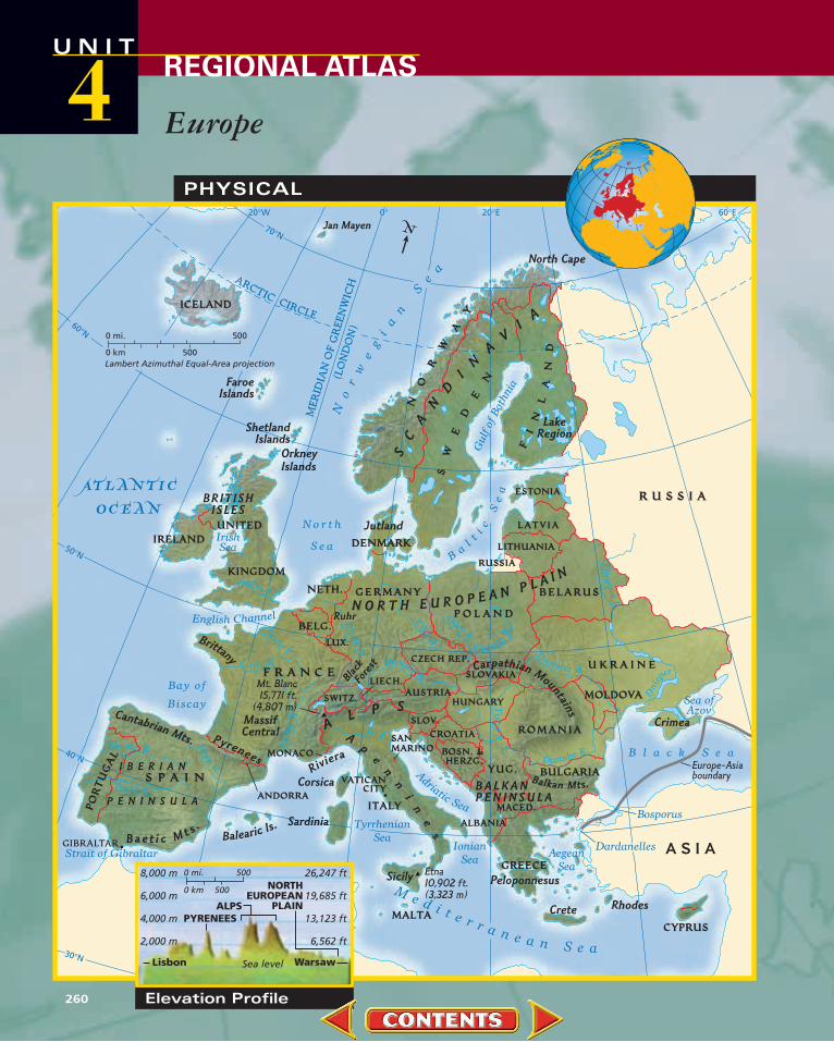
Europe is a small continent with a long, jaggedcoastline.With watery fingers, the sea reachesdeep into the land, embracing peninsulas and carving out bays, gulfs, and channels.Warm
Atlantic winds and currents bathe European shores,helping to give this northerly landmass an unexpect-edly mild climate.They also bring abundant rain thatnurtures lush, green landscapes.
Fertile plains extend across much of northernEurope. Farther south, the plains become ruggedhills, then mountains.The Alps are the continent’s highest mountainrange.They stretch across south-central Europe, forming a barrier thatshelters the sunny Mediterranean area from moist northern winds.
Great rivers wind their way through Europe’s landscapes, linkinginland areas with the sea.The Danube flows through or along morecountries than any other river in the world.The Rhine, with itssource high in the Swiss Alps, is the continent’s most importantwaterway.
What Makes Europe a Region?
Guernsey cows tread a familiartrack on one of the ChannelIslands, between England andFrance. Warmed by ocean currents that originate in thetropical Atlantic, these islandshave a mild, moist climate—perfect for cattle and crops.
1
1
2
3
U N I TREGIONAL ATLAS4
256 U n i t 4

Rows of bright umbrellasshelter beachgoers at Positano,Italy. Europe’s unusually longcoastline borders many seas.Countries along the Mediter-ranean Sea enjoy what is called a Mediterranean climate,with mild winters and hot, dry summers.
Ships and barges follow thesnaking curves of the RhineRiver in Germany. For cen-turies, the Rhine has providedan important transportationroute through western Europe.Some of Germany’s largestcities—and many medieval castles—lie along the Rhineand its tributaries.
Icy peaks in the Swiss Alpsreflect the colors of the settingsun. The Alpine mountain sys-tem forms a broad arc thatreaches from Spain to theBalkan Peninsula. The range’shighest peak, Mont Blanc, liesin France, near the border withSwitzerland and Italy.
2 3 4
4
U n i t 4 257
Cultural Colossus A mosaic of more than 40 countries, Europe enjoys a richcultural heritage.Western traditions of art, architecture,science, and mathematics had their start in ancient Greeceand Rome. In the centuries that followed, European culture
spread far beyond the continent, aided byeasy access to the sea. Modern Europeancities remain thriving centers for educationand the arts.
Europe is home to people of many ethnic groups. Differences among thosegroups have led to frequent conflictsthroughout European history.Toward theend of the twentieth century, politicalreforms greatly changed the face of Europeand brought new unity—as well as newchallenges—to the region’s inhabitants.
Crates of cargo stand on dockslining the harbor of Aberdeen,Scotland. The cargo awaitsloading onto oceangoingships. Europe’s long coastlineis dotted with busy ports.Access to the sea has helpedspread European goods andculture worldwide.
1
12
3
U N I TREGIONAL ATLAS4
258 U n i t 4

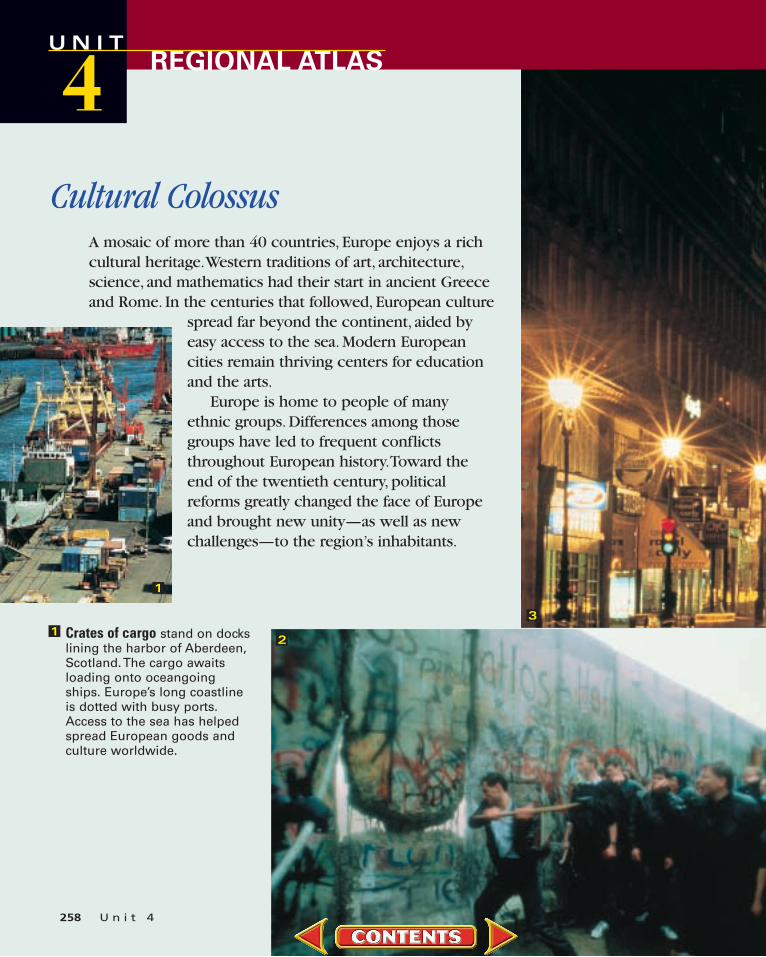
The extravagant Opéra Garnier,one of the largest theaters inthe world, stands near the cen-ter of Paris. Sometimes com-pared to a gilded wedding cake,this ornate structure was builtin the mid-1800s. Originally anopera house, it now featuresmostly ballet.
West Berliners batter the wall that once separated thecity into eastern and westernsectors—and representedEurope’s division into Com-munist and non-Communistcamps. In 1989 several Com-munist governments were top-pled, and the Berlin Wall beganto come down.
A young Basque boy dons hisfather’s cap and will carry onthe elder’s ethnic traditions.Three million Basques inhabit a wedge-shaped homeland that straddles the borderbetween France and Spain.Basques speak an ancienttongue that is unrelated to any other known language.
2 3 4
4
PHYSICAL
AR
CT
ICC
IRC
LEM
ER
ID
IA
N O
F G
RE
EN
WIC
H
(LO
ND
ON
)
20°W 0° 20°E 40°E 60°E
30°N
50°N
40°N
60°N
70°N
N O R T H E U R O P E A N P L A I N
SC
AN
D
IN
AV
IA
AL P S
Ap
e
nn
in
es
Riviera
LakeRegion
Bae t i c M t s .
BRITISHISLES
Carpathian Mountain
s
Pyrenees
B A L K A NP E N I N S U L A
I B E R I A N
P E N I N S U L A
MassifCentral
Balkan Mts.
Sardinia
Corsica
Sicily
Crete
North Cape
Rhodes
Peloponnesus
Cantabrian Mts.
Crimea
FaroeIslands
Jan Mayen
Jutland
OrkneyIslands
ShetlandIslands
Brittany
Balearic Is.
Ruhr
Blac
k F
ores
t
Oder
R.
Dniester R.
Tagus R.
Rhin
eR
.
Douro R. Rh
ˆon
eR
.
Seine
R.
L oire R.
Elbe
R
.
Po R.
Danube R.
VistulaR
.
Tisz
aR
.
Danube R.
Dnie
per
Dn
iep
erR
.
Ebro
R
.
ThamesR.
B l a c k S e a
No
rw
eg
ia
n
Se
a
Me d i t e r r a n e a n S e a
IrishSea
Aegean
Sea
N o r t h
S e a
A
driatic Sea
Ionian
Sea
Tyrrhenian
Sea
Bay of
Biscay
Ba
l
ti
cS
ea
Gulf
of
Both
nia
Sea ofAzov
Strait of Gibraltar
English Channel
Dardanelles
Bosporus
ATLaNTIC
OCEaN
GIBRALTAR
S P A I N
F R A N C E
R U S S I A
U K R A I N E
MONACO
SLOV.CROATIA
SLOVAKIA
SWITZ.
ESTONIA
ANDORRA
LUX.
LIECH.AUSTRIA
GREECE
CZECH REP.
RUSSIA
SANMARINO
VATICANCITY
BOSN. & HERZG.
MACED.
CYPRUS
ALBANIA
LITHUANIA
YUG. BULGARIA
POR
TUG
AL
MALTA
ICELAND
IRELANDUNITED
KINGDOM
BELG.
HUNGARY
GERMANYNETH.
DENMARK
P O L A N D
ITALY
MOLDOVA
ROMANIA
BELARUS
LATVIA
NO
RW
AY
FI
NL
AN
D
SW
ED
EN
A S I A
Mt. Blanc15,771 ft.
(4,807 m)
Etna10,902 ft.(3,323 m)
Europe-Asiaboundary
N
Lambert Azimuthal Equal-Area projection500
5000 mi.
0 km
Elevation Profile
Sea level
2,000 m
4,000 m
6,000 m
8,000 m
6,562 ft
13,123 ft
19,685 ft
26,247 ft0 mi.
0 km 500
500
ALPS
NORTHEUROPEAN
PLAINPYRENEES
Lisbon Warsaw
U04-08NGS-664173GW.Eur.ElevProWG Europe Elevation ProfileFinal Proof10-23-00
Europe
U N I TREGIONAL ATLAS4
260

POLITICAL
Europe-Asiaboundary
Dardanelles
Bospo
rus
Skager
rak
Oder R
.SeineR
.Loire R.
E
lbe R.
R
hine
R.
Rh
ˆon
eR
.
Vistula
R.
Dniester R.
Tagus R.
Dnieper R.
Danube R.
Danube R. C a r p a t h i a n
Mt s.
Pyrenees
A L P S
L A P L A N D
Faroe Islands
Peloponnesus
North Cape
Crimea
RhodesCrete
Balearic Is.
OrkneyIslands
ShetlandIslands
Sicily
Sardinia
Corsica
Gotland
Isle of Lewis
Rockall
Land's End
Balkan Mts.
Jan Mayen
Den.
Nor.
U.K.
Fr.
It.
U.K.
Sp.
Reykjavík
OsloStockholm Tallinn
Helsinki
Minsk
Rīga
Vilnius
Kiev
Chişin˘au
LondonBerlin
Paris Prague
Budapest
Belgrade Bucharest
Madrid
Rome Sofia
Warsaw
Amsterdam
Dublin
Zagreb
SarajevoLisbon
Athens
Nicosia
Ljubljana
Skopje
Brussels
Bern
Tirana
Vienna
Valletta
Copenhagen
Bratislava
Milan
Barcelona
Munich
Hamburg
Edinburgh
Odesa
Naples
Donetsk
ATLaNTIC
OCEaN
Me d i t e r r a n e a n S e a
B l a c k S e a
Bay of
Biscay
CelticSea
North
SeaB
al
tic
Se
a
No
rw
eg
ia
nS
e
a
Gulf
ofB
othnia
TyrrhenianSea Ionian
SeaAegean
Sea
Adriatic
Sea
Sea of Azov
IrishSea
WALESENGLAND
SCOTLAND
N. IRE.
GIBRALTAR
MONTENEGROKOSOVO
VOJVODINA
SE
RB
I A
S P A I N
F R A N C E
U K R A I N E
MONACO
SLOV.
CROATIA
SLOVAKIA
SWITZ.
ESTONIA
ANDORRA
VATICAN CITY(Within Rome)
LUX.
LIECH.AUSTRIA
CZECH REP.
RUSSIA
SANMARINO
BOSN. &HERZG.
MACED.
CYPRUS
ALBANIA
LITHUANIA
GR
EE
CE
YUG.
BULGARIA
POR
TUG
AL
FI
NL
AN
D
SW
ED
EN
MALTA
ICELAND
IRELAND UNITED
KINGDOM
BELG.
HUNGARY
GERMANY
NETH.
DENMARK
P O L A N D
ITALY
MOLDOVA
ROMANIA
T U R K E Y
BELARUS
R U S S I A
NO
RW
A
Y
LATVIA
AR
CT
ICC
IRC
LE
ME
RID
IA
N O
F G
RE
EN
WIC
H
(LO
ND
ON
)
20°W 0° 20°E 40°E 60°E
50°N
40°N
60°N
70°N
N
Lambert Azimuthal Equal-Area projection500
5000
0
mi.
km
National capitalMajor city
StudyMAP
U n i t 4 261
1. Which European countries border theBlack Sea?
2. Which European countries are land-locked, or have no coastline?

Europe
U N I TREGIONAL ATLAS4
POPULATION DENSITY20°W
70°N
0°
20°E
60°E
50°N
40°N
60°N
AR
CT
ICC
IRC
LEM
ER
ID
IA
N O
F G
RE
EN
WIC
H
(LO
ND
ON
)
ATLaNTIC
OCEaN
B l a c k S e a
Bay of
Biscay
North
Sea
Celtic
Sea
Ba
l
tic
Se
a
N
or
we
gia
nS
ea
Adriatic
Sea
Ionian
Sea
Strait of
Gibraltar
Gu
lfof
Both
nia
M e d i te
r
ra
ne a n S e a
RhodesCyprus
Crete
Sicily
Sardinia
Faroe Islands
Corsica
Balearic Is.
Oslo
Stockholm
Helsinki
Minsk
KievKharkiv
LondonBerlin
ParisPrague
Budapest
Belgrade Bucharest
Madrid
Rome Sofia
Dublin
Zagreb
Lisbon
Athens
Vienna
Copenhagen
Milan
Barcelona
Munich
Naples
Donetsk
Glasgow
Belfast
Birmingham
Manchester
Gda´nsk
Frankfurt
Cologne
Zurich
GenoaVenice
Krak´ow
Amsterdam
Nice
Lyon
Seville
Nicosia
Sarajevo
Tirana
Hamburg
Turin
Marseille
Lviv
Valencia
Palermo
Salonica
Porto
Dnipropetrovsk
Brussels
Bratislava
Tallinn
Rīga
Vilnius
Odesa
G¨oteborg
Reykjavík
Warsaw
A F R I C A
Fr.
It.
Den.
Sp.
RUSSIA
N
Lambert Azimuthal Equal-Areaprojection
500
5000 mi.
0 km
Per sq. mi.Per sq. kmOver 100
50–100
25–50
1–25
Under 1
Uninhabited
Over 250
125–250
60–125
2–60
Under 2
Uninhabited
Cities(Statistics reflect metropolitan areas.)
Over 5,000,000
2,000,000–5,000,000
1,000,000–2,000,000
250,000–1,000,000
Under 250,000
262 U n i t 4
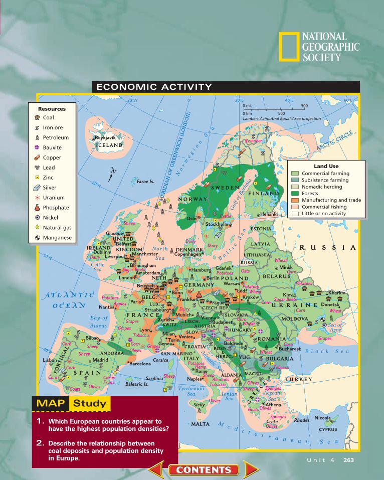
ECONOMIC ACTIVITY
Balearic Is.
Corsica
Sardinia
Sicily
Crete Rhodes
Bilbao
Lyon
Barcelona
Paris
MadridLisbon
Amsterdam
Brussels
Frankfurt
Bonn
StrasbourgMunich
Zurich
Hamburg
Berlin
Copenhagen
Gda´nsk
Warsaw
Ł´od´z
PragueKrak´ow
ViennaBudapest
BucharestBelgrade
TurinGenoa
MilanVenice
Naples
Rome
Athens
Dublin
Belfast
LiverpoolManchester
London
Glasgow
OsloStockholm
Helsinki
Minsk
Kiev Kharkiv
Donetsk
Birmingham
Nantes
Reykjavík
Nicosia
0° 20°E20°W 40°E 60°E
50°N
40°N
60°NFaroe Is.
ME
RID
IA
N O
F G
RE
EN
WIC
H (LO
ND
ON
)
AR
CT
ICC
IRC
LE
ATLaNTIC
OCEaN
Bay of
Biscay
North
Sea Ba
l
tic
Se
a
No
rw
eg
ia
nS
e
a
Gulf
ofB
othnia
TyrrhenianSea Ionian
SeaAegean
Sea
Adriatic
Sea
Sea of Azov
Me d i t e r r a n e a n S e a
B l a c k S e a
CelticSea
Strait of Gibraltar
S P A I N
F R A N C E
U K R A I N E
SLOV.
CROATIA
SLOVAKIA
SWITZ.
ESTONIA
ANDORRA
LUX.
LIECH.AUSTRIA
CZECH REP.
RUSSIA
BOSN. &
HERZG.
MACED.
CYPRUS
ALBANIA
LITHUANIAG
RE
E
CE
YUG. BULGARIA
POR
TUG
AL
MALTA
IRELAND
UNITED
KINGDOM
BELG.
HUNGARY
GERMANYNETH.
DENMARK
P O L A N D
F I N L A N DS W E D E N
N O R W A Y
ITALYSAN MARINO
MOLDOVA
ROMANIA
T U R K E Y
BELARUS
R U S S I ALATVIA
ICELAND
N
Cork
Goats Olives
Cork
Corn
CitrusFruits
Sheep
Sheep
Sheep CornOlives
Olives
Olives
Grapes
TobaccoGrapes
Grapes
DairyApples
Potatoes
Sheep
Sugar Beets
Dairy
Reindeer
Wheat
Cattle
DairyDairy
Corn
Potatoes
Potatoes Oats
PotatoesWheat
Corn Sugar Beets
Corn Wheat
GrapesCorn
Wheat
CornWheat
Fruit
Corn
Tobacco
OlivesSheep Sponges
OlivesGoatsSponges
PotatoesHemp
SheepAlmonds
Tobacco
N
Lambert Azimuthal Equal-Area projection500
5000 mi.
0 kmResources
Coal
Iron ore
Petroleum
Bauxite
Copper
Lead
Zinc
Silver
Uranium
Phosphate
Nickel
Natural gas
Manganese
N
Land UseCommercial farmingSubsistence farmingNomadic herdingForestsManufacturing and tradeCommercial fishingLittle or no activity
StudyMAP
U n i t 4 263
1. Which European countries appear tohave the highest population densities?
2. Describe the relationship between coal deposits and population density in Europe.
* COUNTRIES AND FLAGS NOT DRAWN TO SCALE
3,400,000310 per sq. mi.120 per sq. km
11,100 sq. mi.28,748 sq. km
100,000380 per sq. mi.147 per sq. km
8,100,000251 per sq. mi.97 per sq. km
10,300,000872 per sq. mi.337 per sq. km
3,400,000173 per sq. mi.69 per sq. km
8,100,000190 per sq. mi.73 per sq. km
4,700,000197 per sq. mi.76 per sq. km
10,300,000337 per sq. mi.130 per sq. km
5,400,000322 per sq. mi.124 per sq. km
174 sq. mi.451 sq. km
32,378 sq. mi.83,859 sq. km
11,787 sq. mi.30,528 sq. km
19,741 sq. mi.51,129 sq. km
42,822 sq. mi.110,909 sq. km
21,830 sq. mi.56,540 sq. km
30,448 sq. mi.78,860 sq. km
16,637 sq. mi.43,090 sq. km
Machinery
Iron and Steel
Machinery
TransportEquipment Machinery
ManufacturedGoods
Asphalt
Electricity
Machinery
Machinery
Fuels
Fuels
Fuels
Lek
FrenchFranc,
SpanishPeseta
Schilling,Euro
BelgianFranc,Euro
Convertible Mark
BelarussianRuble
Lev
Kuna
Koruna
Krone
Parliamentary Democracy
Republic
Federal Republic
Republic
ConstitutionalMonarchy
ConstitutionalMonarchy
Republic
Republic
Republic
10,000,000125 per sq. mi.48 per sq. km
80,154 sq. mi.207,598 sq. km
900,000247 per sq. mi.95 per sq. km
3,571 sq. mi.9,249 sq. km
Manufactured Goods
Citrus Fruits
CyprusPound Republic
Republic
Machinery Machinery
Machinery
N/A N/A
Petroleum
Albanian
Catalan, French, Spanish
German
Flemish, French
Serbo-Croatian
Serbo-Croatian
Bulgarian
Czech, Slovak
Danish
Belarussian, Russian
Greek, Turkish
ANDORRA
Andorra la Vella
AUSTRIA
Vienna
Sarajevo
BOSNIA AND HERZEGOVINA
Minsk
BELARUS
Tirana
ALBANIA
Brussels
BULGARIA
Sofia
Zagreb
Prague
Copenhagen
CYPRUS
Nicosia
CROATIA
BELGIUM
CZECH REPUBLIC
DENMARK
Crude Oil
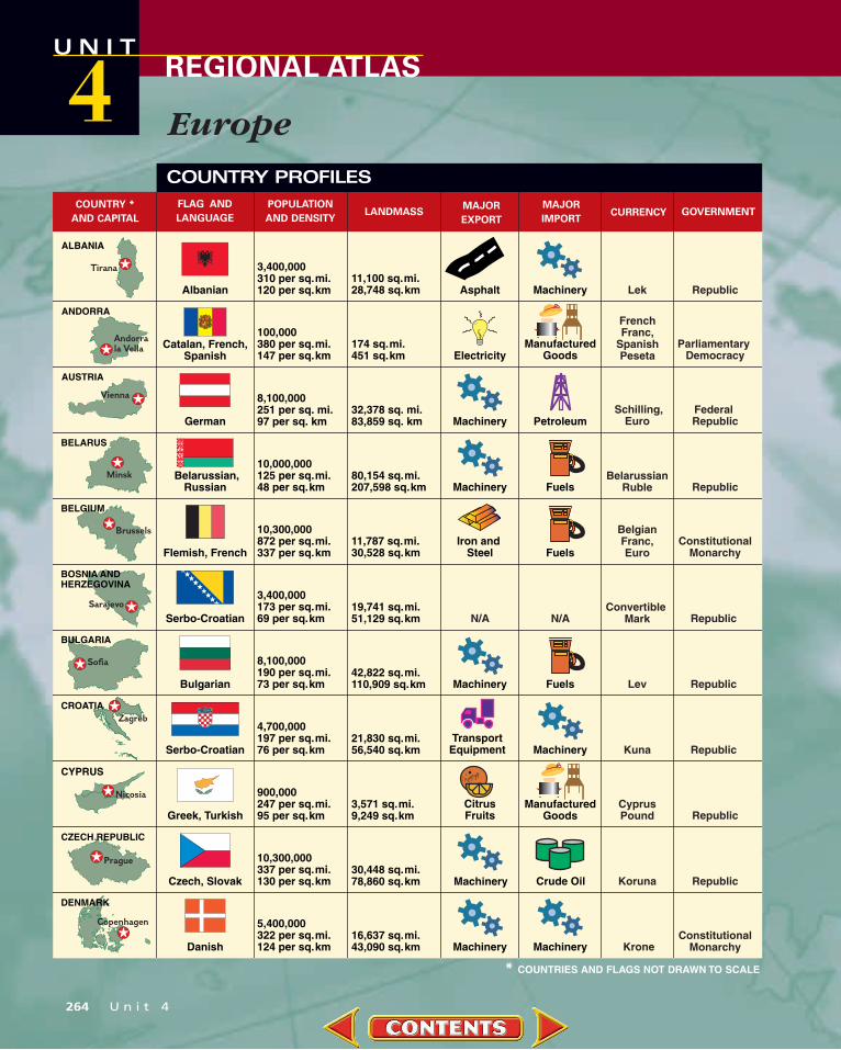
COUNTRY *
AND CAPITAL
FLAG AND
LANGUAGE
POPULATION
AND DENSITYLANDMASS
MAJOR
EXPORT
MAJOR
IMPORTCURRENCY GOVERNMENT
COUNTRY PROFILES
Europe
U N I TREGIONAL ATLAS4
264 U n i t 4

59,200,000278 per sq. mi.107 per sq. km
212,934 sq. mi.551,499 sq. km
82,200,000597 per sq. mi.231 per sq. km
10,900,000214 per sq. mi.83 per sq. km
10,000,000278 per sq. mi.107 per sq. km
300,0007 per sq. mi.3 per sq. km
3,800,000142 per sq. mi.55 per sq. km
57,800,000497 per sq. mi.192 per sq. km
2,400,00095 per sq. mi.37 per sq. km
137,830 sq. mi.356,978 sq. km
50,950 sq. mi.131,960 sq. km
35,919 sq. mi.93,030 sq. km
39,768 sq. mi.102,999 sq. km
27,135 sq. mi.70,280 sq. km
116,320 sq. mi.301,269 sq. km
24,942 sq. mi.64,599 sq. km Wood
French
German
Greek
Hungarian
Icelandic
English, Irish Gaelic
Italian
Latvian, Russian
Foods
Fuels
5,200,00040 per sq. mi.15 per sq. km
130,560 sq. mi.338,150 sq. km FoodsFinnish, Swedish Paper
Fish
Markka,Euro
DeutscheMark, Euro
French Franc,Euro
Drachma
Forint
Icelandic Króna
Irish Pound,Euro
Lira, Euro
Lat
Republic
Republic
Republic
Republic
Republic
Federal Republic
Republic
Republic
Republic
Republic
30,000534 per sq. mi.206 per sq. km
62 sq. mi.160 sq. kmGerman Swiss Franc
Constitutional Monarchy
1,400,00078 per sq. mi.30 per sq. km
17,413 sq. mi.45,099 sq. km TextilesEstonian Kroon
Chemicals
Metals
Foods
FINLAND
Helsinki
Paris
Berlin
GREECE
Athens
HUNGARY
IRELAND
ITALY
Rome
Vaduz
Tallinn
ICELAND
Reykjavík
Dublin
Budapest
Ríga
LIECHTENSTEIN
LATVIA
GERMANY
FRANCE
ESTONIA
Machinery
Machinery
Machinery Machinery
Machinery
Machinery
Machinery
Machinery
Machinery Machinery
Crude Oil
Crude Oil
COUNTRY *
AND CAPITAL
FLAG AND
LANGUAGE
POPULATION
AND DENSITYLANDMASS
MAJOR
EXPORT
MAJOR
IMPORTCURRENCY GOVERNMENT
FOR AN ONLINE UPDATE OF THIS INFORMATION, VISIT GEOGRAPHY.GLENCOE.COM AND CLICK ON “TEXTBOOK UPDATES.”
* COUNTRIES AND FLAGS NOT DRAWN TO SCALE
U n i t 4 265
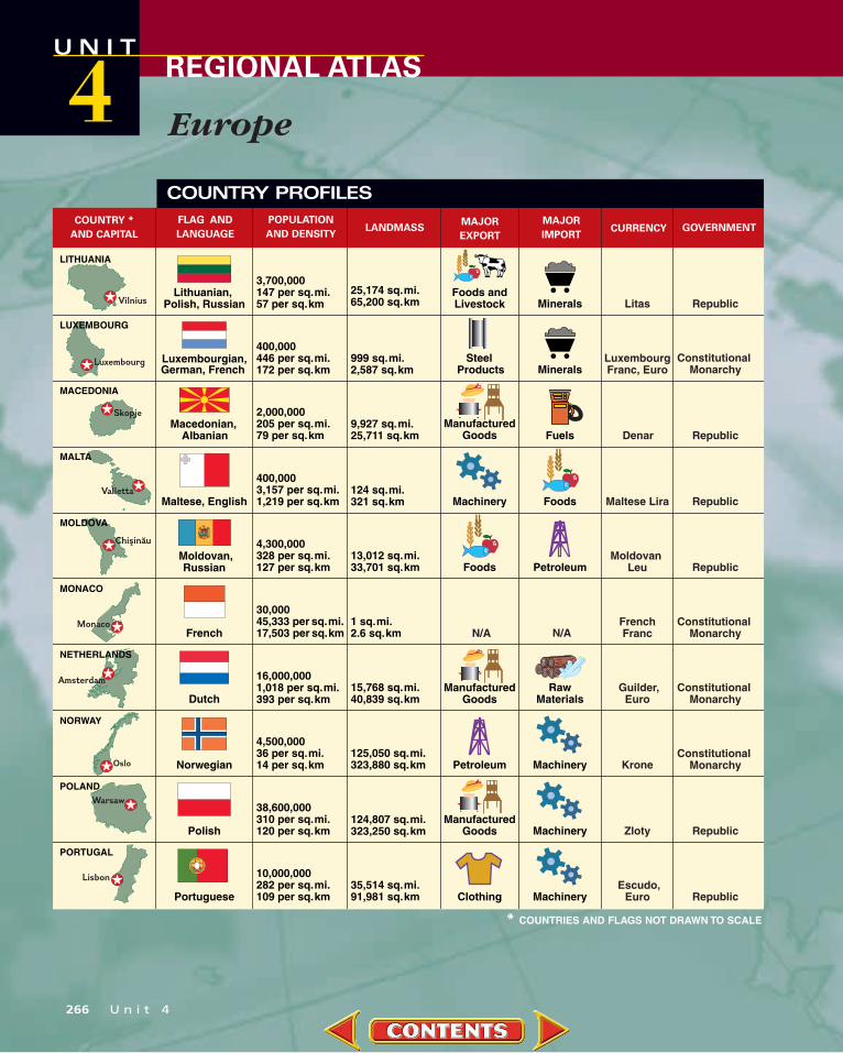
400,0003,157 per sq. mi.1,219 per sq. km
124 sq. mi.321 sq. km
30,00045,333 per sq. mi.17,503 per sq. km
16,000,0001,018 per sq. mi.393 per sq. km
4,500,00036 per sq. mi.14 per sq. km
38,600,000310 per sq. mi.120 per sq. km
10,000,000282 per sq. mi.109 per sq. km
1 sq. mi.2.6 sq. km
15,768 sq. mi.40,839 sq. km
125,050 sq. mi.323,880 sq. km
124,807 sq. mi.323,250 sq. km
35,514 sq. mi.91,981 sq. km
RawMaterials
Maltese, English
French
Dutch
Norwegian
Polish
Portuguese Clothing
2,000,000205 per sq. mi.79 per sq. km
9,927 sq. mi.25,711 sq. km
ManufacturedGoods
Macedonian, Albanian Denar
Maltese Lira
Moldovan Leu
Guilder, Euro
French Franc
Escudo,Euro
Krone
Zloty Republic
Republic
Republic
Republic
Republic
Republic
Constitutional Monarchy
Constitutional Monarchy
Constitutional Monarchy
400,000446 per sq. mi.172 per sq. km
999 sq. mi.2,587 sq. km
Luxembourgian, German, French
Steel Products
LuxembourgFranc, Euro
Constitutional Monarchy
3,700,000147 per sq. mi.57 per sq. km
25,174 sq. mi.65,200 sq. km
Lithuanian, Polish, Russian
Foods andLivestock Minerals Litas
4,300,000328 per sq. mi.127 per sq. km
13,012 sq. mi.33,701 sq. km
Moldovan, Russian
ManufacturedGoods
ManufacturedGoods
Luxembourg
LUXEMBOURG
MACEDONIA
Skopje
Valletta
MALTA
Chişin˘au
MOLDOVA
MONACO
Monaco
NORWAY
Oslo
POLANDWarsaw
PORTUGAL
Lisbon
LITHUANIA
Vilnius
Amsterdam
NETHERLANDS
Minerals
Fuels
Foods
Foods
Machinery
Petroleum
Petroleum Machinery
Machinery
Machinery
N/A N/A
COUNTRY *
AND CAPITAL
FLAG AND
LANGUAGE
POPULATION
AND DENSITYLANDMASS
MAJOR
EXPORT
MAJOR
IMPORTCURRENCY GOVERNMENT
COUNTRY PROFILES
* COUNTRIES AND FLAGS NOT DRAWN TO SCALE
Europe
U N I TREGIONAL ATLAS4
266 U n i t 4

7,200,000453 per sq. mi.175 per sq. km
15,942 sq. mi.41,290 sq. km
60,000,000635 per sq. mi.245 per sq. km
1,000
94,548 sq. mi.244,879 sq. km
0.2 sq. mi.0.4 sq. km
German, French,Italian
English, Welsh,Scottish Gaelic
Italian, Latin
10,700,000270 per sq. mi.104 per sq. km
39,448 sq. mi.102,170 sq. km
Serbo-Croatian,Albanian
ManufacturedGoods
ManufacturedGoods
PrecisionInstruments
5,400,000286 per sq. mi.110 per sq. km
2,000,000256 per sq. mi.99 per sq. km
39,800,000204 per sq. mi.79 per sq. km
8,900,00051 per sq. mi.20 per sq. km
18,923 sq. mi.49,011 sq. km
195,363 sq. mi.505,990 sq. km
7,819 sq. mi.20,251 sq. km
173,730 sq. mi.449,961 sq. km
Cars and Trucks
Slovak,Hungarian
Slovene, Serbo-Croatian
Spanish, Catalan,Galician, Basque
Swedish
Koruna
SlovenianTolar
Peseta,Euro
Krona
Swiss Franc
Hryvnya
Lira
PoundSterling
SovereignState Under
the Pope
YugoslavNew Dinar
Federal Republic
Republic
Republic
Constitutional Monarchy
Federal Republic
Republic
Constitutional Monarchy
Constitutional Monarchy
Italian Lira
Leu
Republic
30,0001,166 per sq. mi.450 per sq. km
23 sq. mi.60 sq. kmItalian
ManufacturedGoods
Building Stone
22,400,000243 per sq. mi.94 per sq. km
92,042 sq. mi.238,389 sq. km
Romanian,Hungarian Republic
49,100,000211 per sq. mi.81 per sq. km
233,089 sq. mi.603,701 sq. km
Ukrainian, Russian
SAN MARINO
San Marino
SLOVAKIA
SLOVENIA
SPAINMadrid
SWEDEN
Stockholm
UKRAINE
London
UNITED KINGDOM
VATICAN CITY
Belgrade
YUGOSLAVIA
Bucharest
Bratislava
Ljubljana
SWITZERLAND
Bern
Kiev
ROMANIA
Textiles Fuels
Machinery
Machinery
Machinery
Machinery
Machinery
Machinery
Foods
Metals
PaperProducts
TransportEquipment
TransportEquipment
Crude Oil
N/A N/A
COUNTRY *
AND CAPITAL
FLAG AND
LANGUAGE
POPULATION
AND DENSITYLANDMASS
MAJOR
EXPORT
MAJOR
IMPORTCURRENCY GOVERNMENT
FOR AN ONLINE UPDATE OF THIS INFORMATION, VISIT GEOGRAPHY.GLENCOE.COM AND CLICK ON “TEXTBOOK UPDATES.”
* COUNTRIES AND FLAGS NOT DRAWN TO SCALE
U n i t 4 267

Wander through any city in the United States, and you’ll see European influences—not just in foods and fashions,but in brick, wood, and stone. From churches to country homes, many American buildings reflect our connection
to European cultures.The Capitol is a national landmark in the heart of Washington, D.C.
Its great dome, or large arched roof, dominates the structure.Roman architects favored arching shapes, and domes are
their legacy.In 1792 President George Washington
asked architects to submit designs for a “federal Capitol” to house the U.S.Congress.William Thornton, an ama-teur draftsman, won the competitionwith a neo-Roman design.Thornton modeled the Capitoldome after the one that crownsthe Pantheon, an ancient Romantemple built in the A.D. 100s.
The Gothic style of archi-tecture originated in Francein the 1100s and becamethe style of choice forcathedrals. Gothic cathedrals are huge and soaring, with
�
GLOBALCONNECTIONEUROPE AND THE UNITED STATES
Queen Annehouse inWashingtonState
▲
ARCHITECTURE
U N I TREGIONAL ATLAS4
268 U n i t 4
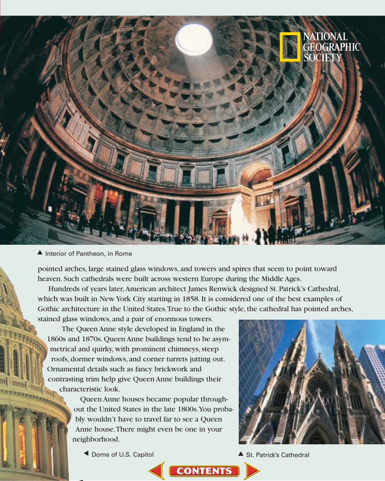
pointed arches, large stained glass windows, and towers and spires that seem to point toward heaven. Such cathedrals were built across western Europe during the Middle Ages.
Hundreds of years later, American architect James Renwick designed St. Patrick’s Cathedral,which was built in New York City starting in 1858. It is considered one of the best examples ofGothic architecture in the United States.True to the Gothic style, the cathedral has pointed arches,stained glass windows, and a pair of enormous towers.
The Queen Anne style developed in England in the1860s and 1870s. Queen Anne buildings tend to be asym-metrical and quirky, with prominent chimneys, steeproofs, dormer windows, and corner turrets jutting out.
Ornamental details such as fancy brickwork and contrasting trim help give Queen Anne buildings their
characteristic look.Queen Anne houses became popular through-
out the United States in the late 1800s.You proba-bly wouldn’t have to travel far to see a QueenAnne house.There might even be one in your
neighborhood.
Dome of U.S. Capitol▲ St. Patrick’s Cathedral▲
Interior of Pantheon, in Rome▲

GeoJournalAs you read this chapter, use your journal todescribe Europe’s physical geography. Includevivid descriptions of its mountains, plains, andwater systems.
Chapter Overview Visit the Glencoe WorldGeography Web site at tx.geography.glencoe.comand click on Chapter Overviews—Chapter 11 to preview information about the physicalgeography of the region.

The Land
A Geographic ViewFire in Iceland. . . [O]ne of the largest volcaniceruptions to hit Iceland this century rumbled to life beneath the country’s biggest ice cap. Fortwo weeks ash and steam billowedskyward as elemental forcesclashed in thermal battle. . . .[A]sh-laden runoff rushed fromthe eruption site, carving an icecanyon 500 feet deep and morethan two miles long.
—Glenn Oeland, “Iceland’s Trial by Fire,” National Geographic,May 1997
Though few natural occurrences are as dramatic asIceland’s volcanic eruptions, physical forces continue to shape thelandscape of Europe. In this section you will learn about the variety ofEurope’s landforms, water systems, and natural resources.
Seas, Peninsulas, and IslandsUnlike the world’s other continents, Europe and Asia share a com-
mon landmass called Eurasia. Yet Europe, the second smallest of thecontinents after Australia, is a distinct region. Jutting westward fromAsia, Europe has an unusually long, irregular coastline that touchesa number of bodies of water, including the Atlantic Ocean and theBaltic, North, Mediterranean, and Black Seas.
History
Struggle With the SeaMost of Europe lies within 300 miles (483 km) of a seacoast. This
closeness to the sea has shaped the lifestyles of its peoples. In the
Guide to ReadingConsider What You KnowReferences to Europe are often in thenews. What physical features come to mind when you think of Europe?What do you know about them?
Read to Find Out• Why is Europe sometimes called a
“peninsula of peninsulas”?
• What are some of the numerousislands surrounding the continentof Europe?
• Why are rivers vital to Europe’seconomy?
• What are some of Europe’s mostimportant natural resources?
Terms to Know• dike
• polder
• glaciation
• fjord
• loess
Places to Locate• North Sea
• Iberian Peninsula
• Balkan Peninsula
• Alps
• Rhine River
• Po River
• North European Plain
C h a p t e r 1 1 271
Church in the Alps, Bavaria,Germany
Ice canyon, Iceland
Europe is aboutthree-fourthsthe size of thecontinentalUnited States.
272 U n i t 4
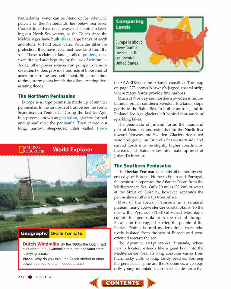
Dutch Windmills By the 1800s the Dutch hadbuilt about 9,000 windmills to pump seawater fromlow-lying areas.
Place Why do you think the Dutch shifted to otherpower sources to drain flooded areas?
Netherlands, water can be friend or foe. About 25percent of the Netherlands lies below sea level.Coastal dunes have not always been helpful in keep-ing out North Sea waters, so the Dutch since theMiddle Ages have built dikes, large banks of earthand stone, to hold back water. With the dikes forprotection, they have reclaimed new land from thesea. These reclaimed lands, called polders, oncewere drained and kept dry by the use of windmills.Today, other power sources run pumps to removeseawater. Polders provide hundreds of thousands ofacres for farming and settlement. Still, from time to time, stormy seas breach the dikes, creating dev-astating floods.
The Northern PeninsulasEurope is a large peninsula made up of smaller
peninsulas. In the far north of Europe lies the scenicScandinavian Peninsula. During the last Ice Age,in a process known as glaciation, glaciers formedand spread over the peninsula. They carved outlong, narrow, steep-sided inlets called fjords
(fee•AWRDZ) on the Atlantic coastline. The mapon page 273 shows Norway’s jagged coastal strip,where many fjords provide fine harbors.
Much of Norway and northern Sweden is moun-tainous, but in southern Sweden, lowlands slopegently to the Baltic Sea. In both countries, and inFinland, Ice Age glaciers left behind thousands ofsparkling lakes.
The peninsula of Jutland forms the mainlandpart of Denmark and extends into the North Seatoward Norway and Sweden. Glaciers depositedsand and gravel on Jutland’s flat western side andcarved fjords into the slightly higher coastline onthe east. Flat plains or low hills make up most of Jutland’s interior.
The Southern PeninsulasThe Iberian Peninsula extends off the southwest-
ern edge of Europe. Home to Spain and Portugal,the peninsula separates the Atlantic Ocean from theMediterranean Sea. Only 20 miles (32 km) of waterat the Strait of Gibraltar, however, separates thepeninsula’s southern tip from Africa.
Most of the Iberian Peninsula is a semiaridplateau, rising above slender coastal plains. To thenorth, the Pyrenees (PIHR•uh•NEEZ) Mountainscut off the peninsula from the rest of Europe.Because of this rugged barrier, the people of theIberian Peninsula until modern times were rela-tively isolated from the rest of Europe and wereoriented toward the sea.
The Apennine (A•puh•NYN) Peninsula, whereItaly is located, extends like a giant boot into theMediterranean Sea. Its long coastline varies fromhigh, rocky cliffs to long, sandy beaches. Formingthe peninsula’s spine are the Apennines, a geologi-cally young mountain chain that includes an active

Mt. Blanc15,771 ft.
(4,807 m)
Vesuvius4,190 ft.(1,277 m)
Ben Nevis4,406 ft.(1,343 m)
Carpathian M
ountains
SC
AN
DI N
AV
I A
N O R T H E U R O P E AN
PL
A
IN
Pyrenees Ap
en
ni n
e s
AL P S
BalkanPeninsula
IBERIAN
PENINSULA
GreatHungarian
Plain
Crete
Balearic Islands
Jutland
Sicily
Sardinia
Corsica
GreatBritain
Balkan Mts.
Lapland
Rhodes
Faroe Is.
Shetland Is.
Orkney Is.
MassifCentral
Meseta
L. Geneva
ElbeR
.
VistulaR
.
Rhi
ne
R.
Rh
ˆone
R.
Thames R.
Loire R.Seine
R.
Po R.
Dniest er R.
Danube R.Ebro
R.
Atlantic
Ocean
Bay ofBiscay
Strait of Gibraltar
NorthSea
B a l t
i cS
ea
No
rw
eg
i an
Se
a
B l a c k S e a
M e d i t e r r an
ea n S e a
AegeanSea
Adriatic Sea
Dardanelles
Bosporus
IonianSea
LATVIA
BELARUS
T U R K E Y
ROMANIA
MOLDOVA
UKRAINE
ITALY
P O L A N D
SWEDEN
FINLAND
NORWAY
DENMARK
NETH.
GERMANY
HUNGARY
BELGIUM
UNITEDKINGDOMIRELAND
ICELAND
MALTA
BULGARIAYUG.
LITHUANIA
ALBANIA
GREECE
CYPRUS
MACED.
BOSN. &HERZG.
SANMARINO
CZECH REP.
AUSTRIALIECH.
LUX.
ANDORRA
ESTONIA
SWITZ.
SLOVAKIA
CROATIASLOV.
MONACO
FRANCE
S P A I N
Dnieper R.
GIBRALTAR
PORTUGAL
AR
CT
ICC
IRC
LE
ME
RID
IA
N O
F G
RE
EN
WIC
H
(LO
ND
ON
)
20°W 0° 20°E
70°N
40°E
40°N
50°N
60°N
N
Lambert Azimuthal Equal-Area projection
500
5000 mi.
0 km
MAP STUDY
Europe: Physical-Political
Find NGS online map resources @ www.nationalgeographic.com/maps
National boundaryMountain peak
Feet10,0005,0002,0001,000
0
MetersElevations
3,0001,500
600300
0
1. Interpreting Maps What body of water separates the United Kingdomfrom Denmark?
2. Applying Geography Skills Which country has areas of land belowsea level? How might people live in these areas?

Islands also lie south of the European mainland,in the Mediterranean Sea. Rugged mountains formthe larger islands of Sicily, Sardinia, Corsica, Crete,and Cyprus. Volcanic and earthquake activity arecharacteristic of the region. Mount Etna, Europe’shighest active volcano, rises over Sicily. Smallerisland groups in the Mediterranean area areSpain’s Balearic Islands, Malta’s 5 islands, andGreece’s nearly 2,000 islands in the Aegean Sea.The scenic, rugged landscape and the sunny climateof Europe’s Mediterranean islands draw touristsfrom around the world.
Mountains and PlainsEurope’s mainland, in essence, consists of plains
interrupted by mountains running through itsinterior and along its northern and southernedges. The map on page 273 shows the names andlocations of some of these landforms.
Mountain RegionsEurope’s northwestern mountains have some of
the earth’s most ancient rock formations. Roundedby eons of erosion and glaciation, these ranges fea-ture relatively low peaks, such as Ben Nevis, thehighest mountain in the British Isles at 4,406 feet(1,343 m). Extending from the Iberian Peninsula toeastern Europe, the central uplands consist of low,rounded mountains and high plateaus with scat-tered forests. This region includes the Meseta,Spain’s central plateau, and the Massif Central,France’s central highlands.
By contrast, southern Europe’s geologicallyyounger mountains are high and jagged. Asthe earth’s crust lifted and folded, the PyreneesMountains were thrust upward to more than 11,000feet (3,354 m). Created by glaciation and folding, themountain system known as the Alps forms a cres-cent from southern France to the Balkan Peninsula.The highest peak in the Alps, Mont Blanc, stands at
Student Web Activity Visit the Glencoe World Geography Website at tx.geography.glencoe.com and click on Student Web Activities—Chapter 11 for an activity about the physical geography of theNetherlands.
volcano—Mount Vesuvius, near the city of Naples.Plains cover only about one-third of the ApenninePeninsula, the largest being the fertile plain ofLombardy along the Po River in the north.
In southeastern Europe lies the Balkan Peninsula.Bounded by the Adriatic and Ionian Seas on thewest and the Aegean and Black Seas on the east,the Balkan Peninsula holds a tangle of mountainranges and valleys that stretch southward from theDanube River. Because of the region’s craggy land-scape, overland travel is difficult. Historicallypeople moved along rivers and seas in this moun-tainous region.
Europe’s IslandsIn addition to peninsulas, Europe includes many
islands. Iceland is located south of the Arctic Cir-cle in the North Atlantic Ocean. Lying astride theMid-Atlantic Ridge, Iceland has volcanoes, hotsprings, and geysers. Because of Iceland’s farnorthern location, glaciers are found next to thevolcanoes and hot springs. Most of the homes andindustries in the area of the capital, Reykjavík(RAY•kyah•VEEK), pipe in water from hot springsfor heat. Grassy lowlands stretch along Iceland’scoast, but the land rises sharply to form a largeinland plateau.
The British Isles lie northwest of the Europeanmainland. They consist of two large islands, GreatBritain and Ireland, and thousands of smallerislands. Mountain ranges, plateaus, and deep val-leys make up most of northern and western GreatBritain, and low hills and gently rolling plainsdominate in the south. Ireland, often called theEmerald Isle, is a lush green land of cool tempera-tures and abundant rainfall. In many places therugged coastline of the British Isles features rockycliffs that drop to deep bays. One visitor to theBritish coast writes:
“ We hiked past . . . plenty of farms, andmile after mile of rocky cliffs, their longfaces carved raw and craggy by theocean’s dull knife. All day we stayedclose to Cornwall’s serrated edge, weav-ing in and out like a conga line.”Alan Mairson, “Saving
Britain’s Shore,” NationalGeographic, October 1995
274 U n i t 4

C h a p t e r 1 1 275
15,771 feet (4,807 m) on the borderof France and Italy. Some ofEurope’s major rivers, such asthe Rhine and the Po, originate in the Alps. TheAlps also form a barrier that separates the warm,dry climate of the Mediterranean region from thecooler climates of the north. Another toweringmountain chain, the Carpathians, runs througheastern Europe from Slovakia to Romania.
Plains RegionsEurope’s broad plains curve around the high-
lands. Scoured by Ice Age glaciers, the North European Plain stretches from southeastern England and western France eastward to Poland,Ukraine, and Russia. The plain’s fertile soil andwealth of rivers originally drew farmers to the area,and the plain is still a major agricultural region. Thesouthern edge is especially fertile because depositsof loess, a fine, rich, wind-borne soil, cover it.
Deposits of coal, iron ore, and other mineralsfound on the North European Plain led to westernEurope’s industrial development during the 1800s.Today many of Europe’s largest cities, such asParis and Berlin, are located on the plain.
Another fertile plains area, the Great HungarianPlain, extends from Hungary to Croatia, Serbia,
and Romania. Farmers cultivate grains, fruit, and vegetables and raise livestock in the lowlandsalong the Danube River.
Water SystemsMany of Europe’s water systems flow from inland
mountain and highlands areas to the coasts. By con-necting navigable rivers with canals, Europeanshave greatly enhanced their natural waterways astransportation links. Europe’s rivers and canals alsoprovide water to irrigate farmland and to produceelectricity.
Europe’s rivers have differing characteristics.The rivers in Scandinavia are short and do not pro-vide easy connections between cities. In the IberianPeninsula, main rivers generally are too narrowand shallow for large ships. England’s Thames(TEHMZ) River, on the other hand, allows ocean-going ships to reach the port of London.
In the heartland of Europe, however, relativelylong rivers provide links between inland areas aswell as to the sea. The Rhine is the most importantriver in western Europe. It flows from the Swiss
Main-Danube CanalRolling through rural Bavaria, the Main-Danube Canal offers a large lakefor swimming and artificial ponds for wildlife along landscaped banks.
Region Describe the two different types of rivers that flow in Europe.
276 U n i t 4
Alps through France and Germany and into theNetherlands, connecting many industrial cities tothe busy port of Rotterdam on the North Sea.
The Danube, which flows from Germany’s BlackForest to the Black Sea, is eastern Europe’s majorwaterway. Each year ships and barges carry mil-lions of tons of cargo on the Danube. In 1992 theMain (MYN) River, a tributary of the Rhine,became connected to the Danube when the Main-Danube Canal was completed, thereby linking theNorth Sea with the Black Sea.
Other major European rivers include the Seine,Rhône, and Loire in France; the Elbe and Weser inGermany; the Vistula in Poland; the Po in Italy; andthe Dnieper in Ukraine.
Natural ResourcesEurope has a long history of utilizing its natural
resources, including energy sources, agriculturalareas, water, and especially minerals. Europe’sabundant supply of coal and iron ore fueled thedevelopment of modern industry.
Major reserves of coal lie in the United Kingdom,Germany, Ukraine, and Poland as well as otherEuropean countries. Although coal is still animportant fuel source, many coalfields in westernEurope are depleted or are too expensive to mine.Large deposits of iron ore lie in northern Sweden,
Checking for Understanding1. Define dike, polder, glaciation,
fjord, loess.
2. Main Ideas Re-create the tablebelow on a sheet of paper, and fillin examples of the physical featuresand natural resources of Germany,Norway, Ukraine, Italy, and France.
Critical Thinking3. Comparing and Contrasting How
does the landscape of the Jutlandpeninsula differ from that of theBalkan Peninsula?
4. Making Generalizations Europe’sMediterranean islands are popu-lar vacation destinations. Whatphysical features make theseislands attractive to tourists?
5. Drawing Conclusions How doesEurope’s network of rivers andcanals contribute to industrialdevelopment in the region?
Analyzing Maps6. Location Study the physical-
political map of Europe on page273. What part of Europe has thelowest elevation? The highest?
7. Conflict Over Resources Usethe economic activity mapon page 263 to identifythree areas in which naturalresources cross internationalboundaries. Describe theareas in which conflict couldarise because of the manage-ment of these resources.
Applying Geography
Physical NaturalCountry Features Resources
northeastern France, and southeastern Ukraine.Europe’s other mineral resources include bauxite,zinc, and manganese.
In places where other fuels are scarce, Europeansburn peat, a kind of vegetable matter found inswamps and usually composed of mosses. Peat isdug up, chopped into blocks, and dried so it can beburned. Europeans, however, largely rely on coal,oil, gas, and nuclear and hydroelectric power. Vastoil and natural gas deposits under the North Seacontribute greatly to Europe’s energy needs.France, which lacks large oil or gas reserves, hasinvested heavily in nuclear power.
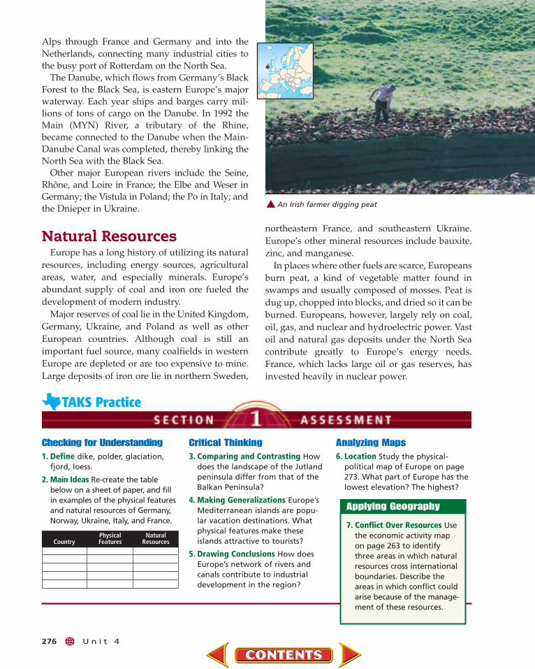
An Irish farmer digging peat
Climate andVegetation
A Geographic ViewPower of the WindI stood on the shore of Als Sund, a saltwater sound . . . with[Flemming] Rieck, a maritimearchaeologist at the NationalMuseum of Denmark. . . . After aweek of rain the spring sun radi-ated intense light but little heat.Chins tucked in our windbreak-ers, Rieck and I stared at sail-boats bobbing on the whitecaps.
“At some point . . . ,” hesaid, “Scandinavians beganusing sails.” He spread hisarms into the stiff breeze. “No one can saywhy it took so long for them to use the power of all this wind.”
—Michael Klesius, “Mystery Ships From a Danish Bog,” National Geographic, May 2000
Wind is only one of the factors affecting Europe’sclimates. Latitude, mountain barriers, ocean currents, and the dis-tance from large bodies of water all help determine Europe’s variedclimates. In this section you will read about Europe’s climateregions—from the sunny, dry Mediterranean climate to the frozensubarctic zone. You will also study the patterns of vegetation growthfound in each region of Europe.
Water and LandThe climates and vegetation of Europe vary from the cold, barren tun-
dra and subarctic stretches of Iceland, Norway, Sweden, and Finland tothe warm, shrub-covered Mediterranean coasts of Italy, Spain, andGreece. What factors account for such variety in a relatively small area?
C h a p t e r 1 1 277
Guide to ReadingConsider What You KnowMuch of Europe borders oceans andseas. What kinds of climates wouldyou expect in Europe?
Read to Find Out• What are the climate regions in
Europe?
• What physical features influenceEurope’s climates?
• Why are most of Europe’s originalforests gone?
Terms to Know• timberline
• foehn
• avalanche
• mistral
• sirocco
• chaparral
• permafrost
Places to Locate• Gulf Stream
• North Atlantic Drift
Sailboats on Als Sund

278 U n i t 4
Europe’s northern latitude and its relationshipto the sea influence its climates and vegetation.Western and southern parts of Europe, which lienear or along large bodies of water, benefit fromwarm maritime winds. These areas have a generallymild climate compared with other places in theworld at the same latitude. Frankfurt, Germany, aswell as Paris, France, and Boston, Massachusetts, areabout the same distance from the Arctic Circle, yetJanuary temperatures in Paris are milder than thosein Boston. By contrast, parts of eastern and northernEurope have a colder climate than most of westernand southern Europe because of their distance fromthe warming effects of the Atlantic Ocean.
As in other areas of the world, location influencesvegetation patterns in Europe. Natural vegetationin the region varies from forests and grasslands to
20°W 20°E0° 40°E
40°N
50°N
50°N
60°N
ARCTICCIR
CLE
ME
RID
IA
NO
FG
RE
EN
WIC
H
(LO
ND
ON
)
ATLaNTIC
OCEaN
Bay ofBiscay
NorthSea
Balti
cSe
a
No
rw
eg
ia
nS
ea
BlackSea
M e d i t e r r an
e a n S e a
TyrrhenianSea
IonianSea
AegeanSea
Adriatic Sea
Sea of Azov
Bosporus
Gulf ofBothnia
LondonBerlin
Paris
Amsterdam
Copenhagen
KievPragueFrankfurt
BucharestMadrid
Vienna
Belgrade
Rome
Athens
Dublin
Oslo
Stockholm
Helsinki
Reykjavík
Rotterdam
Glasgow
N
Rīga
Azimuthal Equidistant projection500
5000 mi.
0 km
MAP STUDY
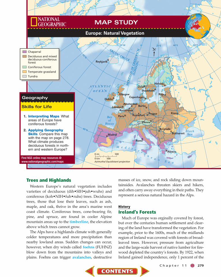
Europe: Climate Regions
Find NGS online map resources @www.nationalgeographic.com/maps
Steppe
Marine west coastMediterraneanHumid subtropicalHumid continental
SubarcticTundra
Highlands (climatevaries with elevation)
Dry
Mid-Latitude
High Latitude
1. Interpreting Maps Whatclimate regions are foundin Scandinavia?
2. Applying GeographySkills Why does north-western Europe have amilder climate than eastern Europe? Explain.
tundra plants and small shrubs. Compare the naturalvegetation map on page 279 with the climate mapabove. Notice that the types of vegetation found inEurope are closely linked to the climate regions.
Western EuropeAs the climate map on this page shows, much of
western Europe has a marine west coast climate—mild winters, cool summers, and abundant rain-fall. The Atlantic Ocean’s Gulf Stream and itsnorthern extension, the North Atlantic Drift,bring warm waters to this part of Europe from theGulf of Mexico and regions near the Equator (seemap on page 61). Prevailing westerly winds blow-ing over these currents carry warm, moist airacross the surface of the European landmass.
masses of ice, snow, and rock sliding down moun-tainsides. Avalanches threaten skiers and hikers,and often carry away everything in their paths. Theyrepresent a serious natural hazard in the Alps.
History
Ireland’s ForestsMuch of Europe was orginally covered by forest,
but over the centuries human settlement and clear-ing of the land have transformed the vegetation. Forexample, prior to the 1600s, much of the midlandsregion of Ireland was covered with forests of broad-leaved trees. However, pressure from agricultureand the large-scale harvest of native lumber for fire-wood depleted the country’s forests. By 1922, whenIreland gained independence, only 1 percent of the
C h a p t e r 1 1 279
Trees and HighlandsWestern Europe’s natural vegetation includes
varieties of deciduous (dih•SIH•juh•wuhs) andconiferous (koh•NIH•fuh•ruhs) trees. Deciduoustrees, those that lose their leaves, such as ash,maple, and oak, thrive in the area’s marine westcoast climate. Coniferous trees, cone-bearing fir,pine, and spruce, are found in cooler Alpinemountain areas up to the timberline, the elevationabove which trees cannot grow.
The Alps have a highlands climate with generallycolder temperatures and more precipitation thannearby lowland areas. Sudden changes can occur,however, when dry winds called foehns (FUHNZ)blow down from the mountains into valleys andplains. Foehns can trigger avalanches, destructive
Bayof
Biscay
BlackSea
M e d i t e r r an
e a n S e a
Paris
Madrid
Vienna
Bucharest
Rome
Athens
London
Stockholm
Kiev
DublinCopenhagen
Helsinki
Rīga
Oslo
Belgrade
Berlin
Reykjavík
Prague
Glasgow
Amsterdam
Rotterdam
Frankfurt
20°W 0° 20°E 40°E 60°E
40°N
50°N
60°N
AR
CT
ICC
IRC
LE
ME
RID
IA
N O
F G
RE
EN
WIC
H
(LO
ND
ON
)
ATLaNTIC
OCEaN
N
Azimuthal Equidistant projection500
5000 mi.
0 km
MAP STUDY
Europe: Natural Vegetation
Chaparral
Deciduous and mixeddeciduous-coniferousforest
Coniferous forest
Temperate grassland
Tundra
Find NGS online map resources @www.nationalgeographic.com/maps
1. Interpreting Maps Whatareas of Europe haveconiferous forests?
2. Applying GeographySkills Compare this mapwith the map on page 278.What climate producesdeciduous forests in north-ern and western Europe?
280 U n i t 4
Southern EuropeMost of southern Europe has a Mediterranean cli-
mate—warm, dry summers and mild, rainy winters.Several other climates, however, are found in smallareas of the region. For example, a humid subtropi-cal climate stretches from northern Italy to the central part of the Balkan Peninsula. In addition,parts of Spain’s Meseta have a drier steppe climate.
The Alps block moist Atlantic winds, so lessprecipitation falls in southern Europe than innorthwestern Europe. Local winds in the regionsometimes cause changes in the normal weather pat-tern. The mistral, a strong north wind from the Alps,sometimes sends gusts of bitterly cold air into south-ern France. By contrast, siroccos (suh•RAH•kohs),
Averag
e Mo
nth
ly Precipitatio
n
Ave
rag
e M
on
thly
Tem
per
atu
re
MonthsMonthsDNOSAJJMAMFJDNOSAJJMAMFJ 0/0
20/51In./Cm
0/-18
100/38°F/°C
8/20
12/30
16/41
4/10
60/16
40/4
20/-7
80/27
Averag
e Mo
nth
ly Precipitatio
n
Ave
rag
e M
on
thly
Tem
per
atu
re
0/0
20/51In./Cm
0/-18
100/38°F/°C
8/20
12/30
16/41
4/10
60/16
40/4
20/-7
80/27
UNITED STATESFRANCE
Paris, France 49° N, 2° E216 ft (66 m) above sea level
Boston, Massachusetts, U.S.42° N, 71° W19 ft (6 m) above sea level
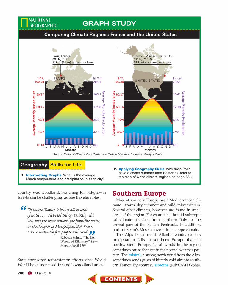
Source: National Climatic Data Center and Carbon Dioxide Information Analysis Center
GRAPH STUDY
Comparing Climate Regions: France and the United States
1. Interpreting Graphs What is the averageMarch temperature and precipitation in each city?
2. Applying Geography Skills Why does Paris have a cooler summer than Boston? (Refer to the map of world climate regions on page 66.)
country was woodland. Searching for old-growthforests can be challenging, as one traveler notes:
“ ‘Of course Tomies Wood is all secondgrowth’. . . . The real thing, Padraig toldme, was far more remote, far from the trails,in the heights of MacGillycuddy's Reeks,where even now few people ventured.”Rebecca Solnit, “The Lost
Woods of Killarney,” Sierra,March/April 1997
State-sponsored reforestation efforts since WorldWar II have increased Ireland’s woodland areas.
high, dry winds from North Africa, may bring hightemperatures to the region. The hot, dry summers inmuch of southern Europe support the growth ofchaparral, or shrubs and small trees, such as the corkoak tree and the olive tree.
Eastern and Northern Europe
Eastern and certain northern areas of Europehave a generally humid continental climate—cold,snowy winters and hot summers. Warm Atlanticcurrents have less influence on climate in theseareas farther from the Atlantic Ocean. As a result,summer and winter temperatures vary morewidely in eastern and northern Europe than in therest of Europe.
In eastern Europe the vegetation is generally a mixof deciduous and coniferous forests. Coniferoustrees, which are able to survive long, cold winters,are found in parts of Scandinavia and the regionaround the Baltic Sea. Grasslands cover parts ofeastern Europe, especially in Hungary, Yugoslavia,and Romania.
Europe’s far north—for example, Iceland, northernScandinavia, and Finland—has subarctic and tundraclimates of bitterly cold winters and short, cool sum-mers. Tundra and subarctic regions have permafrost,soil that is permanently frozen below the surface.
C h a p t e r 1 1 281
Checking for Understanding1. Define timberline, foehn,
avalanche, mistral, sirocco, chaparral, permafrost.
2. Main Ideas Create an outline likethe one below, showing the cli-mates and vegetation found inthree European countries.
Critical Thinking3. Predicting Consequences Prevailing
westerly winds bring warm airfrom the North Atlantic Drift tothe European continent. What doyou think happens when thewinds temporarily change course?
4. Analyzing Information What geo-graphic factors contribute to veg-etation differences between high-lands and tundra climate regions?
5. Identifying Cause and Effect Howhas human interaction with theenvironment caused changes inEurope’s vegetation patterns?
Analyzing Maps6. Location Study the map of
Europe’s climate regions on page278. Where are highlands climateregions found? What are theirphysical features?
7. Physical Processes Describethe physical processes thataffect Europe’s climate andvegetation. Provide specificexamples related to thevariety of climates and vegetation found in theregion.
Applying Geography
Climate and Vegetation
I. IcelandA. Climates: subarctic, tundra, and
permafrostB. Vegetation: conifers, lichens, moss
Tundra areas support little vegetation, with theexception of mosses, small shrubs, and wildflow-ers that bloom during the brief summer. The sub-arctic supports a vast coniferous forest thatbroadens in the eastern part where Europe andRussia share a border.
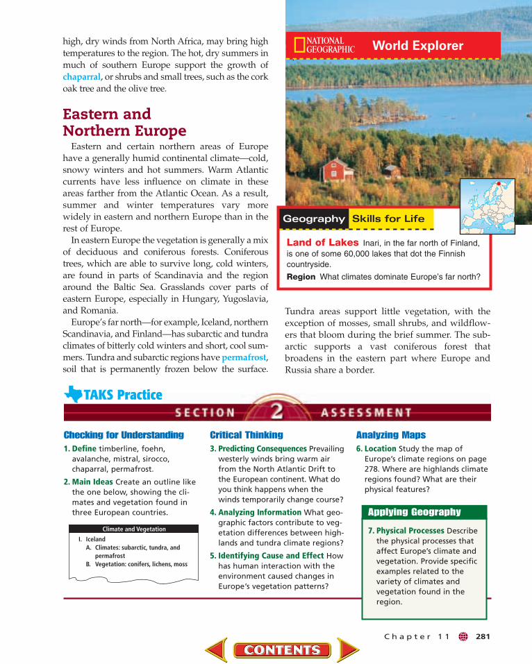
Land of Lakes Inari, in the far north of Finland,is one of some 60,000 lakes that dot the Finnishcountryside.
Region What climates dominate Europe’s far north?

282 U n i t 4
… Patterdale lies within the 885 square miles of the Lake District National Park….
It is the largest of ten national parks in England and Wales (Scotland has none), but, as
with the others, the designation is really a misnomer [incorrect name] since the land is
neither owned by the nation nor is it in any conventional sense a park. It is, rather, a
lived-in landscape, full of towns and farms, with a resident population of 40,000. All
but a small fraction of the land is in private hands.
Unlike U.S. national parks, which often aim to preserve wilderness, British parks
inevitably include residents. These parks were created so there could be a way to exert
some control over the speed and nature of change, not to prevent it altogether. Unfortunately,
the various authorities have little power, relying primarily on persuasion to resolve myriad
[numerous] demands.–Bill Bryson, ”England’s Lake District,”
National Geographic, August 1994
Learning the SkillTo identify the main idea,
you may need to “read betweenthe lines” and interpret thefacts and evidence that are pre-sented. Review the importantdetails, and decide which onesare central to the message. Bylooking closely at importantdetails, you can infer an author’smain meaning.
When looking for a mainidea, follow these steps:
• Skim the material to iden-tify its general subject. Look at any headings andsubheadings.
• Read the information to pin-point the ideas that thedetails support. Why is theauthor presenting these factsand this evidence?
• Identify the main idea. Askyourself: How can I state themain idea in my own words?
Practicing the SkillRead the passage above. Then
answer the following questions.
1. What is the general subjectof the passage?
2. What important facts anddetails does the passageinclude?
3. What is the main idea of thepassage? State the main ideain your own words.
Bring to class a news article aboutan issue facing Europe. Summarizethe main idea of the article, andexplain why it is important.
The Glencoe Skillbuilder Interactive Workbook,
Level 2 provides instruction andpractice in key social studies skills.
Finding and Summarizing the Main IdeaFinding and summarizing the main idea in an article or book
will help you organize information. It will also help you iden-tify the most important concepts to remember.

SUMMARY & STUDY GUIDE
C h a p t e r 1 1 283
Key Points• Europe is a huge peninsula extending westward
from the Eurasian landmass.
• Europe has a long coastline with many peninsu-las and islands.
• Europe has a large plains region in its northernareas; mountains are found along the continent’seastern and southern boundaries.
• Rivers provide important transportation inEurope, linking the interior of the continentwith coastal ports.
• Europe has important deposits of minerals, oil,and natural gas.
Organizing Your NotesUse a table like the one below tohelp you organize the notes youtook as you read the chapter.
Terms to Know• timberline• foehn• avalanche• mistral• sirocco• chaparral• permafrost
Key Points• Warm ocean currents give much of Europe a
milder climate than other areas at similar latitudes.
• Areas of western Europe with a marine westcoast climate have generally moderate temperatures.
• Much of southern Europe has a Mediterraneanclimate, with mild, rainy winters and warm, drysummers.
• Europe’s interior has more extreme seasonaltemperatures than do areas nearer the sea.
• Both climate and human activity affect the natural vegetation of Europe.
Organizing Your NotesCreate graphic organizers likethe one below to help organizeyour notes about each of Europe’sclimate regions.
Terms to Know• dike• polder• glaciation• fjord• loess
SECTION 1 The Land (pp. 271–276)
SECTION 2 Climate and Vegetation (pp. 277–281)
Rivers OtherCountry Mountains and Lakes Features
Marine West Coast
Reindeer herding, northern Sweden

2. Identifying Cause and Effect Why didthe North European Plain develop into adensely populated industrial center?
3. Drawing Conclusions Copy the diagramof European rivers, seas, and waterways belowonto a sheet of paper. In each oval, write thename of a city that is located on or beside thebody of water. Then draw lines to show howcities are linked by waterways.
Reviewing Key TermsWrite the letter of the key term that best matcheseach definition below.
a. sirocco d. polderb. fjord e. timberlinec. foehn f. mistral
1. elevation above which trees cannot grow
2. dry wind that blows in the Alps
3. hot wind that blows from North Africato Europe’s Mediterranean coast
4. drained area reclaimed from thesea
5. deep, water-filled valley carvedby glaciers
6. strong north wind from the Alpsthat brings cold air to southernFrance
Reviewing FactsSECTION 1
1. Why is Europe a “peninsula ofpeninsulas”?
2. What geographic area in Europehas rich, fertile farmland and is acenter of industry?
3. How have human actions overthe centuries changed Europe’swaterways?
SECTION 24. How do the Gulf Stream and the
North Atlantic Drift affectEurope’s climate?
5. What kinds of climate regions arefound in Iceland and the Scandi-navian Peninsula?
Critical Thinking1. Drawing Conclusions How did
geographic features help shapeEuropean cultures? Provide exam-ples to support your answers.
Locating PlacesEurope: Physical Geography
Match the letters on the map with the physical features of Europe. Write your answers on a sheet of paper.
1. British Isles2. Rhine River3. Sicily4. Apennines
5. Baltic Sea6. Mediterranean Sea7. Scandinavia
8. Crete9. Iberian Peninsula
10. Balkan Peninsula
20°W 10°W 0° 10°E 20°E 30°E 40°E 50°E
40°N
50°N
30°W
60°N
70°NA
RC
TIC
CIR
CLE
A
C
J
D
H
E
F
I
G
B
N
Azimuthal Equidistant projection500
5000 mi.
0 km
ASSESSMENT & ACTIVITIES
284 U n i t 4
North Sea –
Baltic Sea –
Rhine River –
Danube River –
Thames River –
Main-Danube Canal –

C h a p t e r X 285
When choosing an answer for a multiple-choice question, sometimesmore than one option may seem cor-
rect. Read the question carefully, and then look in the reading for information about the kind of place.Compare each answer with that information.
Self-Check Quiz Visit the Glencoe WorldGeography Web site at tx.geography.glencoe.comand click on Self-Check Quizzes—Chapter 11 toprepare for the Chapter Test.
Using the Regional AtlasRefer to the Regional Atlas on pages 260–263.
1. Location Through what country do theSeine, Loire, and Rhône Rivers flow?
2. Place What are three major agriculturalproducts of the North European Plain?
Thinking Like a GeographerThink about the physical geography of Europe.Identify Europe’s energy resources, and where theyare located. Which of these are nonrenewableresources? What future energy sources would youadvise European countries to pursue?
Problem-Solving ActivityGroup Research Activity People in Europeface many weather-related challenges, fromavalanches in the mountains to flooding in thelowlands. Using the Internet and other resources,research an area in Europe that has successfullycoped with weather-related events. Then report tothe class on the solutions to these challenges.Include photos, charts, graphs, or any other visualelements to enhance your report.
GeoJournalCreative Writing Using the information in yourGeoJournal, describe an imaginary trip through aEuropean country of your choice. Describe thecountry’s physical features and the climate andnatural vegetation you find. Use what you havelearned in your reading to make your accountdetailed and colorful.
Technology ActivityUsing an Electronic Spreadsheet
Choose a city in each of Europe’s climate regions,and find the average rainfall for each city. Use aspreadsheet program to organize your informa-tion, listing the cities in the first column and therainfall amounts in the next column. Use the pro-gram’s graphics feature to make a bar graph.Write a paragraph summarizing the variations inrainfall among the cities.
Choose the best answer for the following multiple-choice question. If you have troubleanswering the question, use the process ofelimination to narrow your choices.
1. What kind of place does the author wantto escape to sometimes?
A He wants a place where there is a lot ofpressure and energy.
B He wants a beautiful place halfwayaround the world.
C He wants a unique, beautiful place that isdifferent from where he lives.
D He wants a place where he can disappearinto the crowds.
C h a p t e r 1 1 285
0
5
10
15
20
25
30
“And so I have finally come to understand thatwhile I am hopelessly American, accustomed to(and dependent on) the relentless pressures andfierce energies of the New World, . . . there aremoments when I want to escape to a differentplace with a beauty and a beat of its own. Andwhen that happens, when I want to disappearfrom who I am, and where I live, the place Ithink of is Paris.”
—David Halberstam, “Paris,” National Geographic Traveler, October 1999
Related Documents