G eographic I nformation S ystems 2015-2017 Strategic Plan

Welcome message from author
This document is posted to help you gain knowledge. Please leave a comment to let me know what you think about it! Share it to your friends and learn new things together.
Transcript

Geographic Information Systems
2015-2017 Strategic Plan

Westchester County GIS
White Plains, New York
Department of Information Technology
John B. McCaffrey Chief Information Officer
Albert Villate Deputy Chief Information Officer
Sam Wear Assistant Chief Information Officer (GIS)
Xiaobo Cui GIS Manager
Ana Hiraldo-Gomez Manager of IT Shared Services
Ilir Tota Software Architect I
Zhenglu Zhang Software Architect II
Connor Lynch GIS Specialist II
Dongming Tang Software Architect II
Will Buckhout GIS Specialist I
http://giswww.westchestergov.com
facebook:WestchesterCountyGIS twitter:WCGIS

Table of Contents
Mission ....................................................................................... 3
Vision ......................................................................................... 3
Program ..................................................................................... 3
I. Data ................................................................................ 4
II. Applications ...................................................................... 5
III. System Infrastructure ........................................................ 6
Staff Resources ............................................................................ 8
2015-2017 Westchester County GIS Program Goals ........................ 12
I. Administrative ................................................................ 12
II. Applications and Software ................................................ 14
III. Data Management ........................................................... 15
Enterprise GIS Technical Committee (EGTC) .................................. 16
Westchester GIS User Group ....................................................... 16
GIS Projects, Applications and Services ......................................... 18
Westchester County GIS on the Web ............................................. 29
Shared Services ......................................................................... 30
Program Metrics ......................................................................... 31
GIS System Architecture ............................................................. 35
ON THE COVER: Beta 3D model of downtown White Plains using ESRI City Engine Web Viewer.
Page 2

Westchester County GIS Strategic Plan 2015-2017
Mission Westchester County’s Department of Information Technology (DoIT) Geographic Information Systems (GIS) program helps County departments and government agencies improve service delivery to County residents by coordinating, designing and implementing cost-effective geospatial technologies and services. Program activities and resource allocation are aligned with the County Executive’s priorities of protecting the tax payer, preserving essential servies, and promoting economic development.
Vision Westchester County GIS works to provide and support state-of-the-art GIS mapping services and applications in the rapidly evolving and expanding field of geospatial technology. This commitment requires GIS staff to be proactive in leveraging new geospatial solutions based on enterprise Environmental Systems Research Institute (ESRI) software (www.esri.com), while exploring opportunities to integrate innovative aligned technologies for broad and cost-effective deployment in County and local government and the Westchester County business community. Increased collaborative work with school districts, nonprofits, and utilities, offer many new opportunities in geospatial data sharing, geospatial analysis support, and GIS mapping applications.
Program The success of the County’s GIS program, since its inception in 1988, is due to many factors. The program has maintained active support of both the office of the County Executive and the Board of Legislators and is now strategically integrated into several County enterprise systems. Considered a critical County asset, GIS technology is used as a tool to save time, money, and lives and is used on a day-to-day basis throughout County and local government. As an enterprise technology, the program continues to take a holistic view of GIS infrastructure, data, applications, and processes with the intent of cost–effectively leveraging resources across the County. As user and system demands for improved functionality, availability and reliability continue to escalate in several computing environments (i.e. mobile, Web), an increased complexity in GIS
Page 3

infrastructure and services will be required. These demands will be even more challenging in 2015-2017, as both County and local governments face ongoing funding and budgetary challenges. Operational needs, combined with new technology opportunities built around ESRI’s world-leading GIS software, will continue to drive the GIS business plan. Experienced GIS software users, including the growing number of users in professional engineering and business disciplines, will continue to rely on ArcGIS desktop client software though many basic geoprocessing tools are increasingly being made available through Web and online ESRI software products. Non-technical staff and County residents will access enterprise GIS content through ArcGIS.com and other easy-to-use viewers such as the County’s flagship web mapping portal Mapping Westchester County, the Tax Parcel Viewer, ArcGIS Explorer and Google Earth. Business and industry will leverage and integrate County-published authoritative map services into business applications being used by local governments. Illustrating its presence in the regional geospatial community, 178 individuals representing several professional disciplines attended the annual Westchester GIS User Group Meeting at Purchase College on May 15, 2014. This group continues to grow as a forum to keep users across all disciplines (government, industry, academia, and nonprofits) informed about products and services made available by Westchester County GIS, related GIS events, and training and education opportunities. It has grown to be one of the largest annual GIS user group meetings in the state. In 2015-2017, Westchester County GIS resources will prioritize and focus in the following key enterprise areas:
I. Data: Following completion and delivery of the 2013-2014 countywide basemap update, County GIS resources will continue to concentrate on the development and assemblage of key environmental and infrastructure datasets which will be used at both the County and local level. The County will remain committed to making County geospatial datasets available to end users via ESRI data formats, map services, Google KML and AutoCAD formats, and as appropriate to a the growing number of open government data portals.
Efforts to improve health and human service delivery systems with geospatial tools will also continue to be a focus for the County’s GIS program. Introducing and implementing geography-based workflows in these government program areas offer great potential for cost savings for the
Page 4
County. While much of the data behind these program areas are in New York State systems, County GIS staff is prepared to move forward in working with County and State counterparts in advancing these next generation of “geospatial-centric” systems.
Additional priority geospatial data development projects for 2015-2017 will include the ongoing acquisition and integration of local tax maps, development of 3D models for urban planning and economic development projects, building data sharing agreements with utilities (i.e., New York State Electric and Gas, United Water, ConEd, etc.) and the anticipated acquisition of new oblique aerial imagery. Continued integration of Environmental Protection Agency (EPA), Federal Emergency Management Agency (FEMA), National Oceanic and Atmospheric Agency (NOAA), and Homeland Security Infrastructure Program (HSIP) datasets will also remain of significance towards making communities more resilient against climate change and extreme weather events, as well as supporting the efforts of the Public Safety and Emergency Response Communities. GIS staff is also currently working with the Department of Planning in the production of an updated Environmental Planning Atlas for each Westchester County municipality.
The ongoing efforts of mapping assets for local fire districts will continue. To date, County GIS staff has assisted in the inventory mapping of fire hydrants in 26 districts with an additional two-three per year anticipated between 2015-2017. The review and potential acquisition of commercially available business and demographic datasets, such as the InfoGroup business/employment statistics, will continue to be closely monitored and reviewed.
As outlined in previous Strategic Plans, GIS staff will continue to implement and improve methods to measure enterprise data accuracy and completeness. This will be accomplished through a combination automated ESRI software tools and vendor developed applications, as well as detailed staff review of authoritative datasets created by both County and other government agencies. Proper tools and business processes will continue be adopted by individual departments as this data stewardship approach becomes more fully realized and accepted across the enterprise. ESRI will be focusing on best practices and long term management of the enterprise GIS database as part of the 2015 EAP.
II. Applications: Following the successful development/enhancement and
implementation of numerous enterprise geospatial services and applications
Page 5

in County government over the past several years, GIS staff anticipates continued growth during 2015-2017 in strategic and regulatory County business areas including the Westchester County Airport, Economic Development, County Real Estate One Stop (CROS), health and human services, mobile mapping and data collection, storm water and septic system programs, vehicle routing, and asset management. The continued updating of mission-critical applications at the Emergency Operations Center (EOC) with new software components and GIS datasets will require continued focus and vigilance. Where cost savings are clearly measureable, County GIS will collaborate with local governments to design and support geospatial programs and activities through cost-effective internet based systems. The County’s GIS internet infrastructure and mobile technology lessens the need for costly client software for both County departments and local governments.
Tremendous cost savings by local governments has already been seen in this regard in the municipalities of Larchmont, Eastchester, City of Rye, Rye Brook and Greenburgh as the County has assisted in the mapping of 19,588 street signs. Due to limited resources and technology support, most of this mapping would have been very difficult to accomplish without the County’s assistance. The same mapping applications and work flows will be used to map both County and other municipal infrastructure systems. Based on a recent collaborative effort, it is estimated the County helped save the Town of North Salem nearly $30,000 by providing a web mapping tool to update and inventory stormwater infrastructure features by town employees – opposed to contracting the same work to outside vendors.
III. System Infrastructure: Focused design efforts over the next 12-24 months
with ESRI technical staff and business partners will strengthen GIS enterprise system stability and reliability by bringing current infrastructure components up to current software releases, and security components, developing and maintaining staff expertise in core ESRI software modules and database management software (Oracle and SQL Server) and GIS application development environments (JavaScript, Python HTML5), and building capacity to support vendor-developed systems. Following implementation of hardware infrastructure redesign in 2012, migration of the enterprise ESRI software environment and databases to ArcGIS 10.0 was completed in 2012. Migration to ArcGIS 10.3 is anticipated to be completed within the next 18 months and will require consultant support. The enterprise GIS infrastructure includes six GIS database servers and 19 application servers (eleven physical servers and eight virtual servers) to
Page 6
support production, standby, and development environments. Six GIS database servers are used for three Oracle Real Application Clusters with each Oracle cluster having two databases (vector and raster) and two terabytes of disk storage. Application servers are used for a wide range of GIS applications including enterprise geocoding services, emergency services, internet and intranet programs, and programs supporting departmental operations. GIS staff is also working with ESRI and other County DoIT staff towards the virtualization of all GIS application servers including production, test, and development servers. The County’s Enterprise Licensing Agreement (ELA) with ESRI supports the virtualization effort which will maximize hardware resources, provide failover, disaster recovery capabilities, reduce overhead and consolidate servers. The GIS infrastructure will add new Dell servers which will establish the necessary virtual production environment and help replace selected existing physical servers. The current physical production servers will be cost effectively turned into virtual hosts for test and development servers. By reviewing storage use for map caches across existing production servers, storage requirements on new virtual servers will be defined and configured appropriately. Once the virtual production server environment is established, it is anticipated to migrate all GIS applications to ArcGIS 10.3 to take advantage of new ArcGIS Server architecture and technology. While server side technology continues to be the focus of building applications and delivering applications to user departments, the need to support ArcGIS Desktop client users will continue as well. Desktop users are often experienced users with a deeper need for more powerful and advanced geospatial software tools. In is not uncommon for each County department that uses GIS on a regular basis to have at least one “power” (or desktop) user. Ongoing software training and higher end “GIS ready” personal computers are highly recommended and needed for this user community. The GIS program anticipates significant growth in mobile technology use during the next three years both as a means for geospatial data collection but as a platform for data viewing and advanced user applications as well. Combining the County’s anticipated investment/commitment to smartphone (Android) technology, the well-established countywide Verizon wireless network, and ESRI’s industry leading mobile application development framework, the County GIS program will be well positioned to advance geospatial applications to a broad user base. One final piece of hardware infrastructure which is anticipated to be purchased during this timeframe is a large-document Hewlett-Packard
Page 7

scanner/printer.
Staff Resources County GIS staff is dedicated to maintaining core GIS services such as base layer maintenance, GIS application hosting, system administration, data management, imagery acquisition, and user training at the enterprise level. This includes geospatial support services to all county departments, including customer assistance, mapping, spatial analysis, data integration, application development, and project management. GIS staff also supports the Emergency Operations Center for special events and activations. To build GIS capacity throughout county departments, GIS staff encourages departments to take responsibility for the creation and maintenance of agency spatial datasets which can be used for enterprise applications. Data development is also provided through agreements to departments which lack the specific technical expertise or prefer to have this function tasked to GIS staff. Departments such as Health, Planning, Transportation and Public Works, Board of Elections, Emergency Services, Environmental Facilities, PRC, and the District Attorney’s office all have internal staff performing various levels of GIS work using ESRI client software. Other County staff uses a mix of ArcGIS Explorer, ArcReader, and Google Earth data viewers. All county departments are included in the enterprise licensing agreement (ELA) with ESRI which GIS staff administers and manages. The ELA, which originally focused on both desktop and server software products, now includes access to a growing number of products and services associated with ArcGIS.com, ESRI’s rapidly growing and expanding Cloud platform. The County has also invested in the ESRI Enterprise Advantage Program (EAP) which provides the County with a wide range of ESRI technical support and user training options. Continued participation in the EAP Program beyond June 2015 is still under review and consideration. Currently, desktop support is extended to 52 ArcGIS client software users in 20 departments and offices with several other County staff using GIS desktop viewers. GIS staff is called upon to provide GIS support and assistance with other enterprise mapping programs such as IMPACT (Public Safety), Buffalo Graphics DisasterLAN (OEM), GeoMedia (Emergency Services), and AutoCAD (Public Works). As well as in-house web mapping applications such as Criminal Justice Data Warehouse and Police District Locator (Public Safety), Bridge Inventory Viewer (DPW) and Sex Offender Address Verification Utility (Probation) among others. GIS staff support to building a geospatial database for the Westchester County Airport – which will be Federal Aviation Administration (FAA) compliant – is expected to grow significantly over the next few years and will require permanent and sustaining staff support.
Page 8
2015 work also includes the prototyping of LiGo tracking technologies to evaluate the potential for broader County vehicle fleet deployment. GIS staff continues to use analyze metrics on GIS system access and use (software licensing, desktop usage, intranet and internet application access, data downloads, etc.) as a means to track resource demand, and plan for future GIS resources allocation. Over the next several months, continued demand for GIS staff services is expected in the areas of economic development, infrastructure and transportation management, environmental health, veterans services, emergency services, county property inventory, field data collection and mobile mapping initiatives, discussions on automated vehicle locator (AVL) and routing systems, nonprofit organizations, and a wide range of shared services projects. GIS use is anticipated to expand as mobile devices become more common in government.
Annual events such as the ESRI User Conference, Northeast Arc Users Conference (NEARC), the bi-annual New York State GIS (NYGeoCon) and Geospatial Summit, Conferences, and the Annual NYCArc User Symposium provide excellent and affordable training opportunities for GIS staff. In addition to County departments, the demand for County GIS staff services remains strong throughout local governments, where the county is recognized for leadership in establishing cost-effective and successful GIS programs. In many respects, the County’s GIS infrastructure serves as a “GIS Cloud” to local governments, providing consumable map services, spatial data downloads, and interactive online web mapping applications with authoritative local datasets. This relationship – and demand - is expected to expand significantly over the next several years as a result of the County’s use of ESRI’s ArcGIS.Com infrastructure. County GIS staff continues to engage in frequent outreach to local governments with meetings and discussions with individual municipalities numbering 30-35 annually. Central to the collaborative work between County GIS and local governments is geospatial data sharing in program areas such as tax mapping, police and fire departments, critical infrastructure, and land use planning. All Westchester County municipalities routinely integrate the County’s GIS data resources and mapping services. Westchester County school districts use GIS technology on a daily basis in program areas such as bus routing, facilities and campus management, demographic and statistical analysis, and in classroom teaching. Though requiring further analysis and discussion, there appear to be many areas where school districts can collaborate with the County GIS staff in data sharing, GIS technical support, and
Page 9

accessing web services. Such an alliance could produce cost savings in several of the school district geospatial-based programs noted above. Assistance to nonprofits is also on the rise with requests for assistance from the Red Cross, Salvation Army, Food Bank for Westchester, Westchester Land Trust, and the Stone Barns Center having been received in the last year. This countywide geospatial leadership role is anticipated to expand to all itemized user communities.
Page 10

Westchester County GIS Staff Organizational Chart January 2015
Sam Wear Assistant CIO
(GIS)
Xiaobo Cui GIS Manager
Geospatial Support Team
Ana Hiraldo-Gomez Manager of IT
Shared Services
Connor Lynch GIS Specialist II
Will Buckhout GIS Specialist I
Application Development
Team
Dongming Tang Software
Architect II
Zhenglu Zang Software
Architect II
Illir Tota Software
Architect I
Page 11

2015-2017 Westchester County GIS Program Goals Program goals have been initially identified and will be pursued in several critical areas:
I. Administrative Maintain administrative and management procedures which evaluate staff
resource allocations and productivity relative to the annual goals of the offices of the County Executive and the Chief Information Officer (CIO).
Maintain a reliable and cost-effective enterprise Geographic Information
System which supports the business needs of Westchester County governments.
Prioritize cost-effective geospatial systems which promote the public good in
the areas of public safety, infrastructure management, health and human services, economic development, environmental and land use planning, and the overall general welfare of the residents of the County.
Closely monitor and evaluate opportunities in areas of County government
which have yet to build geospatial capacity. The next generation of geospatial technologies (i.e., mobile, Cloud, Web services) provide expanded and easier options for leveraging and building GIS capacity.
Promote opportunities for cost savings and consolidation such as by
contracting for multiple products/software and professional services from a single GIS vendor.
Nurture working relationships with professional organizations including police
and fire departments, school districts, nonprofits, assessors, engineering and public works, planning organizations, and the Westchester business community – all of which rely on geospatial data and systems to support day-to-day business needs.
Promote and champion proactive collaboration with utilities (gas, electric, water) which have made significant investments across the County in geospatial technology. Improved collaborative work between government and utility GIS programs offer great potential and benefits to the residents of Westchester County.
Improve countywide GIS coordination through Shared Services and building GIS solutions based on common business needs and industry standards.
Page 12

Promote Westchester County GIS programs through local, regional, state,
and federal geospatial initiatives.
Expand GIS outreach and communications via:
o Enterprise GIS Technical Committee
o Social media technologies such as Twitter, Facebook, and YouTube to reach the broad GIS community with timely and pertinent information on Westchester County GIS products and services.
o Proactive email communications with both Westchester County staff and local government GIS users.
o Posting of GIS updates, data development efforts, advancements in data viewers, web mapping applications, and related activities to NYS GIS, GISMO, and NEARC listservs as well as websites for professional organizations such as the Westchester/Putnam Chapter of the NYS Society of Professional Engineers, Westchester Water Works Conference, Westchester County Association of Municipal Public Works Administrators, and Federated Conservationists of Westchester County.
o Promoting GIS Day each year in partnership with the Westchester GIS Users Group Community. One of the signature events associated with GIS Day are maps and posters submitted by GIS users in government, industry, and academia. Maps and posters are often displayed in the County office building.
o Continue to co-host the Annual Westchester GIS User Group Meeting with Purchase College. The May 2014 meeting was attended by over 170 individuals.
o Publication of the GIS newsletter, now in its eighteen year of circulation, two to three times with particular focus on the new Online Express Version.
Pursue non-tax levy sources of funding such as grants to support County GIS projects. Such funding sources include: NYS Dept. of Environmental Conservation (DEC) http://www.dec.ny.gov/pubs/grants.html, NYS Dept. of State http://www.dos.state.ny.us/grants.html, and federal grants www.grants.gov.
Page 13

On request, provide educational presentations on the benefits of geospatial technologies for County Executive staff, Board of Legislators, professional societies and organizations, elected officials, schools, and community groups.
II. Applications and Software
Aggressively lead research and development of mobile and Cloud-based
geospatial solutions for County business applications with a focus in the fields of emergency response and public safety, inspections, environmental and health monitoring, and vehicle routing.
Maintain a focused program to develop scalable, server and Cloud-based GIS
solutions, such as ArcGIS.com, for County business functions. This technology offers customizable cost-effective solutions to a broader range of users while reducing the need for more costly client-based software systems requiring in-house infrastructure.
Advocate the use and distribution of free and easy-to-use data viewers such as ArcGIS.com, ArcGIS Explorer, Google Earth, and GeoPDF (Adobe) which are integrated with Westchester County GIS and local geospatial content. These viewers are excellent tools for non-technical users and include the use of shapefiles, KML and connections to live map services.
Promote the use of geospatial applications to improve service delivery
throughout County government with particular focus in the areas of health and human services, consumer protection, constituent services, and probation systems.
Following redesign plans developed in tandem with the vendor, complete GIS
enterprise hardware and software architecture plan, and finalize the migration of all enterprise GIS components to ESRI ArcGIS 10.3.
Where clearly defined and financially justified, continue to develop and offer
cost-effective web-based mapping applications for local governments providing online access to County geospatial products and services.
Evaluate existing vendor data and software subscription contracts for cost
effectiveness as well in context of alternative solutions and/or emerging Open Source, mobile and Cloud technologies.
Manage both the ESRI Enterprise Licensing Agreement (ELA) and Enterprise Advantage Program (EAP)for annual cost effectiveness including:
Page 14
o Relevance to all existing GIS licenses to County staff both for desktop and server software.
o Annual technology and account reviews, scheduled meetings with designated Technical Advisor, applicable learning and educational credits, and written advisory briefings.
III. Data Management Begin development of 3D models in selected study areas of the County. This
effort will be vendor supported which will be responsible for initial data development and onsite training in ESRI CityEngine software. 3D models are anticipated to increasingly be used in countywide economic development and urban planning projects.
Continue the ongoing effort towards acquisition and development of critical public (both county and local) infrastructure datasets including public water distribution, storm water, and sanitary sewer systems. Important to a range of regulatory infrastructure management and public safety programs, much of this work requires coordination with local governments which have jurisdictional and maintenance responsibilities over these systems.
Continue data development efforts to support GIS-based applications in the Department of Social Services, Public Works/Traffic Engineering, Consumer Protection, Veterans Office, Environmental Facilities, and Parks, Recreation, and Conservation (PRC).
Continue proactive and collaborative efforts to obtain high-accuracy local government funded tax parcel datasets to support County government business programs as well as to republish through the County’s highly successful Tax Parcel Viewer applications.
Broaden the maintenance plan for enterprise GIS data which as of December 2014 contains approximately 1369 features classes and 39 raster datasets. Spatial datasets are updated in a variety of ways including: (1) scheduled/ on-demand maintenance, (2) obtained from authoritative outside sources (i.e., local, state or federal agencies), or (3) updated as part of a supported business (departmental) process. Representing 20 years of investment, geospatial data continues to be one of the County’s most valuable assets.
Continue to support on-demand County GIS data distribution through download services via the Data Warehouse and from Mapping Westchester County. Downloaded data is accompanied with Federal Geographic Data
Page 15

Committee (FGDC) compliant metadata. Data is also incorporated and made available as part of several through public facing map services which can be consumed by a broad range of software programs. The County’s map server is used extensively by both individual users as well as by business and industry.
Enterprise GIS Technical Committee (EGTC) New in 2015 is the formation of the Enterprise GIS Technical Committee (EGTC). Established by the County’s Chief Information Officer, the EGTC consists of representatives from each of County department and office. Meetings are to be used as a forum to bring County departments up-to-date on new enterprise GIS products and services, software updates, examples from existing department GIS applications, and discussions on other geospatial advancements which can be leveraged to support your department’s day-to-day business needs. Department liaisons to the Committee will take information obtained from the meetings back to other department managers and staff. It is anticipated EGTC will meet between two-three times a year.
Westchester GIS User Group The Westchester GIS User Group establishes a medium to collaboratively maximize the effective use of GIS resources throughout Westchester County. The User Group, which meets annually, draws participants from County and local government, as well as from businesses and industry, schools, academia, and nonprofits. It is anticipated User Group meetings will continue to be held in May each year at Purchase College. The User Group serves as an educational forum for issues that cross government and organizational boundaries, providing input to the planning, development, implementation of GIS services. These meetings often include key note speakers representing cutting edge GIS projects or industry leading geospatial advocates. Attendees observe software and technical presentations which facilitates knowledge transfer and communication between GIS users. Topics and subject matter from the recent 2014 User Group meeting included:
Discovering 3D Modeling & Visualization Solutions
Managing Your Public Assets
Geocaching and Orienteering
Challenges and Solutions in Mapping Health Data
Automatic Calculation f Place-
Based Questions for NYS’s Newly Updated Environmental Assessment Forms
Food Bank for Westchester Community Mapping Initiative
Connecting Social Media to Satellites for Disaster Response
Student Poster Contest, and
Page 16

vendor presentations
Building 3D Models
Improving Data Quality for
Hydrography, Topography, and Land Cover in the NYC Watersheds
In addition to the many local governments and organizations participating in the 2014 GIS User Group meeting, several Westchester County departments were represented as well.
Beginning in mid-2015, County GIS staff will be hosting a series of informal sessions and demonstrations on topics such as “What’s new at ArcGIS 10.X,” leveraging map services, geocoding services, options for hardcopy mapping production, new viewing clients such as ArcGIS.com, and updates to the enterprise Spatial Data Warehouse. These sessions will be held in the GIS map room and open to all County staff.
Page 17

GIS Projects, Applications and Services Mapping Westchester County Internet
Mapping Westchester County is the primary public facing interactive mapping application from Westchester County GIS. The application provides residents with a variety of functions to locate an address, find nearby facilities, and access to hundreds of GIS datasets. Municipal Tax Parcel Viewer Internet
This application utilizes tax parcel and assessment data obtained from local governments. The program provides tools to query data by address, print key, SBL, or owner name. Users can also view properties in context of other environmental and zoning datasets.
Page 18

Police District Locator Intranet
This application was originally developed for staff in Family Court to determine appropriate police district jurisdiction relative to issuance of Orders of Protection. It is also used by the Departments of Public Safety and Probation. The application is used frequently on a daily basis by these county agencies. Find a Licensed Contractor Internet
This application identifies all licensed contractors registered with the Department of Consumer Protection. The Google Maps mapping utility tool allows county residents to search for licensed contractors to work with based on zip code or by municipality.
Page 19

Airport Environmental Management System (AEMS) Internet
Requested by the Department of Public Works and Transportation, County GIS developed a data viewer which consolidates several data sources which were being maintained by the County and contractors. The viewer establishes a framework for the editing and updating of data by only designated users. Maintenance and stewardship of the airport datasets will be integrated into the larger Enterprise Airport GIS project with ESRI. Mapping for Veterans Service Agency Internet
Working with the Westchester County Office of Veterans Affairs, GIS staff inventoried services and facilities relevant to the Westchester County Veterans community. Information was incorporated into a public facing web viewer identifying the locations of medical clinics, job and education centers, counseling services, American Legion Posts, monuments, current events, and more.
Page 20

Find Your Water Supplier Internet
The new application “Find Your Water Supplier” helps residents identify local water suppliers. Residents can type in an address and obtain both water supplier contact info and a Web site URL. Residents can also use the application to find out information on how to report a water main break, low water pressure, or brown water. Health Navigator Locations Internet
County GIS worked with Westchester County Department Health to develop an application which locates “health navigators” that are available to assist County residents towards enrolling in an affordable health plan being made available through the NYS Health Plan Marketplace. The application also shows the facility address, phone number, office hours and driving directions.
Page 21
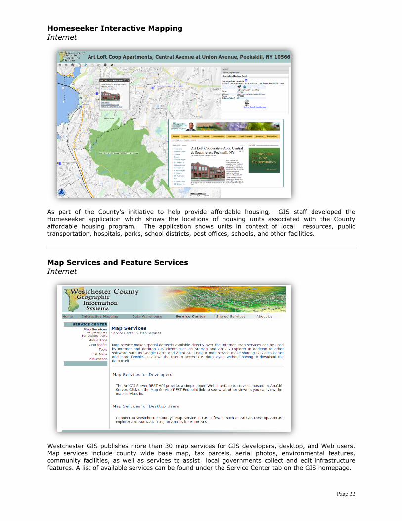
Homeseeker Interactive Mapping Internet
As part of the County’s initiative to help provide affordable housing, GIS staff developed the Homeseeker application which shows the locations of housing units associated with the County affordable housing program. The application shows units in context of local resources, public transportation, hospitals, parks, school districts, post offices, schools, and other facilities.
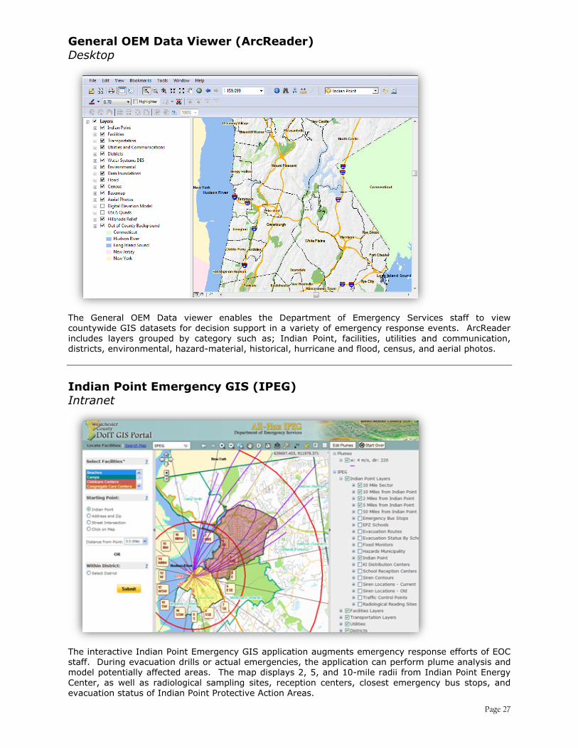
Map Services and Feature Services Internet
Westchester GIS publishes more than 30 map services for GIS developers, desktop, and Web users. Map services include county wide base map, tax parcels, aerial photos, environmental features, community facilities, as well as services to assist local governments collect and edit infrastructure features. A list of available services can be found under the Service Center tab on the GIS homepage.
Page 22

Spatial Data Warehouse Internet
Westchester County provides public access to hundreds geospatial datasets online, both directly from the interactive maps or via the data warehouse. New datasets for download include 2013 base map planimetrics and orthophotography, federal and state environmental GIS coverages, and municipal tax parcel boundaries. Automated Sewer Manhole Inspection Intranet
Automated Sewer Manhole Inspection (ASMI) is a browser-based intranet application which provides access to a wide range of maps, GIS coverages, geo-references images, and videos relative to the County’s sanitary sewer infrastructure. ASMI allows DEF staff to edit attributes and spatial information on DEF sanitary sewer manholes, pump stations, and trunk lines.
Page 23

County Bridge Inventory Intranet
Working with DPW engineering staff, County GIS developed an intranet application showing the detailed locations of 300 county owned bridges. The application provides linkages to NYS bridge inspection reports and will also provide access to other relevant reports, engineering documents, and photographs. Municipal Infrastructure Mapping Data Development
An infrastructure base map series has been created for distribution to local governments to help support inventory mapping, maintenance and inspection programs. Critical infrastructure systems include, public water, sanitary sewers, and storm water components.
Page 24

Mobile Data Collection Data Development
County GIS is utilizing the ESRI mobile Collector App on Android devices to support field data collection. Four municipalities have already completed street sign inventories, with another currently underway. To date over 19,000 street signs have been mapped. Additional municipalities are scheduled over the next six-nine months. Base Mapping Project Data Development
Based on Spring 2013 leaf-off aerial photography, the countywide digital base map - including half-foot resolution color orthophotography and updated planimetric datasets such as street centerlines, structures and transportation features - was delivered and completed Spring 2014. Base map datasets are integrated in nearly every County and local government GIS mapping application.
Page 25

Food Bank for Westchester Collaborative GIS
GIS staff is assisting the Food Bank for Westchester on mapping food distribution patterns and “areas of need” throughout county municipalities. Staff is providing American Community Survey 5-Year estimates data which can be useful for additional mapping, reports, and Food Bank outreach efforts. Disaster Planning Map for Red Cross Collaborative GIS
GIS staff recently teamed with the American Red Cross to design a hard copy map which is intended to help Red Cross staff quickly initiate shelter operations during an Indian Point radiological event. The map features prepositioned supplies, key roads, evacuation routes, bridge clearances, primary vendors, reception centers, shelter sites, and medical services.
Page 26
General OEM Data Viewer (ArcReader) Desktop
The General OEM Data viewer enables the Department of Emergency Services staff to view countywide GIS datasets for decision support in a variety of emergency response events. ArcReader includes layers grouped by category such as; Indian Point, facilities, utilities and communication, districts, environmental, hazard-material, historical, hurricane and flood, census, and aerial photos. Indian Point Emergency GIS (IPEG) Intranet
The interactive Indian Point Emergency GIS application augments emergency response efforts of EOC staff. During evacuation drills or actual emergencies, the application can perform plume analysis and model potentially affected areas. The map displays 2, 5, and 10-mile radii from Indian Point Energy Center, as well as radiological sampling sites, reception centers, closest emergency bus stops, and evacuation status of Indian Point Protective Action Areas.
Page 27

Business Analyst Online (BAO) Internet Business Analyst Online (BAO) is an online application hosted by ESRI which provides access to up-to-date demographics, business and market data analysis. BAO allows the Office of Economic Development and Planning Department staff to generate maps based on user defined locations and reports that can be downloaded as a spreadsheet or PDF. School District Boundary Update
Countywide school district boundaries are currently being reviewed and modified as of December 2014. The effort includes outreach and coordination with each school district which was sent a map to review and annotate as needed. Local tax maps and assessment files were also used to establish determine boundary lines. Work is anticipated to continue through first quarter 2015.
Page 28

Westchester County GIS on the Web The Westchester County GIS website offers a number of services to the public including GIS mapping applications and datasets available for download in both ESRI and Google Earth file formats. The Service Center provides access to available mapping tools, websites and other geospatial resources. Users can view current and past projects, GIS newsletters, maps, and posters. Contact information relative to GIS Shared Services with local governments is also provided. In 2014, the website was viewed in 134 countries or territories and in 93 languages.
Page 29

Shared Services Beginning in the early 1990’s, Westchester County was one of the first counties in New York State to establish and implement geospatial programs that provided GIS outreach to local governments. Since then, Westchester County GIS has been successful in assisting local governments in building geospatial capacity through a variety of Shared Services initiatives. Early efforts by GIS staff under the Shared Services program focused on conducting user needs studies, data collection, providing assistance with desktop applications, and “start-up” implementation efforts. While many of these early efforts remain relative today, 2015 collaborative programs with local governments focus on strategic geospatial data and application development efforts. Priority data development efforts focus on critical infrastructure mapping, tax parcel mapping, and the delivery of authoritative base map datasets from the 2013 photogrammetric base map update. Leveraging the county’s built GIS hardware and software infrastructure, local governments can gain access to cost-effective web enabled GIS solutions for data access and viewing. 2015-2017 outreach is anticipated to continue with local governments with regard to holding technical advisory meetings, guidance on application and data development efforts, consultant selection, and maintaining the most valuable component of the County–local government geospatial relationship: Data Sharing. During this same timeframe, it is expected requests for County GIS products and services will increase from the nonprofit sector and from the school systems as the use of geospatial technology in school system programs continues to grow. GIS staff continues to advocate at both the state and federal level for grant programs supporting local government GIS. County GIS staff proactively represents County and local geospatial technology interests as part of the New York State GIS Association (www.nysgis.org). Staff routinely works in concert with consultants and GIS contractors on behalf of local governments to provide seminars and demonstrations. Through the Shared Services program, Westchester County GIS staff is available to local governments, nonprofits, and community groups to provide:
• Geospatial map services • Desktop GIS support • GIS Project Management • Data development and conversion • Data hosting (County GIS Data Warehouse) • User Needs Assessments
Page 30

• GIS training and education • Consultant coordination and recommendations
Local government assistance is provided annually to nearly all municipalities in Westchester County.
Program Metrics GIS system metrics provide a means to periodically measure various components of the County's GIS program. Such metrics are also commonly referred to as "key performance indicators". Within the GIS program, quantitative indicators focusing on Web activity, data downloads, software licensing, user training, internal application usage, annual data maintenance activities, and outreach to local governments, all provide key statistics and measurements assuring the program's accountability and demonstrating its value to County government and residents. For the purpose of establishing baseline metrics to which future assessments can be compared, key 2014 GIS program metrics include the following:
WEB SERVICES (Intranet and Internet) 1/1/2014 – 12/31/2014
GIS Web
GIS Web Site # of Visits Jan. 1 –Dec.31,2014 Website has been accessed from 134 different countries around the world in 93 different languages 115,240
Data Downloads # of Downloads Countywide Download 1,763
Base Map Download 537 Municipal Tax Parcel Download 3,836
Topo Download 3,097 LiDAR Download 1,427
Total Downloads 18,618
GIS INTERNET Applications # of Views Municipal Tax Parcel Viewer 164,189
Mapping Westchester County 153,923 Homeseeker Map 4,430
Licensed Contractors 1,974 Health Care Navigator 1,768
GIS INTRANET Applications # of Views Police District Locator 10,625
Call Before You Dig (DEF) 17,412 Sex Offender Address Verification 579 DOH Septic Management System 168
Historic Aerial Photos 68
Page 31

PROGRAM SUPPORT 1/1/2014 – 12/31/2014
Geo Utilities 2014 Enterprise Geocoding Service (Function calls) 612,826 GeoWebcast (Calls placed) 350,000 Septic Management Program (Records) 15,800 Human Resources Examination Notification Application 5,246 Municipal Government GIS Development Tax Parcel Viewers (Municipalities) 42 Municipal GIS Meetings 39 Municipal Websites linked to Mapping Westchester County 24 Historic Aerial Photos Georeferencing 1990 (Number of images registered) 214 Emergency Services (60 Control) Map Correction Requests (MCRs) (Edit requests) 229 Map Requests 190 GIS User Group Meetings May 2014 User Group Meeting (Attended) 178
PROGRAM SUPPORT
Systems Integration # of Users GIS Desktop Software by County Departments
Board of Elections 2 District Attorney 2 Emergency Services/Emergency Operations Center 3 Environmental Facilities 3 Information Technology – GIS 8 Health 7 IT Radio Group 1 IT Telecom 1 Office for Community Mental Health 1 Parks, Recreation and Conservation 7 Planning 12 Probation 1 Public Works – Engineering & Traffic Divisions 10 Public Safety 3 Tax Commission 1 Transportation 4
Total Geospatial Desktop Users 66
Page 32

GIS DATABASE
User Usage Statistics GIS Database Storage Space
GIS Databases in ArcSDE and Oracle Allocated Disk Space (GB)
Used Disk Space (GB)
Production Databases 3,615 2,034 Standby Databases for Emergency 3,615 2,034 GIS Test Databases 4,615 2,119
Total Disk Space 11,845 6,187
ENTERPRISE DEPLOYMENT
System Components 2014-2015 GIS Software Licenses ArcInfo, ArcEditor and ArcView and ArcReader Unlimited ArcGIS Spatial Analyst Unlimited ArcGIS 3D Analyst Unlimited ArcGIS Publisher Unlimited ArcGIS Network Analyst Unlimited ArcGIS Schematics Unlimited Geostatistic Analyst Unlimited Workflow Manager Unlimited Maplex Unlimited ArcLogistics Unlimited ArcScan Unlimited ArcGIS for Departmental Users ArcPad Licenses 7 ArcGIS for Aviation 2 ArcGIS Data Interoperability for Desktop 1 CityEngine 3 Business Analyst 1
Page 33

ENTERPRISE DEPLOYMENT (cont.)
System Components 2014-2015 Development Tool ArcGIS Engine Runtime Developments and Extensions Unlimited Server Licenses and Extensions ArcGIS for Server (Advanced, Standard, Basic-Workgroup Enterprise) Unlimited ArcGIS Mobile Unlimited Spatial;3D;Network;Geostatiscal;Schematics;Geoportal; Job Tracking and images Unlimited
Software/Database Licenses NavTeq Data 1 Pitney Bowes Address Broker Licenses 2 Oracle Real Application Clusters 20 GeoExpress & Express Server (LizardTech) 1 LiDAR Compressor software 1 Terra Go (GeoPDF) 3 Pictometry Software (29 installs) Unlimited System Hardware Servers 28 Plotters with large format scanner 1 PC’s, laptops and mobile devices 32
Page 34

GIS System Architecture
Page 35
Related Documents