Geochronological, morphometric and geochemical constraints on the Pampas Onduladas long basaltic flow (Payún Matrú Volcanic Field, Mendoza, Argentina) Venera R. Espanon a,b, ⁎, Allan R. Chivas a , David Phillips c , Erin L. Matchan c , Anthony Dosseto a,b a GeoQuEST Research Centre, School of Earth & Environmental Sciences, University of Wollongong, NSW 2522, Australia b Wollongong Isotope Geochronology Laboratory, School of Earth & Environmental Sciences, University of Wollongong, NSW 2522, Australia c School of Earth Sciences, The University of Melbourne, Parkville, VIC 3010, Australia abstract article info Article history: Received 9 August 2014 Accepted 28 October 2014 Available online 10 November 2014 Keywords: Pampas Onduladas Long lava flow Rheology Payún Matrú Volcanic Field The Pampas Onduladas flow in southern Mendoza, Argentina, is one of the four longest Quaternary basaltic flows on Earth. Such flows (N 100 km) are relatively rare on Earth as they require special conditions in order to travel long distances and there are no recent analogues. Favourable conditions include: a gentle topographic slope, an insulation process to preserve the melt at high temperature, and a large volume of lava with relatively low vis- cosity. This study investigates the rheological and geochemical characteristics of the ~170 km long Pampas Onduladas flow, assessing conditions that facilitated its exceptional length. The study also reports the first geochronological results for the Pampas Onduladas flow. 40 Ar/ 39 Ar step-heating analyses of groundmass reveal an eruption age of 373 ± 10 ka (2σ), making the Pampas Onduladas flow the oldest Quaternary long flow. The methods used to assess the rheological properties include the application of several GIS tools to a digital el- evation model (DEM) to determine the length, width, thickness, volume and topographic slope of the flow as well as algorithms to determine its density, viscosity and temperature. The slope of the Pampas Onduladas flow deter- mined from the initial part of the flow on the eastern side of La Carbonilla Fracture to its end point in the province of La Pampa is 0.84% (0.29°), the steepest substrate amongst long Quaternary flows. The rheological properties, such as density viscosity and temperature from the Pampas Onduladas flow are similar to values reported for other long Quaternary flows. However, the minimum volume calculated is relatively low for its length compared with other long Quaternary flows. Therefore, the extension of the Pampas Onduladas flow was probably con- trolled by a steep slope, combined with an insulating mechanism, which helped in providing optimal conditions for a travel length of almost 170 km. © 2014 Elsevier B.V. All rights reserved. 1. Introduction Long basaltic flows (N 100 km) produced in a single volcanic erup- tion are unusual on Earth (but common on Mars), as they require rela- tively large lava volumes and steep slopes (Keszthelyi and Self, 1998; Keszthelyi et al., 2004). For the Quaternary (b 2.6 Ma), only four flows have been reported to be longer than 100 km, and there are no historic analogues of long flows. The four long Quaternary flows recognised are: the Toomba and Undara flows in Queensland, Australia (Stephenson et al., 1998); the Thjorsa flow in Iceland (Vilmundardottir, 1977); and the Pampas Onduladas flow in Mendoza, Argentina (Pasquarè et al., 2005). These have reported volumes greater than 12 km 3 and a pahoehoe character. Some of the basic requirements for long basaltic flows are: (1) an insulating mechanism to maintain the lava at high temperature; and (2) a large volume of erupted lava (Pinkerton and Wilson, 1994). The four long Quaternary basaltic flows exhibit inflation structures such as lava rises and/or tumuli and in some cases lava tubes such as in the Toomba and Undara flows (Stephenson et al., 1998) that insulate the lava, thereby reducing its cooling by b 50 °C/100 km accord- ing to the models of Keszthelyi and Self (1998). Of special interest is the Pampas Onduladas flow as it has been described as the longest on Earth during the Quaternary (Pasquarè et al., 2008). It has a relatively narrow (~5 km) tongue-like structure that dominates for more than 70% of its length and lacks lava tube structures. Despite the significance of the Pampas Onduladas flow, rheological, geochemical and geochronological analyses are lacking. Previous inves- tigations mainly dealt with recognising and describing this flow from a morphological view point (Pasquarè et al., 2005, 2008). The purpose of this investigation is to assess some of the physical parameters and Journal of Volcanology and Geothermal Research 289 (2014) 114–129 ⁎ Corresponding author at: Wollongong Isotope Geochronology Laboratory, School of Earth & Environmental Sciences, University of Wollongong, NSW 2522, Australia. Tel.: +61 24221 5899; fax: +61 242214250. E-mail addresses: [email protected] (V.R. Espanon), [email protected] (A.R. Chivas), [email protected] (D. Phillips), [email protected] (E.L. Matchan), [email protected] (A. Dosseto). http://dx.doi.org/10.1016/j.jvolgeores.2014.10.018 0377-0273/© 2014 Elsevier B.V. All rights reserved. Contents lists available at ScienceDirect Journal of Volcanology and Geothermal Research journal homepage: www.elsevier.com/locate/jvolgeores

Welcome message from author
This document is posted to help you gain knowledge. Please leave a comment to let me know what you think about it! Share it to your friends and learn new things together.
Transcript
Journal of Volcanology and Geothermal Research 289 (2014) 114–129
Contents lists available at ScienceDirect
Journal of Volcanology and Geothermal Research
j ourna l homepage: www.e lsev ie r .com/ locate / jvo lgeores
Geochronological, morphometric and geochemical constraints on thePampas Onduladas long basaltic flow (Payún Matrú Volcanic Field,Mendoza, Argentina)
Venera R. Espanon a,b,⁎, Allan R. Chivas a, David Phillips c, Erin L. Matchan c, Anthony Dosseto a,b
a GeoQuEST Research Centre, School of Earth & Environmental Sciences, University of Wollongong, NSW 2522, Australiab Wollongong Isotope Geochronology Laboratory, School of Earth & Environmental Sciences, University of Wollongong, NSW 2522, Australiac School of Earth Sciences, The University of Melbourne, Parkville, VIC 3010, Australia
⁎ Corresponding author at: Wollongong Isotope GeochEarth & Environmental Sciences, University of WolloTel.: +61 24221 5899; fax: +61 242214250.
E-mail addresses: [email protected] (V.R. Espan(A.R. Chivas), [email protected] (D. Phillips), emat(E.L. Matchan), [email protected] (A. Dosseto).
http://dx.doi.org/10.1016/j.jvolgeores.2014.10.0180377-0273/© 2014 Elsevier B.V. All rights reserved.
a b s t r a c t
a r t i c l e i n f oArticle history:Received 9 August 2014Accepted 28 October 2014Available online 10 November 2014
Keywords:Pampas OnduladasLong lava flowRheologyPayún Matrú Volcanic Field
The Pampas Onduladasflow in southernMendoza, Argentina, is one of the four longest Quaternary basaltic flowson Earth. Such flows (N100 km) are relatively rare on Earth as they require special conditions in order to travellong distances and there are no recent analogues. Favourable conditions include: a gentle topographic slope,an insulation process to preserve themelt at high temperature, and a large volume of lavawith relatively low vis-cosity. This study investigates the rheological and geochemical characteristics of the ~170 km long PampasOnduladas flow, assessing conditions that facilitated its exceptional length. The study also reports the firstgeochronological results for the Pampas Onduladas flow. 40Ar/39Ar step-heating analyses of groundmass revealan eruption age of 373 ± 10 ka (2σ), making the Pampas Onduladas flow the oldest Quaternary long flow.The methods used to assess the rheological properties include the application of several GIS tools to a digital el-evationmodel (DEM) todetermine the length,width, thickness, volumeand topographic slope of theflowaswellas algorithms to determine its density, viscosity and temperature. The slope of the PampasOnduladasflowdeter-mined from the initial part of theflowon the eastern side of La Carbonilla Fracture to its end point in the provinceof La Pampa is 0.84% (0.29°), the steepest substrate amongst long Quaternary flows. The rheological properties,such as density viscosity and temperature from the Pampas Onduladas flow are similar to values reported forother long Quaternary flows. However, the minimum volume calculated is relatively low for its length comparedwith other long Quaternary flows. Therefore, the extension of the Pampas Onduladas flow was probably con-trolled by a steep slope, combined with an insulating mechanism, which helped in providing optimal conditionsfor a travel length of almost 170 km.
© 2014 Elsevier B.V. All rights reserved.
1. Introduction
Long basaltic flows (N100 km) produced in a single volcanic erup-tion are unusual on Earth (but common on Mars), as they require rela-tively large lava volumes and steep slopes (Keszthelyi and Self, 1998;Keszthelyi et al., 2004). For the Quaternary (b2.6 Ma), only four flowshave been reported to be longer than 100 km, and there are no historicanalogues of long flows. The four long Quaternary flows recognised are:the Toomba and Undara flows in Queensland, Australia (Stephensonet al., 1998); the Thjorsa flow in Iceland (Vilmundardottir, 1977); andthe Pampas Onduladas flow in Mendoza, Argentina (Pasquarè et al.,
ronology Laboratory, School ofngong, NSW 2522, Australia.
on), [email protected]@unimelb.edu.au
2005). These have reported volumes greater than 12 km3 and apahoehoe character. Some of the basic requirements for long basalticflows are: (1) an insulating mechanism to maintain the lava at hightemperature; and (2) a large volume of erupted lava (Pinkerton andWilson, 1994). The four long Quaternary basaltic flows exhibit inflationstructures such as lava rises and/or tumuli and in some cases lava tubessuch as in the Toomba and Undara flows (Stephenson et al., 1998) thatinsulate the lava, thereby reducing its cooling by b50 °C/100 kmaccord-ing to themodels of Keszthelyi and Self (1998). Of special interest is thePampas Onduladas flow as it has been described as the longest on Earthduring the Quaternary (Pasquarè et al., 2008). It has a relatively narrow(~5 km) tongue-like structure that dominates for more than 70% of itslength and lacks lava tube structures.
Despite the significance of the Pampas Onduladas flow, rheological,geochemical and geochronological analyses are lacking. Previous inves-tigations mainly dealt with recognising and describing this flow from amorphological view point (Pasquarè et al., 2005, 2008). The purpose ofthis investigation is to assess some of the physical parameters and
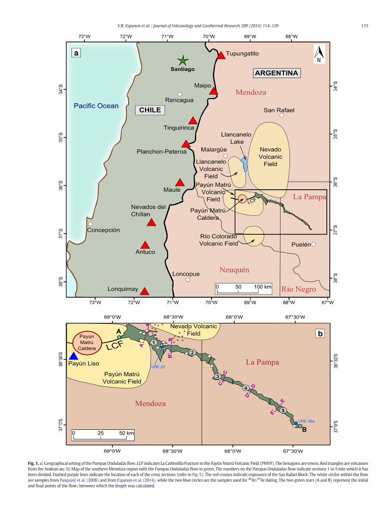
Fig. 1. a)Geographical setting of the PampasOnduladasflow. LCF indicates La Carbonilla Fracture in the PayúnMatrúVolcanic Field (PMVF). The hexagons are towns. Red triangles are volcanoesfrom the Andean arc. b)Map of the southernMendoza regionwith the Pampas Onduladas flow in green. The numbers on the Pampas Onduladas flow indicate sections 1 to 5 intowhich it hasbeen divided. Dashed purple lines indicate the location of each of the cross sections (refer to Fig. 5). The red crosses indicate exposures of the San Rafael Block. Thewhite circles within the floware samples from Pasquarè et al. (2008) and from Espanon et al. (2014), while the two blue circles are the samples used for 40Ar/39Ar dating. The two green stars (A and B) represent the initialand final points of the flow; between which the length was calculated.
115V.R. Espanon et al. / Journal of Volcanology and Geothermal Research 289 (2014) 114–129
116 V.R. Espanon et al. / Journal of Volcanology and Geothermal Research 289 (2014) 114–129
geochemical characteristics of this flow, in order to comprehend thefactors that have facilitated its length, and to also determine the erup-tion age.
2. Background
2.1. Regional geological setting
The Andean volcanic arc occupies the western margin of SouthAmerica and is dominated by andesitic lavas with abundant pyroclasticejecta. This volcanism mainly results from the dehydration of thesubducting oceanic plate to the west of the South American plate(Thorpe, 1984). The subducting oceanic plates are the Nazca platefrom ~5°N to ~46°S and the Antarctic plate from ~46°S. The volcanicarc is not continuous along the Andes as in areas of flat (sub-horizontal)subduction volcanic activity is absent. The Nazca plate subducts at ashallow angle along the Peruvian and the Pampean flat slab segmentsconstituting the divide between the Northern and Central volcaniczones and between the Central and the Southern volcanic zones, respec-tively (Stern, 2004). The Southern and Austral volcanic zones are sepa-rated by the Chile rise which constitutes the boundary between theNazca and the Antarctic plates.
Despite the abundance of arc volcanism, alkali basaltic volcanismalso occurs behind the main Andean volcanic arc, this volcanism istermed continental back-arc volcanism. In this setting, the subductionsignature decreases in an easterly direction from the arc (Stern et al.,1990; Rivalenti et al., 2004; Jacques et al., 2013). A high density of con-tinental back-arc volcanism is found in the Southern volcanic zonemainly due to changes in subduction regime (Kay et al., 2006). Thecurrent investigation is based on the northernmost back-arc basalticprovince from the Southern volcanic zone called the Payenia BasalticProvince (PBP), defined by Polanski (1954) (also described as theAndino–Cuyana Basaltic Province by Bermúdez and Delpino, 1989).The PBP covers an area of approximately 40,000 km2, with more than800 volcanic cones, the majority of them being monogenetic (Ramosand Folguera, 2011). The PBP is classified into several volcanic fields(Fig. 1) including Nevado, Llancanelo, Payún Matrú and Rio Colorado(Ramos and Folguera, 2011; Gudnason et al., 2012) mostly based ontheir geochemical diversity. In this sense, the Nevado Volcanic Fieldhas a defined subduction signature while the Rio Colorado VolcanicField has a typical intraplate signature resembling that of ocean islandbasalts (Kay et al., 2013; Søager et al., 2013). The Llancanelo VolcanicField has weak subduction signature while the same type of signaturewas not recognised in the Payún Matrú Volcanic Field (PMVF;Espanon et al., 2014). The basalts from the Payún Matrú Volcanic Fieldhave an intraplate geochemical signature similar to that of the RioColorado Volcanic Field (Espanon et al., 2014). The Pampas Onduladasflow is part of the PMVF and is located on the eastern side of this
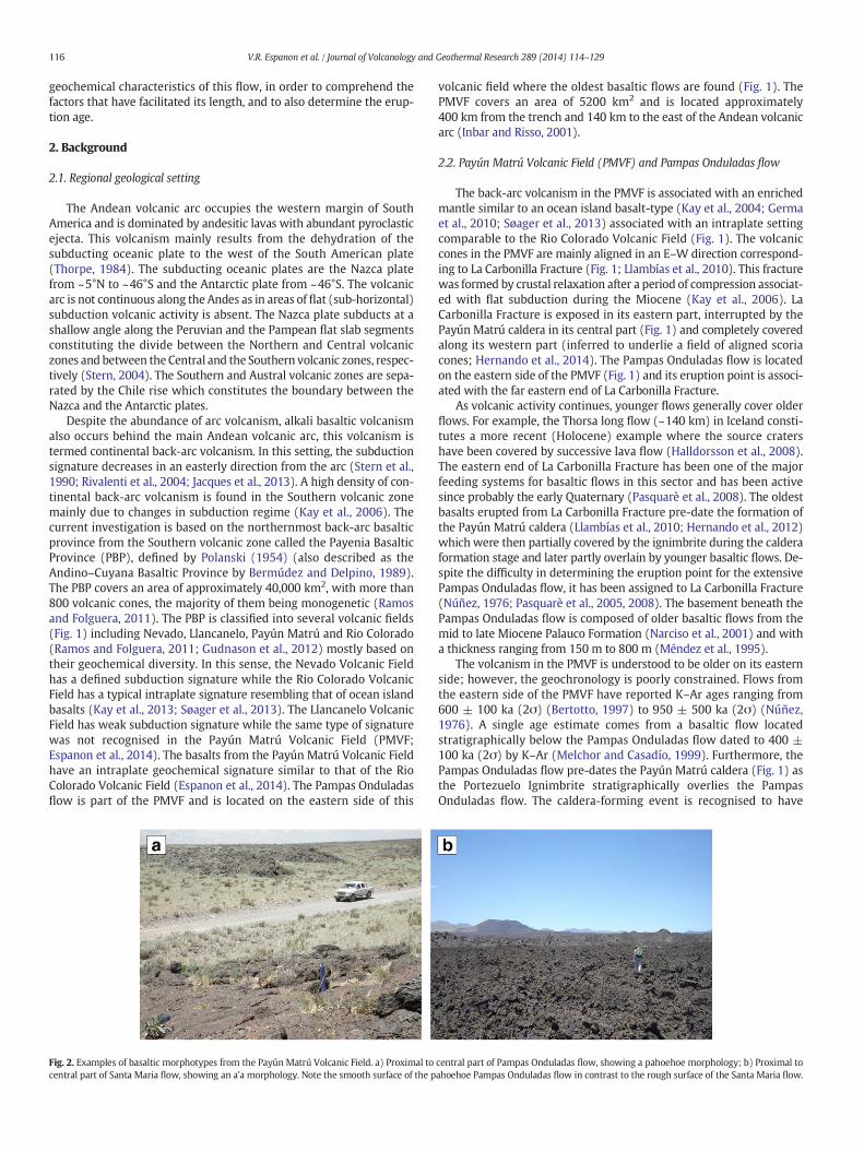
Fig. 2. Examples of basaltic morphotypes from the Payún Matrú Volcanic Field. a) Proximal tocentral part of Santa Maria flow, showing an a'a morphology. Note the smooth surface of the p
volcanic field where the oldest basaltic flows are found (Fig. 1). ThePMVF covers an area of 5200 km2 and is located approximately400 km from the trench and 140 km to the east of the Andean volcanicarc (Inbar and Risso, 2001).
2.2. Payún Matrú Volcanic Field (PMVF) and Pampas Onduladas flow
The back-arc volcanism in the PMVF is associated with an enrichedmantle similar to an ocean island basalt-type (Kay et al., 2004; Germaet al., 2010; Søager et al., 2013) associated with an intraplate settingcomparable to the Rio Colorado Volcanic Field (Fig. 1). The volcaniccones in the PMVF are mainly aligned in an E–W direction correspond-ing to La Carbonilla Fracture (Fig. 1; Llambías et al., 2010). This fracturewas formed by crustal relaxation after a period of compression associat-ed with flat subduction during the Miocene (Kay et al., 2006). LaCarbonilla Fracture is exposed in its eastern part, interrupted by thePayún Matrú caldera in its central part (Fig. 1) and completely coveredalong its western part (inferred to underlie a field of aligned scoriacones; Hernando et al., 2014). The Pampas Onduladas flow is locatedon the eastern side of the PMVF (Fig. 1) and its eruption point is associ-ated with the far eastern end of La Carbonilla Fracture.
As volcanic activity continues, younger flows generally cover olderflows. For example, the Thorsa long flow (~140 km) in Iceland consti-tutes a more recent (Holocene) example where the source cratershave been covered by successive lava flow (Halldorsson et al., 2008).The eastern end of La Carbonilla Fracture has been one of the majorfeeding systems for basaltic flows in this sector and has been activesince probably the early Quaternary (Pasquarè et al., 2008). The oldestbasalts erupted from La Carbonilla Fracture pre-date the formation ofthe Payún Matrú caldera (Llambías et al., 2010; Hernando et al., 2012)which were then partially covered by the ignimbrite during the calderaformation stage and later partly overlain by younger basaltic flows. De-spite the difficulty in determining the eruption point for the extensivePampas Onduladas flow, it has been assigned to La Carbonilla Fracture(Núñez, 1976; Pasquarè et al., 2005, 2008). The basement beneath thePampas Onduladas flow is composed of older basaltic flows from themid to late Miocene Palauco Formation (Narciso et al., 2001) and witha thickness ranging from 150 m to 800 m (Méndez et al., 1995).
The volcanism in the PMVF is understood to be older on its easternside; however, the geochronology is poorly constrained. Flows fromthe eastern side of the PMVF have reported K–Ar ages ranging from600 ± 100 ka (2σ) (Bertotto, 1997) to 950 ± 500 ka (2σ) (Núñez,1976). A single age estimate comes from a basaltic flow locatedstratigraphically below the Pampas Onduladas flow dated to 400 ±100 ka (2σ) by K–Ar (Melchor and Casadío, 1999). Furthermore, thePampas Onduladas flow pre-dates the Payún Matrú caldera (Fig. 1) asthe Portezuelo Ignimbrite stratigraphically overlies the PampasOnduladas flow. The caldera-forming event is recognised to have
central part of Pampas Onduladas flow, showing a pahoehoe morphology; b) Proximal toahoehoe Pampas Onduladas flow in contrast to the rough surface of the Santa Maria flow.
117V.R. Espanon et al. / Journal of Volcanology and Geothermal Research 289 (2014) 114–129
occurred between 168 ± 4 ka and 82 ± 2 ka based on K–Ar dating(Germa et al., 2010), providing a minimum age constraint for the Pam-pas Onduladas flow. Therefore, its age is possibly younger than 400 kaand older than 168 ka.
The Pampas Onduladas flow aswell asmost of the older flows in thePMVF, has a pahoehoe character, in contrast to the younger flows(b10 ka), which are dominated by a'a morphology (Inbar and Risso,2001; Fig. 2). The Pampas Onduladas flow has been described by
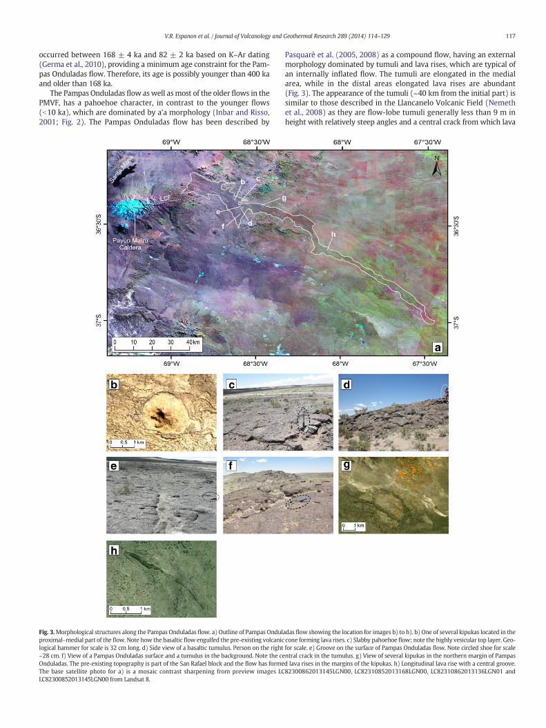
Fig. 3.Morphological structures along the Pampas Onduladas flow. a) Outline of Pampas Ondulproximal–medial part of the flow. Note how the basalticflow engulfed the pre-existing volcaniclogical hammer for scale is 32 cm long. d) Side view of a basaltic tumulus. Person on the right~28 cm. f) View of a Pampas Onduladas surface and a tumulus in the background. Note the ceOnduladas. The pre-existing topography is part of the San Rafael block and the flow has formeThe base satellite photo for a) is a mosaic contrast sharpening from preview images LCLC82300852013145LGN00 from Landsat 8.
Pasquarè et al. (2005, 2008) as a compound flow, having an externalmorphology dominated by tumuli and lava rises, which are typical ofan internally inflated flow. The tumuli are elongated in the medialarea, while in the distal areas elongated lava rises are abundant(Fig. 3). The appearance of the tumuli (~40 km from the initial part) issimilar to those described in the Llancanelo Volcanic Field (Nemethet al., 2008) as they are flow-lobe tumuli generally less than 9 m inheight with relatively steep angles and a central crack from which lava
adas flow showing the location for images b) to h). b) One of several kipukas located in thecone forming lava rises. c) Slabby pahoehoe flow; note the highly vesicular top layer. Geo-for scale. e) Groove on the surface of Pampas Onduladas flow. Note circled shoe for scalentral crack in the tumulus. g) View of several kipukas in the northern margin of Pampasd lava rises in the margins of the kipukas. h) Longitudinal lava rise with a central groove.82300862013145LGN00, LC82310852013168LGN00, LC82310862013136LGN01 and
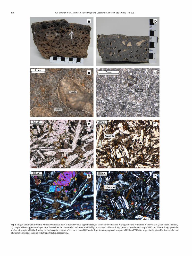
Fig. 4. Images of samples from the Pampas Onduladas flow. a) Sample VRE20 uppermost layer. White arrow indicates way up, note the roundness of the vesicles (scale in cm and mm).b) Sample VRE46a uppermost layer. Note the vesicles are not rounded and some are filled by carbonates. c) Photomicrograph of a cut surface of sample VRE21. d) Photomicrograph of thesurface of sample VRE46a showing the high crystal content of the rock. e) and f) Polarised photomicrographs of samples VRE20 and VRE46a, respectively. g) and h) Cross-polarisedphotomicrographs of samples VRE20 and VRE46a, respectively.
118 V.R. Espanon et al. / Journal of Volcanology and Geothermal Research 289 (2014) 114–129
Table 1Major- and trace-element analysis of the Pampas Onduladas flow. Themajor-elements are inwt.% and the trace elements are in ppm. Themajor-elements are recalculated to an anhydrousbasis (original data Pasquarè et al., 2008; Espanon et al., 2014).
Sample VRE19 VRE20 VRE21 VRE46 (A) VRE47 PY16 PY20
Latitude (°) −36.4124 −36.4085 −36.3732 −36.9712 −36.9987 −36.3939 −36.2919
Longitude (°) −68.5789 −68.5800 −68.5754 −67.4923 −67.4992 −68.6413 −68.7628
SiO2 47.16 48.22 49.51 49.01 48.86 47.82 47.73TiO2 1.97 1.96 1.91 1.78 1.54 1.63 1.65Al2O3 17.36 17.45 18.09 17.23 16.30 17.88 18.28FeOt 11.78 11.49 10.75 11.55 11.98 10.86 10.03MnO 0.15 0.15 0.15 0.15 0.15 0.14 0.16MgO 7.21 6.94 5.90 7.01 8.82 7.91 7.61CaO 8.91 8.79 8.61 8.75 8.01 8.36 9.53Na2O 3.93 3.50 3.23 3.24 3.39 3.82 3.27K2O 1.04 1.01 1.33 0.89 0.67 1.04 0.84P2O5 0.48 0.49 0.48 0.38 0.27 0.39 0.32V 221 225 242 221 186 133 192Cr 197 190 244 247 293 298 196Ni 81 77 105 144 216 109 73Rb 14.5 14.8 22.8 12.7 9.5 18.0 15.0Sr 642 638 626 557 367 600 587Y 23.5 23.1 22.6 20.8 18.4 16.0 16.0Zr 148 149 199 135 104 123 123Nb 19.0 19.3 22.3 13.6 9.5 15.0 14.0Cs 0.3 0.3 0.3 0.2 0.2 0.3 0.5Ba 308 475 510 320 183 305 356La 18.7 18.4 20.4 14.0 10.7 14.9 16.0Ce 37.6 36.0 34.4 28.6 22.6 31.5 34.7Pr 5.0 4.9 5.1 3.9 3.1 3.9 4.5Nd 23.2 22.4 23.3 18.5 14.7 17.3 20.1Sm 5.6 5.5 5.6 4.8 4.0 4.3 5.0Eu 1.9 1.8 1.8 1.7 1.4 1.6 1.8Gd 5.5 5.4 5.3 5.0 4.1 4.3 4.9Tb 0.9 0.8 0.9 0.8 0.7 0.7 0.8Dy 4.9 4.7 4.6 4.3 3.8 3.9 4.4Ho 0.9 0.9 0.9 0.8 0.7 0.7 0.9Er 2.5 2.4 2.4 2.2 2.0 1.9 2.3Tm 0.3 0.3 0.3 0.3 0.3 0.3 0.3Yb 2.1 2.1 2.1 1.9 1.6 1.5 1.8Lu 0.3 0.3 0.3 0.3 0.2 0.2 0.3Hf 3.7 3.7 4.9 3.4 2.7 2.5 3.3Ta 1.1 1.1 1.4 0.8 0.5 0.7 0.7Pb 3.5 3.4 4.8 3.8 2.6 3.0Th 2.0 2.0 3.2 1.7 1.3 1.5 1.6U 0.5 0.5 0.8 0.5 0.3 0.5
Sample PY23 PY24 PY25 PY34a PY34b SAL1 SAL4
Latitude (°) −36.4597 −36.4721 −36.5541 −36.9702 −36.9702 −36.2764 −36.2944
Longitude (°) −68.3886 −68.1894 −68.1754 −67.4913 −67.4913 −68.7088 −68.7316
SiO2 47.56 47.25 47.86 48.75 47.25 48.86 47.86TiO2 1.9 1.83 1.77 1.73 1.49 1.85 1.78Al2O3 17.53 17.2 17.56 17.49 16.83 16.48 16.2FeOt 10.74 10.65 11.15 10.65 10.81 11.21 11.1MnO 0.16 0.16 0.16 0.16 0.18 0.17 0.16MgO 6.87 7.35 7.3 7.62 9.14 6.96 7.05CaO 9.5 9.39 8.96 8.75 9.32 9.78 10.17Na2O 3.47 3.5 3.46 3.5 3.43 3.74 3.61K2O 1.01 0.91 0.93 0.86 0.82 1.28 1.22P2O5 0.37 0.35 0.35 0.29 0.26 0.44 0.44V 179 187 188 152 197 210 217Cr 221 256 256 247 417 240 220Ni 82 97 103 115 190 110 110Rb 15.0 15.0 15.0 14.0 18.0 23.0 26.0Sr 583 571 564 553 518 627 621Y 16.0 16.0 18.0 15.0 16.0 21.6 23.5Zr 130 124 125 119 118 151 144Nb 18.0 17.0 17.0 14.0 11.0 16.2 15.1Cs 0.3 0.3 0.4 0.3 0.7 0.7 0.8Ba 293 257 251 238 298 303 443La 17.7 16.9 16.6 14.4 16.2 19.0 19.1Ce 37.8 36.2 36.1 30.9 35.0 40.2 40.8Pr 4.6 4.5 4.4 3.9 4.4 5.1 5.4Nd 20.9 20.0 20.5 17.5 19.5 20.9 21.6Sm 5.0 4.9 5.1 4.5 4.8 5.1 5.4Eu 1.8 1.8 1.9 1.6 1.7 1.8 1.9
(continued on next page)
119V.R. Espanon et al. / Journal of Volcanology and Geothermal Research 289 (2014) 114–129
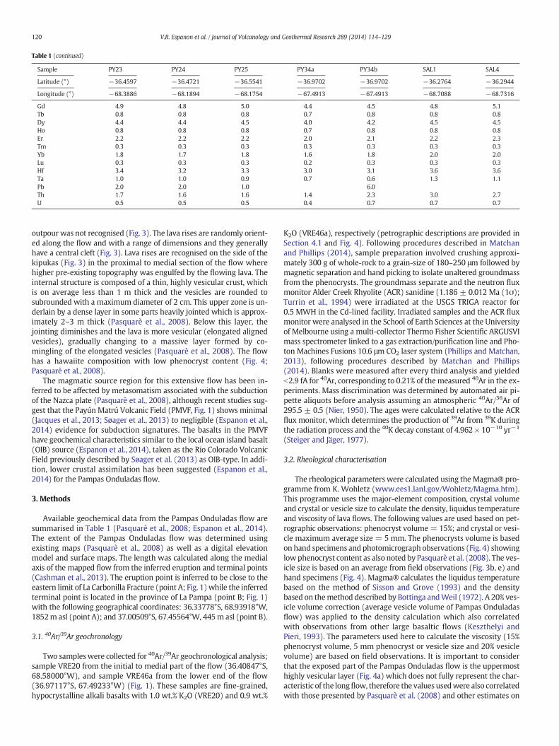
Table 1 (continued)
Sample VRE19 VRE20 VRE21 VRE46 (A) VRE47 PY16 PY20
Latitude (°) −36.4124 −36.4085 −36.3732 −36.9712 −36.9987 −36.3939 −36.2919
Longitude (°) −68.5789 −68.5800 −68.5754 −67.4923 −67.4992 −68.6413 −68.7628
Gd 4.9 4.8 5.0 4.4 4.5 4.8 5.1Tb 0.8 0.8 0.8 0.7 0.8 0.8 0.8Dy 4.4 4.4 4.5 4.0 4.2 4.5 4.5Ho 0.8 0.8 0.8 0.7 0.8 0.8 0.8Er 2.2 2.2 2.2 2.0 2.1 2.2 2.3Tm 0.3 0.3 0.3 0.3 0.3 0.3 0.3Yb 1.8 1.7 1.8 1.6 1.8 2.0 2.0Lu 0.3 0.3 0.3 0.2 0.3 0.3 0.3Hf 3.4 3.2 3.3 3.0 3.1 3.6 3.6Ta 1.0 1.0 0.9 0.7 0.6 1.3 1.1Pb 2.0 2.0 1.0 6.0Th 1.7 1.6 1.6 1.4 2.3 3.0 2.7U 0.5 0.5 0.5 0.4 0.7 0.7 0.7
Table 1 (continued)
Sample PY23 PY24 PY25 PY34a PY34b SAL1 SAL4
Latitude (°) −36.4597 −36.4721 −36.5541 −36.9702 −36.9702 −36.2764 −36.2944
Longitude (°) −68.3886 −68.1894 −68.1754 −67.4913 −67.4913 −68.7088 −68.7316
120 V.R. Espanon et al. / Journal of Volcanology and Geothermal Research 289 (2014) 114–129
outpour was not recognised (Fig. 3). The lava rises are randomly orient-ed along the flow and with a range of dimensions and they generallyhave a central cleft (Fig. 3). Lava rises are recognised on the side of thekipukas (Fig. 3) in the proximal to medial section of the flow wherehigher pre-existing topography was engulfed by the flowing lava. Theinternal structure is composed of a thin, highly vesicular crust, whichis on average less than 1 m thick and the vesicles are rounded tosubrounded with a maximum diameter of 2 cm. This upper zone is un-derlain by a dense layer in some parts heavily jointed which is approx-imately 2–3 m thick (Pasquarè et al., 2008). Below this layer, thejointing diminishes and the lava is more vesicular (elongated alignedvesicles), gradually changing to a massive layer formed by co-mingling of the elongated vesicles (Pasquarè et al., 2008). The flowhas a hawaiite composition with low phenocryst content (Fig. 4;Pasquarè et al., 2008).
The magmatic source region for this extensive flow has been in-ferred to be affected by metasomatism associated with the subductionof the Nazca plate (Pasquarè et al., 2008), although recent studies sug-gest that the Payún Matrú Volcanic Field (PMVF, Fig. 1) shows minimal(Jacques et al., 2013; Søager et al., 2013) to negligible (Espanon et al.,2014) evidence for subduction signatures. The basalts in the PMVFhave geochemical characteristics similar to the local ocean island basalt(OIB) source (Espanon et al., 2014), taken as the Rio Colorado VolcanicField previously described by Søager et al. (2013) as OIB-type. In addi-tion, lower crustal assimilation has been suggested (Espanon et al.,2014) for the Pampas Onduladas flow.
3. Methods
Available geochemical data from the Pampas Onduladas flow aresummarised in Table 1 (Pasquarè et al., 2008; Espanon et al., 2014).The extent of the Pampas Onduladas flow was determined usingexisting maps (Pasquarè et al., 2008) as well as a digital elevationmodel and surface maps. The length was calculated along the medialaxis of the mapped flow from the inferred eruption and terminal points(Cashman et al., 2013). The eruption point is inferred to be close to theeastern limit of La Carbonilla Fracture (point A; Fig. 1) while the inferredterminal point is located in the province of La Pampa (point B; Fig. 1)with the following geographical coordinates: 36.33778°S, 68.93918°W,1852m asl (point A); and 37.00509°S, 67.45564°W, 445m asl (point B).
3.1. 40Ar/39Ar geochronology
Two sampleswere collected for 40Ar/39Ar geochronological analysis;sample VRE20 from the initial to medial part of the flow (36.40847°S,68.58000°W), and sample VRE46a from the lower end of the flow(36.97117°S, 67.49233°W) (Fig. 1). These samples are fine-grained,hypocrystalline alkali basalts with 1.0 wt.% K2O (VRE20) and 0.9 wt.%
K2O (VRE46a), respectively (petrographic descriptions are provided inSection 4.1 and Fig. 4). Following procedures described in Matchanand Phillips (2014), sample preparation involved crushing approxi-mately 300 g of whole-rock to a grain-size of 180–250 μm followed bymagnetic separation and hand picking to isolate unaltered groundmassfrom the phenocrysts. The groundmass separate and the neutron fluxmonitor Alder Creek Rhyolite (ACR) sanidine (1.186 ± 0.012 Ma (1σ);Turrin et al., 1994) were irradiated at the USGS TRIGA reactor for0.5 MWH in the Cd-lined facility. Irradiated samples and the ACR fluxmonitor were analysed in the School of Earth Sciences at the Universityof Melbourne using a multi-collector Thermo Fisher Scientific ARGUSVImass spectrometer linked to a gas extraction/purification line and Pho-ton Machines Fusions 10.6 μm CO2 laser system (Phillips and Matchan,2013), following procedures described by Matchan and Phillips(2014). Blanks were measured after every third analysis and yieldedb2.9 fA for 40Ar, corresponding to 0.21% of themeasured 40Ar in the ex-periments. Mass discrimination was determined by automated air pi-pette aliquots before analysis assuming an atmospheric 40Ar/36Ar of295.5 ± 0.5 (Nier, 1950). The ages were calculated relative to the ACRflux monitor, which determines the production of 39Ar from 39K duringthe radiation process and the 40K decay constant of 4.962 × 10⁻¹⁰ yr−1
(Steiger and Jäger, 1977).
3.2. Rheological characterisation
The rheological parameters were calculated using theMagma® pro-gramme from K. Wohletz (www.ees1.lanl.gov/Wohletz/Magma.htm).This programme uses the major-element composition, crystal volumeand crystal or vesicle size to calculate the density, liquidus temperatureand viscosity of lava flows. The following values are used based on pet-rographic observations: phenocryst volume= 15%; and crystal or vesi-cle maximum average size = 5 mm. The phenocrysts volume is basedon hand specimens and photomicrograph observations (Fig. 4) showinglow phenocryst content as also noted by Pasquarè et al. (2008). The ves-icle size is based on an average from field observations (Fig. 3b, e) andhand specimens (Fig. 4). Magma® calculates the liquidus temperaturebased on the method of Sisson and Grove (1993) and the densitybased on themethod described by Bottinga andWeil (1972). A 20% ves-icle volume correction (average vesicle volume of Pampas Onduladasflow) was applied to the density calculation which also correlatedwith observations from other large basaltic flows (Keszthelyi andPieri, 1993). The parameters used here to calculate the viscosity (15%phenocryst volume, 5 mm phenocryst or vesicle size and 20% vesiclevolume) are based on field observations. It is important to considerthat the exposed part of the Pampas Onduladas flow is the uppermosthighly vesicular layer (Fig. 4a) which does not fully represent the char-acteristic of the longflow, therefore the values usedwere also correlatedwith those presented by Pasquarè et al. (2008) and other estimates on
121V.R. Espanon et al. / Journal of Volcanology and Geothermal Research 289 (2014) 114–129
long lava flows (Keszthelyi and Self, 1998). The viscosity was calculatedusing Magma® and the algorithms proposed by Bottinga and Weil(1972). Furthermore, the flow velocity was calculated using Jeffrey'sLaw equation:
v ¼ ρgθH2
8η
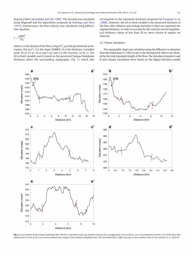
where ρ is the density of the flow (in kg/m3), g is the gravitational accel-eration (9.8 m/s2), θ is the slope (0.0084), H is the thickness (variablesused: 20 m, 15 m, 10 m and 5 m) and η is the viscosity (in Pa·s). The20 m thick variable used is based on the preserved Pampas Onduladasthickness above the surrounding topography (Fig. 5) which also
Fig. 5.Cross sections of the PampasOnduladas flow.North is to the left in each case and the vertidashed lines in each of the cross sections delimit the margins of the Pampas Onduladas flow. T
corresponds to the minimum thickness proposed by Pasquarè et al.(2008). However, the 20 m thick variable is the preserved thickness ofthe flow after inflation and cooling, therefore it does not represent theoriginal thickness. In order to account for the velocity several hypothet-ical thickness values of less than 20 m, were chosen at regular setintervals.
3.3. Volume calculation
The topographic slopewas calculated using the difference in elevationfrom the initial point A (1852masl) to the final point B (445masl) divid-ed by the total calculated length of the flow. The elevation of points A andB and volume calculation were based on the digital elevation model
cal scale is exaggerated. Cross sections a) to e) correspond to sections 1 to 5 of theflow. Redhe San Rafael block (SRB) outcrops on the northern side of cross sections A–A′ and B–B′.
Table 240Ar/39Ar results for groundmass samples from the Pampas Onduladas basaltic flow.
Sample VRE20 VRE46a
Flow sector 2 5
Plateau age Age (ka) 373 ± 10 (2σ) N/AMSWD 1.4 N/ACum 39Ar (%) 68.2 N/A
Inverse isochron age Age (ka) 349 ± 68 (2σ) 374 ± 76 (95% Cl)MSWD 1.2 35Steps included 5 of 9 9 of 9
Total-gas age Age (ka) 434 ± 10 (2σ) 370 ± 8 (2σ)
N/A, not applicable.
122 V.R. Espanon et al. / Journal of Volcanology and Geothermal Research 289 (2014) 114–129
(DEM), Shuttle Radar Topography Mission (SRTM) 90 m (30 m × 30 m)with an absolute vertical error of less than 9 m and a relative verticalerror of less than 10 m (Rodriguez et al., 2006). Five cross-sections(Fig. 1) were made along the flow in order to assess the topographic cor-relation between the flow and the adjacent pre-existing surfaces, as wellas to estimate its thickness. The volume was calculated using the proce-dure described by Smith et al. (2009) based on the SRTMdigital elevationmodel and employing the ArcGIS® software. To calculate the volume, thePampas Onduladas flowwas divided into 5 sectors (Fig. 1) in order to ac-count for the changes in slope and adjacent topography. The volumewascalculated for each individual segment and then summed to provide thetotal. There are areas of the flow, especially in its proximal part, whereit is interrupted by the pre-existing topography (kipukas) such as scoriacones and elevated landscapes (i.e. parts of theflowwhere the underlyingsubstrate has not been covered; Fig. 3a, f). The volumes of each of thekipukas was calculated and later subtracted from the total (see followingsection for further details). The errors associatedwith the volume calcula-tions have not been determined as this is a first-order estimate of thevolume (see Smith et al., 2009) and there are several potential sourcesof error that are difficult to quantify. The possible sources of error include:(1) the SRTMhas an absolute height error of less than 9m in a global scaleand 6.2 m for South America (Rodriguez et al., 2006); (2) digitalisation isbased on user interpretation; (3) topographic highs on the sides of theflowmay give inaccurate base surfaces; and (4) data point interpolation.The interpolation algorithm uses the values from the sides of the flow tocreate a planar estimate of the underlying surface; however the interpo-lation does not consider topographic lows that may have existed beforethe lava emplacement.
3.3.1. Detailed volume calculation methodThe volumewas calculated bymodifying the approach of Smith et al.
(2009). The procedure used is described in several steps.
(1) The Pampas Onduladas flow was digitised using Landsat7 imag-ery Google Earth® and then divided into 5 segments. In addition,features such as kipukas, were also digitised.
(2) The files createdwhere exported to ArcGIS10® and the remaininganalyseswere performedusing this software. The volumewas cal-culated individually for each sector and kipuka. The total volumewas determined by summing all the sector volumes. The sameprinciple was applied to all the kipukas. Finally, the total volumeof the kipukas was subtracted from the total volume.
(3) The SRTM 90 m (30 m × 30 m) digital elevation model coveringthe area of interest was uploaded to ArcGIS10®. Using theWindows tool, selecting the sector shapefile and employing thecreate-a-void command, a cavity covering the area of the sectorwas created in the DEM. Basically, in this step, the sector of theflowbeing calculatedwas removed from theDEM. The same prin-ciple was applied for the kipukas.
(4) After removing the sectors, the surrounding topography was in-terpolated to create an approximate base surface. In order to dothis, all the values of each cell in the SRTM were converted topoint values using the conversion tool. Once the new point layerwas created, interpolation between point values was carried out.The interpolation tool used is the spline (Smith et al., 2009) andthe output cell size was set with the default value for sector 1.The default value used for sector 1 was then used for all sectorsfrom 2 to 5.
(5) The hypothetical basal surface created, was isolated from the restof theDEM. Thiswas doneusing theWindows tool and employingthe clip option. The resulting layer should only contain the inter-polated base area of the sector. The same principle was appliedto the original DEM so that the top surface of the sectorwas isolat-ed from the rest of the DEM.
(6) Once the base and top part of a particular section were isolated,the volume and area of the top and the base surface were
calculated separately using the area and volume statistics option.In the calculation, the plane height differed from sector to sectoras they have different elevations; therefore the default value foreach particular sector was used. The calculated volume and areafrom the top and base of the sector were exported into Excel.
(7) The final volume of each sector was calculated using Excel bysubtracting the base volume from the top volume. The volumefrom the 5 sectors was summed and the volume from the kipukasthat interrupted the Pampas Onduladas flow was subtracted.
4. Results
4.1. Petrographic description of Pampas Onduladas flow
The Pampas Onduladas samples are highly vesicular in the upper-most layer (Fig. 4) with well developed roundness in the proximal-middle part of the flow (Fig. 4a) while the vesicles are longitudinallydeformed in the distal part (Fig. 4b). Nevertheless, a sub-angularvesicle can be observed in sample VRE46a (Fig. 4f and h). The rocksfrom the flow are fine grained and hypocrystalline (Fig. 4c andd) with sparse phenocrysts; the groundmass is composed of micro-liths. The photomicrographs show a subophitic texture for sampleVRE20 (Fig. 4e and g), which is generally found in the central partof basaltic flows (Llambías, 2008). Sample VRE46a has an interstitialtexture (Fig. 4f and h). The rocks are mainly composed of plagioclase,olivine, and orthopyroxene with some clinopyroxene (Fig. 4g, h). Ol-ivine phenocrysts are euhedral to subhedral, and some show alter-ation on the margins to iddingsite. All the samples contain opaqueminerals.
4.2. 40Ar/39Ar results
A summary of the results from the 40Ar/39Ar analysis is shown inTable 2 (including plateau, inverse isochron and total gas ages) andFig. 6, while the full data set is presented in Supplementary Data 1. Pla-teau age plots (Fig. 6a), step heating spectra (Fig. 6b) and inverse iso-chron graphs were produced using the Isoplot 3.75 add-in forMicrosoft Excel (Ludwig, 2012).
The age spectrum for VRE20 comprises an essentially flat profilefollowed by successively older apparent ages for high-temperaturesteps. A plateau age of 373 ± 10 ka (2σ) was calculated for sampleVRE20 (Table 2), using the plateau criteria of Singer and Pringle(1996). The slightly higher apparent age calculated for the initial stepmost likely reflects release of excess 40Ar from fluid inclusions at lowtemperature. The older apparent ages calculated for the high tempera-ture steps most likely reflect outgassing of incompletely removed pla-gioclase and clinopyroxene phenocrysts, consistent with elevated Ca/Kratios and observations in other whole-rock basalt 40Ar/39Ar studies(e.g. Cassata et al., 2008). An inverse isochron generated for all data, ex-cluding the anomalous result from the final fusion step, suggests atrapped argon component (40Ar/36Ari) with a near-atmospheric
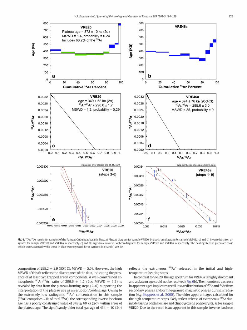
Fig. 6. 40Ar/39Ar results for samples of the Pampas Onduladas basaltic flow. a) Plateau diagram for sample VRE20. b) Spectrum diagram for sample VRE46a. c) and d) Inverse isochron di-agrams for samples VRE20 and VRE46a, respectively. e) and f) Large-scale inverse isochron diagrams for samples VRE20 and VRE46a, respectively. The heating steps in green are thosewhich were accepted while those in blue were rejected. Error symbols in e) and f) are 1σ.
123V.R. Espanon et al. / Journal of Volcanology and Geothermal Research 289 (2014) 114–129
composition of 299.2 ± 2.9 (95% CI; MSWD= 5.5). However, the highMSWDof thisfit reflects thediscordance of the data, indicating the pres-ence of at least two trapped argon components. A well-constrained at-mospheric 40Ar/36Ari ratio of 296.6 ± 1.7 (2σ; MSWD = 1.2) isrevealed by data from the plateau-forming steps (2–6), supporting theinterpretation of the plateau age as an eruption/cooling age. Owing tothe extremely low radiogenic 40Ar* concentration in this sample(40Ar* comprises ~3% of total 40Ar), the corresponding inverse isochronage has a poorly constrained value of 349 ± 68 ka (2σ), within error ofthe plateau age. The significantly older total-gas age of 434 ± 10 (2σ)
reflects the extraneous 40Ar* released in the initial and high-temperature heating steps.
In contrast to VRE20, the age spectrum for VRE46a is highly discordantand a plateau age could not be resolved (Fig. 6b). Themonotonic decreasein apparent ages implicates recoil loss/redistributionof 39Ar and 37Ar fromsecondary phases and/or fine-grained magmatic phases during irradia-tion (e.g. Koppers et al., 2000). The older apparent ages calculated forthe high-temperature steps likely reflect release of extraneous 40Ar dur-ing degassing of plagioclase and clinopyroxene phenocrysts, as for sampleVRE20. Due to the recoil issue apparent in this sample, inverse isochron

124 V.R. Espanon et al. / Journal of Volcanology and Geothermal Research 289 (2014) 114–129
analysis is of limited value in constraining the trapped argon composition(Koppers et al., 2000). The data are highly discordant in three-isotopespace (Fig. 6), but suggest an atmospheric 40Ar/36Ari ratio of 295.6 ± 3.0
Fig. 7.Geochemical data for Pampas Onduladas lavas. a) TiO2 vs K2O concentrations inwt.%, b)trations normalised to primitive mantle values (McDonough and Sun, 1995) and f) trace-elemThe green triangles and lines are from Pasquarè et al. (2008), and the blue triangles and lines arcrust (LCC) compositions are from Rudnick and Gao (2003). The ocean island basalt (OIB) complocal intraplate composition similar to an OIB endmember from Søager et al. (2013). Data from(1991) Ferguson et al. (1992), Tormey et al. (1995), Costa and Singer (2002) and Jacques et al
(95% CI; MSWD = 35). Therefore, assuming negligible loss of 39Ar fromthe sample, the total gas age of 370±8ka (2σ) can be regarded as amax-imum age estimate for sample VRE46a.
Ba/Nb vs Th/Ta, c) La/Yb vs Nb/Yb, d) La/Nb vs Th/Nb, e) Rare earth element (REE) concen-ent concentrations, normalised to primordial mantle values (McDonough and Sun, 1995).e from Espanon et al. (2014). The upper continental crust (UCC) and the lower continentalosition is from Sun andMcDonough, (1989). The Río Colorado volcanic field is taken as thethe basaltic Andean volcanic arc (ARC) are from Lopez-Escobar et al. (1977), Tormey et al.. (2013).
125V.R. Espanon et al. / Journal of Volcanology and Geothermal Research 289 (2014) 114–129
4.3. Geochemistry of Pampas Onduladas
Major-element concentrations of the Pampas Onduladas flow sug-gest a primitive composition with low and restricted SiO2 content(Table 1). The MgO content ranges from 9.1 wt.% (sample PY34b,Pasquarè et al., 2008) to 6.0 wt.% (Espanon et al., 2014). The MgOconcentration is negatively correlated with TiO2, P2O5 and K2O concen-trations (not shown), while no correlation was established with Al2O3,CaO, Na2O and FeOt contents. A positive correlation is apparent betweenTiO2 and K2O contents (Fig. 7a). Rare Earth Element (REE) concentra-tions normalised to the primitive mantle (values from McDonoughand Sun, 1995) show enrichment in light REEs over heavy REEs(Fig. 7e). This pattern is generally associated with the presence ofresidual garnet in the magmatic source. In addition, a small Eu peak isnoticeable in Fig. 7e. Trace-element concentrations, normalised to theprimitive mantle (values from McDonough and Sun, 1995; Fig. 7f), dis-play enrichment for Ba and Sr while some samples have a positive Pbanomaly. The negative Nb–Ta anomaly typical of arc volcanism is notapparent (except for sample PY34b, fromPasquarè et al., 2008) amongstsamples of the Pampas Onduladas flow (Fig. 7f). Sr isotope values arelow, ranging from 0.703747 (Espanon et al., 2014) to 0.704151(Pasquarè et al., 2008), which are comparable with 87Sr/86Sr values re-ported by Hernando et al. (2012) for pre-caldera basalts (0.703766 to0.703906).
4.4. Rheology
The average calculated viscosity is 96 Pa·s at a mean temperature of1170 °C andwith a 15%phenocryst content correction, corresponding toa typical olivine basalt melt (Williams and McBirney, 1979). The valuefor viscosity and temperature inferred for the Pampas Onduladas areslightly higher than the range suggested by Pasquarè et al. (2008) of3–73 Pa·s for viscosity and 1130–1160 °C for temperature. However,the viscosity values are within the range of those calculated for theUndara and Toomba flows in Queensland, Australia, which have a sim-ilar composition to the Pampas Onduladas flow (Stephenson et al.,1998). The calculated bulk density ranges from 2120 to 2466 kg/m3
after correction for 20% vesicle volume.The calculated velocity of the Pampas Onduladas flow (assuming a
mean density value of 2300 kg/m3) is 99 (~355 km·h−1), 55, 25 and6 m·s−1 for flow thicknesses of 20, 15, 10 and 5 m, respectively(Table 3). These flow velocities were calculated assuming a laminarflow behaviour. The average velocities appear excessive in comparisonto the fastest velocity recorded for basaltic lava flows such as forMt. Nyiragongo (ultramafic flow) in 1977with speeds of approximately17 m·s−1 (60 km·h−1; Tazieff, 1977) or some of the Mauna Loaflows with speeds of up to 15 m·s−1 (55 km·h−1; Lipman andBanks, 1987). Because the average velocities calculated are excessive,Reynolds numbers (Re) (Reynolds, 1974) were calculated to determinewhether the flowwas turbulent (density = 2300 kg/m3 and viscosity =96 Pa·s). Using velocities calculated above, Re values do suggest a tur-bulent flow (Re values of 47,000, 20,000 and 6000 at 20 m, 15 m and10 m flow thickness; Table 3). For a 5 m thick flow, the Re number is
Table 3Velocity calculated at liquidus temperature for a laminar and turbulent flow, for the Pam-pas Onduladas flow.
Thickness(m)
Re number Velocity @1170 °Cfor laminar flow(m·s−1)
Velocity @1170 °Cfor turbulent flow(m·s−1)
20 47,000 99 2815 20,000 55 2210 6000 25 165 700 6 9
700, which is regarded as laminar. In order to calculate the velocity ofa turbulent flow, a different equationmust be applied that incorporatesthe friction coefficient (Cf) in the Chezy equation (Jeffreys, 1925) (seeAppendix A for equations). Using the calculated Re numbers andemploying the Goncharov (1964) equation for turbulent sheet flow, aCf value of 0.0021, 0.0025 and 0.0033 for a 20 m, 15 m and 10 m thickflow respectively were calculated. These values were incorporatedinto the Chezy equation to calculate the velocity of a turbulent flow:28 (~101 km·h−1), 22 (~79 km·h−1) and 16 (58 km·h−1) m·s−1 fora 20, 15 and 10 m thick flow, respectively (Table 3). The calculated av-erage flow velocities are high even for a turbulent flow compared withobservations from Mt Nyiragongo (Tazieff, 1977) and Mauna Loa(Lipman and Banks, 1987). Consequently some parameters weremodified in order to examine the velocity change by increasing themaximum phenocryst and/or vesicle size and the vesicle volume pro-portion. By increasing the maximum phenocryst or vesicle size the ve-locity did not incur much change (~1%) while increasing the vesiclevolume to 30% the average viscosity increased to 133 Pa·s and the aver-age bulk density decreased to 1924 kg/m3, therefore reducing the veloc-ity by an average of 11% which is still elevated.
4.5. Length and volume
The length of the PampasOnduladasflowwasmeasured from the fareastern end of La Carbonilla Fracture to 35 km north of Puelén (Fig. 1) inthe province of La Pampa. The length is estimated to be 167 km (follow-ing the method by Cashman et al., 2013; see Section 3). This value isslightly less than previous measurements of 174 km and 181 km(Pasquarè et al., 2005, 2008, respectively). This variation is attributedto the uncertainty in assessing the initial eruption point and the finalpoint of the Pampas Onduladas flow as the eruption point for the Pam-pasOnduladasflowhas not been identified. Pasquarè et al. (2005, 2008)provided some general description of the initial and terminal point ofthe flow determining that its proximal part belongs to the eastern endof the Payún fissure system (also referred to as La Carbonilla Fracture)while the end point was located in the Salado river valley in the prov-ince of La Pampa (Pasquarè et al., 2008). The length of La CarbonillaFracture on its eastern side is ~14 km (Llambías et al., 2010) therefore,providing a wide area from which the Pampas Onduladas eruptionpoint might be.
Theflow volumewas calculated to be 7.2 km3, while the surface areawas calculated as 739 km2 (Table 4). The calculated volume should beregarded as a minimum as the base of the flow was extrapolated fromthe adjacent topography,whichmay not represent its true basal surface.The topographic slope from the initial to the final part of the flow is0.84% or 0.24°; however, the slope is not constant along the length.The slope is much steeper in the initial part than in most of its length(Fig. 8) as it changes from 1.6% in sector 1, to 0.9% in sector 2 and thento 0.6, 0.5 and 0.4% in sectors 3, 4, and 5, respectively. The mean widthof the flow decreases downhill from 9.4 km in sector 1, to 5.1 km in sec-tor 2, then to 3.8, 2.6 and 3.5 km in sectors 3, 4 and 5, respectively.
Table 4Area and volume calculated for the 5 sectors of the Pampas Onduladas flow, as well as forthe volcanic cones and the void areas that interrupted the flow.
Sector Area(km2)
Volume(km3)
1 303 3.92 166 1.33 100 1.14 81 0.85 102 0.3Volcanic cones 4 0.1Voids (kipukas) 8 0.1Total for flow 739 7.2
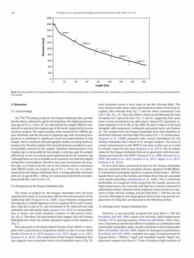
Fig. 8. Elevation profile of the Pampas Onduladas flow from its initial (proximal) part to its final (distal) part. Dashed lines separate the five sectors into which the Pampas Onduladas flowwas divided.
126 V.R. Espanon et al. / Journal of Volcanology and Geothermal Research 289 (2014) 114–129
5. Discussion
5.1. Geochronology
The 40Ar/39Ar dating results for the Pampas Onduladas flow, providethe first direct radiometric age for this long flow. The highly precise pla-teau age of 373 ± 10 ka (3%; 2σ) determined for sample VRE20 is con-sidered to represent the eruption age of the basalt, supported by inverseisochron analysis. The argon isotopic ratios measured for VRE46a ap-pear disturbed, and the decrease in apparent age with increasing tem-perature is attributed to significant recoil loss/redistribution in thissample. This is consistent with petrographic studies revealingminor al-teration (Fig. 4f and h)mainly of the interstitialmicrocrystalline to cryp-tocrystalline material in this sample. Therefore determination of aneruption age is not possible for this sample, as total gas ages for samplesaffected by recoil can only be good approximations for eruption age(although these are not so reliable aswe cannot be sure that the trappedcomponent is atmospheric, therefore they may overestimate the erup-tion age), as it looks to be the case in this instance, due to consistencywith VRE20 results. An eruption age of 373 ± 10 ka (3%; 2 s) deter-mined from the Pampas Onduladas flow is stratigraphically consistentwith a K–Ar age of 400± 100 ka (2σ) previously reported for an under-lying basalt flow (see Section 2.2).
5.2. Petrogenesis of the Pampas Onduladas flow
The origin of magma for the Pampas Onduladas flow has beenregarded previously as having been affected by metasomatism of thesubducting slab (Pasquarè et al., 2008). Trace-element compositionslack typical arc-related signatures such as negative Nb, Ta and Ti anom-alies, high Ba/Ta and La/Ta, and enrichment in Th (inferred from slabsediments and slab partial melts, Jacques et al., 2013) or strong deple-tion in heavy rare earth elements (relative to slab partial melts;Fig. 3b, e). Therefore, the geochemical data suggest that the PampasOnduladas flow does not exhibit signatures typical of the Andean arc(Fig. 7).
The volcanism in the Payún Matrú Volcanic Field (PMVF) is intra-plate with a geochemical composition similar to that of ocean islandbasalts (Germa et al., 2010; Jacques et al., 2013; Søager et al., 2013;Espanon et al., 2014). The composition of the Pampas Onduladas flowalso suggests some association with a local intraplate source (Fig. 7b;
local intraplate source is here taken as the Rio Colorado field). Thetrace-element ratios show values intermediate to those of the local in-traplate (Rio Colorado field, Fig. 7) and the lower continental crust(LCC) (Fig. 7b, c, d). They also define a linear trend following the localintraplate-LCC regression line (Fig. 7c and d), suggesting that somelower crustal assimilation has taken place. Typical LCC signatures in-clude depletion in Th, K, Rb, Zr, Ba, LREE, Hf, and U relative to the localintraplate, slab components (sediments and partial melts) and Andeanarc. The samples from the Pampas Onduladas flow show depletion inall of these elements and have high Th/U ratios (LCC=6). Furthermore,Pasquarè et al. (2008) proposed sialic crustal assimilation for thePampas Onduladas flow, based on Sr isotopic analyses. The issue ofcrustal contamination in the PMVF is not clear as there are no crustalSr-isotopic values for this area (Espanon et al., 2014). The Sr isotopevalues for the Pampas Onduladas flow are in agreementwith those pre-viously presented for the PMVF (Pasquarè et al., 2008; Bertotto et al.,2009; Hernando et al., 2012; Jacques et al., 2013; Søager et al., 2013;Espanon et al., 2014).
As discussed above, geochemical data for the Pampas Onduladasflow are consistent with an intraplate volcanic signature of OIB affinity.It is noted that an intraplate signature is typical of other long (N100 km)basaltic flows such as the Toomba and Undara flows that are associatedwith mantle upwelling (Stephenson et al., 1998). This is intuitivelypredictable, as a magmatic body rising from the mantle, possess thehigh temperatures, low viscosity and high lava volumes expected toyield long lava flows. However, thesemagmatic characteristics are com-mon to many volcanic settings, and yet long flows (N100 km) are notcommon. Rheological and topographical factors that may permit em-placement of a long flow are discussed in the following section.
5.3. Rheology of the Pampas Onduladas flow
Formerly, it was generally accepted that long flows (N100 km,Keszthelyi and Self, 1998) require low viscosity, rapid emplacement(Walker, 1973) and large volumes (Pinkerton andWilson, 1994). How-ever, it has been proposed that effective insulation, in combinationwitha favourable topographic slope, can also contribute to form long basalticflows (Keszthelyi and Self, 1998). Based on rheological characteristics,Keszthelyi and Self (1998), modelled two types of emplacement forlong lavaflows (N100 km); “rapid” and “insulated”models. “Rapid” em-placement requires less than 0.5 °C/km of cooling at high velocities of
127V.R. Espanon et al. / Journal of Volcanology and Geothermal Research 289 (2014) 114–129
2–15 m·s−1 for a channel 2–19 m deep and high effusion rates 200–17,000 m3/s (Keszthelyi and Self, 1998). On the contrary, “insulated”emplacement requires much lower velocities (0.1–1.4 m·s−1), slightlythicker flows 2–23 m and lower effusion rates 8–7100 m3/s(Keszthelyi and Self, 1998). The calculated viscosity for the PampasOnduladas flow is in agreement with previous viscosity calculationsfor long basaltic flows (Stephenson et al., 1998; Pasquarè et al., 2008).The viscosity of a flow increases with concentrations of solids, waterand dissolved gases. Pinkerton and Stevenson (1992) suggested thatfor solid concentrations below 30%, the viscosity remains relatively con-stant and flow behaviour is approximately that of a Newtonian fluid. Inthe case of the Pampas Onduladas flow, the viscosity was calculatedbased on a 15% solid concentration, while Pasquarè et al. (2008) as-sumed a phenocryst-free magma in their calculation. In both cases thecalculated average viscosity is similar (2–73 Pa·s Pasquarè et al., 2008and 96 Pa·s current study); therefore, provided the concentration ofsolids is less than 30%, viscosity values remain low. Nevertheless, thevesicle volume proportion affects the average viscosity of the PampasOnduladasflowas it increases by from20 to 30%. Nevertheless, in agree-mentwith the internalmorphology of a basalticflow, the vesicles can beassociatedwith a viscosity reduction, as the pressure imposed by spher-ical bubbles is not absorbed by the system, but released as the vesiclesdeform and collapse (Llambías, 2008). In Section 2.2, the internal struc-ture of the Pampas Onduladasflow is described as having disrupted andelongated vesicles forming the lower massive layer, agreeing with theprevious statement. Despite, the possibility of keeping the flow at lowviscosity by vesicle deformation and collapse as previously mentioned,the sub-angular vesicle in Fig. 4f andh suggest a transition to amore vis-cous character in the distal part. This constitutes the only evidence of achange in flow regime; therefore further studies along the flow areneeded in order to fully assess the hypothesis of a viscosity change.
The calculated velocity for the Pampas Onduladas flow (Table 3) ishigher than previous open channel basaltic flow velocity estimates(4–12m·s−1, Keszthelyi and Self, 1998). The high velocities determinedhere are regarded as maxima, as the velocity is dependent on thickness,slope and viscosity. The thickness of the flow is one of the largest sourcesof error. This is because inflation can take place after emplacement andcooling, hence resulting in an apparent thicker flow. In Hawaii, Honet al. (1994) observed that a flow initially 30 cm thick was inflated to athickness of 3–7m in a period of over aweek. In the current study severalthicknesses (20, 15, 10 and 5 m) were considered in order to estimatethe flow velocity, showing that it becomes turbulent at thicknessesgreater than 5 m (Table 3). The velocity calculated for a 5 m thick flow(6m·s−1, Table 3) can be regarded as an appropriate value, as it iswithinthe range of open-channel basaltic flows (see Keszthelyi and Self, 1998).Velocities calculated here are higher than the estimate of 1.4m·s−1 fromKeszthelyi and Self (1998) for a sheet flowwith a slope of 0.1%, an upperlava crust 1m thick and a total thickness of 23m. Furthermore, the sameauthors proposed that faster flows (N5 m·s−1) would tend to have athinner upper crust (b1 m thick), which agrees with the average b1 mthin Pampas Onduladas crust (Pasquarè et al., 2008).
In relation to other long basaltic flows on Earth, the calculated vol-ume for the Pampas Onduladas flow is 7.2 km3, which is lower thanthe volume calculated for the Toomba (12 km3) and for the Undaraflow (approximately 25 km3; Stephenson et al., 1998). Furthermore,in their model Keszthelyi and Self (1998) proposed that the minimumvolume for a 10 m thick long flow (N100 km in length) is 10 km3. Thecalculated volume is much lower than previous calculated volumes forlong flows on Earth, mostly resulting from the flat pre-flow topographyassumption, therefore regarded as minimum.
5.4. Aspects of Pampas Onduladas pre-flow topography
The average slope of the Pampas Onduladas flow (0.84%) is greaterthan the slope of the Toomba, Undara and Thjotsa flows (0.4%, 0.5%and ~0.7% respectively, Keszthelyi and Self, 1998). Other Quaternary
flows in the Pampas Onduladas region have been emplaced over an An-dean piedmont topography that created a gradual and lengthy decliningslope towards the east. The pre-existing topography is covered mainlyby basaltic flows with some exposures of the uplifted San Rafael Block(SRB), characterised by Permian–Triassic volcanic and plutonic assem-blages (Figs. 1b and 5a, b). The SRB acted as a wall on the northernpart of sectors 1 and 2, as is evident in cross section A–A′ and B–B′(Fig. 5). The eruption point for this flowhas been associatedwith the ac-tivity in La Carbonilla Fracture (LCF in Fig. 1; Pasquarè et al., 2008). Here,the topography is characterised by a high elevation resulting from upliftof the Payún Matrú eastern shield when it was magmatically active.
The Pampas Onduladas basalt flowed from its initial point over an ir-regular topography following its steepest course down-slope. The highslope suggests that the flow followed an unencumbered path, inferredfrom the long profile (Fig. 8), while the irregular topography can bepartly inferred from the cross sections. Accordingly, the PampasOnduladas flow has a positive relief in relation to the surrounding to-pography in the middle and distal sectors (Fig. 5 cross sections C–C′,D–D′ and E–E′). Interestingly, the cross-section from sector 1, shows arough surface corresponding to the flow, which has been confined onits northern side by the San Rafael Block and by a topographic high onits southern part (Fig. 5, cross section A–A′). Furthermore, in thecross-section from sector 2 (Fig. 5, cross-section B–B′) the topographyadjacent to the flow shows higher elevation, suggesting that the flowhas followed a pre-existing topographic depression at least in someareas. This observation is critical in the volume calculation which canlead to underestimation assuming a flat base. Furthermore by followinga topographic depression, the flow is insulated possibly resemblingthe type of effective insulation observed in lava tubes. The PampasOnduladas has inflation structures such as tumuli and lava rises whichare generally associated with pahoehoe sheet flow. No lava tubes havebeen identified for this basaltic flow. However, it is likely that at leastin the proximal part, the flow was confined enhancing the insulationprocess.
The geochemical, rheological and topographical constraints present-ed here suggest that the Pampas Onduladas flow shows a combinationof characteristics that assisted in the development of its great length.The extent of the Pampas Onduladas flow cannot be explained by itsgeochemical characteristics as it shares these with other basalts of thePMVF. Thus, it is likely that its exceptional length is related to a steepslope, aided by low viscosity and a good insulating system derivedfrom its inflating nature and topographic confinement.
6. Conclusions
The Pampas Onduladas flow in southernMendoza constitutes one ofthe four longest Quaternary lava flows on Earth. It was erupted duringthe pre-caldera basaltic volcanism of the Payún Matrú Volcanic Field(Hernando et al., 2012) as confirmed by the geochronological data.The 40Ar/39Ar analysis suggests an eruption age of 373 ± 10 ka (2σ),constituting the first direct age constraint for this flow. Geochemicalcharacteristics are consistent with an intraplate setting. This corre-sponds to a negligible arc signature, an enriched mantle source similarto local ocean island basalts (Rio Colorado Volcanic Field; Søager et al.,2013) and possible lower continental crust assimilation (Germa et al.,2010; Jacques et al., 2013; Søager et al., 2013; Espanon et al., 2014).
Rheological characteristics indicate that the viscosity was low andthe average eruption temperature was 1170 °C. An important featureis the topographic slope which is higher (0.84%) than those determinedfor the Undara (0.5%), Toomba (0.4%) (Stephenson et al., 1998) andThjorsa (~0.7) (Vilmundardottir, 1977) flows. The slope is likely to bethe most important feature affecting the length (Keszthelyi and Self,1998) and velocity. The calculated velocity varies depending on thick-ness, from 30 m·s−1 (N110 km·h−1) to 17 m·s−1 (~60 km·h−1) for20 m and 10 m thickness, respectively (turbulent velocities for flowthickness values N5 m). The proposed thickness is at least 20 m
128 V.R. Espanon et al. / Journal of Volcanology and Geothermal Research 289 (2014) 114–129
(Pasquarè et al., 2008), after the flow inflated and cooled. The originalthickness however, could have been ten times smaller than that pre-served, using the inflation ratios fromHon et al. (1994) for Hawaiian ba-salts. The volume calculated here (7.2 km3) is regarded as a minimumestimate, based on the method used, which assumes a flat surfacebelow the flow. The length of the Pampas Onduladas flow is notgoverned by its geochemical characteristics, but by the steep and con-stant topographic slope supported by an effective insulating systemand low viscosity.
Acknowledgements
We greatly thank the park rangers at Llancanelo and PayuniaProvincial Natural Reserve (Mendoza), Stephanie Kerr, Paul Connollyand Adriana Garcia for their help and assistance during field trips,Jan-Hendrik May for his assistance with spatial analysis and StanSzczepanski for technical support with 40Ar/39Ar analysis. We acknowl-edge the Renewable Natural Resources division of the Province ofMendoza for providing access permits. We are grateful to Dr KarolyNemeth and an anonymous reviewer for their comments which consid-erably improved themanuscript. AD acknowledges Australian ResearchCouncil Future Fellowship FT0990447.
Appendix A. Equations used for turbulent flow calculations
(1) Reynolds number (Re)
Re ¼ ρHvη
where ρ is density, H is the thickness, v is the velocity and η is theviscosity.
(2) Chezy equation
v2 ¼ gHθCf
where v is the velocity for a turbulent flow, g is the gravitationalacceleration, H is the thickness, θ is the slope and Cf is the frictioncoefficient.
(3) Goncharov equation (Goncharov, 1964) to determine the frictioncoefficient for a turbulent flow with Re b 105
Cf ¼λ2
λ ¼�4 log10 6:15 Re0 þ 800
� �=41
� �0:92h i�−2
Re0 ¼ 2Re:
Appendix A. Supplementary data
Supplementary data to this article can be found online at http://dx.doi.org/10.1016/j.jvolgeores.2014.10.018.
References
Bermúdez, A., Delpino, D., 1989. La Provincia Basaltica Andino Cuyana (35–37°L.S.). Rev.Asoc. Geol. Argent. 44 (1–4), 35–55.
Bertotto, G.W., 1997. Estudio volcanológico y petrográfico de los conos basálticos cerrosdel Nido, Escorial y Agua Poca. Departamentos Puelén y Chicalcó, sector occidentalde la provincia de La Pampa. Trabajo Final de Licenciatura (inédito), UniversidadNacional de La Pampa.
Bertotto, G., Cingolani, C., Bjerg, E., 2009. Geochemical variations in Cenozoic back-arc ba-salts at the border of La Pampa and Mendoza provinces, Argentina. J. S. Am. Earth Sci.28 (4), 360–373. http://dx.doi.org/10.1016/j.jsames.2009.04.008.
Bottinga, Y.A., Weil, D.F., 1972. The viscosity of magmatic silicate liquids: a model for cal-culation. Am. J. Sci. 272 (5), 438–473. http://dx.doi.org/10.2475/ajs.272.5.438.
Cashman, K., Soule, S., Mackey, B., Deligne, N., Deardorff, N., Dietterich, H., 2013. How lavaflows: new insights from applications of lidar technologies to lava flow studies.Geosphere 9 (6), 1664–1680. http://dx.doi.org/10.1130/GES00706.1.
Cassata, W.S., Singer, B.S., Cassidy, J., 2008. Laschamp and Mono Lake geomagnetic excur-sions recorded in New Zealand. Earth Planet. Sci. Lett. 268 (1), 76–88. http://dx.doi.org/10.1016/j.epsl.2008.01.009.
Costa, F.G., Singer, B.S., 2002. Evolution of Holocene dacite and compositionally zonedmagma, volcán San Pedro, Southern Volcanic Zone, Chile. J. Petrol. 43 (8),1571–1593. http://dx.doi.org/10.1093/petrology/43.8.1571.
Espanon, V.R., Chivas, A.R., Kinsley, L.K.J., Dosseto, A., 2014. Geochemical variations in theQuaternary Andean back-arc volcanism, southern Mendoza, Argentina. Lithos208–209, 251–264. http://dx.doi.org/10.1016/j.lithos.2014.09.010.
Ferguson, K.M., Dungan,M.A., Davidson, J.P., Colucci, M.T., 1992. The Tatara–San Pedro vol-cano, 36°S, Chile: a chemically variable, dominantly mafic magmatic system. J. Petrol.33 (1), 1–43. http://dx.doi.org/10.1093/petrology/33.1.1.
Germa, A., Quidelleur, X., Gillot, P.Y., Tchilinguirian, P., 2010. Volcanic evolution of theback-arc Pleistocene Payun Matru volcanic field (Argentina). J. S. Am. Earth Sci. 29,717–730. http://dx.doi.org/10.1016/j.jsames.2010.01.002.
Goncharov, V. 1964. Dynamics of Channel Flow, 317 pp., translated from Russian by IsraelProgram Sci. Transl., US Dep. of Commer., Off. of Tech. Serv., Washington, DC.
Gudnason, J., Holm, P.M., Søager, N., Llambias, E.J., 2012. Geochronology of the latePliocene to Recent volcanic activity in the Payenia back-arc volcanic province,Mendoza, Argentina. J. S. Am. Earth Sci. 37, 191–201. http://dx.doi.org/10.1016/j.jsames.2012.02.003.
Halldorsson, S.A., Oskarsson, N., Gronvold, K., Sigurdsson, G., Sverrisdottir, G.,Steinthorsson, S., 2008. Isotopic-heterogeneity of the Thjorsa lava—implicationsfor mantle sources and crustal processes within the Eastern Rift Zone, Iceland.Chem. Geol. 255 (3), 305–316. http://dx.doi.org/10.1016/j.chemgeo.2008.06.050.
Hernando, I.R., Llambías, E.J., González, P.D., Sato, K., 2012. Volcanic stratigraphy and evi-dence of magma mixing in the Quaternary Payun Matru volcano, Andean backarc inwestern Argentina. Andean Geol. 39 (1), 158–179.
Hernando, I.R., Franzese, J.R., Llambías, E.J., Petrinovic, I.A., 2014. Vent distribution in theQuaternary Payún Matrú Volcanic Field, western Argentina: its relation to tectonicsand crustal structures. Tectonophysics 622, 122–134. http://dx.doi.org/10.1016/j.tecto.2014.03.003.
Hon, K., Kauahikaua, J., Denlinger, R., Mackay, K., 1994. Emplacement and inflation ofpahoehoe sheet flows: observations and measurements of active lava flows onKilauea Volcano, Hawaii. Geol. Soc. Am. Bull. 106 (1), 351–370. http://dx.doi.org/10.1130/0016-7606.
Inbar, M., Risso, C., 2001. Amorphological andmorphometric analysis of a high density cin-der cone volcanic field— PayunMatru, south-central Andes, Argentina. Z. Geomorphol.45 (3), 321–343.
Jacques, G., Hoernle, K., Gill, J., Hauff, F., Wehrmann, H., Garbe-Schönberg, D., Van DenBogaard, P., Bindeman, I., Lara, L.E., 2013. Across-arc geochemical variations in theSouthern Volcanic Zone, Chile (34.5–38.0°S): constraints on mantle wedge and slabinput compositions. Geochim. Cosmochim. Acta 123, 218–243. http://dx.doi.org/10.1016/j.gca.2013.05.016.
Jeffreys, H., 1925. The flow of water in an inclined channel of rectangular section. Philos.Mag. 49 (293), 793–807. http://dx.doi.org/10.1080/14786442508634662.
Kay, S.M., Gorring, M., Ramos, V.A., 2004. Magmatic sources, setting and causes of Eoceneto Recent Patagonian plateau magmatism (36°S to 52°S latitude). Rev. Asoc. Geol.Argent. 59 (4), 556–568.
Kay, S.M., Burns, W.M., Copeland, P., Mancilla, O., 2006. Upper Cretaceous to Holocenemagmatism and evidence for transient Miocene shallowing of the Andean subduc-tion zone under the northern Neuquén basin. Geol. Soc. Am. Spec. Pap. 407, 19–60.http://dx.doi.org/10.1130/2006.2407(02).
Kay, S.M., Jones, H.A., Kay, R.W., 2013. Origin of Tertiary to Recent EM- and subduction-likechemical and isotopic signatures in Auca Mahuida region (37°–38° S) and otherPatagonian plateau lavas. Contrib. Mineral. Petrol. 166 (1), 165–192. http://dx.doi.org/10.1007/s00410-013-0870-9.
Keszthelyi, L., Pieri, D.C., 1993. Emplacement of the 75-km-long Carrizozo lava flow field,south-central NewMexico. J. Volcanol. Geotherm. Res. 59 (1–2), 59–75. http://dx.doi.org/10.1016/0377-0273(93)90078-6.
Keszthelyi, L., Self, S., 1998. Some physical requirements for the emplacement of longbasaltic lava flows. J. Geophys. Res. 103 (B11), 27447–27464.
Keszthelyi, L., Thordarson, T., Mcewen, A., Haack, H., Guilbaud, M.N., Self, S., Rossi, M.J.,2004. Icelandic analogs to Martian flood lavas. Geochem. Geophys. Geosyst. 5 (11).http://dx.doi.org/10.1029/2004GC000758.
Koppers, A.A.P., Staudigel, H., Wijbrans, J.R., 2000. Dating crystalline groundmassseparates of altered Cretaceous seamount basalts by the 40Ar/39Ar incrementalheating technique. Chem. Geol. 166 (1–2), 139–158. http://dx.doi.org/10.1016/S0009-2541(99)00188-6.
Lipman, P.W., Banks, N.G., 1987. Aa flow dynamics, Mauna Loa 1984. U.S. GeologicalSurvey Professional Paper vol. 1350, pp. 1527–1567.
Llambías, E.J., 2008. Geología de los cuerpos ígneos. Asociación Geológica Argentina,Buenos Aires, Argentina.
Llambías, E.J., Bertotto, G., Risso, C., Hernando, I., 2010. El volcanismo Cuaternario en elretroarco de Payenia: Una revision. Rev. Asoc. Geol. Argent. 67 (2), 278–300.
Lopez-Escobar, L., Frey, F.A., Vergara, M.M., 1977. Andesites and high-alumina basaltsfrom the central-south Chile high Andes: geochemical evidence bearing on their pet-rogenesis. Contrib. Mineral. Petrol. 63 (3), 199–228. http://dx.doi.org/10.1007/BF00375573.
Ludwig, K.R., 2012. User's Manual for Isoplot 3.75. A Geochronological Toolkit forMicrosoft Excel. Special Publication No. 5. Berkeley Geochronology Center, Berkeley,California, p. 75.
129V.R. Espanon et al. / Journal of Volcanology and Geothermal Research 289 (2014) 114–129
Matchan, E.L., Phillips, D., 2014. High precision multi-collector 40Ar/39Ar dating of youngbasalts: Mount Rouse volcano (SE Australia) revisited. Quat. Geochronol. 22, 57–64.http://dx.doi.org/10.1016/j.quageo.2014.02.005.
McDonough, W.F., Sun, S.-S., 1995. The composition of the Earth. Chem. Geol. 120 (3–4),223–253. http://dx.doi.org/10.1016/0009-2541(94)00140-4.
Melchor, R., Casadío, S., 1999. Hoja Geológica 3766-III La Reforma. Servicio GeológicoMinero Argentino 295. Instituto de Geología y Recursos Minerales, Provincia de LaPampa.
Méndez, V., Zanettini, J.C., Zappettini, E.O., 1995. Geología y metalogénesis del Orógenoandino central, República Argentina, Secretaría de Minería de la Nación. DirecciónNacional del Servicio Geológico.
Narciso, V., Santamaría, G., Zanettini, J., 2001. Hoja Geológica 3769-1, Barrancas. ServicioGeológico Minero Argentino, Boletín 253. Instituto de Geología y Recursos Minerales,Provincias de Mendoza y Neuquén.
Nemeth, K., Haller, M., Martin, C., Risso, C., Massaferro, G., 2008. Morphology of lavatumuli from Mendoza (Argentina), Patagonia (Argentina), and Al-Haruj (Libya).Z. Geomorphol. 52 (2), 181–194.
Nier, A.O., 1950. A redetermination of the relative abundances of the isotopes of carbon,nitrogen, oxygen, argon, and potassium. Phys. Rev. 77, 789–793. http://dx.doi.org/10.1103/PhysRev.77.789.
Núñez, E., 1976. Descripción geológica de la Hoja 31e Chical-Có, provincias de Mendoza yLa Pampa. Servicio Nacional Geológico Minero, Informe Inédito. Buenos Aires.
Pasquarè, G., Bistacchi, A., Mottana, A., 2005. Gigantic individual lava flows in the Andeanfoothills near Malargue (Mendoza, Argentina). Rend. Lincei Sci. Fis. Nat. 16, 127–135.
Pasquarè, G., Bistacchi, A., Francalanci, L., Bertotto, G., Boari, E., Massironi, M., Rossotti, A.,2008. Very long pahoehoe inflated basaltic lava flows in the Payenia VolcanicProvince (Mendoza and La Pampa, Argentina). Rev. Asoc. Geol. Argent. 63 (1),131–149.
Phillips, D., Matchan, E.L., 2013. Ultra-high precision 40Ar/39Ar ages for Fish Canyon Tuffand Alder Creek Rhyolite sanidine: new dating standards required? Geochim.Cosmochim. Acta 121, 229–239. http://dx.doi.org/10.1016/j.gca.2013.07.003.
Pinkerton, H., Stevenson, R., 1992. Methods of determining the rheological properties oflavas from their physico-chemical properties. J. Volcanol. Geotherm. Res. 53 (1–4),47–66. http://dx.doi.org/10.1016/0377-0273(92)90073-M.
Pinkerton, H., Wilson, L., 1994. Factors controlling the lengths of channel-fed lava flows.Bull. Volcanol. 56 (2), 108–120. http://dx.doi.org/10.1007/BF00304106.
Polanski, J., 1954. Rasgos geomorfológicos del territorio de la provincia de Mendoza.Cuadernos de Estudio e Investigación. Instituto de Investigaciones Económicas yTecnológicas, Mendoza.
Ramos, V.A., Folguera, A., 2011. Payenia volcanic province in the Southern Andes: anappraisal of an exceptional Quaternary tectonic setting. J. Volcanol. Geotherm. Res.201 (1–4), 53–64. http://dx.doi.org/10.1016/j.jvolgeores.2010.09.008.
Reynolds, A.J., 1974. Turbulent Flow in Engineering. John Wiley, New York.Rivalenti, G., Mazzucchelli, M., Laurora, A., Ciuffi, S.I.A., Zanetti, A., Vannucci, R., Cingolani,
C., 2004. The backarc mantle lithosphere in Patagonia, South America. J. S. Am. EarthSci. 17 (2), 121–152. http://dx.doi.org/10.1016/j.jsames.2004.05.009.
Rodriguez, E., Morris, C.S., Belz, J.E., 2006. A global assessment of the SRTM performance.Photogramm. Eng. Remote. Sens. 72 (3), 249–260. http://dx.doi.org/10.14358/PERS.72.3.249.
Rudnick, R.L., Gao, S., 2003. Composition of the continental crust. In: Holland, H.D.,Turekian, K.K. (Eds.), Treatise on Geochemistry 3: The Crust, pp. 1–64 http://dx.doi.org/10.1016/B0-08-043751-6/03016-4.
Singer, B.S., Pringle, M.S., 1996. Age and duration of the Matuyama–Brunhes geomagneticpolarity reversal from 40Ar/39Ar incremental heating analyses of lavas. Earth Planet.Sci. Lett. 139 (1–2), 47–61. http://dx.doi.org/10.1016/0012-821X(96)00003-9.
Sisson, T.W., Grove, T.L., 1993. Experimental investigations of the role of H2O in calc-alkaline differentiation and subduction zone magmatism. Contrib. Mineral. Petrol.113 (2), 143–166. http://dx.doi.org/10.1007/BF00283225.
Smith, M.J., Rose, J., Gousie, M.B., 2009. The Cookie Cutter: a method for obtaining a quan-titative 3D description of glacial bedforms. Geomorphology 108 (3–4), 209–218.http://dx.doi.org/10.1016/j.geomorph.2009.01.006.
Søager, N., Holm, P.M., Llambías, E.J., 2013. Payenia volcanic province, southern Mendoza,Argentina: OIB mantle upwelling in a backarc environment. Chem. Geol. 349–350,36–53. http://dx.doi.org/10.1016/j.chemgeo.2013.04.007.
Steiger, R.H., Jäger, E., 1977. Subcommission on geochronology: convention on the use ofdecay constants in geo- and cosmochronology. Earth Planet. Sci. Lett. 36 (3),359–362. http://dx.doi.org/10.1016/0012-821X(77)90060-7.
Stephenson, P.J., Burch-Johnston, A.T., Stanton, D., Whitehead, P.W., 1998. Three long lavaflows in north Queensland. J. Geophys. Res. 103 (B11), 27359–27370.
Stern, C.R., 2004. Active Andean volcanism: its geologic and tectonic setting. Rev. Geol.Chile 31 (2), 161–206.
Stern, C.R., Frey, F.A., Futa, K., Zartman, R.E., Peng, Z., Kyser, T.K., 1990. Trace-elements andSr, Nd, Pb and O isotopic composition of Pliocene and Quaternary alkali basalts of thePatagonian Plateau lavas of southernmost South America. Contrib. Mineral. Petrol.104 (3), 294–308. http://dx.doi.org/10.1007/BF00321486.
Sun, S.-S., McDonough, W.F., 1989. Chemical and isotopic systematics of oceanic basalts:implications for mantle composition and processes. Geological Society, London, Spe-cial Publications 42, 313–345.
Tazieff, H., 1977. An exceptional eruption: Mt. Niragongo, Jan. 10th, 1977. Bull. Volcanol.40 (3), 189–200. http://dx.doi.org/10.1007/BF02596999.
Thorpe, R.S., 1984. The tectonic setting of active Andean volcanism. Andean Magmatism:Chemical and Isotopic Constraints. Shiva Geological Series. Shiva Publications,Nantwich, U.K., pp. 4–8.
Tormey, D.R., Hickey-Vargas, R., Frey, F.A., Lopez-Escobar, L., 1991. Recent lavas from theAndean volcanic front (33 to 42°S); interpretations of along-arc compositional varia-tions. Spec. Pap. Geol. Soc. Am. 265, 57–78. http://dx.doi.org/10.1130/SPE265-p57.
Tormey, D.R., Frey, F.A., Lopez-Escobar, L., 1995. Geochemistry of the active Azufre–Planchon–Peteroa Volcanic Complex, Chile (35°15′S): evidence for multiple sourcesand processes in a cordilleran arc magmatic system. J. Petrol. 36 (2), 265–298.http://dx.doi.org/10.1093/petrology/36.2.265.
Turrin, B.D., Donnelly-Nolan, J.M., Hearn Jr., B.C., 1994. 40Ar/39Ar ages from the rhyolite ofAlder Creek, California: age of the Cobbmountain normal-polarity subchron revisited.Geology 22 (3), 251–254. http://dx.doi.org/10.1130/0091-7613(1994)-22b0251:AAAFTRN2.3.CO;2.
Vilmundardottir, E.G., 1977. Tungnarhraun, Orustofnun geologic report. Rep. OS ROD7702 (156 pp., Reykjavik).
Walker, G.P., 1973. Length of lava flows. Phil. Trans. R. Soc. A 274 (1238), 107–118.http://dx.doi.org/10.1098/rsta.1973.0030.
Williams, H., McBirney, A., 1979. Volcanology. Freeman, Cooper and Company,San Francisco.
Related Documents