C C O O M M P P R R E E H H E E N N S S I I V V E E P P L L A A N N 2 2 0 0 0 0 0 0 - - 2 2 0 0 2 2 0 0 E E x x e e c c u u t t i i v v e e S S u u m m m m a a r r y y C I T Y O F E N N I S , T E X A S

Welcome message from author
This document is posted to help you gain knowledge. Please leave a comment to let me know what you think about it! Share it to your friends and learn new things together.
Transcript

CCOOMMPPRREEHHEENNSSIIVVEE PPLLAANN 22000000--22002200
EExxeeccuuttiivvee SSuummmmaarryy
CITY OF ENNIS, TEXAS

TTTTTTTT aaaaaaaa bbbbbbbb llllllll eeeeeeee oooooooo ffffffff CCCCCCCC oooooooo nnnnnnnn tttttttt eeeeeeee nnnnnnnn tttttttt ssssssss
!! TTTTTTTT hhhhhhhh eeeeeeee FFFFFFFF uuuuuuuu tttttttt uuuuuuuu rrrrrrrr eeeeeeee LLLLLLLL aaaaaaaa nnnnnnnn dddddddd UUUUUUUU ssssssss eeeeeeee PPPPPPPP llllllll aaaaaaaa nnnnnnnn
!! PPPPPPPP uuuuuuuu bbbbbbbb llllllll iiiiiiii cccccccc FFFFFFFF aaaaaaaa cccccccc iiiiiiii llllllll iiiiiiii tttttttt iiiiiiii eeeeeeee ssssssss PPPPPPPP llllllll aaaaaaaa nnnnnnnn (((((((( MMMMMMMM aaaaaaaa pppppppp ))))))))
!! PPPPPPPP aaaaaaaa rrrrrrrr kkkkkkkk ssssssss ,,,,,,,, RRRRRRRR eeeeeeee cccccccc rrrrrrrr eeeeeeee aaaaaaaa tttttttt iiiiiiii oooooooo nnnnnnnn &&&&&&&& OOOOOOOO pppppppp eeeeeeee nnnnnnnn SSSSSSSS pppppppp aaaaaaaa cccccccc eeeeeeee PPPPPPPP llllllll aaaaaaaa nnnnnnnn
!! BBBBBBBB aaaaaaaa ssssssss eeeeeeee llllllll iiiiiiii nnnnnnnn eeeeeeee AAAAAAAA nnnnnnnn aaaaaaaa llllllll yyyyyyyy ssssssss iiiiiiii ssssssss
!! EEEEEEEE llllllll eeeeeeee mmmmmmmm eeeeeeee nnnnnnnn tttttttt ssssssss oooooooo ffffffff tttttttt hhhhhhhh eeeeeeee CCCCCCCC oooooooo mmmmmmmm pppppppp rrrrrrrr eeeeeeee hhhhhhhh eeeeeeee nnnnnnnn ssssssss iiiiiiii vvvvvvvv eeeeeeee PPPPPPPP llllllll aaaaaaaa nnnnnnnn
!! TTTTTTTT hhhhhhhh oooooooo rrrrrrrr oooooooo uuuuuuuu gggggggg hhhhhhhh ffffffff aaaaaaaa rrrrrrrr eeeeeeee PPPPPPPP llllllll aaaaaaaa nnnnnnnn (((((((( MMMMMMMM aaaaaaaa pppppppp ))))))))
!! WWWWWWWW aaaaaaaa tttttttt eeeeeeee rrrrrrrr &&&&&&&& WWWWWWWW aaaaaaaa ssssssss tttttttt eeeeeeee wwwwwwww aaaaaaaa tttttttt eeeeeeee rrrrrrrr PPPPPPPP llllllll aaaaaaaa nnnnnnnn (((((((( MMMMMMMM aaaaaaaa pppppppp ))))))))
!! FFFFFFFF uuuuuuuu tttttttt uuuuuuuu rrrrrrrr eeeeeeee LLLLLLLL aaaaaaaa nnnnnnnn dddddddd UUUUUUUU ssssssss eeeeeeee PPPPPPPP llllllll aaaaaaaa nnnnnnnn (((((((( MMMMMMMM aaaaaaaa pppppppp ))))))))
CITY OF ENNIS, TEXAS
CCCCCCCCOOOOOOOOMMMMMMMMPPPPPPPPRRRRRRRREEEEEEEEHHHHHHHHEEEEEEEENNNNNNNNSSSSSSSSIIIIIIIIVVVVVVVVEEEEEEEE PPPPPPPPLLLLLLLLAAAAAAAANNNNNNNN 22222222000000000000000000000000 –––––––– 22222222000000002222222200000000 EEEEEEEEXXXXXXXXEEEEEEEECCCCCCCCUUUUUUUUTTTTTTTTIIIIIIIIVVVVVVVVEEEEEEEE SSSSSSSSUUUUUUUUMMMMMMMMMMMMMMMMAAAAAAAARRRRRRRRYYYYYYYY

TTTTTTTTHHHHHHHHEEEEEEEE FFFFFFFFUUUUUUUUTTTTTTTTUUUUUUUURRRRRRRREEEEEEEE LLLLLLLLAAAAAAAANNNNNNNNDDDDDDDD UUUUUUUUSSSSSSSSEEEEEEEE PPPPPPPPLLLLLLLLAAAAAAAANNNNNNNN
LLLLLLLLaaaaaaaannnnnnnndddddddd UUUUUUUUsssssssseeeeeeee DDDDDDDDeeeeeeeessssssssiiiiiiiiggggggggnnnnnnnnaaaaaaaattttttttiiiiiiiioooooooonnnnnnnnssssssss LLLLLLLLOOOOOOOOWWWWWWWW DDDDDDDDEEEEEEEENNNNNNNNSSSSSSSSIIIIIIIITTTTTTTTYYYYYYYY RRRRRRRREEEEEEEESSSSSSSSIIIIIIIIDDDDDDDDEEEEEEEENNNNNNNNTTTTTTTTIIIIIIIIAAAAAAAALLLLLLLL AAAAAAAARRRRRRRREEEEEEEEAAAAAAAASSSSSSSS Most of the undeveloped/vacant land area within the corporate limits and the extraterritorial jurisdiction (ETJ) of Ennis is proposed for low density, single-family residential use. The average density for these areas is approximately 3.5 dwelling units per acre. HHHHHHHHIIIIIIIIGGGGGGGGHHHHHHHH DDDDDDDDEEEEEEEENNNNNNNNSSSSSSSSIIIIIIIITTTTTTTTYYYYYYYY RRRRRRRREEEEEEEESSSSSSSSIIIIIIIIDDDDDDDDEEEEEEEENNNNNNNNTTTTTTTTIIIIIIIIAAAAAAAALLLLLLLL AAAAAAAARRRRRRRREEEEEEEEAAAAAAAASSSSSSSS Approximately 13 percent of the total housing units within Ennis are multi-family units. To maintain the balanced mixture of housing types, the multi-family housing percentage should not exceed 15 percent of the City’s total housing stock. CCCCCCCCOOOOOOOOMMMMMMMMMMMMMMMMEEEEEEEERRRRRRRRCCCCCCCCIIIIIIIIAAAAAAAALLLLLLLL AAAAAAAARRRRRRRREEEEEEEEAAAAAAAASSSSSSSS The Future Land Use Plan (Plate 4-1) designates areas along Interstate Highway 45, around the railroad close to downtown, and along State Highway 34 for commercial land use. The purpose of this land use designation is to allow for high-intensity commercial uses that may not be suitable for other nonresidential use districts but that may still need a well-connected system of roadways to enable efficient movement of goods. RRRRRRRREEEEEEEETTTTTTTTAAAAAAAAIIIIIIIILLLLLLLL AAAAAAAARRRRRRRREEEEEEEEAAAAAAAASSSSSSSS It is anti-cipated that much of the potential for retail uses will be along Inter-state Highway 45, Ennis Avenue/ State Highway 34, and within the downtown area. Some retail uses (i.e., convenience stores, cleaners, etc.) are also appropriate at major intersections along the U.S. Highway 287 bypass and other high-traffic intersections interspersed throughout the community. Retail sites at these locations should generally be 8 to 12 acres in size. TTTTHE HE HE HE DDDDOWNTOWN OWNTOWN OWNTOWN OWNTOWN AAAAREAREAREAREA The downtown center of Ennis is identified as a special nonresidential retail area due to its property ownership patterns and mixture of municipal and office uses. Guidelines and design criteria should be established for future development in this area and for facilitating and/or encouraging adaptive reuse of existing structures, wherever possible, to ensure future high-quality development maintains the integrity of downtown.
AAAAAAAARRRRRRRREEEEEEEEAAAAAAAASSSSSSSS OOOOOOOOFFFFFFFF HHHHHHHHIIIIIIIISSSSSSSSTTTTTTTTOOOOOOOORRRRRRRRIIIIIIIICCCCCCCC
SSSSSSSSIIIIIIIIGGGGGGGGNNNNNNNNIIIIIIIIFFFFFFFFIIIIIIIICCCCCCCCAAAAAAAANNNNNNNNCCCCCCCCEEEEEEEE Three areas within Ennis have been recognized as having local historic significance (local designation landmark districts). In addition, a portion of downtown Ennis has been designated as a National Register Historic District. The City should consider adopting a comprehensive local historic preservation ordinance in order to further protect these important areas.
PPPPPPPPUUUUUUUUBBBBBBBBLLLLLLLLIIIIIIIICCCCCCCC UUUUUUUUSSSSSSSSEEEEEEEE AAAAAAAARRRRRRRREEEEEEEEAAAAAAAASSSSSSSS The Future Land Use Plan does not specify exact locations for public and semi-public uses, such as churches, schools, certain non-profit organizations, and other similar insti-tutions. Major public and semi-public uses shown on the Plan are those that exist at the present time. Future areas used for public/semi-public purposes should have direct access to a major arterial or collector street. IIIIIIIINNNNNNNNDDDDDDDDUUUUUUUUSSSSSSSSTTTTTTTTRRRRRRRRIIIIIIIIAAAAAAAALLLLLLLL AAAAAAAARRRRRRRREEEEEEEEAAAAAAAASSSSSSSS Three major industrial areas have been established in the Future Land Use Plan. High quality, environmentally appropriate industries should be targeted to locate within the City of Ennis, due to the fact that these types of industries provide advantageous economic development opportunities for Ennis. The City should consider high development standards for those industrial tracts that have frontage along, or are visible from, major thoroughfares.
City of Ennis City of Ennis City of Ennis City of Ennis ---- Future Land Use By Category Future Land Use By Category Future Land Use By Category Future Land Use By Category
LLLLLLLLaaaaaaaannnnnnnndddddddd UUUUUUUUsssssssseeeeeeee LLLLLLLLaaaaaaaannnnnnnndddddddd UUUUUUUUsssssssseeeeeeee AAAAAAAAccccccccrrrrrrrreeeeeeeeaaaaaaaaggggggggeeeeeeee
PPPPPPPPeeeeeeeerrrrrrrrcccccccceeeeeeeennnnnnnnttttttttaaaaaaaaggggggggeeeeeeee ooooooooffffffff tttttttthhhhhhhheeeeeeee TTTTTTTToooooooottttttttaaaaaaaallllllll AAAAAAAAccccccccrrrrrrrreeeeeeeeaaaaaaaaggggggggeeeeeeee WWWWWWWWiiiiiiiitttttttthhhhhhhhiiiiiiiinnnnnnnn tttttttthhhhhhhheeeeeeee
CCCCCCCCiiiiiiiittttttttyyyyyyyy LLLLLLLLiiiiiiiimmmmmmmmiiiiiiiittttttttssssssss Low Density Residential 6,563 58.74%
Medium Density Residential 72 0.64% High Density Residential 118 1.05%
Public & Semi-Public 725 6.43% Parks & Open Spaces 458 4.06%
Retail 692 6.14% Commercial 588 4.69%
Office 34 0.07% Light Industrial 1,837 16.30%
Lakes and Water Bodies 211 1.87%

PPPPPPPPUUUUUUUUBBBBBBBBLLLLLLLLIIIIIIIICCCCCCCC FFFFFFFFAAAAAAAACCCCCCCCIIIIIIIILLLLLLLLIIIIIIIITTTTTTTTIIIIIIIIEEEEEEEESSSSSSSS PPPPPPPPLLLLLLLLAAAAAAAANNNNNNNN
Existing FExisting FExisting FExisting Fire Stationire Stationire Stationire Station 1.5----Mile Service AreaMile Service AreaMile Service AreaMile Service Area
Proposed Fire StationProposed Fire StationProposed Fire StationProposed Fire Station 1.5----Mile Service AreaMile Service AreaMile Service AreaMile Service Area
Existing Fire StationExisting Fire StationExisting Fire StationExisting Fire Station
Proposed Fire StationProposed Fire StationProposed Fire StationProposed Fire Station
LLLLLLLLeeeeeeeeggggggggeeeeeeeennnnnnnndddddddd
4000 4000 4000 4000 0000 4000 4000 4000 4000 8000 Feet8000 Feet8000 Feet8000 Feet
Ennis Ennis Ennis Ennis Country CountryCountryCountry
Ennis Municipal Ennis Municipal Ennis Municipal Ennis Municipal AirportAirportAirportAirport
City HallCity HallCity HallCity Hall
RailroaRailroaRailroaRailroad ddd
Ellis Ellis Ellis Ellis County County County County Precinct Precinct Precinct Precinct
Ennis Ennis Ennis Ennis Public Public Public Public LibraryLibraryLibraryLibrary
1.5-Mile Mile Mile Mile RadiusRadiusRadiusRadius
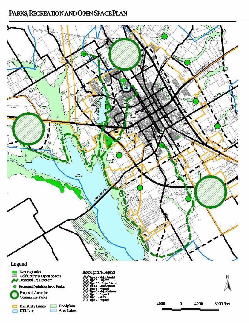
PPPPPPPPAAAAAAAARRRRRRRRKKKKKKKKSSSSSSSS,,,,,,,, RRRRRRRREEEEEEEECCCCCCCCRRRRRRRREEEEEEEEAAAAAAAATTTTTTTTIIIIIIIIOOOOOOOONNNNNNNN AAAAAAAANNNNNNNNDDDDDDDD OOOOOOOOPPPPPPPPEEEEEEEENNNNNNNN SSSSSSSSPPPPPPPPAAAAAAAACCCCCCCCEEEEEEEE PPPPPPPPLLLLLLLLAAAAAAAANNNNNNNN
LLLLLLLLeeeeeeeeggggggggeeeeeeeennnnnnnndddddddd
Golf Courses/Open SpacesGolf Courses/Open SpacesGolf Courses/Open SpacesGolf Courses/Open Spaces Existing ParksExisting ParksExisting ParksExisting Parks
Proposed Trail SystemProposed Trail SystemProposed Trail SystemProposed Trail System
Proposed NeProposed NeProposed NeProposed Neighborhood Parksighborhood Parksighborhood Parksighborhood Parks
Proposed Areas for Proposed Areas for Proposed Areas for Proposed Areas for Community ParksCommunity ParksCommunity ParksCommunity Parks
Ennis City LimitsEnnis City LimitsEnnis City LimitsEnnis City Limits E.T.J. LineE.T.J. LineE.T.J. LineE.T.J. Line
Type C Type C Type C Type C –––– Major Collector Major Collector Major Collector Major Collector
Type D Type D Type D Type D –––– Minor Minor Minor Minor C ll tC llC llC ll t
Type A Type A Type A Type A –––– Proposed Proposed Proposed Proposed
Type B Type B Type B Type B –––– Proposed Proposed Proposed Proposed
Type A Type A Type A Type A –––– Major ArterialMajor ArterialMajor ArterialMajor Arterial
Type AA Type AA Type AA Type AA –––– Major ArterialMajor ArterialMajor ArterialMajor Arterial Type B Type B Type B Type B –––– Minor Arterial Minor Arterial Minor Arterial Minor Arterial
Type C Type C Type C Type C ---- Proposed Proposed Proposed Proposed
Type D Type D Type D Type D –––– Proposed Proposed Proposed Proposed
Thoroughfare LegendThoroughfare LegendThoroughfare LegendThoroughfare Legend
FloodplainFloodplainFloodplainFloodplain Area LakesArea LakesArea LakesArea Lakes
4000 4000 4000 4000 0000 4000 4000 4000 4000 8000 Feet8000 Feet8000 Feet8000 Feet

EEEEEEEEnnnnnnnnnnnnnnnniiiiiiiissssssss CCCCCCCCiiiiiiiittttttttyyyyyyyy LLLLLLLLiiiiiiiimmmmmmmmiiiiiiiittttttttssssssss aaaaaaaannnnnnnndddddddd EEEEEEEETTTTTTTTJJJJJJJJ AAAAAAAArrrrrrrreeeeeeeeaaaaaaaa
Baseline AnalysisBaseline AnalysisBaseline AnalysisBaseline Analysis
HHHHHHHHiiiiiiiissssssssttttttttoooooooorrrrrrrriiiiiiiiccccccccaaaaaaaallllllll IIIIIIIInnnnnnnnffffffffoooooooorrrrrrrrmmmmmmmmaaaaaaaattttttttiiiiiiiioooooooonnnnnnnn The City of Ennis was established in the year 1872 when the Houston and Texas Central Railroad reached the area, and was named after an early railroad official, Cornelius Ennis. The City of Ennis was incorporated in November 1873 and held its first election in April 1874. By 1890, Ennis had reached a population of 3,000. Today, Ennis is home to 63 industries that employ more than 4,600 workers, with a total population of approximately 16,045 people according to the 2000 Census.
RRRRRRRReeeeeeeellllllllaaaaaaaattttttttiiiiiiiioooooooonnnnnnnnsssssssshhhhhhhhiiiiiiiipppppppp ooooooooffffffff EEEEEEEEnnnnnnnnnnnnnnnniiiiiiiissssssss ttttttttoooooooo tttttttthhhhhhhheeeeeeee RRRRRRRReeeeeeeeggggggggiiiiiiiioooooooonnnnnnnn Ennis is located along the Union Pacific Railroad, at the intersection of Interstate Highway 45, State Highway 34 and U.S. Highway 287. Located in southeastern Ellis County, Ennis is approximately 30 miles south of Dallas/Fort Worth. The City also lies just east of Lake Bardwell, a popular recreational area.
DDDDDDDDeeeeeeeemmmmmmmmooooooooggggggggrrrrrrrraaaaaaaapppppppphhhhhhhhiiiiiiiicccccccc IIIIIIIInnnnnnnnffffffffoooooooorrrrrrrrmmmmmmmmaaaaaaaattttttttiiiiiiiioooooooonnnnnnnn Much of Ennis's growth can be attributed to its proximity and easy access to Dallas; the City has captured a significant percentage of the region’s growth. The trend in population growth has been a steady increase since 1960. Ennis is estimated to have grown at a relatively rapid rate between 1990 and 2000, with 16 percent growth and an increase of over 2,200 people.
EEEEEEEExxxxxxxxttttttttrrrrrrrraaaaaaaa--------tttttttteeeeeeeerrrrrrrrrrrrrrrriiiiiiiittttttttoooooooorrrrrrrriiiiiiiiaaaaaaaallllllll JJJJJJJJuuuuuuuurrrrrrrriiiiiiiissssssssddddddddiiiiiiiiccccccccttttttttiiiiiiiioooooooonnnnnnnn Unincorporated areas of Ellis County surround the City of Ennis on all sides of the existing city limits, which allows the City opportunity for future expansion. The extra-territorial juris-diction (ETJ) of Ennis is one mile in radius. Although the City is currently surrounded by unincorporated land, if surrounding cities such as Garrett and Bardwell begin to grow, they may have a limiting effect on Ennis’ ETJ.
9,34711,046 12,110
13,812
16,045
6,0008,000
10,00012,00014,00016,00018,000
1 2 3 4 5 1960 1970 1980 1990 2000CCCCCCCCeeeeeeeennnnnnnnssssssssuuuuuuuussssssss YYYYYYYYeeeeeeeeaaaaaaaarrrrrrrr
P PPPP PPP o oooo ooop pppp ppp u uuuu uuu
l llll lll a aaaa aaat tttt ttt i iiii iii
o oooo ooo n nnnn nnn
CCCCCCCCiiiiiiiittttttttyyyyyyyy ooooooooffffffff EEEEEEEEnnnnnnnnnnnnnnnniiiiiiiissssssss -------- PPPPPPPPooooooooppppppppuuuuuuuullllllllaaaaaaaattttttttiiiiiiiioooooooonnnnnnnn GGGGGGGGrrrrrrrroooooooowwwwwwwwtttttttthhhhhhhh

BBAASSEELLIINNEE AANNAALLYYSSIISS ((CCOONNTTIINNUUEEDD))
EEEEEEEExxxxxxxxiiiiiiiissssssssttttttttiiiiiiiinnnnnnnngggggggg LLLLLLLLaaaaaaaannnnnnnndddddddd UUUUUUUUsssssssseeeeeeee CCCCCCCChhhhhhhhaaaaaaaarrrrrrrraaaaaaaacccccccctttttttteeeeeeeerrrrrrrriiiiiiiissssssssttttttttiiiiiiiiccccccccssssssss Of the developed land area in the year 2000, single-family residential land uses comprise the greatest percentage. Most of the nonresidential land uses within the City are located along major thoroughfares or in the downtown area. There is almost an equal amount of developed land and vacant land, which provides the City continued opportunity for positive, proactive planning decisions.
FFFFFFFFUUUUUUUUTTTTTTTTUUUUUUUURRRRRRRREEEEEEEE PPPPPPPPOOOOOOOOPPPPPPPPUUUUUUUULLLLLLLLAAAAAAAATTTTTTTTIIIIIIIIOOOOOOOONNNNNNNN PPPPPPPPRRRRRRRROOOOOOOOJJJJJJJJEEEEEEEECCCCCCCCTTTTTTTTIIIIIIIIOOOOOOOONNNNNNNNSSSSSSSS The rate of population change within Ennis will be indirectly related to various factors, including employment opportunities and the rate at which the housing inventory can be expanded. The population of Ennis is expected to increase by 500 persons per year, which corresponds to an average compounded growth rate of approximately 2.5 percent. Therefore, for planning purposes, Scenario “B” is recommended as the most appropriate and applicable for projected growth within Ennis.
EEEEEEEEXXXXXXXXIIIIIIIISSSSSSSSTTTTTTTTIIIIIIIINNNNNNNNGGGGGGGG IIIIIIIINNNNNNNNFFFFFFFFRRRRRRRRAAAAAAAASSSSSSSSTTTTTTTTRRRRRRRRUUUUUUUUCCCCCCCCTTTTTTTTUUUUUUUURRRRRRRREEEEEEEE The City of Ennis completed a Water Distribution System Master Plan in 1985 and a Wastewater System Master Plan in 1986. These master plans were both updated in 1999. The current water and wastewater systems serve all of the area within the Ennis corporate limits. The water system’s capacities are adequate to meet current peak demands. The existing wastewater system also has adequate capacity to meet current flows. Major expansions of both the water and wastewater systems should be complete within two years and will provide adequate capacity for the next fifteen to twenty years.
Land Use Land Use Land Use Land Use CategoryCategoryCategoryCategory
AcreageAcreageAcreageAcreage Percentage Percentage Percentage Percentage
of Total of Total of Total of Total AcreageAcreageAcreageAcreage
Single-Family 1,373 12.18%
Duplex 41 0.36%
Multi-Family 50 0.44% Manufactured
Homes 41 0.00%
Public/Semi-Public
648 5.75%
Parks & Open Space
333 2.96%
Office 26 0.23% Retail 119 1.06%
Commercial 588 5.21% Industrial 565 5.10%
Rights-of-Way 1,972 17.50%
Total DevelopedTotal DevelopedTotal DevelopedTotal Developed 5,756 51.08%
Total Acreage Total Acreage Total Acreage Total Acreage Within the CityWithin the CityWithin the CityWithin the City
11,268 100.00%
CCCCCCCCiiiiiiiittttttttyyyyyyyy ooooooooffffffff EEEEEEEEnnnnnnnnnnnnnnnniiiiiiiissssssss –––––––– EEEEEEEExxxxxxxxiiiiiiiissssssssttttttttiiiiiiiinnnnnnnngggggggg LLLLLLLLaaaaaaaannnnnnnndddddddd UUUUUUUUsssssssseeeeeeee
Scenario ‘A’Scenario ‘A’Scenario ‘A’Scenario ‘A’ Scenario ‘B’Scenario ‘B’Scenario ‘B’Scenario ‘B’ Scenario ‘C’Scenario ‘C’Scenario ‘C’Scenario ‘C’ YearYearYearYear
2+% 3+% 4+% 1999 16,046 16,046 16,046 2005 17,400 18,400 19,680 2010 19,200 21,600 23,400 2015 21,200 25,300 28,500 2020 23,400 30,000 34,700
Building Building Building Building Permits Permits Permits Permits
Required Per Required Per Required Per Required Per YearYearYearYear
125/year 210/year 315/year
CCCCCCCCiiiiiiiittttttttyyyyyyyy ooooooooffffffff EEEEEEEEnnnnnnnnnnnnnnnniiiiiiiissssssss –––––––– PPPPPPPPooooooooppppppppuuuuuuuullllllllaaaaaaaattttttttiiiiiiiioooooooonnnnnnnn PPPPPPPPrrrrrrrroooooooojjjjjjjjeeeeeeeeccccccccttttttttiiiiiiiioooooooonnnnnnnnssssssss
EEEEEEEExxxxxxxxiiiiiiiissssssssttttttttiiiiiiiinnnnnnnngggggggg LLLLLLLLaaaaaaaannnnnnnndddddddd UUUUUUUUsssssssseeeeeeee WWWWWWWWiiiiiiiitttttttthhhhhhhhiiiiiiiinnnnnnnn EEEEEEEEnnnnnnnnnnnnnnnniiiiiiiissssssss

TTTTTTTTHHHHHHHHEEEEEEEE TTTTTTTTHHHHHHHHOOOOOOOORRRRRRRROOOOOOOOUUUUUUUUGGGGGGGGHHHHHHHHFFFFFFFFAAAAAAAARRRRRRRREEEEEEEE PPPPPPPPLLLLLLLLAAAAAAAANNNNNNNN The Thoroughfare Plan is an overall guide used to enable individual developments within Ennis to be coordinated into an integrated, unified transportation system. The following are key recommendations:
(1) Extend and straighten Preston Street so that it creates a north-south connection through Ennis. Specifically, Preston Street would extend to the north until it intersects with Sleepy Hollow Street, and to the south until it intersects with F.M. 1183.
(2) Extend F.M. 85 west from Interstate Highway 45 until it intersects with the U.S. Highway 287 Bypass. This connection would provide additional access to and through a proposed future industrial area, thereby making the area increasingly valuable in terms of economic development
(3) Improve Hall Street/Ensign Road in the southern part of the City. This improvement will become an important north-south arterial for Ennis as the City continues to grow to the southwest.
(4) Construct a connection between U.S. Highway 287 Bypass and Interstate Highway 45 in the northern portion of the City. The proposed connection will create an arterial street loop (just north of Sleepy Hollow Street), thereby mitigating the flow of traffic within the City in both north-south and east-west directions and creating an additional connection between the east and west sides of the City.
(5) Construct an overpass over the railroad at an appropriate location, after further engineering studies determine where an overpass can be constructed.
It is also recommended within the Thoroughfare Plan that Ennis consider developing certain urban design guidelines for development along major travel corridors. The visual appearance of adjacent developments along these corridors would enable Ennis to project its quality community character to those traveling through or to the City.
TTTTTTTTHHHHHHHHEEEEEEEE PPPPPPPPAAAAAAAARRRRRRRRKKKKKKKKSSSSSSSS,,,,,,,, RRRRRRRREEEEEEEECCCCCCCCRRRRRRRREEEEEEEEAAAAAAAATTTTTTTTIIIIIIIIOOOOOOOONNNNNNNN &&&&&&&& OOOOOOOOPPPPPPPPEEEEEEEENNNNNNNN SSSSSSSSPPPPPPPPAAAAAAAACCCCCCCCEEEEEEEE PPPPPPPPLLLLLLLLAAAAAAAANNNNNNNN A vital component of an urban area is the space devoted to satisfying community recreational needs. The existing system of parks in Ennis consists of approximately 203 acres. Several local schools have baseball, softball and soccer fields that supplement the City’s facilities. The total park acreage was evaluated within the Plan based on its function. Consequently, there is a lack of neighborhood and community parks in Ennis, but there are an adequate number of regional parks. The City appears to be in need of active play facilities, and a public forum identified the need for hike-and-bike trails. It is estimated that Ennis will need approximately 330 acres of parkland by 2010.
TTTTTTTTHHHHHHHHEEEEEEEE PPPPPPPPUUUUUUUUBBBBBBBBLLLLLLLLIIIIIIIICCCCCCCC FFFFFFFFAAAAAAAACCCCCCCCIIIIIIIILLLLLLLLIIIIIIIITTTTTTTTIIIIIIIIEEEEEEEESSSSSSSS PPPPPPPPLLLLLLLLAAAAAAAANNNNNNNN The Public Facilities element of the Comprehensive Plan addresses the expectations that a community's residents have regarding public services, and the facilities and personnel needed to provide these services. The principle recommendation is that the City should consider construction of a Public Safety Complex that could provide one location for City Hall, the Police Department, and the Fire Department, along with a multi-purpose training facility, a municipal court, and a community center.
IIIIIIIIMMMMMMMMPPPPPPPPLLLLLLLLEEEEEEEEMMMMMMMMEEEEEEEENNNNNNNNTTTTTTTTAAAAAAAATTTTTTTTIIIIIIIIOOOOOOOONNNNNNNN OOOOOOOOFFFFFFFF TTTTTTTTHHHHHHHHEEEEEEEE CCCCCCCCOOOOOOOOMMMMMMMMPPPPPPPPRRRRRRRREEEEEEEEHHHHHHHHEEEEEEEENNNNNNNNSSSSSSSSIIIIIIIIVVVVVVVVEEEEEEEE PPPPPPPPLLLLLLLLAAAAAAAANNNNNNNN
The City of Ennis has taken an important step in shaping its future by undertaking this comprehensive planning process. TheComprehensive Plan will provide a very important tool for the City to use in making sound planning decisions regarding long-termgrowth and development.
CCCCCCCCaaaaaaaappppppppiiiiiiiittttttttaaaaaaaallllllll IIIIIIIImmmmmmmmpppppppprrrrrrrroooooooovvvvvvvveeeeeeeemmmmmmmmeeeeeeeennnnnnnnttttttttssssssss PPPPPPPPrrrrrrrrooooooooggggggggrrrrrrrraaaaaaaammmmmmmmmmmmmmmmiiiiiiiinnnnnnnngggggggg The CIP should show a recommended, generalized plan for capital improvements within Ennis, and should identify them by priority with their approximate cost over a specific period of time.
GGGGGGGGrrrrrrrroooooooowwwwwwwwtttttttthhhhhhhh MMMMMMMMaaaaaaaannnnnnnnaaaaaaaaggggggggeeeeeeeemmmmmmmmeeeeeeeennnnnnnntttttttt
Growth management is often tied to annexation, which is essential to the efficient extension of urban services. Ennis has a one-mile-radius ETJ within which annexation can occur. It is in the best interest of Ennis to annex areas prior to their development in order to ensure that it occurs to an adequate standard.
AAAAAAAAddddddddmmmmmmmmiiiiiiiinnnnnnnniiiiiiiissssssssttttttttrrrrrrrraaaaaaaattttttttiiiiiiiivvvvvvvveeeeeeee PPPPPPPPrrrrrrrroooooooocccccccceeeeeeeesssssssssssssssseeeeeeeessssssss Proactive ways in which to implement the Comprehensive Plan include development of a Capital Improvements Program and revision of the Zoning Ordinance and Subdivision Ordinance. Reactive ways include ensuring development and/or rezoning is consistent with the Plan, and reviewing site plans and subdivisions. Both proactive and reactive measures should be used in the implementation of the Comprehensive Plan.
CCCCCCCCiiiiiiiittttttttyyyyyyyy ooooooooffffffff EEEEEEEEnnnnnnnnnnnnnnnniiiiiiiissssssss –––––––– RRRRRRRReeeeeeeeccccccccoooooooommmmmmmmmmmmmmmmeeeeeeeennnnnnnnddddddddeeeeeeeedddddddd PPPPPPPPaaaaaaaarrrrrrrrkkkkkkkk AAAAAAAAccccccccrrrrrrrreeeeeeeeaaaaaaaaggggggggeeeeeeee
Recommended AcreageRecommended AcreageRecommended AcreageRecommended Acreage
Park TypePark TypePark TypePark Type
General General General General Standard Standard Standard Standard Per Per Per Per 1,000
PersonsPersonsPersonsPersons
Existing Existing Existing Existing Park Park Park Park
AcreageAcreageAcreageAcreage 21,600
Persons in Persons in Persons in Persons in 2010
30,000 Persons in Persons in Persons in Persons in
2020
Mini NR 3.85 NR NR Neighborhood 2.5 acres 14 55 75
Community 5.0 acres 17 110 150 Regional 7.5 acres 146 165 225 Special Variable 22 Variable Variable
Parkways/ Ornamental
Variable ----------- Variable Variable
TotalTotalTotalTotal 15 acresacresacresacres 203 acresacresacresacres 330 acresacresacresacres 450 acres acres acres acres

TTTTTTTTHHHHHHHHOOOOOOOORRRRRRRROOOOOOOOUUUUUUUUGGGGGGGGHHHHHHHHFFFFFFFFAAAAAAAARRRRRRRREEEEEEEE PPPPPPPPLLLLLLLLAAAAAAAANNNNNNNN
6,000 6,000 6,000 6,000 0000 6,000 6,000 6,000 6,000 12,000 Feet12,000 Feet12,000 Feet12,000 Feet
45
45
LLLLLLLLeeeeeeeeggggggggeeeeeeeennnnnnnndddddddd
Type C Type C Type C Type C –––– Major Collector Major Collector Major Collector Major Collector
Type D Type D Type D Type D –––– Minor Collector Minor Collector Minor Collector Minor Collector
Type A Type A Type A Type A –––– Major Arterial Major Arterial Major Arterial Major Arterial
Type B Type B Type B Type B –––– Propos Propos Propos Proposedededed
Type AA Type AA Type AA Type AA –––– Major Arterial Major Arterial Major Arterial Major Arterial
Type A Type A Type A Type A –––– Proposed Proposed Proposed Proposed Type B Type B Type B Type B –––– Minor Arterial Minor Arterial Minor Arterial Minor Arterial
Type C Type C Type C Type C ---- Proposed Proposed Proposed Proposed
Type D Type D Type D Type D –––– Proposed Proposed Proposed Proposed
FloodplainFloodplainFloodplainFloodplain
E.T.J LineE.T.J LineE.T.J LineE.T.J Line Ennis City LimitsEnnis City LimitsEnnis City LimitsEnnis City Limits

WWWWWWWWAAAAAAAATTTTTTTTEEEEEEEERRRRRRRR &&&&&&&& WWWWWWWWAAAAAAAASSSSSSSSTTTTTTTTEEEEEEEEWWWWWWWWAAAAAAAATTTTTTTTEEEEEEEERRRRRRRR DDDDDDDDIIIIIIIISSSSSSSSTTTTTTTTRRRRRRRRIIIIIIIIBBBBBBBBUUUUUUUUTTTTTTTTIIIIIIIIOOOOOOOONNNNNNNN
LLLLLLLLeeeeeeeeggggggggeeeeeeeennnnnnnndddddddd PPPPROPOSED ROPOSED ROPOSED ROPOSED WWWWATER ATER ATER ATER SSSSYSTEMYSTEMYSTEMYSTEM
Existing Water MainsExisting Water MainsExisting Water MainsExisting Water Mains
Proposed Water MainsProposed Water MainsProposed Water MainsProposed Water Mains
PPPPROPOSED ROPOSED ROPOSED ROPOSED WWWWASTEWATERASTEWATERASTEWATERASTEWATER SSSSYSTEMYSTEMYSTEMYSTEM
Existing Gravity SewerExisting Gravity SewerExisting Gravity SewerExisting Gravity Sewer
Existing ForceExisting ForceExisting ForceExisting Force
Existing Lift StationExisting Lift StationExisting Lift StationExisting Lift Station
Recommended Gravity SewerRecommended Gravity SewerRecommended Gravity SewerRecommended Gravity Sewer
Recommended Force MainRecommended Force MainRecommended Force MainRecommended Force Main
2000 2000 2000 2000 0 0 0 0 2000 2000 2000 2000 6000 Feet6000 Feet6000 Feet6000 Feet

Related Documents