FROM PHYSICAL TO SPATIAL PLANNING AND THE DEVOLUTION OF PLANNING TO COUNTY LEVEL IN KENYA. By Laji Adoyo SES/D.PHIL/05/011 SES 976: SPECIAL TOPICS i

From Physical to Spatial Planning: The Evolution of Land Use Planning in Kenya
Jul 17, 2016
The paper gives a background on evolution of land use planning in Kenya by describing its initial development as just town planning to the current set-up where planning of the entire country is envisaged.
Welcome message from author
This document is posted to help you gain knowledge. Please leave a comment to let me know what you think about it! Share it to your friends and learn new things together.
Transcript
FROM PHYSICAL TO SPATIAL PLANNING AND THE
DEVOLUTION OF PLANNING TO COUNTY LEVEL IN
KENYA.
By
Laji Adoyo
SES/D.PHIL/05/011
SES 976: SPECIAL TOPICS
LECTURER: Dr. V. Odenyo
i
Table of Contents
1.0 Introduction..............................................................................................................................1
2.0 Mainstreaming Spatial Planning in Existing Planning Systems.........................................3
Why Spatial Planning?...............................................................................................................................................5
3.0 Devolving Spatial Planning to County level..........................................................................5
3.1 Devolution of Spatial Planning:- Examples from other countries..................................................7
3.1.1 Spatial Planning in Germany........................................................................................................................7
3.1.2 Spatial Planning in Switzerland....................................................................................................................9
3.2 Spatial Planning Situation in Kenya......................................................................................................10
3.2.1 The Current Situation..................................................................................................................................10
3.2.2 The Anticipated Situation...........................................................................................................................13
4.0 Conclusion..............................................................................................................................17
REFERENCES............................................................................................................................19
ii

1.0 IntroductionKenya aspires to be a ‘globally competitive and prosperous country’ with a high quality of life
by 2030. This will be achieved through the implementation of the country’s long term
development blue print, the Kenya Vision 2030 (GoK, 2007). The vision aims to transform
Kenya into ‘a newly – industrializing middle income country’ providing a high quality of life to
all its citizens in a clean and secure environment. The realization of this desired socio-economic
transformation is founded on key factors among them, land. Land is the foundation on which the
economic, social and political flagships projects under the vision will be implemented. It is
because of this, that land use planning becomes vital.
Land use planning in Kenya has been practiced over the years and the process has been geared
towards promoting orderly land use and development. It has been carried out within the
framework of a number of legislations including Town Planning Act and Land Planning Act –
which were repealed in 1996. A more comprehensive legal regime, namely the Physical Planning
Act was enacted in the same year (The Physical Planning Act, Gazette Notice No.6 of 1996).
The legislation was enacted to provide for the formulation of physical planning policies,
strategies and plans to guide land use planning in the country. Since then, the Department of
Physical Planning within the Ministry of Lands has prepared various Regional and Local
physical development plans to guide land use. Though these plans have provided a basis for
orderly development in various urban centres and rural areas, numerous challenges have arisen.
It should be noted however, from the outset that the terms ‘land use planning’ and ‘physical
planning’ have been used interchangeably in Kenya. The terms have been used to connote
formulation of plans for the purpose of orderly, coordinated, harmonious and progressive
development of an area in order to promote health, safety, order, amenity, convenience and
general welfare of all inhabitants. Land use planning has been defined as the scientific, aesthetic
and orderly disposition of land, resources, facilities and services with a view to securing the
physical, economic and social efficiency, health and well being of urban and rural communities
(Wehrmann, 2011). Similarly, physical planning is concerned with general pattern of land use,
the character and location of public buildings and structures, the design of streets, the location
and development of transit and transportation systems and all other physical facilities which are
1
necessary or desirable to promote the economic betterment, comfort, convenience and the
general welfare (Pivo, et al, 1990). Physical planning is normally carried out by the state or by
local government for the general good of the community.
Nevertheless, in recent times the terms ‘land use planning’ and ‘physical planning’ are gradually
being replaced by the more wide ranging term namely, ‘spatial planning’. The word ‘spatial’
comes from a Latin word “spatium” which means space. The Oxford Advanced Learner’s
Dictionary defines spatial as relating to space, position, size, shape of things in it. According to
Amdam (2004), spatial planning refers to the methods used largely by the public sector to
influence the future distribution of activities in space. It is undertaken with the aims of creating a
more rational territorial organization of land uses and the linkages between them, to balance
demands for development with the need to protect the environment and to achieve social and
economic objectives. Spatial planning also embraces measures to coordinate the spatial impacts
of other sectoral policies, to achieve a more even distribution of economic development between
regions that would otherwise be created by market forces and to regulate the conversion of land
and property uses.
Spatial planning is an approach to ensure the most efficient use of land by balancing competing
demands within the context of sustainable development. It provides an overall framework upon
which development actions that are guided by sectoral plans are based (Ministry of Lands, 2010).
It could also be used to mean the process of distributing or redistributing population and
organizing activities on land. Spatial planning predetermines and rationalizes the use of land and
is a basis for coordinating sectoral actions for improvement. It assigns roles and functions to
specific places and sets out measures to achieve them.
Spatial planning goes beyond the traditional land use planning to bring together and integrate
policies for the development and use of land with other policies and programmes which
influence the nature of places and how they function. Indeed, it moves focus from a land use
planning approach based on regulation and control of land, to a wider far ranging approach that
aims to ensure the best use of land by assessing competing demands. To this end, social,
economic and environmental factors are taken into account in producing a decision that is more
conducive to sustainable development (Amdam, 2004).
2
From the foregoing, it emerges that spatial planning is a broader concept and is a more inclusive
approach that entails considering the best use of land than traditional ‘land use planning’. It
brings together and integrates policies for the development and use of land with other policies
and programmes which influence the nature of places and how they function. It also emphasizes
improved sectoral policy integration, the realization of sustainable development and improved
public participation. This form of planning includes all levels of land use planning, including
urban planning, regional planning and environmental planning. While spatial planning sets out a
strategic framework to guide future development and policy interventions, land use planning
focuses on the regulation and control of land through land classification and zoning, while
physical planning is more concerned with predetermining the nature of the physical environment
(Ministry of Lands, 2011). The scope of spatial planning differs from one country to another, but
in almost all countries, spatial planning is concerned with identifying long-or medium- term
objectives and strategies for regions, dealing with land use and physical development as a
distinct sector of government activity and coordinating sectoral policies such as transport,
agriculture and environment.
2.0 Mainstreaming Spatial Planning in Existing Planning SystemsMany countries have recently made fundamental reforms to the body of planning law to enable
changes in the elaboration and operation of their planning systems (UN, 2008). In some
countries, however, planning statutes have not kept pace with the reality of spatial development.
The problem is usually not a lack of legislation, but rather that the legislation is no longer
relevant (UN, ibid). Nevertheless, the growing commitments to sustainable development in many
countries and the increasing interest in spatial planning systems means there is currently
considerable opportunity to reshape and strengthen spatial planning systems in the countries
concerned. Kenya is one of such countries where the existing planning legislation falls short of
meeting the emerging spatial planning challenges as well as the requirements of the recently
promulgated constitution (August 2010) which created Counties and County Governments.
There is thus a need for a paradigm shift in planning.
From the foregoing, it is evident that countries like Kenya that have legislation that no longer
meet the needs of the society especially as spatial planning is concerned need to review and/or
3
re-write the planning legislations to enable them effectively address emerging problems and
challenges. Thus, in Kenya, the legislation that would be enacted would be aligned in such a
manner as to facilitate the delivery of the constitutional promise particularly by providing for
planning to be undertaken at all levels of the government and engendering effective citizen
participation in the planning process. In addition, the legislation would take cognizance of the
expanded horizon of planning, more so the recognition of land as a resource which underscores
the need for sustainable development planning. The legislation would thus, take cognizance of
paradigm shifts in planning and be able to address the unrelenting existing challenges and
emerging realities.
Effective spatial planning helps avoid duplication of efforts by actors at different levels of
government. Thus, a clear distribution of responsibilities would be outlined between different
levels of government. For instance, at the national level, the National Spatial Plan would provide
the vision for development of the whole country that reflects national objective, policies and
strategies. The government would therefore be responsible for developing framework policies
that both initiate and guide the decision making process, setting the conditions for the operation
of effective planning at regional and local levels. Major tasks would include the establishment of
effective framework legislation, coordination with other sectors and between regions, the
monitoring of implementation of national guidelines and principles at the regional and local
levels and the identification of bottlenecks in planning and implementation. Likewise, feedback
from the regional and local levels to the national level based on experiences with the framework
would also be provided. Effective spatial planning goes further and gives recognition to unique
conditions at the regional and local levels.
The main task at the regional level would be preparation and coordination of an overall regional
spatial strategy by looking ahead 15 to 20 years at the overall development of the region (UN,
2008). Local level spatial planning would take into account policies elaborated at both the
national and regional levels. County government would prepare regulatory planning instruments,
establish priorities for action, facilitate the preparation of local spatial plans, coordinate planning
with neighborhood authorities and take proactive measures to encourage development.
4
Why Spatial Planning?
Spatial planning is critical for delivering economic, social and environment benefits by
creating more stable and predictable conditions for investment and development, by
securing community benefits from development and by promoting prudent use of land
and natural resources for development. It is thus an important level for promoting
sustainable development and improving quality of life.
Spatial planning has a key role in providing a long-term frame for development and
coordinating policies across sectors. It also helps to promote economic growth and
investment while guiding the policies for protecting the environment and promoting more
efficient use of resources.
3.0 Devolving Spatial Planning to County levelDevolution is a multi-dimensional approach which organizes governance and manages state
power along multiple lines. It is a system of governance that devolves power from the centre to
smaller sub government units at the lower levels. Devolution can actually be described as the
statutory granting of powers from the central government of a state to government at sub-
national level, such as a regional, local or county level. It is a practice through which the
authority to make and implement decisions in selected spheres of public policy is conferred to
elected lower or sub-national levels of government by law. But, devolution is not just a linear
process of power transfer from national to sub-national level; it also involves some degree of
cooperation between the different levels of government. Devolution has over the past years
gained significant importance as one of the key measure of decentralizing governance, by
handing over certain functions to local democratic government granting them full power to
decide in terms of planning and implementation and bearing the full responsibility of their
decisions.
A review of Kenya’s history reveals that the country has for the better part of its independent life
been a unitary state with a highly centralized government that has had an overbearing control
over the sub national governments and other arms of the government. Even the local
governments established under the Local Government Act (Revised Edition 2010) cap 265 of the
Laws of Kenya, were not granted significant political, administrative and fiscal powers. Instead,
5
central government retained control of the local governments through administration officers. It
is against this background that physical planning in Kenya has been practiced. Physical planning
in Kenya has been the responsibility of the central government through the Department of
Physical Planning in the Ministry of Lands. The Department is headed by the Director of
Physical Planning who is mandated by the Act to among other things;
(i) Formulate national, regional and local physical development policies, guidelines and
strategies.
(ii) Be responsible for the preparation of all regional and local physical development plans, and
(iii) From time to time, initiate, undertake or direct studies and research into matters concerning
physical planning (Ministry of Lands, 2011).
By and large, the Director of Physical Planning is responsible for the preparation of all physical
development plans in Kenya. With the promulgation of the new constitution and subsequent
implementation of its wide ranging provisions and statutory demands, physical planning in
Kenya is poised to undergo drastic changes to enable compliance with the new dispensation. The
new constitution has also created an urgent need to re-evaluate the Physical Planning Act of
1996, which is the main legislation that governs spatial planning in the country. This has arisen
from the fact that the constitution has introduced new governance structures in the form of
devolved government, citizen participation, expanded definition of land and new categorization
of land tenure.
The constitution provides for two levels of government namely; national and county
governments which are distinct and interdependent (Article Six; Part 2 of the Constitution of
Kenya 2010). Distinctness in this sense rules out the concept of hierarchy as a relational
principle. These two levels of government are coordinate and not subordinate to each other and
none can be abolished by the other. Therefore, they are expected to conduct their mutual
relations on the basis of consultation and cooperation. In effect, the levels of government must
have the freedom to make decisions in the functional areas assigned to them by Constitution of
Kenya 2010 without undue interference from the other.
6
It is because of this, that there is need for re-casting of the Physical Planning Act to appropriately
respond to the current set-up and new demands. The Act is out of tune with the new devolved
governance structure and does not articulate constitutional values and principles. It also defines
land in a narrower sense. In addition, due to these provisions, it is no longer tenable to perform
physical planning functions in a centralized manner. For this reason, the need to restructure the
spatial planning in Kenya to conform to the requirements of the constitution cannot be
overemphasized. Indeed, what has increasingly become apparent in the new dispensation is that
local planning has started occupying the centre stage, if not in practice but certainly in concept.
Examples from other countries that have devolved planning to the local level will suffice to
illustrate.
3.1 Devolution of Spatial Planning: - Examples from other countries
Spatial Planning in GermanyPlanning in Germany is a multi layered process which takes place at four government levels.
Each government tier has varying degrees of planning responsibility and legal power within the
planning process. The top tier planning in Germany occurs at the federal level. The role of the
Federal government emanates from the Federal Spatial Planning Act which sets out some of the
principles, goals and guidelines for planning and development within Germany. The Lander or
States are responsible for drawing up a state development plan. This is a summarizing and a
supervising document which outlines the situation within each state and provides guidance on
planning that must be undertaken at more localized levels. These documents are however, not
legally binding and act essentially as frameworks for future development. The Municipal or
Local tiers of government hold the greatest amount of responsibility in terms of land use
planning. They derive the mandate from the German constitution which asserts that
“Municipalities must be guaranteed the right to regulate all local affairs on their own
responsibility” (Galbraith, 2007).
The majority of planning takes place at local levels and the core planning document is called the
local land use (Bebauungsplan) which is legally binding. There are two stages to planning at
local level. The first is the development of a preparatory land use plan which zones land for
future use. This can be general in nature and defines zoning for the entire municipal territory
7
according to the needs of the area. This is entirely preparatory and is not legally binding
(Galbraith, 2007). From this arises the core planning document, the Bebauungsplan or local land
use plan. These are prepared for certain areas within the municipality and are legally binding.
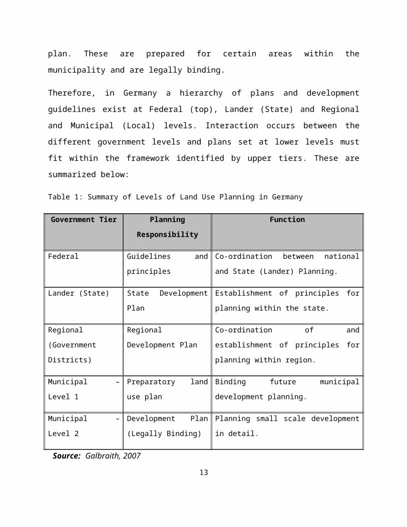
Therefore, in Germany a hierarchy of plans and development guidelines exist at Federal (top),
Lander (State) and Regional and Municipal (Local) levels. Interaction occurs between the
different government levels and plans set at lower levels must fit within the framework identified
by upper tiers. These are summarized below:
Table 1: Summary of Levels of Land Use Planning in Germany
Government Tier Planning Responsibility Function
Federal Guidelines and principles Co-ordination between national and State
(Lander) Planning.
Lander (State) State Development Plan Establishment of principles for planning within
the state.
Regional (Government
Districts)
Regional Development
Plan
Co-ordination of and establishment of principles
for planning within region.
Municipal – Level 1 Preparatory land use plan Binding future municipal development planning.
Municipal – Level 2 Development Plan (Legally
Binding)
Planning small scale development in detail.
Source: Galbraith, 2007
From the foregoing, it clearly emerges that spatial planning in Germany is polycentric and
majority of planning is undertaken at the local government level. Public participation is also deep
seated in the German planning system. All planning proceeding comprises the participation of
persons concerned by future planning measures. This is in contrast to the centralized approach to
planning that is found in Kenya which has failed to help build attractive and sustainable
settlements which meet needs and improve quality of life of local communities. The centralized
8
planning system in Kenya has also failed to deliver an efficient and effective service to ensure
economic prosperity and continued growth in the economy.
Spatial Planning in SwitzerlandSwitzerland is arguably the most devolved and decentralized government in the world. There is
probably no other country in the world that is as decentralized and devolved as Switzerland
(Galbraith, 2007). The planning system in the country follows the structure of the political
system of the Swiss Federation and works on all tiers of the government. That is, the Federal
(top), canton (state/region) and municipal (local) levels. The top tier provides principles and
guidance on planning which are then detailed at local levels. The Federal Land Use Planning Act
lists the basic procedural requirements of spatial (land use) planning. The Act goes on to spell
out the requirement of all tiers and branches of government to participate in planning.
The Federal Constitution spells out the roles of Federal government in connection with spatial
planning to include among others; laying down the principles of land use planning, supporting
and coordinating the efforts of the cantons and working together with the cantons, and taking
into consideration the requirements of land use planning as far as the fulfillment of their tasks is
concerned. The Cantons on the other hand, are the key players in spatial planning in Switzerland.
Their tasks include among others; development of guiding plans which determine the principles
to which the area shall develop; determination of which areas are suitable for agriculture,
recreation, of natural importance or are threatened by natural disasters; consideration of the
concepts and special affairs plans of neighboring cantons as well as regional development
concepts and plans. The guiding plan is legally binding only for public authorities who must
accept the plan as given for their own planning related activities. There may be more than one
guiding plan for each canton. Municipalities must then produce local guidance plans. These
plans cannot overturn decisions contained within the canton plan; instead they can only detail
them further. The planning system in Switzerland has similarities with the German planning
approach. Like the German system, the Swiss system also promotes planning at the local level
and is also polycentric in nature. Land use planning in Switzerland can be summarized as below:
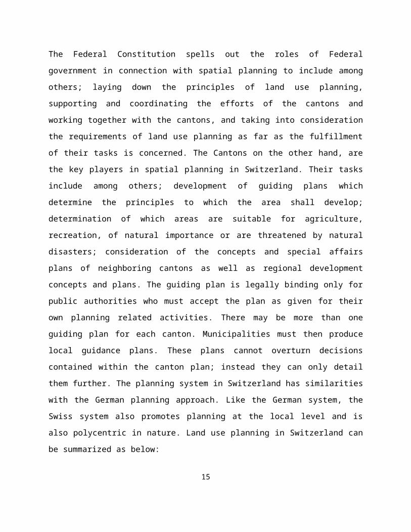
Table 2: Land use Planning in Switzerland9
Government
Level
Responsibility
Federal Principles of land use planning and coordination of planning undertaken by
Cantons.
Cantons Development of guiding plans which zone land and target development.
Municipal Level Development of local guidance plans and detailed use plans.
Source: Galbraith, 2007
3.2 Spatial Planning Situation in Kenya
The Current Situation As already explained above, the main law that governs physical planning in Kenya is the
Physical Planning Act of 1996. It provides the legal basis for the preparation and enforcement of
different physical development plans and requirements. The Department of Physical Planning
which is under the Ministry of Lands is the planning authority in Kenya and is mandated to
actually prepare the plans and also oversee all planning activities in the country. The Director of
Physical Planning, who is the head of this department, is responsible for the preparation of all
physical development plans in accordance with the Act. The Director is also the chief
government adviser on all matters relating to physical planning. The Act however, gives
provisions in section 5 (2) to the effect that the Director may delegate any of his functions to
officers within the Department. This is why the District Physical Planning Officers are able to
prepare plans and submit the same to the Ministry Headquarter for approval. The plans
originating from the Districts are usually subjected to further scrutiny and/or corrections at the
headquarter before being taken to the Minister, through the Permanent Secretary of the Ministry
for approval.
Current Processes and Practices
Physical planning is achieved through, among others, the following functions:
1. Preparation of various physical development plans namely;
10
Regional Physical Development Plan provided for under Section 16 of the Physical Planning Act: - This is a plan of an area or part thereof of a county council.
Local Physical Development Plan provided for under section 24 of the Act: - This a plan of an area or part thereof of a city, municipality, town or urban council and includes a plan with reference to any trading and market center.
Special Planning area: - These are plans prepared for areas with unique development potential or problems. Such areas include regions that go across boundaries of two county councils or regions crossed by rivers.
There are sectoral activities that are considered in physical development plans including; agriculture, industry, transportation, human settlement and infrastructure, water resources, mining, forestry, energy, wildlife management and tourism, fisheries and aquaculture.
2. Recommending on development applications namely;
Change of use, for example, from residential to commercial.
Extension of use, e.g. from single to multi family dwelling house.
Extension of lease
Subdivision and amalgamation.
3. Dispute resolution through the various Physical Planning Liaison Committees;
Municipal/District Physical Planning Liaison Committee.
Nairobi Physical Planning Liaison Committee.
The national Physical Planning Liaison Committee.
In addition to these, the Physical Planning Act empowers the local authorities under Section 29,
to regulate and exercise control over physical development decisions and activities. The Act
further provides for the formulation of national, regional and local physical planning guidelines,
policies and strategies. Through this Act, various regional and local physical development plans
have been prepared.
Procedure for Plan Preparation
11
In Kenya, the preparation of either regional or local physical development plans is done by following these steps;
i. The first step is the intention to prepare the development plan.ii. The second step involves data collection from imagery, topographical information,
background information – The critical sources of these information are Surveys of Kenya, Regional Centre for Mapping for Resources and Development, among others.
iii. The third step entails data collection from line Ministries and Departments (These data
include economic data and social data among others).iv. The collection of data from Ministries is followed by base map preparation.v. The fifth step entails organizing stakeholder meetings to facilitate consensus building.
vi. The next step is preparation of Draft Plan.vii. Notice of completion of the plan is then prepared and circulated (calling for
comments,objections within a period of sixty days) in Kenya Gazette and two local dailies.
viii. The next step involves incorporation of Amendments.ix. This is followed by Vetting for approval.x. The plan is then Submitted to the Minister for approval.
xi. Once approved the Notice of Approval is indicated in the Kenya Gazette.xii. The Plan is then assigned Plan Approval Number.
xiii. The next step involves circulation to Commissioner of Landsxiv. This is followed by recording in Plan Records registerxv. Once the plan has been recorded in Plan Records register, it is stored.
Fig. 1: Flow of Activities of Physical Planning
Source: Authors construction.12
Intention to Plan (DPP or Local Authority)
Background Information (Social data, Physical data, Economic data, Environmental data.
Image /Topo Survey (SoK, RCMRD, etc.)
Base Maps (Topocadastral Maps, RIMs, PIDs, Survey Plans).
Stakeholders meeting (Consensus Building)
Prepare Draft PlanNotice of Completion (PPA 3)
Circulate for Comments/Amendments
Submission to Minister for Approval
Approval number is assigned
Notice of Approval (PPA 4)
Storage in Plans Record Office/ Circulation to COL.
Shortcomings of the Current Planning System in Kenya
From the above description of the planning process in Kenya and provisions of the Physical
Planning Act, it clearly emerges that all powers and functions in planning are consolidated on the
Director of Physical Planning. The planning system in Kenya is thus based on the centralized
model perhaps adopted from the colonial masters, the United Kingdom. Research has shown that
such centralized planning system is unable to deliver an efficient service to ensure economic
prosperity and continued growth in the economy. Likewise, the levels of planning established in
Physical Planning Act do not cover the whole range of types of plans that could be prepared. In
addition, the Physical Planning Act does not provide for meaningful stakeholder participation,
including the public, public private partnerships, integrated development planning, resourced
based planning, metropolitan planning and special planning needs for the Arid and Semi Arid
regions. Similarly, the centralization of decision making at the office of the Minister responsible
for physical planning, inevitably slows down project implementation as decision about several
projects from all over the country have to be made by one individual.
The Anticipated SituationWith the promulgation of a new constitution in Kenya in 2010, there has arisen an urgent need to
overhaul the existing physical planning system and align it with the new dispensation. This will
entail formulation and enactment of a new planning legislation to conform to the statutory
demands of the constitution. It is for this reason that a Spatial Planning Bill is being proposed
and is currently being drafted by the Department of Physical Planning of Ministry of Lands.
What is envisioned in the expected legislation is the practice of spatial planning at the two levels
of the government created by the constitution. The national government is to be responsible for
broad principles of land use planning and coordination of planning by counties. The county
government on the other hand, is to be responsible for county land use planning and
development. The county government will also be responsible for local physical development
planning for unincorporated cities and municipalities.
It is anticipated that every county government will be the local planning authority within its area
of jurisdiction. This is a radical departure from the old system which centralized all the planning
issues at the Department of Physical Planning at the Ministry of Lands. Indeed, it is undoubtedly
13
a movement toward the polycentric form of spatial planning that is practiced in Germany and
Switzerland as enunciated in this discussion. In order to achieve this devolution of spatial
planning, the county governments are expected to establish a Department of County Spatial
Planning. This department will be tasked with; preparation of integrated county spatial plans;
preparation of Local Physical Development Plans for unincorporated cities and municipalities;
coordinating planning with the national government; coordinating planning with corporate cities
and municipalities within their jurisdiction and processing applications for planning permission,
enforcing development, monitoring and evaluation of planning and other planning functions. In
addition, the county government will ensure that the boards established under the Urban Areas
and Cities Act 2011, prepare and implement spatial plans for their areas of jurisdiction. The table
below gives a summary of the levels of spatial planning as anticipated in the current constitution.
Table 3: Anticipated Hierarchy of Spatial Planning
Level Type of Plan Coverage Responsibility
National National Spatial Strategy Territory of Kenya National Government.
Regional Metropolitan Development Strategy
Regional Development Strategy
City – Region.
Inter-County.
National and County Governments.
County County Integrated Development Plans.
Countrywide County governments.
Local Urban Development plan Cities, Municipalities and Urban areas.
County Governments and Corporate
Cities and Municipalities.
Source: Ministry of Lands, 2010
National Spatial Plans
The National Spatial Plans will contain the long term objectives of spatial development and
planning in conformity with overall economic social physical and cultural development; criteria
and guidelines for development of spatial and other entities and proposed priorities in the
accomplishment of planning objectives; essential elements for harmonization and orientation of
the spatial development, spatial organization of the state, priority development activities; 14
measures and activities needed for implementation of the plan; a basis for organization,
protection and use of the space, environmental protection and improvement, the development of
infrastructure system in particular locations, among other functions.
Regional Spatial Plans
Integrated Regional Spatial Plans will be aimed at controlling development in disaster prone
areas; providing the regional infrastructure development system; preservation and improvement
of natural, cultural, historical and landscape values; providing environmental improvement and
protection measures; providing starting points for development and protection of the space,
criteria and guidelines for economic development and to provide a system of central settlements
of regional importance.
Spatial Plans at the County level
The counties will prepare integrated county spatial plans. The preparation of spatial plans at the
county level would be achieved through; setting out a vision for the desirable future population
distribution and utilization of land; setting up goals and objectives to clarify the vision;
understanding the opportunities and challenges inherent in the counties and outlining policies,
strategies and measures to tap the opportunities, offset the challenges and achieve the vision of
the county. Planning in the county will be coordinated by a County Planning Unit which will be
responsible for various planning functions including;
Coordinating integrated development planning within the county;
Ensuring integrated planning within the county;
Ensuring linkages between county plans and the national planning framework
The County Planning Unit will also appropriately organize for the effective implementation of
the planning function within the county. The types of plans that will be prepared at the county
include the following;
1. County Integrated Development Plan
2. County Sectoral Plans
15
3. County Spatial Plans
4. Cities and Urban areas plans as provided for under Urban Area and Cities Act.
County Spatial Plans will provide a spatial expression of the social and economic development
programme of the county, with clear statements of how it is aligned to the regional and national
programmes in a manner that harmonizes the sustainable development of the county and country.
It will form the basis for other sub-county plans and a prerequisite for appropriation of resources.
In addition, county spatial plan will help in formulating strategies for identifying critical
development issues and defining clear desired outcomes across functional areas; establishing the
overall objectives for development in the entire area of the county as a planning unit and
providing guidelines and strategies for multi-sectoral planning. Plans prepared at the county level
will be expected to be anchored on broad policies, guidelines and standards set out at the higher
levels, that is the regional level and the national government level.
Challenges brought by the new order
While devolution embedded in the Constitution 2010 is appreciated, the two levels of
government pose a challenge due to lack of constitutional protection for lower units of
government. These lower levels below the county include; sub-county which is expected to
embrace constituencies/districts; wards which embrace locations and villages which embrace
sub-locations. Even though, there is a provision in the constitution that the county governments
decentralize their functions (including spatial planning) and provision of services to the extent
that is efficient and practicable, the lower entities have not been given sufficient execution power
to effectively act in planning process. They do not have constitutional protection and can only
operate under legislation which can be changed at the will of either the county or national
government. Although Spatial Planning Bill envisages robust community participation, it will be
very difficult to achieve the same in rural areas which form the lowest levels of the counties. In
this regard therefore, the proposed spatial planning bill needs to re-orient its focus on planning at
the lowest levels including villages and sub-locations which hitherto have been neglected in the
spatial planning process.
16
Secondly, devolution to the county level has brought with it some level of autonomy to the
county governments. However, this autonomy poses challenges particularly in planning for
shared resources such as forests which extend into two or more counties, or rivers which
originate from another county and pass through different counties as well as infrastructure that
are shared by two or more counties. Residents of some counties have advocated for closing up on
resources or contending that fees be charged for use of resources originating from their counties.
Although the proposed bill envisages cooperation on spatial planning between neighboring
counties and proposes a duty to cooperate, it is unclear whether this duty will amount to
preparing a common spatial plan. Therefore, provisions need to be clearly articulated in the
upcoming Spatial Planning Bill for the cross county resource use planning arrangements that are
of mutual benefit to the counties involved.
Counties also vary on their spatial planning requirements as well as on the development planning
needs. Thus, each county has unique features that require specific spatial planning techniques.
The proposed Spatial Planning Bill has not effectively focused on this dimension. Similarly, in
terms of development planning, some counties are better off than others both in terms of income
of residents and in terms of access to services. Indeed, some counties may have difficulty
identifying appropriate sites to provide development to meet needs of their existing and future
residents. This is where integrated spatial planning comes in to try to address some of these
challenges. In this regard therefore, the Spatial Planning Bill ought to articulate how the regional
disparities will be addressed through effective spatial planning.
4.0 ConclusionSpatial planning has become the new orthodoxy of Kenyan planning practice presented for
professional and public consumption as something of a quantum leap from previous approaches.
The standard spatial planning practice compared with previous land use planning approaches is
distinctive, for it encourages long term strategic visions, providing the spatial dimensions to
improved integration across a range of sectoral plans and activity, supporting balanced
approaches to sustainable development and improving engagement with stakeholders and the
public. Spatial planning is thus an all encompassing activity that will enable the country to
achieve its planning targets and realize the Vision 2030.
17
In addition, the new approach of spatial planning emphasized on disaggregated planning at the
regional and local level, is a move that will help address the over centralized planning system
that has characterized the physical planning paradigm in Kenya. It will also allow the lower
levels of government to stamp their authority over the way spatial planning is formulated and
implemented. Public participation is also anticipated and this will not only improve acceptance
of the spatial planning process but will also cultivate the feeling of ownership of the resultant
spatial development plans, especially by the residents of the counties concerned.
However, there is still room for improvement in the process of devolving spatial planning to the
lowest levels in Kenya. The County governments with collaboration with the national
government may apply the concept of biophysical zonation which would provide an opportunity
to recognize natural region that can be utilized for planning purposes. Once these regions are
identified, based on natural resource distribution pattern, it would be possible to correlate natural
resource potential and levels of development. This kind of zonation aimed at aiding spatial
planning would also work toward facilitating cooperation and collaboration in spatial planning
between two or more neighboring counties, particularly those with shared natural resources.
18
REFERENCESAmdam, R. (2004) Spatial County Planning as a Regional Legitimating Process, European
Journal of Spatial Development: Available at http://www.nordregion.se/EJSD/
Galbraith, S. (2007) Comparative Planning Systems, Northern Ireland Assembly, Briefing
Paper.
Kenya, Republic of (2011) Final Report of the Task Force on Devolved Government, Nairobi,
Office of the Deputy Prime Minister and Ministry of Local Government.
Kenya, Republic of (1996) Physical Planning Act, Nairobi, Government Printer.
Ministry of Lands (2011) Devolution of Physical Planning Services, Draft Paper prepared by
Department of Physical Planning, Ministry of Lands.
Ministry of Lands (2010) National Spatial Plan 2010-2060, Nairobi, Draft Concept Paper.
Ministry of Lands (2011) Proceedings of the Capacity Building Workshop on the Role of
Spatial Planning in Realization of the Constitution and Vision 2030 aspirations, in
Kakamega County, Held on 12th and 13th October 2011 in Kakamega.
Ministry of Lands (2010) Spatial Planning Bill for Kenya, A Concept Paper prepared by the
Ministry of Lands.
Pivo, G. et al, (1990) ‘Physical Planning Thought: Retrospect and Prospect’, The Journal of
Architectural and Planning Research 7:1 (Spring 1990) 53.
United Nations (UN) (2008) Spatial Planning: Key Instrument for Development & Effective
Governance with special reference to Countries in Transition, New York, UN.
Wehrmann, B. (2011) Land Use Planning: Concepts, Tools and Application, Eschborn-
Germany, GTZ.
19
Related Documents