New York State Freshwater Mussel Survey Guidelines for Waterbody Disturbance Projects April 2021 The survey methods described herein are intended to apply to routine Joint Permit Applications and natural resources general permits (e.g., stream disturbance, excavation and fill, water quality certificates) where proposed regulated activities are within areas known or suspected to contain imperiled mussels 1,2 . These guidelines will assist with survey plan development and provide a standardized approach and acceptable level of search effort to maximize detectability of mussels, provide essential details for impact assessment, and guide project design to avoid or minimize adverse impacts to mussels. This methodology can be applied or adapted to most situations requiring assessment of potential impact to mussels within New York State; however, the regulatory process for activities having an extensive impact to aquatic systems vary, and largescale impacts to more common mussel species and mussel concentration areas require additional consideration. Therefore, separate consultation with the Department of Environmental Conservation (DEC) is required for: Federal Energy Regulatory Commission projects for hydropower relicensing, dam maintenance and construction, hazardous waste remediation dredging, State Pollutant Discharge Elimination System (SPDES) projects for wastewater treatment facility repair or maintenance, Emergency Authorizations under the Uniform Procedures Act (UPA), or large stream diversions or withdrawals. While this document establishes standardized survey methodology, the project sponsor should coordinate with the DEC prior to developing a mussel survey plan and application for a License to Collect or Possess (LCP). Early consultation with the DEC will help in the evaluation and determination of the appropriate survey extent for the proposed activity before survey design. Additionally, surveys conducted in areas where federally listed freshwater mussel species or species proposed for listing may occur must be coordinated with the U.S. Fish and Wildlife Service (USFWS) New York Field Office. The LCP, which is the license required to handle and survey freshwater mussels in New York State, can be applied for and submitted with the survey plan after consultation with the DEC and the USFWS (if applicable). Details regarding minimum surveyor qualifications and application procedures for obtaining a LCP can be found on the DEC’s website at: www.dec.ny.gov/permits/122781.html 1 Within this document “imperiled mussels” refers to freshwater mussel species that are federal or state listed as threatened or endangered, as well as those that are ranked as S1 (critically imperiled), S2 (imperiled) or any combination thereof (e.g., S1S2, S2S3) by the New York Natural Heritage Program. Appendix A provides a list of native freshwater mussels considered “imperiled” in New York State. 2 Several resources are available for determining whether imperiled species may be of concern at a given project site. For state listed or ranked species, refer to the imperiled freshwater mussels layer in the DEC Environmental Resource Mapper at: https://gisservices.dec.ny.gov/gis/erm/ or the list of waterbodies provided in Appendix B. For federally listed species, use the USFWS Information or Planning and Consultation (IPaC) online tool at: https://ecos.fws.gov/ipac/. If the project is within an area highlighted as containing imperiled mussels, consultation with the DEC and USFWS (if applicable) should occur as soon as possible.

Welcome message from author
This document is posted to help you gain knowledge. Please leave a comment to let me know what you think about it! Share it to your friends and learn new things together.
Transcript
New York State
Freshwater Mussel Survey Guidelines for Waterbody Disturbance Projects April 2021
The survey methods described herein are intended to apply to routine Joint Permit Applications and
natural resources general permits (e.g., stream disturbance, excavation and fill, water quality certificates)
where proposed regulated activities are within areas known or suspected to contain imperiled mussels1,2.
These guidelines will assist with survey plan development and provide a standardized approach and
acceptable level of search effort to maximize detectability of mussels, provide essential details for impact
assessment, and guide project design to avoid or minimize adverse impacts to mussels.
This methodology can be applied or adapted to most situations requiring assessment of potential impact to
mussels within New York State; however, the regulatory process for activities having an extensive impact
to aquatic systems vary, and largescale impacts to more common mussel species and mussel
concentration areas require additional consideration. Therefore, separate consultation with the
Department of Environmental Conservation (DEC) is required for: Federal Energy Regulatory Commission
projects for hydropower relicensing, dam maintenance and construction, hazardous waste remediation
dredging, State Pollutant Discharge Elimination System (SPDES) projects for wastewater treatment facility
repair or maintenance, Emergency Authorizations under the Uniform Procedures Act (UPA), or large
stream diversions or withdrawals.
While this document establishes standardized survey methodology, the project sponsor should
coordinate with the DEC prior to developing a mussel survey plan and application for a License to
Collect or Possess (LCP). Early consultation with the DEC will help in the evaluation and determination
of the appropriate survey extent for the proposed activity before survey design. Additionally, surveys
conducted in areas where federally listed freshwater mussel species or species proposed for listing may
occur must be coordinated with the U.S. Fish and Wildlife Service (USFWS) New York Field Office.
The LCP, which is the license required to handle and survey freshwater mussels in New York State, can
be applied for and submitted with the survey plan after consultation with the DEC and the USFWS (if
applicable). Details regarding minimum surveyor qualifications and application procedures for obtaining a
LCP can be found on the DEC’s website at: www.dec.ny.gov/permits/122781.html
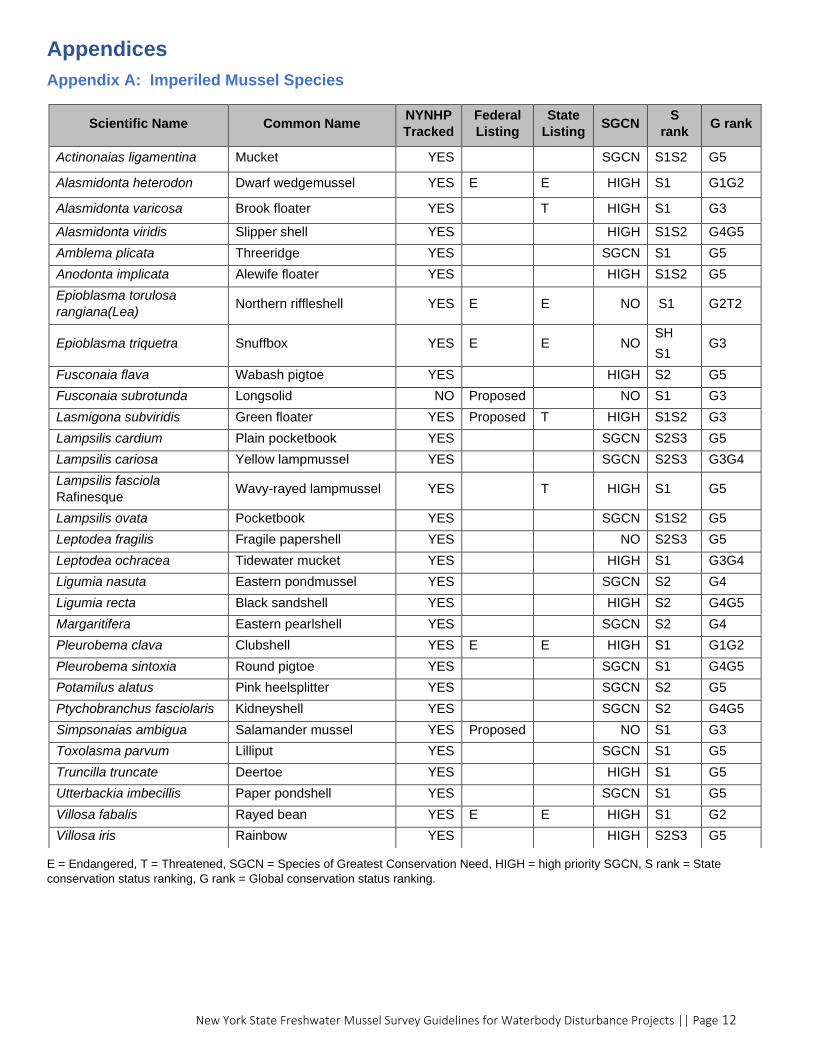
1 Within this document “imperiled mussels” refers to freshwater mussel species that are federal or state listed as threatened or endangered, as well as those that are ranked as S1 (critically imperiled), S2 (imperiled) or any combination thereof (e.g., S1S2, S2S3) by the New York Natural Heritage Program. Appendix A provides a list of native freshwater mussels considered “imperiled” in New York State.
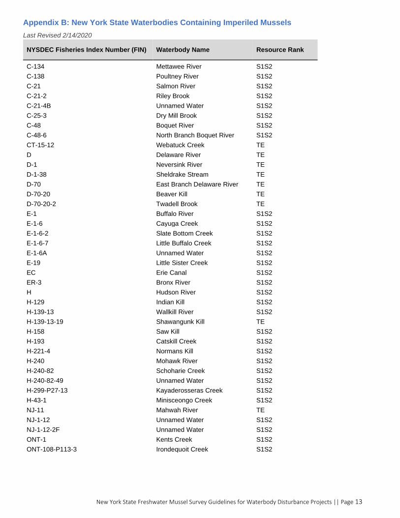
2 Several resources are available for determining whether imperiled species may be of concern at a given project site. For state listed or ranked species, refer to the imperiled freshwater mussels layer in the DEC Environmental Resource Mapper at: https://gisservices.dec.ny.gov/gis/erm/ or the list of waterbodies provided in Appendix B. For federally listed species, use the USFWS Information or Planning and Consultation (IPaC) online tool at: https://ecos.fws.gov/ipac/. If the project is within an area highlighted as containing imperiled mussels, consultation with the DEC and USFWS (if applicable) should occur as soon as possible.

New York State Freshwater Mussel Survey Guidelines for Waterbody Disturbance Projects || Page 2
Table of Contents
1. Survey Area ................................................................................................................................................................. 3
1.1. Area of Project Impact ......................................................................................................................................... 3
1.2. Buffers .................................................................................................................................................................. 4
2. Survey Methods .......................................................................................................................................................... 4
2.1. Acceptable Survey Methods ................................................................................................................................ 4
2.2. Search Techniques ................................................................................................................................................ 5
3. Candidate Relocation Site Survey ............................................................................................................................... 5
3.1. Ideal Relocation Site Characteristics .................................................................................................................... 5
4. Survey Timing and Condition Requirements ............................................................................................................... 6
5. Mussel Handling .......................................................................................................................................................... 6
6. Survey Plan Requirements .......................................................................................................................................... 7
6.1. Submission Deadlines ........................................................................................................................................... 7
6.2. Survey Plan Checklist ............................................................................................................................................ 7
7. Report Requirements .................................................................................................................................................. 7
7.1. Reporting Deadlines ............................................................................................................................................. 7
7.2. Notification Requirements ................................................................................................................................... 7
7.3. Required Data and Information to Report ........................................................................................................... 8
7.4. Shell Voucher Processing ................................................................................................................................... 10
7.5. Survey Results Expiration ................................................................................................................................... 10
Definitions ..................................................................................................................................................................... 10
References ..................................................................................................................................................................... 11
Appendices .................................................................................................................................................................... 12
Appendix A: Imperiled Mussel Species .................................................................................................................... 12
Appendix B: New York State Waterbodies Containing Imperiled Mussels ............................................................... 13
New York State Freshwater Mussel Survey Guidelines for Waterbody Disturbance Projects || Page 3
1. Survey Area
The survey area should incorporate the entire area of project impact (see definitions and section 1.1),
including any temporary or permanent disturbances, as well as survey area buffers (see section 1.2).
1.1. Area of Project Impact
The area of project impact includes the proposed footprint of any in-water work, new structures or existing
structures that will be altered or removed, any areas of proposed excavation or fill, as well as any
upstream, downstream, or adjacent areas of adverse impacts resulting from the proposed activity. Table 1
provides examples of activities and disturbances to consider when determining the area of project impact.
Table 1. Activities to Consider When Determining Area of Project Impact Note: These are typical considerations for various project types. Additional project-specific considerations may also apply.
Adverse Impact to Mussels Examples of Activity or Disturbance
Crushing or mechanical effects
Any in-water work, including:
• Equipment access, operation, and staging
• Placement of rip rap, fill, structures, cofferdams
• Excavation, dredging, leveling
• Fording, skidding of logs
Sedimentation/siltation Upland and in-water work, including:
• Ground clearing (especially on the stream bank or lake/pond shore)
• Discharging of water or fill (resuspension)
• Placing or removing cofferdams
• Dredging, excavation
• Fording, skidding of logs
Water quality effects • Chemical load (fertilizer, sewage, road runoff, waste disposal, toxic sediment dispersal)
• Dissolved oxygen changes
• Temperature increases/decreases (e.g., riparian vegetation removal, dam releases, pump-around/sewage outflows, etc.)
Flow alteration/impoundmentsa
• Drying/dewatered areas (e.g., cofferdams, drawdowns, diversion of flow)
• Scour from discharges
• Changes in velocity or bedload
• Redirection of thalweg
• Dredging
• Barrier/dam removal
• Bank hardening or stream channelization
• Water intakes (withdrawals affecting stream flow)
Fragmentation • Barrier/dam placement
• Impassable culvert
a) The flow alteration zone for dewatering, causeways, cofferdams, etc. minimally includes a linear distance of 4x the dewatered
area or in-water projection or at least 20m downstream. Dam removal impact zones are project specific.
New York State Freshwater Mussel Survey Guidelines for Waterbody Disturbance Projects || Page 4
1.2. Buffers
Survey buffers are to serve as a safety margin for unintended effects or minor changes in project scope
that may occur during the proposed activity and must be included in the survey area. For most projects,
including those still in the planning stage, the default buffer distances described in Table 2 apply.
Projects with well-defined areas of impact and exceptional protective measures may be able to reduce
survey buffer distances in consultation with the DEC.
Table 2: Survey Area Buffers Based on Project Type
Project Type Upstream Buffer Downstream Buffer Lateral Buffer
Dredging (Maintenance) 150m 500m 150m
Bridge Projects 50m 100m Bank to bank
Waterline/Pipeline Corridor Disturbances
50m 100m Bank to bank
Water Intakes (at shoreline) 10m 10m 10m
Shoreline Protection - without projecting structures
10m 10m 10m
Projecting Structures (e.g., work causeways, docks/piers, boat ramps, temporary work area isolation, grade control structures, rock vanes, j-hooks, etc.)
10m 20m 10m
New Outfalls 10m Mixing Zone + 100m 10m
Replacing an existing outfall 10m 10m 10m
2. Survey Methods
The first step in most instances is a timed search survey to determine whether mussels are present
within the survey area and to provide insight into their distribution. The following methods are the minimum
requirements necessary to develop an adequate survey while also taking into consideration any project-
specific and site-specific circumstances.
2.1. Acceptable Survey Methods
Survey Type
• Cell surveys are required in most cases. Survey cells should cover the entire survey area and
individual cells should not exceed 100m2 (10mx10m).
• Transect surveys are generally discouraged but may be considered on a case-by-case basis to identify
areas for project planning including location of cell surveys, or where large areas or linear project
impact (miles) are expected.3
Search Effort for Cell Surveys
• Minimum search effort of 0.5min/m2 OR,
• Minimum search effort of 2 min/m2 if:
o target mussels include any of the following small-bodied species: rayed bean (Villosa fabalis),
dwarf wedgemussel (Alasmidonta heterodon), brook floater (A. varicosa), slippershell (A.
viridis), salamander mussel (Simpsonaias ambigua), snuffbox (Epioblasma triquetra), liliput
(Toxolasma parvum), green floater (Lasmigona subviridis)
o within a mussel concentration area (see definitions on page 10)
• Cells with unsuitable mussel habitat can be visually assessed and excluded from the survey effort.
Unsuitable habitat may include dense clay, concrete, rip rap, and bedrock with no sand/gravel
deposits.
3 Where transect surveys are approved by the DEC, transects should be 1m wide, placed parallel to stream flow, and spaced at a maximum of 10m, with a minimum search effort of 1min/m2
New York State Freshwater Mussel Survey Guidelines for Waterbody Disturbance Projects || Page 5
2.2. Search Techniques
Surveys must use visual and tactile search techniques. Acceptable techniques to best detect mussels include the following:
• Sweeping away silt, sand, and/or small detritus by hand
• Hand-probing at least the upper 5cm (2 inches) of loose substrate. Depending on the potential species within the vicinity of the project site, probing at an additional depth (e.g., brook floater (A. varicosa), snuffbox (E. triquetra), green floater (L. subviridis), clubshell (Plerobema clava), etc.) or searching under rocks (salamander mussels (S. ambigua)) may be required
• Searching among the bases/roots of submerged vegetation and around the edges of emergent vegetation
• Searching banks; exposed silt, gravel or point bars; muskrat middens; and islands to recover any
shells or dead mussels
• Examining any cracks or openings in areas of bedrock, concrete, rip rap, etc.
• Thoroughly examining heterogenous substrate (mixtures of sand, cobble, boulders, etc.,)
• Snorkeling at depths ≤ 3 feet (viewing buckets or aquascopes may be used at depths ≤ 1 foot)
• Using SCUBA or surface supplied air in areas > 3 feet
• Working from downstream to upstream
Unacceptable techniques include the following:
• Conducting visual surveys from a boat
• Using combs, rakes or any mechanical means that may cause harm to mussels and their habitat
3. Candidate Relocation Site Survey
This survey should be conducted to identify a suitable site for relocating mussels if a salvage event is
deemed necessary. This would be performed at the same time as the initial survey if imperiled mussel
species or a mussel concentration area was found. The site(s) should be searched using visual and tactile
methods to identify a mussel population and assemblage comparable to the project site. Survey results
must be submitted (see page 8 for reporting requirements) and DEC approval of the site is required prior
to a relocation event. No mussels are to be moved without prior consultation with DEC and USFWS (if
applicable). A relocation plan must be approved before receiving an LCP to conduct a salvage.
Additionally, if endangered or threatened species require relocation, the project sponsor must submit a
mitigation plan and obtain an Incidental Take Permit.
3.1. Ideal Relocation Site Characteristics
The relocation site should meet as many of the following criteria as possible:
• Upstream of the project site and other potential threats or disturbances such as existing infrastructure
that may require future maintenance (e.g., bridge/culvert sites, proposed dredging sites, stormwater
outfalls, etc.)
• Within the same waterbody and no more than three river miles from the project site
• In a site having no barriers to reproduction or dispersal
• Habitat equal to or better than the source site (e.g., similar substrate, flow conditions, etc.)
• Size/area equal to or larger than the source site, with suitable space for settlement to avoid
overcrowding and competition with resident mussels
• In a location having the presence of a similar mussel population and assemblage
o Attention should be given where there are hybridization and/or competition considerations (e.g.,
within the Allegheny, Susquehanna, and Delaware basins for species such as elktoe and brook
floater (A. marginata/varicosa)
• Native freshwater mussels should not be moved into areas where invasive species (e.g., Dreissenid
mussels, didymo) could reduce mussel survival
• Introduction of invasive species should be avoided when identifying candidate relocation sites
New York State Freshwater Mussel Survey Guidelines for Waterbody Disturbance Projects || Page 6
4. Survey Timing and Condition Requirements
• Surveys may only be conducted between May 15 and September 30. Surveying outside of this
window will require a case by case review and approval of plans by the DEC, but will generally not be
approved unless there are extenuating circumstances. A time extension will also require modification
of the LCP.
• Flow: Surveys within streams should be conducted during typical low flow or base flow conditions
• Visibility: Minimum of 0.5m (approx. 20 inches) at depth of substrate under adequate lighting (e.g.,
avoid dusk or dawn)
• Temperature:
o Water temperature must be 55 degrees Fahrenheit (⁰F) or above
o Air temperature must be 50⁰F or above
Conditions should be monitored prior to conducting surveys.4 Data for flow or stage height, visibility, and
temperature must be recorded on site at the time of the survey.
5. Mussel Handling
The following measures describe the required methods for handling mussels at the time of the survey.
Processing/data collection measures can be found on pages 8-9.
Handling Requirements
• Mussels shall not be exposed to air longer than necessary (no more than 5 minutes) for identification,
measurement, and photographic documentation.
• For shallow water areas (≤ 3 feet), mussels should be handled and processed one at a time and
placed back into the substrate from the location collected.
• For deeper water areas (>3 feet), mussels shall be submerged in water and kept in the shade at all
times when waiting to be processed. Use of mesh bags or perforated buckets placed in the stream or
other methods to maintain flow is required. Mussels shall be returned in suitable substrate within a few
meters from the location they were collected.
• Mussels shall be partially placed back into the substrate with their posterior side up.
• For individuals that appear gravid, gently encourage the mussel to withdraw their lure and foot into the
shell to prevent them from releasing glochidia before removing the mussel from the substrate.
4 To assess conditions prior to the survey, up-to-date data on flow, visibility, and temperature may be found on the USGS website https://waterdata.usgs.gov/ny/nwis/rt. Please note: USGS gauges are not provided in all streams and should only be used as a general reference.
New York State Freshwater Mussel Survey Guidelines for Waterbody Disturbance Projects || Page 7
6. Survey Plan Requirements
6.1. Submission Deadlines
Prior to submitting a survey plan and LCP application, the project sponsor should consult with the DEC’s
Environmental Permits Regional Office and the USFWS New York Field Office (if applicable).
After consultation and approval of the survey area for the project, the mussel survey plan and
accompanying LCP application should be submitted using the required deadlines listed below.
• At least 45 days prior to the start of the planned survey
• No later than August 1 of the same calendar year for the planned survey
6.2. Survey Plan Checklist
All submissions must have appropriate documents for review in order to receive timely approval. To
ensure all necessary documents and information are submitted, review the checklist below.
✓ Justification for survey and description/scope of work of the waterbody disturbance project
✓ Anticipated start dates and end dates of the project and the mussel survey
✓ Aerial photo showing entire area of project impact overlaid with the mussel survey area boundaries
✓ List of potential species within the vicinity of the project site
✓ Survey methodology (including level of search effort in min/m2) and mussel handling techniques
✓ Description of data/metrics that will be collected (refer to the checklist under Report Requirements
(pages 8-9) for data/metrics to be collected at the time of the survey)
✓ Survey methodology for determining candidate relocation sites
7. Report Requirements
Survey data must be provided to the DEC, the USFWS New York Field Office (if applicable), and the
project sponsor whether or not imperiled mussels are found at the project site.
7.1. Reporting Deadlines
Survey reports should be submitted to the DEC’s Environmental Permits Regional Office at least 60 days
in advance of the proposed project and no later than December 31 of the year the survey was
conducted. Where federally listed species are found, formal consultation with the USFWS New York Field
Office must be initiated at least 135 days in advance of the project’s activity.
A copy of the survey report and a digital data form, which provides a summary of the species found and
search effort per survey, must also be submitted no later than December 31. This form can be found on
the DEC’s Special Licenses webpage at: www.dec.ny.gov/permits/122781.html
7.2. Notification Requirements
If NYS endangered or threatened species are found that were not identified in the survey plan, the DEC
must be informed within 24 hours.
If federally listed species are found during the survey, the USFWS New York Field Office must be
informed within 24 hours of their discovery. Contact information can be found at:
www.fws.gov/northeast/nyfo/info/intro.html

New York State Freshwater Mussel Survey Guidelines for Waterbody Disturbance Projects || Page 8
7.3. Required Data and Information to Report
The survey report should provide a narrative and summary of findings and all elements as outlined on the
following two pages.
✓ Introduction:
o Purpose, brief project description
o Name of stream/waterbody surveyed
o Location details including city/town, county, and GPS coordinates in decimal degrees
o Setting and surrounding land use
✓ Methods:
o Date(s) and time(s) of day the survey was conducted
o Survey conditions, including visibility, water & air temperature, water flow/speed/stage height, and
weather (e.g., rain, sun, overcast)
o Survey techniques and methods (e.g., SCUBA, snorkel)
o Area(s) surveyed, including extent of survey area (e.g., project area of impact, buffers, and cells)
o Search effort including number of surveyors and total time spent surveying, including catch per unit
of effort (CPUE – #/hour) and survey effort (min/m2)
o Explanation of any deviations from the approved survey plan (e.g., reduced survey effort)
✓ Results:
o Species information:
▪ Identification to species – scientific name and common name
▪ Number of individuals per species
▪ Identification of listing/ranking (see Appendix A for all species considered imperiled in NYS)
▪ For imperiled species only:
• Identification of condition (live, dead, shell)
• Measurements of shell length (mm)
• Sex, if determinable
• GPS data of location (coordinates in decimal degrees)
o Habitat/substrate assessment:
▪ Sediment characterization of each cell based on percent cover of the substrate type using
the Wentworth scale
▪ Stream/waterbody features (e.g., channel alterations, impoundments)
▪ Average stream depth and width
▪ Aquatic vegetation identification and percent cover
▪ Presence of invasive bivalves, species, and description of abundance
o Aerial photo displaying the following (all items must be shown on a single aerial photo):
▪ Entire survey area in relation to the proposed project
▪ Cells/transects surveyed
▪ Distribution of imperiled species within survey cells/transects and total search effort
▪ Sediment characterization
o Tabular data organized by search cell, including cell size, total search effort (min/m2), average
depth, substrate type, and species found (common & scientific name, total #, and condition)
– see Table 3 for an example
✓ Candidate Relocation Site (if applicable):
o Map identifying site location(s) and coordinates in decimal degrees
o Description of habitat/substrate characteristics
o Square footage of the area
o Mussel species assemblage and density found
o Number of individuals per species counted o Person hours of search time o Presence of invasive bivalve species and description of abundance

New York State Freshwater Mussel Survey Guidelines for Waterbody Disturbance Projects || Page 9
✓ Conclusion
o Summary of findings, potential impacts to mussels and their habitat, and a description of outcomes
and recommended actions
✓ Appendices
o Clear and representative photographs of individual species as
follows:
▪ Must show beak view and lateral view (see Figure 1)
▪ For imperiled mussels, photographs of up to 5 individuals
per species encountered ▪ For all other mussels, at least one photo of each species
encountered
▪ For empty shells of imperiled species, internal photos
showing overall shape and internal structures (e.g., hinge
teeth). See “Shell Voucher Processing” on page 10 to
determine where to distribute spent shells collected at the
survey site.
▪ Photographs of any suspect or questionable species
o Clear and representative photographs of waterbody and study area.
Underwater photographs showing the substrate are encouraged,
but not required.
o Copy of collection license(s) and surveyor qualifications
o Copy of approved survey plan
o Copy of field data sheets
o Copy of digital data form
(available at www.dec.ny.gov/permits/122781.html)
Table 3: Example Data Table Cell # (corresponds w/ aerial photo)
Cell Size (m2)
Total Search Effort (min)
Average Depth (feet)
Substrate Type(s) %
Species Found
Name (common & scientific)
Total # Found (n)
Condition (live, shell, dead)
1 100 85 7 • Sand (50%)
• Silt (50%)
a. Green floater (Lasmigona subviridis)
b. Eastern lampmussel (Lampsilis radiata)
a. n = 3 b. n = 20
a. Live, 2; Shell, 1 b. Live, 16; Shell,
2; Dead, 2
2 50 30 4 • Cobble
(70%)
• Fine Gravel
(30%)
Green floater (L. subviridis)
n = 1 Live
3 50 15 * 5 • Boulder
(90%)
• Sand (10%)
No mussels found n/a n/a
4 50 25 13 • Cobble
(60%)
• Silt (40%)
a. Eastern elliptio (Elliptio complanata)
b. Pyganodon spp. (Pyganodon grandis/cataracta)
c. Rainbow (Villosa iris)
a. n = 16 b. n = 22 c. n = 3
a. Live, 15; Dead, 1
b. Live, 16; Shell, 2; Dead, 2
c. Shell, 3
* Search effort reduced due to poor habitat conditions of artificially placed boulders/riprap with sand infilling (photos
attached).
Figure 1. Beak view and lateral view photographs are required for each species encountered. Must be clear enough to definitively identify beak sculpture and shell shape.
New York State Freshwater Mussel Survey Guidelines for Waterbody Disturbance Projects || Page 10
7.4. Shell Voucher Processing
Dead shell vouchers, at least one of each species found, should be retained and submitted along with a
copy of the report to the DEC at: NYS Mussel ID, 6274 East Avon-Lima Rd, Avon, NY 14414.
Living mussels should not be sacrificed for voucher purposes.
Each shell voucher must be labeled with the following information:
• Species (common and scientific name)
• Collection date
• Collection location (include waterbody name, road crossing, and coordinates)
• Number of specimens
• Name of collector
7.5. Survey Results Expiration
Results are valid for up to five years from the date of the survey.
Definitions
• Area of Project Impact: the areal extent of any potential impacts to mussels from a proposed activity
or project. This includes construction of new structures, modification, or removal of existing structures
(e.g., bridge piers, temporary bridge, cofferdam, etc.) and any other potential impacts occurring from
the activity. The area of project impact also includes areas downstream and upstream where changes
in sediment deposition, erosion patterns, substrate composition, and local hydrology are anticipated.
• Buffers: components of the survey area that serves as a safety margin for unintended effects or minor
changes in project scope that may occur during the proposed activity.
• Disturbance Project: any project causing a disturbance to a waterbody that requires a permit or
permit equivalent from the DEC. Examples include the following projects: bridge repairs/construction,
shoreline protection, dock installation, dredging, etc.
• Imperiled Mussels: freshwater mussel species that are federal or state listed as threatened or
endangered, as well as those that are ranked as S1 (critically imperiled), S2 (imperiled) or any
combination thereof (e.g., S1S2, S2S3) by the New York Natural Heritage Program. View the list of
imperiled species in Appendix A.
• Joint Permit: environmental permit required in New York State for activities affecting streams,
waterways, waterbodies, wetlands, coastal areas, sources of water, and endangered and threatened
species. For more information visit: www.dec.ny.gov/permits/6222.html#waterways
• License to Collect or Possess (LCP): collection license issued by the DEC’s Special Licenses Unit,
which allows for the possession and collection of native species of fish and wildlife for scientific
purposes. For purposes of this document, the LCP authorizes the collection or handling of freshwater
mussel species for surveys and relocations associated with a proposed project. For more information
visit: www.dec.ny.gov/permits/122781.html
• Mussel Concentration Area: an area containing a high density of mussels, which would necessitate
increased search effort to determine the presence of imperiled species and trigger efforts for
avoidance or potential relocation. A mussel concentration area is defined as having a Catch per Unit
Effort (CPUE) of 30 live mussels per hour or more, or a density of 0.5mussels/m2. In an event the
CPUE or density is triggered, the search effort should increase to 2 min/m 2
• Project Sponsor or Designee: person who applies for and receives the necessary permits (e.g.,
stream disturbance permit, water quality certificate, etc.) from the DEC’s Division of Environmental
Permits (DEP) to conduct a regulated action or waterbody disturbance project.
• Special License Applicant/Surveyor: person who applies for and receives a License to Collect or
Possess (LCP) from the DEC’s Division of Fish and Wildlife (DFW) Special Licenses Unit to conduct a
mussel survey associated with the proposed project.
• Survey area: area and extent of proposed mussel survey, including the area of project impact and
required buffers.

New York State Freshwater Mussel Survey Guidelines for Waterbody Disturbance Projects || Page 11
References
The sources listed below were used during the development of this document.
Clayton, J. et al. 2018. West Virginia Mussel Survey Protocols (March 2018 revision).
Available at: www.wvdnr.gov/Mussels/2018%20WV%20Mussel%20Survey%20Protocols.pdf
Hanshue, S. et al. Michigan Freshwater Mussel Survey Protocols and Relocation Procedures. May
2019, Version 2. Michigan Department of Natural Resources.
Available at: www.fws.gov/midwest/eastlansing/te/pdf/MI_Freshwater_Mussel_Survey_Protocol.pdf
Hart, M. et al. 2016. A literature review of Freshwater Mussel Survey and Relocation Guidelines.
Prepared for Texas Department of Transportation. August 2016.
Massachusetts Natural Heritage and Endangered Species Program. Endangered Species Survey
Guidelines: Freshwater Mussels, May 2013. North Drive, Route 135, Westborough, MA 01581.
www.nhesp.org
Smith, D. R., R. F. Villella, and D. P. Lemarie. 2001. Qualitative methods section of: Survey protocol for
assessment of endangered freshwater mussels in the Allegheny River. J. N. Am. Benthol. Soc
20(1):118-132.
Available at: www.fws.gov/northeast/pafo/pdf/Mussel%20Survey%20Guidelines%20-
%20Smith%20et%20al%202001.pdf
Strayer, D. L. and K.J. Jirka. 1997. The Pearly Mussels of New York State. The New York State
Department of Education.
Strayer, D.L. and D.R. Smith. A Guide to Sampling Freshwater Mussel Populations. American Fisheries
Society Monograph 8.
New York State Freshwater Mussel Survey Guidelines for Waterbody Disturbance Projects || Page 12
Appendices
Appendix A: Imperiled Mussel Species
E = Endangered, T = Threatened, SGCN = Species of Greatest Conservation Need, HIGH = high priority SGCN, S rank = State
conservation status ranking, G rank = Global conservation status ranking.
Scientific Name Common Name NYNHP
Tracked
Federal
Listing
State
Listing SGCN
S
rank G rank
Actinonaias ligamentina Mucket YES SGCN S1S2 G5
Alasmidonta heterodon Dwarf wedgemussel YES E E HIGH S1 G1G2
Alasmidonta varicosa Brook floater YES T HIGH S1 G3
Alasmidonta viridis Slipper shell YES HIGH S1S2 G4G5
Amblema plicata Threeridge YES SGCN S1 G5
Anodonta implicata Alewife floater YES HIGH S1S2 G5
Epioblasma torulosa
rangiana(Lea) Northern riffleshell YES E E NO S1 G2T2
Epioblasma triquetra Snuffbox YES E E NO SH
S1 G3
Fusconaia flava Wabash pigtoe YES HIGH S2 G5
Fusconaia subrotunda Longsolid NO Proposed NO S1 G3
Lasmigona subviridis Green floater YES Proposed T HIGH S1S2 G3
Lampsilis cardium Plain pocketbook YES SGCN S2S3 G5
Lampsilis cariosa Yellow lampmussel YES SGCN S2S3 G3G4
Lampsilis fasciola
Rafinesque Wavy-rayed lampmussel YES T HIGH S1 G5
Lampsilis ovata Pocketbook YES SGCN S1S2 G5
Leptodea fragilis Fragile papershell YES NO S2S3 G5
Leptodea ochracea Tidewater mucket YES HIGH S1 G3G4
Ligumia nasuta Eastern pondmussel YES SGCN S2 G4
Ligumia recta Black sandshell YES HIGH S2 G4G5
Margaritifera Eastern pearlshell YES SGCN S2 G4
Pleurobema clava Clubshell YES E E HIGH S1 G1G2
Pleurobema sintoxia Round pigtoe YES SGCN S1 G4G5
Potamilus alatus Pink heelsplitter YES SGCN S2 G5
Ptychobranchus fasciolaris Kidneyshell YES SGCN S2 G4G5
Simpsonaias ambigua Salamander mussel YES Proposed NO S1 G3
Toxolasma parvum Lilliput YES SGCN S1 G5
Truncilla truncate Deertoe YES HIGH S1 G5
Utterbackia imbecillis Paper pondshell YES SGCN S1 G5
Villosa fabalis Rayed bean YES E E HIGH S1 G2
Villosa iris Rainbow YES HIGH S2S3 G5
New York State Freshwater Mussel Survey Guidelines for Waterbody Disturbance Projects || Page 13
Appendix B: New York State Waterbodies Containing Imperiled Mussels
Last Revised 2/14/2020
NYSDEC Fisheries Index Number (FIN) Waterbody Name Resource Rank
C-134 Mettawee River S1S2
C-138 Poultney River S1S2
C-21 Salmon River S1S2
C-21-2 Riley Brook S1S2
C-21-4B Unnamed Water S1S2
C-25-3 Dry Mill Brook S1S2
C-48 Boquet River S1S2
C-48-6 North Branch Boquet River S1S2
CT-15-12 Webatuck Creek TE
D Delaware River TE
D-1 Neversink River TE
D-1-38 Sheldrake Stream TE
D-70 East Branch Delaware River TE
D-70-20 Beaver Kill TE
D-70-20-2 Twadell Brook TE
E-1 Buffalo River S1S2
E-1-6 Cayuga Creek S1S2
E-1-6-2 Slate Bottom Creek S1S2
E-1-6-7 Little Buffalo Creek S1S2
E-1-6A Unnamed Water S1S2
E-19 Little Sister Creek S1S2
EC Erie Canal S1S2
ER-3 Bronx River S1S2
H Hudson River S1S2
H-129 Indian Kill S1S2
H-139-13 Wallkill River S1S2
H-139-13-19 Shawangunk Kill TE
H-158 Saw Kill S1S2
H-193 Catskill Creek S1S2
H-221-4 Normans Kill S1S2
H-240 Mohawk River S1S2
H-240-82 Schoharie Creek S1S2
H-240-82-49 Unnamed Water S1S2
H-299-P27-13 Kayaderosseras Creek S1S2
H-43-1 Minisceongo Creek S1S2
NJ-11 Mahwah River TE
NJ-1-12 Unnamed Water S1S2
NJ-1-12-2F Unnamed Water S1S2
ONT-1 Kents Creek S1S2
ONT-108-P113-3 Irondequoit Creek S1S2

New York State Freshwater Mussel Survey Guidelines for Waterbody Disturbance Projects || Page 14
NYSDEC Fisheries Index Number (FIN) Waterbody Name Resource Rank
ONT-108-P113-3-8 Allen Creek S1S2
ONT-117 Genesee River TE
ONT-117-14 Red Creek S1S2
ONT-117-148 Black Creek TE
ONT-117-19 Black Creek S1S2
ONT-117-19-28 Spring Creek S1S2
ONT-117-19-30 Bigelow Creek S1S2
ONT-117-19-8 Onion Creek S1S2
ONT-117-27 Honeoye Creek S1S2
ONT-117-27-28 Bebee Creek S1S2
ONT-117-40 Conesus Creek S1S2
ONT-117-66 Canaseraga Creek S1S2
ONT-122-P153-2 Larkin Creek S1S2
ONT-125 Salmon Creek S1S2
ONT-125-1 West Creek S1S2
ONT-125-2 Brockport Creek S1S2
ONT-130 Sandy Creek S1S2
ONT-130-1 East Branch Sandy Creek S1S2
ONT-130-2 West Branch Sandy Creek S1S2
ONT-138 Oak Orchard Creek S1S2
ONT-138-15 Unnamed Water S1S2
ONT-139 Johnson Creek S1S2
ONT-148-3 East Branch Eighteenmile Creek S1S2
ONT-152A Twelvemile Creek S1S2
ONT-156 Fourmile Creek S1S2
ONT-158 Niagara River S1S2
ONT-158-12 Tonawanda Creek TE
ONT-158-12-1 Ellicott Creek S1S2
ONT-158-12-11 Ledge Creek TE
ONT-158-12-11-1 Murder Creek TE
ONT-158-12-32 Little Tonawanda Creek S1S2
ONT-158-12-6 Ransom Creek S1S2
ONT-158-12-8 Mud Creek S1S2
ONT-158-12-8-7 Unnamed Water S1S2
ONT-158-12-9 Beeman Creek S1S2
ONT-19-40-3 Black Creek S1S2
ONT-19-45-1 Butler Creek S1S2
ONT-19-57-1 Unnamed Water S1S2
ONT-19-60 Otter Creek S1S2
ONT-19-70 Fish Creek S1S2
ONT-53 Salmon River S1S2
ONT-66_12 Seneca River S1S2
ONT-66-11-P26-24 West Branch Fish Creek S1S2
ONT-66-11-P26-24-14 East Branch Fish Creek S1S2
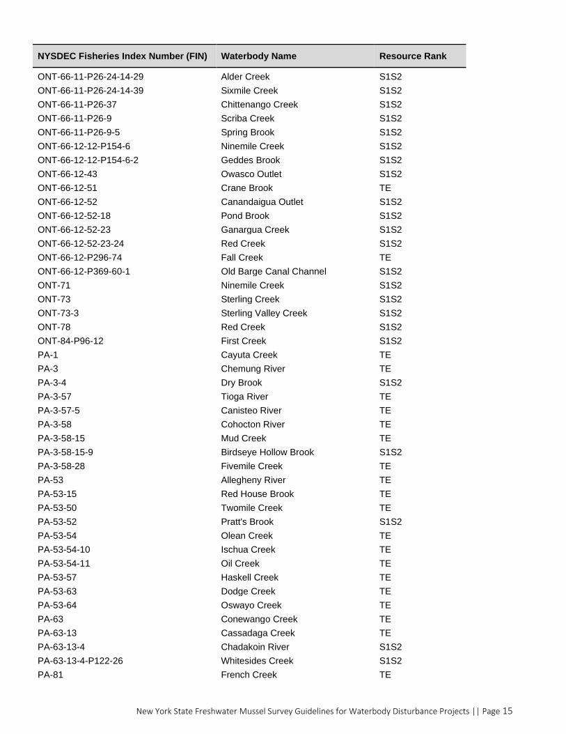
New York State Freshwater Mussel Survey Guidelines for Waterbody Disturbance Projects || Page 15
NYSDEC Fisheries Index Number (FIN) Waterbody Name Resource Rank
ONT-66-11-P26-24-14-29 Alder Creek S1S2
ONT-66-11-P26-24-14-39 Sixmile Creek S1S2
ONT-66-11-P26-37 Chittenango Creek S1S2
ONT-66-11-P26-9 Scriba Creek S1S2
ONT-66-11-P26-9-5 Spring Brook S1S2
ONT-66-12-12-P154-6 Ninemile Creek S1S2
ONT-66-12-12-P154-6-2 Geddes Brook S1S2
ONT-66-12-43 Owasco Outlet S1S2
ONT-66-12-51 Crane Brook TE
ONT-66-12-52 Canandaigua Outlet S1S2
ONT-66-12-52-18 Pond Brook S1S2
ONT-66-12-52-23 Ganargua Creek S1S2
ONT-66-12-52-23-24 Red Creek S1S2
ONT-66-12-P296-74 Fall Creek TE
ONT-66-12-P369-60-1 Old Barge Canal Channel S1S2
ONT-71 Ninemile Creek S1S2
ONT-73 Sterling Creek S1S2
ONT-73-3 Sterling Valley Creek S1S2
ONT-78 Red Creek S1S2
ONT-84-P96-12 First Creek S1S2
PA-1 Cayuta Creek TE
PA-3 Chemung River TE
PA-3-4 Dry Brook S1S2
PA-3-57 Tioga River TE
PA-3-57-5 Canisteo River TE
PA-3-58 Cohocton River TE
PA-3-58-15 Mud Creek TE
PA-3-58-15-9 Birdseye Hollow Brook S1S2
PA-3-58-28 Fivemile Creek TE
PA-53 Allegheny River TE
PA-53-15 Red House Brook TE
PA-53-50 Twomile Creek TE
PA-53-52 Pratt's Brook S1S2
PA-53-54 Olean Creek TE
PA-53-54-10 Ischua Creek TE
PA-53-54-11 Oil Creek TE
PA-53-57 Haskell Creek TE
PA-53-63 Dodge Creek TE
PA-53-64 Oswayo Creek TE
PA-63 Conewango Creek TE
PA-63-13 Cassadaga Creek TE
PA-63-13-4 Chadakoin River S1S2
PA-63-13-4-P122-26 Whitesides Creek S1S2
PA-81 French Creek TE

New York State Freshwater Mussel Survey Guidelines for Waterbody Disturbance Projects || Page 16
NYSDEC Fisheries Index Number (FIN) Waterbody Name Resource Rank
SL-1 Raquette River S1S2
SL-1-2 Squeak Brook S1S2
SL-2 Grass River S1S2
SL-2-16G Unnamed Water S1S2
SL-2-22 Little River S1S2
SL-2-22-2 Grannis Brook S1S2
SL-2-22-2-6 Leonard Brook S1S2
SL-2-25 Harrison Creek S1S2
SL-2-25-2 Elm Creek S1S2
SL-2-45 Plumb Brook S1S2
SL-2-45-17 Orebed Creek S1S2
SL-2-47 Black Brook S1S2
SL-2-48 North Branch Grass River S1S2
SL-25 Oswegatchie River S1S2
SL-25-7-P1-3 Indian River S1S2
SL-2-58 Middle Branch Grass River S1S2
SL-25branch Oswegatchie River branch S1S2
SLC-25 Trout River S1S2
SLC-29-1 Little Salmon River S1S2
SLC-29-2-2 West Branch Deer Creek S1S2
SLC-32 St. Regis River S1S2
SLC-32-20 West Branch St Regis River S1S2
SLC-32-6 Deer River S1S2
SR Susquehanna River TE
SR-128 Unnamed Water TE
SR-146 Unadilla River TE
SR-146-64 West Branch Unadilla River S1S2
SR-146-64-6 Unnamed Water S1S2
SR-146-9 Butternut Creek S1S2
SR-16 Owego Creek TE
SR-16-4 Catatonk Creek TE
SR-16-4-16 Willseyville Creek TE
SR-16-4-7A Unnamed Water S1S2
SR-172 Otego Creek S1S2
SR-204 Oaks Creek TE
SR-44 Chenango River TE
SR-44-14 Tioughnioga River TE
SR-44-14-27 Otselic River TE
SR-44-14-59 East Branch Tioughnioga River TE
SR-44-14-60 West Branch Tioughnioga River TE
SR-44-23 Genegantslet Creek S1S2
SR-44-72 Sangerfield River TE
SR-44-78 Payne Brook S1S2
Related Documents


![Mitigation Site Freshwater Mussels · [Freshwater Mussel Mitigation Site Report] [December 2010] 5 Potential Mussel Mitigation Opportunity Summary Table The following table summarizes](https://static.cupdf.com/doc/110x72/601c682255c44875853dcff2/mitigation-site-freshwater-mussels-freshwater-mussel-mitigation-site-report-december.jpg)