Floodplain hydrology in an Amazon floodplain lake (Lago Grande de Curuai) Marie-Paule Bonnet, Gw´ ena¨ el Barroux, Jean-Michel Martinez, Fr´ ed´ erique Seyler, Patricia Moreira Turcq, G´ erard Cochonneau, J. M. Melack, G. Boaventura, Laurence Maurice Bourgoin, J. G. Leon, et al. To cite this version: Marie-Paule Bonnet, Gw´ ena¨ el Barroux, Jean-Michel Martinez, Fr´ ed´ erique Seyler, Patricia Mor- eira Turcq, et al.. Floodplain hydrology in an Amazon floodplain lake (Lago Grande de Curuai). Journal of Hydrology, Elsevier, 2008, 349 (1-2), pp.18-30. <10.1016/j.jhydrol.2007.10.055>. <ird-00270979> HAL Id: ird-00270979 http://hal.ird.fr/ird-00270979 Submitted on 8 Apr 2008 HAL is a multi-disciplinary open access archive for the deposit and dissemination of sci- entific research documents, whether they are pub- lished or not. The documents may come from teaching and research institutions in France or abroad, or from public or private research centers. L’archive ouverte pluridisciplinaire HAL, est destin´ ee au d´ epˆ ot et ` a la diffusion de documents scientifiques de niveau recherche, publi´ es ou non, ´ emanant des ´ etablissements d’enseignement et de recherche fran¸cais ou ´ etrangers, des laboratoires publics ou priv´ es.

Welcome message from author
This document is posted to help you gain knowledge. Please leave a comment to let me know what you think about it! Share it to your friends and learn new things together.
Transcript

Floodplain hydrology in an Amazon floodplain lake
(Lago Grande de Curuai)
Marie-Paule Bonnet, Gwenael Barroux, Jean-Michel Martinez, Frederique
Seyler, Patricia Moreira Turcq, Gerard Cochonneau, J. M. Melack, G.
Boaventura, Laurence Maurice Bourgoin, J. G. Leon, et al.
To cite this version:
Marie-Paule Bonnet, Gwenael Barroux, Jean-Michel Martinez, Frederique Seyler, Patricia Mor-eira Turcq, et al.. Floodplain hydrology in an Amazon floodplain lake (Lago Grande de Curuai).Journal of Hydrology, Elsevier, 2008, 349 (1-2), pp.18-30. <10.1016/j.jhydrol.2007.10.055>.<ird-00270979>
HAL Id: ird-00270979
http://hal.ird.fr/ird-00270979
Submitted on 8 Apr 2008
HAL is a multi-disciplinary open accessarchive for the deposit and dissemination of sci-entific research documents, whether they are pub-lished or not. The documents may come fromteaching and research institutions in France orabroad, or from public or private research centers.
L’archive ouverte pluridisciplinaire HAL, estdestinee au depot et a la diffusion de documentsscientifiques de niveau recherche, publies ou non,emanant des etablissements d’enseignement et derecherche francais ou etrangers, des laboratoirespublics ou prives.


Floodplain hydrology in an Amazon floodplain lake(Lago Grande de Curuaı)
M.P. Bonnet a,*, G. Barroux a, J.M. Martinez a, F. Seyler a,P. Moreira-Turcq b, G. Cochonneau c, J.M. Melack d, G. Boaventura e,L. Maurice-Bourgoin a, J.G. Leon a, E. Roux a, S. Calmant f, P. Kosuth g,J.L. Guyot h, P. Seyler a
a IRD – Institut de Recherche pour le Developpement, UR154 LMTG, 14, Av. Edouard Belin, 31400 Toulouse, Franceb IRD – Institut de Recherche pour le Developpement, UR154 LMTG – Departamento de Geoquımica, Universidade Federal
Fluminense, Morro do Valonguinho s/no 24020-007 Niteroi, RJ, Brazilc IRD – Institut de Recherche pour le Developpement, UR154 LMTG, Maison de la teledetection 34000 Montpellier, Franced Bren School of Environmental Science and Management, University of California, Santa Barbara, CA, USAe UNB – University of Brasilia, Instituto de Geociencias, Universidade de Brasilia, Campus Universitario Darcy Ribeiro, ICC-
Central CEP 70910-900 Brasilia, Brazilf IRD – Institut de Recherche pour le Developpement, LEGOS, 14, Av. Edouard Belin, 31400 Toulouse, Franceg UMR TETIS (Cemagref-ENGREF-Cirad) – Territoires, Environnement, teledetection et Information Spatiale – Maison de la
teledetection, 34000 Montpellier, Franceh IRD – Institut de Recherche pour le Developpement, UR154 LMTG, Universidad Nacional Agraria La Molina, Lima, Peru
Received 6 September 2006; received in revised form 12 October 2007; accepted 16 October 2007
KEYWORDS
Amazon river;Floodplain;River–floodplaininteractions;Hydrologic residencetime
Summary The floodplains of the Amazon basin influence the hydrology and fluxes ofsuspended solids and solutes onmultiple scales. Our study focused on the floodplain of LagoGrande de Curuaı (Obidos, Brazil), a 4000 km2 segment of floodplain and local uplandcatchment representative of the lower Amazon. Based on in situ and satellite data acquiredfrom 1997 to 2003, we calculated the exchanges of water between the floodplain and theriver and determined the temporal dynamics of flooded area water derived from riverflooding, rainfall, runoff, and exchange with groundwater annually for six years. The Ama-zon River dominated the inputs of water to the flooded area year-round, accounting about77% of the annual total inputs; rainfall and runoff accounted for about 9% and 10%, respec-tively, while seepage from the groundwater system accounted for 4%. The hydrologicresidence time of the lake was about three months, and the floodplain made a net contri-bution of water to the river. The exported volume (net balance between water input and
0022-1694/$ - see front matter ª 2007 Elsevier B.V. All rights reserved.doi:10.1016/j.jhydrol.2007.10.055
* Corresponding author. Tel.: +33 5 61 33 26 61; fax: +33 5 61 33 25 60.E-mail address: [email protected] (M.P. Bonnet).
Journal of Hydrology (2008) 349, 18–30
ava i lab le at www.sc iencedi rec t . com
journal homepage: www.elsevier .com/ locate / jhydro l
losses) varied between 4.2 and 7.3 km3 depending on the year and represented about 0.75times the maximal storage reached each year.
ª 2007 Elsevier B.V. All rights reserved.
Introduction
Extensive floodplains are associated with the Amazon Riverand its tributaries and these floodplains alter the transportof water and dissolved and particulate materials from up-land watersheds through river systems to the sea (Dunneet al., 1998; Guyot et al., 2005; Hamilton et al., 2002; Hesset al., 2003; Junk, 1997; Meade et al., 1985; Melack andForsberg, 2001; Seyler and Boaventura, 2001, 2003; Sippelet al., 1998). During residence of water on floodplains, sub-stantial biogeochemical modifications occur under the influ-ence of sorption and redox reactions and biotic processes(Melack et al., 2004; Richey et al., 1988, 1990; Seyler andBoaventura, 2001, 2003). These processes are influencedby the spatial and temporal patterns of hydrology, whichare altered by the topography, soils and vegetation in thefloodplain (Mertes et al., 1995). Hence, large spatial heter-ogeneities are expected and additional in situ data are re-quired to reduce the uncertainties on regional and globalestimates as mentioned in Melack et al. (2004).
Few attempts have been made to quantify floodplain andriver interactions in the Amazon basin, in part because ofthe difficulties in acquiring data. Direct measurements orcalculations of all the terms in the water balance of an Ama-zon floodplain lake has been performed for only one lake (L.Calado near Manacapuru; Lesack and Melack, 1995). Basedon a Muskingum analysis, Richey et al. (1989) estimated thatup to 30% of the discharge of the Amazon River is routedthrough the floodplain along a 2000 km reach between SaoPaulo de Olivenca and Obidos.
In our study, we measured and modelled water fluxesassociated with a floodplain segment located in the lowerpart of the Amazon River, the floodplain of Lago Grandede Curuaı near Obidos (Brazil). This floodplain contains largelakes connected to the mainstem river by several channelsand is representative of the floodplain located in the down-stream part of the Amazon River (Hess et al., 2003; Sippelet al., 1992). For 6 years, in the framework of the HyBAm(Hydrology and Geochemistry of the Amazonian Basin, IRD-CNPq http://www.mpl.ird.fr/hybam/) research program,hydrological and geochemical conditions have been investi-gated (e.g., Barroux et al., 2003; Bonnet et al., 2005; Mau-rice-Bourgoin et al., 2005; Moreira-Turcq et al., 2004,2005). Our measurements and analyses allow calculationof the hydrologic residence time of the floodplain segment,an estimation of the contributions of different sources ofwater to the floodplain, and provide a general frameworkfor river–floodplain studies.
Materials and methods
Study area
The study site is the floodplain of Lago Grande de Curuaı(between 56.10�W and 55.00�W from upstream to down-
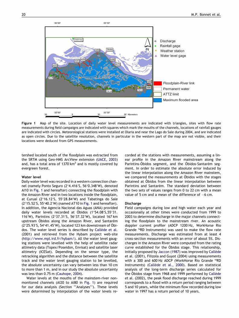
stream, and 2.3�S and 1.9�S), a floodplain segment locatedin the downstream reach of the Amazon River near Obidos(1�54.08 0S, 55�31.116 0W, Para, Brazil), the location of a pri-mary gauging station (Fig. 1).
The floodplain is delimited to the north by the AmazonRiver and to the south by the ‘‘terra firme’’, and is com-posed of several interconnected lakes temporally or perma-nently connected to the Amazon mainstem by smallchannels.
Available data
Digital elevation model
A digital elevation model (DEM) of the floodplain was madeusing several approaches. For the areas never flooded butlocated within the floodplain, Shuttle Radar TopographyMission data (SRTM) (Rabus et al., 2003) were used. Localinaccuracies of SRTM data are due to backscatter from plantcanopies, but vegetation located in the unflooded portion ofthe floodplain is mainly herbaceous and does not cause asignificant error. For the aquatic–terrestrial transition zone(ATTZ, sensu Junk, 1997), time series analysis of 21 JERS-1images acquired between February 1993 and May 1997 wasperformed (Martinez and Le Toan, 2007). Inundated areaon each date was related to water level measured at theCuruaı gauge. The water level range covered by the imageswas about 95% of the range of water level recorded atCuruaı since 1982, and images were well distributed overthe stages. The comparison of the flooded area betweentwo successive images acquired at water level Zi and Zi+1enabled the elevation Z in the zone Zi < Z < Zi+1 to beretrieved. Repeating the comparison for all available imagesallowed construction of the ATTZ DEM. Since the Curuaıwater level gauge was located within the main lake on thefloodplain, we did not have to take into account a possiblewater level difference between the floodplain and the riveras reported by Alsdorf et al. (2000). Classification accuracyfor flooded area based on JERS-1 imagery has been esti-mated to be 30% (Martinez and Le Toan, 2007). For areas al-ways inundated, we used depths recorded during fieldcampaigns using an acoustic doppler current profiler. Thethree DEMs were merged, and areas were computed withinARCGIS using UTM projection. A linear regression wasadopted between the lake surface SL (km
2) and the lake sur-face elevation ZL (m) after statistical verification that therelationship was linear (p = 0.24 with the null hypothesisformulated as the relation is significantly non linear). Therelationship is as follows with 90% confidence bands:
SL ¼ ð�35� 65Þ þ ð216� 8ÞZL: ð1ÞThe flooded area ranged between 575 km2 and 2090 km2
as water levels varied between 3.03 m and 9.61 m, the max-imum and minimum recorded in Curuaı since 1997. The max-imum floodable area delimited by the boundary betweenterra firme and the Amazon, is 2430 km2, correspondingto a water level in Curuaı of about 11.5 m. The local wa-
Floodplain hydrology in an Amazon floodplain lake (Lago Grande de Curuaı) 19
tershed located south of the floodplain was extracted fromthe SRTM using Geo-HMS ArcView extension (UACE, 2003)and, has a total area of 1370 km2 and is mostly covered byevergreen forest.
Water level
Daily water level was recorded in a western connection chan-nel (namely Ponto Seguro (2�4.416 0S, 56�0.348 0W), denotedAI10 in Fig. 1 and hereafter) connecting the floodplain withthe Amazon River and in two locations inside the floodplain,at Curuaı (2�16.12 0S, 55�28.84 0W) and Tabatinga do Sale(2�15.52 0S, 55�40.2 0W) (named AT10 in Fig. 1 and hereafter).In addition, the Agencia Nacional das Aguas (ANA) provideddaily water levels recorded at Obidos (1�54.08 0S,55�31.116 0W), Parintins (2�37.31 0S, 56�37.32 0W), located 167 kmupstream Obidos along the Amazon River, and Santarem(2�25.93 0S, 54�41.45 0W), located 123 km downstream of Obi-dos. The water level series is described by Callede et al.(2001) and retrieved from the Hybam project web-site(http://www.mpl.ird.fr/hybam/). All the water level gaug-ing stations were levelled with the help of satellite radaraltimetry data (Topex/Poseidon, Envisat) and satellite laseraltimetry (ICESat). Depending on the sensor type, theretracking algorithm and the distance between the satellitetrack and the water level gauging station to be levelled,the absolute uncertainty can vary between less than 10 cmto more than 1 m, and in our study the absolute uncertaintywas less than 0.75 m (Cauhope, 2004).
Water levels at the mouths of the mainstem-river non-monitored channels (AI20 to AI80 in Fig. 1) are requiredfor our data analysis (Section ‘‘Analyses’’). These levelswere determined by interpolation of the water levels re-
corded at the stations with measurements, assuming a lin-ear profile in the Amazon River mainstream along theParintins-Obidos segment, and the Obidos-Santarem seg-ment. In order to estimate the absolute error induced bythe linear interpolation along the Amazon River mainstem,we compared the measurements at Obidos with the stagesobtained at Obidos from the linear interpolation betweenParintins and Santarem. The standard deviation betweenthe two sets of values ranges from 0 to 22 cm with a meanvalue of 5 cm and a mean of the difference of �6 cm.
Discharge
Field campaigns during low and high water each year andoccasionally at other times were conducted from 1999 to2003 to determine discharge in the major channels connect-ing the floodplain to the mainstream river. An acousticdoppler current profiler (ADCP 1200 Hz, WorkHorse RioGrande TMRD Instruments) was used to make the flow ratemeasurements. Discharge was estimated from at least 4cross-section measurements with an error of about 5%. Dis-charges in the Amazon River were computed from the ratingcurve established for the Obidos stage. This relationship,initially proposed by Jaccon (1987) was improved by Calledeet al. (2001), Filizola and Guyot (2004) using measurementswith a 300 and 600 Hz ADCP (WorkHorse Rio Grande TMRDInstruments) (Callede et al., 2000). Based on statisticalanalysis of the long-term discharge series calculated forthe Obidos stage from 1968 and 1999 performed by Calledeet al. (2002), the peak flood discharge reached during 1999corresponds to a flood with a return period ranging between5 and 10 years, while the minimum flow recorded during lowwater in 1997 has a return period of 10 years.
Figure 1 Map of the site. Location of daily water level measurements are indicated with triangles, sites with flow rate
measurements during field campaigns are indicated with squares which mark the mouths of the channels, locations of rainfall gauges
are indicated with circles. Meteorological stations were installed at Olaria and near the Lago do Sale during 2004, and are indicated
as open circles. Due to the satellite resolution, channels in particular in the western part of the map are not visible, and their
locations were deduced from GPS measurements.
20 M.P. Bonnet et al.
Rainfall
Rainfall was recorded daily at three sites: Curuaı (2�16 07 0S,55�28 5100W), Oriximina (1�45 03700S, 55�51 04300W) and Juruti(2�9 0800S, 56�5 01500W) (Fig. 1) with manually read gauges(400 cm2 orifice size with a total capacity of 5000 cm3
(125 mm of rain) and a resolution of 0.2 mm).Compared with the average of the 76-year record of rain-
fall at Obidos, which is 2033 mm for all the water years ta-ken from November to October, water year 1997–1998 wasbelow average with a total amount of 1418 at Obidos, andwater years 1998–1999 and 1999–2000 were above averagewith totals of 2600 and 3238 mm, respectively. The otherwater years studied were approximately average with totalsof 2427, 2116 and 2470 mm for water years 2000–2001,2001–2002, 2002–2003, respectively.
Rainfall recorded at the different locations shows no sta-tistically significant spatial variability on an annual basis,but does vary significantly on a monthly basis. Thiessenpolygons were computed using ArcView extension, in orderto distribute daily precipitation over the study area.
Due to the small number of rain gauges, uncertainties inrainfall data are difficult to fully evaluate. They were as-sumed equal to 0.5.
Evaporation
Potential evaporation was calculated from an empirical for-mula for both open-water and non-flooded areas located inthe ATTZ proposed by Riou (1975) given as follows:
ETP ¼ 0:3Tm � 5:9 ð2Þwhere ETP is the potential evapotranspiration (mm day�1)and Tm is the monthly averaged maximum temperature(�C) measured at the Santarem meteorological station. Toevaluate this simple formula, we compared it with evapora-tion estimated according to a mass transfer formula given inBonnet et al. (2000) using meteorological data collectedfrom March 2004 to March 2005. This formula follows theDalton law E = f(u)(es � ea), in which f(u) = 2 + 0.9u, u isthe measured wind speed at two meters of elevation(m s�1). es is the saturated vapour pressure at the temper-ature of the water, ea is the effective vapour pressure. es(kPa) depends on temperature es ¼ 611 exp 17:27Tw
Twþ237:3
� �
withTw the water temperature (�C). ea is related to measuredrelative humidity (%) Hr ¼ ea
es100.
On an averaged monthly basis, values differ slightly be-tween the two formulas, especially during November andDecember, but a good agreement is obtained on an annualbasis. The mean cumulative value was 1359 mm year�1
based on the Riou formula whereas it is 1373 mm year�1
using the mass transfer formula. The absolute uncertaintywas fixed to 0.2 for the M-C analysis (see below).
During average water years (2000–2001, 2001–2002,2002–2003), evapotranspiration was about 58% of the totalrainfall, for 50% of the rainfall during above average yearsand for more than 80% during below average years. Seasonalvariations of evaporation were weak.
Analyses
The objectives of our analyses are to calculate exchanges ofwater between the Amazon River and its floodplain, todetermine water residence time within the floodplain and
to determine the mixture of various sources of water onthe floodplain. The proposed model, called HEVa allowsthe computation of the floodplain water mass balanceknowing the floodplain surface/stage relationship, waterlevels in the channels, precipitation and calculated monthlyaverage evapotranspiration, and is similar to the approachused by Lesack and Melack (1995).
At each daily time step Dt(d), the hydrologic mass bal-ance of the floodplain is expressed as
Vtþ1L ¼ V t
L þ QR � Q E þ QwN þ QwS � QG �X
i
Q ci
!
Dt ð3Þ
where VL is the volume (m3) of the flooded area, the super-script t or t + 1 indicating the time step,
P
iQ ci is the alge-braic sum of discharge entering (positive sign) or leaving(negative sign) in each channel i (m3 d�1), QR is the rainfall(m3 d�1) onto the flooded surface, QE is the evaporation(m3 d�1), QwN is the runoff from floodplain’s watersheds lo-cated in the ATTZ (their surface is determined as the differ-ence between the maximum floodable area and the floodedarea), QwS is the runoff from the southern upland water-sheds and QG (m3 d�1) is the seepage into or from thegroundwater system. To simplify the notation, the super-script t is removed from each of the flux terms.
The quantification of these water fluxes is explained be-low. Hence, knowing an initial condition, it is possible tocompute the water level of the following time step and todeduce from the stage/areas and stage/volume the newsurface and volume of the floodplain. For computationalpurpose, the time step can be reduced, but the model re-sults are reported as daily values.
The discharge Qci (m3 d�1) in each channel i linking the
floodplain and the Amazon River is computed by a Stric-kler-Manning-like formulation for a rectangular section,but instead of using the bottom slope of the channel, thefree surface slope of the channel is introduced in theformulation.
Q ci ¼ Ks
ffiffiffiffiffi
scip
LH5=3ci ð4Þ
where Ks is the roughness coefficient, sci ¼ jZci�ZL jl
is the freesurface slope between the upstream mouth of the channel i(elevation Zci) and the flooded area (elevation ZL computedby the model at each time step). l is the channel length (m)and Hci is the mean depth of the channel (m). Flow directionis deduced from the sign of sci.
As explained below in the Monte Carlo analysis, the slopealong the Amazon River was allowed to vary from2.35 cm km�1 to 0.6 cm km�1 with a mean value over thethousand simulations of 1.48 cm km�1 ± 0.36 for the Parin-tins-Obidos segment and from 2.6 cm km�1 to 0.23 cm km�1
with a mean value over the thousand simulations of1.37 ± 0.47 cm km�1 for the Obidos-Santarem segment.These two mean values are in good agreement with valuesgiven in Birkett et al. (2002) for the same area of study.The allowed range of slope introduced in the calculationsincorporated the uncertainty in the altimetry. The water le-vel in the flooded area was deduced from computation ofthe previous time step and only an initial value wasrequired.
Floodplain hydrology in an Amazon floodplain lake (Lago Grande de Curuaı) 21

Inputs from direct rainfall onto the surface of the floodedarea are QR = PSLQR = PSL with P (m d�1) the rainfall, SL (m
2)the surface of the flooded area computed at the each timestep, while QE = ESL with E (m d�1) the evaporation rate.
The runoff from the ATTZ is computed as
QwN ¼ MaxððP � EÞðSBVN � SLÞ; 0Þ ð5Þ
where SBVN (m2) is the maximal surface of the watershedincluding the flooded area located in the ATTZ. SL is the sur-face of the open-water area. As the floodplain wets anddries, the surface of the non flooded area varies. We as-sumed the same evaporation rate E as for open watersurface.
The runoff from the upland local watershed QwS was as-sumed to be 60% of the precipitation as calculated in Lesackand Melack (1995)
QwS ¼ 0:6PSBVS ð6Þ
where SBVS is the upland local watershed area (m2) and P isthe rainfall. At this stage, and without any data to constrainthe model, we assumed that precipitation minus evapora-tion was transformed into runoff without any loss and with-out any time lag.
No data related with bank-seepage were acquired duringthe field trips. However, according to Darcy’s law andassuming stationary flow conditions, the exchanged fluxescan be expressed as
QG ¼ KL � dZdH
dXð7Þ
where K is the permeability of the bank forming the porousmedia (m s�1), dH is the water level difference between theAmazon River and the flooded area. L is the contact-lengthalong the Amazon River (m) (about 120 km), dZ is the thick-ness of the alluvial groundwater system; as a first approxi-mation, dZ is assumed constant and equal to the AmazonRiver depth (about 60 m at the Obidos location). dX is thedistance between the river and flooded area. This distancevaries with time as the floodplain wets and dries and with
space, as the distance between the Amazon River and theflooded area is varying from west to east along the AmazonRiver (see Fig. 1). As a first approximation, dX was assumedto linearly vary between a minimal value (obtained from theDEM during high water period) and a maximal value obtainedduring low water period. The bank permeability was as-sumed constant, equal to 10�2 m s�1.
At each time step, the water input and output from theflooded area are computed (Eq. (8)) and the volume (orthe water level) for the new time step is deduced fromthe mass conservation equation (Eq. (9)).
B ¼X
i
Q ci
!
þ QR þ QwN þ QwS þ QG � Q E ð8Þ
Vtþ1L ¼ Vt
L þ BDt or Ztþ1L ¼ Zt
L þBDt
SLð9Þ
The parameters requiring calibration include the rough-ness coefficient and channel geometry defined by widthand bottom elevation and length, a rectangular sectionbeing assumed. However, as width and roughness coeffi-cient Ks are expected to vary with water level, the modelallows describing a connection as a set of channels with dif-ferent width and roughness coefficients. The required in-puts are the daily rainfall and the water level estimatedat points connecting each connection with the Amazon Riv-er. These water levels were measured in one of the westernchannels (in AI10 in Fig. 1) and determined from water lev-els measured in the Amazon River in Parintins, Obidos andSantarem assuming a linear profile of the river betweenthese three locations.
Uncertainty analysis on input data was performedaccording to a Monte-Carlo (M-C) approach. We assumedthat each input data came from a normal distributionN(m,SD), with SD the absolute or relative uncertainty asmentioned in Section ‘‘Available data’’. A thousand simula-tions were done, absolute or relative error of input data SDbeing randomly chosen based on their allowed range of var-iation reported in the text (Section ‘‘Available data’’). Mod-el results uncertainties were appraised using the standarddeviation computed from the 1000 simulations.
Table 1 Minimal, average, and maximal water levels (m), open water surface (km2) and volume (km3) over the course of the
water years and related standard deviations
Year Water level Surface Volume
Min (m) Average
(m)
Max (m) Min (km2) Average
(km2)
Max (km2) Min (km3) Average
(km3)
Max (km3)
m SD% m SD% m SD% m SD% m SD% m SD% m S% m SD% m SD%
97–98 2.7 0.2 5.4 4.5 7.9 3.0 627 5.6 1148 7.6 1681 5.2 0.4 45.1 3.0 11.7 6.3 5.7
98–99 3.1 3.3 6.7 4.5 9.6 3.2 662 6.9 1426 7.6 2027 5.3 0.6 30.6 4.9 10.1 9.3 5.3
99–00 3.0 5.5 6.7 4.6 9.2 3.4 661 7.8 1435 7.7 1956 5.6 0.6 34.9 4.8 10.1 8.7 5.6
00–01 3.0 2.3 6.6 4.5 9.1 3.3 659 6.1 1400 7.6 1929 5.5 0.6 30.8 4.6 10.2 8.4 5.6
01–02 3.1 5.1 6.8 4.6 8.7 3.6 665 8.0 1438 7.7 1846 6.0 0.6 31.8 4.8 10.2 7.7 6.3
02–03 3.2 4.8 6.1 5.0 8.5 3.6 696 7.8 1305 7.9 1794 5.8 0.7 27.5 3.9 10.9 7.2 5.9
Average 3.0 6.4 8.8 662 1359 1872 0.6 4.4 7.9
SD% 5.3 8.6 6.7 3.3 8.4 6.7 18.2 16.8 13.9
22 M.P. Bonnet et al.

Results and discussion
Model calibration and validation
Our analyses were applied to the period from September 1,1997 to December 15, 2003 enabling us to examine six con-secutive water years.
Six connections were incorporated and correspond to con-nections AI10; AI20, AI30, AI40, AI70 andAI80 (Fig. 1). In orderto take into account changes in geometry with water level,each of the connections is described as a set of two channelsdiffering by their cross-section. Two shallow channels wereadded to describe over-bank flooding in the eastern part ofthe floodplain. Channel lengths were deduced from satelliteimagery and field data; as the channel geometry is simplified,width and depth acquired during field campaigns needs aslight adjustment in order tominimize themean absolute dif-ference between the water level measured at Curuaı and thecomputedwater levels in theflooded area. Of the parametersrequiring calibration, the roughness coefficient was the leastsensitive; it was fixed at 40 for all channels except the shal-lowest for which we used a value of 20. The model was cali-brated against water levels measured at Curuaı andchecked against discharges measured at floodplain–AmazonRiver connecting channel mouths for water year 2001–2002.It was validated against data from the other years.
One thousand simulations were performed and the re-sults presented hereafter are the average of the thousandsimulations and related uncertainties are appraised by theirstandard deviation.
Water level
Good agreement was found between the simulated andmeasured water levels. Maximal daily absolute differencebetween measured and computed water levels is less than40 cm. On an annual basis, the mean absolute differencedid not exceed 7 cm for the six water years from 1999 to2003 with about 5 cm of standard deviation. Results areslightly less satisfying for the first simulated water year witha mean absolute difference of 8 ± 9 cm. Minimum, averageand maximum stage height over the course of the wateryears are reported in Table 1 for each year as well as thecorresponding lake surface area and volume ranges overthe course of the water year. Standard deviations deducedfrom Monte-Carlo analysis are also reported.
Based on the six water years, over the course of the wateryear, the absolute water level ranged from 3.0 ± 0.2 m to8.8 ± 0.6 m, flooded area ranged from 662 ± 22 km2 to1872 ± 125 km2, the floodplain volume ranged from 0.6 ± 0.1km3 to 7.9 ± 1.1 km3 (Table 1). However, significant inter-annual variationswere observed between the sixwater years.The maximum water level ranged from 7.9 ± 0.2 m to 9.6 ±0.3 m, the maximum flooded area ranged from 1681 ± 87km2 to 2027 ± 107 km2, the maximum volume ranged from6.3 ± 0.4 to 9.3 ± 0.5 km3. Inter-annual variations were largerduring the high water periods than during the low waterperiods.
Discharge
For most of the floodplain–Amazon River channels, thecomputed flow rate was in good agreement with the ADCP
measurements (Fig. 2). Upstream channels AI 10–AI 70 areonly a source of water for the floodplain, whereas the down-stream channel AI80 behaves mainly as an outflow. Eachyear, Amazon River water starts invading the floodplain inmid-December or early January (during below averageyears) by flooding channels AI10 and AI70. Flooding channelsAI20 and AI30 starts later in early March because of shal-lower depths of these channels. Fluxes between the AmazonRiver and the floodplain at the downstream channel (AI80)are driven by small differences between the rate of rise
0997
03-9
8
09-9
8
03-9
9
09-9
9
03-0
0
09-0
0
03-0
1
09-0
1
03-0
2
09-0
2
03-0
3
09-0
3
0
100
200
300
400
500Q_AI10
a
Time
Flo
w r
ate
(m
3.s
-1)
0997
03-9
8
09-9
8
03-9
9
09-9
9
03-0
0
09-0
0
03-0
1
09-0
1
03-0
2
09-0
2
03-0
3
09-0
3
0
100
200
300
400
500
600Q_AI70b
Time
Flo
w r
ate
(m
3.s
-1)
0997
03-9
8
09-9
8
03-9
9
09-9
9
03-0
0
09-0
0
03-0
1
09-0
1
03-0
2
09-0
2
03-0
3
09-0
3
-4000
-3500
-3000
-2500
-2000
-1500
-1000
-500
0
500
1000
1500
Q_AI80
c
Time
Flo
w r
ate
(m
3.s
-1)
Figure 2 Modeled (solid line for the mean, dashed lines for
the min and max of the M-C analysis) and measured (points)
flow rates in different connecting channels.
Floodplain hydrology in an Amazon floodplain lake (Lago Grande de Curuaı) 23
occurring in the floodplain and the river and both the direc-tion and discharge rate are quite variable. For normal years,the temporal distribution of water flux through the connec-tion indicates an inflow from the Amazon River during Jan-uary, followed by a period with flow directions changingfrom inflowing to outflowing from February to end of April.The flow direction changes into outflowing from end of Aprilto end of October. For below average runoff water years,the temporal distribution of water flux through this connec-tion indicates an inflow from the end of December to mid-January. From mid-January to mid-May, the direction offlow alternates from inflowing to outflowing. From mid-May to early October, the water lake was discharging intothe Amazon River. From October to the next period of risingwater, the only loss of water from the lake was throughevaporation and seepage into groundwater. For above aver-
age years, inflow starts at the end of November and contin-ues to end of March; direction of flow changes to outflowfrom the end of March to November. The period of alternat-ing inflows and outflows was shortened.
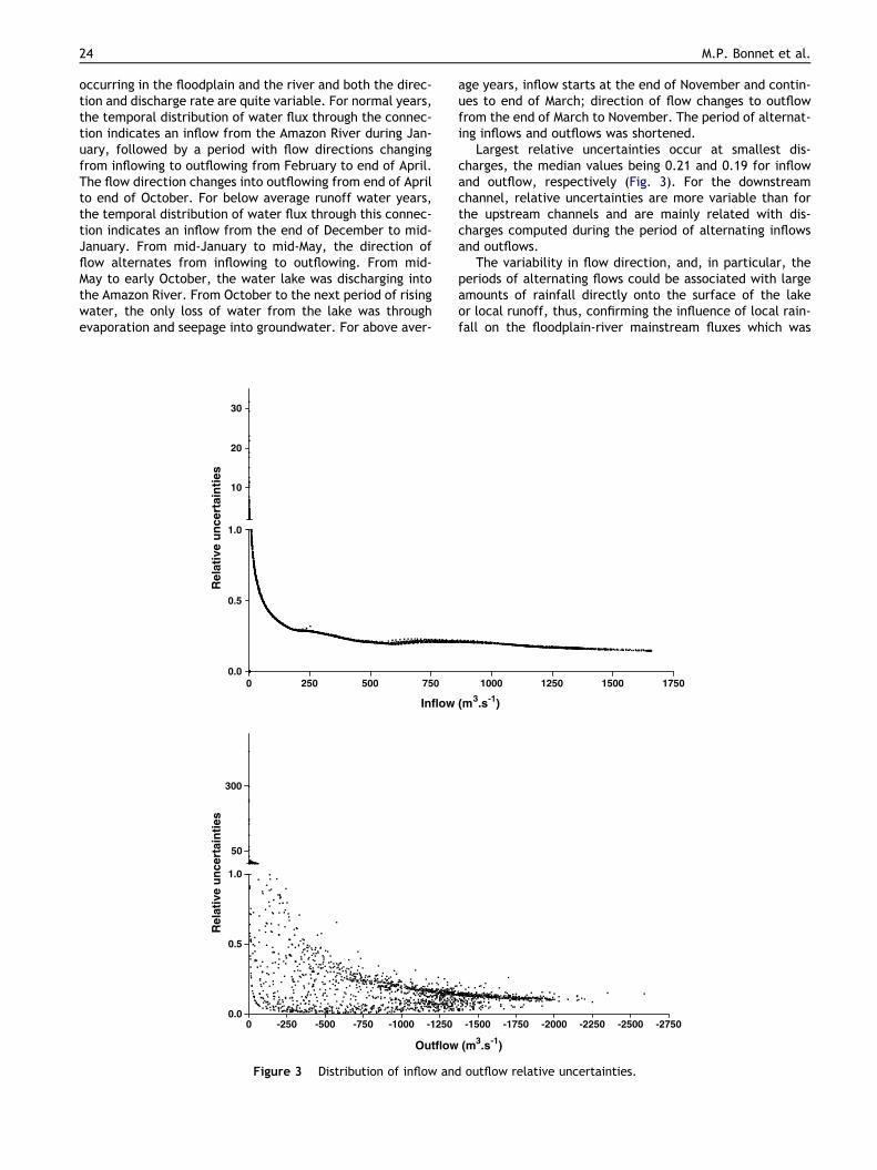
Largest relative uncertainties occur at smallest dis-charges, the median values being 0.21 and 0.19 for inflowand outflow, respectively (Fig. 3). For the downstreamchannel, relative uncertainties are more variable than forthe upstream channels and are mainly related with dis-charges computed during the period of alternating inflowsand outflows.
The variability in flow direction, and, in particular, theperiods of alternating flows could be associated with largeamounts of rainfall directly onto the surface of the lakeor local runoff, thus, confirming the influence of local rain-fall on the floodplain-river mainstream fluxes which was
0 250 500 750 1000 1250 1500 17500.0
0.5
1.0
10
20
30
Inflow (m3.s
-1)
Rela
tive u
ncert
ain
ties
-2750-2500-2250-2000-1750-1500-1250-1000-750-500-25000.0
0.5
1.0
50
300
Outflow (m3.s
-1)
Rela
tive u
ncert
ain
ties
Figure 3 Distribution of inflow and outflow relative uncertainties.
24 M.P. Bonnet et al.

observed for Lake Calado, a smaller floodplain segmentwest of Manaus (Lesack and Melack, 1995). However, duringthis period, discharge uncertainties are large and additionaldata would be required to confirm this hypothesis.
Temporal dynamics of the floodplain – river mainstem
exchanges
Generally, water storage within the floodplain started be-tween December and February, and lasted until June(Fig. 4). From this time until the end of the water year,water was exported from the floodplain into the river. Max-imum export occurred each year during August and Septem-ber. Relative uncertainty of the cumulative net waterbalance is about 15%.
Temporal dynamics of the lake water mixtureStudy of the water year 2001–2002. Cumulative volume of
the water flux components: The results for water year2001–2002 indicate that the main component of water inthe lake was from the river, the local rainfall and runofffrom upland local watershed and from watershed locatedin the ATTZ constituting the second and third most impor-tant sources of water for the lake (Fig. 5). From the begin-ning of the water year to January 20, 2002, the only loss ofwater was through evaporation. From this date to July 5,2002, the water level in the lake continued to rise despitesignificant outflow into the Amazon River. By mid-Septem-ber the lake was making a net contribution to the river.At the end of the year, the total volume from the AmazonRiver was 3.7 times the maximum volume reached by thelake (7.7 · 109 m3), whereas the outflow into the river rep-resented 4.5 times this volume. By the end of July, localrunoff from watersheds located in the ATTZ and from up-land local watersheds was similar and was about 0.2 timesthe maximum volume reached by the lake, whereas rainfallrepresented 0.4 times this volume. The input through bank
seepage was 0.1 times the maximum volume of the lake, butpart of this volume was returned to the groundwater by theend of the year. Seepage from groundwater and runoff fromthe upland watershed mainly occurs during the period of ris-ing water from the end of December through the end ofJuly. These computations are summarized in Table 2. Theannual retention of water from all sources is defined asRw ¼ ðP In�POutÞDt. The term
P
In is the sources ofwater from the river, from the rainfall onto the surface ofthe lake, from the runoff from the ATTZ and from thelumped source; the term
P
Out is the loss of water intothe river, into the groundwater system and the loss byevaporation.
Temporal mixture in the lake
In order to evaluate the mixture of water types present inthe lake over the course of the 2001–2002 water year, weadopted the approach used by Lesack and Melack (1995).Initially, the mixture was dominated by the mixture fromthe end of the previous year, denoted V0
P
In
(Fig. 5b). From
the beginning of the water year and to mid-December, thefloodplain mixture was dominated by the water from theprevious year. In early January, the Amazon River domi-nated the mixture (64%). From this date until the beginningof April, the river water contribution slightly decreasedwhile contributions from watersheds and direct rainfall in-creased. By the end of year, river water represented 78%of the mixture. By mid-April water from rainfall (P inFig. 5b) constituted as much as 17% while contributions fromlocal upland watershed (wS in Fig. 5b) and from watershedlocated in the ATTZ (wN in Fig. 5b) were maximum by theend of February and constituted 14% and 15%, respectively.The contribution from the groundwater reservoir (G inFig. 5b) was maximum at the end of December reaching5% of the mixture.
-5
-4
-3
-2
-1
0
1
2
3
11-9
7
05-9
8
11-9
8
05-9
9
11-9
9
05-0
0
11-0
0
05-0
1
11-0
1
05-0
2
11-0
2
05-0
3
11-0
3
0
2
4
6
8
10
12River-floodplain exchanged volume Mean water level at Obidos gauge
Wa
ter
rete
nti
on
(k
m3)
Wa
ter
ex
po
rta
tio
n (
km
3)
Figure 4 Monthly cumulative volume exchanged between the floodplain and the Amazon River mainstem. A positive value
indicates water retention.
Floodplain hydrology in an Amazon floodplain lake (Lago Grande de Curuaı) 25

Inter-annual variation
Cumulative volume of each water flux components
Inter-annual variations are evident especially for maximalvolumes reached each year which vary from 6.3 to 9.3 km3
(Table 1). Fluxes with the Amazon River vary by more than40% among years (Table 2). At the end of each year, the to-tal volume from the Amazon River represented between 2.1and 5.6 times the maximal volume reached by the floodplaineach year, while volume exported to the river varied be-tween 2.8 and 6.5 times this volume. The volume receivedfrom bank seepage was about 0.1 times the maximum flood-plain volumes reached each year, and was about 4 times thevolume exported by seepage into the groundwater system.
The total volume from rainfall and local runoff from uplandlocal watershed and from ATTZ does not exceed 0.5 and 0.3times the maximal volume reached each year by the flood-plain, respectively. River water retention ranges from �4.2to �7.3 km3 and corresponds to a net source for the AmazonRiver. Retention of water from all sources varied from �0.5to 0.5 km3.
Temporal mixture in the lake
Inter-annual variation is strongest during the rising period(Fig. 6). In 1997–1998, the lake water mixture was domi-nated by mixture from the previous year and main sourcesof water were direct precipitation and runoff from water-sheds. River inflow represented only 2.1 times the maximum
12
01
02
03
04
05
06
07
08
09
10
11
-6
-4
-2
0
2
4
6
0.0
2.5
5.0
7.5
10.0
01-02
QwN
QP
QE
I-O
VL
QwS
QG
Month
Cu
mu
lati
ve
flu
xe
s (
km
3)
Vo
lum
e (k
m3)
12
01
02
03
04
05
06
07
08
09
10
0.0
0.5
1.0
0
2
4
6
8
10
01-02
wN
G
I
Σin
P
wN
V0/Σin
Month
Fra
cti
on
of
each
so
urc
e t
erm
Vo
lum
e (k
m3)
a
b
Figure 5 (a) Cumulative fluxes of water on the floodplain for water year 2001–2002 (November 29, 2001 to November 27, 2002).
I–O denotes the inflows minus outflow cumulative fluxes from the Amazon River. QwN is the cumulative runoff from the watershed
located in the ATTZ, QwS is the cumulative flux related with the upland local watershed, QE is the cumulative evaporation flux, QP is
the cumulative precipitation flux and QG is the cumulative flux related with bank seepage. The volume of water on the floodplain is
also shown. Inflowing fluxes have a positive sign. (b) Fraction of total input contributed by each source of water and total inputs in
the floodplain during water year 2001–2002. Vo is the volume of the floodplain at the beginning of the water year.
26 M.P. Bonnet et al.

storage (6.3 km3) while outflow represented 2.8 times thisvolume. From the end of August to the end of the wateryear, the floodplain made a net contribution to the riverof about 4.2 km3. By the end of the year, the volume thathad entered the lake by runoff and rainfall onto the surfaceonly accounted for 0.6 and 0.3 times the maximum storageand the volume from the groundwater system was about 0.1times the maximum storage. This term is partially balancedby the seepage into the groundwater system which was 0.07times the maximum volume of stored water.
During 1999–2000, the wettest year during our study,river inflow accounted for 4.7 times the maximum waterstorage in the lake (8.7 km3), while outflow accounted for5.5 times this volume. By the end of the year, rainfall hadcontributed 0.5 the maximum storage while runoff fromthe tidal zone accounted for 0.3 this volume. Input fromthe groundwater system and southern runoff represented0.08 and 0.3 times the maximum storage, respectively,while seepage into the groundwater system accounted for0.01 times this volume. The lake water mixture was domi-nated successively by the lake water mixture from the pre-vious year by the end of December. At this time runoff fromwatersheds located in the tidal zone started to dominatethe lake water mixture through the beginning of February.From this time through the end of the year, the lake watermixture was mainly composed of river water which ac-
counted for about 81% by the end of the year while directrainfall and runoff represented 8% and 9%, respectively.During this year, the floodplain made a net contribution tothe Amazon River of about 6.7 km3.
When hydrologic conditions are average or above aver-age, river inflow constituted the main source of water anddominated the lake water mixture during most of the wateryear. Direct rainfall and local runoff may dominate thewater lake mixture during the rising period for below aver-age years. Seepage from the groundwater system contrib-uted each year less than 5%.
Apart from the rising period of each year, exchanged vol-umes are of the same order of magnitude of the volumeuncertainties and additional field data are necessary to cor-rectly evaluate the contribution of the local upland wa-tershed and the groundwater system as well as to reducemodel uncertainties (Fig. 7).
Water residence in the floodplain
We computed annual residence time of water Tw computed
as Tw ¼ VtP
Inð Þt
. The term ðP
InÞt is the sources of water
from the river, from the rainfall onto the surface of thelake, from the runoff from the ATTZ and from the local up-land watershed and from the groundwater system computed
Table 2 Cumulative volume related to inflow, outflow, rainfall, runoff, evaporation, and lumped term for seepage and upland
runoff for each of the six water years
Year Source terms (km3) Sink terms (km3)
Inflow Rainfall Runoff wN Runoff wS Seepage Outflow Evaporation Seepage
m SD% m SD% m SD% m SD% m SD% m SD% m SD% m SD%
(a)
97–98 13.3 20 2.4 30 1.8 40 1.6 40 0.7 20 17.6 19 1.6 13 0.4 20
98–99 55.6 16 3.4 30 1.8 40 1.9 40 0.6 20 60.8 13 2.1 13 0.4 20
99–00 40.6 19 4.0 30 2.2 40 2.3 40 0.7 20 47.3 13 1.9 13 0.1 20
00–01 36.8 19 3.9 30 2.1 40 2.2 40 0.6 20 44.2 13 1.8 13 0.1 20
01–02 28.6 18 3.3 30 1.8 40 1.8 40 0.9 20 34.4 14 1.8 13 0.0 20
02–03 22.6 19 3.8 30 2.2 40 2.2 40 0.9 20 29.5 15 1.9 13 0.0 20
Average 32.9 3.5 2.0 2.0 0.7 39 2 0.2
SD% 45.0 17.3 11.5 12.8 17.0 38.8 7.8 100.7
Net balance Rw
m SD%
(b)
97–98 0.2 60
98–99 0.0 60
99–00 0.5 60
00–01 �0.5 60
01–02 0.1 60
02–03 0.2 60
Average 0
SD% 340.0
Standard deviations were obtained from the M-C analysis. A negative net balance indicates water export to the Amazon River. Rw is thewater mass balance including all the source and sink terms. A positive value indicates water storage in the floodplain.
Floodplain hydrology in an Amazon floodplain lake (Lago Grande de Curuaı) 27

at each time step. Depending on the water year, it rangesbetween 84 ± 7 days and 97 ± 11 days with a mean value of90 ± 6 days for the whole study period.
Comparison with other floodplains in theAmazonian basin
Due, in part, to the difficulty of collecting the necessarydata, hydrologic characteristics of floodplain lakes have
been studied in few tropical or Amazon basin sites. Amongthese studies, the closest to our site is Lake Calado(3�15S, 60�34 0W), located in the central Amazon basin,and intensively studied by Lesack (1993, 1995), Lesack andMelack (1995). This floodplain lake is connected to the Soli-moes River year-round; the portion of the lake that alwayscontained water is about 2 km2, the maximum flooded areais about 8 km2. The lake’s local catchment has an area of58 km2 and was covered by evergreen forest with some con-version to agriculture at the time of Lesack’s study. LakeCalado and its catchment are smaller and have a simplerlinkage to the mainstem than the floodplain of Lago Grandede Curuaı. The one full water year studied at L. Calado hadrainfall of 2590 mm. Runoff from the local catchment wasdetermined by measuring discharge with a weir on onestream, rainfall at several sites and extrapolation to the en-tire basin and was estimated to be 1470 mm. Rainfall ontothe surface of the lake accounted for 11% of the input ofwater in the case of Lake Calado, which is comparable withthe value found for the Curuaı floodplain. Runoff accountedfor 57% the total water input for L. Calado while at LagoGrande de Curuaı, runoff contributed about 20% by theend of each year. This is explained by the ratio betweenthe lake’s local catchment and the maximal flooded surfacewhich is about 7.5 for Lake Calado and only 1.6 for thefloodplain of Lago Grande de Curuaı.
In the case of Lake Calado, river inflow accounted onlyfor 21% of the lake water mixture and export into the riverwas about 3.3 times higher. In the case of the floodplain ofCuruaı, by the end of each water year, the river water
Ma
r-9
8
Se
p-9
8
Ma
r-9
9
Se
p-9
9
Ma
r-0
0
Se
p-0
0
Ma
r-0
1
Se
p-0
1
Ma
r-0
2
Se
p-0
2
Ma
r-0
3
Se
p-0
3
-0.6
-0.4
-0.2
-0.0
0.2
0.4
0.6
Lu
mp
ed
vo
lum
e (
km
3)
Figure 7 Difference between the computed and measured
volume. Uncertainties on the measured volume are also
reported (shadow area). A positive sign indicates a loss for
the lake is required to obtain a better fit.
I
10
60
11
0
0.0
0.2
0.4
0.6
0.8
1.0
14
0
20
0
26
0
32
0
38
0
0.0
0.2
0.4
0.6
0.8
1.0
Days
Fra
cti
on
of
tota
l in
pu
t
Fra
cti
on
of
tota
l in
pu
t
Fra
cti
on
of
tota
l in
pu
tF
racti
on
of
tota
l in
pu
t
Fra
cti
on
of
tota
l in
pu
t
Fra
cti
on
of
tota
l in
pu
tP
10
60
11
0
0.0
0.1
0.2
0.3
0.4
14
0
20
0
26
0
32
0
38
0
0.0
0.1
0.2
Day
wN
10
60
11
0
0.0
0.1
0.2
0.3
0.4
14
0
20
0
26
0
32
0
38
0
0.0
0.1
0.2
Day
10
60
11
0
0.0
0.1
0.2
0.3
0.4
14
0
20
0
26
0
32
0
38
0
0.0
0.1
0.2wS
Day
V0/Σ in
10
60
11
0
0.0
0.2
0.4
0.6
0.8
1.0
14
0
20
0
26
0
32
0
38
0
0.0
0.2
0.4
0.6
0.8
1.0
Day
G
10
60
11
0
0.00
0.01
0.02
0.03
0.04
0.05
0.06
14
0
20
0
26
0
32
0
38
0
0.00
0.01
0.02
0.03
0.04
0.05
0.06
Day
97-98 98-99 99-00 02-03
Figure 6 Fraction of total input contributed by inflow (upper left), by direct rainfall (upper middle), by runoff from watershed
located in the tidal zone (upper right), by runoff from local upland catchments (bottom left) and by mixture from the previous year
(bottom middle) and by bank seepage (bottom right) for a below average year 1997–1998, for above average years 1999–2000 and
1998–1999, and for an average year 2002–2003.
28 M.P. Bonnet et al.

accounted for about 80% for 2000–2001 and 2001–2002water years. The ratio between inflows and outflows rangedbetween 1.1 and 1.3 and is less than the ratio found for LakeCalado. This can be explained by the different ways thelakes are connected to the river. In the case of the LakeCalado, a single channel is the primary link of the lake tothe Solimoes River. In contrast, the Curuaı floodplain is con-nected to the Amazon River by several channels. Fluxes inthe upstream channels AI10–AI70 are only inflowing, whilefluxes in the downstream channel AI80 may be in the inflow-ing direction, but are more often in the outflowing direc-tion. As observed for Lake Calado, we found that duringthe rising period, rainfall onto the surface of the lake andlocal runoff prevent river water from entering the lake, atleast in the downstream channel, in which small changesin the rates of rise of the river or floodplain determinethe flow direction.
Based on direct measurements, Lesack and Melack (1995)estimated that seepage from the groundwater system (bankstorage) accounted for about 4 · 106 m3 (about 7% of themaximal volume reached during the water year) and thatthe volume of water that seeped out of the lake duringthe rising water period was about 1.5 times the volume ofwater received from groundwater during the falling waterperiod. In the case of the Curuaı floodplain, the computedcontribution from the groundwater system was estimatedto about 9% of the maximal volume reached each year andis about 4 times the volume of water that seeped out ofthe lake. However, the ratio between seepage from and intothe groundwater system is highly variable among wateryears.
Conclusions
This study presents an analysis of the temporal dynamics ofthe lake water mixture and fluxes between the river and afloodplain located along the lower Amazon River. The mainresults are as follows:
Each year, the storage stage of the floodplain starts be-tween November and January and lasts until May-June.The draining phase starts in July and lasts until November;the largest exported volume occurs from August until Octo-ber. On an annual basis, the floodplain represented a sourceof water to the Amazon River.
Water from the Amazon River and from runoff from wa-tershed located in the ATTZ and local upland catchmentsare the two main sources of water. Depending on the hydro-logic characteristics of the water year, the Amazon Riverconstituted between 70% and 90% of the water inputs. Seep-age from the ground water system contributed to less than5%. Significant inter-annual variations are evident.
The river water residence time within the floodplain is 5months ± 0.8 month while the residence time of water fromall sources is 3 ± 0.2 months.
Acknowledgements
This research was funded by the joint CNPq (Conselho Nac-ional de Desenvolvimento e Pesquisa Tecnologica, Brazil) –IRD (Institut de Recherche pour le Developpement, France)
Project HIBAm (Hydrology and Geochemistry of the AmazonBasin) and by the French National Research Council (CNRS,programs ECCO, PNRH and PNBC). It uses data acquired inthe framework of the ORE Hybam (IRD, INSU). The authorswould like to thank the technical groups of Agencia Nacionaldas Aguas from Brazil (ANA) and Companhia de Pesquisados Recursos Minerais (CPRM, Manaus) for furnishing partof the data used in the study and for their help during thecruises.
References
Alsdorf, D.E., Melack, J.M., Dunne, T., Mertes, L.A.K., Hess, L.L.,Smith, L.C., 2000. Interferometric radar measurements of waterlevel change: Amazon floodplain response to river stage. Nature404, 174–177.
Barroux, G., Viers, J., Seyler, P., Oliva, P., Dupre, B., Guyot, J.L.,Pinelli, M., 2003. How plants of the Amazon floodplain (Brazil)can affect the geochemical status of trace elements in theAmazon River mainstream? J. Phys. IV 107, 119–125.
Birkett, C.M., Mertes, L.A.K., Dunne, T., Costa, M.H., Jasinski, M.,2002. Surface water dynamics in the Amazon Basin: applicationof satellite radar altimetry. J. Geophys. Res. 107 (D20), LBA 26-1–LBA24-21.
Bonnet, M.P., Barroux, G., Seyler, P., Pecly, G., Moreira-Turcq, P.,Lagane, C., Cochonneau, G., Viers, J., Seyler, F., Guyot, J.L.,2005. Seasonal links between the Amazon corridor and itsfloodplain - the case of the varzea of Curuai. In: IAHS (ed.),IAHS. IAHS Publication 294, Foz de Iguacu, Brazil, pp. 69–77.
Bonnet, M.P., Poulin, M., Devaux, J., 2000. Numerical modeling ofthe thermal stratification in a lake reservoir: methodology andcase study. Aquatic Sci. 62, 105–124.
Callede, J., Guyot, J.L., Ronchail, J., Molinier, M., de Oliveira, E.,2002. L’Amazone a Obidos (Bresil): etude statistique des debitset bilan hydrologique. Hydrol. Sci. – J. des Sciences Hydrolog-iques 47 (2), 321–333.
Callede, J., Kosuth, P., Guyot, J.L., Guimaraes, V., 2000. Dischargedetermination by accoustic doppler current profiler (ADCP).Hydrol. Sci. J. 45 (6), 911–924.
Callede, J., Kosuth, P., Oliveira, E., 2001. Etablissement de larelation hauteur-debit de l’Amazone a Obidos: methode de ladenivelee normale a geometrie variable. Hydrol. Sci. J. 46 (3),451–463.
Cauhope, M., 2004. Hauteur d’eau d’une plaine d’inondationamazonienne par altimetrie spatiale. DEA Thesis, UniversitePaul Sabatier, Toulouse, pp. 30.
Dunne, T., Mertes, L.A.K., Meade, R.H., Richey, J.E., Forsberg,B.R., 1998. Exchanges of sediment between the flood plain andchannel of the Amazon River in Brazil. Geol. Soc. Am. Bull. 110(4), 450–467.
Filizola, N., Guyot, J.L., 2004. The use of Doppler technology forsuspended sediment discharge determinations in the RiverAmazon. Hydrol. Sci. J. 49 (1), 143–153.
Guyot, J.L., Filizola, N., Laraque, A., 2005. Regime et bilan du fluxsedimentaire de l’Amazone a Obidos (Para, Bresil), de 1995 a2003. Sediment budgets, IAHS Publ., pp. 347–356.
Hamilton, S.K., Sippel, S.J., Melack, J.M., 2002. Comparison ofinundation patterns among major South American floodplains. J.Geophys. Res. 107 (D20), LBA-1–LBA1-4.
Hess, L.L., Melack, J.M., Novo, E.M.M., Barbosa, C.C.F., Gastil, M.,2003. Dual season mapping of wetland inundation and vegetationfor the central Amazon basin. Remote Sensing Environ. 87, 404–428.
Jaccon, G., 1987. Jaugeage de l’Amazone a Obidos par lesmethodes du bateau mobile et des grands fleuves. Hydrol.Continent. 2 (2), 117–126.
Floodplain hydrology in an Amazon floodplain lake (Lago Grande de Curuaı) 29

Junk, W.J., 1997. General aspects of floodplain ecology with specialreference to Amazonian floodplains. In: Junk, W.J. (Ed.), TheCentral-Amazonian Floodplain: Ecology of a Pulsing System,Ecological Studies. Springer Verlag/Heidelberg, Berlin/NewYork, pp. 3–22.
Lesack, L.F.W., 1993. Water balance and hydrologic characteristicsof a rainforest catchment in the central Amazon basin. WaterResour. Res. 29, 759–773.
Lesack, L.F.W., 1995. Seepage exchange through the lakebed in anAmazon floodplain lake. Limnol. Oceanogr. 40, 598–609.
Lesack, L.F.W., Melack, J.M., 1995. Flooding hydrology and mixturedynamics of lake water derived from multiple sources in anAmazon floodplain lake. Water Resour. Res. 31 (2), 329–345.
Martinez, J.M., Le Toan, T., 2007. Mapping of flood dynamics andvegetation spatial distribution in the Amazon flooplain usingmultitemporal SAR data. Remote Sensing Environ. 108 (3), 209–233.
Maurice-Bourgoin, L., Martinez, J.M., grelaud, J., Boaventura,G.R., Filizola, N., 2005. The role of floodplain in the hydrologyand sediment dynamics of the Amazon River. In: I. Publication(Ed.), IAHS. IAHS Publication 291, Foz do Iguaco, Brazil.
Meade, R.H., Dunne, T., Richey, J.E., Santos, U.M., Salati, E., 1985.Storage and remobilization of suspended sediment in the lowerAmazon river of Brazil. Science 228, 488–490.
Melack, J.M., Forsberg, B.R., 2001. Biogeochemistry of Amazonfloodplain lakes and associated wetlands. In: McClain, M.E.,Victoria, R.L., Richey, J.E. (Eds.), The Biogeochemistry of theAmazon Basin and its Role in a Changing World. OxfordUniversity Press, Oxford, pp. 235–276.
Melack, J.M., Hess, L.L., Gastil, M., Forsberg, B.R., Hamilton, S.K.,Lima, I.B.T., Novo, E.M.L.M., 2004. Regionalization of methaneemissions in the Amazon basin with microwave remote sensing.Global Change Biol. 10, 530–544.
Mertes, L.A.K., Daniel, D.L., Melack, J.M., Nelson, B., Martinelli,A., Forsberg, B.R., 1995. Spatial patterns of hydrology, geomor-phology, and vegetation on the floodplain of the Amazon River inBrazil from a remote sensing perspective. Geomorphology 13,215–232.
Moreira-Turcq, P., Jouanneau, J.M., Turcq, B., Seyler, P., Weber,O., Guyot, J.L., 2004. Carbon sedimentation at lago grande deCuruai, a floodplain lake in the low Amazon region; insights into
sedimentation rates. Palaeogeogr. Palaeoclimatol. Palaeoecol.214, 27–40.
Moreira-Turcq, P., Barroux, G., Bernades, M., Bonnet, M.P.,Maurice-Bourgoin, L., Perez, M., Seyler, P., 2005. Dynamics oforganic carbon between Amazon river and floodplain lakes. In:IAHS (Editor), IHAS. IAHS Publication 294, Foz de Iguacu, Brazil,pp. 19–26.
Rabus, B., Eineder, M., Roth, A., Bamler, R., 2003. The ShuttleRadar Topography Mission – a new class of digital elevationmodels acquired by spaceborne radar. Photogrammetry RemoteSensing 57, 241–262.
Richey, J.E., Devol, A.H., Wofsy, S.C., Victoria, R., Ribeiro, M.N.G.,1988. Biogenic gases and the oxidation and reduction of carbonin Amazon River and floodplain waters. Limnol. Oceanogr. 33(4), 551–561.
Richey, J.E., Hedges, J.I., Devol, A.H., Quay, P.D., Victoria, R.,Martinelli, L., Forsberg, B.R., 1990. Biochemistry of carbon inthe Amazon river. Limnol. Oceanogr. 35 (2), 352–371.
Richey, J.E., Mertes, L.A.K., Dunne, T., Victoria, R., Forsberg, B.R.,Tancredi, A.C.F.N.S., Oliveira, E., 1989. Source and routing ofthe Amazon River flood wave. Global Biogeochem. Cycles 3 (3),191–204.
Riou, C., 1975. La determination pratique de l’evaporation.Application a l’Afrique Centrale. 80, ORSTOM.
Seyler, P., Boaventura, G.R., 2001. Trace elements in the main-stream Amazon River. In: McClain, M.E. (Ed.), The Biochemistryof the Amazon Basin. Oxford University Press, Oxford, UK, p.534.
Seyler, P., Boaventura, G.R., 2003. Distribution and partition oftrace metals in the Amazon basin. Hydrol. Process. 17, 1345–1361.
Sippel, S.J., Hamilton, S.K., Melack, J.M., 1992. Inundation areaand morphometry of lakes on the Amazon River floodplain,Brazil. Arch. Hydrobiol. 123, 385–400.
Sippel, S.J., Hamilton, S.K., Melack, J.M., Novo, E.M.M., 1998.Passive microwave observations of inundation area and thearea/stage relation in the Amazon River floodplain. Int. J.Remote Sensing 19 (16), 3055–3074.
UACE, 2003. Geospatial hydrologic modeling extension HEC-GeoHMS, User Manual, US Army Corps of Engineers, Davis, CA95616.
30 M.P. Bonnet et al.
Related Documents