Full Terms & Conditions of access and use can be found at https://www.tandfonline.com/action/journalInformation?journalCode=tjde20 International Journal of Digital Earth ISSN: 1753-8947 (Print) 1753-8955 (Online) Journal homepage: https://www.tandfonline.com/loi/tjde20 Finding and sharing GIS methods based on the questions they answer S. Scheider, A. Ballatore & R. Lemmens To cite this article: S. Scheider, A. Ballatore & R. Lemmens (2018): Finding and sharing GIS methods based on the questions they answer, International Journal of Digital Earth, DOI: 10.1080/17538947.2018.1470688 To link to this article: https://doi.org/10.1080/17538947.2018.1470688 © 2018 The Author(s). Published by Informa UK Limited, trading as Taylor & Francis Group View supplementary material Published online: 07 May 2018. Submit your article to this journal Article views: 567 View Crossmark data

Welcome message from author
This document is posted to help you gain knowledge. Please leave a comment to let me know what you think about it! Share it to your friends and learn new things together.
Transcript
Full Terms & Conditions of access and use can be found athttps://www.tandfonline.com/action/journalInformation?journalCode=tjde20
International Journal of Digital Earth
ISSN: 1753-8947 (Print) 1753-8955 (Online) Journal homepage: https://www.tandfonline.com/loi/tjde20
Finding and sharing GIS methods based on thequestions they answer
S. Scheider, A. Ballatore & R. Lemmens
To cite this article: S. Scheider, A. Ballatore & R. Lemmens (2018): Finding and sharingGIS methods based on the questions they answer, International Journal of Digital Earth, DOI:10.1080/17538947.2018.1470688
To link to this article: https://doi.org/10.1080/17538947.2018.1470688
© 2018 The Author(s). Published by InformaUK Limited, trading as Taylor & FrancisGroup
View supplementary material
Published online: 07 May 2018.
Submit your article to this journal
Article views: 567
View Crossmark data
Finding and sharing GIS methods based on the questions theyanswerS. Scheider a, A. Ballatore b and R. Lemmens c
aDepartment of Human Geography and Spatial Planning, Utrecht University, Utrecht, the Netherlands; bDepartmentof Geography, Birkbeck, University of London, London, UK; cDepartment of Geoinformation Processing, ITC,University of Twente, Enschede, the Netherlands
ABSTRACTGeographic information has become central for data scientists of manydisciplines to put their analyzes into a spatio-temporal perspective.However, just as the volume and variety of data sources on the Webgrow, it becomes increasingly harder for analysts to be familiar with allthe available geospatial tools, including toolboxes in GeographicInformation Systems (GIS), R packages, and Python modules. Eventhough the semantics of the questions answered by these tools can bebroadly shared, tools and data sources are still divided by syntax andplatform-specific technicalities. It would, therefore, be hugely beneficialfor information science if analysts could simply ask questions in genericand familiar terms to obtain the tools and data necessary to answerthem. In this article, we systematically investigate the analytic questionsthat lie behind a range of common GIS tools, and we propose asemantic framework to match analytic questions and tools that arecapable of answering them. To support the matching process, we definea tractable subset of SPARQL, the query language of the Semantic Web,and we propose and test an algorithm for computing querycontainment. We illustrate the identification of tools to answer userquestions on a set of common user requests.
ARTICLE HISTORYReceived 24 October 2017Accepted 16 April 2018
KEYWORDSQuestion answering; GISmethods; SPARQL; semanticworkflows; querycontainment
1. Introduction
More and more tools and methods for geospatial data analysis are being developed and distributedon the Web. Many analysts and researchers share their code as Python modules and as R packages(Müller, Bernard, and Kadner 2013). For this reason, the amount of available tools and data sourcesis becoming so large that a single analyst is hardly capable of keeping track of all of them. Forexample, in 2015, the number of R packages available on CRAN was 6,789, about 150 times asmany commands available in commercial statistical packages such as SAS.1 Even a single commercialGIS software suite such as ESRI’s ArcGIS2 contains hundreds of tools, and it is a challenge for ana-lysts to understand and efficiently exploit their capabilities.
In recent years, several initiatives have been seeking to publish workflows as linked data (LD) onthe Web (Belhajjame et al. 2015; Hofer et al. 2017). This should make it more easy for GIS analysts tosearch, find, and exchangemethods, rather than just code and data (Scheider and Ballatore 2018). Asnoted by many authors, the main advantage is that, while code is intrinsically bound to narrow
© 2018 The Author(s). Published by Informa UK Limited, trading as Taylor & Francis GroupThis is an Open Access article distributed under the terms of the Creative Commons Attribution-NonCommercial-NoDerivatives License (http://creativecommons.org/licenses/by-nc-nd/4.0/), which permits non-commercial re-use, distribution, and reproduction in any medium, provided theoriginal work is properly cited, and is not altered, transformed, or built upon in any way.
CONTACT S. Scheider [email protected] data for this article can be accessed at https://doi.org/10.1080/17538947.2018.1470688
INTERNATIONAL JOURNAL OF DIGITAL EARTHhttps://doi.org/10.1080/17538947.2018.1470688
technical specifications, methods are easily adaptable to new data, platforms, and contexts (Rey 2009;Müller, Bernard, and Kadner 2013; Bernard et al. 2014; Hinsen 2014). However, this requiresdescribing methods and related tools at a high level of abstraction. Early approaches to systematizeGIS tools based on their analytic functionality failed, mainly because of the difficulty of abstractingfrom arbitrary details in their engineering and implementation (e.g. Albrecht 1998).
The technical complexity of available tools tends to hide the fact that they often answer rathersimple analytic questions, like wheels re-invented many times across platforms and communities.This issue is well understood by spatial information scientists, and a small set of core conceptscan be identified as a possible abstraction layer for geospatial questions (Kuhn 2012). The varietyof questions that can be asked about such concepts is presumably limited, just as the variety ofquestions about factual knowledge on the Web.3
Unfortunately, even though a question is the driving force behind every analysis and is decisive forselecting both tools and data, current GIS are not capable of representing and handling questions in anexplicit and machine readable way. GIS are incapable of letting analysts ask questions to find andemploy those tools and data from the Web that would provide them with answers. For this reason,analysts are currently forced to formulate their questions in terms of the many awkward formatsrequired by the analytic resources (Kuhn 2012). This is an approach that neither leads to an inter-operable form of analysis nor does it scale with the variety of resources on the Web.
While there are many possible approaches to question-based interaction with analytic tools, fromkeyword matching (Gao and Goodchild 2013), to service type matching (Zhao, Foerster, and Yue2012) and question answering (QA) (Lin 2002), we suggest that question-based analysis in GISneeds to involve some explicit representation of the question itself at the level of generalizable spatialconcepts. In this article, we investigate how common GIS tools can be captured in terms of the ques-tions they answer using SPARQLCONSTRAINT , a subset of the SPARQL
4 query language for the Seman-tic Web. Using this language, we show how tools can be matched to requests by an algorithm forquery containment, using ordinary Semantic Web reasoning on ontologies about interrogativespatial concepts. This approach supports the development of a platform-independent representationof tools, and allows analysts to identify tools based on the geospatial questions they answer. All theresources used in this article are available online.5
In the following section, we start with giving a quick review of computational approaches to question-based data analysis. In Section 3, we argue why Datalog based queries are not enough to capture GISquestions, and show how to turn questions into SPARQL queries in Section 4. In Section 5, we introduceSPARQLCONSTRAINT and propose a corresponding procedure for determining whether a tool descriptionmatches a request formulated in this language. The approach is tested by requests on the example toolsin Section 6, before we conclude and give an outlook on further research in Section 7.
2. Current approaches to question-based data analysis
Interacting with tools in terms of understandable questions has a large potential for future infor-mation technology. This is demonstrated, e.g. by Artificial Intelligence (AI) driven digital personalassistants, such as Apple’s Siri, Amazon’s Alexa, Microsoft’s Cortana or Google’s Home-Assistant(Canbek and Mutlu 2016). The principle behind these assistants is that a user does not have to figureout the particular way how an app handles requests or data in order to make use of its service. He orshe simply formulates a question such as ‘What is the weather like today?’, and the digital assistantinvokes a weather web service that provides an answer to the question, feeding it with the necessaryinput, such as the location of interest, and delivering back an answer. However, digital assistantsnowadays are incapable of figuring out appropriate information services on their own. For example,in the case of Alexa, a weather app needs to be registered in terms of Alexa skills and triggered byexplicitly stored keywords.
In information retrieval, question answering (QA) is seen as a possible paradigm to overcome thelimitations of keyword-based querying (Allan et al. 2012). This approach seeks to automate
2 S. SCHEIDER ET AL.
answering questions about factual knowledge by querying over Web resources that potentiallycontain answers, based on named entity recognition or similarity of linguistic patterns (Lin 2002).In the recent past, IBM’s achievement in Artificial Intelligence, a computer system winningJeopardy! against human champions, was carried out in this way.6 These QA systems make use ofthe huge redundancy of answer formulations contained in Web documents, making it possible tomatch linguistic patterns present in a question. However, as was noted already by Lin (2002), apurely text-based approach fails with questions involving more complex concepts that requirereasoning.
Along similar lines, matching of tools to questions based on keywords (Gao and Goodchild 2013)is difficult because the concepts used to formulate questions and to describe answers may be ondifferent semantic levels (Ofoghi, Yearwood, and Ma 2008). For example, in the context of air qualityassessment, a raster GIS tool in ArcGIS, such as Raster Calculator, becomes an essential method forassessing the environmental influence on a person’s health (Kwan 2016). Yet nothing in its name orthe official tool description expresses this fact explicitly.7 Moreover, an analytic question abstractsnot only from particular tool names or input formats, but also from particular solutionsimplemented in a tool. QA systems therefore also use semantic structures8 and make use of datacubes on the Semantic Web (Höffner, Lehmann, and Usbeck 2016; Mazzeo and Zaniolo 2016).
A relevant research area aims at translating natural language questions into executable queries.Controlled natural languages (CNL) use parsers to bridge the gap between machine-readable queriesand human-readable questions (Schwitter 2010). In the Semantic Web, several attempts have beenmade to map the query language SPARQL9 and natural language (Ngonga Ngomo et al. 2013; Ferré2014; Rico, Unger, and Cimiano 2015). Using the Semantic Web as a platform for question-basedinteraction, interrogative concepts can, in principle, be shared and reused across the Web (Scheiderand Lemmens 2017). However, to really reap the benefits of this approach for question-based GIS, itis necessary to unpack and formalize these interrogative concepts in greater depth.
Another research area that has been addressing both query concepts and corresponding technol-ogy is that of service request matching. Geoweb service standards, such as OGC’s Web ProcessingServices (WPS), mainly rely on textual metadata (OGC 2015), while researchers have proposed for-mal, ontology-based service descriptions,10 focusing on methods’ input, output, preconditions, andpostconditions (Visser et al. 2002; Lemmens et al. 2006; Ludäscher et al. 2006; Lutz 2007; Fitzner,Hoffmann, and Klien 2011).
Describing tools based on the types of input and output is a common approach to make compu-tational functions more findable (Albrecht 1998). However, to effectively reuse GIS methods, types ofinput and output, also known as the data type signature, are not enough (Hofer et al. 2017). First,different methods can have the same signature and thus cannot be distinguished based on it. Forexample, the choropleth map classification method, available in ArcMap,11 allows analysts to deter-mine and visually compare the attribute class into which each region of a given spatial layer falls.However, it is not sufficient to know that the method takes a region layer as input and generatesa map, because all mapping techniques essentially do this.
Second, it is necessary to capture complex logical relations, e.g. functional constraints, betweeninputs and outputs that are not easily expressed with data types (Fitzner, Hoffmann, and Klien2011), such as the ones underlying areal interpolation, where attribute values of regions are estimatedbased on the values of overlapping regions. As we will articulate below, expressing such relationshipsrequires a highly expressive interrogative language. Lutz (2007) and Fitzner, Hoffmann, and Klien(2011) suggested to capture questions about the capability of a service in terms of queries, usingHorn rules/Datalog with concepts taken from ontologies. Questions need to be formulated interms of Datalog queries, and these queries need to be matched by determining whether a requestquery contains a service query. This task is well known as query containment in logic and databasetheory (Calì, Gottlob, and Lukasiewicz 2012). While we follow this basic idea in this article, we willshow in Section 3 why Datalog is not sufficiently expressive, and why we deem SPARQL to be a moreappropriate language.
INTERNATIONAL JOURNAL OF DIGITAL EARTH 3
Recent approaches to make geooperators reusable with linked data on the Web (Brauner 2015;Hofer et al. 2017) do not provide a systematic theory of the involved functionality. Other authorshave attempted at describing methods in terms of spatial core concepts (Kuhn 2012; Kuhn and Bal-latore 2015), and recently, in terms of usage patterns on the Web in a bottom-up manner (Ballatore,Scheider, and Lemmens 2018). Unlike these authors, in what follows, we build on an approach toformalizing questions using SPARQL.
3. Why Datalog is not enough
What are appropriate strategies for capturing the functionality behind GIS tools? Datalog is a logicprograming language based on Prolog that has been presented as a promising way of describing geo-processing services (Fitzner, Hoffmann, and Klien 2011). In this section, however, we show thatDatalog is insufficient for capturing certain geospatial functionality. In what follows, we expressfree variables with a preceding question-mark ?x. Datalog rules are of the form:
rule (body ⇒ head) : ∀x, . . . , z. P1(x, . . . , y) ^ · · · ^ Pn(w, . . . , z) ⇒ Ph(x, . . . , z) (1)
conjunctive query (no head): P1(?x, . . . , ?y) ^ · · · ^ Pn(?w, . . . , ?z) (2)
Note that variables x, . . . , z can be substituted by constants denoting instances, and Pi are pre-dicates ranging over instances. When both requests (R) and methods (M ) are represented as Datalogqueries, then it becomes possible to match them in an efficient way based on query containment, i.e.testing whether the results of one query contain those of the other (Lemmens 2006, Section 6.4)(M # R):
Definition 3.1: A query Q1 is contained in a query Q2, written Q1 # Q2, if the set of facts obtainedfrom Q1 is a subset of facts obtained from Q2.
For example, if we request for an overlay operation with two spatial regions as inputs (?x,?y) andone region as output (?z), then this strategy would return the intersection method, since intersectionis subsumed by overlay, and thus all results returned by intersection are contained in the resultsreturned by overlay (see also Lemmens 2006, pp. 173):
R query : Region(?x) ^ Region(?y) ^ Region(?z) ^ Overlay(?x, ?y, ?z) (3)
M query : Region(?x) ^ Region(?y) ^ Region(?z) ^ Intersect(?x, ?y, ?z) (4)
The advantage of handling questions with query containment is that we do not have to know theanswer (the query result) in order to know whether a method is useful for answering them. As can beseen above, however, Datalog has important syntactic restrictions (Calì, Gottlob, and Lukasiewicz2012), including:
(1) Variables range only over instances, and never over predicates (= classes or relations)(2) Any variable in the head of a rule must also appear in the body (no existential quantification in
the head, i.e. no expressions of the form ∀. ⇒ ∃, ‘for all …there exists …’)
While these restrictions make Datalog reasoning as well as query containment efficiently comput-able, they also implicate that important methods cannot be adequately described. Suppose we wantto express choropleth classification:
hasAttr(?l, ?a) ^ classOfScheme(?Class, ?s) ^ ?Class(?a) (5)
In other words, we are looking for the class of a given classification scheme that applies to the attri-bute value of a given region layer. However, this requires a variable ?Class that ranges over predicates,
4 S. SCHEIDER ET AL.
not instances, hence contradicting restriction 1. Furthermore, consider Areal Interpolation, whichasks for a region layer ?ltgt in which all attribute values a were derived based on some interpolationoperation o, being a parameter of the method, using layer ?l:
∀a.hasElmnt(?ltgt, ?e) ^ hasAttr(?e, a) ⇒ ∃o.hasInp(o, ?l) ^ hasOutp(o, a) (6)
To describe this method, we have to quantify over the inner operation o, which is impossible inDatalog. For these reasons, we suggested in Scheider and Lemmens (2017) to use the more expressiveSPARQL language.
4. Describing GIS questions as SPARQL queries
SPARQL 1.1 is the main query language of the Semantic Web.12 In contrast to Datalog, it is based onResource Description Framework (RDF), a logic with very expressive formal semantics, which is alsothe basis of linked data. In effect, RDF is a higher-order language (Hitzler, Krötzsch, and Rudolph2009). While Semantic Web reasoning languages such as OWL2 profiles13 and RDFS are first-orderto stay within decidable bounds, SPARQL itself is not a language for reasoning, but only for queryinga knowledge base containing explicit facts. There are three features of SPARQL/RDF that make it asuitable candidate for solving our method description problem:
(1) As a higher-order language, it allows quantification over relations and classes. Relations are thepredicates in linked data triples, i.e. the ‘arrows’ that connect subjects to objects. Classes areobjects of the predicate rdf:type, which is abbreviated as a. Both classes and predicates can besubject of further triples.
subject−−−−�predicateobject (7)
(2) It allows distinguishing bound and unbound variables to tell goals (what you want to know) fromother unknowns in a method. Bound variables are inside a SELECT or a CONSTRUCT clause.
(3) It allows expressing unrestricted negation and existential rules (Mugnier and Thomazo 2014) interms of two nested FILTER NOT EXISTS statements:
FILTER NOT EXISTS{ body FILTER NOT EXISTS{ head }} (8)
This corresponds to a logical statement of the form ¬∃(body ^ ¬∃.head), or equivalently:∀.body ⇒ ∃.head (9)
where both body and head are arbitrary graph patterns whose free variables are universally/exis-tentially quantified, respectively. Such rules are needed to express questions with extrema, like‘What is the attribute value of the nearest object?’, or to express quantified constraints over data-sets, such as ‘A layer in which all attribute values were interpolated’. We will use this kind of rulestatement extensively in the following.
In the remainder of this section, we suggest a selection of common GIS tools and formalize under-lying questions as SPARQL queries.
4.1. GIS tools and informal questions
Most GISs include a recurring set of tools to perform operations on spatial data. Each tool can bethought of answering questions about the data. To develop our approach, we have selected a sampleof GIS tools. As there is no broadly accepted hierarchy of GIS tools to draw upon for this selection,we have chosen a set of tools that are (1) conceptually diverse and non-overlapping, (2) include vec-tor and raster operations, and (3) are well-known among GIS users. These tools are present in many
INTERNATIONAL JOURNAL OF DIGITAL EARTH 5
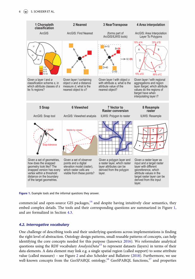
commercial and open-source GIS packages,14 and despite having intuitively clear semantics, theyembed complex details. The tools and their corresponding questions are summarized in Figure 1,and are formalized in Section 4.3.
4.2. Interrogative vocabulary
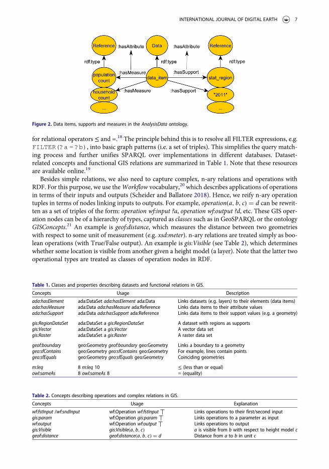
One challenge of describing tools and their underlying questions across implementations is findingthe right level of abstraction. Ontology design patterns, small reusable patterns of concepts, can helpidentifying the core concepts needed for this purpose (Janowicz 2016). We reformulate analyticalquestions using the RDF vocabulary AnalysisData15 to represent datasets (layers) in terms of theirdata elements. A data element may link e.g. a single spatial region (called support) to some attributevalue (called measure) – see Figure 2 and also Scheider and Ballatore (2018). Furthermore, we usewell-known concepts from the GeoSPARQL ontology,16 GeoSPARQL functions,17 and properties
Figure 1. Example tools and the informal questions they answer.
6 S. SCHEIDER ET AL.
for relational operators ≤ and =.18 The principle behind this is to resolve all FILTER expressions, e.g.FILTER(?a = ?b), into basic graph patterns (i.e. a set of triples). This simplifies the query match-ing process and further unifies SPARQL over implementations in different databases. Dataset-related concepts and functional GIS relations are summarized in Table 1. Note that these resourcesare available online.19
Besides simple relations, we also need to capture complex, n-ary relations and operations withRDF. For this purpose, we use theWorkflow vocabulary,20 which describes applications of operationsin terms of their inputs and outputs (Scheider and Ballatore 2018). Hence, we reify n-ary operationtuples in terms of nodes linking inputs to outputs. For example, operation(a, b, c) = d can be rewrit-ten as a set of triples of the form: operation wf:input ?a, operation wf:output ?d, etc. These GIS oper-ation nodes can be of a hierarchy of types, captured as classes such as in GeoSPARQL or the ontologyGISConcepts.21 An example is geof:distance, which measures the distance between two geometrieswith respect to some unit of measurement (e.g. xsd:meter). n-ary relations are treated simply as boo-lean operations (with True/False output). An example is gis:Visible (see Table 2), which determineswhether some location is visible from another given a height model (a layer). Note that the latter twooperational types are treated as classes of operation nodes in RDF.
Figure 2. Data items, supports and measures in the AnalysisData ontology.
Table 2. Concepts describing operations and complex relations in GIS.
Concepts Usage Explanation
wf:fstInput /wf:sndInput wf:Operation wf:fstInput ⟙ Links operations to their first/second inputgis:param wf:Operation gis:param ⟙ Links operations to a parameter as inputwf:output wf:Operation wf:output ⟙ Links operations to outputgis:Visible gis:Visible(a, b, c) a is visible from b with respect to height model cgeof:distance geof:distance(a, b, c) = d Distance from a to b in unit c
Table 1. Classes and properties describing datasets and functional relations in GIS.
Concepts Usage Description
ada:hasElement ada:DataSet ada:hasElement ada:Data Links datasets (e.g. layers) to their elements (data items)ada:hasMeasure ada:Data ada:hasMeasure ada:Reference Links data items to their attribute valuesada:hasSupport ada:Data ada:hasSupport ada:Reference Links data items to their support values (e.g. a geometry)
gis:RegionDataSet ada:DataSet a gis:RegionDataSet A dataset with regions as supportsgis:Vector ada:DataSet a gis:Vector A vector data setgis:Raster ada:DataSet a gis:Raster A raster data set
geof:boundary geo:Geometry geof:boundary geo:Geometry Links a boundary to a geometrygeo:sfContains geo:Geometry geo:sfContains geo:Geometry For example, lines contain pointsgeo:sfEquals geo:Geometry geo:sfEquals geo:Geometry Coinciding geometries
m:leq 8 m:leq 10 ≤ (less than or equal)owl:sameAs 8 owl:sameAs 8 = (equality)
INTERNATIONAL JOURNAL OF DIGITAL EARTH 7
Given this vocabulary, on which ontological level should we describe tools and questions? Follow-ing the principle of query matching, we suggest that inside an ontology, tool descriptions should useconcepts as concrete as possible to store enough detail, while interrogative concepts used for requestsshould be as general as possible, in order to maximize recall of tool queries.22
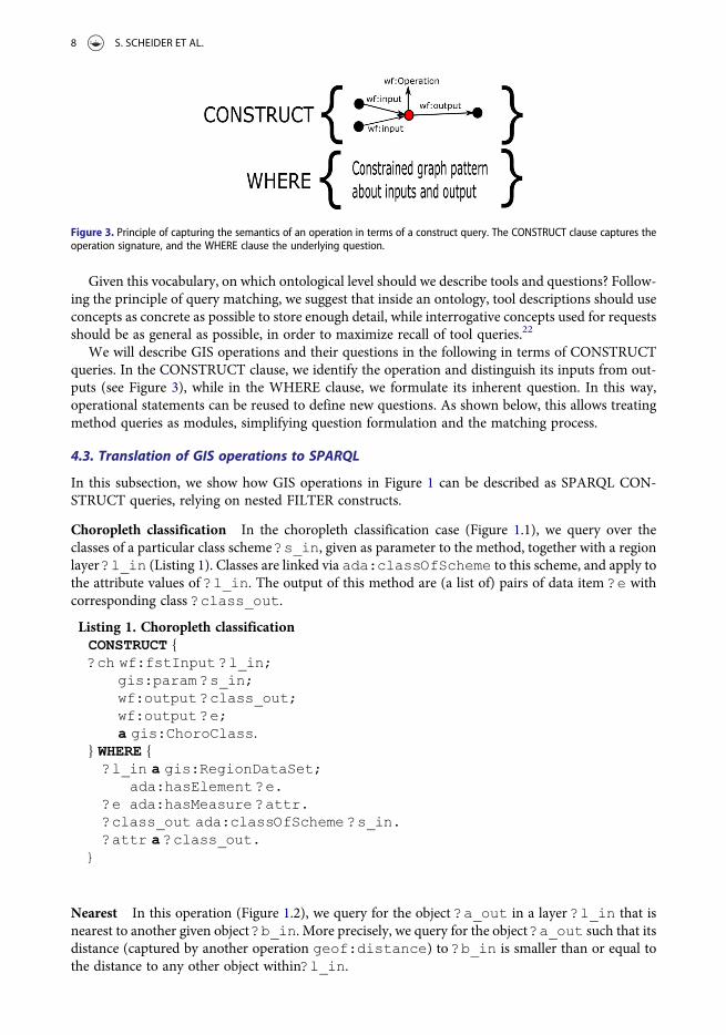
We will describe GIS operations and their questions in the following in terms of CONSTRUCTqueries. In the CONSTRUCT clause, we identify the operation and distinguish its inputs from out-puts (see Figure 3), while in the WHERE clause, we formulate its inherent question. In this way,operational statements can be reused to define new questions. As shown below, this allows treatingmethod queries as modules, simplifying question formulation and the matching process.
4.3. Translation of GIS operations to SPARQL
In this subsection, we show how GIS operations in Figure 1 can be described as SPARQL CON-STRUCT queries, relying on nested FILTER constructs.
Choropleth classification In the choropleth classification case (Figure 1.1), we query over theclasses of a particular class scheme ?s_in, given as parameter to the method, together with a regionlayer ?l_in (Listing 1). Classes are linked via ada:classOfScheme to this scheme, and apply tothe attribute values of ?l_in. The output of this method are (a list of) pairs of data item ?e withcorresponding class ?class_out.
Listing 1. Choropleth classificationCONSTRUCT {?ch wf:fstInput ?l_in;
gis:param ?s_in;wf:output ?class_out;wf:output ?e;a gis:ChoroClass.
} WHERE {?l_in a gis:RegionDataSet;
ada:hasElement ?e.?e ada:hasMeasure ?attr.?class_out ada:classOfScheme ?s_in.?attr a ?class_out.
}
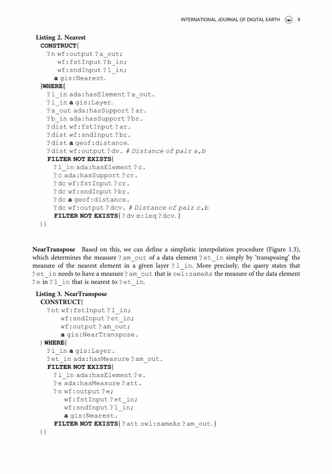
Nearest In this operation (Figure 1.2), we query for the object ?a_out in a layer ?l_in that isnearest to another given object ?b_in. More precisely, we query for the object ?a_out such that itsdistance (captured by another operation geof:distance) to ?b_in is smaller than or equal tothe distance to any other object within?l_in.
Figure 3. Principle of capturing the semantics of an operation in terms of a construct query. The CONSTRUCT clause captures theoperation signature, and the WHERE clause the underlying question.
8 S. SCHEIDER ET AL.
Listing 2. NearestCONSTRUCT{
?n wf:output ?a_out;wf:fstInput ?b_in;wf:sndInput ?l_in;
a gis:Nearest.}WHERE{
?l_in ada:hasElement ?a_out.?l_in a gis:Layer.?a_out ada:hasSupport ?ar.?b_in ada:hasSupport ?br.?dist wf:fstInput ?ar.?dist wf:sndInput ?br.?dist a geof:distance.?dist wf:output ?dv. # Distance of pair a,bFILTER NOT EXISTS{?l_in ada:hasElement ?c.?c ada:hasSupport ?cr.?dc wf:fstInput ?cr.?dc wf:sndInput ?br.?dc a geof:distance.?dc wf:output ?dcv. # Distance of pair c,bFILTER NOT EXISTS{ ?dv m:leq ?dcv. }
}}
NearTranspose Based on this, we can define a simplistic interpolation procedure (Figure 1.3),which determines the measure ?am_out of a data element ?et_in simply by ‘transposing’ themeasure of the nearest element in a given layer ?l_in. More precisely, the query states that?et_in needs to have a measure ?am_out that is owl:sameAs the measure of the data element?e in ?l_in that is nearest to ?et_in.
Listing 3. NearTransposeCONSTRUCT{
?nt wf:fstInput ?l_in;wf:sndInput ?et_in;wf:output ?am_out;a gis:NearTranspose.
}WHERE{?l_in a gis:Layer.?et_in ada:hasMeasure ?am_out.FILTER NOT EXISTS{?l_in ada:hasElement ?e.?e ada:hasMeasure ?att.?n wf:output ?e;
wf:fstInput ?et_in;wf:sndInput ?l_in;a gis:Nearest.
FILTER NOT EXISTS{ ?att owl:sameAs ?am_out. }}}
INTERNATIONAL JOURNAL OF DIGITAL EARTH 9
This one and other interpolation techniques (such Block Kriging) on the data item level are sub-class of gis:Interpolate in the gis ontology. For the sake of brevity, the rest of the tools aredescribed in Appendix A (see supplemental material).
5. Computing query containment on a SPARQL subset
In this section, we suggest how query containment can be computed for a subset of the SPARQLquery language that we consider particularly relevant for describing analytic questions in general,and GIS tools in particular. Our assumption is based on the observation that the diversity of analyticquestions discussed in Section 2 and translated in Section 4.3 can be entirely expressed in this subset.In addition, we believe that GIS analyzes tend to require questions that are structurally similar. Westart with defining the subset in terms of a formal pattern, then specify query containment for thispattern, and finally propose an algorithmic solution.
5.1. SPARQLCONSTRAINT
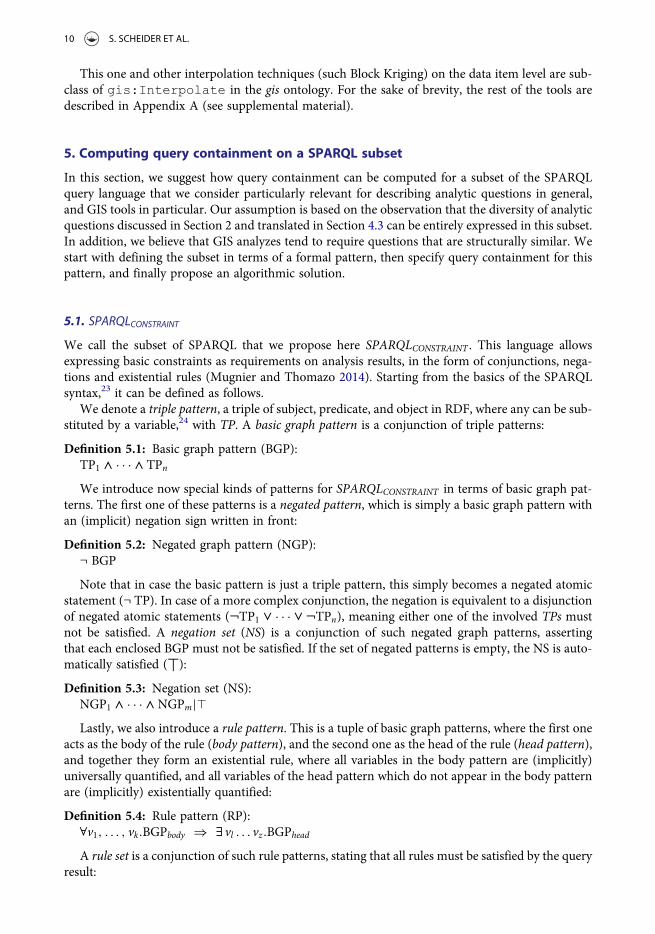
We call the subset of SPARQL that we propose here SPARQLCONSTRAINT . This language allowsexpressing basic constraints as requirements on analysis results, in the form of conjunctions, nega-tions and existential rules (Mugnier and Thomazo 2014). Starting from the basics of the SPARQLsyntax,23 it can be defined as follows.
We denote a triple pattern, a triple of subject, predicate, and object in RDF, where any can be sub-stituted by a variable,24 with TP. A basic graph pattern is a conjunction of triple patterns:
Definition 5.1: Basic graph pattern (BGP):TP1 ^ · · · ^ TPn
We introduce now special kinds of patterns for SPARQLCONSTRAINT in terms of basic graph pat-terns. The first one of these patterns is a negated pattern, which is simply a basic graph pattern withan (implicit) negation sign written in front:
Definition 5.2: Negated graph pattern (NGP):¬ BGP
Note that in case the basic pattern is just a triple pattern, this simply becomes a negated atomicstatement (¬ TP). In case of a more complex conjunction, the negation is equivalent to a disjunctionof negated atomic statements (¬TP1 _ · · · _ ¬TPn), meaning either one of the involved TPs mustnot be satisfied. A negation set (NS) is a conjunction of such negated graph patterns, assertingthat each enclosed BGP must not be satisfied. If the set of negated patterns is empty, the NS is auto-matically satisfied (⟙):
Definition 5.3: Negation set (NS):NGP1 ^ · · · ^NGPm|`Lastly, we also introduce a rule pattern. This is a tuple of basic graph patterns, where the first one
acts as the body of the rule (body pattern), and the second one as the head of the rule (head pattern),and together they form an existential rule, where all variables in the body pattern are (implicitly)universally quantified, and all variables of the head pattern which do not appear in the body patternare (implicitly) existentially quantified:
Definition 5.4: Rule pattern (RP):∀v1, . . . , vk.BGPbody ⇒ ∃ vl . . . vz.BGPhead
A rule set is a conjunction of such rule patterns, stating that all rules must be satisfied by the queryresult:
10 S. SCHEIDER ET AL.

Definition 5.5: Rule set (RS):RP1 ^ · · · ^ RPo|`We now can define a SPARQLCONSTRAINT pattern as a conjunction of a basic graph pattern, a
negation set and a rule set, where the latter two might stay empty:
Definition 5.6: Constrained graph pattern (CGP):BGP ^NS ^ RS
A SPARQLCONSTRAINT CONSTRUCT query is a tuple of a CGP and a CONSTRUCT templatewhich contains another BGP. In Appendix B, we show that a CGP corresponds to a certain subsetof SPARQL.
5.2. Defining query containment for SPARQLCONSTRAINT
In this subsection, we specify the precise conditions under which it is admissible to say that a givenSPARQLCONSTRAINT query is a subquery of another. We start with introducing some commonterminology.
A solution mapping for a query pattern is a function mapping the variables in this patterninto terms (RDF-T) such that the assertions of the pattern are preserved. A solution mappingbinds the variables in the pattern to constants provided by data, and so matches the patternwith a data set. We call the existence of a solution mapping (in correspondence with logic ter-minology) a model of the pattern. So when we say a pattern has a model, it means there is asolution mapping, a non-empty query result. Note that a given pattern can have many differentmodels. Furthermore, if a pattern does not have model, it must either be empty or contain acontradiction.
In order to determine whether one SPARQLCONSTRAINT query is contained in another one, wehave to find out whether it is the case that any model (any query result) of the first query is alsoa model of the second query. We define query containment in terms of homomorphic mappingsbetween query patterns which establish that they share all possible models. Homomorphic mappingsare established separately for the different kinds of graph patterns that constitute a constrained graphpattern (CGP). We start with a BGP (compare Figure 4(a)):
Figure 4. Definitions of sub-query patterns for query containment of SPARQL constraint. (a) Containment of BGP, (b) Sub negation(NGP), (c) Sub rule (RP).
INTERNATIONAL JOURNAL OF DIGITAL EARTH 11
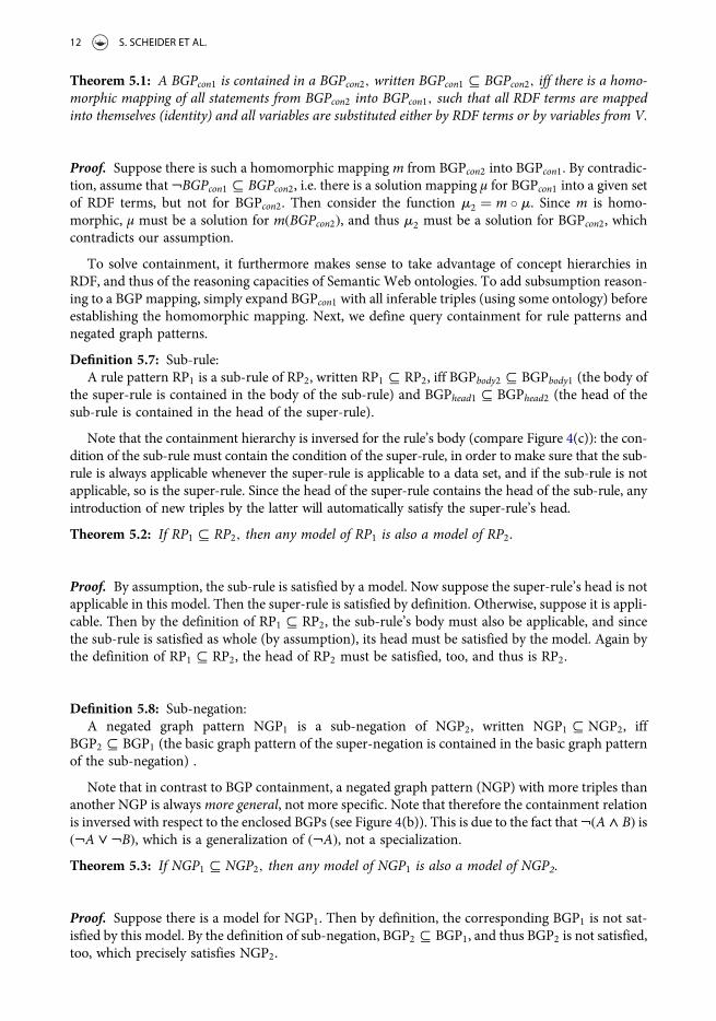
Theorem 5.1: A BGPcon1 is contained in a BGPcon2, written BGPcon1 # BGPcon2, iff there is a homo-morphic mapping of all statements from BGPcon2 into BGPcon1, such that all RDF terms are mappedinto themselves (identity) and all variables are substituted either by RDF terms or by variables from V.
Proof. Suppose there is such a homomorphic mapping m from BGPcon2 into BGPcon1. By contradic-tion, assume that ¬BGPcon1 # BGPcon2, i.e. there is a solution mapping μ for BGPcon1 into a given setof RDF terms, but not for BGPcon2. Then consider the function m2 = m ◦ m. Since m is homo-morphic, μ must be a solution for m(BGPcon2), and thus m2 must be a solution for BGPcon2, whichcontradicts our assumption.
To solve containment, it furthermore makes sense to take advantage of concept hierarchies inRDF, and thus of the reasoning capacities of Semantic Web ontologies. To add subsumption reason-ing to a BGP mapping, simply expand BGPcon1 with all inferable triples (using some ontology) beforeestablishing the homomorphic mapping. Next, we define query containment for rule patterns andnegated graph patterns.
Definition 5.7: Sub-rule:A rule pattern RP1 is a sub-rule of RP2, written RP1 # RP2, iff BGPbody2 # BGPbody1 (the body of
the super-rule is contained in the body of the sub-rule) and BGPhead1 # BGPhead2 (the head of thesub-rule is contained in the head of the super-rule).
Note that the containment hierarchy is inversed for the rule’s body (compare Figure 4(c)): the con-dition of the sub-rule must contain the condition of the super-rule, in order to make sure that the sub-rule is always applicable whenever the super-rule is applicable to a data set, and if the sub-rule is notapplicable, so is the super-rule. Since the head of the super-rule contains the head of the sub-rule, anyintroduction of new triples by the latter will automatically satisfy the super-rule’s head.
Theorem 5.2: If RP1 # RP2, then any model of RP1 is also a model of RP2.
Proof. By assumption, the sub-rule is satisfied by a model. Now suppose the super-rule’s head is notapplicable in this model. Then the super-rule is satisfied by definition. Otherwise, suppose it is appli-cable. Then by the definition of RP1 # RP2, the sub-rule’s body must also be applicable, and sincethe sub-rule is satisfied as whole (by assumption), its head must be satisfied by the model. Again bythe definition of RP1 # RP2, the head of RP2 must be satisfied, too, and thus is RP2.
Definition 5.8: Sub-negation:A negated graph pattern NGP1 is a sub-negation of NGP2, written NGP1 # NGP2, iff
BGP2 # BGP1 (the basic graph pattern of the super-negation is contained in the basic graph patternof the sub-negation) .
Note that in contrast to BGP containment, a negated graph pattern (NGP) with more triples thananother NGP is alwaysmore general, not more specific. Note that therefore the containment relationis inversed with respect to the enclosed BGPs (see Figure 4(b)). This is due to the fact that¬(A ^ B) is(¬A _ ¬B), which is a generalization of (¬A), not a specialization.Theorem 5.3: If NGP1 # NGP2, then any model of NGP1 is also a model of NGP2.
Proof. Suppose there is a model for NGP1. Then by definition, the corresponding BGP1 is not sat-isfied by this model. By the definition of sub-negation, BGP2 # BGP1, and thus BGP2 is not satisfied,too, which precisely satisfies NGP2.
12 S. SCHEIDER ET AL.
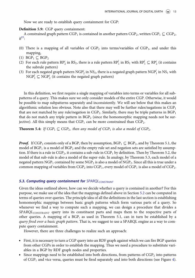
Now we are ready to establish query containment for CGP:
Definition 5.9: CGP query containment:A constrained graph pattern CGP1 is contained in another pattern CGP2, written CGP1 # CGP2,
if25:
(0) There is a mapping of all variables of CGP2 into terms/variables of CGP1, and under thismapping,
(1) BGP1 # BGP2
(2) For each rule pattern RPi2 in RS2, there is a rule pattern RPj
1 in RS1 with RPj1 # RPi
2 (it containsthe subrule pattern)
(3) For each negated graph pattern NGPi2 in NS2, there is a negated graph pattern NGPj
1 in NS1 withNGPj
1 # NGPi2 (it contains the negated graph pattern)
In this definition, we first require a single mapping of variables into terms or variables for all sub-patterns of a query. This makes sure we only consider models of the entire CGP. Otherwise, it wouldbe possible to map subpatterns separately and inconsistently. We will see below that this makes analgorithmic solution less obvious. Note also that there may well be further rules/negations in CGP1that are not matched by any rule/negation in CGP2. Similarly, there may be triple patterns in BGP1that do not match any triple pattern in BGP2 (since the homomorphic mapping needs not be sur-jective). All this simply means that CGP1 can be more constrained than CGP2.
Theorem 5.4: If CGP1 # CGP2, then any model of CGP1 is also a model of CGP2.
Proof. If CGP2 consists only of a BGP, then by assumption, BGP1 # BGP2, and by Theorem 5.1, themodel of BGP1 is a model of BGP2 and the empty rule set and negation sets are satisfied by assump-tion. If there is a rule in CGP2, it contains a sub-rule in CGP1 by definition. Then by Theorem 5.2, themodel of that sub-rule is also a model of the super-rule. In analogy, by Theorem 5.3, each model of anegated pattern NGP1 contained by some NGP2 is also a model of NGP2. Since all this is true under acommon mapping of variables from CGP2 into CGP1, every model of CGP1 is also a model of CGP2.
5.3. Computing query containment for SPARQLCONSTRAINT
Given the ideas outlined above, how can we decide whether a query is contained in another? For thispurpose, we make use of the idea that the mappings defined above in Section 5.2 can be computed interms of queries over queries. The principle idea of all the definitions in the last section is establishinghomomorphic mappings between basic graph patterns which form various parts of a query. Sowhenever we find a way to compute such a mapping, we can design a procedure that divides aSPARQLCONSTRAINT query into its constituent parts and maps them to the respective parts ofother queries. A mapping of a BGP, as used in Theorem 5.1, can in turn be established by aquery fired over a basic graph pattern. That is, we suggest to use a SPARQL engine as a way to com-pute query containment.
However, there are three challenges to realize such an approach:
. First, it is necessary to turn a CGP query into an RDF graph against which we can fire BGP queriesfrom other CGPs in order to establish the mapping. Thus we need a procedure to substitute vari-ables in a BGP by RDF graph nodes and properties.
. Since mappings need to be established into both directions, from patterns of CGP2 into patternsof CGP1 and vice versa, queries must be fired separately and into both directions (see Figure 4).
INTERNATIONAL JOURNAL OF DIGITAL EARTH 13
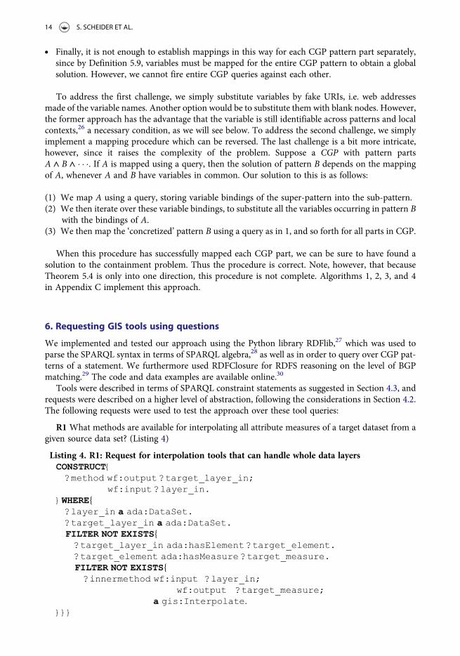
. Finally, it is not enough to establish mappings in this way for each CGP pattern part separately,since by Definition 5.9, variables must be mapped for the entire CGP pattern to obtain a globalsolution. However, we cannot fire entire CGP queries against each other.
To address the first challenge, we simply substitute variables by fake URIs, i.e. web addressesmade of the variable names. Another option would be to substitute them with blank nodes. However,the former approach has the advantage that the variable is still identifiable across patterns and localcontexts,26 a necessary condition, as we will see below. To address the second challenge, we simplyimplement a mapping procedure which can be reversed. The last challenge is a bit more intricate,however, since it raises the complexity of the problem. Suppose a CGP with pattern partsA ^ B ^ · · ·. If A is mapped using a query, then the solution of pattern B depends on the mappingof A, whenever A and B have variables in common. Our solution to this is as follows:
(1) We map A using a query, storing variable bindings of the super-pattern into the sub-pattern.(2) We then iterate over these variable bindings, to substitute all the variables occurring in pattern B
with the bindings of A.(3) We then map the ‘concretized’ pattern B using a query as in 1, and so forth for all parts in CGP.
When this procedure has successfully mapped each CGP part, we can be sure to have found asolution to the containment problem. Thus the procedure is correct. Note, however, that becauseTheorem 5.4 is only into one direction, this procedure is not complete. Algorithms 1, 2, 3, and 4in Appendix C implement this approach.
6. Requesting GIS tools using questions
We implemented and tested our approach using the Python library RDFlib,27 which was used toparse the SPARQL syntax in terms of SPARQL algebra,28 as well as in order to query over CGP pat-terns of a statement. We furthermore used RDFClosure for RDFS reasoning on the level of BGPmatching.29 The code and data examples are available online.30
Tools were described in terms of SPARQL constraint statements as suggested in Section 4.3, andrequests were described on a higher level of abstraction, following the considerations in Section 4.2.The following requests were used to test the approach over these tool queries:
R1 What methods are available for interpolating all attribute measures of a target dataset from agiven source data set? (Listing 4)
Listing 4. R1: Request for interpolation tools that can handle whole data layersCONSTRUCT{
?method wf:output ?target_layer_in;wf:input ?layer_in.
}WHERE{?layer_in a ada:DataSet.?target_layer_in a ada:DataSet.FILTER NOT EXISTS{?target_layer_in ada:hasElement ?target_element.?target_element ada:hasMeasure ?target_measure.FILTER NOT EXISTS{
?innermethod wf:input ?layer_in;wf:output ?target_measure;
a gis:Interpolate.}}}
14 S. SCHEIDER ET AL.
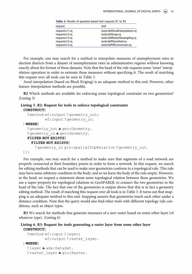
For example, one may search for a method to interpolate measures of unemployment rates inelection districts from a dataset of unemployment rates in administrative regions without knowingexactly about the format of these datasets. Note that the head of the rule requests some ‘inner’ interp-olation operation in order to estimate these measures without specifying it. The result of matchingthis request over all tools can be seen in Table 3.
Areal interpolation (based on Block Kriging) is an adequate method to this end. However, otherfeature interpolation methods are possible.
R2 Which methods are available for enforcing some topological constraint on two geometries?(Listing 5)
Listing 5. R2: Request for tools to enforce topological constraintsCONSTRUCT{
?method wf:output ?geometry_out;wf:input ?geometry_in.
}WHERE{?geometry_out a geo:Geometry.?geometry_in a geo:Geometry.FILTER NOT EXISTS{FILTER NOT EXISTS{
?geometry_in gis:spatialTopRelation ?geometry_out.}}}
For example, one may search for a method to make sure that segments of a road network areproperly connected at their boundary points in order to form a network. In this request, we searchfor editing methods that can be used to make sure geometries conform to a topological rule. This rulemay have some arbitrary condition in the body, and so we leave the body of the rule empty. However,in the head, we request a statement about some topological relation between these geometries. Weuse a super-property for topological relations in GeoSPARQL to connect the two geometries in thehead of the rule. The fact that one of the geometries is output shows that this is in fact a geometryediting method. The result of matching this request over all tools is in Table 3. It turns out that snap-ping is an adequate method to this end. Snapping assures that geometries touch each other under adistance condition. Note that the query would also find other tools with different topology rule con-ditions, such as object types.
R3 We search for methods that generate measures of a new raster based on some other layer (ofwhatever type). (Listing 6)
Listing 6. R3: Request for tools generating a raster layer from some other layerCONSTRUCT{
?method wf:input ?layer;wf:output ?raster_layer.
}WHERE{?layer a ada:DataSet.?raster_layer a gis:Raster.
Table 3. Results of question-based tool requests R1 to R3.
request tool
requests/r1.rq tools/defArealInterpolation.rqrequests/r2.rq tools/defSnap.rqrequests/r3.rq tools/defRasterResampling.rqrequests/r3.rq tools/defViewshed.rqrequests/r3.rq tools/defVRConversion.rq
INTERNATIONAL JOURNAL OF DIGITAL EARTH 15
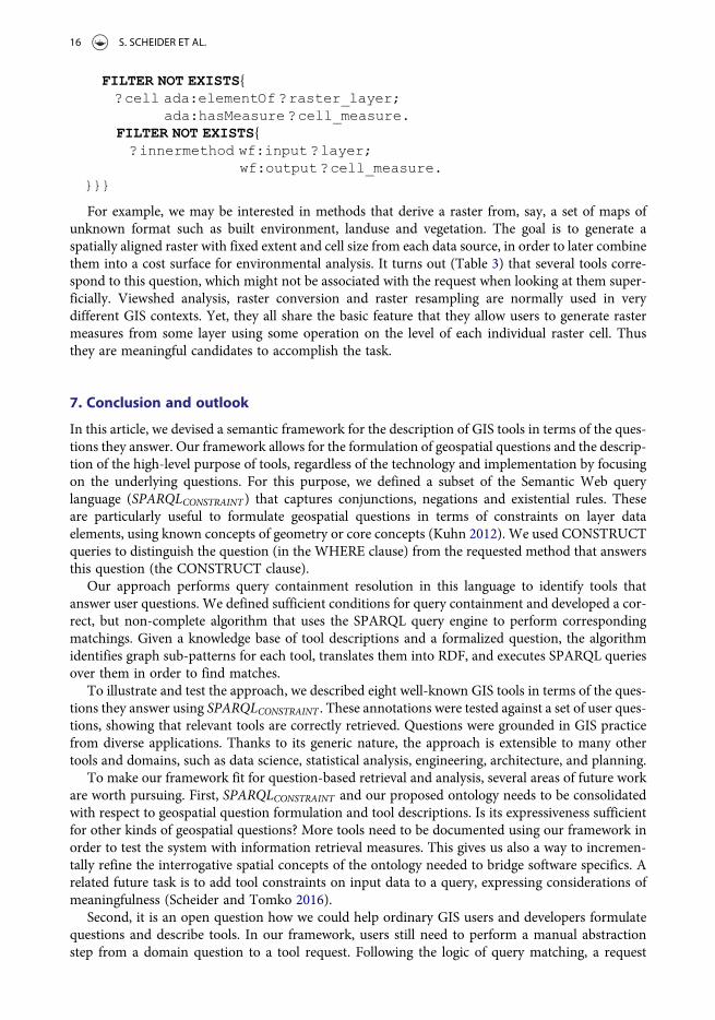
FILTER NOT EXISTS{?cell ada:elementOf ?raster_layer;
ada:hasMeasure ?cell_measure.FILTER NOT EXISTS{
?innermethod wf:input ?layer;wf:output ?cell_measure.
}}}
For example, we may be interested in methods that derive a raster from, say, a set of maps ofunknown format such as built environment, landuse and vegetation. The goal is to generate aspatially aligned raster with fixed extent and cell size from each data source, in order to later combinethem into a cost surface for environmental analysis. It turns out (Table 3) that several tools corre-spond to this question, which might not be associated with the request when looking at them super-ficially. Viewshed analysis, raster conversion and raster resampling are normally used in verydifferent GIS contexts. Yet, they all share the basic feature that they allow users to generate rastermeasures from some layer using some operation on the level of each individual raster cell. Thusthey are meaningful candidates to accomplish the task.
7. Conclusion and outlook
In this article, we devised a semantic framework for the description of GIS tools in terms of the ques-tions they answer. Our framework allows for the formulation of geospatial questions and the descrip-tion of the high-level purpose of tools, regardless of the technology and implementation by focusingon the underlying questions. For this purpose, we defined a subset of the Semantic Web querylanguage (SPARQLCONSTRAINT ) that captures conjunctions, negations and existential rules. Theseare particularly useful to formulate geospatial questions in terms of constraints on layer dataelements, using known concepts of geometry or core concepts (Kuhn 2012). We used CONSTRUCTqueries to distinguish the question (in the WHERE clause) from the requested method that answersthis question (the CONSTRUCT clause).
Our approach performs query containment resolution in this language to identify tools thatanswer user questions. We defined sufficient conditions for query containment and developed a cor-rect, but non-complete algorithm that uses the SPARQL query engine to perform correspondingmatchings. Given a knowledge base of tool descriptions and a formalized question, the algorithmidentifies graph sub-patterns for each tool, translates them into RDF, and executes SPARQL queriesover them in order to find matches.
To illustrate and test the approach, we described eight well-known GIS tools in terms of the ques-tions they answer using SPARQLCONSTRAINT . These annotations were tested against a set of user ques-tions, showing that relevant tools are correctly retrieved. Questions were grounded in GIS practicefrom diverse applications. Thanks to its generic nature, the approach is extensible to many othertools and domains, such as data science, statistical analysis, engineering, architecture, and planning.
To make our framework fit for question-based retrieval and analysis, several areas of future workare worth pursuing. First, SPARQLCONSTRAINT and our proposed ontology needs to be consolidatedwith respect to geospatial question formulation and tool descriptions. Is its expressiveness sufficientfor other kinds of geospatial questions? More tools need to be documented using our framework inorder to test the system with information retrieval measures. This gives us also a way to incremen-tally refine the interrogative spatial concepts of the ontology needed to bridge software specifics. Arelated future task is to add tool constraints on input data to a query, expressing considerations ofmeaningfulness (Scheider and Tomko 2016).
Second, it is an open question how we could help ordinary GIS users and developers formulatequestions and describe tools. In our framework, users still need to perform a manual abstractionstep from a domain question to a tool request. Following the logic of query matching, a request
16 S. SCHEIDER ET AL.
needs to abstract from content themes and parameter values in order to subsume any tool descrip-tion that is devoid of these specifics. Several approaches can be adopted to support and automate thisstep. For one, tool descriptions and questions need to be modularized, as done here by defining inter-mediate, inner methods and reusing them in other descriptions. This may result in a library of re-usable questions that are implementation-independent, as part of a linked method repository wheretools can be registered with their corresponding questions (Scheider and Ballatore 2018). Also, toincrease the usability of our approach, controlled natural languages (Schwitter 2010; Mazzeo andZaniolo 2016) and interactive SPARQL interfaces (Ngonga Ngomo et al. 2013) could be used totranslate questions into queries, and autocompletion helps reuse existing interrogative concepts. Fur-thermore, we suggest to consider bottom-up approaches, such as query by example and case-basedreasoning, in which a corpus of known questions is used to support the formulation of new ones andto automate the necessary abstraction to tool requests. Along the same lines, Web science can alsohelp identify real usage patterns of tools and resources (Ballatore, Scheider, and Lemmens 2018).
Third, the algorithm for query containment needs to be developed further to tackle issues likecompleteness, scalability, and performance. We currently use a brute-force approach to searchover tools, which could be improved by reducing the search space of tools in question. To tacklecompleteness, we would need rule-based inference to derive queries from another query by the appli-cation of rules. Since this considerably increases the complexity of the algorithm, it should be care-fully assessed whether practical applications really benefit from it (Hitzler and van Harmelen 2010).
Finally, the integration of question-based analysis with linked GIS workflows remains an openproblem (Scheider and Ballatore 2018). How can we derive questions for entire workflows fromquestions over tools? Can we perform workflow composition and design using questions (Lamprecht2013) to solve indirect question answering? In our view, such efforts at question-based analytics havethe potential to enable a more usable, inter-operable technological landscape for a more spatially-integrated data science.
Notes
1. http://blog.revolutionanalytics.com/2015/06/fishing-for-packages-in-cran.html2. http://desktop.arcgis.com3. The latter follows a Zipf distribution, that is there are only few, simple most frequent queries, see Lin (2002).4. https://www.w3.org/TR/sparql11-query/5. https://github.com/simonscheider/QuestionBasedAnalysis6. https://nyti.ms/2kc45DB7. http://desktop.arcgis.com/de/arcmap/10.3/tools/spatial-analyst-toolbox/raster-calculator.htm8. For example, Ofoghi, Yearwood, and Ma (2008) suggested to use Fillmore’s frames to match questions and
answers.9. https://en.wikipedia.org/wiki/SPARQL10. See for example the Web Service Modeling Ontology (WSMO): https://www.w3.org/Submission/WSMO/11. http://desktop.arcgis.com/en/arcmap/10.3/map/working-with-layers/a-quick-tour-of-displaying-layers.htm12. https://www.w3.org/TR/sparql11-overview/13. Web Ontology Language, https://www.w3.org/TR/owl2-profiles/14. We will mention example implementations from ArcGIS (https://www.arcgis.com) and ILWIS (https://www.
itc.nl/ilwis).15. ada: http://geographicknowledge.de/vocab/AnalysisData.rdf16. geo: http://www.opengis.net/ont/geosparql17. geof: http://www.opengis.net/def/function/geosparql/18. We use the MathML m: http://www.w3.org/TR/MathML/ ‘less than or equal’ property (m:leq) to denote the
filter function ≤.19. https://github.com/simonscheider/QuestionBasedAnalysis20. wf: http://geographicknowledge.de/vocab/Workflow.rdf21. gis: http://geographicknowledge.de/vocab/GISConcepts.rdf22. Note that this requires users to abstract from domain questions in order to formulate requests, see Section 6.23. https://www.w3.org/TR/rdf-sparql-query/24. see https://www.w3.org/2001/sw/DataAccess/rq23/#BasicGraphPattern
INTERNATIONAL JOURNAL OF DIGITAL EARTH 17
25. Note that we establish this only forward, not backward. The latter would require taking into account that a CGPquery can be inferred from another using the application of rules. For example, from CGPa:TP1 ^ (TP1 ⇒ TP2), it follows that CGPb: TP1 ^ TP2 is always satisfied, and thus CGPb # CGPa.
26. Blank nodes loose their identity across local scopes.27. https://github.com/RDFLib/rdflib28. https://www.w3.org/2001/sw/DataAccess/rq23/rq24-algebra.html29. https://github.com/RDFLib/OWL-RL30. https://github.com/simonscheider/QuestionBasedAnalysis
Acknowledgments
We would like to thank Wim Feringa from ITC for the graphical design of Figure 1.
Disclosure statement
No potential conflict of interest was reported by the authors.
ORCID
S. Scheider http://orcid.org/0000-0002-2267-4810A. Ballatore http://orcid.org/0000-0003-3477-7654R. Lemmens http://orcid.org/0000-0001-5269-6343
Underlying research materials
The underlying research materials for this article can be accessed at: https://github.com/simonscheider/QuestionBasedAnalysis.
References
Albrecht, J. 1998. “Universal Analytical GIS Operations: A Task-oriented Systematization of Data Structure-indepen-dent GIS Functionality.” In Geographic information research: Transatlantic perspectives, edited by H. Onsrud andM. Craglia, 577–591. Abingdon, UK: Taylor & Francis.
Allan, J., B. Croft, A. Moffat, and M. Sanderson. 2012. “Frontiers, Challenges, and Opportunities for InformationRetrieval - Report from SWIRL 2012.” ACM SIGIR Forum 46 (1): 1–32.
Ballatore, A., S. Scheider, and R. Lemmens. 2018. “Patterns of Consumption and Connectedness in GIS Web Sources.”In Geospatial Technologies for All. Selected Papers of the 21st AGILE Conference on Geographic Information Science,edited by A. Mansourian, P. Pilesjö, L. Harrie, and R. van Lammeren, 1–19. Berlin: Springer. In press.
Belhajjame, K., J. Zhao, D. Garijo, M. Gamble, K. Hettne, R. Palma, and E. Mina, et al. 2015. “Using a Suite ofOntologies for Preserving Workflow-centric Research Objects.” Web Semantics: Science, Services and Agents onthe World Wide Web 32: 16–42.
Bernard, L., S. Mäs, M. Müller, C. Henzen, and J. Brauner. 2014. “Scientific Geodata Infrastructures: Challenges,Approaches and Directions.” International Journal of Digital Earth 7 (7): 613–633.
Brauner, J. 2015. “Formalizations for Geooperators – Geoprocessing in Spatial Data Infrastructures.” PhD thesis,Technical University of Dresden, Germany.
Calì, A., G. Gottlob, and T. Lukasiewicz. 2012. “A General Datalog-based Framework for Tractable Query AnsweringOver Ontologies.” Web Semantics: Science, Services and Agents on the World Wide Web 14: 57–83.
Canbek, N. G., and M. E. Mutlu. 2016. “On the Track of Artificial Intelligence: Learning with Intelligent PersonalAssistants.” International Journal of Human Sciences 13 (1): 592–601.
Ferré, S. 2014. “SQUALL: The Expressiveness of SPARQL 1.1 Made Available as a Controlled Natural Language.” Data& Knowledge Engineering 94: 163–188.
Fitzner, D., J. Hoffmann, and E. Klien. 2011. “Functional Description of Geoprocessing Services as ConjunctiveDatalog Queries.” GeoInformatica 15 (1): 191–221.
Gao, S., and M. F. Goodchild. 2013. “Asking Spatial Questions to Identify GIS Functionality.” Proceedings of the FourthInternational Conference on Computing for Geospatial Research and Application (COM.Geo), 106–110. San Jose,CA: IEEE.
18 S. SCHEIDER ET AL.
Hinsen, K. 2014. “Computational Science: Shifting the Focus from Tools to Models.” F1000Research 3: 101. https://f1000research.com/articles/3-101/v1
Hitzler, P., M. Krötzsch, and S. Rudolph. 2009. Foundations of Semantic Web Technologies. Boca Raton, FL: CRC Press.Hitzler, P., and F. van Harmelen. 2010. “A Reasonable Semantic Web.” Semantic Web 1 (2): 39–44.Hofer, B., S. Mäs, J. Brauner, and L. Bernard. 2017. “Towards a Knowledge Base to Support Geoprocessing Workflow
Development.” International Journal of Geographical Information Science 31 (4): 694–716.Höffner K., J. Lehmann, and R. Usbeck. 2016. “CubeQA—Question Answering on RDF Data Cubes.” In The Semantic
Web – ISWC 2016. ISWC 2016. Lecture Notes in Computer Science, edited by P. Groth, E. Simperl, A. Gray, M.Sabou, M. Krötzsch, F. Lecue, F. Flöck, and Y. Gil, vol. 9981. Cham: Springer.
Janowicz, K. 2016. “Modeling Ontology Design Patterns with Domain Experts-A View From the Trenches.” InOntology Engineering with Ontology Design Patterns - Foundations and Applications, Studies on the SemanticWeb, edited by Pascal Hitzler, Aldo Gangemi, Krzysztof Janowicz, Adila Krisnadhi, and Valentina Presutti,Vol. 25, 233–243. Berlin: AKA Verlag.
Kuhn, W. 2012. “Core Concepts of Spatial Information for Transdisciplinary Research.” International Journal ofGeographical Information Science 26 (12): 2267–2276.
Kuhn, W., and A. Ballatore. 2015. “Designing a Language for Spatial Computing.” In AGILE Conference on GeographicInformation Science 2015, Lecture Notes in Geoinformation and Cartography, edited by F. Bacao, M. Y. Santos, andM. Painho, 309–326. Berlin: Springer.
Kwan, M.-P. ed. 2016. Geographies of Health, Disease and Well-Being: Recent Advances in Theory and Method.London: Routledge.
Lamprecht, A.-L. 2013. User-Level Workflow Design: A Bioinformatics Perspective, Lecture Notes in Computer Science,Vol. 8311. Berlin: Springer.
Lemmens, R., A. Wytzisk, R. By, C. Granell, M. Gould, and P. van Oosterom. 2006. “Integrating Semantic andSyntactic escriptions to Chain Geographic Services.” IEEE Internet Computing 10 (5): 42–52.
Lemmens, R. L. 2006. “Semantic Interoperability of Distributed Geo-services.” PhD thesis, Delft University ofTechnology, Delft, Netherlands.
Lin, J. 2002. “The Web as a Resource for Question Answering: Perspectives and Challenges.” Proceedings of the ThirdInternational Conference on Language Resources and Evaluation (LREC-2002), Canary Islands, Spain, 1–8.
Ludäscher, B., K. Lin, S. Bowers, E. Jaeger-Frank, B. Brodaric, and C. Baru. 2006. “Managing Scientific Data: From DataIntegration to Scientific Workflows.” Geological Society of America – Special Papers 397: 109–129.
Lutz, M. 2007. “Ontology-Based Descriptions for Semantic Discovery and Composition of Geoprocessing Services.”GeoInformatica 11 (1): 1–36.
Mazzeo, G. M., and C. Zaniolo. 2016. “Answering Controlled Natural Language Questions on RDF Knowledge Bases.”Proceedings of the 19th International Conference on Extending Database Technology (EDBT), Bordeaux, France,608–611.
Mugnier, M.-L., and M. Thomazo. 2014. “An Introduction to Ontology-based Query Answering with ExistentialRules.” In Reasoning on the Web in the Big Data Era: 10th International Summer School 2014, Athens, Greece, editedby M. Koubarakis, G. Stamou, G. Stoilos, I. Horrocks, P. Kolaitis, G. Lausen, and G. Weikum, 245–278. Berlin:Springer.
Müller, M., L. Bernard, and D. Kadner. 2013. “Moving Code – Sharing Geoprocessing Logic on the Web.” ISPRSJournal of Photogrammetry and Remote Sensing 83: 193–203.
Ngonga Ngomo, A.-C., L. Bühmann, C. Unger, J. Lehmann, and D. Gerber. 2013. “Sorry, I Don’t Speak SPARQL:Translating SPARQL Queries into Natural Language.” Proceedings of the 22nd International Conference on theWorld Wide Web (WWW’13), Rio de Janeiro, Brazil, 977–988.
Ofoghi, B., J. Yearwood, and L. Ma. 2008. “The Impact of Semantic Class Identification and Semantic Role Labeling onNatural Language Answer Extraction.” In Advances in Information Retrieval: 30th European Conference on IRResearch, ECIR 2008, Glasgow, UK, edited by C. Macdonald, I. Ounis, V. Plachouras, I. Ruthven, andR. W. White, 430–437. Berlin: Springer.
OGC (2015). “OGC WPS 2.0 Interface Standard. OGC Document 14-065.” Technical report, Open GeospatialConsortium, Wayland, MA.
Rey, S. J. 2009. “Show Me the Code: Spatial Analysis and Open Source.” Journal of Geographical Systems 11 (2): 191–207.
Rico, M., C. Unger, and P. Cimiano. 2015. “Sorry, I Only Speak Natural Language: A Pattern-based, Data-driven andGuided Approach to Mapping Natural Language Queries to SPARQL.” Proceedings of the 4th InternationalWorkshop on Intelligent Exploration of Semantic Data (IESD 2015) Co-located with the 14th InternationalSemantic Web Conference (ISWC 2015), Bethlehem, Pennsylvania , USA, 1–10.
Scheider, S., and A. Ballatore. 2018. “Semantic Typing of Linked Geoprocessing Workflows.” International Journal ofDigital Earth 11 (1): 113–138.
Scheider, S., and R. Lemmens. 2017. “Using SPARQL to Describe GIS Methods in Terms of the Questions theyAnswer.” In Short Papers, Posters and Poster Abstracts of the 20th AGILE Conference on Geographic InformationScience, edited by A. Bregt, T. Sarjakoski, R. van Lammeren, and F. Rip, 1–6. Wageningen, Netherlands.
INTERNATIONAL JOURNAL OF DIGITAL EARTH 19

Scheider, S., and M. Tomko. 2016. “Knowing Whether Spatio-Temporal Analysis Procedures Are Applicable toDatasets.” In Proceedings of the 9th International Conference on Formal Ontology in Information Systems, FOIS2016, Annecy, France, 67–80.
Schwitter, R. 2010. Controlled Natural Languages for Knowledge Representation. COLING ’10 Proceedings of the 23rdInternational Conference on Computational Linguistics: Posters, 1113–1121. Beijing, China: Association forComputational Linguistics.
Visser, U., H. Stuckenschmidt, G. Schuster, and T. Vogele. 2002. “Ontologies for Geographic Information Processing.”Computers & Geosciences 28: 103–117.
Zhao, P., T. Foerster, and P. Yue. 2012. “The Geoprocessing Web.” Computers & Geosciences 47: 3–12.
20 S. SCHEIDER ET AL.
Related Documents


