I I I Reference No.: 01 Former Macon Naval Ordnance Landfill EPA ID No. GAD0000102178 Rust Envlrornment & Infrastructure Inc. A RustlnlemariMo! l'fl1111t 770 17.1880 :6&)081dlfoalc0rive.Suite4'5 Fat 770.417.!899 No:tro&S, GA 3009J. 1817 FINAL SITE INVESTIGATION REPORT FORMER MACON NAVAL ORDNANCE PLANT LANDFILL SITE MACON, GEORGIA September 1997 Prepared for: SAVANNAH DISTRICT- U.S. ARMY CORPS OF ENGINEERS USACE Contract DACA 21-93-D-0029 Delivery Order No. 24 Prepared by: RUST ENVIRONMENT & INFRASTRUCTURE Atlanta, Georgia Rust P·.·oject No. 33941.000 Rust Doc11ment Contro13J94l-0051 • I Q !WORDPI?OClJJ94/\JJ94/1!8. WI-D 91258'! Ct Ous!ity through teamwnrk

Welcome message from author
This document is posted to help you gain knowledge. Please leave a comment to let me know what you think about it! Share it to your friends and learn new things together.
Transcript
I I I
Reference No.: 01 Former Macon Naval Ordnance Landfill EPA ID No. GAD0000102178
Rust Envlrornment & Infrastructure Inc.
A RustlnlemariMo! ~ l'fl1111t 770 ~ 17.1880 :6&)081dlfoalc0rive.Suite4'5 Fat 770.417.!899 No:tro&S, GA 3009J. 1817
FINAL SITE INVESTIGATION REPORT
FORMER MACON NAVAL ORDNANCE PLANT LANDFILL SITE
MACON, GEORGIA
September 1997
Prepared for: SAVANNAH DISTRICT- U.S. ARMY CORPS OF ENGINEERS
USACE Contract DACA 21-93-D-0029 Delivery Order No. 24
Prepared by: RUST ENVIRONMENT & INFRASTRUCTURE
Atlanta, Georgia
Rust P·.·oject No. 33941.000 Rust Doc11ment Contro13J94l-0051
• I ~
Q !WORDPI?OClJJ94/\JJ94/1!8. WI-D 91258'!
Ct Ous!ity through teamwnrk
' . RIKf Rust Environment & lnfrastnlcture Inc.
A !lust International Company Phone 770.417.1680 1650 Oakbroolt Drive, Suite 445 Fax 770.417.1899 Norcross. GA 30093-1817
FINAL SITE INVESTIGATION REPORT
FORMER MACON NAVAL ORDNANCE PLANT LANDFILL SITE
MACON, GEORGIA
September 1997
Prepared for:. SAVANNAH DISTRICT- U.S. ARMY CORPS OF ENGINEERS
USACE Contract DACA 21-93-D-0029 Delivery Order No. 24
Prepared by: RUST ENVIRONMENT & INFRASTRUCTURE
Atlanta, Georgia
Lester J. Williams, P.O. Project Geologist
Q:\WORDPROC\33941\J394//18. WPD
0 Quality through teamwork
Rust Project No. 33941.000 Rust Document Control 33941-005 I
9125197
CERTIFICATION
SITE INVESTIGATION REPORT LANDFILL SITE
(FORMER MACON NAVAL ORDNANCE PLANT) MACON, GEORGIA
PREPARED FOR: U.S. ARMY CORPS OF ENGINEERS
SAVANNAH DISTRICT
?t: •ecccnfd-,a,LS •#f3 Kenneth P. Bechely, P.O. Project Director
Q:\WORDPROCU394/l33941 I 18. WPD 1012/97
TABLE OF CONTENTS
Section
Final Site Investigation Report
Former Macon Naval Ordnance Landfill
Rust Project No. 3394/.000
EXECUTIVE SUMMARY ................................................... viii
1.0 INTRODUCTION ......................................................... 1
1.1 SITE DESCRIPTION .............................................. 1
1.2 BACKGROUND .................................................. 2
2.0 PHYSICAL SETTING ..................................................... 4
2.1 SUBSURFACE GEOLOGY ......................................... 4
2.2 HYDROGEOLOGY ............................................... 5
2.3 WATER USE ..................................................... 7
2.4 SURF ACE WATER FEATURES AND HYDROLOGY ................... 9
3.0 POTENTIAL SOURCE AREAS ............................................ 10
3.1 FORMERMNOPLANDFILL ...................................... 10
3.2 EXPLOSIVE DEMOLITION AREA ................................. 10
3.3 OFF-SITE SOURCES ....................................... ~ ..... 10
4.0 SOIL CONTAMINATION ................................................ 12
4.1 GENERAL APPROACH USED .................................... 12
4.2 ANALYTICAL PARAMETERS .................................... 12
4.3 LOCATION OF SAMPLING POINTS ................................ 12
4.4 SAMPLING AND ANALYSIS PROCEDURES ........................ 13
4.4.1 Sampling Equipment ........................................ 13
4.4.2 Collection Techniques ....................................... 13
4.4.3 Field Screening Techniques ................................... 14
4.4.4 Sample Handling ........................................... 15
4.4.5 Decontamination Procedures .................................. 15
4.4.6 Chain ofCustody Procedures .................................. 15
4.4.7 Laboratory Analytical Techniques .............................. 16
4.5 BACKGROUND SOIL SAMPLING ................................. 16
4.6 DATA SUMMARY ............................................... 16
4.6.1 Field Data ................................................. 16
4.6.2 Laboratory Results .......................................... 17
4.6.3 Extent of Contamination ..................................... 18
4.6.4 Fate and Transport .......................................... 19
5.0 GROUNDWATER CONTAMINATION ..................................... 23
5.1 GENERAL APPROACH ........................................... 23
5.2 ANALYTICAL PARAMETERS (Monitoring Wells) .................... 23
Q:\WORDPROC\3394/\3394/ I J8.WPD 9125/97
Final Site Investigation Report Former Macon Naval Ordnance Landfill
Rust Project No. 33941.000
5.3 DRIVE POINT WELU HYDROPUNCH SCREENING .................. 23 5.3.1 HydroPunch™ ............................................ 24 5.3.2 Drive Point Wells ....•...................................... 24 5.3.3 Gas Chromatography ........................................ 24 5.4 MONITOR WELL INSTALLATION PROCEDURE .................... 25 5.4.1 Monitor WeJl Installation ..................................... 25 5.4.2 Well Development .......................................... 25 5.4.3 Water Level Measurement .................................... 26 5.4.4 Surveying ................................................. 26 5.5 SAMPLING AND ANALYSIS PROCEDURES ........................ 26 5.5.1 Well Evacuation ........................................•... 26 5.5.2- Sample Collection .................... -·-·--·-~_,_._, __ .. _, ·--<~-·-· --~·~-~-.27 5.6---- - BACKGROUND W k'fER QUALITY-:-~-:-:~--:-. -:-.~ ....... : .............. 27 5.7 DATA SUMMARY ............................................... 27 5.7.1 Drive Point Well/HydroPunch Screening Data .................... 27 5.7.2 Laboratory Results .......................................... 28 5.7.3 Extent of Contamination ..................................... 29 5. 7.4 Fate and Transport ............ _· ... ._ ... ~·~ ._ .... _ .. , .. ~ ~· •....• 31 6.0 ADDITIONAL ENVIRONMENTAL SAMPLING ............................. 32 6.1 SURFACE WATER ............................................... 32 6.1.1 Procedure ................................................. 32 6.1.2 Results ................................................... 32 6.2 SEDIMENT SAMPLING .......................................... 33 6.2.1 Procedure ................................................. 34 6.2.2 Results ................................................... 34 6.3 BlOT A SAMPLING .............................................. 35 6.3.1 Procedures ................................................ 35 6.3.2 Results .......................................... _ ......... 35-
7.0 ENVIRONMENTAL RECEPTORS ......................................... 37 8.0 PROPERTIES AND RESPONSIBLE PARTIES .............................. 40 8.1 SITE PROPERTY OWNERSHIP HISTORY ........................... 40 8.2 OFF-SITE PROPERTY OWNERSHIP ................................ 40 9.0 SUMMARY OF PREVIOUS ACTIONS ..................................... 41 10.0 COMPLIANCE WITH RISK REDUCTION STANDARDS .................... 42 10.1 GROUNDWATER DATA , ........................................ 42 10.2 SOIL DATA ..................................................... 43 10.3 SUMMARY ..................................................... 43
Q:\WORDPROCU394113J94//18. WPD ii 9125197
Final Site Investigation Report
Former Macon Naval Ordnance Landfill
Rust Project No. 33941.000
~~ 11.0 CONCLUSIONS AND.RECOMMENDATIONS ............................. 44
11.1 CONCLUSIONS ................................................. 44
11.1.1 Extent of Contamination ................ : .................... 44
11.1.2 Evaluation of Potential Source Areas ............................ 47
11.1.3 Compliance with HSRA Risk Reduction Standards ................ 47
11.2 RECOMMENDATIONS ........................................... 49
REFERENCES .............................................................. 50
Q:\WORDPROC\33941133941 I J8.WPD. iii 9/25197
1-1
1-2
2-1
2-2
2-4
2-5
2-6
3-1
4-l
4-2
4-3
5-1
5-2
5-3
5-4
5-5
6-1
LIST OF FIGURES
Final Site Investigation Report Former Macon Naval Ordnance Landful
Rust Project No. 33941.000
Follows Pa~ Site Location Map : ............................................. 1 Previous Environmental Studies ................................... 3 Cross Section Location Map ...................................... 4 Cross Section A-A' ............................................. 4 Cross Section B-B ~- ............................................. 4 Cross Section C-C' ............................................. 4 Potentiometric Surface Map ...................................... 6 Industrial Well Location Map ..................................... 8 Source Area Map . . . . . . . . . . . . . . . . . . . . . . . . . . . . . . . . . . . . . . . . . . . . . . l 0 Soil Boring Sample Locations .................................... 12 Analytical Results for Metals in Soil ............................... 17 Analytical Results for PCBs (Arochlor) in Soil ....................... 18 HydroPunch/Drive Point Location Map ............................ 24 -Monitor Well Location Map ................................... ; . 25 HydroPunch/Drive Point & Screening Summary ..................... 27 Analytical Results for TCE in Groundwater ......................... 30 Analytical Results for Vinyl Chloride in Groundwater ................. 31 Surface Water/Sediment Sample Locations .......................... 33
Q:\WORDPROCU394/\3394/J/8.WPD iv 9129197

..
,. ..
I.iWk
1-1
1-2
2-1
2-2
2-3
4-l
4-2
4-3
5-l
5-2
5-3
6-1
6-2
6-3
6-4
LIST OFT ABLES
Final Site Investigation Report
Former Macon Naval Ordnance Landfill
Rust Project No. 33941.000
Summary of Previous Groundwater Analytical Data ................... 3
Summary of Previous Soil Analytical Data ........................... 3
Well Construction Summary ...................................... 6
Groundwater Elevation Summary .................................. 6
Summary of Well Construction Details Obtained from USGS Records ..... 8
Soil Sampling and Analytical Requirements ......................... 12
Background Samples Collected at Allied Industrial Park ............... 16
Soil Analytical Data . . . . . . . . . . . . . . . . . . . . . . . . . . . . . . . . . . . . . . . . . . . . 17
Groundwater Sampling and Analytical Requirements .................. 23
Summary of Hydro Punch/Drive Point Screening ..................... 27
Monitor Well Groundwater Analytical Data ......................... 28
Surface Water, Sediment Sampling and Analytical Requirements ........ 33
Surface Water Analytical Data ................................... 33
Sediment Analytical Data ....................................... 35
Biota Analytical Data ............................................ 37
Q:\WORDPROC13394l\33941 I 18.WPD v 9/29197
-....... LIST OF APPENDICES
i\ppendjx
A Investigative Infonnation
Final Site Investigation Report Former Macon Naval Ordnance Landfill
Rust Project No. 33941.000
AI- Boring Logs and Well Schematics from Current Investigation A2- Well Installation Documentation from Previous Investigation AJ - Miscellaneous Calculations
B Quality Control Summary Report
C Evaluation of Risk Reduction Standards
Q:\WORDPROC\33941133941 I 18. WPD vi 9125197
" f l
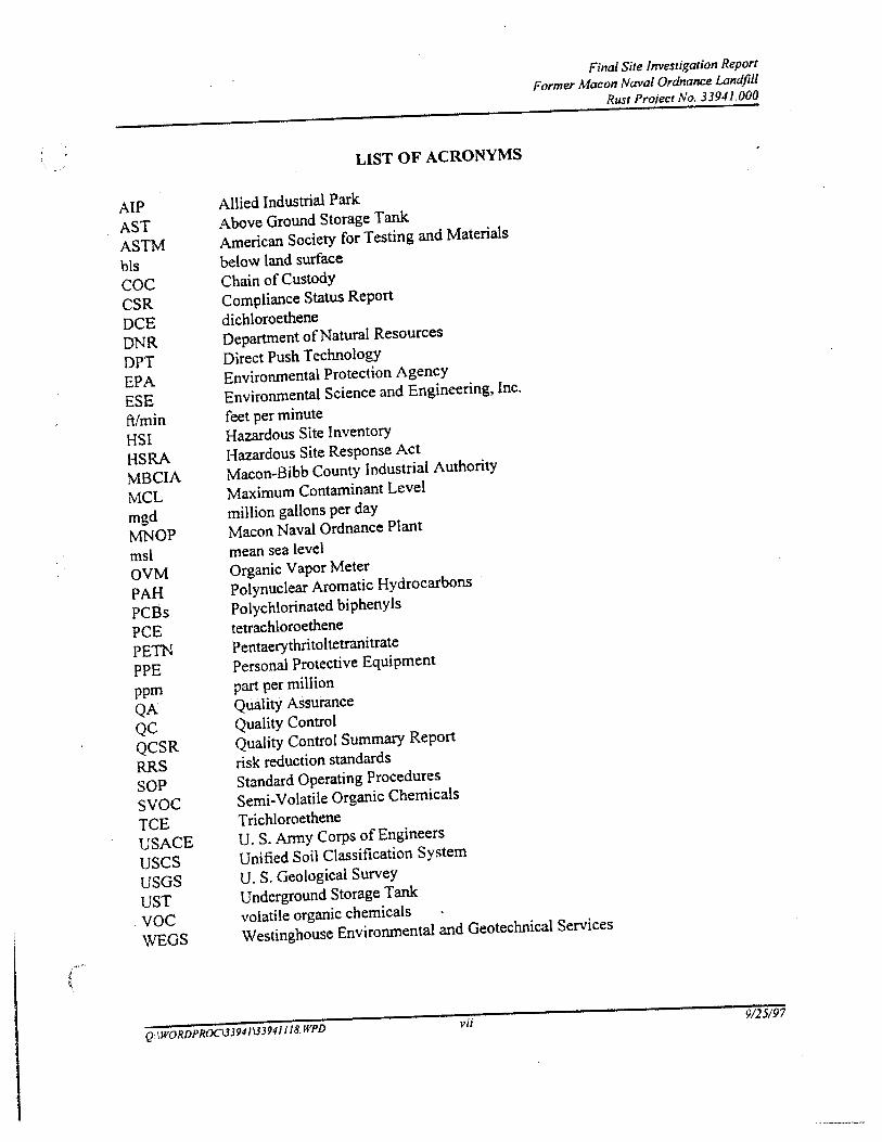
AlP AST ASTM bls coc CSR DCE DNR DPT EPA ESE ftlmin HSI HSRA MBCIA MCL mgd MNOP msl OVM PAH PCBs PCE PETN PPE ppm QA QC QCSR RRS SOP svoc TCE USACE uses USGS UST voc WEGS
LIST OF ACRONYMS
Allied Industrial Park
Above Ground Storage Tank
American Society for Testing and Materials
below land surface
Chain of Custody
Compliance Status Report
dichloroethene
Department of Natural Resources
Direct Push Technology
Environmental Protection Agency
Environmental Science and Engineering, Inc.
feet per minute
Hazardous Site Inventory
Hazardous Site Response Act
Macon-Bibb County Industrial Authority
Maximum Contaminant Level
million gallons per day
Macon Naval Ordnance Plant
mean sea level
Organic Vapor Meter
Polynuclear Aromatic Hydrocarbons
Polychlorinated biphenyls
tetrachloroethene
Pentaerythritoltetranitrate
Personal Protective Equipment
part per million
Quality Assurance
Quality Control
Quality Control Summary Report
risk reduction standards
Standard Operating Procedures
Semi-Volatile Organic Chemicals
Trichloroethene
U. S. Anny Corps of Engineers
Unified Soil Classification System
U. S. Geological Survey
Underground Storage Tank
volatile organic chemicals
Final Site /nvestigalion Report
Former Macon Naval Ordnance Landfill
Rust Pro;ect No. 33941.000
Westinghouse Environmental and Geotechnical Services
Q:\WORDPROC\33941133941 I /8. WPD vii 9125197
~ I
EXECUTIVE SUMMARY
Final Site Investigation Report Former Macon Naval Ordnance Landfill
Rust Project No. 3394/.000
The former Macon Naval Ordnance Plant (MNOP) Landfill site is located in an industrial setting of south Macon, Bibb County, Georgia Other than the landfilled area, the site is undeveloped. Land use in the area is primarily industrial with some undeveloped areas to the south. The site was originally a part of the MNOP which included the Allied Industrial Park (AlP) property immediately to the north. The MNOP was constructed and operated by Reynolds Corporation prior to World War n. The Navy assumed operations in 1941 and continued operations until 1965 for the production of ordnance. The Georgia Hazardous Site Inventory (HSI) currently lists the former MNOP Landfill site (HSI number 10167) as a Class II site under the Georgia Hazardous Site Response Act (HSRA).
Rust Environment and Infrastructure (Rust) was contracted by the Savannah District of the U.S. Army Corps of Engineers (USACE) to complete parallel site investigations at the former MNOP Landfill site and at the AlP. The AlP study is described under a separate cover. The purpose of the former MNOP Landfill investigation was to collect sufficient information concerning site contamination to prepare a Compliance Status Report (CSR) as required under Section 391-3-19-.06 of the HSRA regulations.
Historical information indicated that potential sources of contamination may include the inactive landfill located on the site, an area noted as having been an explosives demolition area, and an off-site landfill located immediately west of the site. To evaluate these sources and general site conditions, the scope of work included collecting soil samples from on-site borings, field screening groundwater collected from temporary sampling points, installing and sampling groundwater wells, collecting biota samples from a nearby creek, and collecting surface water and sediment samples from on-site and off-site drainage features.
The results ofthe groundwater sampling indicate that a release oftrichloroethene (TCE), and other constituents has occurred. Site groundwater contamination appears to be localized to areas immediately surrounding the landfill. The extent of groundwater contamination has not been determined. The analytical results did not reveal any evidence of contamination for explosive residues, semi-volatiles, pesticides. or polychlorinated biphenyls (PCBs).
The results of soil sampling indicate that elevated levels of metals and PCBs are present throughout the subsoils of the site. The contamination is present adjacent to the source areas and at locations in the floodplain to the south. These contaminants will not likely undergo significant natural degredations, but will strongly sorb to soil. No evidence of explosive residues contamination was identified in the soils sampled.
Q:\WORDPR0Cl3394/IJ39411/8.WPD viii 9125/97
Final Site Inve~tigation Report
Former Macon Naval Ordnance Landfill
Rust Projecr No. 3394/.000
Surface water and sediment samples collected found no evidence of contamination in Rocky Creek,
south ofthe site. However, surface water samples collected north and southeast of the source areas
were found to contain metals and volatile organic compollilds (VOCs). Sediment samples from the
same areas detected VOCs, semi-volatiles, and metals. Detections in the samples collected to the
north indicate the possibility of an off-site source to the north or northwest.
Potential receptors include hunters and fisherman, environmental samplers, and trespassers.
Ecological receptors are numerous and include a variety of small and large mammals, birds, and
aquatic organisms. The most feasible routes by which exposure to contaminants could occur include
ingestion and/or dermal contact with contaminated soil or surface waters, inhalation of soil
particulates, and ingestion of contaminated fish or game.
Based on the analytical results, the on-site landfill appears to be a likely source of the contaminants
identified. There is no indication of explosives residues in soil or groundwater.
It is concluded that contaminant levels in the shallow groundwater currently exceeds the state of
Georgia's risk reduction standards (RRS) as promulgated in the Hazardous Sites Response Act
(HSRA). While a large number of constituents were detected in the groundwater samples, only lead,
arsenic, TCE, 1, 1-DCE, and vinyl chloride were detected at more than one location in concentrations
greater than the Type 4 (nonresidential) RRS. The Type 4 RRS for soil were exceeded for only lead
and para-cymene.
Based on the results of investigation and current site conditions it is recommended that further
definition of the vertical and horizontal extent of soil and grOtmdwater contamination be completed
to meet the requirements of a HSRA Compliance Status Report. Further definition ofthe sources
identified in this report will also be necessary. A full description of the project conclusions and
recommendations can be found in Section 11 of this report.
Q:\WORDPROC\3394/\3394/ I /8.WPD ix 9125197
1.0 INTRODUCTION
Final Site Investigation Report Former Macon Naval Ordnance Landfill
Rust Project No. 3394/.000
This report documents the site investigation conducted by Rust Environment and Infrastructure at the former Macon Naval Ordnance Plant LandfiJI (MNOP Landfill) site. The Georgia Hazardous Site Inventory (HSI) currently lists the site (HSI number 10167) as a Class II site under the Georgia Hazardous Site Response Act (HSRA). Historically, the site was part of the Macon Naval Ordnance Plant (MNOP) which was owned by the United States Navy until 1965.
This report was prepared by Rust for the Savannah District of the U.S. Army Corps of Engineers (USACE) in accordance with Contract Number DACA 21-93-D-0029, Delivery Order No. 24. The original intent of the investigation was to collect sufficient information concerning site contamination to prepare a Compliance Status Report (CSR) as required under Section 391-3-19-.06 of the HSRA regulations. Little was known concerning the types, sources, and extent of contamination prior to this site investigation. Due to the lack of knowledge concerning specifics of the potential contamination, the scope of work was designed to provide an understanding of site conditions through a broad scale investigation.
The investigation included the sampling of subsurface and surface soils, groundwater, surface water, and stream sediment from multiple locations across the site. While this investigation has provided a good estimate of the general nature and extent ofthe contamination, not all of the requirements of a CSR were met (specifically the full delineation of the horizontal and vertical extent of contamination).
The following report is structured to provide information applicable to the creation of a CSR following further study. Therefore, the report includes information concerning the physical setting an evaluation of environmental data collected, an evaluation of potential environmental receptors, a discussion of current and historical property ownership, an evaluation of the site's compliance with the HSRA Risk Reduction Standards, and recommendations for further actions to be taken.
Geologic, hydrogeologic. and chemical data used in this evaluation were obtained by Rust from January through May 1996.
1.1 SITE DESCRIPTION
The landfill site is in Bibb County on the so~h side ofMacon. Georgia (Figure 1-1) on the property formerly occupied by the Macon Naval Ordnance Plant. The topography in this area slopes to the south from approximately 300 feet above mean sea level (msl) to 275 feet msl at Rocky Creek
Q:\WORDPROC\33941133941 I 18. WPD I 9125197
' . i
. -~ ...
- -- :_ ··- -· - ·--
NVIRONMENT & INFRASTRUCTURE
\·.· ' .
.J ' ~ • t
- -·~ :' - -- ~-. - -- --~,:
-- ---- -;... : ~ J
' ·:lOll
FIGURE 1-1 SITE LOCATION MAP FORMER MNOP LANOF~L MACON, GEORGIA
-- - -
1000
RUST PROJECT 33941.000 33941102 7/96
·-· .. _-
0
/o-
! ~
•000
Final Site Investigation Report Former Macon Naval Ordnance Landfill
Rust Project No. 33941.000
immediately south of the landfill. Although the exact boundaries and construction of the landfill are not known, it is estimated to be 12 to 15 acres in size and unlined.
Land use in the area around the site is primarily industrial. The landfill is bordered on the south by Rocky Creek. The Rocky Creek Waste Water Treatment Plant, operated by the Macon Water Authority, is located east of the landfill. The Riverwood International plant site is east of the treatment plant. The western side of the property is bordered by the Armstrong Cork Company's (Armstrong Cork) plant site. The property to the north is occupied by the Allied Industrial Park (AlP). The Armstrong Cork plant and the AlP are Class II HSRA sites (HSI site nwnbers 10131 and 10308, respectively). The Riverwood International site ~a _<:!ll.Ss I~ _}{SRA_~_ite (f:I~! ~it~Jlt11J1QeL 10027).
1.2 BACKGROUND
As stated earlier, the former MNOP Landfill site was once part of the MNOP which included the AIP property to the north. The MNOP was constructed a.Ild operated by the Reynolds Corporation prior to World War II. The Navy assumed operations in 1941 and continued operations until 1965 for the production of ordnance. Items manufactured included flares, small primers, detonators, and other triggering mechanisms. The MNOP owned and operated the landfill south of the manufacturing areas.
After being declared surplus by the Navy, the MNOP property was sold in December 1965 to the Maxson Electronics Company ofNew York. Maxson continued to produce ordnance under contract with the Navy. Maxson subsequently sold the property to Allied Chemical Corporation in 1973 which manufactured automobile seat belts at the site. Allied sold the pro pert}' in 1980 to the MaconBibb County Industrial Authority (MBCIA). The MBCIA deeded the southern portion of the MNOP property containing the landfill to the Macon Water Authority in 1989. The landfill was used by all owners subsequent to the Navy until approximately 1974, at which time the site was closed. However, evidence at the site indicates that intermittent dumping of construction and demolition debris has continued.
The landfill is said to have received explosives and flammable wastes during Navy operations, but in interviews and previous studies (ESE, 1990) the landfill wastes were indicated to be limited primarily to solid waste, used parts, and construction debris. A bum pit was located in the same general area as the landfill. The bum pit was used for explosives testing and the disposal of flammable waste.
Q:\WORDPROC1339-1113394///8. WPD 2 9125197
Final Site Investigation Report
Former Macon Naval Ordnance Landfill
Rust Project No. 33941.000
In 1989 and 1990, groundwater, soil, and sediment samples were collected and analyzed from the
areas upgradient and downgradient of the landfill and on the adjacent property owned by
Armstrong Cork. The Armstrong Cork property sampled contained a drum storage area and a
pond. Organic and inorganic analytes were detected in each media (ESE, 1990). The analytical
results for groundwater and soil are found on Tables 1-1 and 1-2, respectively. Figure 1-2 shows
the locations sampled as part of the 1989-90 investigation.
Also during this investigation, groundwater samples were collected from five monitor wells
installed around the landfill, including one upgradient of the landfill (MW-1). Various metals
were detected in almost all of the samples, however, cyanide, arsenic, and selenium were detected
in down gradient samples only. The explosives compounds 1 ,3-DNB and 2,4-DNT were detected
in groundwater samples collected downgradient of the landfill. Pentaerythritoltetranitrate (PETN),
a common component of fuses and primers, was detected in a sample collected from only the
upgradient well (MW-1). Trichloroethene and vinyl chloride were also detected in groundwater
samples collected downgradient of the landfill. Bis(2-ethylhexyl)phthalate was detected in every
well and the equipment blank, which probably indicates it is laboratory contamination and is
therefore, not considered significant.
Soil samples were collected from the explosives demolition area on the east side of the landfill on
two occasions. The only reported detections in these samples were for arsenic, barium, chromium
and lead. No background soil data were provided.
Two composite soil samples were collected from the Armstrong property, one from the pond
containing the discolored water and one from the soils in the area of the drums (Figure 1-2). The
sample from the pond contained a number ofpolycyclic aromatic hydrocarbons (PAHs) and
petroleum hydrocarbons. The sample from the soil around the drums contained several metals,
one PAH (benzo(g,h,i)perylene), nitrogen, and petroleum hydrocarbons.
Q:\WORDPROC\33941\339411!8.WPD 3 9125197
(JJ
f'
Compound MW-1
cyanide (mg/L) .. nitrogen N01+NO) (mg/L as N) 5.45
arsenic, total (mg!L) -barium, total (mg/L) 0.0507
chromium, total (mg/L) 0.0140
iron, IOilli (mg/L) 4.42
manganese, total (mg/L) 0.428
selenium, tOtal (mg!L) ·-sodium, total (mg!L) 20.6
pentael)'thriiOI tetranilrate {J.<g/l) 68.8
I ,3-dinitrobenzene (.ug!L) .. 2.4-dinitrotnluene (.ug/L) ..
trichloroethene (l'gfL) ·-vinyl chloride (l'g/L) .. bis(2·elhylhexyl)phthalate(f'~/L) 1.6
Nate: GA = Georgia state stallllard described in EPA (1988).
Table 1-1 Summary of Previous Groundwater Analytical Data
Former MNOP Landfill Macon, Georgia
Rust Project No. 33941.000
Sample ldentlt..:atioo
MW-2 MW-3 MW-4 MW-5 MW-3-DP MW-EB
0.133 0.005 .. .. ·- ..
0.151 0.040 - ·- 0.073 0.021
0.0032 0.0029 .. .. .. -0.120 0.0556 0.0418 0.109 0.0569 0.0015
0.0259 0.0181 0.0091 .. 0.0118 .. 19.0 5.91 19.2 17.3 6.04 0.0124
0.590 0.0970 0.248 0.530 0.100 .. -· 0.0023 .. ·- - ..
28.7 13.6 8.12 9.30 14.3 0.169 .. - .. .. 33.3 .. - 1.18 .. ·- 1.23 .. - 1.83 .. .. 1.68 . .
7,000 3,800 JIO 19 3,900 .. -· .. 170 . . - -1.7 6.4 2.4 12 3.0 1.2
GA Recom .. recommc:nded Georg~ standard • nonenforceable (Personal Communication, F~d Lehman).
Water Qualiey
MW-TB SO-TB Criterion
NRQ NRQ 0.0035
NRQ NRQ 10
NRQ NRQ 0.005 •.
NRQ NRQ 1.0
NRQ NRQ o.os NRQ NRQ 0.3
NRQ NRQ 0.05
NRQ NRQ 0.01
NRQ NRQ 20
NRQ NRQ NC
NRQ NRQ NC
NRQ NRQ 1.1
.. ·- s
.. .. 2
NRQ NRQ 10,000
MCLc maximum contaminamlcvc:J specified in the National Primal)' drinking Water Regulations, 40 CFR 141.11 (July I, 1986) and the National Secoodal)' Drinking Wat.:r Regulations, 40 CFR 143.3 (1uly I, 1986). mg/L = milligrams per liter. NRQ = not required.
Rosenblan = criter~ suggested by Roscnblau (1981) for lhc permissible coocemration level for the contaminanl in drinking water. 1-lg/L == micrograms per liter. WQC = suggested ambiem water qualil)' criteria for the protection of human health from the to~ic propc:nics or cucinogcnic effects of the compound; critcfia associilled with cancer risk levels (CRLs) of I x 10-6 are reported where available; lhcsc criteria are summarized in lhc documenl Quality Criteria for Water 1986, EPA. May I, 1986, Wasbin&ton. DC; criteria were previously announced in 45 FR 79318 (November 28, 1984), 49 FR 5831 (februal)' IS, 1984), and .SO FR 30784 (July 29, 1984). - = not det.:cted at mcthOO dcteetion limit.
Source: ESE, 1990
Q:\WORDPROC\339-11133941 118. WPD 9125197
Re&Uiallon
GA
MCL
MCL
MCL
MCL
MCL
MCL
MCL
GA Rccom
.. I
..
Rosc:nl>latt ' MCL
MCL
WQC
i !,
Table 1-2 Summary of Previous Soil Analytical Data
Former MNOP Landfill Macon, Georgia
Rust Project No. 33941.000
Sample Identification
Compound• SO-l SO-l S0-3 S0-4 SO-S
moisture (% wet wt.) 9.3 14.2 11.6 44.3 52.6
arsenic: 0.650 1.55 0.574 0.781 4.83
barium 6.92 11.4 8.71 196 70.5
chromium 7.02 8.87 5.82 22.1 29.6
lead .. 5.00 -- 41.8 39.3
anthracene .. -- -- - 0.32
benzo(a)anthracene - -- . -- - 1.4
benzo(b )tluoranthene -- -- .. -- 0.92
benzo(k)fluoranthene .. .. -- - 0.67
benzo(a)pyrene -- .. -- -- 0.69
benzo(g,h, i)pery1ene -- -- -- 1.9 0.72
cbrysene .. .. -- -· 0.95
tluoranthene -- ·- -- -- 2.1
indeno( 1,2,3-cd)pyrene - -- -- -- 0.75
phenanthrene .. -- - - 1.0
pyrene -- - -- -- 1.8
nitrogen, NO!+NOl, sediment (.ug/g-dry) 4.3 - -- 196 ..
hydrocarbons, petroleum (t.~g/g-dry) -- - - 1.020 207
Note: ,ug/g-dry = micrograms per gram, dry weight.
- = not selected at method detection limit.
SO-J.DP
13.4
0.502
7.26
3.99
------..
----..
-------·
0.71
-
* = units are in milligrams per kilogram, dry weight (mglkg-dry) unless otherwise noted.
Source: ESE, 1990
Q:\WORDPROC\3394/\33941118. WPD 9125197
,-------·- - ··- ·· -· \
\
~>:~-=-- c·-_J \ + ii
' -~- ' · . .. ..__l'.-" ·-·-ll-·-·-·-·-·-·-·-~~~-·-.).._·-~~~- ¥ -llt-·-·-·-"--·-' '
- .....
LEGEMJ
0 ~~~Ts~~ ~~~}Qi
8 ;~mLfirr'r~~ LOCATIQI
~ ~?f~':M~~~1LOCATIQI -·---·-PROPERTY BOOHIJARY
REFERENCE: E~. mo.
;:;:..,..,;;,"' ·:~:' ~~~ ..... ENVIRONMENT &
I
~""-~01 :-'"="""""='--+''~' .. 1~1 INFRASTRUCTURE 1-'~0"~'-'-,'::.!:,.,=,• ;:.;sv'-,-,.-.,..------;--1 AT l.A NT A . G f;Q RG I A
/
/
.• F'IGURE 1·2 PREVlOIJS ENVRONMENT AI. STUDIES F'ORMER t.INOP LNI:>Fill UACON, C£0RGIA
r
3c.
I.
2.0 PHYSICAL SETTING
2.1 SUBSURFACE GEOLOGY
Final Site Investigation Report
Former Macon Naval Ordnance Landfill Rust Project No. 33941.000
The former MNOP Landfill site is underlain by a thin surficial deposit composed primarily of
red-brown silty sands, clayey silts and silty clays at ground surface which in turn is underlain by
sands, silts, and clay of the Tuscaloosa formation. The surficial materials from north to south,
toward Rocky Creek, becomes increasingly organic rich and, in places, are composed of peat and
organic-rich silts/clay.
Geologic profiles were generated using data gathered during this and previous investigations.
Figure 2- t is a cross section location map, while the cross sections are represented in Figures 2-2
through 2-4. The boring logs and well construction summaries for the historical data used in this
report and those generated as part of the current investigation are found in Appendix A. The cross
sections generated define two distinctive (shallow) lithologic units:
• surficial deposits composed of silty sand, clay, peat and organic silts/clay
(Quaternary)
• clayey sand, clean sands, clay and silt (Tuscaloosa)
The surficial unit varies in thickness from 4 to 7 feet and is composed of residual soils to the north
and organic rich. mostly clayey deposits (Quaternary) to the south. The organic rich deposits were
probably laid down as a result of vertical accretion of the flood plain adjacent to Rocky Creek. The
base of the surficial unit is estimated to be at elevation 280 feet msl sloping to 272 feet msl near
Rocky Creek. Below the surficial materials, the Tuscaloosa is composed of what appears to be
predominantly sand and clayey sand with interbeds of clay and silt The Tuscaloosa has distinctive
grey/green-grey silts and clays and white-tan kaolinitic clayey sands.
The surficial materials are saturated throughout the floodplain area, and is sufficiently thick to form
a distinctive hydrogeologic unit in these areas. Monitoring wells near the former MNOP Landfill
site are predominantly screened into the underlying Tuscaloosa silts, sands, and clays, while
monitoring wells near Rocky Creek, such as MW-6, MW-7, MW-8, MW-9 and MW-10 are
predominantly screened into the surficial unit.
The deeper stratigraphic and lithologic units are known only from the drillers logs available for many
ofthe deep water-supply wells which surround the site and from review of available literature. The
Cretaceous aged Tuscaloosa formation consists of light-colored sand, sandy clay, and discontinuous
Q:\WORDPROC\J394l\33941118. WPD 4 9125197
\
\
LEGEND
• t.OIITOR WELL LOCATION
+SOIL BORING LOCATION
.. -·.-. --.--.- ,.\_ . --.-.-. --..
I
I
'
/
.. .oj.
.. ..
FIGURE 2-1 CROSS SECTION LOCATION WN> FORMER MNOP LH-IOFILL MACON. G£0RGIA
•
, I I , :I I • ' \ ' .
.w. I :~ I
""" -!1-
4
, . ~:i,,,(,,
t-LLJ LLJ u.
t
z 0 ....... t-<r > w _j LLJ
NORTHWEST A
28
27
26
et.PII'tM.~ •'"'
-'"lUI. IU.l 1• flO
NO. ~A ttl j:tt.~ISiCH\
LSL-1
• "SH
'" ,.
LSL·4
SllY SIHl •
,,.
ENVIRONMENT & INFRASTRUCTURE
SOUTHEAST A'
290
2B0
~-. _'-'-fiq . . ·t" 270
• l~OOSA fOR>IAl~ t~U • SN()S
ILGtlll
LSI..•I
111'! llfJIII«; lOCAllllt
260
I-lOA lEU SIC)pC; SOIW£0 lt!O'IAL
- ~--=:-~c:~~~o.I'OII
SP • 1/SCi Sill. tv.SS CXXlt:
Ooi • OUoll~l
lt • CJI[liC{WS !USOt.OOSA fOIIIIAIIllt
FIGURE 2~2 CROSS SECTION A·A' FORUER MNOP LiiNOFILL '-lACON, GEORGIA
•
~ "
NORT~WEST I.SL-u SOUTHEAST Bl • • • 051>..
tw w u.
z 0 1-<! > w .J w
0 ..... +'!<)
··-·· ..... ,_ ,,.,, ICIIII.ll<IIJ .... \C.I41.o-.o n.o
"h«504
L5L ·i
~-.ocr -~
~'.;""- ~ :·"7"', .. ·: .~ ·-. ". -r ':' -.. ::;:: . .. ....... -
~~~=~~~~-~· -~~-~:~·~,,~. :~. ,~-~~ -~--~::. ;!'~-~~-~-~- ·~-~IO!i· :::~ll:;~:jlf'~:-: :"~~---:: :,·.;_~~:·~~- ~;~-~·~:- ~-~~-~~- -~~~~:;~:~~~~- ~· C~L~~Y:.~~~~~~~~~::~· ·~:r -- 11(0- .• --
- - -- -- --GII(Y ·GII([ll Sll
·.SH
•• SliT .$.110
, Cl.Af{Y $.110
, ' IUSCAI.OOSA FIBIAIOI IKU
• I o I ,LJI I I .I I I Jll I I 4Ll1 I I Je I : ... , I '1 ~til I •I Ja I I j Jt I I I .I I I Ill,. I I \iaa' I I ~~I
VIEW BASELINE - FEET
" 8Y l ltU'il nQ.<f:t l
ot:~D 11 :;:lt.4.WN !IY I:J-£Cl<(O 8'1' rt.t hO.
u .... ooo 1,. .\llll,. l,i.W\
W.lt(llltC(
J~IOQ-2
061( ,,.,. '·>< ...... ENVIRONMENT & 1~1 INFRASTRUCTURE
Z'l8
zee
270
2GB
2511
240
238 L[Gf!Cl
...... , 1111'1 IIOIIK LDCAIOI iiiOIII IQIIW(U
SIIOIIIOG ltiiWO llllll'IJL
. --¥- -- =:"~':~~~ IK.OI
sr · uses SGl CUS$ au IIIJ-~-
11 • CKT.octM lUSCilllO$.\ F~liDII
FIGURE 2-J CROSS SECTION B-B' F ORioiER IANOf> LANOFILL MACON, GEORGIA
\.;)
•iiillt.."""" M.fR'I
...,)CAL \(AIJ. , . ' '"
~ 4\.
"''""""
:0
BY IRVST f'A:OJ(Cl
~ ~
CI"ECkEC 1-'f" ;-u-;;o
SOUTHWEST c
1-w L.LI u..
z 0 ~
1-<I > L.LI ..J w
2
l!t-11.000
L .... LIIil4
wfl'(l,ltC(
J»-110t3
NORT~,EAST
280
. :~ . "'~=-:- ~ 270 K~r~ i
SllY SIHl
. . , Q.~Y[l SNf)
, 1USC~OOSA rCAW..TIOIIIlll
sui SNO
CL~f!:Y SIN! '
'I> l)jf' < '~'-.--,:Jf'' '•11' I 'Jill' I 'JII VIEW BASELINE - FEET
OAT( ,,.. ""
·>-
ENVIRONMENT & INFRASTRUCTURE
260
Z50
2411
lJe
U:GEIG
LS.·I 1 DPI - LOCAIIQII I-TOR IELL 51101iiiG SQII[(lt:Q IIIU'III.
---¥ -- =:r~lf~!IC~"'in~ II'ON
'I . ltiCS 50t ClASS COil(
Oor · IIUIII-
ll -au.oa014 I'\I5C.OLOOS4 r-lillll
FIGURE 2-4 CROSS SECTION C-C' FORMER loiNOP LANDFILL I.IACON. GEORGIA
FinaJ Site Investigation Report Farmer Macon NavaJ Ordnance Landfill
Rust Project No. 33941.000
clay (LeGrand, 1962). Sand beds within the Tuscaloosa formation are exceptionally productive and form an ample source of fresh, high quality water used for industrial and potable purposes. The Tuscaloosa is approximately 280 to 285 feet thick (260 to 265 feet thick below former MNOP Landfill site) and directly overlies what is described in drillers logs as "granite", "marl", or "limestone". Jn several of the drilled wells, 10 to 20 feet of marl or limestone is described to overlie granite but is not always present.
In each of the drilled wells reviewed from Armstrong Cork (seven deep wells located west and north ofMNOP landfill), Riverwood International Corp (3 deep wells located east), and Keebler (one deep well to the north of AlP), a consistent stratigraphic sequence can be observed. At an elevation of approximately 248 feet msl a white and pink clay unit is encountered. This clay, which appears to be discontinuous across the area, is roughly 12 feet thick where present. In Armstrong well No.7, which is the closest well to the former MNOP landfill, this clay appears to be absent and may be represented by what is described as a coarse sand with streaks of white clay. This unit is interpreted to be the base of the shallow water-table aquifer making the shallow aquifer approximately 30 feet thick assuming the water-table is at 280 feet msl.
Between the "shallow aquifer" and the first significant water bearing sand aquifer is a sequence of interbedded sand and clay (predominantly sand with clay and clay interbeds) that measures roughly 59 feet thick. In the Armstrong No.7 well this unit is approximately 62 feet thick. Below the interbedded sands and clay, between approximately 95 and 120 feet bls, is a medium to coarse grained water producing sand. Almost all water-supply wells in the area are screened across this 25 foot thick sand. Two or more water bearing sands or sequences of sands and clays are encountered between 120 feet bls and the base of the Tuscaloosa formation. Distinctive clay units are encountered between about 160 and 1 80 feet bls and between 200 and 220 feet bls.
2.2 HYDROGEOLOGY
Based upon literature review, evaluation of geologic logs both on-site and from deep water-supply wells, the following hydrogeologic units are defined:
• shallow wqter-table aquifer: the shallow aquifer extends from the water-table to approximately 30 feet bls. The shallow aquifer is comprised primarily of clayey sands, clean sands, and silty sands with frequent but discontinuous silt-clay intervals. The shallow aquifer also includes saturated portions of the surficial clay, silty sand
and organic rich silt/clay deposits. Rocky Creek fonns a discharge boundary for the shallow aquifer.
Q:\WORDPROCUJ941\J394/I/8.WPD 5 9125197
Final Site Investigation Report
Former Macon Naval Ordnance Landfill Rust Project No. 3394/.000
• interbedded sand and clqy units: This unit is characterized by a distinctive red-white
12-foot thick clay unit overlying an approximately 60-foot thick sequence of
interbedded sand and clay. Note that near the MNOP landfill, the distinctive
red-white clay appears to be absent based upon logs from nearby water-supply wells.
The "interbedded" unit is encountered between 35 and 95 feet bls. The clay and
interbedded sand and clay units may form a confining unit or leaky confining unit to
the deeper water producing aquifer zones.
• Tuscaloosa sand qquiferfsl: the Tuscaloosa sand aquifers consist of three or more
primary water bearing sands or sequences of interbedded sand and clay separated by
clay. This includes a shallow interval. from approximately 95 to 120 feet bls at
Armstrong No. 7 well, and deeper aquifers between approximately 135 bls and the
base ofthe Tuscaloosa at approximately 265 feet bls.
The following discussion on groundwater flow primarily deals with the shallow aquifer under study.
Table 2-1 provides a summary of well construction details which groundwater flow. and
measurement data are based upon. All monitor wells are screened into the shallow aquifer except
for MW- II which is interpreted to be screened into the "interbedded" unit.
· The groundwater flow direction for the shallow aquifer at the former MNOP Landfill site is
generally in a south direction toward Rocky Creek, based on water levels taken on April 25, 1996. ·
The potentiometric surface map (Figure 2-5) shows a predominant flow direction to the south except
for in the vicinity of the pond where the potentiometric surface appears to be slightly mounded,
possibly due to recharge from this surface water feature.
Depth to groundwater varies from about 14 feet bls at MW -1 to less than 2 feet bls in the area of the
former MNOP Landfill site (Table 2-2). Saturated ground surface conditions exist all through the
floodplain areas south of the former MNOP landfill. Static water levels correlated to elevations msl
ranged from 292.34 feet msl at MW-1 to approximately 275 feet msl at monitoring wells MW-7 and
MW-8 near Rocky Creek.
Rust conducted a study of the former MNOP which included the installation of piezometers on the
AlP property, north ofthe former MNOP Landfill site (Rust, 1994). The hydraulic conductivity of
the shallow aquifer was estimated by conducting hydraulic slug tests on the piezometers installed.
Because no slug testing has been conducted on monitoring wells at the former MNOP Landfill. the
results obtained from the AlP are included here as estimated conductivity values for the similar types
of materials observed at the Landfill site. These results are expected to be representative of the
Tuscaloosa sands, silts and clay units.
Q:\WORDPROC\339-11\33941118. WPD 6 9/25/97
·(:;'
?
,cr.>.\
WeD No. NortbiDg CoordiDate
MW-1 1008453.52 MW-2 1007495.06 MW-3 1007249.66 MW-4 1007276.37 MW-5 1007329.30 MW-6 1007074.45 MW-7 1006814.08 MW-8 1006893.75 MW-9 1006972.18 MW-10 1007259.72 MW-11 1007284.82 PZ-1 1010971.39 PZ-2 1011352.85 I•Z-3 1009930.01 PZ-4 1009238.56 PZ-5 1008907.39 PZ-6 1008681.53
ft-ms1 =- feet mean sea level ft-bls = feet below land surface
g:\WOidproc\33~1\33g41070
Easting Ground Elev. Coordinate n-msl
658704.01 306.4 659335.07 283.9 659675.89 280.8 659217.75 278.9 659110.10 278.5 659019.61 276.8 659355.04 276.9 659730.93 275.4 660189.45 275.7 660061.84 277.4 659218.67 279.0 658986.27 322.6 661746.59 351.0 660709.40 343.8 660710.80 333.0 659173.21 308.2 661729.58 304.9
Table 2-1 Well Construction Summary Macon Naval Ordnance Plant
Macon, Georgia Rust Project No. 33941.000
- -
Top ofCasiDg Top Screen Bottom Elevation fi-bls Screen
ft-msl fi-bls 308.87 24.2 34.2 286.06 12.1 22.1 283.04 13.4 23.4 281.12 5.4 15.4 280.69 6.0 16.0 279.3 4.8 14.8 218.2 3.8 8.8
277.87 2.0 7.0 278.20 2.7 7.7 279.92 3.0 8.0 281.52 40.0 50.0 325.17 21.0 31.0 350.70 39.5 49.5 346.12 44.5 54.5 335.11 39.5 49.5 310.48 14.5 24.5 307.21 19.5 29.5
.-
Bottom Top Seal Bottom Well Date Well ft-bls Seal Material Installed fi-bls ft-bls
34.2 17.5 21.0 2"-PVC 9/12189 22.1 2.0 4.0 2"-PVC 9/13/89 23.4 8.1 10.8 2"-PVC 9/14/89 15.4 1.4 3.7 r-PVC 9/14/89 16.0 2.2 4.4 2"-PVC 9/15/89 15.3 0.5 I.S r-PVC 1129/96 9.1 0.0 3.8 2"-PVC 216/96 7.3 0.0 2.0 r-PVC 218/96 8.0 0.0 2.7 2"-PVC 217/96 8.3 0.0 3.0 2"-PVC 216/96
50.5 28.6 32.6 2"-PVC J/26/96 31.5 11.0 17.0 2"-PVC 10/11/94 50.0 31.0 37.0 2"-PVC 10/6/94 55.0 36.0 42.0 2"-PVC 10/13/94 50.0 32.0 37.0 2"-PVC 10/5/94 25.0 5.5 10.5 2"-PVC 1016/94 30.0 10.7 I~.Q ~"-P'{f 10/7/94
-----··-
W2Pii7

-------------
L(GOIO
• IOIITOII W:ll LOUT 101
• Pl£lllt:1ER LOCA1101
-·•-·PIIO'(A!T IIWClMY
_,--... P0101111K1Ait SUWAC( COOOIJI
~":"'-""""'""I"-'~<-'.,_,_,c_• _....:':::.:'.':.'"":;': : :: .... ENVIRONMENT &
~""-~·· ,---=u·"'""-" - " .. 1~1 INFRASTRUCTURE
~~~~r:.!:"'~:_p_o~o''----,-,.-,,...-,--+--1 ATLA NTA . GWRGIA
.... ...
FIGURE 2-0
~ ~ . .. ... _
... • ...
• •
• r -.,., ----· ··-~· ~
~ --
POTENTIOMETRIC SURF ACE WP
.tt.LIED tmUSTR!.6l P.IAA ' fORt.IER loiNOP LAIU"l
MACON, GEORGIA
<Pb ----------------..........
"·-··
Well No. Northing Coordinate
MW·I 1008453.52 MW-2 1007495.06 MW-3 1007249.66 MW-4 1007276.37 MW-5 1007329.30 MW-6 1007074.45 MW-7 1006814.08 MW-8 1006893.75 MW-9 1006972.18 MW-10 1007259.72 MW-11 1007284.82 PZ-1 1010971.39 PZ-2 1011352.85 PZ-3 1009930.01 PZ-4 1009238.56 PZ-5 1008907.39 PZ-6 1008681.53
ft. msl = feet mean sea level
Table 2-2 Groundwater Elevation Summary
Macon Naval Ordnance Plant Macon, Georgia
Rust Project No. 33941.000
Easting · Ground Top of Casing Coordinate Surface Elevation
Elevation ft. msl ft. msl
658704.01 306.4 308.87 659335.07 283.9 286.06 659675.89 280.8 283.04 659217.75 278.9 281.12 659110.10 278.5 280.69 659019.61 276.8 279.3 659355.04 276.9 278.2 659730.93 275.4 277.90 660189.45 275.7 278.20 660061.84 277.4 279.90 659218.67 279.0 281.50 658986.27 322.6 325.17 661746.59 351.0 350.70 660709.40 343.8 346.12 660710.80 333.0 335.11 659173.21 308.2 310.48 661729.58 304.9 307.21
ft. bls =feet below land surface ft. TOC = feet below top of casing Note: all measurements taken 4125196
MW-1 through MW-11 at former MNOP Landfill PZ-1 through PZ-6 at AlP
g:\wordproc\33941\33941071
Depth to Water Water Elevation
ft. TOC ft. msl
16.53 292.34 4.86 281.20 4.22 278.82 3.05 278.07 2.23 278.46 1.96 277.29 3.25 274.93 3.24 274.66 2.82 275.38 2.73 277.17 7.15 274.35 8.19 316.98
43.04 307.66 49.72 296.40 41.38 293.73 16.05 294.43 17.45 289.76
9129/97
Final Site investigation Report
Former Macon Naval Ordnance Landfdl Rust Project No. 3394/.000
Hydraulic conductivity is a measure of a fluid's ability to move through a porous media under a unit
gradient and is an important variable in evaluating groundwater flow velocities. Calculations
indicate the average hydraulic conductivity for the six piezometers tested to be 2.1 x 1 o-3 feet per
minute (ftlmin) while the highest calculated value was 6.3 x I o·3 ftlmin.
The horizontal average linear groundwater flow velocities were calculated for the former MNOP
Landfill site using the Darcy equation (Fetter, 1988). The results indicate groundwater flow in the
shallow aquifer is estimated to be 32 feet per year using the average hydraulic conductivity value
reported and a high of 100 feet per year using the high hydraulic conductivity reported. The average
hydraulic gradient used in these calculations was 0.0074 (see calculations in Appendix A).
Information on the vertical flow gradients between the two aquifers is only known from the observed
gradients between monitoring wells MW-4 and MW-11 which are nested together and screened
across the shallow aquifer, and deeper (interbedded) aquifer respectively. Vertical gradient was
calculated by dividing the groundwater head difference between nested wells by the vertical
elevation difference from screen interval midpoints. Positive gradients indicate upward flow, and
negative gradients indicate downward flow. The head difference between MW-4 and MW-11 for
April 25, 1996 was a -3.72 feet over a 34.4 foot vertical distance giving a gradient of -0.108 ftlft.
: · Based upon differing water levels in this well nest, a strong downward gradient appears to exist
between the shallow aquifer and the underlying interbedded water bearing unit. It is interesting to
note that the groundwater elevation at MW-11 (274.35 msl) is almost half a foot lower than
groundwater elevations measured in shallow monitor wells near Rocky Creek. This may be a
general indication that the water-supply wells adjacent to the site may have locally reversed the
natural hydraulic gradient in this interbedded unit and underlying aquifers.
I
~
Groundwater within the shallow aquifer is expected to move from north to south and discharge to
Rocky Creek and/or it's poorly defined tributaries which drain the floodplain area between the
former MNOP landfill and the creek. The shallow aquifer may also recharge deeper aquifers by
downward infiltration through underlying geologic units.
2.3 WATER USE
According to LeGrand (1962), all municipalities within the vicinity of the study area use water from
wells except for the city of Macon, which treats water from the Ocmulgee River. The Macon-Bibb
county water system indicates that all water is collected at one intake on the Ocmulgee River near
the intersection of interstates I-75 and I-16. Industrial groundwater use is more frequent south of
Macon. Local irrigation using well-water is practiced, but the overall use is small.
Q:\WORDPROC\33941\3394/I/8.WPD 7 9125197
Final Site investigation Report Former Macon Naval Ordnance Landfill
Rust Project No. 3394/.000
Three water-supply wells currently exist on the AlP property and a number of other supply wells operate to the east, west and north (Figure 2-6). Table 2-3 summarizes available well construction details for well records on file at the USGS Log Library. One of the wells at the AlP site, a 287-foot deep water well installed during Navy ownership, provided non-potable water for use in plant operations. According to site personnel, the pumping apparatus is still in place, but is nonfunctional. It is unclear when the well was last used. No well construction details on this well were available from the USGS. Another non-potable water-supply well ( 16W023 on Figure 2-6) is located on the southern portion of the AlP property, between the southern perimeter road and the Central of Georgia railroad spur. This 243 foot well is owned by Armstrong Cork and is currently active. A third water-s'upply well was drilled on the AlP property at the same time as the initial 1994 Rust investigation. The well is owned by the Georgia Hydrate Corporation, which recently acquired property from the Macon-Bibb County Industrial Authority. The well is located in the southeastern corner of the AIP property, near the railroad spur used during past site operations. The well was drilled to 290 feet by Green's Water Well Company of Gray, Georgia. It is understood from discussions with Georgia Hydrate Corporation personnel that the well is now active and it is used for both process and potable water-supply (Ashley Vickers, personal communication, February 1996).
Nine water-supply wells exist on the Armstrong Cork Property, located west of the AlP (Figure 2-6). Also, as described above, one Armstrong Cork well is located on the AlP property. According to Armstrong Cork personnel, the plant operates four primary wells which are designated as Well No. I, 4, 5, and 6. Well No. 2 has not been used for years but remains open, well No. 3 has not been used for approximately 3 years, and well No. 7 is used occasionally (Bill Hahan, personal communication). Armstrong Cork indicates that average groundwater use is a combined 1.1 million gallons per day (mgd) with a maximum of 1.3 mgd from active water-Supply wells. All groundwater supplies are used as make-up water for the process. Potable water for the Armstrong Cork plant is obtained from the Macon-Bibb county water system. According to USGS well records, Armstrong Cork's supply-wells are screened across multiple intervals from approximately 100 feet bls to approximately 250 feet bls.
The Keebler Company, located north of the AlP property, currently has one active supply well. According to site personnel this well is used for lawn irrigation, and process make-up water (Geraldine Jones, personal communication). Keebler personnel were unable to provide any records on groundwater withdrawals from the supply-well. USGS well records indicate this well is screened across multiple intervals from 150 feet bls to 290 feet bls.
The Riverwood International Corporation (formerly Kraft) operates 3 wells east of the AlP property. Riverwood personnel indicated that these three wells are used for process make-up waters and that
Q: \WORDP ROCIJJ941 \33941/18. WPD 8 9125197
~
"-~
16W02'i
*11151 16W004*
RUS T PRO.I( C I 339 HOOO - - --·-· OE SIGNf.O BY C. ADAM S
DRAW N BY 1.1 1-' [ AI K F. ----------· ·~ ------ · ·~--~·- . CH(CI< (O BY
tiL[ N~t .IJ 941 10J
!I il ____ .. _ ___ __ ..;
KEEBLER • \'~ • \c
• • - -- ~ .• II ----- -~--- ~ --- - -~ I I
L~~Zlt-~"~ , -~o~l \'\
l ALLIE~~~ INDUSTRIAL j PARK
:--....-:·_- ·-----:_:- -- - - --- --------====~
-~i': ; ,.._. I ,,,....,
Pl-= •._,; -. I '•.;.-;;-~ 16111021 /
'··~~~/ fQRI.(R ~OP
LANDFILL
''-··-.. -· ! ! I
-a,·-··-··-··-·· ... ··-··-··.J
\
GA. HYDRATE
1~-~~ __ _ :::/
ENVIRONMENT & INFRASTRUCTURE
I
LEGEND * INDUSTRIAL WELL LOCATION
l#lAI OWNERS DESIGNATION
NOT[: LOCATIONS SHOWN ARE THOSE OBTAINED FROM U.S.C.S. LOG LIBRARY. NORCROSS. GEORGIA. SOME WELLS SHOWN WAY BE ABAHOONEO OR HOT IN USE.
WELLS 16W002. 16W003. AND 16W004 HAVE NO CORRESPONDING USGS WELL RECORDS AND ARE HOT INCLUDED IH TABLE 2-4.
ARMSTRONG WELLS 115. #4A. 116. AHD #lA ARE ACTIVELY USEDI #]A, #2. #1 REMAIN OPEN. ARMSTRONG #2 WELL NOT SHOWN.
16W027~ 16W007
* --* * RIVERWOOO 161018
IF ORI.(Rl Y KRAFT 1
~ ., 500 1000 2000
SCAll t• FEEl
FIGURE 2-6 INDUSTRIAL WELL LOCATION MAP FORMER MNOP LANDFILL MACON, GEORGIA
~
Table 2-3 Summary of Well Constuction Details Obtained From USGS Records
Wells Located Near MNOP and AlP Sites
USGSID WeUID Company
16W024 Armstrong 115 Armstrong Corle 16W025 Armstrong 114A Armstrong Corle 16W026 Armstmngll7 Annstrong Corlc 16W020 AmlStrong 113A Armstrong Cork 16W023 Armstroilg 116 Armsll'ong Cork 16WOI9 Armstrong lilA Armslrong Cork 16W005 Armstrong 114 Armstrong Cork 16W009 16W009 Keebler 16W008 Keebler ill Keebler 16WOI8 Kraft Ill Riverwood 16W007 Kraft 112 Riverwood 16W027 Kraft 113 Riverwood
I: Groundsurface elevations are approximate N/G: Not Given NIA: Not Applicable All scn:cn depths given below land $Utfacc.
Dale
Comp.
11/2)/64
I J/24169
3/18/68
5/20/64
10/S/66
4/15/64
1/19/60
10/9/89
911153
3121146
9/30168 9!lon9
Specific Capacity in gallons per minute per foot drawdown Yield in gallons per minute
f:hrordproctJJ9.J/UJUI/Jij7
GS Elev! Total
Depth
320 243
290 240 270 210
320 2S6
303 260
340 238
290 285
N/G 300
370 N/G
310 244
3.54 183 315 290
Rust Project No. 33941.000
Scrua I Screea 2 Scree• 3 Sc:rcea .f Scree11S
100 to 105 133to 153 168to 173 .228to 243 NIA 120 to ISS 225 to 240 N/A NIA NIA 80to 120 128 to 133 195 to 210 NIA NIA l28to 148 ISS to 160 186 to 191 230 to 235 251to 256 140to 160 240 to 260 NIA N/A NIA 120 to 145 223to 238 NIA N/A NIA 130to 140 165 to 180 235 to 245 260 to 265 NIA ISO to 165 175 to 195 250 to 265 280to290 N/A
N/G N/G N/G N/G NIG 60 to 70 160to170 212to217 NIA NIA
100 to 120 135 to 160 178to 183 NIA NIA 150 to 190 200to 210 270 to 280 NIA NIA
Yield Spec Use StatllS Capacity
465 4.1 lndustrial Supply Active • 524 7.2 Industrial Supply Active 305 6.3 Industrial Supply Active 360 2.8 Industrial Supply Active 510 7.1 Industrial Supply Active 448 4.9 Industrial Supply Active 632 N/G Industrial Supply Abandoned 270 I 1.2S Industrial Supply Active N/G N/G Industrial Supply Abandoned (?) 411 8.93 Industrial Supply Active 28S 8.63 Industrial Supply Active
I 250 2.84 Industrial Supply Active I
91191P7
-' • ,.. ; f-. "' • ;:-• .I .. k_,. ·•'> I> '~. • •
Final Site Investigation Report
Former Macon Naval Ordnance Landfill
Rust Project No. 3394/.000
all potable water is obtained from Macon-Bibb water authority. Riverwood has indicated that
approximately the same amount of water is withdrawn from these wells as under previous ownership
by Kraft (Marion Bard, personal communication). USGS records indicate that during the previous
ownership by Kraft two wells were operated and produced a combined flow of 0.537 mgd during
the period of August 1976 and January 1978. The Riverwood International wells are screened similar
to other industrial wells in the area.
Public water supply wells are indicated to be within 0.5 to 1.0 miles from the site (HSI, 1995),
however the locations of these wells was not specified. Access to the Department of Natural
Resources (DNR) Drinking Water Program databases indicates at least one public water system
potentially within 0.5 miles from the site. The presence and geographic location of the public water
systems has not yet been verified in the field, as suggested by the Drinking Water Program when
using the public access databases.
2.4 SURFACE WATER FEATURES AND HYDROLOGY
The former MNOP Landfill site lies within the drainage basin of the Ocmulgee River. The
Ocmulgee is located approximately 2. 6 miles east of the site, flowing through eastern Bibb
County. The floodplain of the Ocmulgee is generally about 2 miles wide. All streams flowing
into the Ocmulgee have a predominantly southeast course. Almost all small tributaries flow
southward to join the l~rger creeks at an acute angle (LeGrand, 1962).
Within the vicinity of the site, the dominant drainage fearure is Rocky Creek, which defines the
southern boundary of the former MNOP Landfill site. This stream exhibits a well developed
floodplain and enterS Tobesofkee Creek about 1 mile southeast of the site. Tobesofkee Creek in
tum forms a confluence with the. Ocmulgee River 5 miles fanher to the southeast.
Surface water run-off, at the former MNOP Landfill site, generally follows the land topography
which slopes gently southward across the site. There are two primary tributaries which drain
southward; one enters into a surface water pond northwest of the landfill and the other continues
onto the floodplain of Rocky Creek. South of the landfill and pond areas, the soil is saturated.
This floodplain area does not have any defined surface water or tributary drainage areas. During
periods of heavy rainfall and flooding, the floodplain areas are often submerged.
Q:\WORDPROC133941\J3941/18. WPD 9 9125197
(
l
'' '
Final Site Investigation Report Former Macon Naval Ordnance Landfill.
Rust Project No. 3394/.000
3.0 POTENTIAL SOURCE AREAS
3.1 FORMER MNOP LANDFILL
The landfill is considered to be the primary probable source of subsurface contamination on the site. The exact boundaries and construction of the landfill are not known, but it is estimated to be 12 to 15 acres in size and unlined. The approximate landfill location is shown on Figure 3-1. Based on interviews and previous studies, the waste disposed of in the landfill was limited to solid waste, used parts, and constrUction debris. However, no documentation of disposal activities has
.. been identified and it is- uncertain what- waste- streams- generated· by tlle MNOP or later-property· owners may have been disposed of at the site (ESE, 1990; Rust, 1994).
Based on the information available, the scope of potential contaminants from this area is unknown.
3.2 EXPLOSIVE DEMOLITION AREA
The explosive demolition area is located at the southeastern side of the landfill. This area was used for the testing and demolition of explosives manufactured at the MNOP, primarily detonators, flares and primers. Also, a pit used to bum flammable wastes was located in this area (ESE, 1990). The explosive demolition area is shown on Figure 3-1. Currently, the northern portion of the area is submerged by ponded water. The pond was not discussed nor indicated on maps in the 1990 ESE report. However, the report does describe the area as marshy. Based on this information it appears that the pond is recent in origin. Evidence of beaver activity near the pond was observed and may account for its existence.
Based on available information the explosive demolition area could be the source of explosive residues and chemical by-products of the flammable liquids burned there.
3.3 OFF-SITE SOURCES
An inactive landfill exists immediately west of the MNOP Landfill on property owned by the Armstrong Cork (Figure 3-1 ). During the period from approximately 1948 to 1970, wastes generated at the facility were disposed ofin the remote landfill site according to the site investigation report prepared by ERM Southeast, Inc. (ERM) in 1994. Historically, the processes conducted at Armstrong included the pulping of wood and newsprint, mixing of the pulp with additives including perlite, mineral wool, clay, and starch. The wastes disposed of in the landfill include wood fiber,
i paper. scrap metal, construction debris, and filler materials used in the manufacture of ceiling tiles. According to Environmental Science and Engineering (ESE) the remote landfill area also contained
Q:\WORIJPROCU394/U394/ 118. WPD 10 9125197
\
ESTIIAATED 1 _., ARMSTRONG CiORK/ V
LANOFILL BiliHOARY
"'
LEGEND
-··----PA~RTY BOJH!lARV
•
::,;::," .'!~""'·.ooo'""'""'--- ~;: ..... ENVIRONMENT & ~~=~~~~~·~~w=.~~~~·----~~~"~% 1~1 INFRASTRUCTURE t.:;,'::':u~.....:="-:-·":-,.-.,.,-,-----t--1 ,;. TL ANT A . G P.ORC: I A
\
FIGURE 3·1 SOURCE AAEA IMP FORMER MNOP LH()f"lll MACON, GEORGIA
•
... T ~llrUt
100--
Final Sire Investigation Report Former Macon Naval Ordnance Landfill
Rust Project No. 33941.000
a drum storage area (ESE, 1990). The ESE report also indicated that fill material appears to extend up to the western edge of the former MNOP landfill property boundary.
The Armstrong landfill property has been listed on the HSI based on lead levels detected in groundwater and fs classified as a Class II HSRA site. Soil samples collected as part of the initial study ofthe Annstrong landfill by ERM detected trace amounts ofVOCs in the subsoils including trichlorofluoromethane, methylene chloride, 1 ,2-dichloroethane, I ,2 dichloropropane, ethyl oenzene, and toluene. Analysis also detected bis(2-ethylhexyl) phthalate and metals in the subsoils. ERM reported total petroleum hydrocarbons in the soils ranging from 7 mg/Kg to 4,1 00 mg/Kg. Results of sampling seven on-site monitoring wells indicated no presence of priority pollutant VOCs, BNAs, pesticides, or PCBs in the collected groundwater samples. Detectable concentrations of beryllium (0.001 to 0.003 mg!L), cadmium (0.0006 to 0.0015 mg!L), chromium (0.01 to 0.100 mg/L), copper (0.01 to 0.11 mg/L), mercury (0.0002 to 0.0007 mg!L), nickel (0.02 to 0.07 mg/L), lead (0.004 to 0.15 mg/L), and zinc (0.02 to 0.4 mg!L) were, however, reported in groundwater samples (ERM, 1994).
The regulatory status of the Armstrong HSI landfill site is not known at this time, however, the site has recently been secured with a chain-link fence to limit access. Due to the close proximity of the Armstrong landfill to the former MNOP Landfill site it is considered a potential source of the groundwater contamination on the former MNOP Landfill site.
Q:\WORDPROC\33941\33941 I 18. WPD 1J 9125197
('
4.1
Final Site Investigation Report
Former Macon Naval Ordnance Landfill Rust Project No. 3394/.000
4.0 SOIL CONTAMINATION
GENERAL APPROACH USED
Sampling and analysis of subsurface soils was used to determine whether the MNOP Landfill has
impacted the site subsoils. The majority of boring locations were placed around the outer limits of
the landfill boundary, or in marshy areas down gradient from the landfill (Figure 4-l ). These borings
were believed to be the best locations to assess potential soils contamination from the landfill. Two
borings also serve as property boundary sampling points (LSL-12 and LSL-13) which were placed
specifically to evaluate the Armstrong off-site landfill source. Routine soil sampling was also
conducted at each of the installed monitor wells to evaluate soils in the floodplain areas. Borings
were drilled and sampled using standard hollow-stem auger techniques where access permitted.
Borings located in marshy and dense wooded areas were hand-augered.
Quality control (QC) samples, consisting of replicates and trip blanks, were collected. In addition,
replicate quality assurance (QA) samples were sent to the USACE, South Atlantic Division (SAD)
Laboratory.
4.2 ANALY11CALPARAMETERS
Based on the suspected contaminants and historical activities at the landfill, the analytical parameters
for site soils included:
• volatile organic chemicals (VOC)
• semivolatile organic chemicals (SVOC)
• priority pollutant metals
• pesticides and polychlorinated biphenyls (PCB)
• explosive residues
Table 4-1 summarizes the sampling and analytical requirements for this work. The table includes
the analytical methods used, the sample preservation and holding times, and the number of quality
control and quality assurance samples to be collected.
4.3 LOCATION OF SAMPLING POINTS
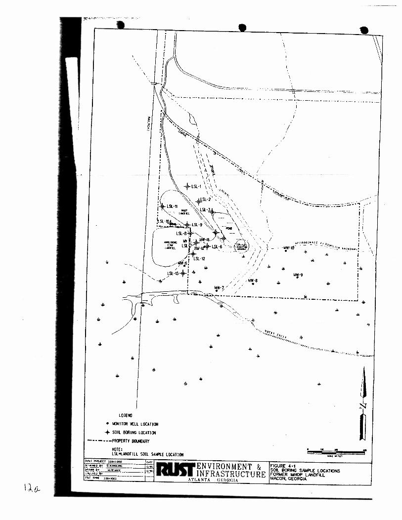
Soil samples were collected from 13 soil borings and 5 monitor well installations. The locations
{ · of the soil borings were based on historical data and a visual inspection of the landfill. Two (2)
soil samples were collected from each boring and one (1) sample collected from each monitor well
Q: \WORDPROC\3394 I \3394 I I I 8. WPD 12 9125197
• \
\
' + ' ., ·., ... ____ ,. __ ,. _ .. ___ , __ ._~ .. - _ , ..
·· · .. · c:::=:::o: ::::=\=:..="~-7-: I
' · .
I /
/
I
I
W'll·7 • 1 ----~=t·-:;;---.. _ • / I .. I --~'\··-··-·· -··-··-··-·· --·-··-··-··-··-·. ~ ..
LECEHO
• IMlNJTOR WELL LOCAliCJI
+ SOIL BORING LOCATICJI
- • ·-• • -Pfli»>£RTY BOOII)ARY
NOTE: lSI.otAHilflll SOIL SAif'lE LOCATIOH
"-~~ ~-., - ·~ - --~·:~'-,
DAll RIBrENVIRONMENT 0 ~ ...... ·o 8'1' O.W~IMG ~ ~ w.;.;;;e-;~-- "'.., INFRASTRUCTURE ci-.:c.<ioiiT _ _ _____ -· · nr·NA64[ n..-1063 - - - - ATLANTA . GEO!tGIA
... .. lUll • lff1
F'IGURE 4·t SOIL BORING S~ LOCATIONS FORMER I.INOf> LANOFILL MACON, GEORGIA
T
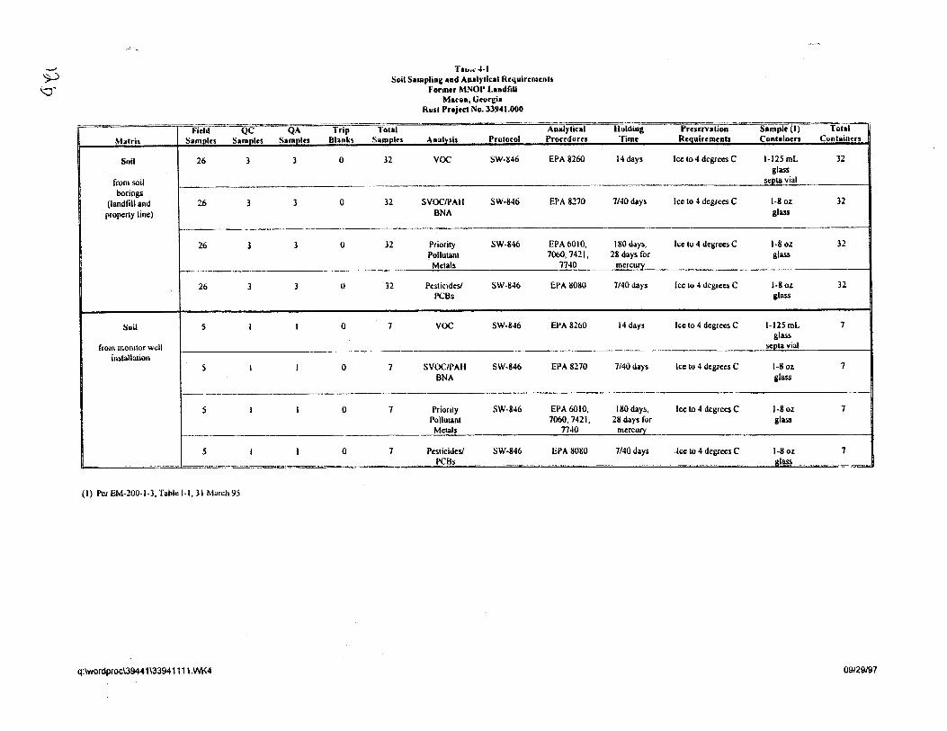
-)0 ~
- -J<'ield QC QA Trip
M:.atrix Sa moles SamPles SaRli!!« Blanks
Soil 26 3 3 0
from soil boripgs
(landfill and 26 3 3 0 (lroperty line)
26 3 3 0
26 3 3 0
Soil 5 I I 0
from monitor well installation
5 I I 0
--
5 I I 0
--- .
5 I I 0 .. .. ·- - .. ·"
{I) Per EM-200-1-3, Table 1·1, 31 March 95
q:\wordproc\39441\33941111.WK4
Tao.<4·1 Soil Samplinl,l ud Aaalylical Rcquircoacols
Former MNOP LlndfiU Muon, Gwll:i•
Rust Project No.ll941.000
Tot.ai Analytical Samplrs Analnis Protocol Proccduru
32 voc SW-846 EPA 8260
-32 SVOCIPAH SW-846 EPA 8270
BNA
32 Priority SW-846 EPA6010, Pollutant 70b0, 7421, Metals 7740
32 Pesticides/ SW-846 EPA 8080 PCBs
7 voc SW-846 EI'A 8260
7 SVOCIPAii SW-846 EPA 8270 BNA
-7 Priority SW-846 EPA6010,
Pollutant 7060,7421, Metals T140
7 Pesticides! SW-846 EPA 8080 PCBs
~-··
Holdiag Pnscrvatioa Sample (I) Tot~ Time Rcoulrrments Containers Cuntaiatrs
14 days Ice to 4 degrees C 1-125mL 32 glass
septa vial
1140 day$ Ice to 4 degrees C 1-8oz 32 glass
180 days, Ice to 4 degrees C 1-8 oz 32 28 days for glass
mercun:
7/40 days Icc to 4 degrees C l-8oz. 32 glass
14 days Ice to 4 degrees C 1·125mL 7 glass
SC:(!ta vial
7140 days Ice to 4 degrees C 1-8 oz 7 glass
180 days, Ice to 4 degrees C 1-8oz 7 28 days for glass
mcrcun:
7/40 days Ice to 4 degrees C l-8oz 7 ,&lass
~
09/29/97
Final Site Investigation Report Former Macon Naval Ordnance Landfill
Rust Pro;ect No. 33941.000
boring. The soil boring locations are designated LSL-1 through LSL-13 and shown on Figure 4-1. Soil samples collected from borings were designated as "LSL" followed by the boring number and the depth interval sampled. Soils collected from monitoring well locations MW-6 through MW-10 (Figure 4-1) were designated as "MW" followed by the well number and the depth interval sampled. Replicate samples were designated with the parent name followed by an "A". Replicates were collected from borings LSL-2. LSL-3. LSL-9 and MW-6.
4.4 SAMPLING AND ANALYSIS PROCEDURES
4.4.1 Sampling Equipment
Samples were collected from standard split spoon samplers in those borings drilled with hollow-stem augers. Several other borings were completed using hand augers. In these borings, the samples were collected directly from the hand auger.
4.4.2 Collection Techniques
Two soil samples for laboratory chemical analyses were collected from each of the "LSL" borings. One sample was taken between 0-2 feet bls and one at the depths of probable contamination as determined by headspace monitoring of the collected soils using an PID/OVM.
Eleven of the 13 "LSL .. borings and the boring for MW-6 were completed using 3.25-inch inside diameter (ID). hollow stem augers (HSA). Continuous split-spoons were collected as in accordance with American Society for Testing and Materials (ASTM) 01586-67. ASTM methods designate that the split-spoon be driven 18 inches into the soil,· however, in order to achieve the soil sample volumes required for this project the split spoons were driven a maximum of24 inches. Each soil sample was collected in accordance with the following procedures:
• The 3.25-inch ID hollow-stem augers were advanced to the desired depth. A 140-pound automatic hammer free falling 30 inches was used to drive the split spoon approximately 24 inches.
The split-spoon was removed from borehole, opened, and the recovered soil sample described in the test boring log using the Unified Soil Classification System (USCS).
• A portion of the soil was immediately packed into a clean, glass sample container with a teflon-lined cap and set aside for possible chemical analysis. This sample, to
Q:\WORDPROC\3394/U394/I 18.WPD 13 9125/97
Final Site brvestigaJion Report
Former Macon Naval Ordnance Landfill
Rust Project No. 33941.000
be analyzed for VOC 8260 parameters, was placed in the sample container in a
manner to minimize headspace.
• The remaining soil sample from the split-spoon sampler was containerized in a
plastic bag and sealed. The sealed bag was allowed to sit for a minimum of five
minutes at which time the headspace was screened with a PID/OVM. At each
borehole location, the soil sample with the highest headspace readings and a near
surface sample was sent for chemical analysis.
• The soil samples chosen for laboratory chemical analyses consisted of the bagged
sample showing the highest headspace reading and the corresponding bottled VOC
sample. Soil from the bagged sample was removed from the sealed bag, placed in
a clean stainless-steel or glass bowl. and mixed using the sampling spoon. The
sample was then carefully placed in appropriate sample containers using the
stainless-steel spoon or a spatula.
• Upon completion of sample collection, the sample container was labeled, the sample
identification entered in field log book, and the Chain-of-Custody record completed.
• The sample was placed in a cooler at 4 oc and prepared for shipping.
Two of the soil borings sites (LSL-12 and LSL-13) adjacent to the western property boundary and
borings for monitor wells MW -7 through MW -10 were inaccessible using a truck mounted rig. At
these locations, soil samples were collected by hand augering down to the designated depth or until
refusal.
Each hand auger sample was collected in accordance with the following procedures:
• The hand auger was advanced to the full depth of the auger head.
• The hand auger was removed from the borehole and the soil from the auger head
emptied onto a clean sheet of aluminum foil. The recovered soil sample was
described using the Unified Soil Classification System (USCS).
The remaining sampling procedures are the same as those listed previously for the
split spoon samples.
Q:tWORDPROC\J394/I.JJ941/18. WPD 14 9125197
4.4.3 Field Screening Techniques
Final Site Investigation Report Former Macon Naval Ordnance Landfill
Rust Project No. 33941.000
Once the soil sample descriptions were recorded, and the VOC sample bottle was filled, the remaining soil from the sampler was placed in a plastic bag and sealed. After waiting at least 5 minutes, a Thermo Environmental Instruments, Inc. Model 580B Organic Vapor Meter (OVM) was used to measure the headspace reading.
4.4.4 Sample Handling
Sample bottles were cleaned prior to delivery to the field by the laboratory. Once collected, the samples were placed in ·a cooler to maintain a temperature of approximately 4 °C. Coolers were prepared for shipping when full or at the end of each day. Sample volumes and holding times are
· presented in Table 4-1.
4.4.5 Decontamination Procedures
Equipment decontamination was performed within a decontamination pad, designed to contain cleaning fluids. The drill rig was decontaminated upon mobilization to the site and prior to leaving the site. The sample collection equipment and downhole tools were steam cleaned with high pressure steam within the decontamination area. Persistent dirt and other foreign materials were removed with a scrub brush. . The sample collection equipment and downhole tools were decontaminated upon mobilization to the site and between each borehole.
Sampling and monitoring equipment, including spoons, bowls, and the split spoon sampler were decontaminated according to EPA Region IV SOP and Quality Assurance (QA) manual (see Section 8.4 of EPA, I 991) prior to each sampling location.
4.4.6 Chain of Custody Procedures
Information regarding the sample analyses was recorded on the Chain of Custody (COC) form. This information included:
sample identification sampling time and date
• location of sampling point • sampling personnel • analytical parameters
Q:\WORDPROC133941\JJ94/IIUVPD 15 9125197
The origs
Samples
across th1
overnight
to become
4.4.7 La
Soil sampk
organic ana
for Evalua.
project are :
Data qualit~
samples inte
samples, labt
results indue
and sample r:
HydroLogic ,
all laborator:
maintenance
malfunction ;,
Final Site Investigation Report
Former Macon Naval Ordnance Landfill
Rust Project No. 33941.000
OC form was packed ith the samples and copies maintained in the project files.
v was accomplished b placing custody seals on individual sample containers and
f the cooler after secu ·iy taping the cooler. The sample coolers were shipped via
ss carrier to the labor: ·)ry, A copy of the shipping bill has been retained by Rust
.1f the sample custody Jcumentation.
:ory Analytical Techr 1ues
e shipped to HydroLc c Laboratories Inc., in Brighton, Colorado for analyses of
·anic analytes. The ar .ytical methods used are described in EPA's Test Methods
1/id Waste (SW-846) nird edition. Specific methods and analytes used for this
:n Table 4-1.
; ~ctives were set for th:; analytical methods by specifying control limits for QC
; to the laboratory. Q 1ality control (QC) samples included laboratory control
xy duplicates, and metl:od blanks. Control limits used to evaluate the QC sample
percent recovery and percent difference and are functions of the analytical method
:ix.
formed regular inspection, maintenance, cleaning, calibration, and servicing of
.wipment according to the manufacturers' recommendations. Calibration and
s are kept for each piece of laboratory and field instrumentation, detailing any
the steps taken to correct the problem.
4.5 BACK ROUND SOIL SAMPLING
No specific bac, ;round soil sampling was performed as part of this study. However, background
soil samples colt cted from the AlP serve as background soils to the IviNOP landfill site. A total of
four background :oil samples were taken from two borings located along the northern border of the
AlP property. T e results of background soil sampling are provided in Table 4-2.
4.6 DATA SUMMARY
4.6.1 Field Data
Soils were screened in the field with an OVM to evaluate the presence of volatile organic
compounds (VOC). The results of screening, which are presented on boring Jogs contained in
Appendix A, generally indicated that soils in the area of the IviNOP landfill exhibited moderate to
Q:\WORDPROCI3J941\3J941118.WPD 16 9/25/97
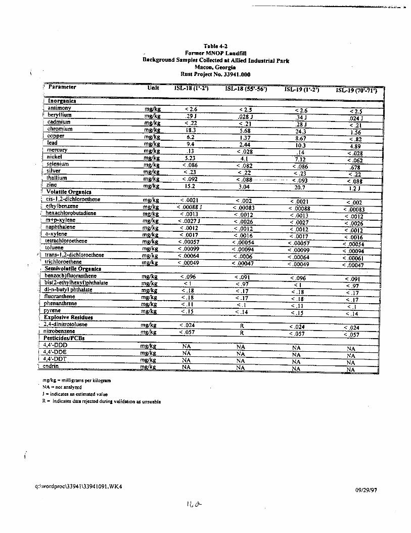
;1 Parameter ;'
,I lnorpniu :1 antimony ii beryllium I cadmium I chromium
copper I lead
mercury I nickel
selenium silver thallium zinc Volatile Organics cis- I ,2-dichloroethene
i ethylbenzene i hexachlorobutadiene !1 m+p.xylene :! naphthalene
o-xylene tetrachloroethene toluene
,. ~ trans-1,2-dichloroethene trichloroethene
,; Semivolatile Of~!. Ilia I benzo(b )fluoranthenc I bis(2-ethylhexyl)phthalate I
di-n-butyl phthalate :1 fluoranthene ! phenanthrene ' pyrene :1 Explosive Residues •; 2,4-dinitrotoluene 1 nitrobenzene '! Pestiddes/PCBs ' 4,4'-DDD i 4,4'-DDE I 44'-DDT
endrin
mglkg • milligrams per Idiogram NA = not analyzed J • indicates an estimated value
------------------------------.-~~=~~
Table4-l Former MNOP Landfill
Background Samples Collected at Allied Industrial Park Macon, Georgia
Rust Project No. 33941.000
Unit ISL-18 (1'-l') ISL-18 (55'-56') ISL-19(1'-2')
mglkg <2.6 <2.5 <2.6 mgOcg .29J .028 J .34J mg/ka <.22 <.21 .28 J mgtkg 18.3 5.68 24.3 mglkg 6.2 1.37 8.67 mglkg 9.4 2.44 10.3 mglkg .13 <.028 .14 mglk_g S.23 4.1 7.12 mgll<g < .086 <.082 <.086 mg/kg <.23 <.22 <.23 mg/kg <.092 <.088··. -- - . - <.093 mg/kg 15.2 3.04 20.7
mg/kg <.0021 <.002 <.0021 mg/kg < .00088 J <.00083 < .00088 mg/kg < .0013 <.0012 < .0013 mglkg < .0027 J <.0026 <.0027 mg/kg <.0012 <.0012 <.0012 mst/h <.0017 <.0016 <.0017 mg/kg <.00057 <.00054 <.00051 mglkg <.00099 <.00094 <.00099 mg!kg <.00064 < .0006 < .00064 mg,'kg <.00049 <.00047 <.00049
mg/kg <.096 <.091 <.096 mg/kg <I <.97 <I mgllcg < .18 <.17 <.18 mg/kg < .18 < .17 < .18 mglkg <.II <.1 <.I 1 mglkg <.IS < .14 <.IS
mg/kg <.024 R <.024 mg/kg <.051 R <.057
mgj'kg NA NA NA mg/kg NA NA NA m2fkg NA NA NA m21k2 NA NA NA
ISL-19 (70'·71')
<2.5 .024 J < .21 1.56
< .82 4.89
<.028 <.062 .678 < .22
..
<.088 1.2 J
<.002 <.00083 < .0012 <.0026 < .0012 <.0016
<.00054 <.00094 <.00061 <.00047
<.091 <.97 < .17 < .17 <.I
< .14
< .024 <.057
NA NA NA NA
R - indicates data rejected during validation as uruuable
q:\wordproc\33941\3394109l.WK4 09129/97
Final Site Investigation Report
Former Macon Naval Ordnance Landfill Rust Project No. 3394/.000
high VOC readings. However, some of these elevated headspace readings are believed to have been
due to the presence of organic debris and humus found throughout the surficial deposits of the
floodplain area Therefore, no correlation has been attempted between elevated OVM headspace
readings and presence of VOC soils contamination.
4.6.2 Laboratory Results
A summary of soil analytical results is presented in Table 4-3. Analytical data quality evaluations
were performed on all data by both the analytical laboratory and Rust. A summary of the data
quality review is included as part of the Quality Control Summary Report (QCSR) in Appendix B.
The results of analyses indicate that elevated levels of heavy metals (compared to background
values, Table 4-2) are present throughout the site subsoils; primarily for antimony, cadmium,
chromium, copper, lead, and zinc. Antimony was detected at it's highest levels in LSL-8 at
concentrations of 18.7 milligrams per kilogram (mg/Kg) (0-2 feet) and 10.9 mg!Kg (4-5 feet).
Antimony was not detected in background soil samples. Cadmiwn was detected in samples ranging
from less than 0.5 mg/Kg up to 3 70 mg/Kg. The highest concentrations of cadmium were observed
in samples collected from borings LSL-7, LSL-8, and LSL-9, which are located adjacent to the
MNOP Landfill (Figure 4-2). Cadmium was' detected in only one background soil sample at a
concentration of 0.28 mg/Kg.
Chromium, copper, and lead were detected in every soil sample collected at the landfill area.
Chromium concentrations ranged from 4.33 mg/Kg to 224 mg/Kg (LSL-8, 4-5 feet). Four other
detected concentrations were greater than 1 00 mg/Kg. Chromium was detected in the background
samples at concentrations up to 24.3 mg/Kg. Copper concentrations ranged from 1.71 mg/Kg to
1730 mg/Kg at LSL-6 (0-2 feet). Background samples detected copper at values up to 8.67 mg/Kg.
Lead concentrations in the landfill soil samples ranged from 3.18 mg/Kg to 1020 mg/Kg at LSL-3-A
(0-2 feet). Lead had a maximum background concentration of 10.3 mg!Kg. Zinc was not detected
in three landfill soil samples, but was detected in the other samples at concentrations up to 1730
mg/Kg at LSL-8 (4-5 feet). Zinc was detected in the background samples at a maximum
concentration of 20.7 mg/Kg.
Volatile organic compounds were detected generally at trace or low level concentrations in only a
few of the samples collected. The deep sample at LSL-2 (6-8 feet) exhibited the presence of a
number of compounds including isomers of trimethylbenzene (1,2,4 and 1,3,5), isopropylbenzene,
n·butylbenzene, n-propylbenzene, naphthalene, sec-butylbenzene, tert-butylbenzene, para-cymene,
and o-xylene. The deep sample at LSL-5 (8 to 10 feet) also exhibited the presence of
trimethylbenzene and n-butylbenzene, ethyl benzene, m-xylene/p-xylene and napthalene. These two
samples account for most of the volatile organic compound detections. The soil sample from MW-9
Q. tWORDPROCUJ94/UJ9<11118. WPD 17 9125197
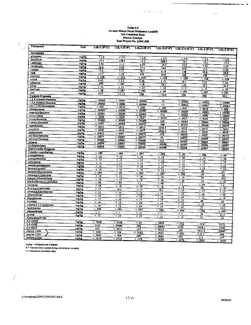
Parameter Uolt
lnorta•lca anumony mwkll beryllium mwkR cadmium milleR chromium mllllta copper ml!ll<l lead ml/lcl mercury mwkll nickd mllfkl 1elcnium ma:/kll silver ~mg/g_ thallium ml!ik1 zinc mwkll Vola lila Orpaic:l 1.2.4-lrirnethvlbcnzene mille a l.l • .S.trimethylbenzene mille _a
~ cis-1.2-dichloroethl:ne m!llkl ethyl benzene mllllt~r· isoPfOpylbenzcne m!lik.& m+j)-XVIcnc mll/ltlt n-butylbenzeM mwkg n-propylbenzcne mwkl naphthalene ml!lkll o-xvlcne !l1glkg oanu:vmene ml!lk& scc·butylbcnzcnc mg/kg_ tcn-butvlbenzcnc mgtkg tolue,.. mllllta tnchloroethcnc m!llk.&. Setnlvolatlle Or& .. lea 2-rnethvl nalllullllene mlllltR accnaphthcM mgfk_&_
I accnaphtlty1enc mglkg anlhracenc mll/llll benzo(a mg/q benzo(a)PYmtC! mille a benz~b fluorantllene mwka bcnzo( fil.h.i )pcrylcne mgfk1 benzo<klfluorantbcnc matka bis(2-ethvlhexvllPhthalatc mlllk11 chrysene mgt kg di-n·butvl phthalate mg/kg dibcnz{ a.hlanthrac:ene m!llk11 dibenzofuran "'W'k&.. nuoranthcne mgika fluorene mRikll indeno( 1.2J·cd)pyrcnc mglkg naJ)II_thalene mglka phenanthrene mllilt1 pyrcne m.&~kl!. Prstiddaii'CBI 4,4'-DDD mw'ka 4.4'-DDE ml/lca 44"-DDT mwka aroclor 1248 ".<~ mgtlc_g_ aroclor 1260 J ml/lca methoxychlor mgtq
R • indiates dllll ~Jected durinf vaJidMKtn .. uttusable
q:lwordproc:\33941133941073 .WK4
Table4-J For•er MKOo Naval Orduace Lu4fill
Soil Aulytlcal Da1a MHO-.Geercia
Rut Projea No. 33941.000
------------------------~~--~~- ~
L!:il..-1 (0'·6") LSL.-1 (0"-11") L!:il..-6 (V·<I') l..SL-1 (6'-&') LSL-1·A (8'·1') l..SL-.J (0'-2') LSW(6'-8')
< 2.5 < 2.5 < 2.6 < 2.5 <2.6 < 2.-' < 2.6 .15J .011 J 13 J .0-411 .141 12 J .1SJ 2.42. < .2 6.S9 .291 10.S 9.23 2.23 26.6 4.33 17.1 !0.6 15.5 tS.S 9.32 IS. I 1.71 76.1 4.19 Ill 95.9 21.9 17.7 3.11 471 46.9 441 171 111 < .021 < .027 < .029 < .021 < .029 < .021 <.029 4.43 1.21 6.26 3.17 18.1 7.51 3.38 .579 < .011 1.19 .29J 1.27 .321 .39J < .22 < .21 <.23 < .22 J.IJ < .21 < .22 <.09 <.087 < .092 <.09 < .091 <017 <.091 24.7 <4.1 J 296 < 16.4 556 161 60.1
< .00063 ~ .00061 < .00065 .74 < .00064 < 00061 < .00064 < .00062 < .0006 < .00064 .13 < .00063 < 00061 < .00063 < 002 < .0019 < .002 < .002 <002 .; .OOI!L..- <.002 < .0001$" < .ooon- < 00017 < .00085 < .000&7 < 00013 < .00086 < .00061 < .00059 < .00063 012 < 00062 < .0006 < .00062 < .0026 < .0025 < .0027 < .0026 < .0027 < 0026 < 0027 < .00061 < 00065 < .00069 036 < 00069 < .00066 < 00061 <0007 < .00068 <.ooon .066 < 00072 < .00069 < .00071 < 0012 <.0011 < 0012 .0036J < 0012 < 0012 < 0012 < .0016 <.0016 <.0017 .00261 < 0016 < .0016 < .0016 < .00072 < .0007 < 00074 .on < .00073 < .0007 < .00073 < .00071 < .00069 < .00073 .03 < .00072 < .00069 <.00072 < .00066 < .00064 < 00061 .O.SI < .00061 < .0006S -· · < .00067 < .00096' < .00093 < .00091 < .00096 < .00097 < .00094 < 00097 < .00041 < .00046 < .00049 < .00041 < .00041 < .00047 < .00041
< .019 < .086 <.091 < .088 <.09 < .086 <.09 < .16 <.I~ < .16 < .16 < .16 <.16 <.16 < .12 < .12 < .13 < .12 < .13 < .12 < .13 <.II <.II < .12 <.II <.II <.II <.II < .12 <.II < .12 < .12 < .12 < .12 < .12 < .15 < .14 <.I~ <.IS <.I~ .83 .21 < .093 <09 < .095 <.093 <.09$ .79 24 < 14 < ,13 < .14 <.14 <.14 .97 .Ill <; .16 < .15 < .16 <.16 < .16 .24 < .16 < .99 < .95 <I < .99 <I < .96 <I < .18 < .18 < .19 <.II < .18 .56 <.18 < .17 161 < .17 .18 J < .17 < .17 < .17 < .15 < .14 < .1~ <.IS <.IS <.14 <.IS < .14 < .13 < .14 <.14 < .14 < .13 < 14 < .17 < .16 < .17 < .17 < .17 .48 .24 < .14 < .13 <.14 < .14 < .14 < .13 < .14 <.14 < .13 < .14 < .14 < .14 .52 .14J <. .094 < .091 <.097 < .094 < .096 < 092 < .095 <.I <.I <.II <.1 <.I .25 .II J <.IS < .14 < .I.S < .15 <.IS S! .23
< .0029 < .0021 < 03 < .0029 < .012 < .014 0172 .0331 < .00061 .062 < .00063 .0323 .0428 J .0209 .012 < .0011 .233 < .0012 .106 .06311 .00847 < .00-41 < .00-4 < .0042 < .0041 < .004 9.231 . .4011 < .00-41 < .004 089 < 0041 092 <'.4 .107 < .0019 < .0018 < .019 < .0019 < .0076 < .0091 < 0019
t1 0--' 09129197
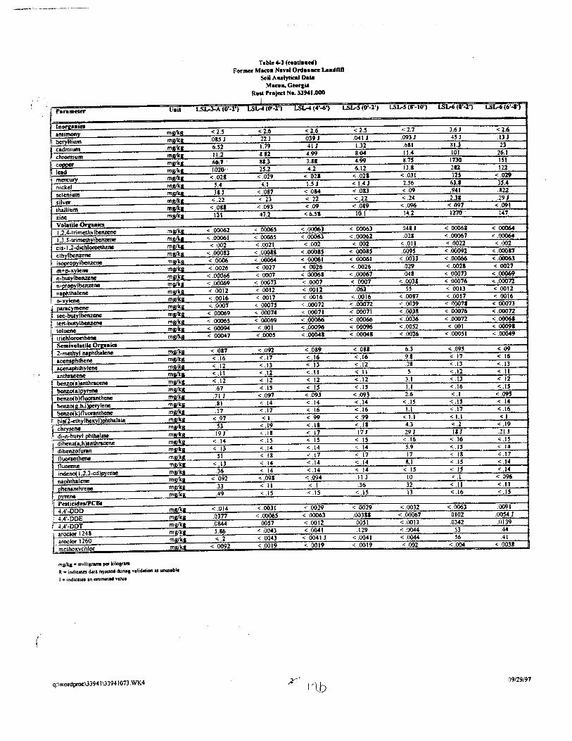
antimony beryllium
cadmium chromium CODOCI'
lead
' nickel selenium silver tkallium zinc Volatile 01'JtUies
I 1,2,4-trimellwlbcnzenc
cis-1.2-dichloroe!llenc ethylbenzene iSOilfOpyibenzc:ne
naphthalene o-xvlcne
sec-bulylbenzena
r ten-butyl~
toluene
2-mcthvl nallhthaleno
accnal!hthvtcne anthral:enc benzo(a
benzO(b )fluoranthcne
henzO( ll.h.i )pcry Jene henzo(k fluonnthene bi!(2-cthylheKyl)phthala10
di-n-butvl_llllthalale diben2( a.h )anthral:cne
dibcnzofuran
fluorene indeno( 1.2.3-cd)Dyrene naphthalene
I ohenanthrene
Pesticidos/PCBI I 4,4'•000
4.4'-DDE 4.4'-DDT aroclor 124$ aroclor 1260 mcthoKvchlor
ml!lks• mtlli.....,. per kiJoarora
Unit
mg/k&_
mall< I
mlllkR mgf!g_
mllikl
mllikll
mgilt.L
mwka mwkl
mg/kJl mwlts mllfl<ll
mgtk& mlllkl mszlk&
mlllkll
mwka
mgt kg
ml!lkl
miU'kll
R • indi ..... daU rtj«<Id duriiiJ validatioft U unusable
J a ind~ an estimated vaNe
q:lwordproci33941\33941073.WK4
Table 4-l (ceDtillllcd)
Forma: Macotl Naval Ord .. ace LudllD Soil Analytical Data
Macoa. Georp. Rldt hoject No.ll!MI.OOO
l LSL-.J.A (0 -1) l..SL-4 (O'·l') LSIA (<4'-6') LSL-5 (O'·l') LSL-S (8'·10') LSW (0'·1') LSW (6'4')
<2.5 .OUJ 6.52 11.2 66:7 ..
1020 < 028
.31 J <.22
< .081 Ill
<.00062 < .00061 <002
< .00083 < .0006 < .0026 < .00066 <.00069 < .0012 < .0016 < .0007 <.00069 < .00065 < ,1)()094
< .00047
<.087 < .16 < .12 <.II < .12
67 .71 J .81 .17
< .97 .53
.19J <.14 < .13 .51
< .13 .36
<.092 .33 .49
< .014
.0844 5.86 <.2
< .0092
<2.6 .22 J 1.79 &.82 81.3 25.2
< .029 4.1
< .087 < .23 < .093 47,2
< .00065
< 00065 < 0021
< .00088
< .0027 < 0007 < 00073 < 0012 < .0017 < .0007$ < .00074 < .00069 < .001
< .092 < .17 < .13 <.12 < 12 <.IS
< .097 < .14 < .17 <I
< .19 < .18 <.IS < .14 < 18 < .l4 < .14
< .098 <.II < .15
< .0031 < 00065
.oon < .OO.Cl < .0043 < 0019
< 2.6 0391 .411 4.99 3.81 4.2
< 021 UJ
<0&4 < 22 < .09 < 6.51
< .00063 < .00063 <.002
< .00015 <.00061 < 0026
< .00068 < 0007 < 0012 < 0016 < 00072 < .00071 < .00066 < .00096 < .00041
< .089 < .16 <.13 <.II < .12
< .093 < .14 < .16 <.99 <.II < .17 < IS < .14 < .17 < .14 < .14
<.094 <.I < .15
< .0029 < .00063 < .0012 < .OO.C I
< .0041 J < .0019
,2'~· I '1 b
< 2.5 .o-Il J 1.32 8.04 4.99 6.12
<.021 < I . .C J <.Oil < .22 < .0&9
10.1
< 00063 <.00062 <.002
< .00085 < 00061 < .0026
< .00067 < 0007
.061 <. .0016 < 00072 < .00071 < .00066 < .00096 < .000411
< .081 < .16 < .12 <.II <.12 < .15
< .093 <.I.C <.16 < .99 < .18 .171 < IS < .1.C < 17 <.14 < .1.C .II J .36
<.IS
< .0029 .00381 0051 .129
< .0041 < 0019
< 2.7 .093J
6SI II . .C 8.75 13.8
<.031 2.56 <09 < .2.C
<.096 14.2
.0411 .021
< .011 .0095
< .0033 .029 .041
< .003&
< .0087 < .0039 < .0031 < .0036 < .0052 < .0026
6.3 9.1 .28 5
3.1 1.1 2.6
<.IS t.l
<1.1 4.3 191
<.16 5.9 17 S.l
< IS 10 32 13
< .0032 < .00067 < .0013 < .0044 < .0044 < .002
3.6 J .4SJ &1.3 101
1730 282
6U .94t 2.31
< .097 1270
< .00061 <.00067 <.0022
< .00091 < .00066 < .0028
< .00073 < .00076 < 0013 < .0017
< 00071 < .00076 < 00072 < 001
< 00051
< .095 < 17 < .13 < .12 < .13 < .16 <,I
< .17 <1.1 < .2 .18 J < .16 <.IS < .18 < .1.5 <.IS <.I <.II <.16
< .0063 .0102 0342 .53 .56
<004
<1.6 .13 J
26.1
122 < .029 3'-4 .822 291
< .091 147
< OQ06.f
< .0006.c < .002
<.00081 < .00063 < .0027
< .00069 < .00072 < .0012 < .0016 < 00073 < .ooon < .00068 < 00091 <.00049
< .09 <.16 <.13 <.II < 12 <.IS < .095
<.16 <I
< .19 .21 J <.IS < .14 <.17 <.14 <.14 <.096 <.II <.IS
0091 .00.54 J 0139 .44 41
< .0038
·.
09129191
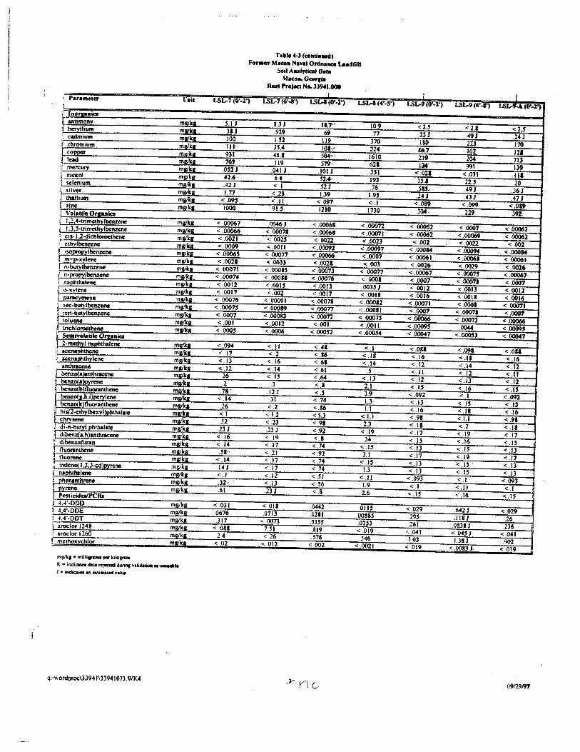
'Parameter Uait
fl lnorpaiclo l anu~ mwk11 ~ bervllium m111k11 ( .;.admium mt!lkl l chromium ml!lka c- m!lik1 i lwl mllik11 I' rna'CIJIY m!llka i: ru"kd mll/kl! 1· selmaum mlllka R silver ml!ikll :, thallium m!lik1
zinc mgilcl Volatile Ornaicl 1.2 4-trimetbvlbemene m1zika
I 1,3 .S-trimethvlbcrlzc:M m!likR 1: cis-1.2-dichloroethene ml!ilcl! { ethvlbtnm~e mgtkg ~ osooroovlbenzenc mllikll 'I m-p-xylene miZI'ka 1 n-butv I benzene mi/ka ! n-propylbenune mlllkR i naphthalene mll/kl
I o-,.;vlene mllikR I PAf*:Ymene miZI'kll ) sec:-butylbenzene mWka ;, tcn-butylbenzene millie a
!oluene milk a trichloroethene mtlka Snll¥ol8tlle Q~niclo
i 2 -methyl llal>hthalcne mltlk11 j aunatlhtheftc m!lik1
aunaphthytcne mVJicR anth~Kene m11k1 benzoia>anthrKCM millie I benzo( a)pyrenc millie a benzo(b}Ouoranthene mllik11 bem:o( Lh.i lt>eTYiene mllllcl benzo(k )fluoramhene mllik11 I bis(2-ethvlhexyllt>hthalate m!llka chrysene fltll/ka di-n-butvf phthalate ml!lkl
il dibenz(a.h)anthracene mlllka 1 di~fw-an malka ~ fluonnrhene msrikll ~ fluorene mllikl I indcno( 1.2.3-<:d)pytene m111h ~ napillhalcne ml!lk11 : Dhenanthmte mwkll I PYretiC ml!lka [ Peticiclet/PC!h ~ 4,4'-DDD mgikg : 4.4'-DDE mw'lta :: 4.4'-DDT mlllktt i aroclot 1248 mlllk11
aroclot 1260 ml!lka merhoxychlor mllika
mg/kJ • milli.,_ pe< kilosr-R • indicata dal&..,.acd duriftt va~ uJ • i-ndicu.l an ~•au:d va!ul
q: · wordproc\3394 J\3394 J 073. WK-4
Table~ (toftrilllled) Foraer MHOa Na\'111 Ordaa~~ee uadfill
Soil Aaalytltat Data Maco-.~
Rut Proj«t Ne. J3941.001 I
LSL-7(0q') LSL-1 (6'-3') LSW(0'-2') LSL-3 (4'-5')
5.1 J 8.3J 11;1' 10.9 . .l&J .929 .69 .n 100 U2 119 370 Itt· 3S.4 101''· 224 931 46.& 504'-• 1610 707 119 S19 621
.OS21 .0411 .101 J . .lSI 42.~ 6.4 52.., 193 421 <.1 .52 J . 76 t.n "'.28 1.39 1.9S
"'.09:5 <.II <.097 <.1 1000 9U f2t0 1730
<.00067 .00461 < .00068 "'00012 "'.00066 < 0007& < .00061 < .00071 < .0021 < 002.S < 0022 < .0023 < .0009 < .0011 < .00097 < .00097
< .0006S < ooon < .00066 <.0007 <.0021 < .0033 < .0021 <.003 < 00071 < .OOOU < .00013 <.ooon < .00074 < .00081 < .00076 < .0001 < .0012 <.OOU < .0013 .OOJ.SJ <.0017 < .002 <.0017 < .0018
< .00076 < .00091 < .00078 < .00082 < .0007.S < .00089 < .00071 < .00011 < .0007 < .00083 < .00012 <.0007.5 <.001 < .0012 < .001 < .0011 <.COM < .0006 < .00052 < .OOO.S4
<.094 <.II < .•• <.I < .17 < 2 < .86 <.18 < .13 < .16 < .61 <.14 < .12 < .14 < 61 .s .26
< '' < .64 < .ll
.2 .J < .8 2.1 .1&-: .12 I < .5 3.9
< .14 .31 <.74 1.3 .26 < 2 < .86 1.1 <I < 1.2 < S.J <1.1 .52 < .23 < .91 2.3
.231 .23 J < .92 < .19 < .16 < 19 <.I .34 < .14 <.17 < .74 <.U .58 < 21 < .92 3.1
< .14 < .17 < .74 <.IS .14J < .17 < .74 1.3 <.I < 12 <.51 <.II .32· < .13 <.56 1.9 .6t .23J < .8 2.6
<.031 < .018 .0«2 .0115 .0676 .0713 .0281 .0088S .317 < 0013 .Q3S5 .02H
< .088 7.51 .819 < .019 2.4 < .26 .S16 .546
< .02 < .012 < 002 < .0021
I I ~I:.-9(0'•1') LSL-9 (6' -1') LSL-,_A (O'•r)
<2.5 <2.1 <2.5 23J 491 .24J ISO 22.) 170
86-.1 102 121 219 204 713 124 991 139
"'.021 < .031 .Ill 15.& 22.S 20 .su . 49J .361 .34J .43J .47J
"'.089 <.099 <.019 3.04· 229 39!
< 00062 < .0007 "'.00062 < 00062 < .00069 < .00062 <.002 < .0022 < .002
< .00014 < .00094 < .00014 < .00061 < .00068 < .00061 < .0026 < .0029 < .0026
< .00067 < .00075 <.00067 <.0007 < .00071 < .0001 < .0012 < 0013 < .0012 < .0016 < 0011 < .0016
< .00071 < 0001 < .00071 < .{)007 < .0007& < .0001
<,00066 < .00073 < .00066 < .0009.S .0044 < 00095 < .00047 <.~3 < .00047
<.081 < .091 <.OU < .16 <.II < .16 <.12 < .14 <.12 <.II < .12 <.II < .12 < ,() < .12 <.IS < .16 <.IS
< .092 <.I < .092 <.13 < .1.5 < .13 < .16 <.IS <.16 < .911 <1.1 < .91 <.IS < .2 <.IS < .17 < .19 <.17 < IS < .16 < .15 < .13 < .15 < .13 <.17 < .19 <.17 < .13 < .15 < .13 < .13 <.IS < .13 < .093 <.I <.093 <.1 <.II <.I
< ·" < .16 <.IS
< 029 642J <.029 .29S .118 J .26 .261 .08JIJ .236
< .041 < .04SJ <.041 1.03 1.38 J .902
< .019 < .0083 J. < .019
09129f<l7
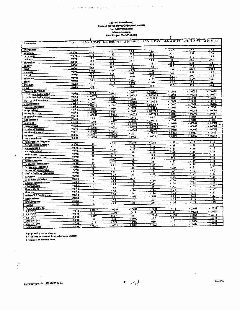
' {
Pan111cter Unit
mtimonv ' berYllium mg/kl
cadmium clm:tmiwn
lead
nickel selenium mg/kl
silver thallillrll mRikt:
zine Volatile OI'UJiicl I .2.4-trimethylbcnzene mgika
1..3.5-tnmethvlbenzene cis-1.2-dichloroethenc mg/kg
ml!ll<a
! isopropylbenzcne
mgllc.s mglkg
naPhthalene o-xvlene I)&I'KYmcne
ml!lka m11tka
toluene tric:hloroethenc Semtvolatile Orpaia
I 2-medlvi rtaPIUhalenc
mgly
benzo(bjfluomuhcne mllikll benzol a.h.i )pcrylcne mgika
benzol k )fluoranthcne
bis(l-cthvlhcxyi}Jlhthalate
chry,cnc di-n-butvl phthalate
: dibcnzofuran mgikg
mll/kJI
indeno( 1.2.3·cd)pyycne mg.ikl
: phenanlhrefte PVrei\C
,1 Pesticldes/PCBs 44'-DDD ml!lkl
4.4'-DDE mllikl
4.4'-DDT mgikg
aroc:klr 1248 mgt kg
' aroclor 1260 ~ mcthoxvchlor
ml!il<J • milllsnms per ki~
R. • indicatca data rejcc;1Mi dur•"!!nlidolioa u unUIIblw
J • indicltcs Ill estimi:Ced \o'llue
q:\wordproc\33941\33941073. WK4
Table 4-J (coatla~~eol)
Fonaer Macoa Nanl O~u- l.alldfiU Soil Aulytical Dna
Macea,GeoJ'Ila Rut Project No. JJ941.000
f I '
LSL-10 (0'-n LSL-10 (a--10') LSt.-ll (ll"·l') L.SL-11 (4'-6') I..Sa--11 (l'·l') LSL-Il (l'_.') LSL-U (1'·1')
3.71 OJ 3.1 J < 2.7 <6.3 < 3.3 <3.2
.711 887 22J .43 J .~2 J 1.26
29.6 .6SJ 2.31 2.32 61.9 .61 J 2.11
52.2 13.7 23.1 21.3 25.9 29.3
39.1 II 22 6.35 20
11.1 12.6 17.6 62.3· 20,4 27.1
< .036 < .047 < .029 <.03 Ll<f 0141 .0911
20.9 s.oa 4.62 6.44 10.2 S.S9 12.2
.s 1 4H ., 1 < 21 .591 UJ
361 <.37 < .23 <.23 ".$-4 < .29 < .27
<.!1 <.IS < .093 ".094 < .22 .41 .73
353 63 32.9 IS4 92;3 4S.4 67,3
.00241 < .001 ".0006$ < .000661 "0016 < .00012 < .00071
<.00079 <.001 < .0006S < .000661 < OOIS < 00011 < .00077
< .002S < .0033 < .0021 ".0021 J < .0049 ".0026 < 002S
< .0011 < .0014 < .00088 < .00091 " 0021 < .0011 < 0011
< .00077 < .001 < .0006-4 < .000651 < OOIS < .0001 < .00076
< 0033 <_1)().44 < .0027 < .00211 < .006S < .0034 ".0032
< .0011 < .0001 < .00071 J < 0017 < 00081 < 00084
<.00089 < .0012 < .00073 < .00074 J < .0011 < .00092 < .000&7
.131 .OISJ < .0012 .941 < 0029 < .OOIS < .oou <.002 < .0027 < .0017 < .00171 <.004 < .0021 <. .002
023 J .021 < .0007S < .00076 J < .0011 < .00094 < .00019
< .00089 < .0012 < 00074 < 000751 < .0017 < .00093 < 00011
< .00084 <.0011 < .00069 < .0007 J < 0016 < 00017 < .00012
<.0012 <.0016 < .001 < .001 J < .0024 < .0013 < .0012
< .0006 <.00079 < .0005 < .ooos J < .0012 < .00062 < .00059
R < 2.1 < ,092 <.093 < .22 <.12 <.II
R <S <,17 < .17 < .39 < .21 < .2
R < l.9 < .13 < .13 < ll <.16
R < J.S .27 <.12 < .21 <.I.S <.14
R < 3.7 56 .II 1 <.29 <.I.S <.U
R < 4.7 .52 .19J .391 <.19 <.II
R < 2.9 .79' .31 < .23 < .12 < .12
4.4J 4.SJ .32 < .14 .61 < .18 <.17
R <S .31 < .17 < .39 <.21 < .2
R < Jl <I 12 < 1.3 < 1.2
R < 5.7 ,59 < .19 < .24 < .ll
R < 5.4 .21 J .21 < .42 < .22 < .21
R <4.7 < .15 < 16 < .36 < .19 <.IS
R. < 4.3 < .14 <.14 < .34 <.I& < .17
R < S.4 1.3 36 < .22 < .21
R < 4.3 < .14 <.14 < .34 < .11 < .17
R .34 < 14 <.34 <.II < .17
R <3 <.098 < 099 < .23 <.12 < .12
R -<3.3 Lt .25 < .2.5 < .13 < .13
R <4.7 .98· .36 < .36 <.19 <.II
< .0037 < ,0049 < .0031 <.0031 <.14 < .0038 < .0036
.0111 < .001 .0413 .0112 < .031 < .00012 < .00078
.0581 .0187 .0!7 < .0012 < .058 <.OOU
.91 .945 < .0043 .29S 9.11 < .0054 < .OOSI
.21S < .027 < .0043 .039 <.2 < .OOJI
< .0024 < .0031 < .0019 <.002 .21 < .0024 < .0023
09129/97
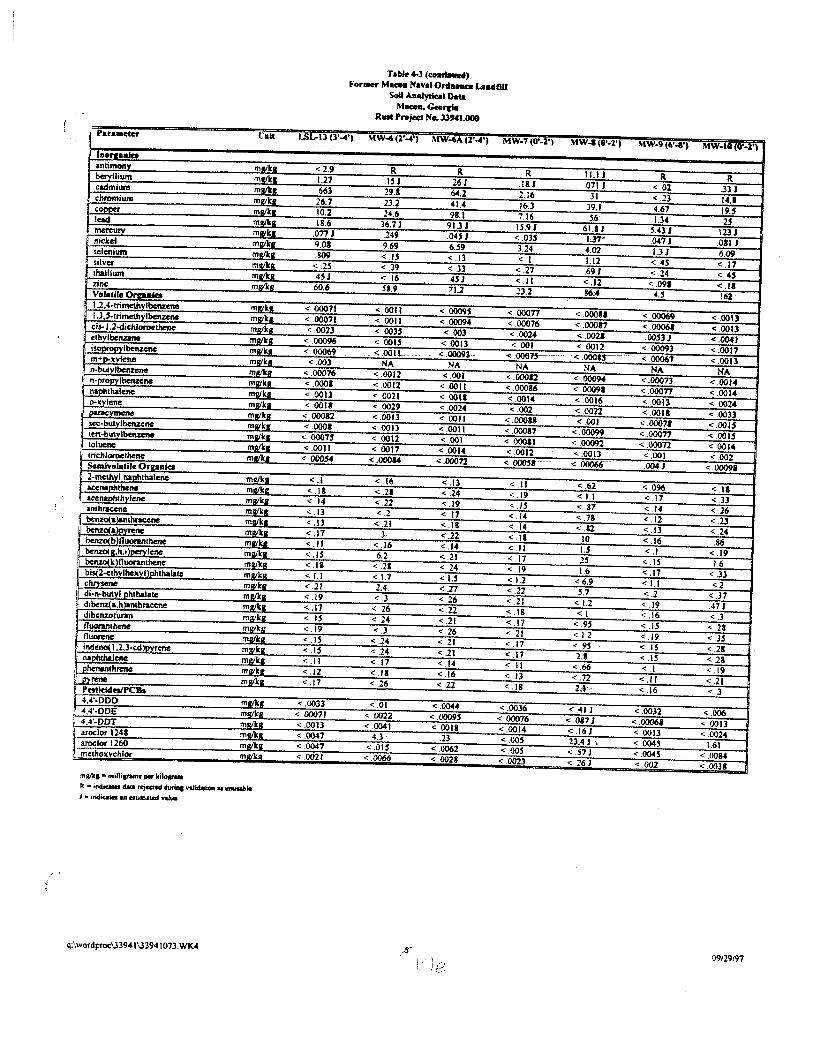
Para•eter Ualt
I lnortaala antimony m!lik1 beryllium malkR cadmitll'll m!llk& chromium ml!l'k11 COI)I)el' miZiltl! lead malh mercury mll/lr:l! nickel millie a selenium kr m.U: sii\'Cf mg/1 k& thallium kll m.U: zinc: kll m.U: Volatile Orpaiea 1.2.4-trimethvlbenzene m~:~lr.a l.l,S·trimctbylbenzeM mgJ •• cis-1.2~ichlorocrlhmo m111 ka
othvlbenzene 1M/ Ill i~lbcnzene mal ., m+p.llvlene mllikll n-butvll>enzene mwkl
i n·propylbenzenc m111k1 naphthalene mt!lkR
j o-><vlene malka pazac:)'lnlme malka sec·butylbenzenc m111k11 ten_-_bi!!Yl'*'- mllikll toluene malk1 trichloroethene mr/kl Seativolatile Or2aalet 2-mcthyl napll_thalenc ml!ikl! acenallhthene mllik& acenaphthvlene mtv'k1 anthracene m1Zilt1 benxo(a)anthno:ene m!Vkl benzol alovrene malkl benzo(b }fiiJOtllnthene mlllb benzo( 11.h. I )OC1Yiene mllfkl bellZO(k )flucxanthene ml!lka bis(2-othvlhexyl)pbthalatc mll/klz chrvscm: ml!l'klr
' di·n-butyl plubalatc m.u:ka j di~a.h}anthtacene m1Zilt1 dibcnzofuran mg/ka fluorantMtle m111k11 fllllmne mt!llt11 indeno( 1.2.3-cdlovrene m!lika naphthalene mllllca
, phenanthrene ma/11:1 ! ovreM mtv'kl!
Pe5tlcidesiPCBs 4.-4'-DDD mllfk8 4,4'-DDE mgikJI
i 4,4'-DDT ma ilut aroclor 1241 mR lkl aroclor 1260 lkll ma methoxvchlor lkll m1
mi/1<1• milli-1 por kilo..-R • ondi-lllca rejcaed Wril>l volidoliooo II -le I • •nd'"* an aom•tl:d value
q:\wordproei33941\33941073.WK4
Table 4-3 (coadltwN) Fo.....,. M- Nanl Onlance Ludml
Soil Aaalytic.al Data M-C.rcia
Rllat Project Na. 33941.008
I..SL-13 (3' ... ') MW-4(1'_.') MW-4A (2' .... ') MW·7 (ll'-2.')
<2.9 R R R 1.27 .lSI .261 .lSI .663 29.1 64.2 2.16 26.7 23.2 41.4 16.3 10.2 24.6 98.1 7.16 18.6 36.7 J 91.3 J IS.9 J
.0171 .249 .04H < .035 9.01 9.69 6.59 3.24 .809
< -" < .13 <.I < .2S < .39 < .33 < .27 4SJ < .16 45J <.II 60.6 51.9 71.2 23.2
< 00071 < 0011 < 00095 < .00077 < .00071 < 0011 < .00094 < .00076 < .0023 < 003$ < .003 <.OOU
< .00096 < .001$ < .0013 < 001 < 00069 < .OO!t . < 00093-- < .OOOlS----
< .003 NA NA NA < .00076 < .0012 < .001 < .00012 < .0001 < 0012 < .0011 < .00086 < .0013 < 0021 < OOtl < .0014 < 0011 < .0029 < .0024 < .002
< 00012 < 0013 < .0011 < 00081 < .0001 < .OOil < .0011 < .00087
< .00075 < .0012 < .001 < 00011 < .0011 < .0017 < .0014 < .0012
< .000$4 <.OOOU < .00072 <-~·-·
<.I < .16 < .13 <.II < .1& < .21 c: .24 < .19 < .14 < 22 <.19 <.IS < .13 < .2 <.17 < .14 < .13 < .21 < .18 < .14 < .17 3 < .22 <.I& <.II < .16 <.14 <.II < .15. 6.2 < .21 < 17 <.II < .21 < .24 < .19 <1.1 < 1.7 <1.5 < 1.2 <.21 2.4 < .27 < .22 < .19 < .3 < .26 < .21 < .17 < 26 <.22 <.1& < .I.S < .24 < .21 < .17 < .19 < .J < 26 < 21 <.IS < .24 < 21 < .17 c: .15 < .24 c: .2t < .17 <.II < .17 < .14 <.II <.12 <.II <.16 < .13 < .17 < .26 < .22 < .18
< .0033 <.OJ < .0044 < .0036 < 00071 < 0022 < .0009S < .00076 < .0013 < .0041 < .0018 <.0014 < .0047 4.3 .23 < .oos <.0047 <.OU < .0062 < .oos < .0021 < .0066 < .0028 < .0023
MW-1 (0'·1') MW-9 (6'-1') MW•l8 (0"•1')
11.1 J R R .071 J < .02 .3lJ
Jl < .23 14.1 39.1 4.67 19.$ 56 1.34 2j
61.1 J Hll t23J Ll7" .0471 .0111 4.02 I.JJ 6.09 1.12 < .4S <.17 .691 < .24 < .4S < .12 < .091 <.II 86;4 4.5 162
< .00011 < .00069 < .0013 < .00017 < .00061 < .0013 < .0021- .OO.S3J < .0041 < .0012 < 00093 < .0017
< .ooou----· < 00067 < .0013 NA NA NA
< .00094 < .00073 <.0014 <.00091 < 00077 <.0014 < .0016 < 0013 < 0024 < 0022 < .0011 < .0033 < .001 < .00011 < .0015
< .00099 <.00077 < .001$ < .00092 < .00072 < 0014 <.0013 < .001 < .002
<.00066 .004} < .00091
".62 < .096 <.II <1.1 < .17 < 33 < .37 < 14 < .26 < .78 < .12 < .23 <.&2 < .13 < .24
10 < .16 .86 r..s <.I <.19 2S <.IS 16 16 < .17 < .33
<6.9 <1.1 <2 S.1 < .2 <.37
<1.2 < 19 .47 J <I < .16 < .3
< .95 <.IS < .21 < 1.2 < .19 < .35 < .95 <.IS < .28 2.1 < .IS < .28
< .66 <.I < .19 <.72 <.II < .21 2,-t,,-. < .16 < .3
< .411 < .0032 < .006 < .087 J <.00068 < .0013 < .161 < .0013 c: .0024 23.4J \ < 004~ 1.61 <.51 J < .0045 < .0084 < 261 <.002 < .0038
09129197
' \
Final Site Investigation Report
Former Macon Naval Ordnance Landfill
Rust Project No. 3 3 94/. 000
(6-8 feet) showed estimated concentrations of cis-1,2-dichloroethene (0.00531 mg/Kg) and
trichloroethene (0.004 J mg/Kg). Naphthalene was the most frequently detected VOC, with
detections in 7 samples.
SVOCs were detected at several sample locations (LSL-1, LSL-3, LSL-5, LSL-6, LSL-7, LSL-8,
LSL-10, LSL-11, LSL-12, MW-6, MW-8, and MW-10). At locations LSL-3, LSL-7, and LSL-11,
semi-volatile parameters were detected in samples collected at all depths. Of the SVOCs detected
the most significant is the presence of benzo(a)pyrene in a number of samples at concentrations
ranging from less than 0.5 mg/Kg to up to 10 mg/Kg. The highest concentration ofbenzo(a)pyrene
was detected in the shallow soil sample collected from MW-8 (0-2 feet).
Both pesticides and PCBs were detected in soil samples collected at the landfill area. Pesticide
compounds were detected at all but seven soil boring locations; LSL-12, LSL-13, MW-6, MW-7,
MW-8, MW-9, and MW-10. Concentrations of pesticides in the collected soils were found to be
below applicable regulatory criteria and are not discussed further. The PCB compounds detected
were Aroclor 1248 and 1260. Aroclor 1248 was the primary PCB which was detected at 10 boring
locations (Figure 4-3). The highest levels of Aroclor were observed in shallow soil samples
collected from MW-8 (23.4 J mg/Kg), LSL-12 (9.1 1 mg/Kg), and LSL-3 (9.23 J mg/Kg).
4.6.3 Extent of Contamination
The results of soil sampling indicate that elevated levels of metals, SVOCs, and PCBs are present
in subsurface soils at the fanner .MNOP Landfill site. Distribution of metals and PCBs are illustrated
in Figures 4-2 and 4-3 and are further discussed below. In addition, trace amounts of VOCs are
present in isolated soil samples. Based upon the distribution and relative concentration of each
analyte the following can be said concerning extent of soils contamination:
• Cadmium is present in both surface soils (0-2 feet) and to a lesser extent deeper soils
throughout the site at levels that exceed background concentrations and relevant
regulatory criteria (see Section 10.0). The highest cadmium levels are at locations
LSL-7, LSL-8 and LSL-9 near the MNOP landfill with lower concentrations at more
remote locations to the east and south (Figure 4-2). The aerial extent of elevated
levels of cadmium has not yet been defined for surface soils, nor has it been defined
vertically at some locations near the landfill mass.
• Chromium and copper are present in both surface soils and to a lesser extent deeper
soils at locations LSL-6, LSL-7, LSL-8, and LSL-9 at concentrations that exceed
background and regulatory criteria (Figure 4-2).
Q. \WORDPROC\339~/\33941 118. WPD /8 9125197
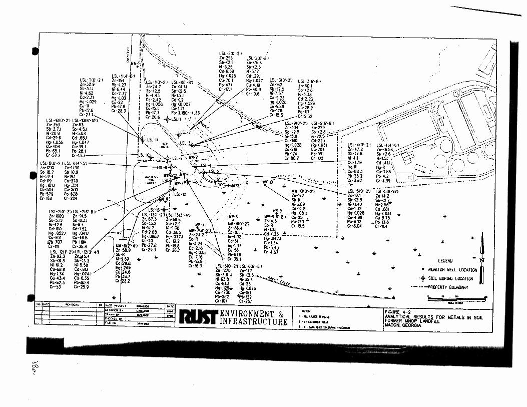
---------,~ i'\:.. " • i~~~' \ \
''' · ·,·.. \ ·.. LSL-210'· 2'1 111 , ,..._ -~ \1 •,-..; . Zn·296 LSL-2!6'·8'1 Q •l ·· i ~< .. .-.,; Ni -6.26 Sb-<2.5 r~-~~~ ):~_- ·. Sb-<2.6 Zn-<16.4
' \ ...... -:; . Cd-6.59 Ni· 3.17 . , , LSL-1114'· 'l l\ . '!'i-.~~ _ Hq· <-028 Cd:.29J • .• • • • , '; i
LSL ·11t0 ·2 1 Zn-154 llSL-110._2,1 LSL -1!6._8.1 Cu-76.1 i-19<.027 L1SL3t0 21 LSL -316·81 ~· ..,.,_ Zn-32.9 Sb-<.27 1zn_24 _7 Zn·<-4 .1J Pb-471 Cu-4.19 n:162 Zn-60.1 __. .--· -:'f't., Sb-~. 1J Ni-6.44 Sb-<2 S Sb·<2 5 Cr-17.1 Pb-46.9 $!l <2.5 Sb-<2 6 ; ,.....-,-/';~ Ni·H2 Cd-2.32 Ni·-4 4
3 Ni·12j Cr-10.6 CNi·7.57 Ni·.U8 ..-::: · · ,....-• ·...J-;/ \ \ Co-231 Hg-<03 · . d-9.23 Cd -2.23 - · .....- · , _,....--,'\ ., ., ... Hg-<:029 Cu-i2 Cd:2.42 Cd:<-2 Hg-<.028 H9·<.029 .. ~ ~ • .....-· '('? ("""'"' \\ \ r\ \ \ Cu· ll Pb- 17 6 Hg <.028 Hg (0.027 Cu-95.9 Cu-28_9 . ~~-- . •/ ( \ ~\ \ \ \ '_ 1 Pb-12.6 Cr·2S.3 Cu:15.1 Cu: t71 • Pb-178 Pb-117 . . ..- .....-.·---' ;:::::--'\'-\~.~ \ .,\ \\\\, Cr · Z:S.l Pt> 17.7 Pb 3.18Cr 03 Cr-15.5 Cr-9_32 ..- . / ~...--:· \\'d. \ \ ·,\ ·, ._..., \ Cr-26.6 • 1 ,I 1
· .....-: \ · (\ \1 •/ LSL-1010'·2') LS\.·10(8'·10'1 ~ +LSL 1 '. ~:~ • LSL-9!6'·8') . / -~ ·:~~~ \
11 \
Zn· 353 Zn-63 . · , \, -, ~"t•.· Zn· 229 ..-- ..-- .--' .....- \ ( ( \ , \ \~\ 1;
Sb·3.7J Sb·4.5J '\~, CJ ·2 . ·.'-."' Sb-<2.8 -.. .....-· \' I ~ ·'-"\ ' •, \
Ni -209 Ni-5.08 -~--- -¥ .... ... , ... -.." Ni-22.5·-·j ;-"' ''\ ~~\\ •·. ~-Cd-29.6 Cd· .68J LSL-n '\\ . · Cd-223 \\ • ,.....-- .) , · ' 1 \ ••• .....--~ Hg-<.036 119·<.047 , ~- _ - '-':~. LSI.· \: '·.\ Hq·<.OJ1 : ~ LSL·4W'·2'l LSL - 4!4'~6'1 ~. ~-·-. --c:> \l\ \ .. .....---~~ Cu-408 Cu-39.1 • , HGJJ. \, , • Cu-204 I , Zn-47 .2 Zn-<6 .58~ .......-:: ... ... ...........-p~ >·.\ Pb-65.1 Pb-26.1 I _ ~.', Pb-991 ! ~- Sb-<2.6 Sb-<2.6 ~___k) ~- ; ,_:.:::::;:;.;-..-...., -.~'.::::;'· Cr-52.2 Cr-13.7 , Sl ~ LSL·g ; WW·'l! \ Cr-102 I ' Ni-4.1 Ni-1.5J : '\...---"\ : \; ! r--- '.. ' ' '~· · ·· ... ·. . Cd-t79 Cd-41J • v ' 'I'( \ ........ LSl·8t0'·2')lSl·8(4'·5'1 ~ "~il. L ' . . : - Hq·R Hg·R \\ :-"' .'----"" . . :-.. ';
Zn-1210 Zn-1730 51.·8 1 "-......._ . ; . · · ' I \ Cu-88 3 Cu-3.88 \~-......._ ::: I ·~~ ,... Sb-18.7 5~·10.9 loiW~ _jjiHl--" . ·., / .. , . , .,, , ••. , ,, • ,Pb-25.2 Pb-4.2 I c:] /' Ni-52.4 Ni-193 -~- ~'"-<.~~I ' \ ' --- ~v'<4 ' 'Cf·8 82 Cr·-4 99 • • • Cd-119 Cd-370 ,~ l IIW-4 l..Sl -6~ ~~! . .._,.;.---MW"'lO -..!.•~ :.::~• · 1 __ '\. . .-·-·-·-· ' H9·I01J Hg-351 · '--~Yr'l . ~ • -·-·-·-Cu-~04 Cu-i610 · i i hiW -10(0'· 2'1 ' lSL-510'·2'1 LSL·:X8·10'1 Pb-579 Pb-628 • , ' Zn-162 . , Zn·\0.1 Zn-14.2 Cr·108 Cr·224 _ W-6: ; / ' . . Sb·R .1;. • . Sb-<2.5 Sb-<2 .~ • 1 + ,. · • + Ni-6.09 I• Ni·<t4J Ni·2.56 / ;t, '* . Cd-14 .8 : Cd-1.32 Cd-.681 LSI:·ll , / . 11U·9 ttg·.081J Hg-<.028 Hg-<.031 + LSL·131T· 2' LSl·1.m '-4'1 / . ' / llil ·8 , WW-9!6'·8'1 Cu-25 . ! Cu-4.99 Cu-8.75 Zr\·67.3 Zn·60.6 -' • • Zn-4.5 Pb· 12J "'- • Pt>-6.12 -<i.Pb·13.8 Sb-<3.2 Sb-<2.9 IAW·J . · . loiW·Bl0'·2'l Sb·R Cr-19.5 I Cr-8.04 Cr·1U Ni·\2.2 Ni-9.08 IIW-~IO':J:J / Zn-86.4 Ni· l3J ! · Cd-2.88 Cd-.663 ln 2, 2 • ··- Sb-11.1 • - •• - •• Cd-< 23 + J f:I9-.098J Hc}·.077J : J. tu-4.02 H9·.0.7J-··-· · -··-· · -·· ... Cu-20 Cu-10.2 Sb R -..._ Cd-31 Cu·1l4
Pb:27.8 Pb-18.6 ~d~l~ ...... ~' H9:1J7 • Pb·S.43 ... Cr 29.3 Cr-26.7 ""·< O""· Cu 56 Cr -4.67 ~., . "": ' Pb-61.8 Cu-7.16 Cr-391 Pb·l5.9 . Cr-16.3 LSL-610'·2'1 LSL-616'·8'1
Zn-1270 Zn-147 Sb-3.6 J Sb-<2 .6~-Ni-63.8 Ni-35.4 •oc~, c~ . Cd-81.3 Cd-23 rc• Hg- .125+ Hg-<.026 Cu-1730 ,Cu-151 Pb-282 -iifb-122 Cr-101 Cr-26.1
LSL-710'·2'1 LSI.· 7!6'·8'1 Zn·1000 Zn·9t5 Sb·5.1J Sb·8.3J Ni-42.6 Ni-6.4 Cd·100 Cd-1.52 H9· .052J Hg-.04\J Cu-931 Cu-46.8
.eb-707 Pb-119i> Cr-111 Cr· 35.4 LSL· \20'·2') LSL ·121.1'·4'1 Zn-92.3 Zl\i!l5.4 Sb-<6.3 Sb-<3.3 Ni-10.2 Ni-5.59 Cd-68.9 Cd·.6\J Hg-1.34 Hg·.074J Cu-43.4 Cu-6.35 Pb•62.3 Pb·i0.4 Ct·53 Cr-25.9
• ...
... .... • • ...
• .. .1;.
.II;. ... •
.... •
<ill-
.. ~~ LEGEND N
• MONITOR WELL LOCI! TIOH ~ + SOIL BORIIll LOCATIOH ~ •- • • .....pflQPERH 80Ut4lAAY
,. "' ...
""' .... - · -~ ~ llllU<
l · al,-..u(SN ....
l • I • ISTIOOID Y"-'1
FIGURE 4·2 ·l=t:t=======t~~==~=~ III ... ENVIRONMENT & ~---+--+-------+----1~ ... ~.-~----.. _ _._-I 1-..1 INFRASTRUCTURE
-c:l0
r
l - I • Ml'II(..(CltD .~ UlOAlOI
AN.Iol YTICAL RESULTS FOR WET ALS tl SOL FORMER MNOP lANOfllL MACON, GEORGIA
Final Site Investigation Report
Former Macon Naval Ordnance Landfill
Rust Project No. 33941.000
• Lead is present in both surface soils and to a lesser extent deeper soils at
concentrations which exceed background and regulatory criteria for borings LSL-2,
LSL-3, LSL-6, LSL-7, LSL-8, and LSL-9 located near the landfill mass.
• Aroclor 1248 is present in both surface soils and deeper soils collected throughout
the site (Figure 4-3). This constituent is present in soils near the landfill and in soils
south and east of the landfill. The aerial extent of Aroclor has not yet been
determined. however it's concentration appears to be greatest in surface soils.
Aroclor 1260 was detected less frequently (Figure 4-3).
• The highest concentrations of copper, chromium, cadmium, and lead were found in
samples collected in a small area just east of the Armstrong Cork Landfill and just
south of the MNOP Landfill. It is likely that both of these landfills are now or have
been contributing to the contamination in this area.
In summary, it appears that contamination, primarily by heavy metals and PCBs, has occurred in the
site soils. The data generated during this investigation provides basic information to sufficiently
characterize the area but does not fully delineate the extent of constituents with elevated levels. It
is also noted that approximately half of the soil samples were collected from the vadose zone and
half from saturated soils. No significant difference in the elevated concentrations between vadose
zone and saturated zone soils can be distinguished. The source of metals and PCBs appears to be
from the landfill mass via subsurface infiltration or possibly from run-off and sediment deposition.
Because a portion of the site is located within the Rocky Creek floodplain off-site sources are
possible from surface run-off and sedimentation.
4.6.4 Fate and Transport
4.6.4.1 ~
PCBs are mixtures of different congeners of chlorobiphenyl. Once released to soils, PCBs are
strongly sorbed and will generally not leach significantly in aqueous soil systems (Micromedex,
1996). This is mostly due to the fact that PCBs have relatively low octanol-water partition
coefficients and low solubilities and are hence strongly adsorbed by mineral and organic materials
in soils. The literature reviewed indicates that PCBs with high chlorine content such as Aroclor
1248, 1254, and 1260, are resistant to biodegradation and PCBs with low chlorine content (Aroclor
( 1221 and 1232) biodegrade very rapidly (Micromedex, 1996). Chapelle, 1993, indicates that
emerging research suggests that some of the highly chlorinated PCBs may be resistant to aerobic
Q:\WORDPROC\339-11\339-11 I 18. WPD 19 9125197

•
-,..$)
~
LSL ·1H0'·2'1 orochlot 1248-<.0043 oroehlor 1260·<.~3 LSL · 11l4'·6'1 oroct\lor 1246-.295 oroct\lor 1260· .039
LSL-1010' · 2'1 oroctior 1248· .91 orochlor 1260· .215 LSL ·1018'·10'1 orochlor 1248·.945 orochlof 1260·<.027
LSL ·610'·2'1 orochlor 1246·.819 orochlor 1260· .576 LSL-814'·5'1 orachlor 1248·<.019 orochlor 1260·.546
...
LSL • 7<0'·2'1 orochlor 1246·<.088 · orochlor 1260· 2.4 LSL· 716'·8'1 orochlor 1248·7.51 orochlor 1260·<.26
.. •
....
O(v""""
•
('-._
''
•
. ,· ;.: ., i:
-'~ .,., .. ,., -........"I / orcx:hlor 1246-<_0042 ~ orochlor 1260-.089
_. • ~ LSL-2<6'-8'1 ...... . r:;r-.__.....--~ ' '• oroclllor 1248-<.00
41 .// ~·-----· '>-)~ \ arcx:ntor 1260-<.0041 / __ ..- ,__..--• )r. "\\ \ ,~ ,
~\<{ .\ \~ ' \ '-, \1 ' \
LSL-J<0'-2'1 ,.- - ~.:'\_:_._ \ '\ \\ \ :t..s-:-. arcx:hior 124!1-9.23J __ ___ ..- , \\i-f\\ ·\ \ '·, \ '---'-, :.t'--.~arochio< 1260-<0.4 _ __ __ _ _.. ____ __.. \ \\) 1\ \,/" ···LSL· •• • - -- -· __..--• ' \· , ..... ..,., -~i.:! .!:,... ~,,\ ~~\ __ ,-, \ \\ "',
orochlor 1248·<.041 cwochlor 1260· ,J78
1 ' ' \ ~\ ' ~\\ ' ' \ ·-""'"' . ' ' .\ '. .. ,, . \ ' LS>. ·····B'> . LSL ·<>0'·2'> > ' \.' ?' \ \ ~ \
·-:.·~"" , ... , "" """" ""''"" ': ~ ~7 / () ,~,-~ . • ·~"" ,,,.,,, ··- 060·<.00<l .::.---_ ~...;;-~ ,~? ! ~,..-.., ,d --~ \· LSL-414 '·6'1 · . -~ / . .------- : • ·.·-:~-~-- "'LSI. -5 ,, ·, '•. : oroct-.lof 1248·< 004 ,._ ·__/ ; ) ( (,------.. \, ; --;·--
' . , , . , . I \• ,---.____ '· I ·. '----'' · · I -- · J .,. I ' ' -- --......,- ....._ ' ' ·
-6~~-"' 'uw-'10<0.'2. ,,,,.:, .,, , _oroc_ ntor t260-< .0041J . ·;.., ....__ ; . .,__j !~ , > -- "'l-"'""' ,.,.,,,'\"'1) . LS>.·-·"'"""" ·' \ \ ="~ - )I ~ ~ ...... , ... ,... • ·-, ... " .... -I--~ ~ . /
11
I / aroc!WI260-<.0041 i '·---·-·---·- ·-·-·- · - ·-·-·-·-·-! : ~SL-518·10'1 : ..,_ 1.4\lf-~- j._-
1 ..:. ,. otochlo< 1248·<-~H l ·'!IC t248-23.4J ;r otochlor 1260-<.0044 !;;;.
/0:/ roc ·81260·<.57J ~-9 ! / / • ... 1.4'11·9!6'·8'1 i lAW-~ / orochlor 1241H .OO~ : -~~-_._::'____ ___ orochlor 1260·<.0045 ! -.........:~~ ··----··-··-:·-··-----:1::. .. _. l LSl·610'·2'l ·-··-··----··----.. J + LSL-12<1'·2'1 arochlor 12.48·9.11 arochlor ~60-<.2 LSL ·1213'·4'1 orochlot 1248-< .0054 otocl1lor 1260· <.0054
orochlor l248·.53J orochlot' 1260· .56J
. LSL -616'·8'1 'orochlor 1248-.HJ ~ orochlor 1260·.41J
.jj. ... .jj.
+
...
• •
... ..
.. ... . !
.. ~ LEGEND N
• HONlTOII WELL LOCATION ~ UW·612'·4'1 orochlof 1248·4 .3 arocl1lor 1260-<.015
... I.IW·710'·2'1 orochlor 1248· .23 . orocNor 1260·<.0062 ~o,,, ;o.
+ ~ .... · i~ SOIL BOlliNG LOCATION u
··-.. -·-PROPERTY llll\.WAAY • ... • .. ENVIRONMENT & I IIOIES<
INFRASTRUCTURE I • AU. VAUI:S II "'9fkt 2 • J • [SI .... IED VALL(
-"""
i "R M0 ; ..... .... FIGURE 4·3 1WL YTIC~ RESULTS fOR PCB's IAROCH.ORI IN S· f'ORI.I£R ~.~HOP LANDfiLL WACON, Gt:ORGIA
Final Site Investigation Report
Former Macon Naval Ordnance Landfill
Rust Project No. 33941.000
oxidation (degradation) but could be subject to reductive dehalogenation in anaerobic environments.
Conversely, lightly chlorinated PCBs are resistant to reductive dehalogenation but can be aerobically
oxidized (Chapelle, 1993). This PCB research generally demonstrates that microbial processes have
the potential to completely degrade these compounds under the proper conditions, however, such
cases are not yet documented.
Based upon the presence of abundant organic materials within the floodplain area and clayey soils
throughout the site, PCBs are expected to be tightly sorbed and are probably immobile in the
subsoils. Degredation of PCBs, as indicated in the literature, is not likely an important removal
process, however, no data is available to determine if such processes are at work here. Erosion and
deposition of surface soils appears to be the most likely mechanism for transport ofPCBs across the
site and possibly into the surface waters of Rocky Creek.
4.6.4.2 Metals
The following provides a discussion on the fate and transport of antimony, cadmium, chromiu~
copper, lead, nickel, and zinc. These constituents were the primary inorganics detected in soils at
elevated levels, and are of greatest interest to this investigation. The discussion is intended to
provide only general fate and transport information available from the literature. Limited soils and
metals speciation data precludes making any specific conclusions concerning fate and transport of
metals.
The retention of metals in soil depends on a number of physical, chemical, and in some cases
biological factors. Soil properties such as texture, bulk density, pH. organic matter, type and amount
of clay minerals, and the presence of mineral oxides, ·especially iron oxides, influence the retention·
and release of metals by soil. The partitioning between aqueous and solid phase are controlled by
a number of processes including adsorption, precipitation, co-precipitation, and complexation.
Partitioning may be influenced by the aqueous pH, redox potential, ionic strength of the water, the
concentration of complexing ions, the type of anions present, and the metal concentration and type.
Physical deposition by fluvial and wind processes are the most common mechanism for transport
and distribution of metals and are probably the most important transport processes at the MNOP
landfill site. Metals can be released to the atmosphere in the form of particulate matter, dispersed
by wind, and deposited by gravitational settling. Regional metals deposition has been widely studied
and is characterized by large temporal and spatial variability. For example, cadmium deposition in
urban areas is about one order of magnitude higher than in rural areas of the United States (ATSDR,
l993a). Metals released to waterways are generally associated with particulate matter and are
transported and deposited in areas of active sedimentation.
Q:\WORDPROC\JJU/133941 I JB.WPD 20 9125197
Final Site Investigation Report Former Macon Naval Ordnance Landfill
Rust Project No. 33941.000
Little is known about the adsorptive behavior of antimony, its compounds, and ions (ATSDR, I992a). Some studies suggest that antimony is mobile under a variety of environmental conditions, while other references cited that it is strongly sorbed to soil. A TSDR ( 1992a) suggests that antimony is not expected to have an affinity for organic carbon and the cation exchange capacity of clay soils may not be an important factor to adsorption of this element. Antimony does not appear to bioconcentrate in fish and aquatic organisms (A TSDR, 1992a).
Cadmium exists in natural waters as the hydrated ion Cd(+2) 6H20 and can be complexed with humic substances (ATSDR, 1993a). In the literature, cadmium is cited to be more mobile in aquatic environments than other heavy metals such as lead (ATSDR, 1993a). Precipitation and sorption of cadmium compounds onto soils are the most important removal precesses cited in the literature. It is also cited that cadmium may redissolve from sediments under varying ambient conditions ofpH, salinity, and redox potential (ATSDR, 1993a). Cadmium bio-accumulates in all levels ofthe food chain.
Chromium is present in soils primarily as an insoluble oxide Cr203(nH20) and is not considered very mobile in soil (EPA, l984a). A much smaller percentage of total chromium in soil exists as soluble hexavalent chromium (Cr+6) and the less soluble trivalent chromium (Cr+3). As with other metals, the sorption of chromium to soil depends on a number of factors including the clay content and to a Jesser extent the presence of iron oxides and organic matter (ATSDR, 1993b).
Copper is cited in the literature to bind to soil much more strongly than other divalent cations (ATSDR, 1990). The literature reviewed suggested that copper will adsorb to organic matter, carbonate minerals. clay minerals, or hydrous iron and manganese oxides (A TSD R. 1990). Copper has a low potential for bio-acc'lllnulation.
The amount of lead in soil is affected by the adsorptive properties of various soil types, precipitation of soluble solid forms of the lead, and the formation of relatively stable organic-metal complexes or chelates with soil organic matter (ATSDR, I 993c ). Under most conditions lead is strongly sorbed to soil (especially organic matter) and very little is transported to surface water or groundwater (EPA. 1986a; NSF 1977). Leaching of lead from soil to groundwater is very slow under most natural conditions except for highly acidic environments (ATSDR, 1993c).
Nickel is also described in the literature to be strongly adsorbed by soil, although to a lesser degree than lead and copper discussed above. Nickel is strongly adsorbed to oxides and hydrous oxides of iron, manganese, and aluminum (A TSDR, I 995). Nickel is expected to be primarily present as sorbed to soils.
Q:\WORDPROCI3394/l3J9-III/8.WPD 21 9125197
Final Site Investigation Report
Former Macon Naval Ordnance Landfill
Rust Project No. 3394/.000
Zinc occurs in the environment primarily in the +2 oxidation state (ATSDR, 1992b). Zinc in aerobic
waters is expected to be partitioned into sediments through sorption onto hydrous iron and
manganese oxides. clay minerals, and organic material. The degree of sorption varies according to
cation exchange capacity, pH. salinity, redox potential, and concentration of complexing ligands and
zinc. (ATSDR, 1992b ). In anaerobic environments zinc sulfide is the controlling species (EPA
1980d; Kalbasi et al. 1978) and, since sulfide is insoluble, the mobility of zinc in anaerobic
environments is low.
In summary, the metals (antimony, cadmium, chromium, copper, lead, nickel, and zinc) reviewed
will most likely have an affinity to sorb onto organic rich soils and/or clayey soils under most natural
conditions. These metals are not expected to significantly leach from soils and partition into
groundwater to any large degree. Further, it is likely that the dominant transport mechanism for
metals may be from erosion and sedimentation processes.
Q:\WORDPROC\33941\3394//18.WPD 22 9125197
Final Site Investigation Report Former Macon Naval Ordnance Landfill
Rust Project No. 33941.000
5.0 GROUNDWATER CONTAMINATION
5.1 GENERAL APPROACH
Groundwater quality at the site was evaluated by collecting groundwater samples from HydroPunch'"" /drive point wells and pennanently installed monitoring wells. The primary purpose of the groundwater sampling was to determine the horizontal and vertical extent of contamination in the shallow water-table aquifer.
In the first phase of the investigation, groundwater screening samples were collected using .. HydroPunchTV and drive point methods;- The samples were fieldimalyied -usiriga~p-ortab1e gas chromatograph (GC). These results were used to determine permanent monitor well locations. Finally, groundwater samples were collected from both the newly installed monitor wells and existing monitor wells in the fonner MNOP Landfill site.
Quality control (QC) samples, consisting of repJicates and trip blanks-were collecteG. QualitY assurance (QA) samples were also sent to the USACE, South Atlantic Division (SAD) Laboratory.
5.2 ANALYTICAL PARAMETERS (Monitoring Wells)
Based on the suspected contaminants and historical activities at the landfill, the analytical parameters for the site included:
• volatile organic compounds (VOC) • semivofatile organic compounds (SVOC) • radium 226 and 22g • priority pollutant metals • pesticides and polychlorinated biphenyls (PCB)
Table 5-l summarizes the sampling and analytical requirements for this work. The table includes the analytical methods used, the sample preservation and holding times, and the number of quality control and quality assurance samples collected.
5.3 DRIVE POINT WELU HYDROPUNCH SCREENING
To aid in detennining the outer boundaries of the groundwater contaminant plume known to exist locally near the landfill, eleven groundwater samples were collected by utiJizing a combination
Q:\WORDPROCIJJ94JIJJ94/I/8. WPD 23 9125197
Q _,.:; ~
~- Field~---Qc ~
Matrh Samples Sampl6
Grouadwater II I
from monitor wells
II I
II I
II I
II I
- . '-·- ···---~~- _:.:..::=.:~~--:o-:.--.;;:;.;..r:_=~--=-
(I) Per EM-200-1·3. Table 1-1,31 March 95.
q:\wordproc\39441\33941111.WK4
-QA
Sam_t~lts
I
I
I
I
I
Trip Blanks
2
0
0
0
0
Ta .... ::>-1
Grouodwattr Samplia& aad Analytical R<quirtmtaU
Former MNOP l.andfiU Matoa, Gcorcla
Rust Pre~jtd No.l394l.OOO
~ ~-
Total Aoalytkal
Sam__I!!ts Aaalvsis Protocol Proctdures
IS voc SW-846 EPA 8260
13 SVOCIPAH SW-846 EPA 8270
BNA
13 Pesticides/ SW-846 EPA 8080
PCBs
13 Radium 226 SW-846 EPA 9310,
&228 9315,9320
13 Priority SW-846 EPA6010,
Pollutant 7060,7421,
-
Holdinc Time
14 days
7140 days
7/40 days
NA
ISO days 28 days for
·=•..;::,;;~-=~----r- ---- Metals -~- .... --=~~~--~~~ •e
- -- ~~-
PrHUValie~a San:aplt (I)
Rcauinmcats Coataiatrs Coatainen
Icc 10 4 degrees C 2-40ml 30
Add HCito pH<2 glass orNaHS04 septa vial
Icc to 4 degrees C 2-IL 26 ! amber glass I
Icc to 4 degrees C 2-IL 26 amber glass
Icc to 4 degrees C 1-8 0~ 13
HNOltopU<2 glass
Icc to 4 degrees C 1-IL 13
HN03topH<2 glass or plastic -
09129197
Final Site Investigation Report Former Macon Naval Ordnance landfill Rust Project No. 33941.000
of HydroPunch'"' methods and the installation of drive point wells. These samples were screened in the field using a portable GC.
5.3.1 HydroPunch,.
One HydroPunch,. sample was collected upgradient from the landfill (Figure 5-1). During the HydroPunch'"' sampling process, a borehole was advanced by hollow-stem auger drilling to approximately 3 to 5 feet below static water level. The HydroPunch.,... was lowered through the auger stem and driven approximately 5 feet further into the aquifer. The HydroPunch'111 was then retracted several feet to allow water under hydrostatic pressure to enter the tool. After approximately 30 minutes, the HydroPunch'111 was retrieved and the groundwater sample transferred to the appropriate laboratory container.
5.3.2 Drive Point Wells
Temporary drive point wells were installed because access to sampling point locations prohibited the use of a truck mounted rig needed for HydroPunch,.,. sampling. Each drive point well consisted of a 5-foot long, 1.25 inch ID stainless steel mesh screen and 5-foot galvanized steel riser. Drive point locations are shown on Figure 5-1. Stainless steel risers are not standard equipment and were not considered necessary for field screening of groundwater. Each drive point was installed to a depth of approximately 10 feet by hand auger methods. At each of the drive points, one groundwater sample was collected by bailer. Two of the drive points (DP-11 and DP-12) were used for water level measurements.
After sample collection. the drive point well was either removed from the ground or cut below the ground surface and abandoned by backfilling with grout.
5.3.3 Gas Chromatography
The groundwater screening results generated from the drive point well/HydroPunchnf testing were performed using a Shimadzu 14A gas chromatograph (GC) and flame ionizing detector (FID). Concentrations were calculated using the Shimadzu Chromatopack GC integrator and calibration standards.
Analytical screening procedures were perfonned using a modified version ofSW-846 Method 3810. Modifications include using a two point initial calibration, forty microliter (ul) headspace injection, and ambient temperature sample equilibration. Continuing calibration checks on the initial calibration were performed each day of analysis using the initial standard stock solution. Syringe Q:IWORDPROCIJ394l\33941/18.WPD 24
9125197
\
\ \
c= -~L~=-"'- ._h --=~==~-=-·~co _ .o=~=· ,_." . ~
. .-_,_,. ·-·-·- .. -·-·-•-)l--.~-- ... - ... -~-L .. - .c -·- ~- ·-- ···- ... -
..._ .
l(G£NO
+ tiYOROPUIICH/ORIVE POINT LOCATICJt
-··-··- PAI»'ERTY BOUNOARY
I
I
I
/
... StiLl ••ru1
FIGURE 5-1 HYOROPlH:H/ORIVE POINT LOCATION J.IN>
FORMER MNOP LANOFI.L
l.t.A.CON, GEORGIA
~ ~· · · r
I l
Final Site 111Vestigation Report Former Macon Naval Ordnance Landfill
Rust Project No. 3394/.000
blanks were performed at the beginning of each day and after concentrated samples. Initial calibration standards were prepared at low parts per billion (ppb) levels using the following target analytes: trichloroethene, vinyl chloride, cis~ 1 ,2-dichloroethene. Standards were prepared using serial dilutions from neat standards and injected into air tight forty milliliter (ml) septa vials containing twenty ml of water via a syringe.
Due to the target organic compounds high vapor pressure, these compounds partitioned from the aqueous phase into the gaseous phase. An aliquot ofthe twenty ml of air (headspace) in each ofthe sample vials was collected using an air tight 50 ul syringe which was then injected into the GC.
5.4 MONITOR \VELL INSTALLATION PROCEDURE
5.4.1 Monitor Well Installation
A total of six monitoring wells were installed during this investigation at locations indicated in Figure 5-2. The installation of monitor wells confonned to the applicable regulations in construction and sampling. Specifically, the following guidelines were adhered to:
Manual for Groundwater Monitoring, Georgia Environmental Protection Division (GAEPD), 1991.
• EPA Groundwater Monitoring Technical Enforcement Guidance Document (TEGD), EPA No., OSWER-9950.1-RCRA.
• Monitor Well Design, Installation, and Documentation at Hazardous and/or Toxic Waste Sites, Corps of Engineers, EMJ 110-1-4000.
Monitor well installation for MW-6 and MW-11 were accomplished using a truck-mounted drill rig equipped with hollow stem augers. Monitor wells MW ~ 7 through MW- I 0 were installed by using a hand auger. Two-inch ID, Schedule 40 polyvinyl chloride (PVC) well screens, casings, and fittings were used in the construction of each welL Each well was completed with a steel protective cover, protective posts (where appropriate) and a square concrete pad.
5.4.2 Well Development
Each well was developed within two weeks of construction, but no sooner than 48 hours after ( · grouting. Well development was accomplished by a combination of bailing and pumping. Development began with mechanical surging with a bailer and bailing for a minimum of two
Q:\WORDPROCU394/11J94///8.WPD 25 9125197
\
\
- --
lEGl!IO
\
\
·:.:;-:.._~~-::--'C.-L.-:_J=,-:::::-..=.=~ ·= :.:-:-==:-::c"=:..,·.: .. ::- :·.· ·· - - - ·- ·· ·
........... ........... '
' . .:. - ·- ~oo~- · - ,. ___ ·- ~ - 101 - · - ·-·-·-- - - ... ':- .. --- ,_. ···- ..r -.- ··- .. - '"' -
/
...
~ ~
• IOUTIJI WELL LOCATI()I
-··-··- PRCPERlY SOJNOARY "' r
~ l MOJ( CT !oJt4 tOOO O.t.T[
Dl~O SY C . .t()Jillf'$ '1196
~~E:y BY .....;::"-:;.c"<""""<l:=----t·"96
ru tw« } 39-&nM
.... ENVIRONMENT & ~I INFRASTRUCTURE
ATLANTA . GEORGIA
'.tiU ~ru r
FIGURE 5- 2 IIONTOR Wf:ll LOCATION M,t,p
FOR~R MNOP lANOFll.L MACON, GEORGIA
Final Site Investigation Report Former Macon Naval Ordnance Landfill Rust Project No. 33941.000
hours. At the end of two hours, the wells were pumped using a submersible pump or a bailer. Field personnel monitored groundwater temperature, pH, specific conductivity (SC), and turbidity as indicator parameters.
A minimum of 5 times the volume of water present in the well and the filter pack (assuming 30% porosity) was removed from the well. In addition to this minimum volume, the following criteria were met before development ceased:
• The well water is clear to the unaided eye.
• The sediment thickness remaining in the well is less than 1 % of the screen length. • Temperature, pH, and specific conductivity stabilized to less than a ten percent change between two well and filter pack volumes. The pH was considered stable when a variation of +I~ 0.2 pH units was achieved.
5.4.3 Water Level Measurement
The water level in the wells were measured using an electric water level indicator. This was accomplished by inserting the electric probe into the well, lowering until ground water is encountered, and recording the depth to ground water. All measurements were made and recorded to the nearest 0.01 foot, using the top of casing as a reference.
5.4.4 Surveying
The locations of the drive point wells, soil borings and permanent monitoring wells were surveyed by Entech, Inc. of Marietta. Georgia. Horizontal coordinates and elevations were determined at each point.
5.5 SAMPLING AND ANALYSIS PROCEDURES
5.5.1 Well Evacuation
Monitor wells were purged before collecting samples. For moderate to high yielding wells (i.e. wells that are not purged dry), a minimum of five well volumes were evacuated from the well. Additional water was removed from the well, as necessary, until three consecutive measurements of pH and specific conductivity from successive bails varied by 10 percent or less. Well evacuation was accomplished by bailers, or centrifugal pumps.
Q:\WORDPROC1JJ941UJ94/I/8.WPD 26 9/25/97
5.5.2 Sample Collection
Final Site Investigation Report
Former Macon Naval Ordnance Landfill
Rust Project No. 33941.000
As soon as sufficient recharge had occurred, or at the end of evacuation, samples were collected
using a single-use, teflon, or stainless-steel bailer. For sample collection, the bailer was lowered
with minimum splash to just below the water surface.
To comply with Georgia Environmental Protection Division regulations, the samples (including
those for metals) were not filtered in the field prior to preservation.
Sample handling, decontamination, and Chain of Custody procedures for groundwater sampling
activities are the same as those described in Section 4.4 for soil sampling activities. General
laboratory analytical requirements are also the same as those described in Section 4.4.7. The specific
sample preservation and laboratory analytical methods used for groundwater analyses are discussed
in Section 5.2 and summarized in Table 5-1.
5.6 BACKGROUND WATER QUALITY
Background water quality data was obtained from MW -1. This well is upgradient from the Landfill
source.
5.7 DATASUMMARY
5.7.1 Drive Point Well/HydroPunch Screening Data
Groundwater screening was performed for the following compounds:
• TCE
• cis- I ,2-dichloroethene
• vinyl chloride
The results of the drive point!HydroPunch screening data are summarized on Table 5-2 and depicted
on Figure 5-3. These results indicate the presence of vinyl chloride at 6 locations, cis-1 ,2-
dichloroethene at 7 locations, and TCE at 1 location. Concentrations of vinyl chloride ranged from
12 ug/L (DP-8) to 540 ug/L (DP-5). Cis-1 ,2-dichloroethene was detected at concentrations ranging
from a low of 5 J ug/L to a high of 6330 ug/L (DP-8). TCE was detected at a concentration of 48
ug/L at DP-8. No target compounds were detected in samples collected from HP-l located
upgradient from the landfill area or at drive point locations DP-2 and DP-3.
Q.\WORDPROC\J3941\3394J I 18. WPD 27 9/25197
(
; I
(
Sample ID
HP-J
OP-1
OP-1-a1
OP-2
OP-3
OP-3-a1
OP-4
OP-4-c2
OP-5
OP-6
OP-7
DP-8
OP-9
OP-10
Table 5·2 Summary of HydroPunch/Drive Point Screening
Former MNOP Landfill Macon, Georgia
Rust Project No. 33941.000
Compound vinyl chloride cis-l,l-dichloroethene Uoits ug!L ug/L
Detection Limit 10 10 Date CoUected ~y··'· ~··~~!' .· .. f&~'=.;~~~~s.:.J ~s--~~ I1$Stt,.•"'':'itfi~~:~·-~;~'g; ;,a;c . . l'\;~'1: -~~ : :.:s flo" ... ~~:-.;~ ~i:~~l;i....,. .,. . . 1/16/96 NO NO
1/22196 81 66 1/22196 74 69 1122196 NO NO 1/16/96 NO NO 1/16/96 NO NO 1/16/96 34 NO 1116/96 NO NO 1116196 540 442 1122196 41 8 l/22196 41 5 1/22196 12 6330 1/22196 NO II 1122196 NO 5
1 -a indicates that the sample is a duplicate. 2 -c indicates that the sample is a trip blank. NO indicates that the analyte was not detected above the method detection limit
q: \wordproc\JJ9-IIIJJ941088
tricbloroethene ug/L
10 ~~JM5<·>;>~ ;:.. . :.- ~· •' .. ~~~ ;~ .. \.
NO
NO
NO
NO
NO
NO
NO
NO
NO
NO
NO
48
NO
NO
912919'1
·'~ . .
\
\
\ "---~> --- \
.• "~ _L_]~=-=+=-=-=--::.:::-.o=. :""-:::c=.co-=='-" • ~, ~·..._ •• -- • ·• - /l- Jl' -- ~ ~ .. - .. ----· - · · - .W - • A . _ ,, A - - I'-·-~- .. -)>-- .0:- A • •• • • • · · • •-; --•"- Jt -
.....
' ·
LEGEND
+ IIYORCI'IKHIDRI VE POINT WELL LOCATII:»4
-··-··-PACf'£RlY BOONOAIIY
ICJ- VINYL CHlORIDE/ CIS-1.2 OICHt.ootlTHEN£1TRICHLOII!£THliiE
All VU.UES IN U!J/l
/
/
/
T
f'ICURE 5·3 HYOROPUNCH/DRIVE POINT ' SCR[EtfHG SI.JI,I,IAA
FORMER WIOP LNIDF'l.L MACON, GEORGIA
5.7.2 Laboratory Results
Final Site Investigation Report Former Macon Naval Ordnance Landflll
Rust Project No. 33941.000
The results of monitor well sampling are summarized in Table 5-3. All analytical data were evaluated with regards to data quality by both the analytical laboratory and Rust. A summary of the data quality review is included as part of the QCSR in Appendix B. Monitor well MW-1 is considered the background well for the MNOP landfill site. Monitor wells MW-2 through MW-5 are downgradient of the Landfill and were installed by ESE, Inc. in 1990. The six additional wells installed as part of this investigation were located south and southeast of the landfill. One well. MW -11, was installed adjacent to MW -4 and screened at a lower depth to evaluate vertical contaminant migration.
' The results of sampling indicate the presence of primarily TCE, cis- I ,2-dichloroethene and vinyl chloride in the groundwater of the former MNOP Landfill site. Detections of other VOCs and metals were also observed.
TCE was detected in groundwater samples collected from seven of the eleven monitoring wells sampled. Concentrations ranged from a high of 12 mg!L at MW-4 to a low of 0.061 mg!L at MW -I 0. TCE was not detected in samples collected from MW -6, MW -7 and MW -8 which are all located south (downgradient) of the former landfill and within the floodplain area. It should be noted that these three wells are installed and screened predominantly into the surficial (Quaternary) unit composed of clay. TCE also was detected in monitoring well MW-11 (screened into the deeper unit) at a concentration of 0.22 mg/L as compared to 12 mg!L at MW -4 (screened into the shallow aquifer at this nested location).
Cis- I ,2-dichloroethene, a common breakdown product of TCE. was detected in the .same groundwater samples described above for TCE. Concentrations of cis-1,2-dichloroethene ranged from 0.94 mg/L at MW-3 to 0.046 mg!L at MW-11.
Except for MW -11, vinyl chloride was detected in groundwater samples from the same wells described above for TCE. Vinyl chloride concentrations ranged from 0.130 mg!L at MW -2 to 0.022 mg/L at MW-5. Vinyl chloride is also a common breakdown product from the dehalogenation (degredation) ofTCE. Other VOCs detected included 1,1,2-trichloroethane, 1,1-dichloroethene, chloroform, chloromethane, isopropylbenzene, sec-butylbenzene, tetrachloroethene, toluene, and trans- I ,2-dichloroethene.
Ten metals were detected in the samples collected in the landfill area. Three of these, antimony, arsenic, and mercury were detected in the background well MW-1. Selenium was also detected in the background well, but not in any of the wells around the landfill. Of the ten metals detected,
Q:\WORDPROC\339-111339-11 I 18. WPD 28 9125197
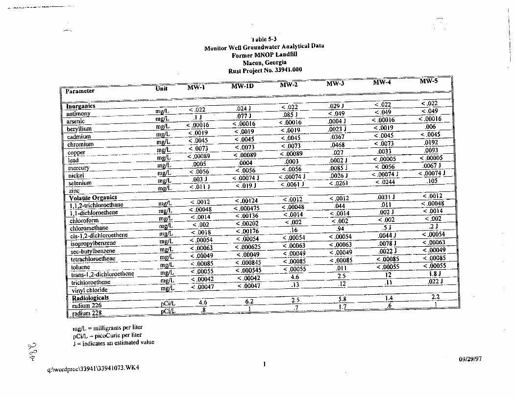
y 'cP 9
_.....--...,
·rable S-l
Monitor WeU Groundwater Analytical Data
Former MNOP Landfill
Macon, Georgia
Rust Project No. 33941.000
[Paramet~~ __ Unit ~-1 MW-lD MW-2 MW-3 -- MW-4 MW-:=J
In organics ' antimony mg/L < .022 .024 J < .022 .029 J < .022 < .022
1 arsenic mg/L .1 J .077 J .085 J < .049 < .049 < .049
beryllium mg!I..,_ < .00016 < .00016 < .000\6 .0004 J < .00016 < .00016
cadmium mg/L < .00\9 < .0019 < .0019 .0023 J < .0019 .006
chro'!!~um mg!L ·<.0045 < .0045 < .0045 .0367 < .0045 < .0045
-~~p~~ ·------·--·-·····----!!!&'h... _______ ~ :0>7_3 ____ < .0073 < .0073 .0468 < .0073 .0192
lead mg!L < .00089 < .00089 < .00089 .027 .0033 .0093
mercury mg/L .0005 .0004 .0003 .0002 J < .00005 < .00005
nickel mg/L < .0056 < .0056 < .0056 :.-------'-::.0:-:-0~85:-J'::-___ <-:-:.00:-:-=-567-:---....c..::·0:-=:0:::-67'=!-:-
selenium ------· mg!L .003 J < .00074 J < .00074 J .0026 J < .00074 J < .00074 J
zinc mg!L <.011J <.Ol9J <.0061J <.0261 <.0244 .105
Volatile Organics I, 1 2-trichloroethane mg/L < .0012 < .00124 < .0012 < .0012 .0031 J < .0012
\,1-dichloroethene mg!L < .00048 < .000475 < .00048 .044 .011 < .00048
chlorofonn mg/L < .0014 < .00136 < .0014 < .0014 .002 J < .0014
chloromethane mg/L < .002 < .00202 < .002 < .002 < .002 < .002
cis-1,2-dichloroethene mg/L < .0018 < .00176 .16 .94 .5 J .2 J
isopropylbenzene mg/L < .00054 < .00054 < .00054 < .00054 .0044 J < .00054
sec-butylbenzene mg/L < .00063 < .000625 < .00063 < .00063 .0078 J < .00063
.. t~!!!~~!~roethene mgtL < .00049 .. < .00049 < .00049 < .00049 .0022 J < .00049
J~!uen~---- _______ __ mg/L < .00085 < .00084~ < .00085 < .00085 < .00085 < .00085
trans-!,2-dichloroethene mg/L < .00055 < .000545 < .00055 .011 < .00055 < .00055
Jri~~!~roe!_hen~----·-···--------!!!&'L < .00042 < .00042 4.6 2.5 12 1.8 J
vinylchloride mg/L <.00047 <.00047 .13 .12 .ll .022J
Radiologicals radium 226 pCi!L 4.6 6.2 2.5 5.8 1.4 2.2
radiuJll228 pCi!L .8 I .7 _ 1.7 .6 1
mg!L :: milligrams per liter
pCi!L :: picoCurie per liter
J "" indicates an estimated value
q:\wordproc\33941 \33941073. WK4 09/29/97
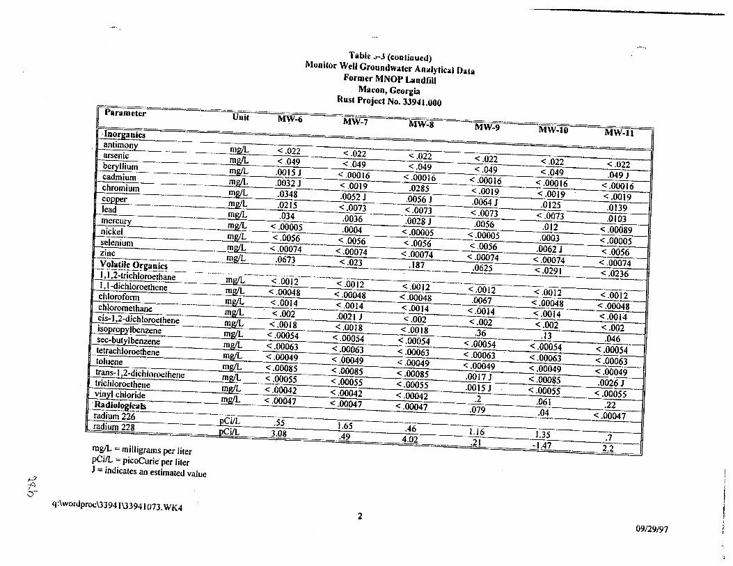
i-2 p ::)
Table .rJ (continued) Monitor Well Groundwater Analytical Data
Former MNOP Landfill Macon, Georgia
Rust Project No. 33941.000 -~~_.- ··-· r Parameter Unit MW-6 MW-7
I
In organics antimony m~ <.022 <.022 arsenic mg!L <.049 <.049 be_ryllium mg!L .0015 J <.00016 -cadmium mg/L .0032 J <.0019 chromium mg!L .0348 .0052 J copper mg!L .0215 < .0073 lead mg!L .034 .0036 mercurr m~ < .00005 .0004 nickel mg{L <.0056 <.0056 -selenium mg!L <.00074 <.00074 ~!!c m&t!: .0673 __ < .023 __ y~~~~~ Organ!~~----- __ ______ _ _____ . ____________ I, 1,2-trichloroethane mgll. < .0012 < .00 12 1 , 1-dichloroethene
chloroform chloromethane cis-1 ,2-dichloroethene isopropyl benzene sec-butylbenzene tetrachloroethene toluene trans- I ,2-dichloroethene trichloroethene vinyl chloride
· Radio~g~~----radium 226 radium 228
mg!L "" milligrams per liter pCi/L =- picoCurie per liter J = indicates an estimated value
q:\wordproc\33941 \33941073. WK4
mg/L mg/L mg/L. mg!L mg/1. mg/L mg/L mg/L mg!L mg!L mg/L
pCi/L pCi/L
<.00048 <.00048 <.0014 <.0014 -<.002 .0021 J <.0018 <.0018 <.00054 <.00054 <.00063 <.00063 < .00049 < .00049 <.00085 <.00085 <.00055 <.00055 <.00042 <.00042 <.00047 <.00047
.55 1.65 3.08 .49
MW-8
<.022 <.049
<.00016 .0285
.0056 J <.0073 .0028 J
<.00005 <.0056
<.00074 .187 --·
< .0012 <.00048 <.0014 <.002 <.0018
<.00054 <.00063 <.00049 <.00085 <.00055 <.00042 <.00047
.46 4.02
2
MW-9
<.022 <.049
<.00016 <.0019 .0064 J <.0073 .0056
<.00005 <.0056 <.00074
.0625
<.0012 .0067
<.0014 <.002
.36 <.00054 <.00063 < .00049 .0017 J .0015 J
.2 .079
1.16 .21
MW-10 M\V-11 ]
<.022 <.022 <.049 .049J
<.00016 <.00016 <.0019 <.0019 .0125 .0139
< .0073 .0103 .012 <.00089
.0003 <.00005 .0062 J <.0056
<.00074 <.00074 <.0291 <.0236
<.0012 <.0012 <.00048 <.00048 <.0014 <.0014 <.002 <.002 I .13 .046 I
I
<.00054 <.00054 I
<.00063 <.00063 <.00049 <.00049 <.00085 .0026 J <.00055 <.00055
.061 .22 .04 < .00047
1.35 .7 -1.47 ~-2 ------.
09/29/97
Final Site Investigation Report
For mer Macon Naval Ordnance Landfill
Rust Project No. 3394/.000
chromium and lead were detected the most frequently, with 7 and 8 detections respectively. One or
more samples had detected concentrations of antimony, arsenic, and cadmium that exceeded the
analyte's MCL.
Chromium was detected in concentrations ranging from 0.00521 mg!L to 0.0367 mg/L (at MW-3).
None of these detections exceed chromium's MCL of 0.1 mgtL. The two highest lead concentrations
occurred in MW-3 and MW-6 (0.027 mg/L and 0.034 mg/L respectively). Both of these detections
are above the 0.015 mg/L MCL for lead.
Antimony was detected in MW-3 at a concentration of 0.0291 mg/L. This exceeds the MCL for
antimony (0.006 mg/L), however, antimony was also detected in the duplicate sample of the
background well MW-1 at a concentration of 0.0241. Arsenic was detected in MW-2 at
0.0851 mgtL, which exceeds the MCL of0.05 mg/L. Arsenic was detected in the background well
sample at a concentration of 0.11 mg/L. Two detections of cadmium exceeded it's MCL of
0.005 mg/L - 0.006 mg!L at MW-5 and 0.0285 at MW-8. Cadmium was not detected in the
background well.
S. 7.3 Extent of Contamination
The following discussion provides a summary of the extent of groundwater contamination based
upon the data collected during this investigation. The following compounds are not discussed as
explained below:
• 1, 1,2-trichloroethane. 1, 1-dichloroethene, chloroform, chloromethane,
tsopropylbenzene, sec-butylberizene, tetrachloroethene, toluene, and
trans-1,2-dichloroethene were detected in samples collected from isolated wells, and
although these compounds may be present in groundwater they do not form a
contiguous or mappable plume area.
• Antimony, arsenic, and mercury were detected in both the background well and in
samples from downgradient monitoring wells. Based upon this, it appears that these
metals may be naturally occurring.
• Several other metals are detected at isolated and infrequent points which do not form
a continuous plume area that can be defined.
t · The analytical results indicate that the primary constituent detected in groundwater is TCE with
! Jesser amounts of cis-1,2-dichloroethene (cis-1,2-DCE) and vinyl chloride. The latter two
Q:\WORDPROC133941\33941/18. WPD 29 9/25197
FinaL Site Investigation Report Former Macon Naval Ordnance Landfill Rust Project No. 33941.000
compounds likely are degradation products of TCE. These three compounds appear to have had the most significant impact to groundwater quality and form mappable plume areas. Trichloroethene As described above. TCE is the most widely distributed compound and is present at the highest concentrations of any of the contaminants detected in groundwater. The analytical data indicate TCE is present at it's highest concentration in the shallow groundwater surrounding the landfill mass (wells MW~2, MW-4, and MW~5) and in the explosive demolition area (MW~3). The lateral distribution ofTCE is shown on Figure 5-4.
The data indicate that TCE has migrated vertically downward through the shallow aquifer(s) to a depth of at least 50 feet (MW-11). Also, based upon geologic/lithologic units, the primary contaminant migration pathways are expected to be the more permeable sands and silty sands of the underlying Tuscaloosa formation. The· downward gradients observed at the well nest (MW-4/ MW~ 11) indicate a mechanism for downward infiltration of shallow groundwater into the deeper portions of the aquifer. Shallow strata throughout the floodplain (being composed primarily of clay) may form a less conductive water bearing unit in the hydrogeologic system. The lateral extent ofTCE cannot be determined at this time based upon the data collected. It can be said, however, that TCE is present at relatively high concentrations in the shallow groundwater localized to the MNOP landfill mass and to the explosive demolition area. Lower level concentrations ofTCE at MW~9 and MW~lO, which are located side-gradient to the source areas, may be indications ofhorizontal movement of the TCE in the shallow surficial units (Figure 54). However; it is also possible that the detections in these two wells are from an upgradient source of TCE which has been recently delineated within the AlP area (Rtist, 1996). There are no l.lpgradient wells north ofMW-10 to establish the relationship to the AlP plume(s) at this time.
Based upon the data, it can be concluded that TCE does not appear to be significantly migrating through the shallow surficial unit as evidenced by an almost complete absence ofTCE in the drive point and monitoring wells (MW-6, MW-7 and MW~8) located hydraulically down gradient from the landfill. Further, screening data suggest that while TCEis absent, the breakdown products of TCE (cis-1,2-DCE and vinyl chloride) were found to be present in the shallow groundwater in the drive point screening data.
Cis~1.2-Dichloroethene The lateral and vertical extent of cis~ 1 ,2~DCE appears to be the same as TCE described above. This is as expected since this compound is believed to be present as an intennediate breakdown product ofTCE. It is noted that in MW-9 and MW-10 the ratio ofTCE to cis-1,2-DCE is about proportional
Q:IWORDPROCUJ94Jl3394J l 18. WPD 30 9125/97
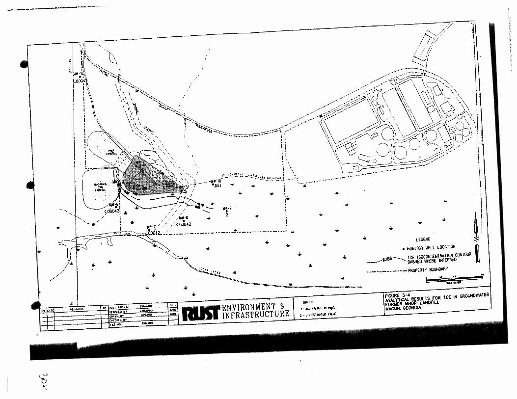
.__ .__
•
~ 'X
"
I .
1\ \ \ . \ I \ 1_, ~ \ t- \. \ >· t' \ I I \ ' '
' \ \ \\\ '<4<-\ ''' '(~ .... ' ....... ' ' ,~ . ' '
""·' \ ' · ', \
/
/
/
\
/' .............. I. • I .. II .. j I
... . ~~ ...... \~ :'\
' ' i -I \
'- ;.f..:~~ I_!.".:.,: ~~ OiJ OF oil : \
l---111\r-1(} - -·..!.•_!o~~·.:t- - •;- - ·-·-·-·-·
I •.061 ,.. .. • ... __ ,.- ... -•
!
' •
. . I ~I
y00042: ....
", // I
I/// /
/. / /
• wp .2
• • • i"'
-.- ! • / / / Mifl·ll
. ·1 / . / / / <.00042
~.CO~t..:
• ....
.... • +
-· ... --·--·--·-··-·-~---··-· -- : ··-··- ...
• •
... ....
..... ENVIRONMENT &
1~1 INFRASTRUCTURE
...
•
... ...
•
HilUS'
I • AU V.ll~S II "'9'L
2 • J • ES11U11EO Voll~
* ...
...
• ...
... ...
.,j;. oiir
• • LEGEND
• ~ITOR WELL LOCATION
___.e.\~---.....__ TCE lSOCONCENlRATION CONTOUR
DASHED WHERE INFERRED
• • --·-··- • ·-PROPERlY IIOUNOARY
... S&IIIIIP
...
TeE IN GROIJN)WATER
1'-
Final Site Investigation Report Former Macon Naval Ordnance Landfill
Rust Project No. 3394/.000
verses the ratios of these compounds in wells near the landfill which show a predominance of TCE.
A cis-1 ,2-DCE map is not presented in this report because it has a similar distribution to TCE.
Vinvl Cbloride
The lateral extent of vinyl chloride in the shallow groundwater is similar to that described above for
TCE and cis- I ,2-DCE. The distribution of vinyl chloride is shown on Figure 5-5. Vinyl chloride
is an expected breakdown product of both TCE and cis- I ,2-DCE.
5.7.4 Fate and Transport
This section discusses transport and fate of the primary detected contaminants; TCE, cis-1,2-DCE
and vinyl chloride. These constituents belong to a class of compounds referred to as halogenated
aliphatic compounds, often referred to as alkyl halides. When released to soils and surface water this
class of compounds are primarily lost to volatilization. This is due to the relatively high vapor
pressure of these compounds. Once these compounds enter subsurface soils or groundwater the
principal attenuating mechanisms are sorption, biodegradation and possibly volatilization in the
vadose zone.
t . Halogenated aliphatic compounds are subject to biodegradation under both aerobic and anaerobic
conditions (Chapelle. 1993). However, aerobic biodegradation only occurs under special conditions
and has generally been found to play a minor role in the degradation process of halogenated aliphatic
compounds. Hence, this explains the observed persistence ofTCE in most shallow aerobic aquifer
systems. Anaerobic degradation of these compounds is much more commonly observed and
documented in the literature. Numerous studies have indicated that compounds such as TCE are
progressively dechlorinated under a.na.erobic conditions; The tendency of reductive dehalogena.tion
is to transform TCE to isomers of dichloroethene (cis- or trans-) and then to vinyl chloride. Research
has also shown that complete dehalogenation in the subsurface environment is difficult to achieve
(Chapelle, 1993).
Based upon site data, it appears that the contaminants of interest are probably undergoing slow
dechlorination in the shallow water-table aquifer. Due to the proximity of the adjacent floodplain,
conditions appear to be favorable for these processes to take place.
While some transformation may be occurring in the shallow water-table aquifer, these compounds
are expected to be relatively persistent in the deeper groundwater systems of the Tuscaloosa. TCE
and it's breakdown products should be transported at approximately the same rate as groundwater
( flow. Only slight retardation will occur from adsorption to aquifer materials. The ultimate fate
Q:\WORDPROC\3394/\33941118. WPD 31 9125197
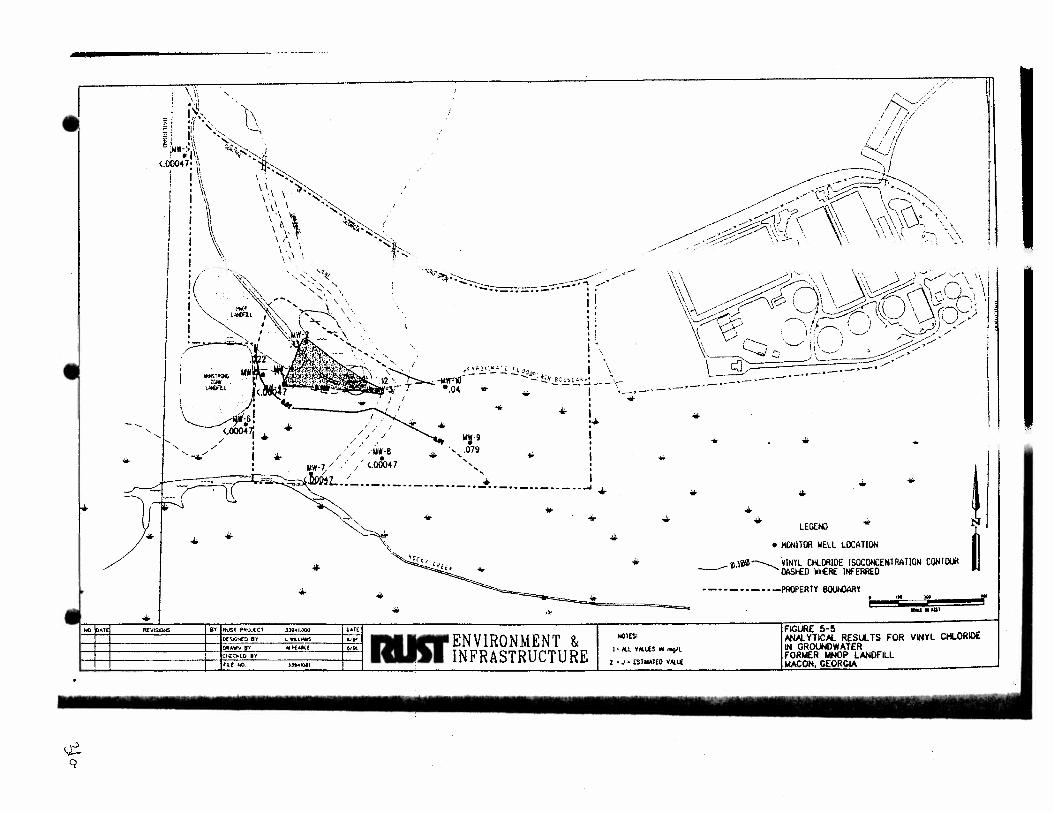
~ Q
--
Hll ~·T~
" \\\ :~ l\ '\':, 1, .•• ''{ ~-,
'I' '-' ~·, '--'I ' h: '';."-....
~~~(' / ;/,/
,/ /•/ I ,
i / ;-1 "' I :!
'/'
~~~~~-~ ','. '<'i~s-' •I\ f ••
<Jl0047• \1 c::.._.z.....it ------ .... \;
' '
i \\ • 1\ I \\
I I} : 1\ I \~
\.
~ __ .~-~
~~//Q~···,~
/__..->/('? \ \ \r "· ..... ' I , \ <"',· 1 o "·.,\ / . '~:'],. ~··.. \\ '\f\ '\. '''-- ~\ \\.\ . \
.- .. , \ ' ·. ' \\, \ ":>-.,~ ,., \ ~ '
,,_, \ "~~ i
\ ' ·· ..... ""-..:_.' \ " ·._ ..... ,;·. '~-' \ I ,. \ , \ I \\ '
\ "~ ''\.1t{: , .. " ' , ...... ,\ \
'· ' \ \
\
"'V~~~ .. --;;:(::// \~\\ ~~~\\~j\\~D;-.J~r\\1 ----~-· :.I \\. ~,A(--\\\ . \~ \. \\y'· 1-.\ 'j , , '\\ - :::::;;.---\:.v ·0.~· · 1it 1 \ r:J:::c.) •, \\"'v:::::::../<_..... ) (, '-\.'--/ \ \l • • I ,,,__...... ___ ....--\-Y ~ ... ! ! I ";---... ' ,:) ,/ I
l i 1 vc:::;; ...__.. . .~:i(....---... ; ·'---"' ~/ j
+
1 .... \ ,,., . ~~/
. \ \ :::; :~./· I; ' ........ -.... , ' . .,. ~ -" __ ....... '~/ 1ft-}l,.,J.~t rl~'~n I \ -,;-·-· 12\ ~-IIIW"'lD-----.:..::~::, • ..!;~r:_:·.:;_.:, ·-·-·-·-·-·-· 1
..... ~.ll;~=:aliii!:'Jr t •.o4 • ,.. 1 ·-..;-·-·- \ I •
• + i .. :+ I . // J
/// / ~ WJ-9 ' / / 079
/// . .:U~A8 .. "'-,~ 1 ' ' 00047 ' •
... .. ... + ..:.
IAW-1/ ,' / (, ', I t~..:'. / • ~JA1112L •• ____________________ ·-··-··-··-··_. +
+ ... ...
• + ...
* .. + I ""'"""'"' I "" I A\J$1 PR<MU l.N41.000
Of:S.C.w£0 Bl l 'Wl.Ll'M$
Cl'i:A.WW!! fll,"'£tA((
Ci-E:tkm i'1 tU: NO )~tO&I
+ ... + •
+ .. .. ..
·"'-- .. ~ .,.. ENVIRONMENT & NOTES .,.. IIIII INFRASTRUCTURE I 21 :~~~::::~
+ + LEGE!() +
• MONillll WELL LOCA liON
___..-~.\~---...._VINYL CHLil!IOE ISOCOt£EtilRATION CONlWI OASHEO Wl£RE INFERRED
·-··-··-··-PROPERlY BOUNOARY oM "' ......... --"'
FIGURE 5·5 N'W. YTICN. RESll. TS FOR VINYL Ctt.ORIO£ IN GROUNDWATER fORMER MNOP LANDFILL W.CON, GEORGIA
!, '
/ ;
Final Site Investigation Report Former Macon Naval Ordnance Landfill
Rust Project No. 3394/.000
of these .contaminants wiJJ primarily be discharge to the floodplain and surface waters of Rocky Creek. or continued transport and migration into deeper aquifers.
Q:\WORDPROC\3394JU394/Il8.WPD 32 9125197
.•'-
Final Site lnvesligation Report
Former Macon Naval Ordnance Landfill
Rust Project No. 3394/.000
6.0 ADDITIONAL ENVIRONMENTAL SAMPLING
6.1 SURFACE WATER
Surface water samples were collected from (1) multiple points along Rocky Creek, (2) overland
drainage areas between the MNOP Landflll and Rocky Creek, and (3) sampling points along the up
slope drainages to the landfill site. The Rocky Creek sampling locations included two sampling
points approximately 1000 feet downstream of the landfilJ (LSW-8 and LSW-9), a number of points
near the probable point of entry for overland drainage from within the MNOP property boundaries
(LSW-4 through LSW-7) and two sampling locations up gradient (LSW-1 and LSW-2) as shown
on Figure 6--1. Two of the overland drainage area sampling locations were located in the drainage
easement right of way (LSW-5 and LSW-10) and one point was located at the outfall from the pond
area (LSW -11 ). QC samples, consisting of replicates and trip blanks were also collected. Quality
assurance (QA) samples (splits) were also collected and submitted to the USACE, SAD Laboratory
located in Marietta, Georgia.
All surface water samples were analyzed for volatile organic compounds (EPA, 8260), semi volatile
organic compounds and polynuclear aromatic hydrocarbons (EPA, 8270) and priority pollutant
metals (EPA, 6010, 7060,7421, 7740). Explosive residues (EPA, 8330) were tested in all samples
except for LSW -12 and LSW -13. The sampling and analytical program implemented is outlined in
Table 6--1.
6.1.1 Procedure
Surface water sample locations were approached from the creek bank and from the downstream
direction to prevent possible disturbance of sediments or contamination of surface water by field
personnel during sampling. Field parameters (pH. temperature, and conductivity) of the surface
water were determined at each sample location. Samples for VOC analysis were collected at a
depth of 0-2 inches from the water surface using a new glass jar. Sample vials were filled with
in such a manner as to exclude air bubbles. Sample containers for other analyses were filled in
a similar manner. The samples were properly documented, placed on ice, and shipped to the
analytical laboratory.
6.1.2 Results
A total of thirteen surface water samples were collected in the Landfill area at the sampling locations
depicted in Figure 6-1. The results of these analyses are summarized in Table 6--2.
Q:\WORDPROC\33941\3394// JS.WPD 33 9125197
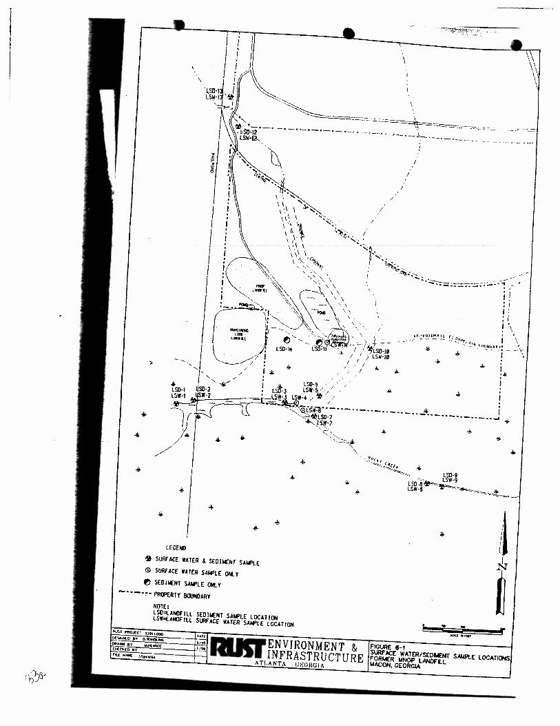
... .. ..
I . I >
.. • //
..;.
•
LEGEND
& SURFACE WATER & SEDIIIENT SAt.Ft.E 0 SURF ACE WATER SAif'lE 01«. Y f!) SEDIIIENT SAII'LE ONlY
..;.. • •-.,. • P!UPERTY BOJI«<ARY
NOTE: LSD=t.ANOf Ill SED!NENT SAII't.E LOCA ll~ lSWolAIIOfiLL S~ACE WATER SA..,tE LOCATIOH
:::::·;·-:·:-: . .:. :.:. ··:.:. -- , __ .. ~ --Jl.-- -- ~~ .. - ... _, __ ,._ "
I
I
I
/
.. ... r FIGURE 8-1 SURF ACt WATERISEOIWENT S..w>I.E LOCATIONS FORMER YNOP LANOFLL MACON, GEORGIA
< .__;;,.; 'iS
Matrix s!! s.! ... Sa~~
Solrfa(e Water 11 I I
from Rocky Creek aad dowapdiCPt
ofladlill II I I
II I I
II I I
S.rfaceWakr 2 I I
from property line
2 ' I
2 I I
SediiHIII 10 I I
from 1toacy Creek 11¥1 dowllpdiclll
of '-IIlii 10 I I
10 I I
10 I I
~· 2 I I
from. p«lpCCl''y lise
2 I I
2 I I
(I) Pet EM-200.1-3, Table 1-1,31 Man:h 9S.
q:\wordproc\39-44 1133~ 1111. WK4
Trip
l"ab •• -1
Slarfa<e Water, Sdimtnt Samplill& ....S Analylkal k«Juin•tnts
f~r MNOP Landfill
Mac.., Georzia Rat p,.ject N-. ll94 I .000
··-· A.ai;1ical Total
Blanks Sa•JOIH Analym Protocol Procodllrn
2 IS voc SW-846 EPA 8260
-0 n SVOCJPAtl SW-846 EPA 8270
----0 13 Explosive SW-846 EPA 8330
Residues -0 13 Priority SW-846 EPA6010,
Polluuw 7060. 7421,
Metals 1740
I 5 voc SW-846 EPA&l60
·----·
0 4 SVOCJPAH SW-&46 EPA &170
·--~-·~·
0 4 Priority SW-840 EPA6010,
Pollllt•t 7060,7421,
Metals 7140
0 12 VOC SW-846 EPA 1260
--·
0 12 SVOCJPAII SW-&46 EPA 8270
0 12 Priority SW-840 EPA6010.
Pollulanl 7060,7421,
Metal$ 7740 ---
0 12 F-'lplo.ivc SW-846 F.PA 1330
Residue.
0 4 voc SW-&46 EPA8l60
-0 4 Priority SW-846 EPA 6010,
Pollulaftl 7060,7421.
lloklin&~ TilDe
14 dayl
7140days
14140 days
1&0 days, 28 days for
lA etC\! I'/
14 days
7140 days
1&0 days. 28daysfor
mercury
14 days
7140 days
1&0 days. 21 days for
Bletal!)'
14140 days
14 days
1&0 days. 28 days for
Metals n4o ------~J!!l.._ - -
0 4 SVOCIPAH SW-84Ct EPA 8270 7140 day•
- ·---
Praenatiea s,t;.pie (I) Total~-
R"'llin-11 Ct~~~taiKn Containers
Icc to 4 dcpces C 2-4011ll 30
Add HO to pH<2 JWs orNaHS04 sc~ vial -----
Icc to 4 de&rcel C HL 26
amber &!ai5
lccto4~C 2-ll. 26 1111bcrl!au
HN03topH<1 I-ll 26
Icc lo 4 dcpce$ C &lass or olastic
Icc to 4 dcJ!rces C 2-40 IIIL 10
Add Ha to pH<2 ,w. orNaHS04 sc~vial
Icc to 4 dcpccs c 2·1L 8 I llllbcr slass -j
HN03topH<1 I-ll. 4 I Ice to 4 depoe~ C glauor
lliaslic
Ice to 4 dcpt~CS C I-12Sml 12
cJass squvial --
Ice 10 4 dearccs C l·loz 12
..J!au
Icc to 4 degrees C l·loz 12 class
------
Icc lo 4 dcpces C 1-4 oz 12
dass
Icc 10 4 dcptiCS C H2Sml • &lass
sepia vial ~
Icc to 4 dcarccs C 1-loz I
4
gl.us I -~----·-· ---1
Ice to 4 depccs C 1-&oz 4 .J ~lass __ _
09129197
d:; .,_, ('
Parameter Uait LSW-1
loon:aaicS · .. ••· •·•· . ·.·
cadmium mglk <.0019 chromium mgll. <.004S copper mgll.. <.0073 lead mgll.. <.00089 mercJIIY_ mgll.. <.00005 nickel mgll, <.0056 zinc lll&fL._ <.0207 Volatile Oruaks .. . . . •~ bromomethanc mgll. <.00049J cis-1,2-dichloroetbcne m_&/h_ <.0018J trichloroctbcnc m_&/l._ < .00042 J
mg/L - milligrams per liter J "' indica&es an estimated value
q:\wordproc\33941\33941073.WK4
Table6-2 Surface Water Aaalytical Data
Former MNOP LaudfiU Macoo, Georgia
Rust Project No. 33941.000 ~-- -LSW-l LSW-3 LSW-4
<.0019 <.0019 <.0019 <.004S <.0045 <.0045 <.0073 <.0073 <.0073 <.00089 <.00089 <.00089 <.00005 <.00005 <.00005 --<.0056 <.0056 <.0056 < .017 J < .02J < .018 J
<.00049 <.00049 <.00049 <.0018 <.0018 <.0018 <.00042 <.00042 ~,Q0042
LSW-S LSW-' LSW-7 LSW-8 I I <.0019 <.0019 <.0019 <.0019
<.0045 <.0045 <.0045 <.0045 <.0073 <.0073 <.0073 <.0073 I
<.00089 <.00089 <.00089 <.00089 <.OOOOS <.00005 <.00005 <.OOOOS <.0056 ~ .0141 <.0056 <.0056 < .019J <.0479 < .019J < .018 J
<.00049 <.00049 <.00049 <.00049 <.0018 <.0018 <.0018 <.0018 ' <.00042 ~_,_Q0042 _ _ _< .OOQ4L _ < .Q()Q4_]
HW2'J/97 l
l
23 9'
Parameter
J~qa-.ks > - _·.•. .· <
cadmium chromium copper
Unit
mgiL m&IL ffig/L .
·~ ----·--·- --- ------ .. --m211;-
mercury_ mg/l
nickel milt zinc mltll
VOlatile Ornaks · ·.· .. ·
bromo methane mgll.
cis-1,2-dichloroethcne mgll.
trichloroethene mRit
mgll. • milligrams per liter J • indicates an estimated value
q:\wordproc\33941\33941 073. WK4
LSW-9
<.0019 <.0045 <.0073 <.00089 <.00005 <.0056 <.016J
<.00049 < .0018 <.00042
Table 6-l (continued)
Surface Water Aoalytkal Data
Former MNOP Landfill
Macoa, GeorJia
Rust Project No. 33941.000
-LSW-10 LSW-11
-
.0023 J <.0019
- -- ---
LSW-llD
.0033 J
<.0045 <.0045 <.0045
<.0073 ·---:-oo97T ___ ---·~oos3 J
.0049 .0053 .0037 -·
<.00005 .0003 .0003
<.0056 <.0056 < .0056
.0574 .107 .106
<.00049 <.00049 <.00049
.051 < .0018 <.0018
.38 <.00042 <.00042
2
-- --,
LSW-ll LSW-llD LSW-13
·-· ~
.00949 <.0019 <.0019
<.0045 .0052 J <.0045
<.0073 <.0073 <.0073 ___
<.00089 <.00089 <.00089
.0002 J <.00005 .0002 J
<.0056 <.0056 <.0056
.046 <.0424 <.0346
-<.00049 <.00049 .0026 J
<.0018 <.0018 .0049 J
.0086 .0069 .032
(l9/19N7
Final Site Investigation Report Former Macon Naval Ordnance Landfill
Rust Project No. 33941.000
The results of the eight surface water samples collected from Rocky Creek indicate that surface waters do not exhibit the presence ofVOCs, SVOCs, explosive residues, or priority pollutant metals except for a single detection of nickel in the sample collected at location LSW-6. Nickel was detected at a concentration of 0.014 J mg/L which is below the Georgia in-stream water quality standard of 0.088 mg/L.
The remaining five surface water sample locations were collected from drainage features located within the boundary of the former MNOP. Two of these points are located on the tributary of Rocky Creek where it flows onto the northwest side of the MNOP property; LSW-12 and LSW-13. These locations are the point of entry for surface waters entering the northern part of the site. The results of sampling indicate the presence of TCE at a concentration of 0.007 mg!L to 0.032 mg!L at LSW-12 and LSW-13, respectively. In addition, trace concentrations (less than 0.005 mg!L) of bromomethane and cis;1,2-dichloroethene were also detected in samples collected from LSW-13. Inorganics detected at these points include cadmium, chromium, mercury and zinc. Georgia in-stream standards were exceeded for cadmium (0.0007 mg!L) at LSW-12 and for mercury (0.000012 mg!L) at both LSW-12 and LSW-13. TCE has an in-stream standard of0.080 mg!L but was not exceeded at these upstream points.
The results of surface water sampling at LSW-10, located in the drainage easement east of the pond and landfill refuse area, indicate the surface water in this overland flow area exhibits the presence ofTCE (0.38 mg!L), cis-1,2-dichloroethene (0.051 mg!L), and a number ofinorganics including cadmium (0.0023 J mg/L),lead (0.0049 mg!L), and zinc (0.0574 mg/L). Georgia in-stream water quality standards were exceeded for TCE, cadmium and lead at this point. Cadmium and lead have Georgia in-stream standards of0.0007 mg!L and 0.0013 mg/L, respectively.
The results of sampling at LSW -11, which sampled surface water discharging from the pond located immediately east of the landfill, indicated that no VOCs, SVOCs or explosive residues were detected in surface water at this location. However, several inorganic parameters were detected including lead (0.0053 mg/L), mercury (0.0003 mg/L), copper (0.0097 J mg!L) and zinc (0.107 J mg!L). Georgia in-stream water quality standards were exceeded for lead, mercury (0.000012 mg!L), and copper (0.0065 mg!L).
The remaining surface water point located in the drainage easement (LSW-5) did not reveal any target analytes above the laboratory quantitation limit
Q:\WORDPROCUJ94/IJ3941 118. WPD 34 9125197
6.2 SEDIMENT SAMPLING
Fino/ Site Investigation Report
Former Macon Naval Ordnance Landfill
Rust Project No. 33941.000
Twelve sediment samples were collected at the locations depicted in Figure 6-1. Six sediment
samples were collected within the former MNOP Landfill property and six were collected from
Rocky Creek. QC samples, consisting of replicates and trip blanks were collected. Quality
assurance (QA) samples (splits) were also collected and submitted to the USACE, SAD Laboratory
located in Marietta, Georgia.
All sediment samples were analyzed for volatile organic compounds (EPA, 8260), semi volatile
organic compounds/polynuclear aromatic hydrocarbons (EPA, 8270) and priority pollutant metals
(EPA, 6010,7060,7421, 7740). Explosive residues (EPA, 8330) were tested in all samples except
for LSD-12 and LSD-13 located at the northwest (up gradient) comer of the site. The sampling and
analytical program implemented is outlined in Table 6-1.
6.2.1 Procedure
Sediment samples were collected at each station to represent stream bed or drainage area
sediments. A clean, stainless steel spoon or grain scoop was used to collect the sample. For
VOCs, the sample container was gently tapped as the sample was placed in the container, and the
container was completely filled to eliminate any headspace. For other analyses the sediment was
gently mixed, quartered, and placed in the sample containers.
6.2.2 Results
The results of sediment sampling are provided in Table 6-3. All samples within the boundary of the
MNOP property had various inorganic parameters. The inorganics detected included beryllium.
cadmium, chromium, copper, lead, mercury, nickel, selenium, silver, and zinc. Beryllium,
chromium, copper, lead, nickel and zinc were detected at similar concentrations in LSD-12 and
LSD-13 (northwest tributaries upgradient from Landfill) and in LSD-I and LSD-2 (up gradient points
in Rocky Creek) as compared to sediment sampling points within the MNOP boundary (LSD-5,
LSD-I 0, LSD-Il, and LSD-14 ). Hence, it is concluded that these inorganic parameters are probably
naturally occurring in the sediments. Cadmium, however, was detected at concentrations which
appear elevated. In addition mercury, selenium, and silver were not detected in any upgradient
sediment sampling points. Cadmium was detected at it's highest concentration within the MNOP
boundary at LSD-14 (17 mg/Kg) compared to the 0.95 mg!Kg to 1.42 mg!Kg detected at upgradient
sediment locations. Mercury and selenium were detected at one sampling point (LSD-5) at
concentrations of0.975 mg/K.g and 0.9 J mg/Kg. Silver was detected in one sample (LSD-11) at a
concentration of 1. 7 mg!Kg.
Q:\WORDPROC\JJ94/UJU//18.WPD 35 9125197
-1,1
' I
:::> ~s
<{,
Table 6-3 Sediment Analytical Data Former MNOP Landfill
Macon, Georgia Rust Project No. 33941.000
rr=;;;:===:=======~=~~:===c=~~=- -· ....... ,·.·c..·"-~~=--~ . ··-··- _,
Parameter Unit LSD-1 LSD-l LSD-3 LS0-5 LS0-7 LSD-8 LS0-9
I•of&allks beryllium
mg/kg .3 J .38 J .24 J .43 J .04 J .35 J .38 J
cadmium mg/kg < .42 .47 J .49 J 5.09 < .23 .65 J 4.88
~ chromium mg/kg 1
14.5 15.7 8.29 35 1.1 J 10.9 15.6
copper mWka · 9.41 9.09 4.74 20.3 < .9 . 7.1 11.5
lead 42 28.7 __ 18.6 __ 53.4 3.79· 13.9 22.5
11
mere < .13 < .067 .058 J .975 < .038 .15 J < .077
nickel 3.2J 4.54 ---w- 5.88 .6J 3.1J 3.1J
selenium < .17 < .12 .61 J .9 J < .09 .69 J .57 J
silver < .44 .< .31 < .28___ < .38 < .24 < .33 < 34
zinc 27.2 3L2 27.6. 45.7 4.73 30.6 37.7
Volatlte 0t"Eanks bromomethane mg/kg ·--<-])(}IT- < .00079 J < .0007 J < .00095 < .00059 < .00082 < .00084
1 cis-1,2-dichloroethene mg;kg --< .004 < .0029 J < .00~6 < .0034 < .0022 < .003 < .0031 11
o-xylene mg!kg < .0032 < .0023 J < .0021 < .0028 < .0017 < .0024 < .0025
see--butylbenzene mg/kg < .0014- < .001 J < .00091 < .0012 < .00076 < .0011 < .OOll
--- < .0013 < .00095 j < .00085 < .0011 < .00072 < .00099 < .001
< .0012 < .00088 J < .00079 < .0011 < .00067 < .00092 < .00095
~~=~=~----~~~--<~·~0009=~5 ___ <~~~6=8~1 ___ <~~=0~6~-- <~n <~t <~1 <~n ~ < .0011 < .00076 J < .00068 < .00092 < .00057 < .00079 < .00082
SeJI~ijleOrganle$ 1~=~~=~=-----:~~---::;:-<~.3~----::<:-'.2:;;1;---- < .19 ____ .76 < .16 < .22 ___ .75 I
llll--::=:=~:.:.::-:::..:::::.::==----_..::.=-:;:c~.---<..:...::.l:.::9...:... ____ <..::.1~3--- < .12 < .32 <.I < .14 . .21 J
l!-===:=ll:u;::t::a:.:'.'..:;L:..~:-:----.:;;I;=cl'----<-=.2:..:.7 ____ <_..:,:.1:..:::9 _____ <_..:;.1:.;_7~~----· 1.2 < .15 < .2 1.1 0 ~
t!-=;:::x=-=-=:.t..=:.:.t..=.==="---'"'~::oz....---<-2~----<-=::1.~4 _____ <....:1,.:::.3 _ < 3.4 < t .I < 1.5 < 1..:.~1
-=:=::~=-:---::-:--:--------'-~:-=""----<..:.:.3:-::6~ ____ <...:.2=-=6:__. < .23 < .62 < .2 < .27 .59 -
< .34 < .24 ==----z-.22 ___ --- <.58 < .18 < .25 ··--<26 ~
< .2 J <.I 5 < .13 < .35 < .II < .15 < .16
lf--L..;..;..;_:=.o.:..;;.._;,;_:. _______ ~""------------=----·-·-·----
----i
~=============~~=====<=.3====-==<~.2='=====<==.1~9 <.51 < .16 < .22-- . --- .26 J
mglkg ,.. milligrams per kilogram J ... indicates an estimated value
q:\wordproc\33941\33941073.WK4
09/29/97
l •l
l I
:> '"'S ¢
.-.. ""' ~\
I hrameter Unit
laor& .. ks. .. -···· .·: ... ·.· beryllium m21k2
cadmium m21kR
chromium mglkg
copper - m21ka
lead mglkg
mercury mR!ka
nickel mglkg
selenium mglkg
silver mWkR
zinc mglkg
VolatUeQmuks · · .-·_· -·•- . · .. · .. bromomethane mglkg
cis-I ,2-dlchloroethene mglkg
o-xYlene mglkg
sec-butyl benzene mg/kg
tert-butylbenzene mg/kg
trans-1..2-dich1oroethene mg/kg
trlchloroetbene mltika
vinyl chloride mglkg
Semlvolatlle :()rgalliet .•.. _ -·_ .-· -· . :' .:.
benzo(a)pyrenc malka
oetlZO{ o 1 ftuoranthcne mg/kg
beJ1ZO{ a.h. i)perylene mwkR
bis(2-ethylhcxyl)phthalate rnglka
chrysene mg!kg
di-n--butyl Dhthalate mglkg
phenanthrene mglkg
pvrene mRikfE
mglkg = milligrams per kilogram
J "' indicates an estimated value
q:\wordproc\33941\33941073. WK4
LSD-10 I
- ~c
.19 9.87 921 15.9 42.4
<.036 3.35 <.II <.28 72.6
.. '
<.0007
.0086
<.002
<.0009 <.()0084
<.00078
<.0006
.0033 -.
.8 .36 .83
1
1 },6
.66 <.22 < .13
.34
: Table 6-3 (continued)
Sediment Analytical Data
. Former MNOP Laadfill
1 Macon, Georgia
Rust Projeet No. 33941.000
LSD-11 LSD-IlD LSD-ll ,
i I
i
i
.15 .16 .19
8.91. 7.41 1.42
19.3 16.4 8.14 -48~8 SJ 7.48
52.2 49.1 32.1
<.047 <.044 <.039
8.18 5.2 2.8
< .14 < .13 < .11
1.7 1.89 <.3
136 140 58.3
' <.00092 < .00086 <.00075
.0081 J <.0031 <.0027
<.0027 .0027 J <.0022
<.0012 < .0011 <.00097
<.0011 <.001 <.00091
.0034 J .0023 J <.00035
.0042 J <.00074 <.00065
<.00089 <.00083 <.00073
< .25 --z:23·--
LSD-JlD LSD-13 LSD-14
.17 .058 .23
2.64 .95 17
7.3 3.57 15.8
9.42 2.4 73.7
29.2 9.31 41.6
<.038 <.032 <.It
2.4 <1.3 10
<.II <.094 < .33
<.29 < .25 <.86
53.2 22.7 230
.015 <.00062 < .0021 J
<.0026 <.0022 < .0078J
<.0021 < .0018 < .0063 J
<.00094 <.0008 .019 J
<.00088 <.00075 .015 J .
<.00082 <.0007 < .0024 J
<.00063 < .00054 < .0019J
<.00071 <.0006 < .0021 J
---
~-~~---------~~----..___S.:_!?. ____ "'·-·-- ~-:5~!_ ___
- . ·-- -··<-:~6 ___ - . ---·<:14 .14 . < .12 < .l < .36 J
<.23
'"-~
-<.sJT-
<.21 <.19 < .18 <.15
·-~~ ~ ·-~·-
---------
2.3 1.8 <1.4 < 1.3 <1.1 < 3.8 J -·------
<.3 <.28 <.25 <.24 <.2 < .71 J
-<.28 .32 <.23 <.23 < .19 <.661
~·~·~-~ -·
< .17 <.16 .15 <.14 < .12 <.41
-<.25 <.23 __ ~-~~-
<.2 < .17 <.58 J
2
09/29197
----------------------'"7V
~~
' -· ... ' ........ '' ,_ ... ,") ..
Final Site Investigation RepOI't Former Macon Naval Ordnance Landfill
Rust Project No. 3 394/. 000
Two locations, LSD·IO and LSD-II, contained multiple detections of both SVOCs and VOCs (Table 6·3). These two locations are southeast of the landfill area. Two locations, LSD·5 and LSD·l4, evidenced detections of a limited number ofSVOCs and VOCs. VOCs and SVOCs were generally not detected in the upgradient sediment locations except f<?r a single, possibly anomalous. detection of bromomethane (0.0 15 mg/K.g) in LSD·l20, a replicate sample taken at LSD· 1 2. No explosive residue compounds were detected in any of the samples analyzed.
AJI six sediment samples from Rocky Creek contained one or more of the inorganic parameters listed above for samples collected within the MNOP boundary. ·However, concentrations of these inorganic parameters were generally found to be within the same range of values as the upgradient sediment sample locations. No VOCs or explosive residue compounds were detected in any of the Rocky Creek sediment samples. SVOCs were not detected in any other samples except for LSD-9 (downstream point) which exhibited the presence of benzo(a)pyrene, benzo(b)fluoranthene, benzo(g,h,i)perylene, chrysene, and pyrene (Table 6·3).
6.3 BIOTA SAMPLING
6.3.1 Procedures
Biota sampling was conducted at Rocky Creek, which runs along the southern portion of the former MNOP Landfill site. Collection of aquatic life (i.e., fish) was done by electrofishing both up stream and down stream of the landfill.
ElectrofishingofRocky Creek took place on March 25 and May I, 1996. Fish collected during both sampling events, include: redear sunfish (Lepomis microlophus), redbreast sunfish (Lepomis auritus), longear sunfish (Lepomis mega/otis), bluegill (Lepomis macrochirus), largemouth bass (Micropterus salmoides), white crappie (Pomoxis annularis), redfin pickerel (Esox americanus), American eel (Anguilla rostra/a), gizzard shad (Dorosoma cepedianum), silver redhorse sucker
(Moxostoma anisurum), spotted sucker (Minytrema melanops), creek chub (Semotilus atromaculatus). golden shiner (Notemigonus crysoleucas), Ocmulgee shiner (Cyprinella call izera), and inland silverside (Menidia beryl/ina). During the March sampling, no samples for contaminant analysis were collected due to stream access problems, and rising water levels due to thunderstorms. Samples for contaminant analysis were obtained during the May 1, 1996 sampling event. Samples collected include four fish caught from down stream locations- a bluegill (138mm), white crappie (I85mm), spotted sucker (438nim), and a silver redhorse sucker (345mm). A spotted sucker (394mrn) was also caught up stream (200-500 feet upstream of the Central Railroad tracks) of the landfill area. All fish were filleted in the field prior to shipment to the lab.
Q.\WORDPROCUJ9il\JJ9il I J8.WPD 36 9125197
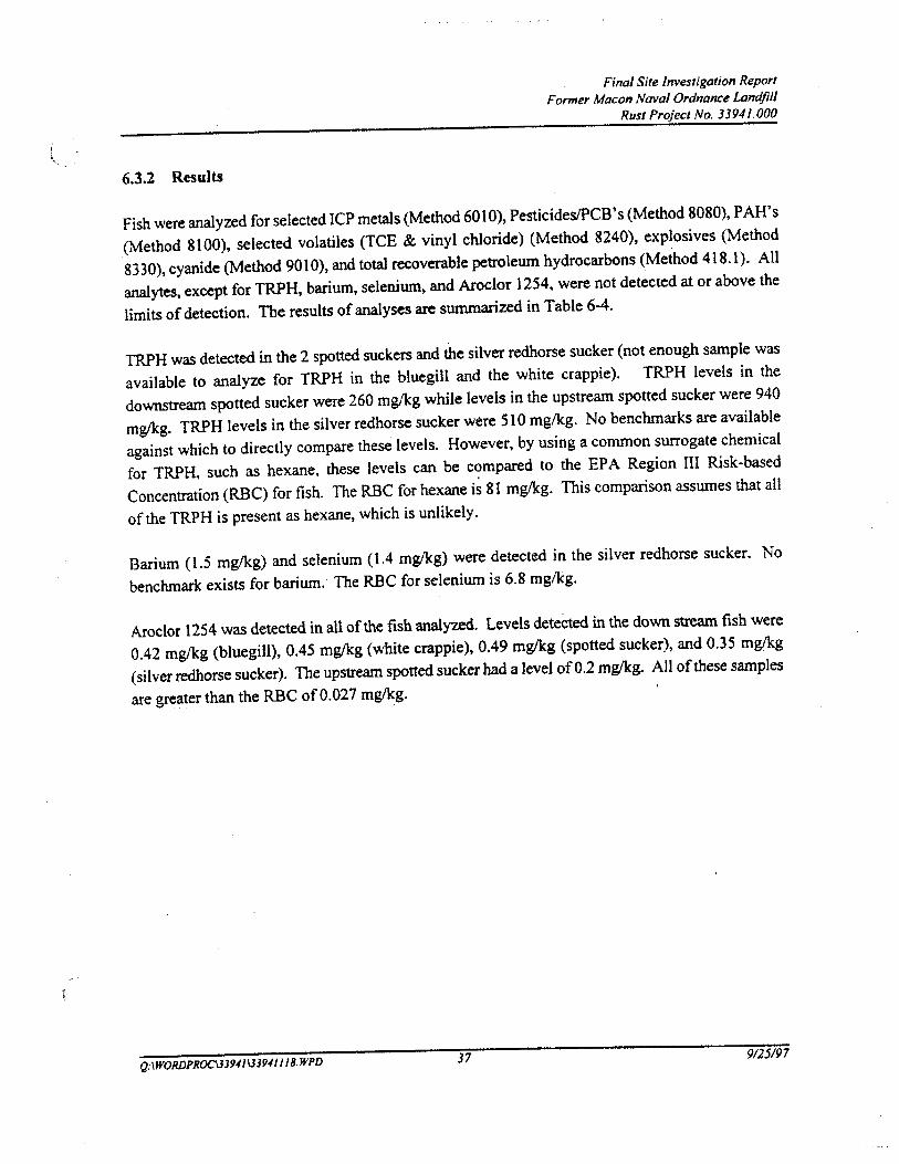
' \ 6.3.2 Results
Final Site Investigation Report
Former Macon Naval Ordnance Landfill
Rust Project No. 33941.000
Fish were analyzed for selected ICP metals (Method 601 0), Pesticides!PCB 's (Method 8080), P AH' s
(Method 8100), selected volatiles (TCE & vinyl chloride) (Method 8240), explosives (Method
8330), cyanide (Method 901 0), and total recoverable petroleum hydrocarbons (Method 418.1 ). All
analytes, except for TRPH, barium, selenium, and Aroclor 1254, were not detected at or above the
limits of detection. The results of analyses arc summarized in Table 6-4.
TRPH was detected in the 2 spotted suckers and the silver redhorse sucker (not enough sample was
available to analyze for TRPH in the bluegill and the white crappie). TRPH levels in the
downstream spotted sucker were 260 mglkg while levels in the upstream spotted sucker were 940
mglkg. TRPH levels in the silver redhorse sucker were 510 mglkg. No benchmarks are available
against which to directly compare these levels. However, by using a common surrogate chemical
for TRPH, such as hexane, these levels can be c~mpared to the EPA Region III Risk-based
Concentration (RBC) for fish. The RBC for hexane is 81 mglkg. This comparison assumes that all
of the TRPH is present as hexane, which is unlikely.
Barium (1.5 mglkg) and selenium (1.4 mglkg) were detected in the silver redhorse sucker. No
benchmark exists for barium; The RBC for selenium is 6.8 mg/kg.
Aroclor 1254 was detected in all ofthe fish analyzed. Levels deteCted in the down stream fish were
0.42 mg/kg (bluegill), 0.45 mg/kg (white crappie), 0.49 mg/kg (spotted sucker), and 0.35 mglk.g
(silver redhorse sucker). The upstream spotted sucker had a level of0.2 mglkg. All of these samples
are greater than the RBC of 0.027 mg/kg.
Q:\WORDPROCUJ941\JJ94/I/8.WPD 37 9125197
-..a ~ ;:;.. 'V
--....
Table 6-4 Biota Analytical Data
Former MNOP LandfiU Macon, Georgia
Rust Project No. 33941.000
[ Parameter
. l.llotgaai.:s-•:· _ .. -: --.-_-·>: - < -'-barium selenium Pesddd..wPC8s - ' ! .:-.
arocJor 1254 PM· _; < -___ -- __ -•--•:-•. ~·-_·:-·-
total petroleum hydrocarbons
mglkg =milligrams per kilograms NA =not analyzed BG-1 =Bluegill (138 mm) SU-I= Spotted Sucker(438 mm)
Unit
mg/k2 mwlq~
m!¥ki
mglkg
SU-2 =Silver Redhorse Sucker (345 nun) SU-3 = Spotted Sucker (394 mm- Upstream) WC-1 =White Crappie {185 nun)
g:\wordproc\33941 \33941075.WK4
-- -BG-1 SU-1 ~ 5/0l/96 5/01/9~
<1.1 < 1.1 < 1.1 <1.1
.42 .49
NA 260 --- -- -
_.-.
SU-2 SU-3 WC-1 5/01/96 5/01/96 5/01/96 ....
1.5 <I <I 1.4 <I < I
.35 .2 .45
510 940 NA -
09/29/97
Final Site Investigation Report
Former Macon Naval Ordnance Landfill
Rust Project No. 33941.000
7.0 ENVIRONMENTAL RECEPTORS
Access to the former MNOP Landfill site is gained through several routes including two dirt roads
entering the property from the AlP property to the north and one from a gravel road entering from
the Annstrong Cork property to the west. All three roads converge at the northwest comer of the
.property where a dirt road leads south to the landfilled area. The landfill occupies approximately 15
acres while the remaining property is undeveloped. A new chain-link property fence has been
erected on the Armstrong Cork property near the southwestern edge of the landfill. All other
portions of the site have unrestricted access. Several drainage features flow across the site from
north to south discharging into Rocky Creek. Two areas of ponded water have been identified, one
west and the other immediately east of the landfill.
An ecological reconnaissance of the fonner MNOP Landfill site was conducted on May 2, 1996.
The Rocky Creek floodplain, which lies immediately south and downgradient of the landfill, was
also visited as part of the biota sampling discussed in Section 6.0. The following paragraphs discuss
the findings of the reconnaissance.
• The vegetation over the landfill had recently been disturbed due to field investigation
efforts. There was no canopy layer, although small scattered trees were noted. The
trees present were small (up to 20 feet) and included loblolly pine (Pinus taeda},
box-elder (Acer negundo), white ash (Fraxinus americana), chinaberry (Melia
azedarach), and wild black cherry (Prunus serotina). The shrub layer was also
patchy, and contained the following species: Groundsel-tree (Baccharis halimifo/ia),
smooth sumac (Rhus glabra), and Chickasaw plum (Prunus angustifolia). The herb
layer was dense over all of the landfill except for the north-central portion, where the
ground was bare due to recent bulldozer activity. Herbs which are present over the
rest of the landfill included trumpet-creeper (Campsis radicans), red sorrel (Rumex
acetose/la), Japanese honeysuckle (Lonicera japonica), goldenrod (Solidago sp.),
blackberry (Rubus al/egheniensis), broom-sedge (Andropogon virginicus), passion
flower (Passijlora incarna), vetch (Vicia sp.), and sassafras (Sassafras albidum)
seedlings.
The Rocky Creek floodplain, located immediately south of and downgradient from·
the landfill, is fairly mature, and has a closed canopy. Dominant species in the
canopy layer include red maple (Acer rubrum), sycamore (Platanus
occidentalis),black willow (Salix nigra), black gum (Nyssa sy/vatica var. biflora),
box-elder, and cherrybark oak (Quercus fa/cat a var. pagodaefolia). The shrub layer
is sparse, and most components are saplings of the previously noted tree species
Q:\WORDPROC\3394/\339411 /8. WPD 38 9/25197
Final Site Investigation Report Former Macon Naval Ordnance Landfill
Rust Project No. 33941.000
(especially red maple). Other species present in this stratum include dog-hobble (Leucothoe axil/aris), strawberry bush (Euonymus americanus), bayberry (Myrica cerifera), and Virginia-willow (!tea virginica). Dominants in the herb stratum include manna grass {Giyceria striata), soft rush (Juncus effusus), lizard's-tail (Saururus cernuus), sensitive fern (Onoclea sensibilis), green arum (Peltandra virginica), sedge (Carex comosa), bur-reed (Sparganium americanum), cane (Arundinaria gigantea), false nettle (Boehmeria cylindrica), butterweed (Senecio glabellus), Virginia-creeper (Parthenocissus quinquefolia), poison-ivy (Toxicodendron radicans), muscadine grape (Vitis rotundifolia) and, in the wettest areas (including some sluggish portions of Rocky Creek proper), parrot-feather (Myriophyllum aquaticum).
• The only mammals observed in the immediate vicinity of the landfill were two coyote (Canis latrans). Tracks of white-tailed deer (Odocoileus virginianus) were also observed. Birds noted in the immediate vicinity of the landfill include indigo bunting (Passerina cyanea), northern cardinal (Cardinal is cardinalis), and mourning dove (Zenaida macroura).
Mammal signs observed within the Rocky Creek floodplain include trees gnawed by beaver (Castor canadensis), and tracks of dogs (Canis domesticus) and white-tailed deer. Birds observed in the floodplain (including Rocky Creek) include a great blue heron (Ardea herodias), Carolina chickadee (Parus carolinensis), brown-headed cowbird (Molothrus ater), and numerous other songbirds. Reptiles observed within the floodplain include an eastern box turtle (Terrapene carolina) and an unidentified snake.
• Invertebrates observed within Rocky Creek include water striders (Order Hemiptera; Family Gerridae), water boatmen (Order Hemiptera; Family Corixidae), and crayfish (Cambarus sp.). Fishes observed in Rocky Creek (via electrofi.shing) were bluegill (Lepomis macrochirus), redbreast sunfish (Lepomis auritus), longear sunfish (Lepomis mega/otis), white crappie (Pomoxis annularis), largemouth bass (Micropterus salmoides), creek chub (Semotilus atromaculatus), redfin pickerel (Esox americanus), longnose gar (Lepisosteus osseus), gizzard shad (Dorosoma cepedianum), golden shiner (Notemigonus crysoleucas), spotted sucker (Minytrema melanops), silver red.horse sucker (Moxostoma anisurum), Ocmulgee shiner (Cyprinel/a callizera), and inland silverside (Menidia beryllina).
Q:IWORDPROCIJ391JIJ391JIJ8.WPD 39 9/25/97
Final Site lltVestigation Report
For mer Macon Naval Ordnance Landfill
Rust Project No. 33941.000
Evidence of human activity near the landfill included tire tracks, spent shotgun
shells, and discarded appliances and construction/demolition debris. Two monitoring
wells are located near the southern edge of the landfill.
The most utilized access to Rocky Creek and its associated floodplains is via a dirt
road which parallels the Central of Georgia railroad. tracks, and cross Rocky Creek
approximately 250 feet upstream of the landfill. Evidence of human act.ivity in
Rocky Creek and its associated floodplain included hunting tree stands, fishing
debris (tangled line, lures in overhanging trees, bait containers, etc.), a trash barrel,
and trodden paths along the creek in the immediate vicinity of . the trestle.
Conversation with three fishennan indicated that their catch consisted of bluegill and
crappie. They also reported having seen an alligator (Alligator mississippiensis) in
the backwater area upstream of the trestle.
In summary, potential receptors may come into contact with contaminated media associated with the
fanner tvt:NOP Landfill site. Evidence in the vicinity of the landfill indicates that hunters utilize the
area. Rocky Creek is frequently used by fishermen. Other possible human receptors for the landfill
are environmental samplers or trespassers (dumping debris etc.). Exposure to human receptors could
potentially occur via incidental ingestion of and dennal contact with soil, inhalation of particulates
from soil, and ingestion of contaminated fish or game. Ecological receptors are numerous and
include a variety of small and large mammals, birds, and aquatic organisms in Rocky Creek.
Q:\WORDPROC\JJ94J~39411 18. WPD
40 9125197
Final Site Investigation Report Former Macon Naval Ordnance Landfill Rust Project No. 31941.000
8.0 PROPERTIES AND RESPONSIBLE PARTIES
8.1 SITE PROPERTY OWNERSHIP HISTORY
The public records reviewed by Rust during research for the Project Action Plan indicated that the fanner MNOP Landfill site was purchased by the Navy from the City of Macon in 1955. The landfill site was included in the sale of the entire MNOP to Maxson Electronics in 1965, and in the subsequent sale to Allied Chemical Corporation in 1973 and the Macon-Bibb County Industrial Authority in 1981. In 1989, the Macon-Bibb County Industrial Authority exchanged property with the Macon Water Authority, swapping the 40 acre parcel of land containing the Landflll for 19 acres located north of the Central of Georgia railroad tracks. Therefore, the current property owner of the former MNOP Landfill site is the Macon Water Authority.
8.2 OFF-SITE PROPERTY OWNERSIDP
The fanner MNOP Landfill site is bordered to the west and south by property owned by Armstrong Corle The property to the west contains an inactive landfill once operated by Annstrong Cork. The property to the north consists of the AIP which consists of light industrial and commercial businesses. Property in the AIP is either owned by individual businesses or is leased from the Macon-Bibb County Industrial Authority. Property to the east is owned by the Macon Water Authority and contains a waste water treatment facility.
Q:IWORDPROClJJ9nlJ39n 118.WPD 41 9/25197
Final Site Investigation Report
Former Macon Naval Ordnance Landfill
Rust Project No. 33941.000
9.0 SUMMARY OF PREVIOUS ACTIONS
Limited environmental investigations have been conducted at the fonner MNOP Landfill site prior
to this investigation. These studies are described in Section 1.2.
Only one action has been identified as having reduced the environmental risk posed by the source
areas. During the sites' ownership by Allied Chemical Company, the landfill was covered with soil
and active use was discontinued. No actions have been identified for the explosive demolition area.
Q:\WORDPROC\JJ9-ti\J394J J 18. WPD 42
9/25197
Final Site Investigation Report Former Macon Naval Ordnance Landfill Rust Project No. 33941.000
10.0 COMPLIANCE WITH RJSK REDUCTION STANDARDS The Georgia HSRA regulations specify that a site listed on the HSI must meet one of five risk reduction standards (RRS). The requirements of the RRS, identified as Type 1 through Type 5, are described in Rule 391-3-19-.07 of Georgia Department of Natural Resources Environmental Protection Division Hazardous Site Response (HSRA). Type I and 2 RRS criteria apply to residential properties and provide for either a standardized approach to exposure asswnptions and defined risk levels (Type 1) or a site-specific risk assessment (Type 2). The Type 3 and 4 RRS apply to non-residential properties following the same standardized versus site-specific approach to risk evaluation. The Type 5 RRS applies to sites where the application of Type 1 through 4 is not appropriate and allows for the use of measures to control the regulated substances on the property where the regulated substances are located.
A detailed description of the evaluation procedure applied to the analytical data collected is found in Appendix C. The appendix presents the evaluation grouped by the RRS risk evaluation approach. Therefore, Type 1 and 3 RRS are discussed first as they require a standardized approach to exposure assumptions and defined risk levels. A discussion of Type 2 and 4 RRS follows in which a site-specific approach to risk evaluation is applied.
10.1 GROUNDWATER DATA
The results of the RRS evaluations indicate that the primary regulated substances in groundwater are TCE and vinyl chloride and to a lesser extent metals depending on the RRS criteria being compared. A total ofl 0 analytes were found to exceed the Type l (residential) and Type 3 (non-residential) RRS at some point in the groundwater of the landfill. Of these, the primary constituents exceeding the Type 1 or Type 3 criteria were TCE and vinyl chloride. Four metals also (antimony, arsenic, cadmiwn, and lead) exceeded the criteria. The metals criteria, however, were not exceeded in more than one or two groundwater samples each.
A comparison of the calculated Type 2 RRS to site groundwater concentrations indicate that antimony, arsenic, cadmium and cis- I ,2-dichloroethene and lead exceeded the standard in two samples. Arsenic was detected at a concentration above the Type 2 RRS in the sample from the background well (MW -1 ). Antimony, arsenic, cadmium, and cis-1 ,2-dichloroethene are dropped when compared to the Type 4 RRS, leaving only TCE, vinyl chloride and lead as regulated substances with respect to the non-residential scenario.
Q:\WORDPROCIJJU/13JUII/8. WPD 43 9/25197
10.2 SOIL DATA
Final Site Investigation Report
Former Macon Naval Ordnance Landfill
Rust Project No. 33941.000
The soils evaluation indicated a number of inorganic and organic parameters that were detected in
samples at concentrations in excess of the Type 1 and Type 3 soil RRS. Metals (antimony,
cadmium, chromium, copper, lead, mercury, nickel, and zinc), PCBs (arochlor 1248 and arochlor
1260) and two serni-VOCs (benzo(a)pyrene and chrysene) exceeded the standards. In addition, a
number of VOCs and SVOCs were detected in the Landfill soils that do not have established
standards. Based upon the levels detected for metals and PCBs it was concluded that the landfill
soils did not meet the Type 1 or Type 3 criteria and further evaluation of these standards were not
performed.
For the evaluation of Type 2 (residential ) and Type 4 (non-residential) standards the regulated
substances were screened against several criteria to limit the number of parameters evaluated. The
results of this evaluation ~dicated that the Type 2 RRS is exceeded for PCBs, benzo(a)pyrene, lead,
and para-cymene at multiple points. Lead and para-cymene exceed the calculated Type 4
concentrations at several points. It is noted that since some compounds were not included in the
Type 2 and 4 evaluations additional compounds may be present above their respective RRS.
10.3 SUMMARY
Based upon the data evaluation, all four of the RRS are exceeded at some point in the groundwater
and soil. In addition, while the Type 2 (residential) or Type 4 (non-residential) standards would
apply to any off-site properties affected, the Type 4 (non-residential) standards would likely apply
to the non-residential use of the subject property at this time. The Type 2 and Type 4 standards (see
Table C4-4 and C5-l in Appendix C) are considered ''safe concentrations" by the State of Georgia,
based upon the two scenarios presented in Appendix C, and may be considered preliminary remedial
goals.
Q:\WORDPROC\JJUIUJ941 I JB.WPD 44 9/25197
J
\. ····'
11.1
Final Site Investigation Report Former Macon Naval Ordnance Landfill
Rust Project No. 3394/000
11.0 CONCLUSIONS AND RECOMMENDATIONS
CONCLUSIONS
11.1.1 Extent of Contamination
Based upon data collected during the current and past investigations we conclude that:
Groundwater. • A release of HSRA regulated substances has occurred to the groundwater of the MNOP landfill site. TCE was the primary organic constituent released to groundwater.
• Gross contamination by TCE and other regulated substances appears to be localized to areas immediately surrounding the landfill mass and near the explosive demolition area.
• No evidence of explosive residues, semi-volatiles, pesticides, or PCBs were detected in groundwater samples analyzed.
• Downgradient of the landfill, TCE does not appear to be migrating significantly in the surficial (Quaternary) unit, as evidenced by an almost complete absence ofTCE in samples collected from shallow drive point and monitoring wells south of the landfill. Also, based on screening data (drive point wells), it appears that since the breakdown products of TCE (cis- I ,2-DCE and vinyl chloride) are present in the shallow groundwater of the floodplain area, TCE may be actively degrading in these areas.
• TCE and other site related constituents were detected in samples collected from monitor wells MW-9 and MW-10 which are located some 600 to 900 feet east and southeast of the landfill. The horizontal extent of the contaminant plume in the surficial aquifer of this area has not been determined. Also, since these wells are located side-gradient to the source areas an upgradient source is possible.
• The contaminant plume has migrated vertically downward through the shallow aquifer(s) to a depth of at least 50 feet (MW-1 t) in the landfill source area. The downward hydraulic gradients observed at the landfill indicate a clear mechanism for downward infiltration of shallow groundwater into the deeper portions of the aquifer.
Q:\WORDPROC\31941\JJU/118. WPD 45 9125197
Final Site Investigation Report
For mer Macon Naval Ordnance Landfill
Rust Project No. 33941. 000
Based upon geologic/lithologic units, the primary contaminant migration pathways
are likely the more permeable sands and silty sands of the underlying Tuscaloosa
formation. The current investigation did not fully investigate vertical or horizontal
extent in the Tuscaloosa aquifer(s).
• While some transformation may be occurring in the shallow water-table aquifer,
TCE, cis-1 ,2-DCE and vinyl chloride will probably be relatively persistent in the
deeper groundwater systems of the Tuscaloosa. TCE and it's breakdown products
should be transported at approximately the same rate as groundwater flow.
However, the detectable concentrations of TCE are found in fairly close proximity
to the landfill. Only slight retardation is expected from adsorption to aquifer
materials, but the swampy areas of Rocky Creek may be diluting concentrations
below detection limits. The ultimate fate of these contaminants will primarily be
discharge to surface waters of Rocky Creek or continued migration into deeper
aquifers.
• Elevated levels of heavy metals and PCBs are present throughout the subsoils of the
MNOP landfill site. Detected metals are primarily antimony, cadmium, chromium,
copper, lead and zinc. PCBs are primarily Arochlor 1248. Based on the data, metals
and PCB contamination is present adjacent to the landfill ~ well as in remote
sampling locations throughout floodplain areas. The extent of elevated metals and
PCBs have not been fully determined from the data collected.
• Based upon the chemical characteristics of PCBs, these compounds will not likely
undergo significant biodegradation, but are expected to be strongly sorbed to soil.
Detected metals may also have an affinity to sorb onto soil.
• Volatile organic compounds were detected generally at trace or low level
concentrations in only a few of the samples collected. Naphthalene was the most
frequently detected VOC, with detections in 7 samples. Two of the deeper soil
samples (LSL-2 at 6-8 feet and LSL-5 at 8 to 10 feet) exhibited the presence of a
number of VOCs. These two samples account for most of the volatile organic
compound detections.
• SVOCs were detected at several sample locations. At three locations, LSL-3, LSL-7,
and LSL-11, SVOC parameters were detected in samples collected at all depths. Of
the SVOCs detected the most significant is the presence of benzo(a)pyrene in a
Q:\WORDPROCU394J\J394J J 18. WPD 46 9125197
' i
Final Site Investigation Report Former Macon Naval Ordnance Landfill Rusl Projecl No. 33941.000
number of samples at concentrations ranging from less than 0.5 mg/Kg to up to 10 mg/Kg.
• No evidence of explosive residues were detected in the samples and concentrations of pesticides were not significant in terms of regulatory compliance. Surface Water
• Surface water sampling conducted along Rocky Creek does not indicate the presence of target VOCs. SVOCs, explosive residues, or priority pollutant metals in the waterway.
• Samples of surface water entering the site from the northwest corner contain detectable amounts of TCE, cis-1 ,2-DCE, bromomethane, and several metals including cadmium and mercury. The source of these constituents is likely from an off-site source to the north or northwest.
• In the drainage easement area, near LSW-10, elevated levels ofTCE and other site related contaminants were detected in surface water. Since TCE levels are more than l 0 times that detected in the upgradient (northwest) tributary the levels observed may be related to seepage of contaminated groundwater from the on-site source. The tributary stream coming in from the north may also be bringing contamination from the Allied Industrial Park site.
Sediment • Sediinent samples collected from Rocky Creek did not reveal any evidence of VdCs or explosive residues. The farthest downgradient sample collected from Rocky Creek (LSD-9) did contain detections of several SVOCs.
• Sediments samples collected in overland flow areas between the on-site sources indicate some evidence of SVOCs and VOCs and elevated levels of cadmium in places.
• The results of biota sampling indicate that PCBs (Aroclor 1254) are present in the fish tested.
Q:\ WORDPROC\J3941\JJ94/I/8. WPD 47 9/25197
Final Site Investigation Report
Former Macon Naval Ordnance Landfill
Rust Project No. 33941.000
• Due to the limited study conducted it cannot be concluded that the PCBs detected in
the biota were from on-site sources. The PCB isomer detected in the fish (Aroclor
1254) was not the same as that detected in the site subsoils (Aroclor 1248).
• Total petroleum hydrocarbons were detected in all 3 samples in which they were
analyzed for, including the upgradient sample. Values for all three fish were greater
than any of the surrogate compound RBCs, suggesting a potential for risk. However
it should also be kept in mind that TPH can be associated with urban non-point
source runoff. Therefore it cannot be concluded that TPH are from on-site sources.
11.1.2 Evaluation of Potential Source Areas
With respect to source areas, we conclude that:
• The former MNOP landfill is a continuing source of TCE and to a lesser degree,
other VOCs to groundwater. The landfill site is also a source of metals and PCBs,
as evidenced by elevated concentrations of these constituents in subsoils. No
evidence of explosive residues was detected in the samples, nor were pesticides
above the RRS levels. The exact boundaries of the landfill are not known at this
time.
• The explosives demolition area does not appear to be a source of contamination.
Groundwater samples collected downgradient do not show significant levels of
contamination originating from the demolition area. No soil sampling was conducted
in this area during the recent investigation; however, soil samples were collected
during a previous investigation (Environmental Science and Engineering, 1990) and
analyzed for VOCs, SVOCs, metals, petroleum hydrocarbons, and explosives
compounds. No organic compounds and no significant levels of metals were
detected during this previous investigation.
• There is no evidence to suggest that the Annstrong Cork Landfill site is impacting
the MNOP property in terms ofVOCs and SVOCs. However, based on the fact that
the Annstrong Cork property was placed on the HSI due to the presence of lead, it
is unclear as to whether or not this site is contributing metals, particularly lead. More
information on the Armstrong Cork site will be needed to make this determination.
Q:\WORDPROCIJJ94113394111B.WPD 48 9/25197
! ,
{
11.1.3 Compliance with HSRA Risk Reduction Standards
11.1.3.1 Scih
Final Site Investigation Report Former Macon Naval Ordnance Landfill
Rust Project No. 3394 r 000
Based on an evaluation of the analytical data collected, soils at the site do not comply with the Type 1 or Type 3 Risk Reduction Standards (RRS), which use a standardized approach to exposure assumptions for residential (Type 1) and non-residential (Type 3) property classifications. The criteria for both RRS were exceeded for 9 inorganic compounds.
The Type 2 and Type 4 RRS apply site-specific risk data to the evaluation of residential (Type 2) and non-residential (Type 4) property classifications. An analysis of the soil data collected revealed that the Type 2 RRS is exceeded due to the levels of Aroclor 1248 (10 locations), Aroclor 1260 (one location), benzo(a)pyrene (3 locations), lead (l4locations) and para-cymene (2 locations) detected in the samples. Under the Type 4 RRS the PCBs (Aroclor) and benzo(a)pyrene are eliminated, leaving only lead (14locations) and para-cymene (2locations) above the RRS.
11.1.3.2 Groundwater
Evaluation of groundwater analytical data indicates that shallow groundwater beneath the site does not comply with the Type 1 or Type 3 RRS, which use a standardized approach to exposure assumptions for residential (Type 1) and non-residential (Type 3) property classifications. The samples analyzed failed to meet the criteria for TCE, vinyl chloride, 1,1-DCE, antimony, arsenic, cadmium and lead.
The results of screening groundwater data against the Type 2 (residential) and Type 4 (nonresidential) standards indicate that the levels of TCE, vinyl chloride, and lead exceed both RRS. Antimony, arsenic and cadmium exceed only the Type 2 standards at one to two points individually.
11.1.3.3 Summary
Based on the non-residential use of the property at this time, it is asswned that the calculated Type 4 RRS for soil and groundwater (Table CS-1 of Appendix C) may apply as remedial goals for the site. In order to prepare a CSR it will be necessary to obtain sufficient data to adequately defme the vertical and horizontal extent of contamination. The CSR should be compiled on the basis of site conditions which exist after the completion of any voluntary corrective actions that will be taken at the site. The CSR must certify compliance with one of the five HSRA risk reduction standards.
Q:\WORDPROC\JJ9411JJ94/ I /8.WPD 49 9125197
:'
Final Site Investigation Report
Former Macon Nm•al Ordnance Landfill
Rust Project No. 33941.000
No determination on the need or types of corrective action can be made without further evaluation.
However, based upon site conditions, it would appear that the site will not comply with the Type 1
through Type 4 RRS without corrective action. Compliance with the applicable Type l through 4
standards requires that all source materials must be removed or decontaminated to the RRS media
criteria (see Table CS-1 in Appendix C for calculated Type 4 criteria). HSRA allows for
concentrations in excess of soil and groundwater criteria to be left in place under special conditions
of the Type 5 risk reduction standard. However, remedial measures designed to meet the Type 5
standard must meet a number of performance criteria for carcinogens, systemic toxicant, air,
groundwater and soil as defined in 391-3-19-.07 (lO)(d).
The Type 5 RRS requires long-tenn monitoring and maintenance, restrictive covenant, and requires
that the Type 1 through 4 RRS be met beyond the boundary of the area for which compliance with
Type 5 standards are sought whenever implementation of remedial measures is complete. This
standard allows for engineering controls to remove the principal threats however it does not allow
substitution of institutional controls for active remedial measures unless such measures are
determined not to be practicable.
11.2 RECOMMENDATIONS
Based upon the results of the site investigation and current site conditions, we recommend that:
• The vertical and horizontal extent of groundwater contamination be further defined
in order to meet the requirements of a HSRA Compliance Status Report. Monitoring
wells should be specifically installed along the south, east, and western property
boundaries to establish a point of compliance. Nested wellloca.tions may be required
to evaluate deeper aquifers beneath the site. Also, at least one upgradient well nest
will be required to evaluate potential migration of the recently identified contaminant
plumes from the AlP onto the MNOP landfill property. The additional data
gathering should focus on collecting site specific data that will support compliance
with the Type 4 RRS at the property boundary. Routine monitoring of upgradient
and downgradient wells may be required to develop a broader statistical base
concerning groundwater quality for risk-evaluation purposes.
• The contaminant sources impacting the shallow groundwater .should be further
evaluated. Specifically, a survey should be conducted to locate the landfill
boundaries, condition and thickness of cover, and possibly the thickness and
character of waste material if a removal action is being considered. The bmmdary
of the explosive demolition area, as well as the extent of soils contamination, should
Q:\WORDPROC\JJ94/\JJ941118. WPD 50 9/25197
...... •• ' ~ '· •• 0. ·~ • l o, • ·• • ; • • ' " '
Final Site Investigation Report Former Macon Naval Ordnance Landfill
Rust Project No. 3394/.000
be evaluated. These additional investigations should detennine if a cost effective remedial action can help achieve one of the HSRA risk reduction standards. \
• An additional investigation concerning the PCB contamination be conducted. It is recommended that this include a literature review to help establish PCB levels in the Macon area, specifically with the Rocky Creek drainage area.
• Levels ofTRPH and PCBs observed in biota samples collected from Rocky Creek are greater than EPA RBCs, implying that there is a potential risk to humans from consuming these fish. Further analysis of fish in Rocky creek should be conducted. This includes collection of additional samples downgradient of the site and from several background locations. These data should be analyzed for full scan TCL!f AL to determine what the total contaminant body burden is. A full scan for total petroleum hydrocarbons should also be conducted.
Q:IWORDPROCU39-IJUJ9-II I 18.WPD 51 9125197
REFERENCES
Final Site lnvestigalionl?eport
Former Macon Naval Ordnance Landfill
Rust Project No. 3394/.000
American Society for Testing and Materials, "Standard Method for Penetration Test and Split-Barrel
Sampling of Soils, ASTM Designation: D 1586-84".
ASTOR, 1990, (Agency for Toxic Substances and Disease Registry), Toxicoloe;ical Profile for
Copper. Prepared by Syra?use Research Corporation, U.S. Public Health Services.
ASTOR, 1992a, (Agency for Toxic Substances and Disease Registry), Ioxicoloe:ical Profile for
Antimony and Compounds. Prepared by Syracuse Research Corporation, U.S. Public
Health Services.
ASTDR, l992b, (Agency for Toxic Substances and Disease Registry), Draft Toxicoloaical
Profile for Zjnc.
ASTDR, 1993a, (Agency for Toxic Substances and Disease Registry), Toxicolol!lical Profile for
Cadmium. Prepared by Life Systems Inc., U.S. Department of Health and Human
Services.
ASTOR, 1993b, (Agency forT oxic Substances and Disease Registry}, Ioxicoloe:ical Profile for
Chromium. Prepared by Syracuse Research Corporation, U.S. Department of Health and
Human Services.
ASTOR, 1993c, (Agency for Toxic Substances and Disease Registry), Toxicoloe;ical Profile for
~. Prepared by Clement Intemation8.1. Corporation, U.S. Department of Health and
Human Services.
ASTOR, 1995, (Agency for Toxic Substances and Disease Registry), Draft Toxicoloe;ical Profile
for Nickel. Prepared by Sciences International Inc., U.S. Department of Health and
Human Services.
Chapelle, 1993, Ground-Water Microbioloi)' and Geochemistry. John Wiley and Sons, Inc.,
New York.
Driscoll, F.G., 1986, .,Groundwater and Wells, Second Edition," Johnson Filtration Systems, Inc.,
St Paul, Minnesota 55112.
Q:\WORDPROC\33941133941 1/8. WPD 52 9125197
' 1
Final Site Investigation Report Former Macon Naval Ordnance Landfill
Rust Project No. 3194/000
Environmental Science and Engineering, Inc., 1990, "Engineering Report, Confirmation Study of the Fonner Macon Naval Ordnance Plant," Macon, Bibb County, Georgia.
ERM, 1994, Site Investigation Report for Armstrong Cork Landfill, ERM-Southeast Inc., Kennesaw, Georgia
EPA, l980d, Exposure and Risk Assessment for Zinc. Washington, DC: Environmental Protection Agency, Office of Water Regulations and Standards (WH-553). EPA 440/4-81-016. PBBS-2121009.
EPA, I 986a, Air Quality Criteria for Lead. Research Triangle Park, NC: U.S. Environmental Protection Agency, Office of Research and Development, Office of Health and Environmental Assessment, Environmental Criteria and Assessment Office. EPA 600/8-83-028F.
Fetter, C.W., 1988, "Applied Hydrogeology, Second Edition, "Merrill Publishing Company, Columbus, Ohio 43216.
Howard, P.H., 1990, "Handbook of Environmental Fate and Exposure Data," Lewis Publishers, Chelsea, Michigan.
Kalbasi M, Racz GJ, Lewen-Rudgers LA, 1978, Reaction Products and Solubility of Applied Zinc compounds in some Manitoba Soils. Soil Sci 125:55-64.
LeGrand, H.E., 1962, "Geology and Ground-Water Resources of the Macon Area, Georgia," U.S.G.S. and Georgia Department ofMine5y Mining, and Geology, Atlanta, Bulletin No. 72.
Micromedex, Inc., Tomes Plus(R) System, Tomes Plus(R) Databases, Hazardous Substances Data Bank {HSDB), National Library of Medicine, Vol. 29, exp. 7/31196.
NSF, 1977, Lead in the Environment. In: Boggess WR. ed. Washington, DC. National Science Foundation. NSF/RA-770214.
Rust Environment & Infrastructure, May 1995, " Final Project Action Plan Former Macon Naval Ordnance Plant," Atlanta, Georgia.
Q:lWORDPROCUJUIU394/I/8.WPD 53 9125197
Final Site Investigation Report
Former Macon Naval Ordnance Landfill
Rust Project No. 3394/.000
Rust Environment & Infrastructure, November 1995, ''Final Work Plan HSRA Investigation,
Former Macon Naval Ordnance Plant, Macon, Georgia," Atlanta, Georgia.
Rust, Environment & Infrastructure, July 1996, "'Site Investigation Report for the Allied
Industrial Park Site," Atlanta, Georgia.
Q:\WORDPROC\J3941\JJ94/l/8. WPD 54
9125197
Related Documents


