EXPOSIÇÃO CONJUNCTA ^ £\ A\& Y\2t> FT MEADE GenCol 1 DE MAPPAS MILITARES E A ARTE DE FAZER MAPPAS PREPARADA PELO MINISTÉRIO DA GUERRA E 0 MINISTÉRIO DO INTERIOR ESTADOS UNIDOS DE AMERICA JOINT EXHIBIT MILITARY MAPS AND MAPPING PREPARED BY THE WAR DEPARTMENT AND THE DEPARTMENT OF THE INTERIOR UNITED STATES OF AMERICA Com cumprimentos da Commissão dos Estados Unidos de America á Exposição do Centenário do Brasil Rio de Janeiro, 1922 1923 Compliments of the Commission of the United States of America to the Brazilian Centennial Exposition Rio de Janeiro, 1922-1923

Welcome message from author
This document is posted to help you gain knowledge. Please leave a comment to let me know what you think about it! Share it to your friends and learn new things together.
Transcript

EXPOSIÇÃO CONJUNCTA
^ £\ A\& Y\2t>
FT MEADE GenCol 1
DE
MAPPAS MILITARES E A ARTE
DE FAZER MAPPAS
PREPARADA PELO
MINISTÉRIO DA GUERRA E 0 MINISTÉRIO
DO INTERIOR
ESTADOS UNIDOS DE AMERICA
JOINT EXHIBIT
MILITARY MAPS AND MAPPING
PREPARED BY THE
WAR DEPARTMENT AND THE DEPARTMENT
OF THE INTERIOR
UNITED STATES OF AMERICA
Com cumprimentos da Commissão dos Estados Unidos de America
á Exposição do Centenário do Brasil Rio de Janeiro, 1922 1923
Compliments of the Commission of the United States of America
to the Brazilian Centennial Exposition Rio de Janeiro, 1922-1923

EXPOSIÇÃO CONJUNCTA
DE
MAPPAS MILITARES E A ARTE
DE FAZER MAPPAS
PREPARADA PELO
MINISTÉRIO DA GUERRA E 0 MINISTÉRIO
DO INTERIOR
ESTADOS UNIDOS DE AMERICA
JOINT EXHIBIT
OF
MILITARY MAPS AND MAPPING
PREPARED BY THE
WAR DEPARTMENT AND THE DEPARTMENT
OF THE INTERIOR
UNITED STATES OF AMERICA
Com cumprimentos da Commissão dos Estados Unidos de America
á Exposição do Centenário do Brasil
Rio de Janeiro, 1922-1923
Compliments of the
Commission of the United States of America
to the Brazilian Centennial Exposition
Rio de Janeiro, 1922-1923
Printed by U. S. Geological Survey

CONTEÚDO.
Pagina.
Como se faz um mappa topographico__ 5 A prancheta_ 6 Fundamento da triangulação e do nivelamento_ 9
O methodo da prancheta_ 10 Linhas “polygonaes” ou zig-zags por fita e aneroide_ 12 Folhas supplementares _ 13 Trabalho de gabinete e reproducção por gravura _ ___ 13 O engenheiro-topographo_ 14
Specimens de inappas topographicos_ 15 Reproducção de mappas por photolithographia_ 22 Installacões de reproducção de campanha_ 27 O mappa militar do futuro_ 30 Requisitos__ 30 Modelo em relevo_ 33 Gravura do mappa em relevo _ 34 Construcção e reproducção__ 34
Modelos do Canal de Panamá, da montante do Rio Potomac e do campo de batalha de Gettysburg_ 41
Divisão de Informação Militar, Estado Maior, Exercito dos Estados Unidos _ 43
CONTENTS.
Page.
The making of a topographic map_ 5 The plane table__ 6 Triangulation and leveling control_ 9 The plane-table method_ 10 Meander or traverse lines by tape and aneroid_ 12 Oversheets_ 13 Office work and reproduction by engraving_ 13 The topographic engineer_ 14
Samples of topographic maps_ 15 Map reproduction by photolithography_ 22 Mobile reproduction plant_ 27 The military map of the future __ 30
Requirements_ 30 Relief model_ 33 Pictorial relief map_ 34 Construction and reproduction_ 34
Models of the Panama Canal, upper Potomac River, and Gettysburg battlefield. __ 41 Division of Military Intelligence, General Staff, United States Army_ 43
3

ILLU STR AÇÕES.
Pagina.
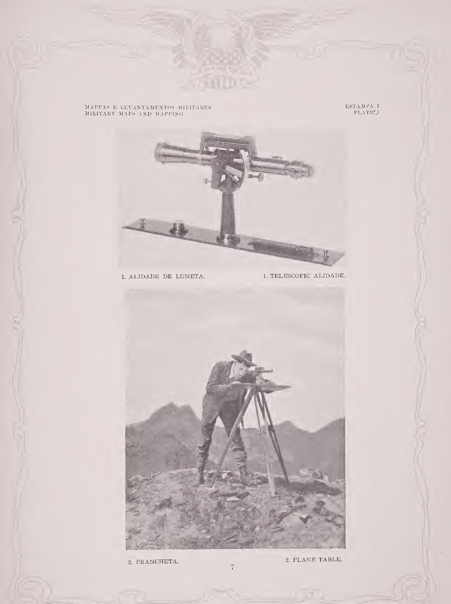
Estampa I. 1, Alidade de luneta; 2, Prancheta_ 7
II. Theodolito_
III—VIII. Specimens de mappas topographicos_ 16-21
IX. Reproducção de mappas por photolithographia: 1, Folha de pran¬
cheta; 2, Impressão á linha azul_ 24
X. Reproducção de mappas por photolithographia: 1, Traçado da
cultura; 2, Traçado das linhas de nivel_ 25
XI. Reproducção de mappas por photolithographia: 1, Traçado da
hydrographia; 2, Mappa impresso_ 26
XII. A installação de reproducção de campanha em França- 29
XIII. Mappa de linhas de nivel_ 61
XIV. Modelo em relevo_ 62
XV. Gravura do mappa em relevo_ 65
XVI. Preparação do molde para o modelo em relevo: 1, Molde modelo:
2, Esqueleto fundido do modelo; 6, Modelo acabado_ 67
XVII. Preparação do molde para o modelo em relevo: 1, O recorte do
cartão da area incluída pela curva de nivel; 2, Molde final_ 68
XVIII. Area incluída pela curva de nivel recortada do cartão_ 69
XIX. Camadas recortadas reunidas em ordem consecutiva_ 40
XX. Modelos em relevo: 1, Montante do Rio Potomac; 2, Campo de ba¬
talha de Gettysburg_ 42
ILLUSTRATIONS.
Page.
Plate I. 1, Telescopic alidade; 2, Plane table_ 7
II. Theodolite_ 8
III-VIII. Specimens of topographic maps_ 16-21
IX. Map reproduction by photolithography: 1, Plane-table sheet; 2, Blue¬
line print_ 24
X. Map reproduction by photolithography: 1, Culture tracing; 2, Contour
tracing- 25
XI. Map reproduction by photolithography: 1, Drainage tracing; 2, Printed
map- 26
XII. The mobile reproduction plant in France_ 29
XIII. Contour map_ 31
XIV. Relief model_ 32
XV. Pictorial relief map_ 35
XVI. Preparation of mold for relief model: 1, Pattern mold; 2, Plaster cast of
pattern mold; 3, Modeled plaster cast_ 37
XVII. Preparation of mold for relief model: 1, Sawing contoured areas; 2, Final mold_ 38
XVIII. Contoured area sawed from cardboard_ 39
XIX. Sawed layers assembled in consecutive order_ 40
XX. Relief models: 1, Upper Potomac River; 2, Gettysburg battlefield_ 42
4
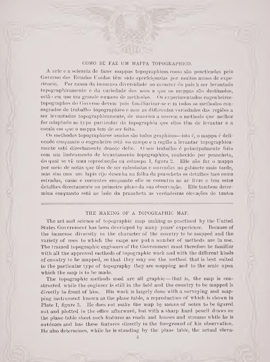
COMO SE FAZ UM MAPPA TOPOGRAPHICO.
A arte e a sciencia de fazer mappas topographicos como são practicadas pelo
Governo dos Estados Unidos têm sido aperfeiçoadas por muitos annos de expe-
riencia. Por causa da immensa diversidade no caracter do pais n ser levantado
topographicamente e da variedade dos usos a que os mappas são destinados,
estão em uso um grande numero de methodos. Os experimentados engenheiros-
topographos do Governo devem pois familiarizar-se c* m todos os methodos con¬
sagrados de trabalho topographico e com as differentes variedades das regiões a
ser levantadas topographicamente, de maneira a usarem o methodo que melhor
for adaptado ao typo particular da topographia que elles têm de levantar e a
escala em que o mappa tem de ser feito.
Os methodos topograph icos usados são todos graphicos—isto é, o mappa é deli¬
neado emquauto o engenheiro está no campo e a região a levantar topographica¬
mente está directamente deante delle. O seu trabalho é principalmente feito
com um instrumento de levantamento topographico, conhecido por prancheta,
do qual se vê uma reproducção na estampa I, figura 2. Elle não faz o mappa
por meio de notas que têm de ser calculadas e marcadas no gabinete mais tarde,
mas sim com um lapis rijo desenha na folha da prancheta os detalhes taes como
estradas, casas e correntes emquauto elle se encontra ao ar livre e tem estes
detalhes directamente no primeiro plano da sua observação. Elle também deter¬
mina emquanto está ao lado da prancheta as verdadeiras elevações de tantos
THE MAKING OF A TOPOGRAPHIC MAP.
The art and science of topographic map making as practiced by the United
States Government has been developed by many years’ experience. Because of
the immense diversity in the character of the country to be mapped and the
variety of uses to which the maps are put a number of methods are in use.
The trained topographic engineers of the Government must therefore be familiar
with all the approved methods of topographic work and with the different kinds
of country to be mapped, so that they may use the method that is best suited
to the particular type of topography they are mapping and to the scale upon
which the map is to be made.
The topographic methods used are all graphic — that is, the map is con¬
structed while the engineer is still in the field and the country to be mapped is
directly in front of him. His work is largely done with a surveying and map¬
ping instrument known as the plane table, a reproduction of which is shown in
Plate I, figure 2. He does not make the map by means of notes to be figured
out and plotted in the office afterward, but with a sharp hard pencil draws on
the plane-table sheet such features as roads and houses and streams while he is
outdoors and has these features directly in the foreground of his observation.
He also determines, while he is standing by the plane table, the actual eleva-
5

pontos quantos forem necessários para fornecer os dados com que tem de dese¬
nhar as linhas de nivel, e é assim que as linhas de nivel fielmente mostram a
superfície do terreno tal qual ella é segundo as medidas feitas ao passo que o
trabalho progride.
A PRANCHETA.
Como se vê na estampa I a prancheta consiste de um estirador collocado em
cima de um tripé. O estirador pode ser nivelado e pode tomar qualquer posição
horisontal e pode ser fixado quando propriamente orientado. Quando em uso o
estirador e o supporte não se devem nunca mexer, devendo-se tomar o maior
cuidado com a prancheta para que quando uma vez fixada ou “orientada” não
seja alterada a sua posição. O engenheiro não se deve apoiar sobre ella nem
contra ella. Sobre o estirador fixa-se a folha de desenho sobre a qual o mappa
tem de ser desenhado. O papel usado é espesso e de duas faces—isto é, fixado
sobre os dois lados de uma tela de linho de modo que o grão do papel corra em
angulo recto nas suas duas faces. Este papel é bem curtido por vários annos e
então pode ser usado de qualquer dos lados. Os estiradores das pranchetas têm
em geral dimensões de 18 por 24 pollegadas, mas usam-se tanto estiradores maiores
como mais pequenos.
tions of as many points as are needed to furnish data on which to draw the con¬
tour or form lines, and it is thus that the contour lines faithfully depict the
surface of the ground as it is found by measurements made as the work
progresses.
THE PLANE TABLE.
As shown in Plate I, the plane table consists of a drawing board supported
by a tripod. The board can be leveled and also turned in any horizontal posi¬
tion and can be clamped when properly set. When in use the table and its
support must never move, and the greatest care must be taken that when it is
once set or “oriented” it shall not be disturbed in position. The engineer
must neither lean on it nor against it. On the board is fastened the drawing
paper upon which the map is to be plotted. The paper used is thick and
double mounted—that is, so mounted on both sides of a sheet of linen cloth that
the grain of the paper runs at right angles on its two faces. Such paper is well
seasoned for several years, and then either side may be used. Plane-table
boards are usually 18 by 24 inches in size, but both larger and smaller boards are in use.
6
MAPPAS K LEVANTAMENTOS MILITARES MILITARY MAPS AND MAPPING
ESTAMPA I PLATE:,!

MAPPA8 E LEVANTAMENTOS MILITARES MILITARY MAPS AND MAPPING
ESTAMPA II PLATE II

FUNDAMENTO DA TRIANGULAÇÃO E DO NIVELAMENTO.
O fundamento da triangulação e do nivelamento é complemento essencial do
trabalho do levantamento topographico. A triangulação é baseada inicialmente
sobre observações astronómicas quanto á latitude, e sobre siguaes telegraphicos
quanto á longitude. Uma linha base de 4 ou 5 milhas de comprimento é medida
com uma fita de aço compensada, e esta linha 6 prolongada por meio de ângulos
horisontaes medidos com um theodolito (est. II) âs estações de triangulação
intervisiveis previamente estabelecidas, dando em resultado uma rede de linhas
e ângulos, pelos quaes se calculam as posições geographicas das estações de
triangulação expressas em graus, minutos e segundos de latitude e longitude.
Uma linha base e uma observação astronómica são necessárias em uma região
onde não foram estabelecidas estações de triangulação, mas onde taes estações
existem a triangulação é prolongada por varias centenas de milhas antes de
serem necessárias novas observações de estrellas e verificações telegraphicas.
Se for impracticavel medir os ângulos entre as estações de triangulação inter¬
visiveis com um theodolito por causa da falta de cumes de collinas donde se
possam fazer observações, fazem-se levantamentos polygonaes em circuitos ou
curvas corridas de não mais de cem milhas de comprimento. As distancias são
medidas com fitas de aço e os ângulos horisontaes com luneta e o azimuth é
determinado por observação solar ou estrellar. Destes dados calculam-se a
latitude e a longitude dos pontos necessários da linha.
TRIANGULATION AND LEVELING CONTROL.
Triangulation and leveling are essential adjuncts to topographic map work.
Triangulation is based initially upon astronomical observations for latitude
and upon telegraphic signals for longitude. A base line 4 or 5 miles in length
is measured with a compensated steel tape, and this line is expanded by means
of horizontal angles measured with a theodolite (PI. II) to previously established
intervisible triangulation stations, resulting in a network of lines and angles
from which are computed the geographic positions of the triangulation stations
expressed in degrees, minutes, and seconds of latitude and longitude. A base
line and an astronomic observation are necessary in a region where no triaugu-
lation stations have been established, but where such stations are available
triangulation is carried over distances of several hundred miles before new star
observations and telegraphic checks are necessary.
If it is impracticable to measure the angles between intervisible triangulation
stations v ith a theodolite because of the lack of open hilltops from which to
make observations, traverse or meander lines are run in circuits or loops of not
more than 100 miles in length. Distances are measured with steel tapes, hori¬
zontal angles with a transit, and azimuth is determined by observations on the
sun or a star. From these data the latitude and longitude of the necessary
points on the line are computed.
9

As elevações são obtidas por meio de linhas cuidadosamente marcadas com
uivei de bolha de ar e arranjadas em circuito e baseadas sobre o uivei medio do
mar.
Tanto a triangulação como o nivelamento são ajustados pelo methodo de
“quadrados minimos,” que harmoniza os resultados e produz os valores mais
prováveis.
O METHODO DA PRANCHETA.
Practicamente todos os levantamentos topographicos feitos pelo Governo dos
Estados Unidos são executados em folhas de prancheta sobre as quaes uma
“ projecção” é construida antes de se começar o trabalho topographico do campo.
Tal projecção delineada na escala do mappa marca os meridianos que limitam a
longitude e os parallelos que limitam a latitude do mappa e para conveniência é
subdividida dentro da sua area. A triangulação ou os pontos de fundamento são
primeiramente marcados na folha de projecção, e os differentes detalhes do mappa
que devem ser marcados são então delineados e desenhados na sua verdadeira
posição em latitude e longitude e portanto nas suas verdadeiras posições em
relação umas as outras.
O estirador é primeiramente nivelado e depois orientado em relação ao azimuth
até que a linha meridiana que passa pelo ponto marcado na folha que representa
o ponto inicial do terreno onde se acha a prancheta esteja dirigido para o norte
verdadeiro, então o estirador é fixado. A maneira como esta orientação é feita
Elevations are obtained from carefully run spirit-level lines arranged in
circuits and based upon meau sea level.
Both the triangulation and the leveliug are adjusted by the method of “ least
squares,” which harmonizes results and produces the most probable values.
THE PLANE-TABLE METHOD.
Practically all plane table mapping done by the United States Government is
executed on plane-table sheets upon which a “projection ” has been constructed
before topographic field work is begun. Such a projection plotted to the scale
of the map marks the bounding meridians of longitude and the bounding paral¬
lels of latitude of the map and for convenience is subdivided within itself. The
triangulation or control points are first plotted on the projection sheet, and the
several map features to be shown are then plotted and mapped in their true
locations in latitude and longitude aud therefore in their true positions relative
to one another.
The table is first leveled and then swung in azimuth until the meridian line
through the point on the sheet that represents the initial point on the ground
where the plane table is set up trends true north, when it is clamped. How
this orienting is done need not be described in technical detail here; the
10
não necessita ser descripta com detalhes technicos aqui; o facto essencial é que
em cada occasião e em cada logar que a prancheta se estacione ella seja fixada em
uma posição parallela a todas as outras suas posições—isto é, o seu lado norte
esteja sempre dirigido para o norte, o seu lado leste sempre para leste, etc.
As miradas são effectuadas por meio de luneta aos objectos que têm de ser
marcados, e as linhas que indicam a sua direcção do ponto inicial são mar
cadas na folha da prancheta por meir da regua que está rigidamente ligada ao
supporte da luneta. Este instrumento auxiliar é a alidade de luneta (est. I,
fig. 1). Uma mirada portanto indica sempre um detalhe visto em uma direc¬
ção, e o engenheiro tem somente de transportar-se a qualquer outro ponto da
triangulação e fazer uma mirada do mesmo detalhe em outra direcção para obter
a sua posição na folha, a qual se encontra na intersecção das duas linhas das
duas miradas. Este procedimento multiplicado muitas vezes marca muitos
pontos. Ou o engenheiro pode fazer uma mirada para um ponto proximo e
medir a sua distancia, por exemplo por meio da estadia, e marca-lo immediata-
mente. Para cada medida de distancia a differeuça de elevação é usualmente
determinada nor meio de um angulo vertical tomado ao dito ponto na mesma
occasião que a direcção é marcada.
A medida que se vão determinando as elevações, as linhas de nivel para os
dados intervallos vão sendo desenhados nas folhas na sua verdadeira relação aos
accidentes observados, taes como estradas, correntes e casas. Para exemplificar :
lana curva numa estrada, uma passagem numa corrente e uma casa são marcadas
essential fact is that at each time and at each place the plane table is set up it
is fixed in a position parallel to all its other positions—that is, its north face
always faces north, its east face always east, etc.
Sights are taken through a telescope to the objects to be located, and lines
showing their direction from the initial point are drawn on the plane-table
sheet along the side of a ruler attached rigidly to the telescope support. This
auxiliary instrument is the telescopic alidade (PI. I, tig. 1). A sight line
therefore always locates the feature sighted in one direction, and the engineer
has only to move to another triangulation point and sight the same feature in
another direction to obtain its location on the sheet, which will be at the inter¬
section of the two sight lines. This procedure multiplied many times locates
many points. Or the engineer can sight a point near by and measure its dis¬
tance, say by stadia, and plot it at once. For each measurement of distance
the difference in elevation is usually determined by means of a vertical angle
taken to the same point at the same time the direction sight is taken.
As fast as elevations are determined, the contour lines for the interval
selected are drawn on the sheet in their true relation to the features shown,
such as the roads and streams and houses. To illustrate: A bend in a road, a
11

e desenhadas no mappa; e corno se determinou a elevação de cada um destes
logares o engenheiro desenha as linhas de nivel sobre e perto dos symbolos que
representam estes pontos, de maneira que quem usar o mappa, examinando as
linhas de nivel, pode tomar conhecimento da elevação da curva da estrada, da
passagem da corrente e da casa.
Pranchetas auxiliares de vários tamanhos são usadas com a alidade de luneta
para levantamentos “polygonaes” ou de zig-zags de estradas ou correntes, e os
resultados destes levantamentos são traçados e transferidos diariamente ao mappa
principal do estirador maior. As elevações são marcadas de ponto para ponto
por meio do methodo da estadia.
LINHAS “ POLYGON AES” OU ZIG-ZAGS POR FITA E ANEROIDE.
Onde o arvoredo é muito denso para medidas á estadia e onde se não podem
obter pontos de mira para triangulação á prancheta, um methodo polygonal á
üta e prancheta é usado com resultados rápidos em regiões que de outro modo
seria impo.-sivel levantar topo^raphicamente a não ser com grande despeza. A
distancia é determinada por uma lita de tela parafinada de 528 pés, a direcção
pelo som da voz, e a elevação por barometro aneroide. Quando ajustados a
pontos externos que tiverem sido marcados por methodo de prancheta taes zig¬
zags com üta darão resultados valiosos. Usa-se um pequeno estirador, e a região
densamente arborisada é coberta por uma rede de taes linhas até que o mappa
fique completo.
stream crossing, and a house are located and plotted on the map; and as at
each of these places the elevation has been determined the engineer draws the
contour lines in and around the symbols representing these features, so that the
map user, by examining the contours, can ascertain the elevation at the road
bend, the stream crossing, and the house.
Auxiliary plane tables of various sizes are used in connection with the tele¬
scopic alidade for meander or “traverse” surveys of trails or streams, and the
results of these surveys are traced and transferred daily to the main map on the
larger board. Elevations are carried from point to point by the stadia method.
MEANDER OR TRAVERSE LINES BY TAPE AND ANEROID.
Where the timber is too dense for stadia measurements and where open view
points for plane-table triangulation can not be obtained, a tape-traverse plane-
table method is used that gives rapid results in a country otherwise impossible
to map save at excessive cost. Distance is determined by a 528 foot paraffined
cloth tape, direction by the sound of the voice, and the elevation by aneroid
barometer. When adjusted to outside points that have been located by plane-
table methods such tape meanders give valuable results. A small plane-table
board is used, and the densely timbered country is covered by a network of
such lines until the map is complete. 12
FOLHAS SUPPLEMENTARES.
O trabalho cie campo indue também a preparação cie series cie folhas supple-
mentares em tela, que se conservam completas clia a dia e que dão os nomes dos
detalhes que têm cie ser impressos nos mappas a publicar, contornos de florestas
que serão impressos em separado no mappa, e ciados para a classificação das terras, das estradas e das pontes.
TRABALHO DE GABINETE E REPRODUCÇÃO POR GRAVURA.
O mappa é completado a lapis mas não passado a tinta no campo. O trabalho
de campo é em geral executado em uma escala um pouco maior do (pie a da pu¬
blicação. Se o mappa é destinado a ser reproduzido a tres cores por gravura em
cobre, o mappa de campo é passado a tinta no gabinete nas tres cores em que
tem cie ser impresso. A maior parte dos mappas topographicos indicam os
detalhes hydrographicos a azul, as linhas cie nivel a castanho e a “cultura”
(edificios, estradas, limites, lettreiros, etc.) a preto. O clesenho passado a tinta
é reduzido por photographia á escala da publicação e transferido por meios
mechanicos a tres chapas cie cobre, em cada uma das quaes se constroe uma ver¬
dadeira projecção. Em uma destas chapas de cobre cortam-se as linhas cpie
representam o traçado preto cio desenho, em outra as que representam o traçaclo
azul do clesenho e na terceira as cpie representam o traçado castanho do clesenho.
O resto das linhas transferidas em cada chapa é então destruído, deixando tres
chapas cie cobre nas quaes se representam por linhas profundamente cortadas
OVERSHEETS.
The field work also includes the preparation of a series of oversheets on trac¬
ing linen, kept complete day by clay and giving the names of features that are
to be printed on the published map, outlines of woodland to be overprinted on
the map, and data for land classification and road and bridge classification.
OFFICE WORK AND REPRODUCTION BY ENGRAVING.
The map is completed in pencil but is not inked in the field. The field work
is usually executed on a scale somewhat larger than the publication scale. If
the map is to be reproduced as a three-color map by engraving on copper, the
field map is inked in the office in the three colors in which it is to be printed
Most topographic maps show water features in blue, contours in brown, and
“culture” (buildings, roads, boundaries, lettering, etc.) in black. The inked
drawing is reduced by photography to the scale of publication and transferred
by mechanical means to three copper plates, on each of which a true projection
has been constructed. On one of these copper plates are cut those lines which
represent the black lines on the drawing, on another plate those which repre¬
sent the blue lines of the drawing, and on the third those which represent the
brown lines of the drawing. The rest of the transferred lines on each plate are
then wiped off, leaving three copper plates on which are represented by lines
IB

na superfície os detalhes do mappa que têm de ser reproduzidos respectivamente
a preto, azul e castanho.
< Como é impracticavel imprimir grandes edições a cores com chapas de cobre
fazem-se transferencias de cada chapa de cobre para correspondentes chapas de
zinco ou alumínio ou pedras lithographicas, e cada uma destas é posta na prensa
por sua vez e passada com a tinta da cor que representa no mappa final.
Os arvoredos são geralmente representados por areas de verde claro juntas
numa quarta impressão, e quaesquer outros detalhes especiaes que o mappa pode
conter, taes como classificação de estradas, são addicionados em outras impres¬
sões a tinta vermelha ou outras cores.
O ENGENHEIRO-TOPOGRAPHO.
Para ser um bom engenheiro-topographo é necessário não só saber escolher os
methodos e instrumentos melhor adaptados ao pais cujo mappa se pretende, mas
precisa também possuir um olho artístico e educado que possa interpretar as
formas da superfície com o fim de as representar com rigor por linhas de nivel
numa superfície plana de papel. Pile tem de traduzir sobre o papel o que
elle vê no terreno de tal forma que todos os que o leem possam reconhece-lo e
comprehende lo. Elle precisa ter á sua disposição um sufficiente fundamento
topographico que lhe permitta collocar os detalhes que elle está levantando com
rigor, mas a sua vista deve ser tão bem trenada de modo que possa exprimir
cut deep into the surface the features of the map to be shown in black, blue, and
brown, respectively.
As it is impracticable to print large editions in colors from copper plates,
transfers are made from each of the copper plates to corresponding plates of
zinc or aluminum or to lithographic stones, and each of these is put into a press
in turn and inked with the color it represents on the final map.
Woodland is generally shown by light-green areas added in a fourth printing,
and any other special features that the map may carry, such as a road classifi¬
cation, are added in further printings in red or other colors.
THE TOPOGRAPHIC ENGINEER.
To be successful a topographic engineer must not only understand the choice
of methods and intruments best suited to the country to be mapped, but must
posses the trained artistic eye that can so interpret surface forms as to represent
them accurately by contour lines on a flat paper surface. He must so translate
on paper what he sees on the ground that all who read may recognize and
understand. He must have sufficient topographic control to enable him to
place the features he maps accurately, yet his eye must be so trained that he
can express both quickly and accurately a maximum of map features with a
14

tanto rapida como rigorosamente o máximo de detalhes de mappa com o minimo
de tal fundamento. Elle deve trabalhar depressa para que o trabalho não custe
muito, mas precisa ser rigoroso para evitar o ainda maior custo da repetição
do trabalho. O engenheiro-topographo que comprehende alguma cousa dos
processos physiographicos que modelam as formas da natureza pode reproduzir
o pais mais rapidamente e com maior fidelidade de expressão. Elle deve estudar
a relação entre a escala e a distancia das curvas de nivel de maneira que o mappa
que elle estiver fazendo não fique sobrecarregado com detalhes que não são
essenciaes para a escala adoptada, e comtudo elle deve estabelecer o seu funda¬
mento de maneira que o mappa seja adequado a todos os requisitos de engenharia.
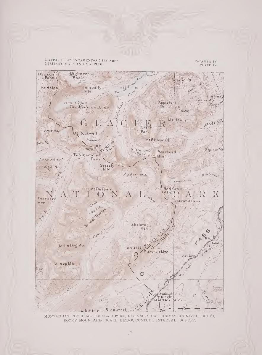
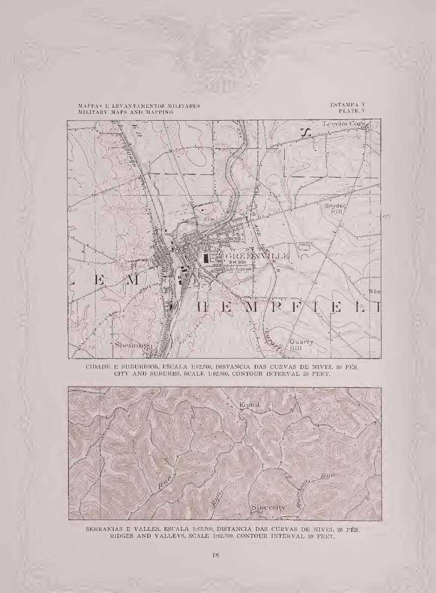
SPECIMENS DE MAPPAS TOPOGRAPHICOS.
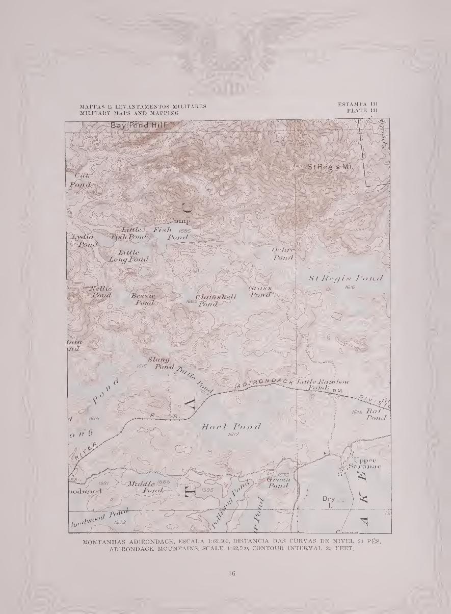
Estampas III a VIII representam partes de mappas topographicos de areas
levantadas pelos methodos que acabamos de descrever e executados pelo Serviço
Geologico dos Estados Unidos (Ministério do Interior). Cerca de 40 por cento
da area dos Estados Unidos ja se acha reproduzida deste modo e os 3,000 mappas
resultantes têm sido publicados na sua maior parte em unidades de 1 grau, de
30 minutos, de 15 minutos ou de 71 minutos em cada direcção, em escalas respec¬
tivamente de 1:250.000, 1:125.000, 1:62.500 e 1:31.680.
minimum of such control. He must work fast lest the work cost too much, but
he must be accurate to avoid the still greater cost of resurvey. The topo¬
graphic engineer who understands something of the physiographic processes
that model the forms of nature can depict the country more quickly and with a
greater faithfulness of expression. He must study the relation between scale
and contour interval, so that the map he makes shall not be overloaded with
detail that is unessential to the scale adopted, and yet he must so arrange his
control that the map is adequate to meet all engineering requirements.
SAMPLES OF TOPOGRAPHIC MAPS.
Plates III to VIII inclusive are representative portions of topographic maps of
areas surveyed by the methods just described and mapped by the United States
Geological Survey (Department of the Interior). About 40 per cent of the
area of the United States has been thus mapped, and the 3,000 resulting maps
have been issued mostly in units showing 1 degree, 30 minutes, 15 minutes,
or 7s minutes in each direction, on scales of 1:250,000, 1:125,000, 1:62,500,
and 1:31,680, respectively.
MAPPAS E LEVANTAMENTOS MILITARES MILITARY MAPS AND MAPPING
ESTAMPA 111 PLATE III
MONTANHAS ADIRONDACK, ESCALA 1:62.500, DISTANCIA DAS CURVAS DE NIVEL 20 PÉS.
ADIRONDACK MOUNTAINS, SCALE 1:62,500, CONTOUR INTERVAL 20 FEET.
16
s I n
. Í obaUIf
N'''—^ B-M
7675
-Two Medicine Pa ss
Grizzly *—. _ Mtn
i ■ jT • \ \ \
Mt Despai r
Statu Mtn Trebrand
keleton
Little Doó Mtn
SummitMtn
Sheep Mtn
BI a cktai I
MONTANHAS ROCHOSAS, ESCALA 1:125.000, DISTANCIA DAS CURVAS DE NÍVEL 100 PÉ3. ROCKY MOUNTAINS, SCALE 1:125,000, CONTOUR INTERVAL 100 FEET.
MAPPAS E LEVANTAMENTOS MILITARES MILITARY MAPS AND MAPPING
ESTAMPA IV PLATE IV
17
MAFPAS E LEVANTAMENTOS MILITATES MILITARY MAPS AND MAPPING
ESTAMPA V PLATE. V
CIDADE E SUBURBIOS, ESCALA 1:62.500, DISTANCIA DAS CURVAS DE NIVEL 30 PÉS. CITY AND SUBURBS, SCALE 1:62,500, CONTOUR INTERVAL 20 FEET.
/S40
SERRANIAS E VALLES, ESCALA 1:62.500, DISTANCIA DAS CURVAS DE NIVEL 20 PÉS. RIDGES AND VALLEYS. SCALE 1:62,500, CONTOUR INTERVAL 20 FEET.
18

LAGOS E COLINAS GLACIALES, ESCALA 1:62.500, DISTANCIA DAS CURVAS DE NIVEL 20 PÉS. GLACIAL LAKES AND HILLS, SCALE 1:62,500, CONTOUR INTERVAL 20 FEET.
19

JVIAIM’AS K LEVANTAMENTOS MILITARES MILITARY MAPS AND MAPI'INO
ESTAMPA V 11 PLATE Vjl
10'
VALLE E CAMFINA, ESCALA 1:31.680, DISTANCIA DAS CURVAS DE NIVEL 1 FÉ VALLEY AND PLAIN, SCALE 1:31,680, CONTOUR INTERVAL 1 FOOT.
20

MAPPAS E LEVANTAMENTOS MILITARES MILITARY MAPS AND MAPPING
ESTAMPA VIII PLATE VIII
DESERTO, ESCALA 1:250.000, DISTANCIA DAS CURVAS DE NIVEL 100 PÉS. DESERT, SCALE 1:250,000, CONTOUR INTERVAL 100 FEET.
21
REPRODUCÇÃO DE MAPPAS POR PHOTOLITHOGRAPHIA.
A folha de prancheta atraz descripta (cst. IX, fig. 1) pode ser reproduzida por
photolithographia em logar de ser gravada a cobre. O passo inicial consiste
em fazer um negativo photographico. Uma chapa de vidro coberta com uma
camada de emulsão, sensibilizada por immersão em um banho de prata, é collo-
cada em uma machina photographica de chapas húmidas que f»>i previamente
focada para dar o tamanho desejado. A exposição é feita e o negativo é revelado
e intensificado até a força necessária. Os defeitos encontrados no negativo sao
eliminados pintando a negro ou cortando-os com ponta de aço.
Uma chapa de impressão lithographica de zinco ou de alumínio é a seguir
coberta com uma solução sensível e posta em contacto com a chapa húmida
negativa por meio de um caixilho de impressão no vácuo, e o desenho do nega¬
tivo é impresso na chapa de metal pela exposição a uma luz forte. A chapa de
metal é revelada e manipulada fazendo-a passar por uma serie de operações que
dão ao desenho a base gordurosa necessária para attrair a tinta de impressão e
ao fundo a resistência necessária á gordura para conservar essa parte da chapa
limpa. A chapa fica então prompta para impressão. Esta chapa comtudo não
é usada para fazer reproducções para distribuição mas para o fim especifico de
MAP REPRODUCTION BY PHOTOLITHOGRAPHY.
The plane table sheet described above (PI. IX, fig. 1) may be reproduced by
photolithography instead of being engraved on copper. The initial step is the
making of a photographic negative. A piece of plate glass is coated with
emulsion, sensitized by immersion in a silver bath, and placed in a wet-plate
camera that has previously been focused to give the desired size. The exposure
is made, and the negative is developed and intensified to the desired strength.
Defects appearing in the negative are eliminated by painting with black paint
or cutting with a steel point.
A zinc or aluminum lithographic printing plate is next coated with a sensitive
solution and placed in contact with the wet-plate negative by means of a
vacuum printing frame, and the design on the negative is printed on the metal
plate by exposure to a strong light. The metal plate is developed and worked
up through a series of operations that give to the design the greasy base neces¬
sary to attract printing ink and to the background the necessary resistance to
grease to keep this part of the plate clean. The plate is then ready im¬
printing. This plate, however, is not used for making reproductions for dis¬
tribution but for the specific purpose of obtaining what are known as blue-line
22

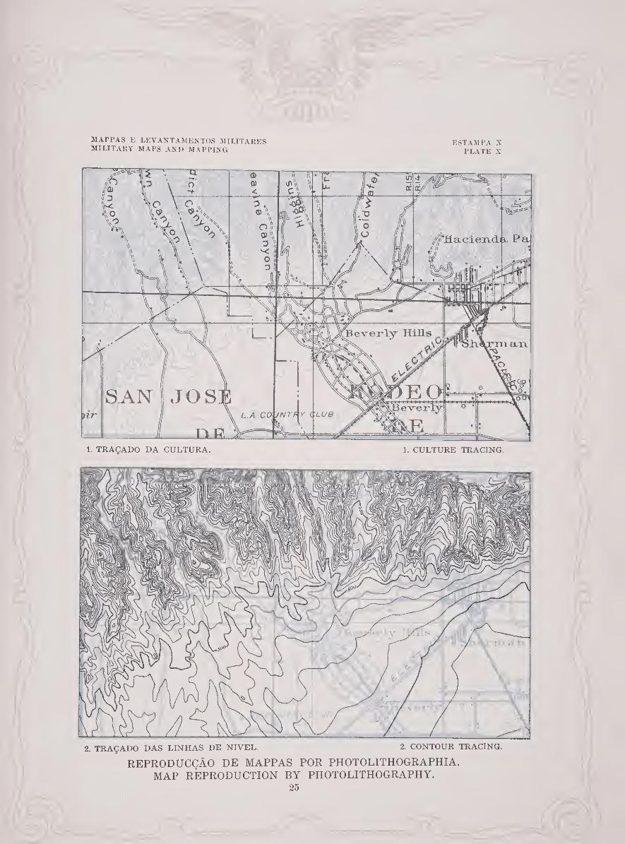
obter o que é conhecido pelo nome de impressões á linha azul ou folhas de desenho (est. IX, fig. 2). Estas folhas são impressas com tinta não photo- graphica azul clara em uma qualidade superior de papel de desenho, sendo o numero de impressões dependente do numero de cores desejadas sobre o mappa final. Por exemplo, se o mappa deve ser reproduzido nas tres cores usuaes, preto, castanho e azul, serão necessárias somente tres impressões á linha azul. Em uma destas o desenhador traçará em tinta de desenho preta todas as linhas que representam a “cultura” (est. X, fig. 1); em outra todas as linhas que representam as linhas de nivel (est. X, fig. 2); e na terceira todas as que representam hydrographia (est. XI, fig. 1). Fazem-se então negativos pho¬ tograph icos de cada impressão, apparecendo somente as linhas desenhadas a tinta preta nos respectivos negativos. Destes negativos fazem-se chapas litho- graphadas separadas de impressão. Estas chapas são depois impressas na prensa lithographica com as cores devidas e cuidadosamente registradas na mesma folha de papel (est. XI, fig. 2), ficando assim reproduzida em tres cores uma folha de prancheta que foi desenhada no campo com todo o detalhe a uma cor.
prints or drafting sheets (PI. IX, fig. 2). These sheets are printed in light- blue nonphotographic ink on a superior grade of drawing paper, the number of prints necessary depending upon the number of colors desired on the finished map. For example, if the map is to be reproduced in the three standard colors black, brown, and blue, only three blue-line prints will be necessary. On one of these the draftsman will trace in black drawing ink all the lines representing the culture (PI. X, fig. 1); on another all those representing contours (PI. X, fig. 2) ; and on the third all those representing drainage ( PI. XI, fig. 1). Photo¬ graphic negatives are then made from each print, only the lines drawn in black ink appearing on the respective negatives. From these negatives separate litho¬ graphic printing plates are made. These plates are then printed on the lithographic power press in the correct colors and accurately registered on the same sheet of paper (PI. XI, fig. 2), thereby reproducing in three colors a plane- table sheet that was drawn in the field with all detail in one color.
23

d1
MAPPAS E LEVANTAMENTOS MILITARES MILITARY MAPS AND MAPPING
1. FOLHA DE PRANCHETA.
■n!
ESTAMPA IX PLATE IX
1. PLANE-TABLE SHEET.
2. IMPRESSÃO Á LINHA AZUL. 2. BLUE-LINE PRINT.
REPRODUCÇÃO DE MAPPAS POR PHOTOLITHOGRAPHIA. MAP REPRODUCTION BY PHOTOLITHOGRAPHY.
24
MAPPAS E LEVANTAMENTOS MILITARES MILITARY MAPS AND MAPPING
ESTAMPA X PLATE X
nr
SAN
Í1U
1. TRAÇADO DA CULTURA. 1. CULTURE TRACING.
2. TRAÇADO DAS LINHAS DE NIVEL. 2. CONTOUR TRACING.
REPRODUCÇÃO DE MAPPAS POR PHOTOLITHOGRAPHIA. MAP REPRODUCTION BY PHOTOLITHOGRAPHY.
25

51APPAS E LEVANTAMENTOS MILITARES MILITARY MAPS AND MAPPING
ESTAMPA XI PLATE XI
v-1
1. DRAINAGE TRACING. 1. TRAÇADO DA HYDROGRAPHIA
7TT®-
~£0 W'Tf V CLUB
XüJEL
2. MAPPA IMPRESSO. 2. PRINTED MAP.
REPRODUCÇÃO DE MAPPAS POR PHOTOLITHOGRAPHIA. MAP REPRODUCTION BY PHOTOLITHOGRAPHY.
26
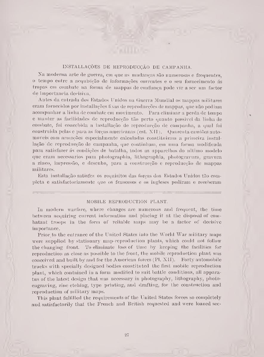
INSTALLAÇÒES DE REPRODUCÇÃO DE CAMPANHA.
Na moderna arte de guerra, em que as mudanças são numerosas e frequentes,
o tempo entre a acquisição de informações correntes e o seu fornecimento ás
tropas em combate na forma de mappas de confiança pode vir a ser um factor de importância decisiva.
Antes da entrada dos Estados Unidos na Guerra Mundial os mappas militares
eram íornecidos por installações fixas de reproducçÕes de mappas, que não podiam
acompanhar a linha de combate em movimento. Para eliminar a perda de tempo
e manter as facilidades de reproducção tão perto quanto possivel da linha de
combate, foi concebida a installação de reproducção de campanha, a qual foi
construida pelas e para as forças americanas (est. XII). Quarenta camiões auto¬
móveis com armações especialmente calculadas constituiram a primeira instal¬
lação de reproducção de campanha, que continham, em uma forma modificada
para satisfazer ás condições de batalha, todos as apparelhos do ultimo modelo
que eram necessários para photographia, lithographia, photogravura, gravura
a zinco, impressão, e desenho, para a eonstrucção e reproducção de mappas
militares.
Esta installação satisfez os requisitos das forças dos Estados Unidos tão com¬
pleta e satisfactoriamente que os franceses e os ingleses pediram e receberam
MOBILE REPRODUCTION PLANT.
In modern warfare, where changes are numerous and frequent, the time
between acquiring current information and placing it at the disposal of com¬
batant troops in the form of reliable maps may be a factor of decisive
importance.
Prior to the entrance of the United States into the World War military maps
were supplied by stationary map-reproduction plants, which could not follow
the changing front. To eliminate loss of time by keeping the facilities for
reproduction as close as possible to the front, the mobile reproduction plant was
conceived and built by and for the American forces (PI. XII). Forty automobile
trucks with specially designed bodies constituted the first mobile reproduction
plant, which contained in a form modified to suit battle conditions, all appara¬
tus of the latest design that was necessary in photography, lithography, photo¬
engraving, zinc etching, type printing, and drafting, for the construction and
reproduction of military maps. This plant fulfilled the requirements of the United States forces so completely
and satisfactorily that the French and British requested and were loaned sec-
27

emprestadas secções para o uso dos seus exercitos em campanha, e uma unidade
completa foi mais tarde comprada pelo Governo Britannico.
Depois da assignatura do armistício uma secção da installayão primitiva ameri¬
cana foi incorporada no exercito de occupação e acompauhou-o ao Bheuo, elabo¬
rando no caminho mappas da região e fazendo os variados trabalhos de impressão
requeridos por esse exercito. Esta secção regressou mais tarde aos Estados
Unidos para mais aperfeiçoamentos e para treno do pessoal.
Uma unidade escolhida desta mesma secção constitue uma parte da exposição
conjuncta de mappas e arte de fazer mappas em exhibição nesta Exposição e está
agora reproduzindo um mappa de communicações intitulado “O Atlântico” em
viute e cinco cores necessitando oito impressões.
tions for the use of their held armies, and a complete unit was later purchased
by the British Government.
After the armistice was signed a section of the original American mobile
plant was attached to the army of occupation and accompanied it to the Rhine,
producing on the way maps of the country and doing the miscellaneous print¬
ing required by that army. This section was later returned to the United
States for further development and for personnel training.
A selected unit of this particular section is a part of the joint exhibit of maps
and mapping on display in this Exposition and is now reproducing a communi¬
cation map entitled “The Atlantic” in twenty-five colors, requiring eight
printings.

MAPI’AS E LEVANTAMENTOS MILITARES MILITARY MAPS AND MAPPING
ESTAMPA XII PLATE XI[
1. EM CAMINHO A MENIL-LA-TOUR. 1. EN ROUTE TO MENIL-LA-TOUR.
4. EM ST. JUVIN. 4. AT ST. JUVIN.
A INSTALLACAO DE REPRODUCÇAO DE CAMPANHA EM FRANCA. THE MOBILE REPRODUCTION PLANT IN FRANCE.
29

O MAPPA MILITAR DO FUTURO.
REQUISITOS.
A Guerra Mundial demonstrou que um dos maiores problemas da lucta moderna é a instrucção e a preparação dos exercitos voluntários mobilizados para
a comprehensão e uso efficaz dos mappas. Como as uuidades dos enormes exercitos modernos se afastam consideravel¬
mente nas suas operações, a boa conducção destas unidades requer cada vez mais o uso dos mappas. Este requisito demanda não somente um crescente rigor e detalhe na construcção dos mappas mas também maior habilidade dos soldados individualmente para rapidamente adquirirem dos mappas uma pintura mental viva e clara do terreno representado.
Os mappas são portanto um dos essenciaes instrumentos das luctas modernas offensivas e defensivas e têm assumido uma maior importância em cada successiva guerra e com cada progresso da arte da guerra. Como as nações do mundo estão-se a tornar cada vez mais dependentes em organizar as forças voluntárias ou de serviço obrigatorio, os mappas mostrando o relevo em uma forma facil e rapidamente comprehensivel constituem pois uma necessidade da maior impor¬ tância possivel para a instrucção e operações militares.
O mappa militar aceite (est. XIII) tem até aqui mostrado o relevo pelo rigoroso, não obstante arbitrário, symbolo das linhas de nivel. Este é em primeiro logar
THE MILITARY MAP OF THE FUTURE.
REQUIREMENTS.
The World War demonstrated that one of the greatest problems of modern warfare is the instruction and training of the mobilized volunteer armies in the comprehension and efficient use of maps.
As the units of the huge modern armies become more widely separated in their operation, successful handling of these units is more and more dependent upon maps. This requirement demands not only increased accuracy and detail in map construction but greater ability of the individual soldier to gain quickly from a map a clear and vivid mental picture of the terrain represented.
Maps are therefore one of the essential weapons of modern offensive and defensive warfare and have assumed greater importance in each succeeding war and at every advance in the art of war. As the nations of the world are grow¬ ing more and more dependent upon hastily raised volunteer or conscript forces, maps showing relief in an easily and quickly comprehended form thus consti¬ tute a necessity of the highest possible importance for military instruction and operations.
The accepted military map (PI. XIII) has heretofore shown relief by the accurate though arbitrary symbol of contours. This is primarily an engineer’s
30

31
MAP PAS E LEVANTAMENTOS MILITARES
MILITARY MAPS AND MAPPING
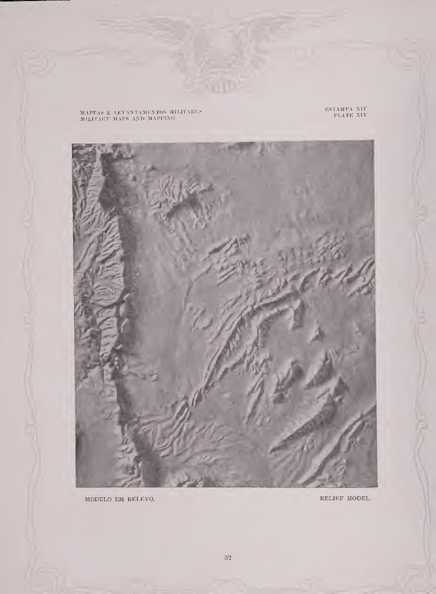
ESTAMPA XIV PLATE XIV
MODELO EM RELEVO. RELIEF MODEL.
82

um mappa de engenheiros, e para usos de engenharia e artilharia é de grande
valor, mas necessita de um certo grau de aptidão mental e considerável instrucção
antes que o soldado vulgar do exercito moderno possa figurar a forma do terreno assim indicada.
A maioria das pessoas e mesmo para muitas que se suppõem habilitadas a ler
mappas, o mappa de curvas de nivel vulgar parece plano, não concebendo a vista
nem interpretando o espirito as arbitrarias linhas de nivel em detalhes de relevo
que ellas suppõem representar. O modelo de relevo porem (est. XIV) é uma
representação dos detalhes de topographia em uma forma fiel da natureza e con-
stitue um mappa facilmente comprehendido e rigorosamente lido mesmo por
pessoas sem preparo algum. Por isso tem havido um uso cada vez maior dos
modelos em relevo para instrucção e fins de tactica, e como um substituto
aceitavel para estes foi concebida e vai sendo aperfeiçoada a gravura do mappa
em relevo.
MODELO EM RELEVO.
O modelo em relevo por causa da sua verdadeira similhança com a natureza
lê-se rapidamente. Os dados topographicos que elle representa são facilmente
absorvidos e vivamente retidos. O que usa um tal mappa sente confiança nas
conclusões a que chega e nas decisões que se lhe offerecem, como se tratasse com
cousas materiaes que se lhe apresentassem nas suas verdadeiras posições relativas
map and for engineering and artillery purposes it is invaluable, but it requires
a certain degree of mental aptitude aud considerable instruction before the
average soldier of a modern army can visualize the form of terrain thus
indicated. To the average person and even to many who are supposed to be proficient in
map reading the usual contoured map appears flat, the eye failing to grasp and
the mind to interpret the arbitrary contour lines into the features of relief they
are supposed to represent. The relief model, however (PI, XIV), is a presen¬
tation of the details of topography in a form true to nature and constitutes a
map quickly understood and accurately read by even the untrained map reader.
Hence there has been an increasing use of relief models for instruction and for
tactical purposes, and as an acceptable substitude for these the pictorial relief
map has been conceived and is being developed.
RELIEF MODEL.
The relief model, because of its strict adherence to nature, is quickly read.
The topographic facts it presents are easily grasped and vividly retained. The
user of such a map feels a confidence in the conclusions he reaches and decisions
he renders, as he is dealing with material things that appear in their true rela-
33
e numa forma a que os seus olhos estão acostumados. Para certos problemas
militares especiaes o modelo em relevo po^sue vantagem sobre todas as outras
formas de mappas. Ao mesmo tempo tem a desvantagem de ser volumoso e
difficil de transportar, e a reproducção em quantidade é, apesar de todos os
esforços, um processo vagaroso, de modo que o seu uso é limitado aos quartéis
generaes dos altos commandos.
GRAVURA DO MAPPA EM RELEVO.
Tomando em consideração o grande valor do mappa que apresenta o relevo em
uma forma facilmente reconhecivel e desejando produzir alguma cousa que pos¬
suísse tanto quanto possível as priucipaes vantagens de modelo em relevo, o
Corpo de Engenheiros dos Estados Unidos aperfeiçoou a gravura do mappa em
relevo (est. XV), que alem de ser um mappa de curvas de nivel representa o
terreno em uma forma mais parecida com a que o olho inexperiente espera e
pode comprehender. O typo mais acabado do mappa em relevo gravado possue
todo o rigor de detalhe incluindo as curvas de nivel do mappa aceite até agora,
sobre o qual se imprime um “mappa de sombra” do relevo obtido tirando
uma photographia com luz forte do modelo em relevo da mesma area.
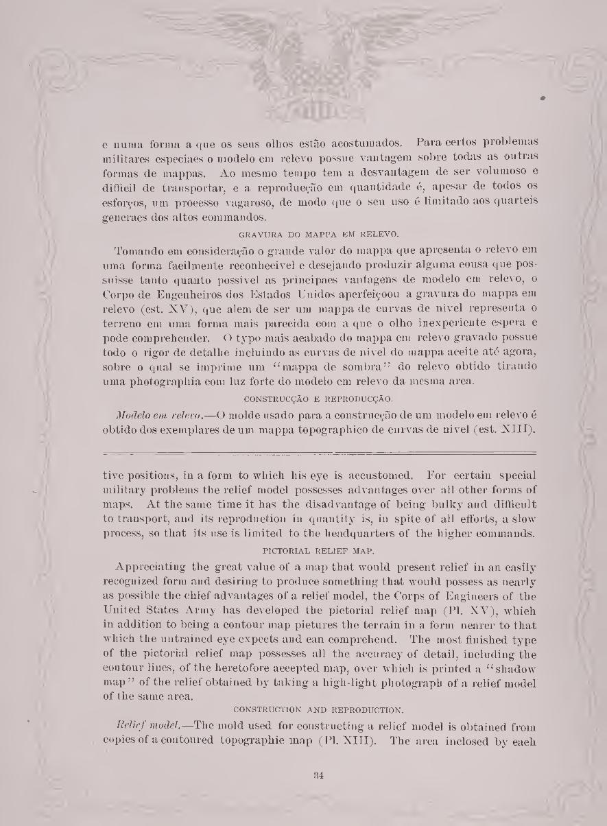
CONSTRUCÇÃO E REPRODUCÇÀO.
Modelo em relevo.—O molde usado para a coustrucção de um modelo em relevo é
obtido dos exemplares de um mappa topographico de curvas de nivel (est. XIII).
tive positions, in a form to which his eye is accustomed. For certain special
military problems the relief model possesses advantages over all other forms of
maps. At the same time it lias the disadvantage of being bulky and difficult
to transport, and its reproduction in quantity is, in spite of all efforts, a slow
process, so that its use is limited to the headquarters of the higher commands.
PICTORIAL RELIEF MAP.
Appreciating the great value of a map that would present relief in an easily
recognized form and desiring to produce something that would possess as nearly
as possible the chief advantages of a relief model, the Corps of Engineers of the
United States Army has developed the pictorial relief map (PI. XV), which
in addition to being a contour map pictures the terrain in a form nearer to that
which the untrained eye expects and can comprehend. The most finished type
of the pictorial relief map possesses all the accuracy of detail, including the
contour lines, of the heretofore accepted map, over which is printed a “shadow
map ” of the relief obtained by taking a high light photograph of a relief model of the same area.
CONSTRUCTION AND REPRODUCTION.
Relief model.—The mold used for constructing a relief model is obtained from
copies of a contoured topographic map (PI. XIII). The area inclosed by each
34

MAPPAS E LEVANTAMENTOS MILITARES MILITARY MAPS AND MAPPING
ESTAMPA XV PLATE XV
TOPQBRAPHY DEPARTMENT OF THE INTERIOR
ALBERT 3 PALL, SECRETARY U S GEOLOGICAL SURVEY
OEOPGE OTIS SUfTK DIRECTOR
THE UNIVERSITY OF TEXAS R-E VINSON.PRESIDENT
BUREAU OF ECONOMIC GEQLOCY AND TECHNOLOGY J.A.UDDEN DIRECTOR
TEXAS (BREWSTER COUNTY1
MONUMENT BFRJNG QUADRANGLE; WAR DEPARTMENT
ORPS OF ENGINEERS U 8 AP-MY
cm e,-«(*•/• Cm T G Gmrdin* G«o Topot *et'* t\ f * s ir-’" > •'
MONUMENT 8PRINC
GRAVURA DO MAPPA EM RELEVO. PICTORIAL RELIEF MAP.

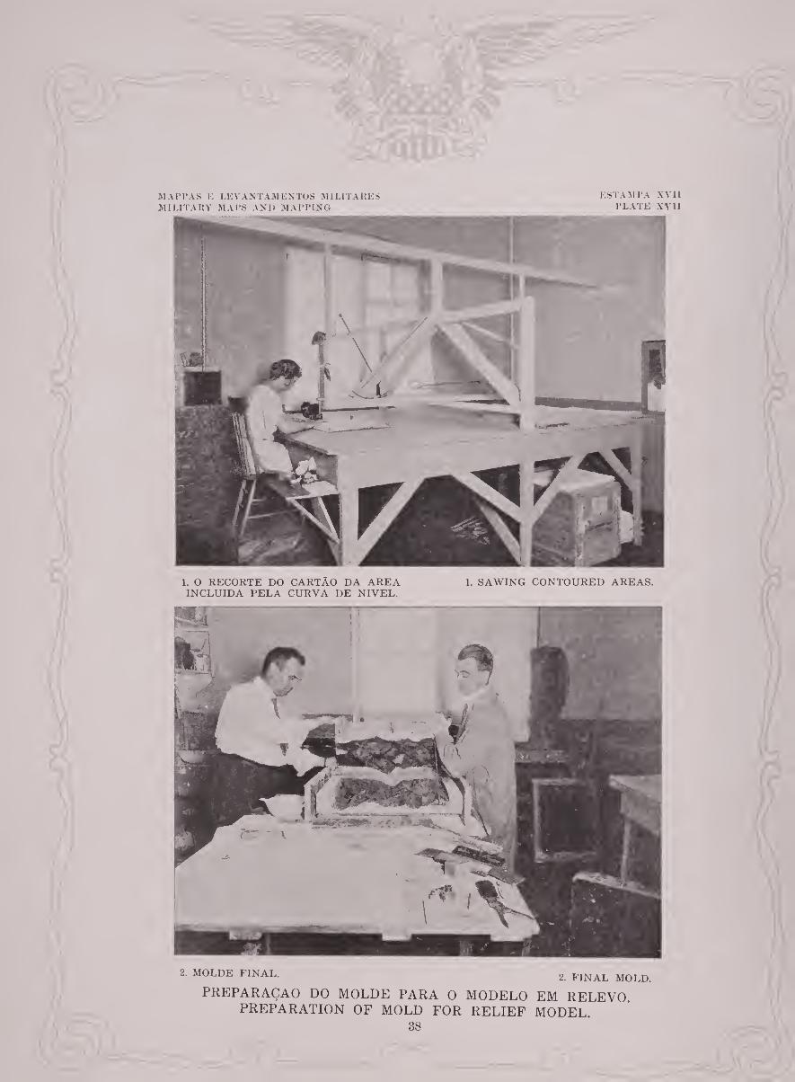
Aarea incluída por cada curva de nivel é recortada do cartão (est. XA II, fig. l)eá
maneira que vai sendo cortado é conservado em uma moldura marginal formada
pelo limite do mappa (est. XVIII). As camadas assim obtidas são reunidas em
ordem consecutiva com o fim de formar o molde modelo (est. XIX). As pre¬
parações preliminares tendo sido feitas para a modelação o gesso é deitado no
molde modelo (est. XVI, fig. 1), collocando-se no cimo uma armação de madeira,
produzindo se um ligeiro esqueleto fundido do modelo (est. XVI, fig. 2). A
verdadeira forma da natureza é dada depois ao modelo de gesso cobrindo a
superfície com uma composição preparada (est. XVI, fig. 3). Do modelo
acabado faz-se um novo molde. Este é o molde final com o qual se podem
fazer reproducçÕes em qualquer quantidade (est. XVII, fig. 2).
Mappa em relevo gravado.—Xa preparação de um mappa em relevo gravado o
gesso saido do molde final de um modelo de relevo é disposto de maneira a fazer
sobresair em relevo os elementos de luz e sombra e depois photographado; o
resultado é um mappa de sombra realçando todos os detalhes modelados no gesso
(est. XIV). Desta photographia fazem-se chapas lithographicas para serem
usadas na impressão do mappa de sombra sobre um mappa topographico de
curvas de nivel da mesma area; esta combinação faz a gravura do mappa em
relevo (est. XV).
contour is sawed from the cardboard (PI. XVII, fig. 1) and as it is cutis retained
in a marginal frame formed by the border of the map (PI. XVIII). The layers
thus obtained are assembled in consecutive order to form a pattern mold (PI.
XIX). The usual preliminary preparations for molding having been made,
plaster of paris is poured into the pattern mold (PI. XVI, fig. 1), on top of which
a wooden frame is secured, and a light skeleton cast of the pattern is produced
(PI. XVI, fig. 2). A form true to nature is then given to the plaster cast bj''
modeling the surface with a prepared composition (PI. XVI, fig. 3). From
the finished model a new mold is made. This is the final mold from which casts may be turned out in any quantity (PI. XVII, fig. 2).
Pictorial relief map.—In the preparation of a pictorial relief map a cast from
the final mold of a relief model is adjusted to bring out in relief the true light
and shadow values and then photographed; the result is a shadow map show¬
ing all the details modeled on the cast (PI. XIV). From this photograph
lithographic plates are made, to be used in printing the shadow map orer a
contoured topographic map of the same area; this combination makes the pictorial relief map (PI. XV).
MAP PAS E LEVANTAMENTOS MILITARES MILITARY MAPS AND MAPPING
ESTAMPA XVI PLATE XVI
2. ESQUELETO FUNDIDO DO MODELO. 2. PLASTER CAST OF PATTERN MOLD.
1. MOLDE MODELO.
PREPARAÇÃO DO MOLDE PARA O MODELO EM RELEVO. PREPARATION OF MOLD FOR RELIEF MODEL.
1. PATTERN MOLD.
3. MODELED PLASTER CAST. 3. MODELO ACABADO.
37
MAPPAS K LEVANTAMENTOS MILITARES MILITARY MAPS ANI> MAPPING
ESTAMPA XVII PLATE XVII
1. O RECORTE DO CARTÃO DA AREA 1. SAWING CONTOURED AREAS. INCLUÍDA PELA CURVA DE NIVEL.
2. MOLDE FINAL. 2 FINAL mold.
PREPARAÇAO DO MOLDE PARA O MODELO EM RELEVO. PREPARATION OF MOLD FOR RELIEF MODEL.
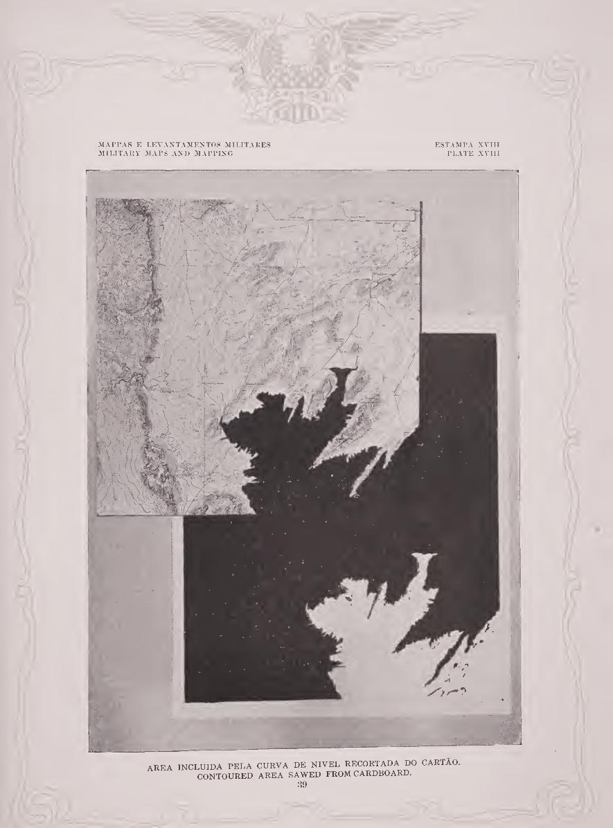
AREA INCLUÍDA PELA CURVA DE NIVEL RECORTADA DO CARTÃO.
CONTOURED AREA SAWED FROM CARDBOARD.
39

MA I’PAS K LEVANTAMENTOS MI LI TAKES MILITARY MAPS AND MAPPING
ESTAMPA XIX PLATE XlX
40

MODELOS DO CANAL DE PANAMÁ, DA MONTANTE DO RIO POTOMAC E
DO CAMPO DE BATALHA DE GETTYSBURG.
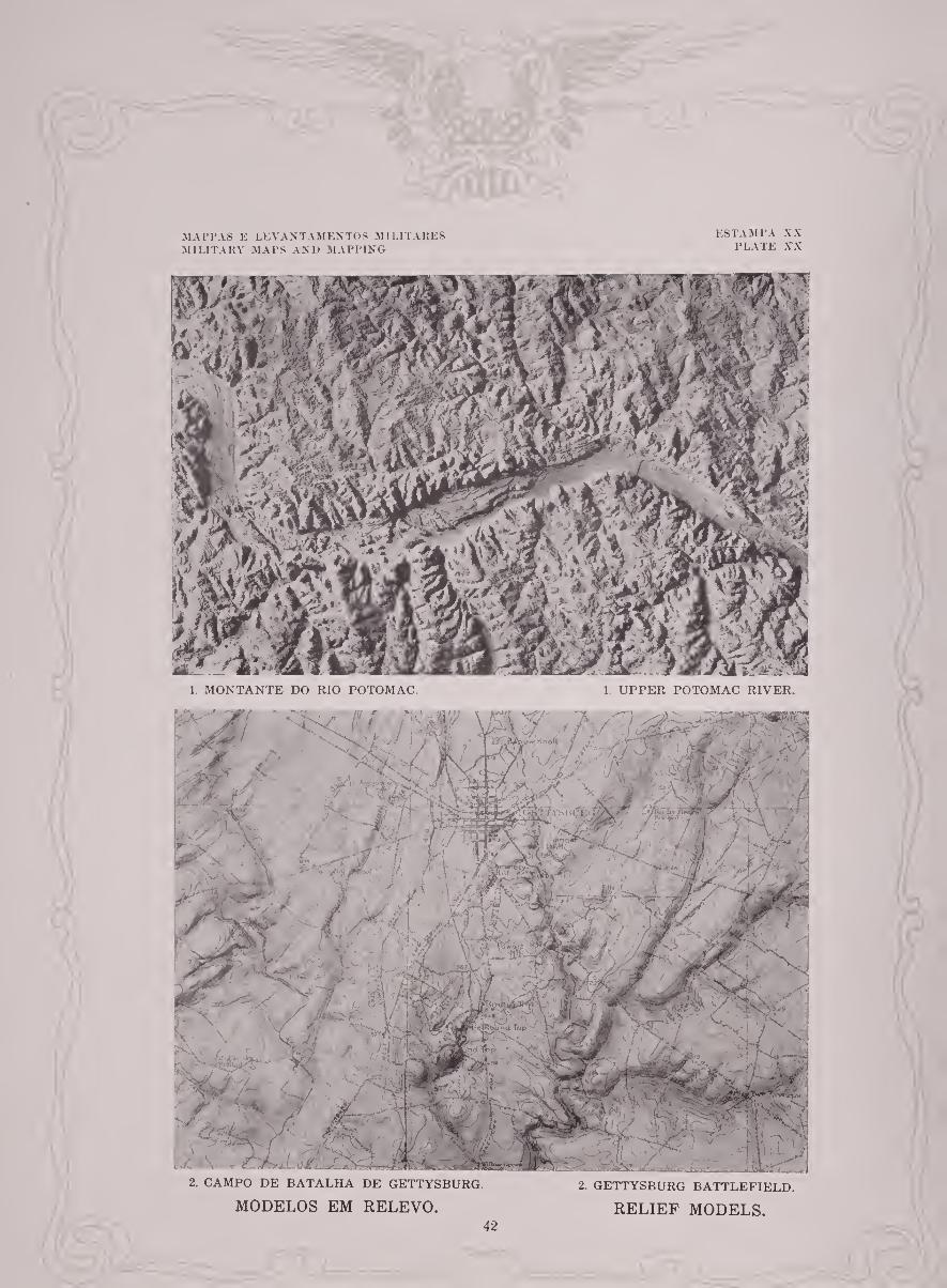
Os modelos do Canal de Panamá, da montante do rio Potomac e do campo de
batalha de Gettysburg, mostram os vários methodos de dispor os detalhes topo-
graphicos directamente sobre o modelo. Nos modelos do Canal de Panamá e da
montante do rio Potomac (est. XX, tig. 1) taes detalhes têm sido cuidadosa¬
mente applicados com pincel e tintas delicadas. Não ha limite, alem do da
escala do mappa, para a quantidade de detalhes que se podem indicar por este
methodo de applicar dados na superfície. O acabamento destes modelos tem
sido levado a um grau mais avançado do que é costume indicando-se as secções
de chacaras e de florestas, creando-se assim uma pintura verdadeira que se torna
clara a quem não está familiar com a geographia da região. Esta forma de
modelos pertence mais propriamente ao desenvolvimento popular de obras publicas.
Um outro methodo ê applicar á superfície do modelo um papel de seda especial
sobre o qual os dados do mappa basilar se acham impressos. Este methodo é o
empregado no modelo em relevo do campo de batalha de Gettysburg (est. XX, fig. 2).
A elaboração de taes detalhes superficiaes depende inteiramente da escala do
mappa e do caracter da região representada.
MODELS OF THE PANAMA CANAL, UPPER POTOMAC RIVER, AND
GETTYSBURG BATTLEFIELD.
The models of the Panama Canal, upper Potomac River, and Gettysburg
battlefield illustrate the several methods of displaying topographic details
directly upon the model. In the models of the Panama Canal and upper
Potomac River (PI. XX, fig. 1) such details have been carefully applied with
brush and delicate colors. There is no limit, other than the scale of the map,
to the amount of detail that may be shown by this method of applying surface
data. The finishing of these models has been carried to a further degree than
usual by showing farm sections and forestation, a truthful picture being thus
created that is clear to one not familiar with the geography of the region. This
form of model belongs more properly to the popular development of public
works. Another method is to apply to the surface of the model a sheet of special
tissue paper upon which the data of the base map have been printed. This
method is shown on the relief model of the Gettysburg battlefield (PI. XX,
fig. 2). The elaboration of such surface detail depends entirely on the scale of the
map and the character of the country represented.
41
MAPPAS E LEVANTAMENTOS MILITARES MILITARY MAPS AND MAPPING
ESTAMPA XX PLATE XX
2. CAMPO DE BATALHA DE GETTYSBURG. 2. GETTYSBURG BATTLEFIELD.
MODELOS EM RELEVO. RELIEF MODELS. 42

DIVISÃO DE INFORMAÇÃO MILITAR, ESTADO MAIOR, EXERCITO DOS
ESTADOS UNIDOS.
A Divisão de Informayão Militar do Estado Maior do Exercito dos Estados
Unidos tem a seu cargo a supervisão da política cartographica dos Estados
Unidos e das suas possessões no que se refere aos estabelecimentos militares.
Alem disso acha-se encarregada da guarda e manutenção da collecyão de mappas
do Estado Maior, que comprehende cerca de 400,000 mappas diflferentes de areas
dos Estados Unidos e paises estranjeiros. Os mappas estranjeiros são obtidos
principalmente por troca com os serviços topographicos dos governos dos dif-
ferentes paises mas em parte por compra dos mappas commerciaes no mercado livre.
Como resultado natural dos seus deveres a Divisão tem um profundo interesse
no trabalho das empresas de exploração geographica e topographica, offerecendo
o seu apoio até onde for requerido, fornecendo aos interessados nas explorações
mappas e instrumentos astronomicos e topographicos que podem ser requisitados
quando disponíveis nos estabelecimentos militares.
A Divisão frequentemente prepara mappas por compilação, e estes mappas
compilados, juntamente com os mappas que fazem parte da collecyão do Estado
Maior, são usados em grande extensão pelas divisões civis e repartições do
DIVISION OF MILITARY INTELLIGENCE, GENERAL STAFF, UNITED STATES
ARMY.
The Division of Military Intelligence of the General Staff of the United States
Army is charged with the supervision of the mapping policy of the United
States and its possessions in so far as it pertains to the military establishment.
It is further charged with the custody and maintenance of the General Staff
map collection, which comprises about 400,000 different maps of areas in the
United States and foreign countries. The foreign maps are obtained princi¬
pally through exchange with the governmental topographic services of the
different countries, but in part by the purchase of commercial maps in the open
market. As a natural result of its duties, the division is keenly interested in the
activities of geographic and topographic exploring organizations, lending its
support, in so far as it may be sought, by placing at the service ot the exploring
parties such maps and astronomic and topographic instruments as may be
desired and are available in the military establishment.
The division frequently prepares maps by compilation, and these compiled
maps, together with the maps contained in the General Staff collection, are
used to a great extent by the civilian divisions and bureaus of the Federal
43

Governo Federal. Exemplos do caracter destes mappas compilados são apresen¬
tados pelos specimens expostos na exposição conjuncta de mappas e levantamentos
topographicos, que são os seguintes:
(a) D. I. M. Mappa da Europa e da Asia Menor. Compilado com o íim de
obter dados tão rigorosos quanto possíveis das alterações das fronteiras resul¬
tantes da Guerra Mundial.
(b) D. I. M. Mappa do Pacifico. Preparado para uso da Conferencia de
Limitação de Armamentos recentemente reunida em Washington, D. C.
(c) D. I. M. Mappa do Atlântico. Preparado especialmente para ser exposto
na Exposição do Centenário do Brasil.
Government. Illustrations of the character of these compiled maps are afforded
by the examples on view in the joint exhibit of maps and mapping, which are
as follows:
(a) M. I. D. Map of Europe and Asia Minor. Compiled for the purpose of
obtaining as accurate data as possible on the changes of boundaries resulting
from the World War.
(b) M. I. D. Map of the Pacific. Prepared for the use of the Conference for
the Limitation of Armament recently held at Washington, D. C.
(c) M. I. D. Map of the Atlantic. Prepared specifically as an exhibit for
the Brazilian Centennial Exposition.
44


/
A


Related Documents