Enhancing Dam Safety and Public Protection through InaSAFE- Based Emergency Action Plan and Contingency Planning Public Disclosure Authorized Public Disclosure Authorized Public Disclosure Authorized Public Disclosure Authorized

Welcome message from author
This document is posted to help you gain knowledge. Please leave a comment to let me know what you think about it! Share it to your friends and learn new things together.
Transcript

Enhancing Dam Safety and Public Protection through InaSAFE-Based Emergency Action Plan and Contingency Planning
Pub
lic D
iscl
osur
e A
utho
rized
Pub
lic D
iscl
osur
e A
utho
rized
Pub
lic D
iscl
osur
e A
utho
rized
Pub
lic D
iscl
osur
e A
utho
rized

Enhancing Dam Safety and Public Protection through InaSAFE-Based Emergency Action Plan and Contingency Planning
KNOWLEDGE NOTEJIT DAM SAFETY ANDDISASTER PREPAREDNESS

Indonesia’s exposure to multiple hazards has the potential to impose significant economic and financial costs. During major disaster years the costs associated with natural disasters can reach 0.3 percent of national GDP and as high as 45 percent of GDP at the provincial level. Following the 2004 Indian Ocean Tsunami, the government allocated more than US$7 billion for reconstruction in Aceh and Nias and approximately US$2 billion following the 2010 Mount Merapi volcanic eruption.
With increasing urbanization and the need to secure water resources for productive purposes, dam safety is one of a number of emerging hazards in Indonesia. The Government’s experience with the failure of the Situ Gintung Dam in 2009 and that of the Way Ela Natural Dam in 2013 have re-enforced the importance of proper planning and the need for continuous improvement and innovation in disaster preparedness, along with inter-governmental coordination.
A dam safety workshop organized by the World Bank and the Global Facility for Disaster Reduction and Recovery in Tokyo, April 2017, bought together a range
of practitioners from across East Asia to explore the legal and institutional frameworks, along with the tools available, for improving planning and emergency preparedness. One of the key conclusions was recognition of the need to increase awareness and action on dam safety in Indonesia.
The InaSAFE software developed by BNPB in partnership with the Australian Government and the World Bank is central to supporting the Government in improved dam safety and disaster preparedness. The software enables disaster managers and decision makers to prepare and simulate natural disaster scenarios, to predict the magnitude of their impacts and to use the result to develop an emergency preparedness plan at local level. With active support from the World Bank and the Ministry of Public Works and Housing (MPWH) under this GFDRR JIT support, InaSAFE has been further developed to allow for the analysis of dam failures and preparation of appropriate response mechanisms.
This initiative represents an important collaboration with MPWH and BNPB as well as the community groups. I would like to offer my appreciation to the Ministry of Public Works and Housing and the World Bank for this support in improving and modernizing the Indonesian dam disaster preparedness. I believe such coordinated efforts should be sustained and the application extended to other dams in the portfolio. This will not only bring benefits to the communities downstream of the Jatigede and Gintung dams, as the focus under this initiative, but also to communities, dam operators and disaster management specialists involved in large dams across Indonesia.
Jakarta, December 2017
B. Wisnu WidjajaDeputy Minister for Prevention and PreparednessNational Disaster Management Authority
Foreword
4

Foreword
The development and sustainable management of water resources is central to securing Indonesia’s continued economic growth and prosperity. Growth in water withdrawals compared to the available supply, coupled with the island geography and lack of storage, is predicted to lead to high levels of water stress by 2040.
In response, the Governments has committed to the development of 65 new dams over a five- year period estimated to cost more than IDR 70 trillion. The development of dams is an important contributor to economic prosperity and poverty reduction measures by storing water for productive purposes, and these new dams will increase the total storage volume by 6.5 billion cubic meters to serve an estimated 460,380 Ha of the country’s rich irrigated land.
The majority of existing dams (85 percent) are owned by the MPWH Ministry of Public Works and Housing and operated by either the river territory organizations and state-owned corporations. Of these, 110 dams are registered as single purpose, primarily bulk water supply for irrigation under the MPWH. Of the 49 multi-purpose dams, 23 include a combination of water for irrigation and domestic supply, 13 combine irrigation with hydropower, while 13 combine irrigation with hydropower and domestic water supply.
Dam owners are required to prepare an Emergency Action Plan (EAP) for the unlikely event of a dam failure. More than 80 have been prepared to date based on the EAP Guidelines and Hazard Classification approved by the Indonesian Dam Safety Committee in 1999. In preparing the EAP, the dam owner should consult with downstream communities and public safety is at the center of the Governments’ efforts.
With the development of new dams, increasing urbanization and the changing nature of the Indonesian landscape ensuring appropriate measures for enhancing public safety and economic security through collaboration is critical to continued success.
Jakarta, December 2017
Imam SantosoDirector General of Water ResourcesMinistry of Public Works and Housing
5

Acknowledgements
This Knowledge Note summarizes the outputs from Just-in-Time support provided by the Global Facility for Disaster Reduction and Recovery (GFDRR) to The Coordination of Dam Safety and Disaster Preparedness in Indonesia. This was executed by the World Bank as part of the support to the Government of Indonesia under the Dam Operational Improvement and Safety Project (DOISP) in joint collaboration with the National Disaster Management Authority and the Directorate General for Water Resources in the Ministry of Public Works and Housing. Funding of US$50,000 for this project was made available under the GFDRR Multi-Donor Trust Fund (MDTF) for Mainstreaming Disaster and Climate Risk Management in Developing Countries, Climate Change Thematic Program, Just-in-Time Capacity Building and Advice.
The World Bank team was led by Marcus Wishart (Senior Water Resources Specialist), David Ginting (Water Resources Engineer), and Ruby Mangunsong (Disaster Risk Management Consultant), and included Agus Jatiwiryono (Dam Safety Specialist), Ilham Abla (Irrigation Specialist), Vica Bogaerts (Disaster Risk Management Specialist) and Nina Herawati (Program Assistant). Technical support was provided by Mohammad Fadli and Faizal Prabowo (Geo Enviro Omega) and Humanitarian Openstreetmap Team (HOT) Indonesia. The team is grateful for the support provided by Cindy Robles (Disaster Risk Management Specialist) and Cristina Otano (Senior Partnership Specialist) from the GFDRR, including Jolanta Kryspin-Watson (East Asia and the Pacific Regional DRM Coordinator).
The team from the National Disaster Management Authority (BNPB) included B. Wisnu Widjaja (Deputy Minister for Prevention and Preparedness), Medi Herlianto (Director for Response Preparedness), Bambang Surya Putra (Assistant Director for Early Warning), Maryanto (Supervisor for Network System Integration), and PASTIGANA (Center for Situation Analysis of Disaster Preparedness).
The team from the Ministry of Public Works and Housing (MPWH) included Agung Djuhartono (Director of Operation and Maintenance), Adek Rizal (Secretary of Central Project Management/Implementation Unit, Dam Operational Improvement and Safety Project), and Nova Swara (Section Head of Operation and Maintenance for Dams and Lakes).
The findings, interpretations, and conclusions expressed in this work do not necessarily represent the views of these individuals or their organizations.
Photo credits: Dam Operational Improvement and Safety Project (DOISP), Ministry of Public Works and Housing (MPWH), National Disaster Management Authority (BNPB), Haryono Sirait, Ruby Mangunsong. Design, layout, infographic: Indra Irnawan
6

Abbreviations
AWLR: Automatic Water Level RecorderB(B)WS: Indonesian River Basin Organization (Balai
Besar) Wilayah Sungai)Bappeda: Regional Development Planning Agency
(Badan Perencanaan Pembangunan Daerah)
BIG: Geospatial Information Agency (Badan Informasi Geospasial)
BNPB: National Disaster Management Authority (Badan Nasional Penanggulangan Bencana)
BMKG: Indonesian Agency for Meteorology, Climatology and Geophysics (Badan Meteorologi, Klimatologi dan Geofisika)
BPBD: Regional Disaster Management Authority (Badan Penggulangan Bencana Daerah)
BPS: Statistics Indonesia (Badan Pusat Statistik)
DOISP: Dam Operational Improvement and Safety Project
DGWR: Directorate-General of Water ResourcesDIBI: Indonesian Disaster Database (Data
Indeks Bencana Indonesia)DMU: (Dam Management Unit) within B(B)WSDSU: Dam Safety UnityDMI: Disaster Management InnovationDSC: Dam Safety Commission (Komisi
Keamanan Bendungan)EAP: Emergency Action PlanGDP: Gross Domestic ProductGFDRR: Global Facility for Disaster Reduction and
RecoveryGIS: Geographic Information SystemHOT: Humanitarian OpenStreetMap Team
ICOLD: International Commission on Large DamsIDR: Indonesian RupiahINACOLD: Indonesian National Committee on Large
Dams (Komite Nasional Indonesia untuk Bendungan Besar – KNI-BB)
InaSAFE: Indonesia Scenario Assessment for Emergency
InaWARE: Indonesia All-hazards Warning and Risk Evaluation
JakSAFE: Jakarta Scenario Assessment for Emergency
JIT: Just in time supportLAPAN: National Institute of Aeronautics and
Space (Lembaga Penerbangan dan Antariksa Nasional)
MHEWS: Multi Hazard Early Warning SystemMPWH: Ministry of Public Works and HousingsMoU: Memorandum of UnderstandingNGO: Non-governmental organizationOSM: OpenStreetMapPJT: Perusahaan Umum Jasa Tirta (State
Owned River Agency)PMI: Indonesian Red Cross (Palang Merah
Indonesia)PMF: Probable Maximum FloodPODES: Village Potential Statistics Dataset (Data
Potensi Desa)QGIS: Quantum Geographic Information System
Software PackageRBO: River Basin OrganizationsRENSTRA: Strategic Plan (Rencana Strategis)RPJMN: National Mid-term Development Plan
(Rencana Pembangunan Jangka Menengah Nasional)
7


INTRODUCTION
INDONESIAN DISASTER RISK MANAGEMENT AND DAM SAFETY
13 Indonesian Natural Disaster Profile15 Indonesian Dam Safety19 Institutional framework21 Legal framework22 Existing works in the Indonesian Dam Safety Management
INDONESIA SCENARIO ASSESSMENT FOR EMERGENCY (InaSAFE)
25 Impact analysis in InaSAFE28 JIT Dam Safety and InaSAFE Development
EMERGENCY ACTION PLAN AND CONTIGENCY PLAN
35 Emergency Action Plan (EAP)39 Contingency plan43 General comparison43 JIT Support to EAP and Contingency Plan Preparation
WAY FORWARD: InaSAFE-BASED EMERGENCY ACTION AND CONTIGENCY PLANNING?
50 Inter-institutional cooperation50. Compatibility of BNPB-MPWH database51. Participatory mapping51. Disaster Risk Communication51. BNPB-MPWH joint working group
60 References
Contents

Introduction
10
Indonesia has emerged over the last decade as a vibrant middle-income economy, with a GDP per capita of USD 3,603 in 2016. During the period of 2000-2013, the average annual real GDP growth of the country reached 5.9 percent and the income per capita has more than tripled in nominal terms compared to the preceding decade1. Over the same period, the population has steadily grown (national average rate of 1.5 percent per year) with the urban population increases at more than twice the national growth rate, at an average annual rate of 3.4 percent, which has positioned the country’s urban areas among the fastest urbanizing cities in the Southeast Asia region. Despite these gains, poverty reduction has stagnated over recent years and inequality is increasing rapidly. As measured by the current national poverty rate of 11.3 percent, there are 28 million poor people in Indonesia, with a near zero decline in 2014. Consequently, the Consumption Gini coefficient, an indicator of economic inequality, rose from 30 to 42 over this period (among the fastest widening rates in the region).
The Government has outlined its commitment to address these challenges in its National Mid-Term Development Plan (RPJMN 2015 - 2019) by focusing on human, community and infrastructure development; which is expected to increase the productivity and narrow the gap2. The RPJMN has a strong emphasis on water resources management and infrastructure development, which are seen as central to contributing directly to the goals of water security, food self-sufficiency and energy, with the ultimate target of improving the welfare of the people of Indonesia. The Ministry of Public Works and Housing (MPWH) has translated the
provisions of the RPJMN into a Strategic Plan (RENSTRA: Rencana Strategis) that provides detailed targets in support of the vision and objectives of the RPJMN. Specifically, the MPWH has targeted the construction of 65 new dams over five years, along with the rehabilitation of 46 existing dams and 1,175 tanks (embung)3. Dams and reservoir are expected to provide economic empowerment and security to the poor and other vulnerable groups by providing protection against flooding and minimizing the impacts associated with droughts, while also improving the availability and reliability of irrigation supply to the agricultural sector; a sector of which employs the majority of the country’s poor. Given its central position in the poverty eradication effort, dams and reservoirs must be well managed and maintained through a good operation and maintenance condition in order to sustain the service level, prolong the productive asset life and maintain the inherent dam failure risk within an acceptable level by preserving the structural stability throughout its lifespan.
Dam safety is increasingly important to ensuring public safety and economic security in Indonesia. The challenges of rapid population growth and urbanization, coupled with increasing climate variability and rainfall intensification, will accentuate the downstream hazards with the development of 65 new large dams. Most climate models predict the already constrained availability of water will be exacerbated in many areas along with further increases in the probability and frequency of water related disasters, such as floods, especially in densely populated urban areas near the coast. The poorest will bear the brunt of this
Enhancing Dam Safety and Public Protection through InaSAFE-Based Emergency Action Plan and Contingency Planning 11
burden as they are typically the most vulnerable to the impacts of drought, floods, and landslides and pursue livelihoods that are highly dependent on climate-sensitive sectors. The importance of dam safety was highlighted by two widely-reported dam failures; Gintung Dam (Province of Banten) in 2009 (previously named Situ Gintung) and Way Ela Natural Dam (Province of Maluku) in 2012. These events have urged the government to improve its disaster preparedness and planning in order to minimize the potential impact associated with dam failures.
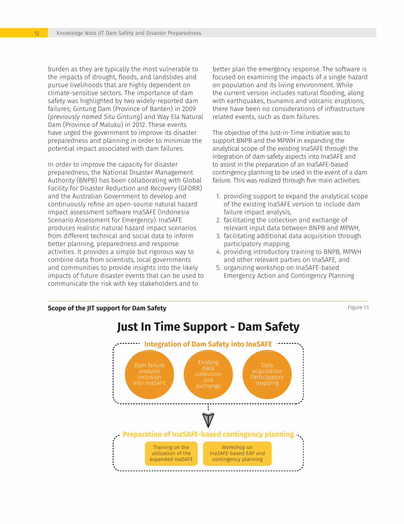
In order to improve the capacity for disaster preparedness, the National Disaster Management Authority (BNPB) has been collaborating with Global Facility for Disaster Reduction and Recovery (GFDRR) and the Australian Government to develop and continuously refine an open-source natural hazard impact assessment software InaSAFE (Indonesia Scenario Assessment for Emergency). InaSAFE produces realistic natural hazard impact scenarios from different technical and social data to inform better planning, preparedness and response activities. It provides a simple but rigorous way to combine data from scientists, local governments and communities to provide insights into the likely impacts of future disaster events that can be used to communicate the risk with key stakeholders and to
Scope of the JIT support for Dam Safety FIgure 1.1
better plan the emergency response. The software is focused on examining the impacts of a single hazard on population and its living environment. While the current version includes natural flooding, along with earthquakes, tsunamis and volcanic eruptions, there have been no considerations of infrastructure related events, such as dam failures.
The objective of the Just-in-Time initiative was to support BNPB and the MPWH in expanding the analytical scope of the existing InaSAFE through the integration of dam safety aspects into InaSAFE and to assist in the preparation of an InaSAFE-based contingency planning to be used in the event of a dam failure. This was realized through five main activities:
1. providing support to expand the analytical scope of the existing InaSAFE version to include dam failure impact analysis,
2. facilitating the collection and exchange of relevant input data between BNPB and MPWH,
3. facilitating additional data acquisition through participatory mapping,
4. providing introductory training to BNPB, MPWH and other relevant parties on InaSAFE, and
5. organizing workshop on InaSAFE-based Emergency Action and Contingency Planning
Just In Time Support - Dam SafetyIntegration of Dam Safety into InaSAFE
Training on theutilization of the
expanded InaSAFE
Workshop onInaSAFE-based EAP andcontingency planning
Preparation of InaSAFE-based contingency planning
Dam failureanalysisinclusion
into InaSAFE
Existingdata
collectionand
exchange
Dataacquisition:Participatory
mapping
Knowledge Note JIT Dam Safety and Disaster Preparedness12

Dam safety is increasingly important to ensuring public safety and economic security
“
”

Indonesian Disaster Risk Management and Dam Safety
14
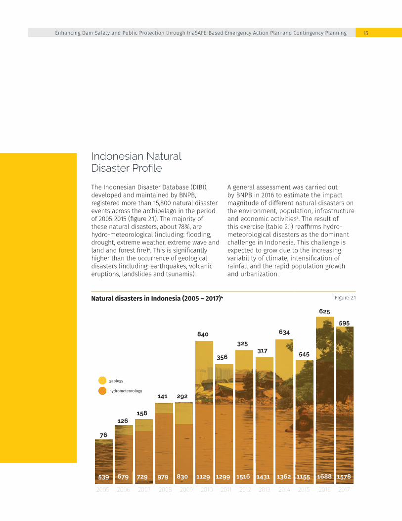
Natural disasters in Indonesia (2005 – 2017)4 FIgure 2.1
Indonesian Natural Disaster Profile
The Indonesian Disaster Database (DIBI), developed and maintained by BNPB, registered more than 15,800 natural disaster events across the archipelago in the period of 2005-2015 (figure 2.1). The majority of these natural disasters, about 78%, are hydro-meteorological (including: flooding, drought, extreme weather, extreme wave and land and forest fire)4. This is significantly higher than the occurrence of geological disasters (including: earthquakes, volcanic eruptions, landslides and tsunamis).
A general assessment was carried out by BNPB in 2016 to estimate the impact magnitude of different natural disasters on the environment, population, infrastructure and economic activities5. The result of this exercise (table 2.1) reaffirms hydro-meteorological disasters as the dominant challenge in Indonesia. This challenge is expected to grow due to the increasing variability of climate, intensification of rainfall and the rapid population growth and urbanization.
hydrometeorology
geology
20072006 2008 20092005 20122011 2013 20142010 2015 2016 2017
729679 979 830539 15161299 1431 13621129 1155 1688 1578
158126
141 292
76
325
356317
634840
545
625
595
Enhancing Dam Safety and Public Protection through InaSAFE-Based Emergency Action Plan and Contingency Planning 15

Potential impact of major natural disaster in Indonesia5 Table 2.1
Flooding (including flash flood)
42,105,133 13,192,322 109,451,827 221,009,360 155,878,446
Extreme weather 106,582,476 - 244,295,774 11,972,702 3,088,869
Extreme wave and abrasion
1,888,085 460,252 4,917,327 22,042,350 1,290,842
Drought 163,101,784 63,781,004 228,163,266 - 192,737,143
Land and forest fire 86,457,259 41,856,289 - - 59,036,830
Earthquake 52,374,614 - 86,247,258 466,689,834 182,185,171
Volcanic eruption 394,324 139,676 749,126 2,695,427 12,613
Landslide 57,418,460 41,337,707 14,131,542 78,279,825 75,870,343
Tsunami 961,133 119,688 3,702,702 71,494,821 7,976,358
Impact coverage
(Ha)
Exposed natural environment
(Ha)
Exposed population
Infrastructure loss
(Million IDR)
Impact of economic activities
(Million IDR)
Knowledge Note JIT Dam Safety and Disaster Preparedness16
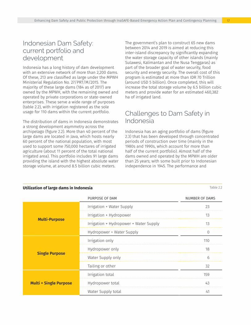
Indonesian Dam Safety:current portfolio and developmentIndonesia has a long history of dam development with an extensive network of more than 2,200 dams. Of these, 213 are classified as large under the MPWH Ministerial Regulation No. 27/PRT/M/2015. The majority of these large dams (184 as of 2017) are owned by the MPWH, with the remaining owned and operated by private corporations or state-owned enterprises. These serve a wide range of purposes (table 2.2), with irrigation registered as the sole usage for 110 dams within the current portfolio.
The distribution of dams in Indonesia demonstrates a strong development asymmetry across the archipelago (figure 2.2). More than 40 percent of the large dams are located in Java, which hosts nearly 60 percent of the national population, with most used to support some 750,000 hectares of irrigated agriculture (about 11 percent of the total national irrigated area). This portfolio includes 91 large dams providing the island with the highest absolute water storage volume, at around 8.5 billion cubic meters.
The government’s plan to construct 65 new dams between 2014 and 2019 is aimed at reducing this inter-island discrepancy by significantly expanding the water storage capacity of other islands (mainly Sulawesi, Kalimantan and the Nusa Tenggaras) as part of the broader goal of water security, food security and energy security. The overall cost of this program is estimated at more than IDR 70 Trillion (around USD 5 billion). Once completed, this will increase the total storage volume by 6.5 billion cubic meters and provide water for an estimated 460,382 ha of irrigated land.
Challenges to Dam Safety in Indonesia
Indonesia has an aging portfolio of dams (figure 2.3) that has been developed through concentrated periods of construction over time (mainly in the 1980s and 1990s, which account for more than half of the current portfolio). Almost half of the dams owned and operated by the MPWH are older than 25 years; with some built prior to Indonesian independence in 1945. The performance and
Utilization of large dams in Indonesia Table 2.2
PURPOSE OF DAM NUMBER OF DAMS
Multi-Purpose
Irrigation + Water Supply 23
Irrigation + Hydropower 13
Irrigation + Hydropower + Water Supply 13
Hydropower + Water Supply 0
Single Purpose
Irrigation only 110
Hydropower only 18
Water Supply only 6
Tailing or other 32
Multi + Single Purpose
Irrigation total 159
Hydropower total 43
Water Supply total 41
Enhancing Dam Safety and Public Protection through InaSAFE-Based Emergency Action Plan and Contingency Planning 17

Age distribution of the state-owned large dams6 FIgure 2.3
Distribution of existing and planned (state-owned) large dams in Indonesia FIgure 2.2
50 - 100 year
19%
> 100 year2%
25 - 50 year
23%
10 - 25 year
43%
< 10 year
13%
Sumatra20
Existing DAM2,850,000Storage (103 m3)
11Planned/under construction
985,000Storage (103 m3)
Java91
Existing DAM8,600,000Storage (103 m3)
24Planned/under construction
2,674,370Storage (103 m3)
Bali5
Existing DAM27,160
Storage (103 m3)
3Planned/under construction
29,600Storage (103 m3)
West NusaTenggara
62Existing DAM270,150
Storage (103 m3)
4Planned/under construction
99,920Storage (103 m3)
15Existing DAM
33,525Storage (103 m3)
7Planned/under construction
216,590Storage (103 m3)
Maluku2
Existing DAM275
Storage (103 m3)
1Planned/under construction
15,000Storage (103 m3)
Sulawesi9
Existing DAM506,060Storage (103 m3)
9Planned/under construction
1,380,620Storage (103 m3)
Kalimantan9
Existing DAM1,225,713Storage (103 m3)
5Planned/under construction
916,570Storage (103 m3)
Papuap1
Planned/under construction
200,000Storage (103 m3)
East NusaTenggara
Knowledge Note JIT Dam Safety and Disaster Preparedness18

structural stability of these dams are challenged by the prolonged accumulation of sediments and increasing climate uncertainty. Furthermore, limited hydrological records mean that many of these older dams may not be designed to accommodate the predicted change in run-off and increasing rainfall variability. This increases the risk associated with uncontrolled downstream flooding and dam failure.
While dam failures are rare events, the consequences can be severe and there have been number of incidents in Indonesia. These include the failure of the Sempor Coffer Dam in Central Java in 1967, an earthen dam that failed due to overtopping
and claimed the lives of an estimated 127 people. In 2009, the failure of the 10-meter high Situ Gintung Dam inundated more than 400 residential dwellings, displaced 170 people, and claimed the lives of an estimated 100 people. Neither of these two dams had emergency preparedness plans in place and contrast against the experience of the Way Ela Natural Dam in Maluku that collapsed in 2013. The procedures put in place through the emergency action plan provided for the timely and effective evacuation that saved almost 5,000 lives when the dam eventually collapsed within a period of 12 hours on July 25, 2013 (Box 1).
The Situ Gintung Dam failed in 2009 due to consecutive days of heavy rains created a flash flood which inundated more than 400 residential dwellings.
Enhancing Dam Safety and Public Protection through InaSAFE-Based Emergency Action Plan and Contingency Planning 19
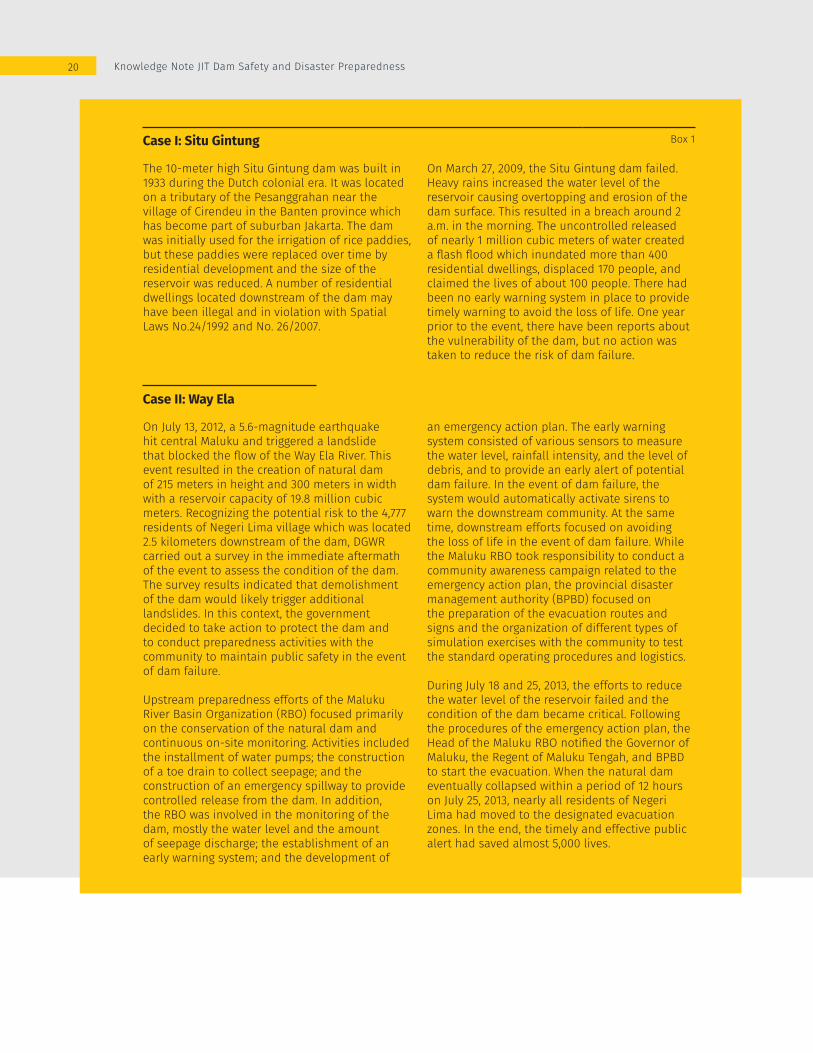
Case I: Situ Gintung Box 1
The 10-meter high Situ Gintung dam was built in 1933 during the Dutch colonial era. It was located on a tributary of the Pesanggrahan near the village of Cirendeu in the Banten province which has become part of suburban Jakarta. The dam was initially used for the irrigation of rice paddies, but these paddies were replaced over time by residential development and the size of the reservoir was reduced. A number of residential dwellings located downstream of the dam may have been illegal and in violation with Spatial Laws No.24/1992 and No. 26/2007.
On March 27, 2009, the Situ Gintung dam failed. Heavy rains increased the water level of the reservoir causing overtopping and erosion of the dam surface. This resulted in a breach around 2 a.m. in the morning. The uncontrolled released of nearly 1 million cubic meters of water created a flash flood which inundated more than 400 residential dwellings, displaced 170 people, and claimed the lives of about 100 people. There had been no early warning system in place to provide timely warning to avoid the loss of life. One year prior to the event, there have been reports about the vulnerability of the dam, but no action was taken to reduce the risk of dam failure.
Case II: Way Ela
On July 13, 2012, a 5.6-magnitude earthquake hit central Maluku and triggered a landslide that blocked the flow of the Way Ela River. This event resulted in the creation of natural dam of 215 meters in height and 300 meters in width with a reservoir capacity of 19.8 million cubic meters. Recognizing the potential risk to the 4,777 residents of Negeri Lima village which was located 2.5 kilometers downstream of the dam, DGWR carried out a survey in the immediate aftermath of the event to assess the condition of the dam. The survey results indicated that demolishment of the dam would likely trigger additional landslides. In this context, the government decided to take action to protect the dam and to conduct preparedness activities with the community to maintain public safety in the event of dam failure.
Upstream preparedness efforts of the Maluku River Basin Organization (RBO) focused primarily on the conservation of the natural dam and continuous on-site monitoring. Activities included the installment of water pumps; the construction of a toe drain to collect seepage; and the construction of an emergency spillway to provide controlled release from the dam. In addition, the RBO was involved in the monitoring of the dam, mostly the water level and the amount of seepage discharge; the establishment of an early warning system; and the development of
an emergency action plan. The early warning system consisted of various sensors to measure the water level, rainfall intensity, and the level of debris, and to provide an early alert of potential dam failure. In the event of dam failure, the system would automatically activate sirens to warn the downstream community. At the same time, downstream efforts focused on avoiding the loss of life in the event of dam failure. While the Maluku RBO took responsibility to conduct a community awareness campaign related to the emergency action plan, the provincial disaster management authority (BPBD) focused on the preparation of the evacuation routes and signs and the organization of different types of simulation exercises with the community to test the standard operating procedures and logistics.
During July 18 and 25, 2013, the efforts to reduce the water level of the reservoir failed and the condition of the dam became critical. Following the procedures of the emergency action plan, the Head of the Maluku RBO notified the Governor of Maluku, the Regent of Maluku Tengah, and BPBD to start the evacuation. When the natural dam eventually collapsed within a period of 12 hours on July 25, 2013, nearly all residents of Negeri Lima had moved to the designated evacuation zones. In the end, the timely and effective public alert had saved almost 5,000 lives.
Knowledge Note JIT Dam Safety and Disaster Preparedness20

Institutional FrameworkDam safety management in Indonesia involves a range of different stakeholders, including the following:
1. BNPB and Local Disaster Management Authorities (BPBD)
2. River Basin Organizations or B(B)WS – Balai (Besar) Wilayah Sungai; as the implementing agency of the DGWR, MPWH
3. Dam Management Units within River Basin Organization
4. Dam Safety Units – DSU (Balai Bendungan)5. Dam Construction Center (Pusat Bendungan)6. Directorate of Operation and Management
Guidance - MPWH7. Dam Safety Commission – DSC (Komisi
Keamanan Bendungan) 8. Private and state-owned enterprises that own/
manage dams9. Indonesian National Committee on Large Dams-
INACOLD (Komite Nasional Indonesia untuk Bendungan Besar - KNI-BB)
As the national authority for disaster management, BNPB holds a central role in both strategic and operational levels for disaster preparedness. At a strategic level, the authority issues policies, standards and guidelines on disaster prevention, emergency response, rehabilitation and reconstruction activities; and formulates the national strategic plan on disaster management (as specified by the Disaster Management Law No. 24/2007). At the operational level the authority is responsible for supporting the operation and development of the regional disaster management authorities (BPBD) in preparedness building, disaster relief and rehabilitation work. While BNPB and BPBD are not directly responsible for dam safety, both are mandated to assess the nationwide distribution of disaster risks and to develop contingency plans for high-risk disasters. In certain areas and under specific conditions this can include the potential for dam failures. To fulfil its role in communicating disaster risks to the public, BNPB collects various socio-technical data that characterize the disaster risk and community vulnerability. These are processed and made available to the public through different open-source (and in-house developed) software and websites, including InaSAFE, InaRISK and InaWARE.
Water Resources, including the licensing of water infrastructure and dam safety, is the responsibility
of the MPWH; which is mandated to the DGWR. The MPWH is responsible for formulating and implementing policies for water resources management; road management; the provision of housing; the development of residential areas; housing finance; arrangements for buildings, water supply systems, waste water management systems and environmental drainage, as well as waste management and construction services. MPWH is also tasked with implementation of human resource development in the area of public works and public housing, in addition to the strategic integration of public works infrastructure development.
Given the unique characteristics of the country’s topography and climate, a system of water resources development and management has been established in Indonesia that combines a number of independent river basins into larger administrative “river territories” or Wilayah Sungai(s). The Water Law in 2004 introduced a national system of river basin management carried out by public river basin organizations referred to as either Balai Besar Wilayah Sungai(s) (BBWSs) or Balai Wilayah Sungai(s) (BWSs). These balai fill both regulatory and management functions, as well as undertaking construction, operation, and maintenance of river infrastructure and irrigation systems larger than 3,000 hectares. MPWH Ministerial Regulation No.34/PRT/M/2015 assigns the working area of every B(B)WS (and indirectly distributes the responsibility for operation and maintenance of large dams among the Balais). In practice, dam operation and maintenance is a combination of effort between the Operation and Maintenance Unit (Satuan Kerja Operasi dan Pemeliharaan) and, where they exist, the Dam Management Unit (Unit Pengelola Bendungan) within the Balai. These efforts are supported and guided by other agencies within the DGWR, such as the Directorate of Operation and Maintenance in dam management.
The DGWR and the B(B)WSs are supported by the Dam Construction Center (Pusat Bendungan) in the construction phase and Directorate of Operation and Maintenance in the management phase whose role and responsibilities are outlined in the MPWH Ministerial Regulation No. 15/PRT/M/2015 on Organizational and Work Structure of MPWH. Related to dam safety, these include the following (i) preparation and implementation of guidance norms, standards, procedures, and criteria for dams, lakes, water, and ponds, as well as the physical conservation
Enhancing Dam Safety and Public Protection through InaSAFE-Based Emergency Action Plan and Contingency Planning 21

of water resources; (ii) readiness assessment and execution of activities in dams, lakes, water, and ponds, as well as the physical conservation of water resources; (iii) planning arrangements for dams, lakes, water, and ponds, as well as the physical conservation of water resources; (iv) human resource development relating to the management of dams, lakes, water, and ponds, as well as the physical conservation of water resources; and Directorate of Operation and Maintenace Guidance for all water resources infastructure including dam.
A Dam Safety Commission has been in place since 2007 and was re-established under MPWH Ministerial Regulation No. 03/KPTS/M/2016 to assist the ministry in: (i) Providing recommendations relating to dam safety to the minister in every phase of dam development such as design, construction, operation, rehabilitation, and dam closure; (ii) evaluating the activities of the Dam Safety Units in order to make recommendations to the Minister; and (iii) preparing accountability reports for the Minister and (iv) organizing the dam inspection activity.
Under the former Government Regulations, the Dam Safety Commission was the responsible authorities as regulator for dam safety assurance, including different ministries/agencies who own the dam, but the prevailing regulations are only binding on those dams under the MPWH. This notwithstanding, the other agencies also continue to adhere to the provisions of the current ministerial regulations. The DSC is chaired by the Director General of Water Resources and its membership comprises representatives of government and state-owned companies as the owner of the dams, professional associations, and any another government agency related to dams as appointed by the minister
The Dam Safety Commission is supported by the Dam Safety Unit – DSU (Balai Bendungan) with general task to provide technical and administrative support to the Commission. The MPWH Ministerial Regulation No. 25/PRT/M/2006 outlines the roles and responsibilities of the DSU include: (i) data collection and processing of every dam, (ii) assessment of dam construction and
Dam failure is a new emerging hazard, therefore innovation and collaboration on dam safety are required
Knowledge Note JIT Dam Safety and Disaster Preparedness22

management (iii) conducting dam inspections, (iv) providing technical advice on dam construction, (v) dissemination and guidance on dam safety, (vi) drafting regulations, guidelines, technical instructions on dam safety, (vii) monitoring the implementation of dam construction safety aspects, (viii) maintaining inventories and registration of dams as well as their hazard classification and (ix) dam archive management.
The Indonesian National Committee on Large Dams (INACOLD: Komite Nasional Indonesia untuk Bendungan Besar - KNI-BB) is a professional organization that serves on the Dam Safety Commission and has an active role in the development, operation and maintenance of large dams in Indonesia through the continued existence of the organization and activities of its members. Its involvement as an active member of the International Commission on Large Dams (ICOLD) since 1967, as well as its continuous efforts to maintain relationships with other regional and international institutions, reflect efforts to maintain an active presence globally. In line with its goal, the KNI-BB aims to develop and maintain large dams to create a more effective and efficient means for the development and management of water resources to improve the wealth of the community. This is achieved through: 1) Development and management in the planning, implementation, and operation and maintenance of large dams; 2) Improving the quality of expertise and responsibility of Indonesia’s Technical Experts on dams in the field of large dams; and 3) Actively participating in the improvement of wealth for the Indonesian people through the development and management of large dams and water resources management.
Legal FrameworkIndonesia has a well-developed, national legal framework for dam safety based on three main tenets: (i) structural safety, (ii) surveillance and (iii) emergency preparedness. This has evolved over four decades and is currently governed through MPWH Ministerial Regulation, No. 27/PRT/M/2015 specifically on dams. Following the repeal of the Water Resources Law No.7 of 2004 in 2015, Indonesia reverted back to operating under Water Law No. 11 of 1974 and MPWH Ministerial Regulation No 72/PRT/1997 on Dam Safety. This regulation was subsequently repealed and replaced by Ministerial
Regulation No. 27/2015 on Dams and MPWH Ministerial Regulation No. 03/KPTS/M/2016 On Dam Safety Commission. Notwithstanding changes in the legal regime, it provides a comprehensive framework for dam safety assurance.
Under the MPWH Ministerial Regulation No. 27/2015 Article 77(1) the dam owner is primarily responsible dam management, as well as their corresponding reservoirs, along with dam safety assurance. For state-owned dams, the MPWH appoints the technical implementation unit responsible for water resource management or a state-owned enterprise to be the dam manager. The dam manager is assisted in carrying out the management of the dam, as well as the reservoir, by a dam management unit. Under these provisions, the B(B)WSs have been designated as the technical implementation units along with two state owned river agencies (Perusahaan Umum Jasa Tirta/PJT). Periodic reports are required to be submitted to the relevant agencies by the dam management unit, including structural and operational information on the behavior of the dam and the reservoir conditions; readings from instruments and their interpretation, the results of the inspection, and safety evaluations; modification or rehabilitation; events related to dam safety and incident extraordinary; and the condition of water reservoir including water allocation. The dam management unit must also have an information system for the dams under their jurisdiction, as well as the reservoirs, that can be accessed by the public. This should specify: the collection, processing, and provision of data and information on dam as well as the reservoir; and be regularly updated information of the dam as well as the reservoir.
A guideline has been developed by DSU and was issued by the DGWR in 2003 under the Technical Guidelines for Operation, Maintenance and Monitoring of Dam (Keputusan Ditjen SDA 199/KPTS/D/2003 Pedoman Operasi, Pemeliharaan dan Pengamatan Bendungan). The guidelines include dam safety surveillance as an inseparable and important part of the regular operation and maintenance. This includes regular monitoring of various performance and safety related technical parameters and periodic safety evaluations by independent third parties.
Emergency preparedness is the third element of the dam safety framework in Indonesia. During preparation, the downstream communities that would be affected by any potential dam failure and the
Enhancing Dam Safety and Public Protection through InaSAFE-Based Emergency Action Plan and Contingency Planning 23

provincial and local authorities responsible for early warning, evacuation, and post-flood assistance, are required to be consulted. The legislative provisions for emergency preparedness relating to dam safety are intended to ensure that the dam manager is prepared for the worst conditions in the event of a catastrophic failure. The draft emergency action plan should contain specific actions relating to dam safety as well as community rescue actions and environmental safety and should be based on an analysis on the potential failure modes of the dam.
In order to assist the dam owners and managers in preparing an EAP, DSU issued a guideline document in 1998; which was formalized under DGWR Decree No. 94/KPTS/A/1998. The guideline provides a framework in identifying hazard / driving factors of dam failure, developing disaster scenarios, assessing the potential impact of a dam failure, designing notification protocols and preparing response actions. This document has been used to develop numerous EAP for state-owned dams, including the Jatigede and Gintung dams (the focus of the case studies in this knowledge note). In addition to this, BNPB issued a guideline in 2011 for preparing disaster contingency plans.
Different from the EAP Guideline, this document does not specifically address a certain type of hazard but provides a universal guidance in building disaster preparedness against natural disasters in general. The guideline suggests that contingency planning should be started by assessing the risk of different disaster hazards (scoring based on their impact level and occurrence probability) and only high-risk hazards should be addressed in the contingency plan. Due to its likelihood and localized impact, dam failure is rarely selected as the basis for a contingency plan. Contingency plan for Way Ela Natural Dam Break is the only contingency plan issued by BNPB and BPBD that has been specifically designated for a dam break event. A closer look on both guideline documents are provided in section 5.
Dam Safety Management Planning
The Government has implemented a number of programs to improve the overall architecture for dam safety in Indonesia. These are aimed at improving the operational efficiency of the
User-interface of the MPWH dam safety database12 FIgure 2.4
Knowledge Note JIT Dam Safety and Disaster Preparedness24

Real-time dam surveillance system7 FIgure 2.5
infrastructure while also building resilience to hydro-meteorologic disasters and preparedness in the event of a dam failure. The MPWH is developing a web-based database which compiles the results of periodic on-site measurements for key safety parameters for large dams across Indonesia. This database enables the MPWH to continuously monitor dam safety levels and prepare an appropriate response for different hazard levels.
The MPWH is also piloting a publicly-accessible and real-time dam surveillance system (http://monitoringbendungan.com/index.php). Surveillance cameras have been installed at nine large dams across Java and Sumatra. This system uses a simplified display derived from the larger database; with its presentation focused solely on water level, rainfall intensity and an aerial image of the dam and its reservoir.
Although BNPB is not specifically mandated to safeguard large dams, they undertake a number of activities related to increasing the national water safety and thus improving the resilience to dam failure. The BNPB has collaborated with international and regional agencies in developing
different web-based disaster management applications, which include the following:
1. Multi Hazard Early Warning System (MHEWS): for forecasting the change of disaster hazard level, with the prediction mainly based on hydro-meteorologic parameters including rainfall intensity, air temperature, air pressure, air humidity, wind speed and direction; accessible at http://mhews.bnpb.go.id/
2. Indonesia All-hazards Warning and Risk Evaluation (InaWARE) for compiling and processing data required for synchronizing the stakeholders’ perception on disaster risk, and to provide communication and coordination platform for them; accessible at http://inaware.bnpb.go.id/
3. Indonesia Scenario Assessment for Emergency (InaSAFE): for simulating natural disaster scenarios across Indonesia and, then, assessing their impact on population and land use; accessible at http://inasafe.org/
4. Jakarta Scenario Assessment for Emergency (JakSAFE): similar tool to InaSAFE with an analysis scope limited to the Province of Jakarta; accessible at http://jaksafe.bpbd.jakarta.go.id/
Enhancing Dam Safety and Public Protection through InaSAFE-Based Emergency Action Plan and Contingency Planning 25
Indonesia Scenario Assessment for Emergency[InaSAFE]
26
InaSAFE was originally developed in Indonesia through a partnership between BNPB, the Australian Government and the World Bank GFDRR as a tool for disaster managers and communities to support contingency planning. It is a free software that produces realistic natural hazard impact scenarios for better planning, preparedness and response activities. InaSAFE provides a simple but rigorous way to combine data from scientists, local governments and communities to provide insights into the potential impacts of future disaster events. The software is focused on examining, in detail, the impacts a single hazard on population and its living environment. The analytical scope of the original version of InaSAFE covers four types of natural disasters including: earthquake, flooding, tsunami and volcano eruption.
InaSAFE is available as a plug-in for the open-source QGIS software package; and its usage has been widely socialized by, or in close collaboration with, the BNPB. In the period between its initial development (June 2011) up to the release of its latest 4.1 version (June 2017), there have been 126 trainings and workshops organized on InaSAFE across 17 Indonesian provinces, reaching more than 3,200 participants.
Impact Analysis in InaSAFEInaSAFE combines the data on disaster hazard and exposure to assess the magnitude of impact of the most-common natural disasters in Indonesia. InaSAFE carries out the assessment by overlaying the spatial data of hazard on exposure data, in the QGIS software package, and then examines the intersecting portion. This analysis yields in three main outputs: disaster impact map, disaster impact report and disaster action-checklist (figure 3.1).
HazardInaSAFE defines ‘hazard’ as any natural or human caused event or series of events that may negatively impact the population, infrastructure or resources in an area. Hazard data is commonly obtained from past analysis or mapping activities on disaster hazard conducted by different authorities. Such analysis uses data on disaster characteristics (mainly related to its scale, frequency, duration based on historical records and probabilistic studies) and on the physical properties of the area surrounding the hazard source (mainly topographic profile and land use configuration) to estimate the areal coverage exposed by a certain type of disaster and the spatial distribution of risk level across the potentially-impacted area. This analysis result should be converted, if not already, into a geographical spatial format (i.e. raster image / .tiff or vector image / .shp) which is digestible by InaSAFE. For example, the urban flooding analysis of Jakarta, using hydrological (computational) models, produces a map that presents the extent and depth of inundation due to extreme rainfall and river overflow across Jakarta (figure 3.2).
Enhancing Dam Safety and Public Protection through InaSAFE-Based Emergency Action Plan and Contingency Planning 27
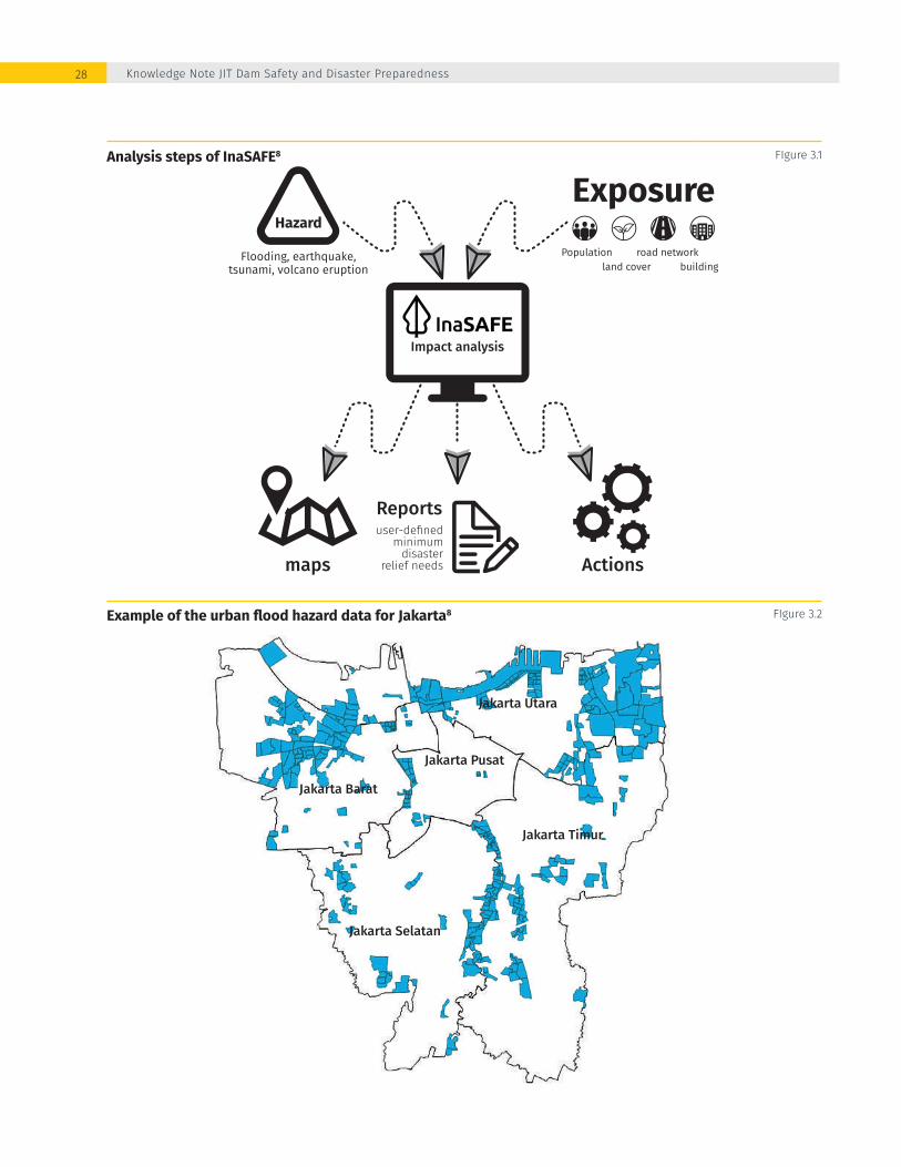
Analysis steps of InaSAFE8 FIgure 3.1
Example of the urban flood hazard data for Jakarta8 FIgure 3.2
Hazard
Flooding, earthquake,tsunami, volcano eruption
Exposure
land cover
Reportsuser-defined
minimumdisaster
relief needs Actionsmaps
Impact analysis
Population road networkbuilding
Jakarta Pusat
Jakarta Selatan
Jakarta Timur
Jakarta Barat
Jakarta Utara
Knowledge Note JIT Dam Safety and Disaster Preparedness28

ExposureInaSAFE defines ‘exposure’ as the susceptibility of an area towards a certain type of disaster; it is defined by feeding GIS-based spatial information on the distribution of populations, buildings, road networks and land cover. The current availability of this spatial data is very limited among public institutions, including within BNPB and MPWH, especially data on land cover and building distribution. When available, the data is often outdated or not available in the correct format (either available as .pdf, .jpg or printed version). From past experiences, BNPB recognizes ‘participatory mapping’ as an effective event to convert the available data into the desired format and version. Such an event invites active participation from the public, often represented by students and interest groups, to digitize the available data into raster or shape file. BNPB has multiple experiences in organizing this events, such as during the development of JakSAFE and InaRISK, to convert the land cover information (commonly available in photographic imagery format /.jpg) into spatial data (map in shape file format) and, then, upload
the result to an open-source land use and building distribution database (OpenStreetMap – OSM).
Impact analysis resultsThe InaSAFE outputs include a Disaster impact Map, a Disaster Impact report and a Disaster Action Checklist. The disaster impact map mainly presents the intersection between the hazard and exposure spatial data; based on this map InaSAFE will automatically generate the disaster impact report. This impact report consists of two main sections: (i) impact recapitulation: lists and calculates the number of the impacted population, road, buildings, public facilities and different types of land cover and (ii) disaster relief need: estimates the minimum (food, clean water, sanitary and family kit) supplies for disaster relief based on the impact report (Figure 3.4). The conversion ratio between the ‘impact’ and the ‘disaster relief need’ is user-defined; with the default conversion ratio based on the BNPB Regulation No. 2/2012 on General Guidelines for Disaster Risk Study. Lastly, the action checklist contains questions to start the conversations around better disaster preparedness.
Example of an exposure map for Jakarta, containing information on land use, building distribution and road network (available at OpenStreetMap)8
FIgure 3.3
Enhancing Dam Safety and Public Protection through InaSAFE-Based Emergency Action Plan and Contingency Planning 29

DEVELOPING DAM SAFETY CAPABILITIES within InaSAFE
The analytical scope of the current version of InaSAFE (ver. 4.1) covers the most common natural disasters in Indonesia; including: earthquakes, volcanic eruptions, tsunamis and flooding. In order to expand the scope to include dam safety aspects and facilitate the exchange of the required input data, two pilot sites were selected by MPWH and BNPB to trial the updates to the InaSAFE-Dam Safety version. Data collection was focused on the Jatigede and Gintung dams
InaSAFE expansion: Inclusion of dam failure analysisThe flooding analysis tool of the InaSAFE 4.1 was designed to assess the impact flooding due to river-overflow and local inundation, characterized with relatively low flow velocity, gradual increase of inundation level and long inundation period. As such, it is not suited to assessing flooding due to a dam failure which is typically characterized by a sudden, uncontrolled discharge with flashflood-like characteristics.
Modifications were incorporated into InaSAFE to include a dam break assessment function. The development process was carried out in close consultation with Disaster Management Innovation (DMI), the original developer of InaSAFE, which has not only spawned an expanded version of InaSAFE (figure 3.5) but also assisted BNPB and the MPWH to
Example of an impact analysis result (map, report and action list) generated from the simulation of the 2013 flooding in Jakarta
FIgure 3.4
Knowledge Note JIT Dam Safety and Disaster Preparedness30

Background and key technical properties of Gintung and Jatigede Dam 9, 10 Table 3.1
Gintung Dam Jatigede Dam
Gintung Dam is located near the village of Cirendu, Province of Banten, which due to urban sprawl has become part of Jakarta’s suburban area. This earthfill dam blocks a tributary of the Pessangrahan River and is mainly used for flood protection, bulk water supply and tourism purpose. After its failure in March 2009, reconstruction of the dam commenced in December 2009, with the works completed in early 2011 and approved for operation by the DSC. This state-owned dam is currently operated and maintained by the BBWS Ciliwung Cisadane.
Background
Jatigede Dam is located in the Jatigede Sub-District, District of Sumedang, Provinde of West Java. Its construction was started in 2008 and completed in 2015. This rockfill dam blocks the Cimanuk River with a massive catchment area of 1,462 km2; covering the districts of Garut, Sumedang, Majalengka and Indramayu. The dam is mainly used for irrigation, hydropower generation, bulk water supply, flood protection and tourism. This state-owned dam is currently operated and maintained by the BBWS Cimanuk-Cisanggarung.
Earthfill with geotextile reinforcement at the upstream side Dam structure Rockfill
El. +100 m Crest level El. +265 m
15 m Dam’s height (measured from the deepest foundation) 114 m
180 m Crest length 1,715 m
5 m Crest width 12 m
22.92 ha Reservoir footprint 412,200 ha; at water level El +262 m
0,720 million m3; water level at El. +97.50 m
Storage capacity FSL -Full supply limit
980 million m3; water level at El. +260 m
0,619 million m3 Effective storage capacity 877 million m3
32.7 km2 Catchment size 1,462 km2
75 l/s Average river discharge 2.5 x 10⁹ m3/year
EL +92.70 m Normal Water Level El +260 m
EL +87.60 m Low Water Level El +230 m
El +98.70 m Flood Water Level El +262 m
124.30 m3/s Probable maximum flood (PMF) 11,000 m3/s
Enhancing Dam Safety and Public Protection through InaSAFE-Based Emergency Action Plan and Contingency Planning 31

identify the required input data, to inventory the data availability and to identify data-gaps.
Existing data collection and exchangeDuring the process of expanding the capabilities of InaSAFE and a series of JIT coordination meetings with dam operators and disaster managers from BNPB and MPWH (figure 3.6), the following socio-technical data were identified as crucial to support the dam break analysis in the updated version of InaSAFE and in building disaster preparedness: (i) dam break inundation map; (ii) population distribution map; (iii) land cover map; (iv) building distribution map; (v) road network map. These data are required for the selected study case of Jatigede and Gintung Dam in GIS-supported format (i.e. shp or tiff format) in order to be compatible with QGIS-based InaSAFE system.
Dam break inundation maps were retrieved from the Emergency Action Plans (EAP) of the Jatigede Dam (published in 2012) and the Gintung Dam (published in 2011). These maps were produce as part of the outputs from the dam break
assessments using computational hydraulic models conducted by engineering firms contracted by the MPWH. The results of these studies were delivered to MPWH in .pdf and .doc format and not compatible with InaSAFE. The maps were subsequently acquired from the engineering firms in the desired format (figure 3.7).
Population distribution maps and land cover maps were obtained from the data archives within BNPB (figure 3.8). This data was collected during the development of InaRISK, an accompanying open website that provides information on the distribution of natural disaster risk across Indonesia. Population distribution data was issued by the Statistics Indonesia (BPS) based on national demography survey in 2014 (Pendataan Potensi Desa 2014), while the land use map data was published by the National Geospatial Information Agency (BIG) in 2013. The land use map presents the spatial configuration of land designations on a macro-level and thus does not display the precise location of buildings, roads and public infrastructures. The latter data is required to assess the impact of inundation on infrastructures in detail.
User interface: Dam break functionality among other disaster analysis options FIgure 3.5
Knowledge Note JIT Dam Safety and Disaster Preparedness32

Data Acquisition: participatory mappingInformation on the distribution of buildings, road networks and public infrastructure is unavailable in any governmental agency in Indonesia. While some data are available through the OpenStreetMap (OSM) platform, and directly downloadable from InaSAFE, this is limited to larger cities across Indonesia. The database of OSM has been going through continuous expansion and benefits from the output of different mapping activities aimed at digitizing aerial photos and or maps of buildings and public infrastructures (commonly available in .jpg format) into a GIS-based format11.
The Humanitarian OpenStreetMap Team (HOT), a non-profit organization committed to continuously build the OSM database and maintain its accessibility
for the public, was engaged to facilitate a series of participatory mapping events. These were aimed at converting high-resolution satellite images of areas potentially affected in the event of a failure of the Jatigede and Gintung dams into GIS-based shapefiles (namely rural areas which are not yet included in the existing OSM database). This activity was carried out in two steps (figure 3.9). First, the HOT team digitized the imageries into shapefiles which contain the spatial distribution of buildings, road and public infrastructures. The team then conducted ground-checks to validate the accuracy of the maps produced. This was done by organizing meetings with local leaders (including the head of village and community elders) and by visiting the buildings and infrastructures to produce a validated data set and OpenStreetMap (figure 3.10).
Inundation map of Gintung Dam (left) and Jatigede Dam (right) from a Dam break analysis carried out by MPWH9,10
FIgure 3.7
JIT coordination meeting and discussions FIgure 3.6
Enhancing Dam Safety and Public Protection through InaSAFE-Based Emergency Action Plan and Contingency Planning 33

Land use map and population distribution downstream of the Gintung Dam (top) and Jatigede Dam (bottom)
FIgure 3.8
Knowledge Note JIT Dam Safety and Disaster Preparedness34

Consultations with village heads and community elders as part of the participatory mapping FIgure 3.9
OpenStreetMap database in the surroundings of Gintung Dam before and after the participatory mapping event
FIgure 3.10
Enhancing Dam Safety and Public Protection through InaSAFE-Based Emergency Action Plan and Contingency Planning 35

OpenStreetMap database in the surroundings of Jatigede Dam before (left) and after (right) the participatory mapping event
FIgure 3.11
Knowledge Note JIT Dam Safety and Disaster Preparedness36

Enhancing Dam Safety and Public Protection through InaSAFE-Based Emergency Action Plan and Contingency Planning 37

Emergency Action Plan and Contigency Plan
38

Disaster preparedness and response in the event of a dam failure are shared responsibilities of the MPWH and BNPB. The MPWH, represented by the B(B)WS as the dam manager, is responsible for developing an emergency action plan; while BPNPB, represented by BPBD as the regional disaster manager, is responsible for preparing a contingency plan. Although there is significant overlap in the content of both plans, they are developed through different mechanisms and focused on different aspects of disaster management. This section elaborates and compares both plans to help bridge the plans and move towards a coordinated InaSAFE-based preparedness planning tool.
EMERGENCY ACTION PLAN
The MPWH Regulation No. 27/2015 regulating dam safety management requires dam owners and managers to prepare an Emergency Action Plan for use in the event of a dam failure. More than 80 EAPs have been developed by the B(B)WSs, on behalf of the MPWH. Sixty-five of these were financed as part of the Dam Operational Improvement and Safety Project (DOISP) using guidelines developed under the project. These EAPs are based on the Hazard Classification Guidelines prepared under the original Dam Safety Project and approved by the Indonesian Dam Safety Committee in 1999. In preparing the EAP, the dam owner can obtain technical input from the water resource manager in the river basin and input from the potentially affected communities downstream.
In the case that one river basin has more than one dam (as cascade); the EAP for each dam should be made into one unified EAP. When a dam is built in a river basin with an existing dam, preparation of the EAP for the new dam must also involve the dam management unit that is already established in addition to involving local technical agencies and local communities. The EAP for the existing dam should be adjusted and then integrated into one unified EAP. If in one river basin multiple dams are constructed simultaneously, the EAPs shall be prepared in a coordinated manner so that all the EAPs can be merged into one unified plan.
Enhancing Dam Safety and Public Protection through InaSAFE-Based Emergency Action Plan and Contingency Planning 39

Finish
Reportas O&Mactivity
Coordinate withlocal government
and relevant parties
Emergencysituation
Emergencyinspection
Start
Normal?No
Yes
Declare the end emergency status
Criticalcondition?
Instrumentreading
Intensified and detailed observation
Disasterreporting
Yes
Yes
No
Yes
No
No
Reporting to:- EAP coordinator- Head of EAP team- Head of Dam Monitoring Unit- Balai Bendungan (DSU)- Directorate River and Coastal
Reporting similar to the O&Mreport, with addition of:- Dam Safety Commission (DSC)- Central Dam Monitoring Unit
Reporting similar to EmergencyLevel III, with addition of:- Mayor of South Tangerang and Mayor of South Jakarta- BPBD of South Tangerang and South Jakarta
Reporting similar to EmergencyLevel II, with addition of:Mayor of South Tangerang andMayor of South Jakarta instructtheir BPBD’s to start evacuationprocedure and maintaincoordination throughoutthe process
Declared by:- For areas surrounding the dam: declaration by the dam owner (MPWH – BBWS)- For the upstream area: Mayor of South Tangerang and Mayor of South Jakarta
Action successful?
Emergency evacuation
Safety restored?
Takeprevention
and/orrestoration
action
Regularinspectionon damcollection
Oper
atio
n an
d M
aint
enan
ceem
erge
ncy
leve
l iii
emer
genc
y le
vel i
iem
erge
ncy
leve
l ien
d of
emer
genc
y
Emergency action plan and communication flowchart of Gintung Dam9 FIgure 4.1
Knowledge Note JIT Dam Safety and Disaster Preparedness40

The MPWH has issued a guideline, formalized under DGWR Decree No. 94/KPTS/A/1998, to assist dam owners in preparing and updating their EAP. The guideline recommends that an EAP should include at a minimum:
1. Elaboration of the emergency situation, potential drivers, impact assessment and options of prevention and restoration measures;
2. Emergency communication procedure and notification protocol, coordination plan and task division among relevant parties (example presented in figure 4.1);
3. Elaboration on the availability (quantity and accessibility) of electricity, tools and goods required for the dam failure prevention and restoration activities;
4. Inundation map due to dam failure;5. Evacuation plan;6. Criteria in terminating or ending a dam break
emergency situation.
In line with MPWH Regulation No. 27/2015, the guideline also requires the EAP to be regularly updated. The guideline strongly recommends a quick review and update to be conducted on an annual basis; while a comprehensive update should be carried out at least every five years (or earlier if the socio, economic and environmental condition is considered to undergone a rapid and significant change).
The guideline also introduces multi-stage emergency management; in which an emergency situation is broken-down into three levels according to the observable severity of the dam damage and/or the magnitude of the hazard or driving factors of dam failure (table 4.1). Response actions and the engagement plan with the relevant stakeholders are developed to suit the different emergency stages (table 4.2) in order to prevent excessive or insufficient response actions. Therefore, consistent observations (visual and gauge-aided) on the dam is required to trail the actual emergency state.
The guideline further outlines that during a dam break emergency the decision in commencing the evacuation procedure should be taken by the local government whose areas are affected by the dam failure. The dam owner should position itself as an active supporting partner, with the evacuation activity itself led by the local government (at least by a district-level government) and the regional disaster management authority. The local government and disaster management authority are also responsible for declaring the end/termination of the emergency state when the hazard level is considered to be normalized. The dam owner is responsbile for actively assisting this process by continously monitoring and predicting the safety level around the dam and the affected areas; and reporting its finding to the local government.
INDICATION GENERAL RESPONSE
Emergency level 1 (siaga 1 or awas level)
technical assessment confirms that dam will shortly fail or the failure currently happens
start the evacuation procedure (if needed); local governments and relevant governmental agencies carry out tasks as described in the EAP
Emergency level 2 (siaga 2 or siaga level)
key dam safety parameters further change towards (and nearly reach) the threshold level; structural damage starts to occur at the dam
further intensification of the key safety parameters, carry out damage restoration activity, notify the local governments and relevant governmental agencies on the situation
Emergency level 3 (siaga 3 or waspada level)
key dam safety parameters (rainfall intensity, water level, river discharge, etc.) change towards the threshold level
intensification (frequency and scope) of monitoring activities on the key safety parameters
The multiple stages of emergency management under an EAP 9, 10 Table 4.1
Enhancing Dam Safety and Public Protection through InaSAFE-Based Emergency Action Plan and Contingency Planning 41
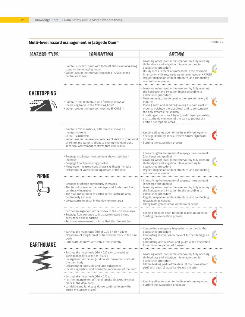
Multi-level hazard management in Jatigede Dam10 Table 4.2
HAZARD TYPE INDICATION ACTION
• Rainfall > 75 mm/hour; with forecast shows an increasing trend in the following hours
• Water level in the reservoir exceeds El +260.5 m and continues to rise
• Lowering water level in the reservoir by fully opening th floodgate and irrigation intake according to established procedure
• Hourly measurement of water level in the reservoir (manual or with automatic water level recoder – AWLR)
• Regular inspection of dam structure, and conducting restoration as needed
• Rainfall > 100 mm/hour; with forecast shows an increasing trend in the following hours
• Water level in the reservoir reaches El +262.5 m
• Lowering water level in the reservoir by fully opening the floodgate and irrigation intake according to established procedure
• Measurement of water level in the reservoir every 15 minutes
• Placing earth and sand bags along the dam crest in order to heighten the crest level and to concentrate the flow towards the spillway
• Installing erotion-proof layer (plastic layer, geotextile, etc.) at the downstream of the dam to protect the erotion-susceptible areas
• Rainfall > 150 mm/hour; with forecast shows an increasing trend
• Q-PMF is achieved• Water level in the reservoir reaches El +245.5 m (freeboard
of 0.5 m) and water is about to overtop the dam crest• Technical assessment confirms that dam will fail
• Keeping all gates open to the its maximum opening Seepage discharge measurement shows significant increase
• Starting the evacuation process
• Seepage discharge measurement shows significant increase
• Seepage flow become higly turbid• Piezometer measurement shows significant increase• Occurance of vortex in the upstream of the dam
• Intensifying the frequency of seepage measurement (discharge and quality)
• Lowering water level in the reservoir by fully opening th floodgate and irrigation intake according to established procedure
• Regular inspection of dam structure, and conducting restoration as needed
• Seepage discharge continously increases• The turbidity level of the seepage, and its derbree load,
continusly increases• The size and number of vortex in the upstream area
continously incrases• Vortex starts to occur in the downstream area
• Intensifying the frequency of seepage measurement (discharge and quality)
• Lowering water level in the reservoir by fully opening the floodgate and irrigation intake according to established procedure
• Regular inspection of dam structure, and conducting restoration as needed.
• Filling (with gravel) areas where water seeps
• Further enlargement of the vortex in the upstream area• Seepage flow continue to increase followed byland
subsidence and landslide• Technical assessment confirms that the dam will fail
• Keeping all gates open to the its maximum opening• Starting the evacuation process
• Earthquake magnitude (kh) of 0.05 g < kh < 0.10 g• Occurance of longitudinal or transversal crack in the dam
body• Dam starts to move vertically or horizontally
• Conducting emergency inspection according to the established procedure
• Conducting restoration to prevent further damage as needed
• Conducting weekly visual and gauge-aided inspection for a minimum period of 6 weeks
• Earthquake magnitude (kh) > 0.10 g or consecutive earthquakes of 0.05 g < kh < 0.10 g
• Enlargement of the longitudinal or transversal crack at the dam body
• Occurance of landslide and land subsidence• Increasing vertical and horizontal movement of the dam
• Lowering water level in the reservoir by fully opening th floodgate and irrigation intake according to established procedure
• Fill the leaking parts of the dam (at the downstream part) with bags of gravel-and-sand mixture
• Earthquake magnitude (kh) > 0.10 g• Further enlargement of the of longitudinal/transversal
crack at the dam body• Landslide and land subsidence continue to grow (in
terms of number & size)
• Keeping all gates open to the its maximum opening• Starting the evacuation procedure
Knowledge Note JIT Dam Safety and Disaster Preparedness42

The dam owner is also expected to maintain close communication with the National or Local Meterological Agency (BMKG) to obtain a rainfall intensity forecast. At the end of the emergency, the dam owner is responsbile for evaluating the implementation of the EAP, identifying potential areas for improvement, summarizing learning lessons and updating the EAP as needed.
The guideline requires an approval page to be included in every EAP. The page is to be signed by the representative of local governments and relevant governmental agencies (whose tasks and responsibilities during dam break emergency are formulated in the EAP) as a form of agreement in taking the necessary action during a dam failure. The order of actions and notification protocol are summarized in the form of a flowchart in the EAP. The EAP Guideline provides a template, although this has been considered outdated since it was established in 1998, prior to the formation of the B(B)WS’, BNPB and BPBD (the current key parties of the Indonesian dam safety sector). The MPWH is currently drafting an update of the guideline to address the institutional evolution in the sector.
CONTINGENCY PLAN
The contingency plan is one of the key instruments for disaster preparedness and the success of the emergency response lies in the preparation and implementation quality. This was acknowledged by the BNPB strategic plan 2015-2019 which approached the reduction of the disaster risk index by developing and then internalizing the principles of disaster risk reduction into development planning. This is achieved through developing a contingency plan at the city or district level. This approach was proven successful during the Way Ela Natural Dam Break (Box 2). As stated in the Disaster Management Law No. 24/2007, “contingency plan” means a process of forward planning for unforeseen situations in order to better prevent or overcome an emergency or critical situation by mutually agreeing on scenarios and objectives, determining technical and managerial actions as well as response and mobilization of potentialities. The law also states that disaster preparedness and response are the responsibility of the local government.
Disaster drill in Kapaha and Seith villages, February 2013 before the Way Ela Natural Dam collapsed in July 2013
FIgure 4.2
Enhancing Dam Safety and Public Protection through InaSAFE-Based Emergency Action Plan and Contingency Planning 43
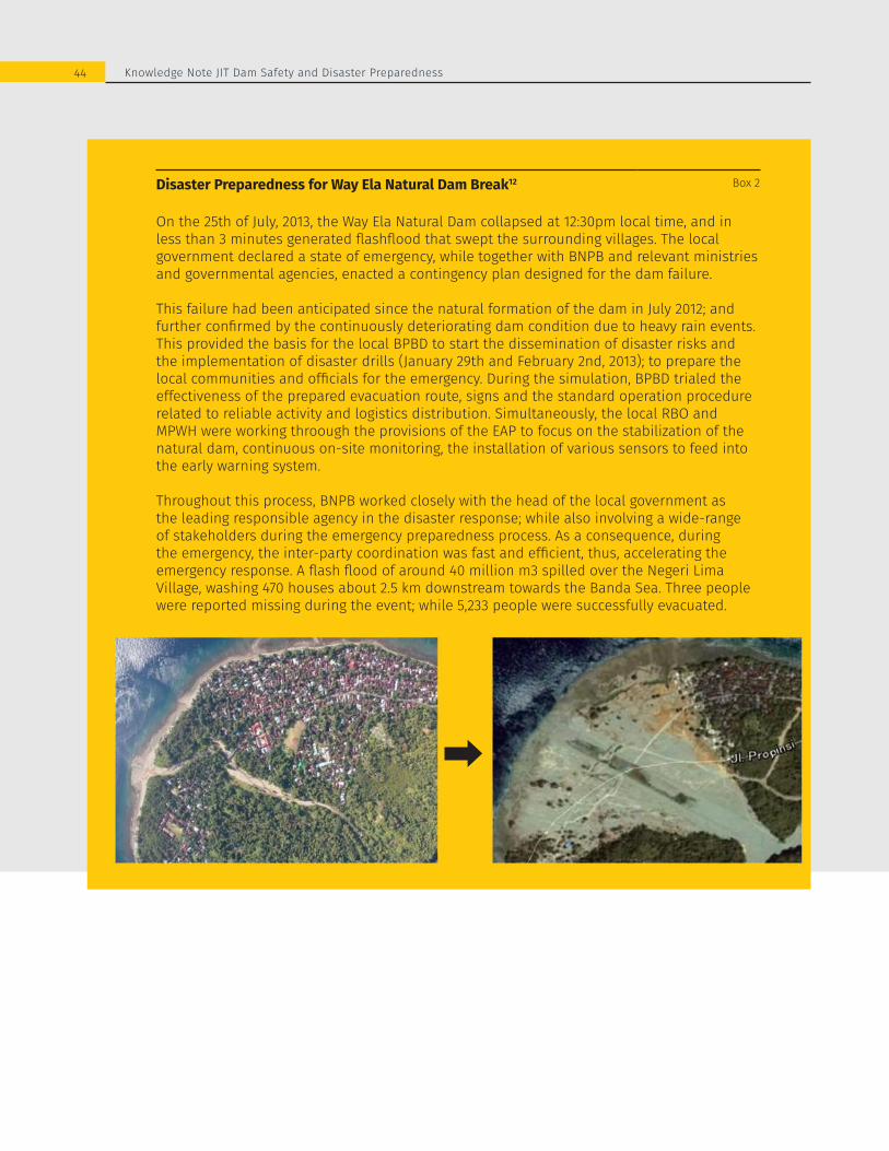
Disaster Preparedness for Way Ela Natural Dam Break12 Box 2
On the 25th of July, 2013, the Way Ela Natural Dam collapsed at 12:30pm local time, and in less than 3 minutes generated flashflood that swept the surrounding villages. The local government declared a state of emergency, while together with BNPB and relevant ministries and governmental agencies, enacted a contingency plan designed for the dam failure.
This failure had been anticipated since the natural formation of the dam in July 2012; and further confirmed by the continuously deteriorating dam condition due to heavy rain events. This provided the basis for the local BPBD to start the dissemination of disaster risks and the implementation of disaster drills (January 29th and February 2nd, 2013); to prepare the local communities and officials for the emergency. During the simulation, BPBD trialed the effectiveness of the prepared evacuation route, signs and the standard operation procedure related to reliable activity and logistics distribution. Simultaneously, the local RBO and MPWH were working throough the provisions of the EAP to focus on the stabilization of the natural dam, continuous on-site monitoring, the installation of various sensors to feed into the early warning system.
Throughout this process, BNPB worked closely with the head of the local government as the leading responsible agency in the disaster response; while also involving a wide-range of stakeholders during the emergency preparedness process. As a consequence, during the emergency, the inter-party coordination was fast and efficient, thus, accelerating the emergency response. A flash flood of around 40 million m3 spilled over the Negeri Lima Village, washing 470 houses about 2.5 km downstream towards the Banda Sea. Three people were reported missing during the event; while 5,233 people were successfully evacuated.
44 Knowledge Note JIT Dam Safety and Disaster Preparedness

In order to help the Local Disaster Management Authorities (BPBDs) in preparing contingency plans, BNPB issued a guideline in 2011.13 The document does not specifically address a certain type of hazard yet it provides universal guidance in building disaster preparedness against natural disasters. The guideline suggests that contingency planning should be started with a ‘risk assessment’. Here, BPBD enlists and estimates the risk of disaster-driving hazards (assessment by scoring the occurrence likelihood and potential magnitude of impact) and then address the high-risks hazards in the contingency plan. Steps in developing a contingency plan are presented in figure 4.2
The guideline suggests that a contingency plan should include at least the following:
1. Identification of relevant stakeholders;2. Relevant data availability among stakeholder;
Disaster
Simulation /disasterdrill
Resourcesneed fordisaster relief
Resourcesavailability
Policy and strategyformulation
Scenariodevelopment
Gapanalysis
Sectorialplanning
Hazardranking
Riskassessment
Formalization
Actionplanning
Activation
Review
Process for developing a contingency plan13 FIgure 4.2
3. Responsibility for formulation and distribution among stakeholders;
4. Estimation of the required resources for disaster relief;5. Inventory of the available resources among stakeholder;6. Agreement among stakeholders on emergency
actions, review plan and disaster drill plan;
The guideline emphasizes that the contingency planning process should prioritize consensus formation (towards a common perception of hazard, a jointly-developed disaster scenario and an agreement on the task and responsibility distribution) rather than solely producing a document. Therefore, the guideline strongly recommends the plan to be shaped through series of consultation activities (hearings, workshops, trainings, etc.) with a wide-range of stakeholders. This should not only include those who are affected by the disaster but also those who have
45Enhancing Dam Safety and Public Protection through InaSAFE-Based Emergency Action Plan and Contingency Planning
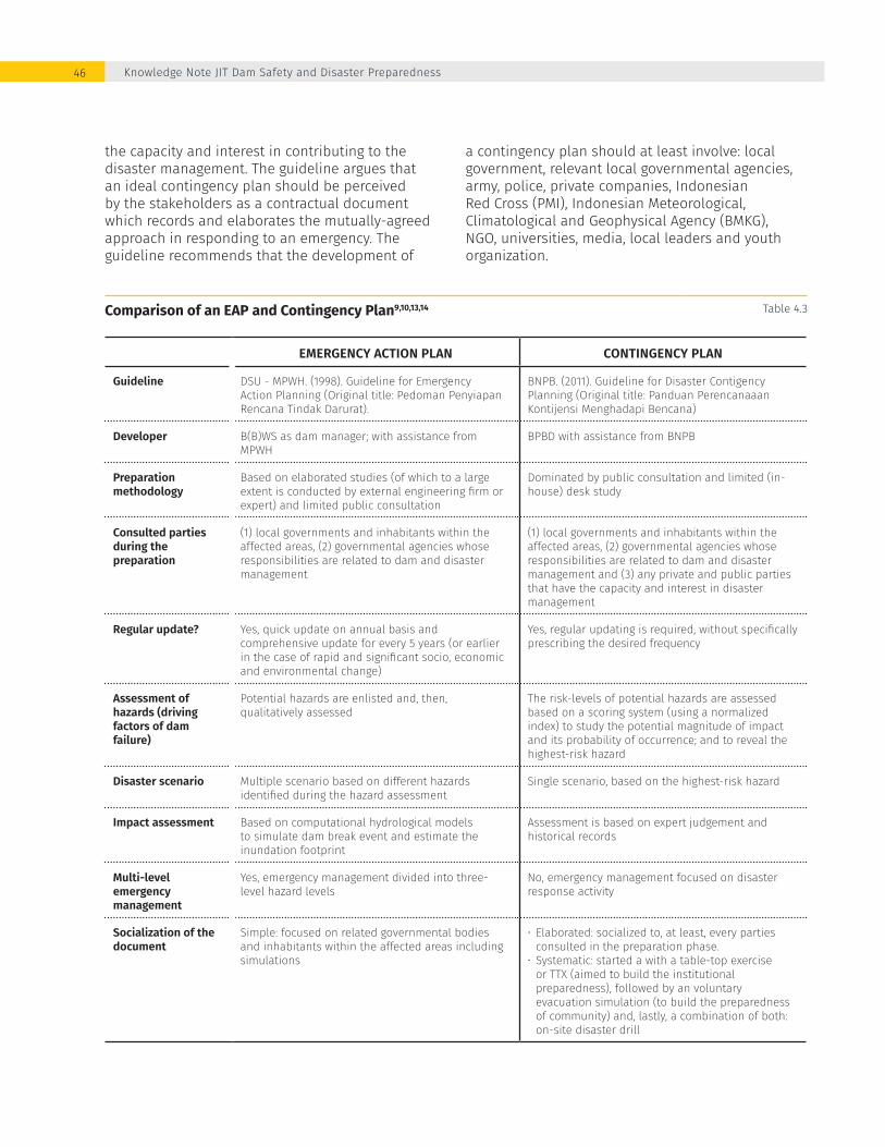
the capacity and interest in contributing to the disaster management. The guideline argues that an ideal contingency plan should be perceived by the stakeholders as a contractual document which records and elaborates the mutually-agreed approach in responding to an emergency. The guideline recommends that the development of
a contingency plan should at least involve: local government, relevant local governmental agencies, army, police, private companies, Indonesian Red Cross (PMI), Indonesian Meteorological, Climatological and Geophysical Agency (BMKG), NGO, universities, media, local leaders and youth organization.
Comparison of an EAP and Contingency Plan9,10,13,14 Table 4.3
EMERGENCY ACTION PLAN CONTINGENCY PLAN
Guideline DSU - MPWH. (1998). Guideline for Emergency Action Planning (Original title: Pedoman Penyiapan Rencana Tindak Darurat).
BNPB. (2011). Guideline for Disaster Contigency Planning (Original title: Panduan Perencanaaan Kontijensi Menghadapi Bencana)
Developer B(B)WS as dam manager; with assistance from MPWH
BPBD with assistance from BNPB
Preparation methodology
Based on elaborated studies (of which to a large extent is conducted by external engineering firm or expert) and limited public consultation
Dominated by public consultation and limited (in-house) desk study
Consulted parties during the preparation
(1) local governments and inhabitants within the affected areas, (2) governmental agencies whose responsibilities are related to dam and disaster management
(1) local governments and inhabitants within the affected areas, (2) governmental agencies whose responsibilities are related to dam and disaster management and (3) any private and public parties that have the capacity and interest in disaster management
Regular update? Yes, quick update on annual basis and comprehensive update for every 5 years (or earlier in the case of rapid and significant socio, economic and environmental change)
Yes, regular updating is required, without specifically prescribing the desired frequency
Assessment of hazards (driving factors of dam failure)
Potential hazards are enlisted and, then, qualitatively assessed
The risk-levels of potential hazards are assessed based on a scoring system (using a normalized index) to study the potential magnitude of impact and its probability of occurrence; and to reveal the highest-risk hazard
Disaster scenario Multiple scenario based on different hazards identified during the hazard assessment
Single scenario, based on the highest-risk hazard
Impact assessment Based on computational hydrological models to simulate dam break event and estimate the inundation footprint
Assessment is based on expert judgement and historical records
Multi-level emergency management
Yes, emergency management divided into three-level hazard levels
No, emergency management focused on disaster response activity
Socialization of the document
Simple: focused on related governmental bodies and inhabitants within the affected areas including simulations
• Elaborated: socialized to, at least, every parties consulted in the preparation phase.
• Systematic: started a with a table-top exercise or TTX (aimed to build the institutional preparedness), followed by an voluntary evacuation simulation (to build the preparedness of community) and, lastly, a combination of both: on-site disaster drill
Knowledge Note JIT Dam Safety and Disaster Preparedness46
GENERAL COMPARISON
The EAPs and Contingency Plans both aim towards a shared goal of building disaster preparedness. However, these documents are characterized by different approaches and focus (table 4.3).
According to the guideline, a contingency plan should strive to establish itself as an agreement on the distribution of disaster response responsibilities among related stakeholders. Stakeholders are defined as parties who are potentially affected by a dam failure, governmental bodies which are mandated to contribute in disaster management and any group which has the capacity and interest to contribute in this sector. In contrast, the EAP identifies itself more as a disaster impact and response report than an agreement document. Although every EAP is required to include an approval or agreement page, the signatory of such sheet is limited only to governmental agencies whose administrative areas are affected by the disaster or whose formal responsibility includes disaster management. The nature of the EAP and the contingency plan indirectly dictate their development methodologies and the extent of the required public engagement. The development of a contingency plan is dominated by public consultations as it strives to reach consensus among numerous stakeholders on various aspects of the disaster response. The development of the EAP relies heavily on studies; especially in simulating the probable failure modes and dam break events by using computational models. Consultation activities are included in this process yet limited only to potentially affected inhabitants and responsible governmental agencies.
In terms of content, each document focuses on slightly different aspects of disaster management aligned with institutional roles and responsibilities (table 4.4). The EAP, with its multi-stages emergency management approach, extensively elaborates the required pre-disaster activities and arrangements; mainly aimed to quantitatively-estimate the potential impact of a dam failure and the measures required to prevent and limit its impact. The plan emphasizes that B(B)WS, as the dam owner/manager and composer of the EAP, should position itself as a supporting-partner to the leading role of the local government and disaster management authority in those activities. In contrast, the content of the
contingency plan focuses on the disaster-response and post-disaster activities, namely the evacuation and disaster relief plan.
The fact that the focus and strength of these documents lies on different, yet potentially inter-realted and complimentary, aspects of disaster management reveals a future opportunity and need for a BNPB-MPWH joint disaster planning. Contingency plan is a powerful tool for disaster response with an extensive stakeholder engagement; while EAP is an effective disaster-preparation plan based on elaborated technical studies (discussed further in section 5).
SUPPORT TO EAP AND CONTINGENCY PLAN PREPARATION
Training on the utilization of the expanded InaSAFE A number of trainings have been given to BNPB and BPBD technical staffs and representatives of stakeholders in the Indonesian disaster management sector on the introduction and utilization of InaSAFE since the launch of its first version in 2011.15 For example, BPBD Maluku Tengah and Kota Ambon have organized a series of workshops, involving a wide range of regional stakeholders (including local government, local police and army force, local health department and PMI), where the software was introduced and a comprehensive training was given (starting from collecting input data, developing disaster scenario and reading the software’s analysis result). The output of these activities was then used as a foundation in drafting a contingency plan for tsunami disaster in the City of Ambon.15
Continuing in this line of work, a training session was organized on December 29th, 2017 . This was aimed at introducing InaSAFE (both current and expanded version) and its operation mechanism. After the introduction on how InaSAFE can be used to manage the risk of dam failures in disaster management by BNPB’s Director of Preparedness, the InaSAFE developer from Geo Enviro Omega (GEO) and HOT team provided the following: introduction to QGIS; steps of analysis in the expanded version of InaSAFE and extracting the analysis result using Gintung Dam case
Enhancing Dam Safety and Public Protection through InaSAFE-Based Emergency Action Plan and Contingency Planning 47
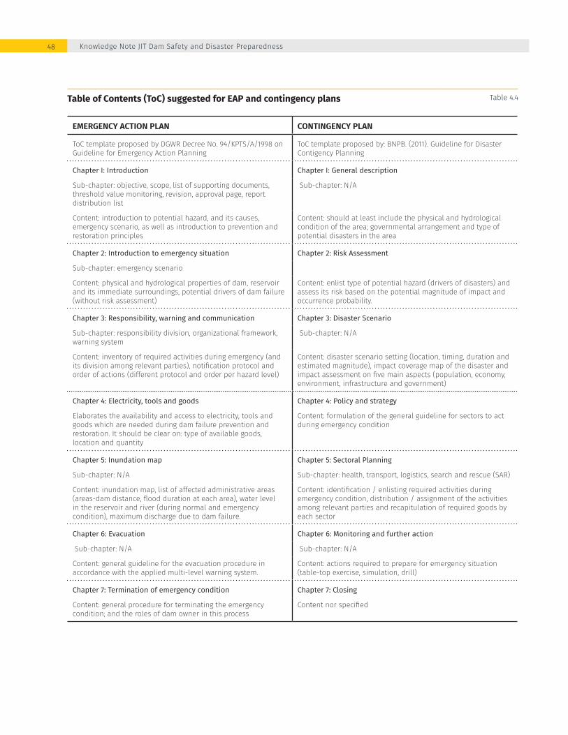
Table of Contents (ToC) suggested for EAP and contingency plans Table 4.4
EMERGENCY ACTION PLAN CONTINGENCY PLAN
ToC template proposed by DGWR Decree No. 94/KPTS/A/1998 on Guideline for Emergency Action Planning
ToC template proposed by: BNPB. (2011). Guideline for Disaster Contigency Planning
Chapter I: Introduction Chapter I: General description
Sub-chapter: objective, scope, list of supporting documents, threshold value monitoring, revision, approval page, report distribution list
Sub-chapter: N/A
Content: introduction to potential hazard, and its causes, emergency scenario, as well as introduction to prevention and restoration principles
Content: should at least include the physical and hydrological condition of the area; governmental arrangement and type of potential disasters in the area
Chapter 2: Introduction to emergency situation Chapter 2: Risk Assessment
Sub-chapter: emergency scenario
Content: physical and hydrological properties of dam, reservoir and its immediate surroundings, potential drivers of dam failure (without risk assessment)
Content: enlist type of potential hazard (drivers of disasters) and assess its risk based on the potential magnitude of impact and occurrence probability.
Chapter 3: Responsibility, warning and communication Chapter 3: Disaster Scenario
Sub-chapter: responsibility division, organizational framework, warning system
Sub-chapter: N/A
Content: inventory of required activities during emergency (and its division among relevant parties), notification protocol and order of actions (different protocol and order per hazard level)
Content: disaster scenario setting (location, timing, duration and estimated magnitude), impact coverage map of the disaster and impact assessment on five main aspects (population, economy, environment, infrastructure and government)
Chapter 4: Electricity, tools and goods Chapter 4: Policy and strategy
Elaborates the availability and access to electricity, tools and goods which are needed during dam failure prevention and restoration. It should be clear on: type of available goods, location and quantity
Content: formulation of the general guideline for sectors to act during emergency condition
Chapter 5: Inundation map Chapter 5: Sectoral Planning
Sub-chapter: N/A Sub-chapter: health, transport, logistics, search and rescue (SAR)
Content: inundation map, list of affected administrative areas (areas-dam distance, flood duration at each area), water level in the reservoir and river (during normal and emergency condition), maximum discharge due to dam failure.
Content: identification / enlisting required activities during emergency condition, distribution / assignment of the activities among relevant parties and recapitulation of required goods by each sector
Chapter 6: Evacuation Chapter 6: Monitoring and further action
Sub-chapter: N/A Sub-chapter: N/A
Content: general guideline for the evacuation procedure in accordance with the applied multi-level warning system.
Content: actions required to prepare for emergency situation (table-top exercise, simulation, drill)
Chapter 7: Termination of emergency condition Chapter 7: Closing
Content: general procedure for terminating the emergency condition; and the roles of dam owner in this process
Content nor specified
Knowledge Note JIT Dam Safety and Disaster Preparedness48

study; and building data exposure using OSM platform. The training was represented by B(B)WS from 13 provinces, Water Resources Research and Development Agency, and Dam Safety Units (Figure 4.3).
Workshop on InaSAFE-based EAP and Contingency Plan PreparationThe preceding activity was directly followed by a workshop session on InaSAFE-based EAP and Contingency Planning; with a focus on the two case studies from Jatigede and Gintung Dam.
Although the outputs of this activity are theoretically usable for contingency planning in Jatigede
and Gintung Dam, these products (especially flooding map, details of affected population and infrastructure as presented in figure 4.4 and 4.5) should not be used for contingency planning purpose; due to the outdated and imprecise nature of the some of the input data (specifically: the inundation maps which were produced in 2011, population data published by BPS in 2014 and the macro-level land use data issued by BIG in 2013). Notwithstanding the limitations, the outputs provide an illustrative example of how InaSAFE can be used to inform the preparation and implementation of an EAP and Contingency Planning in the event of a dam failur, along with the required response activities.
Training on the utilization of the expanded InaSAFE FIgure 4.3
Enhancing Dam Safety and Public Protection through InaSAFE-Based Emergency Action Plan and Contingency Planning 49
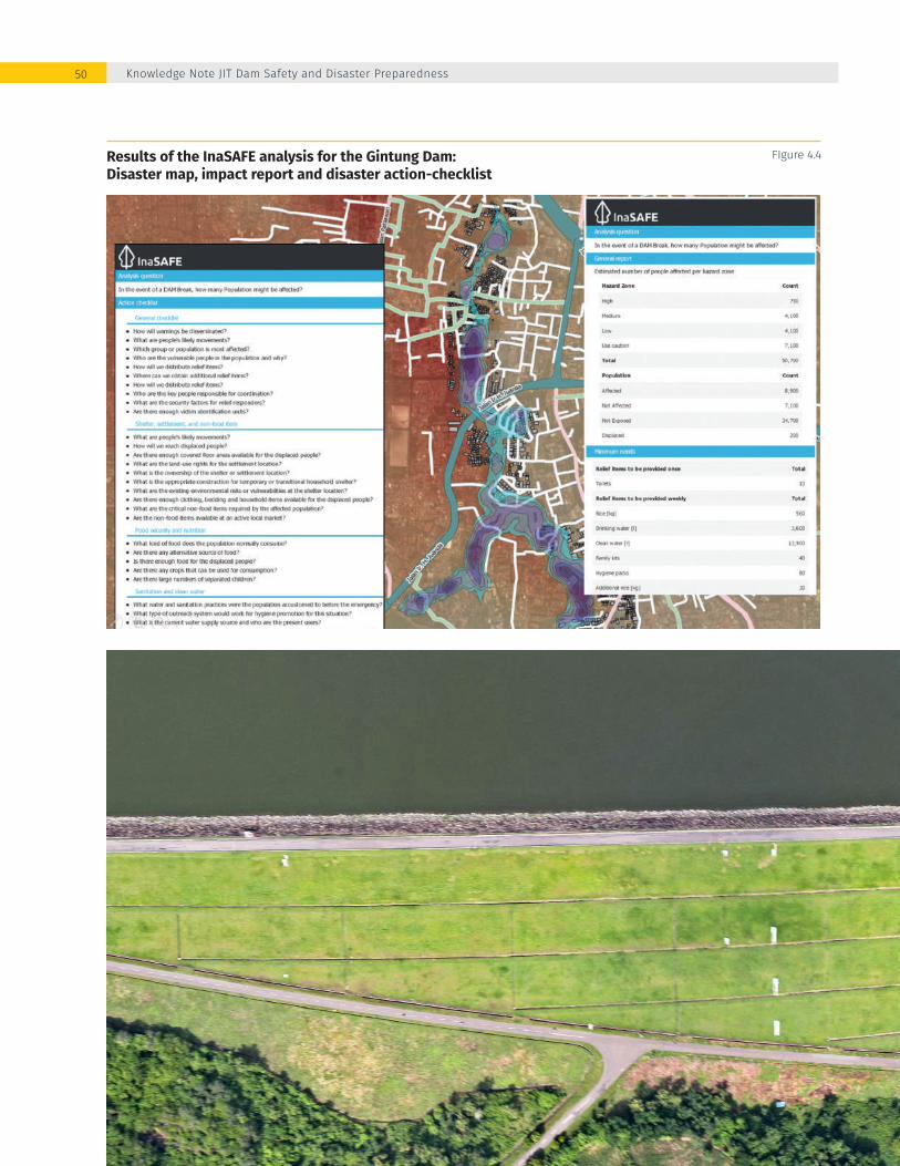
Results of the InaSAFE analysis for the Gintung Dam: Disaster map, impact report and disaster action-checklist
FIgure 4.4
Knowledge Note JIT Dam Safety and Disaster Preparedness50

Results of the InaSAFE analysis for the Jatigede Dam: Disaster map, impact report and disaster action-checklist
FIgure 4.5
Inclusive contingency planning is an effective
way to strengthen collaboration and
coordination among stakeholders
Enhancing Dam Safety and Public Protection through InaSAFE-Based Emergency Action Plan and Contingency Planning 51

WAY FORWARD: InaSAFE-Based Emergency Action and Contigency Planning?
52

InaSAFE is a powerful tool which has the potential to become central to the preparation of EAP and contingency plans. InaSAFE enables dam managers and disaster risk specialists to develop scenarios associated with specific events, assess the impact of the scenarios and estimate the disaster relief needs. These are the main inputs in composing an EAP and contingency plan. The outputs from InaSAFE include the impact of a potential dam failure in tabular format (enlisting the number of affected population or infrastructure) as well as spatial information (disaster coverage map). These can be used to draft an evacuation plan identifying the extent of the disaster, locating unaffected areas suitable for evacuation routes and gathering points.16
The MPWH and BNPB have acknowledged the potential role that InaSAFE could play in building disaster preparedness against a potential dam failure.17 This section reflects on the experience with the two pilot processes and is dedicated to synthesizing
the findings and lesson learned into a framework for future collaboration between BNPB-MPWH in the preparation of EAPs and contingency planning. The framework proposes a role sharing agreement between BNPB-MPWH and specific actions towards an InaSAFE-based EAP and contingency planning tool that can fully embed the plans within the community and relevant institutions (figure 5.1).
To realize successful adoption of the framework, it is essential to acknowledge the presence of challenges in each of its sections. The challenges identified through this process were compiled and used as a foundation to formulate the success factors for the adoption and implementation of the framework. Failure to include these key elements will not only undermine the utility of the EAP and contingency planning practice but have the potential to increase the impact of a dam failure on the downstream communities and assests due to improper planning and coordination mechanisms being in available.
Enhancing Dam Safety and Public Protection through InaSAFE-Based Emergency Action Plan and Contingency Planning 53

INTER-INSTITUTIONAL COOPERATION
Inter-institutional cooperation is essential for effective disaster risk management and dam safety assurance. Extensive sociotechnical data are required to inform a dam break analysis and preparation of effective planning and response mechanisms. These data are often hosted by a wide range of different stakeholders. In practice, most of these data are not easily accessible by those external to the host organization (even by other governmental bodies); and would commonly require at least an official request letter for acquiring them. An existing Memorandum of Agreement (MoU) on Disaster Management between BNPB-MPWH facilitated the exchange of information for the two pilot projects. The presence of such agreement has been recognized to be valuable in exchanging the needed data and, therefore, accelerating the process of analysis and preparation. It is considered essential for BNPB and MPWH to actively expand and reinforce their collaboration with other relevant data-hosting agencies, especially: Geospatial Information Agency (administrative boundary), LAPAN (satellite imagery), Ministry of Environment and Forestry (macro-level
land use map), Statistics Indonesia (population distribution), local government and regional development planning agency / Bappeda (detailed land use map).
COMPATIBILITY OF BNPB-MPWH DATABASE
One of the main challenges encountered during the pilots was the difference in data management systems between BNPB and MPWH. BNPB, as the host of InaSAFE and other geo-information software for disaster management, adopts a GIS-based database. In contrast, MPWH gathers and manages their technical data in office suites or portable document format (e.g. .doc, .xls, .pdf, etc.). Only a few of the EAPs (and their inundation maps) within MPWH are available in GIS-format while the remaining only exist in .pdf or .doc format. To be able to use these data (especially the inundation maps) in InaSAFE, a digitization/conversion activity is required; an often time consuming activity that can produce imprecise replication. Realizing the obstacles attached to unmatched database system, the adoption of (at least
collection of technical, socio and economic data (required for step 1 and 2) in a GIS format; i.e. popoulation, land use, infrastructure; hydrometeorolgy and topography characteristics, etc.
Dam break simulation based on computational (hydraulic) model to produce inundation footprint map and flooding properties (inundation depth, duration and timing)
Feeding the output of dam break simulation (step 2) and the relevant supporting data (gathered in step 1) into InaSAFE to asess the impact of dam break event and to estimate the disaster relief needs.
Developa join disaster response plan (from initial BNPB-MPWH discussion, the document will be named: RTD-Renkon) that will synergize the identified strengths of both plans.
Socializing the contigency plan to relevant actors thorugh a systemactic process: table-top exercise/role-play, (voluntary) community evacuation exercise and, then, on-site disaster dirll.
Roadmap towards an InaSAFE-based Emergency Action and Contingency Planning FIgure 5.1
Data Collection
Dam BreakSimulation
InaSAFE Analysis
EAP-Contigency planning
Plan Socialization
BNPB-MPWH
BNPB-MPWH
BNPB-MPWH
BNPB
MPWH
Ministerial Regulation No. 27 year 2015
EAP.ContingencyPlanningPromulgationMPWH
Knowledge Note JIT Dam Safety and Disaster Preparedness54

partially) GIS-based database within MPWH for dam safety data will improve and accelerate the InaSAFE analysis process. A first step towards this shift would be collecting GIS-based inundation maps from external engineering firms or experts who conduct the (past, current and future) dam break analysis. The MPWH should also consider using remote data acquisition techniques, such as remote sensing, aerial photography, drones, etc. Longer term, BNPB and the MPWH should consider establishing a shared dam safety database integrated with the real-time dam safety surveillance system (section 2.5).
PARTICIPATORY MAPPING
Participatory mapping is a powerful tool to enhance data acquisition and accuracy, empower community participation and overcome limited in-house human resources. As such, it has become one of the main inputs for successful planning and preparedness in the event of a natural disaster. Spatial data on the detailed distribution of buildings and public infrastructures (in GIS-format) is currently limited in any government ministry. OSM is currently the sole platform that provides this data. Although the OSM platform has been going through a continuous expansion process, the development of the OSM database is uncoordinated and opportunistic and focused on urban areas. The development of the OSM platform relies solely on participatory mappings conducted by any party for a variety of different purposes, from regional planning to infrastructure engineering. Participatory mapping provides a unique opportunity for BNPB and MPWH to actively engage local communities, their leaders, universities, interest groups and participatory mapping facilitators in the development, and evaluating of EAPs, contingency plans and disaster response mechanisms.
DISASTER RISK COMMUNICATION
The dissemination of disaster risk information is essential to ensuring successful execution of an EAP and a contingency plan in the event of a dam failure. The roles and responsibilities of the dam operator / owner is clearly defined and communication should be focused on at least two parties: the agencies
involved in the response activity and the potentially affected communities. Risk communication with the involved governmental and private agencies should be initiated by the dam manager in the early phase development of the EAP and contingency planning. This is important to create a common perception on the risk, the required response actions and to explore the roles and responsibilities of each party. Past experience emphasizes the importance of gradual and casual-fashioned communication with communities during preparation and scenario planning to prevent the creation of fear within the community. This requires a communication strategy which commences by approaching community leaders and elders, and then utilize their voice and influence to convey the risk to the public and reassure around the facilitated process. This approach is also known to be effective in enhancing public participation during the (voluntary) community evacuation exercise.
BNPB-MPWH JOINT WORKING GROUP
Throughout the pilots, it was acknowledged that the existence of a joint working group between BNPB and MPWH was invaluable to realize and smoothen the process, particularly in the data collection and organization of participatory mapping. The presence of the working group has accelerated the administrative processes within BNPB and MPWH, lead to consensus on their views around disaster preparedness, delegated the required organizational tasks and, eventually, resulted in the realization of a greater engagement during the pilots. Realizing a sustainable coordination mechanism for dam safety and emergency preparedness between BNPB and MPWH through the presence of such a specifically-designated joint working group will be essential. The pilots have successfully established a cross-agency working team, chaired by high-level officials (Grade Echelon 1 officials from BNPB and MPWH) and operated by technical staff from both agencies. This working group can be further shaped and extended to not only focused on InaSAFE-based disaster planning but on other aspects of disaster preparedness and planning. The working group should continue to meet on a regular basis to inform the planning and construction of new dams, rehabilitation or modernization of existing dams, updating of existing EAPs or contingency plans and during dam safety emergency situation.
Enhancing Dam Safety and Public Protection through InaSAFE-Based Emergency Action Plan and Contingency Planning 55
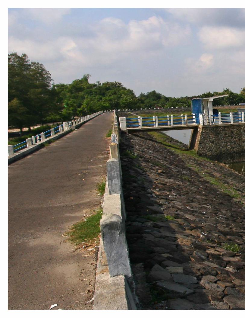
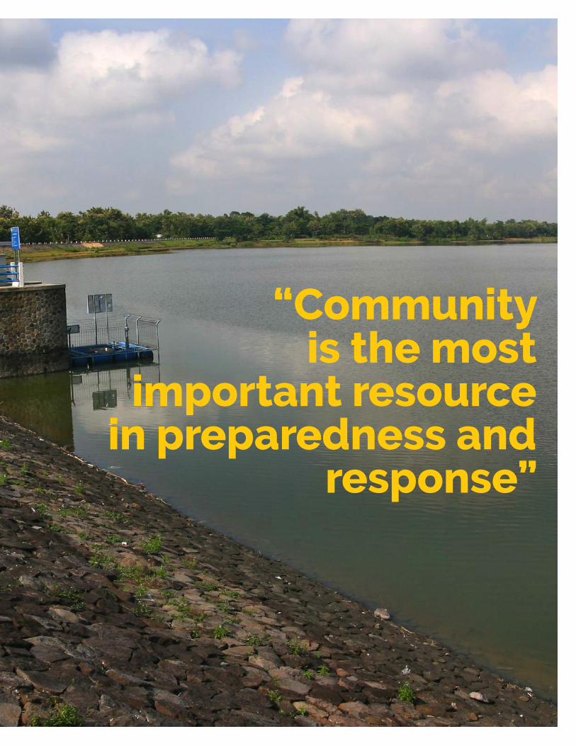
“Communityis the most
important resource in preparedness and
response”
1 The World Bank. (2015). More and Better Spending: Connecting People to Improved Water Supply and Sanitation in Indonesia – Public Expenditure Review.
2 Bappenas (National Development Planning Agency). (2015). Mid-Term Development Plan (Original Title: Rencana Pembangunan Jangka Menengah Nasional 2015-2019)
3 MPWH. (2015). Strategic Plan Ministry of Public Works and Housing (Original Title: Rencana Strategis Kementerian Pekerjaan Umum dan Perumahan Rakyat)
4 BNPB. (2016a). Indonesian Disaster Risk (Original title: Risiko Bencana Indonesia) and Data Informasi Bencana Indonesia (DIBI), accessed at http://dibi.bnpb.go.id/ on December 20, 2017.
5 BNPB. (2016b). The Decline of Indonesian Disaster Risk (Original title: Penurunan Indeks Risiko Bencana di Indonesia 2016). [Presentation slides]
6 MPWH. (2017). Dam Safety and Emergency Action Plan (Original title: Keamanan Bendungan dan Rencana Tindak Darurat). [Presentation slides]
7 MPWH. (2017). Dam Safety Monitoring (Original title: Monitoring Keamanan Bendungan). Accessed at http://monitoringbendungan.com/index.php on November 2017
8 DM Innovation. (2016). InaSAFE Concepts [Powerpoint slides]. Accessed at: http://docs.inasafe.org/en/training/socialisation/inasafe_concepts.html on October 2017
9 BBWS Ciliwung Cisadane – MPWH. (2011). Emergency Action Plan Gintung Dam (Original title: Rencana Tindak Darurat Bendungan Gintung).
10 BBWS Cimanuk Cisanggarung – MPWH. (2012). Emergency Action Plan Jatigede Dam (Original title: Rencana Tindak Darurat Bendungan Jatigede).
REFERENCES
11 OpenStreetMap. https://wiki.openstreetmap.org/wiki/Main_Page
12 Kayadoe F.J., Nugroho S.P. and Triutomo S. (2016). Community Resilience Against Way Ela Flashflood – Vilage of Negeri Lima, Central Maluku District (Original title: Ketangguhan Masyarakat Dalam Menghadapi Banjir Bandang Way Ela di Desa Negeri Lima Kabupaten Maluku Tengah). Dialogue Journal of Disaster Management Vol.7, accessed at: http://perpustakaan.bnpb.go.id/repository/volume7_no1_2016.pdf on November 12, 2017.
13 BNPB. (2011). Guideline for Disaster Contigency Planning (Original title: Panduan Perencanaaan Kontijensi Menghadapi Bencana)
14 BPBD Maluku Tengah. (2012). Contingency Plan Flashflood Way Ela (Original title: Buku Rencana Kontijensi Penanggulangan Bencana Banjir Bandang Way Ela)
15 InaSAFE. (2016). InaSAFE for Contingency Planning Training. Accessed at: http://inasafe.org/inasafe-for-contingency-planning-training/ on November 2, 2017.
16 InaSAFE. (2014). Modul 2: QGIS and InaSAFE in Contigency Planning (Original title: Modul 2: QGIS dan InaSAFE dalam Rencana Kontinjensi). Accessed at: http://docs.inasafe.org/id/training/old-training/beginner/qgis-inasafe/202-qgis-and-inasafe-in-contingency-plan.html on November 2, 2017.
17 BNPB and MPWH. (2017). Minutes of Meeting: Coordination Meeting on Dam Safety – 9 August 2017 (Original title: Notulensi Rapat Keamanan Bendungan 9 Agustus 2017)
Knowledge Note JIT Dam Safety and Disaster Preparedness58

MPWH Ministerial Regulation No. 27/PRT/M/2015 on Dams (Peraturan Menteri Pekerjaan Umum dan Perumahan Rakyat No. 27/PRT/M/2015 tentang Bendungan)
Law No. 24/1992 on Spatial Planning (Undang Undang No. 24 Tahun 1992 tentang Penataan Ruang)
Law No. 26/2007 on Spatial Planning (Undang-Undang No. 26 Tahun 2007 tentang Penataan Ruang)
Law No. 7/2004 on Water Resources (Undang-undang No. 7 Tahun 2004 tentang Sumberdaya Air)
MPWH Ministerial Regulation No. 15/PRT/M/2015 on Organizational and Work Structure of MPWH (Peraturan Menteri Pekerjaan Umum dan Perumahan Rakyat No. 27/PRT/M/2015 tentang Organisasi dan Tata Kerja Kementerian Pekerjaan Umum dan Perumahan Rakyat)
MPWH Ministerial Regulation No. 25 / PRT / M / 2006 Organizational and Work Structure of Dam Safety Unit (Peraturan Menteri Pekerjaan Umum dan Perumahan Rakyat No. 27/PRT/M/2015 tentang Organisasi dan Tata Kerja Balai Bendungan)
Law No. 11/1974 on Water (Undang-undang No 11 Tahun 1974 tentang Pengairan)
MPWH Ministerial Regulation No 72/PRT/1997 on Dam Safety (Peraturan Menteri Pekerjaan Umum dan Perumahan Rakyat No. 72/PRT/1997 tentang Keamanan Bendungan)
MPWH Ministerial Regulation No. 03/KPTS/M/2016 On Dam Safety Commission (Keputusan Menteri Pekerjaan Umum dan Perumahan Rakyat No. 03/KPTS/M/2016 tentang Komisi Keamanan Bendungan)
DGWR Directorate-General Decree No. 199/KPTS/D/2003 on Technical Guidelines for Operation, Maintenance and Monitoring of Dam (Keputusan Ditjen SDA No. 199/KPTS/D/2003 Pedoman Operasi, Pemeliharaan dan Pengamatan Bendungan)
BNPB Regulation No. 2/2012 on General Guidelines for Disaster Risk Study (Peraturan Kepala BNPB No 2 Tahun 2012 tentang Pedoman Umum Pengkajian Risiko Bencana)
DGWR Directorate-General Decree No. 94/KPTS/A/1998 on Guideline for Emergency Action Planning (Keputusan Ditjen SDA No. 94/KPTS/A/1998 Tentang Pedoman Penyiapan Rencana Tindak Darurat)
Enhancing Dam Safety and Public Protection through InaSAFE-Based Emergency Action Plan and Contingency Planning 59


The Global Facility for Disaster Reduction and Recovery (GFDRR) is a global partnership that helps developing countries better understand and reduce their vulnerabilities to natural hazards and adapt to climate change. Working with over 400 local, national, regional, and international partners, GFDRR provides grant financing, technical assistance, training and knowledge sharing activities to mainstream disaster and climate risk management in policies and strategies. Managed by the World Bank, GFDRR is supported by 34 countries and 9 international organizations.
www.gfdrr.org
Related Documents