EMERGENT COMPLEXITY ON THE MONGOLIAN STEPPE: Mobility, Territoriality, and the Development of Early Nomadic Polities By Jean-Luc Houle B.Sc., Université de Montréal, 1999 M.Sc., Université de Montréal, 2002 Submitted to the Graduate Faculty of Arts and Sciences in partial fulfillment of the requirements for the degree of Doctor of Philosophy University of Pittsburgh 2010

Welcome message from author
This document is posted to help you gain knowledge. Please leave a comment to let me know what you think about it! Share it to your friends and learn new things together.
Transcript
EMERGENT COMPLEXITY ON THE MONGOLIAN STEPPE: Mobility, Territoriality, and the Development of Early Nomadic Polities
By
Jean-Luc Houle
B.Sc., Université de Montréal, 1999
M.Sc., Université de Montréal, 2002
Submitted to the Graduate Faculty of
Arts and Sciences in partial fulfillment
of the requirements for the degree of Doctor of Philosophy
University of Pittsburgh
2010
UNIVERSITY OF PITTSBURGH
Faculty of Arts and Sciences
This dissertation was presented
by
Jean-Luc Houle
It was defended on
March 22, 2010
and approved by
Dr. Bryan K. Hanks, Assistant Professor, Department of Anthropology, University of Pittsburgh
Dr. Olivier de Montmollin, Associate Professor, Department of Anthropology, University of Pittsburgh
Dr. Robert D. Drennan, Distinguished Professor, Department of Anthropology, University of
Pittsburgh Committee Co-chairperson
Dr. Katheryn M. Linduff, Professor, History of Art and Architecture, University of Pittsburgh
Committee Co-chairperson
ii

Copyright © by Jean-Luc Houle 2010
iii
EMERGENT COMPLEXITY ON THE MONGOLIAN STEPPE: Mobility, Territoriality, and the Development of Early Nomadic Polities
Jean-Luc Houle, PhD
University of Pittsburgh, 2010
It is now well recognized that mobile herding subsistence patterns do not preclude the
development of complex social organization, but debate continues over whether the development
of such societies depends upon and requires interaction with already existing agricultural state-
level societies. This is known as the ‘dependency’ hypothesis. In the Mongolian case this debate
centers on the Iron Age Xiongnu (ca. 209 BCE to 93 CE) and whether this polity of mobile
herders resulted from indigenous political processes or from the influence of or interaction with
sedentary agricultural neighbors to their south.
In order to evaluate this, a number of concrete lines of inquiry are investigated in the
present study through regional archaeological survey and small-scale excavations of fourteen
Late Bronze Age (mid-second to mid-first millennia BCE) domestic contexts in a remote region
far from the direct intersection with centers of power such as China, but where numerous
monumental structures suggest complex social organizations, so as to investigate the early
development of societal complexity in Mongolia and systematically and empirically evaluate the
core variables and problematic aspects related to the development of ‘nomadic’ polities (i.e.
iv
those stated in the dependency hypothesis), namely demography, subsistence, mobility, and
political economy in relation to higher degrees of sociopolitical organizations.
Results of the present study upend some of the ideas tied to the dependency hypothesis
and suggest that while clear social hierarchies have not been identified within domestic contexts
there does seem to be some level of social differentiation during the Late Bronze Age. Based on
this evidence and the evidence from the impressive ritual and funerary monumental landscape, it
is suggested that this period may represent the first stage in the emergence of political
organization operating beyond the descent group and that relatively complex forms of
sociopolitical organization among mobile pastoralists can and did indeed develop in remote
regions far from the direct intersection with powerful sedentary agricultural state-level societies.
Accordingly, it is also suggested that some of the foundations of Early Iron Age complex
sociopolitical organization in central Mongolia were already being laid locally during the
preceding Late Bronze Age.
v
TABLE OF CONTENTS ACKNOWLEDGMENTS ...........................................................................................................XV
1.0 INTRODUCTION .................................................................................................................... 1
1.1 THE RESEARCH PROBLEM........................................................................................ 1
1.2 CONTEXTUALIZING MONGOLIA’S LATE BRONZE AGE.................................... 4
1.3 NOMADIC ‘POLITIES’: THE PROBLEM IN DETAIL............................................... 9
1.4 THE SOCIOPOLITICAL ORGANIZATION OF LATE BRONZE AGE SOCIETIES:
THE PARADOX .................................................................................................................. 10
1.5 THE SIGNIFICANCE OF LATE BRONZE AGE MONUMENTS: A QUESTION OF
DEBATE .............................................................................................................................. 11
1.6 THE RESEARCH REGION.......................................................................................... 21
1.6.1 Climate and Environment ................................................................................... 22
1.6.2 Ethnographic and Ethnohistoric Context of the Research Region...................... 24
1.6.3 The Khanuy Valley’s Architectural Landscape .................................................. 27
2.0 METHODOLOGY ................................................................................................................. 35
2.1 SURVEYING THE ‘INVISIBLE CULTURE’: DEALING WITH THE VISIBILITY
AND SCALE OF OCCUPATION AREAS......................................................................... 36
2.1.1 Recording Scheme and Site Definition............................................................... 38
2.2 A NOTE ON CHRONOLOGY...................................................................................... 39
2.3 ENVIRONMENTAL ZONES AND LAND USE PATTERNS: STRATIFYING THE
LANDSCAPE....................................................................................................................... 43
2.4 SAMPLING THE LANDSCAPE: GETTING MORE FROM LESS............................ 45
2.5 EVALUATING CENTRALITY: ZONING THE LANDSCAPE ................................. 46
vi
3.0 SETTLEMENT AND DEMOGRAPHIC PATTERNS IN THE LATE BRONZE AGE ...... 49
3.1 THE DISTRIBUTION AND ORGANIZATION OF OCCUPATION AREAS IN
ZONE A................................................................................................................................ 49
3.1.1 The Characteristics of Occupation Areas in Zone A .......................................... 55
3.2 THE DISTRIBUTION AND ORGANIZATION OF OCCUPATION AREAS IN
ZONE B................................................................................................................................ 57
3.2.1 The Characteristics of Occupation Areas in Zone B........................................... 61
3.3 POPULATION ESTIMATES ........................................................................................ 62
3.4 POPULATION SIZE: THE RELATIVE DEMOGRAPHIC INDEX ........................... 72
3.4.1 Results: Zone A................................................................................................... 72
3.4.2 Results: Zone B................................................................................................... 75
3.5 CENTRALITY: EVALUATING MONUMENT AND SETTLEMENT
RELATIONSHIPS ............................................................................................................... 78
3.6 SUMMARY ................................................................................................................... 79
4.0 ARCHAEOLOGICAL EXCAVATIONS OF OCCUPATION AREAS ............................... 81
4.1 EXCAVATIONS............................................................................................................ 81
4.2 STRATIGRAPHIC SETTING AND EXCAVATION METHODS.............................. 82
4.3 DESCRIPTION OF OCCUPATION AREAS ............................................................... 84
4.3.1 ZONE A .............................................................................................................. 85
4.3.2 ZONE B ............................................................................................................ 100
5.0 SUBSISTENCE, SEASONALITY AND MOBILITY ........................................................ 110
5.1 BOTANICAL REMAINS............................................................................................ 112
5.2 FAUNAL REMAINS................................................................................................... 118
5.2.1 Analysis of the Faunal Remains........................................................................ 119
5.2.2 Species Identification ........................................................................................ 119
5.2.3 Mortality Profiles and Seasonality .................................................................... 120
5.2.4 Quantification.................................................................................................... 121
5.2.5 The Faunal Assemblage .................................................................................... 122
5.2.6 Condition of the Assemblage ............................................................................ 123
5.2.7 Animal Exploitation .......................................................................................... 126
5.2.8 Wild to Domestic Ratio..................................................................................... 130
vii
5.2.9 Seasonality and Mobility .................................................................................. 131
5.3 COMPARING FAUNAL EXPLOITATION BETWEEN OCCUPATION AREAS.. 136
5.4 SUMMARY ................................................................................................................. 142
6.0 SOCIAL AND ECONOMIC DIFFERENTIATION............................................................ 143
6.1 ARCHAEOLOGICAL INDICATORS OF SOCIAL STATUS .................................. 144
6.1.1 Metal Goods ...................................................................................................... 146
6.1.2 Faunal Remains................................................................................................. 146
6.1.3 Long Distance Interaction: Regional Economic Exchange?............................. 148
6.1.4 Ceramics and Social Differences ...................................................................... 151
6.1.4.1 Decorated Ceramics ....................................................................................... 152
6.1.4.2 Vessel Size ..................................................................................................... 154
6.2 SUMMARY OF STATUS INDICATORS .................................................................. 156
6.3 SPECIALIZED ECONOMIC ACTIVITIES ............................................................... 157
6.3.1 Metallurgy......................................................................................................... 158
6.3.2 Agriculture ........................................................................................................ 159
6.3.3 Ceramic Technology ......................................................................................... 160
6.3.3.1 Ceramic Paste................................................................................................. 161
6.3.3.2 Firing Atmosphere ......................................................................................... 164
6.3.3.3 Wall Thickness............................................................................................... 167
6.3.4 Stone Tool Production ...................................................................................... 169
6.4 SUMMARY ................................................................................................................. 176
7.0 CONCLUSIONS................................................................................................................... 179
7.1 THE RESULTS OF THE CURRENT STUDY ........................................................... 180
7.2 CONCLUDING HYPOTHESIS: ‘SOCIALLY INTEGRATIVE FACILITIES’ AND
THE EMERGENCE OF SOCIETAL COMPLEXITY ON THE MONGOLIAN STEPPE ...
...................................................................................................................................... 187
7.3 EPILOGUE: THE LATE BRONZE AGE IN THE LONGER TRAJECTORY ......... 190
7.4 DIRECTIONS FOR FUTURE RESEARCH ............................................................... 191
BIBLIOGRAPHY....................................................................................................................... 196
viii
LIST OF TABLES Table 1.1 Chronological divisions with related archaeological cultures ........................................ 7
Table 3.1 Density-Area Index for all occupation areas ................................................................ 75
Table 3.2 Density-Area Index for all occupation areas ................................................................ 76
Table 5.1 Number and density of seeds per plant taxa recovered from flotation samples in the
Khanuy Valley research area ...................................................................................................... 117
Table 5.2 The separation of bones into fusion stages ................................................................. 121
Table 5.3 Number of Identified Specimens (NISP) in Late Bronze Age contexts only according
to occupation area ....................................................................................................................... 123
Table 5.4 Summary of bone modification characters associated with various taphonomic
processes ..................................................................................................................................... 125
Table 5.5 Total NISP for Late Bronze Age sites ........................................................................ 135
Table 6.1 Lithic to sherd ratio..................................................................................................... 171
ix
LIST OF FIGURES Figure 1.1 Mongolia and surrounding regions................................................................................ 3
Figure 1.2 Mongol-Transbaikalian Deer Stone .............................................................................. 8
Figure 1.3 Bronze plaques in the form of deer ............................................................................... 8
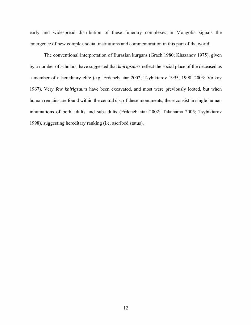
Figure 1.4 Photo and schematic drawing of a Khirigsuur ............................................................ 13
Figure 1.5 ‘Slope’ burials ............................................................................................................. 15
Figure 1.6 Deer stone imagery...................................................................................................... 16
Figure 1.7 Shamanistic elements found on deer stones ................................................................ 17
Figure 1.8 Slab burial.................................................................................................................... 18
Figure 1.9 View of the Khanuy River Valley. .............................................................................. 22
Figure 1.10 Present-day seasonal mobility in north-central Mongolia......................................... 26
Figure 1.11 Distribution of khirigsuurs, deer stones and slab burials .......................................... 28
Figure 1.12 Distribution of deer stones in Mongolia, which approximates the distribution of
khirigsuurs .................................................................................................................................... 29
Figure 1.13 Khanuy River Valley showing khirigsuur clusters and “buffer zones” .................... 32
Figure 1.14 Spatial relationship between khirigsuurs and ‘slope’ burials.................................... 33
Figure 1.15 Urt Bulagyn khirigsuur.............................................................................................. 34
Figure 2.1 Examples of Late Bronze Age ceramics from Khanuy Valley contexts. .................... 40
Figure 2.2 Typical Iron Age Xiongnu ceramics from Ivolga ....................................................... 41
x
Figure 2.3 Stratified survey tracks in the research area ................................................................ 44
Figure 2.4 Zones A and B within the Khanuy Valley research area............................................. 48
Figure 3.1 Distribution of occupation areas in Zone A ................................................................ 51
Figure 3.2 Distribution of contemporary campsites and positive shovel probes in Zone A......... 53
Figure 3.3 Distribution of occupation areas in zone B ................................................................. 59
Figure 3.4 Distribution of positive shovel probes in Zone B with Late Bronze Age ceramics .... 60
Figure 3.5 Satellite imagery showing the extent and organization of winter campsites in the
Khanuy River Valley .................................................................................................................... 65
Figure 3.6 Plan of a winter campsite (Khanuy Valley, Mongolia). .............................................. 66
Figure 3.7 Spacing between winter camps within a valley draw (Khanuy River Valley)............ 67
Figure 3.8. Density of occupation areas in Zone A ...................................................................... 69
Figure 3.9 Density of occupation areas in Zone B........................................................................ 71
Figure 3.10 Topographical representation of the relative demographic index for Late Bronze Age
occupation areas in Zone A........................................................................................................... 74
Figure 3.11 Topographical representation of the relative demographic index for Late Bronze Age
occupation areas in Zone B........................................................................................................... 77
Figure 4.1 Example of the average depth of excavation units. ..................................................... 83
Figure 4.2 Location of occupation areas excavated in Zone A..................................................... 85
Figure 4.3 Location of excavation units at SP22E-BMK ............................................................. 87
Figure 4.4 Location of excavation units at SP26E-WFA ............................................................. 89
Figure 4.5 Location of excavation units at SP26E-MAC ............................................................. 91
Figure 4.6 Location of excavation units at SP31E-JUL ............................................................... 92
Figure 4.7 Location of excavation units at SP31E-QUE .............................................................. 94
xi
Figure 4.8 Location of excavation units at SP27E-MTC.............................................................. 95
Figure 4.9 Location of excavation units at SP32E-MAB ............................................................. 97
Figure 4.10 Part of a possible hearth feature within which flotation samples were taken. .......... 97
Figure 4.11 Location of excavation units at SP32E-SHA ............................................................ 99
Figure 4.12 Location of occupation areas excavated in Zone B................................................. 100
Figure 4.13 Location of excavation units at SP07E-HUN.......................................................... 102
Figure 4.14 Location of excavation units at SP07E-SOV .......................................................... 103
Figure 4.15 Location of excavation units at SP10E-TOP........................................................... 105
Figure 4.16 Location of excavation units at SP11W-SAL ......................................................... 106
Figure 4.17 Location of excavation units at SP08E-GER .......................................................... 108
Figure 4.18 Location of excavation units at SP11E-HOA.......................................................... 109
Figure 5.1 Proportion of bones to sherds according to zone....................................................... 133
Figure 5.2 Differential proportion of large mammals (including horse and cattle categories)
between Riverside (summer) and Foothills (winter) campsite locations.................................... 136
Figure 5.3 Proportion of ‘Medium mammals’ per occupation area............................................ 139
Figure 5.4 Proportion of ‘Large mammals’ per occupation area................................................ 139
Figure 5.5 Proportion of Bos and Bos/Equus bones respectively at occupation areas where they
were present. ............................................................................................................................... 140
Figure 6.1 Fragment of jade/chalcedony from a ‘slope’ burial at site SP26E-MAC.................. 150
Figure 6.2 Turquoise bead from another ‘slope’ burial at site SP26E-MAC ............................. 150
Figure 6.3 Non local vessel type from SP07E-SOV................................................................... 150
Figure 6.4 Stem and leaf plot of the percentage of decorated Late Bronze Age ceramics in
occupation areas from the test excavations................................................................................. 153
xii
Figure 6.5 Proportion of decorated ceramics per occupation area.............................................. 154
Figure 6.6 Stem and leaf plot of the diameter of rim sherds (in cm) found in occupation areas
during the test excavations.......................................................................................................... 155
Figure 6.7 Relative coarseness of Late Bronze Age ceramic pastes........................................... 163
Figure 6.8 Stem and Leaf plot of inclusion sizes in Late Bronze Age ceramics ........................ 163
Figure 6.9 Transformed Stem and Leaf plot using Log10(x) ..................................................... 164
Figure 6.10 Firing atmospheres of Late Bronze Age ceramics .................................................. 166
Figure 6.11 Stem and leaf plot of wall thicknesses .................................................................... 168
Figure 6.12 Proportion of lithic flakes per occupation areas with lithic material....................... 171
Figure 6.13 Proportion of lithic material per occupation area, including SP11W-SAL............. 173
Figure 6.14 Sample of lithics from SP11W-SAL ....................................................................... 175
xiii

To Gaëlle and Salomé
xiv
ACKNOWLEDGMENTS I wish to profoundly thank my two dissertation co-directors, Dr. Robert D. Drennan and Dr.
Katheryn M. Linduff, for their continual advice, support and encouragement all along the
doctoral program at the University of Pittsburgh and especially throughout the research and
writing stages of this study. Their rigorous and helpful feedback has been instrumental in
broadening my horizons. Many thanks also go out to the two other members of my committee,
Dr. Bryan K. Hanks and Dr. Olivier de Montmollin. Their feedback and advice have been
extremely valuable. I also want to take this opportunity to underscore my gratitude to Bryan
Hanks, not only as a professor and colleague, but also as a friend. Our many passionate
discussions and our time spent together doing research in Mongolia in 2006 were essential in
developing and framing this study. We entered the department of anthropology the same year, he
as a teacher and me as a graduate student, and over the years he has become a very good friend
of mine.
Special thanks must also go out to Dr. Francis Allard for introducing me to archaeology
in Mongolia and for his collaboration in the early phases of my research there. I also wish to
thank Dr. Diimaajav Erdenebaatar, my Mongolian co-director on this research project.
Collaborations between senior academics and foreign graduate students are not yet a common
phenomenon in Mongolia, so I truly appreciate the time and support he has provided me
throughout the years. To his brother Otgoo I also wish to give thanks. In many ways he was the
‘facilitator’ during all the phases of this project. More than just a driver, he has become a good
xv
friend, colleague and an essential member of the team. Recognition must also go out to the
Mongolian and foreign students who participated in the very laborious settlement pattern study,
as well as to the people from the Khanuy Valley research area. Without their help and hard work,
this project would not have been possible.
William Honeychurch and Joshua Wright, both of whom have laid down the ground work
for graduate student archaeological research in Mongolia, also merit all my thanks. They have
been helpful in many aspects of my work in Mongolia—a country where Murphy’s Law reigns
supreme! They have also been highly supportive during the whole process of my research there.
Thanks also to my dear friend and colleague, Sandra Olsen, for her continual support and help.
To my dear friend and colleague, Bryan Miller, I also give thanks. We started out as ‘clueless’
field assistants on the same project in Mongolia before developing our own research projects.
His support and friendship has been essential in this endeavor. We did it my friend! Mark
Billings has also been very helpful in this process, and I thank him as well. I am also very
grateful to the people at the American Center for Mongolian Studies for the assistance they have
provided on many occasions. Thank you also to Sarah M. Viner and Cheryl A. Makarewicz for
their analysis of the faunal material, as well as to Dr. Zhao Zhijun for his analysis of the
botanical remains.
Most importantly, my most sincere thanks go to Gaëlle Jégo, my wife. Without her
continual support, my doctoral studies and this research project would have been much more
arduous. Tu es une super compagne de ‘Voyage’! Thank you also to my daughter, Salomé, who
helped me ‘keep it real’. I cannot imagine having gone through the whole PhD process without
their presence.
xvi

Finally, to my family and friends who have been very helpful and supportive during my
doctoral studies, I thank you. I am especially grateful to my mother for her encouragement and
undying faith in me. My cohort in the department is the best anybody could hope for and made
the whole doctoral process much more bearable. They, like many other students in the
department, have truly become good friends and colleagues.
My research in Mongolia has been financially supported by the U.S. National Science
Foundation (Grant # 0731482), the University of Pittsburgh, and the American Council of
Learned Societies, with funding from the Henri Luce Foundation. I am extremely grateful for
their support.
xvii
1.0 INTRODUCTION
1.1 THE RESEARCH PROBLEM
The trajectories that led relatively egalitarian societies to more complex forms of societal
organization are still the subject of much research and debate. Among the issues that have
received the least consensus among scholars, even within the ‘non-evolutionary’ tradition,
remain those addressing the causal factors of the emergence of inequality and its subsequent
institutionalization. This is especially true for the study of the early development of societal
complexity among mobile herders (Barfield 1981, 1989, 2001; Burnham 1979; Di Cosmo 1994,
1999, 2002; Irons 1974, 1979, 1994; Khazanov 1994; Koryakova 1996, 2002; Kradin 1994,
1995, 2002; Kuzmina 2000; Lattimore 1962; Markov 1978; Salzman 1967, 1999 [for a general
discussion], 2000, 2004; Vainshtein 1980; and others). While it is now recognized that a pastoral
mode of subsistence does not preclude the development of complex forms of societal
organization, there is still debate regarding whether the development of hierarchical nomadic
polities can result from internal dynamics alone or if their development is necessarily contingent
on external factors of social change, notably those generated by the interaction with already-
existing sedentary agricultural state-level societies (Barth 1961; Bates 1971; Burnham 1979;
Irons 1971, 1974, 1979, Krader 1979, also see Salzman 1999 for a recent discussion). This
debate is presently best illustrated by the Mongolian case where current hypotheses differ as to
whether such polities as the Iron Age Xiongnu (ca209 BCE to CE 93) arose as the result of
1
indigenous political processes or from the influence of sedentary neighbors. Yet, while
considerable historical research has been dedicated to the question of how and why mobile
pastoralists such as the Xiongnu developed state-like polities (e.g. Barfield 1981, 1989, 2001; Di
Cosmo 1994, 1999, 2002; Jagshid and Symons 1989; Khazanov 1978; Kradin 2002; Lattimore
1992 [1940]), little archaeological research has been devoted to empirically evaluating the actual
roots and developmental processes of political authority in this region (but see Honeychurch
2004). To be sure, there is still little consensus among scholars concerning the nature and social
organization of the Late Bronze Age1 groups that preceded these large-scale Iron Age state-like
nomadic polities (e.g. Allard 2006; Allard and Erdenebaatar 2005; Erdenebaatar 2002;
Honeychurch 2004; Honeychurch et al. 2009; Tsybiktarov 1995, 1998, 2003; Volkov 1967;
Wright 2006, 2007). In order to address these issues, this study investigates the early
development of societal complexity in Mongolia by focusing on a remote region far from the
direct intersection with centers of power such as China, but where numerous monumental
structures suggest the emergence and development of a distinctive cultural phenomenon that
appears to reflect changes in social relations and a transition in what sort of social status existed
(Figure 1.1). More concretely, this work explores the nature of the social and economic
organization of Late Bronze Age societies of central Mongolia, a region that many believe was
occupied at the time by mobile pastoralists, so as to evaluate the nature of societal complexity
during this pivotal period in Mongolian history.
1 The term “Late Bronze Age” refers broadly here to the mid-second to mid-first millennia BCE. Although the date usually assigned to the Early Iron Age in Central Asia is the beginning of the first millennium BCE, iron metallurgy only developed in Mongolia from the middle of the first millennium BCE (DiCosmo 2002:71; Askarov et al. 1992).
2
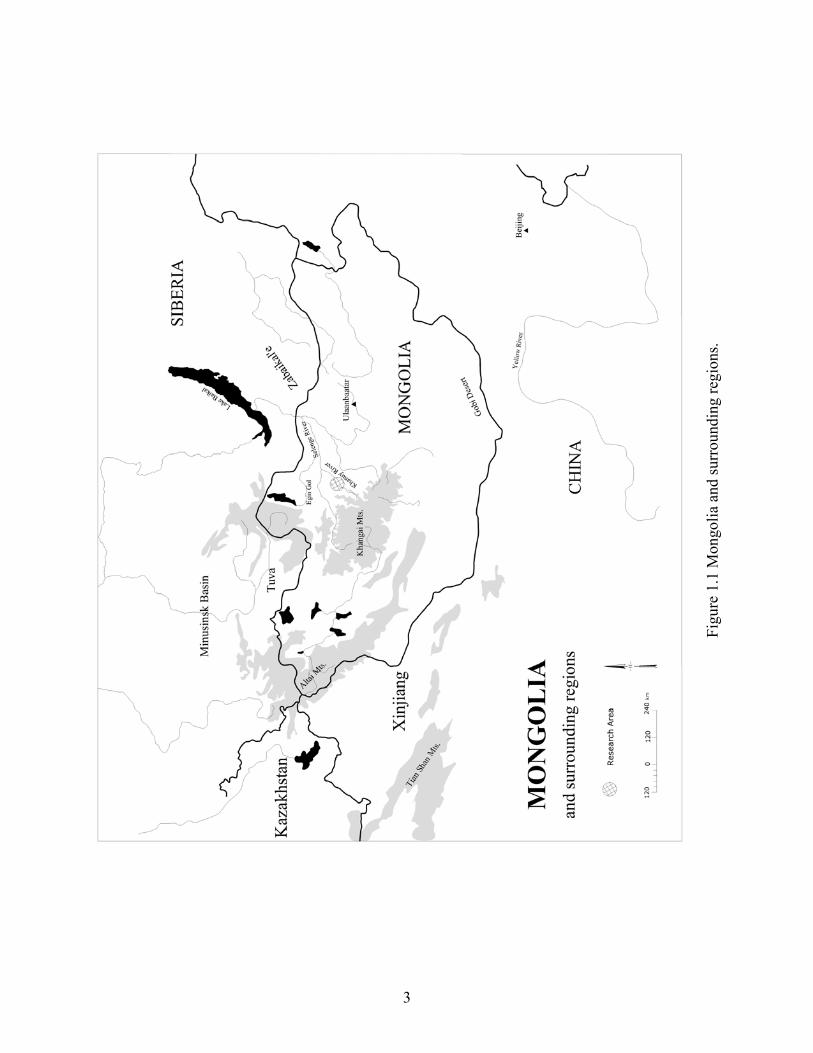
Figu
re 1
.1 M
ongo
lia a
nd su
rrou
ndin
g re
gion
s.
3
1.2 CONTEXTUALIZING MONGOLIA’S LATE BRONZE AGE
Research in central Mongolia has documented the broad chronological sequence of the
archaeological record which covers the Late Neolithic/Early Bronze Age through the Buddhist
periods (Table 1.1). Little is known of Mongolia’s Neolithic period, yet the presence of grinding
stones, pestles, and other agricultural paraphernalia in eastern and northern Mongolia, southern
Siberia and the central provinces of Mongolia have suggested to some the presence of scattered
farming communities (Derevyanko 1994; Derevyanko and Dorj 1992; Di Cosmo 1994; Grishin
1981; Volkov 1964). The earliest data thus far concerning the transition to an animal husbandry
economy in Mongolia dates to the Late Neolithic and Eneolithic Periods (5th to Early 2nd
millennium BCE) (Okladnikov and Derevianko 1970; Séfériadès 2004; Volkov 1995). This
transition has been especially well documented at the site of Tamsagbulag (Dornod aimag) in
eastern Mongolia where the subsistence economy seems to have been based on agriculture and
cattle-breeding, as well as hunting-fishing-gathering (e.g. millet, large fish, bird, cattle, pig,
horse, etc.) (Dorj 1969, 1971; Okladnikov and Derevianko 1970; Séfériadès 2004), while in
northern Mongolia and in the Altai and Khangai Mountains—the regions of interest to the
present study—this transitional period is essentially typified for the moment by the emergence of
the Afanasievo Culture (Volkov 1995; Kovalev 2008). In these regions, subsistence economy
was apparently based on a combination of hunting and cattle-breeding (cattle, sheep/goat, and
horse), burials consisted of relatively poorly furnished circular or rectangular shaped tumuli in
which two or more individuals were interred (usually only males and children), and settlements
were insubstantial—often interpreted as seasonal camps (Mallory 1989:223-25). However, aside
from occasional undated finds of microliths and very coarse low-fired ceramics, no evidence for
4
Afanasievo-related features – or other clear Late-Neolithic/Early Bronze Age features – has
definitively been identified in the northern Khangai region of central Mongolia (but see Wright
2006 for some possible evidence in the adjacent Egiin Gol Valley in northern Mongolia).
The Late Bronze Age—the focus of this study—corresponds to the heyday of
monumental construction in Mongolia, which in turn suggests a more complex pattern of social
organization. In fact, while Mongolia is commonly considered as a “peripheral” area in early
steppe sociopolitical dynamics, some of these monuments surpass in aboveground elaborateness
anything else of this nature in the Bronze Age steppe. Moreover, their appearance at the end of
the second millennium BCE is highly significant in that they precede the first large scale Iron
Age mortuary sites of Arzhan I and II in Tuva (9th-8th century BCE) (Bokovenko 1995a,b;
Gryaznov 1980), and other so-called Scythian Period royal burials in the Eurasian steppes.
Chronologically, Mongolia’s Late Bronze Age broadly corresponds to the better known
Karasuk and Tagar periods in the Minusinsk Basin of southern Siberia (ca.1400-300 BCE)
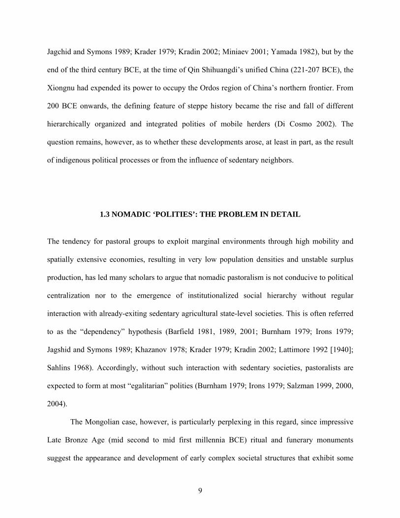
(Bokovenko 2006; Legrand 2006; Novgorodova 1989; Volkov 1995) (Table 1.1). Interestingly,
while it is fairly well recognized that the Iron Age Tagar cultural phase in the Minusink Basin
descends from the Late Bronze Age Karasuk cultural phase (Leont’ev et al. 1996; van Geel et al.
2004), some characteristic artistic elements found during the Late Bronze Age period in central
Mongolia, such as the images of stylized deer with bird-like beaks and backward-flowing antlers
found on what are commonly known as ‘deer stone’ stelae (Olenniye Kamni) (Figure 1.2),
actually predate those found during the Tagar period (Figure 1.3). Indeed, newly produced dates
from ritual features directly associated with deer stones in central and northern Mongolia
(Fitzhugh 2005) are now showing that these structures (at least the Mongol-Transbaikalian form)
not only belong at least to the Late Bronze Age—a sequence intuitively anticipated by Volkov
5

before the production of absolute dates (Volkov 1981)—but they are also consistently 200-300
years earlier than dates from Arzhan and other so-called early Scythian-related sites in southern
Siberia and central Asia (Fitzhugh 2009; Sementsov et al. 1998). In addition, a fragment of a
deer stone has recently been found in the fill of a Late Bronze Age khirigsuur mound (a
Mongolian type of kurgan mound) in Ulaan Uushig I (Khovsgol aimag, northern Mongolia), thus
supporting this chronology (Takahama 2003). This is not without significance, since the Tagar
culture has been argued as belonging to the earliest stages of the Iron Age Scythian
period/horizon (Bokovenko 2006). Consequently, it may be that some of the characteristic
elements of so-called “Scythian” art actually have their origin in Late Bronze Age Mongolia.
This, together with the impressive early khirigsuur mounds to be discussed later, is significant
not only because of its important implications on debates regarding the earliest appearance and
development of this widespread deer motif (and related ‘animal style’) within Eurasia, but
mostly for its important implications for the early development of complex social and religious
organization in this region of the world. Indeed, while there are no other Early Iron Age barrow
sites in the eastern steppe that compare in scale and elaborateness to Arzhan I and II, and while
there are no Late Bronze Age burials of a similar or transitional type in southern Siberia
(Bokovenko 1996), the structure of Late Bronze Age khirigsuur mounds in Mongolia, and
notably their satellite ritual features, foreshadow what is seen several centuries later at the
important Arzhan sites (Čugunov et al. 2004; Rolle 1989:43; Semenov 2002).
6
Table 1.1 Chronological divisions with related archaeological cultures of interest discussed in this text.
General Chronology Archaeological Cultures of Interest in this Study Dates
Upper Paleolithic 38000 – 13000 BCE
Epi-Paleolithic 6000 – 3500 BCE
Neolithic 3000 – 2000 BCE
Early Bronze Age 3500 – 1600 BCE
Bronze Age 1600 – 1000/800 BCE
Karasuk Culture 1400 – 1000/800 BCE Late Bronze Age Khirigsuur and Deer Stone
Culture 1300 – 700 BCE
Tagar Culture 800 – 300 BCE Terminal Bronze Age/Early Iron Age Slab Burial Culture 800 – 400 BCE
Iron Age Xiongnu 300 BCE – AD 200
Turk 7th – 9th AD
Uighur 10th – 11th AD
Medieval 11th – 14th AD
Manchu/Buddhist 17th – 20th AD
7
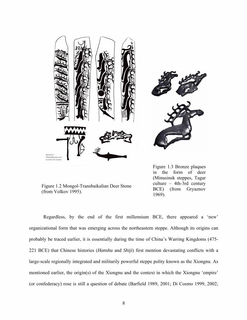
Figure 1.2 Mongol-Transbaikalian Deer Stone (from Volkov 1995).
Figure 1.3 Bronze plaques in the form of deer (Minusinsk steppes, Tagar culture – 4th-3rd century BCE) (from Gryaznov 1969).
Regardless, by the end of the first millennium BCE, there appeared a ‘new’
organizational form that was emerging across the northeastern steppe. Although its origins can
probably be traced earlier, it is essentially during the time of China’s Warring Kingdoms (475-
221 BCE) that Chinese histories (Hanshu and Shiji) first mention devastating conflicts with a
large-scale regionally integrated and militarily powerful steppe polity known as the Xiongnu. As
mentioned earlier, the origin(s) of the Xiongnu and the context in which the Xiongnu ‘empire’
(or confederacy) rose is still a question of debate (Barfield 1989, 2001; Di Cosmo 1999, 2002;
8
Jagchid and Symons 1989; Krader 1979; Kradin 2002; Miniaev 2001; Yamada 1982), but by the
end of the third century BCE, at the time of Qin Shihuangdi’s unified China (221-207 BCE), the
Xiongnu had expended its power to occupy the Ordos region of China’s northern frontier. From
200 BCE onwards, the defining feature of steppe history became the rise and fall of different
hierarchically organized and integrated polities of mobile herders (Di Cosmo 2002). The
question remains, however, as to whether these developments arose, at least in part, as the result
of indigenous political processes or from the influence of sedentary neighbors.
1.3 NOMADIC ‘POLITIES’: THE PROBLEM IN DETAIL
The tendency for pastoral groups to exploit marginal environments through high mobility and
spatially extensive economies, resulting in very low population densities and unstable surplus
production, has led many scholars to argue that nomadic pastoralism is not conducive to political
centralization nor to the emergence of institutionalized social hierarchy without regular
interaction with already-exiting sedentary agricultural state-level societies. This is often referred
to as the “dependency” hypothesis (Barfield 1981, 1989, 2001; Burnham 1979; Irons 1979;
Jagshid and Symons 1989; Khazanov 1978; Krader 1979; Kradin 2002; Lattimore 1992 [1940];
Sahlins 1968). Accordingly, without such interaction with sedentary societies, pastoralists are
expected to form at most “egalitarian” polities (Burnham 1979; Irons 1979; Salzman 1999, 2000,
2004).
The Mongolian case, however, is particularly perplexing in this regard, since impressive
Late Bronze Age (mid second to mid first millennia BCE) ritual and funerary monuments
suggest the appearance and development of early complex societal structures that exhibit some
9
sort of formalized social differentiation at a time before regular interaction with large sedentary
states in China existed. Nevertheless, there is currently very little other preserved material
evidence, such as grave goods, that correlates specifically with social status or political authority.
Consequently, the social organization of these Late Bronze Age groups continues to be
controversial, and the nature and extent of social differentiation uncertain.
1.4 THE SOCIOPOLITICAL ORGANIZATION OF LATE BRONZE AGE SOCIETIES: THE PARADOX
Indeed, the critical peculiarity of these Late Bronze Age societies is that their monumental
structures suggest organized labor investments, differential mortuary treatment for some
individuals, hints of incipient hereditary principles, and supra-local centralized organization
consistent with a hierarchical political structure, yet other formal indicators usually characteristic
of ‘ranked’ societies such as increase in population density, socioeconomic centralization,
complex technologies, increase in structural and functional specialization are apparently missing
(cf. Kradin 2002; see also Johnson and Earle 2000). Yet, because little systematic research has
been devoted to features other than monumental structures, for the most part looted, the scale and
nature of these societies remain, for the most part, at the hypothetical level. Nonetheless, without
delving deeper into the problem, we can neither altogether avoid considering the ‘built
environment’, what Edward T. Hall called the “fixed-feature space”, that is, one of the basic
ways of organizing the activities of individuals and groups in space (1966:103). What follows is
an overview of this Late Bronze Age monumental landscape in central Mongolia and the way it
has been interpreted.
10
1.5 THE SIGNIFICANCE OF LATE BRONZE AGE MONUMENTS: A QUESTION OF DEBATE
The monumental public works and mortuary complexes of the Late Bronze Age, notably the
impressive khirigsuurs, along with ‘slope’ burials, deer stone stelae, and ‘slab’ burials, have
suggested the early development of societal and political complexity in central Mongolia.
Attention has focused especially on the khirigsuurs, a Mongolian version of the kurgans known
from farther west, and consisting of massive central mounds of stones that cover a central cist,
surrounded by square or circular ‘fences’ of surface stones, and satellite features (stone mounds
and stone circles) which contain, respectively, complex deposits of remains of horses and
cremated bone fragments of unidentified animals (Figure 1.4) (Allard and Erdenebaatar 2005;
Allard et al. 2006). Interestingly, as noted before, this type of monument is similar in structure,
and apparently in function to some extent, to what is found in slightly later times at both Arzhan
I and II in Tuva, although the latter are much more elaborate (Čugunov et al. 2004; Rolle
1989:43; Semenov 2002). Indeed, a stone ‘fence’ and several (n= >200) stone mounds and stone
circles (ca. 2-3 meters in diameter) have been found around these monuments (Rolle 1989:43).
The satellite features at Arzhan I contain predominantly head and metapodial elements of sheep,
goats, cattle and horses (similar to what is found in stone mounds at khirigsuurs, although these
have only horse elements), while those at Arzhan II have been found to contain calcined bone
fragments of various livestock (similar to what is found in stone circles at khirigsuurs). As is the
case for their counterparts in Tuva, these types of remains found at khirigsuurs suggest wide-
scale feasting and clearly speak to the significance of ritual activity at these sites. Moreover, the
11
early and widespread distribution of these funerary complexes in Mongolia signals the
emergence of new complex social institutions and commemoration in this part of the world.
The conventional interpretation of Eurasian kurgans (Grach 1980; Khazanov 1975), given
by a number of scholars, have suggested that khirigsuurs reflect the social place of the deceased as
a member of a hereditary elite (e.g. Erdenebaatar 2002; Tsybiktarov 1995, 1998, 2003; Volkov
1967). Very few khirigsuurs have been excavated, and most were previously looted, but when
human remains are found within the central cist of these monuments, these consist in single human
inhumations of both adults and sub-adults (Erdenebaatar 2002; Takahama 2005; Tsybiktarov
1998), suggesting hereditary ranking (i.e. ascribed status).
12
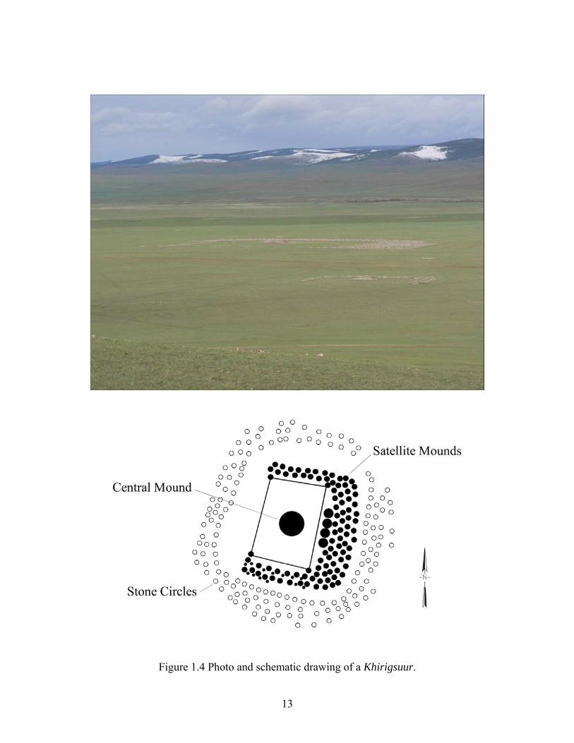
Figure 1.4 Photo and schematic drawing of a Khirigsuur.
13
‘Slope’ burials, which are small graves without prominent tumuli or animal ritual
deposits that occur in cemetery groupings along hill slopes, are taken to represent lower-ranking
members of society (Figure 1.5). This less monumental Late Bronze Age burial custom,
unfortunately, is rarely considered in discussions concerning the social organization of Bronze
Age Mongolia or is conflated into analyses of khirigsuurs proper because of their similar
structure, a practice not unlike the one found in the rest of Eurasia where the term ‘kurgan’ is
generically used to designate any type of burial mound. Here, however, I distinguish between
khirigsuurs proper (a ritual/funerary structure consisting of a massive central mound of stones,
surrounded by a square or circular ‘fence’ of surface stones, and satellite features with complex
deposits of remains of horses and other domesticated animals) and ‘slope’ burials (usually small
graves also surrounded by a square or circular ‘fence’ of surface stones, but without prominent
tumuli and with no or very few animal ritual deposits). Although there is much variability and
occasionally some architectural overlap between these different types of monuments, the most
distinguishable and important characteristic I see between these two types of monuments,
especially in terms of social function, is the presence or not of peripheral ritual activity which
suggests or not large group participation. Both types are usually found together, and date to the
same period of time, that is, between ca. 1300 BCE and 700 BCE (Allard and Erdenebaatar
2005; Fitzhugh 2009; Frohlich, personal communication). Contrary to most khirigsuurs,
however, ‘slope’ burials are located in direct association with contemporaneous habitation sites
(apparently winter/spring campsites if compared to local ethnographic patterns and seasonality
studies – see chapter 5), thus suggesting “household”/encampment burials. Accordingly, this
two-tier burial tradition suggests that social distinctions, at least in death, were drawn in space.
14
Figure 1.5 ‘Slope’ burials.
The social function of deer stones remains an enigma, but the variable belt styles, chevron
motifs, and toolkits depicted on the stelae suggest reference to a particular individual, possibly a
warrior or a chief (Dikov 1958; Erdenebaatar 2004; Jacobson 1993; Magail 2003; Volkov 1981).
Some rare stelae do have a human face carved on the upper portion (Figure 1.6), but most only
depict some of the elements that appear on the top section of these anthropomorphic stones, that
is, what appear to be a necklace and earrings/sun motif (Volkov 1981; Novgorodova 1989). The
imagery and its style of presentation also parallels tattooed shamanistic elements or components
found in shaman’s ritual clothing (Bayarsaikhan 2005; Novgorodova 1975; Purev 1999:19;
Savinov and Chlenova 1978; Volkov 1981) (Figure 1.7), but this should not be surprising since,
as in traditional Mongolia, a clan chief was sometimes both political leader and shaman (Jagchid
& Hyer 1979:171).
15
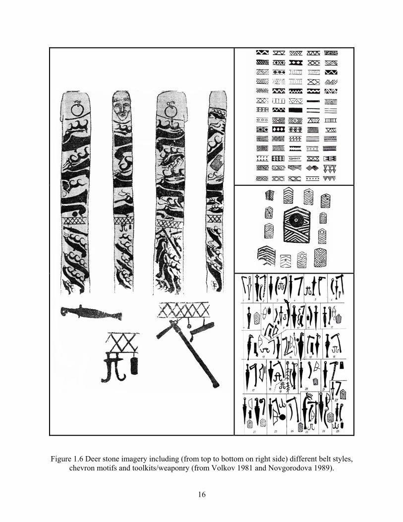
Figure 1.6 Deer stone imagery including (from top to bottom on right side) different belt styles, chevron motifs and toolkits/weaponry (from Volkov 1981 and Novgorodova 1989).
16
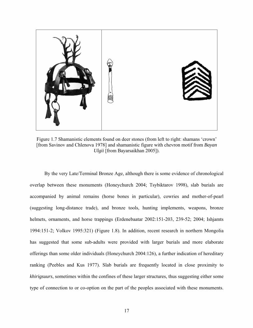
Figure 1.7 Shamanistic elements found on deer stones (from left to right: shamans ‘crown’ [from Savinov and Chlenova 1978] and shamanistic figure with chevron motif from Bayan
Ulgii [from Bayarsaikhan 2005]).
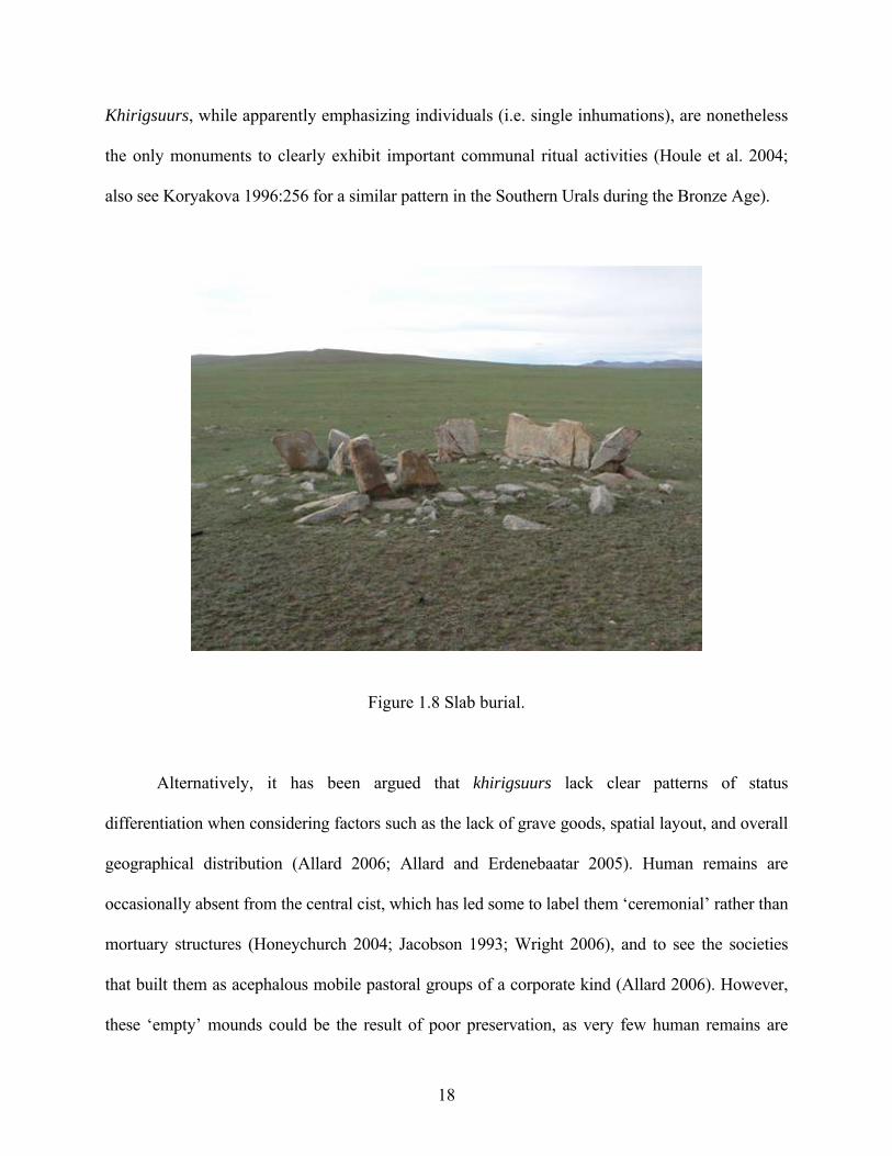
By the very Late/Terminal Bronze Age, although there is some evidence of chronological
overlap between these monuments (Honeychurch 2004; Tsybiktarov 1998), slab burials are
accompanied by animal remains (horse bones in particular), cowries and mother-of-pearl
(suggesting long-distance trade), and bronze tools, hunting implements, weapons, bronze
helmets, ornaments, and horse trappings (Erdenebaatar 2002:151-203, 239-52; 2004; Ishjamts
1994:151-2; Volkov 1995:321) (Figure 1.8). In addition, recent research in northern Mongolia
has suggested that some sub-adults were provided with larger burials and more elaborate
offerings than some older individuals (Honeychurch 2004:126), a further indication of hereditary
ranking (Peebles and Kus 1977). Slab burials are frequently located in close proximity to
khirigsuurs, sometimes within the confines of these larger structures, thus suggesting either some
type of connection to or co-option on the part of the peoples associated with these monuments.
17
Khirigsuurs, while apparently emphasizing individuals (i.e. single inhumations), are nonetheless
the only monuments to clearly exhibit important communal ritual activities (Houle et al. 2004;
also see Koryakova 1996:256 for a similar pattern in the Southern Urals during the Bronze Age).
Figure 1.8 Slab burial.
Alternatively, it has been argued that khirigsuurs lack clear patterns of status
differentiation when considering factors such as the lack of grave goods, spatial layout, and overall
geographical distribution (Allard 2006; Allard and Erdenebaatar 2005). Human remains are
occasionally absent from the central cist, which has led some to label them ‘ceremonial’ rather than
mortuary structures (Honeychurch 2004; Jacobson 1993; Wright 2006), and to see the societies
that built them as acephalous mobile pastoral groups of a corporate kind (Allard 2006). However,
these ‘empty’ mounds could be the result of poor preservation, as very few human remains are
18
found in either slope burials or slab burials as well. Of the six ‘slope’ and slab burials excavated in
the Khanuy River Valley region of central Mongolia, for example, half were empty. Those in
which human remains were found only contained a few badly preserved and often fragmentary
bones (Allard 2004, n.d.). In one instance only lower leg bones were found, while the skeletal
remains from another burial were less than five percent complete and was represented only by a
few frontal cranium bones (Houle 2008, n.d.). Apparently, this is often the case in other regions of
Mongolia as well (Erdenebaatar 2002:52; Honeychurch, personal communication; Frohlich,
personal communication). It could also be argued that some of these ‘empty’ mounds may have
been cenotaphs, as the size and structural organization of the central cists are commensurate to
ones containing human remains (see descriptions by Erdenebaatar 2002; Takahama 2004;
personal observation; and also see Ionesov 2002 and Kroll 2000 on the topic of cenotaphs in the
Eurasian steppes). Nonetheless, although arguing for the possible emergence of hereditary
inequality during the very late Bronze Age, Honeychurch et al. (2009) suggest that khirigsuurs
represent collective ceremonial events for negotiating such things as alliances, marriage
agreements, resource distribution and access, and points of conflict. Once again, no permanent
leader is postulated to have organized these events, while role distinctions between participants
likely comprised ritual coordinators, local group members, and non-local group members.
These interpretations, based almost exclusively on the unsystematic study of mortuary
remains (for the most part looted) and ritual landscapes, need to be further evaluated through the
use of more direct sorts of evidence of social status, political authority, and economic
specialization that might come from the investigation of residential remains—the focus of this
study (see Kohl 2007:247 for a similar argument). To be sure, while the monumentality of
khirigsuurs and other Bronze Age burials suggests organized labor and perhaps differential
19
mortuary treatment for some elite individuals, they still present insufficient evidence regarding
the sociopolitical organization of steppe groups during this period (Tsybiktarov 1998).
Significantly, the lack of data on habitation sites and their regional distribution makes
assessments of population size, subsistence practices, degrees of mobility, and territorial
behavior highly speculative, and all these things are vital to discussions of socioeconomic and
sociopolitical systems among mobile herders (Casimir and Rao 1992; Irons 1979)—especially in
regard to the assumptions tied to the ‘dependency’ hypothesis. Consequently, the relevant prior
question to be answered has less to do with debating why these societies are (or are not) complex,
but how or in what ways they are complex. In order to accomplish this, a number of concrete
lines of inquiry are investigated in this study so as to systematically and empirically evaluate the
core variables and problematic aspects related to the development of ‘nomadic’ polities (i.e.
those related to the dependency hypothesis), namely demography, subsistence, mobility, and
political economy in relation to higher degrees of sociopolitical organization during the Late
Bronze Age in central Mongolia. Specifically, 1) What was the demographic and spatial scale of
these societal organizations at the local and sub-regional levels? 2) What was the nature of
subsistence practices? That is, what exactly was the herd composition? And beyond herding, is
there any evidence of other complementary subsistence practices such as agriculture, plant
cultivation or intense use of wild fauna? 3) What was the degree and scale of residential mobility
(seasonal movement)? 4) Is there any evidence for higher status and/or specialist campsites? If
so, what was the degree and nature of social and/or economic differentiation? and 5) If there is
evidence for higher status and/or specialist campsites, do they tend to concentrate in areas near
khirigsuurs?
20
1.6 THE RESEARCH REGION
The Khanuy River Valley is particularly well suited for answering these questions about central
Mongolian Bronze Age society, as well as for investigating whether political centralization and
complex political institutions among mobile pastoralists could have arisen without the influence,
or at least the direct influence, of sedentary state-organized neighbors (cf. Burnham 1979; Irons
1979; Salzman 1999, 2000). Located to the north of the Khangai (Hangai) mountain range in
Arkhangai aimag, the Khanuy River valley research area (N48°05’/E101°03’) is part of the
extensive non-urbanized grasslands of present-day north-central Mongolia, a remote region far
from the direct intersection with centers of power such as China (Figure 1.1), but where
numerous monumental structures dating to the period of interest dot the landscape. The valley,
whose width varies between 3 and 5 km, is bordered by mountain ranges that rise some 200 –
400 m above the valley floor, itself lying at an altitude of about 1650 m above sea level (Figure
1.9). Treeless grasslands cover the valley floor and much of the hill slopes, with wooded areas
(mixed pine, larch, and birch forest) typically found at elevations above 1700 m. Khanuy River,
the major river in the valley, is in reality a meandering stream no more than 15 m wide during
the summer that originates from the Khangai nuruu mountain range, the second-highest
mountains in Mongolia after the Altai range. Meandering at an average elevation of 1660 m
above sea level and flowing in a general south-north axis, it crisscrosses a usually unconsolidated
coarse-grained alluvium area characteristic of grasslands in central Mongolia.
21
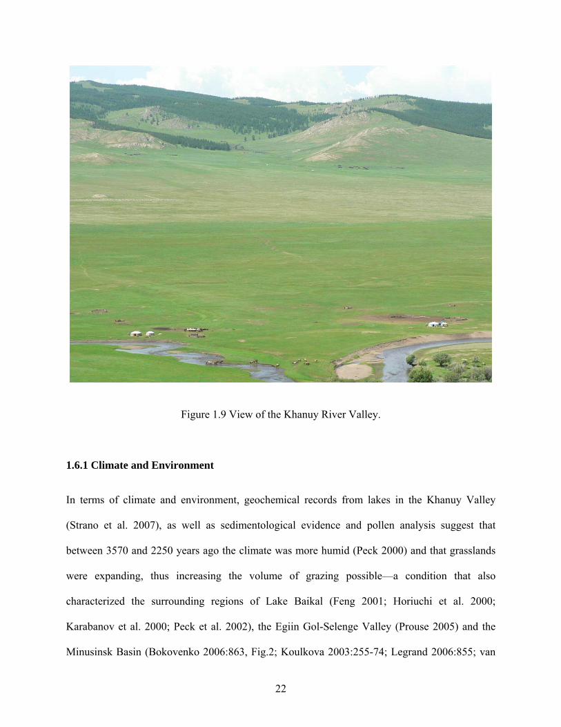
Figure 1.9 View of the Khanuy River Valley. 1.6.1 Climate and Environment
In terms of climate and environment, geochemical records from lakes in the Khanuy Valley
(Strano et al. 2007), as well as sedimentological evidence and pollen analysis suggest that
between 3570 and 2250 years ago the climate was more humid (Peck 2000) and that grasslands
were expanding, thus increasing the volume of grazing possible—a condition that also
characterized the surrounding regions of Lake Baikal (Feng 2001; Horiuchi et al. 2000;
Karabanov et al. 2000; Peck et al. 2002), the Egiin Gol-Selenge Valley (Prouse 2005) and the
Minusinsk Basin (Bokovenko 2006:863, Fig.2; Koulkova 2003:255-74; Legrand 2006:855; van
22
Geel et al. 2004). Noteworthy, as mentioned earlier, this period (the Late Bronze Age)
corresponds to the heyday of monumental constructions in central Mongolia and contradicts the
generalized view in Eurasian archaeology that the transition between the Bronze Age and the
Early Iron Age (ca.1000-800 BCE) was set against a background of ecological stress linked to a
so-called arid phase, which is said to have contributed at least in part to the collapse of Late
Bronze Age cultures, and which in turn would have set off mass westward migrations and
changes in basic economic activities (e.g. Koryakova and Epimakhov 2007:211; Kurochkin
1994, cited in Koryakova and Epimakhov 2007:211). In fact, and by way of comparison, the
abovementioned environmental data for Mongolia and the surrounding northern regions now
clearly show that the environmental conditions that prevailed during the Late Bronze Age in
north-central Mongolia can be described as broadly similar to those of today (Stacy 2008), but
with possibly warmer and wetter climate regimes (Prouse 2005). This is interesting and pertinent
for analogical purposes because a) this region is today one of the most populated of Mongolia,
and b) the research area continues to be inhabited by mobile pastoralists whose seasonal
movements are determined in large part by the needs of their herds of sheep, goat, cattle and
horses. And although unique social and political pressures can also affect patterns of movement
and social interaction, this similarity in environmental context makes the ethnographic and
ethnohistorical analogical comparisons of settlement systems, mobility patterns and
environmental exploitation presented in this study more suitable (Binford 1968; Hole 1979;
Wylie 1985). Therefore, the possibility of (some) continuity linking ancient and modern
populations in this region has been deemed useful for analogical purposes in this study as it can
help to define, support and direct the parameters of inquiry.
23
1.6.2 Ethnographic and Ethnohistoric Context of the Research Region
Currently, approximately 350 families (with an average of 4 persons per household), of which
most are organized into small herding groups, inhabit the valley’s broadly defined research area
(i.e. within the Khanuy Brigade’s administrative unit). Average seasonal camp size varies
between two and four families during the winter and between three to five families during the
summer. These numbers are also consistent with Pre-Soviet Era ethnohistorically recorded
census information gathered in the neighboring regions of Tuva, Kazakhstan and Western
Mongolia in the early 1800s and early 1900s (see examples in Vainshtein 1980:98-99). These
economically self-sufficient herding units (most often consisting of extended families) are in a
very real sense the primary communities of mobile herders in the Khanuy Valley. These herding
units make relatively short-distance seasonal movements in order to maintain herds of sheep,
goats, cattle, and horses. Indeed, ethnographic research by Simukov (1934), Bazargur (2005),
Erdenebaatar (2000) and this author on mobility patterns in the Khangai range of central
Mongolia have recorded patterns of relatively localized seasonal migratory circuits that reflect a
region of constant and high productivity (Figure 1.10). In fact, the Russian ethnographer
Simukov, who carried out research in the 1930’s on mobility patterns in Mongolia, identified a
system of movement, which he called ‘Khangai’, in the region of which the Khanuy valley is a
part. He pointed out that owing to the constant and high productivity of the region, including the
presence of different complementary types of pasture within a short distance, there was no need
to make long migrations in response to drought (Simukov 1934). He estimated the diameter of
the annual movement cycle in this region to be no more than 7-8 km, a pattern still prevalent
today (on this mobility pattern also see Novgorodova 1989; Vainshtein 1980). Interestingly,
according to information provided by the local administrator at the Khanuy brigade (or bag—the
24
smallest Mongolian administrative unit), the human and animal population presently doubles in
the valley during the winter period due to incoming herders from less productive and less well
sheltered neighboring regions, bringing the total animal population to the astonishing number of
about 40,000 to 60,000 head of livestock within about a 300 km2 area (Houle 2004, n.d.). This is
probably a bit of an exaggeration, but it does suggest a substantial increase in population during
the winter, especially in terms of livestock. Although interviewed local herders agree that this is
too much for the at least perceived carrying capacity of the valley, together with the
environmental data presented above it does highlight the fact that the Khanuy Valley is a
particularly favored environmental region.
Seasonal mobility in the Khanuy Valley is currently based on a two to four season
system. Campsites in the valley that are the most distinctive spatially are those of summer and
winter, while spring campsites are usually located between these two, often closer to winter
campsites (Figure 1.10). Spring campsites are usually only set up if and when winter campsites
are excessively soiled by too much animal excrement, for example, and to access new
vegetation. Winter camps tend to be located in valley draws along the foothills, while summer
camps tend to be located along the Khanuy River (some 4 to 5 km from the foothills) or its
floodplain when the terrain is not suitable and/or when other sources of water are available, such
as lakes or other streams. According to the valley’s herders, a good winter site is a location that
is protected from the cold wind, has areas of exposure for grasses during winter, and is relatively
close to a water hole or a spring. The main characteristics for a good summer campsite are flat
terrain with good grazing, and proximity to a large water source (i.e. a river or a lake). This
patterning is very similar to the one recorded in 2000 by Diimaajav Erdenebaatar for the Egiin
Gol Valley in northern Mongolia (Erdenebaatar 2000), and, once again, largely corresponds to
25
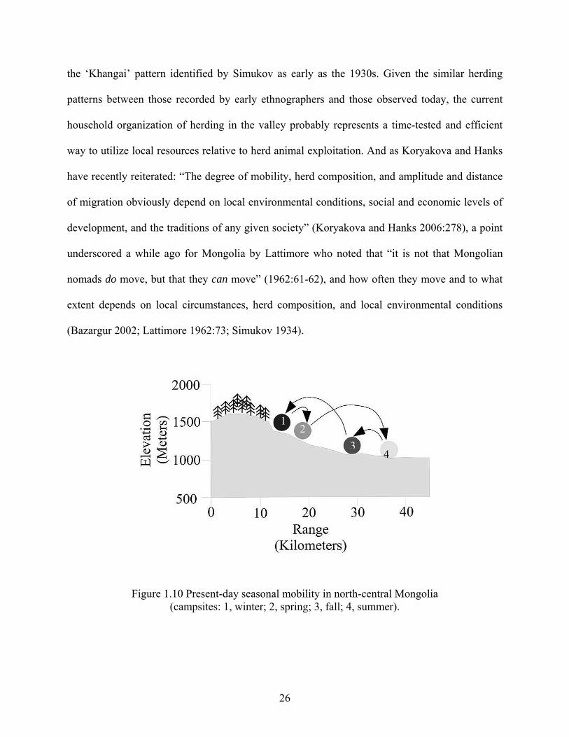
the ‘Khangai’ pattern identified by Simukov as early as the 1930s. Given the similar herding
patterns between those recorded by early ethnographers and those observed today, the current
household organization of herding in the valley probably represents a time-tested and efficient
way to utilize local resources relative to herd animal exploitation. And as Koryakova and Hanks
have recently reiterated: “The degree of mobility, herd composition, and amplitude and distance
of migration obviously depend on local environmental conditions, social and economic levels of
development, and the traditions of any given society” (Koryakova and Hanks 2006:278), a point
underscored a while ago for Mongolia by Lattimore who noted that “it is not that Mongolian
nomads do move, but that they can move” (1962:61-62), and how often they move and to what
extent depends on local circumstances, herd composition, and local environmental conditions
(Bazargur 2002; Lattimore 1962:73; Simukov 1934).
12
34
Figure 1.10 Present-day seasonal mobility in north-central Mongolia (campsites: 1, winter; 2, spring; 3, fall; 4, summer).
26
Theoretically, therefore, and of pertinence to this present study, this type of micro-
regional mobility pattern, if also present in the past, can have profound implications in terms of
territoriality and the nature of a given pastoral economy (Barth 1961; Cribb 1991; Irons 1974;
Koster 1977; Meadow 1992; Rosen 1992; Spooner 1973; Tapper 1979). It also has important
implications for issues of regional demography, resource mobilization, centralization, and the
nature of societal complexity (cf. Burnham 1979, Irons 1979 and Salzman 1967). In the Iranian
area, for example, there seems to be a correlation between lush and predictable pastures (leading
to shorter migration routes), higher population densities, and strong chiefly control (Barth
1961:128; Tapper 1979:97).
1.6.3 The Khanuy Valley’s Architectural Landscape
Archaeologically speaking, the Khanuy Valley is dotted with numerous monumental mortuary
and ritual sites dating to the period of interest. It is also located at the geographical meeting point
of the major forms of Late Bronze Age archaeological monuments (i.e. khirigsuurs, ‘slope
burials’, deer stones and slab burials) (Novgorodova 1989:256) (Figure 1.11). In addition, the
valley is typical of the fact that although khirigsuur complexes cover a fairly large territory, they
are mostly concentrated along major river valleys located between the Khangai mountain range
in central Mongolia and the regions of Gorno-Altai, Buryatia, and particularly Tuva in southern
Siberia (Figure 1.12) (Tseveendorj et al. 1999; Tsybiktarov 2003; Volkov 1981:123), or located
in geographical focal points such as ‘oases’—for example the khirigsuurs found in Baga Gaziryn
Chuluu, south-central Mongolia. This may not be a coincidence since there are many lines of
evidence that suggest that the Late Bronze Age societies of central Mongolia may have had some
type of connection with the contemporary specialized metal producing Karasuk culture of
27
southern Siberia (Askarov et al. 1992; Gryaznov 1969:98; Volkov 1967, 1995)—including the
fact that Mongolia could have been a possible path for the diffusion of Karasuk type bronze
artifacts toward China (Legrand 2004). While this thesis does not propose any particular solution
to the conundrum related to deer stones and their connection to social structure, it is worth
mentioning that their distribution conforms greatly to the distribution of khirigsuurs (Volkov
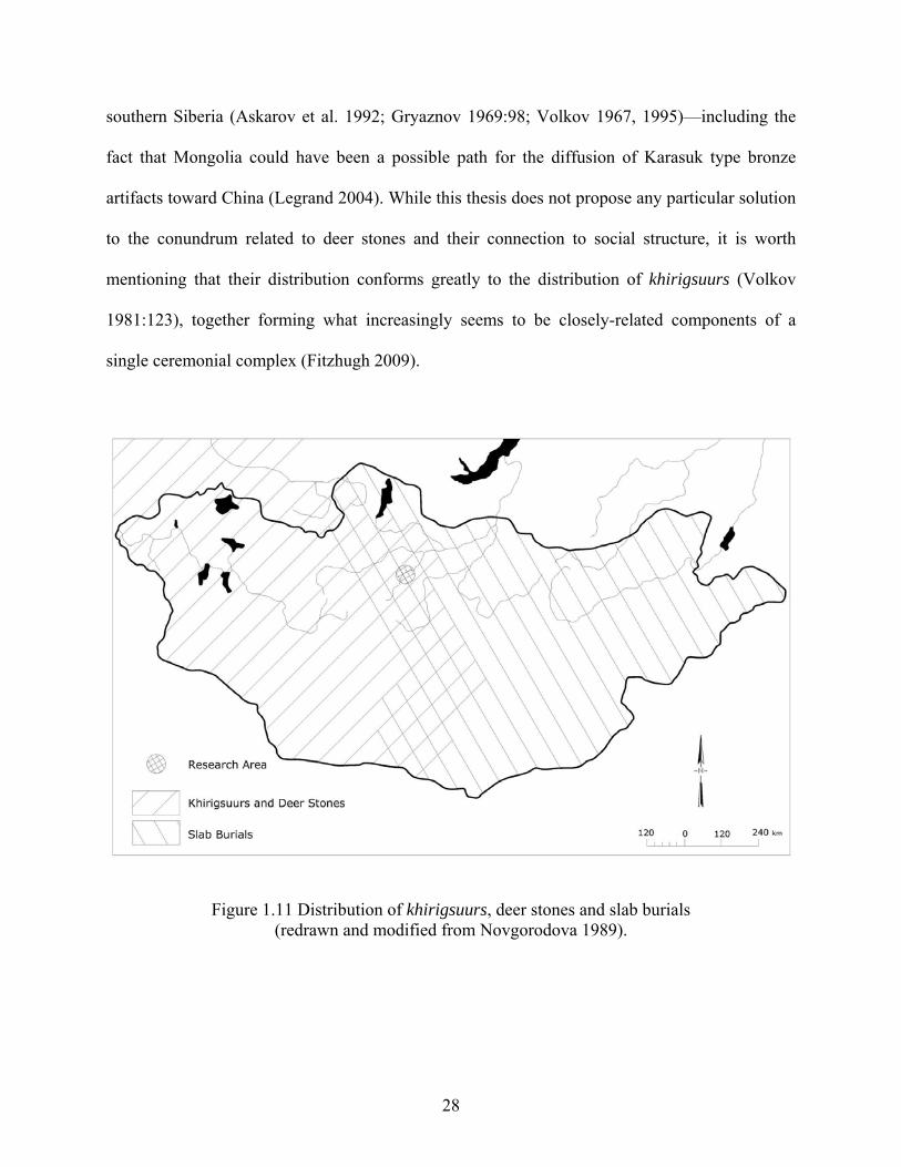
1981:123), together forming what increasingly seems to be closely-related components of a
single ceremonial complex (Fitzhugh 2009).
Figure 1.11 Distribution of khirigsuurs, deer stones and slab burials (redrawn and modified from Novgorodova 1989).
28
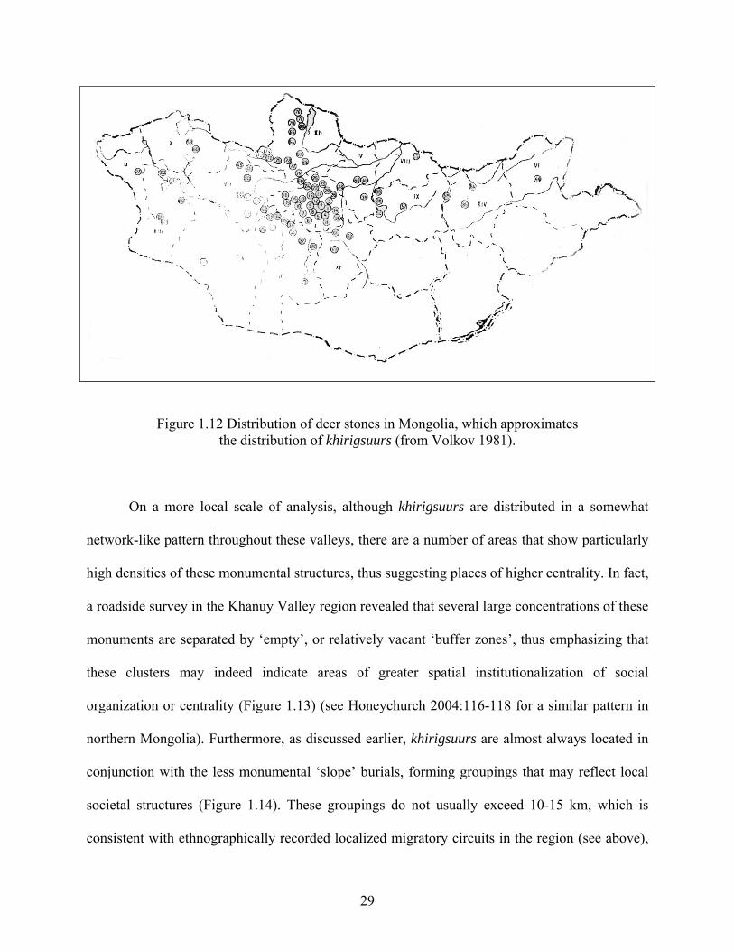
Figure 1.12 Distribution of deer stones in Mongolia, which approximates the distribution of khirigsuurs (from Volkov 1981).
On a more local scale of analysis, although khirigsuurs are distributed in a somewhat
network-like pattern throughout these valleys, there are a number of areas that show particularly
high densities of these monumental structures, thus suggesting places of higher centrality. In fact,
a roadside survey in the Khanuy Valley region revealed that several large concentrations of these
monuments are separated by ‘empty’, or relatively vacant ‘buffer zones’, thus emphasizing that
these clusters may indeed indicate areas of greater spatial institutionalization of social
organization or centrality (Figure 1.13) (see Honeychurch 2004:116-118 for a similar pattern in
northern Mongolia). Furthermore, as discussed earlier, khirigsuurs are almost always located in
conjunction with the less monumental ‘slope’ burials, forming groupings that may reflect local
societal structures (Figure 1.14). These groupings do not usually exceed 10-15 km, which is
consistent with ethnographically recorded localized migratory circuits in the region (see above),
29
and which in turn may have helped to reinforce social and political contacts within a defined
territory. Significantly, the scale of many khirigsuurs, whose construction must have involved
the organized activities of entire communities, and the elaborate seasonal ceremonial activities
carried out at these complexes, including the strong possibility of important feasting activities
(Houle et al. 2004), certainly fits the archaeological description of central places, that is, the
nexus of a larger web of social interaction. One of the two largest khirigsuurs (Urt Bulagyn
[KYR1]) in the Khanuy River Valley research area measures over 400 x 400 m with a 5 m tall
and 26 m in diameter mound at its center (Figure 1.15). It is estimated that well over half a
million stones of granite, some of which weighing over one ton, were used to build this
monument (Allard and Erdenebaatar 2005). Based on experiments we conducted which suggest
that it takes approximately one hour using a cattle-driven cart to bring a 45 kg stone to the Urt
Bulagyn khirigsuur from the closest source of granite rock which is located along a fairly steep
mountain slope about 1 km away (and we have no evidence they used carts in the Late Bronze
Age, although they may have used other contraptions to transport the stones such as sleds similar
to the Pazyryk one found in barrow 5 [Rudenko 1970:192]), it is estimated that it took 20, 833
person-days to build this khirigsuur alone. Furthermore, while a number of ‘satellite’ features
containing animal deposits regularly accompany khirigsuurs (usually ranging from 12 to 40, and
exceptionally as many as 150 [Erdenebaatar 2004]), this khirigsuur has over 1700 small mounds,
all containing an east-facing horse skull and/or vertebrae or leg bones, and over 1000 stone
circles containing cremated animal bone fragments of various animal species (Allard and
Erdenebaatar 2005)—all of which indicates a huge access to and/or a huge supply of probably
valuable animals. Research on some of these satellite features indicate that these structures, at
least the main ritual features, were probably built during the late fall period (Sandra Olsen,
30
personal communication), thus suggesting a short yearly construction period. In addition,
although these monuments may have been reused over time (Wright 2006), the overall and
apparently planned structured organization of these monuments, in addition to overlapping dates
obtained from inner and outer satellite mounds at this khirigsuur (i.e. BP 2970-2780 and BP
2980-2770) (Fitzhugh 2009) suggest a probable relatively brief overall building period. With this
in mind, it then becomes apparent that the number of deposited animal remains as well as the
labor involved in the construction of the khirigsuur Urt Bulagyn, like many others in the research
area, clearly suggests the participation of numerous settlement units, as its construction far
exceeds the realistic contribution of an isolated social unit. The widespread regularity of ritual
practice witnessed at all levels and space within and between these structures (Allard and
Erdenebaatar 2005; Wright 2006, 2007), as well as the practice of depositing particular horse
remains in a specific pattern for a period of over 500 years, has suggested to some studying
similar patterns for the contemporary metal-producing Karasuk culture (13th - 8th centuries BCE)
in southern Siberia that this could only develop in stock-rearing groups with a stable economic
structure, who were relatively prosperous, and who had advanced far beyond the relatively
egalitarian groups that preceded them in terms of social development (Gryaznov 1969:129;
Legrand 2006).
31
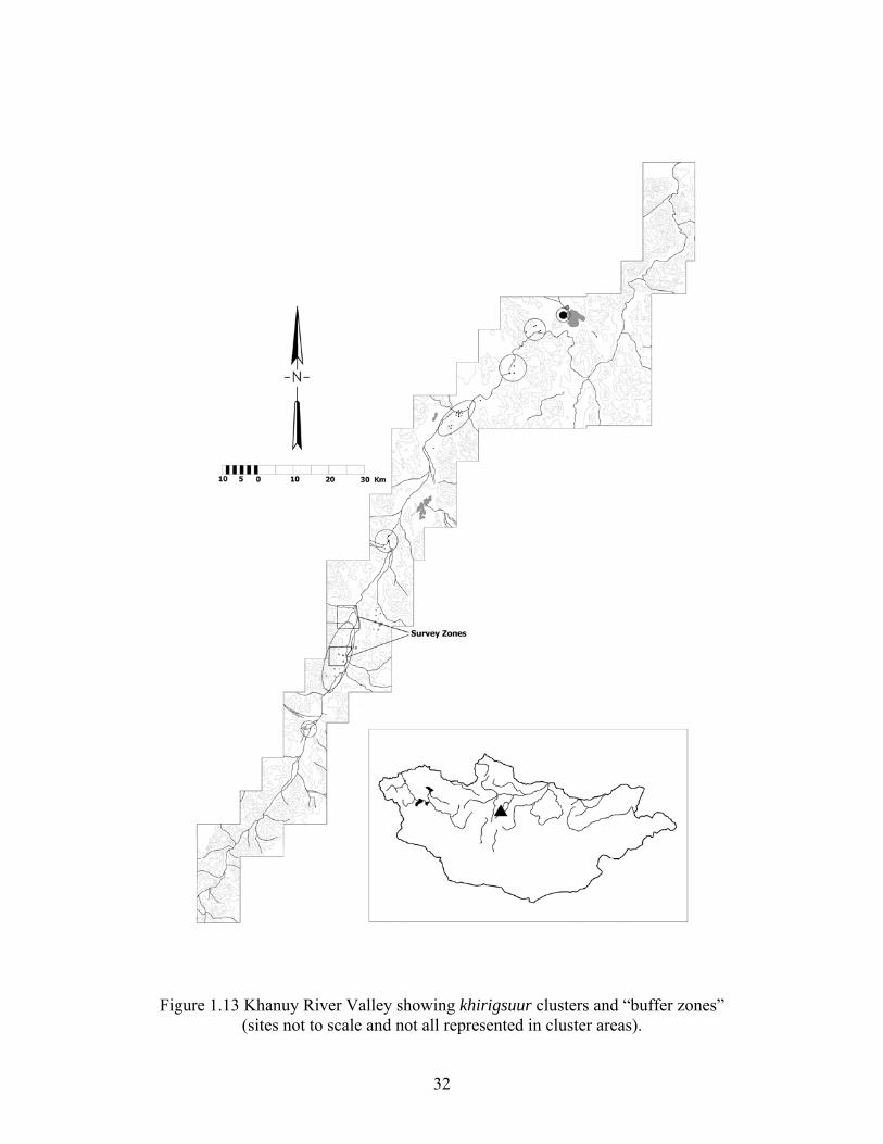
Figure 1.13 Khanuy River Valley showing khirigsuur clusters and “buffer zones” (sites not to scale and not all represented in cluster areas).
32
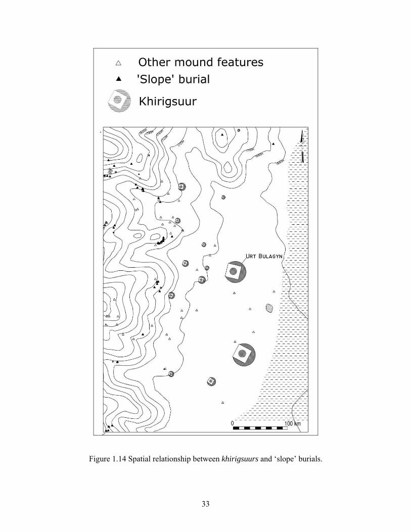
Figure 1.14 Spatial relationship between khirigsuurs and ‘slope’ burials.
33
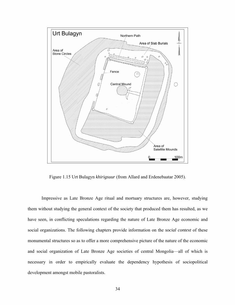
Figure 1.15 Urt Bulagyn khirigsuur (from Allard and Erdenebaatar 2005).
Impressive as Late Bronze Age ritual and mortuary structures are, however, studying
them without studying the general context of the society that produced them has resulted, as we
have seen, in conflicting speculations regarding the nature of Late Bronze Age economic and
social organizations. The following chapters provide information on the social context of these
monumental structures so as to offer a more comprehensive picture of the nature of the economic
and social organization of Late Bronze Age societies of central Mongolia—all of which is
necessary in order to empirically evaluate the dependency hypothesis of sociopolitical
development amongst mobile pastoralists.
34
2.0 METHODOLOGY The field strategy pursued for reconstructing the ancient living patterns in the Khanuy River
Valley (i.e. the social context of the monumental landscape) was regional archaeological
survey—the broadest archaeological method for reconstructing patterns of organization at
different analytical levels (Billman and Feinman 1999; Chang 1968; Trigger 1967). The use of
systematic survey is a relatively recent phenomenon in Mongolia. While burial and ritual
structures have been and continue to be fairly well documented, the locations of settlements,
specifically Bronze Age settlements, remain relatively unknown. For mobile pastoralists in
particular, settlement archaeology may still be one of the areas that has been the most overlooked
by regional archaeology research (Cribb 1991:155; but see Chang and Tourtelotte 2002;
Frachetti 2004; Honeychurch 2004, for mobile pastoralists of the Eurasian Steppes; and also see
Sadr 1988 for Africa). This is unfortunate—and probably has much to do with the assumed
‘invisibility’ or ephemeral nature of the archaeological remains left by mobile peoples—as
settlement sites are where one might expect to find more empirical data for dealing with such
issues as demography, subsistence, mobility, and political economy. This research seeks to
further fill this gap in Mongolia.
Before going further, however, I feel the need to clarify the terminology used in this
study to describe habitation sites. That is, the term ‘settlement’ used above should be taken here
to refer to a place of habitation, without any implication of fixed space or permanence in
35
occupation. Nevertheless, and given the historical context of the research area, a term such as
‘occupation area’ might be a more precise label for the archaeological evidence left by the
habitations of mobile peoples who often reoccupy locales repeatedly/seasonally over long
periods of time, but shift settlement slightly each season, thus leaving a palimpsest of living
areas. ‘Occupation area’, therefore, is used in this text to characterize more precisely the
archaeological evidence of settlement sites discussed in this research.
2.1 SURVEYING THE ‘INVISIBLE CULTURE’: DEALING WITH THE VISIBILITY AND SCALE OF OCCUPATION AREAS
A major challenge for the settlement archaeology of sparse, mobile populations is that habitation
remains may be extremely ephemeral and the areas that must be studied are very large. Intensive
methods are needed for studying (or even locating) such ephemeral habitation remains, but
extensive methods are required to determine the numbers and densities of sites and their
distributions with regard to environmental and other variables. The solution to this difficulty is a
multi-stage strategy that combines both extensive and intensive methods.
In the Khanuy Valley, as well as in the surrounding region, no above-ground structures
related to habitation sites are visible. In addition, the unplowed grassland nature of the research
area and concomitant low surface visibility prevented in most cases the surface collection of
artifacts. Consequently, shovel probes were used as the primary data recovering method in the
current regional survey (cf. Lightfoot 1989). Shovel probes consisted of 50 x 50 cm units that
were excavated until the sterile layer was reached (usually no more than about 20-30 cm below
the surface), and the soil removed from the probes was systematically screened through 6 mm
wire mesh.
36
Little to no information regarding the size and structure of ancient settlements was
previously known. Therefore, in order to maximize the potential for recovering multiple clusters
and in order to increase the chances of recording the plausibility of small-size occupation areas
(a characteristic often associated with mobile peoples [e.g. Rosen 1992]), a high resolution
systematic survey methodology was implemented. This consisted of a crew of 8-10 fieldworkers
in addition to the team leader (this author) who walked contiguous transects systematically back
and forth across the landscape maintaining 20 m intervals between members and digging shovel
probes every 30 m. This fairly narrow survey interval was chosen as it approximates the size of
the smallest present-day campsites in the region. A similar methodology proved to be successful
in a recent archaeological survey project in Liangcheng, Inner Mongolia (Indrisano 2006:30). It
also proved highly successful here as a number of occupation areas of various sizes, as well as
siteless areas were discovered (see results in Chapter 3). It was fortunate that this 20 x 30 m
interval also corresponds to approximately one second in each longitude and latitude direction,
which, with the help of a handheld GPS unit, allowed for an easy way to follow survey tracks in
the open steppe environment. Survey flags were thus placed at each second of latitude and
longitude by the survey leader to indicate the locations of shovel probes to be excavated. This
shovel probing approach was successful and proved necessary as over 99% of the sites were
discovered this way—sites that would have been completely missed otherwise. This is important
as together with the kurgan-like monumental landscape, the apparent invisibility of settlements
in this region (as is the case in many other regions) has usually been interpreted as necessarily
reflecting large-scale (extensive) nomadic pastoralism, an assumption that is being increasingly
refuted or nuanced in many other areas of the Eurasian steppes where researchers are empirically
37
investigating the mobility and occupational patterns of ancient pastoralist populations (e.g.
Frachetti 2004, 2008).
2.1.1 Recording Scheme and Site Definition
The survey leader was in charge of the field maps so as to locate and monitor transects and the
location of sampling units as the survey progressed. Although the focus of this study is the Late
Bronze Age, all artifacts including those from other time periods were collected and bagged with
a label containing location information. During the course of the survey, all artifacts were
identified and assigned a survey area number (e.g. KSP07-A, T1)2, their location by GPS in
UTM (as well as in longitude and latitude), their approximate depth, and a brief description. At
the end of the day, artifacts were catalogued and the information concerning the location of
artifacts transferred onto the field map in order to observe artifact clusters and patterns.
No minimal site definition was initially established for this survey since the survey was
primarily designed to record general and specific density clusters of artifacts and ‘siteless’ areas.
Therefore, all shovel probes with any amount, however small, of ceramics, lithic artifacts, metal
objects, etc. and/or faunal remains, as long as they had clear traces of cultural activity (burning,
cutting, etc.) and found in context with diagnostic ceramics, were recorded. These individual
shovel probes (and associated artifacts) were designated as the basic units of analysis. ‘Sites’
(occupation areas) were then defined in relative terms, that is, as density peaks against a
background of either negative shovel probes or sparsely distributed positive ones spread across
the landscape (see Figure 3.2 in Chapter 3). Topography, of course, was taken into consideration
when determining clusters. Therefore, the term ‘site’ (occupation area) here refers to a spatially
2 ‘KSP07-A, T1’ corresponds to KhanuySettlementPattern2007-zoneA, Tract1
38
definable area of past human activity characterized by high (or relatively high) artifact density
relative to the background material distribution.
2.2 A NOTE ON CHRONOLOGY
There is as yet no well developed chronology for pre- and protohistoric occupation in Mongolia.
For now, only broad sequences (i.e. Late Paleolithic, Bronze Age, Iron Age, etc.) based on
diagnostic ceramics associated with a small number of dated burials are available. Consequently,
occupation areas here have been chronologized by diagnostic ceramics similar to those found in
burials of known period in our research area and from documented ones in the surrounding
region (Allard 2004, n.d.; Davydova 1968, 1995; Erdenebaatar 2002; Honeychurch 2004;
Miniaev 1998; Navaan 1975; Takahama 2003, 2004; Tsybiktarov 1998, 2003; Wright 2006;
Wright, n.d.).
For the Bronze Age, diagnostic ceramics are usually low-fired, coarse grained, and ‘red’
or ‘red-brown’ in color (i.e. within the Munsell color ranges of R and YR). Forms are few and
are typically either beaker-like shaped, bowls or large basins if based on rim diameters (Figure
2.1). While many are plain, they are occasionally decorated with pie-crust appliqué on the upper
portion of the body and/or with simple punctuates or incisions (Allard 2004, n.d.; Erdenebaatar
2002; Honeychurch 2004; Takahama 2003, 2004; Tsybiktarov 1998, 2001; Wright 2006). A
number of Bronze Age pottery fragments have also shown evidence for the use of either cord-
wrapped or thong-wrapped (grooved) paddles, giving the body a textured motif (Takahama 2003,
2004; Wright, n.d.). Based on several recently published radiocarbon dates, these ceramic types
are dated to between the 12th and 5th/3rd centuries BCE (Fitzhugh 2009; Tsybiktarov 1998:103).
39
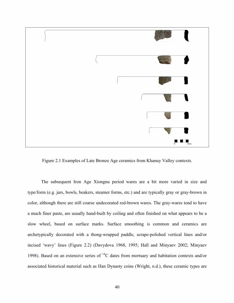
Figure 2.1 Examples of Late Bronze Age ceramics from Khanuy Valley contexts.
The subsequent Iron Age Xiongnu period wares are a bit more varied in size and
type/form (e.g. jars, bowls, beakers, steamer forms, etc.) and are typically gray or gray-brown in
color, although there are still coarse undecorated red-brown wares. The gray-wares tend to have
a much finer paste, are usually hand-built by coiling and often finished on what appears to be a
slow wheel, based on surface marks. Surface smoothing is common and ceramics are
archetypically decorated with a thong-wrapped paddle, scrape-polished vertical lines and/or
incised ‘wavy’ lines (Figure 2.2) (Davydova 1968, 1995; Hall and Minyaev 2002; Minyaev
1998). Based on an extensive series of 14C dates from mortuary and habitation contexts and/or
associated historical material such as Han Dynasty coins (Wright, n.d.), these ceramic types are
40
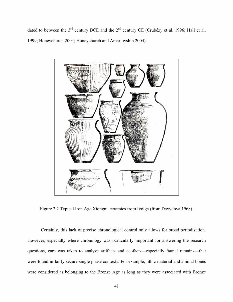
dated to between the 3rd century BCE and the 2nd century CE (Crubézy et al. 1996; Hall et al.
1999; Honeychurch 2004; Honeychurch and Amartuvshin 2004).
Figure 2.2 Typical Iron Age Xiongnu ceramics from Ivolga (from Davydova 1968).
Certainly, this lack of precise chronological control only allows for broad periodization.
However, especially where chronology was particularly important for answering the research
questions, care was taken to analyze artifacts and ecofacts—especially faunal remains—that
were found in fairly secure single phase contexts. For example, lithic material and animal bones
were considered as belonging to the Bronze Age as long as they were associated with Bronze
41
Age ceramics only. Undoubtedly, this lack in chronological preciseness is an important problem
that needs to be further addressed, possibly through soil micromorphology analysis and certainly
through more context-specific excavations and dating (the latter being one of the most important
lacunae right now). Nevertheless, more and better information will always need to be collected
and analyzed, and in accordance with Drennan et al. (1991:315): “It would be a mistake to defer
all consideration of the social, political, and economic implications [of the results of the present
study] until such time as the chronology has ‘sufficient’ precision for such purposes” since, for
one, this present work will actually help provide the more precise habitation contexts for such
future studies. Furthermore, despite the inevitable probability of palimpsests of occupations
during the Late Bronze Age (especially in dealing with mobile peoples), I am fairly confident
that because we are dealing specifically with a single period of time and since, in a sense, it is the
better understanding of the overall socioeconomic and sociopolitical picture that predated the
Iron Age Xiongnu period that is of interest in the present study, then these issues should not
worry the reader excessively since the overall objectives set out in Chapter 1 and reiterated
above should still be met. This is not to say that a more detailed understanding of the Late
Bronze Age period based on more secure dates, sequences and contexts would not be preferable
and maybe more accurate, especially in terms of describing ancient pastoral systems that may
have been highly variable from one year to another. However, since it can be assumed that these
same biases apply equally to all occupation areas (e.g. palimpsests of campsites; variability in
yearly mobility, as well as in herd composition and structure from one year to another, etc.), then
this should not hinder useful comparisons between one survey area to another within the same
period and within the same research zone. In the end, an overall understanding of the nature of
42
the social and economic organization of Late Bronze Age groups inhabiting this region of
Mongolia should still be acquired.
2.3 ENVIRONMENTAL ZONES AND LAND USE PATTERNS: STRATIFYING THE LANDSCAPE
In order to better understand the socioeconomic and sociopolitical organization of human
populations, especially for mobile peoples, it is necessary to capture the fullest range of human
activity over a multitude of exploitable environments. The theoretical underpinning of this, as it
is widely recognized and applied in modern survey archaeology (e.g. Chang 1992; Frachetti
2004; Indrisano 2006; Schiffer et al. 1978), is to have a meaningful sample of a variety of
environmental zones and landscape settings.
The study area was thus stratified according to general environmental criteria. This
process involved the classification of the study area by features of topography or terrain (e.g.
floodplain, foothills, etc.) as hypothetical correlates of distinct ‘environmental’ zones (cf. Chang
1992; Frachetti 2004). These classifications were generated through the observation of modern
land use, as well as from aerial photographs and topographic maps. The result was a research
area that was divided into four distinct zones, or tracts, in which landscapes of unknown, but
presumably relatively high, site potential were explored (Figure 2.3): Tract 1 (T1) consisted in
the contemporary summer (and sometimes fall) campsite area which is located within 200 m of
the Khanuy River; Tract 2 (T2) consisted in the contemporary winter (and spring) campsite area
located in valley draws along the western foothills—some 4-5 km from the present-day summer
campsites; Tract 3 (T3) consisted in the area between the foothills and the floodplain (where
most khirigsuurs are located); and Tract 4 (T4) consisted in the Khanuy River floodplain itself.
43
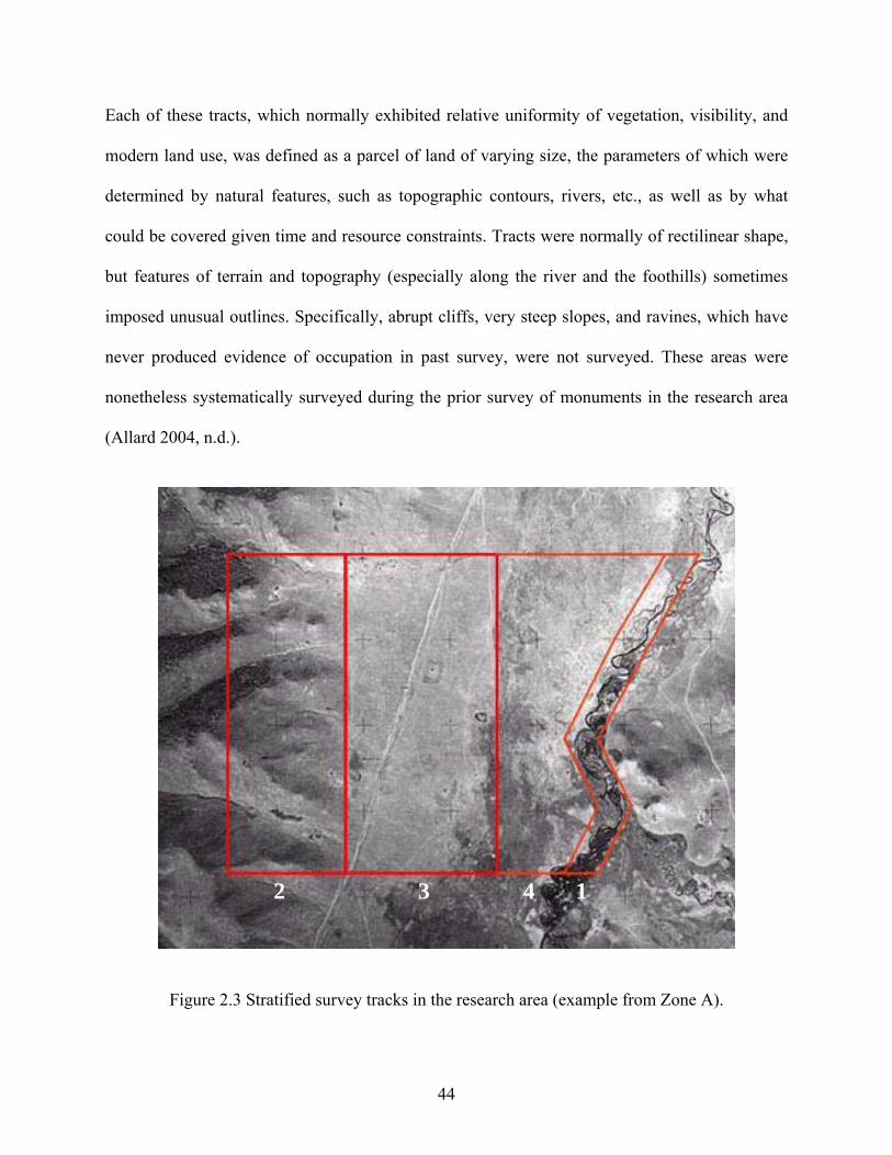
Each of these tracts, which normally exhibited relative uniformity of vegetation, visibility, and
modern land use, was defined as a parcel of land of varying size, the parameters of which were
determined by natural features, such as topographic contours, rivers, etc., as well as by what
could be covered given time and resource constraints. Tracts were normally of rectilinear shape,
but features of terrain and topography (especially along the river and the foothills) sometimes
imposed unusual outlines. Specifically, abrupt cliffs, very steep slopes, and ravines, which have
never produced evidence of occupation in past survey, were not surveyed. These areas were
nonetheless systematically surveyed during the prior survey of monuments in the research area
(Allard 2004, n.d.).
12 3 4
Figure 2.3 Stratified survey tracks in the research area (example from Zone A).
44
2.4 SAMPLING THE LANDSCAPE: GETTING MORE FROM LESS
Tracts 1 and 2 are for many practical reasons preferable zones of occupation and, not
surprisingly, are occupied today. As discussed in the ethnographic section in Chapter 1, the
characteristics of tract 1 fulfill the requirements of what contemporary herders consider to be a
good summer campsite location, while tract 2 fulfils those of a good winter campsite location.
Both these zones were thus systematically surveyed using the high resolution intensive shovel
probing methodology described above. However, a large expanse of territory located between the
foothills and the Khanuy River floodplain (i.e. Tract 3 – the area where most khirigsuurs are
located), in addition to the floodplain area itself (Tract 4), are presently not occupied. This may
well have been the case during the Bronze Age as well. However, in order to avoid any self-
fulfilling prophecies regarding the location of occupations and past patterns of land use, these
zones were systematically sampled. Based on previous systematic exploratory high-resolution
survey work done in 2004 by this author, less than 1.5% of the area corresponding to Track 3
showed evidence of occupation (i.e. positive shovel probes), regardless of the period, whereas in
valley draws (corresponding to Track 2 and where winter camps are located today), for example,
over 5% of the area showed evidence of occupation (regardless of period), thus suggesting that
the area between the foothills and the river were not settled in any substantial way during the
Late Bronze Age. A sample of 188 shovel probes was excavated in each of these two zones
(Tracks 3 and 4) — for a total of 376 shovel probes. Samples of this size made it possible to
estimate the proportion of each of these zones showing evidence of occupation for the Late
Bronze Age, with error ranges no wider than ±2% at the 95% confidence level (Drennan
1996:142-144). The results of this sampling procedure did indeed confirm a very low, even
negligible intensity of occupation for both these zones, as the proportion of occupied territory in
45
tract 3 (the area where most khirigsuurs are located) suggests that less than 0.5% of this area was
occupied during the Late Bronze Age, while there were no traces of occupation in the floodplain
area itself.
Nevertheless, additional shovel probes (n = ca. 500 per monument) were excavated in the
areas within 200 m around the two largest khirigsuurs [KYR1 and KYR40] in order to attain the
same resolution employed for the two zones of complete survey (i.e. 20 x 30 m interval) and so
as to better characterize the area immediately surrounding these monumental structures. These
additional shovel probes did indicate some evidence of activity, although negligible, east and
northeast of both these structures, with three positive probes (or about 0.6%) around KYR1 (Urt
Bulagyn), and four positive probes (or about 0.8%) around KYR40, the largest khirigsuur in the
valley. Negative additional radial probes around these few positive ones confirmed that these
places were not occupation areas. Consequently, in order to keep the sampling procedure free
from bias for statistical analysis, only the shovel probes (and recovered artifacts) excavated
during the initial sampling strategy were used to estimate proportions of occupied area in this
part of the valley. Counting the two ca. 20 km2 zones together (see below), this total survey of all
tracts involved some 7700 shovel probes.
2.5 EVALUATING CENTRALITY: ZONING THE LANDSCAPE
One of the important objectives of this research was to better understand the ancient
sociopolitical structure of these Late Bronze Age societies. Therefore it was necessary to account
for the possibility of ‘centralization’ and the potential pull effect of the monumental structures on
human communities. In order to accomplish this, two ca. 20 km² zones that had distinctively
46
different densities of monumental sites were surveyed, the first (Zone A) encompassing a
particularly large concentration of khirigsuurs and other Late Bronze Age monuments, and the
second (Zone B) encompassing both the tail end of one such khirigsuur site cluster, as well as
part of an area that comprises no visible monumental structures, that is, a “buffer zone” (Figures
1.13 and 2.4). This allowed for an evaluation of monument/settlement spatial relationships. The
idea behind this strategy was that if we were to find that intensity of occupation was high near
the center of the khirigsuur cluster, and diminished farther from it, reaching a low point in the
survey area between khirigsuur clusters, then this “buffer zone” of lightly occupied territory
would provide us with a way to delimit a sociopolitical unit focused on a major khirigsuur or
khirigsuur cluster and to discuss its spatial and demographic scale. Conversely, if there were to
be no evidence of such demographic centralization coinciding with a khirigsuur cluster, it would
then suggest to us that monuments did not play such a role in creating bounded territorial human
communities in the regions immediately surrounding them and therefore that political
organization was more decentralized. This methodological approach also allowed us to evaluate
whether khirigsuurs could have alternatively been used as boundary markers of territories such
as is apparently the case, for example, during the European Migration Period (AD 400-800)
where elite mounded burials are often found on the edges of emergent polities (Parker Pearson
1999:135). This was not the case with khirigsuurs in Late Bronze Age Mongolia.
47
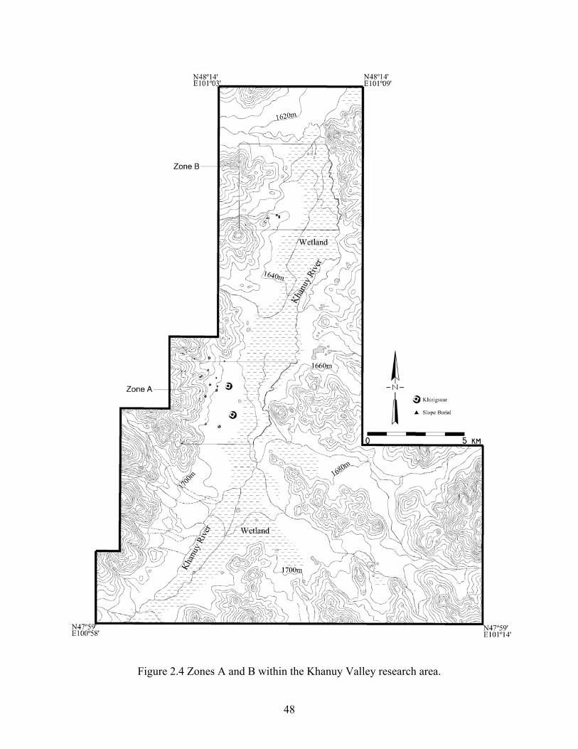
Figure 2.4 Zones A and B within the Khanuy Valley research area.
48
3.0 SETTLEMENT AND DEMOGRAPHIC PATTERNS IN THE LATE BRONZE AGE Information regarding the distribution of Late Bronze Age populations in Mongolia has been
until now essentially limited to what could be extrapolated from the locations of monumental
sites and burials (but see Honeychurch 2004:114; Wright 2006). And because no above-ground
structures related to habitation sites are visible, these populations have essentially been described
as large-scale (extensive) nomadic pastoralists who occupied areas only ephemerally (but see
Wright 2006). This chapter attempts to fill this gap by providing a sub-regional and local
analysis of settlement patterns so as to be able to empirically discuss the distribution of
habitation areas, evaluate the possibility of centralization and settlement differentiation, and
propose population estimates—all necessary elements for better understanding the scale and
nature of the social organization of these populations, and all crucial to evaluating some of the
assumptions that underlie the dependency hypothesis.
3.1 THE DISTRIBUTION AND ORGANIZATION OF OCCUPATION AREAS IN ZONE A
Zone A represents the core area of an important cluster of Late Bronze Age burials and
ritual/funerary structures, including the two largest khirigsuurs presently known. In all, 20
khirigsuurs of various sizes, a few deer stones and at least 43 ‘slope’ burials characterize this
zone—together highlighting the central nature of this area.
49
The distribution of occupation areas in Zone A during the Late Bronze Age suggests a
fairly sparse, but evenly distributed population, the type that might be expected of mobile
pastoralist groups (Figure 3.1). Fourteen sites (as defined in the previous chapter) characterize
this occupation (these yielded a total of 217 sherds from 56 positive shovel probes). Although
this occupation is fairly scant in terms of the overall survey area, the settlements occupy every
valley draw along the western foothills and are distributed at fairly even narrow intervals along
the Khanuy River—all with uninhabited boundary areas and sufficient pastoral resources
between them. These latter sites are also located on slightly higher flatter terrain within the
uneven and sometimes marshy floodplain, a settlement pattern still prevalent today. It is worth
mentioning here that some of the Late Bronze Age occupation areas along the river were
identified during the survey by a single shovel probe which often contained a single Late Bronze
Age sherd. Nevertheless, in addition to the modern-day use of this area, the identification of
subsequent-period sherds within these same locales did attract our attention to these places as
probable occupation areas. This was later confirmed through radial shovel probes and test
excavations. Certainly, some Late Bronze Age evidence might have been missed during the
shovel-probing survey, but the subsequent excavations did confirm the small-size nature of these
occupation areas (smaller than one hectare) which may be the result of a less dense and/or a
shorter-lived occupation. This will be further discussed below, but by way of comparison even
today there are fewer structures (especially animal pens) at these summer campsite locations
along the river which are also occupied for much shorter periods of time compared to winter
campsite locations along the foothills. In fact, today, households usually spend about twice the
amount of time at winter campsite areas (i.e. about 8 months) than they do at summer campsite
areas. In any case, the importance of these small sites for understanding the settlement system, as
50
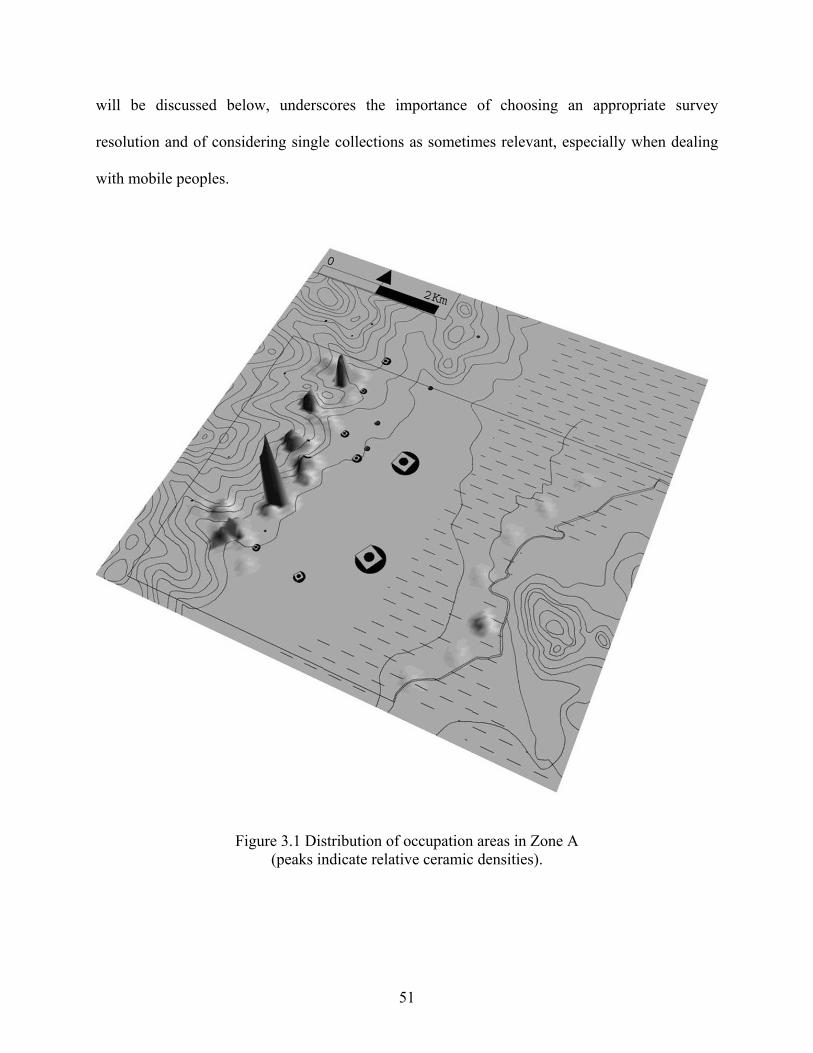
will be discussed below, underscores the importance of choosing an appropriate survey
resolution and of considering single collections as sometimes relevant, especially when dealing
with mobile peoples.
Figure 3.1 Distribution of occupation areas in Zone A (peaks indicate relative ceramic densities).
51
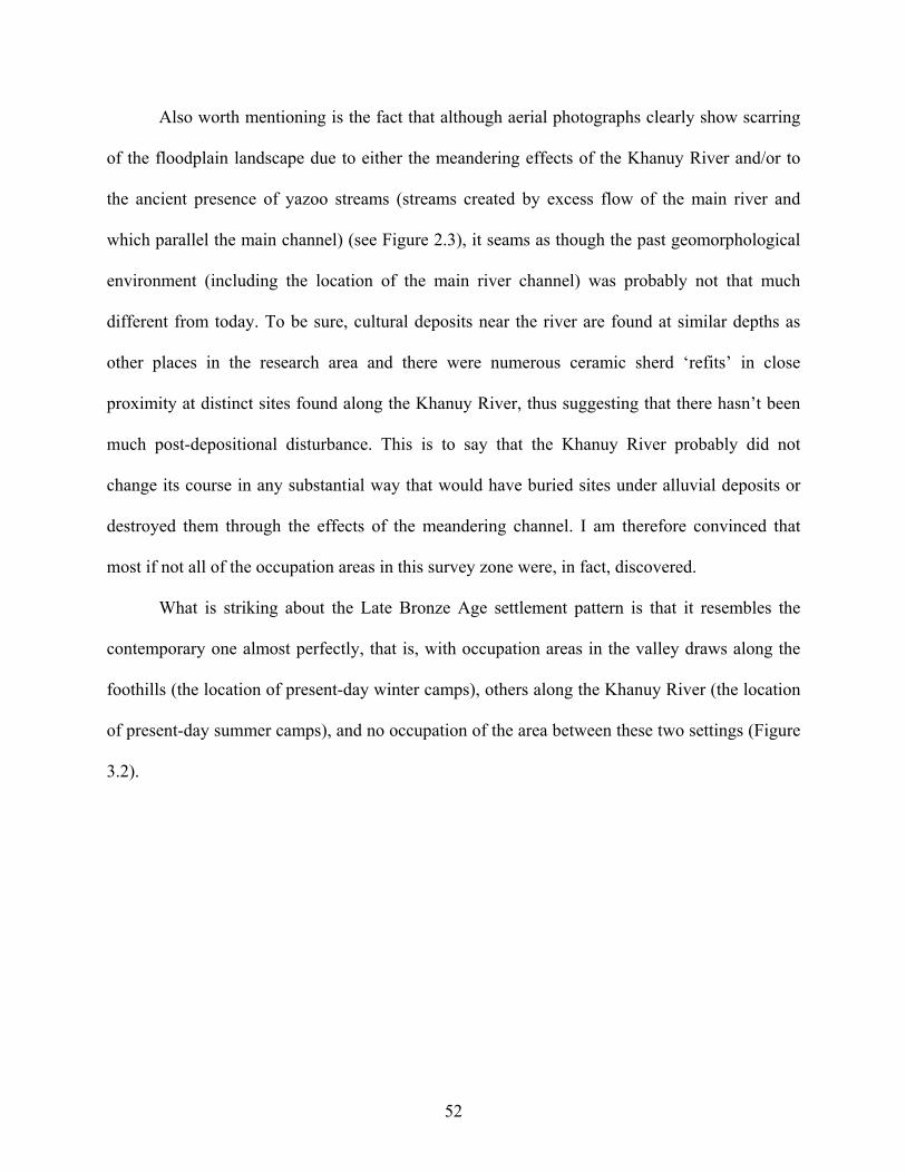
Also worth mentioning is the fact that although aerial photographs clearly show scarring
of the floodplain landscape due to either the meandering effects of the Khanuy River and/or to
the ancient presence of yazoo streams (streams created by excess flow of the main river and
which parallel the main channel) (see Figure 2.3), it seams as though the past geomorphological
environment (including the location of the main river channel) was probably not that much
different from today. To be sure, cultural deposits near the river are found at similar depths as
other places in the research area and there were numerous ceramic sherd ‘refits’ in close
proximity at distinct sites found along the Khanuy River, thus suggesting that there hasn’t been
much post-depositional disturbance. This is to say that the Khanuy River probably did not
change its course in any substantial way that would have buried sites under alluvial deposits or
destroyed them through the effects of the meandering channel. I am therefore convinced that
most if not all of the occupation areas in this survey zone were, in fact, discovered.
What is striking about the Late Bronze Age settlement pattern is that it resembles the
contemporary one almost perfectly, that is, with occupation areas in the valley draws along the
foothills (the location of present-day winter camps), others along the Khanuy River (the location
of present-day summer camps), and no occupation of the area between these two settings (Figure
3.2).
52
Figu
re 3
.2 D
istri
butio
n of
con
tem
pora
ry c
amps
ites a
nd p
ositi
ve sh
ovel
pro
bes i
n Zo
ne A
.
in
dica
te
cont
empo
rary
cam
psite
s; ‘
x’ i
ndic
ate
posi
tive
shov
el p
robe
s with
Lat
e B
ronz
e A
ge c
eram
ics.
53
Moreover, although the contemporary and prehistoric settlement patterns are very similar,
the Late Bronze Age landscape may have been inhabited more densely (or more intensely used)
than it is the case presently (at least on a temporary basis) since even areas that are presently not
occupied, as they are not ideal locations compared to other available settings (e.g. not as well
sheltered or further from water sources), revealed evidence of occupation. That is, without any
exception, but to different degrees, every valley draw along the foothills has evidence of Late
Bronze Age occupation; and nowadays there is no reason, according to local herders, to occupy
some of these less favorable locations if other better suited places are available. One such setting
is represented by the third peak from the top along the foothills on the left hand side of the map
in Figure 3.1. This occupation area (SP26E-MAC), discussed further in Chapters 4, 5 and 6, is
located on a fairly high terrace with no access to water and with little shelter from the cold winter
winds. According to local herders, nobody has occupied this area in living memory.
Nevertheless, based on artifactual evidence this region was apparently never occupied so densely
that the unavailability of land would had forced people to settle in the less than favorable area
located between the foothills and the Khanuy River, the area where most monumental sites are
located.
As will be further discussed below, it is clear that this settlement distribution corresponds
to a pattern that takes into account environmental criteria, ones that seem to be linked to seasonal
changes. This is not to say that social and political factors were not also important when
considering the location of occupation areas (nor that these did not vary yearly), but it is apparent
that people settled more densely (or more often) in the most seasonally favorable areas. The area
between the foothills and the Khanuy River (zones 3 and 4), while constituting the most
abundant fodder resource for animals, is ill suited for habitation either in the winter or in the
54
summer as it provides neither shelter nor easy access to water. It is thus not surprising that this
area has never been occupied either in the present or in the past.
In sum, when the distribution and the relative density of settlement sites, as well as the
important number of mortuary and ritual sites are considered together, it becomes clear that the
Late Bronze Age groups were actively exploiting this zone for social, ritual, and domestic
purposes.
3.1.1 The Characteristics of Occupation Areas in Zone A
Along the foothills, the six or seven identified occupation areas are located within sheltered
draws that lay at an average elevation of 1750 m above sea level, although one or two additional
artifact concentrations which may indicate smaller or shorter-lived campsites lie just outside of
these protected areas (Figure 3.1). For the most part, the only significant aspect distinguishing
individual draws is their size. Although the draws themselves are not forested, wooded areas are
accessible within walking distance either deep inside the draws or atop the mountains. Today,
within these wooded areas, wild animal species such as deer, wolf, fox, wild boar, and hare can
be found, as well as a number of wild edible plants and berries. Water in the form of small
seasonal streams is also found deep inside some of the draws. A quick look at the topographic
map and the location of the occupation areas suggest that the settlement distribution along the
foothills has probably much more to do with the specific topography of the hills themselves (and
the shelter and resources they provide – cf. Cribb 1991:137-138; Vainshtein 1980:83) than with
any kind of social spatial buffering scheme – although these natural barriers can also act as such
(Figure 3.1). Consequently, although individual draws, depending on their size, may have housed
more than one household (and/or have been reoccupied), distinct occupation areas are easily
distinguishable from each other as they are separated by the hill slopes or abrupt cliffs that
55
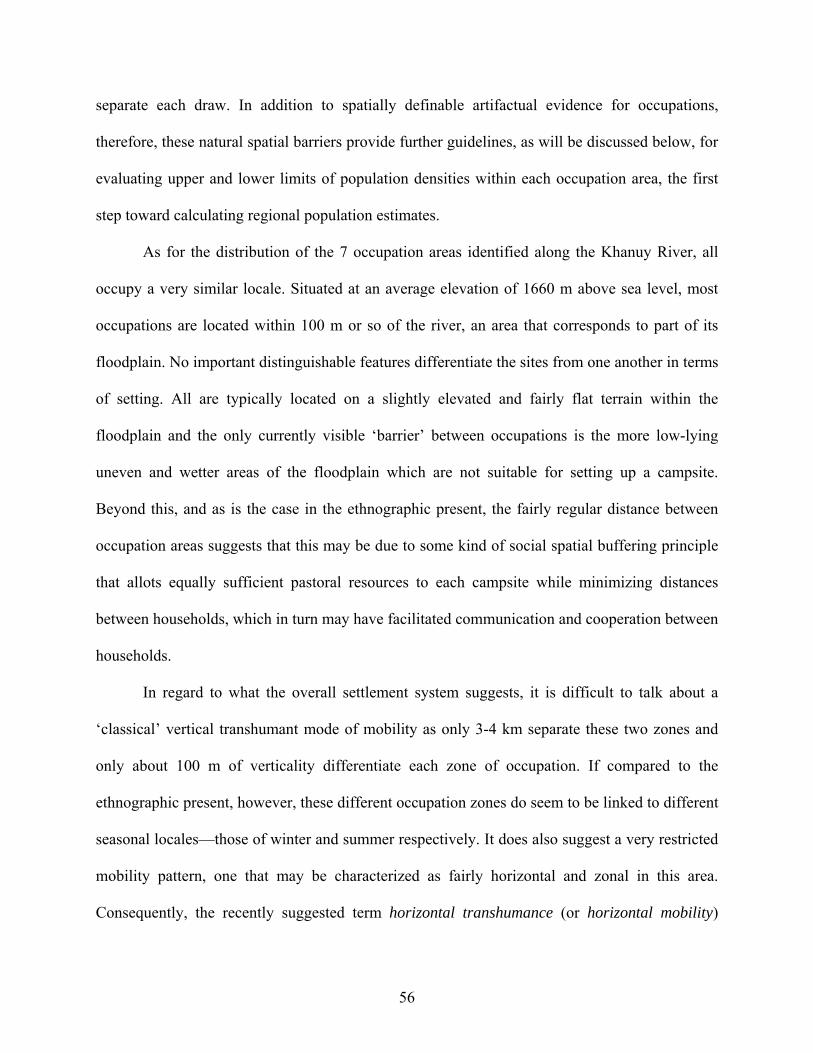
separate each draw. In addition to spatially definable artifactual evidence for occupations,
therefore, these natural spatial barriers provide further guidelines, as will be discussed below, for
evaluating upper and lower limits of population densities within each occupation area, the first
step toward calculating regional population estimates.
As for the distribution of the 7 occupation areas identified along the Khanuy River, all
occupy a very similar locale. Situated at an average elevation of 1660 m above sea level, most
occupations are located within 100 m or so of the river, an area that corresponds to part of its
floodplain. No important distinguishable features differentiate the sites from one another in terms
of setting. All are typically located on a slightly elevated and fairly flat terrain within the
floodplain and the only currently visible ‘barrier’ between occupations is the more low-lying
uneven and wetter areas of the floodplain which are not suitable for setting up a campsite.
Beyond this, and as is the case in the ethnographic present, the fairly regular distance between
occupation areas suggests that this may be due to some kind of social spatial buffering principle
that allots equally sufficient pastoral resources to each campsite while minimizing distances
between households, which in turn may have facilitated communication and cooperation between
households.
In regard to what the overall settlement system suggests, it is difficult to talk about a
‘classical’ vertical transhumant mode of mobility as only 3-4 km separate these two zones and
only about 100 m of verticality differentiate each zone of occupation. If compared to the
ethnographic present, however, these different occupation zones do seem to be linked to different
seasonal locales—those of winter and summer respectively. It does also suggest a very restricted
mobility pattern, one that may be characterized as fairly horizontal and zonal in this area.
Consequently, the recently suggested term horizontal transhumance (or horizontal mobility)
56
might better describe the movement suggested by this settlement pattern (Wendrich and Barnard
2008:8). Notwithstanding distances and altitudinal differences, this pattern is also similar to
Vainshtein’s second type of seasonal migration that involves movement from winter pastures in
the mountains to summer pastures on the plain, and back again with the approach of cold
weather (1980:93). Seasonality of occupation zones will be further discussed in Chapter 5.
3.2 THE DISTRIBUTION AND ORGANIZATION OF OCCUPATION AREAS IN ZONE B
Zone B corresponds to the tail end of a cluster of Late Bronze Age burials and monumental sites,
as well as part of an area that comprises neither burials nor khirigsuurs, that is, a “buffer zone”.
This zone offers a similar settlement pattern as the one observed in Zone A and findings
suggest about 12 occupation areas (these yielded a total of 117 sherds from 47 positive shovel
probes) (Figure 3.3). That is, along the western foothills, the pattern of positive shovel probes
indicates the use of this area as a preferred settlement location during the Late Bronze Age.
However, although the initial survey model—based on what was known from Zone A—was to
systematically survey 200 m along the Khanuy River, this needed to be modified in the field due
to ethnographic evidence (i.e. the location of contemporary campsites) as well as to logistical
problems (i.e. the floodplain was impracticable by vehicle and was often flooded, thus rendering
it impossible for surveyors to either walk and much less dig shovel probes in this area). Based on
this information and situation, we rather systematically surveyed a 200 m band along the
outskirts of the floodplain area. This proved to be a good change of plan as this area did pan out
to reflect past settlement locations. And indeed, in Zone B, herders today set up their summer
campsite within 200 m outside of the floodplain instead of near the Khanuy River where there is
57
practically no flat terrain. In addition to the problem of actually getting to the river channel due
to the extreme unevenness and often inundated nature of this section of the floodplain area,
herders need not get their water from that source as there is a closer and more easily accessible
one. Today, in one area, this is a manmade well built during the Soviet Era; but in addition to
visible river cuts, topographic maps and forty year old aerial photographs clearly indicate that
there were three additional secondary rivers in this area (which are now usually dried up) that fed
into the main Khanuy River (Figure 3.3). Older herders confirmed the use of these other sources
of water by their parents/grand parents prior to the presence of the well. Regardless, numerous
(and continuous) positive shovel probes with artifacts dating to both the Late Bronze Age and the
Iron Age periods along this section of the floodplain confirmed that this was indeed the preferred
location for settlements in the past also (Figure 3.4). This suggests a similar yet even wetter, and
probably richer, environment in the past—all of which is supported by the geochemical and
sedimentological evidence, as well as the pollen analysis presented in Chapter 1. No evidence of
occupation was discovered between the edge of the floodplain and the hills, suggesting once
again that the section of the valley where large monumental structures are usually erected was
apparently uninhabited. Interestingly, although the argument cannot be made wholesale for the
prehistoric past, some of the present-day herders using the floodplain’s edge area for their
summer campsite only actually move about one to two kilometers away from their winter
campsite location. This seems almost like a useless move, except for the reasons given to me of
occupying ‘cleaner’ areas and moving away from the fly-infested hills during the summer.
Although these are exceptions, the overall Late Bronze Age settlement pattern in this zone
parallels the one in Zone A, that is, one that suggests a very restricted mobility pattern. It does
also underscore the fact that the valley is, and probably was, rich enough all year round that there
58
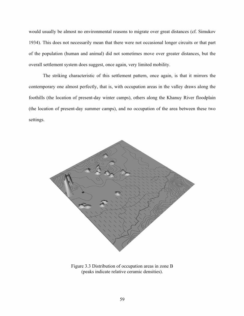
would usually be almost no environmental reasons to migrate over great distances (cf. Simukov
1934). This does not necessarily mean that there were not occasional longer circuits or that part
of the population (human and animal) did not sometimes move over greater distances, but the
overall settlement system does suggest, once again, very limited mobility.
The striking characteristic of this settlement pattern, once again, is that it mirrors the
contemporary one almost perfectly, that is, with occupation areas in the valley draws along the
foothills (the location of present-day winter camps), others along the Khanuy River floodplain
(the location of present-day summer camps), and no occupation of the area between these two
settings.
Figure 3.3 Distribution of occupation areas in zone B (peaks indicate relative ceramic densities).
59
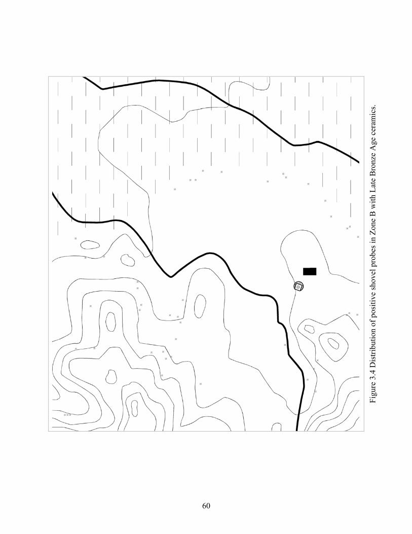
Figu
re 3
.4 D
istri
butio
n of
pos
itive
shov
el p
robe
s in
Zone
B w
ith L
ate
Bro
nze
Age
cer
amic
s.
60
3.2.1 The Characteristics of Occupation Areas in Zone B
The topography in Zone B is slightly different than the one observed in Zone A. Although the
overall nature of the landscape is the same, the western hills are more low-lying and are
presently almost devoid of trees (which are nevertheless available a few kilometers away). I have
also not observed any springs or seasonal streams in any of these mountainous locales. On the
other hand, the presence of the aforementioned nearby three tributary rivers (now dry) indicates
that this zone was once better watered. Not surprisingly, this part of the valley is where Soviet
Era crop cooperatives were set up.
Six to seven identified occupation areas along the western foothills also characterize this
zone (Figure 3.3). These are located between 1640 and 1660 m above sea level and are for the
most part located within the confines of sheltered valley draws. The most significant aspect
distinguishing these occupation areas is whether the draws within which they are situated are
opened toward the east, as in Zone A, or toward the north—a setting that would not be ideal for
sheltering against the northerly cold winter winds. Nevertheless, evidence of past and present
occupation attests to the adequacy of these locations for habitation.
Overall, and similar to the situation in Zone A, the location of the occupations along the
foothills suggests attempts on the part of the people living there to shelter themselves against the
elements, and suggests once again an ideal winter campsite location.
The situation regarding the occupation areas along the Khanuy River floodplain is also
somewhat similar to what is found in Zone A, except that there are no physical ‘impediments’
here due to floodplain activity that would restrict certain areas from being established as is the
case in Zone A—which probably explains the dispersed pattern of positive shovel probes and the
lack of clear patterning in this area (Figure 3.4). This does not mean, as is the case today, that
61
campsites were not separated from one another, but simply that nothing restricted people from
setting up their campsites anywhere along this area, moving their camp from one year to another
a few hundred meters on either side – thus producing overlapping palimpsests of occupations.
For this reason, it is difficult to quantify the number of occupations in this area, although we may
tentatively distinguish between 3 and 6 of them based on relative artifact densities. Regardless,
the mostly two-tiered settlement system is still apparent.
3.3 POPULATION ESTIMATES
Consideration of population estimates is obviously important for determining population
densities, as well as for evaluating, for example, such things as whether or not the labor force
required to build the impressive monumental sites that dot the Khanuy Valley landscape was
immediately available. It is also important for evaluating the nature and organization of societies
(e.g. Chamberlain 2006; Hassan 1979, 1981).
Despite the lack of harder evidence such as Late Bronze Age house structures for helping
to reconstruct population estimates, we are fortunate to have modern and historic census
information (both human and animal) for making comparisons with modern and ancient
settlement characteristics and distribution. As mentioned in the introductory chapter, this
comparative data is especially relevant that the research area’s climate and environment is
similar to the Late Bronze Age’s one and that the research area continues to be inhabited by
mobile pastoralists whose settlement pattern is extremely similar to that of the Bronze Age,
which in turn (at least today) is determined in large part by the needs of their herds of sheep,
goat, cattle and horses. It is thus possible to use this information as analogical support and as a
62
check for estimates, and to suggest upper and lower limits of population densities within each
occupation area. As mentioned above, the fact that occupation areas along the foothills are also
located in clearly delineated valley draws of specific sizes can also be efficiently used as
guidelines for evaluating upper and lower limits of population densities within each occupation
area.
Ethnographic work on the part of this author as well as satellite imagery, provide
information regarding modern campsite sizes and their organization in the research area.
Expectedly, much variability characterizes camp organization, but some informative data is
deemed helpful in the present effort to address population estimates. Based on concrete
measurements taken on the ground and from satellite imagery, winter campsites have been found
to be fairly extensive and to encompass on average some 1-2 ha in area. This area includes the
habitation sites per se (i.e. gers or yurts—traditional Mongolian tent houses) as well as the
adjacent structures that house the animals (i.e. pens, corals, etc.) (Figure 3.5). Further interviews
with herders inhabiting these and other campsites have confirmed the extent of this approximate
living area. That is, although there are no fences or visible delimiting features, herders were
found to consider an area of about 2 hectares “theirs”. This area also includes terrain with no
structures and corresponds to what they perceive as adequate space for them and their animals
(Figures 3.6 and 3.7). This space also assures a certain buffer area between camps (cf. Vainshtein
1980:83). Camps were found to comprise on average between 2 and 5 living ‘gers’ (as opposed
to storage ‘gers’) or families.
63
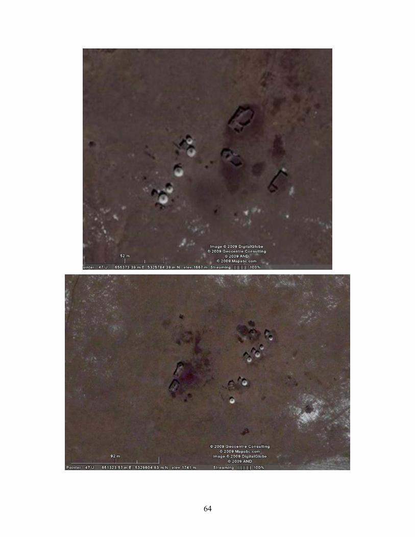
64
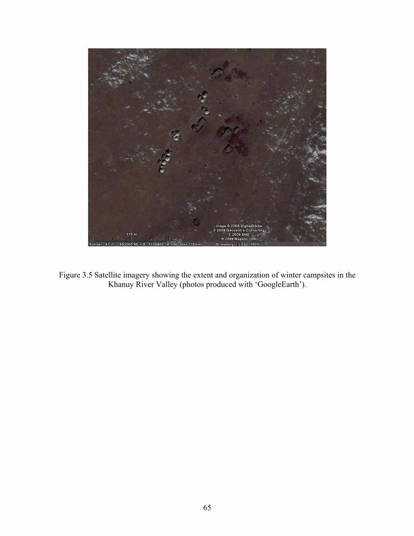
Figure 3.5 Satellite imagery showing the extent and organization of winter campsites in the Khanuy River Valley (photos produced with ‘GoogleEarth’).
65
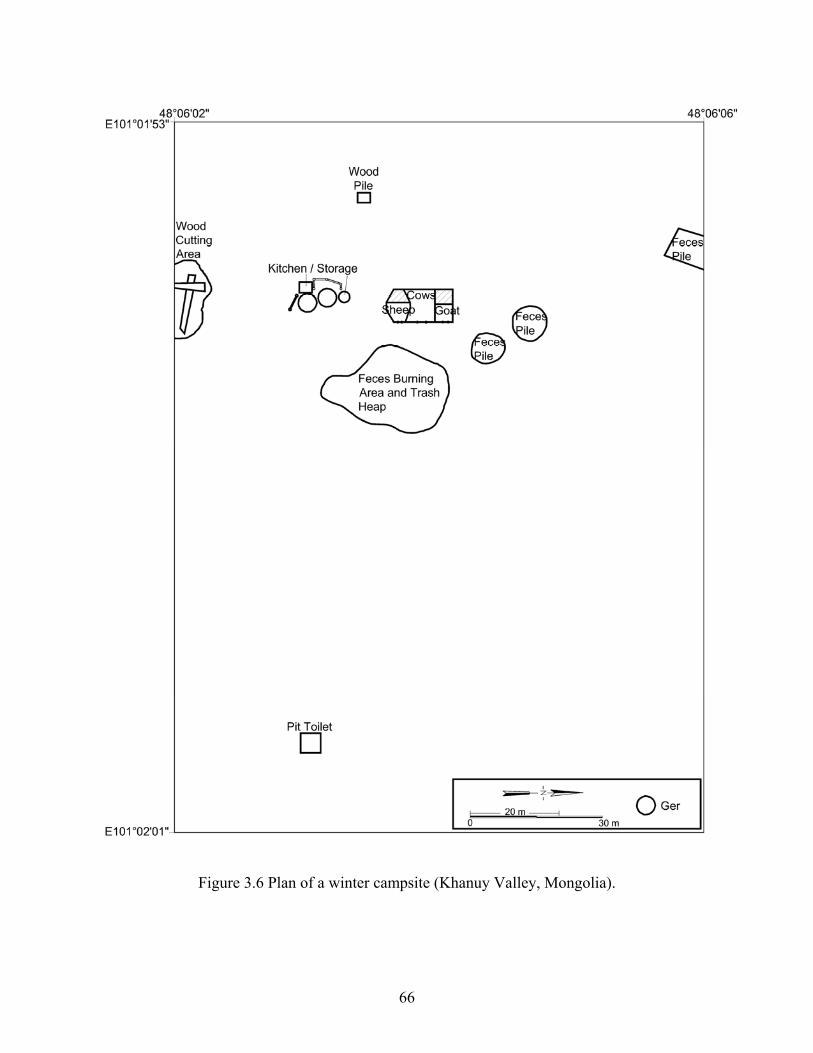
Figure 3.6 Plan of a winter campsite (Khanuy Valley, Mongolia).
66
Figure 3.7 Spacing between winter camps within a valley draw (Khanuy River Valley). Similarly, ethnohistoric and ethnographic data both provide useful information for
proposing upper and lower limits for population estimates. Census information ranging 75 years
(i.e. 1930-2005) suggests that a relatively constant number of families/people have occupied the
Khanuy Valley research area. Until 1998, and except for a few exceptions, livestock numbers
have also been fairly constant (this consistency in livestock numbers apparently characterizes the
whole of the Arkhangai aimag [Blench 2005:11, fig.10]). The average household size is 4
people, and each household owns about 65 head of livestock of various types (usually in
decreasing order of sheep, goat, horse and cattle). This is an average for the Khanuy Valley as
some families own more animals than others. These numbers, however, are also commensurate
67
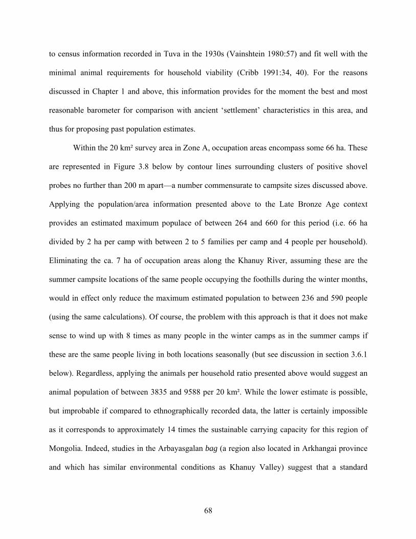
to census information recorded in Tuva in the 1930s (Vainshtein 1980:57) and fit well with the
minimal animal requirements for household viability (Cribb 1991:34, 40). For the reasons
discussed in Chapter 1 and above, this information provides for the moment the best and most
reasonable barometer for comparison with ancient ‘settlement’ characteristics in this area, and
thus for proposing past population estimates.
Within the 20 km² survey area in Zone A, occupation areas encompass some 66 ha. These
are represented in Figure 3.8 below by contour lines surrounding clusters of positive shovel
probes no further than 200 m apart—a number commensurate to campsite sizes discussed above.
Applying the population/area information presented above to the Late Bronze Age context
provides an estimated maximum populace of between 264 and 660 for this period (i.e. 66 ha
divided by 2 ha per camp with between 2 to 5 families per camp and 4 people per household).
Eliminating the ca. 7 ha of occupation areas along the Khanuy River, assuming these are the
summer campsite locations of the same people occupying the foothills during the winter months,
would in effect only reduce the maximum estimated population to between 236 and 590 people
(using the same calculations). Of course, the problem with this approach is that it does not make
sense to wind up with 8 times as many people in the winter camps as in the summer camps if
these are the same people living in both locations seasonally (but see discussion in section 3.6.1
below). Regardless, applying the animals per household ratio presented above would suggest an
animal population of between 3835 and 9588 per 20 km². While the lower estimate is possible,
but improbable if compared to ethnographically recorded data, the latter is certainly impossible
as it corresponds to approximately 14 times the sustainable carrying capacity for this region of
Mongolia. Indeed, studies in the Arbayasgalan bag (a region also located in Arkhangai province
and which has similar environmental conditions as Khanuy Valley) suggest that a standard
68
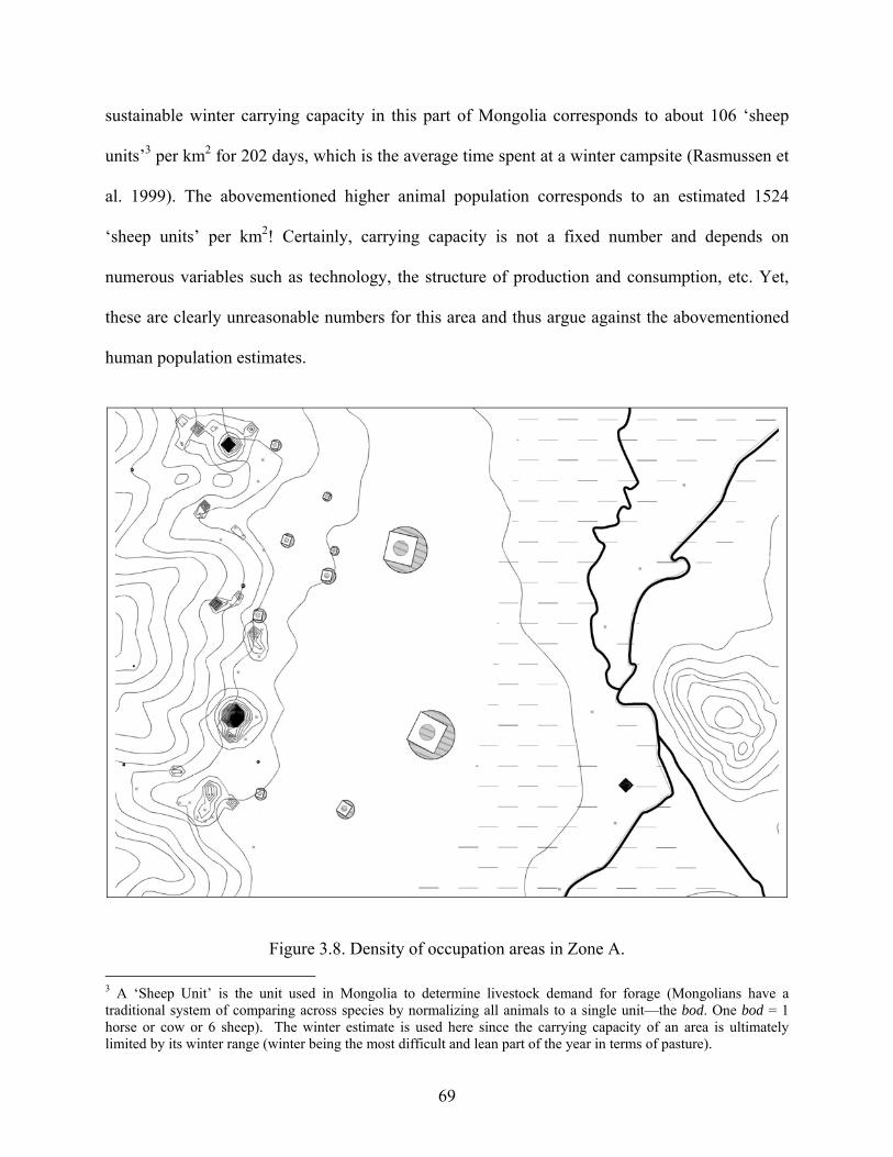
sustainable winter carrying capacity in this part of Mongolia corresponds to about 106 ‘sheep
units’3 per km2 for 202 days, which is the average time spent at a winter campsite (Rasmussen et
al. 1999). The abovementioned higher animal population corresponds to an estimated 1524
‘sheep units’ per km2! Certainly, carrying capacity is not a fixed number and depends on
numerous variables such as technology, the structure of production and consumption, etc. Yet,
these are clearly unreasonable numbers for this area and thus argue against the abovementioned
human population estimates.
Figure 3.8. Density of occupation areas in Zone A. 3 A ‘Sheep Unit’ is the unit used in Mongolia to determine livestock demand for forage (Mongolians have a traditional system of comparing across species by normalizing all animals to a single unit—the bod. One bod = 1 horse or cow or 6 sheep). The winter estimate is used here since the carrying capacity of an area is ultimately limited by its winter range (winter being the most difficult and lean part of the year in terms of pasture).
69
If, on the other hand, we consider these same occupation areas to reflect palimpsests of
single ‘settlements’, then the minimal number of people in this zone would be between 120 and
300 (i.e. up to 8 occupation areas within the foothills and 7 along the Khanuy River—each
comprising 2 to 5 families with 4 people per household). Eliminating the occupation areas along
the river for the same reasons expressed above would reduce this number to between 64 and 160
people. These latter numbers approximate the present density of people per square kilometer in
the research area, that is, some 78 persons per 20 km². Once the estimated animal population is
considered (somewhere between 1040 and 2600 animals per 20 km²), these latter human
population estimates become much more reasonable.
Similarly, the application of the same rationale for Zone B (Figure 3.9) suggests a human
population of between 56 and 140 and an animal population of between 910 and 2275 for this 20
km² zone.
70
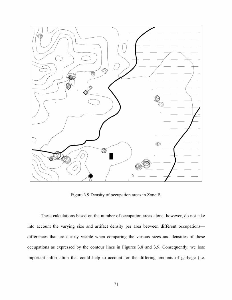
Figure 3.9 Density of occupation areas in Zone B.
These calculations based on the number of occupation areas alone, however, do not take
into account the varying size and artifact density per area between different occupations—
differences that are clearly visible when comparing the various sizes and densities of these
occupations as expressed by the contour lines in Figures 3.8 and 3.9. Consequently, we lose
important information that could help to account for the differing amounts of garbage (i.e.
71
ceramics, faunal remains, etc.) accumulated in different areas—differences that are probably
linked to differing population densities and/or lengths of occupation.
3.4 POPULATION SIZE: THE RELATIVE DEMOGRAPHIC INDEX
It is possible, however, to work out relative population densities, which in turn can help
characterize occupations more substantially than simple dots on a map can alone. The specific
method used here for reconstructing a demographic index is based on an area-sherd density index
(i.e. the area of a site multiplied by the density of sherds) derived from the regional survey data.
This combined index merges both the area distribution of artifacts and the amounts of artifacts
within the areas and thus avoids some of the shortcomings of using only one or the other indexes
alone (see discussion of this procedure in Drennan et al. 2003). Such indexes have been used
successfully in regional settlement analysis of sedentary agricultural populations (Drennan et al.
2003; Haller 2004). When applied in a setting where occupation is more mobile, these indexes
reflect some combination of population levels and length or intensity of seasonal occupation.
That is, a higher index for a particular area of occupation (resulting from a higher sherd density
and/or a larger area) suggests either a greater number of people, or lengthier or more frequent
reoccupation, or both, during the Late Bronze Age.
3.4.1 Results: Zone A
Figure 3.10 below shows the topographical representation of the relative demographic index for
Late Bronze Age occupation areas in Zone A (Table 3.1). Three occupation areas have similar
indexes, while 2 others have an index twice as large. One occupation area, however, stands out in
72
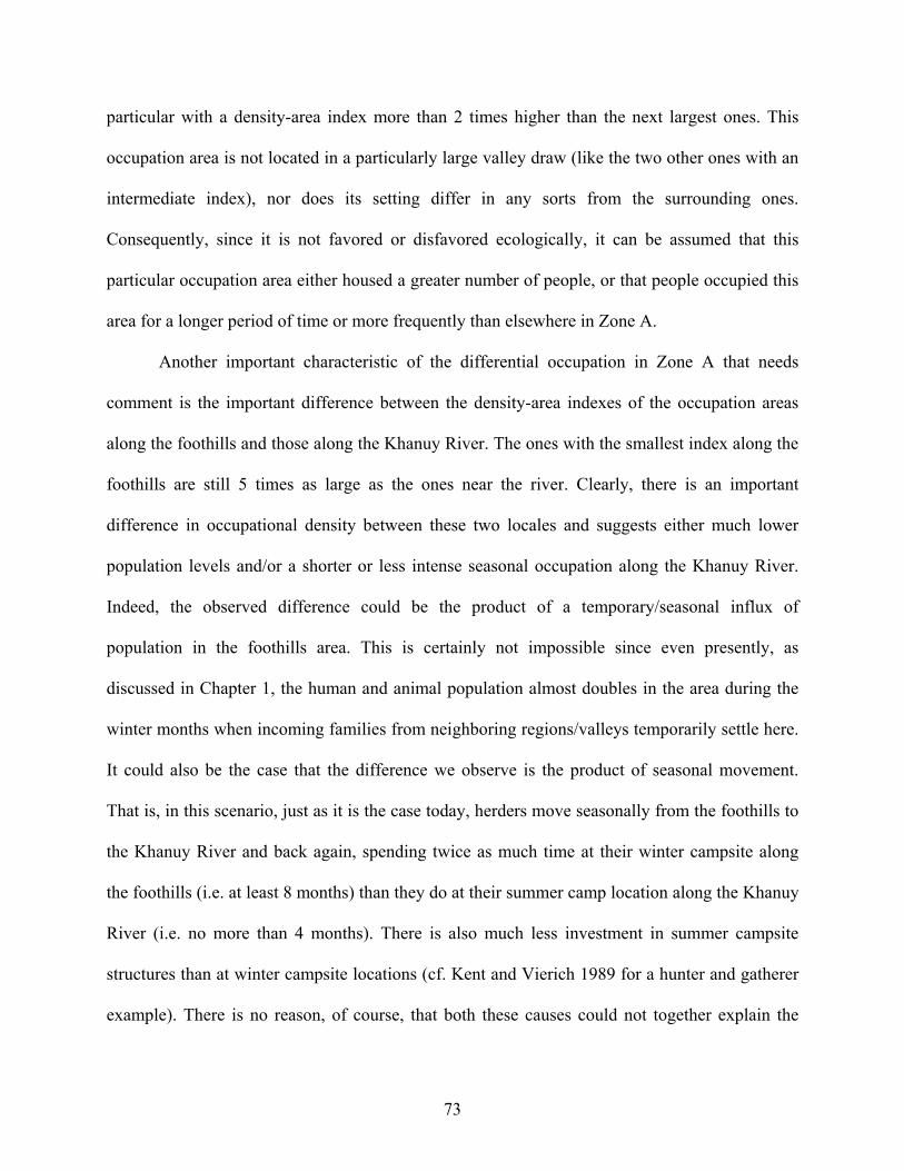
particular with a density-area index more than 2 times higher than the next largest ones. This
occupation area is not located in a particularly large valley draw (like the two other ones with an
intermediate index), nor does its setting differ in any sorts from the surrounding ones.
Consequently, since it is not favored or disfavored ecologically, it can be assumed that this
particular occupation area either housed a greater number of people, or that people occupied this
area for a longer period of time or more frequently than elsewhere in Zone A.
Another important characteristic of the differential occupation in Zone A that needs
comment is the important difference between the density-area indexes of the occupation areas
along the foothills and those along the Khanuy River. The ones with the smallest index along the
foothills are still 5 times as large as the ones near the river. Clearly, there is an important
difference in occupational density between these two locales and suggests either much lower
population levels and/or a shorter or less intense seasonal occupation along the Khanuy River.
Indeed, the observed difference could be the product of a temporary/seasonal influx of
population in the foothills area. This is certainly not impossible since even presently, as
discussed in Chapter 1, the human and animal population almost doubles in the area during the
winter months when incoming families from neighboring regions/valleys temporarily settle here.
It could also be the case that the difference we observe is the product of seasonal movement.
That is, in this scenario, just as it is the case today, herders move seasonally from the foothills to
the Khanuy River and back again, spending twice as much time at their winter campsite along
the foothills (i.e. at least 8 months) than they do at their summer camp location along the Khanuy
River (i.e. no more than 4 months). There is also much less investment in summer campsite
structures than at winter campsite locations (cf. Kent and Vierich 1989 for a hunter and gatherer
example). There is no reason, of course, that both these causes could not together explain the
73
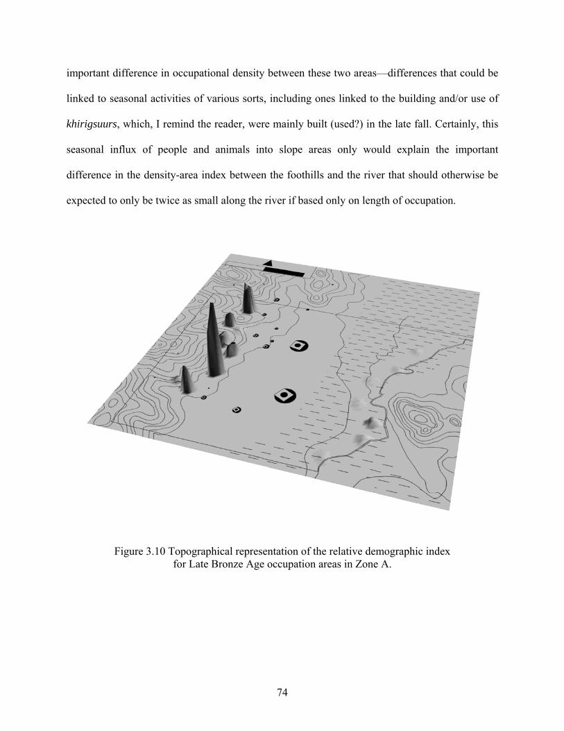
important difference in occupational density between these two areas—differences that could be
linked to seasonal activities of various sorts, including ones linked to the building and/or use of
khirigsuurs, which, I remind the reader, were mainly built (used?) in the late fall. Certainly, this
seasonal influx of people and animals into slope areas only would explain the important
difference in the density-area index between the foothills and the river that should otherwise be
expected to only be twice as small along the river if based only on length of occupation.
Figure 3.10 Topographical representation of the relative demographic index for Late Bronze Age occupation areas in Zone A.
74
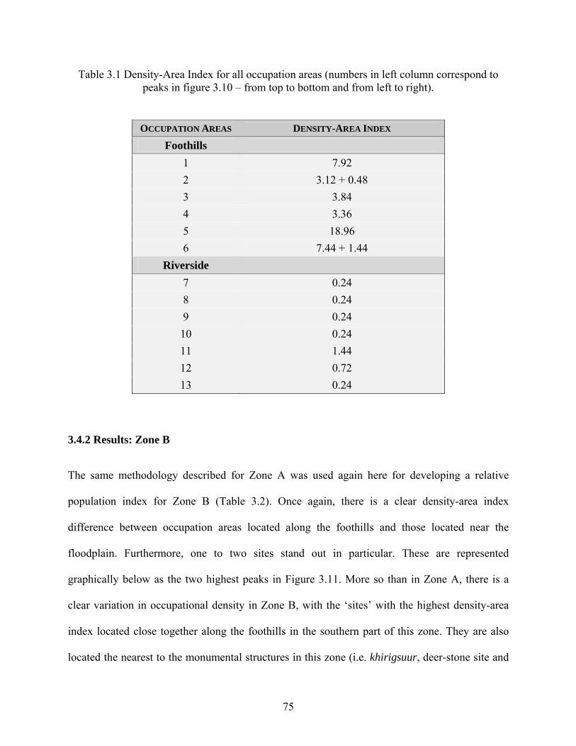
Table 3.1 Density-Area Index for all occupation areas (numbers in left column correspond to peaks in figure 3.10 – from top to bottom and from left to right).
OCCUPATION AREAS DENSITY-AREA INDEX
Foothills 1 7.92 2 3.12 + 0.48 3 3.84 4 3.36 5 18.96 6 7.44 + 1.44
Riverside 7 0.24 8 0.24 9 0.24 10 0.24 11 1.44 12 0.72 13 0.24
3.4.2 Results: Zone B
The same methodology described for Zone A was used again here for developing a relative
population index for Zone B (Table 3.2). Once again, there is a clear density-area index
difference between occupation areas located along the foothills and those located near the
floodplain. Furthermore, one to two sites stand out in particular. These are represented
graphically below as the two highest peaks in Figure 3.11. More so than in Zone A, there is a
clear variation in occupational density in Zone B, with the ‘sites’ with the highest density-area
index located close together along the foothills in the southern part of this zone. They are also
located the nearest to the monumental structures in this zone (i.e. khirigsuur, deer-stone site and
75
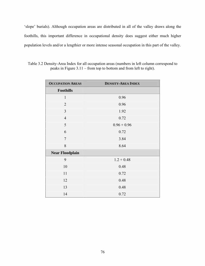
‘slope’ burials). Although occupation areas are distributed in all of the valley draws along the
foothills, this important difference in occupational density does suggest either much higher
population levels and/or a lengthier or more intense seasonal occupation in this part of the valley.
Table 3.2 Density-Area Index for all occupation areas (numbers in left column correspond to peaks in Figure 3.11 – from top to bottom and from left to right).
OCCUPATION AREAS DENSITY-AREA INDEX
Foothills
1 0.96
2 0.96
3 1.92
4 0.72
5 0.96 + 0.96
6 0.72
7 3.84
8 8.64
Near Floodplain
9 1.2 + 0.48
10 0.48
11 0.72
12 0.48
13 0.48
14 0.72
76
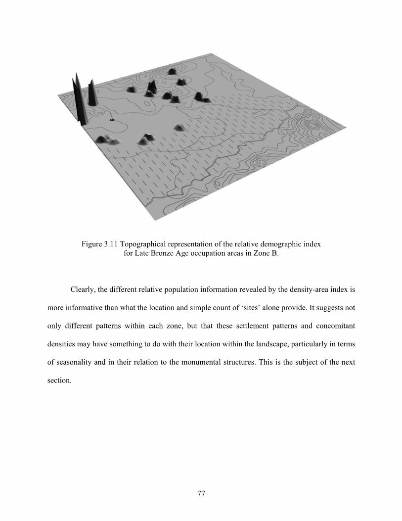
Figure 3.11 Topographical representation of the relative demographic index for Late Bronze Age occupation areas in Zone B.
Clearly, the different relative population information revealed by the density-area index is
more informative than what the location and simple count of ‘sites’ alone provide. It suggests not
only different patterns within each zone, but that these settlement patterns and concomitant
densities may have something to do with their location within the landscape, particularly in terms
of seasonality and in their relation to the monumental structures. This is the subject of the next
section.
77
3.5 CENTRALITY: EVALUATING MONUMENT AND SETTLEMENT RELATIONSHIPS
As discussed in Chapter 1, the monumental landscape in the Khanuy Valley suggests supra-local
centralized organization, and thus the expression of what seems to be central places. While the
scale of some of these monuments as well as the elaborate seasonal ceremonial activities carried
out at these complexes suggest higher centrality in at least the ritual and funerary spheres, it was
unknown if this centrality also involved the sphere of the living. That is, is there evidence of
demographic centralization as well and did these monuments play a role in creating bounded
territorial human communities? The evaluation of this rests especially, but not uniquely, in the
analysis of occupation areas in Zone B, since this zone encompasses the tail end of such a
khirigsuur cluster as well as a “buffer zone” with no burials or khirigsuurs.
The number of occupation areas is fairly evenly distributed within Zone B (i.e. in every
valley draw and at regular intervals along the river’s floodplain) and there is apparently no
overall ‘settlement’ centralization (Figure 3.11). The relative density-area index, however,
suggests much greater occupational density at two occupation areas: those that are the nearest to
a ‘slope’ burial complex and to the khirigsuur and major deer-stone sites. In terms of ‘site’ size,
these occupation areas are not much different than the others, yet there is clearly much more
activity, be it seasonal, at these two occupation areas—notably at the one directly facing the
monumental structures. Its relative population index is more than double its nearest neighbor and
over five times as large as the average occupation area in this whole zone.
Moreover, once the total density-area indexes are compared for both zones A and B, it is
interesting to note that the index is twice as high in Zone A as it is in Zone B (49.91 compared to
78
24.24). Zone A is, noticeably, at the center of an important cluster of monumental structures.
Therefore, although we cannot speak of an overall concentration of occupation areas, there does
seem to be a concentration of increased activity at habitation sites that are closer to burials and
monumental structures. This activity could be linked to either the presence of a greater number
of people, or a lengthier or more frequent reoccupation of these areas during the Late Bronze
Age. While this is an equifinality issue that eventually needs to be resolved—possibly through
more focused research at the household/campsite level of inquiry—it is clear that monuments in
the valley did play a role in binding people together more so than just in death.
3.6 SUMMARY
A systematic stratified comparative survey program was carried out in two zones with
distinctively different densities of monumental sites. The objective was to identify occupation
areas in order to discuss settlement patterning, population estimates and the possibility of
demographic centralization. The results of the survey work presented in this chapter have made it
possible to draw fairly strong conclusions about the nature of settlement in the research area. It
has also allowed for the documentation of the overall settlement system.
Within both zones A and B there is a clear patterning of settlements into two discrete
areas: one along the foothills (the location of present-day winter campsites) and one along the
Khanuy River, or its floodplain (the location of present-day summer campsites). There was no
evidence of settlement between these areas. Given that this pattern mimics perfectly the present-
day one in this region, it strongly suggests that this represents a time-tested settlement system
that seems to be linked to seasonal changes. Moreover, the distance between both of these areas
79
of occupation is less than 5 km and thus suggests, as is the case today, a highly restricted form of
mobility within a region that must concomitantly be of constant and high productivity all year
round. In addition, the survey has revealed a fairly regular distance between occupation areas,
which suggests some kind of social spatial buffering principle that allots equally sufficient
pastoral resources to each campsite while minimizing distances between households—a pattern
which today is known to facilitate communication and cooperation between households. Finally,
the comparative survey at a larger scale (Zone A vs. Zone B) and resulting population estimates
based on an area/sherd density index suggests demographic centralization, one that is linked to
the monumental landscape. In other words, this overall settlement patterning clearly suggests a
centralized (possibly even supra-local) type of social organization that is linked to what can
effectively be termed ‘central places’.
80
4.0 ARCHAEOLOGICAL EXCAVATIONS OF OCCUPATION AREAS The overall objective set out by test-excavating a number of occupation areas was to yield larger
artifact assemblages from domestic contexts than could be obtained from shovel probes alone in
order to better sample variation between areas of occupation. The trade-off of such a sampling
approach is, of course, exchanging great detail about a few occupations for less detail about
many occupations. Since very little information was previously known about Late Bronze Age
habitation sites, a more limited spatial investigation would have decreased the likelihood that the
occupation areas investigated were representative. As a first investigative step, therefore, the
more extensive sampling procedure used in this study at least assures a greater likelihood that the
sample of occupation areas includes the fullest range of habitation sites in the region during this
period of time.
4.1 EXCAVATIONS
Of the 23 or so occupation areas identified through the survey work and represented by clusters
of positive shovel probes, 14 were further stratigraphically test excavated in order to provide
larger samples of artifacts, as well as botanical and faunal remains so as to enable the
reconstruction of mobility patterns, subsistence strategies, economic specialization, and social
ranking. Eight occupation areas were test excavated in Zone A (5 along the foothills [BMK,
WFA, JUL, QUE, MAC] and 3 along the Khanuy River [SHA, MAB, MTC]) (Figure 4.2), while
81
6 occupation areas were test excavated in Zone B (4 along the foothills [TOP, SOV, SAL, HUN]
and 2 along the floodplain of the Khanuy River [HOA, GER]) (Figure 4.12). Seven or eight 2 x 2
m units were spread across each of these 14 areas of occupation. I opted to use both strategically
placed units as well as arbitrarily located units. The former were located in denser areas of
positive shovel probes known from the survey results described in Chapter 3 with the intent to
potentially yield more artifacts for comparative analyses, while the latter (located arbitrarily
within the site boundaries) were occasionally used to attain the desired seven to eight 2 x 2 m
units per site. This was done when positive probes making up the site were too few to guide us
toward preferential locations of high artifact density.
4.2 STRATIGRAPHIC SETTING AND EXCAVATION METHODS The relatively arid steppe soil which covers not only the lowland but also the rocky hills and
mountains in the research area is a sandy-gravely (sometimes rubbly) chestnut soil poor in
humus content (Munsell 10YR 3/2 to 4/4). The A-horizon soil stratum almost never exceeds 20
cm outside the floodplain and overlies a gravely layer. This gravely layer is ubiquitous
throughout the valley’s research area and sometimes includes coarser pebble to cobble clast size
rocks. A sandy to clayey grayish often compact and mostly sterile layer underlies the whole
sequence. The former, and occasionally the latter when the gravely layer was not clearly present,
formed the stratigraphic limit of the excavations. As clear stratigraphic layers have not been seen
in previous excavations in the evenly deflating steppe of central Mongolia, these units were
excavated by arbitrary levels of 5 cm using a trowel until the sterile layer was reached (often no
more than around 20 to 30 cm below the surface) (Figure 4.1). All soil was systematically
82
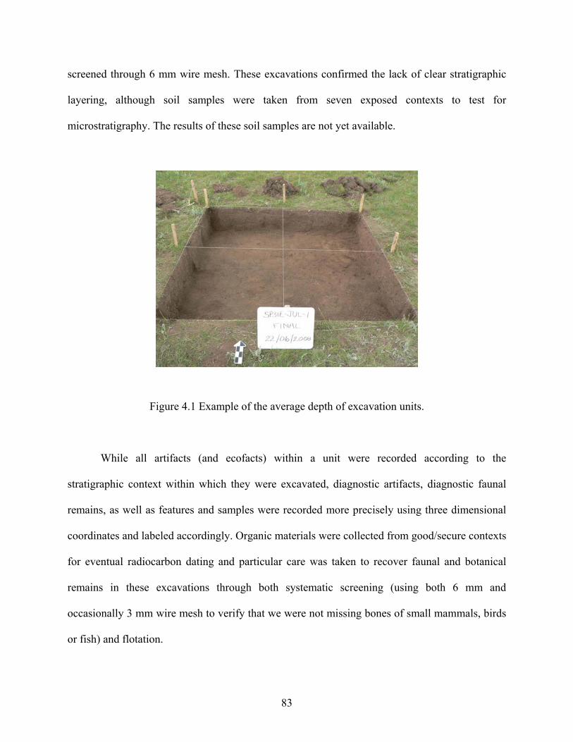
screened through 6 mm wire mesh. These excavations confirmed the lack of clear stratigraphic
layering, although soil samples were taken from seven exposed contexts to test for
microstratigraphy. The results of these soil samples are not yet available.
Figure 4.1 Example of the average depth of excavation units.
While all artifacts (and ecofacts) within a unit were recorded according to the
stratigraphic context within which they were excavated, diagnostic artifacts, diagnostic faunal
remains, as well as features and samples were recorded more precisely using three dimensional
coordinates and labeled accordingly. Organic materials were collected from good/secure contexts
for eventual radiocarbon dating and particular care was taken to recover faunal and botanical
remains in these excavations through both systematic screening (using both 6 mm and
occasionally 3 mm wire mesh to verify that we were not missing bones of small mammals, birds
or fish) and flotation.
83
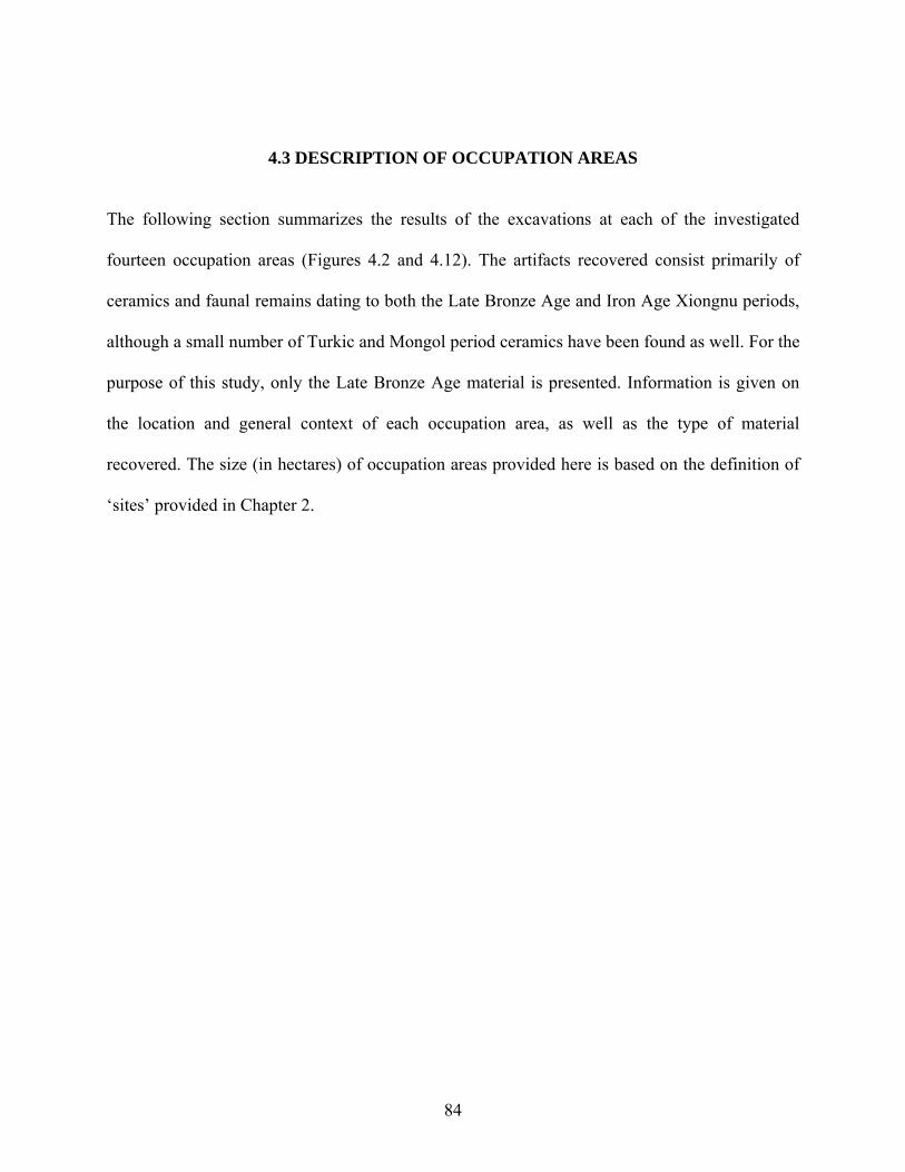
4.3 DESCRIPTION OF OCCUPATION AREAS
The following section summarizes the results of the excavations at each of the investigated
fourteen occupation areas (Figures 4.2 and 4.12). The artifacts recovered consist primarily of
ceramics and faunal remains dating to both the Late Bronze Age and Iron Age Xiongnu periods,
although a small number of Turkic and Mongol period ceramics have been found as well. For the
purpose of this study, only the Late Bronze Age material is presented. Information is given on
the location and general context of each occupation area, as well as the type of material
recovered. The size (in hectares) of occupation areas provided here is based on the definition of
‘sites’ provided in Chapter 2.
84
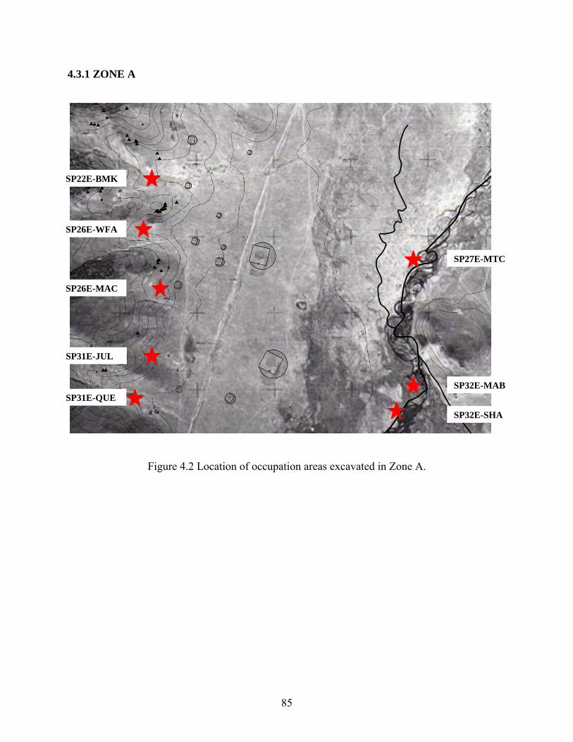
4.3.1 ZONE A
SP22E-BMK
SP26E-WFA
SP27E-MTC
SP26E-MAC
SP31E-JUL
SP32E-MABSP31E-QUE
SP32E-SHA
Figure 4.2 Location of occupation areas excavated in Zone A.
85
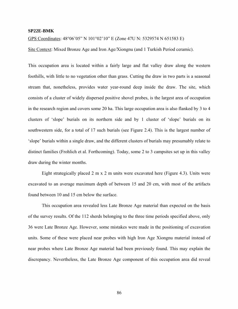
SP22E-BMK GPS Coordinates: 48°06’05” N 101°02’10” E (Zone 47U N: 5329574 N 651583 E)
Site Context: Mixed Bronze Age and Iron Age/Xiongnu (and 1 Turkish Period ceramic).
This occupation area is located within a fairly large and flat valley draw along the western
foothills, with little to no vegetation other than grass. Cutting the draw in two parts is a seasonal
stream that, nonetheless, provides water year-round deep inside the draw. The site, which
consists of a cluster of widely dispersed positive shovel probes, is the largest area of occupation
in the research region and covers some 20 ha. This large occupation area is also flanked by 3 to 4
clusters of ‘slope’ burials on its northern side and by 1 cluster of ‘slope’ burials on its
southwestern side, for a total of 17 such burials (see Figure 2.4). This is the largest number of
‘slope’ burials within a single draw, and the different clusters of burials may presumably relate to
distinct families (Frohlich et al. Forthcoming). Today, some 2 to 3 campsites set up in this valley
draw during the winter months.
Eight strategically placed 2 m x 2 m units were excavated here (Figure 4.3). Units were
excavated to an average maximum depth of between 15 and 20 cm, with most of the artifacts
found between 10 and 15 cm below the surface.
This occupation area revealed less Late Bronze Age material than expected on the basis
of the survey results. Of the 112 sherds belonging to the three time periods specified above, only
36 were Late Bronze Age. However, some mistakes were made in the positioning of excavation
units. Some of these were placed near probes with high Iron Age Xiongnu material instead of
near probes where Late Bronze Age material had been previously found. This may explain the
discrepancy. Nevertheless, the Late Bronze Age component of this occupation area did reveal
86
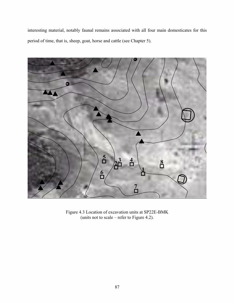
interesting material, notably faunal remains associated with all four main domesticates for this
period of time, that is, sheep, goat, horse and cattle (see Chapter 5).
Figure 4.3 Location of excavation units at SP22E-BMK (units not to scale – refer to Figure 4.2).
87
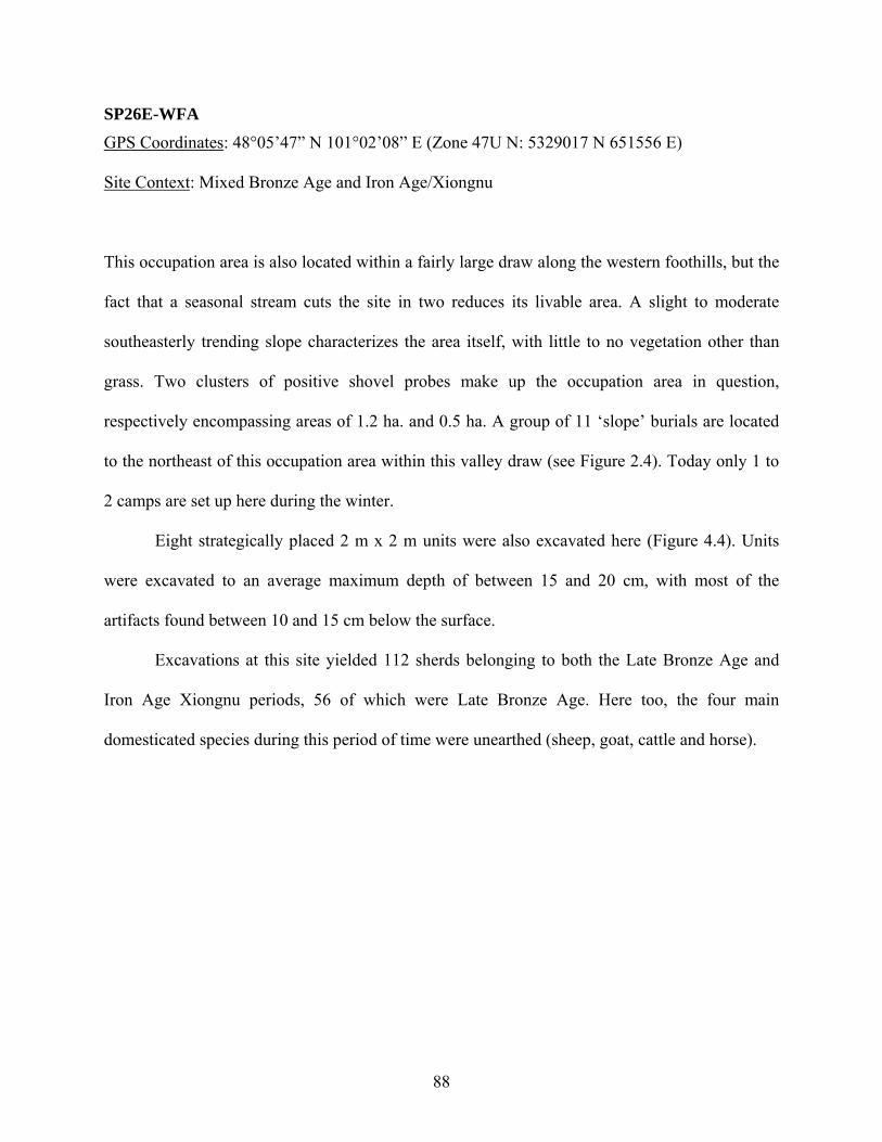
SP26E-WFA GPS Coordinates: 48°05’47” N 101°02’08” E (Zone 47U N: 5329017 N 651556 E)
Site Context: Mixed Bronze Age and Iron Age/Xiongnu
This occupation area is also located within a fairly large draw along the western foothills, but the
fact that a seasonal stream cuts the site in two reduces its livable area. A slight to moderate
southeasterly trending slope characterizes the area itself, with little to no vegetation other than
grass. Two clusters of positive shovel probes make up the occupation area in question,
respectively encompassing areas of 1.2 ha. and 0.5 ha. A group of 11 ‘slope’ burials are located
to the northeast of this occupation area within this valley draw (see Figure 2.4). Today only 1 to
2 camps are set up here during the winter.
Eight strategically placed 2 m x 2 m units were also excavated here (Figure 4.4). Units
were excavated to an average maximum depth of between 15 and 20 cm, with most of the
artifacts found between 10 and 15 cm below the surface.
Excavations at this site yielded 112 sherds belonging to both the Late Bronze Age and
Iron Age Xiongnu periods, 56 of which were Late Bronze Age. Here too, the four main
domesticated species during this period of time were unearthed (sheep, goat, cattle and horse).
88
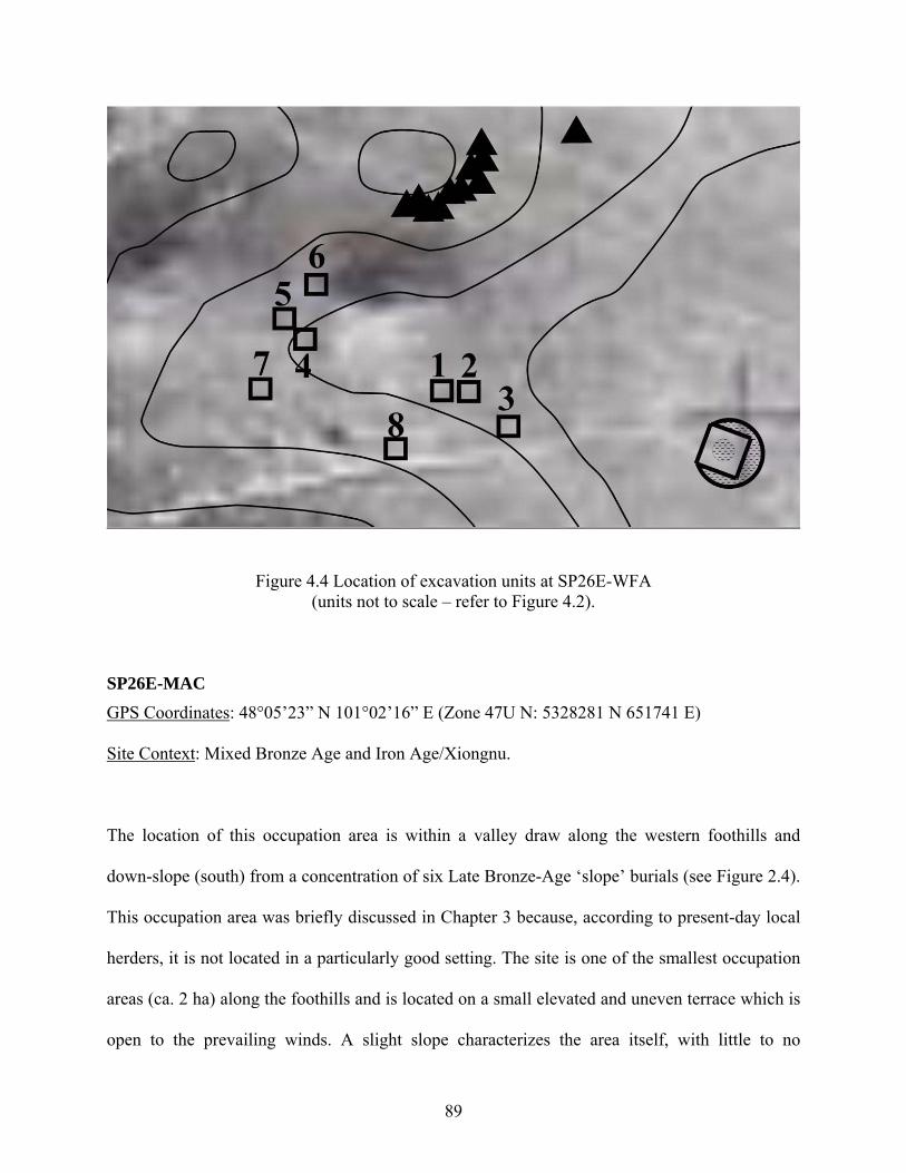
Figure 4.4 Location of excavation units at SP26E-WFA (units not to scale – refer to Figure 4.2).
SP26E-MAC
GPS Coordinates: 48°05’23” N 101°02’16” E (Zone 47U N: 5328281 N 651741 E)
Site Context: Mixed Bronze Age and Iron Age/Xiongnu.
The location of this occupation area is within a valley draw along the western foothills and
down-slope (south) from a concentration of six Late Bronze-Age ‘slope’ burials (see Figure 2.4).
This occupation area was briefly discussed in Chapter 3 because, according to present-day local
herders, it is not located in a particularly good setting. The site is one of the smallest occupation
areas (ca. 2 ha) along the foothills and is located on a small elevated and uneven terrace which is
open to the prevailing winds. A slight slope characterizes the area itself, with little to no
89
vegetation other than grass. Despite its odd setting, the site is consistent with the location of
modern-day winter/fall campsites in the valley. No one has inhabited this occupation area in
living memory.
Contrary to all other test excavations related to this research project, this occupation area
was excavated in 2007, and the site sampling procedure was a bit different. An 8 m x 2 m trench
unit was originally opened in an area of previously known high artifact density discovered in
2004, and four additional 2 m x 2 m arbitrarily located units within the site boundaries were
opened in order to further sample the site as a whole (Figure 4.5). For the analytical purposes of
this study, the 8 m x 2 m trench was divided into four 2 m x 2 m units. Together with the above
mentioned four additional units, these provided the desired eight 2 m x 2 m sampling units this
study set out to test. Units were excavated to a maximum depth of 25 cm, with most of the
artifacts found between 10 and 20 cm below the surface.
In spite of its small size, excavations at this occupation area revealed an amazing amount
of Late Bronze Age and Iron Age Xiongnu material. Excavations yielded 496 sherds belonging
to both the Late Bronze Age and Iron Age Xiongnu periods, 61 of them belonging to the Late
Bronze Age. Sheep/goat and horse bones were also recovered. Flotation samples from two
promising contexts were taken at this site. The two samples came from ‘featureless’ units, but
where a fair amount of charcoal, burnt bone and ceramics were uncovered. This will be further
discussed in Chapter 5.
90
Figure 4.5 Location of excavation units at SP26E-MAC (units not to scale – refer to Figure 4.2).
SP31E-JUL
GPS Coordinates: 48°04’50” N 101°02’22” E (Zone 47U N: 5327265N 651893 E)
Site Context: Mixed Bronze Age and Iron Age/Xiongnu (one sherd may be Medieval).
This occupation area is located in a shallow but fairly wide draw along the same western
foothills and offered the highest population index for the whole research area (see Chapter 3).
The site itself, which is the second largest area of occupation in the research region, covers some
18 ha. A slight east/northeastern trending slope characterizes the terrain, with little to no
vegetation other than grass. Despite having revealed the highest population index, only one
91
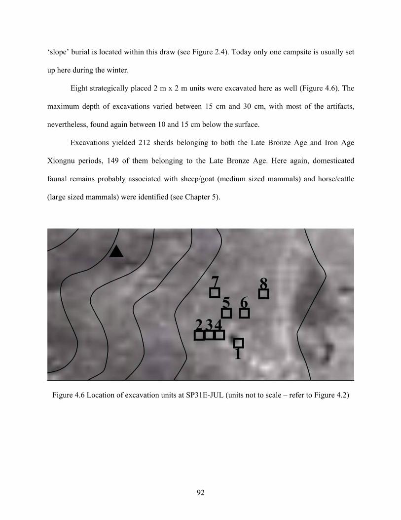
‘slope’ burial is located within this draw (see Figure 2.4). Today only one campsite is usually set
up here during the winter.
Eight strategically placed 2 m x 2 m units were excavated here as well (Figure 4.6). The
maximum depth of excavations varied between 15 cm and 30 cm, with most of the artifacts,
nevertheless, found again between 10 and 15 cm below the surface.
Excavations yielded 212 sherds belonging to both the Late Bronze Age and Iron Age
Xiongnu periods, 149 of them belonging to the Late Bronze Age. Here again, domesticated
faunal remains probably associated with sheep/goat (medium sized mammals) and horse/cattle
(large sized mammals) were identified (see Chapter 5).
Figure 4.6 Location of excavation units at SP31E-JUL (units not to scale – refer to Figure 4.2)
92
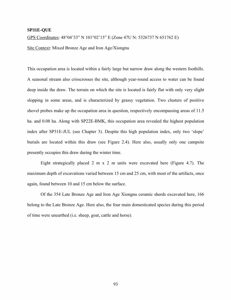
SP31E-QUE
GPS Coordinates: 48°04’33” N 101°02’15” E (Zone 47U N: 5326737 N 651762 E)
Site Context: Mixed Bronze Age and Iron Age/Xiongnu
This occupation area is located within a fairly large but narrow draw along the western foothills.
A seasonal stream also crisscrosses the site, although year-round access to water can be found
deep inside the draw. The terrain on which the site is located is fairly flat with only very slight
slopping in some areas, and is characterized by grassy vegetation. Two clusters of positive
shovel probes make up the occupation area in question, respectively encompassing areas of 11.5
ha. and 0.08 ha. Along with SP22E-BMK, this occupation area revealed the highest population
index after SP31E-JUL (see Chapter 3). Despite this high population index, only two ‘slope’
burials are located within this draw (see Figure 2.4). Here also, usually only one campsite
presently occupies this draw during the winter time.
Eight strategically placed 2 m x 2 m units were excavated here (Figure 4.7). The
maximum depth of excavations varied between 15 cm and 25 cm, with most of the artifacts, once
again, found between 10 and 15 cm below the surface.
Of the 354 Late Bronze Age and Iron Age Xiongnu ceramic sherds excavated here, 166
belong to the Late Bronze Age. Here also, the four main domesticated species during this period
of time were unearthed (i.e. sheep, goat, cattle and horse).
93
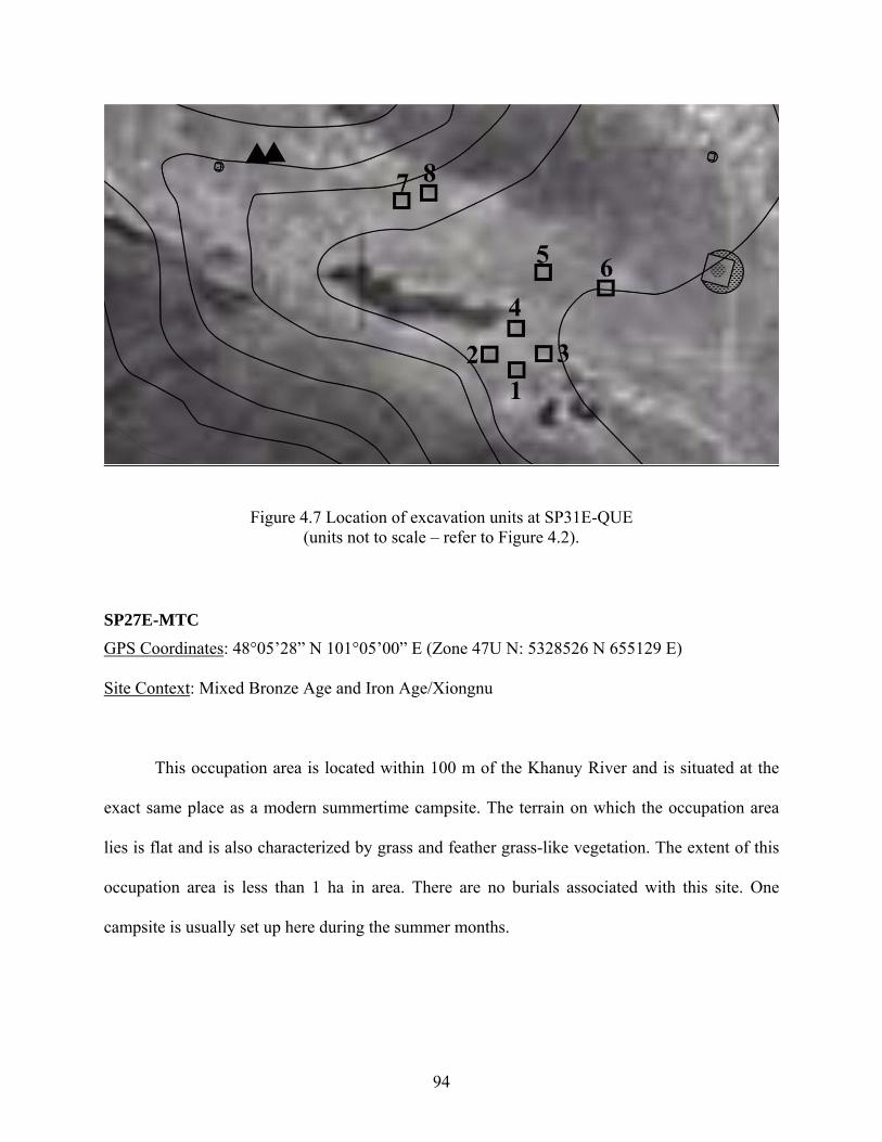
Figure 4.7 Location of excavation units at SP31E-QUE (units not to scale – refer to Figure 4.2).
SP27E-MTC GPS Coordinates: 48°05’28” N 101°05’00” E (Zone 47U N: 5328526 N 655129 E)
Site Context: Mixed Bronze Age and Iron Age/Xiongnu
This occupation area is located within 100 m of the Khanuy River and is situated at the
exact same place as a modern summertime campsite. The terrain on which the occupation area
lies is flat and is also characterized by grass and feather grass-like vegetation. The extent of this
occupation area is less than 1 ha in area. There are no burials associated with this site. One
campsite is usually set up here during the summer months.
94
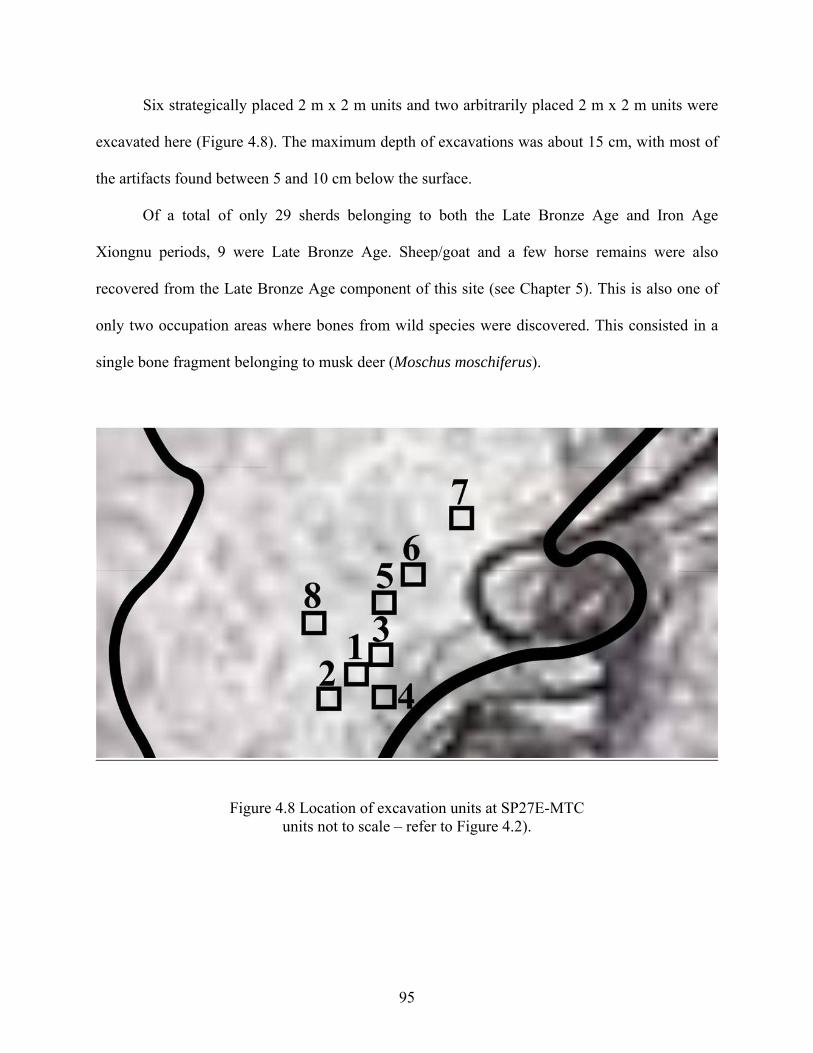
Six strategically placed 2 m x 2 m units and two arbitrarily placed 2 m x 2 m units were
excavated here (Figure 4.8). The maximum depth of excavations was about 15 cm, with most of
the artifacts found between 5 and 10 cm below the surface.
Of a total of only 29 sherds belonging to both the Late Bronze Age and Iron Age
Xiongnu periods, 9 were Late Bronze Age. Sheep/goat and a few horse remains were also
recovered from the Late Bronze Age component of this site (see Chapter 5). This is also one of
only two occupation areas where bones from wild species were discovered. This consisted in a
single bone fragment belonging to musk deer (Moschus moschiferus).
Figure 4.8 Location of excavation units at SP27E-MTC units not to scale – refer to Figure 4.2).
95
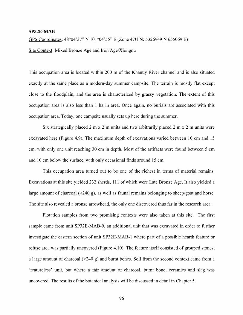
SP32E-MAB
GPS Coordinates: 48°04’37” N 101°04’55” E (Zone 47U N: 5326949 N 655069 E)
Site Context: Mixed Bronze Age and Iron Age/Xiongnu
This occupation area is located within 200 m of the Khanuy River channel and is also situated
exactly at the same place as a modern-day summer campsite. The terrain is mostly flat except
close to the floodplain, and the area is characterized by grassy vegetation. The extent of this
occupation area is also less than 1 ha in area. Once again, no burials are associated with this
occupation area. Today, one campsite usually sets up here during the summer.
Six strategically placed 2 m x 2 m units and two arbitrarily placed 2 m x 2 m units were
excavated here (Figure 4.9). The maximum depth of excavations varied between 10 cm and 15
cm, with only one unit reaching 30 cm in depth. Most of the artifacts were found between 5 cm
and 10 cm below the surface, with only occasional finds around 15 cm.
This occupation area turned out to be one of the richest in terms of material remains.
Excavations at this site yielded 232 sherds, 111 of which were Late Bronze Age. It also yielded a
large amount of charcoal (>240 g), as well as faunal remains belonging to sheep/goat and horse.
The site also revealed a bronze arrowhead, the only one discovered thus far in the research area.
Flotation samples from two promising contexts were also taken at this site. The first
sample came from unit SP32E-MAB-9, an additional unit that was excavated in order to further
investigate the eastern section of unit SP32E-MAB-1 where part of a possible hearth feature or
refuse area was partially uncovered (Figure 4.10). The feature itself consisted of grouped stones,
a large amount of charcoal (>240 g) and burnt bones. Soil from the second context came from a
‘featureless’ unit, but where a fair amount of charcoal, burnt bone, ceramics and slag was
uncovered. The results of the botanical analysis will be discussed in detail in Chapter 5.
96
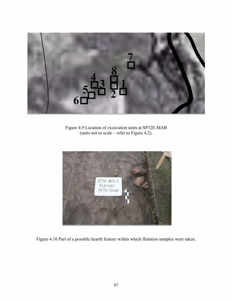
Figure 4.9 Location of excavation units at SP32E-MAB (units not to scale – refer to Figure 4.2).
Figure 4.10 Part of a possible hearth feature within which flotation samples were taken.
97
SP32E-SHA
GPS Coordinates: 48°04’26” N 101°04’50” E (Zone 47U N: 5326606 N 654974 E) Site Context: Mixed Bronze Age and Iron Age/Xiongnu.
Similar to the latter two sites and to contemporary summer campsites in this area, this occupation
area is also situated some 100 m away from the Khanuy River. Here too the terrain is mostly flat
except close to the floodplain, and the area is also characterized by grassy vegetation. The extent
of this occupation area is also less than 1 ha in area. As is the case for other occupation areas
along the river, no burials are associated with this site. During the summer months, one fairly
large campsite is presently set up here.
Six strategically placed 2 m x 2 m units and two arbitrarily placed 2 m x 2 m units were
excavated here as well (Figure 4.11). The maximum depth of excavations varied between 20 cm
and 25 cm, but most of the artifacts were found between 10 cm and 15 cm below the surface,
with only occasional finds in shallower and deeper deposits.
The ceramic content of this occupation area consisted of 40 Late Bronze Age sherds out
of a total of 159 Late Bronze Age and Iron Age Xiongnu sherds. Sheep, goat and large mammal
bones probably belonging to either horse or cattle were discovered here. This is also the only
other site in the research area besides SP27E-MTC to have produced bones of wild species. Two
bone fragments have been identified as belonging to musk deer (Moschus moschiferus).
98
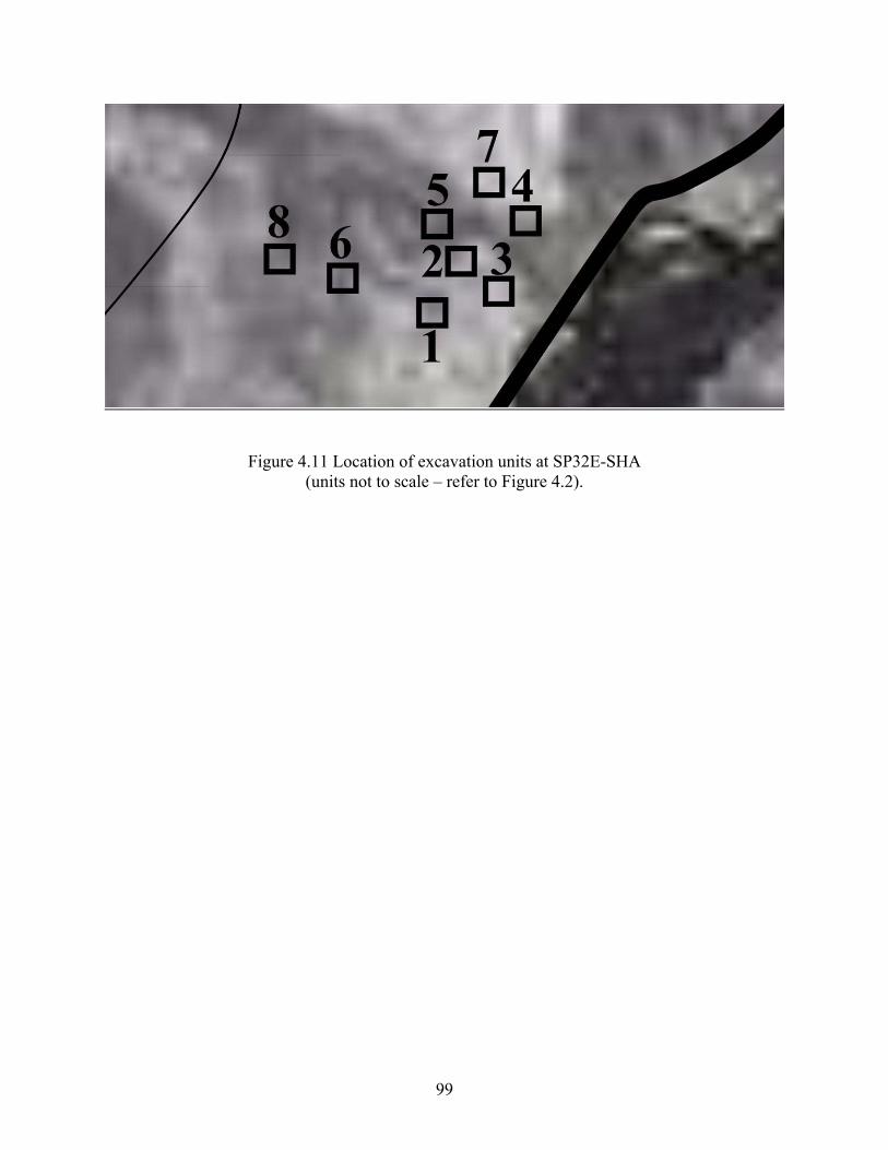
Figure 4.11 Location of excavation units at SP32E-SHA (units not to scale – refer to Figure 4.2).
99
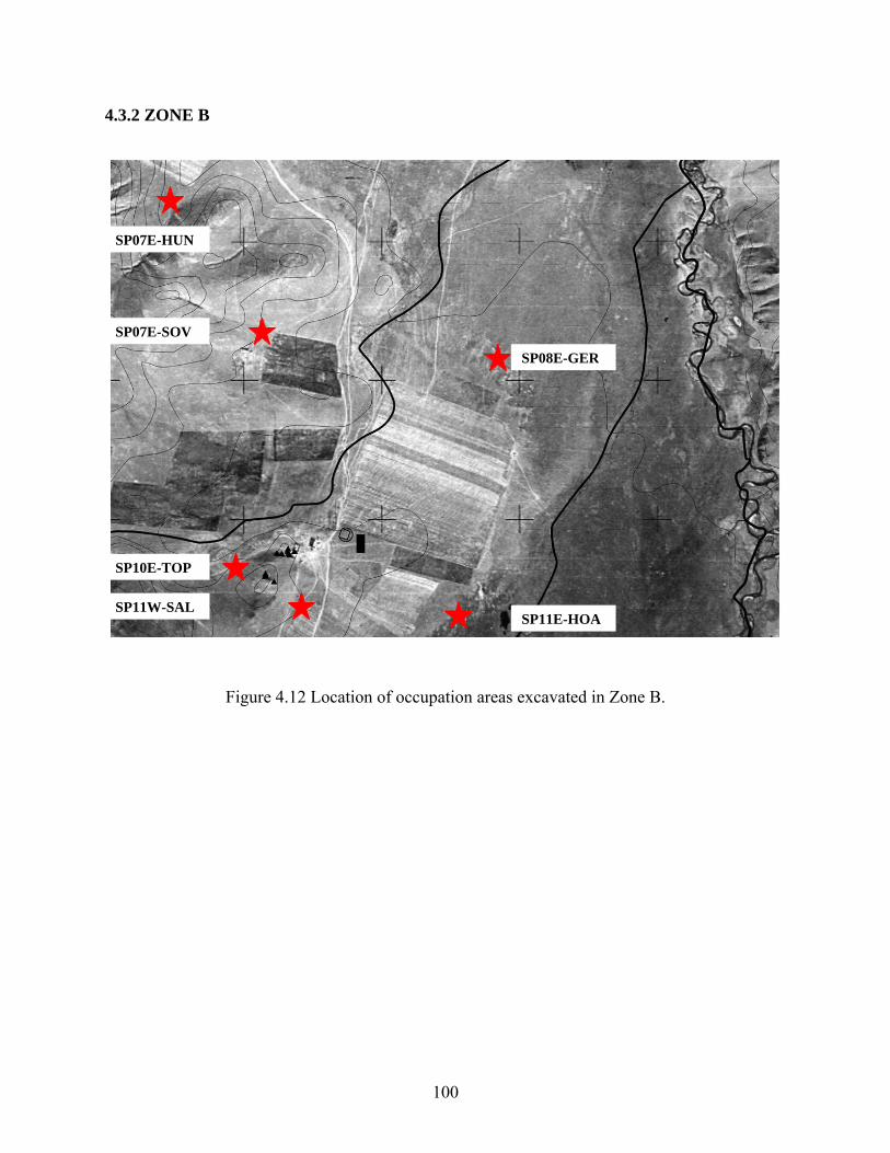
4.3.2 ZONE B
SP07E-HUN
SP07E-SOV
SP08E-GER
SP10E-TOP
SP11W-SAL SP11E-HOA
Figure 4.12 Location of occupation areas excavated in Zone B.
100
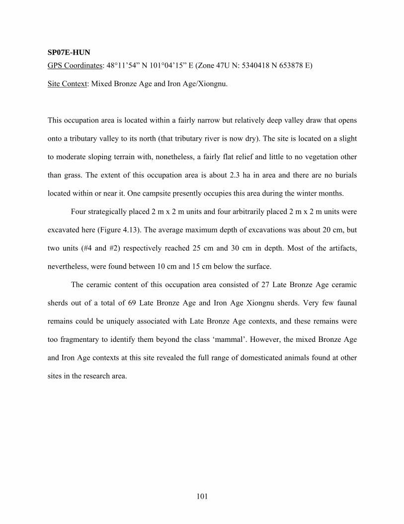
SP07E-HUN
GPS Coordinates: 48°11’54” N 101°04’15” E (Zone 47U N: 5340418 N 653878 E)
Site Context: Mixed Bronze Age and Iron Age/Xiongnu.
This occupation area is located within a fairly narrow but relatively deep valley draw that opens
onto a tributary valley to its north (that tributary river is now dry). The site is located on a slight
to moderate sloping terrain with, nonetheless, a fairly flat relief and little to no vegetation other
than grass. The extent of this occupation area is about 2.3 ha in area and there are no burials
located within or near it. One campsite presently occupies this area during the winter months.
Four strategically placed 2 m x 2 m units and four arbitrarily placed 2 m x 2 m units were
excavated here (Figure 4.13). The average maximum depth of excavations was about 20 cm, but
two units (#4 and #2) respectively reached 25 cm and 30 cm in depth. Most of the artifacts,
nevertheless, were found between 10 cm and 15 cm below the surface.
The ceramic content of this occupation area consisted of 27 Late Bronze Age ceramic
sherds out of a total of 69 Late Bronze Age and Iron Age Xiongnu sherds. Very few faunal
remains could be uniquely associated with Late Bronze Age contexts, and these remains were
too fragmentary to identify them beyond the class ‘mammal’. However, the mixed Bronze Age
and Iron Age contexts at this site revealed the full range of domesticated animals found at other
sites in the research area.
101
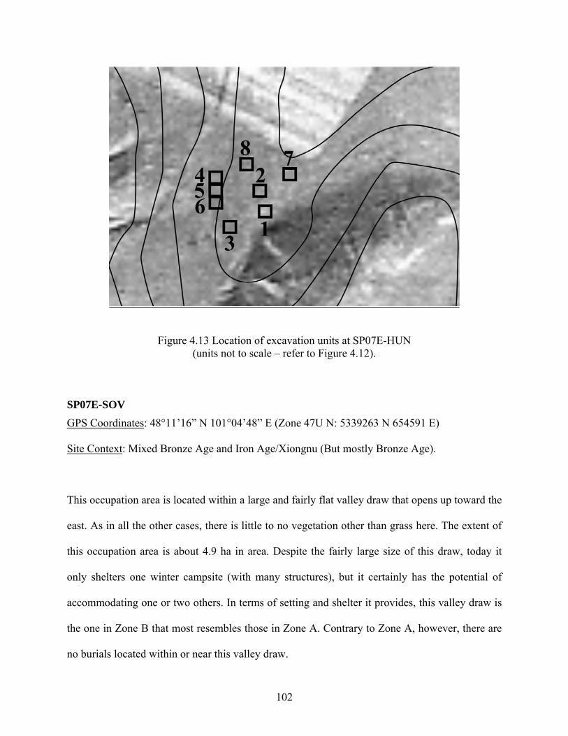
Figure 4.13 Location of excavation units at SP07E-HUN (units not to scale – refer to Figure 4.12).
SP07E-SOV GPS Coordinates: 48°11’16” N 101°04’48” E (Zone 47U N: 5339263 N 654591 E)
Site Context: Mixed Bronze Age and Iron Age/Xiongnu (But mostly Bronze Age).
This occupation area is located within a large and fairly flat valley draw that opens up toward the
east. As in all the other cases, there is little to no vegetation other than grass here. The extent of
this occupation area is about 4.9 ha in area. Despite the fairly large size of this draw, today it
only shelters one winter campsite (with many structures), but it certainly has the potential of
accommodating one or two others. In terms of setting and shelter it provides, this valley draw is
the one in Zone B that most resembles those in Zone A. Contrary to Zone A, however, there are
no burials located within or near this valley draw.
102
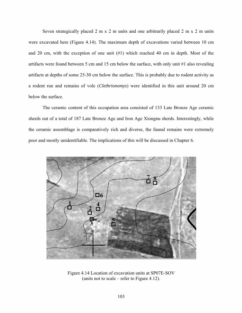
Seven strategically placed 2 m x 2 m units and one arbitrarily placed 2 m x 2 m units
were excavated here (Figure 4.14). The maximum depth of excavations varied between 10 cm
and 20 cm, with the exception of one unit (#1) which reached 40 cm in depth. Most of the
artifacts were found between 5 cm and 15 cm below the surface, with only unit #1 also revealing
artifacts at depths of some 25-30 cm below the surface. This is probably due to rodent activity as
a rodent run and remains of vole (Clethrionomys) were identified in this unit around 20 cm
below the surface.
The ceramic content of this occupation area consisted of 133 Late Bronze Age ceramic
sherds out of a total of 187 Late Bronze Age and Iron Age Xiongnu sherds. Interestingly, while
the ceramic assemblage is comparatively rich and diverse, the faunal remains were extremely
poor and mostly unidentifiable. The implications of this will be discussed in Chapter 6.
Figure 4.14 Location of excavation units at SP07E-SOV (units not to scale – refer to Figure 4.12).
103
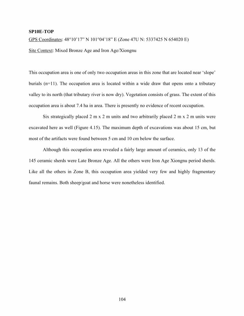
SP10E-TOP
GPS Coordinates: 48°10’17” N 101°04’18” E (Zone 47U N: 5337425 N 654020 E)
Site Context: Mixed Bronze Age and Iron Age/Xiongnu
This occupation area is one of only two occupation areas in this zone that are located near ‘slope’
burials (n=11). The occupation area is located within a wide draw that opens onto a tributary
valley to its north (that tributary river is now dry). Vegetation consists of grass. The extent of this
occupation area is about 7.4 ha in area. There is presently no evidence of recent occupation.
Six strategically placed 2 m x 2 m units and two arbitrarily placed 2 m x 2 m units were
excavated here as well (Figure 4.15). The maximum depth of excavations was about 15 cm, but
most of the artifacts were found between 5 cm and 10 cm below the surface.
Although this occupation area revealed a fairly large amount of ceramics, only 13 of the
145 ceramic sherds were Late Bronze Age. All the others were Iron Age Xiongnu period sherds.
Like all the others in Zone B, this occupation area yielded very few and highly fragmentary
faunal remains. Both sheep/goat and horse were nonetheless identified.
104
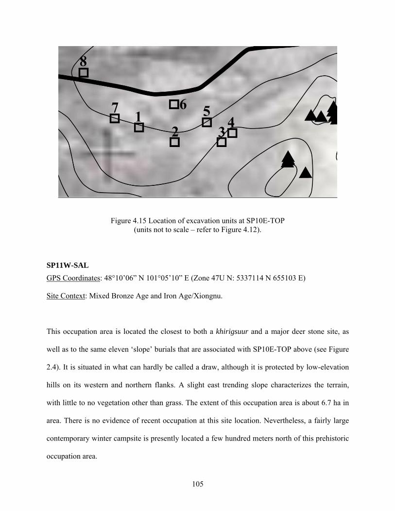
Figure 4.15 Location of excavation units at SP10E-TOP (units not to scale – refer to Figure 4.12).
SP11W-SAL GPS Coordinates: 48°10’06” N 101°05’10” E (Zone 47U N: 5337114 N 655103 E)
Site Context: Mixed Bronze Age and Iron Age/Xiongnu.
This occupation area is located the closest to both a khirigsuur and a major deer stone site, as
well as to the same eleven ‘slope’ burials that are associated with SP10E-TOP above (see Figure
2.4). It is situated in what can hardly be called a draw, although it is protected by low-elevation
hills on its western and northern flanks. A slight east trending slope characterizes the terrain,
with little to no vegetation other than grass. The extent of this occupation area is about 6.7 ha in
area. There is no evidence of recent occupation at this site location. Nevertheless, a fairly large
contemporary winter campsite is presently located a few hundred meters north of this prehistoric
occupation area.
105
Six strategically placed 2 m x 2 m units and two arbitrarily placed 2 m x 2 m units were
excavated here as well (Figure 4.16). The maximum depth of excavations varied between 15 cm
and 20 cm, with most of the artifacts found between 5 cm and 15 cm below the surface.
The ceramic content of this occupation area consisted of 32 Late Bronze Age ceramic
sherds out of a total of 66 Late Bronze Age and Iron Age Xiongnu sherds. Very few faunal
remains were found in general here, but this occupation area revealed the largest number of stone
artifacts in the whole research area. The details of the lithic assemblage and the implications of
this will be discussed in Chapter 6.
Figure 4.16 Location of excavation units at SP11W-SAL (units not to scale – refer to Figure 4.12).
106
SP08E-GER
GPS Coordinates: 48°11’02” N 101°06’27” E (Zone 47U N: 5338886 N 656646 E)
Site Context: Mixed Bronze Age and Iron Age/Xiongnu
This occupation area is one of only two sites investigated along the floodplain in Zone B. Due to
the fact that a present-day summer campsite was set up exactly over this prehistoric occupation
area at the time we were going to excavate, excavation units needed to be moved several tens of
meters southeast and northwest of the center of the actual site discovered in 2007. The terrain in
this area is flat and is also characterized by grass vegetation. The extent of this occupation area is
about 0.2 ha in area. There are no burials associated with this site. Today only one camp is set up
here during the summer.
Seven semi-strategically placed 2 m x 2 m units were excavated here. That is, all were
excavated several meters (ca. 10 m) away from the original positive shovel probes (Figure 4.17).
The maximum depth of excavations was about 15 cm, with most of the artifacts found between 5
cm and 10 cm below the surface.
The ceramic content of this occupation area consisted of only 5 Late Bronze Age ceramic
sherds out of a total of 17 Late Bronze Age and Iron Age Xiongnu sherds. This may indeed be
due to the alternative placement of excavation units, but sherds discovered on the surface did
confirm that this was mostly an Iron Age Xiongnu site. Once again, total faunal remains were
extremely few and highly fragmented at this site, and none were found in Late Bronze Age
contexts only.
107
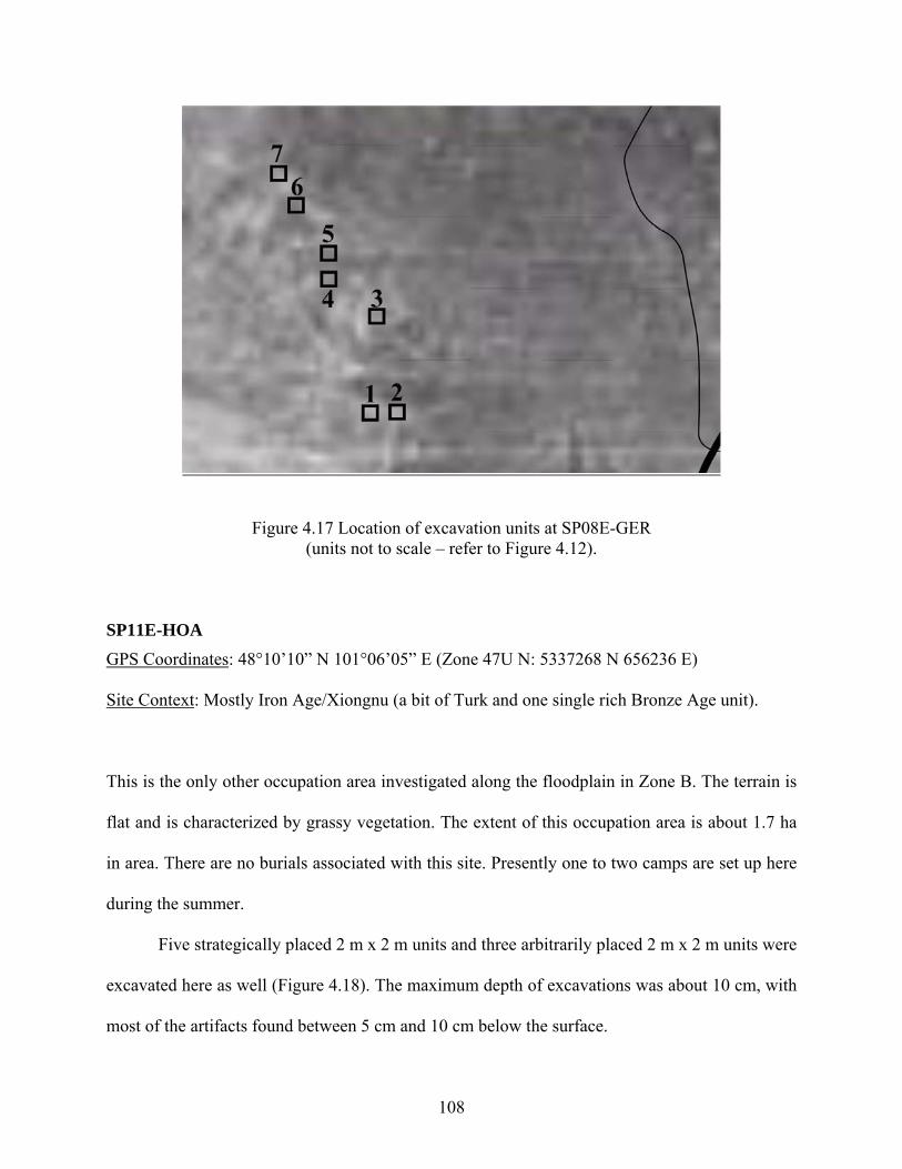
Figure 4.17 Location of excavation units at SP08E-GER (units not to scale – refer to Figure 4.12).
SP11E-HOA GPS Coordinates: 48°10’10” N 101°06’05” E (Zone 47U N: 5337268 N 656236 E)
Site Context: Mostly Iron Age/Xiongnu (a bit of Turk and one single rich Bronze Age unit).
This is the only other occupation area investigated along the floodplain in Zone B. The terrain is
flat and is characterized by grassy vegetation. The extent of this occupation area is about 1.7 ha
in area. There are no burials associated with this site. Presently one to two camps are set up here
during the summer.
Five strategically placed 2 m x 2 m units and three arbitrarily placed 2 m x 2 m units were
excavated here as well (Figure 4.18). The maximum depth of excavations was about 10 cm, with
most of the artifacts found between 5 cm and 10 cm below the surface.
108
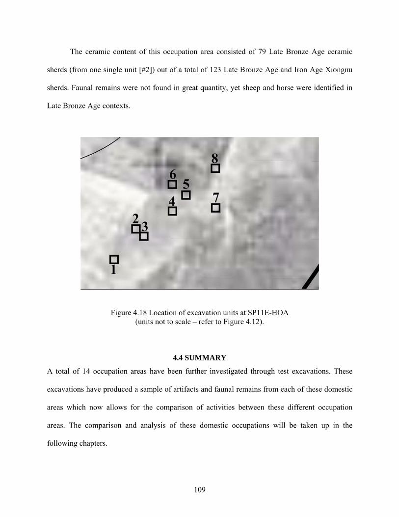
The ceramic content of this occupation area consisted of 79 Late Bronze Age ceramic
sherds (from one single unit [#2]) out of a total of 123 Late Bronze Age and Iron Age Xiongnu
sherds. Faunal remains were not found in great quantity, yet sheep and horse were identified in
Late Bronze Age contexts.
Figure 4.18 Location of excavation units at SP11E-HOA (units not to scale – refer to Figure 4.12).
4.4 SUMMARY
A total of 14 occupation areas have been further investigated through test excavations. These
excavations have produced a sample of artifacts and faunal remains from each of these domestic
areas which now allows for the comparison of activities between these different occupation
areas. The comparison and analysis of these domestic occupations will be taken up in the
following chapters.
109
5.0 SUBSISTENCE, SEASONALITY AND MOBILITY Past assessments of subsistence economy in the prehistoric Eurasian Steppes have recently been
the subject matter of many critiques (Frachetti 2004; Hanks 2003; Morales-Muniz and Antipina
2003; Rassamakin 1999). The problems, they argue, are both methodological and theoretical.
Methodologically, the problem apparently lies in the lack of appropriately recovered and
analyzed botanical and faunal data. Soviet and post-Soviet excavations, for example, have not
systematically collected paleobotanical data, and the lack of systematic screening and an almost
absence of flotation has resulted in an underrepresentation of plant remains, small mammals,
birds and fish. Theoretically, the problem lies in part with “the misuse of ethnographic
observations for associating particular faunal assemblages with prescribed socio-economic
strategies (i.e. pastoral nomadism, sedentary agro-pastoralism, etc.)” (Frachetti 2004:239).
Michael Frachetti (2004:240) has also recently further underscored where the problem lies with
most economic reconstructions of the subsistence economy proposed notably during the Soviet
period, that is, that they have for the most part rested almost solely on faunal findings from
excavated burials. Apparently, this problem has specifically to do with the paucity of settlement
data within the steppe zone (Hanks 2003:72), but recent collaborative studies (e.g. Anthony et al.
2005; Chang et al. 2002; Frachetti 2004; Hanks 2003; this study) indicate that this paucity of
data from habitation sites is not because of their actual absence, but because of the lack of
appropriate techniques (or resolve) to uncover them.
110
This problem has also plagued the reconstruction of ancient subsistence economies in
Mongolia. Indeed, at present, subsistence reconstructions for Bronze Age Mongolia still rest
almost solely on animal remains found in burial and ritual contexts (e.g. Tsybiktarov 1998:147-
149, 2003:82-83) and we lack the more concrete evidence of subsistence practices that come from
residential contexts. This, in part, has led some to suggest that Late Bronze Age groups
associated with khirigsuurs were either necessarily pastoralists (of an uncertain nature) or,
contrary to the general view, Epipaleolithic (Mesolithic) hunter-gatherers (Wright 2006). To be
fair, however, these last two authors (Tsybiktarov and Wright) call for the necessity of
conducting archaeological research on domestic contexts. Nevertheless, for the moment, what is
known of the actual subsistence economy of Late Bronze Age Mongolia is, not surprisingly, very
little. But this is to be expected of a type of archaeology that has been mainly interested in
burials, ritual sites and objects of fine craftsmanship. Botanical remains and animal bones have
not been given the same attention—especially those from domestic contexts. As a result,
interpretations regarding the nature of Late Bronze Age subsistence practices has to date
remained speculative.
The results presented in this study are the first step in reconstructing the subsistence
economy of Late Bronze Age occupation areas (habitation sites) in Mongolia. The objective is to
understand the everyday subsistence economy. And the fact that this study sampled a variety of
occupation areas in different places within the research area renders the evaluation of the overall
subsistence practices fairly reliable. That is, as discussed earlier, the more extensive sampling
procedure used in this study, while sacrificing some detail, at least assures a greater likelihood
that the sample is representative of the region during this period of time. The fullest possible
retrieval of information related to subsistence economy was thus essential for interpreting the
111
nature of Late Bronze Age occupation areas. Given the limited time and resources of this
particular study, however, it was not possible to explore the complete range of methodological
approaches to subsistence practices (see for example Shahack-Gross and Finkelstein 2008), yet
the analyses of the material remains recovered from the various excavated occupation areas
(artifacts, faunal remains and macrobotanical remains retrieved through flotation) provide to date
the most complete and the only comprehensive assemblages from non-mortuary contexts for this
period in Mongolia. This study thus provides, for the first time, quantitative and appropriate
evidence relating to the subsistence practices of Late Bronze Age inhabitants in Mongolia’s
Khanuy Valley.
To be sure, the sample of material from occupation contexts produced by this study is
very small. But this was somewhat expected given the sampling procedure and the probable
pastoralist nature of these societies. This should not, however, prevent us from identifying
clearly the patterns to be found in it or from exploring fully the implications of those patterns.
For this reason, it is also essential to assess the risk that those patterns emerge only because of
the random processes at work in a small sample, and this is properly undertaken as a separate
task from identifying patterns—a task for which statistics provides us with powerful tools.
5.1 BOTANICAL REMAINS
No artifactual evidence—specifically stone tools—for plant cultivation or processing has been
uncovered in any of the excavated contexts. In fact, an extremely low number of stone artifacts
have been found in general, and even fewer from secure Late Bronze Age contexts. The total
Late Bronze Age lithic assemblage actually consisted of only nine unretouched small flakes (< 3
112
cm in width) and a whetstone. None of these can be related to tools that could have been used to
cultivate or process plants or grains. Artifactual evidence, therefore, does not suggest that plants
were being cultivated or processed in this region during Mongolia’s Late Bronze Age.
Nevertheless, not all plants, especially wild species, require special tools to harvest or process
them.
In order to further investigate the possibility of plant use, therefore, flotation samples
from four promising contexts were taken at two different occupation areas, one located in the
foothills and taken to be a winter campsite (SP26E-MAC) and another located along the Khanuy
River, which is taken to be a summer campsite (SP32E-MAB) (see Figure 4.2 in Chapter 4). The
method used to process sediment samples was a simple manual bucket flotation method. After
gently disaggregating the sediment and then creating a vortex by swirling the water by hand,
light fractions were collected from the float with a handheld 1 mm sieve, while heavy fractions
were recovered in a 3 mm mesh screen. Samples removed from the float were then placed in
cheesecloth, labeled and hung for drying. The heavy fractions did not contain any plant remains,
so only light fractions were examined. These light fraction samples were analyzed by Dr. Zhao
Zhijun in the laboratory of the Institute of Archaeology (CASS), Beijing, China.
The first two samples that were analyzed came from two different excavation units at the
SP32E-MAB occupation area. This occupation area is located within 200 m of the Khanuy River
channel and is still occupied today by modern herders during the summer. The first sample
comes from SP32E-MAB-9, an additional unit that was excavated in order to further investigate
the eastern section of unit SP32E-MAB-1 where a possible hearth feature was partially
uncovered (see Figure 4.10 in Chapter 4). The actual sediment sample for flotation came from
the feature itself, which consisted in grouped stones, a large amount of charcoal (>240 g), as well
113
as burnt and calcined bones—all of which reinforced the idea that this was a hearth feature. A
total of 21 liters of soil was taken between 5 and 15 cm below ground surface (the cultural layer).
The flotation sample recovered from this soil yielded a few tiny unidentified land snails (n=3),
abundant modern rootlets, a large amount of wood charcoal identified as belonging to four
species (Larch, Pine, Birch, Poplar) (Wang and Wang 2009), as well as 30 Chenopodium seeds
(also known as goosefoot) and 1 Cyperaceae seed. The types of tree species identified in the
charcoal remains are consistent with contemporary ones in the research area. In addition, both
Chenopodium and Cyperaceae are very common taxa in the steppe environment and are still
prevalent in the research area. Together, the presence of these plant remains confirms the data
presented in Chapter 1 that suggest that Late Bronze Age environmental conditions were similar
to those of today.
Soil from another context (SP32E-MAB-10) within the same occupation area was also
floated. This sample came from a ‘featureless’ unit, but where some charcoal and burnt bone
were also uncovered. Here, a total of 10.5 liters of soil was taken between 5 and 15 cm below
ground surface (the cultural layer). Only 1 Chenopodium seed and 1 Cyperaceae seed were
recovered from this context.
The other two samples that were analyzed came from two different excavation units at
the SP32E-MAC occupation area. This occupation area, situated along the western foothills, was
briefly discussed in Chapter 3 since, according to present-day local herders, it is not located in a
particularly good setting. Nonetheless, it is located in the part of the valley that is contemporarily
used during the winter months.
Despite its odd location, it was decided to float some soil from this occupation area
because it had been reported that Chenopodium seeds had been discovered there in 2004 by a
114
student researching agropastoralism in East Asia. The seeds in question came from a circular
burnt soil feature with a fair amount of charcoal, burnt bone, and ceramics belonging to both the
Bronze Age and the Xiongnu period. Unfortunately, detailed results were never reported, the
student abandoned her studies and the location of the samples is unknown. Although the original
feature was no more, soil for flotation was collected from an adjacent 50x50 cm unit (SP26E-
MAC-8) in the hopes of recovering plant remains that may have been associated with the
original feature. A total of 7 liters of soil was taken between 5 and 15 cm below ground surface
(the cultural layer). Nine Chenopodium seeds were recovered. No other plant remains besides
modern rootlets were identified.
Soil from another unit at this occupation area was also floated (SP26E-MAC-9). The
sample came from a ‘featureless’ unit, but where a fair amount of charcoal, burnt bone, ceramics
(both Bronze Age and Iron Age) and metallurgic slag was uncovered. A total of 10.5 liters of soil
was taken between 5 and 15 cm below ground surface (the cultural layer). No plant remains
besides abundant modern rootlets were identified.
The recovered paleobotanical remains from the two occupation areas, then, consist of 40
Chenopodium seeds and 2 Cyperaceae seeds. None of the cultigens (i.e. millet, wheat and barley)
found in subsequent Iron Age Xiongnu period domestic contexts in neighboring regions
(Davydova 1995; Wright et al. 2009) have been found here. Cyperaceae, a weedy plant still
present in the research area, was only found at SP32E-MAB, which is consistent with its nearby
marshy floodplain location. Chenopodium seeds were recovered in similar quantities from both
tested occupation areas (Table 5.1). As mentioned above, this is also a very common taxon in
steppe environments and it is still prevalent in the research area. Accordingly, together with the
fact that there is no history of cultivation here, it is very likely that these two taxa were not
115
domesticated or cultivated. However, the presence of wild Chenopodium seeds in burnt
assemblages is very interesting. For one, seeds of Chenopodium are very nutritious. In China,
they have been found in archaeological contexts that date back to the Late Longshan Period (ca.
2600-2000 BCE) and they are still used in China today as a source of greens and starchy grain
(Lee et al. 2007). In Mongolia, charred Chenopodium seeds have been found in Iron
Age/Xiongnu settlement contexts in Egiin Gol, a region just north of the Khanuy Valley (Wright
et al. 2009:381) and at the Medieval period site of Karakorum, the capital city of the Mongolian
Empire (Rösch et al. 2005). It is possible, therefore, that just as was the case in the northern
steppe east of the Don during the Late Bronze Age (Anthony 2007:439; Popova 2006), these
wild seed-bearing plants could have also been collected in the wild as early as the Late Bronze
Age in Mongolia. In any case, groups in this region were apparently not farmers, but possibly
harvested local wild grains.
Further support for the idea that plant cultivation was not an important item for the Late
Bronze Age inhabitants of the Khanuy Valley is related to the size of the samples. Indeed, we
can be 87% confident that a sample of 40 seeds including no domesticated plants comes from a
population with less than 5% domesticated plants. The sampling situation is a bit more
complicated here than a simple random sample of 40 seeds, but the fact that they come from
three contexts in two locations where well preserved botanical remains were recovered makes it
even more likely that we would have found domesticated specimens if they were at all abundant.
In regard to how important plant collecting was to Late Bronze Age subsistence is more
complicated to assess. Certainly, the complete absence of grinding stones, pestles and other such
tools from all of the archaeological assemblages in the Khanuy Valley research area does provide
a line of evidence that plant processing (wild or cultivated) may not have been very important.
116
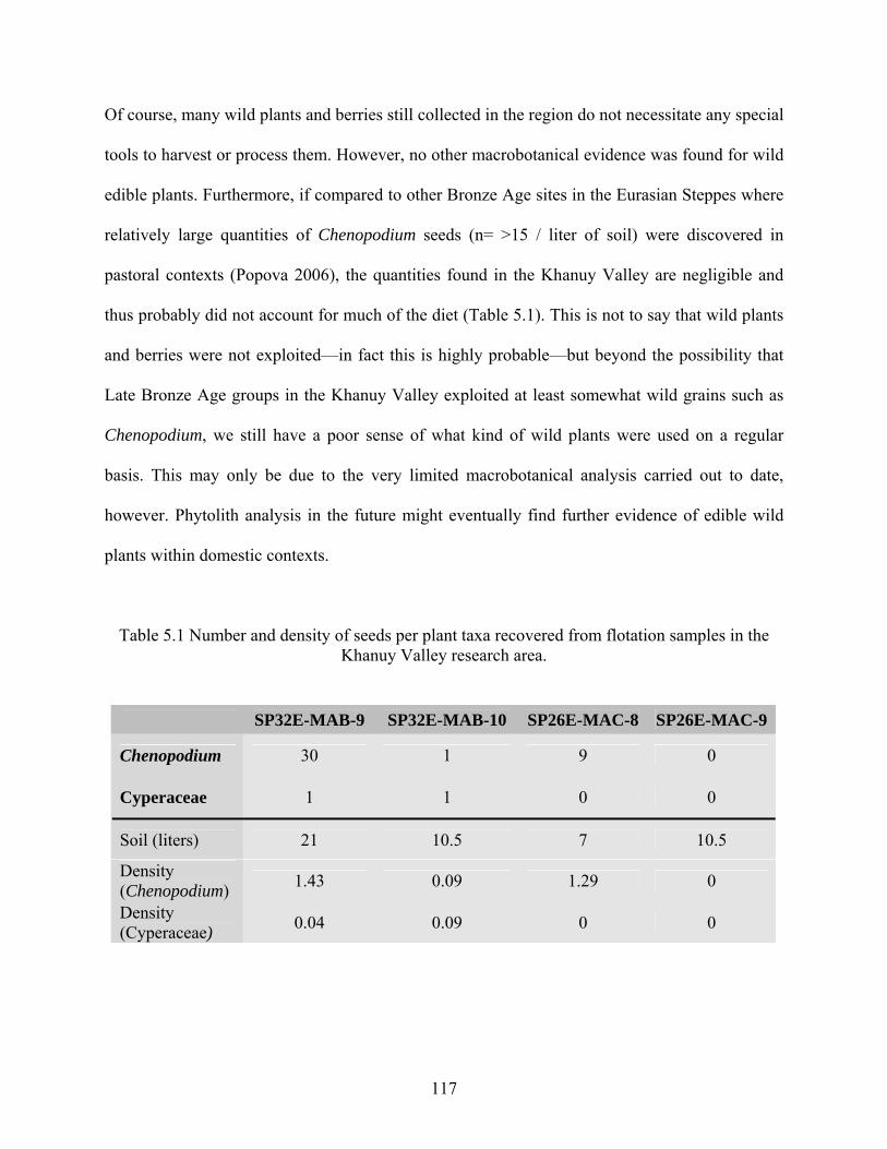
Of course, many wild plants and berries still collected in the region do not necessitate any special
tools to harvest or process them. However, no other macrobotanical evidence was found for wild
edible plants. Furthermore, if compared to other Bronze Age sites in the Eurasian Steppes where
relatively large quantities of Chenopodium seeds (n= >15 / liter of soil) were discovered in
pastoral contexts (Popova 2006), the quantities found in the Khanuy Valley are negligible and
thus probably did not account for much of the diet (Table 5.1). This is not to say that wild plants
and berries were not exploited—in fact this is highly probable—but beyond the possibility that
Late Bronze Age groups in the Khanuy Valley exploited at least somewhat wild grains such as
Chenopodium, we still have a poor sense of what kind of wild plants were used on a regular
basis. This may only be due to the very limited macrobotanical analysis carried out to date,
however. Phytolith analysis in the future might eventually find further evidence of edible wild
plants within domestic contexts.
Table 5.1 Number and density of seeds per plant taxa recovered from flotation samples in the Khanuy Valley research area.
SP32E-MAB-9 SP32E-MAB-10 SP26E-MAC-8 SP26E-MAC-9
Chenopodium 30 1 9 0
Cyperaceae 1 1 0 0
Soil (liters) 21 10.5 7 10.5
Density (Chenopodium) 1.43 0.09 1.29 0
Density (Cyperaceae) 0.04 0.09 0 0
117
5.2 FAUNAL REMAINS
Perhaps not surprisingly, faunal remains (Total NISP = 3511) constitute the majority of the Late
Bronze Age archaeological material recovered from the various occupation areas. While this is
not surprising, their location in domestic contexts renders them especially important for
answering a number of the research questions discussed in Chapter 1, not the least to better
characterize the previously ill-examined subsistence patterns and animal exploitation during
Mongolia’s Late Bronze Age, but also for helping to determine seasonality of occupation areas.
Although the overall sample size is very small and should be considered as a preliminary,
tentative evaluation of the Late Bronze Age economy in this region, the faunal material
presented here represents to date the only fauna recovered from non-mortuary contexts for this
period in Mongolia. In addition to evaluating the overall use of faunal resources in subsistence,
the relative representation of domestic to wild species and seasonality of occupation areas, these
faunal remains were also used for determining herd composition (not its structure). In this study I
distinguish between ‘herd composition’ (the types of animals herded and relative species
representation), and ‘herd structure’ (the nature of the herd and related management practices,
including the nature of animal exploitation and principal products for which the animals were
reared). The analysis of faunal remains included general element and species identification,
mortality profiles (when possible), as well as taphonomic studies of bone surface modification
and treatment (e.g. cut marks, fracture patterns, charring-burning, etc.). As stated before,
everything was systematically screened through 6 mm wire mesh and occasionally through 3 mm
wire mesh to verify that bones of small mammals, birds or fish were not missed.
118
5.2.1 Analysis of the Faunal Remains
All faunal remains were cleaned, sorted, and recorded in the field prior to analysis. Each
specimen was then identified to the lowest taxonomic level possible and the whole assemblage
analyzed independently by two zooarchaeologists, Sarah M. Viner (University of Sheffield) and
Cheryl Makarewicz (Stanford University). For identification purposes, extensive use was also
made of a comparative skeletal collection of local domestic animals that this project assembled
during the 2007 field season. Measurements were taken to the nearest millimeter according to
von den Dreisch (1976). Whenever possible, the approximate age and the sex of the animals
were recorded as well.
5.2.2 Species Identification
Identification of sheep (Ovis) and goat (Capra) long bones and teeth is based on morphological
criteria established by Boessneck et al. (1964), Payne (1985) and Halstead et al. (2002). In most
cases, however, the bones of these two species could not be distinguished. When this is the case,
the term ‘sheep/goat’ is used. In addition, despite various quantitative analyses of the metric
data, it was not possible to identify the bovid and equid material to the species level (Sarah
Viner, personal communication; Sandra Olsen, personal communication), so the genera Bos
(cattle) and Equus (horse) are used.
Save for one undiagnostic eggshell fragment, no non-mammalian species were
encountered. Therefore, fragments of bones from unidentifiable mammalian species were either
categorized by size as ‘large mammal’ (cattle and horse size animals), ‘medium mammal’ (sheep,
goat, and gazelle size animals), and ‘small mammal’ (rodent size animals); or just as ‘mammal’
when these size distinctions could not be made. Of course, these size categories are by no means
119
discrete ones and we do acknowledge a degree of unavoidable error in the classification of these
unidentified remains. Small mammal bones probably originate from vole (Clethrionomys) or
pika (Ochotona), but were impossible to identify more definitely without more extensive
reference material. They are unlikely to have formed a major part of the prehistoric diet and none
of the remains exhibited cut marks. Species of Clethrionomys and Ochotona are extant in the
research area today, and are most likely intrusive to the archaeological contexts in any event.
They will not be discussed in greater detail at present.
5.2.3 Mortality Profiles and Seasonality
Despite the overall fragmentary nature of most of the assemblage, when possible information
regarding both epiphyseal fusion and tooth eruption and attrition was recorded during analysis.
Epiphyseal fusion schedules for sheep and goats are based on Zeder (2006) and for cattle, Silver
(1969). Caprine and cattle tooth wear stages were recorded according to Payne (1973) and Grant
(1982), respectively. The extent of fusion on postcranial bones was characterized as one of fused
(no visible line between the epiphysis and diaphysis), unfused (the process of bone fusion had
not yet commenced), or fusing (fusion had started but was not yet compete). In addition, those
unfused elements in which both the epiphysis and diaphysis were present were recorded as ‘ux’.
Accordingly, bones were then separated into early, intermediate and late fusing elements
following O’Connor (1988) (Table 5.2). Epiphyseal fusion rate can be affected by a variety of
factors such as the sex of an animal, castration, environmental conditions and nutrition (Davis
1996; Reitz and Wing 1999:75). This data should therefore be considered to give an idea of the
approximate age of animals (i.e. infant, immature, and adult) rather than an attempt to determine
absolute age. Despite this, the data is useful for helping to provide general indicators of
seasonality, which in turn can be compared with the local ethnographic record and thus further
120
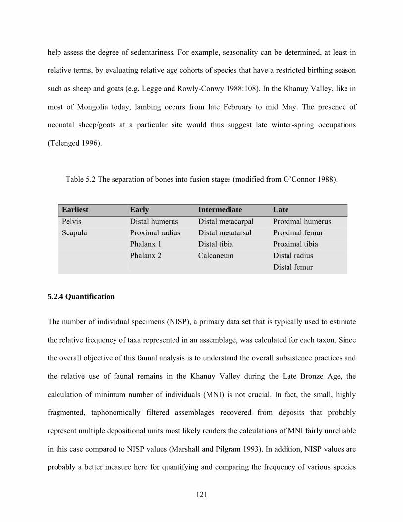
help assess the degree of sedentariness. For example, seasonality can be determined, at least in
relative terms, by evaluating relative age cohorts of species that have a restricted birthing season
such as sheep and goats (e.g. Legge and Rowly-Conwy 1988:108). In the Khanuy Valley, like in
most of Mongolia today, lambing occurs from late February to mid May. The presence of
neonatal sheep/goats at a particular site would thus suggest late winter-spring occupations
(Telenged 1996).
Table 5.2 The separation of bones into fusion stages (modified from O’Connor 1988).
Earliest Early Intermediate Late Pelvis Distal humerus Distal metacarpal Proximal humerus Scapula Proximal radius Distal metatarsal Proximal femur Phalanx 1 Distal tibia Proximal tibia Phalanx 2 Calcaneum Distal radius Distal femur
5.2.4 Quantification
The number of individual specimens (NISP), a primary data set that is typically used to estimate
the relative frequency of taxa represented in an assemblage, was calculated for each taxon. Since
the overall objective of this faunal analysis is to understand the overall subsistence practices and
the relative use of faunal remains in the Khanuy Valley during the Late Bronze Age, the
calculation of minimum number of individuals (MNI) is not crucial. In fact, the small, highly
fragmented, taphonomically filtered assemblages recovered from deposits that probably
represent multiple depositional units most likely renders the calculations of MNI fairly unreliable
in this case compared to NISP values (Marshall and Pilgram 1993). In addition, NISP values are
probably a better measure here for quantifying and comparing the frequency of various species
121
from our probably highly scattered contexts than are MNI values. Furthermore, the analysis of
the material suggests that taphonomic conditions were highly similar across all of the samples
and thus renders comparisons of proportion of NISP between samples acceptable. Meaningful
comparisons of the assemblages are thus still possible using measures of number of individual
specimens (NISP) by taxonomic group.
Due in part to the relatively small samples per unit, data was summed up to provide a
total NISP for each individual occupation area. This also helped to account for scattering effects
due to natural, animal and/or human activity (something we observe today around herder
campsites in the research area). In any event, a more intensive and site specific analysis of each
discrete unit was not necessary since the objective of this study was not an analysis of the spatial
organization of activities within occupations, but rather an analysis designed to deal with the
spatial organization of activities at a larger regional scale. Finally, following the survey and
excavation results, NISP values were further summed up according to the two major occupation
zones where the remains were found (i.e. ‘foothill’ occupation area and ‘riverside’ occupation
area) so as to provide an overall view of the domestic economy and in order to evaluate
seasonality of campsite locations.
5.2.5 The Faunal Assemblage
A total of 3511 bone specimens were recovered from the fourteen excavated occupation areas in
the Khanuy Valley. Unfortunately, most of the bones were recovered from mixed Bronze
Age/Iron Age Xiongnu contexts. While this data will also be discussed to some extent, the
following analyses will essentially cover bones that were recovered from stratigraphic contexts
that yielded Bronze Age ceramics only and no ceramics from other periods. This consists in a
total corpus of 679 diagnostic bones from eleven of the fourteen occupation areas (Table 5.3).
122
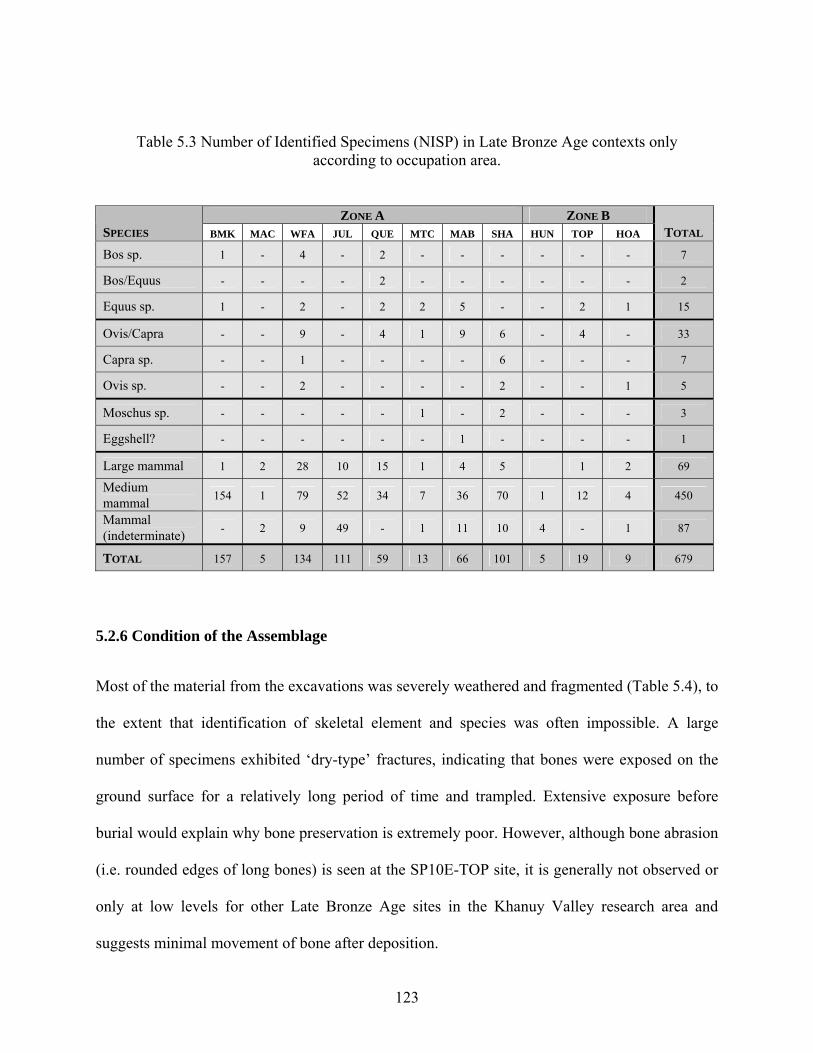
Table 5.3 Number of Identified Specimens (NISP) in Late Bronze Age contexts only according to occupation area.
ZONE A ZONE B SPECIES BMK MAC WFA JUL QUE MTC MAB SHA HUN TOP HOA TOTAL
Bos sp. 1 - 4 - 2 - - - - - - 7
Bos/Equus - - - - 2 - - - - - - 2
Equus sp. 1 - 2 - 2 2 5 - - 2 1 15
Ovis/Capra - - 9 - 4 1 9 6 - 4 - 33
Capra sp. - - 1 - - - - 6 - - - 7
Ovis sp. - - 2 - - - - 2 - - 1 5
Moschus sp. - - - - - 1 - 2 - - - 3
Eggshell? - - - - - - 1 - - - - 1
Large mammal 1 2 28 10 15 1 4 5 1 2 69
Medium mammal 154 1 79 52 34 7 36 70 1 12 4 450
Mammal (indeterminate) - 2 9 49 - 1 11 10 4 - 1 87
TOTAL 157 5 134 111 59 13 66 101 5 19 9 679
5.2.6 Condition of the Assemblage
Most of the material from the excavations was severely weathered and fragmented (Table 5.4), to
the extent that identification of skeletal element and species was often impossible. A large
number of specimens exhibited ‘dry-type’ fractures, indicating that bones were exposed on the
ground surface for a relatively long period of time and trampled. Extensive exposure before
burial would explain why bone preservation is extremely poor. However, although bone abrasion
(i.e. rounded edges of long bones) is seen at the SP10E-TOP site, it is generally not observed or
only at low levels for other Late Bronze Age sites in the Khanuy Valley research area and
suggests minimal movement of bone after deposition.
123
A high proportion of bone specimens recovered from the Late Bronze Age sites exhibit
signs of burning and calcination (evidenced by white/blue bone fragments with a chalky texture)
(Spennemann and Colley 1990:57). Almost all bones from BMK and MTC are calcined, while a
high proportion of bones from MAB, SHA, and WFA are calcined. Only three assemblages
(TOP, HUN and HOA), all from Zone B, provided no evidence of exposure to fire (Table 5.4).
The overall ubiquity of calcined material suggests that exposure to high temperatures was a
common occurrence at the sites (Reitz and Wing 1999:133), and probably contributed to the
fragmentary nature of the faunal assemblage. This is perhaps an indication that much of the
material accumulated as debris from cooking food, or bones being used as a fuel source, a
practice still common today in the research area and commonly discussed in anthropological and
archaeological literature (e.g. Thery-Parisot 2002). It may also be that bone refuse around herder
camp areas was occasionally gathered and burned intentionally as part of camp maintenance
activities. Modern herders inhabiting winter camps often pile and burn the bones of recently
butchered animals in piles, as well as other organic and inorganic trash, in order to reduce debris
around their sites.
Butchery marks were not a common feature of the assemblage, yet poor preservation,
especially burning, weathering and root damage observed on most bones may have obscured
both butchery marks and marks caused by scavenging animals (Table 5.4). However, although
no bone specimens exhibiting percussion fractures were recovered from any site, almost all
bones yielding ‘green-type’ fractures were highly fragmented (less than 10% in shaft
circumference and less than 3 cm in length). High fragmentation may indicate that bones were
heavily processed for their marrow and/or grease (Davis et al. 1987; Hanks 2004; Outram 2001),
a practice sometimes considered to reflect subsistence stress (Outram 1999, 2001). Noteworthy,
124
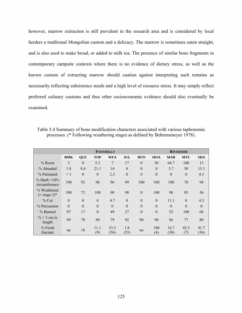
however, marrow extraction is still prevalent in the research area and is considered by local
herders a traditional Mongolian custom and a delicacy. The marrow is sometimes eaten straight,
and is also used to make bread, or added to milk tea. The presence of similar bone fragments in
contemporary campsite contexts where there is no evidence of dietary stress, as well as the
known custom of extracting marrow should caution against interpreting such remains as
necessarily reflecting subsistence needs and a high level of resource stress. It may simply reflect
preferred culinary customs and thus other socioeconomic evidence should also eventually be
examined.
Table 5.4 Summary of bone modification characters associated with various taphonomic processes. (* Following weathering stages as defined by Behrensmeyer 1978).
FOOTHILLS RIVERSIDE BMK QUE TOP WFA JUL HUN HOA MAB MTC SHA
% Roots 3 0 5.3 7 17 0 50 66.7 100 13 % Abraded 1.8 8.4 21.1 14 0 0 0 3.7 50 15.1 % Patinated < 1 0 0 2.3 0 0 0 0 0 4.3
% Shaft <10% circumference 100 92 98 96 99 100 100 100 70 94
% Weathered (> stage 2)* 100 72 100 90 98 0 100 98 85 56
% Cut 0 0 0 4.7 0 0 0 11.1 0 4.3 % Percussion 0 0 0 0 0 0 0 0 0 0
% Burned 97 17 0 49 27 0 0 52 100 68 % < 3 cm in
length 99 78 90 79 92 90 90 86 77 80
% Fresh fracture na 18 11.1
(9) 33.3 (56)
1.8 (53) na 100
(4) 16.7 (30)
42.5 (7)
41.7 (36)
125
5.2.7 Animal Exploitation
Animal taxa exploited at Late Bronze Age habitation sites in the Khanuy Valley include the four
main domesticates for this period and region: horse, cattle, sheep and goat (Table 5.3). In
addition, musk deer (Moschus moschiferus), the smallest of the deer species was the only wild
species encountered in the excavations, although in minute quantity (4% [n=3] of the faunal
material by NISP). From the animal bones that could be identified to taxa, sheep/goat is the most
commonly occurring taxon (65% [n=45] of the faunal material by NISP), followed by horse
(21% [n=15] of the faunal material by NISP) and cattle (10% [n=7] of the faunal material by
NISP). Musk deer, with a total NISP of three, only appears at two sites which are located along
the Khanuy River in Zone A (SP27E-MTC and SP32E-SHA). Biometrical and morphological
data are insufficient to determine the domestic status of the horses and bovids found at these
habitation sites, although the domestic nature of horses found at khirigsuurs has been confirmed
(see below) and those found at occupation areas is highly suggestive.
Indeed, and for comparative purposes, the relative proportion of different faunal remains
found at occupation areas in the Khanuy Valley is very different, for example, from what is
encountered at the Eneolithic site of Botai (Kazakhstan) where horses – the primarily hunted
animal – make up 99% of the faunal material (Dudd et al. 2003; Levine 1999; Olsen 2003). In
the Khanuy Valley, despite the fact that horses are the main, if not the only, ritually deposited
animal at khirigsuurs, they only make up about 21% of the recovered faunal material found in
occupation areas (only slightly less than in the subsequent Iron Age/Xiongnu period for which
mounted pastoralism is historically well established) and they are always associated with
sheep/goat bones (65% of the faunal material). There is thus no reason to believe that these horse
bones found at habitation sites were not domesticated species as well. Incidentally, this is also a
126
good reason for not relying on faunal remains from burial and/or ritual structures to reconstruct
subsistence practices!
Furthermore, although only eight equid specimens (including a whole tibia) from the
whole domestic assemblage (but from different contexts) provided fusion data, three of which
could be securely linked to Late Bronze Age contexts only, the bones fall clearly into two
groups. The first group consists of six fused skeletal elements that fall into the early and
intermediate categories of bone fusion (2 distal tibias, 1 proximal tibia, 2 pelvis [ischial part], 1
first phalanx), while the second group consists of three unfused skeletal elements (1 proximal
tibia, 1 calcaneum, 1 distal femur) that fall into the late and final categories of bone fusion (see
Table 5.2 above; and Silver 1969). Such a pattern suggests that the bones of both very young
animals and adult animals were missing from the assemblage, and that it consists of horses that
died between two and three years of age. Although the sex of these animals is unknown, this age
grade corresponds to the maximum meat weight and, if these were male, to a culling pattern
possibly linked to a herding strategy (Anthony 2007:204).
While this sample size is extremely small, it is, statistically speaking, very revealing.
Indeed, if the mortality distribution was due to herd-driving or random hunting, then we would
expect a similar proportion of horses in each age grade (or with slight differences depending if
the hunted herd was a family group or a bachelor group [Levine 1999:33]). As an idealized
starting point, then, we might expect about 7% 1-year-olds, 7% 2-year-olds, and so on up to 7%
15-year-olds. That means that 87% should be <2 or >3 years-old. Thus, if we were dealing with a
population of remains of horses 87% of whom died at <2 or >3, then there is only a 13% chance
that the first bone in our sample would have been aged between 2 and 3 years old. The chance
that the second bone would also be a 2-3 year old horse is .13 X .13. And so on. The chance that
127
all 8 bones (from different contexts) in our sample would be from horses aged 2-3 is .138 or
0.00000008. Therefore, we can be way over 99.99% confident that our sample did not come
from a population with 87% of the horses dying at <2 or >3. If, more realistically, the mortality
distribution was due to natural attrition, scavenging or livestock husbandry where meat
production was of secondary importance (such as for riding/mobility), then we might expect a
‘U-shaped’ or ‘fish-hook shaped’ mortality curve, that is, with horses dying at <5 or >8 years-old
(Levine 1999:29, 36). Accordingly, if horses 5-8 years old were not culled, then there are 11 age-
grades left to be represented among dead horses. If death fell evenly on those 11 age grades, then
dead horses in our sample would be 9% 2 year olds and 9% 3 year olds. In this case, that means
that 82% should be <2 or >3 years-old. Therefore, if we were dealing with a population of
remains of horses 82% of whom died at <2 or >3, then there is still only an 18% chance that the
first bone in our sample would have been aged between 2 and 3 years of age. The chance that the
second bone would also have been from a 2-3 year-old horse is .18 X .18. And so on. The chance
that all 8 bones (from different contexts) in our sample would be from horses aged 2-3 is .188 or
0.000001. Therefore, we can be way over 99.99% confident that our sample did not come from a
population with 82% of the horses dying at <2 or >3. In reality, the nature of a U-shaped
distribution involves more 1 year olds, fewer 2 year olds, still fewer 3 year olds, very few 4 year
olds, no 5-8 year olds, some 9 year olds, more 10 year olds, still more 11 year olds and so on up
to 15 year olds, but in the absence of any available comparative equid assemblage from mobile
pastoralist contexts with specific counts for each age grade, the abovementioned even
distribution provides the best educated guess for the moment and a close enough estimate for our
purposes—especially since however we slice it, the population of horse bones belonging to 2 or
3 year olds is going to turn out to be very unlikely to have come from that U-shaped death
128
distribution. In fact, the age distribution we have for our 8 horse bones from different contexts
(i.e. all about 2-3 years of age) is staggeringly different from the mortality profile we would get
from anything but a population herded at least partly for meat, and quite in line with what might
be expected if the horse remains found in domestic contexts were mostly horses butchered for
meat (Levine 1999:31).
Further support for a herding strategy is provided by two strong facts from horses found
at khirigsuurs. While these ritually deposited animals cannot be directly linked to subsistence
practices, they are probably linked to the feasting activities of the people that occupied the
nearby occupation areas. First, it has recently been confirmed that the horse remains found at
khirigsuurs are indeed domestic species and not Tarpan or Takhi (Przewalski) species
(Eurasian/Mongolian wild horses) (Sandra Olsen, personal communication). Second, the age
distribution of these horses strongly suggests selective culling (Allard et al. 2007; Sandra Olsen,
personal communication). Indeed, of the 15 horse remains from satellite mounds whose age was
determined, 9 (60%) were less than 4 years old, 5 (33%) were 15 years old or older, and only 1
(7%) was aged between 4 and 15 years old at the time of death (a 6-7 year old horse).
Furthermore, of three mound pairs excavated so far, two are characterized by an older (>15 years)
female in the larger mound and a young (< 4 years) horse of indeterminate sex in the smaller
mound (Allard et al. 2007). Despite this small sample size, this pattern is once again typical of a
herding strategy where meat is of prime importance, that is, a majority of both 2-3 year olds (if
these are indeed mostly males) and ca. 15 year old females (Anthony 2007:204; Levine 1999:27,
31).
129
5.2.8 Wild to Domestic Ratio
As indicated above, only extremely scant evidence exists for the exploitation of wild taxa and no
fish remains were found despite systematic screening. This is true for the whole assemblage of
3511 bones, irrespective of exact context. Examination of the results from Late Bronze Age
contexts reveals that only three specimens belong to deer (Moschus moschiferus). No other wild
taxa were identified in the assemblages, although an additional three bone elements belonging to
marmot (Marmota) were found from an unclear context. Although not the focus of this study, it
is worth mentioning that this lack of evidence at habitation sites for the exploitation of wild taxa
persists into the Iron Age/Xiongnu period in the research area, a time period for which we have
historical evidence that they hunted (Shiji,110: 2888)—but to what dietary extent is not known.
Clearly, the evidence provided by the domestic assemblages suggests an overwhelming
emphasis on domestic taxa for subsistence needs. This does not mean that wild species were not
exploited during the Late Bronze Age (as was the case during the Iron Age) in this region, but it
is likely that they did not contribute much to the overall subsistence requirements of the
settlement’s inhabitants. That is, they may represent only opportunistic additions to the diet.
Certainly, wild animals may have been so sparse in this region during the Late Bronze Age and
Early Iron Age that they were just not a very practical resource for exploitation except on a
casual and opportunistic basis, no matter how stable or unstable herding was; but it is also highly
possible that the extremely low degree of exploitation of wild resources resulted from the fact
that herding of domesticates could provide a fairly reliable and predictable source of resources,
requiring only very minimal supplementation from wild taxa. In fact, if the number of animals
found at khirigsuur sites is any indication of the overall availability of domestic faunal resources,
it seems likely that they were plentiful in or around the research area. Furthermore, the results of
130
the faunal analysis suggest that herding practices were probably already well developed at this
time. The presence of both sheep (ovis) and goat (capra), for example, suggests that a system of
complementary exploitation of these two species was already in place. “Sheep prefer to graze
herbaceous annuals and are more tolerant of cold and wet conditions, whereas goats prefer to
browse perennial plants and are better able to withstand heat and drought” (Garrard et al.
1996:210; Lancaster and Lancaster 1991). Accordingly, keeping mixed herds that have
complementary feeding behaviors and different climatic tolerances provide an insurance against
climatic variability as well as an effective way of utilizing available forage. Regardless, together
with the lack of evidence for plant cultivation (and an apparent minimal role of plant collecting),
the data presented here undeniably characterize the Late Bronze Age inhabitants of the Khanuy
Valley as ‘pastoralists’, as they are clearly engaged in a mode of subsistence that is based
primarily on the exploitation of domestic herd animals (Chang and Koster 1986:99; Cribb
1991:17; Krader 1959:499). It is important to note here, however, that in characterizing these
people as ‘pastoralists’, I do not imply anything about identity issues and other cultural baggage
that are sometimes connected to this term. I only imply that their subsistence system revolves
primarily around domesticated herd animals with a minimal role for hunting, plant cultivation, or
plant collecting.
5.2.9 Seasonality and Mobility
Seasonality of occupation areas based on the age of animals is unclear for the moment. The fact
is that specimens exhibiting useful ageing data for determining seasonality were limited to a
metacarpal and vertebra belonging to an infant-aged caprine from SP27E-MTC and a rib blade
from an infant-aged medium-sized ungulate from SP31E-JUL. In the Khanuy Valley, sheep and
goats are usually born from February to May, and horses and cattle from March to May. The
131
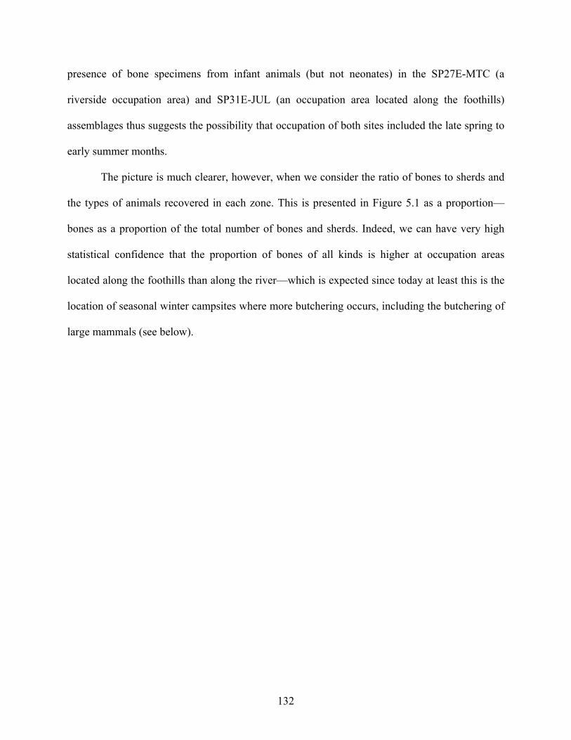
presence of bone specimens from infant animals (but not neonates) in the SP27E-MTC (a
riverside occupation area) and SP31E-JUL (an occupation area located along the foothills)
assemblages thus suggests the possibility that occupation of both sites included the late spring to
early summer months.
The picture is much clearer, however, when we consider the ratio of bones to sherds and
the types of animals recovered in each zone. This is presented in Figure 5.1 as a proportion—
bones as a proportion of the total number of bones and sherds. Indeed, we can have very high
statistical confidence that the proportion of bones of all kinds is higher at occupation areas
located along the foothills than along the river—which is expected since today at least this is the
location of seasonal winter campsites where more butchering occurs, including the butchering of
large mammals (see below).
132
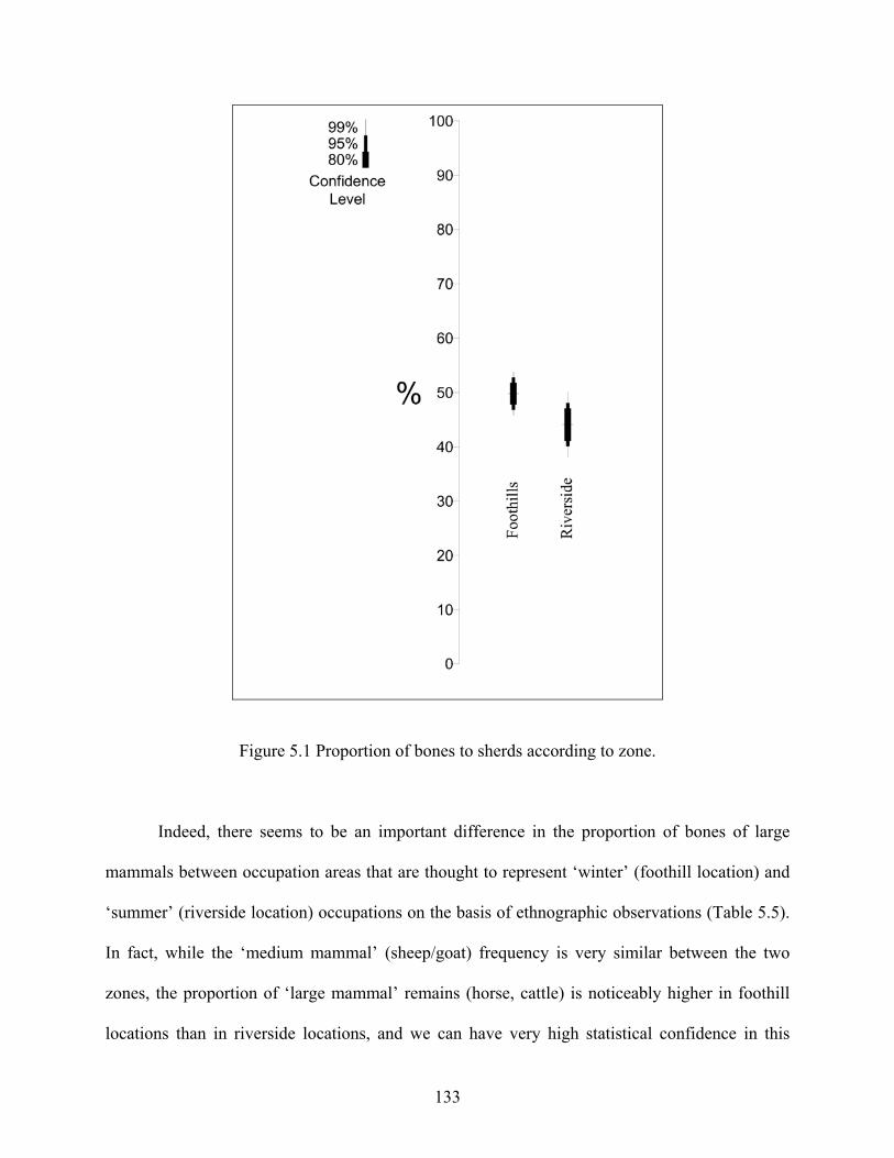
Figure 5.1 Proportion of bones to sherds according to zone.
Indeed, there seems to be an important difference in the proportion of bones of large
mammals between occupation areas that are thought to represent ‘winter’ (foothill location) and
‘summer’ (riverside location) occupations on the basis of ethnographic observations (Table 5.5).
In fact, while the ‘medium mammal’ (sheep/goat) frequency is very similar between the two
zones, the proportion of ‘large mammal’ remains (horse, cattle) is noticeably higher in foothill
locations than in riverside locations, and we can have very high statistical confidence in this
133
observation (Figure 5.2). Of significance here is the fact that modern Mongolian herding families
generally kill large animals (cattle and horses) only during the late fall (usually around
November, which also corresponds to when the animals are the fattest) so that meat does not go
to waste due to spoilage (Levine 1999:25). Interestingly, this also corresponds to the time when
horses associated with khirigsuur monuments were most likely slaughtered (Sandra Olsen,
personal communication).
Therefore, the different proportion of bones in each zone and the differential distribution
of faunal remains between sites located along the foothills and sites located along the Khanuy
River substantiates the suggestion from ethnographic observation that camps located in the small
draws at the edge of the valley could have indeed been winter camps, while occupation areas
located near the river could have been summer camps (i.e. a very restricted mobility pattern).
The fact that cattle remains are only found in foothill site locations further substantiates the idea
that these locales were probably winter campsite locations, while the presence of musk deer at
sites only located along the river suggests that these locations were probably summer/fall
campsites since today, at least, deer hunting in Mongolia is practiced in late summer/early fall
when these animals are at their maximum weight.
Regardless, taken together, all these seasonal indicators further support the idea that Late
Bronze Age people occupied this whole area year round. Indeed, there is evidence that they
occupied this region during the late spring to early summer months (evidenced by the young
animals at occupation areas), the late summer/early fall months (evidenced by the deer remains
at occupation areas), and during the fall/winter period (evidenced by the highly probable
seasonality of horses at khirigsuurs). Accordingly, the available Late Bronze Age faunal data
does suggest a perennial occupation of the research area, and thus supports the very restricted
134
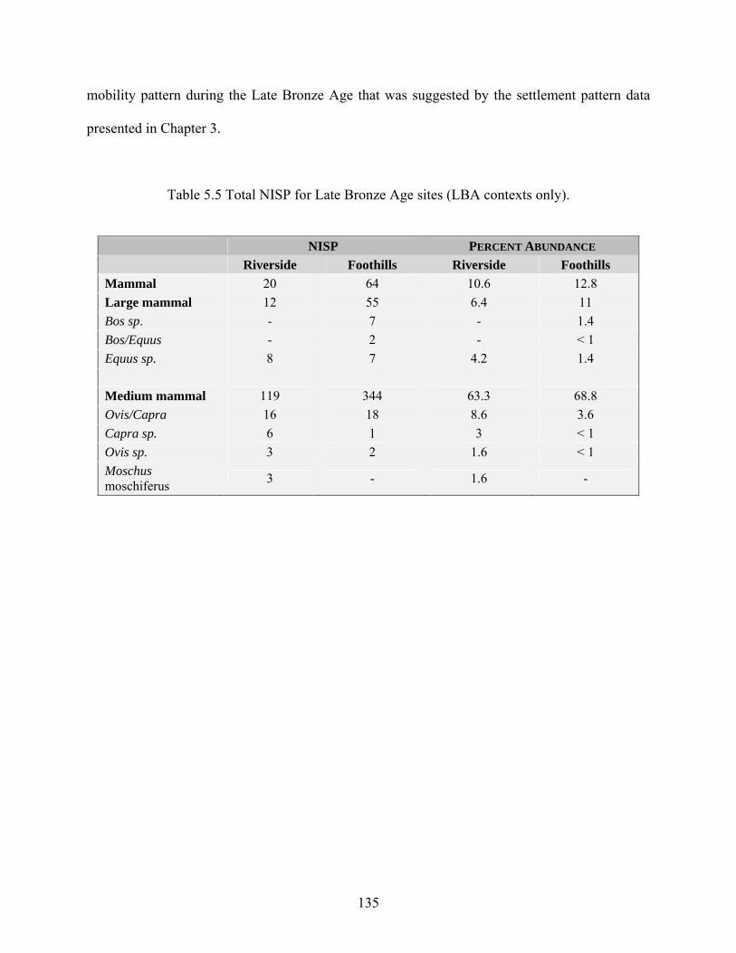
mobility pattern during the Late Bronze Age that was suggested by the settlement pattern data
presented in Chapter 3.
Table 5.5 Total NISP for Late Bronze Age sites (LBA contexts only).
NISP PERCENT ABUNDANCE Riverside Foothills Riverside Foothills Mammal 20 64 10.6 12.8 Large mammal 12 55 6.4 11 Bos sp. - 7 - 1.4 Bos/Equus - 2 - < 1 Equus sp. 8 7 4.2 1.4 Medium mammal 119 344 63.3 68.8 Ovis/Capra 16 18 8.6 3.6 Capra sp. 6 1 3 < 1 Ovis sp. 3 2 1.6 < 1 Moschus moschiferus 3 - 1.6 -
135
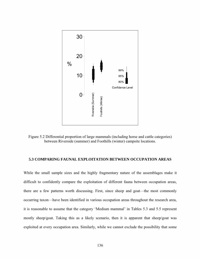
Figure 5.2 Differential proportion of large mammals (including horse and cattle categories) between Riverside (summer) and Foothills (winter) campsite locations.
5.3 COMPARING FAUNAL EXPLOITATION BETWEEN OCCUPATION AREAS
While the small sample sizes and the highly fragmentary nature of the assemblages make it
difficult to confidently compare the exploitation of different fauna between occupation areas,
there are a few patterns worth discussing. First, since sheep and goat—the most commonly
occurring taxon—have been identified in various occupation areas throughout the research area,
it is reasonable to assume that the category ‘Medium mammal’ in Tables 5.3 and 5.5 represent
mostly sheep/goat. Taking this as a likely scenario, then it is apparent that sheep/goat was
exploited at every occupation area. Similarly, while we cannot exclude the possibility that some
136
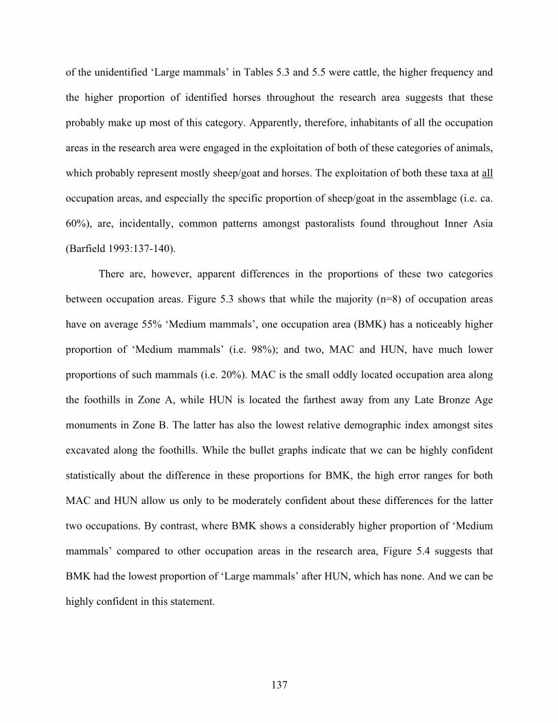
of the unidentified ‘Large mammals’ in Tables 5.3 and 5.5 were cattle, the higher frequency and
the higher proportion of identified horses throughout the research area suggests that these
probably make up most of this category. Apparently, therefore, inhabitants of all the occupation
areas in the research area were engaged in the exploitation of both of these categories of animals,
which probably represent mostly sheep/goat and horses. The exploitation of both these taxa at all
occupation areas, and especially the specific proportion of sheep/goat in the assemblage (i.e. ca.
60%), are, incidentally, common patterns amongst pastoralists found throughout Inner Asia
(Barfield 1993:137-140).
There are, however, apparent differences in the proportions of these two categories
between occupation areas. Figure 5.3 shows that while the majority (n=8) of occupation areas
have on average 55% ‘Medium mammals’, one occupation area (BMK) has a noticeably higher
proportion of ‘Medium mammals’ (i.e. 98%); and two, MAC and HUN, have much lower
proportions of such mammals (i.e. 20%). MAC is the small oddly located occupation area along
the foothills in Zone A, while HUN is located the farthest away from any Late Bronze Age
monuments in Zone B. The latter has also the lowest relative demographic index amongst sites
excavated along the foothills. While the bullet graphs indicate that we can be highly confident
statistically about the difference in these proportions for BMK, the high error ranges for both
MAC and HUN allow us only to be moderately confident about these differences for the latter
two occupations. By contrast, where BMK shows a considerably higher proportion of ‘Medium
mammals’ compared to other occupation areas in the research area, Figure 5.4 suggests that
BMK had the lowest proportion of ‘Large mammals’ after HUN, which has none. And we can be
highly confident in this statement.
137
Further examination of Figure 5.4 shows that four (MAC, WFA, QUE, HOA), but
especially one (MAC) occupation area stands out as having the highest proportion of ‘Large
mammals’. By contrast, MAC has one of the two lowest proportions of ‘Medium mammals’ in
the whole of the research area. This may thus suggest that the inhabitants of this occupation area
were more specialized in herding ‘Large mammals’. It may also mean that they butchered and/or
consumed more ‘Large mammals’ than others, despite the possibility that they were not herding
them themselves. The latter is actually more probable given the limited space within this small
occupation area, although animals could have been kept a short distance away. Owing to the
large error ranges, however, we can only have very little confidence that these differences in
proportions are not only due to the vagaries of sampling.
138
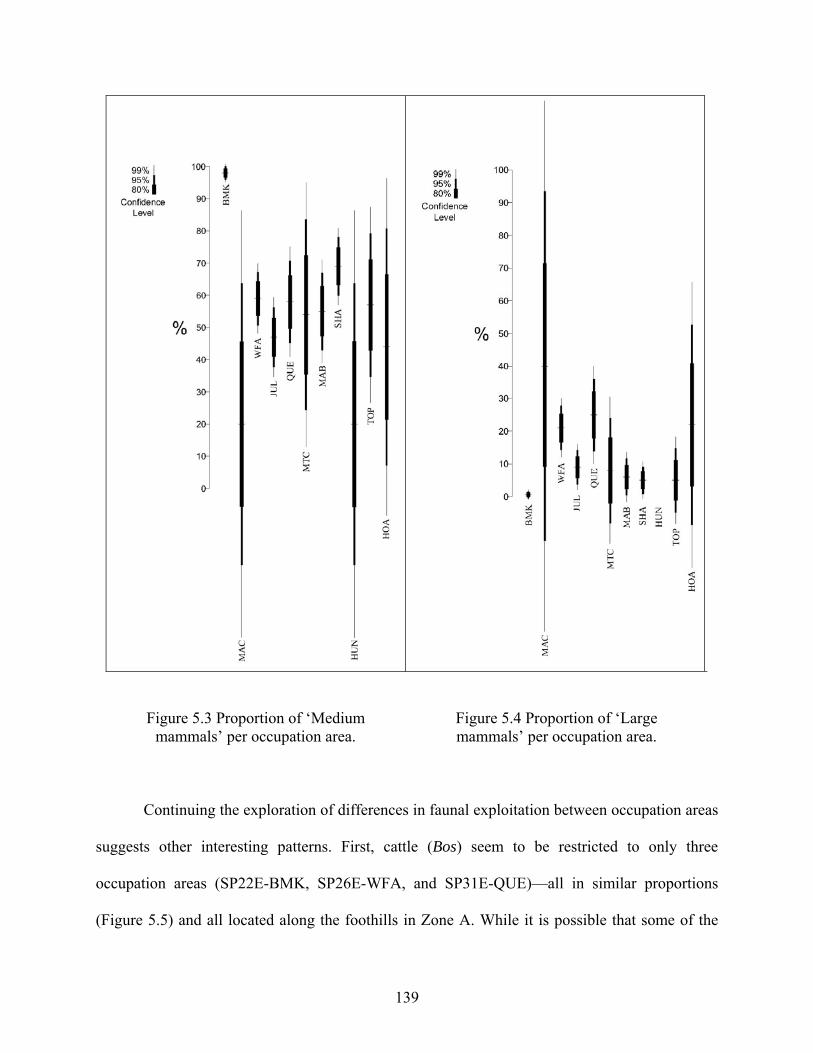
Figure 5.3 Proportion of ‘Medium mammals’ per occupation area.
Figure 5.4 Proportion of ‘Large mammals’ per occupation area.
Continuing the exploration of differences in faunal exploitation between occupation areas
suggests other interesting patterns. First, cattle (Bos) seem to be restricted to only three
occupation areas (SP22E-BMK, SP26E-WFA, and SP31E-QUE)—all in similar proportions
(Figure 5.5) and all located along the foothills in Zone A. While it is possible that some of the
139
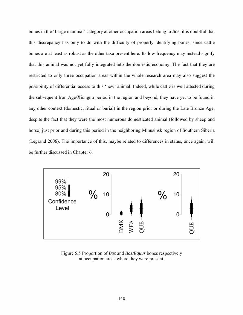
bones in the ‘Large mammal’ category at other occupation areas belong to Bos, it is doubtful that
this discrepancy has only to do with the difficulty of properly identifying bones, since cattle
bones are at least as robust as the other taxa present here. Its low frequency may instead signify
that this animal was not yet fully integrated into the domestic economy. The fact that they are
restricted to only three occupation areas within the whole research area may also suggest the
possibility of differential access to this ‘new’ animal. Indeed, while cattle is well attested during
the subsequent Iron Age/Xiongnu period in the region and beyond, they have yet to be found in
any other context (domestic, ritual or burial) in the region prior or during the Late Bronze Age,
despite the fact that they were the most numerous domesticated animal (followed by sheep and
horse) just prior and during this period in the neighboring Minusinsk region of Southern Siberia
(Legrand 2006). The importance of this, maybe related to differences in status, once again, will
be further discussed in Chapter 6.
Figure 5.5 Proportion of Bos and Bos/Equus bones respectively at occupation areas where they were present.
140
Finally, when contrasting the proportion of the different faunal remains between
occupation areas, it is clear that BMK is the greatest outlier. BMK has not only the highest
proportion (>98%) of medium sized mammals (probably sheep/goat), but conversely it also has
the lowest proportion (<2%) of large sized mammals (probably horse and cattle), which
wealthier and more prestigious households usually have more of (Christian 1998:187; Howe
2008: Chapter 2). At first glance, this could suggest the possibility of some early and particular
form of “pastoral feudalism” (and I take this term lightly) where poorer families take care of part
of a wealthier family’s herd (usually sheep/goat) in exchange for some of the animals’
byproducts—something that is well attested for in more recent times (Fernandez-Gimenez
1999:320; Jagchid and Hyer 1979:298; Lattimore 1962:546-550). Furthermore, despite the fact
that we can only have little statistical confidence in this observation (see Figures 5.3 and 5.4),
this might also explain the inverse pattern found at MAC, that is, a much lower proportion of
‘Medium mammals’ and a much higher proportion of ‘Large mammals’. Accordingly, the much
higher than average proportion of medium mammals together with the much lower proportion of
large mammals at BMK might be explained by the possibility that people living there were
herding animals (sheep/goat) belonging to another household—possibly those of MAC. Of
course, this may not have been a “feudal system” at all since it might also have been based on a
common agreement and/or the shared ownership of herds. To be sure, as we shall see in Chapter
6, BMK has more artifactual indicators of status than does MAC, a pattern that is contrary to
what would be expected if the inhabitants of BMK were the poorer and dependant ones.
Accordingly, inhabitants of BMK could simply have been wealthier in terms of the number of
sheep/goat they had (and this is also one of only three sites were cattle remains were found),
while the inhabitants of MAC could have been engaged in activities other than herding—which
141
on the surface seems the most plausible. The implications of this in terms of status will also be
discussed in the following chapter.
5.4 SUMMARY
In sum, despite some differences in the proportions of herded animals between occupation areas,
the overwhelming lack of evidence for alternative subsistence strategies discussed in the first
part of this chapter (i.e. little evidence of wild species, no artifacts related to plant cultivation, no
domestic plant remains discovered despite systematic screening and some flotation), together
with the seasonality evidence suggest that the most likely economic strategy for the groups living
in the Khanuy Valley during the Late Bronze Age was a well established restricted form of
mobile pastoralism, primarily based on the herding of sheep and horse, and to a lesser degree
goat and cattle (for a select few), with only minimal supplementation of wild plants and animals.
142
6.0 SOCIAL AND ECONOMIC DIFFERENTIATION The emergence of social and economic differentiation is of obvious importance to the topic of
the evolution of complex societies (Earle 1987, 1991; Hayden 2001; Hirth 1993; Price and
Feinman 1995). And in this present quest to explain what kinds of processes may account for the
first clear steps toward hierarchical organization and status differentiation in central Mongolia,
the topic is of clear importance for evaluating the nature and social organization of the groups
that inhabited this area during the pivotal Late Bronze Age. The ability to identify ranking (social
differences) in the archaeological record, if present, is thus crucial to the issue.
Before doing this, however, I begin this discussion with brief definitions of what I mean
by ‘social status’ and ‘economic specialization’—both of which are addressed in different
sections of this chapter. First, I take ‘social status’ to be a very broad category of hierarchical
social differentiation that could subsume more specific features like wealth or prestige. At this
stage of the research I do not find it useful (or even possible) to tease out these differences.
Certainly this is a worthwhile endeavor and it will eventually be dealt with, but for now it avoids
having to make a subjective distinction, for example, between whether the differential number of
domesticated animals per occupation area discussed in Chapter 5 represents wealth or prestige
differences. In all likelihood they represent both and this is well recognized ethnographically.
For example, having domestic animals in Southeast Asia (Hayden 2001), and accumulating large
herds of animals in pastoralist societies (Solomon et al. 2007:484) not only brings wealth but
143
also social prestige. What is important here as a first step is identifying whether or not there was
social variability of a hierarchical nature in Late Bronze Age Mongolia, and if so to what degree.
Second, in this present study I consider ‘economic specialization’ in a manner that also
refers to the sorts of minimal differentiation of productive activities that may even occur in early
forms of complex societies. In this sense, “even part-time specialists differ from non-specialists”
(Wason 1994:107). Once again, the important objective right now is not to pigeonhole
everything in discrete categories, but to evaluate if and how social variability is expressed and if
so in what social spheres they are expressed. The following section addresses the issue of social
status, while economic specialization is dealt with subsequently.
6.1 ARCHAEOLOGICAL INDICATORS OF SOCIAL STATUS
Three types of data are frequently used to identify status differences: burials, residential
architecture and household artifacts (Smith 1987). In the case of pastoralists, as discussed above,
we can also expect status to be tied to larger herd sizes (e.g. Earle 1997:100; Fratkin and Roth
1990), which in archaeological terms may in some cases be observed by larger, more elaborate
corrals (Aldenderfer 2001:407). In addition, indicators of feasting activities may also be present,
particularly those that are linked to alliance building and generating reciprocal obligations
(Hayden 1995, 2001).
It has been argued in Chapter 1 that the burials and the monumental structures of the Late
Bronze Age are ambiguous in terms of evaluating the nature of the social and economic
organization of the peoples inhabiting the Khanuy Valley at this time. They do suggest a
complex social organization; and the size and elaboration of some of these monuments do
144
suggest fairly large labor investments and social differences, but they have yet to produce the
more direct kinds of data, such as grave goods, that correlate specifically with social status. The
apparent absence of any kind of residential architecture for the Late Bronze Age, however, also
impedes our ability to identify the possibility of higher status people by examining whether or
not there were larger or more elaborate houses—perhaps the strongest expressions of status
differences (Hirth 1993:123; Smith 1987; but see Cribb 1991:101-105). By extending the
analysis to include variation in domestic activities, however, it is possible to evaluate if and how
social variability is expressed in everyday life. To be sure, domestic artifacts are typically good
markers of social status (Hirth 1993; Turkon 2004; Smith 1987).
Although data is relatively scarce and comparative inventories are difficult to gather for
Late Bronze Age Mongolia (Honeychurch 2004:118), according to what is known from at least
some burial evidence higher status occupation areas could be indicated by larger quantities of
metal goods, especially those of symbolic as well as practical nature such as buckles and bronze
buttons (Tsybiktarov 2003:91), bronze arrowheads or possibly Karasuk-type daggers and knives.
High status occupation areas could also be identified by the presence of other prestige items,
including long-distance trade goods (Hirth 1978; Kristiansen 1991:33, 1998:187; Smith 1987)
such as Karasuk items once again (Askarov et al. 1992; Gryaznov 1969:98; Legrand 2004;
Volkov 1967, 1995), as well as cowries and mother-of-pearl, turquoise beads, etc. (Erdenebaatar
2002, 2004; Ishjamts 1994:152; Volkov 1995:321; personal observations). While the
identification of these abovementioned items in domestic contexts is doubtful due to their usual
location in burials (i.e. they are not expected to be abandoned in non-burial contexts due to their
high value), higher status occupation areas could also be indicated by higher proportions of high
quality ceramics or lithics generally. The range of variability in the quantity and quality of these
145
items between occupation areas would speak to the degree of social differentiation, while the
nature of the evidence would relate to the bases of social differentiation.
6.1.1 Metal Goods
Almost nothing of the sorts described above in terms of metal goods has been found in the
excavated Khanuy Valley occupation areas. Save for one bronze arrowhead discovered at the
SP32E-MAB occupation area, no metal goods (either of symbolic or of practical nature) have
been recovered. One bronze vessel fragment identified generally to the Late Bronze Age/Early
Iron Age was found on the ground surface during the systematic shovel-probe survey, but its
context is unclear and nothing else was found associated with it. The nearest site is SP08E-GER
(a very small mixed Bronze Age/Xiongnu site) and nothing else was found there that might
suggest the site of a higher status person/group.
6.1.2 Faunal Remains
Where there is possibly a slight hint of discrepancy between occupation areas, as mentioned in
Chapter 5, is in the differential presence of cattle (Bos). Indeed, while sheep/goat and horse are
apparently present at all campsites, it is noticeable that cattle (Bos) are only clearly present at
three sites (SP22E-BMK, SP26E-WFA, and SP31E-QUE), all located in the largest valley draws
along the foothills in Zone A—the zone located at the heart of a cluster of monumental sites.
This might be important since it is the first clear evidence at the moment for the presence of
cattle in this region during the Late Bronze Age. While there is very little known, not to say
nothing, about cattle domestication in Mongolia (see Chapter 1), domestic cattle only really
make their mark in the archaeological record during the subsequent Iron Age Xiongnu period
when they are attested as draft animals and when parts of these animals are also deliberately
146
deposited in burials (e.g. Miller et al. 2006 for a Khanuy Valley example). By contrast, beyond
the cattle remains discovered at the three abovementioned sites, there is as yet no other evidence
of cattle in any Late Bronze Age contexts (domestic, ritual or funerary) in the Khanuy Valley
region. And this is despite the fact, once again, that cattle were the most numerous domesticated
animals just prior and during this period in the neighboring region of southern Siberia (Legrand
2006) and the second most prevalent animal in neighboring southeastern Kazakhstan (Frachetti
2004:357). Therefore, differential access to this ‘new’ animal in this region could indicate
differences in status.
Further evidence for the possibility of status differences comes from the differential
proportion of animals at different occupation areas. Certainly, while it is archaeologically
difficult to discuss status differences based on relative numbers of animals (e.g. Cribb 1991:35,
42)—although this is well attested for ethnohistorically among pastoralists – see for example
Bonte 1977; Khazanov 1994:152; Shahrani 1979:165, 182; Vainshtein 1980:103-109), it is
noticeable that the three occupation areas which yielded cattle remains (BMK, WFA, QUE) also
yielded amongst the highest proportion of large and/or medium sized mammals (see Figures 5.3
and 5.4 in Chapter 5). Of these three occupation areas located in Zone A, two (BMK and WFA)
also have the highest indicator of status based on proportions of decorated ceramics (see full
discussion of this below). SP22E-BMK is particularly intriguing since it is an outlier in terms of
proportions of large and medium mammals from all other sites in the research area. Indeed, this
occupation area produced by far both the highest proportion (98% [n=154] by NISP) of medium
sized animals (sheep/goat) and the smallest proportion (0.6% [n=1] by NISP) of large mammals
(horse, cattle) and we can have high statistical confidence in this observation (see Figures 5.3
and 5.4 in Chapter 5). While this discrepancy is difficult to explain, the occupants of this site
147
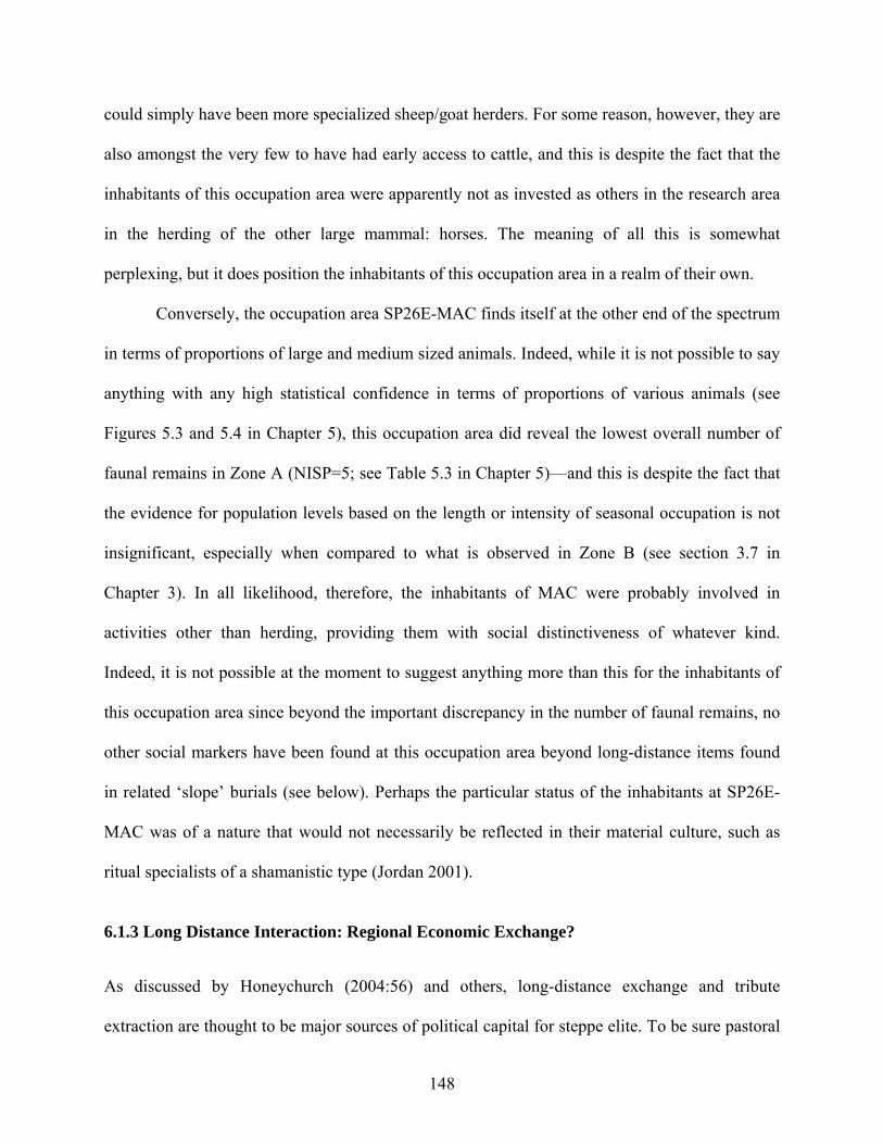
could simply have been more specialized sheep/goat herders. For some reason, however, they are
also amongst the very few to have had early access to cattle, and this is despite the fact that the
inhabitants of this occupation area were apparently not as invested as others in the research area
in the herding of the other large mammal: horses. The meaning of all this is somewhat
perplexing, but it does position the inhabitants of this occupation area in a realm of their own.
Conversely, the occupation area SP26E-MAC finds itself at the other end of the spectrum
in terms of proportions of large and medium sized animals. Indeed, while it is not possible to say
anything with any high statistical confidence in terms of proportions of various animals (see
Figures 5.3 and 5.4 in Chapter 5), this occupation area did reveal the lowest overall number of
faunal remains in Zone A (NISP=5; see Table 5.3 in Chapter 5)—and this is despite the fact that
the evidence for population levels based on the length or intensity of seasonal occupation is not
insignificant, especially when compared to what is observed in Zone B (see section 3.7 in
Chapter 3). In all likelihood, therefore, the inhabitants of MAC were probably involved in
activities other than herding, providing them with social distinctiveness of whatever kind.
Indeed, it is not possible at the moment to suggest anything more than this for the inhabitants of
this occupation area since beyond the important discrepancy in the number of faunal remains, no
other social markers have been found at this occupation area beyond long-distance items found
in related ‘slope’ burials (see below). Perhaps the particular status of the inhabitants at SP26E-
MAC was of a nature that would not necessarily be reflected in their material culture, such as
ritual specialists of a shamanistic type (Jordan 2001).
6.1.3 Long Distance Interaction: Regional Economic Exchange?
As discussed by Honeychurch (2004:56) and others, long-distance exchange and tribute
extraction are thought to be major sources of political capital for steppe elite. To be sure pastoral
148
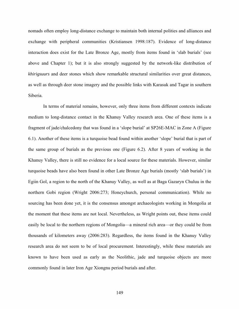
nomads often employ long-distance exchange to maintain both internal polities and alliances and
exchange with peripheral communities (Kristiansen 1998:187). Evidence of long-distance
interaction does exist for the Late Bronze Age, mostly from items found in ‘slab burials’ (see
above and Chapter 1); but it is also strongly suggested by the network-like distribution of
khirigsuurs and deer stones which show remarkable structural similarities over great distances,
as well as through deer stone imagery and the possible links with Karasuk and Tagar in southern
Siberia.
In terms of material remains, however, only three items from different contexts indicate
medium to long-distance contact in the Khanuy Valley research area. One of these items is a
fragment of jade/chalcedony that was found in a ‘slope burial’ at SP26E-MAC in Zone A (Figure
6.1). Another of these items is a turquoise bead found within another ‘slope’ burial that is part of
the same group of burials as the previous one (Figure 6.2). After 8 years of working in the
Khanuy Valley, there is still no evidence for a local source for these materials. However, similar
turquoise beads have also been found in other Late Bronze Age burials (mostly ‘slab burials’) in
Egiin Gol, a region to the north of the Khanuy Valley, as well as at Baga Gazaryn Chuluu in the
northern Gobi region (Wright 2006:273; Honeychurch, personal communication). While no
sourcing has been done yet, it is the consensus amongst archaeologists working in Mongolia at
the moment that these items are not local. Nevertheless, as Wright points out, these items could
easily be local to the northern regions of Mongolia—a mineral rich area—or they could be from
thousands of kilometers away (2006:283). Regardless, the items found in the Khanuy Valley
research area do not seem to be of local procurement. Interestingly, while these materials are
known to have been used as early as the Neolithic, jade and turquoise objects are more
commonly found in later Iron Age Xiongnu period burials and after.
149
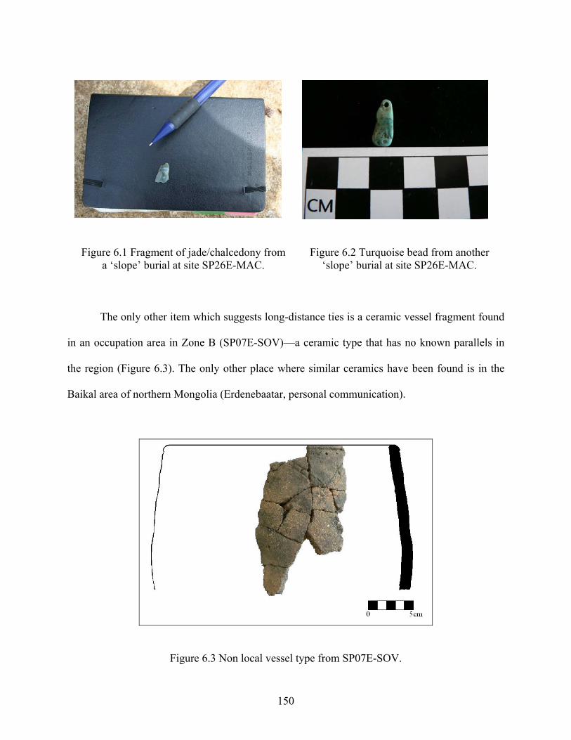
Figure 6.1 Fragment of jade/chalcedony from a ‘slope’ burial at site SP26E-MAC.
Figure 6.2 Turquoise bead from another ‘slope’ burial at site SP26E-MAC.
The only other item which suggests long-distance ties is a ceramic vessel fragment found
in an occupation area in Zone B (SP07E-SOV)—a ceramic type that has no known parallels in
the region (Figure 6.3). The only other place where similar ceramics have been found is in the
Baikal area of northern Mongolia (Erdenebaatar, personal communication).
Figure 6.3 Non local vessel type from SP07E-SOV.
150
This is indeed very scant evidence for long-distance interaction and it is doubtful that it
would have had much economic importance—although it is clear that it does not have to in order
to provide important indicators of status (see for example Malinowski's study of the Kula Ring in
Melanesia). Indeed, as Renfrew and Bahn point out, “interaction involves the exchange not only
of material goods but of information, which includes ideas, symbols, inventions, aspirations, and
values” (2004:389). It may well be, therefore, that it was the symbolic/ideological aspects of
interaction rather than the material goods themselves that were the most significant in defining
social status—perhaps to establish and reinforce alliances.
6.1.4 Ceramics and Social Differences
As mentioned above, another way of looking at social status is to evaluate whether or not some
occupation areas have higher proportions of high quality items (Smith 1987). No especially
fancy prestige goods were discovered during excavations, yet ceramics make up an important
part of the artifactual corpus. And since it is assumed that higher status people will usually have
access to more elaborate or fancier dishware—for feasting activities for example (e.g. Junker
2001),—then it can be assumed that a greater proportion of higher-quality/fancier ceramics at
only some sites could indicate the presence of comparatively higher status people (Kruschek
2003; Smith 1987; Turkon 2004). While it is certainly possible for ‘commoners’ to have access
to at least some prestige items, it is anticipated that higher status people will have access to
relatively more of them (Smith 1987:314). Due to the fact that potsherds from our ceramic
inventory are usually very small fragments of the original vessels, relative differences in status
can mostly be assessed through the relative abundance of decorated ceramics. Too few rim
sherds have been found to compare vessel types, but their analysis does provide information
regarding the relative size of some vessels.
151
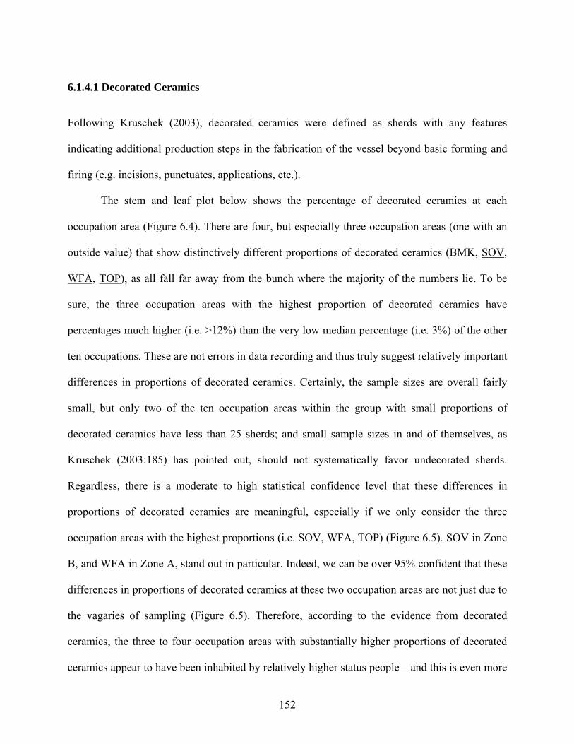
6.1.4.1 Decorated Ceramics
Following Kruschek (2003), decorated ceramics were defined as sherds with any features
indicating additional production steps in the fabrication of the vessel beyond basic forming and
firing (e.g. incisions, punctuates, applications, etc.).
The stem and leaf plot below shows the percentage of decorated ceramics at each
occupation area (Figure 6.4). There are four, but especially three occupation areas (one with an
outside value) that show distinctively different proportions of decorated ceramics (BMK, SOV,
WFA, TOP), as all fall far away from the bunch where the majority of the numbers lie. To be
sure, the three occupation areas with the highest proportion of decorated ceramics have
percentages much higher (i.e. >12%) than the very low median percentage (i.e. 3%) of the other
ten occupations. These are not errors in data recording and thus truly suggest relatively important
differences in proportions of decorated ceramics. Certainly, the sample sizes are overall fairly
small, but only two of the ten occupation areas within the group with small proportions of
decorated ceramics have less than 25 sherds; and small sample sizes in and of themselves, as
Kruschek (2003:185) has pointed out, should not systematically favor undecorated sherds.
Regardless, there is a moderate to high statistical confidence level that these differences in
proportions of decorated ceramics are meaningful, especially if we only consider the three
occupation areas with the highest proportions (i.e. SOV, WFA, TOP) (Figure 6.5). SOV in Zone
B, and WFA in Zone A, stand out in particular. Indeed, we can be over 95% confident that these
differences in proportions of decorated ceramics at these two occupation areas are not just due to
the vagaries of sampling (Figure 6.5). Therefore, according to the evidence from decorated
ceramics, the three to four occupation areas with substantially higher proportions of decorated
ceramics appear to have been inhabited by relatively higher status people—and this is even more
152
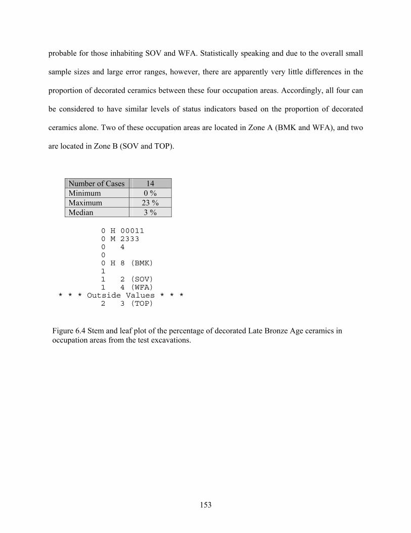
probable for those inhabiting SOV and WFA. Statistically speaking and due to the overall small
sample sizes and large error ranges, however, there are apparently very little differences in the
proportion of decorated ceramics between these four occupation areas. Accordingly, all four can
be considered to have similar levels of status indicators based on the proportion of decorated
ceramics alone. Two of these occupation areas are located in Zone A (BMK and WFA), and two
are located in Zone B (SOV and TOP).
Number of Cases 14 Minimum 0 % Maximum 23 % Median 3 %
0 H 00011 0 M 2333 0 4 0 0 H 8 (BMK) 1 1 2 (SOV) 1 4 (WFA)
* * * Outside Values * * * 2 3 (TOP)
Figure 6.4 Stem and leaf plot of the percentage of decorated Late Bronze Age ceramics in occupation areas from the test excavations.
153
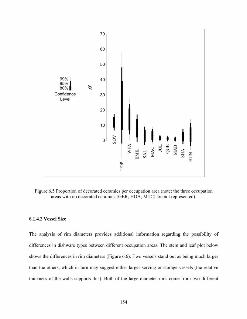
Figure 6.5 Proportion of decorated ceramics per occupation area (note: the three occupation areas with no decorated ceramics [GER, HOA, MTC] are not represented).
6.1.4.2 Vessel Size
The analysis of rim diameters provides additional information regarding the possibility of
differences in dishware types between different occupation areas. The stem and leaf plot below
shows the differences in rim diameters (Figure 6.6). Two vessels stand out as being much larger
than the others, which in turn may suggest either larger serving or storage vessels (the relative
thickness of the walls supports this). Both of the large-diameter rims come from two different
154
vessels, which are nonetheless similarly decorated (i.e. with fingernail impressions). The fact that
both of these unique large diameter rimed vessels come from a single occupation area suggests
that there were plausibly different activities going on at this site which is located within a valley
draw along the foothills in Zone B (i.e. SP07E-SOV). It is also worth mentioning that the vessel
with the fourth to largest rim diameter is also located within this site. Although it is not
decorated, this rim is more elaborate in shape than others at this site and comes from a
completely different vessel type, one that is not seen in any other occupations in the research
area (see second example in Figure 2.1). Finally, it is noteworthy that this occupation area is also
one of the three abovementioned high outliers for decorated ceramic percentages.
Number of Cases 14 Minimum 10 cm Maximum 50 cm Median 24 cm
1 0 1 H 668 2 M 0244 2 68 3 H 2 (SOV) 3 6 4 4 8 (SOV) 5 0 (SOV)
Figure 6.6 Stem and leaf plot of the diameter of rim sherds (in cm) found in occupation areas during the test excavations.
155
6.2 SUMMARY OF STATUS INDICATORS
While there is a lot of variability, four (but especially one) occupation areas stand out in
particular in terms of having the most identified markers of status differentiation: three in Zone
A (BMK, WFA, MAC) and one in Zone B (SOV). Indeed, compared to all the other occupation
areas, BMK and WFA are characterized as having both a higher proportion of animals generally
and a high proportion of decorated ceramics. In addition, these occupation areas are two of the
only three sites to have yielded cattle remains.
MAC, on the other hand, distinguishes itself by having yielded the fewest faunal remains,
and this despite the fact that the site seems to have been occupied fairly intensely or for a lengthy
period of time. This type of occupation together with the lack of faunal remains thus suggests
that the inhabitants of this occupation area were engaged in activities other than herding, the
nature of which is unknown for the moment. However, while the domestic assemblage did not
reveal any other status markers, two ‘slope’ burials at this occupation area revealed non-local
goods that suggest long-distance interaction. BMK and WFA, as well as MAC are located in
Zone A—the zone located at the heart of a cluster of monumental sites.
The occupation area to stand out the most, however, is SP07E-SOV in Zone B. Indeed,
like MAC, SOV revealed very few faunal remains, none of which could be tied to Late Bronze
Age contexts alone, thus indicating that its inhabitants were also engaged in activities other than
herding. But most interestingly, it is the only occupation area to have revealed both a higher
proportion of decorated ceramics and larger vessels based on rim sherd diameters. This
occupation area is also the only one where ‘foreign’ ceramics have been found (i.e. the type
known from the Baikal area of northern Mongolia—see above). Oddly enough, this occupation
156
area is not only located in Zone B, but it is also not spatially associated with khirigsuurs or other
Late Bronze Age burials as was the case for the other three higher status occupation areas in
Zone A discussed above. Accordingly, the relation between social status—however scanty the
evidence is—and proximity to monumental ritual structures is ambiguous, although a single deer
stone is located a short distance from SOV.
6.3 SPECIALIZED ECONOMIC ACTIVITIES
Craft specialization is also often considered as a material correlate and sometimes even a
defining characteristic of increasing societal complexity (Blanton et al. 1993:17; Price and
Brown 1985). In addition, since “craft specialization involves a new division of labor in which
individuals or groups are able to focus their efforts on the production of a limited range of
goods” (Kaiser 1984:280), specialization is often seen as a key index for determining the nature
and scale of societal complexity. The use and/or differential distribution of these specialized
items could thus indicate socioeconomic differences (Brumfiel and Earle 1987), as well as the
nature and scale of these differences. In the present context, and based once again on the limited
data there is from Late Bronze Age burials, such specialized activities could be indicated by
concentrations of such artifacts and features as metal ore fragments, slag, crucibles, or unfinished
metal items (metal production); stone querns or hoe ring-weights (agriculture [Erdenebaatar
2002:239; Tsybiktarov 2003:83]). Specialized activities could also be indicated by technological
evidence for specialized pottery production or from the indication of high proportions of
debitage (flaked stone tool production).
157
6.3.1 Metallurgy
There is no, or very little, evidence for metal production in the research area during the Bronze
Age. While it is true that a fairly large amount of slag was recovered from various occupation
areas (especially considering the limited extent of excavations), most of it seems to be related to
Iron Age/Xiongnu contexts. The exception to this may be a single piece of what seems to be
bronze slag, based on its color. Unfortunately, it was found in a mixed Bronze Age/Iron Age
context; and without compositional analysis and any clear contextual information it is not worth
speculating any further on its temporal association. This will have to be dealt with in the future
through more careful excavations and metallurgical analysis. Regardless, the absence of any
concentration of bronze slag, crucibles and unfinished metal items suggest that there was no
specialized metal production in this part of the Khanuy Valley during the Late Bronze Age.
The known metallurgy in Mongolia at this time, however, argues by its very
characteristics for a degree of specialized production. Whether or not bronze production centers
were far away or relatively local is still unclear as research on the origins of bronze production in
Mongolia is in its initial phase. Some studies based on common alloy formulas and stylistic
similarities suggest links between some Mongolian bronze artifacts and the Karasuk bronze
tradition (Volkov 1967). More recent studies based on compositional variability, however, are
increasingly suggesting the possibility of several independent metal production centers within
the borders of Mongolia as well. At the moment three main sub-zones have been identified: the
Mongolian Altai region, the southern Gobi desert-steppe region and the Khangai forest-steppe
region (Erdenebaatar 2004:218). While the latter encompasses the Khanuy Valley, the lack of
evidence for production of bronze artifacts at any scale in the research area suggests the
likelihood that metal objects were not made in this part of the Khanuy Valley during the Bronze
158
Age—at least nothing of a specialized nature. This is especially made clear by comparison with
the almost ubiquitous evidence for metal production that was found in the area for the
subsequent Iron Age/Xiongnu period (Houle, n.d.). Despite the apparent absence of bronze
production in this part of the Khanuy Valley, the various and finely crafted depictions of bronze
items on the numerous deer stones found in the research area do suggest that these people were
well aware of these bronze objects—to the extent that it is plausible that some of them were
involved in the use or distribution of these items. Accordingly, it leaves the people living in the
Khanuy Valley very much as participants of some kind in a society with craft specialization
linked to metallurgy.
6.3.2 Agriculture
As discussed in Chapter 5, artifactual evidence and plant remains recovered from flotation do not
suggest that domesticated plants were being cultivated or processed in this region during
Mongolia’s Late Bronze Age—certainly nothing that would suggest a specialized type of
production. And despite dubious claims for the “evidence” of agricultural production in some
parts of Mongolia during the Bronze Age (see Chapter 5), increasing evidence suggests that
agricultural activities of tangible scale did not develop in this region until the Iron Age/Xiongnu
period when extensive agriculture is well attested for (Davidova 1995). Accordingly, until direct
or more convincing evidence is shown (i.e. actual plant remains), the stone querns and so-called
“hoe ring-weights” discovered in Bronze Age contexts by both Tsybiktarov (2003:83) and
Erdenebaatar (2002:239) must be disregarded for the moment as evidence for agricultural
production. To be sure, these implements could have also been used to process wild plants. There
is therefore no concrete evidence yet in the Khanuy Valley, nor in Bronze Age Mongolia as a
whole, for specialized economic production tied to the cultivation of domesticated plants.
159
6.3.3 Ceramic Technology
Despite the apparent absence of the above markers of specialization in domestic contexts, the
ubiquitous presence of ceramics in the research area provides another way of evaluating craft
specialization. Indeed, in terms of ceramic production, certain operations are essential while
others are not. Those that are essential are those that are directly linked to the stages of
fabrication (extraction of various materials, preparation, forming, and firing). The non-essential
operations are those that do not usually affect the use of the product (i.e. form [although it is
often defined by use] and decoration). The latter, because of its possible link to differences in
social status, has already been discussed above. Here, the focus is put on evaluating
technological variability as a possible marker of craft specialization.
When analyzing ceramics, a quasi infinite number of variables can be recorded. These in
turn can also be examined with various degrees of precision. As the primary concern here is to
evaluate the possibility of specialized activities (often reflected in the ‘uniformity’ or
‘homogeneity’ of production [Rice 1996:179]) during the Late Bronze Age, the focus was put on
attributes that could be the most variable. Technological variability results from the choices
carried out by the manufacturer and/or is the result of a plurality of manufacturers. With
specialization, we expect, to some degree, more uniform, regular and homogeneous production
since it is assumed that specialists—even part-time specialists—will create objects that are more
standardized than those produced within a part-time low scale domestic context (Rice 1981).
Late Bronze Age ceramics are characterized, as far as we know, by a general low degree of
variability in the techniques of decoration and vessel shapes (see Chapter 1). According to
Shepard (1965), however, many times diversity of paste within a type calls to our attention
differences in style that otherwise pass unnoticed. For this reason, detailed attention was given to
160
the analysis of paste and the variables linked to the techniques of production and firing (Rice
1987; Sinopoli 1991).
Due to the fact that most potsherds could not be associated with a particular vessel type,
specialization is evaluated here by testing for overall homogeneity in production and the
possibility of outliers that may be indicative of variability. Two observations were thus made on
the physical features of some of the more diagnostic sherds from our collection, that is, paste
coarseness and firing atmosphere. Despite the fact that most sherds could not be associated with
particular types of vessels, wall thickness was also examined in order to further evaluate the
degree of variation. Manufacturing methods in which paste composition and firing behavior are
fairly uniform would indicate the possibility of some scale of specialized production, while the
lack of uniformity would be indicative of non-specialized production.
6.3.3.1 Ceramic Paste
Starting from a fresh cross-section break, a surface of 1 cm² was systematically examined using a
10x magnifying glass, a geological standard. Measurements taken from a fresh break tend to be
more exact since the paste is less likely to have been affected by dirt and/or altered due to post-
depositional factors. The size of inclusions, and thus the relative coarseness of Late Bronze Age
ceramics, was evaluated using a digital caliper, and the results were divided into three categories
according to the size of inclusions: fine (< 0.25 mm), medium-sized (0.25 to 0.50 mm) and
coarse (> 0.50 mm). This classification by size of inclusion is based on geological investigations
(Krumbein and Pettijohn 1938 [summarized in Echallier 1984; Rice 1987; Shepard 1965]). The
majority of ceramic pastes comprised inclusions of various sizes. In order to avoid exceptional
cases, such as only one coarse inclusion in a fine pottery, we chose to measure the third largest
inclusion in order to ensure a relatively accurate representation of the observation. “Good
161
judgment”, of course, was the most determining factor so as to make sure that the category
allotted to a paste was indeed representative.
Keeping in mind that Late Bronze Age ceramics in Mongolia are characteristically all
fairly coarse in nature (e.g. only three sherds from three different occupation areas in our whole
collection had finer pastes), the high amount of variation in ceramic pastes observed in Figure
6.7 argues against specialization (but see Arnold 2000). It may be that this variation in paste
“recipe” has to do with specific vessel types, but despite the upward skewness and the presence
of a few outside values the stem and leaf plot in Figure 6.8 suggests an overall fairly single-
peaked batch of inclusion sizes—not what you would expect if there was a particular relationship
between particular paste “recipes” and different types of vessels (i.e. if two or more separate
things were going on). Further mathematical transformation for correcting for this upward
skewness (Drennan 1996: Chapter 5), while retaining a couple of outliers, further confirms the
essentially single-peaked and symmetrical nature of this batch (Figure 6.9). That is, there are no
distinct and separate bunches that could indicate that specific categories of pastes would be
related to distinct types of wares—especially along the lines of the three categories of inclusion
sizes discussed above and illustrated in Figure 6.7. Therefore, it is probable that taken together
these two analyses of the same material reflect instead an overall high amount of variation in
paste coarseness (reflected in the bar chart below and in the elongated Stem and Leaf plot in
Figure 6.9), a usually telltale indicator of a type of production that is non-specialized.
162
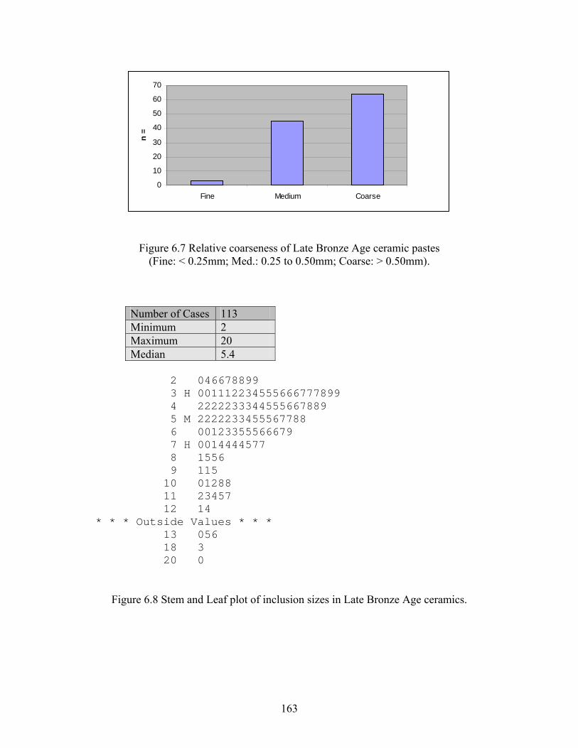
0
10
20
30
40
50
60
70
Fine Medium Coarse
n =
Figure 6.7 Relative coarseness of Late Bronze Age ceramic pastes (Fine: < 0.25mm; Med.: 0.25 to 0.50mm; Coarse: > 0.50mm).
Number of Cases 113 Minimum 2 Maximum 20 Median 5.4
2 046678899 3 H 001112234555666777899 4 2222233344555667889 5 M 2222233455567788 6 00123355566679 7 H 0014444577 8 1556 9 115 10 01288 11 23457 12 14 * * * Outside Values * * * 13 056 18 3 20 0
Figure 6.8 Stem and Leaf plot of inclusion sizes in Late Bronze Age ceramics.
163
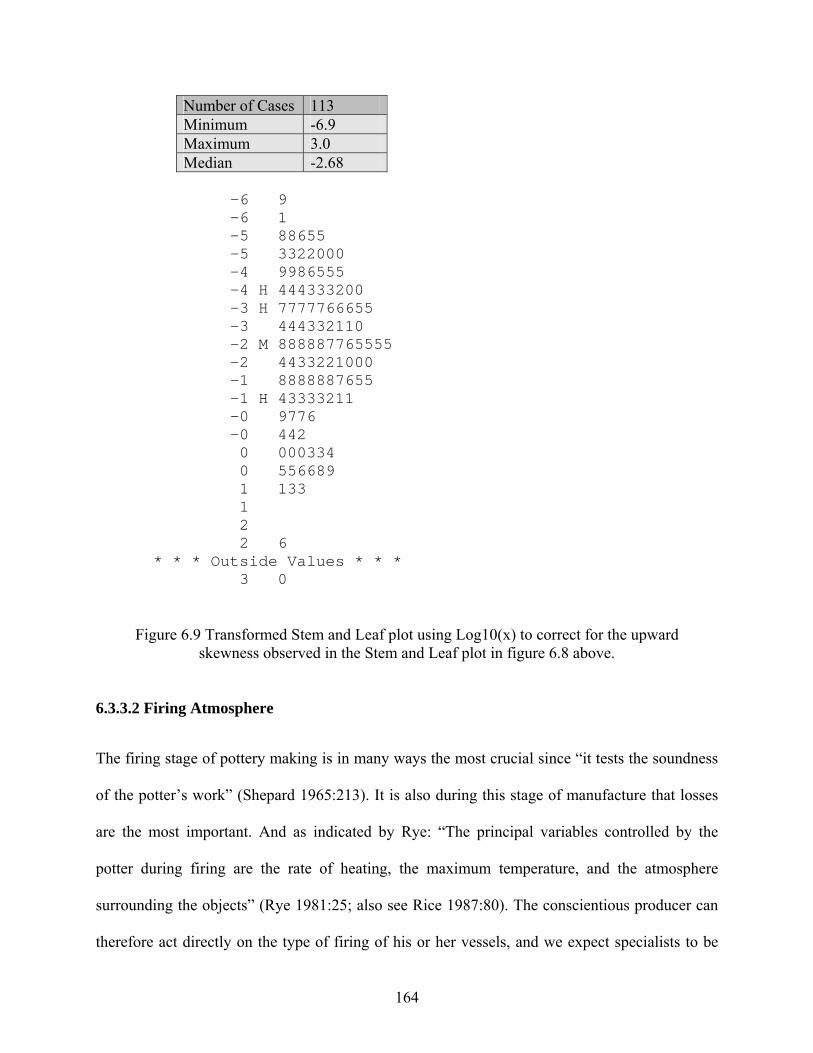
Number of Cases 113 Minimum -6.9 Maximum 3.0 Median -2.68
-6 9 -6 1 -5 88655 -5 3322000 -4 9986555 -4 H 444333200 -3 H 7777766655 -3 444332110 -2 M 888887765555 -2 4433221000 -1 8888887655 -1 H 43333211 -0 9776 -0 442 0 000334 0 556689 1 133 1 2 2 6 * * * Outside Values * * * 3 0
Figure 6.9 Transformed Stem and Leaf plot using Log10(x) to correct for the upward skewness observed in the Stem and Leaf plot in figure 6.8 above.
6.3.3.2 Firing Atmosphere
The firing stage of pottery making is in many ways the most crucial since “it tests the soundness
of the potter’s work” (Shepard 1965:213). It is also during this stage of manufacture that losses
are the most important. And as indicated by Rye: “The principal variables controlled by the
potter during firing are the rate of heating, the maximum temperature, and the atmosphere
surrounding the objects” (Rye 1981:25; also see Rice 1987:80). The conscientious producer can
therefore act directly on the type of firing of his or her vessels, and we expect specialists to be
164
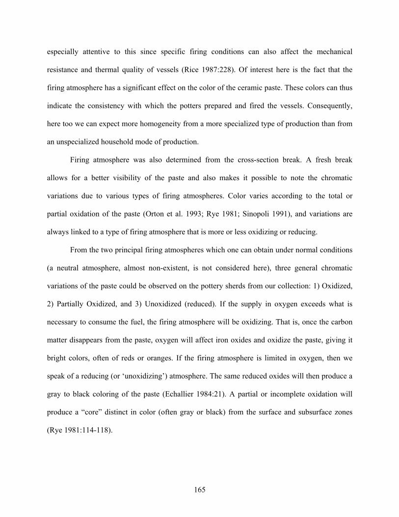
especially attentive to this since specific firing conditions can also affect the mechanical
resistance and thermal quality of vessels (Rice 1987:228). Of interest here is the fact that the
firing atmosphere has a significant effect on the color of the ceramic paste. These colors can thus
indicate the consistency with which the potters prepared and fired the vessels. Consequently,
here too we can expect more homogeneity from a more specialized type of production than from
an unspecialized household mode of production.
Firing atmosphere was also determined from the cross-section break. A fresh break
allows for a better visibility of the paste and also makes it possible to note the chromatic
variations due to various types of firing atmospheres. Color varies according to the total or
partial oxidation of the paste (Orton et al. 1993; Rye 1981; Sinopoli 1991), and variations are
always linked to a type of firing atmosphere that is more or less oxidizing or reducing.
From the two principal firing atmospheres which one can obtain under normal conditions
(a neutral atmosphere, almost non-existent, is not considered here), three general chromatic
variations of the paste could be observed on the pottery sherds from our collection: 1) Oxidized,
2) Partially Oxidized, and 3) Unoxidized (reduced). If the supply in oxygen exceeds what is
necessary to consume the fuel, the firing atmosphere will be oxidizing. That is, once the carbon
matter disappears from the paste, oxygen will affect iron oxides and oxidize the paste, giving it
bright colors, often of reds or oranges. If the firing atmosphere is limited in oxygen, then we
speak of a reducing (or ‘unoxidizing’) atmosphere. The same reduced oxides will then produce a
gray to black coloring of the paste (Echallier 1984:21). A partial or incomplete oxidation will
produce a “core” distinct in color (often gray or black) from the surface and subsurface zones
(Rye 1981:114-118).
165
Although it was impossible to determine the type of vessel from which most of the sherds
came, the overall variability in firing atmospheres suggest non-homogeneous firing conditions
(Figure 6.10). Indeed, the high incidence of incomplete or partly oxidized ceramics (>34%)
suggests uneven (non-specialized) firing conditions. The fact that the subsequent Iron Age
Xiongnu were able to attain much better products and greater evenness in firing conditions using
both the same clay sources and the same standard “recipe” for pottery making as the Late Bronze
Age people (Hall et al. 1999) suggests that it is not the material itself that was poor, but that less
technical excellence characterized pottery making in the Late Bronze Age. Almost all analyzed
ceramics are of the low-, unevenly-fired coarse grained type that is apparently characteristic of
the Late Bronze Age in Mongolia. Even the unoxidized (i.e. gray/black in color) sherds in the
assemblage—a characteristic usually associated with the subsequent finer paste Xiongnu
pottery—are all coarse grained.
0
10
20
30
40
50
60
70
80
Oxidized Partially Oxidized Unoxidized
n =
Figure 6.10 Firing atmospheres of Late Bronze Age ceramics.
166
6.3.3.3 Wall Thickness
Wall thickness is often retained as a criterion in pottery analysis so as to evaluate the degree of
uniformity in production. Of course homogeneity in wall thickness would only be expected
amongst similar vessel types in a specialized mode of production context. However, due to the
small size of most of the ceramic material, once again, it was impossible in most cases to
evaluate from what vessel type a particular sherd came. Consequently, the relative
characterization of wall thickness presented here must only be considered as a broad additional
tool for examining the degree of homogeneity, the possibility of patterns, and investigate, if
present, possible outliers.
While not indicating craft specialization, the analysis of wall thicknesses, when taken
together with previous data, does suggest an interesting pattern. The stem and leaf plot of the
measurements (in mm) of the walls of Late Bronze Age ceramic sherds suggest that the shape of
this batch is roughly single-peaked and symmetrical, at least as much as it is reasonable to expect
in a sample this small (Figure 6.11). There are, however, three outlier values, two of which
suggest slightly thicker bodies than the majority of sherds, and only one that suggests a vessel
with much thinner walls than the rest (i.e. 2.8 mm). The latter is probably much more meaningful
than the two other outliers since it is usually technically more difficult to produce such thin
earthenware. Nevertheless, both one of the thickest walled sherd and the especially thin-walled
vessel fragment come from the same occupation area where a larger proportion of decorated
ceramics, larger vessel forms and a ‘foreign’ vessel type have been found (i.e. SP07E-SOV—see
above). While this does not reasonably suggest any kind of specialized ceramic production at this
site, it does add weight to the idea that something a bit different was happening at the SP07E-
SOV occupation area.
167
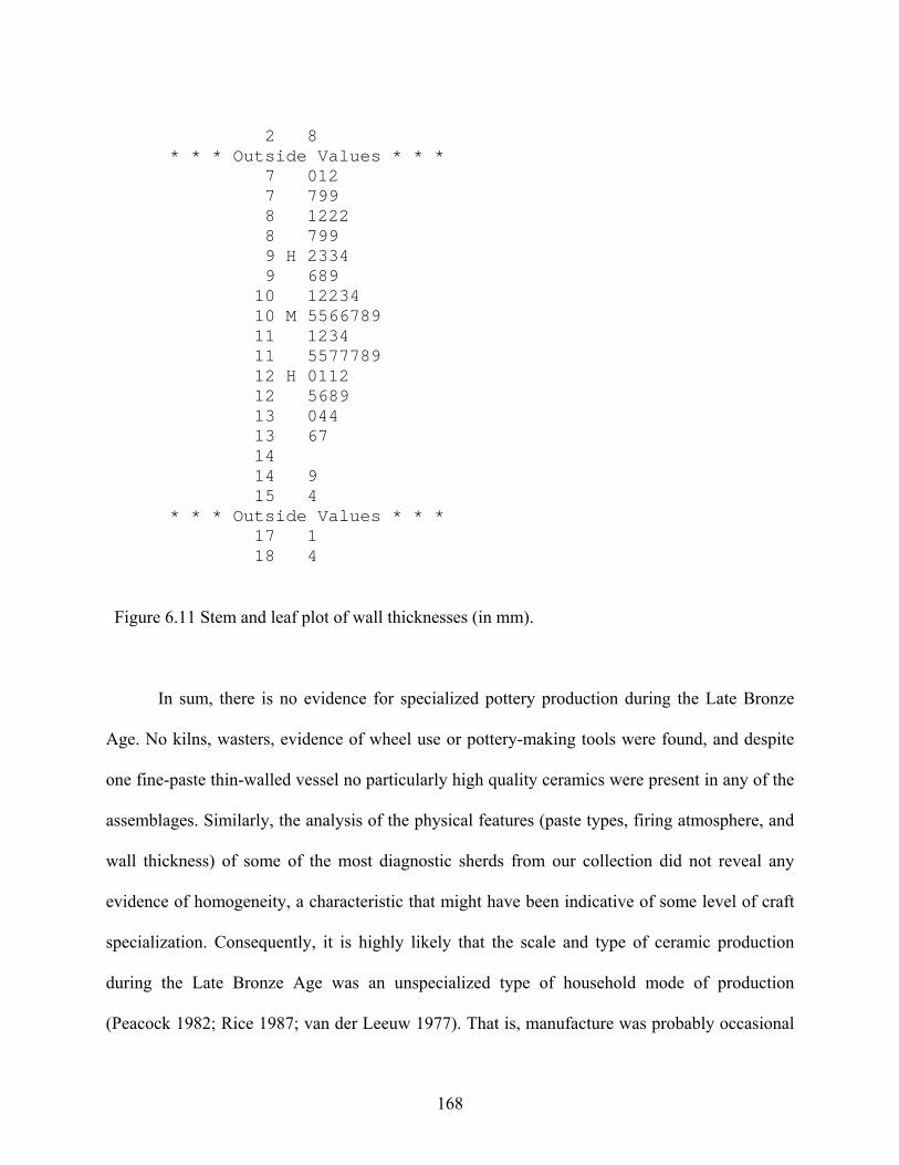
2 8 * * * Outside Values * * * 7 012 7 799 8 1222 8 799 9 H 2334 9 689 10 12234 10 M 5566789 11 1234 11 5577789 12 H 0112 12 5689 13 044 13 67 14 14 9 15 4 * * * Outside Values * * * 17 1 18 4
Figure 6.11 Stem and leaf plot of wall thicknesses (in mm).
In sum, there is no evidence for specialized pottery production during the Late Bronze
Age. No kilns, wasters, evidence of wheel use or pottery-making tools were found, and despite
one fine-paste thin-walled vessel no particularly high quality ceramics were present in any of the
assemblages. Similarly, the analysis of the physical features (paste types, firing atmosphere, and
wall thickness) of some of the most diagnostic sherds from our collection did not reveal any
evidence of homogeneity, a characteristic that might have been indicative of some level of craft
specialization. Consequently, it is highly likely that the scale and type of ceramic production
during the Late Bronze Age was an unspecialized type of household mode of production
(Peacock 1982; Rice 1987; van der Leeuw 1977). That is, manufacture was probably occasional
168
and intended primarily for the makers’ family’s own use, although the aforementioned larger and
‘fancier’ wares could have also been used in feasting activities.
The only exception to all this is the single sherd found at the SP07E-SOV occupation area
which has much thinner walls than the rest. As a single outlier, however, it is difficult to relate
this to any form a specialized production in the research area. The sherd may simply be related to
a vessel type that is foreign to the Khanuy Valley—just as other sherds that have been found at
the same occupation area (see section 6.2). Whether some form of specialized ceramic
production exists somewhere else remains to be discovered and demonstrated. Right now, these
few particular sherds only suggest possible contact with other, probably northerly regions of
Mongolia. And while these sherds are distinct in the Khanuy Valley research area, they are not
necessarily the product of specialized production elsewhere.
6.3.4 Stone Tool Production
The aim in analyzing the lithic material is not to present a detailed and exhaustive study of lithic
technology, but rather to present data that can shed further light on the nature of activities that
may have been going on at the different occupation areas in the Khanuy Valley during the Late
Bronze Age, and whether there is any variability in these activities between sites. Notably, the
objective is to investigate whether there is any evidence for specialized activities (e.g. tool
production) during this time period.
Save for one occupation area (SP11W-SAL) that will be discussed in detail below, little
evidence of stone tool production has been discovered in the research area. In fact, very little
lithic material has been uncovered in general. In the Khanuy Valley, only ten lithics (nine small
flakes [< 3 cm in width] and one whetstone, all made from locally available material, have been
found in total within secure Late Bronze Age contexts. This is surprising since while he has
169
found no evidence for specialized lithic production sites, Wright (2006) has identified large
amounts of lithic artifacts in the Egiin Gol Valley, a region just north of the Khanuy Valley. This
is important because Wright has suggested that in part because khirigsuur monuments are
sometimes associated with microlithic technology, these are not Bronze Age monuments, but
must pre-date the Bronze Age. Consequently, he associates these monuments with Epipaleolithic
(Mesolithic) pre-pastoral hunter-gatherers (Wright 2006:199-265). This is very different from
what is encountered in the Khanuy Valley and elsewhere where an increasing number of dates
pinpoint the khirigsuur phenomenon to the Late Bronze Age (Allard and Erdenebaatar 2005;
Fitzhugh 2009; Frohlich, personal communication) and where comparatively little lithic material
has been found. In addition, as discussed in Chapter 5, the faunal record does argue against a
primordially hunter-gatherer subsistence strategy for this period of time. Finally, there is no
reason why microlithic technology should be solely the hallmark of Mesolithic hunter-gatherers.
To be sure, such technology in the Eurasian steppes (see for example Sintashta Culture contexts)
is well known to have persisted well into the Bronze Age, including, noteworthily, in Mongolia
(Wright 2006:273, 280).
That being said, there are two occupation areas that still merit attention. First, of the nine
lithic flakes that have been found from secure Late Bronze Age contexts, it is interesting that the
majority (n=5) have been discovered at SP07E-SOV—the occupation area that stood out in
particular in terms of ceramics (see above). In order to further evaluate this difference a density
comparison between occupation areas that have produced lithic material was accomplished using
a lithic/sherd ratio (i.e. the number of stone artifacts divided by the number of sherds). In relative
terms, the larger the index number, the more important this category of artifact was at a
particular occupation area. Table 6.1 shows that of the four occupation areas where lithics were
170
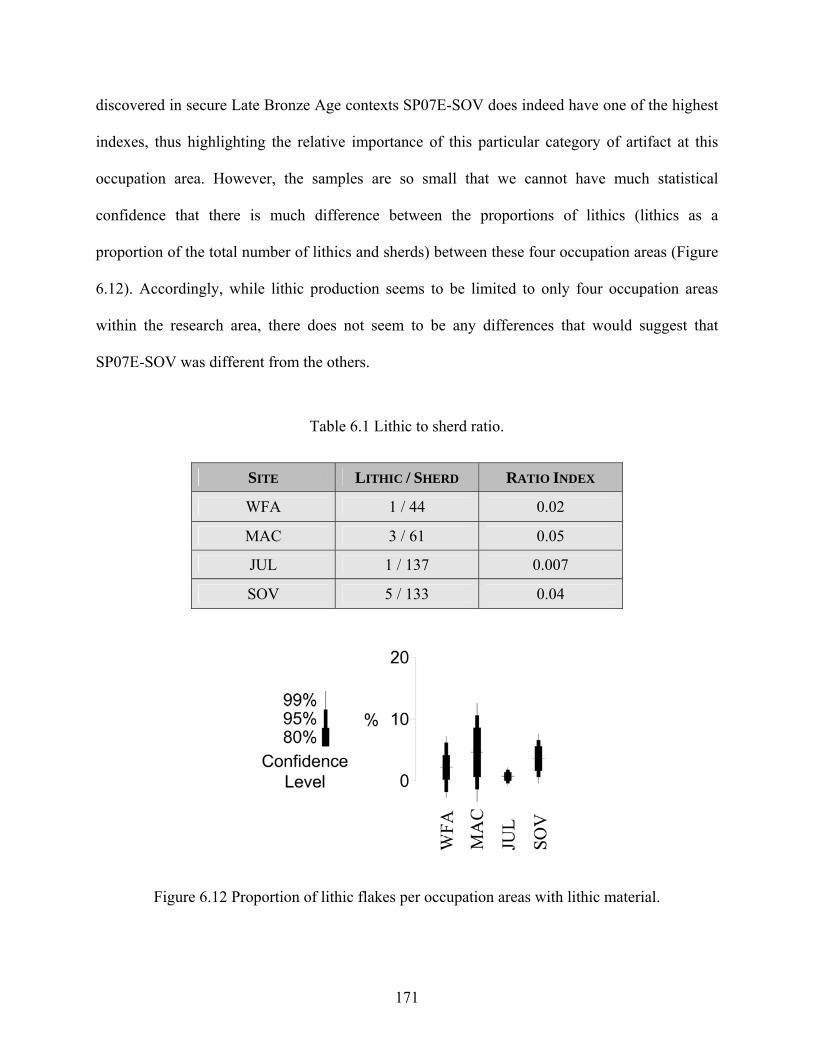
discovered in secure Late Bronze Age contexts SP07E-SOV does indeed have one of the highest
indexes, thus highlighting the relative importance of this particular category of artifact at this
occupation area. However, the samples are so small that we cannot have much statistical
confidence that there is much difference between the proportions of lithics (lithics as a
proportion of the total number of lithics and sherds) between these four occupation areas (Figure
6.12). Accordingly, while lithic production seems to be limited to only four occupation areas
within the research area, there does not seem to be any differences that would suggest that
SP07E-SOV was different from the others.
Table 6.1 Lithic to sherd ratio.
SITE LITHIC / SHERD RATIO INDEX
WFA 1 / 44 0.02
MAC 3 / 61 0.05
JUL 1 / 137 0.007
SOV 5 / 133 0.04
Figure 6.12 Proportion of lithic flakes per occupation areas with lithic material.
171
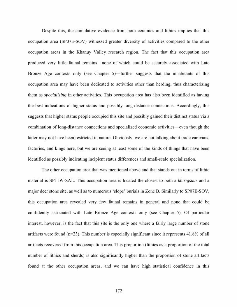
Despite this, the cumulative evidence from both ceramics and lithics implies that this
occupation area (SP07E-SOV) witnessed greater diversity of activities compared to the other
occupation areas in the Khanuy Valley research region. The fact that this occupation area
produced very little faunal remains—none of which could be securely associated with Late
Bronze Age contexts only (see Chapter 5)—further suggests that the inhabitants of this
occupation area may have been dedicated to activities other than herding, thus characterizing
them as specializing in other activities. This occupation area has also been identified as having
the best indications of higher status and possibly long-distance connections. Accordingly, this
suggests that higher status people occupied this site and possibly gained their distinct status via a
combination of long-distance connections and specialized economic activities—even though the
latter may not have been restricted in nature. Obviously, we are not talking about trade caravans,
factories, and kings here, but we are seeing at least some of the kinds of things that have been
identified as possibly indicating incipient status differences and small-scale specialization.
The other occupation area that was mentioned above and that stands out in terms of lithic
material is SP11W-SAL. This occupation area is located the closest to both a khirigsuur and a
major deer stone site, as well as to numerous ‘slope’ burials in Zone B. Similarly to SP07E-SOV,
this occupation area revealed very few faunal remains in general and none that could be
confidently associated with Late Bronze Age contexts only (see Chapter 5). Of particular
interest, however, is the fact that this site is the only one where a fairly large number of stone
artifacts were found (n=23). This number is especially significant since it represents 41.8% of all
artifacts recovered from this occupation area. This proportion (lithics as a proportion of the total
number of lithics and sherds) is also significantly higher than the proportion of stone artifacts
found at the other occupation areas, and we can have high statistical confidence in this
172
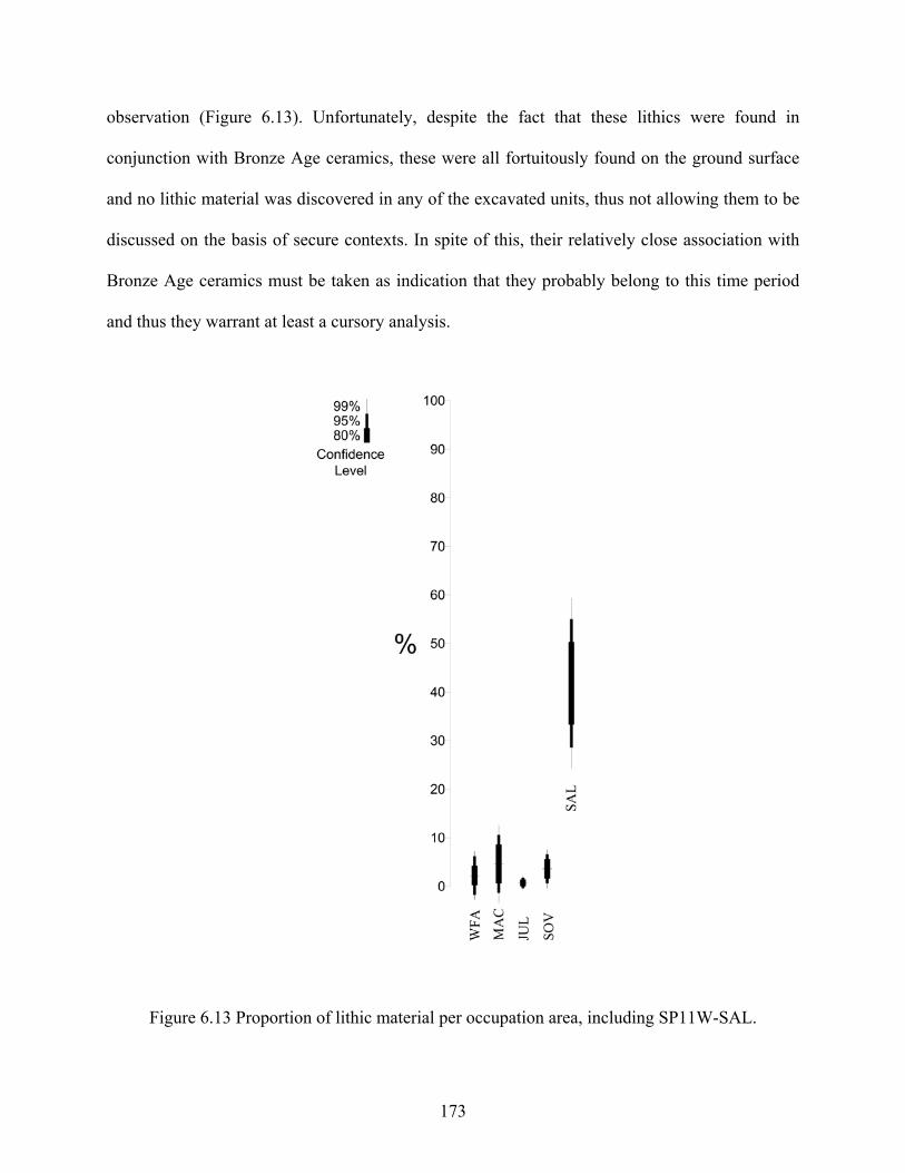
observation (Figure 6.13). Unfortunately, despite the fact that these lithics were found in
conjunction with Bronze Age ceramics, these were all fortuitously found on the ground surface
and no lithic material was discovered in any of the excavated units, thus not allowing them to be
discussed on the basis of secure contexts. In spite of this, their relatively close association with
Bronze Age ceramics must be taken as indication that they probably belong to this time period
and thus they warrant at least a cursory analysis.
Figure 6.13 Proportion of lithic material per occupation area, including SP11W-SAL.
173
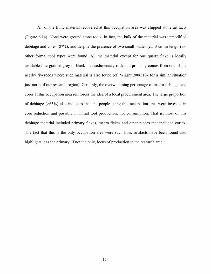
All of the lithic material recovered at this occupation area was chipped stone artifacts
(Figure 6.14). None were ground stone tools. In fact, the bulk of the material was unmodified
debitage and cores (87%), and despite the presence of two small blades (ca. 3 cm in length) no
other formal tool types were found. All the material except for one quartz flake is locally
available fine grained grey or black metasedimentary rock and probably comes from one of the
nearby riverbeds where such material is also found (cf. Wright 2006:184 for a similar situation
just north of our research region). Certainly, the overwhelming percentage of macro-debitage and
cores at this occupation area reinforces the idea of a local procurement area. The large proportion
of debitage (>65%) also indicates that the people using this occupation area were invested in
core reduction and possibly in initial tool production, not consumption. That is, most of this
debitage material included primary flakes, macro-flakes and other pieces that included cortex.
The fact that this is the only occupation area were such lithic artifacts have been found also
highlights it as the primary, if not the only, locus of production in the research area.
174
Figure 6.14 Sample of lithics from SP11W-SAL. As was the case for SOV, it is difficult to know just what to make of this site. The high
population index for this occupation area based and the area/sherd density index presented in
Chapter 3 suggests that this was not just a periodic campsite where people only came to make
their own lithics. This is also supported by the fact that the lithic material that was used is not
restricted to this particular area and that it is available throughout the research area. There is thus
no particular reason linked to the availability of the lithic material that would explain why the
production of lithics would only be concentrated at this particular occupation area. What this
does suggest—and this is supported by the apparently very low incidence of faunal remains at
this site (see Chapter 5)—is that the inhabitants of this occupation area may have been dedicated
175
to activities other than herding, apparently making lithics as a specialized activity. The fact that
no finished tools have been found in the research area also suggests the possibly that the lithic
items were traded outside of the research area. The implications of all of this are puzzling, but
interesting. Indeed, since the lithic material is not restricted in nature, then it means that lithic
production may have been regarded as a ‘specialized’ (or at least special) activity. Lithic
production was certainly extremely restricted in scope. That is, although everybody in the
Khanuy Valley had access to the raw material, only a select few were actually producing lithics
to any extent. The lack of evidence for herding at this occupation area (despite its high
population index—see Chapter 3) compared to most of the others in the research area also
suggests that these people must have been producing these lithics in exchange for something
else—possibly food. Accordingly, the inhabitants of this occupation area must have been
recognized by the local population as lithic ‘specialists’ of some kind.
6.4 SUMMARY
The analyses presented in this chapter suggest that there do seem to be some small differences in
status between occupation areas. The clearest evidence of this comes from ceramics, notably the
differential proportion of decorated ones. Indeed, three to four occupation areas have much
higher percentages of decorated ceramics than the rest of the investigated sites in the research
area. Interestingly, three of these four occupation areas are located in proximity to khirigsuurs,
two in Zone A and one in Zone B. SP07E-SOV is the notable exception to this, although a single
deer stone is located near this site. In addition, two of the three occupation areas where the only
cattle remains were discovered (see Chapter 5) also correspond to the two sites in Zone A where
176
higher proportions of decorated ceramics were found. Thus, there does seem to be some relation
between social status and proximity to monumental structures, the exception being SP07E-SOV,
once again.
Indeed, SP07E-SOV is singular in terms of having revealed comparatively numerous
markers of status despite the fact that this occupation area is not spatially associated with
khirigsuurs or other Late Bronze Age burials. To be sure, ceramic analysis suggests fairly
notable differences in proportion of decorated ceramics, with this site having amongst the highest
proportion of them. Additional evidence for the distinctive nature of this occupation area is also
provided by the occurrence of larger vessels and the presence of the only foreign vessel types
(suggesting long-distance ties). In fact, based on this cumulative evidence, SP07E-SOV is
actually the occupation area that stands out the most in terms of markers of status differences. As
noted above, however, the fact that this occupation area is not spatially associated with
khirigsuurs makes the relationship between higher status and proximity to monumental
structures uncertain. Of course, a lack of immediate proximity to these monuments does not
necessarily demonstrate a lack of involvement in their construction and management, but the link
is not obvious.
The analyses presented in this chapter also suggest some modest form of economic
specialization (or economic emphasis) based on lithic production during the Late Bronze Age.
The quasi-absence of any finished tools and the large proportion of debitage which includes
primary flakes, macro-flakes and other pieces with cortex indicates that the people using the
SP11W-SAL occupation area were invested in core reduction and possibly in initial tool
production, not consumption. The fact that SP11W-SAL is the only occupation area where such
lithic artifacts have been found also highlights it as the primary, if not the only, locus of
177
production in the research area and thus suggests localized production. This is especially relevant
that the raw material is ubiquitously available. Accordingly, the inhabitants of this occupation
area must have been recognized by the local population as lithic ‘specialists’. Oddly enough,
however, no finished tools have been found in any of the investigated occupation areas within
the research area. This might signify that stone tools were traded outside the community.
178
7.0 CONCLUSIONS
The general aim of this study was to investigate the early development of societal complexity in
Mongolia during the Late Bronze Age and address the nature of the social and economic
organization of these societies during this pivotal period in Mongolian history. Concretely, this
archaeological study in the Khanuy River Valley region of north-central Mongolia aimed at
evaluating the ‘dependency’ hypothesis of sociopolitical development among mobile pastoralists.
In order to accomplish this, a number of concrete lines of inquiry have been investigated in this
study so as to systematically and empirically evaluate the core variables and problematic aspects
related to the development of ‘nomadic’ polities (i.e. those stated in the dependency hypothesis),
namely demography, subsistence, mobility, and political economy in relation to higher degrees
of sociopolitical organizations.
In this final chapter I will: 1) summarize the results of this study and discuss some of the
most important implications of these results, 2) present a concluding hypothesis regarding
societal complexity during the Late Bronze Age in the Khanuy Valley region of central
Mongolia and 3) outline some remaining questions that require further investigation.
179
7.1 THE RESULTS OF THE CURRENT STUDY
The results of the present study suggest that a certain level of societal complexity was already
present among mobile pastoralists in the Khanuy River Valley region of central Mongolia during
the Late Bronze Age—a region far from centers of power, population, and trade (cf. Salzman
2004:29) and at a time before regular interaction with large sedentary states in China existed (cf.
Kradin 2002). The importance of the findings of this study is manifold and upends many of the
assumptions tied to the ‘dependency’ hypothesis and the early origins for Mongolian societal
complexity.
First, the type of herding implied by both the settlement pattern study and the analysis of
the faunal material suggest a fixed and highly restricted form of seasonal migration, with fairly
permanent camp-grounds, but no permanent dwellings (cf. Vainshtein 1980:95). In fact, although
it does seem as though the Late Bronze Age inhabitants of the Khanuy Valley did practice some
form of transhumant mode of mobility, their settlement system indicates that they probably did
not move more than a few kilometers from one seasonal campsite to another. Moreover, there is
clear evidence for demographic centralization in the environs of monumental structures during
the Late Bronze Age as the total density-area index for Zone A (located at the center of an
important cluster of monumental structures) is twice as high as the one in Zone B (which
corresponds to an area that is the tail end of a cluster of monumental sites, as well as part of an
area that comprises neither burials nor khirigsuurs, i.e. a “buffer zone”). Consequently, contrary
to the expectations of the dependency hypothesis, pastoralist mobility does not necessarily
preclude centralization.
180
While at first it may seem difficult to reconcile the apparent lack of evidence for
permanent occupation implied by the lack of any architectural remains with the indicators of
restricted mobility provided by the settlement pattern and the faunal remains, the type of mobile
herding described above is exactly analogous to what still prevails today in the research area, that
is, herders move lock, stock and barrel (and their habitation!) from one seasonal campsite to
another over generally very short distances between the foothills and the river—usually no more
than a few kilometers. And despite the stability and fixedness of their campsite locations,
especially their winter ones, present day herders in the valley still do not build permanent
habitation structures except for their animals at winter campsite locations!
With good reason, much has been said about the significance and importance of
recognizing residential flexibility among mobile pastoralists (e.g. Frachetti 2004; Hanks 2003),
but Cribb’s note on overlapping characteristics between “nomad” and “sedentary” dwelling types
and material culture must also be taken into consideration (1991:149-155). It is possible, just as
it is the case today in Mongolia and elsewhere (Cribb 1991:154; Howell-Meurs 2001:322), to use
‘simple’, portable types of dwellings such as gers (traditional Mongolian tent houses) as
‘permanent’(and sometimes ‘fixed’) habitations. Even today complexes of gers make up whole
districts in cities all over Mongolia, including the capital city Ulaanbaatar. Accordingly, in this
context and as a cautionary note, architectural remains (or lack thereof) may provide a poor
indicator of the degree of “sedentariness”. These words of caution should also be considered
when devising pedestrian survey programs designed to identify and differentiate ‘nomadic’ and
‘sedentary’ settlements on the basis of architectural remains (or lack thereof) and artifact types
alone. That is, while a lack of architectural remains may indeed be a good indication of
mobility—or more accurately, the possibility of mobility—, it provides very little in terms of
181
understanding the actual settlement system, which can be highly restricted (almost sedentary-
like) in scope as is the case in the Khanuy Valley during the Late Bronze Age. In other words, it
is possible that no fixed/permanent structures will ever be found at the Late Bronze Age
occupation areas discussed in this thesis (although soil studies and geochemical investigations
may eventually detect anthropogenic features and locations where animal shelters or corrals once
stood), even though their inhabitants seem to have practiced a highly restricted form of mobile
pastoralism. Of course, this does not imply that part of the population (human and animal) did
not occasionally move over greater distances. This is even probable, especially when one
considers the pan-regional similarities in ritual and burial structures. What this underscores is the
importance of approaching the issues of mobility and subsistence patterns with caution and the
need to reevaluate (i.e. TEST) archaeologically these issues instead of simply associating certain
types of monuments (i.e. kurgan-like structures) and particular faunal assemblages with
prescribed, but confusing and mostly unhelpful, ethnographically derived socio-economic types
such as nomadic pastoralism, semi-nomadic pastoralism, semi-sedentary pastoralism, sedentary
pastoralism, etc. As Kelly (1992:60) rightly notes: “By deconstructing the concepts of mobility
and sedentism, we see the need to construct more useful approaches than a simple polarization of
mobile vs. sedentary societies”. In fact, as Hanks (2003:69) predicted, “[the picture is slowly
beginning] to take on a much more complex representation as more intensive, and scientifically
comprehensive, approaches are undertaken to settlement site excavations focusing on the Late
Bronze Age to Early Iron Age period (ca. 1200 – 800 BC).” And indeed, a mosaic of varying
patterns of pastoralism and mobility respective of particular environmental niches is slowly
coming to light (e.g. Chang et al. 2002; Frachetti 2004; this study).
182
Second, the pastoral mode of subsistence described in Chapter 5 seems to have been self-
sufficient and not as spatially extensive and unstable as the dependency hypothesis predicts for
“nomads” who exploit “marginal” environments. In fact, despite the apparent absence of
complementary subsistence practices such as agriculture, plant cultivation or intense use of wild
fauna during this period of time, resources (domestic animals and thus pasture) seem to have
been reliable, predictable, and abundant enough in the region to sustain a fairly large group of
centrally located humans and animals who built impressive monuments for a period of well over
500 years (cf. Koryakova and Epimakhov 2007:211). Moreover, the astonishing number and
continual deposit of animals at khirigsuurs (most probably linked to feasting activities) for this
long period of time calls into question the idea that pastoralism (even in its most “pure” form) is
necessarily inhibitively unstable and not conducive to surplus production.
Third, the population estimates discussed in Chapter 3 suggest that during the Late
Bronze Age the Khanuy Valley was very actively inhabited (in terms of density and/or intensity
of occupation). In fact, the human and animal population estimates during the Late Bronze Age
apparently approximate the present density of people and animals per square kilometer in the
research area—a density that today approaches and even surpasses during the winter months the
perceived carrying capacity of the research area (see Chapter 1). While this population density is
indeed overall fairly low, the Khanuy Valley research area does seem to have supported a rather
important human and animal population—at least seasonally—, one that was large enough to
build the numerous and fairly labor intensive monumental structures that dot the research area.
Accordingly, the mobile pastoralist economy of the Late Bronze Age in the Khanuy Valley did
not apparently necessarily entail very low population densities as the dependency hypothesis
anticipates. Or at least, the population density was not so low that it would have inhibited
183
sociopolitical integration and demographic centralization. In fact, all this suggests a social
organization whose workings are akin to settled and physically bounded communities.
Fourth, the analyses of domestic artifacts and faunal remains presented in Chapter 6
suggest that there does seem to be some level of social differentiation between occupation areas
during the Late Bronze Age. Certainly, we are not talking about exceptionally lavish status
markers: even the decorated ceramics are fairly ordinary! And in all probability, based on the
artifactual material at least, the Late Bronze Age groups inhabiting the Khanuy Valley research
area were probably relatively egalitarian compared to other known middle-range societies. But
the fact that status markers were all found in greater number at one single site (SP07E-SOV)
highlights the distinctive nature of this occupation area—one that suggests that its inhabitants
had some distinctive form of social status (the exact nature of which is still unclear).
The analyses also suggest some modest form of economic specialization (or economic
emphasis) based on lithic production during the Late Bronze Age. It also suggests that lithic
production was centralized as the only evidence for significant lithic production was only found
at one occupation area. And this is despite the fact that the raw lithic material that was used is
ubiquitously available. However, the fact that economic specialization and status do not seem to
correlate spatially suggests a rather horizontal, decentralized sociopolitical organization, possibly
with multiple uncorrelated dimensions of differentiation.
In sum, there do seem to be some social and economic differences between occupation
areas during the Late Bronze Age in the Khanuy Valley, but the types of status markers and the
range of variability in activities between occupation areas speak of an overall low or limited
degree of social differentiation. As for the nature of this social differentiation, the picture is still
not totally clear. The ceramic evidence suggests that feasting might have been important (this is
184
also supported by what seems to be happening at khirigsuurs) and, in the case of SP07E-SOV
and possibly SP26E-MAC, that possibly long-distance alliance building was also an important
factor in status building. The proximity of some higher status campsites to monuments also
seems to suggest the importance of ritual and ideology in defining status differences, but it does
not seem to be exclusive in nature as ‘lower-status’ campsites are also located near khirigsuurs;
and SP07E-SOV—the most distinctive in terms of status markers—is not spatially associated
with khirigsuurs or other Late Bronze Age burials. It is, however, associated with a single nearby
deer stone.
Regardless, what is apparent from all this is that in this case the expected correlates of the
dependency hypothesis do not seem to stand up solidly to archaeological scrutiny and that the
sociopolitical picture during Mongolia’s Late Bronze Age is actually much more complex than
hitherto thought. In fact, the results of this present study suggest that while clear social
hierarchies have not been identified within domestic contexts, limited status differentiation and
relatively complex forms of social organization among mobile pastoralists can indeed develop in
remote regions far from centers of power. But ultimately this should not be surprising since
several ethnographic examples, such as the North African Moors and Tuaregs (Bonte 1999), and
the Rufa’a al-Hoi of Sudan (Johnson 1983), suggest that complex political institutions can and
have indeed arisen without the influence, or at least the direct influence, of states.
Archaeologically, it is also important to mention that such societies as those belonging to the
Late Bronze Age Karasuk Culture (13th - 8th centuries BCE) in the Minusinsk Basin of Southern
Siberia and those Early Iron Age groups associated with the Arzhan I and II barrows (9th - 8th
centuries BCE) in Tuva have also clearly developed highly complex hierarchical institutions and
185
hereditary status differentiation in the absence of interaction with neighboring sedentary states
(Askarov et al. 1992; Gryaznov 1969, 1980; Legrand 2006).
In light of all this, the results of this study are important to consider as they have
significant implications for our understanding of the dynamics of social change in this region of
the world. Indeed, the conventional wisdom has it that at the beginning of the Bronze Age the
people inhabiting Mongolia and adjacent regions had commenced a transformation from a
sedentary, agricultural subsistence strategy to “nomadic” (i.e. long-range) pastoralism, and that
this transition was completed by about 900 BCE (e.g. Koryakova and Epimakhov 2007:211).
Different causes have been proposed to explain this drastic change, the most common one being
linked to climatic changes, which in turn would have set off mass westward migrations and
changes in basic economic activities (e.g. Kurochkin 1994, cited in Koryakova and Epimakhov
2007:211). What this study indicates, however, is that beyond the now established fact that this
region of central Mongolia during this period of time did not witness any particularly important
ecological stress—at least nothing different from what present-day herders are faced with—this
period actually corresponds to a time when pastoralist mobility in central Mongolia was
apparently fairly restricted in scope and to a period when subsistence practices, despite the
absence of agriculture, were apparently sufficiently productive to sustain a fairly centralized
social organization that built impressive stone monuments that required a fairly large and
sustained input of both manpower and animals for a period of well over 500 years. This was also
accomplished centuries before regular interaction with large sedentary states such as those found
in China at the time and before the appearance of the first state-like nomadic polity in this region.
186
So what does all this mean in terms of social organization? And how do we give meaning
to this type of society that, nevertheless, has both the ability to create complex ritual/mortuary
megalithic structures and the need to do so?
7.2 CONCLUDING HYPOTHESIS: ‘SOCIALLY INTEGRATIVE FACILITIES’ AND THE EMERGENCE OF SOCIETAL COMPLEXITY ON THE MONGOLIAN STEPPE
In non-stratified societies, order often depends more on integration and cooperation than on
force; and rituals – especially above the household level – are often essential to social integration
(Hegmon 1989; Netting 1972). To the extent that rituals are conducted in a built environment,
then architecture plays an important role in the ritual and thus in social integration. Substantial
public works, ritual ones in particular, have been shown to serve such ‘integrative’ functions
(Adler 1989; Hegmon 1989). Because architecture used for ritual purposes is often built by the
shared labor of those who will use them, architecture may help to define groups of individuals
and contribute to the integration of these individuals into a social group or community. As
suggested by Hegmon, “architecture contributes to integration by defining [group and territorial]
boundaries and by symbolically reinforcing ideology and social norms” (1989:7, 9). As such, the
scale and labor required to build substantial public works that require unusual construction
investments, such as khirigsuurs, can be indicative of the scale and extent of community
integration. On the basis of the scale of some khirigsuurs, as well as the required labor to build
them and the number of animal deposits, social integration in the Khanuy Valley probably far
exceed the immediate community surrounding these monuments.
However, although khirigsuurs are quite homogeneous across vast regions, there is some
variability in design (Tsybiktarov 1995; Wright 2006). It is presumed therefore that khirigsuurs
187
were not built under the auspices of a macro-regional-level authority. This has important
implications for understanding the spatial arrangement of habitation sites and monuments,
because khirigsuurs and their placement may be seen as products of local decision-making
within a common standardized pan-regional ideological system that included religious ideas. In
fact, especially within a mobile pastoralist system, this sort of purposeful planning at the local
level suggests substantial efforts at maintaining an integrated community that went beyond the
immediate locale and existed in the absence of everyday face-to-face interaction. The locales
would have had a unifying effect, therefore providing, if not the shared experience of a central
communal place, a familiar experience that both reflected cultural and social cohesion and
reinforced it. This may well have been a very important aspect of social integration and
centralization. Mobile pastoralists are potentially highly segmentary, and social as well as
political integration depends on the existence of social groupings that crosscut other social
segments. The shared use of khirigsuurs may have contributed to social integration by
discouraging social segmentation. Certainly, khirigsuurs likely served several purposes, some of
which may have been more important for some members participating in the ceremonial events
than for others. Feasting, community integration, and possibly even aggrandizement are all
possible functions, perhaps all working at the same time through the events associated with their
construction. The action of khirigsuur construction, especially in the form of adding to an
already existing composition, may also have made statements of group power, ancestry, and
alliances. Yet, along with these group-oriented integrative activities, there is also some visible
emphasis on symbolism relating to individuals (such as single interments in the central mound of
some khirigsuurs, deer stone imagery and eventually “warrior-elite” slab burials). There is also
evidence for some social and economic distinctions between occupation areas (see above and
188
Chapter 6). The presence of both group-oriented and individualistic symbolism—maybe related
to both achieved and ascribed status—has been documented in many ‘transegalitarian’ societies,
and may reflect a transitory situation in which a system of hereditary status and a class of chiefs
are not yet firmly established. Mortuary display, for one, could even be at its greatest when the
concept of inheritance is accepted, but when there is still some uncertainty in the attribution of
relative status positions within society (Cannon 1989; Randsborg 1982; Schulting 1995).
In conclusion, this seemingly paradoxical situation is very interesting and important for
understanding the nature and development of societal complexity in this region, since it seems to
actually signify the first stage in the emergence of political organization operating beyond the
descent group (Clark and Blake 1994; Hayden 1995; Parkinson 2002:2). It also seems to reflect
differential (possibly even hierarchical) social relations based on the control of nonmaterial
resources (such as ritual-based polities) rather than hierarchical social relations based on
economic variables (McIntosh 1999; Potter 2000), although we can not rule out the importance
of differential numbers and types of animals as economic, and by extension, status markers.
Regardless, ritual apparently played a significant role in supra-local community integration, in
the maintenance of large group size, and in the emergence of societal complexity. In fact, the
differences in the size, number of animal deposits and above-ground elaborateness of khirigsuurs
suggest that competition between individuals or groups within a cluster of occupation areas was
carried out through ritual (see for example Figure 1.4). Possibly communal rituals were the
principal means of gaining and maintaining status positions and prestige (Clark and Blake 1994;
Hayden 1995). In other words, it appears that some of the foundations of Early Iron Age
complex sociopolitical organization were already being laid locally during the Late Bronze Age,
189
even though it is possible that “real” chiefship (i.e. more powerful forms of leadership) arose
only after confrontation with powerful external polities such as early imperial China.
7.3 EPILOGUE: THE LATE BRONZE AGE IN THE LONGER TRAJECTORY
Khanuy Valley sites, including settlements and the large Gol Mod 2 ‘royal’ cemetery (Allard et
al. 2002; Miller et al. 2006), indicate that the valley was integrated at some point into the
Xiongnu regional polity. As discussed in Chapter 1, numerous scholars have argued that without
regular interaction with already-existing agricultural state-level societies the major problem for
the development of such a complex regional polity was its under-developed productive base and
its highly mobile population capable of fission and mounting significant factional challenges.
What this study has shown, however, is that these possible ‘impediments’ were either inexistent
(or not necessarily as hindering as commonly believed—such as the case with the subsistence
base) or were already being dealt with independently during the previous Bronze Age. Certainly,
during the Iron Age Xiongnu period there is historical and archaeological evidence for
productive interaction with neighboring states in China and elsewhere and that long-distance
trade and tribute extraction were important in the further development of the Xiongnu and
subsequent states in this part of the world (Di Cosmo 1999; Hulsewé 1979:216-217; Jagchid and
Symons 1989). However, as Honeychurch has recently underscored, “spatial reach must be
matched by internal methods of centralized integration which together make-up vital aspects of
the statecraft of any large scale political system” (Honeychurch 2004:239). And as suggested
above and in this study, these centrally integrative principles (but combined with long-distance
outreach) were apparently already strongly present during the Late Bronze Age, indicating that
190
some of what Di Cosmo (1999:7) has identified as “traditionary” institutions (the long-term
repertoire of strategies by which steppe polities were organized and financed and which were
retained and employed differentially over successive periods of regional organization) were
actually already being laid locally during the Late Bronze Age. This ‘centralizing mode of
integration’ is certainly a critical factor in any developing body of statecraft; but with its more
dispersed mobile population which is more easily able to ‘vote with its own feet’, the above-
mentioned communal and ritual mode of ‘centralized integration’ was most likely a crucial
underpinning in the early development of the Xiongnu polity.
7.4 DIRECTIONS FOR FUTURE RESEARCH
This study has provided a framework for evaluating the emergence of, as well as the degree and
nature of, societal complexity during the Late Bronze Age in the Khanuy Valley region of central
Mongolia. Moreover, this study has demonstrated the important contribution of settlement
archaeology to this endeavor. Of course, this study needs to be considered as just the point of
departure for what needs to be a sustained and wider-ranging multiscalar research enterprise as
many unanswered questions still remain. This study has also generated a number of future
research topics.
First, this study is the first of its kind in Mongolia and is based on only one of several
settlement/monument clusters in Late Bronze Age Mongolia. The fact is that at the moment, the
lack of comparative material and measurements from contemporaneous contexts is the biggest
hamper to constructive comparative research. Despite this, the present study provides a model
for future investigations of adjacent and more distant/peripheral regions of Mongolia. Indeed, it
191
is only through similar and comparative multiscalar work in various regions and in different
environmental zones that we will eventually bring about a more complete picture of the
development of complex societies among mobile pastoralists in this and other regions of the
world. Indeed, this study together with similar research by Honeychurch and colleagues in the
more northerly (forest-steppe) and southerly (desert-steppe) regions of central Mongolia have
started to produce a much better understanding of regional social organization during the Bronze
and Iron Age periods in different environmental locales. What is needed now are also similar
types of studies in the more eastern and western parts of Mongolia where not only do present
patterns of mobility based on particular environmental conditions vary more widely—including
areas like in the Altai where ethno-historians have recorded less-tethered mobility patterns than
that found in the Khanuy Valley, for example (Bazargur 2005)—, but where the concentration
(and types) of Late Bronze Age monuments also vary greatly (see Figure 1.11 and 1.12). That
being said, it would also be worth expanding on the area surveyed for this present study in order
to better characterize the “buffer zones” of less dense monuments and occupation. This would
allow for a better interpretation of centralization. For example, the faunal analysis presented in
Chapter 5 confirms the domestic nature of the animals (including horses), but no direct evidence
exists yet for this period until the Terminal Bronze Age (with the slab burial culture) for mounted
pastoralism. Yet the distance between khirigsuur clusters is curiously the same distance that a
horse can be comfortably ridden per day, that is, about 11-17 km (Sandra Olsen, personal
communication) and corresponds to the distance between planned settlements in many places,
including here in the American Northeast during the early 20th century when traveling between
towns was done mainly by horse (Leila Inksetter, personal communication). If horses were
indeed ridden during the Late Bronze Age in the Khanuy Valley, then the extent of the surveyed
192
area that included the “buffer zone” becomes essentially meaningless, even though the results of
this study suggests that the intensity of occupation was apparently higher near the center of the
khirigsuur cluster, and diminished farther from it. Nevertheless, expanding the survey area a few
kilometers more could confirm this and provide more detailed information about the extent of
demographic centralization. Fortunately, this would not necessitate another intensive shovel
probing strategy, as the information gained from this present study could be used to sample with
statistical confidence these other areas (see Drennan 1996:142-144).
Continued and increased multiscalar settlement pattern research in different regions of
Mongolia and publication of the results of exhaustive quantitative and qualitative analyses of
material remains from domestic contexts, including faunal remains, would thus greatly enhance
efforts to compare the results of a given study to those of contemporaneous assemblages. In turn,
this type of research could productively contribute to global comparative anthropological studies
on the topic of social change in general by documenting variability in both the forms and
developmental trajectories of societal complexity. To be sure, while middle-range societies have
been effectively investigated through the comparative analysis of sedentary, agricultural-based
societies around the world, such complexity surrounding “pastoralists” has rarely been
considered within broader comparative studies of trajectories of social complexity (but see
Hanks and Linduff 2009). And in this regard, the Mongolian case offers a seemingly unique and
significant case study for potential autonomous development and corporate complexity that does
not connect easily with such models as the “dependency” one.
Second, while past environmental conditions are now fairly well known in the research
region and correlate nicely with the human occupation of the Khanuy Valley, geoarchaeological
research (including soil micromorphology and soil chemistry) might provide more detailed
193
information regarding the use and frequency of use of occupation areas. This is important as for
the moment we only have a general understanding of the seasonal use of occupation areas and no
understanding whatsoever of site structure. Encouragingly, those geoarchaeological projects that
have recently started to address these issues for mobile pastoralists in other world areas are
proving that not only are these endeavors feasible, necessary and worthwhile, but that it is
possible to attain a level of understanding of the temporal scale and spatial organization of
habitation sites that allows for a reconstruction of social activities (e.g. Shahack-Gross et al.
2003; Shahack-Gross et al. 2004; Shahack-Gross and Finkelstein 2008).
Third, the scant and highly fragmentary nature of the faunal remains examined in this
study only allowed for a fairly cursory analysis of this material, and thus of their contribution to
the overall domestic economy. In many ways, also, sample size proved to be problematic in
terms of the range of analytical techniques that could be applied to the assemblages. These
limitations were overcome to some extent through the application of statistics, but further
remains derived through upcoming larger-scale excavations of domestic occupation areas will
increase sample sizes and subsequently reduce the tentativeness of some of the conclusions
relating to animal exploitation. A diachronic study of animal exploitation from the Bronze Age
to the Early Iron Age would also allow us to evaluate the effects, if any, of large-scale political
processes on the subsistence economy of mobile peoples.
Finally, as we are gaining more regional information about the Late Bronze Age and
Early Iron Age in Mongolia, further study should also emphasize a diachronic and comparative
study of social organization at the campsite/household level. A focus on household remains
would provide an important comparative perspective on suprahousehold changes and the
evolutionary trajectories of occupation areas in the region. Some knowledge has already been
194
gained through the test excavations at a number of these habitation sites, but a more detailed
study of domestic occupation areas would provide important and crucial comparative data
toward evaluating continuity and change in the range, organization and variation of
campsite/household activities among mobile pastoralist societies as the region is incorporated
into a regional-scale state-like polity.
195
BIBLIOGRAPHY Adler, Michael A. 1989 Ritual Facilities and Social Integration in Nonranked Societies. In The
Architecture of Social Integration in Prehistoric Pueblos, edited by W. D. Lipe and M. Hegmon, pp. 35-52. Crow Canyon Archaeological Center, Cortez, Colorado.
Aldenderfer, Mark S. 2001 Andean Pastoral Origins and Evolution: The Role of Ethnoarchaeology. In
Ethnoarchaeology of Andean South America: Contributions to Archaeological Method and Theory, edited by L. A. Kuznar, pp.19-30. International Monographs in Prehistory, Ann Arbor, MI.
Allard, Francis 2004 Report of the Khanuy Valley Archaeology Project on Early Mobile Pastoralism in Mongolia 2002-2004. Report submitted to the Institute of History, Ulaanbaatar.
2006 Investigating the Bronze Age of Khanuy Valley, Central Mongolia. Eurasian Steppe Symposium – New Research Directions in Eurasian Steppe Archaeology: The emergence of complex societies in the third to first millennia BCE (February 10-11, 2006). University of Pittsburgh, Unpublished Paper.
Allard, Francis and D. Erdenebaatar 2005 Khirigsuurs, Ritual and Mobility in the Bronze Age of Mongolia. Antiquity
79:547-563.
Allard, Francis, D. Erdenebaatar, N. Batbold, and B. Miller 2002 A Xiongnu Cemetery found in Mongolia. Antiquity 76:637-638.
Allard, Francis, D. Erdenebaatar and J.L. Houle 2006 Recent Archaeological Research in the Khanuy River Valley, Central Mongolia. In Beyond the Steppe and the Sown: Proceedings of the 2002 University of Chicago Conference on Eurasian Archaeology, edited by D.L. Peterson, L.M. Popova, and A.T. Smith, pp. 202-224. Colloquia Pontica Monograph Supplement of Ancient West & East. Leiden, Boston: Brill Academic Publishers.
196
Allard, Francis, D. Erdenebaatar, S. Olsen, A. Caralla, and E. Maggiore 2007 Ritual and Horses in Bronze Age and Present-Day Mongolia: Some Preliminary Observations from the Khanuy Valley". In Social Orders and Social Landscapes, edited by L. Popova, C. Hartley, and A. Smith, pp. 151-167. Cambridge Scholars Press, Cambridge.
Anthony, David W. 2007 The Horse, the Wheel, and Language: How Bronze Age Riders from the Eurasian Steppes Shaped the Modern World. Princeton University Press, Princeton.
Anthony, David W., D. Brown, E. Brown, A. Goodman, A. Kokhlov, P. Kuznetsov, P. Kosintsev, O. Mochalov, E. Murphy, A. Pike-Tay, L. Popova, A. Rosen, N. Russell and A. Weisskopf 2005 The Samara Valley Project: Late Bronze Age Economy and Ritual in the Russian
Steppes. Eurasia Antiqua (Berlin) 11:395-417.
Arnold, Dean E. 2000 Does the Standardization of Ceramic Pastes Really Mean Specialization? Journal
of Archaeological Method and Theory 7:333-375.
Askarov, A., V. Volkov and N. Ser-Odjav 1992 Pastoral and Nomadic Tribes at the Beginning of the First Millennium B.C. In
History of Civilizations of Central Asia, vol.1. The Dawn of Civilization: Earliest Times to 700 B.C., edited by A. H. Dani and V. M. Masson, pp. 459-472. Unesco Publishing, Paris.
Barfield, Thomas 1981 The Hsiung-nu Confederacy: Organization and Foreign Policy. Journal of Asian
Studies 16:45-61.
1989 The Perilous Frontier, Nomadic Empires and China. Basil Blackwell, Cambridge, MA.
1993 The Nomadic Alternative. Prentice Hall, Englewood Cliffs, New Jersey.
2001 The Shadow Empires: Imperial State Formation along the Chinese-Nomad Frontier. In Empires: Perspectives from Archaeology and History, edited by S. E. Alcock, T. N. D'Altroy, K. D. Morrison and C. M. Sinopoli, pp. 10-41. Cambridge University Press, Cambridge.
197
Barth, Frederik
1961 Nomads of South Persia. Humanities Press, New York.
Bates, Daniel G.
1971 The Role of the State in Peasant-Nomad Mutualism. Anthropological Quarterly 3:109-131.
Bayarsaikhan, Jamsranjav 2005 Shamanistic Elements in Mongolian Deer Stone Art. In The Deer Stone Project:
Anthropological Studies in Mongolia 2002-2004, edited by W. Fitzhugh, pp. 41-45. Arctic Studies Center, National Museum of Natural History, Smithsonian Institution & National Museum of Mongolian History, Washington, D.C. & Ulaanbaatar, Mongolia.
Bazargur, Dambyn 2002 Territorial Organization of Mongolian Pastoral Livestock Husbandry in the
Transition to a Market Economy. Focus on Geography 47:20-24.
2005 Belcheeriin Mal Azh Akhuin Gazarzüi [Geography of Pastoral Animal Husbandry]. Mongolian Academy of Science, Institute of Geography, UlaanBaatar.
Behrensmeyer, Anna K. 1978 Taphonomic and Ecologic Information from Bone Weathering. Paleobiology, 4:150-162.
Binford, Louis R. 1968 Post-Pleistocene Adaptations. In New Perspectives in Archaeology, edited by L. R. Binford and S. Binford, pp. 313–342. Aldine Publishing Company, Chicago.
Billman, Brian R. and G. M. Feinman 1999 Settlement Pattern Studies in the Americas: Fifty Years Since Viru. Smithsonian Institution Press, Washington D.C.
Blanton, Richard E., S. A. Kowalewski, G. A. Feinman and L. M. Finsten 1993 Ancient Mesoamerica: A Comparison of Change in Three Regions. 2nd edition. Cambridge University Press, Cambridge.
Blench, Roger 2005 Arkhangai and Khüvsgül aimags in Mongolia, 2005. IFAD Working Paper: Unpublished Paper (available online at www.rogerblench.info/.../Mongolia/Blench%20Mongolia%202005%20working%20paper.pdf ).
198
Boessneck, J., H. Müller and M. Teichert 1964 Osteologiche Unterscheidungsmerkmale Zwischen Schaf (Ovis aries Linné) und Ziege (Capra hircus Linné). Kühn-Archiv, 78:1-129.
Bokovenko, Nikolai A. 2006 The Emergence of the Tagar Culture. Antiquity 80:860-879.
1996 Asian Influence on European Scythia. Ancient Civilizations from Scythia to Siberia: An International Journal of Comparative Studies in History and Archaeology, Vol. 3(1):97-122.
1995a. Tuva during the Scythian Period. In Nomads of the Eurasian Steppes in the Early Iron Age, edited by. J. Davis-Kimball, V. A. Bashilov and L. T. Yablonsky, pp. 265-281. Zinat Press, Berkeley.
1995b. Scythian Culture in the Altai Mountains, in Nomads of the Eurasian Steppes in the Early Iron Age, edited by J. Davis-Kimball, V. A. Bashilov and L.T. Yablonsky, pp. 285-295. Zinat Press, Berkeley.
Bonté, Pierre 1999 Comments [“Is Inequality Universal?” by Philip Salzman]. Current Anthropology 40:44-45.
1977 Classe et Parenté dans les Sociétés Segmentaires. Dialectiques 21:103-115.
Brumfiel, Elizabeth M. and T. Earle 1987 Specialization, Exchange, and Complex Societies: An Introduction. In
Specialization, Exchange, and Complex Societies, edited by E. M. Brumfiel and T. Earle, pp. 1-9. Cambridge University Press, Cambridge.
Burnham, Philip 1979 Spatial Mobility and Political Centralization in Pastoral Societies. In Pastoral
Production and Society = Production Pastorale et Société: Proceedings of the International Meeting on Nomadic Pastoralism, Paris 1-3 Dec. 1976, edited by Equipe écologie et anthropologie des sociétés pastorales, pp. 349-360. Cambridge University Press, Cambridge.
Cannon, Aubrey 1989 Historical Dimensions in Mortuary Expressions of Status and Sentiment. Current
Anthropology 30:437-458.
199
Casimir, Michael J. and A. Rao 1992 Mobility and Territoriality: Social and Spatial Boundaries among Foragers,
Fishers, Pastoralists and Peripatetics. Berg Publishers Limited, Oxford.
Chamberlain, Andrew T. 2006 Demography in Archaeology. Cambridge Manuals in Archaeology. Cambridge
University Press, Cambridge.
Chang, Claudia 1992 Archaeological Landscapes: The Ethnoarchaeology of Pastoral Land Use in the Grevena Province of Greece. In Space, Time, and Archaeological Landscapes, edited by J. Rossignol and L. Wandsnider, pp. 65-89. Plenum Press, New York.
Chang, Claudia and H. A. Koster 1986 Beyond Bones: Toward an Archaeology of Pastoralism. Advances in
Archaeological Method and Theory 9:97-147.
Chang, Claudia and P. A. Tourtellotte 2002 Settlement Archaeology and Iron Age Agro-pastoral Adaptations in the Talgar
Region of Southeastern Kazakhstan. Unpublished Paper.
Chang, Claudia, P. A. Tourtellotte, K. M. Baipakov and F. P. Grigoriev 2002 The Evolution of Steppe Communities from the Bronze Age through Medieval
Periods in Southeastern Kazakhstan (Zhetysu): The Kazakh-American Talgar Project 1994-2001. Sweet Briar College, Sweet Briar.
Chang, Kwang-chih (ed.) 1968 Settlement Archaeology. National Press, Palo Alto.
Christian, David 1998 A History of Russia, Central Asia and Mongolia. Volume 1: Inner Eurasia from
Prehistory to the Mongol Empire. The Blackwell History of the World 1. Blackwell Publishers, Malden, MA.
Clark, John E. and M. Blake 1994 The Power of Prestige: Competitive Generosity and the Emergence of Rank
Societies in Lowland Mesoamerica. In Factional Competition and Political Development in the New World, edited by E. M. Brumfiel and J. W. Fox, pp. 17-30. Cambridge University Press, Cambridge.
Cribb, Roger 1991 Nomads in Archaeology. Cambridge University Press, Cambridge, UK.
200
Crubézy Eric, H. Martin, P.-H. Giscard, Z. Batsaikhan, S. Erdenebaatar, J.P. Verdier, and B. Maureille 1996 Funeral Practices and Animal Sacrifices in Mongolia at the Uigur Period:
archaeological and ethno-historical study of a kurgan in the Egyin Gol valley (Baikal region). Antiquity 70:891-899.
Čugunov, Konstantin, H. Parzinger and A. Nagler 2004 Arzhan 2: La Tombe d'un Prince Scythe en Sibérie du Sud. Rapport Préliminaire des Fouilles Russo-Allemandes de 2000-2002. Arts Asiatiques 59:5-29.
Davis, Simon, J. M. 1996 Measurements of a Group of Adult Female Shetland Sheep Skeletons from a Single Flock: A Baseline for Zooarchaeologists. Journal of Archaeological Science 23:593-612.
Davis, James L., P. Valkenbury and S. J. Reed 1987 Correlation and Depletion Patterns of Marrow Fat in Caribou Bones. Journal of
Wildlife Management 51:367-371.
Davydova, A.V. 1968 The Ivolga Gorodishche (A monument of the Hiung-Nu culture in the Trans- Baikal region). Acta Archaeologica Academiae Scientiarium Hungaricae 20:209-245.
1995 Ivolginskii Arkheologicheskii Kompleks: Ivolginskoe Gorodishche [The Ivolga archaeological complex: Ivolga settlement]. Aziatika, Saint Petersburg.
Derevianko, A. P. 1994 Central and Northern Asia during the Neolithic. In History of Humanity, vol. I:
Prehistory and Beginnings of Civilization, edited by S. J. D. Laet, pp. 457-467. Unesco, Paris.
Derevyanko, A. P. and D. Dorj 1992 Neolithic Tribes in Northern Parts of Central Asia. In History of Civilizations of
Central Asia, vol.1. The Dawn of Civilization: Earliest Times to 700 B.C., edited by A. H. Dani and V. M. Masson, pp. 169-189. Unesco Publishing, Paris.
201
Di Cosmo, Nicola 1994 Ancient Inner Asian Nomads: Their Economic Basis and its Significance in
Chinese History. Journal of Asian Studies 53:1092-1126.
1999 State Formation and Periodization in Inner Asian History. Journal of World History 10:1-40. 2002 Ancient China and Its Enemies: The Rise of Nomadic Power in East Asian History. Cambridge University Press, Cambridge.
Dikov, N. N. 1958 Bronzovyi vek Zabaikal'ia [The Bronze Age of Zabaikal'e], Siberian Division of
the Academy of Sciences, Ulan-Ude.
Dorj, D. 1969 Neolithic Burials and Dwellings in Eastern Mongolia. Izvestiya Akademii Nauk
Mongol'skoy Narodnoy Republiki:35-53.
1971 Neolit Vostocnoj Mongolii, Ulaanbaatar.
Drennan, Robert D. 1996 Statistics for Archaeologists: A Commonsense Approach. Plenum Press, New York.
Drennan, Robert D., L. G. Jaramillo, E. Ramos, C. A. Sánchez, M. A. Ramírez, and C. A. Uribe 1991 Regional Dynamics of Chiefdoms in the Valle de la Plata, Colombia. Journal of
Field Archaeology 18:297-317.
Drennan, Robert D., C. E. Peterson, G. G. Indrisano, T. Mingyu, G. Shelach, Z. Yanping, K. M. Linduff, G. Zhizhong and M. A. R. Lacayo
2003 Approaches to Regional Demographic Reconstruction. In Regional Archaeology in Eastern Inner Mongolia: A Methodological Exploration, edited by The Chifeng International Collaborative Archaeological Research Project, pp. 152-165. Science Press, Beijing.
Dudd, Stephanie N., Richard P. Evershed, and Marsha Levine 2003 Organic Residue Analysis of Lipids in Potsherds from the Early Neolithic
Settlement of Botai, Kazakhstan. In Prehistoric Steppe Adaptation and the Horse, edited by M. Levine, C. Renfrew and K. Boyle, pp. 45-53. McDonald Institute, Cambridge.
Earle, Timothy K. 1987 Chiefdoms in Archaeological and Ethnohistorical Perspective. Annual Review of Anthropology 16:279-308.
202
1991 Chiefdoms: Power, Economy, and Ideology. Cambridge University Press, Cambridge.
1997 How Chiefs Come to Power: The Political Economy in Prehistory. Stanford University Press, Stanford, California.
Echallier, Jean-Claude 1984 Eléments de Technologie Céramique et d'Analyses des Terres Cuites
Archéologiques. Documents d'Archéologie Méridionale, No Spécial 3, Série Méthodes et Techniques.
Erdenebaatar, Diimaajav 2000 Bulgan Aimagiin Khutag-Ondor Sumyn Khantai Bagiin Nutag Egiin Golyn
Khondiid Yavuulsan Etnografiin Ekspeditsiin Sudalgaany Tailan [Research report of the ethnographic expedition to the Egiin Gol valley of Khantai baga, Khutag-Ondor sum, Bulgan Province]. Field Report. Department of Archaeology and Ethnology, Ulaanbaatar University.
2002 Mongol Nutgiin Dorvoljin Bulsh, Khirigsuuriin Soel [The Four Sided Grave and Khirigsuur Cultures of Mongolia]. Mongolian Academy of Sciences, Institute of History, UlaanBaatar.
2004 Burial Materials Related to the History of the Bronze Age in the Territory of Mongolia. In Metallurgy in Ancient Eastern Eurasia from the Urals to the Yellow River, edited by K. M. Linduff, pp. 189-223. Chinese Studies: Edwin Mellen Press, Lewiston, NY.
Feng, Z.-D. 2001 Gobi Dynamics in the Northern Mongolian Plateau during the Past 20,000+yr:
Preliminary Results. Quaternary International 76/77:77-83.
Fernandez-Gimenez, Maria E. 1999 The Role of Mongolian Nomadic Pastoralists' Ecological Knowledge in
Rangeland Management. Ecological Applications 10:1318-1326.
Fitzhugh, William (ed.) 2005 The Deer Stone Project: Anthropological Studies in Mongolia 2002-2004. Arctic
Studies Center, Washington, D.C.
203
2006 American-Mongolian Deer Stone Project: Field Report 2006. Arctic Studies Center, Washington DC.
Fitzhugh, William
2009 Pre-Scythian Bronze Age Ceremonialism and Art in Northern Mongolia. In Social Complexity in Prehistoric Eurasia: Monuments, Metals and Mobility, edited by B. K. Hanks and K. M. Linduff, pp. 378-411. Cambridge University Press, Cambridge.
Frachetti, Michael D. 2004 Bronze Age Pastoral Landscapes of Eurasia and the Nature of Social Interaction
in the Mountain Steppe Zone of Eastern Kazakhstan, University of Pennsylvania, Unpublished PhD Dissertation.
2008 Variability and Dynamic Landscapes of Mobile Pastoralism in Ethnography and Prehistory. In The Archaeology of Mobility: Nomads in the Old and in the New World, eds. H. Barnard and W. Wendrich. Cotsen Advanced Seminar Series 4, 366-396. Cotsen Institute of Archaeology, Los Angeles.
Fratkin, Elliot and E. A. Roth 1990 Drought and Economic Differentiation among Ariaal Pastoralists of Kenya.
Human Ecology 18:385-402.
Garrard, Andrew, S. Colledge and L. Martin 1996 The Emergence of Crop Cultivation and Caprine Herding in the "Marginal Zone"
of the Southern Levant. In The Origins and Spread of Agriculture and Pastoralism in Eurasia, edited by D. R. Harris, pp. 204-226. University College of London, London.
Grach, A. D. 1980 Drevniye kochevniki v tsentre Asii [Ancient Nomads in Central Asia]. Nauka,
Moscow.
Grant, Annie 1982 The Use of Tooth Wear as a Guide to the Age of Domestic Ungulates. In Aging
and Sexing Animal Bones from Archaeological Sites, edited by B. Wilson, C. Grigson and S. Payne, pp. 91-108. BAR British Series 109, Oxford.
Grishin, Iu. S. 1981 Pamiatniki Neolita, Bronzovogo i Rannego Zheleznogo Vekov Lesostepnogo Zabaikal’ia [Monuments of the Neolithic, Bronze and Early Iron Ages of the Forest-Zone of Zabaikal’e]. Nauka, Moscow.
204
Gryaznov, Mikhail P. 1969 Southern Siberia. Nagel Publishers, Geneva.
1980. Arzhan: Tsarskii kurgan ranneskifskovo vremeni [Arzhan: the Tsar Kurgan of the Early Scythian Time]. Nauka, Leningrad.
Hall, Edward T.1966 The Hidden Dimension. Doubleday & Company, Inc, Garden City, New York.
Hall, Mark, W. Honeychurch, J. Wright, Z. Batsaikhan and L. Bilegt 1999 Chemical Analysis of Prehistoric Mongolian Pottery. Arctic Anthropology 36:133-
150.
Hall, Mark and S. Minyaev 2002 Chemical Analyses of Xiong-nu Pottery: A Preliminary Study of Exchange and Trade on the Inner Asian Steppes. Journal of Archaeological Science 29:135-144.
Haller, Mikael J. 2004 The Emergence and Development of Chiefly Societies in the Rio Parita Valley, Panama, University of Pittsburgh. Unpublished Ph.D. Dissertation.
Halstead, Paul, Collins, P. and Isaakidou, V. 2002 Sorting the Sheep from the Goats: Morphological Distinctions between the Mandibles and Mandibular Teeth of Adult Ovis and Capra. Journal of Archaeological Science 29: 543-53.
Hanks, Bryan K. 2003 Human-Animal Relationships in the Eurasian Steppe Iron Age: An Exploration into Social, Economic and Ideological Change, Cambridge University. Unpublished Ph.D. Dissertation.
Hanks, Bryan K. and K. M. Linduff (eds.) 2009 Social Complexity in Prehistoric Eurasia: Monuments, Metals and Mobility, Cambridge University Press, Cambridge.
Hassan, Fekri A. 1979 Demography and Archaeology. Annual Review of Anthropology 8:137-160.
1981 Demographic Archaeology. Academic Press, New York.
205
Hayden, Brian 1995 Pathways to Power: Principles for Creating Socioeconomic Inequalities. In Foundation of Social Inequality, edited by T. D. Price and G. Feinman, pp. 15-85. Plenum, New York. 2001 The Dynamics of Wealth and Poverty in the Transegaliterian Societies of Southeast Asia. Antiquity 75:571-81.
Hegmon, Michelle 1989 Social Integration and Architecture. In The Architecture of Social Integration in
Prehistoric Pueblos, edited by W. D. Lipe and M. Hegmon, pp. 5-14. Crow Canyon Archaeological Centre, Cortez (CO).
Hirth, Kenneth G. 1978 Interregional Trade and the Formation of Prehistoric Gateway Communities.
American Antiquity 43:35-45.
1993 Identifying Rank and Socioeconomic Status in Domestic Contexts: An Example from Central Mexico. In Prehispanic Domestic Units in Western Mesoamerica, edited by R. S. Santley and K. G. Hirth, pp. 121–146. CRC: Boca Raton.
Hole, Frank 1979 Rediscovering the Past in the Present: Ethnoarchaeology in Luristan, Iran. In
Ethnoarchaeology: Implications of Ethnography for Archaeology, edited by C. Kramer, pp. 192-218. Columbia University Press, New York.
Honeychurch, William H. 2004 Inner Asian Warriors and Khans: A Regional Spatial Analysis of Nomadic Political Organization and Interaction, University of Michigan. Unpublished Ph.D. Dissertation.
Honeychurch, William H. and C. Amartuvshin 2006 Survey and Settlement in Northern Mongolia: The Structure of Intra-Regional Organization. In Beyond the Steppe and the Sown: Proceedings of the 2002 University of Chicago Conference on Eurasian Archaeology, edited by D. L. Peterson, L. M. Popova, and A. T. Smith, pp. 183-201. Colloquia Pontica Monograph Supplement of Ancient West & East Brill, Leiden.
Honeychurch, William H., J. Wright and C. Amartuvshin 2009 Re-Writing Monumental Landscapes as Inner Asian Political Process. In Social
Complexity in Prehistoric Eurasia: Monuments, Metals and Mobility, edited by B. K. Hanks and K. M. Linduff, pp. 330-357. Cambridge University Press, Cambridge.
206
Horiuchi, K., K. Minoura, K. Hoshino, T. Oda, T. Nakamura, and T. Kawai 2000 Paleoenvironmental History of Lake Baikal during the last 23000 years.
Palaeogeography, Palaeoclimatology, Palaeoecology 157:95-108. Houle, Jean-Luc
2008 Report of the Khanuy Valley Archaeology Project 2008. Report submitted to Ulaanbaatar University, Ulaanbaatar, Mongolia.
Houle, Jean-Luc, K. Taché and F. Allard 2004 'Feasts of Burden': Interpreting Bronze Age Khirigsuurs of Central Mongolia. 69th
SAA Annual Meeting. Montreal, Unpublished Paper.
Howe, Timothy 2008 Pastoral Politics: Animals, Agriculture and Society in Ancient Greece.
Publications of the Association of Ancient Historians 9. Regina Books, Claremont.
Howell-Meurs, Sarah 2001 Archaeozoological Evidence for Pastoral Systems and Herd Mobility: the
Remains from Sos Höyük and Büyüktepe Höyük. International Journal of Osteoarchaeology 11:321-328.
Hulsewé, Anthony F. P. 1979 China in Central Asia, the Early Stage: 125 B.C. – A.D. 23. Brill, Leiden.
Indrisano, Gregory G. 2006 Subsistence, Environmental Fluctuation and Social Change: A Case Study in South Central Inner Mongolia. University of Pittsburgh, Unpublished PhD Dissertation.
Ingold, Timothy 1984 Time Social Relationships and the Exploitation of Animals: Anthropological
Reflections on Prehistory. In Animals and Archaeology: Early Herders and their Flocks, edited by J. Clutton-Brock and C. Gringson, pp. 3-13. vol. 3. B.A.R International, Oxford.
Ionesov, Vladimir I. 2002 The Stuggle Between Life and Death in Proto-Bacterian Culture: Ritual and
Culture. Mellen Studies in Anthropology 5. The Edwin Mellen Press, Wales, UK.
Irons, William 1971 Variation in Political Stratification among the Yomut Turkmen. Anthropological Quarterly 44:143-156.
207
1974 Nomadism as a Political Adaptation. American Ethnologist 1:635-658.
1979 Political Stratification among Pastoral Nomads. In Pastoral Production and Society = Production Pastorale et Société: Proceedings of the International Meeting on Nomadic Pastoralism, Paris 1-3 Dec. 1976, edited by Equipe écologie et anthropologie des sociétés pastorales, pp. 361-373. Cambridge University Press, Cambridge.
1994 Why are the Yomut not more Stratified? In Pastoralists at the Periphery: Herders in a Capitalist World, edited by C. Chang and H. D. Koster. University of Arizona Press, Tukson.
Ishjamts, N. 1994 Nomads of Eastern Central Asia. In History of Civilizations of Central Asia, vol. 2. The Development of Sedentary and Nomadic Civilizations: 700B.C. to A.D. 250, edited by J. Harmatta, pp. 151-169. Unesco Publishing, Paris.
Jacobson, Esther 1993 The Deer Goddess of Ancient Siberia. Brill, Leiden.
Jagchid, Sechin and P. Hyer 1979 Mongolia's Culture and Society. Westview Press, Boulder, Colorado.
Jagchid, Sechin and V. J. Symons 1989 Peace, War, and Trade along the Great Wall. Indiana University Press,
Bloomington.
Johnson, Gregory A. 1983 Decision-Making Organization and Pastoral Nomad Camp Size. Human Ecology
2:175-199.
Johnson, Allen and T. Earle 2000 The Evolution of Human Societies: From Foraging Group to Agrarian State.
Stanford University Press, Stanford.
Jordon, Peter 2001 The Materiality of Shamanism as a 'World-View': Praxis, Artefacts and
Landscape. In The Archaeology of Shamanism, edited by N. S. Price, pp. 87-103. Routledge, London.
208
Junker, Laura Lee 2001 The Evolution of Ritual Feasting Systems in Prehispanic Philippine Chiefdoms. In
Feasts: Archaeological and Ethnographic Perspectives on Food, Politics, and Power, edited by M. Dietler and B. Hayden, pp. 267-310. Smithsonian Institution Press, Washington.
Kaiser, Timothy
1984 Vinca Ceramics: Economic and Technological Aspects of the Late Neolithic Pottery Production in Southeast Europe. University of California. Unpublished PhD Dissertation.
Karabanov E. B., A. A. Prokopenko, D. F. Williams, G. K. Khursevich 2000 A New Record of Holocene Climate Change from the Bottom Sediments of Lake Baikal. Palaeogeography, Palaeoclimatology, Palaeoecology 156:211-224.
Kelly, Robert L. 1992 Mobility/Sedentism: Concepts, Archaeological Measures and Effects. Annual Review of Anthropology 21:43-66.
Kent, Susan and H. Vierich 1989 The Myth of Ecological Determinism—Anticipated Mobility and Site Spatial
Organization. In Farmers as Hunters: the Implications of Sedentism, edited by S. Kent, pp. 96-130. Cambridge University Press, Cambridge.
Khazanov, A. M. 1978 Characteristic Features of Nomadic Communities in the Eurasian Steppes. In The
Nomadic Alternative: Modes and Models of Interaction in the African-Asian Deserts and Steppes, edited by W. Weissleder, pp. 119-126. The Hague, Mouton Publishers, Paris.
1994 Nomads and the outside world. 2nd edition. University of Wisconsin Press, Madison.
Kohl, Philip L. 2007 The Making of Bronze Age Eurasia. Cambridge University Press, Cambridge.
Kolb, Michael J. 1994 Monumentality and the Rise of Religious Authority in Precontact Hawai'i.
Current Anthropology 35:521-547.
Kolb, Michael J. and J. E. Snead 1997 It's a Small World After All: Comparative Analyses of Community Organization
in Archaeology. American Antiquity 62:609-628.
209
Koryakova, Ludmila N. 1996 Social Trends in Temperate Eurasia during the Second and First Millennia BC.
Journal of European Archaeology 4:243-280.
2002 Social Landscape of Central Eurasia in the Bronze and Iron Ages: Tendencies, Factors, and Limits of Transformation. In Complex Societies of Central Eurasia from the 3rd to the 1st Millennium BC, edited by K. Jones-Bley and D. G. Zdanovich, pp. 97-118. vol. 1. Institute for the Study of Man, Washington, DC.
Koryakova, Ludmila N. and A. V. Epimakhov 2007 The Urals and Western Siberia in the Bronze and Iron Ages. Cambridge
University Press, Cambridge.
Koryakova, Ludmila N. and B. K. Hanks 2006 Horse Husbandry Practices among Iron Age Trans Uralian Societies. In Horses and Humans: the Evolution of Human/Equine Relations, edited by S. Olsen. Archaeopress, Oxford.
Koster, Harold A. 1977 The Ecology of Pastoralism in Relation to Changing Patterns of Land Use in the
Northeast Peloponnese, Philadelphia.
Kovalev, Alexey A. 2008 Discovery of New Cultures of the Bronze Age in Mongolia (According to the data
obtained by the International Central Asiatic Archaeological Expedition). In Disan Jie Tulufan Xue Guoji Xueshu Yantaohui Ji Ouya Youmu Minzu Deqiyuan Yu Qianxi Guoji Xueshu Yantaohui (Preceedings of the Third International Conference on Turpan Studies: The Origins and Migrations of Eurasian Nomadic Peoples), pp. 343-370. Xinjiang Tulufan Xueyanjiuyuan.
Krader, Lawrence 1959 The Ecology of Nomadic Pastoralism. International Social Science Journal
11:499-510.
1979 The Origin of the State among the Nomads of Asia. In Pastoral Production and Society = Production Pastorale et Société: Proceedings of the International Meeting on Nomadic Pastoralism, Paris 1-3 Dec. 1976, edited by Equipe écologie et anthropologie des sociétés pastorales, pp. 221-235. Cambridge University Press, Cambridge.
210
Kradin, Nikolay N. 1994 Tribe, Chiefdom and Empire in Pastoral Societies. In Bridges of the Science
between North Americas and the Russian Far East. Abstracts. B. 2, pp. 172-173, Vladivostok.
1995 The Transformation of Political Systems from Chiefdom to State: Mongolian Example, 1180(?)-1206. In Alternative Pathways to Early State, edited by N. N. Kradin and V. A. Lynsha, pp. 136-143, Vladivostok.
2002 Nomadism, Evolution and World-Systems: Pastoral Societies in Theories of Historical Development. Journal of World-Systems Research 8:368-388.
Kristiansen, Kristian
1991 Chiefdoms, States, and Systems of Social Evolution. In Chiefdoms: Power, Economy and Ideology, edited by T. Earle, pp. 16-43. Cambridge University Press, Cambridge.
1998 Europe before History. Cambridge University Press, Cambridge.
Kroll, Ann-Marie 2000 Looted Graves or Burials Without Bodies? In Kurgans, Ritual Sites and
Settlements: Eurasian Bronze and Iron Age, edited by J. Davis-Kimball, E. M. Murphy, L. Koryakova and L. T. Yablonski, pp. 215-222. BAR International Series 890, Archaeopress, Oxford.
Krumbein, William C. and F. J. Pettijohn 1938 Manual of Sedimentary Petrography, New York.
Kruscheck, Michael H. 2003 The Evolution of the Bogotá Chiefdom: A Household View, University of
Pittsburgh. Unpublished PhD Dissertation.
Koulkova, M. A. 2003 Applications of Geochemistry to Paleoenvironmental Reconstruction in Southern
Siberia. In Impact of the Environment on Human Migration in Eurasia, edited by E. Marian Scott, A. Y. Alekseev, and G. Zaitseva. NATO Science Series IV. Earth and Environmental Sciences 42:255-74.
211
Kurochkin, G.N. 1994 Generator kochevykh narodov v Tsentralnoi Aziyi i mekhanizm ego funktionirovaniya. In Paleodemografiya i migrationnye protessy v Zapadni Sibiri v drevnosti i srednevekovy'e, edited by V.V.Bobrov. Barnaul: Altai State University, pp. 89-92.
Kuzmina, Elena E. 2000 The Eurasian Steppes: The Transition from Early Urbanism to Nomadism. In
Kurgans, Ritual Sites and Settlements: Eurasian Bronze and Iron Age, edited by J. Davis-Kimball, E. M. Murphy, L. Koryakova and L. T. Yablonski, pp. 118-25. BAR International Series 890.
Lancaster, William and F. Lancaster 1991 Limitations on Sheep and Goat Herding in the Eastern Badia of Jordan: an
Ethnoarchaeological Enquiry. Levant 23:125-138.
Lattimore, Owen 1992 [1940] Inner Asian Frontiers of China. Oxford University Press, New York.
1962 Studies in Frontier History. Mouton Publishing, Paris.
Lee, Gyoung-Ah, G.W. Crawford, L. Liu and X. Chan 2007 Plants and People from the Early Neolithic to Shang Periods in North China. PNAS 104: 1087-92.
Legge, Anthony J. and P. Rowly-Conwy 1988 Star Carr Revisited: A Re-Analysis of the Large Mammals. University of London,
London.
Legrand, Sophie 2004 Karasuk Metallurgy: Technological Development and Regional Influence. In
Metallurgy in Ancient Eastern Eurasia from the Urals to the Yellow River, edited by K. M. Linduff, pp. 139-161. The Edwin Mellen Press, Lewiston, NY.
2006 The Emergence of the Karasuk Culture. Antiquity 80:843-859.
Leont’ev, N., H. Parzinger, A. Nagler 1996 Die russisch-deutschen Ausgrabungen beim Berg Suchanicha am mittleren Enisej, Eurasia Antiqua 2:175-204.
212
Levine, Marsha Ann 1999 The Origins of Horse Husbandry on the Eurasian Steppe. In Late Prehistoric Exploitation of the Eurasian Steppe, edited by M. Levine, Y. Rassamakin, A. Kislenko, and N. Tatarintseva, pp. 5-58. McDonald Institute Monographs, Cambridge.
Lightfoot, Kent G. 1989 A Defense of Shovel Test Sampling: A Reply to Shott. American Antiquity 54:413-416.
Magail, Jérôme 2003 Entre Steppe et Ciel. In Mongolie, le Premier Empire des Steppes, edited by J.-P.
Desroches, pp. 182-208. Actes Sud & Mission archéologique française en Mongolie, Arles.
Mallory, James P.
1989 In Search of the Indo-Europeans: Language, Archaeology and Myth. Thames and Hudson, New York, N.Y.
Markov, G. E. 1978 Problems of Social Change among the Asiatic Nomads. In The Nomadic
Alternative: Modes and Models of Interaction in the African-Asian Deserts and Steppes, edited by W. Weissleder, pp. 305-311. The Hague, Mouton Publishers, Paris.
McIntosh, Susan K. 1999 Pathways to Complexity: An African Perspective. In Beyond Chiefdoms:
Pathways to Complexity in Africa, edited by S. K. McIntosh, pp. 1-30. Cambridge University Press, Cambridge.
Meadow, Richard H. 1992 Inconclusive Remarks on Pastoralism, Nomadism and other Animal-Related
Matters. In Pastoralism in the Levant: Archaeological Materials in Anthropological Perspectives, edited by O. Bar-Yosef and A. Khazanov, pp. 261-269. Prehistory Press, Madison.
Miller, Bryan, F. Allard, D. Erdenebaatar, and C. Lee 2006 A Xiongnu Tomb Complex: Excavations at Gol Mod 2 Cemetery, Mongolia (2002-05). Mongolian Journal of Anthropology, Archaeology and Ethnology, vol. 2 (2/271):1-21.
Miniaev, Sergei 1998 Derestuiskii Mogil'nik [Derestui cemetery]. Saint Petersburg: Aziatika.
213
2001 Art and Archaeology of the Xiongnu: New Discoveries in Russia. CIAA Newsletter 14:3-9.
Morales-Muñiz, Arturo and E. Antipina 2003 Srubnaya Faunas and Beyond: a Critical Assessment of the Archaeozoological
Information from the East European Steppe. In Prehistoric Steppe Adaptation and the Horse, edited by M. Levine, C. Renfrew and K. Boyle, pp. 329-351. McDonald Institute Monographs, Cambridge.
Navaan, D. 1975 Dornod Mongolyn khurliin ue [The Bronze Age of Eastern Mongolia]. Ulaanbaatar: Academy of Sciences.
Netting, Robert 1972 Sacred Power and Centralization. In Population Growth: Anthropological
Implications, edited by B. Spooner. MIT Press, Cambridge.
Novgorodova, Eleonora A.
1975 Karasukskiya Traditsy v Ranneskipskom Monumentalinom Iskusstve Mongoli'i, Moscow.
1989 Drevnyaya Mongoliya [Ancient Mongolia]. Nauka, Moscow.
O’Connor, T.P. 1988 Bones from the General Accident Site, Tanner Row. The Archaeology of York. Principles and Methods. Vol 15, Fasc. 2.
Okladnikov, A. P., Derevianko A.P. 1970 Tamsag-Bulak. Neoliticeskaja kul’tura Vostocnoj Mongolii. Materiali po istorii I
filologii Tsentral’noy Azii 5:3-20.
Olsen, Sandra L. 2003 The Exploitation of Horses at Botai, Kazakhstan. In Prehistoric Steppe Adaptation and the Horse, edited by M. Levine, C. Renfrew and K. Boyle, pp. 83-104. McDonald Institute Monographs, Cambridge.
Outram, Alan K. 1999 A Comparison of Paleo-Eskimo and Medieval Norse Bone Fat Exploitation in
Western Greenland. Arctic Anthropology 36:103-117.
214
2001 A New Approach to Identifying Bone Marrow and Grease Exploitation: Why the "Indeterminate" Fragments should not be Ignored. Journal of Archaeological Science 28:401-410.
Orton, Clive R., P. Tyers, and A. Vince 1993 Pottery in Archaeology. Cambridge Manuals in Archaeology, Cambridge University Press, Cambridge.
Parker Pearson, Mike 1999 The Archaeology of Death and Burial. Stroud: Sutton
Parkinson, William (ed.) 2002 The Archaeology of Tribal Societies. Archaeological Series, Number 15. International Monographs in Prehistory, Ann Arbor.
Payne, Sebastian 1973 Kill-Off Patterns in Sheep and Goats: The Mandibles from Asvan Kale.
1985 Morphological Distinctions between the Mandibular Teeth of Young Sheep Ovis and Goat Capra. Journal of Archaeological Science 12:139-47.
Peacock, David 1982 Archaeology, Ethnology and Ceramic Production. In Production and Distribution:
A Ceramic Viewpoint, edited by H. Howard and E. Morris, pp. 187-194. International Series 120, British Archaeological Reports, Oxford.
Peck, John A. 2000 Mongolian Lake Systems Record Past Climate Change. Maritimes 42(3).
Peck, John A., P. Khosbayar, S. J. Fowell, R. B. Pearce, S. Ariunbileg, B. C. S. Hansen and N. Soninkhishig 2002 Mid to Late Holocene Climate Change in North Central Mongolia as Recorded in
Sediments of Lake Telmen. Palaeogeography, Palaeoclimatology, Palaeoecology 183:135-153.
Peebles, Christopher S. and S. M. Kus 1977 Some Archaeological Correlates of Ranked Societies. American Antiquity 42:421-
448.
Popova, Laura M. 2006 Political Pastures: Navigating the Steppe in the Middle Volga Region (Russia) during the Bronze Age. University of Chicago. Unpublished Ph.D. Dissertation.
215
Potter, James M. 2000 Ritual, Power, and Social Differentiation in Small-Scale Societies. In Hierarchies in Action: Cui Bono?, edited by M. W. Diehl. Center for Archaeological Investigations, Occasional Paper No. 27, Southern Illinois University.
Price, T. Douglas and J. A. Brown 1985 Prehistoric Hunter-Gatherers: The Emergence of Cultural Complexity. Studies in Archaeology. Academic Press, Orlando.
Price, T. Douglas. and G. M. Feinman 1995 Foundations of Prehistoric Social Inequality. In Foundations of Social Inequality,
edited by T. D. Price and G. M. Feinman, pp. 3-11. Plenum Press, New York.
Prouse, Tish 2005 Mongol-American Egiin Gol-Selenge Valley Survey Report: Phytolith Analysis of
Sediments. Institute of Archaeology, University College London.
Purev, O. 1999 Mongol Boogiin Shashin 19, 326, Ulaanbaatar.
Randsborg, Klavs 1989 Theoretical Approaches to Social Change: An Archaeological Viewpoint. In
Theory and Explanation in Archaeology, edited by C. Renfrew, M. J. Rowlands and B. A. Segraves, pp. 423-430. Academic Press, New York.
Rassamakin, Yuri 1999 The Eneolithic of the Black Sea Steppe: Dynamics of Cultural and Economic
Development 4500-2300 BC. In Late Prehistoric Exploitation of the Eurasian Steppe, edited by M. A. Levine, Y. Rassamakin, A. Kislenko and N. Tatarintseva. McDonald Institute Monographs, Cambridge.
Rasmussen, M. S., R. James, T. Adiyasuren, P. Khishigsuren, B. Naranchimeg, R. Gankhuyag and B. Baasanjargal
1999 Supporting Mongolian Pastoralists by using GIS to Identify Grazing Limitations and Opportunities from Livestock Census and Remote Sensing Data. GeoJournal 47:563-571.
Reitz, Elizabeth J. and E. S. Wing 1999 Zooarchaeology. Cambridge University Press, Cambridge.
Renfrew, Colin and P. Bahn 2004 Archaeology: Theories, Methods and Practice. Thames and Hudson, London.
216
Rice, Prudence M. 1981 Evolution of Specialized Pottery Production: A Trial Model. Current Anthropology 22:219-240.
1996 Recent Ceramic Analysis: 2. Composition, Production and Theory. Journal of Archaeological Research 4:165-202.
Rolle, Renate 1989 (English Edition). The World of the Scythians. University of California Press, Los Angeles.
Rösch, Manfred, E. Fischer and T. Märkle 2005 Human Diet and Land Use in the Time of the Khans—Archaeobotanical Research
in the Capital of the Mongolian Empire, Qara Qorum, Mongolia. Vegetation History and Archaeobotany 14:485-492.
Rosen, Steven A. 1992 The Case for Seasonal Movement of Pastoral Nomads in the Late Byzantine/Early Arabic Period in the South Central Negev. In Pastoralism in the Levant: Archaeological Materials in Anthropological Perspectives, edited by O. Bar-Yosef and A. Khazanov, pp. 153-164. Prehistory Press, Madison.
Rudenko, Sergei I. 1970 The Frozen Tombs of Siberia. Dent & Sons Ltd., London.
Rye, Owen S. 1981 Pottery Technology: Principles and Reconstruction. Manuals on Archaeology 4, Taraxacum, Washington, D.C.
Sadr, Karim 1988 Settlement Patterns and Land Use in the Late Prehistoric Southern Atbai, East
Central Sudan. Journal of Field Archaeology 15:381-401.
Sahlins, Marshall D. 1968 Tribesmen. Prentice-Hall, Inc, New Jersey.
Salzman, Philip C. 1967 Political Organization among Nomadic Peoples. Proceedings of the American
Philosophical Society 3: 115-131.
217
1971 Movement and Resource Extraction among Pastoral Nomads: The Case of the Shah Nawazi Baluch. Anthropological Quarterly 44:185-197.
1999 Is Inequality Universal? Current Anthropology 40:31-61.
2000 Hierarchical Image and Reality: The Construction of a Tribal Chiefship. Comparative Studies in Society and History 42:49-66.
2004 Pastoralists: Equality, Hierarchy, and the State. Westview Press, Boulder, Colorado.
Savinov, D. G. and H. L. Chlenova 1978. Zapadnyye Predely Rasprostraneniya Olennykh Kamney i Voprosy ikh Kul’turno-Etnicheskoy Prinadlezhnosti. In Arkheologiya i Etnografiya Mongolii, edited by A. P. Okladnikov, pp. 72-94. Nauka, Novosibirsk.
Schiffer, Michael B., A. P. Sullivan, T. C. Klinger. 1978 The Design of Archaeological Surveys. World Archaeology 10: 1-28.
Schulting, Rick J. 1995 Creativity's Coffin. Innovation in the Burial Record of Mesolithic Europe. In
Creativity in Human Evolution and Prehistory, edited by S. Mithen, pp. 203-226. Routledge, London.
Séfériadès, Michel Louis 2003 An Aspect of Neolithisation in Mongolia: the Mesolithic-Neolithic Site of Tamsagbulag (Dornod District). Documenta Praehistorica 31: 139-149.
Semenov, Vladimir A. 2002 Arzhan Barrow as the Universe Model of the Early Scythians of Central Asia. In Structural and Semiotic Investigations in Archaeology, Vol.1, edited by A.V.Yevglevsky; Institute of Archaeology of the National Academy of Science of Ukraine; Donetsk National University, pp. 215-222. Donetsk University Press, Donetsk.
Sementsov, A. A., G. I. Zaitseva, J. Gorsdorf, A. Nagler, H. Parzinger, N. A. Bokovenko, K. V. Chugunov and L. M. Lebedeva 1998 Chronology of the Burial Finds from Scythian Monuments in Southern Siberia
and Central Asia. In Proceedings of the 16th International 14C Conference, edited by W. G. Mook and J. van der Plicht. Radiocarbon 40:713-720.
218
Shahack-Gross, Ruth and I. Finkelstein 2008 Subsistence Practices in an Arid Environment: a Geoarchaeological Investigation
in an Iron Age Site, the Negev Highlands, Israel. Journal of Archaeological Science 35:965-982.
Shahack-Gross, Ruth, F. Marshall, K. Ryan and S. Weiner 2004 Reconstruction of Spatial Organization in Abandoned Maasai Settlements:
Implications for Site Structure in the Pastoral Neolithic of East Africa. Journal of Archaeological Science 31:1395-1411.
Shahack-Gross, Ruth, F. Marshall and S. Weiner
2003 Geo-Ethnoarchaeology of Pastoral Sites: The Identification of Livestock Enclosures in Abandoned Maasai Settlements. Journal of Archaeological Science 30:439-459.
Shahrani, M. Nazif 1979 The Kirghiz and Wakhi of Afghanistan: Adaptation to Closed Frontiers.
University of Washington Press, Seattle.
Shepard, Anna O. 1965 Ceramics for the Archaeologist. Carnegie Institution of Washington Publication 609, Washington, D.C.
Silver, I. A. 1969. The Ageing of Domestic Animals. In Science in Archaeology, edited by D. Brothwell and E. Higgs, pp. 283-302. Thames and Hudson, London.
Simukov, A. D. 1934 Mongol'skie Kochevki [Mongolian migrations]. Sovremennaia Mongoliia
[Contemporary Mongolia] 4:40-46.
Sinopoli, Carla 1991 Approaches to Archaeological Ceramics Plenum Press, New York.
Smith, Michael 1987 Household Possessions and Wealth in Agrarian States: Implications for Archaeology. Journal of Anthropological Archaeology.
219
Solomon, T. B., H. A. Snyman and G. N. Smit 2007 Cattle-Rangeland Management Practices and Perceptions of Pastoralists Towards
Rangeland Degradation in the Borana Zone of Southern Ethiopia. Journal of Environmental Management 82:481-494.
Spennemann, Dirk H. R. and S. M. Colley 1990 Fire in the Pit: The Effects of Burning on Faunal Remains. Archaeozoologia 3:45-
63.
Spooner, Brian 1973 The Cultural Ecology of Pastoral Nomads. Addison-Wesley Module in Anthropology No.45. Addison-Wesley, Reading, MA.
Stacy, Erin M. 2008 Stable Isotopic Analysis of Equid (Horse) Teeth from Mongolia, University of
Pittsburgh. Unpublished Bachelor of Philosophy Paper.
Strano, Sarah E., M. F. Rosenmeier, F. Allard, and S. Nergui 2007 Lake Sediment Records of Late Holocene Climate Change in the Khanuy Valley, Arkhangai Aimag, North-Central Mongolia: Implications for Local Bronze and Iron Age Cultural Histories. Poster Presentation. American Geophysical Union Fall Meeting, San Francisco, CA.
Takahama, Shu 2003 Preliminary Report on Archaeological Investigations in Mongolia, 2003 by the Permanent Archaeological Joint Mongolian and Japanese Mission. Institute of Archaeology, Ulaanbaatar.
2004 Preliminary Report of the Archaeological Investigations in Mongolia, 2004 by the Permanent Archaeological Joint Mongolian and Japanese Mission. Institute of Archaeology, Ulaanbaatar.
2005 Preliminary Report of the Archaeological Investigations in Mongolia, 2005 by the Permanent Archaeological Joint Mongolian and Japanese Mission. Institute of Archaeology, Ulaanbaatar.
Tapper, Richard L. 1979 Individual Grazing Rights and Social Organization Among the Shahsevan
Nomads of Azerbaijan. In Pastoral Production and Society = Production Pastorale et Société: Proceedings of the International Meeting on Nomadic Pastoralism, Paris 1-3 Dec. 1976, edited by Equipe écologie et anthropologie des sociétés pastorales, pp. 95-113. Cambridge University Press, Cambridge.
220
Telenged, B. 1996 Livestock Breeding in Mongolia Past and Present: The Advantages and
Disadvantages of Traditional and Modern Animal Breeding Practices. In Culture and Environment in Inner Asia, edited by C. Humphrey and D. Sneath, pp. 161-188. vol. 1. The White Horse Press, Cambridge.
Thery-Parisot, Isabelle 2002 Fuel Management (Bone and Wood) During the Lower Aurignacian in the Pataud Rock Shelter (Lower Palaeolithic, Les Eyzies de Tayac, Dordogne, France). Journal of Archaeological Science 29: 1415-1421.
Trigger, Bruce
1968 The Determinants of Settlement Patterns. In Settlement Archaeology, edited by K.C. Chang, pp. 53-78. Stanford University Press, Palo Alto.
Tseveendorj, D., N. Urtnasan, A. Ochir and G. Gongorjav (eds.) 1999 Historical and Cultural Monuments of Mongolia. Mongolian Academy of
Humanities, Ulaanbaatar. (in Mongolian).
Tsybiktarov, A. 1995 Khereksury Buriatii, Severnoi i Tsentral'noi Mongolii [Khirigsuurs of Buriatiia
and Northern and Central Mongolia]. In Kul'tury i pamiatniki bronzovogo i rannego zheleznogo vekov Zabaikal'ia i Mongolii [Cultures and Monuments of the Bronze and Early Iron Age of Zabaikal'e and Mongolia], edited by P. B. Konovalov. Nauka, Ulan-Ude.
1998 Kul'tura Plitochnykh Mogil Mongolii i Zabaikal'ia [Culture of the slab burials of Mongolia and Zabaikal'e]. Nauka, Ulan-Ude.
2003 Central Asia in the Bronze and Early Iron Ages: Problems of Ethno-Cultural History of Mongolia and the Southern Trans-Baikal Region in the Middle 2nd-Early 1st Millennia BC. Archeology, Ethnology & Anthropology of Eurasia 13:80-97.
Turkon, Paula 2004 Food and Status in the Prehispanic Malpaso Valley, Zacatecas, Mexico. Journal of
Anthropological Archaeology 23:225-251.
Vainshtein, Sevyan 1980 Nomads of South Siberia: the Pastoral Economies of Tuva. Translated by M.
Colenso. Cambridge Studies in Social Anthropology No.25. Cambridge University Press, Cambridge.
221
van der Leeuw, Sander Ernst 1977 Towards a Study of the Economics of Pottery Making. Ex Horreo 4:68-76.
van Geel, B., N. A. Bokovenko, N. D. Burova, K. V. Chugunov, V. A. Dergachev, V. G. Dirksen, M. Koulkova, A. Nagler, H. Parzinger, J. van der Plicht, S. S. Vasiliev, G. I. Zaitseva 2004 Climate change and the expansion of the Scythian culture after 850 BC: a
hypothesis. Journal of Archaeological Science 31:1735-1742.
Volkov, Vitali V. 1964 Iz Istorii Izucheniia Pamiatnikov Bronzovogo Veka. In K Voprosu Drevneishei Istorii Mongolii, edited by N. Ser-Odjav. AS 3.9:25-93.
1967 Bronzovyi i ranii zheleznii vek Severnoi Mongolii [Bronze and Early Iron Age of Northern Mongolia]. Ulan-Bator.
1981 Olennie Kamni Mongolii [Deer Stones of Mongolia], Ulan-Bator.
1995 Early Nomads of Mongolia. In Nomads of the Eurasian Steppes in the Iron Age, edited by J. Davis-Kimball, V. A. Bashilov and L. T. Yablonski, pp. 319-333. Zinat Press, Berkeley, California.
Von den Driesch, Angela 1976 A Guide of the Measurements of Animal Bones from Archaeological Sites.
Harvard University, Peabody Museum of Archaeology and Ethnology Bulletin 1.
Wang, Shuzhi and Z. Wang 2009 Primary Analysis on the Charcoals Unearthed from a Bronze Age Site in the
Khanuy River Valley, Central Mongolia. Unpublished Report.
Wason, Marcus 1994 The Archaeology of Rank. Cambridge University Press, Cambridge.
Wendrich, Willeke and H. Barnard 2008 The Archaeology of Mobility: Definitions and Research Approaches. In Archaeology of Mobility: Old World and New World Nomadism, edited by H. Barnard and W. Z. Wendrich, pp. 1-16. Cotsen Institute of Archaeology. Los Angeles.
Wright, Joshua 2006 The Adoption of Pastoralism in Northeast Asia: Monumental Transformation in
the Egiin Gol Valley, Mongolia, Harvard, Unpublished PhD Dissertation.
222
2007 Organizational principles of Khirigsuur Monuments in the Lower Egiin Gol Valley, Mongolia. Journal of Anthropological Archaeology 26:350-365.
Wright, Joshua, W. Honeychurch and C. Amartuvshin 2009 The Xiongnu Settlements of Egiin Gol, Mongolia. Antiquity 83:372-387.
Wylie, Alison 1985 The Reaction against Analogy. Advances in Archaeological Method and Theory
8:63-111. Yamada, Nobuo 1982 Formation of the Hsiung-Nu Nomadic State. Acta Orient, Hung 36:575-582.
Zeder, Melinda A. 2006 Archaeological Approaches to Documenting Animal Domestication. In Documenting Domestication: New Genetic and Archaeological Paradigms, edited by M. A. Zeder, D. G. Bradley, E. Emshwiller, and B. D. Smith, pp. 171-180. University of California Press, Berkeley.
223
Related Documents


