1 1 eGovernment eGovernment for for eCitizens eCitizens Case from Norway Case from Norway and a short visit to Europe and a short visit to Europe Olaf Olaf Østensen stensen Norwegian Mapping and Cadastre Authority Norwegian Mapping and Cadastre Authority FIG Working Week/GSDI 8 FIG Working Week/GSDI 8 Cairo, April 16, 2005 Cairo, April 16, 2005 2 Supporting government initiatives Supporting government initiatives … • eNorway Norway 2005 Plan 2005 Plan • Strategy for electronic content Strategy for electronic content • HØYKOM YKOM-programme programme support initiative for broadband internet support initiative for broadband internet access access 3 Standards for eGovernment Standards for eGovernment • Architecture for Architecture for electronic interoperability electronic interoperability in public sector in public sector • Working group on the Working group on the policy for open standards policy for open standards in support for in support for eGovernment eGovernment 4 Levels of eGovernment Levels of eGovernment 5 «Norge digitalt Norge digitalt» - et felles et felles fundament for verdiskaping fundament for verdiskaping «Digital Norway Digital Norway » - a common a common fundament for value adding fundament for value adding The Parliamentary White Paper The Parliamentary White Paper presented by the Norwegian presented by the Norwegian government and accepted by the government and accepted by the Parliament on June 18, 2003 Parliament on June 18, 2003 The major concept in the White Paper is The major concept in the White Paper is the establishment of national geospatial the establishment of national geospatial infrastructure in support of eGovernment infrastructure in support of eGovernment 6 ” Digital Norway Digital Norway” Distributed infrastructure Distributed infrastructure Unifying reference data Unifying reference data and thematic data and thematic data Partnership and Partnership and joint venture funding joint venture funding Covers local, regional Covers local, regional and national authorities and national authorities Establishes a public Establishes a public limited company to limited company to provide delivery provide delivery services to non services to non-partners partners - commercial commercial - non non-commercial commercial Delivery services The public will have free access The public will have free access to Internet map services to Internet map services Norge digitalt parter Kommune r/Fylke r

Welcome message from author
This document is posted to help you gain knowledge. Please leave a comment to let me know what you think about it! Share it to your friends and learn new things together.
Transcript

1
1
eGovernmenteGovernmentforfor
eCitizenseCitizens
Case from NorwayCase from Norway
and a short visit to Europeand a short visit to Europe
Olaf Olaf ØØstensenstensenNorwegian Mapping and Cadastre AuthorityNorwegian Mapping and Cadastre Authority
FIG Working Week/GSDI 8FIG Working Week/GSDI 8Cairo, April 16, 2005Cairo, April 16, 2005
2
Supporting government initiatives Supporting government initiatives ……
•• eeNorwayNorway 2005 Plan2005 Plan
•• Strategy for electronic contentStrategy for electronic content
•• HHØØYKOMYKOM--programmeprogrammesupport initiative for broadband internet support initiative for broadband internet accessaccess
3
Standards for eGovernmentStandards for eGovernment
•• Architecture for Architecture for electronic interoperability electronic interoperability in public sectorin public sector
•• Working group on the Working group on the policy for open standards policy for open standards in support for in support for eGovernmenteGovernment
4
Levels of eGovernmentLevels of eGovernment
5
««Norge digitaltNorge digitalt»» -- et felles et felles fundament for verdiskapingfundament for verdiskaping
««Digital Norway Digital Norway »» -- a common a common fundament for value addingfundament for value adding
The Parliamentary White Paper The Parliamentary White Paper presented by the Norwegian presented by the Norwegian government and accepted by the government and accepted by the Parliament on June 18, 2003Parliament on June 18, 2003
The major concept in the White Paper is The major concept in the White Paper is the establishment of national geospatial the establishment of national geospatial infrastructure in support of eGovernmentinfrastructure in support of eGovernment
6
””Digital NorwayDigital Norway””
Distributed infrastructureDistributed infrastructure
Unifying reference data Unifying reference data and thematic dataand thematic data
Partnership andPartnership andjoint venture fundingjoint venture funding
Covers local, regional Covers local, regional and national authoritiesand national authorities
Establishes a public Establishes a public limited company to limited company to provide delivery provide delivery services to nonservices to non--partnerspartners-- commercialcommercial-- nonnon--commercialcommercial
Deliveryservices
The public will have free accessThe public will have free accessto Internet map servicesto Internet map services
Norge digitalt parterKommuner/Fylker

2
7
geoportalgeoportal architecturearchitecture
•• national componentsnational components–– WMS, WFS, WCS, WMS, WFS, WCS, ……. , web services. , web services
•• regional and local componentsregional and local components
used to build:used to build:
•• national portalnational portal
•• regional and local portalsregional and local portals•• organisationorganisation specific portalsspecific portals
8
PartnersPartners
Kommuner
Fylker
Internett
Kommuner
Fylker
Internett
•• Directorate for Nature ManagementDirectorate for Nature Management•• The Geological Survey of Norway The Geological Survey of Norway •• The Norwegian Water Resources and The Norwegian Water Resources and
Energy DirectorateEnergy Directorate•• Norway Land InformationNorway Land Information•• Norwegian Institute for Land Inventory Norwegian Institute for Land Inventory •• The Directorate for Cultural HeritageThe Directorate for Cultural Heritage•• The Norwegian Pollution Control AuthorityThe Norwegian Pollution Control Authority•• Norwegian Mapping and Cadastre Norwegian Mapping and Cadastre
AuthorityAuthority•• Public Roads AdministrationPublic Roads Administration
alsoalso
•• Statistics NorwayStatistics Norway•• County authoritiesCounty authorities•• Local authorities (municipalities)Local authorities (municipalities)•• ++ many other interested and complying !++ many other interested and complying !
9
Users :Users :
the development addresses the development addresses all andall and any any potential application field for geospatial potential application field for geospatial information !!information !!
Service Awith interface
Service Bwith interface
Service Cwith interface
Service Zwith interface
…
a variety of content,a variety of content,reference and thematicreference and thematicdatadata
a rich set of functionalitya rich set of functionality-- servicesservices
a variety a variety of of appliappli--cationscations
10
A variety of content, reference A variety of content, reference and thematic data and thematic data ……
reference data, 1:5 mill reference data, 1:5 mill –– 1: 50001: 5000addressesaddressesplace namesplace namesreal estatereal estategeodetic networkgeodetic networkgeologygeologywildlifewildlifepollutionpollutionhydrologyhydrologytransporttransportcultural heritagecultural heritageagricultureagriculture: : :: : :
11
A rich set of functionality A rich set of functionality ––services services ……
Service Awith interface
Service Bwith interface
Service Cwith interface
Service Zwith interface
…
OGC WMS (ISO 19128) OGC WMS (ISO 19128) –– most popularmost popularOGC WFS (ISO 191nn) OGC WFS (ISO 191nn) –– comingcomingOGC WCS OGC WCS –– coming latercoming later……web services for addressesweb services for addressesweb services for place namesweb services for place namesweb services for real estate informationweb services for real estate informationweb services for transformationsweb services for transformations……metadata services (OGC + ISO 19115++)metadata services (OGC + ISO 19115++)service metadata, UDDI catalogueservice metadata, UDDI catalogue
12
A variety of applications A variety of applications ……
some examples will follow later some examples will follow later ……
3
13
TimeframeTimeframe
•• much is in daily, fully operational usemuch is in daily, fully operational use–– the national portalthe national portal
–– wmswms services from a large amount of agencies services from a large amount of agencies with national coveragewith national coverage
–– web servicesweb services
–– local authoritieslocal authorities
•• a new extension including more support of a new extension including more support of eCitizenseCitizens accepted for 2005accepted for 2005
14
StandardsStandards
•• National frameworkNational framework–– mandatory architecture and mandatory architecture and
overview of standards involvedoverview of standards involved
•• Content standardsContent standards–– long range of ISO 191xxlong range of ISO 191xx’’ss
•• MetadataMetadata–– dataset and services, ISO, OGC, dataset and services, ISO, OGC,
UDDIUDDI
•• ServicesServices–– OGC, ISO, OASIS (web services)OGC, ISO, OASIS (web services)
ISO19119
Geograp hic infor matio n -Services
15
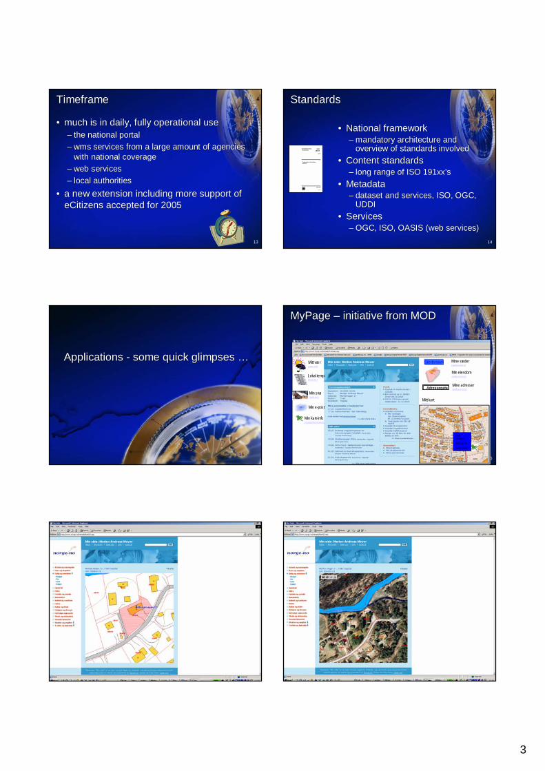
Applications Applications -- some quick glimpses some quick glimpses ……
16
Mitt vær(met.no)
Lokal temp(met.no)
Min snø(met.no)
Stedsnavn Mine steder(webservice)
Min eiendom(webservice)
AdressegataMine adresser(webservice)
Mitt kart(WMS)
Min e-post
Min kart-info(symbolbibliotek)
Jøtul klubbhus
Belsetsv 45
4334 Rykkin
MyPage MyPage –– initiative from MODinitiative from MOD
17 18

4
19
SFTSKNIJOS OTHERKOMM NGU COUNTYDN
Internet services (WMS, WFS, ++)
434
19 x 2
Users Upload data to thick client:Upload data to thick client:
Thematic applicationsThematic applications Download datasetDownload dataset
General viewGeneral view
Fylke
The portals:
20
the geoportal the geoportal –– geoNorge.nogeoNorge.noopened by the Minister of MOD
21
The map viewer The map viewer ……
OverviewOverview
1:50 000 scale1:50 000 scale
1:5 000 scale1:5 000 scale
DetailDetail
22
background background mapmap
from NMAfrom NMA
AIS system for Coast DirectorateAIS system for Coast DirectorateAutomatic Identification SystemAutomatic Identification System•• MMSI number MMSI number -- unique identification unique identification •• Navigation status (e.g. "at anchor" , "under way using engine") Navigation status (e.g. "at anchor" , "under way using engine") •• Rate of turn Rate of turn •• Speed over ground Speed over ground -- 1/10 knot resolution 1/10 knot resolution •• Position accuracy Position accuracy -- differential GPS or other differential GPS or other •• Longitude Longitude -- to 1/10000 minute and Latitude to 1/10000 minute and Latitude -- to 1/10000 minute to 1/10000 minute •• Course over ground Course over ground -- relative to true north to 1/10th degree relative to true north to 1/10th degree •• True Heading True Heading -- 0 to 359 degrees derived from gyro input 0 to 359 degrees derived from gyro input •• Time stamp Time stamp
23 24
Protected areasProtected areas

5
25
Farm with soil classificationApplication for the farmer – agricultural funding support
26
Hydrology authorityHydrology authorityhttp://arcus.nve.no/nyatlashttp://arcus.nve.no/nyatlas
27National Road Data BankNational Road Data Bank
28
NGUNGUMarine geology and resourcesMarine geology and resources
www.mareano.nowww.mareano.no
29No building zone No building zone –– 100 m coastal buffer100 m coastal buffer 30
Fish farmingFish farming

6
31
Sea chart with Sea chart with protects areasprotects areas
32Orthoimagery Orthoimagery –– full national coveragefull national coverage
33Municipal portal Municipal portal –– integrated into national levelintegrated into national level 34Municipal planning classificationMunicipal planning classification
35
BedrockBedrock
36
WildWild naturenature

7
37
PollutionPollution –– depositdeposit and wasteand waste
38
ExampleExample :: Avalanche damage on roadsAvalanche damage on roads andand buildingsbuildings
In more In more detaildetail ......
39
DG Information Society and Media, DG Information Society and Media, March 2005March 2005
40
EuropeanEuropean Spatial Data InfrastructureSpatial Data Infrastructure
Catchments
Meteo data
Land Cover
5 cm/year
ITRF93
NNR-NUVEL1A
GI Institutional framework
GI technicalstandards
Spatial InformationServices
Fundamentaland thematic GI data sets
Spatial Data Infrastructure
GIS to manage Natura2000 sites
Different Policies and standards
Europe is moving 3cm/ year
Different sea levels in Europe
Needs to create europeanspatial data sets eEurope : eGovernement on line
41
INSPIRE required servicesINSPIRE required services
Article 18Article 18Member States shall establish and operate a network of the folloMember States shall establish and operate a network of the following services wing services for the spatial data sets and services for which metadata have bfor the spatial data sets and services for which metadata have been created in een created in accordance with this Directive:accordance with this Directive:
(a) (a) discovery servicesdiscovery services making it possible to search for spatial data sets and making it possible to search for spatial data sets and spatial data services on the basis of the content of the correspspatial data services on the basis of the content of the corresponding onding metadata and to display the content of the metadata;metadata and to display the content of the metadata;(b) (b) view servicesview services making it possible, as a minimum, to display, navigate, making it possible, as a minimum, to display, navigate, zoom in/out, pan, or overlay spatial data sets and to display lezoom in/out, pan, or overlay spatial data sets and to display legend information gend information and any relevant content of metadata;and any relevant content of metadata;(c) (c) download servicesdownload services, enabling copies of complete spatial data sets, or of , enabling copies of complete spatial data sets, or of parts of such sets, to be downloaded;parts of such sets, to be downloaded;(d) (d) transformation servicestransformation services, enabling spatial data sets to be transformed;, enabling spatial data sets to be transformed;(e) (e) ““invoke spatial data servicesinvoke spatial data services”” services, enabling data services to be services, enabling data services to be invoked.invoked.
Those services shall be easy to use and accessible via the InterThose services shall be easy to use and accessible via the Internet or any net or any other appropriate means of telecommunication available to the puother appropriate means of telecommunication available to the public.blic.
42
Lessons learned Lessons learned ……•• The importance ofThe importance of
–– Political supportPolitical support–– Enthusiastic organisations at all levelsEnthusiastic organisations at all levels–– A clear strategyA clear strategy–– An open, standards based technologyAn open, standards based technology
•• Allowing onAllowing on--line integration from distributed line integration from distributed sourcessources
•• Dynamic metadata, both data content and services Dynamic metadata, both data content and services cataloguescatalogues
Still much to do Still much to do ––especially on especially on eCitizeneCitizen interactioninteraction !!!!
Related Documents