The Econ Wilderness Area (EWA) was purchased in 1994 from the Clayton family for 3.5 million dollars for the purpose of conserving of rare Florida habitat as well as for public enjoyment and education. This 240-acre plot of land was acquired to enhance and protect the Econlockhatchee River basin and continue the network of corridors within the region. Starting in 2009, the Econlockhatchee Sandhills Conservation Area (ESCA) set up a land management plan that protects around 2.5 miles of property on either side of the Econlockhatchee River. These 706 acres, from the ESCA, adds to the regional effort to protect the Econlockhatchee and St. Johns River floodplains. This includes the section of the river that runs through the Econ Wilderness Area. The Florida Fish and Wildlife Conservation Commission designated this area a Priority 2 Strategic Habitat Conservation Area; Priority 2 is the second highest designation. The drainage due to the sandhill habitat makes the Econ Wilderness site a key recharge area for aquifers. The following scores were ranked using the Seminole County Natural Lands Advisory Committee Site Priority Ranking Criteria: Vulnerabili ty Completenes s Connectedne ss Rarity Manageabili ty Nature- Oriented Human Use Potential 4 4 5 4 4 4 1

EconWildernessArea-SiteAnalysis-
Aug 17, 2015
Welcome message from author
This document is posted to help you gain knowledge. Please leave a comment to let me know what you think about it! Share it to your friends and learn new things together.
Transcript

The Econ Wilderness Area (EWA) was purchased in 1994 from the Clayton
family for 3.5 million dollars for the purpose of conserving of rare Florida habitat as well
as for public enjoyment and education. This 240-acre plot of land was acquired to
enhance and protect the Econlockhatchee River basin and continue the network of
corridors within the region. Starting in 2009, the Econlockhatchee Sandhills Conservation
Area (ESCA) set up a land management plan that protects around 2.5 miles of property
on either side of the Econlockhatchee River. These 706 acres, from the ESCA, adds to the
regional effort to protect the Econlockhatchee and St. Johns River floodplains. This
includes the section of the river that runs through the Econ Wilderness Area. The Florida
Fish and Wildlife Conservation Commission designated this area a Priority 2 Strategic
Habitat Conservation Area; Priority 2 is the second highest designation. The drainage due
to the sandhill habitat makes the Econ Wilderness site a key recharge area for aquifers.
The following scores were ranked using the Seminole County Natural Lands Advisory
Committee Site Priority Ranking Criteria:
Vulnerability Completeness Connectedness Rarity Manageability
Nature-Oriented
Human Use
Potential
4 4 5 4 4 4
1
Vulnerability
Criteria Rating: 4
“Owner likely to sell or develop but action not imminent. No significant regulatory
protection. Located in high growth area. Good development site.” – Seminole County Natural
Lands Advisory Committee Site Ranking Criteria
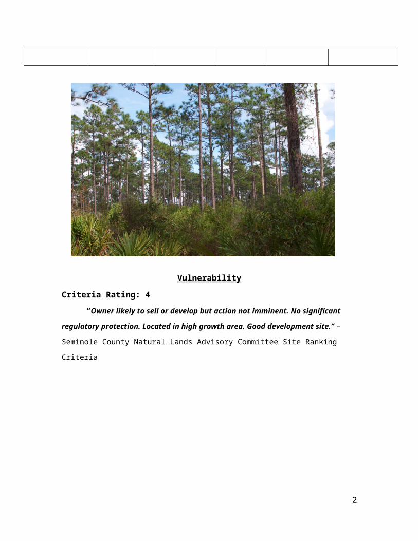
Figure 1.1 The urban development surrounding the Econ Wilderness Area
This criterion encompasses the possibility of development in the area.
Conservation initiatives can become challenging when sites are valued for economic
growth. For example, at the Econ Wilderness Area, the upland area adjacent to the
Econlockhatchee River is a quality location for development. This property is one of
regional significance and is surrounded by encroaching development. However, the
ecological integrity that this section of the corridor maintains outweighs the benefits of
development. By mapping natural systems this can help communities direct development
away from floodplains to prevent the likelihood of being damaged from flooding.
“Socioeconomic and policy factors are taken into account to assess the economic values
of the forestlands, and similar factors were used to evaluate their vulnerability to
2
development.”1 Sites on privately owned lands are especially vulnerable to development
because often times the economic incentives for preservation are low in comparison to
the other uses for the land. Hence, sites in public ownership have a magnified
importance, since they are less likely to be bought and sold privately, and have protection
from the government along with consistent regulation.2 This is especially true for sites
that are state-owned/controlled, where the basis of management is to provide for land
uses that are minimally destructive of resource values. Due to the close proximity of
residential development and the numerous habitats within the Econ Wilderness Area the
possibility of being a potentially vulnerable area for development is moderately high.
When an area is predominantly a wetland habitat, the potential for development is low
due to the many physical restrictions.
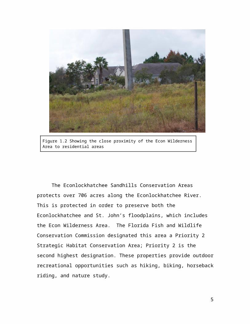
Figure 1.2 Showing the close proximity of the Econ Wilderness Area to residential areas
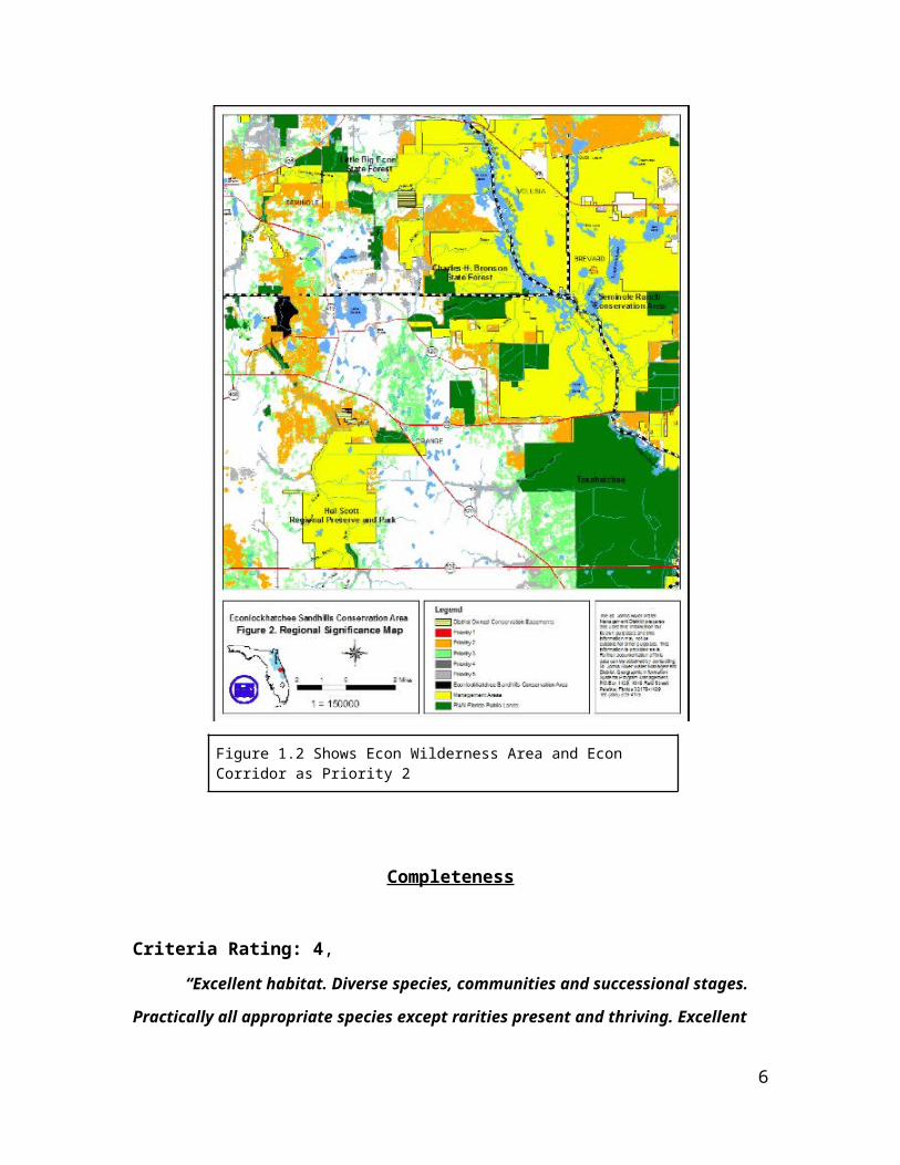
The Econlockhatchee Sandhills Conservation Areas protects over 706 acres along
the Econlockhatchee River. This is protected in order to preserve both the
1 Green Infrastructure
2 Florida Fish and Wildlife Conservation Commission Managed Lands...
3
Econlockhatchee and St. John’s floodplains, which includes the Econ Wilderness Area.
The Florida Fish and Wildlife Conservation Commission designated this area a Priority 2
Strategic Habitat Conservation Area; Priority 2 is the second highest designation. These
properties provide outdoor recreational opportunities such as hiking, biking, horseback
riding, and nature study.
Figure 1.2 Shows Econ Wilderness Area and Econ Corridor as Priority 2
Completeness
4
Criteria Rating: 4,
“Excellent habitat. Diverse species, communities and successional stages. Practically
all appropriate species except rarities present and thriving. Excellent potential for
reintroduction of most missing species.” – Seminole County Natural Lands Advisory Committee
Site Ranking Criteria
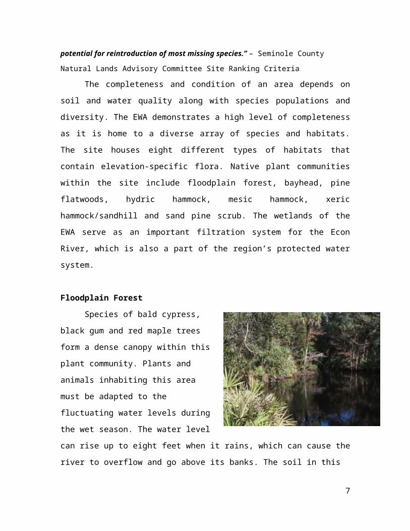
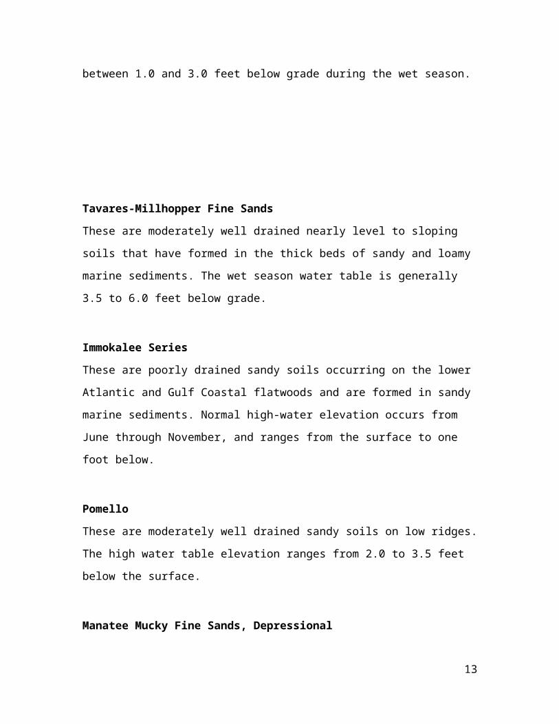
The completeness and condition of an area depends on soil and water quality
along with species populations and diversity. The EWA demonstrates a high level of
completeness as it is home to a diverse array of species and habitats. The site houses
eight different types of habitats that contain elevation-specific flora. Native plant
communities within the site include floodplain forest, bayhead, pine flatwoods, hydric
hammock, mesic hammock, xeric hammock/sandhill and sand pine scrub. The wetlands
of the EWA serve as an important filtration system for the Econ River, which is also a
part of the region’s protected water system.
Floodplain Forest
Species of bald cypress, black gum and
red maple trees form a dense canopy within this
plant community. Plants and animals inhabiting
this area must be adapted to the fluctuating
water levels during the wet season. The water
level can rise up to eight feet when it rains,
which can cause the river to overflow and go
above its banks. The soil in this habitat remains
wet during the low water periods. The plants in
the understory consist of ferns, mosses and shiny lyonia, and are adapted to its shady and
damp conditions. Other plant species found in the floodplain forest community are
cypress, cabbage palm, sweet bay, loblolly bay, sweetgum, red maple, magnolia, willows
and water oak. The water of the black-water creek in this habitat is dark as a result of
tannins leaching into the water and high levels of nutrients from decaying matter.
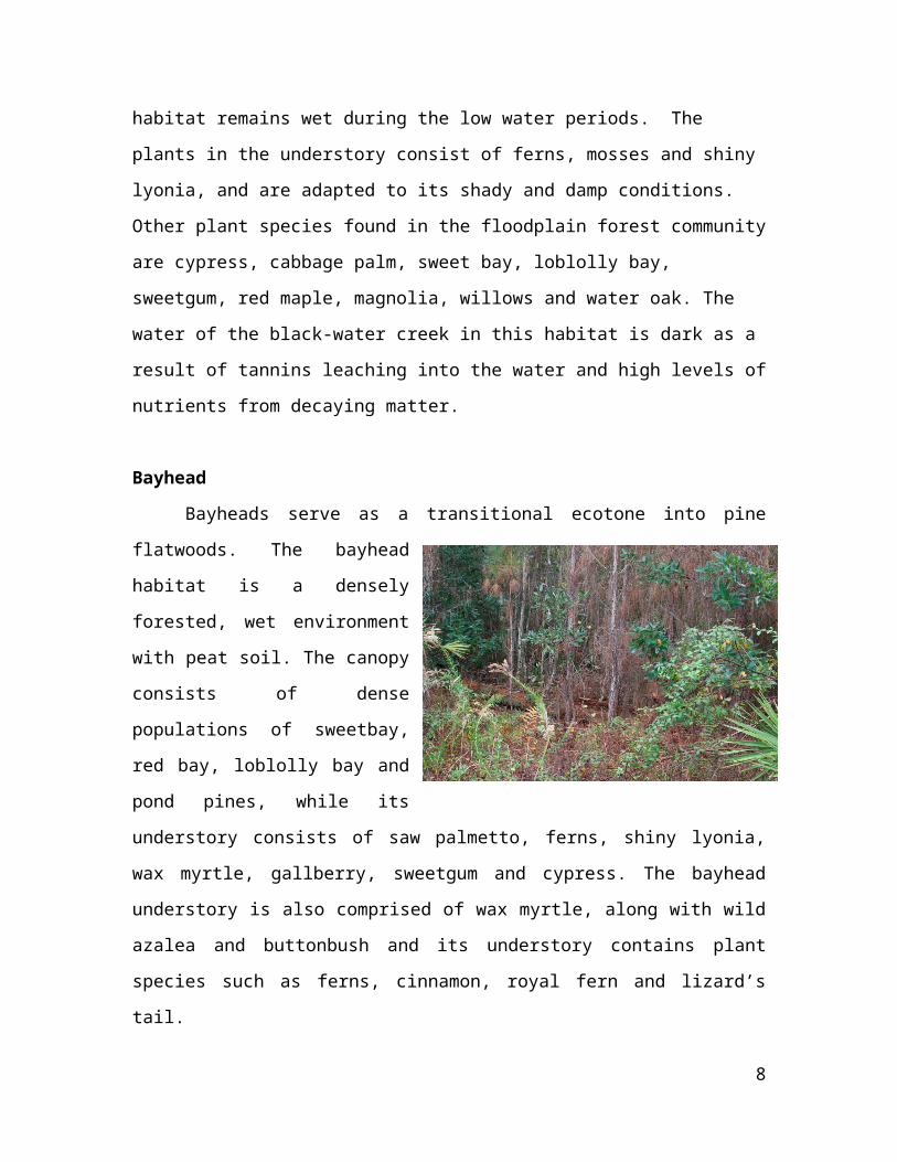
Bayhead
5
Bayheads serve as a transitional ecotone into pine flatwoods. The bayhead habitat
is a densely forested, wet environment
with peat soil. The canopy consists of
dense populations of sweetbay, red
bay, loblolly bay and pond pines,
while its understory consists of saw
palmetto, ferns, shiny lyonia, wax
myrtle, gallberry, sweetgum and
cypress. The bayhead understory is
also comprised of wax myrtle, along
with wild azalea and buttonbush and its understory contains plant species such as ferns,
cinnamon, royal fern and lizard’s tail.
Pine Flatwoods
Pine Flatwoods include Wet Flatwoods, Mesic Flatwoods, and Scrubby
Flatwoods and are all characterized by scattered pine tree canopies. Wet Flatwoods are
dominated by plant species such as
pond pine, slash pine, sweetbay,
dwarf wax myrtle, gallberry and
saw palmetto. The Mesic
Flatwoods are comprised of similar
plants; longleaf pine, wiregrass,
slash pine, gallberry, saw palmetto,
shiny lyonia, dwarf wax myrtle and
blueberry. The Mesic Flatwoods
are the most common habitat found
in Florida. The same species inhabit Scrubby Flatwoods, along with sand live oak,
chapman’s oak, myrtle oak, scrub oak, wiregrass, rusty lyonia, goldenrod and runner oak.
6
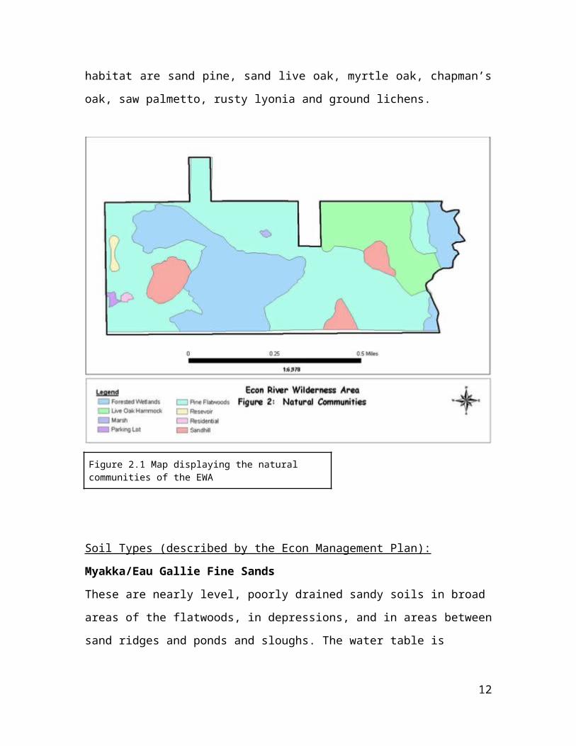
Hydric Hammock
Hydric Hammocks are
typically located between mesic
hammocks and floodplain forests.
Moisture is trapped in the soil by a
combination of sand, clay and organic
material. Species found in this
community are water oak, cabbage
palm, red maple, bays, black gum,
needle palm and mixed hardwoods.
Mesic Hammock
The soil mixture of this plant community is
relatively damp and is a mixture of sand, clay and
organic matter. Plant species that can be found here
are sweetgum, live oak, Florida maple, pignut
hickory, southern magnolia and saw palmetto.
7
Xeric Hammock
The Xeric Hammock is also known as longleaf pine-turkey oak, which displays the
advancing stages of successional
scrub or sandhill. The sandhill
habitat is the most unique amongst
the native plant communities. With
the exception of saw palmetto the
understory does not have many plant
species. The plant species found in
this habitat are sand live oak, turkey
oak, laurel oak, saw palmetto,
bluejack oak, chapman’s oak and wiregrass. The presence of turkey oak in this habitat
indicates a lack of fire within the habitat.
Sand Pine Scrub
The indicator of sand pine scrubs is
its brilliant, white, deep sand that drains
water quickly. This is crucial for aquifer
recharge and a region’s water supply. Plant
species present in this habitat are sand pine,
sand live oak, myrtle oak, chapman’s oak,
saw palmetto, rusty lyonia and ground
lichens.
8
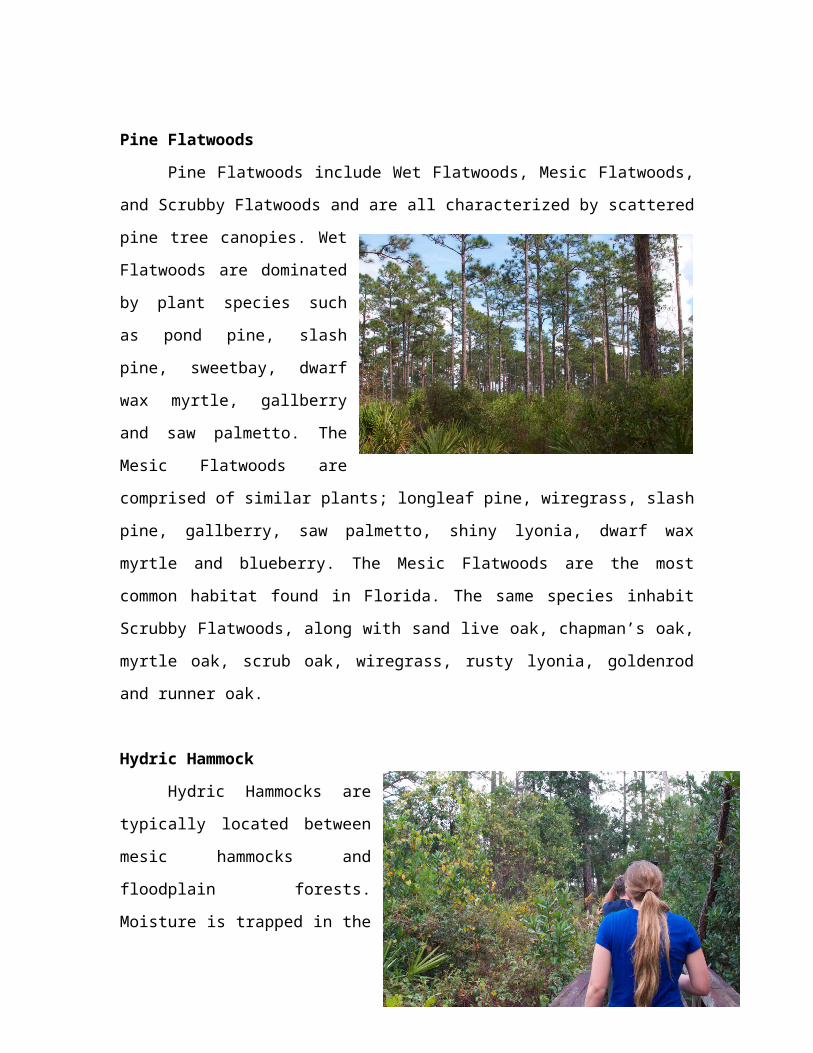
Figure 2.1 Map displaying the natural communities of the EWA
Soil Types (described by the Econ Management Plan):
Myakka/Eau Gallie Fine Sands
These are nearly level, poorly drained sandy soils in broad areas of the flatwoods, in
depressions, and in areas between sand ridges and ponds and sloughs. The water table is
between 1.0 and 3.0 feet below grade during the wet season.
Tavares-Millhopper Fine Sands
These are moderately well drained nearly level to sloping soils that have formed in the
thick beds of sandy and loamy marine sediments. The wet season water table is generally
3.5 to 6.0 feet below grade.
Immokalee Series
These are poorly drained sandy soils occurring on the lower Atlantic and Gulf Coastal
flatwoods and are formed in sandy marine sediments. Normal high-water elevation
occurs from June through November, and ranges from the surface to one foot below.
Pomello
These are moderately well drained sandy soils on low ridges. The high water table
elevation ranges from 2.0 to 3.5 feet below the surface.
Manatee Mucky Fine Sands, Depressional
These are very poorly drained soils occurring in depressions. Normal high-water
9

elevation occurs from June through December and ranges from two feet above to one foot
below the surface.
St. Johns and Eau Gallie Fine Sands
These are nearly level poorly drained soils occurring in broad, low flatwood areas of the
coastal plain. Normal high-water elevation ranges from the surface to one foot below
during the wet season.
Figure 2.2 Map displaying the distribution of soil type in the EWA
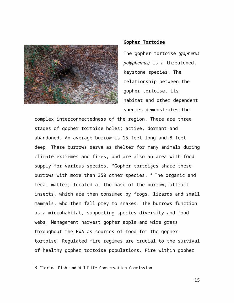
Gopher Tortoise
The gopher tortoise (gopherus
polyphemus) is a threatened, keystone
species. The relationship between the
gopher tortoise, its habitat and other
10

dependent species demonstrates the complex interconnectedness of the region. There are
three stages of gopher tortoise holes; active, dormant and abandoned. An average burrow
is 15 feet long and 8 feet deep. These burrows serve as shelter for many animals during
climate extremes and fires, and are also an area with food supply for various species.
“Gopher tortoises share these burrows with more than 350 other species.”3 The organic
and fecal matter, located at the base of the burrow, attract insects, which are then
consumed by frogs, lizards and small mammals, who then fall prey to snakes. The
burrows function as a microhabitat, supporting species diversity and food webs.
Management harvest gopher apple and wire grass throughout the EWA as sources of food
for the gopher tortoise. Regulated fire regimes are crucial to the survival of healthy
gopher tortoise populations. Fire within gopher tortoise habitats maintains suitable living
conditions for feeding and egg incubation. Heavy canopy growth and density prevents
sunlight from reaching the ground and stimulating the growth of grasses important to the
gopher tortoise’s diet.
Figure 2.3 Gopher Tortoise Potential Habitat
3 Florida Fish and Wildlife Conservation Commission
11
Connectedness
Criteria Rating: 5
“Directly contiguous with large areas of natural habitat along extensive boundaries.
Critical situation for interconnecting natural areas or trail systems.” - Seminole County Natural
Lands Advisory Committee Site Ranking Criteria
Connectedness reflects a locations ability to be adjoined by other important areas
of protection, which are crucial to aspects such as diversity, species movement and
ecological processes. The various habitats and water sources throughout the wilderness
area provide a framework for the implementation of green infrastructure that will
encourage recreation, education, restoration and protection. The Econ Wilderness Area
site connects other ecologically important patches throughout the state including: Little
Big Econ State Park, Seminole Ranch Conservation Area, Charles H. Bronson State
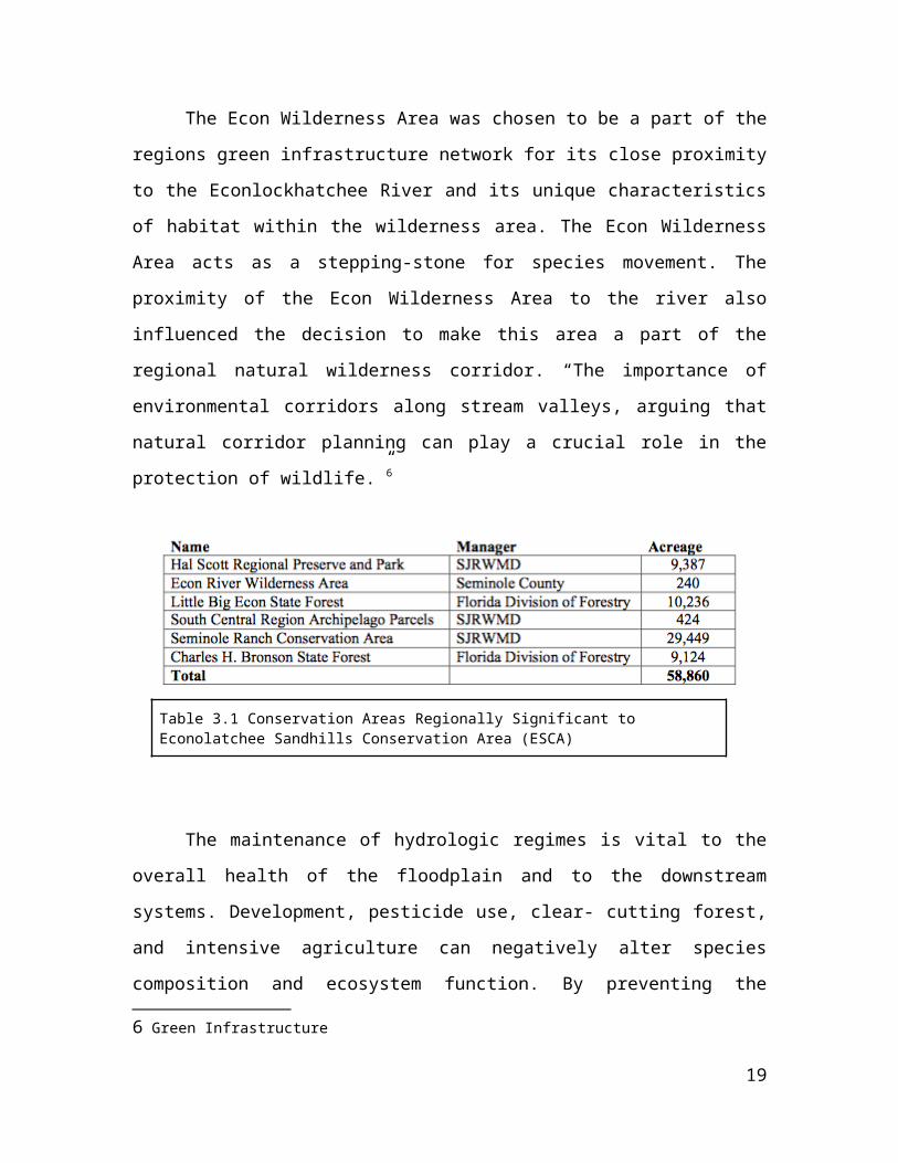
Forest, Hal Scott Regional Preserve, and many other patches/hubs (shown in Table 3.1)
“In the face of continued habitat loss and isolation, many landscape ecologists stress the
need from providing landscape connectivity, particularly in the forms of wildlife
movement corridors and stepping stones”4. These passageways join “existing parks,
preserves, or natural areas and provide sufficient space for native plants and animals to
flourish while serving as corridors connecting ecosystems and landscapes.”5 Corridors
can be applied to both terrestrial and aquatic areas as “river and stream floodplains, serve
4 Landscape Ecology Principles in Landscape Architecture and Land-Use Planning
5 Green Infrastructure
12
as biological conduits for wildlife.”(5) The connectivity of a stream corridor maintains
“aquatic conditions such as cool water temperature and high oxygen content.” (4)
The Econ Wilderness Area, where the Econ River leads to the St. Johns
watershed, demonstrates an example of corridor connectivity. The continuous stream,
provided by preserved waterways, allows the maintenance ecological systems’ health.
The river corridor and wetlands act as “a hydrologic sponge, trap(s) sediment during
floods, and provide(s) soil organic matter for the aquatic food chain, logs for fish habitat,
and habitats for rare floodplain species.” (4)
The Econ Wilderness Area was chosen to be a part of the regions green
infrastructure network for its close proximity to the Econlockhatchee River and its unique
characteristics of habitat within the wilderness area. The Econ Wilderness Area acts as a
stepping-stone for species movement. The proximity of the Econ Wilderness Area to the
river also influenced the decision to make this area a part of the regional natural
wilderness corridor. “The importance of environmental corridors along stream valleys,
arguing that natural corridor planning can play a crucial role in the protection of
wildlife.”6
Table 3.1 Conservation Areas Regionally Significant to Econolatchee Sandhills Conservation Area (ESCA)
6 Green Infrastructure
13
The maintenance of hydrologic regimes is vital to the overall health of the
floodplain and to the downstream systems. Development, pesticide use, clear- cutting
forest, and intensive agriculture can negatively alter species composition and ecosystem
function. By preventing the forests adjacent to the water system from being clear-cut and
limiting the amount of nutrient runoff from agriculture and urban developments will help
preserve this important hydrology. “Better protection of water quality and quantity is a
desired outcome of strategic conservation effort, you would want to include watershed
and water resource features as elements of the green infrastructure network”.(6) The
Econ Wilderness site is vital because it demonstrates stepping stone connectivity for
species movement. Even though the Econ Wilderness Property is a small patch, it
provides movement through these natural corridors. “Many landscape ecologists stress
the need for providing landscape connectivity, particularly in the forms of wildlife
corridors and stepping stones”7
A great example of the importance of these ecological corridors is the movement
of Black Bear throughout Florida.8 The effects of major fragmentation are obvious when
large mammals such as the Black Bear are unable to pass major interstates. This is
magnified with the loss of
small patches that function
as stepping-stones between
larger patches throughout
the state.9
Figure 3.1 Aerial view of EWA in relation to wildlife corridor
7 Landscape Ecology Principles in Landscape Architecture and Land-Use Planning
8 Effectiveness of a Regional Corridor in Connecting Two Florida Black Bear Populations
9 The Florida Wildlife Corridor & the Importance of the Highlands-Glades Florida Black Bear Subpopulation
14
“The optimal spatial arrangement of a cluster of stepping stones between large patches
provides alternate or redundant routes, while maintaining an overall linearly-oriented
array between large patches”(7) “In Seminole County other corridor zones exist along the
St. John’s and Econlockhatchee rivers providing habitat for bald eagles, white-tailed deer
and many other species of wildlife.”10 Furthermore, stepping stones are often a very
important factor for migrating birds, given the vast population of birdlife throughout
Florida, the preservation of the Econ Wilderness site and its connectivity to other
protected areas is extremely important.
10 Seminole County - Site Evaluation Criteria and Ranking Procedures
15
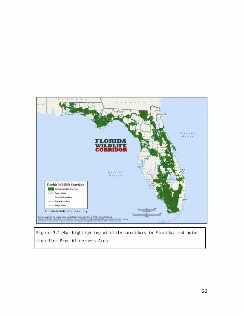
Figure 3.2 Aerial view of EWA in relation to the wildlife corridor
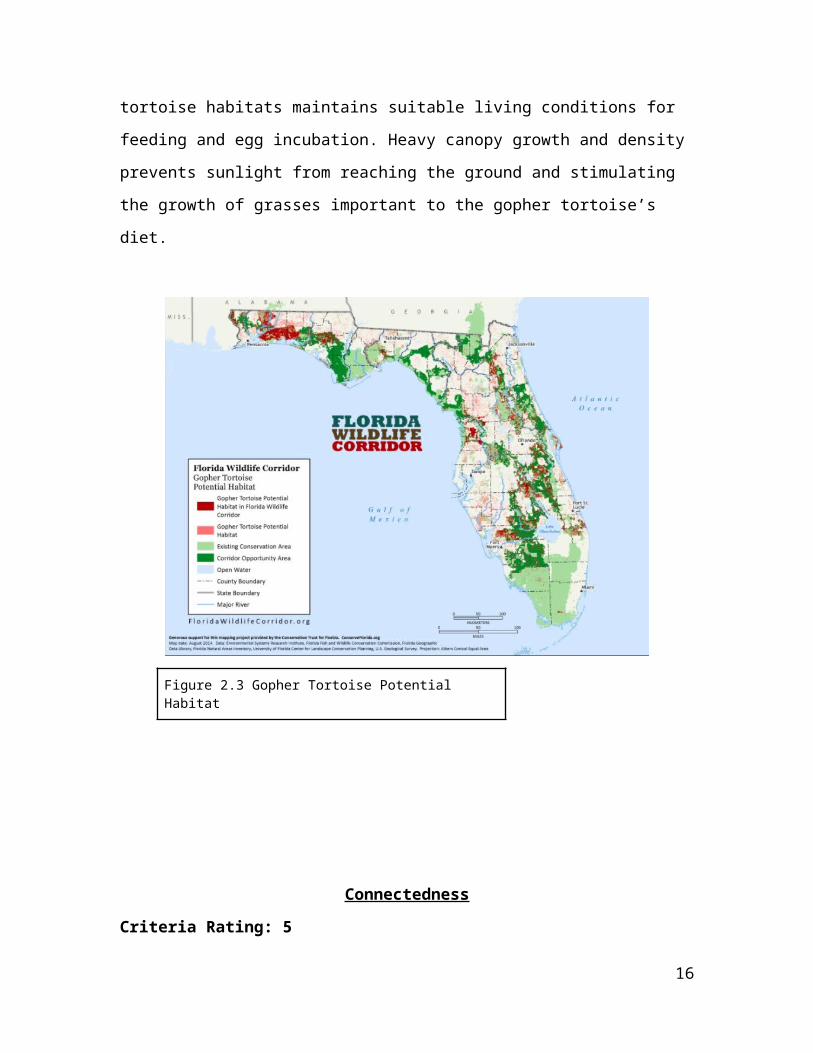
Figure 3.1 Map highlighting wildlife corridors in Florida, red point signifies Econ Wilderness Area
16
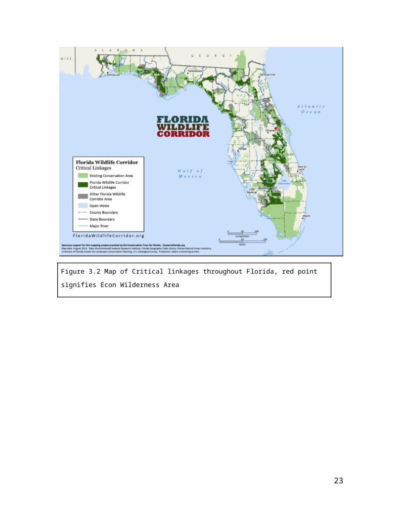
Figure 3.2 Map of Critical linkages throughout Florida, red point signifies Econ Wilderness Area
17
Rarity
Criteria Rating: 4
“Excellent examples of natural communities, some of them scarce. A number of rare
species, but none dependent upon this site for survival. No significant occurrence for a globally
endangered (GI) species or community. Important geological feature, wildlife, archaeological
or historical site. Extensive tract of old growth. One of the best sites of its kind in Seminole
County.” - Seminole County Natural Lands Advisory Committee Site Ranking Criteria
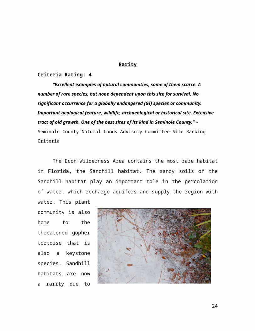
The Econ Wilderness Area contains the most rare habitat in Florida, the Sandhill
habitat. The sandy soils of the Sandhill habitat play an important role in the percolation of
water, which recharge aquifers and supply the region with water. This plant community is
also home to the threatened gopher tortoise that is also a keystone species. Sandhill
habitats are now a rarity due to human activities such as urban development and the
suppression of fire. Due
to the increase in
residential areas and
proximity to natural
areas, residents are weary
of fires close to their
homes. “Eventually the
fire-dependent pines and
other plants will be
crowded out by woody
shrubs and hardwood
trees. The plants and animals of the sandhill system are unable to survive in the thick
understory and are displaced.”11 The fast rate of draining, due to a rise in elevation, is a
desirable real estate quality, which causes this habitat to be vulnerable to development.
11 Sandhill Forests
18
Manageability
Criteria Ranking: 4,
“Excellent examples of natural communities some of them scarce. a number of rare
species, but none dependent upon this site for survival. Several species FNAI ranks 1 or 2 on
state scale. No significant occurrence for a globally endangered (GI) species or community.
Important geological features, wildlife, archaeological or historical site. Extensive tract of old
growth. One of the best sites of its kind in Seminole County.” – Seminole County Natural
Lands Advisory Committee Site Ranking Criteria
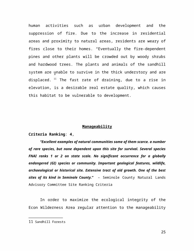
In order to maximize the ecological integrity of the Econ Wilderness Area regular
attention to the manageability of the site is required. In particular, prescribed burns and
removal of exotic species. The use of fire to clear out the woody understory will be
determined by the amount of growth. The
location of the EWA is easily accessible for
management activity. All land management
activities should be continued as to protect
the viability of the site.
Restoration on this site has also
included the reintroduction of fire and the
use of some mechanical treatments, such as
roller chopping. Continued habitat
management through roller chopping,
mowing, and burning will provide optimum
habitat for wildlife species. There are surveys that are conducted annually to verify the
existence of various plant and animal species vital to the health of the habitat. Exotic
species such as the air potato, cogongrass, rattlebox, skunkvine, and Brazilian pepper are
common in the Econ Wilderness Area and are spot treated when found. The main goal is
to get all Category 1 exotic species under maintenance control and trap/remove wild hogs
as needed. 12
12 Econ River Wilderness Area Land Management Planhttp://www.sfrc.ufl.edu/extension/4h/ecosystems/sandhills/sandhills_description.pdf
19
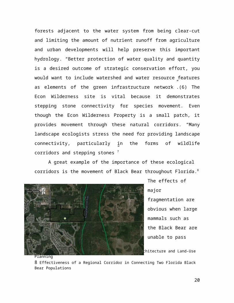
Figure 5.1 The Econ Wilderness Area Management Chart13
Fire and Manageability
13 Econ River Wilderness Area Land Management Planhttp://www.seminolecountyfl.gov/parksrec/pdf/EWALMP_2007.pdf
20

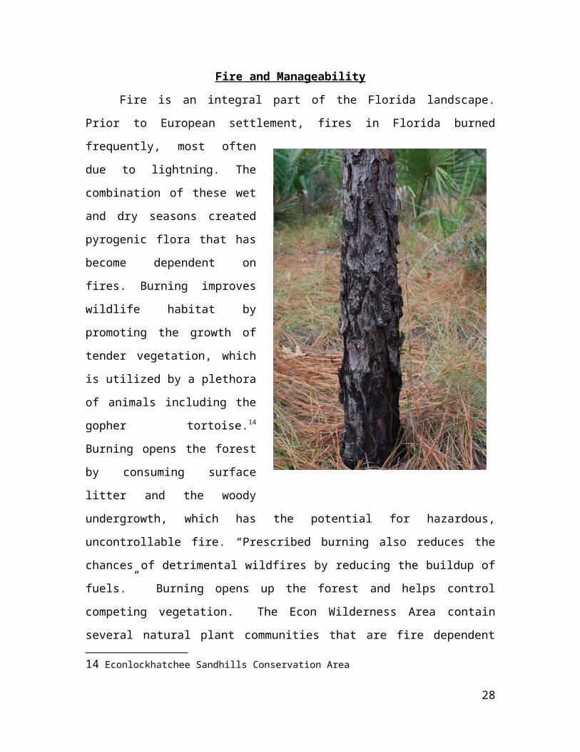
Fire is an integral part of the Florida landscape. Prior to European settlement, fires
in Florida burned frequently, most often due to lightning. The combination of these wet
and dry seasons created pyrogenic
flora that has become dependent on
fires. Burning improves wildlife
habitat by promoting the growth of
tender vegetation, which is utilized
by a plethora of animals including
the gopher tortoise.14 Burning opens
the forest by consuming surface litter
and the woody undergrowth, which
has the potential for hazardous,
uncontrollable fire. “Prescribed
burning also reduces the chances of
detrimental wildfires by reducing the
buildup of fuels.” Burning opens up
the forest and helps control
competing vegetation. The Econ
Wilderness Area contain several
natural plant communities that are
fire dependent including sandhill,
mesic flatwood, wet flatwood, bayhead swamp, etc. all of which are located along the
banks of the Econlockhatchee River. Today due to increased urban pressure on
conservation sites, fire must be managed under strict regulations and performed
according to a set criterion. 15
The objective of prescribed burning at Econ Wilderness Area is to create a mosaic
of native plant communities, promote species diversity, and reduce the accumulation of
hardwoods, which act as a hazardous fuel to fire. Prescribed burning on the property was
introduced in 1999 and continues today. The Econ Wilderness Area is divided into 21
14 Econlockhatchee Sandhills Conservation Area15Econ River Wilderness Area Land Management Plan
http://www.seminolecountyfl.gov/parksrec/pdf/EWALMP_2007.pdf
21
burn zones, which are to be burned at regular intervals. Due to the close proximity to
residential areas and urban settings prescribed burns are carefully planned using the south
and west winds to avoid smoke impacts to adjacent residences and roadways.[3]
Figure 5.2 The Econ Wilderness Burn Zone
Map
Sandhill habitat
22
Figure 5.3 Econ Wilderness Area Firelines and Trails
Dominated by widely spaced pine trees with a sparse understory of deciduous
oaks (like the Turkey Oak), and a dense cover of grasses usually wiregrass on rolling hills
of sand. Fire is a dominant and important factor in the ecology of this habitat. The
natural fire frequency should be every 1-4 years to reduce hardwood competition and
perpetuate the pines and grasses. Without frequent fire these sandhill habitats would
slowly become dominated by the hardwood oak species and move towards becoming a
xeric hammock habitat.
Mesic Flatwoods habitat
Characterized by an open canopy forest of pine trees, (such as the slash pine and
longleaf pine) with little to no understory and a dense ground cover of herbs and shrubs,
(such as saw palmetto, wiregrass, and gallberry.) Fire is an important factor in this
habitat. There are several plant and animal species dependent on fire for their continued
existence. Without fire mesic flatwoods would succeed into hardwood forests whose
closed canopy would eliminate the ground cover of herbs and shrubs.
Bayhead Swamp Habitat
Characterized as densely forested, peat-filled seepage depression often at the basis
of sandy slopes. Frequently located at the edges of floodplains or in other flat areas where
high water tables can help maintain soil moisture. Evergreen hardwoods such as the
sweetbay and loblolly dominate the canopy, and the understory is composed of shrubs
and ferns. Due to the high moisture content of this habitat the fire interval is very long
between 50-100 years. After the fire the bay trees will resprout from the roots and replace
themselves. A high intensity fire has the ability to change the bayhead swamp into drier
habitat.
Hydric Flatwood Habitat
Characterized by a relatively open canopy forest of scatter pine trees, pond pine
23
and slash pine, or cabbage palms, and a thick understory with very sparse groundcover.
Fire is an important factor in the development of Hydric Flatwoods. Nearly all plants and
animals in this habitat are adapted to the periodic fires, every 3-10 years; several species
depend on fire for their survival. In the absence of fire, this habitat becomes overrun by
hardwood species creating a closed canopy, which in turn eliminates groundcover.
Figure 5.4 Burn Chart for frequency of fires
Exotic and Native Species Manageability
There are a number of exotic species that occur on site, including the air potato,
cogongrass, rattlebox, feral hog, Cuban brown anole, nine-banded armadillo, Cuban
treefrog, etc. The State of Florida spends millions every year trying to control invasive
species. “Since the impacts of invasive exotic species have both an environmental and
economic impact, a non-governmental organization called the Florida Exotic Pest Plan
Council was formed.” [4] This organization provides a list of Florida’s invasive exotic
species. The list is divided into two categories: Category 1 species, which includes
species that alter the native plant species by displacing native species and Category 2
species, which include those who have increased in abundance and frequency but have
not yet altered native plant communities. The Econ Wilderness Area has exotic species
from both categories. There are ongoing treatments to control exotic species and there is
an exotic species management plan in place, where the status of exotic animals will be
developed over the next few years.
In 2006, a new Natural Lands Program Monitoring Plan was developed[5] In that
plan, monitoring at the Econ Wilderness Area would now include gopher tortoise
24
marking, photo points, plant transects, and small mammal trapping; Exotic treatment
would also be monitored by photo points. Due to their importance in the Econ Wilderness
Area, gopher tortoise populations are monitored thoroughly through a volunteer program.
The data collected from these monitoring’s allow staff to estimate the gopher tortoise
population on each property. When exotic animal species are found on the property they
are removed with the appropriate outlets. Seminole County has contracted two agencies
that specialize in the removal of nuisance feral hogs. Also, when feral cats or dogs are
found on site, they are captured and turned over to the Seminole County Animal Services.
Figure 5.5 Feral hog rooting area
Forest Management
Florida Statutes require public agencies to evaluate lands they manage for timber
production. Planting of upland forest species may be a component of future upland
restoration projects but as of this time, there are no plans to conduct any forestry related
activity within the Econ Wilderness Area.
Nature-Oriented Human Use Potential
Criteria Ranking: 4,
25
“Good for several types of passive recreation. Scenic. Suitable for nature trails and/or
environmental center. Valuable site for scientific research. Special enough to be a popular
regional passive recreation destination.” - Seminole County Natural Lands Advisory Committee
Site Ranking Criteria
Figure 6.1 Map highlighting recreational trails throughout the EWA
This map highlights the recreation trail system within the site, which extends
through mesic, xeric and hydric habitats. Recreational activities exercised in this area can
range from hiking, biking, horseback riding, fishing, and wildlife viewing. With its close
proximity to urban areas it is easily accessible to the general public. The site also
provides educational opportunities by serving as an outdoor classroom/laboratory for
students and researchers, who can utilize the well-maintained site, which houses a diverse
array of habitats, plants and animal species. Throughout the site there are also
informative signs for visitors, where they are educated on the plant species in the area,
descriptions of the various plant communities and maintenance methods practiced in the
EWA.
26
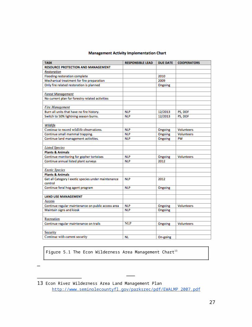
Figure 6.2 Map showing recreational areas in EWA
Rollins College’s Environmental Studies students learning about native plant species in an outdoor classroom setting.
27
Bibliography
● Econ River Wilderness Area: Land Management Plan (2010) :
http://www.seminolecountyfl.gov/parksrec/pdf/EWALMP_2007.pdf
● Econlockhatchee Sandhills Conservation Area (2009):
http://www.sjrwmd.com/landmanagementplans/pdfs/2009_Econlockhatchee_Sandhills.pdf
● Florida Fish and Wildlife Conservation Commission (2006-2016) :
http://myfwc.com/media/132374/CMP_Salt_Lake_2006_2016.pdf,
http://myfwc.com/wildlifehabitats/managed/gopher-tortoise/
● Florida Department of Environmental Protection (2010):
http://www.sjrwmd.com/landmanagementplans/pdfs/2011_Charles_H_Bronson_SF.pdf
● Florida Designated Paddling Trails: Econlockhatchee River:
http://www.dep.state.fl.us/gwt/guide/designated_paddle/Econlock_guide.pdf
● Guide to the Natural Communities of Florida (2010):
http://www.dep.state.fl.us/parks/planning/forms/FNAIDescriptions.pdf
● Effectiveness of a Region Corridor in Connecting Florida Black Bear Populations:
http://people.sc.fsu.edu/~pbeerli/BSC3052/restricted/papers/Dixon-et-al-2006.pdf
● The Florida Wildlife Corridor and the Importance of the Highlands-Glades Florida Black Bear
Subpopulation: http://conservation.dcp.ufl.edu/FWC%20Intro%20and%20Highlands_Glades
%20Bears%20document.pdf
● Florida Wildlife Corridors: http://floridawildlifecorridor.org/maps/,
http://floridawildlifecorridor.org/econ-to-deep-creek/
● Sandhill Forests:
http://www.sfrc.ufl.edu/extension/4h/ecosystems/sandhills/sandhills_description.pdf
● Dramstad, W., Olson, J., & Forman, R. (1996). Landscape ecology principles in landscape
architecture and land-use planning. Cambridge? Mass.: Harvard University Graduate School of
Design
● Benedict, M., & McMahon, E. (2006). Green infrastructure linking landscapes and communities.
Washington, DC: Island Press.
28
Related Documents