Please cite this article in press as: Hepcan, S ¸., et al., Ecological networks as a new approach for nature conservation in Turkey: A case study of ˙ Izmir Province. Landscape Urban Plann (2008), doi:10.1016/j.landurbplan.2008.10.023 ARTICLE IN PRESS G Model LAND-1650; No. of Pages 12 Landscape and Urban Planning xxx (2008) xxx–xxx Contents lists available at ScienceDirect Landscape and Urban Planning journal homepage: www.elsevier.com/locate/landurbplan Ecological networks as a new approach for nature conservation in Turkey: A case study of ˙ Izmir Province S ¸ erif Hepcan a,∗ ,C ¸i˘ gdem Cos ¸ kun Hepcan a , Irene M. Bouwma b , Rob H.G. Jongman b , Mehmet Bülent Özkan a a Ege University, Faculty of Agriculture, Department of Landscape Architecture, Bornova, 35100 Bornova- ˙ Izmir, Turkey b Alterra, Wageningen UR, PO Box 47, 6708 AA Wageningen, The Netherlands article info Article history: Received 9 November 2007 Received in revised form 9 October 2008 Accepted 24 October 2008 Available online xxx Keywords: Ecological network Target species Key Biodiversity Areas Minimum Viable Population Turkey abstract This paper aims to identify and evaluate a potential ecological network including core areas and large- scale corridors in the ˙ Izmir Province and its surrounding areas, Turkey. It is one of the first studies on the connectivity for mammal species and the detection of potential ecological corridors for Turkey. Four wide-ranging species (Hyaena hyaena, Lynx lynx, Caracal caracal, and Felis chaus) have been chosen as target species. Existing Key Biodiversity Areas (KBAs) and surrounding lands have been evaluated based on a three criteria: (1) vegetation/habitat types, (2) carrying capacity and (3) road density using simple GIS-based models. The results are evaluated using the Minimum Viable Metapopulation (MVMP) standards. No KBA in the study region has a Key Population (KP) or Minimum Viable Population (MVP) with the exception of Boz Da˘ glar. Least cost-path analysis has been applied to identify linkages between KBAs relevant for the four target species. The conclusion is that it is possible to maintain MVPs in the region when the KBAs are linked by ecological corridors. © 2008 Elsevier B.V. All rights reserved. 1. Introduction Soulé (1986) and Forman (1996) stated that habitat fragmenta- tions and losses have become an important subject of ecological research (Wiegand et al., 2005) as fragmentation is considered to be one of the major threats to biological diversity (Forman, 1998; Cook, 2002; Bouwma et al., 2003; Jongman, 2004). The planning and establishment of ecological networks as a means of creating spatially integrated landscapes and habitats is being increasingly accepted as an appropriate approach for improving the ecological quality of natural ecosystems and pro- tecting biodiversity (Van Rooij et al., 2003; Verboom and Pouwels, 2004; Smith, 2004). Where fragmentation occurs, establishing or restoring linkages between patches through ecological corridors is essential to facilitate their ecological functions (Cook, 2002). Eco- logical linkages also provide opportunities for human services such as recreation, education, human benefits both cultural and aes- thetic as well as being compatible with the concept of sustainable land use (Ahern, 2002; Cook, 2000). ∗ Corresponding author. Tel.: +90 232 3884000 (3098 extension); fax: +90 232 3881864. E-mail address: [email protected] (S ¸ . Hepcan). An ecological network is recognized as a framework of ecolog- ical components, e.g. core areas (nodes), corridors (natural and/or artificial linkages) and buffer zones which provide the physical conditions necessary for ecosystems and species populations to survive in a human-dominated landscape (Jongman, 2004). In this context, conservation biology is an integral science for the delin- eation of ecological networks (Noss, 1993, 1996; Carroll et al., 2003). The planning of ecological networks and greenways largely focuses on the integration and application of landscape ecological princi- ples and conservation biology (Ahern, 2002). These principles have guided nature conservation and landscape planning in recent years throughout the world (Jongman, 2004). Turkey is a key country in terms of conservation of global bio- diversity owing to its location at the junction of three continents as well as Anatolia’s complex biogeoclimate regimes and geo- morphology. These geographical features account for a high level of biodiversity, especially an exceptionally rich flora (Eken et al., 2004). Biodiversity in Turkey has been seriously threatened by land-use changes in recent decades (Evrendilek and Doygun, 2000; Eken et al., 2006; Yücel, 2005). There are many areas of high bio- logical biodiversity that are not preserved by the existing legal protection system in the country. Nearly 80% of the total surface area of Turkey’s known high Key Biodiversity Areas (KBAs) has no protection (Eken et al., 2004; Yücel, 2005). 0169-2046/$ – see front matter © 2008 Elsevier B.V. All rights reserved. doi:10.1016/j.landurbplan.2008.10.023

Welcome message from author
This document is posted to help you gain knowledge. Please leave a comment to let me know what you think about it! Share it to your friends and learn new things together.
Transcript
L
EA
S
a
b
a
ARRAA
KETKMT
1
trbC
miit2relatl
f
0d
ARTICLE IN PRESSG ModelAND-1650; No. of Pages 12
Landscape and Urban Planning xxx (2008) xxx–xxx
Contents lists available at ScienceDirect
Landscape and Urban Planning
journa l homepage: www.e lsev ier .com/ locate / landurbplan
cological networks as a new approach for nature conservation in Turkey:case study of Izmir Province
¸ erif Hepcana,∗, Cigdem Coskun Hepcana, Irene M. Bouwmab, Rob H.G. Jongmanb, Mehmet Bülent Özkana
Ege University, Faculty of Agriculture, Department of Landscape Architecture, Bornova, 35100 Bornova-Izmir, TurkeyAlterra, Wageningen UR, PO Box 47, 6708 AA Wageningen, The Netherlands
r t i c l e i n f o
rticle history:eceived 9 November 2007eceived in revised form 9 October 2008ccepted 24 October 2008vailable online xxx
a b s t r a c t
This paper aims to identify and evaluate a potential ecological network including core areas and large-scale corridors in the Izmir Province and its surrounding areas, Turkey. It is one of the first studies onthe connectivity for mammal species and the detection of potential ecological corridors for Turkey. Fourwide-ranging species (Hyaena hyaena, Lynx lynx, Caracal caracal, and Felis chaus) have been chosen astarget species. Existing Key Biodiversity Areas (KBAs) and surrounding lands have been evaluated based
eywords:cological networkarget speciesey Biodiversity Areasinimum Viable Population
urkey
on a three criteria: (1) vegetation/habitat types, (2) carrying capacity and (3) road density using simpleGIS-based models.
The results are evaluated using the Minimum Viable Metapopulation (MVMP) standards. No KBA in thestudy region has a Key Population (KP) or Minimum Viable Population (MVP) with the exception of BozDaglar. Least cost-path analysis has been applied to identify linkages between KBAs relevant for the fourtarget species. The conclusion is that it is possible to maintain MVPs in the region when the KBAs are
ors.
iacsceTopgt
da
linked by ecological corrid
. Introduction
Soulé (1986) and Forman (1996) stated that habitat fragmenta-ions and losses have become an important subject of ecologicalesearch (Wiegand et al., 2005) as fragmentation is considered toe one of the major threats to biological diversity (Forman, 1998;ook, 2002; Bouwma et al., 2003; Jongman, 2004).
The planning and establishment of ecological networks as aeans of creating spatially integrated landscapes and habitats
s being increasingly accepted as an appropriate approach formproving the ecological quality of natural ecosystems and pro-ecting biodiversity (Van Rooij et al., 2003; Verboom and Pouwels,004; Smith, 2004). Where fragmentation occurs, establishing orestoring linkages between patches through ecological corridors isssential to facilitate their ecological functions (Cook, 2002). Eco-
Please cite this article in press as: Hepcan, S., et al., Ecological networks aIzmir Province. Landscape Urban Plann (2008), doi:10.1016/j.landurbplan.2
ogical linkages also provide opportunities for human services suchs recreation, education, human benefits both cultural and aes-hetic as well as being compatible with the concept of sustainableand use (Ahern, 2002; Cook, 2000).
∗ Corresponding author. Tel.: +90 232 3884000 (3098 extension);ax: +90 232 3881864.
E-mail address: [email protected] (S. Hepcan).
mo2lElpap
169-2046/$ – see front matter © 2008 Elsevier B.V. All rights reserved.oi:10.1016/j.landurbplan.2008.10.023
© 2008 Elsevier B.V. All rights reserved.
An ecological network is recognized as a framework of ecolog-cal components, e.g. core areas (nodes), corridors (natural and/orrtificial linkages) and buffer zones which provide the physicalonditions necessary for ecosystems and species populations tourvive in a human-dominated landscape (Jongman, 2004). In thisontext, conservation biology is an integral science for the delin-ation of ecological networks (Noss, 1993, 1996; Carroll et al., 2003).he planning of ecological networks and greenways largely focusesn the integration and application of landscape ecological princi-les and conservation biology (Ahern, 2002). These principles haveuided nature conservation and landscape planning in recent yearshroughout the world (Jongman, 2004).
Turkey is a key country in terms of conservation of global bio-iversity owing to its location at the junction of three continentss well as Anatolia’s complex biogeoclimate regimes and geo-orphology. These geographical features account for a high level
f biodiversity, especially an exceptionally rich flora (Eken et al.,004). Biodiversity in Turkey has been seriously threatened by
and-use changes in recent decades (Evrendilek and Doygun, 2000;
s a new approach for nature conservation in Turkey: A case study of008.10.023
ken et al., 2006; Yücel, 2005). There are many areas of high bio-ogical biodiversity that are not preserved by the existing legalrotection system in the country. Nearly 80% of the total surfacerea of Turkey’s known high Key Biodiversity Areas (KBAs) has norotection (Eken et al., 2004; Yücel, 2005).
ING ModelL
2 Urba
tldatiiGoeltEcucng
osTeIw22gbLI2scwm
2
fwo
atfAmcotrfawc
rmlatet
3
wchtpmcadd
3
ARTICLEAND-1650; No. of Pages 12
S. Hepcan et al. / Landscape and
Bibby (1998) states that KBAs are places of international impor-ance for the conservation of biodiversity at the global, regional orocal levels. This approach to designation of KBAs aims to identify,ocument and protect networks of such areas by setting objectivesnd globally applicable criteria. These areas must be large enougho support viable populations of the species for which they aremportant (Eken et al., 2004). In Turkey, the scientific task involvedn designating the KBAs has been carried out by a national Non-overnmental Organisation (NGO) Doga Dernegi, with the supportf the British Royal Society for the Protection of Birds (RSPB, Ekent al., 2006). KBAs established in 2003–2004 have the status of ateast one of the categories, including Important Plant Areas, Impor-ant Bird Areas or Important Mammal Areas (Özhatay et al., 2003;ken et al., 2006). In Turkey as in most other countries, ecologi-ally valuable areas have been established and managed as isolatednits. Haaren and Reich (2006) indicated that the traditional con-ept of protecting isolated remnants of endangered habitats asature reserves could not stop the continuing decline of endan-ered species and the regional losses of biodiversity sufficiently.
Given the ongoing process of land-use changes, preservationf key areas and connectivity through spatially connected land-capes and habitats are now becoming very important in Turkey.he present paper depicts the identification and discussion of ancological network at a large scale for one region in Turkey, the
˙zmir Province. The project is a pilot research for Turkey using fouride-ranging mammals as target species (Padoa-Schioppa et al.,
005; Beier, 1993; Klaver, 2003; Bruinderink et al., 2003; Somma,006; Wikramanayake et al., 2003). Large carnivores mostly in dan-er of extinction or seriously threatened in Turkey (Can, 2004) haveeen included. The four selected target species (Hyaena hyaena,ynx lynx, Caracal caracal, and Felis chaus) are included in both “2007UCN Red List” and “National/Regional Red List” species (Eken et al.,006). The ultimate aims of this study were (1) to assess the habitatuitability of KBAs in the study region for the targeted mammalianarnivores and (2) to analyze and to identify the ecological net-orks by offering spatial linkages between KBAs by using GIS-basedodels.
. The study region
Please cite this article in press as: Hepcan, S., et al., Ecological networks aIzmir Province. Landscape Urban Plann (2008), doi:10.1016/j.landurbplan.2
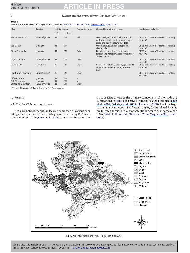
The Izmir Province and its surrounding areas have been chosenor this study (Fig. 1). Izmir is the third largest province in Turkeyith nearly 2.5 million inhabitants and situated in the coastline
f the Ege (Aegean) region. Coastal areas are densely populated
ttgi(
Fig. 1. The location of t
PRESSn Planning xxx (2008) xxx–xxx
nd extensively used for a range of objectives. The landscape inhe region is dominated by fertile arable land and Mediterraneanorest and scrub with affinities with both maquis and phrygana.rable land is mostly located in the fertile lowlands between theountain ranges generally situated perpendicular to the Aegean
oastline. These agriculturally valuable lowlands also have a varietyf other land uses, e.g. intensive urban agglomerations, small set-lements containing holiday accommodation, major transportationoutes, and intensive industrial facilities. The region has many dif-erent protected areas, such as national parks, spatially protectedreas and natural sites. Fortunately, the region has still relativelyell-connected natural landscapes due to its geomorphological
haracter.The core areas in this study are pre-existing KBAs. The total study
egion including 4.740 km2 of KBAs (Eken et al., 2006) is approxi-ately 18.905 km2. The study area is mainly composed of arable
and (40%), urban areas (5%), maquis-phrygana vegetation (35%),nd forest (12%). The region is confined by the Dilek Peninsula inhe south, the Manisa and Aydın provinces in the east and north-ast, and the Candarlı Bay in the north. Fig. 2 gives an overview ofheir locations in the study region.
. Methods
According to Bischoff and Jongman (1993), an ecological net-ork is composed of core areas usually protected by buffers and
onnected through ecological linkages or corridors. Core areasave, in most cases, been identified and safeguarded by a tradi-ional nature conservation strategy through the establishment ofrotected areas (Jongman, 2004). The main pillars in the presentethodology focus on (1) core areas and (2) ecological linkages or
orridors as the basic elements of an ecological network. Bufferreas are not considered within the scope of this study due toifficulties with the identification of buffer zones as they are site-ependent. Fig. 3 provides a flowchart of the methodology followed.
.1. Collection and analysis of data
The main input in this study is a land cover map. Previously,
s a new approach for nature conservation in Turkey: A case study of008.10.023
here was no such map relevant with the scope and the scale ofhe study; therefore, one has been produced and converted intorid map with a grid size of 0.01 km2 for use in analyses dur-ng this study. For determination of land cover types, Landsat-TM2000) satellite images and some topographical maps were uti-
he study region.
ARTICLE IN PRESSG ModelLAND-1650; No. of Pages 12
S. Hepcan et al. / Landscape and Urban Planning xxx (2008) xxx–xxx 3
As) in
lcdl
Fig. 2. The locations of Key Biodiversity Areas (KB
Please cite this article in press as: Hepcan, S., et al., Ecological networks aIzmir Province. Landscape Urban Plann (2008), doi:10.1016/j.landurbplan.2
ized. Interpretation of satellite images was supported by fieldhecks and expert opinions. In addition, included as the other majorata sources were relevant literature and some interviews with
ocal people and experts. Data collected for the identification and
euoc
Fig. 3. Flowchart of the procedure for identi
the study region (derived from Eken et al., 2006).
s a new approach for nature conservation in Turkey: A case study of008.10.023
valuation of the ecological network were stored and analyzedsing ArcGIS 9.2 (ESRI, 2005). In this way, separate assessmentsf relevant habitat types, carrying capacity and road density wereonducted in the study region. Based on these assessments, the
fying ecological (landscape) network.
IN PRESSG ModelL
4 Urban Planning xxx (2008) xxx–xxx
spa
3
apawgri
pac(stw(c2mtt“riopgK
3
btst(bpotmb
(
ce2WIretdslt
Table 1Estimates of the relevant parameters for target species (Jochem et al., 2002; Wagneret al., 2008; Klaver, 2003; Avenant and Nel, 1998; Bouwma et al., 2002).
Species Home range (km) Dispersal distance (km) Density (pairs/km2)
Hyaena hyaena 6 100 0.01LCF
(airwf
(
ttpKpru(din
t(a2c(f((
EtiCvsao
(Roads create barriers and additional disturbances that in turn
cause fragmentation of the landscape and its populations (Jaarsmaand Willems, 2002). There are five major threats to fauna due to theuse of roads: (1) road kills, (2) disturbance, (3) avoidance, (4) bar-
Table 2MVMP (Minimum Viable Metapopulation) standards/number of species (Verboomand Pouwels, 2004).
Species group KP MVP Network Network
ARTICLEAND-1650; No. of Pages 12
S. Hepcan et al. / Landscape and
patial linkages for each target species were delineated among there-existing KBAs on the basis of least-coast paths using spatialnalyst module in ArcGIS 9.2.
.2. Selecting KBAs and target species
Internationally and/or nationally acknowledged protectedreas, and ecologically valuable areas unprotected (existing,lanned and expected in the future) were considered as “corereas”. Therefore, the core areas are pre-existing KBAs in this studyhere highest species richness is present (Eken et al., 2006). Tar-
eted species are mostly included by the selected KBAs in the studyegion. In addition, relative data availability compared to surround-ng land is another reason to select KBAs as core areas.
Target species are critical components of nature conservationlanning. They warrant more conservation attention because theyre functionally important and/or vulnerable to landscape modifi-ations (Beazley and Cardinal, 2004). Identification of target speciesparticularly wide-ranging animals) is the major challenge in thistudy because using them requires consistent and detailed informa-ion concerning both distribution and abundance of such species;hile reliable data are not available even for the whole of Turkey
Can, 2004). One exception is KBAs, where limited informationoncerning the existence of the species is available (Eken et al.,006). Large carnivores have been preferred in this process. Theain reason is that these species are mostly subjected to serious
hreats in Turkey (Can, 2004), and also, they are classified underhe categories of both “2007 IUCN Red List” (IUCN, 2008) andNational/Regional Red List” species (Eken et al., 2006). Anothereason is that if large animals are selected for identifying ecolog-cal networks, many other species may benefit from and dispersen these corridors (Noss et al., 1996; Bruinderink et al., 2003). Forractical reasons such as the availability of limited data on the tar-et species and practicality only one species was assigned to eachBA to make the analysis as explained below.
.3. Analyzing KBAs for target species
Pre-existing KBAs and the surrounding land were evaluatedased on a three-way approach including relevant vegeta-ion/habitat types, carrying capacity and road density analyses in aimilar approach described by Beazley et al. (2005). Suitable habi-at is required for maintaining viable populations of all organismsBouwma et al., 2002). Therefore, habitat attributes of KBAs haveeen analyzed habitat suitability affecting the long run viability ofopulations. In this process, some of the assessments were carriedut on the basis of information regarding “actual existence” of thearget species in KBAs (Eken et al., 2006). However, some assess-
ents were based on “only potential existence” of the target speciesy habitat suitability.
a) Identifying relevant habitat typesRelevant vegetation/habitat types for the selected species were
ompiled from the land cover map by overall habitat prefer-nces of the targeted animals using relevant literature (Can,004; Demirsoy, 1992; Humphrey and Bain, 1990; Klaver, 2003;agner, 2006; Palomares et al., 2005; Avenant and Nel, 1998).
n this process, country/region-specific data regarding the habitatequirements of the target species were particularly valuable andmphasized in this study. H. hyaena is a species mostly confined
Please cite this article in press as: Hepcan, S., et al., Ecological networks aIzmir Province. Landscape Urban Plann (2008), doi:10.1016/j.landurbplan.2
o areas between 250 and 2500 m above sea level in barren lands,ry woodland habitats, and open or rocky habitats in eastern andouth-eastern Turkey. The habitats preferred by L. lynx are mainlyarge deciduous mixed-coniferous forests, open wooded regions inhe eastern Black Sea region and Mediterranean region of Turkey
LM
S
ynx lynx 10 100 0.01aracal caracal 10 100 0.03elis chaus 4 50 0.10
Can, 2004). No region-specific habitat data is available for C. caracalnd F. chaus. In the study, probable relevant habitat types were spec-fied according to the requirements of species in the entire studyegion using ArcGIS 9.2. The coverage of KBAs and habitat typesas then overlaid to provide a basis for carrying capacity analysis
or target species in the KBA.
b) Carrying capacity analysisAccording to Duerkson et al. (1997), the size of habitats affects
he viability of their populations and ecological value. Large habi-at patches are more valuable because they support large, persistentopulations (Cook, 2002). In the light of these considerations, theBAs were examined and classified regarding their capacity to sup-ort large persistent populations of the four selected species in theegion. For estimating the capacity, the following parameters aresed: (1) number of reproductive units or density (pairs/km2), and2) area requirements of target species (home ranges and dispersalistances) in KBAs. It is important to note that dispersal distance
s the key variable in determining the average boundaries of theetwork (Jochem et al., 2002).
The estimates of relevant parameters were derived from litera-ure including Jochem et al. (2002); Wagner et al. (2008); Klaver2003); Avenant and Nel (1998); data collected from regulatorygencies on national and international projects (Bouwma et al.,002) and personal interviews (Table 1). “Carrying Capacity” (CC) isalculated by taking the number of “estimated” Reproductive UnitsRU) into account for each habitat patch and classified into four dif-erent groups such as “No Carrying Capacity (NCC)”, “Small PatchSP)”, “Key Patch (KP)” and “Minimum Viable Population (MVP)”Table 2) (Verboom and Pouwels, 2004).
Each KBA on the basis of some up-to-date data provided byken et al. (2006) was analyzed and mapped by those parame-ers separately for each existing target species in ArcGIS 9.2. Moremportantly, if a particular KBA is not qualified well enough to meetC requirements of the targeted species (i.e., NCC and SP are notiable), remaining KBAs having similar habitat types within disper-al distance of the species were also analyzed with the purpose ofssessing “potential habitats” for future occurrence or colonizationf the species to establish ecological network(s).
c) Road density analysis
s a new approach for nature conservation in Turkey: A case study of008.10.023
with KP without KP
ong lived/large vertebrates 20 80 80 120edium-long lived/middlesized vertebrates
40 120 120 200
hort lived/small vertebrates 100 150 150 200
ING ModelL
Urba
rev2(
aPfoPaiacs
faaet4ab
3
mt
c2ovasfpitKs
dvslbwctA
ael
TP
N
A
B
D
F
G
K
N
S
Y
d
ARTICLEAND-1650; No. of Pages 12
S. Hepcan et al. / Landscape and
ier effects, and (5) habitat fragmentation; for different animals theffects are distinct (Lin, 2005). Road density is one of the primaryariables for identifying priority conservation areas (Beazley et al.,005) as well as identifying dispersal corridors for target speciesBeazley et al., 2005; LaRue and Nielsen, 2008).
Road density thresholds have been identified for several species,nd when exceeded, many species cannot persist (Doolittle andlatt, 2006). A 0.6 km/km2 road density is a common thresholdor a naturally functioning landscape and sustaining populationsf large predators (Forman and Alexander, 1989; Doolittle andlatt, 2006). In this study, the occurrence of paved roads pass-ble by two-wheel-drive vehicles (Eken et al., 2006) were takennto consideration, whereas other roads or tracks were disregardeds described by Clevenger et al. (1997). The road density was cal-ulated using the raster functions of ArcGIS 9.2 and 100 m cellizes.
Model parameters for a regional analysis of road densityor wide-ranging species were derived from available liter-ture (Hoctor, 2003, Forman and Alexander, 1989; Doolittlend Platt, 2006). In this context, road density values for thentire study region were classified and ranked ranging from 1o 5 (1 = 0–0.3 km/km2; 2 = 0.3–0.6 km/km2; 3 = 0.6–1.2 km/km2;= 1.2–2.0 km/km2; 5 = >2.0 km/km2) to be used as a primary vari-ble with the relevant vegetation types for identifying linkagesetween KBAs.
Please cite this article in press as: Hepcan, S., et al., Ecological networks aIzmir Province. Landscape Urban Plann (2008), doi:10.1016/j.landurbplan.2
.4. Identification of the ecological linkages
The provision of linkages has been proposed as mitigationeasure and strategy to reduce the impacts of habitat fragmen-
ation (Douglas et al., 2001; Forman, 1998). Ecological linkages
pFblv
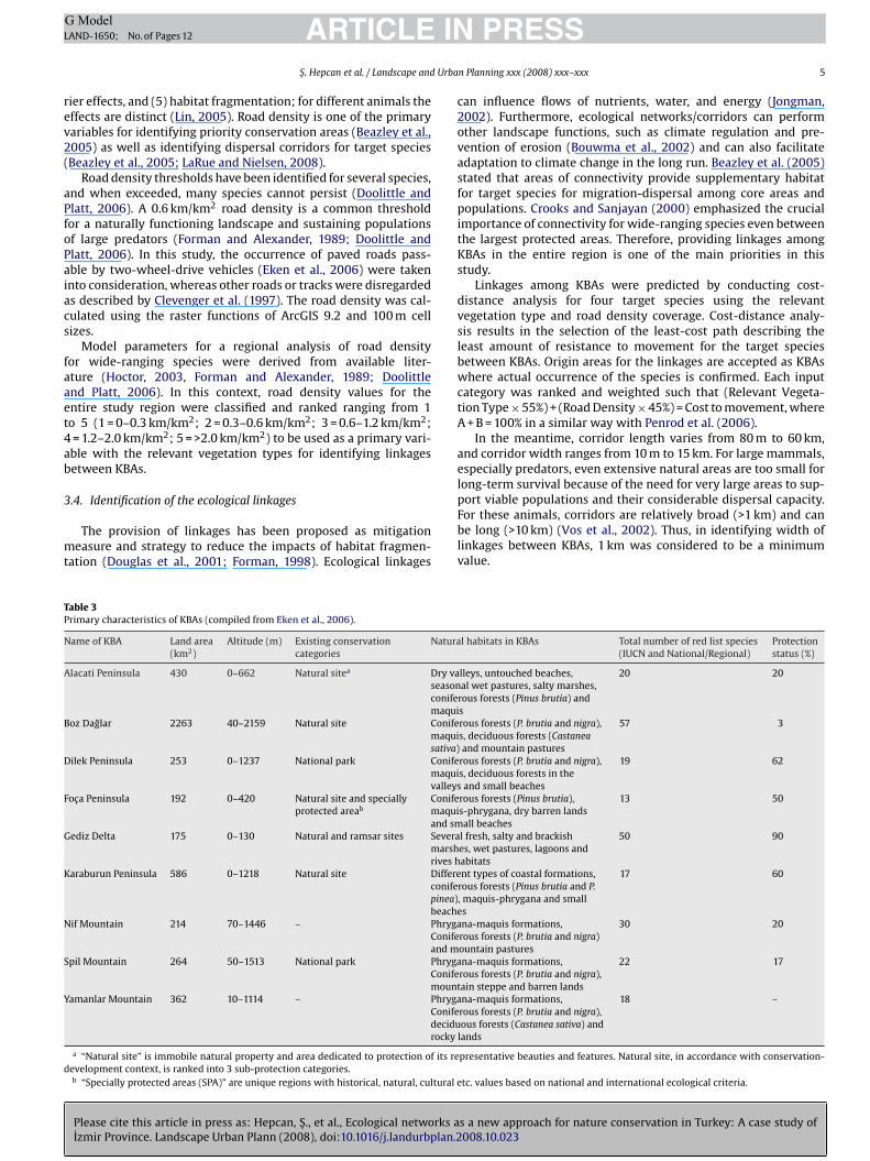
able 3rimary characteristics of KBAs (compiled from Eken et al., 2006).
ame of KBA Land area(km2)
Altitude (m) Existing conservationcategories
Natura
lacati Peninsula 430 0–662 Natural sitea Dry vaseasonconifemaqui
oz Daglar 2263 40–2159 Natural site Conifemaquisativa)
ilek Peninsula 253 0–1237 National park Conifemaquivalleys
oca Peninsula 192 0–420 Natural site and speciallyprotected areab
Conifemaquiand sm
ediz Delta 175 0–130 Natural and ramsar sites Severamarshrives h
araburun Peninsula 586 0–1218 Natural site Differeconifepinea)beache
if Mountain 214 70–1446 – PhrygaConifeand m
pil Mountain 264 50–1513 National park PhrygaConifemount
amanlar Mountain 362 10–1114 – PhrygaConifedecidurocky l
a “Natural site” is immobile natural property and area dedicated to protection of its reevelopment context, is ranked into 3 sub-protection categories.b “Specially protected areas (SPA)” are unique regions with historical, natural, cultural e
PRESSn Planning xxx (2008) xxx–xxx 5
an influence flows of nutrients, water, and energy (Jongman,002). Furthermore, ecological networks/corridors can performther landscape functions, such as climate regulation and pre-ention of erosion (Bouwma et al., 2002) and can also facilitatedaptation to climate change in the long run. Beazley et al. (2005)tated that areas of connectivity provide supplementary habitator target species for migration-dispersal among core areas andopulations. Crooks and Sanjayan (2000) emphasized the crucial
mportance of connectivity for wide-ranging species even betweenhe largest protected areas. Therefore, providing linkages amongBAs in the entire region is one of the main priorities in thistudy.
Linkages among KBAs were predicted by conducting cost-istance analysis for four target species using the relevantegetation type and road density coverage. Cost-distance analy-is results in the selection of the least-cost path describing theeast amount of resistance to movement for the target speciesetween KBAs. Origin areas for the linkages are accepted as KBAshere actual occurrence of the species is confirmed. Each input
ategory was ranked and weighted such that (Relevant Vegeta-ion Type × 55%) + (Road Density × 45%) = Cost to movement, where+ B = 100% in a similar way with Penrod et al. (2006).
In the meantime, corridor length varies from 80 m to 60 km,nd corridor width ranges from 10 m to 15 km. For large mammals,specially predators, even extensive natural areas are too small forong-term survival because of the need for very large areas to sup-
s a new approach for nature conservation in Turkey: A case study of008.10.023
ort viable populations and their considerable dispersal capacity.or these animals, corridors are relatively broad (>1 km) and cane long (>10 km) (Vos et al., 2002). Thus, in identifying width of
inkages between KBAs, 1 km was considered to be a minimumalue.
l habitats in KBAs Total number of red list species(IUCN and National/Regional)
Protectionstatus (%)
lleys, untouched beaches,al wet pastures, salty marshes,
rous forests (Pinus brutia) ands
20 20
rous forests (P. brutia and nigra),s, deciduous forests (Castaneaand mountain pastures
57 3
rous forests (P. brutia and nigra),s, deciduous forests in theand small beaches
19 62
rous forests (Pinus brutia),s-phrygana, dry barren landsall beaches
13 50
l fresh, salty and brackishes, wet pastures, lagoons andabitats
50 90
nt types of coastal formations,rous forests (Pinus brutia and P., maquis-phrygana and smalls
17 60
na-maquis formations,rous forests (P. brutia and nigra)ountain pastures
30 20
na-maquis formations,rous forests (P. brutia and nigra),ain steppe and barren lands
22 17
na-maquis formations,rous forests (P. brutia and nigra),ous forests (Castanea sativa) andands
18 –
presentative beauties and features. Natural site, in accordance with conservation-
tc. values based on national and international ecological criteria.
ARTICLE IN PRESSG ModelLAND-1650; No. of Pages 12
6 S. Hepcan et al. / Landscape and Urban Planning xxx (2008) xxx–xxx
Table 4Available information of target species (derived from Eken et al., 2006; Can, 2004; Wagner, 2006; Klaver, 2003).
KBA Species Red list status Population size General habitat preferences Legal status in Turkey
IUCN National
Alacati Peninsula Hyaena hyaena NT EN Exist Open, rocky or thorn bush country inarid to semi-arid environments, bareareas and dry woodland habitats
CITES and Law on Terrestrial Huntingno. 4195
Boz Daglar Lynx lynx NT EN – Woodlands, savannas, steppes andshrublands
CITES and Law on Terrestrial Huntingno. 4195
Dilek Peninsula Lynx lynx NT EN Exist Deciduous mixed and coniferousforests, and Mediterranean woodlandsand shrubland
CITES and Law on Terrestrial Huntingno. 4195
Foca Peninsula Hyaena hyaena NT EN Exist CITES and Law on Terrestrial Huntingno. 4195
Gediz Delta Felis chaus LC EN Exist Coastal woodlands, scrubby grasslands,coastal and wetland areas, and reedbeds
CITES and Law on Terrestrial Huntingno. 4195
Karaburun Peninsula Caracal caracal LC EN Exist CITES and Law on Terrestrial Huntingno. 4195
Nif Mountain Lynx lynx NT EN –SY
N
4
4
ts
ise
pil Mountain Lynx lynx NT EN –amanlar Mountain Hyaena hyaena NT EN Exist
T: Near Threaten, LC: Least Concern, EN: Endangered.
. Results
.1. Selected KBAs and target species
Please cite this article in press as: Hepcan, S., et al., Ecological networks aIzmir Province. Landscape Urban Plann (2008), doi:10.1016/j.landurbplan.2
KBAs are heterogeneous landscapes composed of various habi-at types in different size and quality. Nine pre-existing KBAs wereelected in this study (Eken et al., 2006). The noticeable character-
maK2
Fig. 4. Major habitats in the stud
stics of KBAs as one of the primary components of the study areummarized in Table 3 as derived from the related literature (Ekent al., 2004; Özhatay et al., 2003; Eken et al., 2006). The four large
s a new approach for nature conservation in Turkey: A case study of008.10.023
ammalian carnivores of H. hyaena, L. lynx, C. caracal and F. chausre targeted species actually or potentially occurring in some of theBAs (Table 4; Eken et al., 2006; Can, 2004; Wagner, 2006; Klaver,003).
y region, including KBAs.
ARTICLE IN PRESSG ModelLAND-1650; No. of Pages 12
S. Hepcan et al. / Landscape and Urban Planning xxx (2008) xxx–xxx 7
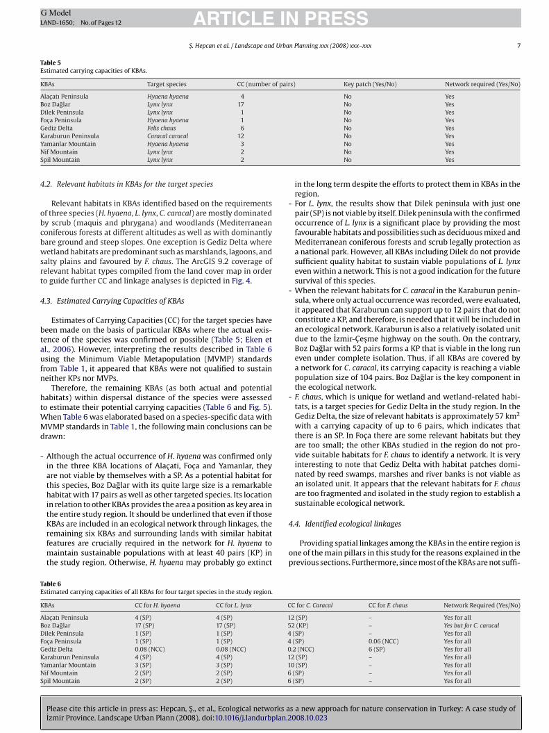
Table 5Estimated carrying capacities of KBAs.
KBAs Target species CC (number of pairs) Key patch (Yes/No) Network required (Yes/No)
Alacatı Peninsula Hyaena hyaena 4 No YesBoz Daglar Lynx lynx 17 No YesDilek Peninsula Lynx lynx 1 No YesFoca Peninsula Hyaena hyaena 1 No YesGediz Delta Felis chaus 6 No YesKYNS
4
obcbwsrt
4
btaufn
htWMd
-
-
-
-
TE
K
ABDFGKYNS
araburun Peninsula Caracal caracal 12amanlar Mountain Hyaena hyaena 3if Mountain Lynx lynx 2pil Mountain Lynx lynx 2
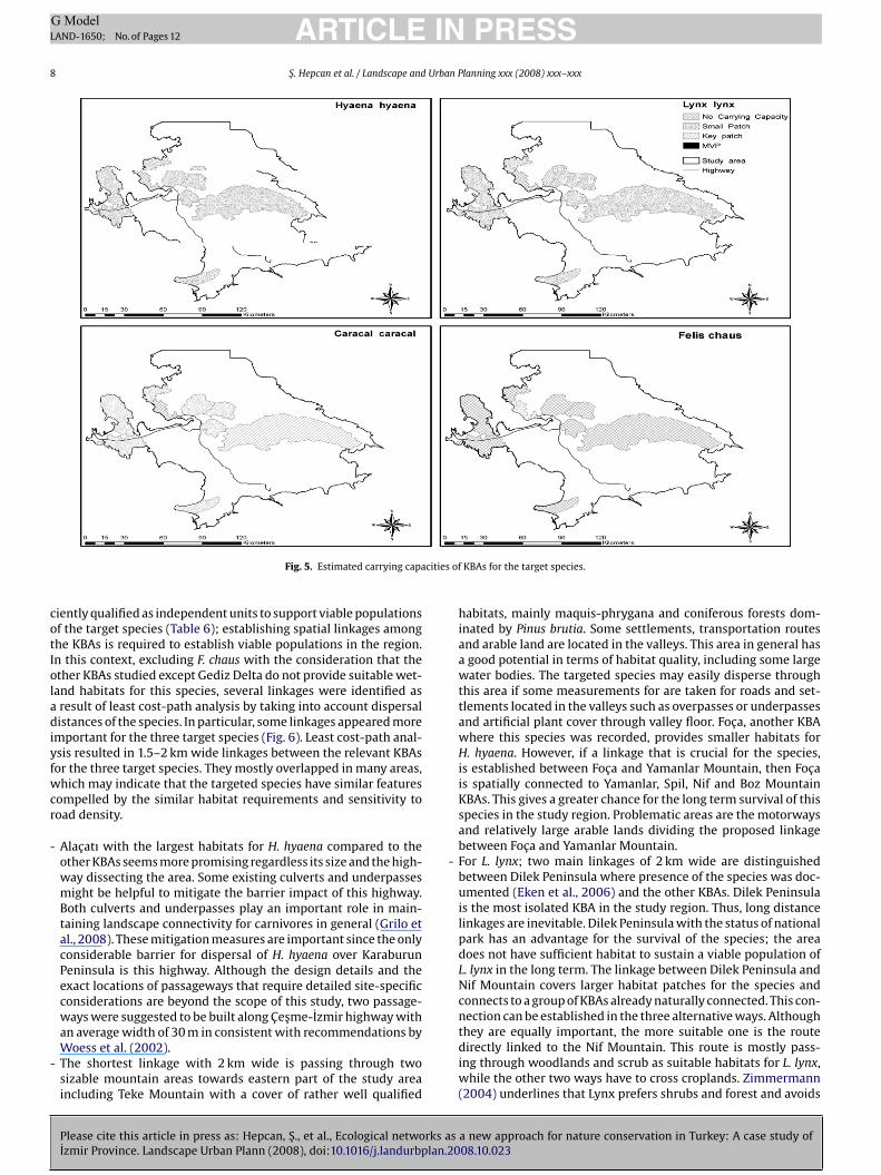
.2. Relevant habitats in KBAs for the target species
Relevant habitats in KBAs identified based on the requirementsf three species (H. hyaena, L. lynx, C. caracal) are mostly dominatedy scrub (maquis and phrygana) and woodlands (Mediterraneanoniferous forests at different altitudes as well as with dominantlyare ground and steep slopes. One exception is Gediz Delta whereetland habitats are predominant such as marshlands, lagoons, and
alty plains and favoured by F. chaus. The ArcGIS 9.2 coverage ofelevant habitat types compiled from the land cover map in ordero guide further CC and linkage analyses is depicted in Fig. 4.
.3. Estimated Carrying Capacities of KBAs
Estimates of Carrying Capacities (CC) for the target species haveeen made on the basis of particular KBAs where the actual exis-ence of the species was confirmed or possible (Table 5; Eken etl., 2006). However, interpreting the results described in Table 6sing the Minimum Viable Metapopulation (MVMP) standardsrom Table 1, it appeared that KBAs were not qualified to sustaineither KPs nor MVPs.
Therefore, the remaining KBAs (as both actual and potentialabitats) within dispersal distance of the species were assessedo estimate their potential carrying capacities (Table 6 and Fig. 5).
hen Table 6 was elaborated based on a species-specific data withVMP standards in Table 1, the following main conclusions can be
rawn:
Although the actual occurrence of H. hyaena was confirmed onlyin the three KBA locations of Alacati, Foca and Yamanlar, theyare not viable by themselves with a SP. As a potential habitat forthis species, Boz Daglar with its quite large size is a remarkablehabitat with 17 pairs as well as other targeted species. Its locationin relation to other KBAs provides the area a position as key area inthe entire study region. It should be underlined that even if those
Please cite this article in press as: Hepcan, S., et al., Ecological networks aIzmir Province. Landscape Urban Plann (2008), doi:10.1016/j.landurbplan.2
KBAs are included in an ecological network through linkages, theremaining six KBAs and surrounding lands with similar habitatfeatures are crucially required in the network for H. hyaena tomaintain sustainable populations with at least 40 pairs (KP) inthe study region. Otherwise, H. hyaena may probably go extinct
4
op
able 6stimated carrying capacities of all KBAs for four target species in the study region.
BAs CC for H. hyaena CC for L. lynx C
lacatı Peninsula 4 (SP) 4 (SP) 1oz Daglar 17 (SP) 17 (SP) 5ilek Peninsula 1 (SP) 1 (SP) 4oca Peninsula 1 (SP) 1 (SP) 4ediz Delta 0.08 (NCC) 0.08 (NCC) 0araburun Peninsula 4 (SP) 4 (SP) 1amanlar Mountain 3 (SP) 3 (SP) 1if Mountain 2 (SP) 2 (SP) 6pil Mountain 2 (SP) 2 (SP) 6
No YesNo YesNo YesNo Yes
in the long term despite the efforts to protect them in KBAs in theregion.For L. lynx, the results show that Dilek peninsula with just onepair (SP) is not viable by itself. Dilek peninsula with the confirmedoccurrence of L. lynx is a significant place by providing the mostfavourable habitats and possibilities such as deciduous mixed andMediterranean coniferous forests and scrub legally protection asa national park. However, all KBAs including Dilek do not providesufficient quality habitat to sustain viable populations of L. lynxeven within a network. This is not a good indication for the futuresurvival of this species.When the relevant habitats for C. caracal in the Karaburun penin-sula, where only actual occurrence was recorded, were evaluated,it appeared that Karaburun can support up to 12 pairs that do notconstitute a KP, and therefore, is needed that it will be included inan ecological network. Karaburun is also a relatively isolated unitdue to the Izmir-Cesme highway on the south. On the contrary,Boz Daglar with 52 pairs forms a KP that is viable in the long runeven under complete isolation. Thus, if all KBAs are covered bya network for C. caracal, its carrying capacity is reaching a viablepopulation size of 104 pairs. Boz Daglar is the key component inthe ecological network.F. chaus, which is unique for wetland and wetland-related habi-tats, is a target species for Gediz Delta in the study region. In theGediz Delta, the size of relevant habitats is approximately 57 km2
with a carrying capacity of up to 6 pairs, which indicates thatthere is an SP. In Foca there are some relevant habitats but theyare too small; the other KBAs studied in the region do not pro-vide suitable habitats for F. chaus to identify a network. It is veryinteresting to note that Gediz Delta with habitat patches domi-nated by reed swamps, marshes and river banks is not viable asan isolated unit. It appears that the relevant habitats for F. chausare too fragmented and isolated in the study region to establish asustainable ecological network.
s a new approach for nature conservation in Turkey: A case study of008.10.023
.4. Identified ecological linkages
Providing spatial linkages among the KBAs in the entire region isne of the main pillars in this study for the reasons explained in therevious sections. Furthermore, since most of the KBAs are not suffi-
C for C. Caracal CC for F. chaus Network Required (Yes/No)
2 (SP) – Yes for all2 (KP) – Yes but for C. caracal(SP) – Yes for all(SP) 0.06 (NCC) Yes for all.2 (NCC) 6 (SP) Yes for all2 (SP) – Yes for all0 (SP) – Yes for all(SP) – Yes for all(SP) – Yes for all
ARTICLE IN PRESSG ModelLAND-1650; No. of Pages 12
8 S. Hepcan et al. / Landscape and Urban Planning xxx (2008) xxx–xxx
cities
cotIoladiyfwcr
-
-
-
Fig. 5. Estimated carrying capa
iently qualified as independent units to support viable populationsf the target species (Table 6); establishing spatial linkages amonghe KBAs is required to establish viable populations in the region.n this context, excluding F. chaus with the consideration that thether KBAs studied except Gediz Delta do not provide suitable wet-and habitats for this species, several linkages were identified asresult of least cost-path analysis by taking into account dispersalistances of the species. In particular, some linkages appeared more
mportant for the three target species (Fig. 6). Least cost-path anal-sis resulted in 1.5–2 km wide linkages between the relevant KBAsor the three target species. They mostly overlapped in many areas,hich may indicate that the targeted species have similar features
ompelled by the similar habitat requirements and sensitivity tooad density.
Alacatı with the largest habitats for H. hyaena compared to theother KBAs seems more promising regardless its size and the high-way dissecting the area. Some existing culverts and underpassesmight be helpful to mitigate the barrier impact of this highway.Both culverts and underpasses play an important role in main-taining landscape connectivity for carnivores in general (Grilo etal., 2008). These mitigation measures are important since the onlyconsiderable barrier for dispersal of H. hyaena over KaraburunPeninsula is this highway. Although the design details and theexact locations of passageways that require detailed site-specificconsiderations are beyond the scope of this study, two passage-ways were suggested to be built along Cesme-Izmir highway with
Please cite this article in press as: Hepcan, S., et al., Ecological networks aIzmir Province. Landscape Urban Plann (2008), doi:10.1016/j.landurbplan.2
an average width of 30 m in consistent with recommendations byWoess et al. (2002).The shortest linkage with 2 km wide is passing through twosizable mountain areas towards eastern part of the study areaincluding Teke Mountain with a cover of rather well qualified
of KBAs for the target species.
habitats, mainly maquis-phrygana and coniferous forests dom-inated by Pinus brutia. Some settlements, transportation routesand arable land are located in the valleys. This area in general hasa good potential in terms of habitat quality, including some largewater bodies. The targeted species may easily disperse throughthis area if some measurements for are taken for roads and set-tlements located in the valleys such as overpasses or underpassesand artificial plant cover through valley floor. Foca, another KBAwhere this species was recorded, provides smaller habitats forH. hyaena. However, if a linkage that is crucial for the species,is established between Foca and Yamanlar Mountain, then Focais spatially connected to Yamanlar, Spil, Nif and Boz MountainKBAs. This gives a greater chance for the long term survival of thisspecies in the study region. Problematic areas are the motorwaysand relatively large arable lands dividing the proposed linkagebetween Foca and Yamanlar Mountain.For L. lynx; two main linkages of 2 km wide are distinguishedbetween Dilek Peninsula where presence of the species was doc-umented (Eken et al., 2006) and the other KBAs. Dilek Peninsulais the most isolated KBA in the study region. Thus, long distancelinkages are inevitable. Dilek Peninsula with the status of nationalpark has an advantage for the survival of the species; the areadoes not have sufficient habitat to sustain a viable population ofL. lynx in the long term. The linkage between Dilek Peninsula andNif Mountain covers larger habitat patches for the species andconnects to a group of KBAs already naturally connected. This con-nection can be established in the three alternative ways. Although
s a new approach for nature conservation in Turkey: A case study of008.10.023
they are equally important, the more suitable one is the routedirectly linked to the Nif Mountain. This route is mostly pass-ing through woodlands and scrub as suitable habitats for L. lynx,while the other two ways have to cross croplands. Zimmermann(2004) underlines that Lynx prefers shrubs and forest and avoids
ARTICLE IN PRESSG ModelLAND-1650; No. of Pages 12
S. Hepcan et al. / Landscape and Urban Planning xxx (2008) xxx–xxx 9
for tar
-
-
-
5
ceaafKtm
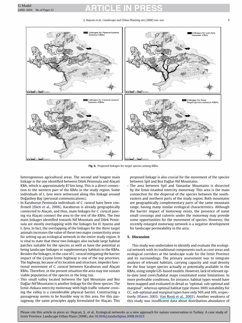
Fig. 6. Proposed linkages
heterogeneous agricultural areas. The second and longest mainlinkage is the one identified between Dilek Peninsula and AlacatiKBA, which is approximately 87 km long. This is a direct connec-tion to the western part of the KBAs in the study region. Someindividuals of L. lynx were witnessed along this linkage aroundDoganbey Bay (personal communications).In Karaburun Peninsula individuals of C. caracal have been con-firmed (Eken et al., 2006). Karaburun is already geographicallyconnected to Alacatı, and thus, main linkages for C. caracal pass-ing via Alacatı connect the area to the rest of the KBAs. The twomain linkages identified towards Nif Mountain and Dilek Penin-sula are mostly overlapping with the linkages for H. hyaena andL. lynx. In fact, the overlapping of the linkages for the three targetanimals increases the value of these two major connectivity areasfor setting up an ecological network in the entire study region. Itis vital to state that these two linkages also include large habitatpatches suitable for the species as well as have the potential asbeing landscape linkages or supplementary habitats to the KBAs.Besides the linkages, in the case of C. caracal mitigating the barrierimpact of the Cesme-Izmir highway is one of the top priorities.The highway, because of its location and structure, impedes func-tional movement of C. caracal between Karaburun and AlacatıKBAs. Therefore, in the present situation the area may not sustainviable population of the species in the long run.This small valley located between the Spil Mountain and Boz
Please cite this article in press as: Hepcan, S., et al., Ecological networks aIzmir Province. Landscape Urban Plann (2008), doi:10.1016/j.landurbplan.2
Daglar-Nif Mountains is another linkage for the three species. TheIzmir-Ankara intercity motorway with high traffic volume cross-ing the valley is a considerable physical barrier. Constructing apassageway seems to be feasible way in this area. For this pas-sageway, the same principles apply formulated for Alacatı. This
bmCtt
get species among KBAs.
proposed linkage is also crucial for the movement of the speciesbetween Spil and Boz Daglar-Nif Mountains.The area between Spil and Yamanlar Mountains is dissectedby the Izmir-Istanbul intercity motorway. This area is the mainconnection for the dispersal of the species between the south-eastern and northern parts of the study region. Both mountainsare geographically complementary parts of the same mountainrange, having many similar ecological characteristics. Althoughthe barrier impact of motorway exists, the presence of somesmall crossings and culverts under the motorway may providesome opportunities for the movement of species. However, therecently enlarged motorway network is a negative developmentfor landscape permeability in the area.
. Discussion
This study was undertaken to identify and evaluate the ecologi-al network with its traditional components such as core areas andcological corridors at the landscape scale for the Izmir Provincend its surroundings. The primary assessment was to integratenalyses of relevant habitats, carrying capacity and road densityor the four target species actually or potentially available in theBAs, using simple GIS-based models. However, lack of relevant up-
o-date land cover/habitat maps constituted some limitations. Inore preferable conditions, for instance, habitat types would have
s a new approach for nature conservation in Turkey: A case study of008.10.023
een mapped and evaluated in detail as “optimal, sub-optimal andarginal”, whereas optimal habitat type shows 100% suitability for
C, sub-optimal and marginal types have only 50% and 10%, respec-ively (Klaver, 2003; Van Rooij et al., 2003). Another weakness ofhis study was insufficient data about distribution-abundance of
ING ModelL
1 Urba
toC2
bdmt(aaam(
oBoitptee(
tonpierHsdtmrFauaiDpjsia
tputisihtTafie
tarolmwl
apaTmen
aoiaoW
srpbtTesvtttvmtot
6
aapsfb
aawpodap
ARTICLEAND-1650; No. of Pages 12
0 S. Hepcan et al. / Landscape and
he species in the study region (Can, 2004) as well as unavailabilityf relevant region-specific parameters to calculate the estimatedC, such as local populations and dispersal distances (Hepcan et al.,005).
Large carnivore populations in Turkey are negatively affectedy large-scale forest/habitat fragmentation and degradation in lastecades (Can, 2004). This study focused on large carnivore mam-als as the target species to develop ecological networks since
hese are key species in nature conservation and managementBeier, 1993; Klaver, 2003; LaRue and Nielsen, 2008; Bruinderink etl., 2003; Wikramanayake et al., 2003; Kerley et al., 2003; Beazleynd Cardinal, 2004). Management plans focused on these species,nd the design of reserves to protect them, may also help to preserveany other species and the overall health of natural ecosystems
Palomares, 2001; Noss et al., 1996).Due to sizable area requirements and specific habitat demands
f Lynx as indicated by Palomares (2001) Klaver (2003) andreitenmoser et al. (2007), none of the KBAs accommodates a KPr MVP for this species even though Boz Daglar is the most promis-ng habitat with 17 pairs (Table 6 and Fig. 5). This indicates thathese populations in the KBAs contain a few individuals, and thus,robability of extinction is quite high without ecological connec-ivity (Kramer-Schadt et al., 2004). In any case, future research isncouraged to apply metapopulation viability analysis and spatiallyxplicit population models in order to incorporate more parametersBeazley et al., 2005).
The cases of H. hyaena and C. caracal are similar with L. lynx inerms of insufficiency of the KBAs to hold viable populations. More-ver, if all the KBAs in the study region are included in an ecologicaletwork through linkages, CC for H. hyaena will still not reach 40airs (KP) unless some of the surrounding lands are incorporated
n the network (Table 6 and Fig. 5). This situation may require thenlargement of the existing KBAs or setting up new core areas in theegion. Likewise, to conserve the present populations especially of. hyaena and L. lynx in Turkey, Can (2004) suggested expansion of
uitable habitats. Otherwise, these species will probably go extinctue to land use change in the long term despite the efforts to protecthem within the KBAs. In the case of C. Caracal, the situation is much
ore promising with the contribution of Boz Daglar where the CCeaches 52 pairs, which is viable even under a complete isolation.or C. caracal in the Karaburun Peninsula, the only habitat wherectual existence was documented (Eken et al., 2006), can sustainp to 12 pairs that and this does not constitute a KP. If all the KBAsre covered by a network for C. caracal, then the carrying capacitys reaching a viable population size of 104 pairs. In this case, Bozaglar is the key component in an ecological network. The mostroblematic situation in the region is represented by F. chaus with
ust 6 pairs in Gediz Delta. The other KBAs in the region do not holdufficient habitat for F. chaus to identify a network for this species. Its obvious that the relevant habitats for F. chaus are too fragmentednd isolated in the study region.
On the basis of the findings of CC assessments, it can be statedhat the KBAs are unable to offer enough habitats for sustainableopulations of target species if they are preserved as disconnectednits. Nevertheless, Crooks and Sanjayan (2000) stated that evenhe largest protected areas existing today are too small or toosolated to maintain viable populations for many wide-rangingpecies. This argument supports the vital importance of connectiv-ty among the KBAs in the region. Our results indicate that primaryabitats in the linkages are normally dominated by forest and scrub
Please cite this article in press as: Hepcan, S., et al., Ecological networks aIzmir Province. Landscape Urban Plann (2008), doi:10.1016/j.landurbplan.2
hat are similar to the habitat types in the KBAs of the study region.he importance similarity of vegetation cover in linkages and corereas is also indicated by Vos et al. (2002). This result also supportsndings of Zimmermann (2004) stating that the percentage of for-st and shrub category in the corridor ranged from 40% to 75.9%. In
rvTiG
PRESSn Planning xxx (2008) xxx–xxx
he case of L. pardinus, Palomares (2001) reported that areas suit-ble as corridors had lower habitat quality than areas suitable foresident individuals. Thus, relatively lower quality habitats in partsf the linkages compared to the KBAs might be acceptable. Particu-arly, the above-mentioned flexibility about lower quality habitats
ay be tolerated in the two primary linkages connecting Alacatıith Dilek Peninsula-Nif Mountain (Fig. 6) because of their extreme
ength (more than 65 km).In order to facilitate functional animal movement, at regional
nd national levels, Woess et al. (2002) recommended at least 5assageways under the roads for large species including L. lynxlong one highway segment with a minimum width of 30 m.heir locations should be apart from human settlements and theaximum distance between neighbouring passageways must not
xceed 20 km. If the motorway segment is longer than 75 km, theumber of passageways under the roads should increase.
In this study, it is particularly stressed that existing culvertsnd underpasses may be helpful to mitigate the barrier impactf Cesme-Izmir highway. Both culverts and underpasses play anmportant role to facilitate the crossings of highway by carnivoress stated by Grilo et al. (2008). Thus, additional underpasses are rec-mmended with an average width of 30 m that is consistent withoess et al. (2002).As mentioned in the previous sections, the KBAs are the land-
capes where primary biological richness can be found in theegion (Eken et al., 2006). These KBAs are home to the top fourredators species that deserve considerable conservation attention,ecause they are functionally important species in the ecosys-em and habitat-quality indicators (Beazley and Cardinal, 2004).herefore, protection of diversity of the natural landscapes andcosystems is crucially related to sustainable protection of thesepecies. However, this study also shows that they may not sur-ive in the spatially isolated KBAs in the long run, but they haveo be included in ecological networks through linkages betweenhe KBAs. Although linkages may not be the utmost solution tohe habitat fragmentation problems of all mammals, they do pro-ide important advantages for the mobility of the majority of nativeammals (Downes et al., 1997) and wildlife in general. Therefore,
he efforts for biodiversity conservation in the region should pri-ritize the protection of these target species in a sustainable wayhrough protecting both KBAs and the linkages between them.
. Conclusion
Planning of greenways and ecological networks is defined asstrategic action that integrates theories from landscape ecology
nd conservation biology with theories and methods of landscapelanning (Ahern, 2002). In this context, landscape planning with apecial emphasis on creating spatially connected and ecologicallyunctioning landscapes is a useful tool towards providing mutualenefits between society and natural landscapes.
It should be restated that there is an urgent need for a newpproach to establishing sustainable and effective ways to protectll high biodiversity areas in Turkey. The concept of ecological net-orks has been hardly ever discussed in Turkey until now. Thisaper introduces the ecological networks at the “large scale”, basedn spatial connectivity of ecologically key landscapes, the Key Bio-iversity Areas (KBAs) for the target species. This regional landscapepproach interwoven with species-based considerations is sup-osed to act as a pilot study in providing a clear guidance for further
s a new approach for nature conservation in Turkey: A case study of008.10.023
esearch in Turkey. Moreover, the approach presented here pro-ides possibilities to better understand species-based strategies forurkey and is most likely to stimulate further studies on establish-ng ecological networks. Moreover, the approach and the simpleIS-based model applied in this study may be a useful in other
ING ModelL
Urba
clMsc
bise
mwwK
gcaogp
fsmsip
7
RfNORGstfDEBvm
R
A
A
B
B
B
B
B
B
B
C
C
C
C
C
C
D
D
D
D
D
E
E
E
E
F
F
G
H
H
H
HI
J
J
J
J
K
K
K
L
L
ARTICLEAND-1650; No. of Pages 12
S. Hepcan et al. / Landscape and
ountries with similar ecological characteristics and species. Theack of data and the species used here is characteristic for many
editerranean countries. Therefore this regional approach is con-idered to be easily applicable in many regions in Mediterraneanountries.
However, whatever the approach to ecological networks is, itoils down to detailed, up-to date and consistent landscape ecolog-
cal data on species and connectivity and legally and ecologicallyound spatial planning tools in this region and in Turkey (Hepcant al., 2005).
The outcomes of this study are among others that area require-ents of species are not completely addressed by the existing KBAshich indicate that they cannot individually sustain the speciesith one exception, Boz Daglar KBA for C. caracal. Therefore, theBAs must be integrated in a network through ecological linkages.
Passageways facilitating the crossings of motorways by the tar-eted carnivores deserve considerable attention. Some guidelinesonsistent with Grilo et al. (2008) can be given that large passagesre required as much as possible, with passages with forested areasf natural forest and low scrub vegetation at passage entrances touide animals, and maintenance of natural vegetation inside theassage.
It is important to conclude that while providing spatial andunctional opportunities for long term survival of the targetedpecies, the social, cultural and economic contexts and demandsust seriously be considered without compromising the long term
ustainability of wildlife. The dynamics of other human networksn the region are also important for maintaining the viability of theroposed ecological networks.
. Acknowledgements
We are thankful to TUBITAK (The Scientific and Technicalesearch Council of Turkey), which provided financial supportor making researches in the field of ecological networks in theetherlands. We also would like to express our gratitude to Paulpdam, Paul Chardon, TheoVan Der Sluis from Alterra Green Worldesearch Center Wageningen University – the Netherlands, andüven Eken and Yıldıray Lise from Doga Dernegi–Turkey for theirincere co-operation and valuable knowledge given. Very specialhanks are given to Ted Cook from Arizona State University–USAor his encouragement and guidance. Finally we also thank Selcukincal, Ph.D candidate at Texas A&M University – USA, Fatihvrendilek from Abant Izzet Baysal University – Turkey and Bobunce from Alterra Green World Research Center Wageningen Uni-ersity – the Netherlands for their contributions to advance theanuscript.
eferences
hern, J., 2002. Greenways as strategic landscape planning: theory and application.Ph.D. Thesis, Wageningen University.
venant, N.L., Nel, J.A.J., 1998. Home range use, activity and density of caracal inrelation top prey density. Afr. J. Ecol. 36, 347–359.
eazley, K., Cardinal, N., 2004. A systematic approach for selecting focal speciesfor conservation in the forests of Nova Scotia and Maine. Environ. Conserv. 31,91–101.
eazley, K., Smandych, L., Snaith, T., Mackinnon, F., Austen-Smith, P., Duinker, P.,2005. Biodiversity considerations in conservation system planning: map-basedapproach for Nova Scotia. Canada Ecol. Appl. 6, 2192–2208.
eier, P., 1993. Determining minimum habitat areas and habitat corridors forcougars. Conserv. Biol. 7, 94–108.
ouwma, I.M., Jongman, R.H.G., Butovsky, R.O., 2002. Indicative map of thePan-European Ecological Network for Central and Eastern Europe. Technical
Please cite this article in press as: Hepcan, S., et al., Ecological networks aIzmir Province. Landscape Urban Plann (2008), doi:10.1016/j.landurbplan.2
Background Document, ECNC, Technical Report Series, Tilburg/Budapest.ouwma, I.M., Opdam, P., Schrevel, A., 2003. Ecological Networks: Linking Protected
Areas with Sustainable Development. Alterra-Wageningen University.reitenmoser, U., Breitenmoser-Würsten, C., Capt, S., Molinari-Jobin, A., Molinari,
P., Zimmermann, F., 2007. Conservation of the lynx. Lynx lynx in the Swiss JuraMountains. Wildl. Biol. 13, 340–355.
N
N
PRESSn Planning xxx (2008) xxx–xxx 11
ruinderink, G.G., Van Der Sluis, T., Lammertsma, D., Opdam, P., Pouwels, R., 2003.Designing a coherent ecological network for large mammals in NorthwesternEurope. Conserv. Biol. 17, 549–557.
an, E., 2004. Status, Conservation and Management of Large Carnivores in Turkey.Convention on the Conservation of European Wildlife and Natural Habitats.Council of Europe, Ankara.
arroll, C., Noss, R.F., Paquet, P.C., Schumacher, N.H., 2003. Use of population viabilityanalysis and reserve selection algorithms in regional conservation plans. Ecol.Appl. 13, 1773–1789.
levenger, A.P., Purroy, F.J., Campos, H.A., 1997. Habitat assessment of a relict BrownBear Ursus arctos population in northern Spain. Biol. Conserv. 80, 17–22.
ook, E.A., 2000. Ecological Networks in Urban Landscapes. Ph.D. Thesis, Wagenin-gen University.
ook, E.A., 2002. Landscape structure indices for assessing urban ecological net-works. Landscape Urban Plann. 58, 269–280.
rooks, K.R., Sanjayan, M., 2000. Connectivity conservation: maintaining connec-tions for nature. In: Crooks, K.R., Sanjayan, M. (Eds.), Connectivity Conservation.Cambridge University Press, Cambridge.
emirsoy, A., 1992. Fundamentals of Life: Vertebrates. Meteksan Press, Ankara, vol-III/Chapter-II (in Turkish).
oolittle, L., Platt, E., 2006. Road removal projects fish and creates jobs. WinterSolstice. 11, 4.
ouglas, T.B., Thomas, A.S., John, T.R., 2001. Use of corridor-like landscape structuresby bird and small mammal species. Biol. Conserv. 102, 213–224.
ownes, S.J., Handasyde, K.A., Elgar, M.A., 1997. The use of corridors by mammals infragmented Australian eucalyptus forests. Conserv. Biol. 11, 718–726.
uerkson, C.J., Elliot, D.L., Hobbs, N.T., Johnson, E., Miller, J.R., 1997. Habitat Pro-tection Planning Where the Wild Things Are. American Planning Association,Washington.
ken, G., Bennun, L., Brooks, T.M., Darwall, W., Fishpool, L.D.C., Foster, M., Knox, D.,Langhammer, P., Matiku, P., Radford, E., Salaman, P., Sechrest, W., Smith, M.L.,Spector, S., Tordoff, A., 2004. Key Biodiversity Areas as site conservation targets.Biol. Sci. 54, 1110–1118.
ken, G., Bozdogan, M., Isfendiyaroglu, S., Kılıc, D.T., Lise, Y. (Eds.), 2006. Key Biodi-versity Areas in Turkey. Doga Dernegi, Ankara (in Turkish).
SRI, 2005. Arc View 3.2 Software. Environmental Systems Research Institute, Red-lands, CA.
vrendilek, F., Doygun, H., 2000. Assessing major ecosystem types and the challengeof sustainability in Turkey. Environ. Manage. 26 (5), 479–489.
orman, R.T.T., Alexander, L.E., 1989. Road and their major ecological effects. Ann.Rev. Ecol. Syst. 29, 207–231.
orman, T.T., 1998. Land Mosaics. The Ecology of Landscapes and Regions. CambridgeUniversity Press, New York.
rilo, C., Bissonette, J.A., Santos-Reis, M., 2008. Response of carnivores to existinghighway culverts and underpasses: implications for road planning and mitiga-tion. Biodiv. Conserv., doi:10.1007/s10531-008-9374-8.
aaren, V.H., Reich, M., 2006. The German way to greenways and habitat networks.Landscape Urban Plann. 76, 7–22.
octor, T.H., 2003. Regional landscape analysis and reserve design to conserveFlorida’s biodiversity. Ph.D. Thesis, University of Florida.
epcan, C.C., Hepcan, S., Kaplan, A., Özkan, B., 2005. Ecological networks as ameans of sustainable nature conservation. In: X. European Ecological Congress(Eureco’05). Proceedings s. 187–196, Kusadası-Izmir, November 8–13.
umphrey, S.R., Bain, J.R., 1990. Endangered Animals of Thailand. CRC Press, London.UCN, 2008. The IUCN Red List of Threatened Species. <http://cms.iucn.org>
(accessed in March, 2008).aarsma, C.F., Willems, G.P.A., 2002. Reducing habitat fragmentation by minor rural
roads through traffic calming. Landscape Urban Plann. 58, 125–135.ochem, R., Koolstra, B.J.H., Chardon, J.P., 2002. LARCH: An ecological application
of GIS in river studies. In: Leuren, R.S.E.W., Poudevigne, I., Teeuw, R.M. (Eds.),Application of Geographic Information Systems and Remote Sensing in RiverStudies. Backhuys Publishers, Leiden, pp. 163–181.
ongman, R., 2004. The context and concept of ecological networks. In: Jongman,R., Pungetti, G. (Eds.), Ecological Networks and Greenways Concept, Design andImplementation. Cambridge University Press, pp. 7–33.
ongman, R.H.G., 2002. Landscape planning for biological diversity in Europe. Land-scape Res. 27, 187–2002.
erley, G.I.H., Pressey, R.L., Cowling, R.M., Boshoffa, A.F., Sims-Castleya, R., 2003.Options for the conservation of large and medium-sized mammals in the CapeFloristic Region Hotspot, South Africa. Biol. Conserv. 112, 169–190.
laver, R., 2003. The sustainability of carnivore metapopulations in Umbria, Italy:spatial modeling with LARCH. M.Sc. Thesis, Wageningen University.
ramer-Schadt, S., Revilla, E., Wiegand, T., Breitenmoser, U., 2004. Fragmented land-scapes, road mortality and patch connectivity: modeling influences on thedispersal of Eurasian lynx. J. Appl. Ecol. 41, 711–723.
aRue, M.A., Nielsen, C.K., 2008. Modeling potential dispersal corridors for cougarsin Midwestern North America using least-cost path methods. Ecol. Model. 212,372–381.
in, S.C., 2005. The ecologically ideal road density for small islands: the case of
s a new approach for nature conservation in Turkey: A case study of008.10.023
Kinmen. Ecol. Eng. 27, 84–92.oss, R.F., 1996. Protected areas: how much is enough? In: Wright, R.G. (Ed.), National
Parks and Protected Areas: Their Role in Environmental Protection. BlackwellScience, Cambridge, MA.
oss, R.F., 1993. Wildlife Corridors. In: Smith, D.S., Hellmund, P.C. (Eds.), Ecology ofGreenways. University of Minnesota Press, Minneapolis.
ING ModelL
1 Urba
N
Ö
P
P
P
P
S
S
V
V
V
W
W
W
W
W
ARTICLEAND-1650; No. of Pages 12
2 S. Hepcan et al. / Landscape and
oss, R.F., Quigley, H.B., Hornocker, M.G., Merrill, T., Paquet, P.C., 1996. Conservationbiology and carnivore conservation in the Rocky Mountains. Conserv. Biol. 10,949–963.
zhatay, N., Byfield, A., Atay, S., 2003. The Important Plant Areas in Turkey. WWF,Istanbul, Turkey (in Turkish).
adoa-Schioppa, B.M., Mass, R., Bottoni, L., 2005. Bird communities as bioindi-cators: the focal species concept in agricultural landscapes. Ecol. Indica. 6,83–93.
alomares, F., 2001. Vegetation structure and prey abundance requirements of theIberian lynx: implications for the design of reserves and corridors. J. Appl. Ecol.38, 9–18.
alomares, F., Revilla, E., Calzada, J., Fernández, N., Delibes, M., 2005. Reproduc-tion and pre-dispersal survival of Iberian lynx in a subpopulation of the DonanaNational Park. Biol. Conserv. 122, 53–59.
enrod, K., Cabanero, C.R., Beier, P., Luke, C., Spencer, W., Rubin, E., Sauvajot, R.M.,Riley, S., Kamradt, D., 2006. South coast missing linkages project. A linkagedesign for the Santa Monica–Sierra Madre Connection. South Coast Wildlandsand National Park Service.
mith, D.J., 2004. Impact of roads on ecological networks and integration ofconservation and transportation planning: Florida as a case study. In: Jong-
Please cite this article in press as: Hepcan, S., et al., Ecological networks aIzmir Province. Landscape Urban Plann (2008), doi:10.1016/j.landurbplan.2
man, R., Pungetti, G. (Eds.), Ecological Networks and Greenways Concept,Design and Implementation. Cambridge University Press, Cambridge, pp. 73–91.
omma, D.J., 2006. Interrelated modeling of land use and habitat for the designof an ecological corridor. A case study in the Yungas, Argentina. Ph.D. Thesis,Wageningen University.
Y
Z
PRESSn Planning xxx (2008) xxx–xxx
an Rooij, S.A.M., Van Der Sluis, T., Steingrover, E.G., 2003. Networks for Life. Devel-opment of an Ecological Network for Persiceto (Italy), Alterra-Report No: 729.
erboom, J., Pouwels, R., 2004. Ecological functioning of networks: a species per-spective. In: Jongman, R., Pungetti, G. (Eds.), Ecological Networks and GreenwaysConcept, Design and Implementation. Cambridge University Press, Cambridge,pp. 56–72.
os, C.C., Baveco, H., Grashof-Bokdam, C.J., 2002. Corridors and species dispersal.In: Gutzwiller, K.J. (Ed.), Applying Landscape Ecology in Biological Conservation.Springer-Verlag, New York, pp. 85–104.
agner, A.P., 2006. Behavioral ecology of the stripped hyena (Hyaena hyaena). Ph.D.Thesis, Montana State University.
agner, A.P., Frank, L.G., Creel, S., 2008. Spatial grouping in behaviorally solitarystriped hyenas, Hyaena hyaena. J Anim. Behav. 75, 1131–1142, doi:10.1016/j.anbehav.2007.08.025.
iegand, T., Revilla, E., Moloney, K.A., 2005. Effects of habitat loss and fragmentationon population dynamics. Conserv. Biol. 19, 108–121.
ikramanayake, E., McKnight, M., Dinerstain, E., Joshi, A., Gurung, B., Smith, D.,2003. Designing a conservation landscape for tigers in human-dominated envi-ronments. Conserv. Biol. 18, 839–844.
oess, M., Grillmayer, R., Voelk, E.H., 2002. Green bridges and wildlife corridors in
s a new approach for nature conservation in Turkey: A case study of008.10.023
Austria. Z. Jagdwiss. 48 (Suppl.), 25–32.ücel, M., 2005. Natura Conservation, 1st edn. Cukurova University Press, Adana,
Turkey (in Turkish).immermann, F., 2004. Conservation of the Eurasian Lynx (Lynx lynx) in a fragmented
landscape – habitat models, dispersal and potential distribution. PhD Thesis,Faculté de biologie et de médecine de l’Université de Lausanne.
Related Documents